Portfolio Management Plan: Mid-Murray Region … · Web viewThe Commonwealth Environmental Water...
52
0
Transcript of Portfolio Management Plan: Mid-Murray Region … · Web viewThe Commonwealth Environmental Water...

0

Front cover image credit: Porters Plain, Murray Valley National Park. Photo by Paul Childs, NSW Office of Environment and Heritage
Back cover image credit: Edward River near Deniliquin. Photo by Commonwealth Environmental Water Office
Acknowledgement of the traditional owners of the Murray-Darling BasinThe Commonwealth Environmental Water Office respectfully acknowledges the traditional owners, their Elders past and present, their Nations of the Murray-Darling Basin, and their cultural, social, environmental, spiritual and economic connection to their lands and waters.
© Copyright Commonwealth of Australia, 2016.
Commonwealth Environmental Water Portfolio Management Plan: Mid Murray Region 2016–17 is licensed by the Commonwealth of Australia for use under a Creative Commons Attribution 4.0 International licence with the exception of the Coat of Arms of the Commonwealth of Australia, the logo of the agency responsible for publishing the report, content supplied by third parties, and any images depicting people. For licence conditions see: https://creativecommons.org/licenses/by/4.0/
This report should be attributed as ‘Commonwealth Environmental Water Portfolio Management Plan: Mid Murray Region 2016–17, Commonwealth of Australia, 2016’.
The Commonwealth of Australia has made all reasonable efforts to identify content supplied by third parties using the following format ‘© Copyright’ noting the third party.
The views and opinions expressed in this publication are those of the authors and do not necessarily reflect those of the Australian Government or the Minister for the Environment.
While reasonable efforts have been made to ensure that the contents of this publication are factually correct, the Commonwealth does not accept responsibility for the accuracy or completeness of the contents, and shall not be liable for any loss or damage that may be occasioned directly or indirectly through the use of, or reliance on, the contents of this publication.
1

Commonwealth environmental water portfolio management planning
Commonwealth environmental water
The Commonwealth Environmental Water Holder is an independent statutory position established by the Water Act 2007 (the Water Act) to manage the Commonwealth environmental water holdings. The Commonwealth Environmental Water Holder leads and is supported by the Commonwealth Environmental Water Office (the Office), a division of the Australian Government Department of the Environment.
Under the Water Act, Commonwealth environmental water must be managed to protect or restore environmental assets, so as to give effect to relevant international agreements. The Water Act also requires that the Commonwealth Environmental Water Holder perform its functions and exercise its powers consistently with and in a manner that gives effect to the Basin Plan and that Commonwealth environmental water is managed in accordance with the Basin Plan’s environmental watering plan.
Purpose of the document
This document sets out the plans for managing the Commonwealth environmental water portfolio in the Mid Murray Region for 2016–17. Efficient and effective management of Commonwealth environmental water requires the utilisation of all portfolio management options, including water delivery, carryover and trade. To support improved outcomes from water use over time, carryover provides the opportunity to optimise water use across water years and to improve water availability early in a water year, while trade provides further capacity to optimise use over the long-term as well as across catchments.
By taking a multi-year approach to planning, portfolio management tools such as use, carryover and trade can be strategically managed for maximising environmental outcomes. The portfolio management plans also support transparent, coordinated and adaptive management of the Commonwealth environmental water portfolio, consistent with Basin Plan obligations including the expected outcomes in the Basin-wide environmental watering strategy and the Basin annual environmental watering priorities.
To learn more about the portfolio management planning approach see Commonwealth environmental water portfolio management planning: Overview of the planning approach in 2016-17 (available at: http://www.environment.gov.au/water/cewo/publications).
Delivery partners
Commonwealth environmental water is managed in conjunction with and delivered by a range of partners. In the Mid Murray Region our partners include New South Wales Office of Environment and Heritage, Victorian Environmental Water Holder, Victorian Catchment Management Authorities, New South Wales Local Land Services, Department of Primary Industries – Fisheries, Department of Primary Industries – Water, Water New South Wales, New South Wales National Parks and Wildlife, the Murray Darling Basin Authority, the Murray-Darling Wetlands Working Group, scientists engaged in monitoring the outcomes of Commonwealth environmental water use, the Murray-Lower Darling Environmental Water Advisory Group, the Edward-Wakool Stakeholder Committee and various community groups and individuals.
This portfolio management plan has been developed in consultation with our delivery partners.
Your input
The management of Commonwealth environmental water relies on considerable advice and assistance from local organisations, state governments and others. Individuals and groups within the Murray-Darling Basin community are encouraged to submit suggestions for the management of Commonwealth environmental water. Please contact the Office via: [email protected].
2

Table of contentsCommonwealth environmental water portfolio management planning 1
Commonwealth environmental water 1Purpose of the document 1Delivery partners 1Your input 1
Table of contents 21. Environmental watering in the Mid Murray Region 3
1.1. The Mid Murray Region 31.2. Environmental objectives and outcomes in the Mid Murray Region 51.3. Environmental flow requirements 71.4. Monitoring and adaptive management 7
2. Portfolio management in 2016–17 82.1. Antecedent and current catchment conditions and the demand for environmental
water in 2016–17 82.2. Water availability in 2016–17 92.3. Overall purpose of managing environmental water based on supply and demand 102.4. Water Delivery in 2016–17 112.5. Trading water in 2016–17 122.6. Carrying over water for use in 2017–18 12
3. Next steps 173.1. From planning to decision making 173.2. Further information 17
Bibliography 18Attachment A – Expected outcomes from the Basin-wide environmental
watering strategy 20Attachment B – Library of watering actions 23
Operational considerations in the Mid Murray Region 23Potential watering actions under different levels of water resource availability 23Potential watering actions – standard operating arrangements 26
Attachment C – Long-term water availability 29Commonwealth environmental water holdings 29Other sources of environmental water 29Planned environmental water 29
Attachment D – Detailed Edward-Wakool indicators 30
3

1.Environmental watering in the Mid Murray Region1.1. The Mid Murray Region
The Mid-Murray planning area extends from Hume Dam to Euston (Figure 1). The region contains a number of wetlands of national and international importance including the Ramsar listed Barmah-Millewa and Gunbower forests. River Murray flows in this region are strongly influenced by the Goulburn, Ovens, Kiewa, Loddon and Campaspe Rivers.
The delivery of Commonwealth environmental water to the Mid Murray Region differs depending on which part of the region water is being delivered to. Where possible, environmental water will be managed to benefit multiple sites en route, thereby maximising the efficient and effective use of environmental water. The day to day delivery of environmental water along the main stem of the River Murray is managed by the Murray-Darling Basin Authority’s River Murray Operations, in close cooperation with state government agencies and state water authorities.
For the New South Wales portion of the Mid-Murray Region, Commonwealth environmental water use is coordinated with other environmental water deliveries by the New South Wales Office of Environment and Heritage. Water delivery is managed by Water New South Wales and/or Murray-Darling Basin Authority River Murray Operations. In some instances Murray Irrigation Limited and landholder infrastructure may also deliver environmental water, subject to separate agreements.
For the Victorian portion of the Mid-Murray Region, Commonwealth environmental water use is coordinated with other environmental water deliveries by the Victorian Environmental Water Holder. Water delivery is managed by the state water authority, Goulburn-Murray Water, and regional waterway managers including the North-Central Catchment Management Authority, Goulburn-Broken Catchment Management Authority, North-East Catchment Management Authority and the Mallee Catchment Management Authority.
Environmental water is managed by a number of water holders in the Murray, including the Commonwealth Environmental Water Holder, The Living Murray, the Victorian Environmental Water Holder and NSW Office of Environment and Heritage. Environmental water portfolios are coordinated to maximise the effectiveness of water delivery for achieving environmental outcomes. For example, the Southern Connected Basin Environmental Watering Committee was established by the MurrayDarling Basin Ministerial Council in October 2014 to coordinate the efficient and effective delivery of all environmental water in the Southern Connected Basin.
4

Figure 1: Map of the Mid Murray Region
5

1.2. Environmental objectives and outcomes in the Mid Murray Region
The long-term environmental objectives and expected outcomes for the Murray-Darling Basin are described in the Basin Plan’s environmental watering plan and the Basin-wide environmental watering strategy (the Strategy). The Strategy includes quantified environmental outcomes at both a Basin-scale and for each catchment—outcomes relevant for the Mid Murray Region are described in Attachment A.
The Victorian state government has developed a long-term watering plan for the Victorian Murray (DELWP 2015) region. The plans identify the priority environmental assets and ecosystem functions in the catchment, the objectives and targets for these assets and functions, and their watering requirements. Once developed, the New South Wales Murray and Lower Darling plans will also provide key information on the long-term environmental water demands in the catchment. In addition to the long-term watering plans, the Office will continue to draw on existing documentation on environmental water demands developed by state governments, local natural resource management agencies and the Murray-Darling Basin Authority.
Based on these strategies and plans, and in response to best available knowledge drawing on the results of environmental watering monitoring programmes, the outcomes being targeted by environmental watering in the Mid Murray Region are summarised in Table 1 below. The objectives and targeted outcomes for water-dependent ecosystems will continue to be revised as part of the Commonwealth Environmental Water Office’s commitment to adaptive management.
6

Table 1: Summary of outcomes being targeted by environmental watering in the Mid Murray Region
BASIN-WIDE OUTCOMES
(Outcomes in red link to the
Basin-wide environmental
watering strategy, MDBA
2014)
EXPECTED OUTCOMES FOR MID MURRAY ASSETS
IN-CHANNEL ASSETS OFF-CHANNEL ASSETSRiver Murray from
Hume Dam to Euston
Edward-Wakool River System
Gunbower Creek
Barmah-Millewa Forest
Gunbower-Koondrook-Perricoota
Forest
Edward-Wakool Forests (e.g. Werai,
Neimur)
Central Murray off-
channel wetlands
and ephemeral
creeksVEGETATION Maintain riparian and in-channel vegetation condition.
Increase periods of growth for non-woody vegetation communities that closely fringe or occur within river
channels.
Maintain the current extent of water-dependent vegetation near river channels and on low-lying areas of the floodplain.
Improve condition of black box, river red gum and lignum shrublands. Improve recruitment of trees within black box and
river red gum communities.Increased periods of growth for non-woody vegetation
communities that closely fringe or occur within the creek channels, and those that form extensive stands within wetlands and low-lying floodplains including moira grassland in Barmah–
Millewa forests.
Maintain and improve
condition of wetland
vegetation.
WATERBIRDS Provide habitat and food sources to support waterbird survival and recruitment, and maintain condition and current species diversity.Complete naturally triggered colonial bird breeding events.
FISH Provide flows to support habitat (including longitudinal connectivity and bench inundation) and food sources and promote increased movement/dispersal, recruitment and
survival/condition of native fish.
Provide flows to support habitat and cues for increased movement, recruitment and survival/condition of native fish (particularly for floodplain specialists).
INVERTEBRATES Provide habitat to support increased microinvertebrate and macroinvertebrate survival, diversity, abundance and condition.OTHER
VERTEBRATESProvide habitat to support survival, maintain condition and provide recruitment opportunities for frogs and turtles.
CONNECTIVITY Maintain lateral connectivity through contributing to an increase in the frequency of freshes, bankfull and lowland floodplain flows.Maintain baseflows and increase overall flows in the River
Murray.Maintain longitudinal connectivity along the River Murray to
fulfil important environmental functions, such as nutrient and sediment transport, organism dispersal and water
quality.
Maintain connectivity through creeks and anabranches, thereby enhancing connectivity and functioning through the length of the River Murray.
PROCESSES Increase primary productivity, nutrient and carbon cycling, biotic dispersal and movement.Increase transport of organic matter, salt and nutrients downstream.
WATER QUALITY Maintain water quality and provide refuge habitat from adverse water quality events (e.g. blackwater).
7

Increase mobilisation and export of salt from the River Murray system.RESILIENCE Provide drought refuge habitat and maintenance/condition of native biota (e.g. fish and other aquatic fauna)
Information sourced from: MDBA (2014); Department of the Environment (2014); Department of the Environment (2011a-d); MDBA (2012a-f); DELWP (2015)
8

1.3. Environmental flow requirements
Not all environmental demands can and will be met through the use of held environmental water. Some demands are met by regulated water deliveries for consumptive purposes and inter-valley transfers, while others are met by large unregulated/natural flow events or are beyond what can be delivered within operational constraints. Figure 2 shows the broad environmental demands that are in scope for Commonwealth environmental water. Importantly, these are broad, indicative demands and individual watering events may contribute to particular opportunities, such as using infrastructure to deliver water to individual wetlands that would otherwise not be possible due to constraints. Also, there may be opportunities for Basin State governments to remove or modify constraints, which will improve the efficiency and/or effectiveness of environmental watering. Further information on delivery constraints are described in Attachment B.
Figure 2: Scope of demands that environmental water may contribute to in the Mid Murray Region
Based on the above outcomes sought and delivery constraints, specific watering requirements (flow magnitude, duration, timing and frequency) have been identified as being in scope for Commonwealth environmental water. These water requirements are described in Table 3. As with the objectives and targeted outcomes, the environmental water requirements will continue to be reviewed and revised in response to new knowledge.
1.4. Monitoring and adaptive management
Operational monitoring is undertaken for all Commonwealth environmental watering actions and involves collecting on ground data with regard to environmental water delivery such as volumes delivered, impact on the river systems hydrograph, area of inundation and river levels. It can also include observations of environmental outcomes.
Intervention monitoring is also being undertaken in the Edward-Wakool. It aims to understand the environmental response from Commonwealth environmental watering with respect to objectives and expected outcomes. Information on the monitoring activities is available at: http://www.environment.gov.au/water/cewo/catchment/mid-murray/monitoring. Monitoring information is also provided by state governments and The Living Murray programme. The outcomes from these monitoring activities are used to inform future portfolio management planning and decision-making in an adaptive management capacity.
9

2. Portfolio management in 2016–17In planning for the management of Commonwealth environmental water, the Commonwealth Environmental Water Office aims to maximise the outcomes achieved from the available water. This includes consideration of the urgency of demands (based on targeted outcomes and watering requirements, watering history and asset condition watering) and the available supply under different resource scenarios. Plans for water delivery, trade and carryover are then made in a multi-year context, with an assessment also undertaken of need for water in future years.
This planning process is outlined in full in Table 3 below and summarised in the sections below.
2.1. Antecedent and current catchment conditions and the demand for environmental water in 2016–17
During the 2010 to 2012 period, natural flow events and environmental watering actions have resulted in improvements in the condition of many sites in the Mid Murray and promoted ecological recovery following the millennium drought. Drier conditions from 2013 to 2016 have seen some floodplain and wetland sites entering into a natural drying phase, while river flows have also reduced in scale. Environmental water demands for the Mid Murray in 2016–17 are represented in Table 3 and summarised below:
River Murray Channel: There is a moderate demand for environmental water to contribute to supporting a more natural seasonality, in-stream outcomes (e.g. for fish and critical functions) and to connect the river with low-lying wetlands.
Edward-Wakool System: There is a moderate to high demand for environmental water in the Edward-Wakool system, particularly to maintain and consolidate the benefits of previous environment watering.
Barmah-Millewa Forest: Demands for environmental water in the Barmah-Millewa Forest are moderate (on average), however there is a high demand in Barmah-Millewa Forest for flows to support moira grass, which is declining in extent, had only a small area inundated in 2015-16 and did not receive significant flows in 2014–15. Preventing critical deterioration of Moira grass in Barmah-Millewa Forest has been identified as a Basin annual environmental watering priority for 2016-17.
Gunbower Creek: There is a moderate - high demand for environmental water to contribute to variable baseflows and freshes to support the survival of juvenile fish, and stimulate lateral movement of large-bodied, native fish, aquatic invertebrates and carbon between Gunbower Creek and Gunbower Forest.
Gunbower-Koondrook-Perricoota Forest: Due to the significant watering action in 2014–15 and 2015-16 that supported floodplain fish spawning and bird breeding, there is a low demand for environmental water in Gunbower Forest. Only high value, permanent wetlands may receive environmental water in 2016-17. In Koondrook-Perricoota Forest there is a moderate to high demand for environmental water to build on the outcomes achieved from The Living Murray and New South Wales environmental water in 2014–15.
Mid Murray off-channel wetlands and ephemeral creeks – Hume to Euston: In the permanent wetlands, there is a high demand for environmental water to maintain Murray hardyhead. In the semi-permanent wetlands there is a moderate need to maintain aquatic vegetation and waterbird habitat, and improve the condition of mature River Red Gum trees. There is a low demand for environmental water in the ephemeral wetlands as water has been recently delivered to many of these assets and drying phases are now ensuing.
Murray-Darling Basin 2016-17 environmental watering priorities
In contributing to these demands, the Commonwealth Environmental Water Office will also be aiming to contribute to some of the following 2016-17 Basin annual environmental watering priorities relevant to the Mid Murray:
Support viable populations of threatened native fish species by protecting drought refuges and maintaining instream habitats
10

Contribute to the long-term recovery of silver perch by improving the viability of existing populations and enhancing conditions for recruitment and dispersal to suitable habitats
Protect aquatic habitat conditions in the Coorong and support native fish movement by optimising flows into the Coorong and through the Murray Mouth
In moderate conditions, contribute to the long-term recovery of threatened species, (including silver perch), through range expansion and the establishment of new populations
In moderate conditions, support waterbird populations by watering critical breeding and feeding habitats at the important Basin environmental assets for waterbirds
In moderate conditions, capitalise on opportunities to support waterbird breeding In moderate conditions, prevent critical deterioration of Moira grass in Barmah-Millewa Forest2.2. Water availability in 2016–17
Forecasts of Commonwealth water allocations
The volume of Commonwealth environmental water likely to be carried over in the Murray for use in 2016–17 is estimated to be between 180-200 GL. Total carryover in the southern-connected Basin is estimated to be 270-290 GL. Allocations against Commonwealth water entitlements in the Murray are determined by state governments and will vary depending on inflows. The following forecasts in Table 2 are based on the best available information including State forecasts and historical inflow scenarios:
Table 2: Forecasts of Commonwealth water allocations (including carryover) in 2016-17 in the Murray Valley as at 30 April 2016.
Entitlement type Forecasts of Commonwealth water allocations (including carryover) in 2016–17 (GL)2
Very dry Very wet
95 percentile
90 percentile
75 percentile
50 percentile
25 percentile
10 percentile
NSW Murray (High/Conveyance/General security)(includes lower Darling)
116 199 280 301 394 394
Murray3
(Victorian High/ low reliability)
207 245 354 409 377 346
Murray (South Australian High security)
148 148 148 148 148 148
Total – Murray 471 592 782 858 919 888Total – Southern-connected Basin1
739 935 1282 1440 1501 1468
Notes:1. The southern-connected Basin includes the Murrumbidgee, Murray, Lower Darling, Goulburn, Campaspe
(excluding Coliban) and Loddon entitlements.2. Forecasts for regulated catchments are given to the nearest whole gigalitre except where the entitlement held
by the Commonwealth is below 1 GL.3. Total forecast water available in the southern-connected Basin assumes that in Victoria 100 per cent of water
held in spillable accounts becomes available under a median or dry scenario and 50 per cent or less becomes
11

available under wetter scenarios. These figures do not include supplementary, unregulated or ground water accruals in the southern-connected Basin.
Information on actual allocations to Commonwealth environmental water holdings can be found at http://www.environment.gov.au/water/cewo/portfolio-mgt/holdings-catchment and is updated monthly.
Water resource availability scenarios
Commonwealth environmental water is not managed in isolation. When considering the available resource to meet environmental demands, it is necessary to also factor in the resources managed by other entities and available to contribute to environmental outcomes. Relevant resources include portfolios held by the Commonwealth Environmental Water Holder, New South Wales Office of Environment and Heritage, Victorian Environmental Water Holder and The Living Murray, planned environmental water, natural and unregulated flows, conveyance water and consumptive water. Further detail on sources of environmental water in the Mid Murray is provided in Attachment C.
By combining the forecasts of water held by the Commonwealth with streamflow forecasts, as well as taking into account operational considerations, water resource availability scenarios can be developed ranging from very low to very high. Based on available information moderate to high resource availability scenarios are in scope for 2016–17. Moderate resource availability is most likely at the start of 2016-17 (despite dry conditions (MDBA 2016), the Commonwealth’s environmental water holdings will be supported by between 270-290 GL of carryover from 2016-17 and opening allocations against high reliability accounts), with high or very high resource availability only possible if conditions become wet.
2.3. Overall purpose of managing environmental water based on supply and demand
Environmental water needs (demand) and water availability (supply) both influence the overall purpose of Commonwealth environmental water management. Under different combinations, the management purpose can range from ‘avoiding damage’ to the environment to ‘improving’ ecological health. This in turn informs the mix of portfolio management options available for maximising outcomes.
Figure 3 shows how current demands and forecasted supply are considered together. The overall ‘purpose’ for managing the Commonwealth’s water portfolio in the Mid Murray Region for 2016–17 is to protect and/or maintain the condition of environmental assets.
12

Figure 3: Determining a broad purpose for portfolio management in the Mid Murray Region for 2016–17. Note: grey lines represent the likely range in demand and resource availability for the 2016-17 water year.Further detail on how the overall purpose for portfolio management changes under different supply and demand scenarios is provided in Commonwealth environmental water portfolio management planning: Overview of the planning approach in 2016-17 (available at: http://www.environment.gov.au/water/cewo/publications).
2.4. Water Delivery in 2016–17
Consistent with the demands and purpose described above, the Office is considering supplying environmental water to the following watering actions for 2016–17 (see also Table 3 for supporting information regarding the basis for determining these watering intentions).
River Murray Channel and Barmah Millewa Forest 2016-17 (Table 4 options 1 and 2)
Environmental water is expected to be delivered as a River Murray ‘whole of system’ in 2016-17. Similar to the approach followed in 2015-16, watering will be guided by natural hydrological triggers (rainfall and inflows) in order to reinstate a portion of the entire flow regime through the year. The ‘whole of system’ flows will be scalable so that the environmental watering is responsive to seasonal and operational conditions, the scale of hydrological cues and water availability. This means that if conditions remain dry and inflow triggers are small, environmental watering will be focused on in-stream watering, such as in-channel flow variability and periodic connectivity with low-lying anabranches and wetlands (to support fish habitat, movement and condition and riparian and wetland floodplain vegetation and ecological productivity). If conditions become wetter, environmental water may be used for modest floodplain watering events (within constraints to avoid adverse third party impacts) for outcomes such as floodplain fish breeding and recruitment, full reproductive cycles of important floodplain vegetation communities, such as Moira Grass, and completion of waterbird breeding events. Floodplain watering may also promote productivity and nutrient cycling processes.
13

Environmental flows moving through the system will be able to be used to support other actions that are considered seasonally appropriate, such as weir pool raising or drawdown or delivery to off-channel wetland sites.
Edward-Wakool System 2016-17 (Table 4 options 3a – 3c)
Permanent Waterways: The purpose of watering events would be to maintain in-stream habitat, particularly aquatic vegetation and areas supporting the various life stages of native fish. Environmental water use is most likely to contribute to in-channel base flows and freshes. It may also be used to provide a more gradual recession following periods of high flow (e.g. rain rejection flows) and improve water quality to provide refuges for aquatic plants and animals if required and where feasible to do so.Ephemeral waterways and wetlands: The purpose of watering events would be to maintain ephemeral in-stream and wetland habitat, particularly water quality, aquatic vegetation and areas supporting the various life stages of native frogs, birds and aquatic invertebrates.Edward-Wakool forests: The purpose of watering events would be to protect or maintain vegetation health and to contribute to hydrological connectivity and nutrient/carbon cycling processes.
Gunbower Creek 2016-17 (Table 4 option 4)
Environmental water will contribute to year-round variable baseflows and freshes to support the survival of juvenile fish, and stimulate lateral movement of large-bodied, native fish, aquatic invertebrates and carbon between Gunbower Creek and Gunbower Forest. Consumptive water will be used to provide some of the flows, with environmental water accounting for any losses associated with the delivery of consumptive water en route in Gunbower Creek.
Gunbower-Koondrook-Perricoota Forest 2016-17 (Table 4 options 5-7)
Due to the significant watering actions in 2014–15 and 2015-16 that supported floodplain fish spawning and bird breeding, there is a low demand for environmental water in Gunbower Forest. It is unlikely that Commonwealth environmental water will be delivered to Gunbower Forest in 2016-17, as water potentially delivered to the permanent wetland sites will likely be met by other water holders in 2016-17. Koondrook-Perricoota Forest there is a moderate to high demand for environmental water. However, Commonwealth environmental water is unlikely to be used in Koondrook-Perricoota Forest until issues regarding potential third party impacts are resolved.
Mid Murray off-channel wetlands and ephemeral creeks 2016-17 (Table 4 option 8.)
It is anticipated that demands will be met by a number of water holders in 2016-17. Commonwealth environmental water may be provided to several wetlands, consistent with local planning processes managed by state delivery partners. For example, up to 90 ML of Commonwealth environmental water has been made available for refilling Norman’s Lagoon, near Albury, following draining of the lake to remove Carp and install a Carp-screen. This watering event is part of a rehabilitation project involving a number of government agencies, local council and community groups.
Stakeholder feedback
Consultation on long term portfolio management planning has occurred with key delivery partners (New South Wales Office of Environment and Heritage, Victorian Environmental Water Holder, Victorian Catchment Management Authorities, New South Wales Local Land Services, Department of Primary Industries – Fisheries, Department of Primary Industries – Water, Water New South Wales, New South Wales National Parks and Wildlife, the Murray Darling Basin Authority, the Murray-Darling Wetlands Working Group, scientists engaged in monitoring the outcomes of Commonwealth environmental water use, the Murray-Lower Darling Environmental Water Advisory Group, and various community groups and individuals). A range of comments were received and incorporated, with stakeholders supportive overall of the proposed approach. Feedback will be sought on an ongoing basis as planning transitions to implementation phase.
2.5. Trading water in 2016–17
Planning for water trade considers supply and demand within the catchment, and across the Basin. As part of the planning process, the Commonwealth Environmental Water Office undertakes a Basin-wide
14

analysis to identify opportunities to use allocation trade to better match differing demands across catchments (see Commonwealth Environmental Water Portfolio Management: Basin-wide analysis 2016–17 available at: http://www.environment.gov.au/water/cewo/publications).
Where the need arises to adjust the availability of allocations in any valley in the southern-connected Basin, it should be noted that the transfer of allocations from other southern connected catchments would be explored as the preferred and more efficient option to allocation purchase or sale, consistent with the rules identified in state water resource plans that apply to all water users.
Potential trading options in line with this approach will be considered throughout the 2016-17 water year. The Commonwealth Environmental Water Office is also investigating the potential for purchases to augment water for the environment in a number of catchments in the Northern Murray-Darling Basin to meet high environmental water demands (particularly in the Macquarie Marshes, Lower Balonne/Narran Lakes and Border Rivers). Further information will be provided to the market ahead of any trade of Commonwealth environmental water at: http://www.environment.gov.au/water/cewo/trade/current-trading-actions.
For more information on the rules and procedures governing the trade of Commonwealth environmental water, see the Commonwealth environmental water Trading Framework available at: http://www.environment.gov.au/water/cewo/publications/water-trading-framework-dec2014.2.6. Carrying over water for use in 2017–18
The volume of water carried over for use in 2017–18 will depend upon resource availability and demand throughout the year. A minimum carryover target of 200 GL is being reserved to meet early season water requirements across the southern-connected Basin in 2017-18 and as a risk management strategy should low inflows result in low allocations. As documented in Table 3 below, potential demands early in 2017–18 that require carryover to support include small contributions to winter or early spring flows through the River Murray, Gunbower Creek and/or Edward-Wakool River systems.
Carryover volumes will be adjusted throughout the year as the season unfolds in response to both current and future demands and the water available to meet these demands. Given the connected nature of southern Murray-Darling Basin catchments and the varying carryover, account and use limits, carryover is considered at a broader scale than just the Mid Murray. More information on how the Commonwealth makes decisions on carryover is here: http://www.environment.gov.au/water/cewo/portfolio-mgt/carryover
15
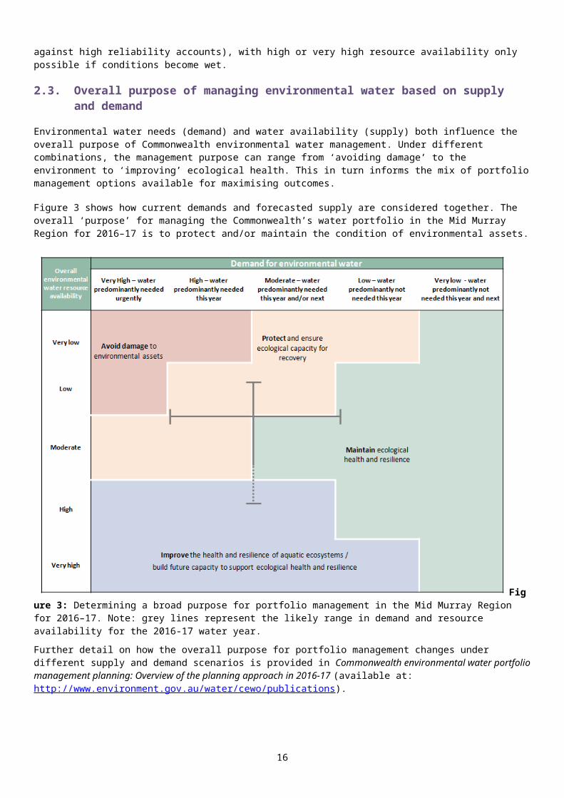
Table 3a: Environmental demands, priority for watering in 2016–17 and outlook for coming years in the Mid Murray Region - LOW-MODERATE WATER RESOURCE AVAILABILITY IN 2016–17
Environmental assets
Indicative demand(for all sources of water in the system)
Watering history(from all sources of
water)
2016–17 Implications for future demands
Predominant urgency of environmental demand for water
Purpose under
moderate resource
availability
Potential Commonwealth environmental water contribution?
Likely urgency of demand in 2017–18 if watering occurred as planned in
2016-17
2018–19Range of
likely demand
Met in 2017–18
Flow/volumeRequired frequency (maximum
dry interval)
2013–14
2014–15
2015–16
(mod) (drying)
(dry) Not met in 2017–18
River Murray from Hume Dam to Euston and Barmah Millewa Forest1
2,000-4,000 ML/d @ Yarrawonga Weir throughout year for fish habitat availability and water quality
Continuous requirement Moderate Maintain
High likelihood of being met via a combination of natural flows, consumptive deliveries and environmental water
ModerateModerate
High
12,000 ML/day @ Yarrawonga Weir for at least 7 days and up to 70 days in winter/spring targeting in-channel outcomes and anabranches
4 in 5 years (4 years)
Moderate Maintain
High likelihood of being met via a combination of natural flows, consumptive deliveries and environmental water. Even without overbank flows, some Commonwealth environmental water may be delivered to low-lying creeks and anabranches for drought refuge
Moderate
Low
Moderate
16,000 ML/day @ Yarrawonga Weir for at least 7 days and up to 100-150 days in winter/spring targeting in-channel outcomes and giant rush wetlands
1 in 2-3 years (5-6 years) Moderate Maintain
Likelihood of being met via a combination of natural flows, consumptive deliveries and environmental water (Commonwealth environmental water deliveries limited to flow rates that manage third party impacts)
Low-Moderate
Low
Moderate
25,000-35,000 ML/day @ Yarrawonga Weir (unregulated flow) for at least 7 days (river red gum forest) and followed by 15,000 ML/day flows for three to five months targeting moira grass plain
2-3 in 5 years (6 years) for river red gums
Annual (2 years) for moira grass
20% of Millewa (3 mo); 6-10% of Barmah (1-3 mo)
Flows of sufficient magnitude and duration required to maintain the extent of moira grass
in both Barmah and Millewa forestsProtect
Requires significant natural flow trigger, with Commonwealth environmental water contribution limited to recession component. Note operational challenges identified in Attachment C.
ModerateModerate
High
Edward-Wakool River System5
(further detail on Edward-Wakool sites is provided at Attachment D)
Permanent waterways Annual
Moderate MaintainA high potential for environmental water to contribute to this action to continue system recovery and support native fish communities
ModerateModerate
High
Ephemeral waterways and wetlands
1 in 2 years (3 years) for aquatic vegetation and water quality
Moderate MaintainLikely to be watered in partnership with NSW OEH to contribute to improving riparian health and water quality.
ModerateModerate
Moderate
Forests2-3 in 5 years (6 years) for river red gums
Potentially high for Weirai Forest, which (unlike Barmah-Millewa or Koondrook-Perricoota forests) has not received
environmental water or significant inundation for some time.
ProtectMore extensive watering could be considered, subject to operational delivery infrastructure, third party impacts and return flows being addressed
ModerateLow
High
Gunbower Creek2
Winter low flow and summer ramp down to support juvenile fish and maintain habitat connectivity during off-irrigation season: Winter base flow (up to
400 ML/day @Gunbower weir for 90 days). Net use ~8,000 ML
Annually (1 year)
Mag
nitu
de re
ache
d bu
t not
for f
ull
dura
tion
Base flow of sufficient magnitude and duration urgently required for maintaining Murray cod
populationProtect A high potential to support native fish
communities High
High
Critical
Spring pulse and stable summer flows for fish breeding: Base-flow of up to
550 ML/day in Spring Single fresh up to 700
ML/d for 120 days in spring/summer
Summer ramp down up to 300 ML/d for 60 days in summer/autumn.
Net use ~ 17,000 ML
Fish spawning fresh 2 in 3 years
Base
flow
met
. Fre
sh
mag
nitu
de re
ache
d bu
t not
fo
r ful
l dur
atio
n
Significant watering action in 2014-15 and 2015-16 inundated various wetlands in Gunbower Forest via Gunbower Creek,
however elevated flows within the creek are required to support native fish spawning to
maintain the diversity and condition of small and large-bodied native fish populations
Maintain A high potential to support native fish communities Moderate
Moderate
High
Gunbower-Koondrook-
Small-moderate action(25,000 ML/day @ Torrumbarry Weir for at least
6-9 in 10 years (2 years) Gu
nbo
wer Gu
nbo
wer
–
Significant watering action in 2014-15 and 2015-16 inundated various wetlands in
Gunbower Forest. A drying phase across the Maintain
If required, it is anticipated that demands in Gunbower Forest will be met primarily by other water holders in 2016-17. However, a
Moderate – following proposed drying for
Gunbower Forest in 2016-17 Low
16

Environmental assets
Indicative demand(for all sources of water in the system)
Watering history(from all sources of
water)
2016–17 Implications for future demands
Predominant urgency of environmental demand for water
Purpose under
moderate resource
availability
Potential Commonwealth environmental water contribution?
Likely urgency of demand in 2017–18 if watering occurred as planned in
2016-17
2018–19Range of
likely demand
Met in 2017–18
Flow/volumeRequired frequency (maximum
dry interval)
2013–14
2014–15
2015–16
(mod) (drying)
(dry) Not met in 2017–18
Perricoota Forest3
20 days and up to 150 days in winter/spring) targeting semi-permanent wetlands, or: ~3,000 ha via Gunbower
Forest infrastructure. (Targeted permanent wetland use 2016-17 limited to ~ 3,000 ML)
~8,000 ha via Koondrook-Perricoota Forest infrastructure
~3,0
00
ha
inun
dat
ed
majority of the floodplain is planned for 2016-17, with the exception of high value,
permanent wetlands
drying phase across the majority of the floodplain is likely for 2016-17.
(unless a natural event occurs to allow
‘piggybacking’ of environmental water)
Moderate
Koon
droo
k-Pe
rrico
ota
Koon
droo
k-Pe
rrico
ota
Site requires further water for continued recovery from drought
Commonwealth environmental water may be used in this area subject to potential third party impacts being resolved. If watering proceeds it is anticipated that demands in Koondrook-Perricoota Forest will be met in partnership with other water holders.
Moderate
Moderate
High
Infrastructure delivery to Gunbower and Koondrook-Perricoota Forests targeting river red gum forest equivalent to around 27-35,000 ML/day @ Torrumbarry, or: Up to 4,000 ha via
Gunbower Forest infrastructure
Up to 16,000 ha via Koondrook-Perricoota Forest infrastructure
1 in 3-4 years (3 years)
Gunb
ower
Gunb
ower
–~3
,000
ha
inun
date
d
As above
Maintain
As per small Gunbower option above.
Moderate – following proposed drying for
Gunbower Forest in 2016-17 (unless a natural event
occurs to allow ‘piggybacking’ of
environmental water)
Low
Moderate
Koon
droo
k-Pe
rrico
ota
Koon
droo
k-Pe
rrico
ota
As above As per small Koondrook-Perricoota option above. Moderate
Moderate
High
Mid Murray Off-Channel Wetlands and ephemeral creeks Hume to Euston4
Infrastructure delivery targeting permanent off-channel wetlands Annually
Requirement for water to manage salinity to provide suitable habitat for threatened species, such as the Murray hardyhead Protect
Commonwealth environmental water may be provided, along with water supplied by other water holders. For example, a commitment has been made to provide water for Norman’s Lagoon, near Albury.
HighHigh
CriticalInfrastructure delivery targeting semi-Permanent2 off-channel wetlands
3-7 in 10 years (5 years)
Requirement for water at some sites to support waterbirds and flora / fauna typical of
a deepwater marsh, while other sites are ready for a drying phase.
Maintain LowLow
Moderate
Infrastructure delivery targeting ephemeral off-channel wetlands
1 in 5 years
Water delivered to most ephemeral Central Murray Wetlands in previous years and
drawdown / drying phases are ensuing in some wetlands. Top up flows / partial fills may
be provided, subject to water availability. Maintain Low
Low
Moderate1. Murray and Barmah-Millewa Forest indicators adapted from Department of the Environment (2011a), MDBA (2012d), MDBA (2012g) and DPI Fisheries 20162. Sourced from North Central CMA (2013; 2014b; 2015b; 2016b). 3. Adapted from MDBA (2012c), MDBA 2012 (f), Department of the Environment (2011d) 4. Sourced from North Central CMA (2014a; 2015a; 2016a).5. Compiled using a number of sources (Hale & SKM 2011; Watts et al 2013; Watts et al 2014; Webster 2010). Previous watering actions and their outcomes have also been used for all indicators
Carryover potential
A minimum carryover target of 200 GL for the Southern-connected Basin is being reserved to meet early season
water requirements across in 2017-18 (See Section 2.6)
- -
Trade potential
Potential for purchases to augment water for the environment in a number of catchments in the Northern Murray-Darling Basin to meet high environmental water demands. Further information will be provided to the market ahead of any trade of Commonwealth environmental water. Transfer of allocations between catchments in the southern-connected Basin would be explored as the preferred option to allocation purchase or sale, consistent with the rules identified in state water resource plans that apply to all water users.
17

Environmental assets
Indicative demand(for all sources of water in the system)
Watering history(from all sources of
water)
2016–17 Implications for future demands
Predominant urgency of environmental demand for water
Purpose under
moderate resource
availability
Potential Commonwealth environmental water contribution?
Likely urgency of demand in 2017–18 if watering occurred as planned in
2016-17
2018–19Range of
likely demand
Met in 2017–18
Flow/volumeRequired frequency (maximum
dry interval)
2013–14
2014–15
2015–16
(mod) (drying)
(dry) Not met in 2017–18
Key - events in previous yearsmeans demand was met by Commonwealth environmental water or any other source means demand was partially met by Commonwealth environmental water or any other source (may be used to indicate infrastructure assisted delivery)means water not provided (or not required)
Note that not all demands require water every year; drying phases are important for floodplains and temporary wetlands or streamsKey - potential watering in 2016-17
means a high priority for Commonwealth environmental watering (full or partial contribution, and subject to seasonal and operational considerations)means a secondary priority for Commonwealth environmental watering, likely to be met via other means (other water holders, or natural flows)means a low priority for Commonwealth environmental watering
Key - urgency of environmental demandsmeans critical demand i.e. urgent need for water in that particular year to manage risk of irretrievable loss or damagemeans high demand for water i.e. needed in that particular year means moderate demand for water i.e. water needed that particular year and/or nextmeans low demand for water i.e. water generally not needed that particular yearmeans very low demand for water i.e. water generally not needed that particular year or the following year
Note that demand is considered at a generalised scale; there may be specific requirements that are more or less urgent within the flow regime
18

Table 3b: Environmental demands, priority for watering in 2016–17 and outlook for coming years in the Mid Murray Region - HIGH WATER RESOURCE AVAILABILITY IN 2016–17
Environmental assets
Indicative demand(for all sources of water in the system)
Watering history(from all sources of
water)
2016–17 Implications for future demands
Predominant urgency of environmental demand for water
Purpose under high resource
availability
Potential Commonwealth environmental water contribution?
Likely urgency of demand in 2017–18 if watering occurred as planned in
2016-17
2018–19Range of
likely demand
Met in 2017–18
Flow/volumeRequired frequency (maximum
dry interval)
2013–14
2014–15
2015–16
(mod) (drying) (dry) Not met in 2017–18
River Murray from Hume Dam to Euston and Barmah Millewa Forest1
2,000-4,000 ML/d @ Yarrawonga Weir throughout year for fish habitat availability and water quality
Continuous requirement Moderate Improve
High likelihood of being met via a combination of natural flows, consumptive deliveries and environmental water
ModerateModerate
High
12,000 ML/day @ Yarrawonga Weir for at least 7 days and up to 70 days in winter/spring targeting in-channel outcomes and anabranches
4 in 5 years (4 years) Moderate Improve
High likelihood of being met via a combination of natural flows, consumptive deliveries and environmental water. Even without overbank flows, some Commonwealth environmental water may be delivered to low-lying creeks and anabranches fro drought refuge
Moderate
Low
Moderate
16,000 ML/day @ Yarrawonga Weir for at least 7 days and up to 100-150 days in winter/spring targeting in-channel outcomes and giant rush wetlands
1 in 2-3 years (5-6 years) Moderate Improve
High likelihood of being met via a combination of natural flows, consumptive deliveries and environmental water (Commonwealth environmental water deliveries limited to flow rates that manage third party impacts)
Low-Moderate
Low
Moderate
25,000-35,000 ML/day @ Yarrawonga Weir (unregulated flow) for at least 7 days (river red gum forest) and followed by 15,000 ML/day flows for three to five months targeting moira grass plain
2-3 in 5 years (6 years) for river red gums
Annual (2 years) for moira grass
20% of Millewa (3 mo); 6-10% of Barmah (1-3 mo)
HighFlows of sufficient magnitude and duration
required to maintain the extent of moira grass in both Barmah and Millewa forests
Improve
Requires significant natural flow trigger, with Commonwealth environmental water contribution limited to recession component. Note operational challenges identified in Attachment C.
ModerateModerate
High
Edward-Wakool River System5
Permanent waterways Annual Moderate ImproveCommonwealth environment water may be used to extend recession periods of high flow events and/or create multiple/longer pulses/freshes to increase flow variability.
ModerateModerate
High
Ephemeral waterways and wetlands
1 in 2 years (3 years) for aquatic vegetation and water quality
Moderate ImproveHigh likelihood of being met via a combination of natural flows, consumptive deliveries and environmental water
ModerateModerate
Moderate
Forests2-3 in 5 years (6 years) for river red gums
Potentially high for Weirai Forest, which (unlike Barmah-Millewa or Koondrook-Perricoota forests) has not received
environmental water or significant inundation for some time.
ImproveMore extensive watering could be considered, subject to operational delivery infrastructure, third party impacts and return flows being addressed
ModerateLow
Moderate-High
Gunbower Creek2
Winter low flow and summer ramp down to support juvenile fish and maintain habitat connectivity during off-irrigation season: Winter base flow (up to
400 ML/day @Gunbower weir for 90 days). Net use ~8,000 ML
Annually (1 year)
Mag
nitu
de re
ache
d bu
t not
for f
ull
dura
tion
High
Base flow of sufficient magnitude and duration urgently required for maintaining Murray cod
population
Protect A high potential to support native fish communities High
High
Critical
Spring pulse and stable summer flows for fish breeding: Base-flow of up to
550 ML/day in Spring Single fresh up to 700
ML/d for 120 days in spring/summer
Summer ramp down up to 300 ML/d for 60 days in summer/autumn.
Fish spawning fresh 2 in 3 years
Base
flow
met
. Fre
sh
mag
nitu
de re
ache
d bu
t no
t for
full
dura
tion
Significant watering action in 2014-15 and 2015-16 inundated various wetlands in Gunbower Forest via Gunbower Creek,
however elevated flows within the creek are required to support native fish spawning to
maintain the diversity and condition of small and large-bodied native fish populations
Maintain A high potential to support native fish communities Moderate
Moderate
High
Gunbower-Koondrook-
Small-moderate action(25,000 ML/day @ Torrumbarry Weir for at least
6-9 in 10 years (2 years) Gu
nbo
wer Gu
nbo
wer
–
Significant watering action in 2014-15 and 2015-16 inundated various wetlands in
Gunbower Forest. A drying phase across the
Improve If required, it is anticipated that demands in Gunbower Forest will be met primarily by other water holders in 2016-17. However, a
Moderate – following proposed drying for
Gunbower Forest in 2016-17
Low
19

Environmental assets
Indicative demand(for all sources of water in the system)
Watering history(from all sources of
water)
2016–17 Implications for future demands
Predominant urgency of environmental demand for water
Purpose under high resource
availability
Potential Commonwealth environmental water contribution?
Likely urgency of demand in 2017–18 if watering occurred as planned in
2016-17
2018–19Range of
likely demand
Met in 2017–18Flow/volume
Required frequency (maximum
dry interval)
2013–14
2014–15
2015–16
(mod) (drying) (dry) Not met in 2017–18
Perricoota Forest3
20 days and up to 150 days in winter/spring) targeting semi-permanent wetlands, or: ~3,000 ha via Gunbower
Forest infrastructure. (Targeted permanent wetland use 2016-17 limited to ~ 3,000 ML)
~8,000 ha via Koondrook-Perricoota Forest infrastructure
~3,0
00
ha
inun
dat
ed
majority of the floodplain is planned for 2016-17, with the exception of high value,
permanent wetlandsdrying phase across the majority of the floodplain is likely for 2016-17.
(unless a natural event occurs to allow
‘piggybacking’ of environmental water)
Moderate
Koon
droo
k-Pe
rrico
ota
Koon
droo
k-Pe
rrico
ota
Site requires further water for continued recovery from drought
Commonwealth environmental water may be used in this area subject to potential third party impacts being resolved. If watering proceeds it is anticipated that demands in Koondrook-Perricoota Forest will be met in partnership with other water holders.
Moderate-High
Moderate
High
Infrastructure delivery to Gunbower and Koondrook-Perricoota Forests targeting river red gum forest equivalent to around 27-35,000 ML/day @ Torrumbarry, or: Up to 4,000 ha via
Gunbower Forest infrastructure
Up to 16,000 ha via Koondrook-Perricoota Forest infrastructure
1 in 3-4 years (3 years)
Gunb
ower
Gunb
ower
–~3
,000
ha
inun
date
d
As above
Improve
As per small Gunbower option above.
Moderate – following proposed drying for
Gunbower Forest in 2016-17 (unless a natural event
occurs to allow ‘piggybacking’ of
environmental water)
Low
Moderate
Koon
droo
k-Pe
rrico
ota
Koon
droo
k-Pe
rrico
ota
As above As per small Koondrook-Perricoota option above. Moderate-High
Moderate
High
Mid Murray Off-Channel Wetlands and ephemeral creeks Hume to Euston4
Infrastructure delivery targeting permanent off-channel wetlands Annually
HighRequirement for water to manage salinity to
provide suitable habitat for threatened species, such as the Murray hardyhead
Protect
Commonwealth environmental water may be provided, along with water supplied by other water holders. For example, a commitment has been made to provide water for Norman’s Lagoon, near Albury.
HighHigh
CriticalInfrastructure delivery targeting semi-Permanent2 off-channel wetlands
3-7 in 10 years (5 years)
Requirement for water at some sites to support waterbirds and flora / fauna typical of
a deepwater marsh, while other sites are ready for a drying phase.
Maintain LowLow
Moderate
Infrastructure delivery targeting ephemeral off-channel wetlands 1 in 5 years
Water delivered to most ephemeral Central Murray Wetlands in previous years and
drawdown / drying phases are ensuing in some wetlands. Top up flows / partial fills may
be provided, subject to water availability.
Maintain LowLow
Moderate
1. Murray and Barmah-Millewa Forest indicators adapted from Department of the Environment (2011a), MDBA (2012d), MDBA (2012g) and DPI-Fisheries 2016 2. Sourced from North Central CMA (2013; 2014b; 2015b; 2016b). 3. Adapted from MDBA (2012c), MDBA 2012 (f), Department of the Environment (2011d) 4. Sourced from North Central CMA (2014a; 2015a; 2016a).5. Compiled using a number of sources (Hale & SKM 2011; MDBA 2012; Watts et al 2013; Watts et al 2014; Webster 2010). Previous watering actions and their outcomes have also been used for all indicators
Carryover potential
A minimum carryover target of 200 GL for the Southern-connected Basin is being reserved to meet early season
water requirements across in 2017-18 (See Section 2.6)
- -
Trade potential
Potential for purchases to augment water for the environment in a number of catchments in the Northern Murray-Darling Basin to meet high environmental water demands. Further
information will be provided to the market ahead of any trade of Commonwealth environmental water. Transfer of allocations between catchments in the southern-
connected Basin would be explored as the preferred option to allocation purchase or sale, consistent with the rules identified in state water resource plans that apply to all water
users.
20

Environmental assets
Indicative demand(for all sources of water in the system)
Watering history(from all sources of
water)
2016–17 Implications for future demands
Predominant urgency of environmental demand for water
Purpose under high resource
availability
Potential Commonwealth environmental water contribution?
Likely urgency of demand in 2017–18 if watering occurred as planned in
2016-17
2018–19Range of
likely demand
Met in 2017–18Flow/volume
Required frequency (maximum
dry interval)
2013–14
2014–15
2015–16
(mod) (drying) (dry) Not met in 2017–18
Key - events in previous yearsmeans demand was met by Commonwealth environmental water or any other source means demand was partially met by C ommonwealth environmental water or any other source (may be used to indicate infrastructure assisted delivery)means water not provided (or not required)
Note that not all demands require water every year; drying phases are important for floodplains and temporary wetlands or streamsKey - potential watering in 2016-17
means a high priority for Commonwealth environmental watering (full or partial contribution, and subject to seasonal and operational considerations)means a secondary priority for Commonwealth environmental watering, likely to be met via other means (other water holders, or natural flows)means a low priority for Commonwealth environmental watering
Key - urgency of environmental demandsmeans critical demand i.e. urgent need for water in that particular year to manage risk of irretrievable loss or damagemeans high demand for water i.e. needed in that particular year means moderate demand for water i.e. water needed that particular year and/or nextmeans low demand for water i.e. water generally not needed that particular yearmeans very low demand for water i.e. water generally not needed that particular year or the following year
Note that demand is considered at a generalised scale; there may be specific requirements that are more or less urgent within the flow regime
21

3. Next steps3.1. From planning to decision making
It is important to distinguish between planning and operational decision making. As shown in Figure 4, planning allows the Office to manage the environmental water portfolio in a holistic manner and is an exercise in developing a broad approach or intention, based on the key drivers (demand and supply).
Decision making throughout each year builds on the intention by considering in more detail the specific prevailing factors and additional factors such as costs, risks and constraints to water delivery and market conditions.
Figure 4: Planning and decision making for Commonwealth environmental water use
3.2. Further information
For further information on how the Office plans for water use, carryover and trade, please visit our web site http://www.environment.gov.au/water/cewo
Water use: www.environment.gov.au/topics/water/commonwealth-environmental-water-office/assessment-framework
Carryover: http://www.environment.gov.au/topics/water/commonwealth-environmental-water-office/portfolio-management/carryover
Trade: Discussion Paper – Trade of Commonwealth Environmental Water and Commonwealth Environmental Water Trading Framework: http://www.environment.gov.au/water/cewo/trade/trading-framework
22

BibliographyDepartment of Environment, Land, Water and Planning (2015) Long Term Watering Plan: Victorian Murray
Department of the Environment (2014), Monitoring and Evaluation Plan for the Edward-Wakool Selected Area, prepared by Charles Sturt University, New South Wales Trade and Investment, Murray Local Land Services, Monash University, Griffith University and New South Wales office of Environment and Heritage.
Department of Primary Industries — Fisheries (2016), Fish and flows in the Southern Murray-Darling Basin.
Hale, J and SKM (2011), Environmental Water Delivery: Edward-Wakool. Department of the Environment (2011a), Environmental Water Delivery: Yarrawonga to Tocumwal and Barmah Millewa, prepared by Ecological Associates and SKM, Commonwealth Environmental Water Office.
Department of the Environment (2011b), Environmental Water Delivery: Edward-Wakool System, prepared by SKM and Hale, J., Commonwealth Environmental Water Office.
Department of the Environment (2011c), Environmental Water Delivery: Gunbower Forest, prepared by SKM and Cooling, M., Commonwealth Environmental Water Office.
Department of the Environment (2011d), Environmental Water Delivery: Koondrook-Perricoota Forest, prepared by SKM and Hale, J., Commonwealth Environmental Water Office.
Hale, J and SKM (2011), Environmental Water Delivery: Edward-Wakool.
Harrington, B. and Hale, J. (2011), Ecological Character Description for the NSW Central Murray Forests Ramsar site. Report to the Department of Sustainability, Environment, Water, Population and Communities, Canberra.
MDBA—see Murray-Darling Basin Authority
Murray-Darling Basin Authority (2016), Basin environmental watering outlook for 2016–17
Murray-Darling Basin Authority (2014), Basin-wide environmental watering strategy
Murray-Darling Basin Authority (MDBA) (2013), Constraints Management Strategy
Murray-Darling Basin Authority (MDBA) (2012a), Assessment of environmental water requirements for the proposed Basin Plan: Barmah Millewa Forest
Murray-Darling Basin Authority (MDBA) (2012b), Assessment of environmental water requirements for the proposed Basin Plan: Edward-Wakool River System
Murray-Darling Basin Authority (MDBA) (2012c), Assessment of environmental water requirements for the proposed Basin Plan: Gunbower-Koondrook-Perricoota Forest
Murray-Darling Basin Authority (MDBA) (2012d), Barmah Millewa Forest Environmental Water Management Plan
Murray-Darling Basin Authority (MDBA) (2012e), Gunbower Forest Environmental Water Management Plan
Murray-Darling Basin Authority (MDBA) (2012f), Koondrook-Perricoota Forest Environmental Water Management Plan
New South Wales Murray and Lower Darling Regulated Rivers Water Sources 2003 (NSW)23

North Central Catchment Management Authority (2013), Seasonal Watering Proposal for Gunbower Forest and Gunbower Creek 2013-14. North Central Catchment Management Authority, Huntly, Victoria.
North Central Catchment Management Authority (2014a), Seasonal Watering Proposal for the Central Murray Wetland Complex 2014–15. North Central Catchment Management Authority, Huntly, Victoria.
North Central Catchment Management Authority (2014b), Seasonal Watering Proposal for Gunbower Forest and Gunbower Creek 2014–15. North Central Catchment Management Authority, Huntly, Victoria.
North Central Catchment Management Authority (2015a), Seasonal Watering Proposal for the Central Murray Wetland Complex 2015–16. North Central Catchment Management Authority, Huntly, Victoria.
North Central Catchment Management Authority (2015b), Seasonal Watering Proposal for Gunbower Forest and Gunbower Creek 2015–16. North Central Catchment Management Authority, Huntly, Victoria.
North Central Catchment Management Authority (2016a), Seasonal Watering Proposal for the Central Murray Wetland Complex 2016–17. North Central Catchment Management Authority, Huntly, Victoria.
North Central Catchment Management Authority (2016b), Seasonal Watering Proposal for Gunbower Forest and Gunbower Creek 2016–17. North Central Catchment Management Authority, Huntly, Victoria.
Watts, R.J., McCasker, N., Baumgartner, L., Bowen, P., Burns, A. , Conallin, A., Dyer, J.G., Grace, M., Healy, S., Howitt, J.A., Kopf, R.K., Wassens, S., Watkins, S., Wooden I. (2013). Monitoring the ecosystem responses to Commonwealth environmental water delivered to the Edward-Wakool river system, 2012–13. Institute for Land, Water and Society, Charles Sturt University, Final Report. Prepared for Commonwealth Environmental Water.
Watts, R.J., McCasker, N., Thiem, J., Howitt, J.A., Grace, M., Healy, S., Kopf, R.K., Dyer, J.G. Conallin, A., Wooden I., Baumgartner L., Bowen P. (2014). Monitoring the ecosystem responses to Commonwealth environmental water delivered to the Edward-Wakool river system, 2013-14. Institute for Land, Water and Society, Charles Sturt University, Final Report. Prepared for Commonwealth Environmental Water.
Webster, R (2010), Environmental Monitoring of Werai Forest Environmental Flow.
24

Attachment A – Expected outcomes from the Basin-wide environmental watering strategyExpected outcomes from the Basin-wide Environmental Watering Strategy (MDBA 2014) that are relevant to the Mid Murray are described below.
RIVER FLOWS AND CONNECTIVITYBaseflows are at least 60 per cent of the natural levelContributing to a 30 per cent overall increase in flows in the River MurrayA 30–60 per cent increase in the frequency of freshes, bankfull and lowland floodplain flowsVEGETATION Maintain the current extent of water-dependent vegetation near river channels and on low-lying areas of the floodplain. Improve condition of black box, river red gum and lignum shrublandsImproved recruitment of trees within black box and river red gum communitiesIncreased periods of growth for non-woody vegetation communities that closely fringe or occur within the river and creek channels, and those that form extensive stands within wetlands and low-lying floodplains including Moira grasslands in Barmah–Millewa Forest.Vegetation extent
Region Area of river red gum (ha)
Area of black
box (ha)
Area of coolibah (ha)
Shrublands Non–woody water dependent vegetation
Murray (assessmen
t is for entire Murray
catchment)
90,600* 41,700* - Lignum along the Murray River from the junction with the Wakool River to downstream of Lock 3, including Chowilla and Hattah Lakes
Closely fringing or occurring within the Murray, Edward, Kiewa, Mitta Mitta, Niemur and Wakool rivers and Tuppal Creek;Moira grasslands in the Barmah–Millewa Forest
Black box conditionRegion Vegetation condition score Percent of
vegetation assessed (within the
managed floodplain)0 –6 >6 –10
Murray (assessment is for entire Murray
catchment)33 per cent 65 per cent 28 per cent
River red gum condition Region Vegetation condition score Percent of
vegetation assessed (within the
managed floodplain)0 – 2 >2 – 4 >4 – 6 >6 – 8 >8 – 10
Murray (assessment is
for entire
2 per cent
1 per cent
10 per cent
51 per cent
35 per cent
51 per cent
25

Region Vegetation condition score Percent of vegetation assessed
(within the managed floodplain)
0 – 2 >2 – 4 >4 – 6 >6 – 8 >8 – 10Murray
catchment)
26

WATERBIRDSMaintain current species diversityIncrease Basin-wide abundance of waterbirds by 20–25 per cent by 2024A 30–40 per cent increase in nests and broods (Basin-wide) for other waterbirdsUp to 50 per cent more breeding events (Basin-wide) for colonial nesting waterbird speciesImportant Basin environmental assets for waterbirds in the Mid-Murray
Environmental assetTotal
abundance and
diversity
Drought refuge
Colonial waterbird breeding
Shorebird abundanc
e
In scope for C’th
watering
Gunbower–Koondrook–Perricoota * Yes
Kerang wetlands * Yes
Barmah–Millewa * * Yes
FISHNo loss of native speciesImproved population structure of key species through regular recruitment, including Short-lived species with distribution and abundance at pre-2007 levels and breeding success
every 1–2 years Moderate to long-lived with a spread of age classes and annual recruitment in at least 80 per
cent of yearsIncreased movements of key speciesExpanded distribution of key species and populationsKey species for the Mid-Murray Species Specific outcomes In-scope for
C’th water in the Mid Murray?
Flathead galaxias (Galaxias rostratus)
Expand the core range in the wetlands of the River Murray.
Yes
Freshwater catfish (Tandanus tandanus)
Expand the core range in Columbo-Billabong Creek and Wakool system
Yes
Golden Perch (Macquaria ambigua)
A 10–15 per cent increase of mature fish (of legal take size) in key populations
Yes
Murray cod (Maccullochella peelii peelii)
A 10–15 per cent increase of mature fish (of legal take size) in key populations
Yes
Murray hardyhead (Craterocephalus fluviatilis)
Expand the range of at least two current populations. Establish 3–4 additional populations, with at least one in the mid-Murray conservation unit.
Yes
Olive perchlet (Ambassis agassizii)
Olive perchlet are considered extinct in the southern Basin. Reintroduction using northern populations is the main option for recovery. Candidate sites may result from improved flow that reinstates suitable habitat
Restoration of flow to River Murray could support the future
27

Species Specific outcomes In-scope for C’th water in the Mid Murray?
in the River Murray. reintroduction of the species.
River blackfish (Gadopsis marmoratus)
Expand the range of current populations from the Mulwala canal
Yes
Silver perch (Bidyanus bidyanus)
Expand the core range within the River Murray (Yarrawonga–Euston)
Yes
Southern purple-spotted gudgeon (Mogurnda adspersa)
- Yes
Southern pygmy perch (Nannoperca australis)
Expand the range of current populations at Barmah-Millewa and other mid-Murray wetlands
Yes
Trout cod (Maccullochella macquariensis)
Expand the range of trout cod up the Murray upstream of Lake Mulwala and into the Kiewa River. For the connected population of the Murrumbidgee–Murray–Edwards: continue downstream expansion.
Yes
Two-spined blackfish (Gadopsis bispinosus)
Establish additional populations (no specific locations identified)
Yes
Important Basin environmental assets for native fish in the Mid-Murray
Environmental asset
Key
mov
emen
t co
rrid
ors
Hig
h Bi
odiv
ersi
ty
Site
of o
ther
Si
gnifi
canc
e
Key
site
of
hydr
odyn
amic
di
vers
ity
Thre
aten
ed
spec
ies
Dry
per
iod
/ dr
ough
t re
fuge
In-s
cope
for
C’th
w
ater
Koondrook–Perricoota * * * * * Yes
Gunbower * * * * * Yes
Barmah–Millewa * * * * * * Yes
Edward–Wakool system * * * * Yes
Werai Forest * * Yes
Billabong–Yanco–Columbo Creeks * * * * * Yes
Lake Mulwala * * * * * Yes
28

Attachment B – Library of watering actionsOperational considerations in the Mid Murray Region
The delivery of environmental water in the Mid–Murray is currently constrained by the release capacities from storages, channel capacities and system constraints. Relevant constraints to be considered include:
To avoid unseasonal inundation of Barmah Millewa Forest during summer, delivery through the Barmah Choke is limited to approximately 10 300 ML/day (downstream of Yarrawonga).
The delivery of Commonwealth environmental water in the Mid-Murray is affected by constraints in the tributaries of the Mid Murray, particularly the Goulburn River. Releases on major tributaries (to avoid unacceptable third party impacts) may limit the delivery of water to sites in the Mid-Murray Region.
Channel capacity may limit the delivery of Commonwealth environmental water in certain parts of the Mid Murray Region. On the River Murray main channel there are various flow constraints to avoid the inundation of property and privately owned infrastructure. At Deniliquin flows in the Edward River above 17 100 ML/day result in minor flood events (MDBA 2013).
Further information about constraints in the Mid Murray Region can be found in the Water Sharing Plan for the New South Wales Murray and Lower Darling Regulated Rivers Water Sources 2003 (NSW) (pt 10 cl 51) and Constraints Management Strategy 2013 to 2024 (MDBA 2013).
Operational considerations such as constraints and risks will differ depending on the inflow scenario. Throughout the year operational and management considerations will be addressed as decisions are taken to make water available for use and as these decisions are implemented. This will include refining the ecological objectives, assessing operational feasibility and potential risks and the ongoing monitoring of the seasonal outlook and river conditions.
Potential watering actions under different levels of water resource availability
Under certain levels of water resource availability, watering actions may not be pursued for a variety of reasons, including that environmental demand may be met by unregulated flows and that constraints and/or risks may limit the availability to deliver environmental water. Table 4 identifies the range of potential watering actions in the Mid Murray and the levels of water resource availability that relate to these actions.
29

Table 4: Summary of potential watering actions for the Mid Murray Region
Environmental Asset Indicative demand
Applicable level(s) of resource availability
Very Low Low Moderate High Very High
River Murray from Hume Dam to Euston
12 000 ML/day @ Yarrawonga Weir for at least 7 days and up to 70 days in winter/spring targeting in-channel outcomes and anabranches 16 000 ML/day @ Yarrawonga Weir for at least 7 days and up to 100-150 days in winter/spring targeting in-channel outcomes, giant rush wetlands
1. Mid River Murray Channel Flow: Contribute to in-stream flows to promote fish movement, condition, spawning and recruitment of flow specialist and floodplain fish species and to re-connect river with low-lying wetlands (including giant rush), subject to appropriate trigger.
Barmah Millewa Forest
25-35 000 ML/day @ Yarrawonga Weir (unregulated flow) for at least 7 days (river red gum forest) and followed by 15 000 ML/day flows for three to five months targeting floodplain marshland
2. Barmah Millewa Forest Flow: Contribute to an overbank flow (15,000-18,000 ML/day following large unregulated peak) to inundate up to 24,000ha of floodplain marshland and river red gum; to promote fish movement, condition, spawning and recruitment of some fish species (flow and floodplain specialists); and to support completion of naturally triggered bird breeding events.
Edward-Wakool River System
Permanent waterways 3a. To maintain in-stream habitat, particularly aquatic vegetation and areas supporting the various life stages of native fish. Environmental water use is most likely to contribute to in-channel base flows and freshes. It may also be used to provide a more gradual recession to periods of high flow (e.g. rain rejection flows) and improve water quality.
Ephemeral waterways and wetlands 3b. To maintain ephemeral in-stream and wetland habitat, particularly water quality, aquatic vegetation and areas supporting the various life stages of native fish, frogs, birds and aquatic invertebrates.
Forests 3c. To maintain vegetation health and to contribute to hydrological connectivity and nutrient/carbon cycling processes
Gunbower Creek Winter base flow of up to 400 ML/day for 90 days and summer / autumn ramp down 300 ML/d for 60 daysSpring pulse and stable summer flows for fish breeding: Baseflow of up to 550 ML/day in spring Single fresh up to 700 ML/day for 120
days in spring/summer
4. Gunbower Creek Channel flow: Contribute to in-stream flows to support the survival and condition of juvenile fish and stimulate lateral movement of large-bodied, native fish, aquatic invertebrates and carbon between Gunbower Creek and Gunbower Forest.
Gunbower- Small-moderate action (25 000 ML/day @ 5. Gunbower-Koondrook-Perricoota Forest Overbank Flow:
30

Environmental Asset Indicative demand
Applicable level(s) of resource availability
Very Low Low Moderate High Very High
Koondrook-Perricoota Forest
Torrumbarry Weir for at least 20 days and up to 150 days in winter/spring) targeting semi-permanent wetlands, or: ~3 000 ha via Gunbower Forest
infrastructure ~8 000 ha via Koondrook-Perricoota
Forest infrastructure
Infrastructure delivery to Gunbower and Koondrook-Perricoota Forests targeting river red gum forest equivalent to around 27,000-35 000 ML/day @ Torrumbarry Weir, or: Up to 4 000 ha via Gunbower Forest
infrastructure Up to 16 000 ha via Koondrook-
Perricoota Forest infrastructure
Contribute to overbank flows to re-connect river with semi-permanent wetlands in Gunbower and Koondrook-Perricoota Forests
6. Gunbower Forest Flow: Deliver water to inundate river red gum forest; support survival, condition and spawning of native fish (floodplain specialists) and/or supporting the completion of a bird breeding event.7. Koondrook-Perricoota Forest Flow: Use infrastructure to provide flows to inundate river red gum forest, support bird breeding and/or support survival, condition and spawning of native fish (floodplain specialists).
Mid Murray Off-Channel Wetlands Hume to Euston
Permanent Wetlands 8. Water a range of annual, semi-annual, intermittent Mid Murray wetlands across all scenarios, subject to seasonal cues.Semi-Permanent Wetlands
Ephemeral Wetlands
Note: Under certain resource availabilities, options may not be pursued for a variety of reasons including that environmental demand may be met by unregulated flows and that constraints and/or risks may limit the ability the deliver environmental water.
31

Potential watering actions – standard operating arrangements
Table 4 above identifies the range of potential watering actions in the Mid Murray Region that give effect to the long-term demands and flow regime identified as being in scope for the Office to contribute environmental water to in any given year. The standard considerations associated with these actions are set out below.
A note on approvals: watering actions in the Mid Murray would be implemented with local delivery partners, who will play a key role in engaging with the local community and third parties and implementing the event. As some actions may be constrained by other demands in the system, the Office will seek advice from river operators on the timing, magnitude and duration of a proposed event.
Watering actions 1, 2 and 5: Mid River Murray channel flow; Barmah-Millewa Forest Flow; and Gunbower-Koondrook-Perricoota Forest high flow (within constraints)
Standard operational considerations
In-stream environmental watering seeks to target improved seasonality of flows to promote spawning of flow specialist fish species and to re-connect river with low-lying wetlands. As such, an action will generally be in response to an appropriate flow triggers, such as rainfall events and flows upstream of Hume Dam and in tributaries (e.g. Ovens, Kiewa, Goulburn and Murrumbidgee rivers).
Larger channel flows will naturally enter creeks and anabranches, low lying wetlands (e.g. Coppingers Lagoon, Duck Lagoon Douglas Swamp, Boals-Deadwoods, St Helena Swamp, Black Swamp, Walthours Swamp, Moira Lake, Barmah Lake and Gulpa Creek Complex). In some cases infrastructure may be used to provide flow conditions for fish outcomes (e.g using Mary Ada regulator to provide flows for native fish in Toupna Creek).
Barmah Millewa Forest:
- To create significant flows into Barmah Millewa Forest, significant natural flows are required, with Commonwealth environmental water only provided to extend the duration of flows once the flow rate recedes to a level that does not create unacceptable third party impacts. Regulators may be opened or closed on either side to influence the extent and duration of flows into Barmah and Millewa forests.
- The action would typically occur during winter or spring, consistent with natural seasonality. From December to May, flows downstream of Yarrawonga Weir are managed below 10 300 ML/day to avoid unseasonal inundation of Barmah Millewa Forest.
- Flows above 10 300 ML/day enter anabranches and creeks in Millewa Forest that connect with the Edward-Wakool system. Flows are also managed at Yarrawonga Weir to avoid third party impacts in the Edward-Wakool system.
- With other factors influencing the extent of moira grassland, complementary natural resource management activities will be important if Commonwealth environmental water is to be provided to extend Barmah Millewa Forest flows, such as managing the encroachment by river red gums and grazing by vertebrate pests.
Gunbower-Koondrook Pericoota Forest:
- Environmental water may be contributed to channel flows to connect the River Murray with Gunbower and Koondrook-Perricoota forests.
- A suitable flow trigger is required for environmental water to piggy-back on and resource availability may often be a limiting factor. The action would likely occur as part of a multi-site connected flow action through the Mid-Murray.
32

- The use of Commonwealth environmental water in Koondrook-Perricoota Forest will depend on necessary State approvals being in place and an assessment of risks including, but not limited to, water quality issues and potential third party impacts.
Environmental water delivery may be constrained by other demands on the system, especially during irrigation season, and capacity to release and coordinate releases from multiple storages.
Typical extent:
Flow rates will be dependent on flow conditions, target outcomes and the operational considerations described above. Releases from Hume Dam will have most impact (in terms of flow variability) on flows in the upper Mid-Murray channel (from Hume to the Barmah Choke). Significantly influencing flow variability in the River Murray downstream of the Barmah Choke requires coordination of water delivery from other tributaries (e.g. the Goulburn and Murrumbidgee rivers).
In Barmah Millewa Forest, the extent would generally be sufficient in terms of magnitude (initial unregulated trigger of at least 20 000-25 000 ML/day) and duration (at least three months) to water large areas of moira grass plain and allow the grass to complete its flowering. Less frequently, and following a larger unregulated trigger, flows may inundate broader areas of river red gum forest. This action may also contribute to outcomes in the Edward-Wakool system (Action 3).
For Gunbower Forest, the extent will be limited to low-lying anabranches and semi-permanent wetlands to avoid unacceptable third party impacts. Natural events or actions 6 and 7 below are required to achieve broader inundation.
For Koondrook-Perricoota Forest the extent will be determined by the watering scenario agreed to by the site manager and water holders.
Watering action 3a, b and c: Edward-Wakool River system
Standard operational considerations
Water NSW is responsible for managing flows in the Edward-Wakool River system, which is highly regulated. Depending on the location and purpose of the action, water may also be sourced from either Murray Irrigation and/or private landholder irrigation infrastructure. Commonwealth environmental water may be delivered in combination with natural, consumptive or other held or planned environment water.
Forest and ephemeral waterway actions will be timed for winter/spring and late autumn to minimise the risk of hypoxic blackwater impacts.
Planning for actions will take into consideration the potential impacts of inundating areas that have acid sulphate soils and/or deep pools that may result in the movement of salt.
During the irrigation off-season (winter) regulating/irrigation systems are shut down and limit the ability to provide environmental flows at that time.
Typical extent: Flows will be delivered within constraints, unless otherwise agreed with potentially impacted landholders and state government agencies.
33

Watering actions 4 and 6: Gunbower Creek channel flow and Gunbower Forest Flow
Standard operational considerations Environmental water can be delivered to Gunbower Creek in combination with consumptive
flows to the Torrumbarry Irrigation Area. Water levels in Gunbower Creek are largely driven by irrigation demand. Commonwealth environmental water will be used to account for the losses associated with the delivery of consumptive water en route through Gunbower Creek.
High flows in the creek can also be used to push water into Gunbower Forest using the Hipwell Road regulator. The fully regulated nature of Gunbower Creek however means there is little application of the ‘natural’ hydrographs form planning environmental flows in Gunbower Creek.
When delivering water during the irrigation season, the environment shares the capacity of Gunbower Creek with irrigation flows. As such, there is potential for system capacity constraints to interrupt the supply of environmental water to Gunbower Forest.
Unless otherwise agreed, Commonwealth environmental water will not be used to contribute to flow rates above 700 ML/day at Cohuna Weir to avoid unplanned inundation of private land.
A number of planned infrastructure works are scheduled out to 2017-18 that will require Gunbower Creek winter water levels to be lowered. The combination of these works have the potential to impact the ability to fully deliver winter base flows in 2016-17 and 2017-18, and therefore present a possible threat to the vulnerable native fish population in Gunbower Creek.
Typical extent: In-channel flows through to inundation of up to 4 800 ha of river red gum forest Watering action 7: Koondrook-Perricoota Forest via infrastructure works Standard operational considerations: Commonwealth environmental water provided to Wakool River-Yallakool Creek (in the Edward–
Wakool system) may assist with managing outflows from Koondrook-Perricoota Forest into the Wakool River.
Water would be delivered to Koondrook–Perricoota Forest via the Torrumbarry Weir pool and inundation managed using a series of regulators. Outfalls to the Wakool River may need to be managed to prevent third party impacts and water quality issues.
Typical extent: To be determined by the watering scenario agreed to by the site manager and water holders. The 2014-15 watering event used 26.3GL to inundated 4 500ha of creeklines, wetlands and low lying forest areas. Up to 16 000ha of the Koondrook-Perricoota can be inundated under a maximum event size. More likely to be in the range of 6 700 – 8 000ha. Watering action 8: Mid Murray off-channel wetlands - Hume to EustonStandard operational considerations The Mid Murray wetlands are scattered along the River Murray on the New South Wales side,
while almost wholly contained within the Torrumbarry Irrigation Region in Victoria. Many of the wetlands are now cut-off from natural inundation and are reliant on the managed delivery of environmental water.
The delivery of environmental water to these wetlands is constrained by a number of factors such as restrictions to delivery outlets and channel capacity.
Multiple wetlands having similar watering regimes and requiring water at the same time results in competition for resource availability, particularly in drier years. Prioritisation and ultimately trade-off decisions may be required during low resource availability periods.
As most of the Midl Murray wetlands in Victoria are now managed to maintain permanent or semi-permanent saline water habitats, the decision to provide environmental water may not only relate to lake levels, but also active management of salinity concentrations conducive to salt-tolerant species.
Typical extent: Individual wetland sites in the Mid Murray region, from Hume Dam to Euston.
34

Attachment C – Long-term water availabilityCommonwealth environmental water holdings
The Commonwealth holds the following entitlements in the Mid Murray Region: NSW Murray High Security NSW Murray General Security NSW Murray Conveyance NSW Murray Supplementary Victorian Murray High Reliability Victorian Murray Low Reliability
In addition the Commonwealth holds entitlements in the Southern-connected Basin that can be used to delivery environmental water to the Mid Murray Region. The full list of Commonwealth environmental water holdings can be found at www.environment.gov.au/topics/water/commonwealth-environmental-water-office/about-commonwealth-environmental-water/how-much and is updated monthly.
Other sources of environmental water
Other potential sources of held environmental water that may be used to complement Commonwealth environmental water delivery in the Mid Murray Region include: Environmental Entitlement: The Living Murray Program – Murray Darling Basin Authority Environmental Entitlement: New South Wales – New South Wales Office of Environment and
Heritage Bulk Entitlement – Victorian Environmental Water Holder
Planned environmental water
In addition to water entitlements held by environmental water holders, environmental demands may also be met via natural or unregulated flows and water provided for the environment under rules in state water plans (referred to as ‘planned environmental water’). The Water Sharing Plan for the New South Wales Murray and Lower Darling Regulated Rivers Water Sources 2003 (NSW) establishes planned environmental water (pt 3, cl 15) relevant to the Mid-Murray Region. This includes: Barmah-Millewa Environmental Allowance:
o Provides an annual allocation of up to 150 GL (100 GL high security and 50 GL low security allocation). This water can be used to deliver flows to meet ecological objectives in the Barmah-Millewa Forest in accordance with specific rules.
o A maximum of 700 GL of water can be carried over from one water year to the next. Responsibility for the Barmah-Millewa Environmental Water Allowance is shared between NSW and Victoria. More information about this water allowance is available from the Barmah-Millewa Forest Environmental Water Management Plan(MDBA 2012e).
New South Wales Murray Regulated River Water Source Additional Environmental Allowance: o the maximum volume held is calculated as 0.15 ML multiplied by the total number of
regulated river (high security) unit shares
35

o releases of water from the Murray Regulated River Water Source Additional Environmental Allowance can be made for the purpose of contributing to any of the objectives (a) to (i) outlined in the Water Sharing Plan (Section 2, Clause 10).
36

Attachment D – Detailed Edward-Wakool indicatorsPriority for watering in 2016–17 in the Edward-Wakool system of the Mid Murray Region – LOW WATER RESOURCE AVAILABILITY IN 2016–17Note: A detailed assessment of the environmental water requirements, particularly at higher flow rates/levels, for environmental assets occurring along many of the tributaries in the Edward-Wakool system is yet to
be undertaken (i.e. Green 2001; Hale and SKM 2011; MDBA 2012). While the potential flows referred to below can be provided within current operational constraints (and with landholder agreement where required) they are mostly within channel flows that are unlikely to contribute to the watering needs of environmental assets that may require higher flow rates/levels (ie. overbank flow events).
Environmental assets
Broad objectives of flows
Potential flows (within constraints) that could contribute to meeting
demands (for all sources of water in the
system)
Required frequency (maximum
dry interval)
Watering history (from all sources of water) 2016-17
2009-10 2010-11
2011-12
2012–13 2013–14 2014–
152015–
16 Predominant urgency of environmental demand for
water
Purpose under LOW
resource availabilit
y
Potential Commonwealth environmental water
contribution?(drought)
(very wet) (wet) (wet) (moderate) (drying
) (dry)
Upper Wakool (above the confluence with Yallakool Creek
Maintenance of native fish habitatLongitudinal connectivityFish spawning and movementWater Quality
Base flows1 (~9 GL) from late winter till late Autumn1
1 in 1 (2 years)Very High
(prevent system from being cut off)
Avoid damage
Unlikely to be met by consumptive demands in a very dry year & in
such scenario flows may be used to prevent system from being cut off
Small events2 (~3-12 GL) in late winter to early summer1,2
2 in 3 (4 years)
Moderate.(protect River Blackfish) Protect Priority to continue ecosystem
recovery
Yallakool & Wakool (below the confluence with the Yallakool)
Maintenance of native fish habitat and instream aquatic vegetationLongitudinal connectivityFish spawning and movementNutrient cyclingWater Quality
Base flows1 (~51 GL) from late winter till late Autumn1
1 in 1 (2 years)Very High
(prevent system from being cut off)
Avoid damage
Likely to be met by consumptive demands except in a very dry year & in such scenario, may be use to prevent system from being cut off
Small events2 of ~30-60 GL in late winter to early summer1,2
2 in 3 (4 years)
Moderate.(protect large bodied native fish) Protect Priority to continue ecosystem
recovery
Pulse/Fresh in winter-spring or spring-summer with slow recession
As RequiredModerate.
(protect riparian & aquatic vegetation)
ProtectMay be used if there are no multi-site/return flow watering actions or
natural events.
Colligen/ Niemur
Maintenance of instream aquatic vegetation and native fish habitatLongitudinal connectivityFish movementNutrient cyclingWater Quality
Base flows (~51 GL) from late winter till late Autumn1
1 in 1 (2 years)Very High
(prevent system from being cut off)
Avoid damage
Likely to be met by consumptive demands except in a very dry year & in such scenario, may be use to prevent system from being cut off
Small events2 (~27-54 GL) in late winter to early summer1,2
2 in 3 (4 years)
Moderate(protect large bodied native fish) Protect
May be used to provide habitat flows such as those received in the
Yallakool in previous years.
Pulse/Fresh in winter-spring with slow recession As Required
Moderate(protect riparian & aquatic
vegetation)Protect May be used if these are no multi-
site or natural events.
Edward River
Flow variabilityLongitudinal connectivityFish spawning and movementNutrient cycling
Pulse/reverse pulse events aligned with River Operations, particularly Stevens Weir for outcomes D/S of the weir.
1 in 1 (2 years) Moderate.(protect flow variability) Protect
May be used if these are no multi-site, natural events or capacity to
manipulate operation flows en route to South Australia.
Ephemeral Streams (e.g. Tuppal, Merran & Little Merran Creeks)
Longitudinal connectivityWater QualityMaintenance of native animal habitat and instream aquatic vegetation
Small events1~6 GL a year in stream Winter/Spring/ Autumn events
1 in 2 (2 years)Moderate
(protect riparian vegtation & water quality)
Protect
Commonwealth environmental water may be used in these systems, depending on the
individual need. Sites may be more likely to be watered by NSW OEH.
Fringing Wetlands (e.g. Private wetlands on Colligen Creek)
As above Small site specific actions <10 GL Site specific Site Specific Protect
May be used in these systems, depending on the individual need.
Sites may be more likely to be watered by NSW OEH.
37

Werai ForestWater QualityMaintenance riparian vegetation
Small events of ~5 GL to provide drought relief and to flush accumulated organic matter from late Autumn to early Spring3
2-3 in 5 years (6 years) for
river red gumsHigh
(protect Ramsar characteristics) ProtectMay be used in this area,
depending on the need & ability to deliver water through existing
infrastructure.
Koondrook-Perricoota Forest
Water QualityMaintenance riparian vegetation
Commissioning event' used a total of 26.3GL over 58 days to inundate around 1500ha of forest, wetlands and creeks.
2-3 in 5 years (6 years) for
river red gums
Moderate(protect riparian vegetation &
water quality)Protect
May be used in this area, subject to potential third party impacts being
resolved.
Edward Wakool System - Winter Flows
Reinstatement of natural hydrograph for winter periodLongitudinal connectivityFish recruitment
Edward River – Subject to the management of Stevens Weir, provide base winter flow of ~ (~ 27 GL).
1 in 2 (2 years) Moderate(protect native fish recruitment) Protect
May be used subject to decisions by Water NSW in relation to the
operation of Stevens Weir and the Gulpa & Edward Offtakes over the
winter period
Yallakool Creek, Wakool River, Colligen Creek-Niemur River
1 in 2 (2 years) Moderate(protect native fish recruitment) Protect
May be used subject to decisions by Water NSW in relation to the
operation of Stevens Weir and the Gulpa & Edward Offtakes over the
winter period
Edward Wakool System – Recession Flows
Maintenance of instream aquatic vegetation and native fish habitat
~15GL within constraints to provide more natural recession flows off rain rejection and unregulated events in the system.2
As Required Moderate.(protect aquatic vegetation) Protect
May be used to manage flow recessions associated with natural
or rain-rejection events.
Edward Wakool System - Critical Habitat flows
Water quality Provision of refuges for native fish
~30 GL a year to manage hypoxic black water events and other critical habitat needs.2
As RequiredCritical
(provide refuge from poor water quality)
Avoid Damage Highest priority if triggers are met.
Key - events in previous years
means demand was met, by Commonwealth environmental water or any other source
means demand was partially met, by Commonwealth environmental water or any other source (may be used to indicate infrastructure assisted delivery) means water not provided (or not required) Note that not all demands require water every year, drying phases are important for floodplains and temporary wetlands or streams
Key - potential watering in 2016-17 means a high priority for Commonwealth environmental watering (full or partial contribution, and subject to seasonal and operational considerations)
means a secondary priority for Commonwealth environmental watering, likely to be met via other means (other water holders, or natural flows) means a low priority for Commonwealth environmental watering
Key - urgency of environmental demands means critical demand i.e. urgent need for water in that particular year to manage risk of irretrievable loss or damage means high demand for water i.e. needed in that particular year means moderate demand for water i.e. water needed that particular year and/or next means low demand for water i.e. water generally not needed that particular year means very low demand for water i.e. water generally not needed that particular year or the following year
Note that demand is considered at a generalised scale; there may be specific requirements that are more or less urgent within the flow regime
The information in this table was compiled using a number of sources (below). Where no specific information was available and/or where constraints excluded the recommended actions, previous water actions and their outcomes were used as a basis for developing watering options.
References: 1 Hale, J and SKM (2011), Environmental Water Delivery: Edward-Wakool. 2 Adapted from Watts et.al (2013), Monitoring the ecosystem responses to Commonwealth environmental water delivered to the Edward-Wakool river system, 2012-13 and Watts et.al (2014), Monitoring the ecosystem responses to Commonwealth environmental water delivered to the Edward-Wakool river system, 2013-14. Webster, R (2010), Environmental Monitoring of Werai Forest Environmental Flow, Green, D (2001), The Edward–Wakool system river regulation and environmental flows, unpublished report, NSW Department of Land and Water Conservation, Sydney, Harrington and Hale (2011) Ecological Character Description for the NSW Central Murray Forests Ramsar site.
38

39
Priority for watering in 2016–17 in the Edward-Wakool system of the Mid Murray Region - MODERATE WATER RESOURCE AVAILABILITY IN 2016–17Note: A detailed assessment of the environmental water requirements, particularly at higher flow rates/levels, for environmental assets occurring along many of the tributaries in the Edward-Wakool system is yet to
be undertaken (i.e. Green 2001; Hale and SKM 2011; MDBA 2012). While the potential flows referred to below can be provided within current operational constraints (and with landholder agreement where required) they are mostly within channel flows that are unlikely to contribute to the watering needs of environmental assets that may require higher flow rates/levels (ie. overbank flow events).
Environmental assets
Primary objective of flows
Indicative demand (for all sources of water in
the system)
Required frequency (maximum
dry interval)
Watering history (from all sources of water) 2016-17
2009-10 2010-11
2011-12
2012–13 2013–14 2014–
152015–
16Predominant urgency of
environmental demand for water
Purpose under
MODERATE
resource availabilit
y
Potential Commonwealth environmental water
contribution?(drought) (very wet) (wet) (wet) (moderate) (drying
) (dry)
Upper Wakool (above the confluence with Yallakool Creek
Maintenance of native fish habitat Longitudinal connectivityFish spawning and movementWater Quality
Base flows1 (~9 GL) from late winter till late Autumn1
1 in 1 (2 years)
Low(demand met by consumptive
flows)Maintain
Likely to be met by consumptive demands except in a very dry year & in such scenario may be used to prevent system from being cut off
Multiple or longer small events2 (~3-12 GL) in late winter to early summer1,2
2 in 3 (4 years)
Moderate(maintain River Blackfish) Maintain Priority to continue ecosystem
recovery
Yallakool & Wakool (below the confluence with the Yallakool)
Maintenance of native fish habitat and instream aquatic vegetationLongitudinal connectivityFish spawning and movementNutrient cyclingWater Quality
Base flows1 (~51 GL) from late winter till late Autumn1
1 in 1 (2 years)
Low(demand met by consumptive
flows)Maintain
Likely to be met by consumptive demands except in a very dry year & in such scenario may be use to prevent system from being cut off
Multiple or longer small events2 in late winter to early summer1,2
2 in 3 (4 years)
Moderate(maintain Silver & Golden Perch
and Murray Cod)Maintain Priority to continue ecosystem
recovery
Multiple or longer pulses/freshes in winter-spring or summer-autumn with slow recession
As RequiredModerate
(maintain native fish, riparian and aquatic vegetation)
MaintainMay be used if there are no multi-site/return flow watering actions or
natural events.
Colligen/ Niemur
Maintenance of instream aquatic vegetation and native fish habitatLongitudinal connectivityFish movementNutrient cyclingWater Quality
Base flows (~51 GL) from late winter till late Autumn1
1 in 1 (2 years)
Low(demand met by consumptive
flows)Maintain
Likely to be met by consumptive demands except in a very dry year & in such scenario may be use to prevent system from being cut off
Small events2 (~27-54 GL) in late winter to early summer1,2
2 in 3 (4 years)
Moderate(maintain native fish particularly
Murray Cod)Maintain
May be used to provide habitat flows such as those received in the
Yallakool in previous years.
Multiple or longer pulses/freshes in winter-spring with slow recession
As RequiredModerate
(maintain riparian and aquatic vegetation)
Maintain May be used if these are no multi-site or natural events.
Edward River
Flow variabilityLongitudinal connectivityFish spawning and movementNutrient cycling
Multiple pulses/reverse pulses aligned with River Operations, particularly Stevens Weir for outcomes D/S of the weir.
1 in 1 (2 years)
Moderate(maintain habitat variability
through flow variability)Maintain
May be used if these are no multi-site, natural events or capacity to
manipulate operation flows en route to South Australia.
Ephemeral Streams (e.g. Tuppal, Merran & Little Merran Creeks)
Longitudinal connectivityWater QualityMaintenance of native animal habitat and instream aquatic vegetation
Small events1~6 GL a year in stream Winter/Spring/ Autumn events
1 in 2 (2 years)
Moderate(maintain riparian vegetation
and water quality)Maintain
May be used in these systems, depending on the individual need.
Sites may be more likely to be watered by NSW OEH.
Fringing Wetlands (e.g. Private wetlands on Colligen Creek)
As above Small site specific actions <10 GL Site specific Site Specific Maintain
May be used in these systems, depending on the individual need.
Sites may be more likely to be watered by NSW OEH.
40

Werai ForestWater QualityMaintenance riparian vegetation
Moderate sized watering events to provide water larger area of forest and flush organic matter from late Autumn to early Spring3
2-3 in 5 years (6 years) for
river red gumsHigh
(protect Ramsar characteristics) ProtectMay be used in this area,
depending on the need & ability to deliver water through existing
infrastructure.
Koondrook-Perricoota Forest
Water QualityMaintenance riparian vegetation
Commissioning event' used a total of 26.3GL over 58 days to inundate around 1500ha of forest, wetlands and creeks.
2-3 in 5 years (6 years) for
river red gums
Moderate(maintain riparian vegetation
and water quality)Maintain
May be used in this area, subject to potential third party impacts being
resolved.
Edward Wakool System - Winter Flows
Reinstatement of natural hydrograph for winter periodLongitudinal connectivityFish recruitment
Edward River – Subject to the management of Stevens Weir, provide base winter flow over mid May to July 2017 (~ 27 GL).
1 in 2 (2 years)
Moderate(maintain native fish
recruitment)Maintain
May be used subject to decisions by Water NSW in relation to the
operation of Stevens Weir and the Gulpa & Edward Offtakes over the
winter period
Yallakool Creek, Wakool River, Colligen Creek-Niemur River
1 in 2 (2 years)
Moderate(maintain native fish
recruitment)Maintain
May be used subject to decisions by Water NSW in relation to the
operation of Stevens Weir and the Gulpa & Edward Offtakes over the
winter period
Edward Wakool System – Recession Flows
Maintenance of instream aquatic vegetation and native fish habitat
~15GL within constraints to provide more natural recession flows off rain rejection and unregulated events in the system.2
As Required Moderate(maintain aquatic vegetation) Maintain
May be used to manage flow recessions associated with natural
or rain-rejection events.
Edward Wakool System - Critical Habitat flows
Water quality Provision of refuges for native fish
~30 GL a year to manage hypoxic black water events and other critical habitat needs.2
As RequiredCritical
(provide refuge from poor water quality)
Protect Highest priority if triggers are met.
Key - events in previous years
means demand was met, by Commonwealth environmental water or any other source
means demand was partially met, by Commonwealth environmental water or any other source (may be used to indicate infrastructure assisted delivery)
means water not provided (or not required) Note that not all demands require water every year, drying phases are important for floodplains and temporary wetlands or streamsKey - potential watering in 2016-17 means a high priority for Commonwealth environmental watering (full or partial contribution, and subject to seasonal and operational considerations)
means a secondary priority for Commonwealth environmental watering, likely to be met via other means (other water holders, or natural flows) means a low priority for Commonwealth environmental watering
Key - urgency of environmental demands means critical demand i.e. urgent need for water in that particular year to manage risk of irretrievable loss or damage means high demand for water i.e. needed in that particular year means moderate demand for water i.e. water needed that particular year and/or next means low demand for water i.e. water generally not needed that particular year means very low demand for water i.e. water generally not needed that particular year or the following year
Note that demand is considered at a generalised scale; there may be specific requirements that are more or less urgent within the flow regime
The information in this table was compiled using a number of sources (below). Where no specific information was available and/or where constraints excluded the recommended actions, previous water actions and their outcomes were used as a basis for developing watering options.
References: 1 Hale, J and SKM (2011), Environmental Water Delivery: Edward-Wakool. 2 Adapted from Watts et.al (2013), Monitoring the ecosystem responses to Commonwealth environmental water delivered to the Edward-Wakool river system, 2012-13 and Watts et.al (2014), Monitoring the ecosystem responses to Commonwealth environmental water delivered to the Edward-Wakool river system, 2013-14. Webster, R (2010), Environmental Monitoring of Werai Forest Environmental Flow, Green, D (2001), The Edward–Wakool system river regulation and environmental flows, unpublished report, NSW Department of Land and Water Conservation, Sydney. Harrington and Hale (2011) Ecological Character Description for the NSW Central Murray Forests Ramsar site.
41

42