Portfolio
25
CynthiaQuang Portfolio
-
Upload
cynthia-quang -
Category
Documents
-
view
213 -
download
0
description
Architectural Portfolio
Transcript of Portfolio

CynthiaQuang
Portfolio


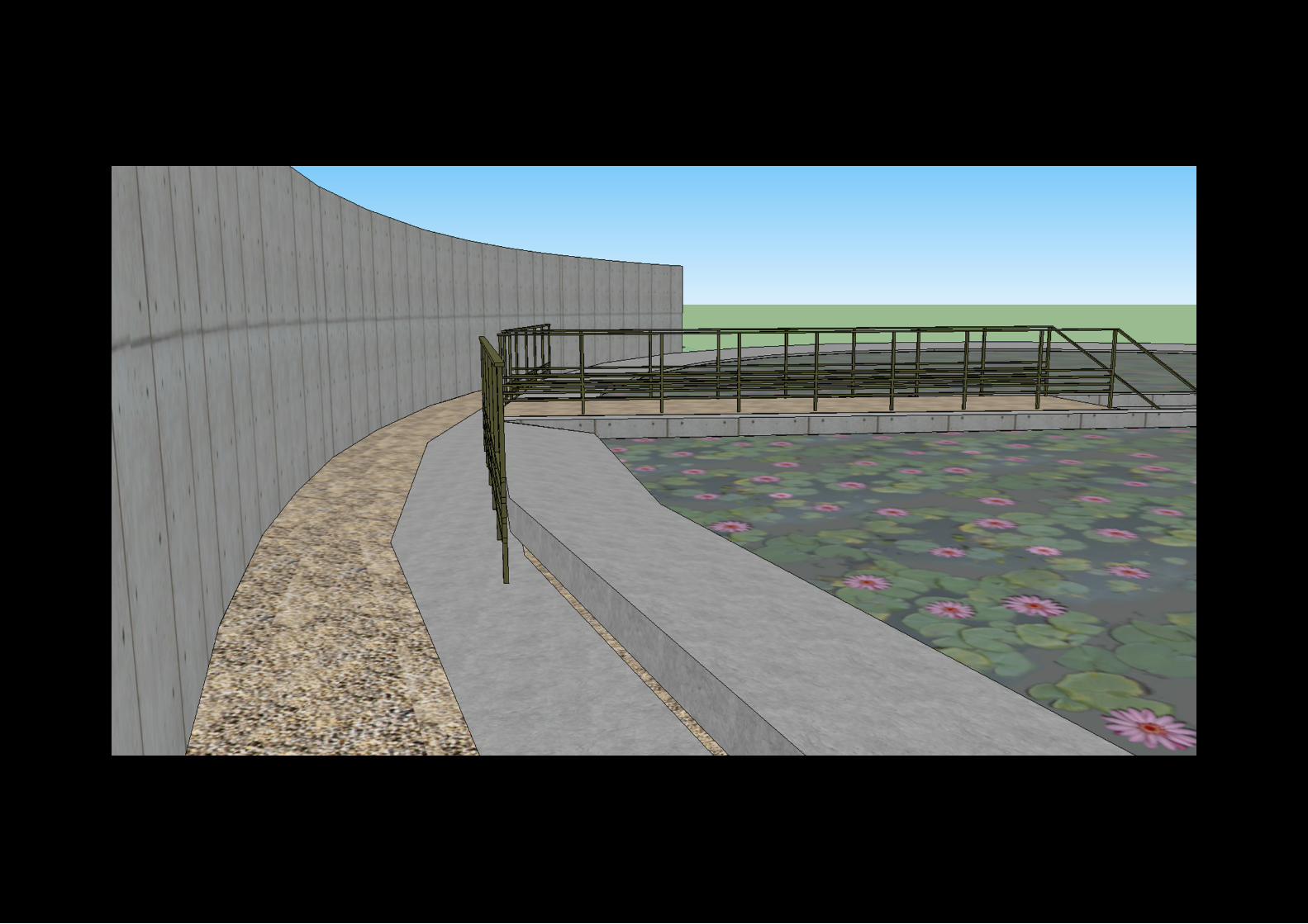
Historical Architectural Information ModelMiddle Head Fortifications_Sydney
2012
Facade DesignOperable Parametric Facade
2012
Interactive Virtual Tour with BIM34 Amy St, Regents Park_Sydney
2012
3 Dimensional ModellingKiyomizudera Temple, Kyoto_Japan
2010
3 Dimensional Crysis EnvironmentTown Hall Station_Sydney
2010


Interactive Information ModelAs part of a collaboration in working with of the New South Wales National Parks and Wildlife Service, a multimedia platform was designed to explain and exhibit the architectural character of the Middle Head Fortifications as well as to provide access to relevant information for both the general public and the staff of National Parks & Wildlife Services. The platform runs in a Unity environment as a stand-alone application to deliver an intuitive design solution for the needs of its varying user-base, no matter their technical abilities or requirements.
The information itself within the model is sourced from extensive research into the Historical Archives concerning Middle Head, incorporating military records as well as conservation reports and site survey material. This information is then overlayed onto aninteractive 3D model created in Revit, combining the model and information with the architectural drawings and geometric data.
Unity allows for the display of all this information in real-time through mouseover events and contextual menus, with links to external files for accessibility and editing. The imagery and text information contained within the environment can be expanded upon and edited by the user to include any topical reporting the user may require such as technical building information, historical contexts, photographs, architectural plans, diagrams or restoration planning. This means that the system can continue to evolve and deliver as it continues usage into the future of the Middle Head Fortifications.
Over the course of 15 weeks, a project brief, formal design pitch, client presentation, the digital deliverable itself and in-depth research and analysis of the site were developed. All of this was documented in great detail, with specific proposal elements being outlined before work commenced and preliminary budgeting of staff hour allocation. The documentation served as a reference not only for our collected resources, but for tracking the progress of the design process throughout the entire project and anticipating potential problems in advance, which allowed for more efficient use of time at every possible stage of development. Having a dedicated Project Manager and Research Analyst streamlined the integration of the various elements as they advanced simultaneously, avoiding complications and ensuring that individual efforts did not conflict or become redundant.
The final product required a 3D environment that demanded a graphical aesthetic beyond that of a simple geometrical Revit Building Information Model. To achieve the interactivelandscape present in Unity, satellite imagery of the site was stitched together with photographs and textures from the survey into a 3DS Max model featuring the terrain of Middle Head Fortifications, the surveyed tunnels and rooms of the fortifications, gunemplacements, cannons and equipments. Into this was modelled revealable cutouts in the terrain for viewing underground structures and included the mapping out pathways and trails within the headlands as well as other graphical changes to improve the visibility and overall art style of the model.


Parametric Aperture FacadeAs a project undertaken in Autodesk Revit, a parametrically operable facade was constructed and designed with the inspiration of the camera aperture in mind. By doing so, rotational blades were modelled that could be flexed continuously by the user. If taken into real time environment context, this facade will be used as a mechanical function that will be operated by a button. This button will be the master control in rotating the angle of the blades, hance by adjusting the amount of sunlight entering the building.
To fit certain design limitations of the model, constraints had to be implemented to ensure no design intended purposes were present. Therefore, rotational constraints were set between 0° and -20°. This is to ensure that the aperture blades do noe overlap each other. This con-straint was created through a maximum and minimum formula. Therefore, when the button if the aperture clses, it will only close at -20° and will not clost any further. This method is essentially the same when the blades are to open as it will reach a maximum of 0° providing full exposure to the sun. This constraint was created as an instance to allow each panel to be acjusted individually within the project.
As it can be seen in the figure on the left side, the panels of the facade can be offsetted at different distances from the glaze in order to provide a more dramatic looking profile. This is more of a constructional choice instead of the the individual usage that can be continuously changed. Therefore, the change in the offset of the panels can only be conducted during the construction stage. By creating an offset for the panels, a maximum and minimum distance was needed to provide structural tolerances for the joints and material choices. In order to prevent the motion of buckling of the steel materials. a limit was set to ensure this does not occur during the constructional and design phase. This was also created as an instance to provide individual adjustments for the panels to create a more dynamic appearance of the facade.

0° -3° -5°
-10° -15° -20°
Rotational Angle
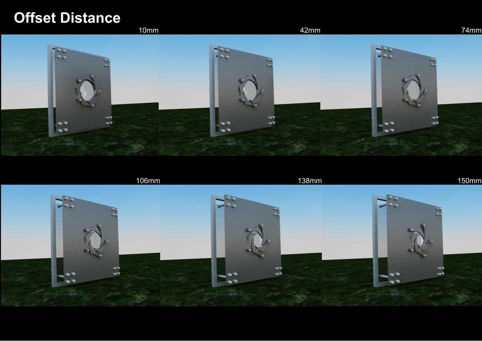
10mm 42mm 74mm
106mm 138mm 150mm
Offset Distance


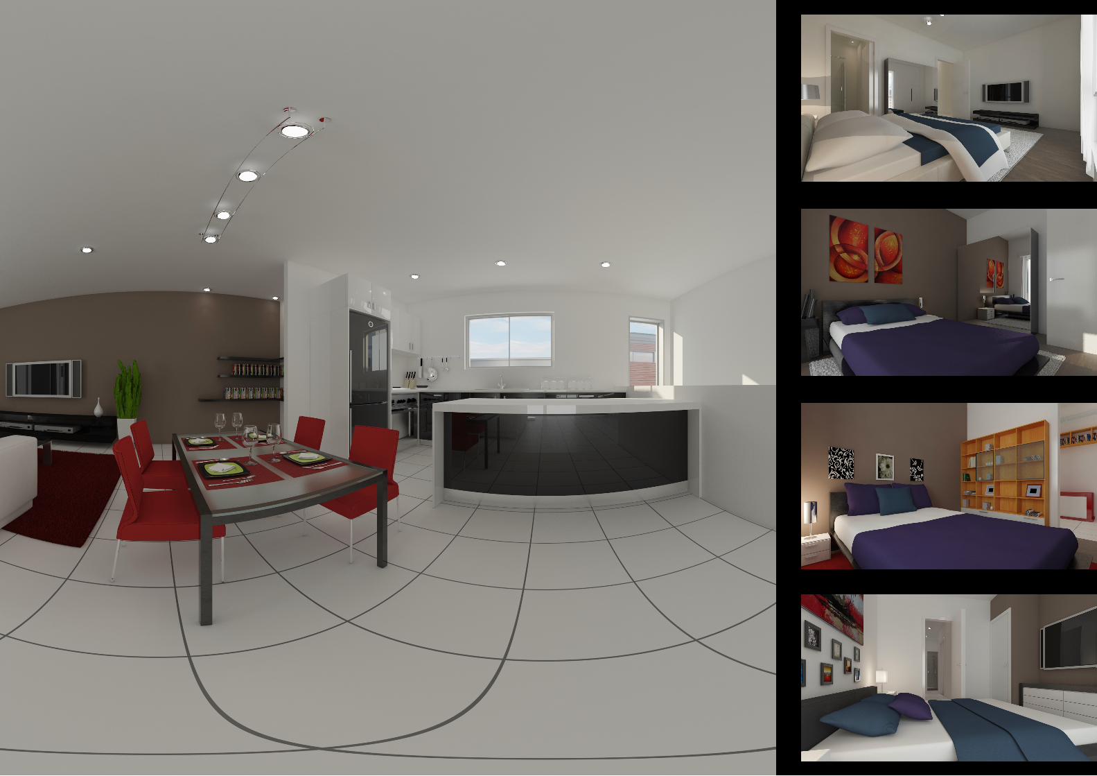
Virtual Tour + BIMThe aim of this project was to create a multimedia presentation that is composed of pano-ramic virtual tours and appropriate photorealistic visualisations which will allow clients to showcase the design of buildings and other structures. This presentational package will also provide an informative way in navigating around a particular building. By doing so, this will allow users to further explore the different aspects of the building and will not be restricted to simply static photorealistic renders.
By achieving an interactive level, multiple points of interests within the building was employed. The objective is to allow users to click on certain points of interests in the panoramic scenes that will lead users into different aspects of the building. By doing so, this will enable users to further communicate the layout, mood and environment of the building.
Within this project, appropriate static visualisations are also produced that will incorporate a list of Building Information Modelling oriented data. Such data will consist of, room name, area, materials and finishes of walls and floors as well as important fixture details.
The purpose of this particular project is to create a dynamic method of exploring buildings such as apartments, shopping complexes and office blocks.
Hence, by transitioning from simple two dimensional naviga-tional methods, by creating pan-oramic virtual tours, the idea is to combine photorealistic renders with interactivity through Flash oriented programs to create a new method and interface of exploring a building. The rationale behind using Flash based programs is highly due to the easy accessability of these programs. In turn, this allows clients to view the end product easily without having to install other programs.
The deliverables for this project included: - A interactive multimedia presentation. - Informative photorealistic renders with the incorporation of BIM and panoramic virtual tours.


Kiyomizudera Temple ModelThe intention of this model was to provide an in depth analysis of the materiality, space and context of the building through its historical development. The Kiyomizudrea temple is situated in the former city of Hokpukuji, northern part of the island Awaji. It is surrounded by hills. The temple is more than just a building but symbolises a scenic experience representing a radical differentiation in the traditional structured temples within Japan. The water temple is situated amongst a the forest of bamboo forests, mountains, fields of rice and with lake of lotus flowers as the roof.
The lotus bed, represents the symbol of Heaven, the emergence of Amida Buddha. This is seen through popular Buddhist belief which carries the message of heavenly paradise. The pool of lotus is filled to its outermost perimeter that creates an illusion of a boundless hori-zon line. By taking advantage of the scenic view, Ando creates an infinite reflection of the surrounding mountains, sky, rice paddies and bamboo groves. The stillness of water represents the idea of peacefulness enhancing a meditative effect and the notion of a spiritual cleansing.
The temple is not constructed of the traditional temples. It is enclosed in a thin oval of concrete structure that is protected by cement barriers. As Ando’s reputation is known for his extensive use of precast cement, the Water Temple is shown to be of the same material. Staircase: A concrete staircase is constructed in the middle which cuts the pool into two symmetrical halves. This staircase acts as the main entrance as it descends down into the most sacred space of the temple just below the water bed.
(LIGHT) Interior of temple: the interior of the temple is filled with a bright palette of colour. The circular space is saturated with a strong red-orange light that pulsates from the core of the structure. The radiant lighting is most intense during the sunset as light radiates the western direction of window. This light represents the meaning of Buddha originating from the west.To enter into the sacred area of the temple, a labyrinth like circular path is created. Similarly like the exterior structure, the interior of the Water Temple is made up of mostly concrete walls and a network of wooden columns built at 17.4 metre square in a circular motion.
Pond: By implementing the use of a water tempered roof, Ando is able to create a figurative meaning with the first sight of the Water Temple. Within Buddhism, water represents the brain’s state of purity, clarity as well as calmness. The use of such a distinctive roof for the tempering accentuates the notion of transcending of everyday life. The idea of harmony amongst nature and architecture with a reflection of the mountains and trees create an illusion of water to induce meditation and asceticism.
The lotus is known to be one of the Eight Auspicious Symbols and one of the most symbolic representation of Buddhism. From the moment of growth, this symbolises the progress of the soul from the primeval mud of materialism, through the waters of experience, thus sprouting into the bright sunshine of being enlightened. By placing pink lotus’ on the roof of the tempering of the Water Temple, it accentuates the meaning of the highest order within Buddhism. The pink lotus is commonly associated the with highest deity, naturally being the Great Buddha himself.


Town Hall Crysis EnvironmentThe intention of using the Town Hall Railwas Station with the Crysis Environment is to represent the artistic challenge in which a vehicle and humans interact within the structure through the use of flowgraphs. By using aspects of the railway, the notion of porosity is evidently realised through the focal point of the objects unique navigation and time spent in the certain area.
As briefly noted, the flowgraphs focus on numerous “AI” nodes. This includes AIs patrolling between two tag points on the structure. By doing so, the movement and simple behaviour that is instructed of them to undertake. The navigation through the environment is simple but effective in highlighting the idea of movement and time spent on a certain area on focus on the structure. Another AI node incorporates AI’s following the playable character as it navi-gates through the structure. This mastery in flowgraph node helps to illustrate the interactive behaviour between the other characters and the playable character as well as the structure.
The entity node must be used in relation to the AI nodes in order to assign points of selections such as tag points and smart objects. By doing so, this creates a synchro-nised combination between the AI nodes allowing different behaviours and actions in the environment and structure. Hence, the intimacy between the AIs and the structure where by a certain behaviour is undertaken on the structure in which affects the time stance of an action undertaken.
The first idea of using a “vehicle” flowgraph node on the structure as an AI to enter and fly the specified helicopter along a given path, this highlights the idea of gravity on individu-als in the world. The vehicle node automatically has an inbuilt time delay of time of flight. Hence by using this node it reflects the idea on the movement which has occurred as well as conveying the notion of navigation as a recording tool.
The use of the time node which essentially targets the effects of the time of day highlights the idea of the time of movement that has passed whilst navigating through the structure. This effectively signifies the relationship of movement as light constitutes the time of change throughout the day through the human eye.