Portage Escarpment Deep History
26
[email protected] bluestoneheights.org Roy Larick, PhD Blueston e Heights Bluestone Heights Research Education Advocacy Cuyahoga C h a g r i n Tinkers lake p lain Lake Erie CSU UST 259 May 23, 2015 Portage Escarpment* Deep History Euclid Creek window Deep History perspective Bedrock, Glaciers, Humans Event Cycle theory * Portage Escarpment (on Lake Erie’s south shore): Sloped terrain connecting Appalachian Highland and Central Lowland
-
Upload
roy-larick -
Category
Environment
-
view
153 -
download
1
Transcript of Portage Escarpment Deep History

bluestoneheights.orgRoy Larick, PhD
Bluestone Heights Bluestone
Heights
Research Education Advocacy
Cuyahoga
Ch
agrin
Tinkers
lake
pla
in Lake
Erie
CSU UST 259May 23, 2015
Portage Escarpment* Deep History
Euclid Creek window
Deep History perspective
Bedrock, Glaciers, Humans
Event Cycle theory
*Portage Escarpment (on Lake Erie’s south shore):Sloped terrain connecting Appalachian Highland and Central Lowland

Hu
ron
Val
ley
Escarpment
A
A
B
B
CC
Portage
Lake Erie
central b
asin
Euclid Falls
Euclid C
reek
Euclid Creek
Cuyahoga Valley
Eu
clid C
reek
Euclid Creek window
Euclid Creek Reservation Quarry Picnic Area
on the Portage Escarpment

History begins with the human brain
Deep History perspective

Weave diverse fields of study into a unifying narrative of life on earth
David Christian
Big History Project
world history: 8 thresholds
Anthropocene
Deep History perspective

Edward O. Wilson
Comprehend history to rebalance natural & human forces
No matter how dominant our species has become, we are still part of nature
Deep History
Inter-weaved human and natural history
Helps us understand our place in nature
Humans belong to nature
Deep History perspective

Humans over-rely on natural ecosystems
Decouple human welfare from environmental impacts
Cities occupy 2% of the Earth’s surface
April 15, 2015
Technology to stabilize the climate and protect nature
Develop cities
Deep History perspective
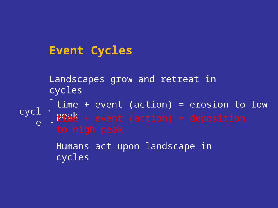
Landscapes grow and retreat in cycles
Event Cycles
time + event (action) = erosion to low peak
Humans act upon landscape in cycles
time + event (action) = deposition to high peakcycle

erode
erodedeposit
t (action) deposit / erodex (amplitude) sediment volume
deposit

years ago process phase era
40 a-? urban abandonment Post Industrial210-40 a industrialization Anthropocene
16 Ka-present post-glacial erosion Holocene 23-16 Ka late glacial deposition Late Pleistocene
300 Ma-23 Ka hard rock erosion Mesozoic/Cenozoic 400-300 Ma hard rock deposition Paleozoic
Portage Escarpment Event Cycles
1:
2:
3:

PS
UC
Eu
clid
Du
gw
ay
Do
an
Kingsbury
Tinkers
Mill
Nine M
ile
Gully
Chagrin
Cu
yah
og
a
Portage Escarpment, Chagrin to Cuyahoga, looking SE from above Lake Erie
N
Tri-CEast
A
B
Bedrock deposition
Portage Escarpment Deep History

NE WA B
Cuyahoga shale
Cleveland shale Chagrin shale
Sharon sandstone
Cuyahoga R.
Chagrin R.
Tri-C East
Lake Erie
Berea Sandstone Euclid b’stone
Bluestone Heights Portage Escarpmentschematic view SE from Lake Erie
exaggerated vertical scale
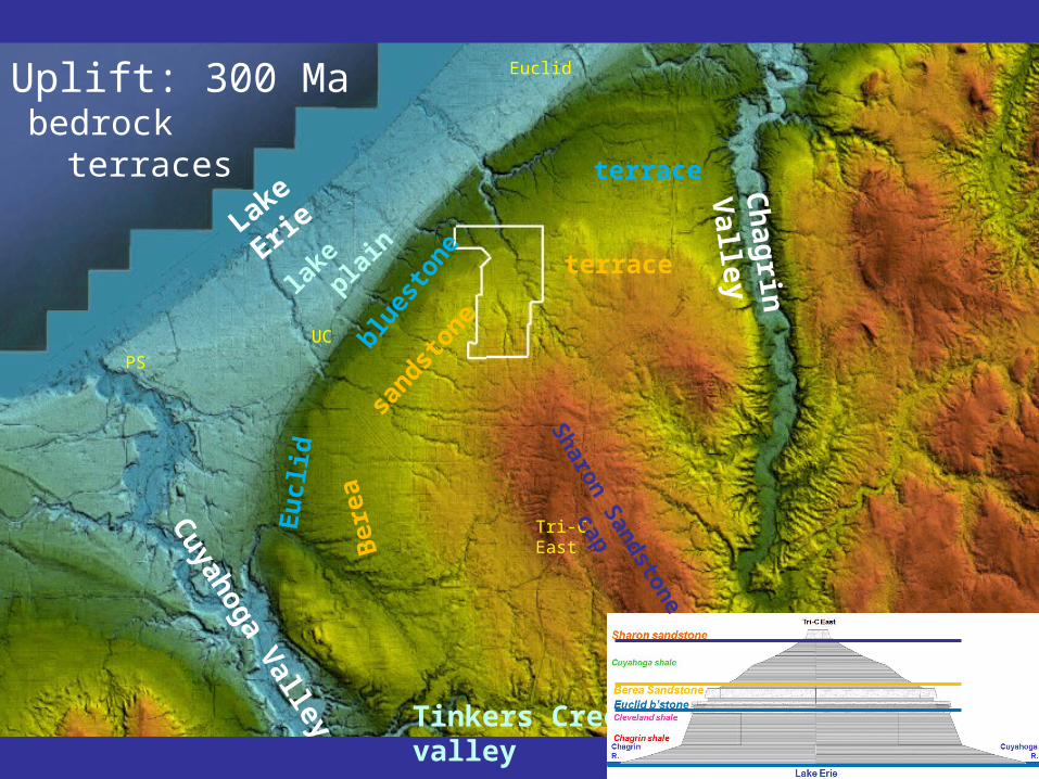
lake
p
lain
Tinkers Creek valley
Ch
agrin
Valley
Cuyahoga Valley
sandst
oneblue
ston
e
terrace
Ber
eaEu
clid
Lake Erie terrace
Tri-CEast
bedrock terraces
PS
UC
Euclid
Sharon S
andstone cap
Uplift: 300 Ma

Tinkers Creek valley
Ch
agrin
Valley
Cuyahoga Valley
16 Ka - present
Lake Erie
lake
p
lain
Stream development
Defiance Moraine
Euclid
PS
UC
Mill
Cre
ek
Pepper
Willey Creek
Haw
tho
rn C
reek
Creek
Bea
r C
reek
16 Ka – present
plan view
Final glacial retreatGlacial retreat & stream cutting
Defiance ice front, 16 ka

Tinkers Creek valley
Ch
agrin
Valley
Cuyahoga Valley
16 Ka - present
Lake Erie
lake
p
lain
Stream development
Defiance Moraine
Euclid MoraineEuclid
Mill
Cre
ek
Pepper
Willey Creek
Haw
tho
rn C
reek
Creek
Doan Brook
Euclid
Dugway Brook
Nine M
ile Creek
Kingsbury Run
Morgan Run
Burke Brook
Sherm
an C
reek
Euclid
Shaw B
rook
Blue Rock
Creek
Creek EB
Bea
r C
reek
PS
UC
Final glacial retreat
Euclid ice front, 14 ka
16 Ka – present
plan view
Tinkers Creek valley
Ch
agrin
Valley
Cuyahoga Valley
16 Ka - present
Lake Erie
lake
p
lain
Stream development
Defiance Moraine
Euclid MoraineEuclid
Mill
Cre
ek
Pepper
Willey CreekB
ear
Cre
ek
Haw
tho
rn C
reek
Creek
Doan Brook
Euclid
Dugway Brook
Nine M
ile Creek
Kingsbury Run
Morgan Run
Burke Brook
Sherm
an C
reek
Euclid
Shaw B
rook
Blue Rock
Creek
Creek EB
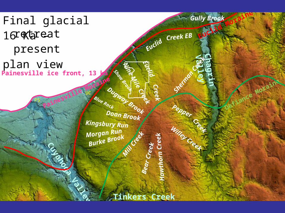
Painesville Moraine
Gully Brook
PS
UC
Final glacial retreat
Painesville ice front, 13 ka
16 Ka – present
plan view

Tinkers Creek valley
Ch
agrin
Valley
Doan Brook
Euclid
Dugway Brook
Nine M
ile Creek
Kingsbury RunM
ill C
reekMorgan Run
Burke Brook
Pepper
Willey CreekB
ear
Cre
ek
Sherm
an C
reek
Haw
tho
rn C
reek
Cuyahoga Valley
Gully Brook
Euclid
Shaw B
rook
Blue Rock
Lake Erie
lake
p
lain
Creek
Creek
Creek EB
Def
ian
ce
Moraine
EuclidMoraine
P’ville M
PS
UC
Natural streams

Euclid & Nine Mile
Upper Doan & Dugway
Lower Doan & Dugway
Euclid Creek Tunnel
NEORSDInterceptor sewers
Tinkers Creek valley
Ch
agrin
Valley
Cuyahoga Valley
Lake Erie
Anthropogenic streams
Tri-CEast
PSUC

Tri-C East
Shaker Hts
University Hts
East Cleveland
Bratenahl
Lyndhurst
Beechwood
W’by Hills
Wickliffe
S. Euclid
Euclid
Collinwood/Nottingham
Glenville
Shaker Hts
Rich Hts
Bratenahl Bratenahl
Cleveland Heights
Univer.Circle
Cleveland Heights
W’by Hills
Flats
Cuyahoga R.
Chagrin R.
Lake ErieEasterly, E 140th
16 Ka – present
profile view
Stream development
Portage Escarpment municipalities Chagrin to Cuyahoga Rivers
Berea Sandstone Euclid b’stone
Cuyahoga shale
Cleveland shale Chagrin shale
Cuyahoga R.
Chagrin R.
16 Ka
Sharon sandstone ~1200’ above sea level
Defiance ice base
16 Ka – present
profile view
Stream development

Cuyahoga R.
Lake Maumee
Cuyahoga shale
Cleveland shale Chagrin shaleChagrin R.
Sharon sandstone
~800’ asl
14.5 Ka
Berea Sandstone Euclid b’stone
Euclid Nine Mile
Shaw Dugway Blue Rock
Doan Kingsbury
16 Ka – present
profile view
Stream development

Cuyahoga R.
Lake Erie
Cuyahoga shale
Cleveland shale Chagrin shale
Gullly Euclid Nine Mile Shaw Dugway Blue Rock Doan Kingsbury
Chagrin R.
Sharon sandstone
12 Ka (Niagara Falls opens)
~500’ asl
Berea Sandstone Euclid b’stone
16 Ka – present
profile view
Stream development

Cuyahoga R.
Lake Erie
Cuyahoga shale
Cleveland shale Chagrin shale
Gully Euclid Nine Mile Shaw Dugway Blue Rock Doan Kingsbury
Chagrin R.
Sharon sandstone
600 BC (Lake Erie rises ~40’ to present level)
~570’ asl
Berea Sandstone Euclid b’stone
16 Ka – present
profile view
Stream development

Tri-C East
Cuyahoga R.
Lake Erie
Gully Euclid Nine Mile Shaw Dugway Blue Rock Doan Kingsbury
Chagrin R.
Shaker Hts
University Hts
East Cleveland
Bratenahl
Lyndhurst
Beechwood
W’by Hills
Wickliffe
S. Euclid
Euclid
Collinwood/Nottingham
Glenville
Shaker Hts
Rich Hts
Bratenahl Bratenahl
Cleveland Heights
Univer.Circle
~570’ asl
Cleveland Heights
W’by Hills Flats
1850-2013 AD (Anthropogenic change)Heavily transformed
16 Ka – present
profile view
Stream development

Natural cave (Euclid Creek, Berea Sandstone)

Anthropogenic cave (Euclid Creek Tunnel)
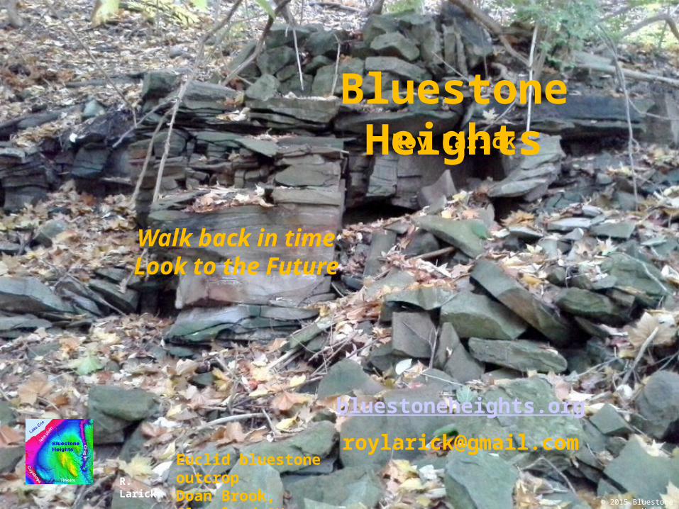
Roy Larick
Walk back in time Look to the Future
Bluestone Heights
© 2015 Bluestone Heights
bluestoneheights.org
[email protected] bluestone outcropDoan Brook, Cleveland OHR. Larick


![Untitled-1 [] · Lyceum—Portage Ave., between Smith and Donald. Garrick—Garry St., north of Portage. Odeon—Smith St., north of Portage. Gaiety—Portage and Colony. Drive-In](https://static.fdocuments.in/doc/165x107/5f515bb9e5f918157102d3af/untitled-1-lyceumaportage-ave-between-smith-and-donald-garrickagarry.jpg)