Polar Topographic Knowledge Prior to LCROSS Impact
22
Polar Topographic Knowledge Prior to LCROSS Impact David E. Smith 1 , Maria T. Zuber 2 1 NASA/Goddard Space Flight Center 2 Massachusetts Institute of Technology LCROSS Site Selection Workshop NASA/Ames Research Center October, 2006
-
Upload
bidelia-davitt -
Category
Documents
-
view
27 -
download
0
description
Polar Topographic Knowledge Prior to LCROSS Impact. David E. Smith 1 , Maria T. Zuber 2 1 NASA/Goddard Space Flight Center 2 Massachusetts Institute of Technology LCROSS Site Selection Workshop NASA/Ames Research Center October, 2006. Question:. - PowerPoint PPT Presentation
Transcript of Polar Topographic Knowledge Prior to LCROSS Impact

Polar Topographic KnowledgePrior to LCROSS Impact
David E. Smith1, Maria T. Zuber2
1NASA/Goddard Space Flight Center
2Massachusetts Institute of Technology
LCROSS Site Selection Workshop
NASA/Ames Research Center
October, 2006
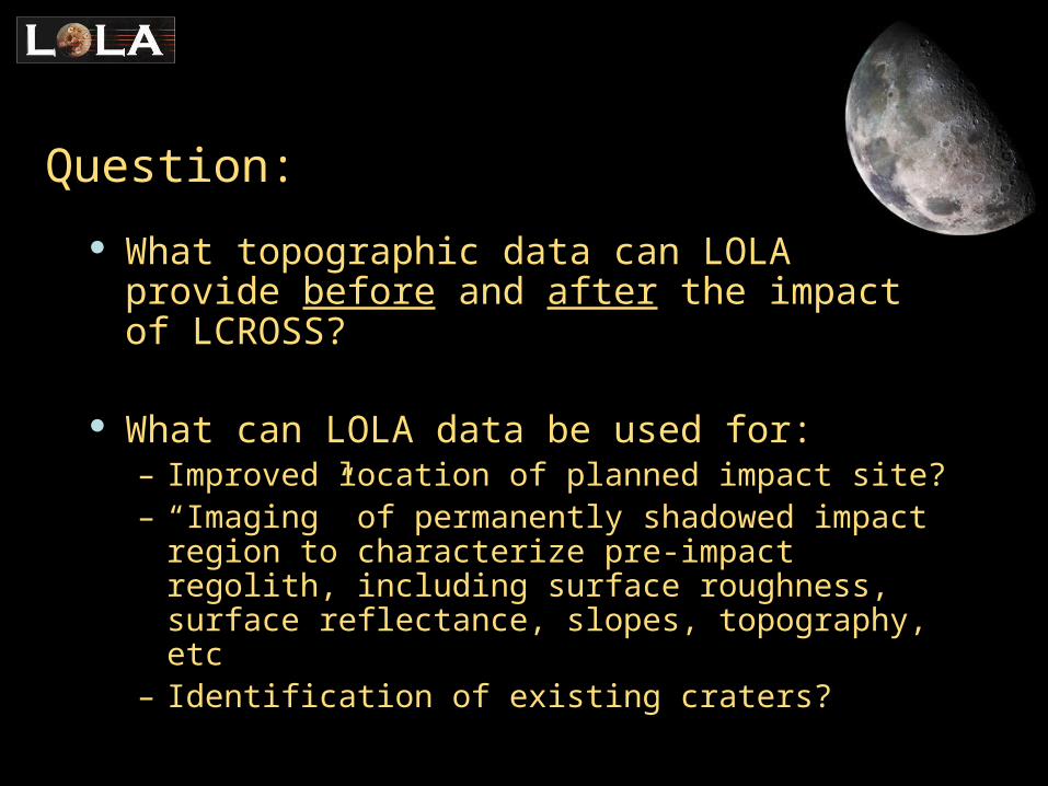
Question:
What topographic data can LOLA provide before and after the impact of LCROSS?
What can LOLA data be used for:– Improved location of planned impact site?– “Imaging” of permanently shadowed impact region
to characterize pre-impact regolith, including surface roughness, surface reflectance, slopes, topography, etc
– Identification of existing craters?
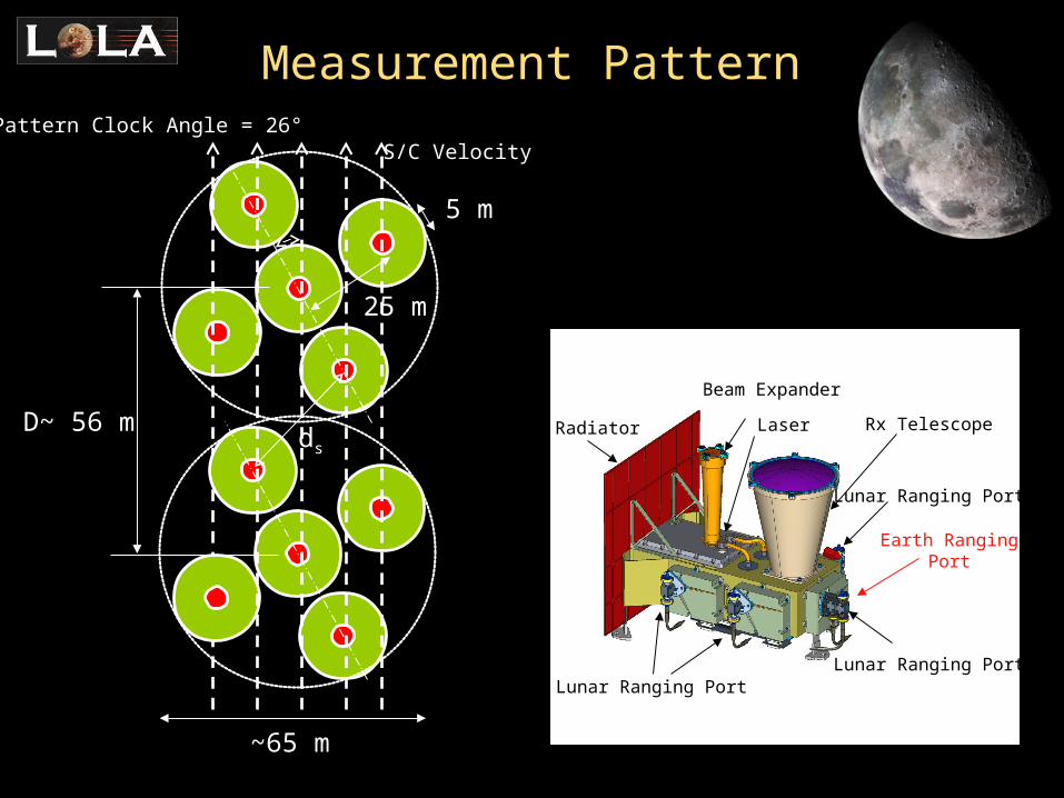
Rx Telescope
Beam Expander
Earth RangingPort
Lunar Ranging PortLunar Ranging Port
LaserRadiator
Lunar Ranging Port
S/C VelocityPattern Clock Angle = 26°
D~ 56 mds
~65 m
25 m
5 m
Measurement Pattern

Measurement Accuracy/Precision
Range to surface: <10 cm, each 5 meter spot
Surface Roughness: 30 cm, each 5 meter spot
Albedo (1064 nm): ± 0.02, each 5 meter spot
Slopes, 2 directions: ± 0.3o, 25 meter baseline
Orbital altitude: < 1 meterAlong track position ~ 25 meters

10 cm range precision
28 Hz, 532 nm
10 cm range accuracy
28 Hz, 1064 nm
LRO Precision Tracking
In conjunction with the altimeter and S-band tracking we estimate positional accuracies of 50 m along track and <1 meter radially (CoM) after improvement of the lunar gravity field.

Orbital Variations
Altitude Inclination
60 km
40 km
90.8
89.2
90.0
Eccentricity
0.0080.002
Because of the eccentricity of the orbit the nadir panel will be offset from the sub-satellite position by ±0.3 to ±2.5 degrees along track each orbit. (~ 2 km from 50 km)

TLI Impulsive 2008 OCT 28 10:23:53.2864 - 10:23:53.2864 LOI-1 Finite 2008 NOV 02 09:54:22.9236 - 10:32:06.8603 LOI-2 Finite 2008 NOV 03 11:04:35.5207 - 11:16:35.5212 LOI-c Finite 2008 NOV 04 06:41:29.4881 - 06:48:56.0716 LOI-p Finite 2008 NOV 04 07:34:50.0094 - 07:37:02.7396 MOI-1 Impulse 2008 DEC 13 16:10:34.6627 - 16:12:22.4381 MOI-2 Impulse 2008 DEC 13 17:37:52.3966 - 17:38:04.3777 MOI-3 Impulse 2008 DEC 13 18:36:52.2089 - 18:37:00.1690 SK-1 Impulse 2009 JAN 09 23:47:47.9146 -
00:43:26.8193 SK-2 Impulse 2009 FEB 06 07:37:37.0569 -
08:31:29.3491 SK-3 Impulse 2009 MAR 05 13:34:55.2297 - 14:30:01.6998 SK-4 Impulse 2009 APR 01 21:21:52.7953 - 22:17:10.2313 SK-5 Impulse 2009 APR 29 05:09:38.6602 - 06:04:44.1272 SK-6 Impulse 2009 MAY 26 12:57:36.7456 - 13:52:31.8429 SK-7 Impulse 2009 JUN 22 18:52:29.0597 - 19:47:24.8620 SK-8 Impulse 2009 JUL 20 02:39:15.7389 - 03:34:15.6089 SK-9 Impulse 2009 AUG 16 10:26:54.1674 - 11:21:39.7218 SK-10 Impulse 2009 SEP 12 18:14:26.0226 - 19:09:24.4532 SK-11 Impulse 2009 OCT 10 02:01:21.2589 - 02:55:58.7047 SK-12 Impulse 2009 NOV 06 09:48:36.7283 - 10:43:30.6627 SK-13 Impulse 2009 DEC 03 17:35:12.8728 - 18:29:53.9120
Date Start StopLRO Maneuvers
The LRO orbit is circularized every month to 50 km in order to avoid impacting the surface
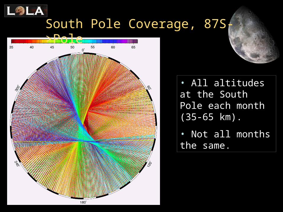
South Pole Coverage, 87S->Pole
• All altitudes at the South Pole each month (35-65 km).
• Not all months the same.
LOLA COVERAGE

Coverage of Southern Partof Shackleton Crater
Nov 2 - Dec 13 Nov 2 - Jan 9
Nov 2 - Feb 6
The coverage varies significantly from month to month

After 1 year:
Approx one 5-meter spot every 10 x 10 meter block
Coverage at the End of Mappingof Shackleton Crater
Coverage in the polar regions at the end of the LRO mission is not likely to be a problem…

Nov 2 - Dec 13 Dec 13 - Jan 9
Jan 9 - Feb 6
Monthly Coverage 88S to PoleIncluding Shackleton and de Gerlache Craters

Open: LOLA SP Crater slide show
1. SP_nadir2. SP_89p7_nadir3. SP_89p7_buildup

Close-Up of Region of “Permanent Light”
Actual ground tracks of Lunar Prospector near Shackleton and de Gerlache craters.
Poorest regional coverage is with a few km around the pole.

Close-Up of Region “Permanent Light”
LRO Commissioning Orbit - 6 weeks
~ 1.0 km
~ 1.2 km Typical landing site area ~ 1.2 sq km
Coverage:Nov 2 - Dec 13

Close-Up of Region “Permanent Light”
LRO Mapping Orbit - 1st Month
4 weeks -Dec 13 - Jan 9
~ 1.0 km
~ 1.2 km

Close-Up of Region “Permanent Light”
LRO Commissioning + 2 Months Mapping Orbit
13 weeks (91d) -
Nov 2 - Feb 6
~ 1.0 km
~ 1.2 km
Average of one 5-meter spot every 20 x 20 meter block

Open: LOLA SP Crater slide show
1. Shackleton_nadir_buildup

Regularizing the Coverage of a Landing Site Region
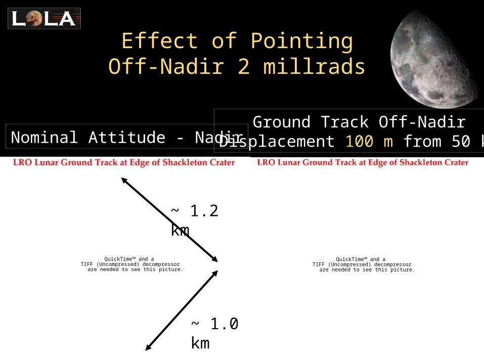
• A small off-nadir roll of LRO could change location of ground track.
• A roll of 2 mrad produces a 100 m movement of the ground track from 50 km altitude.
• Adjustments of less than 100 m unnecessary due to LOLA’s swath width of ~65 m.
• Accuracy of LOLA unaffected by small of-nadir pointing
• NOTE: Along track position of LRO will be non-nadir by 1 to 2 km due to eccentricity of the orbit!
QuickTime™ and aTIFF (Uncompressed) decompressor
are needed to see this picture.
QuickTime™ and aTIFF (Uncompressed) decompressor
are needed to see this picture.
Nominal Attitude - NadirGround Track Off-Nadir
Displacement 100 m from 50 km
Effect of Pointing Off-Nadir 2 millrads
~ 1.2 km
~ 1.0 km

QuickTime™ and aTIFF (Uncompressed) decompressor
are needed to see this picture.
QuickTime™ and aTIFF (Uncompressed) decompressor
are needed to see this picture.
Nominal Attitude - NadirGround Track Off-Nadir
Displacement 200 m from 50 km
Effect of Pointing Off-Nadir 4 millrads
~ 1.2 km
~ 1.0 km

Summary & Conclusions
Prior to LCROSS impact: Characterize impact site
• LOLA will provide accurate elevations (~10 cm) with average coverage of 1 observation in a 20 x 20 meter block inside Shackleton. (Slightly better further from the pole).
• The elevation data will be complemented by roughness estimates, surface slopes and reflectance at 1064 nm.
Post LCROSS impact: Characterize the impact site again for evidence of the impact
• Elevation coverage in Shackleton 3 or 4 time better. Reflectance at the few % in sunlit and permanent shadow regions.
• Global coordinate system providing locations of features.