Pojoaque Valley Community Strategic Plan - Santa Fe … Pojoaque... · LYNNE VELASCO . STELLA...
101
Pojoaque Valley Community Strategic Plan Our Valley. Our Future. One Community. Prepared by: The Pojoaque Valley Planning Committee and the Santa Fe County Planning Division Adopted by the Board of County Commissioners Resolution 2007-120 August 14, 2007
Transcript of Pojoaque Valley Community Strategic Plan - Santa Fe … Pojoaque... · LYNNE VELASCO . STELLA...

Pojoaque Valley Community Strategic Plan
Our Valley. Our Future. One Community.
Prepared by: The Pojoaque Valley Planning Committee and the Santa Fe County Planning Division
Adopted by the Board of County Commissioners
Resolution 2007-120 August 14, 2007


U

TABLE OF CONTENTS
ACKNOWLEDGEMENTS: CORE COMMITTEE MEMBERS AND PARTICIPANTS .............................................4
EXECUTIVE SUMMARY................................................................................................................................8
I: THE PLANNING PROCESS ....................................................................................................................10 SANTA FE COUNTY COMMUNITY PLANNING..................................................................................................................................... 10
.WHAT IS STRATEGIC PLANNING?............................................................................................................................. .................... 11 . .WHY CHOOSE STRATEGIC PLANNING? ............................................................................................................................ ............. 12
THE IMPORTANCE OF PLANNING FOR THE POJOAQUE VALLEY ............................................................13
MAJOR THEMES......................................................................................................................................15
POJOAQUE VALLEY COMMUNITY PLANNING PROCESS.........................................................................16
COMMUNITY INVOLVEMENT..................................................................................................................17
II. BACKGROUND AND CONTEXT..............................................................................................................19 A BRIEF HISTORY OF THE POJOAQUE VALLEY .................................................................................................................................. 19 HISTORICAL TIMELINE OF POJOAQUE VALLEY.................................................................................................................................. 25
TRENDS IN THE POJOAQUE VALLEY ......................................................................................................27
III. VISION, MISSION AND STRATEGIC PLAN .........................................................................................32
COMMUNITY ANALYSIS AND ISSUES ....................................................................................................35
SWOT ANALYSIS ....................................................................................................................................37
A DESIRED AND POSITIVE FUTURE SCENARIO .....................................................................................39
IV: STRATEGIC GOALS AND ACTIONS .....................................................................................................41
V. IMPLEMENTING, MONITORING, AND EVALUATING............................................................................76
IV: APPENDICES ......................................................................................................................................83 POJOAQUE VALLEY TRADITIONAL COMMUNITY DISTRICT USE TABLE................................................................................................... 85 DEMOGRAPHIC AND ECONOMIC PROFILE OF THE GREATER POJOAQUE VALLEY ...................................................................................... 91 MAPS: POJOAQUE VALLEY TRADITIONAL COMMUNITY DISTRICT, MIXED-USE ZONES, MULTI-PURPOSE TRAIL ........................................ 100
3

Acknowledgements: Core Committee Members and Participants Core Pojoaque Valley Committee Members: The following individuals are those community members that have actively participated in the planning process, and have dedicated their time for the good of the community and for future generations.
STEPHEN BENJAMIN CHUCK BERGER CARL BERNEY ELAINE BEST DIANE BOISSEVAIN DOUG CROSBY VICENTE ROYBAL-JASSO, Former Chairman DAVID DOGRUEL, Chairman STEEN RASMUSSEN AMELIA GARCIA JOE GARCIA BEN GOMEZ KAREN KING LYNNE VELASCO STELLA LEDBETTER MARY LOUISE WILLIAMS HARRY MONTOYA
SHARON MOTTOLA KEN MULLEN JOSE CARLOS ORTIZ DAVID ORTIZ, Vice-Chairman NARCISO QUINTANA
RUSSELLA SERNA ROBERT ULLRICH LEVI VALDEZ
DONALD WILSON
4

Community Participants:
GIBO & NORMA BACA LANY BERGER CHARLOTTE BERNEY MARY ANN LUNDY ELLIE & PETER BICKLEY TREVOR BURROWES IDA CARRILLO JAMES & PATTI DELGADO ADDISON DOTY DAVE DURAN STEVE DURAN ARLENE ESTEVAN LINDA FLUK DAVID FOWLER MARTIN GABALDON NEEL GLASS MAXINE GOAD GARY & NATASYA GUNDERSEN JENNIFER HERRERA HELENTY HOMANS DAVID & KAREN KRAIG JAMES LANGENBRUNNER
BEN LUJAN BEN RAY LUJAN
MEADE & ROBIN MARTIN SANDRA MASSENGILL DEIRDRE MONROE WLADIMIR SENUTOVITCH GABRIEL MONTOYA JUAN MONTOYA HAROLD MONTOYA JOSEPHINE NATSEWAY DAVE NEAL WILLIAM OGLE DEANA ORTIZ J. BOLES PENA CELESTINO QUINTANA LUGGIE ROMERO MARIO ROMERO ORLANDO & BECKY ROMERO CLEO ROMERO JERRY ROMERO JON PAUL ROMERO
FLOYD & JEANNIE ROYBAL WIL ROYBAL JAMES & SHIRLEY RUTLEDGE GARY SANCHEZ ROBERT SENA
CARMELLA SERNA PAT SERNA DAVE SUSZCYNSKY SHERI TEPPER ARSENIO TRUJILLO ISIDORO VALDEZ IRVING & CLAIRE WARHAFTIG NEIL WEBER LUCY LYON YUAN
5

Santa Fe County Staff that have assisted in the Planning Effort
Santa Fe County Board of County Commissioners (BCC)
Harry B. Montoya, District 1 Virginia Vigil, District 2 Michael D. Anaya, District 3 Paul Campos, District 4 Jack Sullivan, District 5
County Manager’s Office Roman Abeyta, County Manager Gerald González, Former County Manager Hutch Miller, Intergovernmental Outreach Coordinator
Land Use Department and Planning Division
Jack Kolkmeyer, Land Use Director Penny Ellis-Green, Deputy Land Use Dir. Judy McGowan, Planning Div. Director
Renee Villarreal, Community Planner Robert Griego, Senior Planner Beth Mills, Planner III, GIS Specialist
Former Planning Staff: Sarah Ijadi Romella Glorioso-Moss
Planning Consultants Carl Moore, The Community Store Al Pitts, Demographer and Economist Lynne Canning Suzanne Otter
GIS Division
Daniel Romero Amanda Hargis Paul Casaus Erle Wright
Former GIS Staff:
Greg Gallegos Jim Gallegos
County Assessors Department Shawn Thornton Larry Valdez
Open Space Division Paul Olafson, Open Space Div. Director
Photographs
Planning Division Staff Committee Members Palace of the Governors/ Museum of New Mexico
6

Other Acknowledgements
We would like to extend our appreciation to the following people and organizations for their assistance and support through the planning process.
o Angela Bordegaray, LANL-Water Research Technical Assistance Office
o Don Bustos, New Mexico Farmer’s Market
o Joe Garcia, Department of Transportation
o Paula Garcia, New Mexico Acequia Association
o Rick Homans, New Mexico Economic Development Department
o Elizabeth Keating, Los Alamos National Laboratory
o Michael Lopez, Pueblo of Pojoaque Training Center
o Jacona Land Grant Board Members
o Roberto Mondragon, State Engineers Office
o The Louis Berger Group - Carlos Padilla, Carmen Silva, and Ivan Trujillo
o Luggie Romero and the security crew at the Pojoaque Valley School District
o Superintendent Toni Trujillo and the Pojoaque Valley School Board
o The Santa Fe New Mexican – The Pojoaque Edition writers
o Barbara Williams and the art students that participated in the logo contest
To the tribal leadership of and near the Valley, our deepest appreciation for the time you have taken to meet with us and give us your input and support:
Pueblo of Nambé Pueblo of Pojoaque Pueblo of San Ildefonso
Pueblo of Santa Clara Pueblo of Tesuque
7
Executive Summary
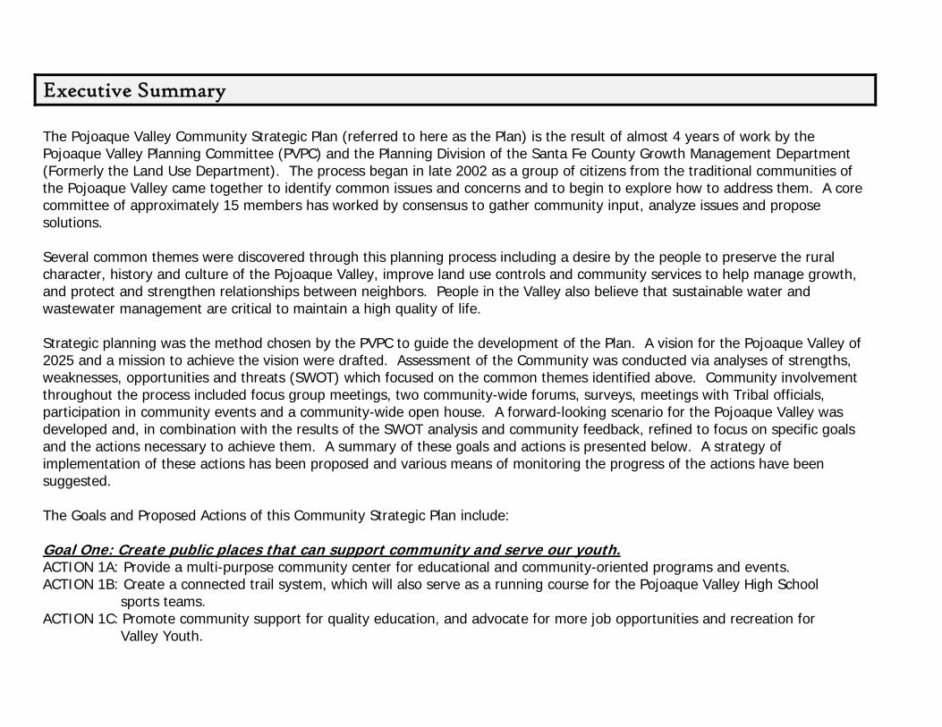
The Pojoaque Valley Community Strategic Plan (referred to here as the Plan) is the result of almost 4 years of work by the Pojoaque Valley Planning Committee (PVPC) and the Planning Division of the Santa Fe County Growth Management Department (Formerly the Land Use Department). The process began in late 2002 as a group of citizens from the traditional communities of the Pojoaque Valley came together to identify common issues and concerns and to begin to explore how to address them. A core committee of approximately 15 members has worked by consensus to gather community input, analyze issues and propose solutions. Several common themes were discovered through this planning process including a desire by the people to preserve the rural character, history and culture of the Pojoaque Valley, improve land use controls and community services to help manage growth, and protect and strengthen relationships between neighbors. People in the Valley also believe that sustainable water and wastewater management are critical to maintain a high quality of life. Strategic planning was the method chosen by the PVPC to guide the development of the Plan. A vision for the Pojoaque Valley of 2025 and a mission to achieve the vision were drafted. Assessment of the Community was conducted via analyses of strengths, weaknesses, opportunities and threats (SWOT) which focused on the common themes identified above. Community involvement throughout the process included focus group meetings, two community-wide forums, surveys, meetings with Tribal officials, participation in community events and a community-wide open house. A forward-looking scenario for the Pojoaque Valley was developed and, in combination with the results of the SWOT analysis and community feedback, refined to focus on specific goals and the actions necessary to achieve them. A summary of these goals and actions is presented below. A strategy of implementation of these actions has been proposed and various means of monitoring the progress of the actions have been suggested. The Goals and Proposed Actions of this Community Strategic Plan include: Goal One: Create public places that can support community and serve our youth. ACTION 1A: Provide a multi-purpose community center for educational and community-oriented programs and events. ACTION 1B: Create a connected trail system, which will also serve as a running course for the Pojoaque Valley High School
sports teams. ACTION 1C: Promote community support for quality education, and advocate for more job opportunities and recreation for
Valley Youth.

UGoal Two: Ensure a clean water supply. ACTION 2A: Preserve acequias and improve diversions and delivery systems. ACTION 2B: Develop and implement strategies for domestic water conservation. ACTION 2C: Protect domestic water supplies. ACTION 2D: Pursue options for wastewater management and treatment systems.
Goal Three: Strengthen and build community relationships and communication between neighbors and government entities and increase local input into zoning regulations. ACTION 3A: Consider a “Youth Council” of both Pueblo and Traditional Community youth that can work directly with the School District, the County and the Pueblos on youth-related issues. ACTION 3B: Address the following community problems in collaboration with governmental agencies and other organizations:
- Vandalism and Graffiti - Trash and Dumping - Road Maintenance - Speeding
- Drugs/Alcohol Abuse - Suicide Prevention - Teen Pregnancy - Animal Control
ACTION 3C: Communicate, evaluate, and modify existing zoning regulations as needed to address growth and land use issues, such as density, family transfers, and affordable housing.
Goal Four: Grow the local economy.
ACTION 4A: Establish mixed-use districts or “corridors” for Valley businesses.
ACTION 4B: Revitalize traditional agricultural practices.
ACTION 4C: Promote an arts and crafts economy in the Valley.
ACTION 4D: Support home businesses and home occupations.
Goal Five: Create an entity that looks after the interests of the Valley by implementing the Community Strategic Plan, and is able to plan cooperatively with the County, State and Federal governments, the Jacona Land Grant, and the local Pueblos.
After approval of the Plan and the Ordinances associated with the above Action Plans, a local development review committee will be formed. This committee will be the recommending body charged with monitoring and implementing the Plan.
9

I: The Planning Process Santa Fe County Community Planning: The 1980 Santa Fe County General Plan first identified Traditional Communities throughout the County. This identification was devised to recognize areas in the County that had been settled at densities higher than the hydrologic studies and 1980 General Plan would allow, where there was a long history of family settlement, and where the opportunity existed to provide or improve water and sewer systems. The original criteria for Traditional Community status has been continued and incorporated into Article XIII of the County Land Development Code. A place that receives a traditional community status must have the following criteria:
1. Continuous settlement since 1925; 2. A historic pattern of diverse and mixed community land uses which
carried through to the present; 3. Presence of historic structures; 4. Existence of a village center.
The Pojoaque Valley settlement areas of Nambe, Pojoaque, Jacona, Jaconita, El Rancho and Cuyamungue were designated as Traditional Communities in the 1980 General Plan based on the criteria above.
As unincorporated communities throughout Santa Fe County have experienced rapid growth over the past two decades, community members realized that planning would be a necessity to address the issues in a proactive, not reactive manner. Therefore, in 1996, the Board of County Commissioners requested that the Land Use Department and Planning Division begin working to help Traditional Communities and Contemporary Communities develop local land use plans. Santa Fe County Ordinance 2002-3 (which revised Ordinance 1998-5) is known as the Community Planning Ordinance and describes the process for conducting community plans and provides for County staff to assist communities in developing plans.
10
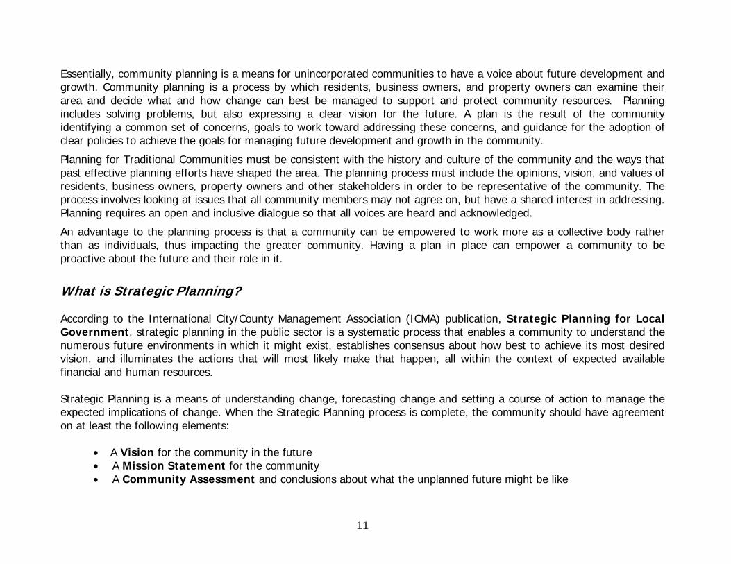
Essentially, community planning is a means for unincorporated communities to have a voice about future development and growth. Community planning is a process by which residents, business owners, and property owners can examine their area and decide what and how change can best be managed to support and protect community resources. Planning includes solving problems, but also expressing a clear vision for the future. A plan is the result of the community identifying a common set of concerns, goals to work toward addressing these concerns, and guidance for the adoption of clear policies to achieve the goals for managing future development and growth in the community.
Planning for Traditional Communities must be consistent with the history and culture of the community and the ways that past effective planning efforts have shaped the area. The planning process must include the opinions, vision, and values of residents, business owners, property owners and other stakeholders in order to be representative of the community. The process involves looking at issues that all community members may not agree on, but have a shared interest in addressing. Planning requires an open and inclusive dialogue so that all voices are heard and acknowledged.
An advantage to the planning process is that a community can be empowered to work more as a collective body rather than as individuals, thus impacting the greater community. Having a plan in place can empower a community to be proactive about the future and their role in it.
What is Strategic Planning? According to the International City/County Management Association (ICMA) publication, Strategic Planning for Local Government, strategic planning in the public sector is a systematic process that enables a community to understand the numerous future environments in which it might exist, establishes consensus about how best to achieve its most desired vision, and illuminates the actions that will most likely make that happen, all within the context of expected available financial and human resources. Strategic Planning is a means of understanding change, forecasting change and setting a course of action to manage the expected implications of change. When the Strategic Planning process is complete, the community should have agreement on at least the following elements:
• A Vision for the community in the future • A Mission Statement for the community • A Community Assessment and conclusions about what the unplanned future might be like
11

• A complete list of the community’s Strengths and Weaknesses as well as its Opportunities and Threats (SWOT)
• Actions with identified time frames • An Implementation Plan that includes timelines and group or individual assignments • A description of the plan’s relationship to County government • A Schedule for performance assessments, periodic reviews and replanning, if necessary.
Why Choose Strategic Planning? A particular challenge for Traditional Communities such as those in the Pojoaque Valley is that, as an unincorporated community, decisions about planning and governmental resources and services are top down. In the past, the community has had a limited role in these decisions, mostly in communication and collaboration with the elected County Commissioner and/or the State legislators representing this area. With the implementation of a formal community planning process (Santa Fe County Ordinance 2002-3), Traditional Communities were provided with a mechanism for undertaking community plans and putting them into legal ordinances. Many Traditional Communities have chosen the comprehensive methodology for their plans. However, such plans can sometimes be difficult to implement, fund and monitor over time. For this reason, in 2003, the PVPC decided to choose a strategic planning methodology because committee members felt that a strategic planning approach would better help them control their future. For a more detailed timeline of the Pojoaque Valley Planning Committee and the work that has been accomplished, please see the Planning Committee Timeline in Appendix D.
12

The Importance of Planning for the Pojoaque Valley The Pojoaque Valley has a history of unique design characteristics and settlement patterns and like many of the Traditional Communities of Santa Fe County, is currently facing critical issues brought about by increases in population, erosion of the agricultural base, development pressures, and inadequate infrastructure and services. Unlike many of the other Traditional Communities, however, the Pojoaque Valley shares the landscape with the Native American Pueblos of Nambé, Pojoaque, and San Ildefonso. This unique relationship presents different challenges and opportunities especially related to boundaries, economic development and infrastructure.
A dramatic change in the Pojoaque Valley occurred about 10 years ago with the advent of Indian gaming, followed by a rapid increase in commercial development, primarily on tribal land. In late 2002, a group of citizens, concerned about the disparate development patterns in the Pojoaque Valley, assembled, and with the support of the County, began to explore how an unincorporated area could manage future growth and development in the Valley. At an initial public meeting held in October 2002, where members of all of the Traditional Communities attended, the following community issues were identified as important to consider in a community plan:
• Agricultural and Cultural Resources Protection • Air, Light and Noise Pollution • Problems with ATVs (all terrain vehicles) – safety, liability, trespassing • Community Facilities and Services – fire, police, community centers • Housing – affordable housing, opportunities for additional housing, balanced growth, areas appropriate for
housing • Infrastructure – roads, utilities and high tech communications • Lack of Public Transportation
13

• Land Use and Zoning Problems – land use controls, code enforcement, density, rural area protection, commercial mining, pollution
• Limited Open Space – recreational facilities and bike lanes • Maintain Rural Lifestyle • Planning Boundary Issues – original land grant deeds and boundaries, property ownership • Pueblo Participation and Involvement in the Planning Process • Trash – illegal dumping, no solid waste disposal system • Tribal Land – sacred sites and sovereign rights • Water Preservation and Conservation – water rights, acequias, quality of drinking water, waste water treatment
and disposal. • Youth Participation in Community Issues
Since several issues common to the Traditional Communities of the Pojoaque Valley were identified, a decision to work collectively to solve them via community planning was made. The Pojoaque Valley Planning Committee (PVPC) was formed, members and leaders from each of the Traditional Communities were identified, roles of committee members were defined, and the consensus process was chosen for committee business. A petition to formally begin the planning process for the Pojoaque Valley was drafted and on December 10, 2002, the Board of Santa Fe County Commissioners approved resolution 2002-163 to initiate the planning process. We have discovered through this planning process that the people of the Pojoaque Valley have a strong desire to preserve the rural character, history and culture of the Valley, improve land use controls and community services to help manage growth, and protect and strengthen relationships between neighbors, including our Pueblo neighbors. People in the Valley also believe that sustainable water and wastewater use are critical to a high quality of life.
This is the first time that the Pojoaque Valley communities have collectively addressed such a comprehensive list of concerns. Developing the Pojoaque Valley Community Strategic Plan has been a concerted effort to take all of these concerns into consideration and craft a strategic plan that provides both short-term and long-term actions. The goal of planning and zoning in this area is to preserve the intrinsic character and integrity of the Valley, while enabling growth in the community over time.
14

Major Themes At meetings held during March 2003, the Pojoaque Valley Planning Committee (PVPC) reviewed several different planning methodologies and agreed to undertake the Pojoaque Valley Community Plan as a Strategic Plan. In addition, the Committee also agreed that the Community Strategic Plan would focus on five major consolidated issues:
1. Water and Wastewater 2. Land Use and Growth Management 3. Rural Lifestyles and Agriculture 4. Pueblo Relationships, including Boundaries and Roads 5. Community Facilities and Services
At this time the Committee was ready to move forward with a strategic, yet community-oriented planning process.
View of Los Barrancos in the Valley
15
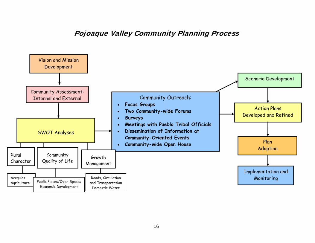
Pojoaque Valley Community Planning Process
16
Community Outreach: • Focus Groups • Two Community-wide Forums • Surveys • Meetings with Pueblo Tribal Officials • Dissemination of Information at
Community-Oriented Events • Community-wide Open House
Scenario Development
Action Plans Developed and Refined
Plan Adoption
SWOT Analyses
Growth Management
Rural Character
Community Quality of Life
Vision and Mission Development
Community Assessment: Internal and External
Acequias Public Places/Open Spaces
Economic Development
Roads, Circulation and Transportation
Domestic Water
Implementation and Monitoring
Agriculture
17
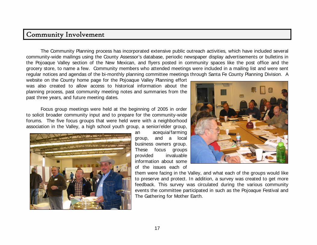
Community Involvement
The Community Planning process has incorporated extensive public outreach activities, which have included several community-wide mailings using the County Assessor’s database, periodic newspaper display advertisements or bulletins in the Pojoaque Valley section of the New Mexican, and flyers posted in community spaces like the post office and the grocery store, to name a few. Community members who attended meetings were included in a mailing list and were sent regular notices and agendas of the bi-monthly planning committee meetings through Santa Fe County Planning Division. A website on the County home page for the Pojoaque Valley Planning effort was also created to allow access to historical information about the planning process, past community meeting notes and summaries from the past three years, and future meeting dates.
Focus group meetings were held at the beginning of 2005 in order
to solicit broader community input and to prepare for the community-wide forums. The five focus groups that were held were with a neighborhood association in the Valley, a high school youth group, a senior/elder group,
an acequia/farming group, and a local business owners group. These focus groups provided invaluable information about some of the issues each of them were facing in the Valley, and what each of the groups would like to preserve and protect. In addition, a survey was created to get more feedback. This survey was circulated during the various community events the committee participated in such as the Pojoaque Festival and The Gathering for Mother Earth.

The committee then held two Community-Wide Forums, one in February and one in August of 2005. Both of these forums were held in order to present information to the public about what the committee saw as important issues and to get feedback on these topics. At the first Community-Wide Forum the Committee sponsored a logo contest. As a way to get the youth involved, the Committee asked two art classes at the Pojoaque Valley High School to be involved in designing the logo for the PVPC. The students produced some magnificent work for the contest. Although not all could be selected, the winner of the logo contest was Steven “Ike” Martinez, whose logo is displayed below. The logo winner was selected by community participants at the 1st Community-Wide Forum. Steven was presented with a $100 award and a certificate. The 2nd Place winner was given a $50 award and a certificate. The Honorable Mentions were each given an award certificate. All students were individually honored at a PVPC meeting in April 2005.
The Pojoaque Valley Community Open House was the final community outreach event held on May 19, 2007. This
event was well attended and gave members of the community a chance to give their feedback on the final draft of the Strategic Plan, but in a community-oriented and less formal setting. Steven Ike Martinez – 1st Place (logo at left)
Joseph Romero – 2nd Place Julia DePaula – Honorable Mention Casey Geyer - Honorable Mention Angelica Maestas - Honorable Mention
18

II. Background and Context A Brief History of the Pojoaque Valley The Pojoaque Valley is a historic community of Indigenous and Hispano peoples that has survived and thrived despite semi-arid lands receiving unpredictable precipitation, a history of struggle over land and water, and the complexities of changing times for consecutive generations up to the present era. The place-name Pojoaque comes from the indigenous word, Po´suwae´geh, which translates as “the water drinking place or where the rivers meet”. The name conveys a geographical reference to the confluence of two rivers; the Rio Nambé and the Rio Tesuque, which creates the Rio Pojoaque.
Early Settlement and Pueblo History The ancestors of the original inhabitants of the Valley were said to have migrated from Chaco Canyon and Mesa Verde to the Pajarito Plateau around 1200 to 1500 AD. Due to a long-lasting drought and other factors, those earlier sites were abandoned and the people migrated to other areas including the Pojoaque Valley. The ancestral Tewa settlements of the Valley were established following this migration, and were occupied through the Pueblo Revolt of 1680. Following the Spanish Reconquest of 1692, the Cuyamungue and Jacona Pueblos were destroyed by Spanish soldiers, and the surviving villagers fled to the neighboring Tewa Pueblos of Tesuque, Pojoaque, Nambé, and San Ildefonso. From 1540 to 1848, the Pueblos fell under Spanish, then Mexican governance. In 1848, the Pueblos became part of the United States.
Nambe Pueblo, circa 1880 Photo by: John K. Riddle Courtesy of Palace of the Governors (MNM/DCA) - Negative no: 7638
The cultural and traditional legacies of Pueblos in the Valley have faced serious challenges throughout history. The combined consequences of warring nomadic tribes, the Spanish conquest, smallpox, lack of water and a diminished land base due to encroachment all contributed to reduced populations of the Pueblos in the Valley over time. The current
19
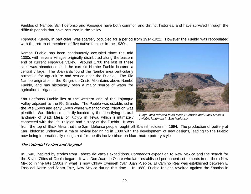
Pueblos of Nambé, San Ildefonso and Pojoaque have both common and distinct histories, and have survived through the difficult periods that have occurred in the Valley.
Pojoaque Pueblo, in particular, was sparsely occupied for a period from 1914-1922. However the Pueblo was repopulated with the return of members of five native families in the 1930s.
Nambé Pueblo has been continuously occupied since the mid 1300s with several villages originally distributed along the eastern end of current Pojoaque Valley. Around 1700 the last of these sites was abandoned and the current Nambé Pueblo became a central village. The Spaniards found the Nambé area particularly attractive for agriculture and settled near the Pueblo. The Rio Nambe originates in the Sangre de Cristo Mountains above Nambé Pueblo, and has historically been a major source of water for agricultural irrigation. San Ildefonso Pueblo lies at the western end of the Pojoaque Valley adjacent to the Rio Grande. The Pueblo was established in the late 1500s and early 1600s where water for crop irrigation was plentiful. San Ildefonso is easily located by the identifying natural landmark of Black Mesa, or Tunyo, in Tewa, which is intimately connected with the life, religion and history of the Pueblo. It was from the top of Black Mesa that the San Ildefonso people fought off Spanish soldiers in 1694. The production of pottery at San Ildefonso underwent a major revival beginning in 1880 with the development of new designs, leading to the Pueblo now being internationally recognized for the distinctive black on black matte pottery style.
Tunyo, also referred to as Mesa Huerfana and Black Mesa is a visible landmark in San Ildefonso.
The Colonial Period and Beyond In 1540, inspired by stories from Cabeza de Vaca’s expeditions, Coronado's expedition to New Mexico and the search for the Seven Cities of Cibola began. It was Don Juan de Onate who later established permanent settlements in northern New Mexico in the late 1500s in what is now Ohkay Owingeh (San Juan Pueblo). El Camino Real was established between El Paso del Norte and Santa Cruz, New Mexico during this time. In 1680, Pueblo Indians revolted against the Spanish in
20

New Mexico, causing the Spanish to flee to El Paso, however in 1692 Don Diego de Vargas re-conquered the capital of the New Mexico territory. Mexico won independence from Spain in 1821 and expelled Spanish officials from New Mexico. War between Mexico and the United States concluded in 1848 with the Treaty of Guadalupe Hidalgo which placed the territories of New Mexico and California under control of the United States. New Mexico became a Territory on September 9, 1850 and a State on January 6, 1912. During this entire period, settlement of the Pojoaque Valley continued to occur as both individual homesteads and family compounds were built, farms and ranches were established and capillas (chapels) and churches were constructed. Small communities developed as families continued to grow and more settlers arrived. Land and water were key components to these settlement patterns as agriculture was a basis for most land use, and these two intertwined factors have played a major role in the history of the Pojoaque Valley.
Land Grants In 1692, after the Reconquest, many land grants were given to followers of Governor Diego de Vargas, sometimes carved from Pueblo lands. Instead of the practice of encomiendas (a form of land granted, typically to soldiers and settlers that usually implicated Pueblo Indians living near the grant to pay tribute in the form of agricultural and trade goods or labor), the 18th century land grants tended to be private grants, where the individual who owned the land could sell it after the possession requirements were met. Community land grants became more prevalent in the nineteenth century. For community land grants, a family or group of families were usually given an allotment of land for a house, an irrigable plot, and a portion of unallotted land that was held in common for such uses as pastures, watering places, firewood, hunting, fishing, gathering plants/vegetation, and rock and mineral quarrying. In 1702 Don Ignacio Roybal applied to Governor Cubero for part of the abandoned Jacona Pueblo land. He was granted this land in 1735 by King Philip V of Spain. This grant, known as the Jacona Land Grant, was one of 295 grants created to encourage frontier settlement by the Spanish and Mexican governments from the late 1600s to 1846. The Spanish Crown granted land to the Pueblos starting in 1689.
San Antonio de Padua Church, El Rancho, NM - ca.1948 Photo by:Tyler Dingee Courtesy of Courtesy Palace of the Governors (MNM/DCA) Negative no: 91893
21

Communal vs. Private Property As the community land grants indicate, land was historically perceived as communal property. Land grants often took an organic form in concurrence with the natural landscape and based on foundations of social relations. However, when New Mexico became part of Mexico, later a Territory and then eventually part of United States, determination of private and public lands began to shift. During Mexican governance, legislation was created allowing the unused communal lands of both Indians and Hispanos to be distributed among private hands, creating a checkerboard pattern of land ownership. Further adjudication of land occurred during the Territorial period, where structured patterns such as the grid-like townships forms were used to view land. The Office of the Surveyor General of New Mexico was established in 1854 and the Court of Private Land Claims was created in 1891 to address land claims. As an example of one such claim, in 1893 the Court acknowledged 6,952 acres of the Jacona Land Grant, but stipulated that the heirs had to pay property taxes. In 1929 the Grant was seized by the federal government for failure to pay taxes. Several shareholders bought the Grant back that same year and reorganized it as a private, unincorporated association (Jacona Land Grant Association). Today 102 shares are divided among the estimated 318 members.
Land Use Patterns in Nambé – ca. 1935 Photo by: T. Harmon Parkhurst Courtesy of Palace of the Governors (MNM/DCA)- Negative no: 40963
Although historically, the Valley has had varying interpretations on land and water ownership, it wasn’t until the Pueblo Lands Act of 1924 was enacted that Congress made a formal legal interpretation of land ownership. Numerous other private land claims in the Valley, including payments to Pueblos for lands lost from federal neglect, were settled after the Pueblo Lands Act. However water rights were not adjudicated at the same time, setting the stage for future conflict.
22

Acequia Culture Although the Pueblos had a system of irrigation and water movement, the Spanish settlers developed an acequia system in the Pojoaque Valley to expand systems that were already in place. As an example, between 1723-1725, Don Ignacio Roybal initiated construction of the Acequia Madre de los Senores Roybales (Now known as the Acequia Larga de Jacona). The acequia organizations in particular were responsible for overseeing the equitable distribution of irrigation water in the Valley and in other rural communities throughout northern New Mexico. The most important role of the acequia was that it was a source of livelihood; using the water to assist in the cultivation of food for sustenance and survival. This irrigation institution was the basis for collective action as community was united through a system that provided self-sufficiency and self governance. Land use patterns were often referenced to acequias, with clustered homes situated above an acequia on an elongated lot with the agricultural land below the acequia.
Pojoaque Canteen, Pojoaque, NM, June 1949 Photo by: Anaelato G. Apodaca Courtes(MNM/
y of Courtesy Palace of the Governors DCA) Negative no: 149284
Modern Times While agriculture and mutual cooperation guided much of the early development of the Pojoaque Valley, the increasing population and shifts in land use patterns have brought about changes in the nature of the Traditional Communities. Some of these changes are manifested in historical and current conflicts created by the interweaving of private and Pueblo trust lands. Outside influences have also affected the sense of community and cooperation in the Valley. Mutual aid societies such as La Sociedad Protección Mutua de Trabajadores Unidos, or S.P.M.D.T.U., established in 1929, united Hispanos to assist and protect members from inequities. New Deal programs of the La Sociedad Protección Mutua de Trabajores Unidos in
Nambé, Present Day
23

1930s brought English-language schools to the Pojoaque Valley and the establishment of the Los Alamos Scientific Laboratory (now Los Alamos National Laboratory) in 1943 offered employment to many in northern New Mexico. As the Laboratory grew, homes and land in the Traditional Communities were purchased by scientists and engineers and agriculture was impacted by the loss of irrigable land to residential development. The first volunteer fire department in Santa Fe County was established by community members in Pojoaque in 1959. The Pojoaque Valley Irrigation District was formed in 1969 and the Nambe Dam was constructed by the US Army Corps of Engineers in 1974, enhancing the acequia system with a more reliable source of water, but also complicating disputes over water rights. The State of New Mexico vs. Aamodt water rights adjudication lawsuit was filed in 1966 to determine the surface and ground water rights of users in the Nambé, Pojoaque and Tesuque drainage basin (the Pojoaque Basin). This determination was necessary as a result of congressional legislation in 1962 that provided for water storage projects such as the Nambé reservoir because its cost had to be fairly distributed among the users. Over the years several legal decisions were set forth, including both the limitation of Pueblo water rights to historical beneficial use based on the doctrine of prior appropriation and its subsequent reversal. However water rights still remained unresolved. In 1999 a federal judge ordered the parties to engage in negotiations which are still in process.
Los Matachines Dance in El Rancho for New Year’s Day
In the late 1980s, tribal gaming emerged as a rapidly-expanding form of economic development in New Mexico. The Pueblo of Pojoaque opened the Cities of Gold Casino in 1995, driving a rapid expansion of both residential and commercial development in Pojoaque. The major highways in the Pojoaque Valley were reconstructed during the 1980s and 1990s, both better connecting the Valley with Santa Fe, Espanola and Los Alamos and bringing additional pressures to the rural character. Still, the people of the Pojoaque Valley have a history of collaboration; land-use decisions were made in the past in ways that were cooperative and respectful, issues were discussed face to face and there were shared gathering places where people came together as a community. Today we are at the point where collaboration and community involvement will be important in solving present and future issues.
24

Historical Timeline of Pojoaque Valley
Key points in history that have had an impact on the Valley
500 A.D. Indigenous inhabitants occupy the area of what is now the Pojoaque Valley
CCoolloonniiaall PPeerriioodd
ca. 1640s The first Spanish
mission in the Valley, San Francisco de Assisi de Nambé is founded
1620 Silver-crowned
canes are given to each Pueblo as a
ymbol of its office and authority
s
1300s Indigenous
inhabitants occupy the area of San
Ildefonso Pueblo
1699 Pojoaque Pueblo is deserted
1694 Spanish attack San Ildefonso
Pueblo and the tribe seeks refuge on top of Tunyo (now called Black
Mesa)
1680 Pueblo Revolt
PPrree--CCoolloonniiaall EErraa
1692 Don Diego de Vargas returns to reconquer the capital in
Santa Fe
1702 The Jacona
Land Grant is established,
encompassing 46,341 acres
1706 San Francisco de Nambé is rebuilt
after being destroyed during the Pueblo Revolt
1731 Cuyamungue Land Grant is established
1821 New Mexico becomes a province of Mexico, as
Mexico gained independence
from Spain
MMeexxiiccaann PPeerriioodd 1890
Smallpox epidemic hits the Valley and many of the Pueblos are devastated
1598 Don Juan de Oñate resettles the area of what is now present
day San Juan Pueblo
1832 San Antonio de Padua Church
first built
1694 Spanish Settlers
arrive at San Ildefonso Pueblo and settle for a
short time
1848 Treaty of
Guadalupe- Hidalgo is signed
establishing the principle that land
grants made during earlier periods
would be recognized
25

Historical Timeline of Pojoaque Valley (continued)
SSttaatteehhoooodd
Early 1930s The Nambé
School is established
1966 Aamodt lawsuit
is filed by the NM State
Engineers Office against all private
water-rights owners
1963 Valley Schools e combined to become one independent
School District
ar
1912 New Mexico admitted as
the 47th State
1936 Five families return to the
Pueblo of Pojoaque
1938 San Antonio
de Padua Church in El Rancho is rebuilt
1943 Los Alamos
National Laboratory is
founded by the government as
an atomic research center
1969 Pojoaque
Valley Irrigation District forms
1974 Construction
of Nambé Falls Dam
begins (completed
in 1976)
1979 Pueblos from the Pojoaque
Basin area enter
Aamodt case as plaintiffs in intervention
1980
The Santa Fe
County General Plan designates the non-Pueblo communities of
the Valley official Traditional
Communities
1995 Cities of GoldCasino opens
1997 The Pojoaque
Wellness Center opens
1996 U.S. 84/285 Los
Alamos interchange construction
begins in Pojoaque
PPrreesseenntt DDaayy 2002
Board of Santa Fe County
Commissioners approves the
initiation of the community planning
process for the Traditional
Communities in the Valley
2003 Tribal Summit
with Valley Pueblos held to discuss the role and goals of the
PVPC
2007 Pojoaque Valley
Community Strategic Plan is approved by the
Board of SF County
Commissioners
1924 Pueblo Lands
Board Act passed to try to resolve land title
disputes Parish Churches
consolidate
1940 First
Protestant Church
established
2002 Widening and
adding of frontage road and bridges on
U.S. 84/285 begins in the
Valley
1929 S.P.M.D.T.U. established in
Nambé
26

Trends in the Pojoaque Valley CHARACTERISTICS OF THE VALLEY Physical and Social Domains
As defined for this strategic plan, the "Greater Pojoaque Valley" includes (a) all land located within the Federally-defined Pueblo boundaries of Nambe, Pojoaque and San Ildefonso, plus (b) that portion of the Jacona Land Grant which lies north of State Highway 502, plus (c) that portion of the Cuyamungue Land Grant which lies outside Pueblo boundaries.
So defined, the Valley extends across 101.3 square miles (64,850 acres), accounting for 5.3% of the County total.
The Pojoaque Valley Traditional Community District, as designated by the Santa Fe County’s 1980 General Plan, lies entirely within the Greater Pojoaque Valley (see context map of the District in Appendix F). The District occupies 7.4 square miles (approximately 4700 acres) of land. Although the District occupies only 5% of the Valley's geography, it currently contains 69% of the Valley's population and 28% of its current employment.
Jurisdictionally, land use planning and regulatory authority within the District (as well as the non-Pueblo portions of the Jacona and Cuyamungue Land Grants) resides exclusively with Santa Fe County. Regulatory authority for development of lands contained within each Pueblo's boundaries, but outside the proposed District, is vested in each of the three respective Pueblo councils of Pojoaque Pueblo, Nambe Pueblo, and San Ildefonso Pueblo. Tribally-controlled lands occupy 88% of the Valley's landscape. Non-tribally owned lands -- including the currently proposed Pojoaque Valley Traditional Community District, the Jacona Land Grant, and a portion of the Cuyamungue Land Grant -- occupy the remainder (Pitts, 2006).
Rural Character The Pojoaque Valley has been a traditional agricultural settlement with a land tenure and social tenacity that makes it unique. The families that have held the land for centuries have created the Valley’s own distinct world-view and tradition of intercultural cooperation. On the other hand the Pojoaque Valley is not monolithic. Although each community that makes up the Valley has a different history. Dependency on the land and the need to work together has bound these
27

communities together in the face of environmental hardships, social and political struggles, and more recently, the growing pains associated with changing cultural and economic factors. Today, the Valley has remained relatively rural compared to the more urbanized centers of Santa Fe, Espanola and Los Alamos that surround it. Although the Valley lacks many of the services and amenities found in urban areas, it has retained a unique rural character and the nuances of rural living. The feeling of openness is due in part to the adjoining lands belonging to the Pueblo Indians. These protected Pueblo lands provide natural viewsheds. In addition, the dense but rural nature of the Traditional Communities will not allow the proliferation of growth. The rural character of the Valley remains important to community residents. Residents prize their ability to use their land for a mixture of uses including agricultural, residential and non-residential uses. Committee members have identified rural land patterns as desirable although there is recognition that activity in the surrounding Pueblos will provide impetus to growth and development. Pojoaque, NM, ca. Undetermined Photo by: T. Harmon Parkhurst
Courtesy of Courtesy Palace of the Governors (MNM/DCA) Negative no: 40962
Existing Zoning Areas of the Pojoaque Valley designated as Traditional Communities that qualified for a community planning process in Zoning Districts (TCZD) were created under the 1980 County General Plan. The intention of this designation was to preserve the land use pattern and character of Traditional Communities in Santa Fe County. The Santa Fe County Land Development Code addresses zoning in Traditional Communities as follows. Minimum lot size in the TCZD is one dwelling unit (du) per three quarters of an acre (3/4 ac). Minimum lot size can be reduced to one third of an acre (1/3 ac) with community water and sewer.
28

EXISTING CONDITIONS
CURRENT POPULATION, HOUSEHOLDS, AND HOUSING
In 2005, approximately 7200 persons inhabited the Greater Pojoaque Valley. Of this number,
5000 reside in the Traditional Community District 900, on tribally owned lands within Pojoaque Pueblo 1100, on tribally owned lands within Nambe and San Ildefonso Pueblos 200, in the non-pueblo portion of the Cuyamungue Land Grant
The Valley contains approximately 3100 homes (2175 of which are located in the Traditional Community District). Valley households number 2800 (of which 2000 inhabit the Community District).
At present, Valley residents account for 9.6% of Santa Fe County's estimated "rural" population (i.e., County residents who live outside the City of Santa Fe).
Noteworthy characteristics of the Valley's population include:
• As compared to the rest of the County, the population is more Hispanic and Native American in character (59% and 19%, as compared to rural County averages of 50% and 4%);
• The Valley hosts relatively more elderly (age 65+) persons;
• Net in-migration into the Valley has been less than elsewhere in the County; in 2000, 71% of the population lived in the same homes they lived in 1995 (versus 59% in the rural County);
• Valley residents have less formal education, and have lower incomes than the County average;
• Valley residents are highly reliant on employment at Los Alamos, less dependent on the City of Santa Fe; 28% work in Los Alamos, 39% in the City (as compared to averages of 9% and 53%, in the rural County as a whole);
• The proportion of mobile homes (25% of all housing) is slightly lower than the rural County average; vacation homes are few.
29

CURRENT EMPLOYMENT
In 2005, the Valley hosted an estimated 1282 jobs. Approximately 28% (360 jobs) of the Valley's employment is located in the Community District; 72%, outside the District (almost entirely on tribal lands). A large majority of the Valley's employees (952) work in the area's public schools, other government services, and the Valley's resort, recreation, and lodging industry.
The Valley's jobs-to-population ratio (18 jobs per 100 residents) is virtually identical to the rural County average. However, the Valley's jobs are disproportionately concentrated in educational and other government services and in the lodgings/entertainment/recreation industries. These activities account for 74.3% of the Valley's employment. In contrast, local service employment is very low. For New Mexico communities of similar size, private-sector workers who provide retail goods and consumer services to the local population typically average 18 employed workers per 100 local residents. The Valley average is 3.
Principal employers within the Valley are the Valley's resort and recreation complexes and the Pojoaque high school and elementary school. Together, they account for approximately 840 of the Valley's employees. Government employment accounts for another 112 jobs; retail establishments, 104.
DEVELOPMENT TRENDS
Population and housing growth in the Valley has been slower than the rural County average. Growth on non-tribal lands has been declining; growth on tribal lands (mostly, within Pojoaque Pueblo) has been increasing. On balance, the increase in tribal-lands growth has offset recently declining growth on non-tribal lands.
Annual population growth in the County (outside the City) averaged 4.5% during the Nineties, but since 1997 has dropped to an average of 2.2% per year. In contrast, the Valley as a whole has been growing at a fairly constant 1.3-1.5% since at least 1990.
During the last five years, net housing growth within the Valley has been relatively stable, averaging approximately 51 units per year.
• 43% of this growth -- 22 units annually -- occurred on non-tribal lands
• 43% (22 units), on tribal lands within Pojoaque Pueblo;
• 14% (7 units), on tribal lands within Nambe and San Ildefonso Pueblos.
30

One consequence of the Valley's stability and the County's declining growth is that the Valley now accounts for a larger share of County growth than has been the case in the recent past. Among major subregions of Santa Fe County (outside the City) during 2000-2003, annual net housing growth in the Valley ranked fourth, surpassed only by:
• Santa Fe Community College District (123 units/year) • Tres Arroyos/West Las Campanas (74 units) • Eldorado (72 units)
In addition, the Valley -- despite its low rate of historic and recent growth -- has now grown to a size equal to many established, self-sufficient, and incorporated New Mexico communities. For example, the Valley's current population (7200) is comparable to those of: Aztec (6900), Belen (7100), Bernalillo (7500), Raton (6900), Truth or Consequences (7200), and Taos (4800).
Finally, review of development plans currently under consideration in the region indicates that through 2010, population and housing growth in the Valley will remain generally stable at current levels.
31

III. Vision, Mission and Strategic Plan
View of the Sangre de Cristo Mountains from the Valley A Vision for the Valley’s Future
What follows is the vision for Pojoaque Valley as collectively expressed by those who participated in the community visioning process undertaken between March and May 2003. It portrays what the community imagines Pojoaque Valley could be like in 2025, if strategic actions are taken to turn this Vision into reality. The Vision is written from the perspective of a community member living in the Valley in the year 2025. Some may feel the Vision is too optimistic; however, what seems difficult, or impossible, in the short-run becomes an exciting challenge over a period of two decades. In addition, the Vision bonds a community, stimulates decision-making processes and becomes a catalyst for action.
32
33
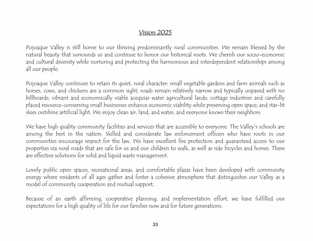
Vision 2025 Pojoaque Valley is still home to our thriving predominantly rural communities. We remain blessed by the natural beauty that surrounds us and continue to honor our historical roots. We cherish our socio-economic and cultural diversity while nurturing and protecting the harmonious and interdependent relationships among all our people. Pojoaque Valley continues to retain its quiet, rural character: small vegetable gardens and farm animals such as horses, cows, and chickens are a common sight; roads remain relatively narrow and typically unpaved with no billboards; vibrant and economically viable acequias water agricultural lands; cottage industries and carefully placed resource-conserving small businesses enhance economic viability while preserving open space; and star-lit skies outshine artificial light. We enjoy clean air, land, and water, and everyone knows their neighbors. We have high quality community facilities and services that are accessible to everyone. The Valley’s schools are among the best in the nation. Skilled and considerate law enforcement officers who have roots in our communities encourage respect for the law. We have excellent fire protection and guaranteed access to our properties via rural roads that are safe for us and our children to walk, as well as ride bicycles and horses. There are effective solutions for solid and liquid waste management. Lovely public open spaces, recreational areas, and comfortable plazas have been developed with community energy where residents of all ages gather and foster a cohesive atmosphere that distinguishes our Valley as a model of community cooperation and mutual support. Because of an earth affirming, cooperative planning, and implementation effort, we have fulfilled our expectations for a high quality of life for our families now and for future generations.

Mission Statement Our mission is to formulate a strategic plan for sustainable development1 that promotes the rural quality of life in the Traditional Communities in the Pojoaque Valley. The quality of life we want includes: a) maintained rural character of the Valley as described in our “Vision 2025”; b) harmonious relationships between Pueblo and Non-Pueblo communities; c) secured water sources and good quality drinking water; d) secured access to property; e) satisfactory level of community facilities & services, particularly the provision of appropriate liquid & solid waste management, law enforcement, safe roads and wellness facilities; f) substantial open space, organized recreational areas and shared gathering places; and g) quality public education that promotes citizenship responsibility of a democratic society2 within our community and prepares our children for the demands of 21st century employment.
Mission Objectives:
1. Empower the Pojoaque Valley Traditional Communities by developing an evolving planning capability, including the capacity to effectively coordinate programs and projects among key stakeholders, to secure funding, and to implement this strategic plan.
2. Promote an economy that supports and revitalizes the agricultural activity in the Valley while developing other resource-conserving economic activities.
3. Identify, map and work towards resolving jurisdictional boundaries in an effort to formulate and implement County land use ordinances.
4. Develop land use ordinances that reflect a concerted and cooperative effort among the County, State, and Pueblo governments in resolving the Valley’s growth management issues: • Maintaining the Valley’s rural character • Maintaining adequate water supply and good water quality • Developing a capacity to manage solid and liquid wastes • Preventing loss of agricultural lands and increasing open space • Providing infrastructure including related public services and public safety
5. Develop local indicators that the Planning Review Committee can use to monitor and evaluate the Plan’s implementation.
1Development that meets the needs of the present without compromising the ability of future generations to meet their own needs. 2 Citizenship responsibility of a democratic society refers to the obligations to contribute to the common good by performing duties to benefit the community.

35
Community Analysis and Issues
A Community Scan A community working on a strategic plan needs to complete a community evaluation that considers the various environments that make an impact on that community. This is particularly important for a Traditional Community such as the Pojoaque Valley that is not incorporated and has limited powers and abilities to effect change. The Community Scan has two parts: an Internal Analysis and an External Analysis.
Internal Analysis
The Internal Analysis is a detailed description of the community’s strengths and weaknesses related to achieving the stated mission. It is an assessment of the community’s existing resources that will be called upon to achieve the mission in several specific categories. The categories deemed most significant to the Pojoaque Valley were: water; land use; historical and cultural issues; social and economic issues; and education. Separate groups were designated to work on these issues. Final reports were presented to the planning committee who decided that this work would determine the specific themes to be used in the SWOT (Strengths, Weaknesses, Opportunities, and Threats) analysis, described in the subsequent section.
External Analysis
Scenario Development for Strategic Community Planning
External Analysis is the identification and study of key factors external to the community seeking to accomplish its mission, and then structuring them into alternative paths of future scenarios. The External Analysis portion of a community strategic plan is essentially a study of Opportunities and Threats that affect the community from the outside. This process begins with identifying Key Decision Factors. These are positive and negative factors within the community environment that have the greatest perceived influence on the success or failure of the stated mission. Positive Key Decision Factors are called Opportunities and negative Key Decision Factors are called Threats. Sometimes, especially in other styles of planning, these are referred to as Opportunities and Constraints. The three important elements considered in the Pojoaque analysis were community and Pueblo power and authority; relations with neighboring Pueblos, communities and other government entities; and future economic development.
36
The Pojoaque Valley Planning Committee identified patterns or clusters of these Key Decision Factors and grouped them into common, thematic Driving Forces. Driving Forces are the outside or external “forces” that will ultimately drive the future of the community’s chosen mission. The overall thematic categories agreed upon for scenario development were socio-cultural, economic, political, technological and environmental. Once specific themes were developed, alternative future scenarios were formulated. Scenarios were constructed using the Key Decision Factors and the Driving Forces as a framework to specify how various possibilities combine to produce a variety of political, economic or other chosen external events in which eventual strategies will have to function. They were descriptions of future possibilities designed to help reduce uncertainties about future planning. The main purpose of a scenario is ultimately to show how it will affect the community’s mission statement, the overall objective of the community’s entire plan. A secondary purpose, also extremely important, is to generate discussion and debate about the future since most of us are predisposed to think about the present or continue to dwell in the past, especially regarding community problem solving initiatives. Scenarios are a way for us to ultimately make planning sense out of a relationship of the past, present and future. They help us to focus on assumptions and visualize relationships about desires and premises in the context of alternative futures. Strategic community planning can use either singular or multiple scenarios. A single scenario of the future may prove to be inaccurate. Multiple scenarios reduce that possibility although reality may also prove to be some combination of the multiple scenarios chosen. Initially the PVPC constructed and discussed four narrative scenarios after the internal and external analyses were completed. It was decided that a final agreed upon future scenario would be developed at a community meeting after a series of focus groups and the SWOT analysis were completed.

37
SWOT Analysis Strengths, Weaknesses, Opportunities and Threats (SWOT) analyses examine strengths and weaknesses internal to a community, and opportunities and threats coming from factors external to the community; strengths and weaknesses are generally under some form of local control, while opportunities and threats are not. Some typical questions used in the SWOT analyses included: Strengths: Which resources are available for success? What are our abilities? What kinds of resources characterize our community in comparison with other traditional communities? Weaknesses: What kind of difficulties could we encounter in our initiative? In what areas are we lacking or have limitations? What are the disadvantages of our community compared to other communities? Opportunities: What are we aiming for? What other opportunities could arise if we achieve a success? What prospects could occur in the future if certain goals are achieved today? Threats: What obstacles could arise? What are the financial risks or problems associated with our goals? What are the risks that could negatively influence our community? Answers to these kinds of questions can help to understand which internal and external elements are taken into account when defining actions, plans and decisions. It is important to know that some elements can be both strengths and weaknesses, and some opportunities can also represent threats. Therefore, correct interpretation of data is essential to understand the local situation. The SWOT is a focused examination or community discussion to guide the development of action plans that are essentially opportunities built on strengths that are checked by the realities of weaknesses and threats. Results of the internal and external analyses were combined to guide the SWOT analysis. The themes and topics to focus the SWOT analyses were identified after a full review of the vision and mission statements, meeting notes and initial key issues. In the above context, the following themes and topics were analyzed:

38
Theme Topics Rural Character Acequias, Agriculture, and History and Culture Growth Management Domestic Water and Wastewater and Roads, Circulation and Transportation Community Quality of Life Public Places and Open Space, and Economic Development An example of a completed SWOT analysis is shown in Appendix E. The results of the SWOT analyses were combined with information including key facts, key stakeholders, key information sources and the relationship to other themes and topics to guide the refinement of specific goals and the actions needed to achieve these goals. These action plans form the core guidance of this Community Strategic Plan. Once the SWOT analysis was completed, the First Community-wide Forum was held on February 2005. From this meeting, matters of importance to community members were synthesized into a document called “A Desired and Positive Future Scenario for the Pojoaque Valley”. The details of these findings are outlined in the following section.
39
A DESIRED AND POSITIVE FUTURE SCENARIO FOR
THE POJOAQUE VALLEY
Through a series of specific PVPC meetings and community meetings, a Future Scenario for the Valley was articulated that reinforced core values and goals:
• Preserve the rural character, history and culture of the Valley • Provide high quality community facilities and services, and • Foster community cooperation and mutual support.
When asked what a desired, positive future scenario would look like, Valley residents were clear that:
• Development would be controlled • A local economy would be consistent with a rural system and setting • A few new facilities would support “community” in the Valley • The Valley needs some kind of organizational entity to look after the interests of the Valley and cooperate with the
Pueblos • Youth need to be involved in the future.
A positive future must be tempered by what is true about the current circumstances in the Valley; assumptions about we believe to be true:
• The Valley is rooted in rural agriculture, the interweaving of private and Pueblo trust lands, and the intercultural
cooperation of a diverse mix of people; • The residents of the Valley want to preserve its rural character, natural beauty, the acequias, the open space, and
the high quality of the environment; • The Valley is influenced by the advent of Indian gaming and the subsequent expansion of commercial
development; • The economy of the Valley depends on its relationship with Los Alamos, Santa Fe, Espanola and the economic
activities of the Pueblos; • The conflict over water usage and appropriation undermines cooperation among residents of the Valley, and
discourages a belief in a positive future; and • A positive future must include strategies that motivate young people to stay in the Valley.

40
A positive future for the Valley must also be realistic about challenges it faces:
• Residents must find better ways of communicating with each other; • Rapid residential and commercial development threaten the traditional nature and quality of life in the Valley; • Conflict over water persists in the Valley; • The interweaving of private and Pueblo lands is straining relationships; and • Pueblo gaming, related commercial development, zoning and the reconfiguration of local highways present
challenges to realizing a diverse local economy.
A New Planning Approach After formulation of this desired and positive scenario for the Pojoaque Valley, the Planning Committee acknowledged that a new planning approach would be needed to achieve this positive future scenario. One of the key elements to this approach was to determine what could be planned cooperatively in the community, particularly with the Pueblos, and what lied outside of the scope of such planning. This was of the utmost importance since Valley residents have no independent, formal source of political power. The Committee realized the power limitations that they had, given the unique planning area of the Valley. That is why the Committee selected specific achievable actions that would require collaboration and dedication from community leaders, and various governmental agencies representing the Valley. Detailed explanations of these actions are discussed in the following section.

41
IV: Strategic Goals and Actions
The Committee was able to consolidate issues of importance into a few major Action Plans. These Action Plans are the basis for the Community Strategic Plan, and will be the main focus for the Pojoaque Valley Planning Authority, or whatever form the local development review committee assumes for the Valley. Community Actions: The Pojoaque Valley Planning Committee seeks support from the Board of County Commissioners for those Action Plans identified in the Community Strategic Plan that will require Community Action. The Community Actions outline proposed future programming or projects that the Community Strategic Plan identifies as important work to be addressed in the community. These Actions are not proposed ordinances and do not outline any legal changes for land use or future development in the community. The community is responsible for working with the County and/or various agencies or groups to see that these actions are executed. Some Actions may be taken by the Pojoaque Valley Planning Authority, or whatever form the Local Development Review Committee will take to oversee the Community Strategic Plan. Ordinance Actions: Some Action Plans will warrant development of Community Ordinance Actions, which are policies identified through the planning process, which may change or amend the County Land Development Code or other County Ordinances. The Ordinance Actions may be adopted by the Board of County Commissioners as a set of legally binding regulations specifically for the Traditional Communities in the Pojoaque Valley. The County is responsible for enforcement of all ordinances. Implementation and Responsibilities: The Planning Division of Santa Fe County’s Growth Management Department is the lead agency responsible for assisting the residents of the Pojoaque Valley Traditional Community in the creation of this Community Strategic Plan as well as for helping the community coordinate implementation of the various actions outlined in the Plan. Upon adoption of a set of ordinances for the Pojoaque Valley, the County is responsible for enforcement of the ordinances contained in the Plan. The Community Strategic Plan is intended as an active document that can and should be reviewed and updated as conditions change throughout the Pojoaque Valley.
The following are the consolidated Action Plans that were gleaned from the various community forums and meetings and from surveys asking about the most important issues the community felt needed attention.

42
Goal One: Create public places that can support community and serve our youth.
ACTION 1A: Provide a multi-purpose community center for educational and community-oriented programs and events.
ACTION 1B: Create a connected trail system, which will also serve as a running course for the Pojoaque Valley High School sports teams.
ACTION 1C: Promote community support for quality education, and advocate for more job opportunities and recreation for
Valley Youth.
Goal Two: Ensure a clean water supply.
ACTION 2A: Preserve acequias and improve diversions and delivery systems. ACTION 2B: Develop and implement strategies for domestic water conservation.
ACTION 2C: Protect domestic water supplies.
ACTION 2D: Pursue options for wastewater management and treatment systems. Goal Three: Strengthen and build community relationships and communication between neighbors and government entities and increase local input into zoning regulations. ACTION 3A: Consider a “Youth Council” of both Pueblo and Traditional Community youth that can work directly with the
School District, the County and the Pueblos on youth-related issues. ACTION 3B: Address the following community problems in collaboration with governmental agencies and other organizations:
- Vandalism and Graffiti - Trash and Dumping - Road Maintenance - Speeding - Drugs/Alcohol Abuse
- Suicide Prevention - Teen Pregnancy - Animal Control

ACTION 3C: Communicate, evaluate, and modify existing zoning regulations as needed to address growth and land use issues,
such as density, family transfers, and affordable housing. Goal Four: Grow the local economy. ACTION 4A: Establish mixed-use districts or “corridors” for Valley businesses.
ACTION 4B: Revitalize traditional agricultural practices.
ACTION 4C: Promote an arts and crafts economy in the Valley. ACTION 4D: Support home businesses and home occupations.
Goal Five: Create an entity that looks after the interests of the Valley by implementing the Community Strategic Plan, and is able to plan cooperatively with the County, State and Federal governments, the Jacona Land Grant, and the local Pueblos. After each of the Action Plan details have been laid out in the following section, a detailed matrix has been provided in the subsequent section to outline how each of these Actions Plans will be implemented and monitored.

44
Goal One: Create public places that can support community and serve our youth.
Actions: • 1A: Provide a multi-purpose community center for educational and community-oriented
programs and events.
• 1B: Create a connected trail system, which will also serve as a running course for the Pojoaque
Valley High School sports teams. • 1C: Promote community support for quality education, and advocate for more job opportunities
and recreation for Valley Youth.

ACTION 1A: Provide a multi-purpose community center for educational and community-oriented programs and events.
BACKGROUND:
CURRENT STATUS:
Over time, the Valley has lost many of its public spaces, from the plazas to the informal areas where youth and elders would gather to share information, visit, or even to seek resolana3. The community needs space for community gatherings and events, as well as places for educational experiences and learning outside of a classroom setting. Currently there are no appropriate public places for large community events, such as large meetings, performing arts, youth activities, display space or arts and crafts festivals. Limited community spaces included PVHS, churches, La Sociedad Protección Mutua de Trabajores Unidos (S.P.M.D.T.U.), El Rancho Community Center, the Wellness Center, and the Boys and Girls Club. Therefore our goal is to create more public spaces, especially for youth and seniors. We envision a community park, as well as a place for performing arts, arts and crafts, and other community-oriented or educational events and activities. The County is discussing a possible site with the Jacona Land Grant. These are current sites that are being considered, however we are not limited to these sites if other opportunities arise. In addition, legislative funding has been obtained to begin feasibility studies and preliminary design work on a community center.
• Work with the County Project Coordinator and Commissioner to: FIRST STEPS:
RESOURCES:
• Decide what site would be appropriate for a multi-purpose community center. • Meet with appropriate parties to confirm options for site. • Prepare a feasibility study and a preliminary conceptual design of the community center. • Secure sale or lease of the site.
• State Legislative Appropriations • Funding through Capital Outlay Projects
453 Spanish word for a sunny place, but typically meaning a comfortable gathering space where people come together to share stories, information and news of the day.

46
Pojoaque Valley School District Jacona Land Grant Board
State Legislature and Representatives for the Valley County Commissioner County Growth Management and Community Services Departments
PARTNERS:
ACTION 1B: Create a connected trail system that will also serve as a running course for the Pojoaque Valley High School sports teams.
The Pojoaque Valley High School has excellent cross country and distance runners, who have won many State titles over the years. Currently the sports teams, including college and professional runners train using existing trails near the new High School campus. There have been trespassing issues in the past, but for the most part the users of the trail, especially the athletes, are respectful of the trails and the natural habitat around them.
BACKGROUND:
The Valley needs more public, multi-use trails to promote the health of the community and to provide visitors and tourists with additional activities. The existing trail needs to be marked and improved. The ultimate goal would be to connect the existing trail near the school to other trails that lie outside of the Valley area. This project would be accomplished in phases.
• The proposed Pojoaque trail system has been designated and recorded by the County Planning and GIS
staff using GPS (See Appendix K). CURRENT STATUS:
• A trail system is being considered along the Pojoaque and Nambe Rivers of the Valley by Pojoaque Pueblo.
• A proposed northern Caja del Rio trail is being considered to the south of the proposed Pojoaque Valley multi-purpose trail.
• Pojoaque Pueblo has established a fitness/recreational trail that can be accessed from the Pojoaque Pueblo Wellness Center.

47
• Present trail system plan to the County Open Land and Trails Planning Advisory Committee (COLTPAC) to put in a request for funding. FIRST STEPS:
• Create an agreement with the Jacona Land Grant, Pojoaque Pueblo and the BLM through means of a Memorandum of Understanding (MOU).
• Define a Management Plan and Phases and secure legal easements • Design the trail, allowing for future connections with other planned and existing trails in both the
Pojoaque Valley and Santa Fe County.
• County Open Land and Trails Planning Advisory Committee (COLTPAC) RESOURCES • PV School District, PVHS cross-country program, other athletic programs • Greater Valley community • Jacona Land Grant Board
PARTNERS: COLTPAC County Open Space and Trails Division PV School District Jacona Land Grant Board BLM/National Park Service State Legislature Valley Pueblos

48
ACTION 1C: Promote community support for quality education, and advocate for more job opportunities and recreation for Valley Youth.
This Action is being proposed to promote healthier living for youth, promote better social opportunities, and retrain young people for new skills. We hope to provide more employment opportunities to keep youth in the Valley. The committee is committed to decreasing drug use, vandalism, graffiti, teen pregnancy and suicides in the area. We also recognize that it is essential to include our young people and those presently providing resources in any and all planning initiatives for this Action.
BACKGROUND
Although this Action is technically out of the scope of a strategic plan of this nature, our intent is to identify the needs of the youth that are currently not being met by the school and the community. Identifying needs is the first step towards providing community support. • Most employment opportunities are being provided by Los Alamos National Laboratory and the Pueblos. CURRENT
STATUS: • The PVPS provides a public education through high school. • There are community colleges or UNM Extensions in Espanola, Los Alamos and Santa Fe. • Explore what is needed by conducting focus groups and surveys with youth, local businesses, educational
entities and social services. FIRST STEPS:
• Define “rallying” issues to build around. • Complete a comprehensive inventory of all activities, clubs, and resources currently available to youth in the
Valley • Start mobilizing the community in support of these issues that have been identified as important.
• An complete understanding of future options for the Old School facility
INFORMATION NEEDED:
• An employment survey of youth • What high speed internet options are available to youth • Local incentives available to keep youth employed in the Valley • Find out if young people would like to create an entity such as a Youth Council including both Pueblo and
Traditional Community Youth, that can work directly with SF County and Pueblo governments on youth-related issues.

49
RESOURCES: Pojoaque Valley Public Schools (PVPS)
Pojoaque Pueblo Wellness Center/Employment Training Center Pojoaque, Nambe and San Ildefonso Pueblos
Hands Across Cultures Teen Center in Arroyo Seco Santa Fe County – CDBG Block Grants State Legislature – Capital Outlay funds Los Alamos Nat’l Laboratory – possible Community Development grants Local groups and sports leagues El Rancho Community Center Grants and foundation funding sources
PARTNERS: Local youth leaders and community volunteers/leaders Santa Fe County District 1 Commissioner PVPS Pueblos State Legislature for project funding

50
GOAL TWO: Ensure a clean water supply.
Actions: • 2A: Preserve acequias and improve
diversions and delivery systems.
• 2B: Develop and implement
strategies for domestic water conservation.
• 2C: Protect domestic water supplies.
• 2D: Pursue options for wastewater
management and treatment systems.

51
INTRODUCTION:
The Aamodt water rights adjudication lawsuit, the longest-running suit in the Federal court system, in excess of 40 years, will resolve ground water rights in the Pojoaque basin for both Pueblo and non-Pueblo users. Water use restrictions will be established for all users in the final form of a settlement agreement to be determined in the near future. This Community Strategic Plan acknowledges that water use restrictions will be determined by the outcome of the Aamodt suit and therefore does not seek to impose any additional water use restrictions in the Traditional Community District boundary at this time. The consensus of the Planning Committee, reflecting the sentiment of the Community, is that attempting to have the Community Plan impose additional water use restrictions would result in loss of Community support for the Plan. The Planning Committee continues to support an integrated approach to wastewater, in concurrence with the proposed settlement, as well as efforts via the Community Strategic Plan to maintain and improve acequias. The Plan also advocates for additional innovative local water conservation and use policies, such as water catchment, advanced treatment systems and small-scale community systems to help the community to remain as independent and sustainable as possible. These recommendations are reflected in the subsequent Actions.
ACTION 2A: Preserve acequias and improve diversions and delivery systems.
Our acequias are a historical and cultural icon of the Pojoaque Valley and are considered the lifelines of the community. They are essential for the support of agriculture, and sustain the ecological health of the riparian ecosystems and the entire watershed. We need to create a fair, comprehensive and sustainable water usage plan for acequias. We can ease pressure on other Valley water sources by making efficient use of the acequias. Tasks include improving water capture and delivery, and educating parciantes about water conservation and potential funding sources.
BACKGROUND:
CURRENT STATUS:
Some of the challenges we face in preserving our acequias include problems with rights of way and access to these waterways, as well as limited funding and lack of knowledge of their importance.
• Today, there are about 24 functioning acequias in the Valley. • About 90% of the water used in the Valley is for acequias. • Currently acequias irrigate approximately 1900 acres in the Pojoaque-Nambe Sub-basins by diversion of
8,440 afy of surface water and 365 afy of ground water from authorized/metered agricultural wells.

52
• Much of the irrigation infrastructure is old and in need of repair, with obsolete diversions requiring a great deal of maintenance
• Most parciantes use the flood irrigation method • There is limited information about usage • Lack of use of existing system can affect water rights • Building is occurring on land with water rights
FIRST STEPS: • Promote a pilot project in order to model the method for bringing together the resources necessary to
improve and preserve acequias. o Choose an acequia for the pilot project. La Otra Banda is a likely candidate because it is the
largest in the Valley, both in terms of irrigated acres and number of parciantes. o Document the process and make it available to other acequias.
• Investigate sources of technical and financial assistance for acequias.
• The New Mexico Acequia Association and the Interstate Stream Commissioner can supply information
about funding sources for acequia improvement RESOURCES/ INFORMATION NEEDED:
PARTNERS:
• The County Public Works Department has a vested interest in improving the acequia diversions because they currently help with maintenance on the diversions.
• Learn more about the state of the existing systems, for example, the flow rate, and the level of usage. • Get information about available, appropriate technologies. • Water banking is an option for preserving unused water rights.
Each Acequia Commission in the Valley Rio Pojoaque Acequia and Well Water Association (RPAWWA) Agricultural Revitalization Initiative (ARI) Valley parciantes SF County NM Acequia Association Natural Resources and Conservation Service Office of the State Engineer
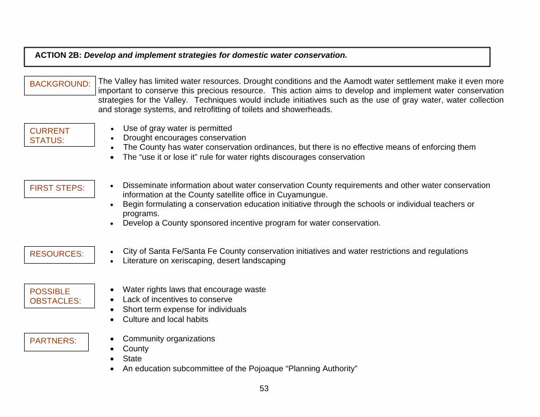
53
ACTION 2B: Develop and implement strategies for domestic water conservation.
The Valley has limited water resources. Drought conditions and the Aamodt water settlement make it even more important to conserve this precious resource. This action aims to develop and implement water conservation strategies for the Valley. Techniques would include initiatives such as the use of gray water, water collection and storage systems, and retrofitting of toilets and showerheads.
BACKGROUND:
CURRENT STATUS:
• Use of gray water is permitted • Drought encourages conservation • The County has water conservation ordinances, but there is no effective means of enforcing them • The “use it or lose it” rule for water rights discourages conservation
• Disseminate information about water conservation County requirements and other water conservation information at the County satellite office in Cuyamungue.
FIRST STEPS:
• Begin formulating a conservation education initiative through the schools or individual teachers or programs.
• Develop a County sponsored incentive program for water conservation.
• City of Santa Fe/Santa Fe County conservation initiatives and water restrictions and regulations RESOURCES: • Literature on xeriscaping, desert landscaping
• Water rights laws that encourage waste POSSIBLE OBSTACLES: • Lack of incentives to conserve
• Short term expense for individuals • Culture and local habits
• Community organizations PARTNERS: • County • State • An education subcommittee of the Pojoaque “Planning Authority”
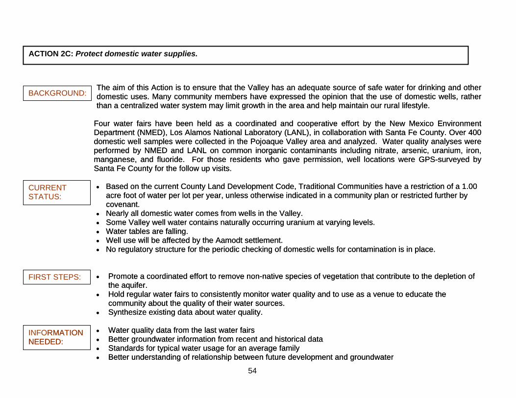
54
ACTION 2C: Protect domestic water supplies.
The aim of this Action is to ensure that the Valley has an adequate source of safe water for drinking and other domestic uses. Many community members have expressed the opinion that the use of domestic wells, rather than a centralized water system may limit growth in the area and help maintain our rural lifestyle.
The aim of this Action is to ensure that the Valley has an adequate source of safe water for drinking and other domestic uses. Many community members have expressed the opinion that the use of domestic wells, rather than a centralized water system may limit growth in the area and help maintain our rural lifestyle.
BACKGROUND:
CURRENT STATUS:
FIRST STEPS:
INFORMATION NEEDED:
RMATION NEEDED:
Four water fairs have been held as a coordinated and cooperative effort by the New Mexico Environment Department (NMED), Los Alamos National Laboratory (LANL), in collaboration with Santa Fe County. Over 400 domestic well samples were collected in the Pojoaque Valley area and analyzed. Water quality analyses were performed by NMED and LANL on common inorganic contaminants including nitrate, arsenic, uranium, iron, manganese, and fluoride. For those residents who gave permission, well locations were GPS-surveyed by Santa Fe County for the follow up visits.
Four water fairs have been held as a coordinated and cooperative effort by the New Mexico Environment Department (NMED), Los Alamos National Laboratory (LANL), in collaboration with Santa Fe County. Over 400 domestic well samples were collected in the Pojoaque Valley area and analyzed. Water quality analyses were performed by NMED and LANL on common inorganic contaminants including nitrate, arsenic, uranium, iron, manganese, and fluoride. For those residents who gave permission, well locations were GPS-surveyed by Santa Fe County for the follow up visits. • Based on the current County Land Development Code, Traditional Communities have a restriction of a 1.00
acre foot of water per lot per year, unless otherwise indicated in a community plan or restricted further by covenant.
• Based on the current County Land Development Code, Traditional Communities have a restriction of a 1.00 acre foot of water per lot per year, unless otherwise indicated in a community plan or restricted further by covenant.
• Nearly all domestic water comes from wells in the Valley. • Nearly all domestic water comes from wells in the Valley. • Some Valley well water contains naturally occurring uranium at varying levels. • Some Valley well water contains naturally occurring uranium at varying levels. • Water tables are falling. • Water tables are falling. • Well use will be affected by the Aamodt settlement. • Well use will be affected by the Aamodt settlement. • No regulatory structure for the periodic checking of domestic wells for contamination is in place. • No regulatory structure for the periodic checking of domestic wells for contamination is in place. • Promote a coordinated effort to remove non-native species of vegetation that contribute to the depletion of
the aquifer. • Promote a coordinated effort to remove non-native species of vegetation that contribute to the depletion of
the aquifer. • Hold regular water fairs to consistently monitor water quality and to use as a venue to educate the
community about the quality of their water sources. • Hold regular water fairs to consistently monitor water quality and to use as a venue to educate the
community about the quality of their water sources. • Synthesize existing data about water quality. • Synthesize existing data about water quality.
• Water quality data from the last water fairs • Water quality data from the last water fairs • Better groundwater information from recent and historical data • Better groundwater information from recent and historical data • Standards for typical water usage for an average family • Standards for typical water usage for an average family • Better understanding of relationship between future development and groundwater • Better understanding of relationship between future development and groundwater

55
• Office of the State Engineer
RESOURCES:
PARTNERS:
• NM Environment Department • Los Alamos National Laboratory (LANL) • Acequia Organizations • Rio Pojoaque Acequia and Well Water Association (RPAWWA) • Pojoaque Basin Water Alliance (PBWA)
• LANL • County • Community • NM Environment Department • Office of the State Engineer • Federal government representatives • Valley Pueblos
ACTION 2D: Pursue options for wastewater management and treatment systems.
BACKGROUND: This Action is intended to provide options for short and long term wastewater management and treatment systems in the Valley to prevent potential problems of groundwater contamination.
Currently Valley residents use septic tanks to handle wastewater. Although there have been a few localized problems with groundwater contamination, we are not yet at the point where aquifer damage is extensive. However, if density in the Valley increases, septic systems may not continue to be a viable option. Therefore, we need to consider other options for wastewater treatment. Pojoaque Pueblo is in the process of planning a new system which will include hook ups to the Pueblo and the Pojoaque Valley schools through a Memorandum of Understanding (MOU) with Santa Fe County. There is potential for non-Indian residents of the Valley to hook up to this system if there are ways to subsidize the costs. However, it is not certain when, or if, the Pojoaque Pueblo wastewater treatment system will become available to the Traditional Communities planning area. Moreover, it may not be feasible to connect all residents to the system. Therefore we support the development and improvement of decentralized wastewater treatment options.
CURRENT STATUS:

56
• Continue to improve wastewater treatment systems: FIRST STEPS:
o Address the issue of older, sub-standard septic systems by requiring properties within the Pojoaque Valley Traditional Community District that are going to be divided, subject to a family transfer, variance, or rezoning, to furnish complete and accurate documentation to the County which demonstrates that all facilities on-site are in compliance with all New Mexico Environment Department regulations. Also require proof that necessary permits have been obtained for any and all septic and waste disposal facilities on the property.
o Get more information about options for local systems and information on better septic and re-use technologies
o Create demonstration and pilot projects of Advanced Treatment Systems
• Support a regional wastewater facility to include the Traditional Communities of the Valley: o Have a location study done for a potential regional scale waste water system project o Work with Pueblos to get other areas of Valley connected to their system
Regional consortium on wastewater- Española Basin Regional Planning Issues Forum RESOURCES:
PARTNERS:
Pilot projects throughout NM Modern septic technology
Community organizations County Pueblos The Pojoaque Valley “Planning Authority”

57
GOAL THREE: Strengthen and build community relationships and communication between neighbors and government entities and increase local input into zoning regulations.
Actions: 3A: Consider a “Youth Council” of both Pueblo and
Traditional Community youth that can work directly with the School District, the County, and Pueblos on youth-related issues.
3B: Address the following community problems in
collaboration with governmental agencies and other organizations:
- Vandalism and Graffiti - Animal Control - Speeding - Road Maintenance - Trash and Dumping - Drugs/Alcohol Abuse - Teen Pregnancy - Suicide Prevention
3C: Communicate, evaluate, and modify existing
zoning regulations as needed to address growth and land use issues, such as density, family transfers, and affordable housing.
58
ACTION 3A: Consider a “Youth Council” of both Pueblo and Traditional Community youth that can work directly with the School District, the County, and Pueblos on youth-related issues.
This youth directed entity should represent and speak for the students and youth of the various communities of the Valley. It should meet on a regular basis to propose solutions for issues that affect youth in the Valley. These issues would be defined by the youth council, but might include, for example, recreational opportunities, part time job opportunities, youth mentoring and pregnancy and suicide prevention initiatives.
BACKGROUND:
CURRENT STATUS:
Most school and student organizations focus on school functions and activities and do not always capture community issues and topics. The Boys and Girls Club is a resource for youth, but usually does provide programs that appeal to youth past the age of 14 or 15. Existing religious based youth groups do not include all of the Valley youth.
• Determine what entity will take the lead to start this organization and hold the initial meetings with youth
groups, for example, an Education and Youth Subcommittee. FIRST STEPS:
RESOURCES:
• Meet with existing high school groups/organizations to get input and to see if youth would be interested o Decide the purpose of this group and what issues the group would work on o Determine whether the entity would simply provide support for other student/youth organizations,
or would also attempt to influence decisions made in the community (by the County, the PV School District, Pueblos etc).
• If a Youth Council is desired after thorough consultation with local youth, explore funding resources might be available through State and Federal grants, or through the Community Development division of LANL. Funding could be used for youth conferences, youth leadership programs, local projects, or other initiatives that would benefit youth.
PV School District Boys and Girls Club Hands Across Cultures Teen Center Pueblos County Wellness Center Church groups

59
Existing student organizations and youth groups PARTNERS:
BACKGROUND:
CURRENT STATUS:
PV School District and School Board Pueblo government and community County government
ACTION 3B: Address the following community problems in collaboration with governmental agencies and other organizations:
- Vandalism and Graffiti - Animal Control - Speeding - Road Maintenance - Trash and Dumping - Drugs/Alcohol Abuse - Teen Pregnancy - Suicide Prevention
In order to enhance the quality of life in the Valley, we need better law enforcement and community based volunteer efforts to address community problems. All of the community is affected by those with alcohol, drug and gambling problems. We are concerned about teen pregnancy and suicide. Graffiti, vandalism, litter and illegal dumping mar the beauty of our Valley. Speeding makes walking, driving and at times even living on certain streets, dangerous. Many pets are not in compliance with County ordinances. All of these issues will require the community to work in collaboration with government agencies and other organizations. However, community involvement will be essential for finding solutions to many of these issues.
SHERIFF’S DEPARTMENT:
Enforcement - • One County deputy is regularly assigned to cover north of the City of Santa Fe; Additional deputies are
sent on an “as needed” basis. • Pueblo Officers have jurisdiction on Pueblo land:
o Both BIA and tribal officers provide law enforcement on Pueblo lands o Easements that pass through Pojoaque Pueblo land are patrolled by tribal officers who are
deputized by the Santa Fe Sheriff’s Office.

60
o The BIA officers are primarily responsible for law enforcement on tribal lands of Nambe and San Ildefonso.
o Offenses such as DWI or traffic violations found by tribal police do not necessarily become part of the offender’s record.
Vandalism and Graffiti - • Graffiti is considered a crime • The Sheriff’s Department keeps a file of the work of graffitists and taggers in the County, and actively
uses these sources to catch the vandals. One detective is specifically assigned to graffiti cases. • Graffiti/tagging incidents in the community can be reported to Crime Check. The number is 428-3720.
Animal Control - • County regulations require owners to have licenses for dogs. The owner must show a proof of rabies
shots in order to get the license. • Dog owners must provide a mechanism to keep the animal on the property – i.e.) fencing, electric fencing,
or by tying the dog with a chain, rope, etc. The chain or rope should not be shorter than 6 feet, but no longer than 8ft or the length that would not permit the animal from going onto an adjacent property.
• No leash is required when walking a dog, but the animal must heed verbal commands.
Advocate for improved law enforcement to include: FIRST STEPS: o Advocate for a continuous law enforcement presence in the Valley to address crime, speeding,
vandalism, ATV violations, and animal control issues. o Advocate for improved communication between County, BIA, and Tribal Police. o Provide community support to the deputies for enforcement of speeding, animal control and vandalism
laws.
Address vandalism and graffiti: o Identify where graffiti is most problematic o Organize volunteer efforts for cleaning graffiti o Support an adopt-a-wall and/or adopt-a-sign program o Support educational awareness programs in collaboration with law enforcement efforts to comeback
graffiti issues in the Valley.

61
CODE ENFORCEMENT:
Littering/Illegal Dumping - CURRENT STATUS:
FIRST STEPS:
FIRST STEPS:
• Rivers and arroyos are commonly used as dumping grounds
o Jurisdictional issues prevent the policing of arroyos that are the most common location for illegal dumping
• Legal dumping can occur at the transfer station – but permits can only be purchased in Santa Fe or by mail.
• The County has a Solid Waste Compliance Officer in the Growth Management Department that works with Tribal officials, the BLM, and the State Forest Service to work on illegal dumping issues. The officer also assists with citations for uncovered loads to the Pojoaque Transfer Station. Unfortunately, this Officer must cover the entire County so there is not much focus on the Pojoaque Valley.
• Examine littering and dumping issues:
o Identify the high priority areas for illegal dumping • Organize clean up of the roads, arroyos and other waterways:
o Request trash clean-ups by Corrections Department programs o Organize community-based volunteer cleanup efforts – i.e.) Explore adopt-a-road/arroyo programs
• Determine the causes of littering and educate the public to discourage it. • Provide more access to transfer stations and make the purchase of permits more convenient:
o Utilize the County Satellite Office in Cuyamungue to sell refuse permits. o Reduce fees; expand hours of operation
ROADS:
CURRENT STATUS:
• There are 41 roads in the Pojoaque Valley that are maintained by the County. • The majority of the roads that are County maintained are dirt roadways, but there are also roads that are
maintained with asphalt and base course.
• Work with Roads Division to improve road maintenance: o Address general routine grading of earth roads o Remove trees and weeds that are encroaching on roads making walking and biking difficult and
unsafe

62
OTHER AGENCIES AND ORGANIZATIONS:
FIRST STEPS:
OTHER RESOURCES FOR ABOVE AGENCIES AND ORGANIZATIONS:
PARTNERS:
• Support the State, County, Schools, Pueblos and non-profit organizations to promote community programs that address abuse of drugs, alcohol, and gambling, and to work on suicide and teen pregnancy prevention:
o Establish a multi-purpose community center to house some of these community programs and/or be an information clearinghouse for them.
o Support the County’s CARE Connection program for substance abuse and mental health treatment that currently has a location at the County Northern Office in Cuyamungue.
• Graffiti: County Sheriff and deputies – models for reducing graffiti in communities • Illegal Dumping: La Cienega model that was used to reduce illegal dumping in the traditional
community areas. • Speeding: Adopt-a-Sign programs or “In Memory Of” signs to get people thinking about speeding,
drinking etc. Marquee signs owned by Pueblo and school could be used as reminders to slow down • Social Issues: Hands Across Cultures for youth related issues; CARE Connection through Santa
Fe County for substance abuse and mental health treatment.
• County: Sheriffs Department, Community Services Department, Growth Management, Open Space and Trails, Animal Control, Health and Human Services (CARE Connection and Healthcare Assistance Program)
• Pueblo: Tribal Police, Bureau of Indian Affairs • PV Schools: Teen Wellness Centers and Counselors • Leaders in the community

63
ACTION 3C: Communicate, evaluate, and modify existing zoning regulations as needed to address growth and land use issues, such as density, family transfers, and affordable housing.
The greater Pojoaque Valley comprises 65,000 acres, of which 4,700 acres of privately-owned lands in the Traditional Communities are subject to Santa Fe County development authority. The diverse nature of the Pojoaque Valley was recognized in the 1980 Santa Fe County Development Code which established county zoning ordinances seeking to balance preservation with development. Even before these early regulations were adopted, land use patterns in the Pojoaque Valley were changing as historical agricultural use has been giving way to more contemporary development of residential dwellings.
BACKGROUND:
The lack of education, understanding and communication relating to land use regulations has led to misunderstanding by both landowners and regulatory officials. Development through variances and illegal subdivisions of land has created several areas with public and environmental safety concerns, local density problems and occasional conflict. In addition, there are not enough officers to enforce the Code. A key desire by residents of the Pojoaque Valley is the preservation of the natural beauty and landscape of the area including remaining bosque, wetlands and green space that has been valued by generations of local residents and newcomers alike. The viewshed composed of such elements and even manmade features is a component of the rural character of the Valley that residents seek to protect as development continues to occur. The Pojoaque Valley Community Strategic Plan supports the preservation and enhancement of the viewshed of the Pojoaque Valley and advocates for the appropriate integration of new development into the landscape, including the use of design features and landscaping to minimize visual impacts. The Plan also supports the integration of alternative, efficient and renewable energy systems and designs into both existing and future development. Aspects of development that impact the quality of life include visual impacts, air quality and noise, and such impacts can affect a few neighbors, entire neighborhoods or extended communities. Planning for impact mitigation begins with appropriate public notification of the proposed development and the type(s) of impact it will have. The Pojoaque Valley Community Strategic Plan seeks to improve and expand the public notification process for developments that would have impacts beyond neighboring landowners and for which existing public notification requirements are not adequate.

64
The primary result of the Plan is a set of land use ordinances appropriate for maintaining the quality of life in the Traditional Communities yet flexible enough to accommodate future needs. These ordinances shall be developed through communication, evaluation and appropriate modification of existing requirements and shall be consistently interpreted and enforced. • Unregulated variances contribute to random development patterns, safety problems, and contention
between community members. CURRENT STATUS:
• Current development notifications are often limited to small signs or postings that are visible only to people standing a few feet in front of them and do not serve to inform neighborhoods or the larger community adequately.
• The current land use regulations are not clear and not consistently enforced. • Family transfers provide families in the Valley an opportunity to continue the legacy of land inheritance
and to ease burdensome subdivision regulations for families. • The minimum lot size in the Pojoaque Valley Traditional Communities is one dwelling unit (du) per three
quarters of an acre (3/4 ac). Minimum lot size can be reduced to one third of an acre (1/3 ac) with both community water and sewer. Maximum density with community water and sewer is three dwelling units per acre.
• The Code Rewrite is in the process of being completed – County Land Use is trying to expedite this process with the legal department.
FIRST STEPS/ PROGRAM ACTIONS:
Development Review: • Hold community forums to explain the changes in the Santa Fe County Growth Management Plan and gather feedback
from community members. Communicate the information through schools, churches and other community organizations. • Provide copies of ordinances and the Community Strategic Plan at the Santa Fe County Northern Office in Cuyamungue.
• Establish local review of new developments to determine if the location, intensity, and design of new development respect
existing neighborhood values, natural environmental conditions and carrying capacities, scenic resources, and resources of other social, cultural or recreational concern.

65
Public Notification and Community Outreach: • Applicants for any residential development with 5 or more lots, as well as for non-residential development projects with
large-scale impacts, shall publicize and hold a pre-application community-wide meeting to present the proposed development concept and gather public comments and concerns about the development.
o Large-scale impacts include, but are not limited to, significant impacts such as large or high artificial structures,
generation of smoke, dust, particulate emissions or noxious fumes or odors, loud noise, bright light pollution or the modification of community infrastructure such as roads, waterways and trails.
o The applicant shall publish notice of the time, place and purpose of the meeting in the weekly Pojoaque section of
the Santa Fe New Mexican and Albuquerque Journal North newspapers and shall mail notice to neighborhood organizations and associations in the Pojoaque Valley.
o The applicant shall record the meeting proceedings and submit a written record to the County along with the
application for development. • In addition to County Code requirements, notice of pending applications of land divisions, family transfers, subdivisions,
rezoning, home businesses, non-residential uses or other applications requiring committee review, shall be prominently posted and maintained in a manner most visible to community and adjacent neighbors.
Support Affordable Housing Options: • Support the enforcement of the Santa Fe County Affordable Housing Ordinance in the Pojoaque Valley Traditional
Communities District. • Avoid segregation of affordable housing by encouraging developments with both affordable housing and market rate
housing. • Encourage clustering of homes in order to give landowners the option to maintain agricultural practices and/or preserve
open space. • Support family compounds in order to maintain traditional lifestyles.
• Promote the location, intensity, and design of new housing to respect existing neighborhood values.
• Support Family Transfers as a form of affordable housing which supports the continuation of family legacy and inheritance
through the transfer of family land.
66
Continue Resolving Boundary Issues: • Work with property owners, the Pueblos, the County, State representatives, and Congressional delegates to resolve issues
and discrepancies concerning the Pojoaque Valley Traditional Community District boundaries on a case by case basis.
• Consider including other areas of the Jacona Land Grant in the Pojoaque Valley Traditional Community District boundaries, provided the majority of the shareholders of the Grant support this inclusion.
• In the future, areas such as Loma Blanca (north of the old dairy), the southern part of Cuyamungue, the Pojoaque Schools
at the Jacona Campus, and other public lands should be considered for inclusion into the Traditional Community District. This inclusion will need a majority of the community members in these areas to come forth and express a desire to be included in the Traditional Community District.
• County Growth Management Department RESOURCES:
PARTNERS:
• County Attorney’s Office • Other Traditional Community plans and ordinances
• Community leaders • County Commissioner and County staff • State Representatives • Congressional delegates • Bureau of Indian Affairs • Pueblo Leadership in the Valley
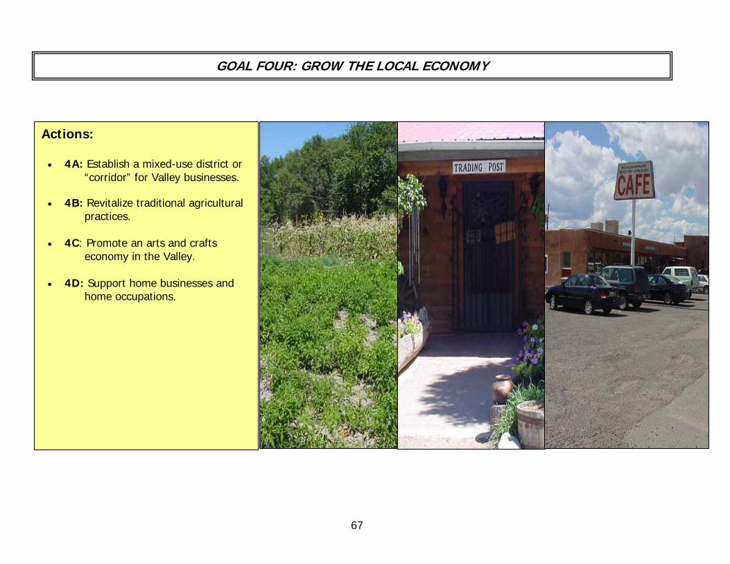
67
GOAL FOUR: GROW THE LOCAL ECONOMY
Actions: • 4A: Establish a mixed-use district or
“corridor” for Valley businesses. • 4B: Revitalize traditional agricultural
practices. • 4C: Promote an arts and crafts
economy in the Valley. • 4D: Support home businesses and
home occupations.

68
ACTION 4A: Establish mixed-use districts or “corridors” for Valley businesses.
In Traditional Community districts, the Land Use Code allows for mixed uses including agriculture, residential, large scale residential, community service, institutional, non-residential or recreational uses anywhere within the boundaries of the community and at qualifying intersections. However, going through the approval process for some uses can be a difficult undertaking. With the completion of the community strategic plan, mixed use areas will be designated in order to provide options for local services and help grow the local economy. The process of starting a business in these areas would also be simplified.
BACKGROUND:
CURRENT STATUS:
FIRST STEP:
• The Pojoaque Pueblo owns the majority of businesses and services in the Valley. There are a few non-
Pueblo businesses located off of U.S. 84/285 and State Road 502, most of which have been grandfathered in. There is potential for more businesses on these main corridors.
• In 1980, a commercial radial node that encompasses an area larger than the major intersections, was designated. However, this node requires updating to fit the current needs of the community.
• The Pojoaque Valley Planning Committee has designated potential areas for commercial/mixed use zones along U.S. 84/285 and S.R. 502. These designations have been approved by the residents that live in those areas.
• Home businesses and home occupations will remain an option for entrepreneurial Valley residents throughout the Traditional Community District.
• Support the Pojoaque Valley District Use Table that outlines specific lands uses which are permitted, not
permitted, conditional uses, and special uses within the Residential and Mixed-Use Districts. See Appendix B for the list of uses specific to the Pojoaque Valley Traditional Community District.
• Recommend adoption of the mixed-use districting maps and the Pojoaque Valley District Use Table through the public hearing process and through BCC approval. The proposed mixed-use zoning map and the related uses in the Valley can be found in Appendix G. More detailed maps of the three proposed mixed-used zones can be found in Appendix H, I, and J.
• Recommend including parcels that were formerly Jacona Land Grant land, adjacent to S.R. 502, in the Pojoaque Valley Traditional Community District and designating them as mixed-use.
• Continue disseminating information in the community about mixed-use zoning.

69
• Current business owners/landowners adjacent to U.S. 84/285 and S.R. 502 or any other County Road in the Valley
RESOURCES:
• Landowners in other potential mixed-use/commercial corridors • County
ACTION 4B: Revitalize traditional agricultural practices.
Our Valley has a long tradition of agriculture, and agriculture is an essential component of the rural character of the area. Although many people are turning to other ways of making a living, and housing is being built on agricultural land, there are some people in the Valley who are successfully farming for a living. In addition, many people grow their own food in gardens. A vital agricultural sector will enable people to make a living locally or to supplement their income, as well as to provide fresh, healthy food for the community. However, due to limited water resources and social and economic factors, the ability to maintain our agricultural traditions will become more challenging for current and future generations.
BACKGROUND:
CURRENT STATUS:
• A Pojoaque Farmer’s Market has been started, with the financial support of the Pueblo of Pojoaque and
the New Mexico Farmers’ Market. The Pueblo of Pojoaque has provided a permanent venue that is easily accessible and visible from the freeway.
• Initial funding for a commercial kitchen has been appropriated by the State. The details to get the kitchen up and running are still in the formulation process.
• A program has been negotiated by the Pojoaque Pueblo to allow local growers to sell their produce at the Pojoaque Supermarket.
• Community organizations have been created to establish programs that would address the loss of agricultural land in the Valley and throughout Santa Fe County. The goals of some of these programs are to protect these lands and put them back into production by finding funding sources to pay for clearing invasive vegetation, for acequia system components, and for hiring people to cultivate fallow land. A few of the local groups that are currently initiating this kind of work are: Santa Fe County Soil and Water Conservation District, the New Mexico Acequia Association and the Agriculture Revitalization Initiative (ARI).

70
• Work with local groups to achieve the following: FIRST STEPS:
RESOURCES:
o Determine which agriculture programs in the area are viable.
o Consider reestablishing and/or supporting youth related agricultural revitalization programs such as the FFA, 4-H, or other horticulture or land based programs.
o Disseminate information about agri-business and local agricultural projects and initiatives.
• Local farmers, growers, and acequia users • Youth oriented programs focusing on agricultural initiatives in and outside the schools. • Farmer’s Market – local and state • Pueblo of Pojoaque • Pueblo of Nambé • Pueblo of San Ildefonso • SF County Soil and Water Conservation District • Agricultural Revitalization Initiative • New Mexico Acequia Association • Pojoaque Valley Irrigation District • Rio Pojoaque Acequia and Well Water Association (RPAWWA) • Pojoaque Basin Water Alliance (PBWA) • Interstate Stream Commission (ISC) • United States Department of Agriculture (USDA) • Funding for agricultural initiatives: Legislative Capital Outlay; 80/20 Federal/Local matching funds

71
BACKGROUND:
CURRENT STATUS:
FIRST STEPS:
RESOURCES:
ACTION 4C: Promote an arts and crafts economy in the Valley.
Historically the Valley has been home to well known artists and many traditional and contemporary artists currently live and work in the Valley. An arts and crafts economy is consistent with the character of the Valley that we wish to preserve. Today, there are some artists that want and need more exposure. Promoting arts and crafts in the Valley may be the way to accomplish this.
There are currently two annual art events in the Valley: the Pojoaque River Art Tour and La Sociedad Protección Mutua de Trabajadores Unidos (S.P.M.D.T.U) Hispanic Arts Festival. The Poeh Center Museum exhibits the work of regional Native American artists, and some artists have galleries in their homes. La Sociedad Protección Mutua de Trabajadores
Unidos (S.P.M.D.T.U.) facility holds the Hispanic There is no ongoing community venue for all local artists to Arts Festival in the fall. promote, market and sell their products.
• Create a permanent community arts venue:
o Survey artists and craftspeople to gauge interest in having other venues or opportunities to market their work
o Explore potential venues that may be available, or may become available in the future. A potential site may be the future multi-purpose community center for the Valley.
• Active artists and local galleries • S.P.M.D.T.U. • Pojoaque River Art Tour • El Rancho Community Center • State and federal funds available for
Community Centers and Capital Outlay Funds

72
ACTION 4D: Support home occupations and home businesses.
The Santa Fe County 1999 Growth Management Plan promoted the concept of home occupations. The Plan’s intent was to create the option to have a business or profession operating within a residential dwelling, thus promoting economic growth, without the impact that comes with commuting or going to another place of work.
The Santa Fe County 1999 Growth Management Plan promoted the concept of home occupations. The Plan’s intent was to create the option to have a business or profession operating within a residential dwelling, thus promoting economic growth, without the impact that comes with commuting or going to another place of work.
BACKGROUND:
CURRENT STATUS:
FIRST STEPS: IRST STEPS:
The home occupation requirements are currently outlined in the County Development Code and are allowed anywhere in the County, provided all of the requirements of the Code are met. Home businesses are an addition in the proposed Santa Fe County Code Rewrite and are recommended and supported by the Pojoaque Valley Planning Committee.
The home occupation requirements are currently outlined in the County Development Code and are allowed anywhere in the County, provided all of the requirements of the Code are met. Home businesses are an addition in the proposed Santa Fe County Code Rewrite and are recommended and supported by the Pojoaque Valley Planning Committee.
Amend the current Land Use Code to allow home businesses in the Pojoaque Valley Traditional Community District as a Conditional Use. The following requirements would be enforced below: Amend the current Land Use Code to allow home businesses in the Pojoaque Valley Traditional Community District as a Conditional Use. The following requirements would be enforced below:
Home Business Requirements: Home Business Requirements:
Small scale home businesses, including but not limited to retail shops and galleries, offices or restaurants may be allowed as accessory uses to single-family dwellings provided that such businesses comply with the following standards: Small scale home businesses, including but not limited to retail shops and galleries, offices or restaurants may be allowed as accessory uses to single-family dwellings provided that such businesses comply with the following standards:
1. A site development plan shall be submitted and all uses and plans shall be subject to a Conditional Use permit as identified in the County Code;
1. A site development plan shall be submitted and all uses and plans shall be subject to a Conditional Use permit as identified in the County Code;
2. Not more than 2,500 sq. ft. shall be dedicated to the use; 2. Not more than 2,500 sq. ft. shall be dedicated to the use; 3. The owner shall reside on-site; and not more than 6 persons, other than members of a family residing on the premises,
shall be regularly engaged in work at the site of the home business; 3. The owner shall reside on-site; and not more than 6 persons, other than members of a family residing on the premises,
shall be regularly engaged in work at the site of the home business; 4. All outdoor storage shall be screened and there shall be no more than 1,000 square feet of such storage related to the
home business; 4. All outdoor storage shall be screened and there shall be no more than 1,000 square feet of such storage related to the
home business; 5. The use shall not be disruptive of the residential character of the neighborhood; 5. The use shall not be disruptive of the residential character of the neighborhood; 6. Such uses may have no more than one sign advertising the accessory use in accordance with the requirements of Sec.
7.12, Signs; 6. Such uses may have no more than one sign advertising the accessory use in accordance with the requirements of Sec.
7.12, Signs; 7. No equipment or process shall be used that significantly interferes with the existing use of property in the adjacent area; 7. No equipment or process shall be used that significantly interferes with the existing use of property in the adjacent area; 8. Such uses shall comply with any otherwise applicable use-specific standards of this Code; 8. Such uses shall comply with any otherwise applicable use-specific standards of this Code; 9. The use shall not create any disturbing or offensive activity, noise, vibration, smoke, dust, odor, heat, glare, or unhealthy
or unsightly condition. 9. The use shall not create any disturbing or offensive activity, noise, vibration, smoke, dust, odor, heat, glare, or unhealthy
or unsightly condition.

73
Action 5: Create an entity that looks after the interests of the Valley by implementing the Community Strategic Plan, and is able to plan cooperatively with the County, State and Federal governments, the Jacona Land Grant, and the local Pueblos.
GOAL FIVE: IMPLEMENTATION OF THE ACTION PLANS AND CONTINUED COOPERATIVE PLANNING WITH THE COUNTY, STATE AND FEDERAL GOVERNMENTS, THE JACONA LAND GRANT INC., AND THE LOCAL PUEBLOS.
74
Action 5: Create an entity that looks after the interests of the Valley by implementing the Community Strategic Plan, and is able to plan cooperatively with the County, State and Federal governments, the Jacona Land Grant, and the local Pueblos.
The Pojoaque Valley is unlike any other community in Santa Fe County. Although it is unincorporated, it has a population and area comparable to existing incorporated communities in New Mexico. To add to its complexity the Valley is made up of six Traditional Communities surrounded by three Pueblos and the Jacona Land Grant.
BACKGROUND AND JUSTIFICATION:
CURRENT STATUS:
FIRST STEPS:
Upon approval of the Community Strategic Plan by the Board of County Commissioners, our unique community will need a distinctive “Planning Authority” to implement the plan. This entity should represent the people of the various communities of the Valley and be able to communicate across political jurisdictions. In addition, this entity will need to make recommendations concerning Valley issues and be advocates for the residents of the Valley. The role and responsibilities of this group would include those of existing Local Development Review Committees (LDRCs) as designated in the Santa Fe County Code. However this entity will have an expanded role to include both planning and advocacy functions in order to implement the non-ordinance actions of this Strategic Plan. The size of the group is proposed to be 5 to 7 members depending on the need and also the interest, but most importantly, to get equitable representation from each of the Traditional Communities in the Valley.
• The Planning Committee exists but is temporary • We need to implement a Local Development Review Committee (LDRC) entity when the plan is
approved. A “Valley Council” or “Planning Authority” has been proposed that would include the functionality of a LDRC (which traditionally focuses on land use issues), but would have the additional mission of implementing other actions of this Strategic Plan.
• Tribal leadership from the surrounding Pueblos in the Valley will continue to communicate and make decisions via government to government interaction.
• Modify the existing Code to allow for the expanded role of the LDRC to a “Planning Authority”
recommending body. • Solicit community-wide support by meeting with existing Valley organizations as well as the
general community to explain the role of the group.
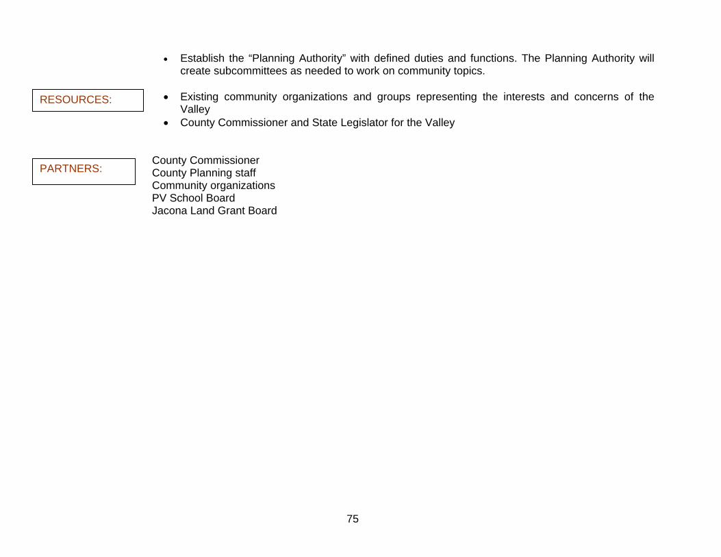
75
• Establish the “Planning Authority” with defined duties and functions. The Planning Authority will create subcommittees as needed to work on community topics.
• Existing community organizations and groups representing the interests and concerns of the
Valley RESOURCES:
PARTNERS:
• County Commissioner and State Legislator for the Valley
County Commissioner County Planning staff Community organizations PV School Board Jacona Land Grant Board
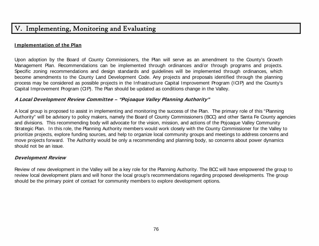
76
V. Implementing, Monitoring and Evaluating Implementation of the Plan
Upon adoption by the Board of County Commissioners, the Plan will serve as an amendment to the County’s Growth Management Plan. Recommendations can be implemented through ordinances and/or through programs and projects. Specific zoning recommendations and design standards and guidelines will be implemented through ordinances, which become amendments to the County Land Development Code. Any projects and proposals identified through the planning process may be considered as possible projects in the Infrastructure Capital Improvement Program (ICIP) and the County’s Capital Improvement Program (CIP). The Plan should be updated as conditions change in the Valley.
A Local Development Review Committee – “Pojoaque Valley Planning Authority” A local group is proposed to assist in implementing and monitoring the success of the Plan. The primary role of this “Planning Authority” will be advisory to policy makers, namely the Board of County Commissioners (BCC) and other Santa Fe County agencies and divisions. This recommending body will advocate for the vision, mission, and actions of the Pojoaque Valley Community Strategic Plan. In this role, the Planning Authority members would work closely with the County Commissioner for the Valley to prioritize projects, explore funding sources, and help to organize local community groups and meetings to address concerns and move projects forward. The Authority would be only a recommending and planning body, so concerns about power dynamics should not be an issue. Development Review Review of new development in the Valley will be a key role for the Planning Authority. The BCC will have empowered the group to review local development plans and will honor the local group's recommendations regarding proposed developments. The group should be the primary point of contact for community members to explore development options.

77
Selection of Committee Members
The selection process may be similar to that used to fill seats in the County Open Land and Trails Planning and Advisory Committee (COLTPAC) process. It will be required however, that membership of the committee will be representative of each of the six Traditional Communities of the Pojoaque Valley. The ideal size of the Planning Authority would be 5 to 7 members. An ad-hoc selection committee could be established by the Valley County Commissioner. The selection committee members would likely have some experience and/or history with the Pojoaque Valley community planning effort or otherwise be active in some sort of public capacity in the Pojoaque Valley. This selection committee would review all applications, giving priority to those candidates’ names that the committee believes would best serve the goals of the Community Strategic Plan and the entire Valley. These recommendations will be forwarded to the County Commission for final appointment.
David Dogruel, Chairman of the PVPC, gives a presentation at the Community Open House.

78
ACTION Phase One Phase Two Phase Three Partners (1 - 2 Years) (3-5 Years) (6 -10 years)
1A: Provide a multi-purpose
community center
Work with County Project Coordinator and Commissioner to: • Decide what site would be most appropriate • Meet with appropriate parties to confirm options for site • Prepare a feasibility study and a preliminary conceptual design of
the community center. • Secure sale or lease of the site
Request ICIP funding for additional needs not covered by legislative appropriations
Request additional funding for additional needs not covered by legislative appropriations such as construction, operating expenses, and staffing
Design and build the community center
Continue updating and monitoring the community center to assess the needs of the community
County staff Jacona Land
Grant Inc. PV School
District State and
County Representatives
1B: Create a connected trail
system
Present trail system plan to COLTPAC to put in a request for funding
Create an agreement with the Jacona Land Grant, the Pojoaque Pueblo and the BLM through means of a Memorandum of Understanding (MOU).
Define a Management Plan and Phases and secure legal easements • Design the trail, allowing for future connections with other planned
and existing trails in both the Pojoaque Valley and Santa Fe County
Meet with the PV School Board to create a secondary agreement about trailheads, access, and parking
Provide necessary infrastructure
for the trail construction
Name the multi-purpose trail – a name indicative of where the trail runs and the history of the area
Promote the trail to the community
Create a “Friends of the Trail”
program for volunteer maintenance of the trail
Explore connectors with other trail
systems in or near the Valley.
Update COLTPAC on trail needs and maintenance; ask for additional funding if possible
Continue to pursue connecting trail systems with the Pojoaque Trail
COLTPAC Jacona Land
Grant Board San Ildefonso
and Pojoaque Pueblos
BLM PV School Board
1C: Promote community support for
quality education, and advocate for
more job opportunities and
recreation for Valley Youth
Conduct focus groups and surveys with youth, local business, educational entities and social services
Define issues of importance to the above groups
Complete an inventory of all activities, clubs, and resources available
to youth
Start mobilizing the community in support of the issues that have been identified as important.
Establish an ongoing working relationship with the PV School Board concerning youth related issues.
Establish an ongoing working relationship with local businesses to identify and encourage job opportunities for Youth.
Support recreational activities for the Youth at the community center.
Ongoing support and evaluation of youth issues and needs
A subgroup of the Pojoaque Valley Planning Authority or another local group will need to initiate these activities
PV Schools Valley Pueblos
Implementation and Monitoring Strategy

79
2A: Preserve acequias and
improve diversions and
delivery systems
Promote a pilot project in order to model the method for bringing together the resources necessary to improve and preserve acequias.
- Choose an acequia for the project that is one of the larger systems in regards to irrigated land and number of parciantes (i.e. La Otra Banda)
Document the process and make it available to other acequias.
Assist in establishing an acequia preservation program, working with local acequia groups and the NM Acequia Association
Investigate sources of technical
and financial assistance for acequias
Ongoing inquiries for future technical and financial assistance for acequias
Acequia Commissions in the Valley
Rio Pojoaque Irrigation District
NM Acequia Association
RPAWWA OSE
2B: Develop and
implement strategies for
domestic water conservation
Disseminate information about water conservation County requirements and other water conservation information at the County satellite office in Cuyamungue.
Begin formulating a conservation education initiative through the schools or with individual teachers or programs
Develop a County sponsored incentive program for water conservation
Ongoing education and dissemination of information
Ongoing education and dissemination of information as new technologies are introduced
County staff Education
subcommittee
2C: Protect
domestic water supplies
Promote a coordinated effort to remove non-native species of vegetation that contribute to the depletion of the aquifer.
Hold another water fair in order to consistently monitor water quality - A water fair can be used as a venue to educate the community about the quality of their water sources.
LANL NMED OSE Valley Pueblos
2D: Pursue options for wastewater
management and treatment systems.
Improve wastewater treatment systems: • Address the issue of older, sub-standard septic systems by requiring
properties in the Pojoaque Valley Traditional Community District that are going to be divided, subject to a family transfer, variance, or rezoning, to furnish complete and accurate documentation to the County which demonstrates that all facilities on-site are in compliance with all New Mexico Environment Department regulations
• Require proof that necessary permits have been obtained for any and all septic and waste disposal facilities on the properties mentioned above.
Support a regional wastewater facility to include the Traditional Communities of the Valley.
• Have a location study done for a potential regional scale waste water system project
• Work with Pueblos to get other areas of Valley connected to their system
Get more information about options for local systems and information on better septic and re-use technologies
Create demonstration and pilot projects of Advanced Treatment Systems
Continue to support a regional wastewater facility as well as other local options for wastewater treatment.
Valley Pueblos Regional
consortium on wastewater (currently EBRPIF)
3A: Consider a Youth Council that can work
directly with the School District, the County, and
Pueblos on youth-related issues
Determine what entity will take the lead to start this organization and hold the initial meetings with youth groups, for example, an Education or Youth Subcommittee.
Meet with existing high school groups/organizations to get input and to see if youth would be interested
• Decide the purpose of this group and what issues the group would work on
• Determine whether the entity would simply provide support for other student/youth organizations, or would also attempt to provide input to decisions made in the community (by the County, the PV School District, Pueblos, PV Planning Authority etc).
If a Youth Council is desired after thorough consultation with local youth, explore funding resources available through State and Federal grants, or through the Community Development division of LANL. Funding could be used for youth conferences, youth leadership programs, local projects or other initiatives that would benefit youth.
Education or Youth Subcommittee of PV Planning Authority
PV Schools Pueblos Boys and Girls
Club Church groups
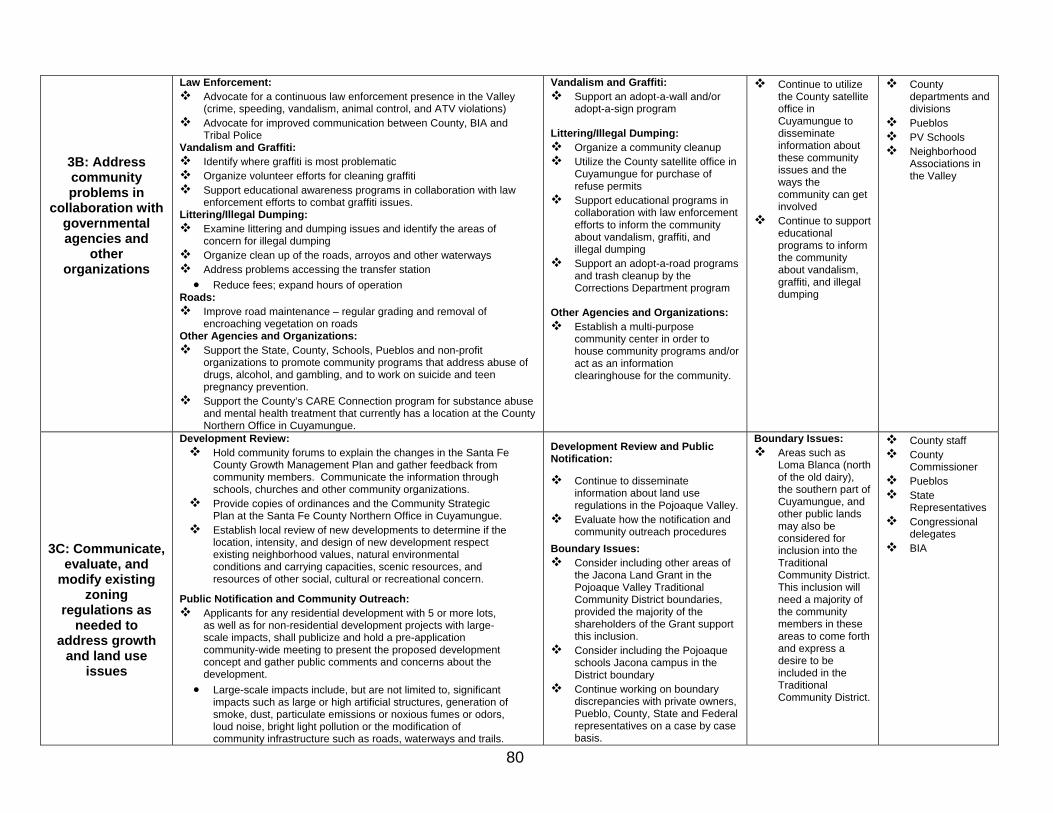
80
3B: Address community problems in
collaboration with governmental agencies and
other organizations
Law Enforcement: Advocate for a continuous law enforcement presence in the Valley
(crime, speeding, vandalism, animal control, and ATV violations) Advocate for improved communication between County, BIA and
Tribal Police Vandalism and Graffiti:
Identify where graffiti is most problematic Organize volunteer efforts for cleaning graffiti Support educational awareness programs in collaboration with law
enforcement efforts to combat graffiti issues. Littering/Illegal Dumping:
Examine littering and dumping issues and identify the areas of concern for illegal dumping
Organize clean up of the roads, arroyos and other waterways Address problems accessing the transfer station • Reduce fees; expand hours of operation
Roads: Improve road maintenance – regular grading and removal of
encroaching vegetation on roads Other Agencies and Organizations:
Support the State, County, Schools, Pueblos and non-profit organizations to promote community programs that address abuse of drugs, alcohol, and gambling, and to work on suicide and teen pregnancy prevention.
Support the County’s CARE Connection program for substance abuse and mental health treatment that currently has a location at the County Northern Office in Cuyamungue.
Vandalism and Graffiti: Support an adopt-a-wall and/or
adopt-a-sign program Littering/Illegal Dumping:
Organize a community cleanup Utilize the County satellite office in
Cuyamungue for purchase of refuse permits
Support educational programs in collaboration with law enforcement efforts to inform the community about vandalism, graffiti, and illegal dumping
Support an adopt-a-road programs and trash cleanup by the Corrections Department program
Other Agencies and Organizations:
Establish a multi-purpose community center in order to house community programs and/or act as an information clearinghouse for the community.
Continue to utilize the County satellite office in Cuyamungue to disseminate information about these community issues and the ways the community can get involved
Continue to support educational programs to inform the community about vandalism, graffiti, and illegal dumping
County departments and divisions
Pueblos PV Schools Neighborhood
Associations in the Valley
3C: Communicate, evaluate, and
modify existing zoning
regulations as needed to
address growth and land use
issues
Development Review: Hold community forums to explain the changes in the Santa Fe
County Growth Management Plan and gather feedback from community members. Communicate the information through schools, churches and other community organizations.
Provide copies of ordinances and the Community Strategic Plan at the Santa Fe County Northern Office in Cuyamungue.
Establish local review of new developments to determine if the location, intensity, and design of new development respect existing neighborhood values, natural environmental conditions and carrying capacities, scenic resources, and resources of other social, cultural or recreational concern.
Public Notification and Community Outreach:
Applicants for any residential development with 5 or more lots, as well as for non-residential development projects with large-scale impacts, shall publicize and hold a pre-application community-wide meeting to present the proposed development concept and gather public comments and concerns about the development.
• Large-scale impacts include, but are not limited to, significant impacts such as large or high artificial structures, generation of smoke, dust, particulate emissions or noxious fumes or odors, loud noise, bright light pollution or the modification of community infrastructure such as roads, waterways and trails.
Development Review and Public Notification:
Continue to disseminate information about land use regulations in the Pojoaque Valley.
Evaluate how the notification and community outreach procedures
Boundary Issues: Consider including other areas of
the Jacona Land Grant in the Pojoaque Valley Traditional Community District boundaries, provided the majority of the shareholders of the Grant support this inclusion.
Consider including the Pojoaque schools Jacona campus in the District boundary
Continue working on boundary discrepancies with private owners, Pueblo, County, State and Federal representatives on a case by case basis.
Boundary Issues: Areas such as
Loma Blanca (north of the old dairy), the southern part of Cuyamungue, and other public lands may also be considered for inclusion into the Traditional Community District. This inclusion will need a majority of the community members in these areas to come forth and express a desire to be included in the Traditional Community District.
County staff County
Commissioner Pueblos State
Representatives Congressional
delegates BIA
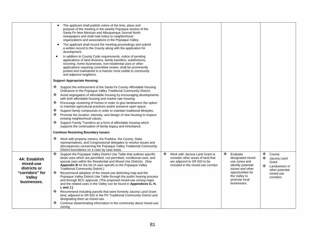
81
• The applicant shall publish notice of the time, place and purpose of the meeting in the weekly Pojoaque section of the Santa Fe New Mexican and Albuquerque Journal North newspapers and shall mail notice to neighborhood organizations and associations in the Pojoaque Valley.
• The applicant shall record the meeting proceedings and submit a written record to the County along with the application for development.
• In addition to County Code requirements, notice of pending applications of land divisions, family transfers, subdivisions, rezoning, home businesses, non-residential uses or other applications requiring committee review, shall be prominently posted and maintained in a manner most visible to community and adjacent neighbors.
Support Appropriate Housing:
Support the enforcement of the Santa Fe County Affordable Housing Ordinance in the Pojoaque Valley Traditional Community District.
Avoid segregation of affordable housing by encouraging developments with both affordable housing and market rate housing.
Encourage clustering of homes in order to give landowners the option to maintain agricultural practices and/or preserve open space.
Support family compounds in order to maintain traditional lifestyles. Promote the location, intensity, and design of new housing to respect
existing neighborhood values. Support Family Transfers as a form of affordable housing which
supports the continuation of family legacy and inheritance.
Continue Resolving Boundary Issues:
Work with property owners, the Pueblos, the County, State representatives, and Congressional delegates to resolve issues and discrepancies concerning the Pojoaque Valley Traditional Community District boundaries on a case by case basis.
4A: Establish
mixed-use districts or
“corridors” for Valley
businesses.
Support the Pojoaque Valley District Use Table that outlines specific lands uses which are permitted, not permitted, conditional uses, and special uses within the Residential and Mixed-Use Districts. (See Appendix B for the list of uses specific to the Pojoaque Valley Traditional Community District.)
Recommend adoption of the mixed-use districting map and the Pojoaque Valley District Use Table through the public hearing process and through BCC approval. (The proposed mixed-use zoning maps and the related uses in the Valley can be found in Appendices G, H, I, and J.)
Recommend including parcels that were formerly Jacona Land Grant land, adjacent to SR 502 in the PV Traditional Community District and designating them as mixed-use.
Continue disseminating information in the community about mixed-use zoning.
Work with Jacona Land Grant to consider other areas of land that are adjacent to SR 502 to be included in the mixed-use corridor.
Evaluate designated mixed-use zones and identify potential issues and other opportunities for the Valley to promote local businesses.
County Jacona Land
Grant Landowners in
other potential mixed-use corridors

82
4B: Revitalize
traditional agricultural practices
Work with local groups to achieve the following: • Determine which agriculture programs in the area are viable. • Consider reestablishing and/or supporting youth related agricultural
revitalization programs such as the FFA, 4-H, or other horticulture or land based programs.
Disseminate information about agri-business and local agricultural projects and initiatives.
Farmer’s Market Pueblos PV Irrigation
District RPAWWA NM Acequia
Association Agriculture
Revitalization Initiative
4C: Promote an arts and crafts economy in the
Valley.
Explore options for a permanent community arts and crafts venue: • Survey artists and craftspeople to gauge interest in having other
venues or opportunities to market their work/skills. • Explore potential venues that may be available or may become
available in the future. A potential site may be the future multi-purpose community center for the Valley.
Create a permanent community arts and crafts venue in which to show, sell and promote the local artists in the Valley.
S.P.M.D.T.U. Active artists and
local galleries Pojoaque River
Arts Tour
4D: Support home occupations and home businesses
Amend the current Land Use Code to allow home businesses in the Pojoaque Valley Traditional Community District.
Disseminate information about home occupation and home business requirements at the County satellite office.
Disseminate information about small business funding opportunities
County staff Small business
enhancement organizations
5: Create an entity that looks after the interests of the Valley by implementing the Community Strategic Plan, and is able to plan cooperatively with the County, State and Federal governments, the Jacona Land Grant Inc., and the local Pueblos.
Modify the existing Code to allow for the expanded role of the Pojoaque Valley LDRC to a “Planning Authority” recommending body.
Solicit community-wide support by meeting with existing Valley organizations as well as the general community to explain the role of the group.
Establish the “Planning Authority” with defined duties and functions. The Planning Authority will create subcommittees as needed to work on community topics.
Re-evaluate the role of the Planning Authority and make the necessary adjustments as needed.
County Commissioner
County Planning staff
County staff PV School Board

83
VI: Appendices
A. Pojoaque Valley Traditional Community District Density Criteria Table B. Pojoaque Valley Traditional Community District Use Table C. Demographic and Economic Profile and Projections of the Greater Pojoaque Valley D. Timeline of the Planning Process E. SWOT Example F. Pojoaque Valley Traditional Community District Map G. Map of Proposed Pojoaque Valley Mixed-Use Zones H. Map of Proposed Mixed-Use Zone A I. Map of Proposed Mixed-Use Zone B J. Map of Proposed Mixed-Use Zone C K. Proposed Pojoaque Valley Multi-Purpose Trail Map

84
Appendix A:
POJOAQUE VALLEY TRADITIONAL COMMUNITY DISTRICT DENSITY CRITERIA TABLE
Minimum gross Lot Area
Residential Uses (Acres Per Dwelling Unit)
Community Services Maximum Lot Coverage (%)
Max. Height (ft)
Minimum Setbacks (ft)
Residential Uses
Zoning Sub-
Districts Base
Density Water Cons.
Long Term Water Water Sewer
Both W&S
Nonresidential Uses
(Acres Per Principal Use)
Residential Uses
Non-residential
Uses SF MF
Non-residential
Uses
Front & Street Side
InteriorSide Rear
PVTCD .75 .75 .75 .33 40 24 24 24 0 20 20

Appendix B: Pojoaque Valley Traditional Community District Use Table
Principal Uses: P Permitted Uses A “P” indicates that a use is allowed by right in the respective zoning district, in accordance with the Development Permit review procedures and shall be approved by the Administrator. Permitted uses are subject to all other applicable regulations of the Santa Fe County Land Development Code.
C Conditional Uses A “C” indicates that a use is allowed only if reviewed and approved by the CDRC or applicable LDRC as a Conditional Use, in accordance with the Conditional Use review procedures. Conditional Uses are subject to the submittal requirements of a site development plan and all other applicable regulations of the Code.
S Special Uses An “S” indicates that a use is allowed only if reviewed and approved by the Board of County Commissioners as a Special Use, in accordance with the Special Use review procedures. Special Uses are subject to the submittal requirements of a site development plan and all other applicable regulations of the Code.
Uses Not Allowed
A blank cell (one without a “P”, “C” and “S”) indicates that a use type is not allowed in the respective zoning district. Uses not listed may be allowed in accordance with the provisions of Section 10.11. Principal Uses Not Specifically Listed.
Note: The Pojoaque Valley Traditional Community District Use Table, below, is organized into 5 major use groups: Residential Use Categories, Public, Civic and Institutional Use Categories, Retail, Service and Commercial Use Categories, Industrial Use Categories, and Open Use Categories. Each major use group is further divided into specific uses. The use category system is based on common functional, product or compatibility characteristics, thereby regulating uses in accordance with criteria directly relevant to the public interest.
Key and Definitions:
Please note that this table is part of the proposed Land Use Code Rewrite, and will be implemented by ordinance when approved by the Board of County Commissioners.
Residential District = Pojoaque Valley Traditional Community District – The Traditional Community boundary area for which we are planning.
Mixed-Use Districts – These are the designated Mixed-Use Districts that the PVTCD that allow for a variety of uses. These areas include portions off of SR 502, US 84/285 and the northwest portion of Cuyamungue on US 84/285.

86
POJOAQUE VALLEY TRADITIONAL COMMUNITY DISTRICT USE TABLE
Use Categories Specific Uses
Residential District Mixed-Use Districts Use Standards
Residential Use Categories
All household living not listed below
Single-family dwellings and manufactured homes P P
Two-family dwellings (duplexes) P P
Multi-family dwellings S C
Manufactured home communities and subdivisions S S
Mobile homes P P
Household Living
Upper floor residential S P
All group living not listed below S S
Community residential homes P P Group Living
Family compounds C C
Public, Civic, and Institutional Use Categories Place of Worship All places of worship C C
All day care not listed below (Accessory Home-based) C C Day Care Day care (13 or more adults or children) C C 6
All community service not listed below S S
Community facilities C P
Libraries C P
Museums C P
Philanthropic institutions C P
Community Service
Senior centers C P
All educational facilities not listed below C C
Elementary school C C
Middle or high school C C
Colleges or universities S C
Educational Facilities
Business and vocational schools S C
All government facilities not listed below C C Government Facilities
Emergency services C P
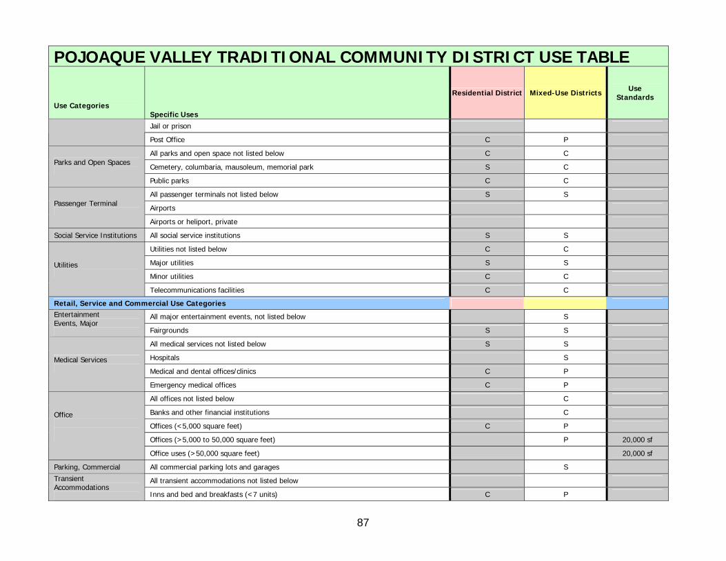
87
POJOAQUE VALLEY TRADITIONAL COMMUNITY DISTRICT USE TABLE
Use Categories Specific Uses
Residential District Mixed-Use Districts Use Standards
Jail or prison
Post Office C P
All parks and open space not listed below C C
Cemetery, columbaria, mausoleum, memorial park S C Parks and Open Spaces
Public parks C C
All passenger terminals not listed below S S
Airports Passenger Terminal
Airports or heliport, private
Social Service Institutions All social service institutions S S
Utilities not listed below C C
Major utilities S S
Minor utilities C C
Utilities
Telecommunications facilities C C
Retail, Service and Commercial Use Categories
All major entertainment events, not listed below S Entertainment Events, Major Fairgrounds S S
All medical services not listed below S S
Hospitals S
Medical and dental offices/clinics C P
Medical Services
Emergency medical offices C P
All offices not listed below C
Banks and other financial institutions C
Offices (<5,000 square feet) C P
Offices (>5,000 to 50,000 square feet) P 20,000 sf
Office
Office uses (>50,000 square feet) 20,000 sf
Parking, Commercial All commercial parking lots and garages S
All transient accommodations not listed below Transient Accommodations
Inns and bed and breakfasts (<7 units) C P

88
POJOAQUE VALLEY TRADITIONAL COMMUNITY DISTRICT USE TABLE
Use Categories Specific Uses
Residential District Mixed-Use Districts Use Standards
Inns and bed and breakfasts (7-12 dwelling units) C C
Hotels, motels, and inns (>12 dwelling units) S
Resorts (with or without conference centers) S
All indoor recreation not listed below S C
Adult entertainment
Convention or conference center S S
Private clubs and lodges (not-for-profit) S C
Indoor Recreation
Entertainment and recreation, indoor S C
All outdoor recreation not listed below
Golf courses S
Recreational uses, outdoor S C
Outfitter and guide services C C
Racetracks and stadiums
Recreational vehicle park/campground S
Outdoor Recreation
Riding academies and public stables C C
All restaurants and bars not listed below
Restaurants (See also Home Restaurants) S P
Restaurant, serving beer, wine, or liquor S
Restaurants and Bars
Taverns and bars S
All indoor retail sales and services not listed below S
Art galleries or dealers C P
Appliance, bicycle, jewelry, shoe or watch repair S C
Convenience stores S C
Exercise or dance studios S P
Gasoline and fuel sales S
Liquor stores S
Outdoor markets C
Personal service establishments S P
Retail Sales and Service
Retail establishments, indoor <5,000sf P

89
POJOAQUE VALLEY TRADITIONAL COMMUNITY DISTRICT USE TABLE
Use Categories Specific Uses
Residential District Mixed-Use Districts Use Standards
Retail establishments, indoor >5,000sf to 50,000sf C 20,000 sf
Retail establishments, indoor >50,000sf S 20,000 sf
Vehicle parts and accessories C
Video and DVD rental establishments P
Vehicle sales and service not listed below S
Vehicle service, general C
Vehicle service, intensive
Vehicle Sales and Service
Vehicle sales and leasing
Storage not listed below Storage Mini-storage units S
Industrial Use Categories
Industrial sales and service not listed below S
Arts and crafts C
Manufactured home sales and service
Manufacturing or assembly of equipment
Plumbing and electrical contractors C
Research, testing and development laboratory S
Industrial Sales and Service
Woodworking, including cabinet makers and furniture manufacturing S C
Warehouse and freight movement not listed below
Transport and shipping
Truck stops
Warehouse and Freight Movement
Outdoor storage yards
Waste-related services not listed below
Landfills Waste-related Services
Recycling facilities
Wholesale trade not listed below S
Equipment rental C Wholesale Trade
Mail-order houses C
Heavy Industrial All heavy industrial
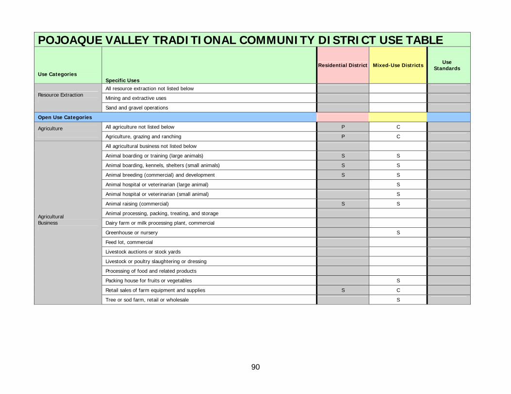
90
POJOAQUE VALLEY TRADITIONAL COMMUNITY DISTRICT USE TABLE
Use Categories Specific Uses
Residential District Mixed-Use Districts Use Standards
All resource extraction not listed below
Mining and extractive uses Resource Extraction
Sand and gravel operations
Open Use Categories
All agriculture not listed below P C Agriculture Agriculture, grazing and ranching P C
All agricultural business not listed below
Animal boarding or training (large animals) S S
Animal boarding, kennels, shelters (small animals) S S
Animal breeding (commercial) and development S S
Animal hospital or veterinarian (large animal) S
Animal hospital or veterinarian (small animal) S
Animal raising (commercial) S S
Animal processing, packing, treating, and storage
Dairy farm or milk processing plant, commercial
Greenhouse or nursery S
Feed lot, commercial
Livestock auctions or stock yards
Livestock or poultry slaughtering or dressing
Processing of food and related products
Packing house for fruits or vegetables S
Retail sales of farm equipment and supplies S C
Agricultural Business
Tree or sod farm, retail or wholesale S

91
Appendix C: DEMOGRAPHIC AND ECONOMIC PROFILE OF THE GREATER POJOAQUE VALLEY, 1990-2010
OVERVIEW
This report presents demographic and economic estimates for the Pojoaque Valley region of northern Santa Fe County and for a proposed Pojoaque Valley Traditional Community Planning District. Comparative figures are provided for the City of Santa Fe, Santa Fe County outside the City, and the County as a whole. Because Pojoaque Pueblo hosts the bulk of economic activity within the Valley, data are also provided for Pojoaque Pueblo.
The following statistical indicators are reported in the pages that follow*:
• A summary of benchmark demographic statistics for years 1990 and 2000 (population, housing, and household characteristics); including benchmarks for social and economic statistics for 2000 (employment, income, education, journey to work);
• Annual population, housing, and household projections for years 2006-2010.
The benchmark demographic estimates of this report derive from U.S. Census Bureau data files, tabulated at the Census Block level. Year 2000 socioeconomic estimates were tabulated from tract-level Census files. In carrying out this study, all housing and population estimates prepared for 1990-2005 were verified against high-resolution aerial photography of the Valley region.
Employment statistics for 2005 were obtained from ESRI Business Information Solutions (ESRIBIS), a national provider of economic statistics to corporate and government users.
The demographic estimates and projections reported for 2001-2010 were prepared by demographer Al Pitts in a study, using data inputs and calibration methods conventionally employed by the Santa Fe County Land Use Planning Division and the Santa Fe City/County Regional Planning Authority. Population and housing statistics for non-tribal lands within the Valley derive principally from building permit data provided by the County's Land Use Department. Statistics on home construction and non-residential development on tribally-owned land within Pojoaque Pueblo were graciously provided by the Pueblo of Pojoaque Enterprise Corporation.
*Note: This study is not the complete demographic and economic profile of the greater Pojoaque Valley. The complete findings of the study can be found in the Demographic and Economic Profile of the Greater Pojoaque Valley, 1990-2010 - September 19, 2006, prepared for the County Planning Division by Al Pitts, Demographer and Economist.

92
DEMOGRAPHIC AND ECONOMIC PROFILEOF THE GREATER POJOAQUE VALLEY, 1990-2010
POJOAQUE GREATER SANTA FE POJOAQUE GREATER SANTA FECOMMUNITY POJOAQUE COUNTY COMMUNITY POJOAQUE COUNTY
INDICATOR YEAR DISTRICT VALLEY (X-CITY) INDICATOR YEAR DISTRICT VALLEY (X-CITY)
POPULATION HOUSINGPersons (April) 1990 4,132 5,816 43,069 Average annual growth (housing units) 1990-2000 31 41 1,013Persons (July) 2000 4,786 6,756 67,424 2000-2005 22 51 774Persons (July, estimated) 2005 4,972 7,217 75,191 2005-2010 22 53 823Persons (July, projected) 2010 5,165 7,756 83,832
Housing Characteristics (% of total units) 2000Average annual growth (percent) 1990-2000 1.4 1.5 4.5 Occupied housing units 92.0 92.2 91.7
2000-2005 0.8 1.3 2.2 Vacant housing units 8.0 7.8 8.32005-2010 0.8 1.5 2.2 Recreational/seasonal units 1.6 1.8 2.7
Owner-occupied units (% of occupied units) 81.9 79.8 80.0Median Age (years) 2000 38.8 36.5 36.3 Conventional detached single-family homes 67.4 64.4
Mobile homes 25.4 28.9Population Characteristics (percent) 2000 Multi-family housing units 7.2 6.7Persons 0-17 years of age 25.6 27.4 27.5Persons 65 years of age and older 12.6 10.9 7.8 EMPLOYMENT 2005Hispanic persons 66.8 59.0 50.2 Employed persons 360 1,282 13,072Native American persons 6.6 18.8 3.9 Percent employed in:Persons living in households 100.0 100.0 98.7 Construction 1.1 0.7 7.9Persons living in families (% of persons in households) 86.3 86.5 85.0 Manufacturing, transport, communications, utlities 1.4 3.6 5.6Persons living alone (% of persons in households) 9.6 9.1 8.0 Retail trade 9.4 8.1 22.9Persons who lived in a different house in 1995 29.0 41.3 Entertainment, recreation, accommodations 47.9 45.0 13.9Persons who lived outside of Santa Fe County in 1995 14.5 23.3 Educational services 5.8 20.7 10.9Persons who lived outside of New Mexico in 1995 7.7 14.6 Government 11.9 8.7 12.6Persons who did not complete high school (*) 18.5 15.6 All other 22.5 13.2 26.2Persons who completed a college degree (*) 23.7 33.9(*) Percent of persons age 25 years and older RESIDENT LABOR FORCE (age 16 and older) 2000
Resident labor force (persons) 3,137 34,203HOUSEHOLDS Employed persons in labor force (persons) 2,993 32,540Number of households (April) 1990 1,570 2,130 15,051 Unemployment rate (percent) 4.6 4.9Number of households (July) 2000 1,906 2,617 25,042Number of households (July, estimated) 2005 2,003 2,829 28,471 Percent of employed residents who work inNumber of households (July, projected) 2010 2,105 3,076 32,256 City of Santa Fe 38.9 52.5
Remainder of Santa Fe County 25.3 21.3Household Characteristics 2000 Los Alamos Couny 28.1 8.5Average household size (persons) 2.5 2.6 2.7 Elsewhere 7.7 17.7Average family size (persons) 3.1 3.1 3.2Family households (% of all households) 71.0 71.4 71.5 JOURNEY TO WORK 2000Single-person and other non-family households (%) 29.0 28.6 28.5 Employed persons who work at home 117 2,437Households living in owner-occupied housing (%) 81.9 79.8 80.0 Employed persons who commute to work 2,876 30,103Households with income less than $20,000 (%) 28.3 19.8 Commuters (% of employed persons) 96.1 92.5Median household income $34,132 $44,205 Median one-way travel time to work (minutes) 28.6 24.4
HOUSING Percent of commuters who travel by:Housing units (April) 1990 1,755 2,405 16,783 One-passenger private vehicle 74.9 76.0Housing units (July) 2000 2,067 2,845 27,168 Carpool 19.7 20.0Housing units (July, estimated) 2005 2,173 3,076 31,037 Public transportation 0.3 0.3Housing units (July, projected) 2010 2,283 3,346 35,151 Other means (e.g., bicycle, walked, motorcycle) 5.1 3.7
SUMMARY

93
01.
PRINCIPAL ASSUMPTIONS
COUNTY-ADMINISTERED LANDS (Pojoaque Valley Traditional Community District and a portion of the Cuyamungue Land Grant)
HOUSING OCCUPANCY After 1996, occupied units as a pct of all housing units remains constant at the Census2000-enumerated level.AVERAGE HOUSEHOLD SIZE After 1996, household size declines at half the average annual rate experienced during 1990-2000.HOUSING GROWTH After 2003, unit housing growth remains constant at the average annual rate experienced during 1999-2003.
PUEBLO-ADMINISTERED LANDS (All Pueblo lands located outside the Pojoaque Valley Traditional Community District)
HOUSING OCCUPANCY After 2000, occupied units as a pct of all housing units remains constant at the Census2000-enumerated level.AVERAGE HOUSEHOLD SIZE After 2000, household size declines at half the average annual rate experienced during 1990-2000.
HOUSING GROWTH Beginning in 2000, unit housing growth in Nambe and San Ildefonso Pueblos remains constant at the average annual rate experienced by each during 1990-2000.
Beginning in 2007, annual housing growth on tribally-owned land within Pojoaque Pueblo remains constantat 24 units per year, consistent with residential construction plans under consideration by thePueblo of Pojoaque Enterprise Corporation as of August 2006.
POPULATION GREATER TRADITIONAL POJOAQUE NAMBE SAN ILDEFONSO CUYAMUNGUEPOJOAQUE COMMUNITY PUEBLO PUEBLO PUEBLO LAND GRANT
YEAR (July 1) VALLEY DISTRICT TRIBAL LANDS TRIBAL LANDS TRIBAL LANDS (NON-TRIBAL) (*)
1990 (April, Census) 5,816 4,132 650 423 408 2032000 (April, Census) 6,695 4,771 658 531 520 2152000 (July) 6,756 4,786 698 533 524 2152001 6,906 4,818 800 544 528 2162002 6,993 4,852 842 552 530 2172003 7,074 4,893 864 562 534 2212004 (Projected) 7,128 4,934 861 572 539 2222005 (Projected) 7,217 4,972 896 583 543 2232006 (Projected) 7,333 5,013 959 593 547 2212007 (Projected) 7,431 5,051 1,008 600 549 2232008 (Projected) 7,540 5,088 1,065 610 553 2242009 (Projected) 7,649 5,126 1,121 620 557 2252010 (Projected) 7,756 5,165 1,174 630 561 226
AVERAGE ANNUAL GROWTH (%)
1990-2000 1.47 1.44 0.70 2.28 2.47 0.562000-2005 1.33 0.77 5.12 1.81 0.71 0.732005-2010 (Projected) 1.45 0.76 5.55 1.56 0.65 0.27
(*) Portion not located within Pueblo boundaries.
DATA APPENDIX
POPULATION, HOUSEHOLD, AND HOUSING GROWTH, 1990-2010
PAGE A-2
POPU
LATIO
N, H
OU
SEHO
LD, A
ND
HO
USIN
G G
RO
WTH
, 1990-2010

94
01.(continued)
HOUSING UNITS GREATER TRADITIONAL POJOAQUE NAMBE SAN ILDEFONSO CUYAMUNGUEPOJOAQUE COMMUNITY PUEBLO PUEBLO PUEBLO LAND GRANT
YEAR (July 1) VALLEY DISTRICT TRIBAL LANDS TRIBAL LANDS TRIBAL LANDS (NON-TRIBAL) (*)
1990 (April, Census) 2,405 1,755 228 166 173 832000 (April, Census) 2,821 2,061 255 214 195 962000 (July) 2,845 2,067 271 215 196 962001 2,912 2,086 311 220 198 972002 2,957 2,105 329 225 200 982003 2,999 2,128 339 230 202 1002004 (Projected) 3,030 2,151 339 235 204 1012005 (Projected) 3,076 2,173 355 240 206 1022006 (Projected) 3,132 2,195 381 245 208 1032007 (Projected) 3,184 2,217 403 250 210 1042008 (Projected) 3,238 2,239 427 255 212 1052009 (Projected) 3,292 2,261 451 260 214 1062010 (Projected) 3,346 2,283 475 265 216 107
AVERAGE ANNUAL GROWTH (%)
1990-2000 1.65 1.61 1.70 2.56 1.23 1.432000-2005 1.57 1.01 5.55 2.22 1.00 1.222005-2010 (Projected) 1.70 0.99 6.00 2.00 0.95 0.96
HOUSEHOLDS GREATER TRADITIONAL POJOAQUE NAMBE SAN ILDEFONSO CUYAMUNGUEPOJOAQUE COMMUNITY PUEBLO PUEBLO PUEBLO LAND GRANT
YEAR (July 1) VALLEY DISTRICT TRIBAL LANDS TRIBAL LANDS TRIBAL LANDS (NON-TRIBAL) (*)
1990 (April, Census) 2,130 1,570 209 149 128 742000 (April, Census) 2,595 1,900 230 204 173 882000 (July) 2,617 1,906 244 205 174 882001 2,679 1,923 281 210 176 892002 2,719 1,941 297 214 177 902003 2,758 1,962 306 219 179 922004 (Projected) 2,787 1,983 306 224 181 932005 (Projected) 2,829 2,003 320 229 183 942006 (Projected) 2,881 2,024 344 234 185 942007 (Projected) 2,926 2,044 363 238 186 952008 (Projected) 2,976 2,064 385 243 188 962009 (Projected) 3,026 2,084 407 248 190 972010 (Projected) 3,076 2,105 428 253 192 98
(*) Portion not located within Pueblo boundaries.
DATA APPENDIX PAGE A-3
POPU
LATIO
N, H
OU
SEHO
LD, A
ND
HO
USIN
G G
RO
WTH
, 1990-2010
POPULATION, HOUSEHOLD, AND HOUSING GROWTH, 1990-2010

95
01.(continued)
ANNUAL NET HOUSING GROWTH
UNIT HOUSING GROWTH GREATER TRADITIONAL POJOAQUE NAMBE SAN ILDEFONSO CUYAMUNGUEPOJOAQUE COMMUNITY PUEBLO PUEBLO PUEBLO LAND GRANT
CALENDAR YEAR VALLEY DISTRICT TRIBAL LANDS TRIBAL LANDS TRIBAL LANDS (NON-TRIBAL)
2000 94 22 64 5 2 12001 38 16 15 5 2 02002 50 22 20 5 2 12003 32 23 0 5 2 22004 30 22 0 5 2 12005 61 22 31 5 2 12006 50 22 20 5 2 12007 54 22 24 5 2 12008 54 22 24 5 2 12009 54 22 24 5 2 12010 54 22 24 5 2 1
Figures in italics are projected or estimated.
AVERAGE ANNUAL GROWTH (units)
1990-2000 41.4 30.6 2.7 4.6 2.2 1.32000-2005 50.9 21.2 21.7 5.0 2.0 1.02006-2010 53.2 22.0 23.2 5.0 2.0 1.0
POJOAQUE VALLEY TRADITIONAL COMMUNITY DISTRICT:ANNUAL HOME CONSTRUCTION BY UNIT TYPE, 1997-2003
UNIT HOUSING GROWTH NET NEW UNIT HOUSINGCALENDAR YEAR GROWTH CONSTRUCTION LOSSES SRES MOBILE OTHER
1997 30 35 -5 14 15 11998 34 40 -6 14 19 11999 29 33 -4 9 19 12000 22 23 -1 11 10 12001 16 17 -1 10 6 02002 22 25 -3 12 10 02003 23 28 -5 17 5 1TOTAL, 1997-2003 176 201 -25 87 84 5
SRES: Conventional single-family residences; MOBILE: Mobile homes.
DATA APPENDIX PAGE A-4
POPU
LATIO
N, H
OU
SEHO
LD, A
ND
HO
USIN
G G
RO
WTH
, 1990-2010
NET GROWTH BY TYPE OF UNIT
POPULATION, HOUSEHOLD, AND HOUSING GROWTH, 1990-2010
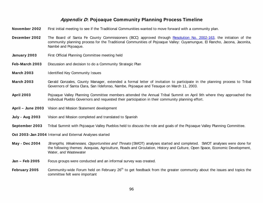
96
Appendix D: Pojoaque Community Planning Process Timeline November 2002 First initial meeting to see if the Traditional Communities wanted to move forward with a community plan. December 2002 The Board of Santa Fe County Commissioners (BCC) approved through Resolution No. 2002-163, the initiation of the
community planning process for the Traditional Communities of Pojoaque Valley: Cuyamungue, El Rancho, Jacona, Jaconita, Nambé and Pojoaque.
January 2003 First Official Planning Committee meeting held Feb-March 2003 Discussion and decision to do a Community Strategic Plan March 2003 Identified Key Community Issues March 2003 Gerald Gonzales, County Manager, extended a formal letter of invitation to participate in the planning process to Tribal
Governors of Santa Clara, San Ildefonso, Nambe, Pojoaque and Tesuque on March 11, 2003. April 2003 Pojoaque Valley Planning Committee members attended the Annual Tribal Summit on April 9th where they approached the
individual Pueblo Governors and requested their participation in their community planning effort. April – June 2003 Vision and Mission Statement development July - Aug 2003 Vision and Mission completed and translated to Spanish September 2003 Tribal Summit with Pojoaque Valley Pueblos held to discuss the role and goals of the Pojoaque Valley Planning Committee. Oct 2003-Jan 2004 Internal and External Analyses started May - Dec 2004 Strengths, Weaknesses, Opportunities and Threats (SWOT) analyses started and completed. SWOT analyses were done for
the following themes: Acequias, Agriculture, Roads and Circulation, History and Culture, Open Space, Economic Development, Water, and Wastewater
Jan – Feb 2005 Focus groups were conducted and an informal survey was created. February 2005 Community-wide Forum held on February 26th to get feedback from the greater community about the issues and topics the
committee felt were important
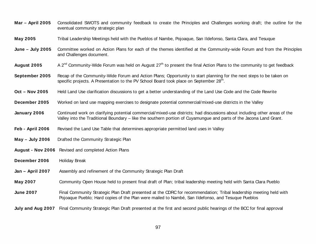
97
Mar – April 2005 Consolidated SWOTS and community feedback to create the Principles and Challenges working draft; the outline for the eventual community strategic plan
May 2005 Tribal Leadership Meetings held with the Pueblos of Nambe, Pojoaque, San Ildefonso, Santa Clara, and Tesuque June – July 2005 Committee worked on Action Plans for each of the themes identified at the Community-wide Forum and from the Principles
and Challenges document. August 2005 A 2nd Community-Wide Forum was held on August 27th to present the final Action Plans to the community to get feedback September 2005 Recap of the Community-Wide Forum and Action Plans; Opportunity to start planning for the next steps to be taken on
specific projects. A Presentation to the PV School Board took place on September 28th. Oct – Nov 2005 Held Land Use clarification discussions to get a better understanding of the Land Use Code and the Code Rewrite December 2005 Worked on land use mapping exercises to designate potential commercial/mixed-use districts in the Valley January 2006 Continued work on clarifying potential commercial/mixed-use districts; had discussions about including other areas of the
Valley into the Traditional Boundary – like the southern portion of Cuyamungue and parts of the Jacona Land Grant. Feb - April 2006 Revised the Land Use Table that determines appropriate permitted land uses in Valley May – July 2006 Drafted the Community Strategic Plan August - Nov 2006 Revised and completed Action Plans December 2006 Holiday Break Jan – April 2007 Assembly and refinement of the Community Strategic Plan Draft May 2007 Community Open House held to present final draft of Plan; tribal leadership meeting held with Santa Clara Pueblo June 2007 Final Community Strategic Plan Draft presented at the CDRC for recommendation; Tribal leadership meeting held with
Pojoaque Pueblo; Hard copies of the Plan were mailed to Nambé, San Ildefonso, and Tesuque Pueblos July and Aug 2007 Final Community Strategic Plan Draft presented at the first and second public hearings of the BCC for final approval

98
Appendix E: Example of SWOT Analysis (Completed in September 30, 2004) Theme: Community Quality of Life Topic: Public Places/Open Space
Mission Statement and Objectives: Shared gathering spaces, substantial open space and organized recreational areas KEY FACTS:
• Ownership of Open Space in Pojoaque Valley consists of Pueblo Land, the Jacona and Cuyamungue Land Grants, BLM, and National Forest Service land that are contiguous to the Valley.
• In 1998, County voters passed a $12 million general obligation bond enabling the County for the first time to acquire large tracts of land for conservation and recreation. It also established the Wildlife, Mountains, Trails, and Historic Places Program in order to preserve historic and natural areas.
• The County Open Land and Trails Planning and Advisory Committee (COLTPAC) was created in September of 1998 as a result of the bond language and the General Plan Policies.
o The County formed the 30-member citizen committee to represent the different regions and divergent points of view – made up of conservation organizations, property owners, youth, families, retired persons, farmers, ranchers and community organizations.
o Serves to advise staff and the Board on long-term open land and trails plans and to recommend implementation strategies. o Now made up of 13 members – 11 of them voting members which represent each of the various areas of the County.
• In 2000, an SF County produced an Open Land and Trails Plan for the Wildlife, Mountains, Trails, and Historic Places Program. The purpose of the plan is to:
o Establish long-term strategies for open space and trails conservation o Evaluate, acquire, develop and manage parks, open lands, and trails o Enforce existing Land Development Code requirements
Recreational Facilities in the Valley: • PV Public School student facilities – track, basketball courts, tennis courts, baseball/softball fields, football/soccer fields • El Rancho Community Center • Pojoaque Pueblo Health and Wellness Center • Wellness Center Trail • San Ildefonso Ballfield • Nambe Pueblo Recreation Area – Nambe Falls and Lake • County Tennis Court • Jacona Baseball Field
SWOT ANALYSIS: Strengths:
• New school buildings and related facilities are replacing old and inadequate buildings. • PVS Community facilities such as the Admin. Building provides spaces in which to convene.

99
• El Rancho Senior Center and S.P.M.D.T.U. serve as meeting places for various activities such as classes, small meetings, special occasions or community and society gatherings.
• Privately owned open spaces provide scenic views and privacy. • Arroyos and waterways (Rio Tesuque, Rio Pojoaque and Rio Nambe) provide natural passageways and important open space. • COLTPAC purchase of 5 acres is an asset for open space. • Open Pueblo land provides scenic vistas and natural buffers from development. • Acequias, related easements, and active associations are an asset; providing a means to provide open space and connectivity to land and
water and biodiversity in general. Weaknesses:
• Lack of identifiable, usable, and shared gathering spaces that serve the various needs of the local communities. • Any new buildings added to PVS facilities have to be financed through bond issue processes – some residents are anti-tax and do not
support bond issues. • Tennis courts and other older facilities are not well maintained. • No other recreational facilities are available outside of the PVS and Wellness Center. • Lack of organized recreational areas for ATVs and other motorized vehicles. • Walking, hiking and other physical activities are limited or prohibited on Tribal designated land.
Opportunities:
• Opportunity to start a Farmer’s Market and Arts and Crafts venue • Multi-purpose facility • Runner’s Course or Multi-Purpose Trail/Cultural Corridor
Threats:
• Lack of areas for ATV use cause degradation of the roads and arroyos that are currently being used for these activities. • ATVs also contribute to other environmental disturbances such as disturbing habitat and contributing to noise pollution. • Potential residential density under current County Code may prevent the preservation of open space and agricultural preservation in the
future. Possible Actions: Using the old high school building for a Community/Senior Center and a Farmer’s Market
Creating a runner’s course/cultural corridor from the current cross country trails
Key Information Sources: Project and Facility Management Dept – Open Space, Parks, and Trails Div; COLTPAC, National Forest Service, BLM
Key Stakeholders: Land Grants, Pueblos, Traditional Communities, Public Schools, Youth sports programs and teams
Related Themes: Land Status, Rural Character, Quality of Life
Related Topics: Agriculture, Acequias, History and Culture, Jurisdiction and Zoning, Growth Management