
POINT REYES NATIONAL SEASHORE AND POINT · PDF filepoint reyes national seashore and point...
82
Transcript of POINT REYES NATIONAL SEASHORE AND POINT · PDF filepoint reyes national seashore and point...


POINT REYES NATIONAL SEASHORE AND POINT REYES-FARALLON ISLANDS NATIONAL MARINE SANCTUARY
;?a


SUIIR4L;RGED CULTURAL RESOURCES INVEN'IOR\I
l'orrions of Point Meyes National Scanhore anti
Point kyes-Farallon Islands Narional Marine S:tnctuary
I'ield Hesearch Rcsults Scssion 1, 1983
I,)( Toni Carrel1
With contributio:is by Larry Murphy
.Subnzer~edCulturnl Rcsiiurces Unit Southwest Cultural I<e.sorrrcesCenter
Nutional Park Service U.S. Ikpurtment ( i j f l i eIntcrior
Santu I"e , Nc7u Mexico
I984


The Submerged Culti!ra? Resources U i i t is a paart of the Southwest CuZi"ura% Resources Cernker, Sout.klwest Rqiorml 0f:fice ~JI mta Pe, k w I~~exico,It was established as a unit i n 1980 t o conduct research on submerged cu l tura l resources throughout the mtional p2rk System w i t h an m p h a ~ i son h is tor ic shipwrecks. One n' the u n i t ' s primry respnsibbiliki-.s ks to disseminate the resul ts of research t o National Park Service mqxs as WU as the professional comrmity i n a form t h a t wets resource mmgement n e e and ad& t o our undecstmding of tht ce~ourcebase. The follo.owirig publi~ati~nand r c v r t series :as been hit iated in order to f u l f i l l t h i s resdpnsibiiityy, The report ipkyps" listed below represent the sequential stages of research activity that the uni t is conducting or in i t i a t ing in each park with a mbrrer~ed.cul tura l resources base, The reports are design& t o he c~mlativeso that, in the i&al case, each marine or freshwater park wuld e172nbally have a. "maritime archeology'* publication which ~otild have h e n preceded in mst cases by an assessent, survey a d inventory.. '%is would put the p x k s in eoqdiance w%Yh any reasonable professional and legal rquirenent t o protect and interpret the aqderwatcr cu l tura l resources under their custodimship=
F i r s t l i n e docuntent t h a t consists of 2 brief l i t e r a t u r e search, an ovegview of the maritime history a i d t i e known or potential undervater sites in the parkYand preliminary recomndat ions for long-tern miagement, msigned t o hme application t o W/DCP~S and t o become a source dwurrsnt for a park's Wnteryc5C u l t u r a l Resources Management Plan,
Conpreher~siveexamination of blcxks of park l a d s for the ptirpse of locatingand identifying as iiuch of 'ine submrged cu!.tural resources base as psshle, A corrpreherjsive literature search w u l d rest likely be a part @f the Pb.ase 1 report bL;tl in sore cases,'rmy be pos tpned u n t i l Phase 11-
Phase I - Reconnaissance of ta rge t areas with remte sensing and visual surveytechniques t o es tab l i sh location of any a r c h l o g i c a l sites or anomalous features t h a t my suggest the presence of archmlogical sites,
Phase P I - Evaluation of archeological sites or anomalous features derived from remete sensing i n s t r w n k s to confirm the i r nature, rand i f possible, k h i r significance. This may involve exploratory remval of overburden,
V

&!!Ly_. x r L = C u l t u r a l Resources Inventory___I_~~
H document t h a t discusses in detai.l all knowt1 underwater a r cheo lq ica l sites in a yiven park. This limy involve test excavations.. ?!he intended audience IS awnagerial anil professional, not the general public.
site I?ep&
Exhaustive docurrentation of one archeologi.cal. site which m y i.nvolve a p a r t i a l or coiiplete si.te excavation, The intended audience is prii inri ly pro2essiorial and incidentally m a g e r i a l . Although the docuirient m y be u s e f u l to a park's interpret ive sp-cial.ists because o f its inr'ornak.ion content I it w u l d probably not be suitable for general d i s t r h t i o n t o p a r k v i s i t o r s ,
Mari.tirre Archeo_lhy_v Series
This is a se r i e s of publications on specif ic parks designed for appeal t o a general audience including subject ]ratter spec ia l . k t s , nltcnagers arid the public a t large, e,g., xh'k-Mariti.iie &cheolocry-gL_ Isle Rpyale pJaj$AAnal Park. It f u l f i l l s an educatj.ona1. and interpret ive function but iieeix professionalstandards i n accuracy and substance,
-Special. RerArt: Series
These m y be i n published or photocopy forinat. Included are special conuwntar.ies papers on iilethadological o r technical i s sues p r t i n e n t t o underwater archedogy, or any 1ni.scell.anwusreport t h a t does not. appropriately f i t into one of the other catcqoci.esu
Daniel 3 , Lenihan

23 23 23 23 26 26 40 41 41. 41 41 46
vii

v i I i

Figure 1..
Figure 2,
F igure 3 ,
F igure 4.
Figure 5,
Figure 5 -
Figure 7.
F igure 8,
Figure 9,
Figure 10 ,
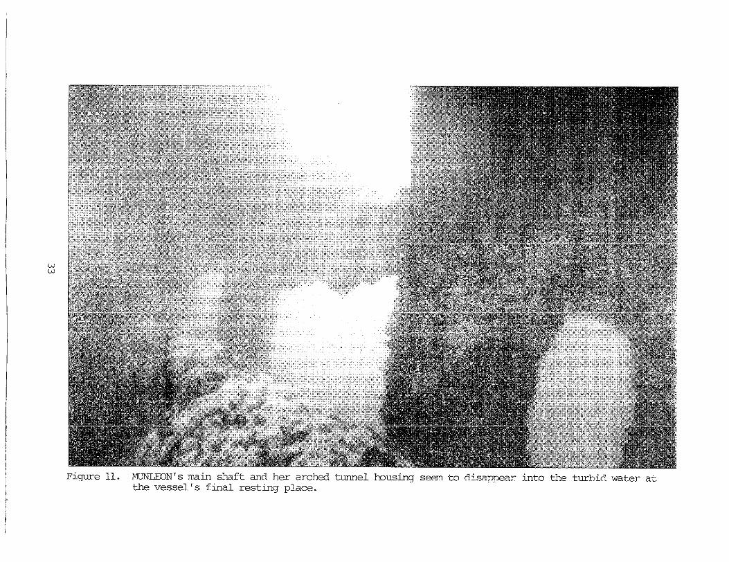
Figure 11.
Figure 12 ,
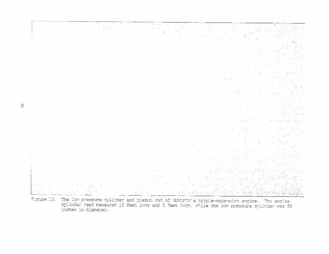
PigGre 13 ,
Figure 14u
Figure 15.
Figure 16. Location of ~CIIFIEL?3.................................,....
F igu re 17. Chimey Rock wns used as a guide t o the location of .~C~~'IEM)........ ' .................".............~........
6
9
15
22
24
25
27
28
30
31
33
35
36
38
39
42
43

X

KO f i e l d ressarch project is successfully accowl.j~ski&w i t b u t the mperci t ionand support, of each individual associ&ed with the e f f o r t , from init ial p l a n i n g through tyj;;ing the f ina l report, Western Regional Archsologist bisyer Kellycontributed t o a l l aspects of the project irxlu6ing coordination between the tw Regional Offices a d the park, transferring funds t o the u n i t and reviewing the f i n a l drar’t of t h i s zepr t . &print.endent. John Sinsing and tine staff a t Point Reyes Katio3al &ashore gave the project 100% support, bwver , spzcial thanks go to Paigers Bryan Sut.ton and RUSE Lesko; w i t h u t t he i r extra efforts we would not have been able t o complete the work. b n Morris, from the !&stern Archloqica l and Conservation Center, s p n t many long hours helping to convert t he raw f i e l d data from i : m w O N into a preLimin8b-y base mp, Larry S4u@PSay#Robert Bcnnett and the crew on board MGK acwmplishd placemnt of the buoys on the mvimly t a rge ts despite radio problem, high winds and rough was. Lundberg, Captain of a f loat ing h i s to r i c resource the sR.V,’ NICK, r\as not only a wil l ing p i l o t b u t also provj.de3 informtion on local mritim history and h e l w t o track down inforrinkion OK)SIBhS”’, the q s t e r y ship a t the f i s h dock. D a n Lenihm, Chief of the Shmrged C u l t u r a l Resources Unit, reviewed t h i s manuscript i n draft form and made several helpful suggestions while pfrary Volkert tackled t s j . n g the d r a f t from ~y h d w r i t t e n notes arid t u r n e d them into a well ordered final rmuscript. Thanks also go t o Jerry Livinyston for technical advice on napping and map preparation and for printing the photographs .in t h i s r e p r t
Toni Carrel!
xi
..


Tne overa1.l niarageiient zpproach t o the s tudy of subnerged cultural. I
within t h s &!c,ional Park 3,rstun nay be conceptualized as cccuring in disti.nct steps; 'cpe course 05 research leading i n a lcgical sequence through in i t . i a l assessrat, remi:e sensing survey of blocks of land t o locate t h w evalu.ate potential resources, arid then inveritory of a l l the know^ subrwrged sites in m area, '?he first task of the Sllbmzrged Cuituwzl. Resources wit a t mint %yes 1Wtiona.i Seashore was, therefore, to conduct aui assffismrk a d ri Phase I recoma.issonce survey; these w r e ~c.cc~n~~isi?Eidin 1.982 .1 The inventory process was begun i n 1383 and is reported on hzre..
The targstcd research objectives of t h i s i n i t i a l inventory session were evaluaticn ~ir.6preliminary napping of ~ ~ I U ~ J I E ~ N ,a YTor1.d War 1: l&er class vessel I.ost a t P0i1.k Reyes on I!Bwxber 8, 1931; rc.locatj.on and evalustion of K~CEFIFETTI,is b u l k o i l tanker l o s t off ChLrney -Rock on %iy 8, b93i); arid dociment:kion and q ~ p i n g of a circa 1880 schoner wharf site im t he LlppeKreaches of %homer &y, 1:n addition t o the inventory activities above# onsite exaarrh&j.on of s4x anoimLy clusters, ident i f ied in 'cne 1982 surveyl bas co!Yplet& _.
A prelininary base m p of t~ltiNihDNwas cor~pletedtha t includes a l l of the mijorstructural coqonents of the site. HOWFJIVBT, it raised more questions a b u t the site than ~zuiswrs. Displ-acemnenk of t h e starboard boiler ad a lasge section of missing c.;tern suggest questions of urreccic d e p s i t i o n and possible intervention through salvage x t i v i t i e s which skculd be addressed i n future i+grk a t 'the site"
The s i t e of NCW1EI.D is hazazdous to dive due t.o the currents present, boat. traffic and poor visibil i ty, Park di.vers now have a mch h t k e r undexsstmding of t h i s >jiteas ~e1.las knowing the E:KEIC~ location of RIGW*'IEID's r a i n s . D2terniriit.ion or' the full extent of t h e :Jseckage scst'Ler and conpletionn of a base my of the site arc f u t u r e inventory tzsks.
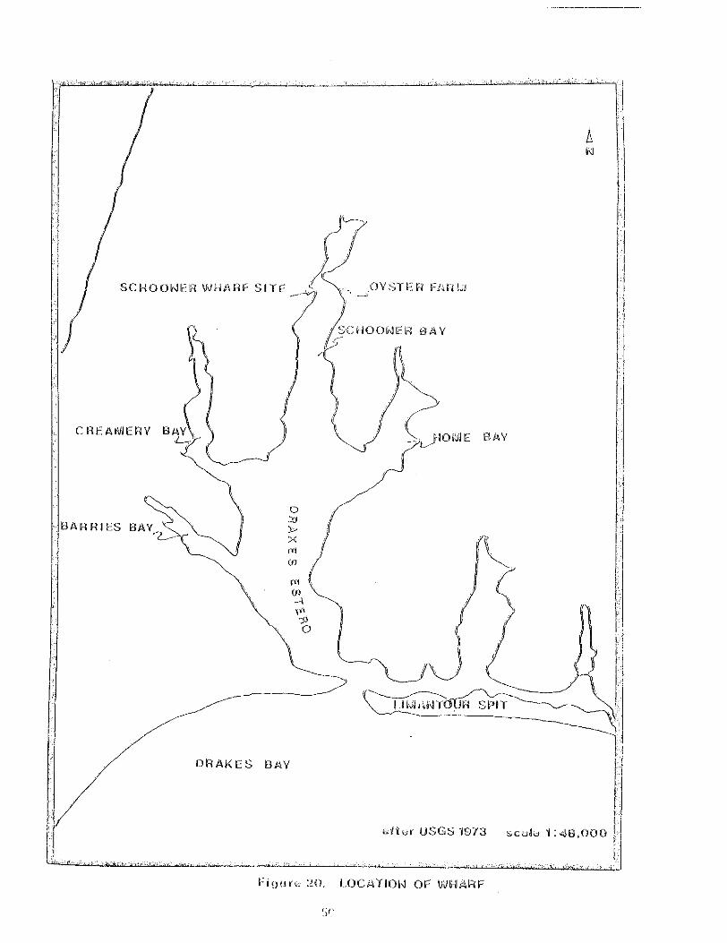
The Schooner &y Nharf Site was docurentd and mpw; it is an example of the ptentia.i. for preservstion of this t y p of s i t e within the park boundary, Eot surpr is lngiy, only 8 of the 38 pilings ?resent at eiie site w e ~ e vis ib le above tkie- surface of the witer I
Onsite examination of the six anomaly clusters resulted in a negative finding; no remains of any typ were located protruding above the sand b t k o m . T h i s confirms the s u p p s i t i o n t h a t whatever is creating the anomlous redings is mst probably deeply buried in the said and silt bottom of Drakes's B y ,

This study 3f the suhrxged cul tura l resources of portions of Poht &yesNational Seashore ;ind Foinnl; Ikyes-FarzLIon Islands h t i o n a l Marine Sanctuary has been designed wiYnin a lpaark n w m p r e n t frarewcrla. The project is geamd t.omrd generathg h f o r m t i o n t h a t will be u s e f u l i n s&xeorgzd cul tura l resowces site protection, v i s i t o r safety and interpretat ion , i n meting Pcderal comp!.iancerequirements, i n contributing to the s tory of the p r k and the marit& hi~story of the Pacif ic coast , and i n answering questions of general a rch logicx i l aid h.istoric;il importance.
Planning is an important consideration in projects which a re mticipatd to run over several years or f ie ld mssions or where funding and time cans tmints d i c t a t e an otherwise sey112nted approach, Tha results of each segrent ~ h u l d met s p i f i c rmagemnt neeJs and he able to stand alone as individual m a g w e n t documnts. The philosophical approach t o phased ship survey :a:bem discussed by others, while 2JiuQhy (1983) provides a recent discuss'ion of its application by the National Park Service. Briefly restated I shipxx& surveysconsists of phase I rerote sensing reconnaissace of blocks of l a n d f o ~ : the purgose of locating as nu& of t h e resource b a e as possible mi! Pbme 11 evaluation of site5 or anomlies t o a n f i r m the i r nature and pxoss?ble significance.
The overal l s&mrged cul tural resources rmagemnt approach, of which survey is only one aspect, m y also be conceptualized as dkstinnct phases or steps; the course of research leading in a logical sequence through in i t ia l assesrmnt, survey of portions of il park an3 Lhep hveritory of al.1 the known s&nx?rged resources i n an area, Each of these a c t i v i t i e s is discussed in greater d e t a i l , as seprate report formts of t h e u n i t , elsevbere i n 'chis report. '%is sequenceof steps my be physically divided activities by tire, space and reporting as J.s Cne case ~ i . t hthe Point-Reyes studyr or conducted concurrently iintrld reported on i n one document when a project runs continuously,
:%e overal l project s q e n c e of the specif ic point &yes study is prqress:ing as follom:
Step 1, Literature a d background research ( i seer a s s e s m n t ) md controlled remte sensing survey ( i oes9Phase I remnnaissmce).
Step 2. I n i t i a l inventory of known subwcgd cul tural resources and onsite exaxhat ion or' selected anomlies (iees8 bJhasc3 I1 evillustion)
Skep 3, Testing of buried anomalies (~hxj~se11 evaluation) and P u l l - - s c a l e inventory of v i s ib le resources.
1

L


The rrajor research pr ior i t ies established for t h e 1933 f i e ld session at Point Reyes National &ashore were: (I) evaluation of six anomlg clusters; (2 ) locatl.on and evaluation of selectd Icr~ow~ shiprecck resjources, s,mcific,diy ! 4 m O N and NCEFIEm; and ( 3 ) location and evaluation o f other Inon- sh ip rxk) subrerged cul tural resources,
&.om1 ies
C b jectiveo
gne of the objectives of t h i s session of the fieLd wrk at Point. Reyes &ti,snal sashore included kine reloc+.tion of s w i f i c rreogetic morralies arc3 ia natural feature discovers2 dcring t h ~ 1982 P k e I reaxmaissame survey. Altk~rcgh it was strongly suspc;ted that m y cul tural materials winich my have ea~sed Yne anomalies imuld be covers3 by serlimnt, it b m necessary to m n f h tha t supposition before programing and funding a P h z e I1 survey, Relocakiun iniolveti optical repositioning o f elwtronical ly generat& coordinates ~ f i i s exercise also serve6 t o c h x k optical relocation accciiracy capabilities a& to train Seashore and We~terr! kgion3.l prsonnel i n these procedures foor future test exca.vation and m n i t o r h g efforts within Drakes myu
Relocation of specific paints within the nmgnetowier survey zone mmpleta3 in 1982 relied on a shore-ba&d system of zccurately sur~7eyed k ~ r ~ z o n t a l mntrol stations, These control stations wre plimned and p s i t i o n d so t h a t a conbination of two or inore .ruoii!d yovide gwmcriciilly accept.iat;.e locations (those giving an wgle o i intersection in the survey zone between 30-150 degrees and 60-120 degrees pre&rred) for inst:al.iation of eiffier electronic or optical survey stations.
Eight p k n t s wre l.oczted or surveyed t o provide control stations ( A p p d i x Stations I and 0" are U,S, @ological~ Survey mnuments, and the ramkdzr bere surveyed either by t r d i t i o n a l ree(;horis !points 3 , 4, 5) or by Mhi-Ranger % k e l l j . t e Positioning &>stem provided by mtorola, Inc. Points 3-7 were closely spc& in the vicinity of L i m t o i a i Spit and the muth of Drakes B t e r o to provide converrient optical stations in the area detemnincd to be a mne of high probability for s h i p m x k occurrence I miversal Transverse B4ercato~- (WN) grid coordinates were corputed for each mntrol. pint.
nuring Phdse I reconnaissance survzy, electronic p s i t i o n i n g was done from horizontal control stations (Hurphy 1983) An x-y ul%f gsid a o r d . h t e vas produced for each of the 664 emomlous magnetic readings. These h c l u d d multiple readings result ing from broad anonalies, as bell AS shsle p i n t s ,
I)
5
1-

41605 9 0 giinulEl three-.lime cluster (90 ilctcrs; l~7--anoimJ.y clhster)
5 41205
Netbdoiogy
Optical p s i t i o n i n g , when used t o relocate a s_pecific point i n the mterV usually requires two innstrumants and o p r a t o r s i n comunication with each ot-hzr and with the v~ssel~ pi.lot. Piit- sinply, .the procedure is t o set c z h i n s t rumnt up on c? s tab lk pht (usually on h n d j and t u r n angles so t k k their intersection is tine desired position on the surface of the water. l'ne b a t p i l o t is directed along one angle, wi-tn Lbe course maintain& by i~.stmc-t:~ons from. one instrummi7 owrator" ;%en the vessel caws into 'view i n the se;::ord instrunent, a prepratory signal. i s given, and the buoy drop conmid is gfveii when the buoy handler is aligned i n t h e crossbirs . ps soon as the buoy is drop@, b t h instrumnts a r e realigned on the floating buoy and the as,:jles recorded, This f ina l procedure a l l o w arr accurate p lo t of the buoy's r e d position relative t o the desired location, so t h a t tG& divers can be dirwteii t o concentrate their search i n the appropriate direct ion awziy from the mrker buoy.
In order t o successh l ly execute this procedure, a nwber o f factors mst; be present. The instrumnts mist be set up on known locations so t h a t they cai be accurately plotted on a. char t , The desired position in tne water npasi: be plotted in order t o allow accurate iiragles t o be masurd or mqxited and turned. Angles can be turned from a baselhe W61iCh -mst be plotted on the base map or azimuths from magnetic or grid north t o generate correct Instrurrent readings, The level of accuracy of each step i n the r e l m t i o n procedure s ignif icant ly a f f ec t s the precision of Yne desired in-water position.
@ t i c a l repositioning for a)rak,es my relies on accurate S ~ K ~ + S I S & h a r i z x t a l control p s i t i o n s and accurate anomaly Locations ('.a to 3 retezs>* & x-y geographic: mordiraate ( m ~ ) ms developed fo r a l l positions. By nl;ahtaining consistent grid coordtmtes~ grid north CZLII be used t o set up both instmnxnts giving a higher accuracy than relying on nagnetic north. The grid aziinuth betwen s ta t ions can be trigor?ornetrically corrputd and the tippropriate rea3ing can be loaded on the f i e l d instrument before it is aligned wi th the proper station, 1.ower p l a t e on the t rms i t is thus aligned t o grid north and the upper plate car: he loosened to set khe aizmuth to the h-mter position, rWbf grid a z i m t k have been conputed bet.ween all e ight s ta t ions (Appdix I), A corputer program was developed t o generate for every a n o d y , the azi.muth between 2c and each shore--control point (these have been trmsmitted t o the western &g.ion Archeologist <and the park). This system provides m 'easy relocation capabiliky fot- f u t u r e test excavation and mnitoring ~
'The

Sealing Schuoner Fassenger/General Bark
Cargo (package freight)
Schooner S c h n e r Schooner Schooner Schooner Freighter U h e r Schooner Lunber Scboner Umber Schooner O i l Tanker
Bulk Cargo
Vessels engaged i n explorati.on, hide and tallow t r d e , sealing, passenger and general cargo and bulk cargo m v e m t evolved t o m e t specific economic and transportation needs. The tivu vessels selected for examination in the i n i t i a l inventory session a t Point Reyes wre MUNhEON, a steel package freighter and RICHFIELD, a steel bulk freighter. Both of these vessels were b u i l t on the Great Lakes; MUNLEON cam out of the k t r o i t Shipbuilding Company's Wayandott, Michigan yards and RICHFIEID from b ra in , Ohio shipyards of the American Shipbuilding Corrpny. MWU?ONr although known as a vessel in the "Laker" class, has its design or igins i n the North and Baltic Seas, The term raker coming from both the area where the majority of these vessels were b u i l t and the prefix IlV(E assigned t o the name of ihese vessels. RICHFIELD evolved from a shipbuilding t rad i t ion developed m n g Great lakes builders who were addressing the spcir 'ic e n v i r o m n t a l d e m d s of t h e Lakes and the desire for rnaximun bulk cargo capacity"
Vessel Context
velown.t,: Pg&Ee-Tz&t--Lakers - The place of MW ON i n m r i c a n .shippins Be After the outbreak of World war I i n Europe there was an urgent need for Ocean freighters t h a t were well adapted for coastal use. Yards i n Europe could not keep up with the demand so European shipowners turned t o Great lakes builders, m n g others, t o f i l l the void. The vessels they ordered had t o be sui table for use on the Baltic and North Seas and be able t o pass through t h e Mes canals; a standard design t h a t had been developed in Norway w a s chosen. mom as the "Frederickstad" type I these vessels were compact general cargo s t e a r s with raised forecast le and poop decks and machinery, bridge and boat decks midships, generally referred t o as a three-island one-decked vessel.
"he first orders for Frederickstad vessels came from Scandanavia and France in 1917. A t o t a l of 25 hul ls , 253'6"~43'6"~22'4", were contracted for with s i x Great Lakes builders. By March 1917, t h e Bri t ish Shipping Controller had placed


(1885) had her mchinery midships I double bottom tkirougbmt, t~c r~ks forward aild a f t extending from side t o side arld up t o the deck in sml1 t r u r d ~ ~ Void spa.ces between the t a n k s apld h u l l , however, presented explosjion hazards. CKARXXS, EXiA and OKA (ca, 1887) carried theii: cargos against the hl1 platins ~di% cofferdams placed a t each end of the tank and nachinery aft. (Qrear L945:131)
I n 1886 tnere were only &out a dozen vessels c z i l e of csxryin? oil in bulk; by 1907 t.here were 137 steiuners and 143 sailing vessels carrying o i l in bulk on the i%pian Sea alone, I n 1885, 99 pwcent o f a!k o i l cargos were carried in barrels, but by 1404, 99 pacent were being moved j.1-1 bulk (Rear 1945:135-E7) The mjcr i ty of t h e ear ly tankers i n the transatlatic o i l t r d e weze Eurqmm owiie5 and were not available nor s u i t e d to Amricapl coastal sewice (:&viland 1978.175) r j The development of an Amxican tanker f k e t WEW based u@n h k h khe conversicn of vessels, bu i l t for other purpses, and bulk tanker mmtmction,
l%e f i r s t tmk steamer b u i l t in t h e b i k e d States 2 s S'MDARE (1888) by Roach and Son (Delaware River Iron Sii@milding and Engine W x k s ) of Chaster, Pennsylvmia, Constructed of iron for Standard O i l Cornmy of &w York, tjne vessel was 162 feet long, 30 feet i n breadth and 14 fet 4 Lnches deep, Powre6 by a t r ip le exp i s ion engine (14 inch, 22 inch and 36 inch diameter c y l i r ~ d e ~ ~ by 2.4 h c h stroke] she was capdle of carrying 4,300 barre2.so
SUkJSCX$lE3l'C to a m m ' S kUllChhg tcuaker COmkkXCtiOn & CCXlVers~Qn llKWl?d rapidly in the Lhited States.
Figure 3 . ! mrly &velopmnt of Arnericm Taker Fleet (aker Havilmd 1978:175-202)
1a8a S T A R D ~ ~ F ~ (US 116,199) iron screw tank s t . e m r " r , m i l t by Uelam.re
162'xJO'x14.4'; 832 gross tons and 590 net; carrying capacity 4,000 barrels. The f i r s t American tanker.
River Iron Shi&uilding & mgine mrks , C h e ~ t e r I Pmsylvmii3;
1889 W.L. HARDISON (US 81,181) Wcdein S C r W t d 6 S t e e r , M i l k by A., $?an Francisco; 160gx39.e58x14e!jf; 453 gross tons ad 352 net , T:?e f i r s t wooden tank s t e m r t o have iron tanks placed i n her hold.
1890 PAVERICK (US 92J71) steel screw tank s t e m r . B u i l t by COlLmbiarI Iron wrks and Dry Dock Cokqmy, Ealtinare; 239 .9 '~J&~ar l7 ' ; 1,722 gross tons a d 1,118 net; carrying capacity 12,000 barrels.
1896 GEORGE LCCXYIS (US 86,340) steel t& dearer, m i l t by Khioaa Iron Works, San Francisco; L75sx27,4'x1&,51; 691 gross t o m anCa 452 net , The Ef i r s t steel tank steamer b u i l t on t h s Pacific coask.
25


4. The kng ' th of the vessel from the engine space a t t h e forward end of the t h m s t recess to t h e a f t e r end of the s t e rn post is approxiwitely 91 fee t , MUfiUDiV's i:ernains nRasure 67 feet; 24 feet cannot be accounted for.
Furthsi:, there i~sno evidence of the tai l shaft o r the rudder i n t h i s areay a?'-.i~r r3ugi i a broken propzl.ler w a s found lying near t h e bow wreckage approximtely160 feet from the s t e rn remains (see discussion of Corpnent 5, below) I f salvage did occtur a t the site the propeller m y have been targeted for rermva.la In order t~ salvage t l ~ eprop, t h e rudder and t a i l shaft a re l ike ly t o be inpact& cluring the op ra t ion .
MUlUZOiu and the other Lakers I.ike her were bui1.t on a system of transverse Fr.m.ing* tha t i s . t h e frarres of the vessel ran crosswise of the ship. A t o t a l of 28 f~mesare c lear ly expsc4 on the starboard s ide of t h e vessel. Fh7enly spaced dt 24-irch intervals# the f r m s are readily ident i f iable up t o the area of ttn? t h ~ u s tbearing. Kc t ha t point, t h e l eng th of t h e fram t o the center of the t h r u s t bearing is 21 fee t 8 inches, rougly one-half the beam of the vessel, The frxres are pa r t i a l ly b u r k d by sand and bo th outside h u l l plating and ce?. l ing pi.a&ing a r e present. "here a r e no frames v is ib le on the port s ide of l-he vessi.1. alLhougn there is a high probabili ty they are b u r i d i n the deep sand ~
Wreckage sca t te r begins t o appear on the port s ide a t a b o u t the 4O-fooot point on a l l ths baseline, and a section of s ide hul l a t t h e level of the nrajn deck i.s present I
C o n i p x n L 2 (Pigxe 1 2 ) is M U N I X " s triple-expansion engine which is lying over on its side with t h e cylinder head on the starboard s ide and piston rods t o por t - The engine b1.ock is 16 f ee t long and 5 f ee t wide, "he low pressure cylinder imi%nr@3 59 inches in d i m t e r and t h e rod, incl~uding the piston c rosshe~d~is 5 feet long (Figure 13). This is the only rod which is not bent and misshapen. 'The i n k e r d i a t e and high pressure pistons and r&s a r e bent downward a d m y be still attached t o the crank shaf t . A great quantity o f wreckage is present i n the engine area on both the port and starboard including h1.l pLating I fr,mes and machinery.
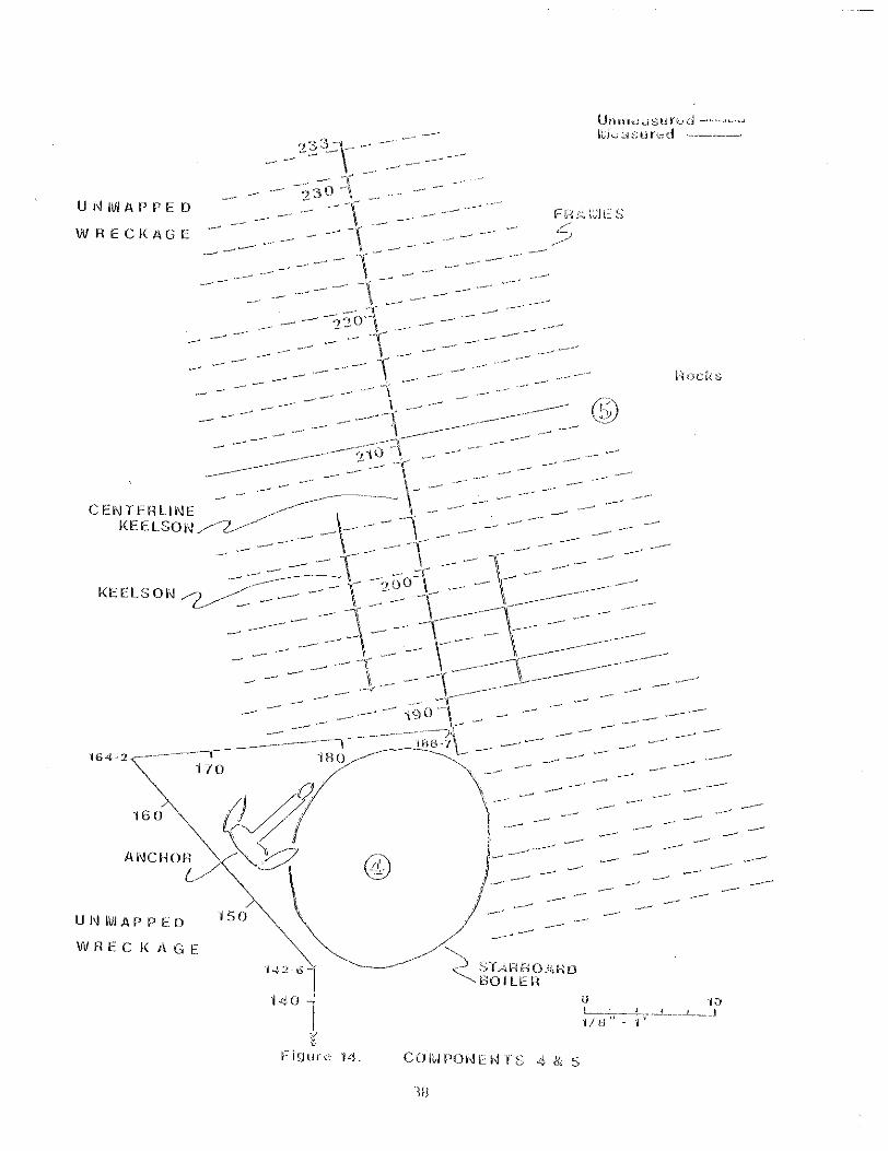
Corripnent 3 is conpsed of MUiVXON's p r t s ide boi ler md tw sections of in te rna l Doi.ler ::&es (Figure 12) b e of the vessel's tvm m t c h boi lers is resting in its prowr orientation, t h a t is w i t h the furnace doors facingiorwardJ and i'c appears t o be on its munt. I t is pr t ia1I .y f i l l e d with sand and tilt& i o port a t an estimated angle of 1 0 t o 15 degrees. N3 evidence o� the boii-.r uptake or funnel a r e readi1.y apparent. The boi l~erwasures 11 fee t long by 15 feet. :in d ime te r . I d i a t e l y i n f ront of t h i s boil.er a r e tw s t a c k s of boi ler tubes, conskt ing of 2-inch d i m t e r pipes. Cne stack, 6 fee t long by 2 feet 6 inches vide, is lying irmreilj.ately in front of t h e boiler; the 5 e C O d stack, 1.0 feet 6 inches by 2 feet 6 inches, is laying t o starboard.
34


53
-_ -_I-


__Wher S%:I:X& Ckrl t u r d &sources
The wharf i n :5chooner k y is an iixaiple o� the p t e n t i a l for presemation o f thi.s tyLw of site within the p.rk bamdary, l\bt only was its existence confirmed lllrough historic reference (Sk i l e s 1983) but t h e general location was recorded on Uie P o h t &yes mtional &ashre m d Vicinity U,S, Geologicalh;urvey topgra,phic r q (1973) w cursory examination of the sam map indicates another sctaoner hndjng si te at. t he t i p of the ,peninsula sepsating k@wand Schooner mys. ~ n l ymderate effort and a limited m m t of q u i p r e n t was required to Lw;estory the &boner ~ a yW ~ r fSi te uhich can now be incopra tedin to the story of ths & . r k Y shistory,
A l l of the -poptenkial non-shipwreck underwater resources should be examha3 1mre closely arid high probabili ty lowcions for khese sites ~ I X K O W ~ down. Known locations of prehistoric sites, eiiriy r~urchs, dairys, 'the Gx%t mard and military, old road or wagon tracks, early w s , land transfers and t i t l e changes, C i a a l l be used successiul.Ly t o d e f h e area urithin the park where these sites m a y occur mterviews with long-ti= cesidmts izrd fisherran will also aid in the process, Once l ike ly locations hve been defined and plotted on a p r k resources base map) &ich sb~~1 .dalso include known resources, it w u l d be possibie t o pr ior i t ize {these sites, b s e d upn the m u n t of historic data avai.l.&le, for further att.enpts a t relocation and inventory. If mrk kn the park is schedu!ed near one of these high prohsbility .l.ocaki.ons, it .would require
-.l i t t le driitional effort to iiicoporate m orisite examination of the area into the wrla p.Lm*

Earry! Jamss P, 1973 -of the m a t rakes: 300 Years of a q a t i o n , Rowe11-Wrth1
"Berkeley,
&&err Robert H. 1961 The Point &.yes I?eninsula--&n Histor ical S~rvey . In J?miiIIse :kWVeV,
proms& point &ves Fational. $ m s m s pp. 35-49. Uni.t& States Deprh-wnt of the Lnterior, hhtional Park Service, Region Four.
Puller, D w e and James Delgado 1983 Losses of Vessels i n 1;rakes Bay Survey Area, I n &imreck %kVeE
IPoint Reves_Abtional SZaSh-mS -Fa rablon Islw*dg rvational P h a , % c t u a r y , edited by Larry Nurphy, U,S. Departmat o f the Interior, iWciona1 Park Service, Suhergedl Cultural Resources Unit , Santa Fe and Western &qional Office, sapl Francisco.
Ericson, brnarcl E, 1968 B e Evolution of Ships on the Great rakes Part II: Steam and Steel.
The Society of Naval Architects and Varine Engineers, Clevel&Qd.
Evans, Peter A, 1969 Shinwreck%_ and Strandincls on the Coast of point Reyes E\lrlt-
Seashore 1840-1940, Master's Thesis, D9paatmnt of Librarianship, San Jose State College, San Jose,
Fuear, Hugo P. 1945 History of %nkers ~ '&c: Societv of WaV a l Architects and Marine
:&qineers BistoricaJ Transactions I893I1942, 135-144, New York,
Gibbs, James Atwood 1962 $himrecl<s of t h e Pacif ic C o a s t , second Edition. Binfords and Mort,
Portland
Izaviland, &Sean 1978 Early American Tankers, The mrican N e D t u n L A OuarterLv ;loumnal of
iVlaritime History 38(3) 2175-202.
Hunter, rdouis C, 1969 S'ceapboats on the Western Rivers, An Wonmjc and T e c a c a l F i s m ,
Wtagon Books, New York,
Burley, Eldward Naash I 927 -Bridcle t o France. Lipwncott, Philadelphia.
57
u,s, Steel News 1937 h%en Better mats Are E;.ilt, September, ppu 4-5.
united Sixte:; DeprtnEnt oi Cormrce, Bureau of Navigation 1907 iv!eerchant; ~&gx?&.-_oE the unite6 states U,S. G o v e m n t Printing
Office, Washington, D,C,
1913-30 Ducurents 0: Registry and License for plri_lllant/Bichfiel.d. Natitiuml Archives, Judicial , Fiscal and Social Branch, Washington, D.C.
1919-31 Documerris of Registry and License for Lake F a b ~ u n ; l e ' o n , Hatioml Archives, Judicial, Fiscal and Sacial Branch, Washington, D.C,
United States Geological Sc~rvey 1973 Point Reyes National seashore and Vicinity,
United States Shipping b a r d 1920 Reqister of Ships Owned by the U d t e d l States S h i y i m Board, F i f t h
H i t i o n , Auqust 1920. u . ~ ,&xerwnznt Printing Office,
united Stakes Sliippinq Lward m r q e n c y Fleet C o p r a t i o n
59


Y=4268269.566 Scale Factor: 0,9999#53,4 ConveL-germ Angle: 1 29 45"


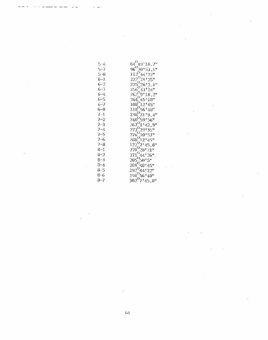
Sirairions 1-2 1-2 Y -4 1-5 1-5 r-7 1-8 2-1. 2-3 2-4 2-5 2-6 2-1 2-8 3-1 3-2 3-4 3-5 3-6 3-7 3-8 4-L 4-2 4-3 4-5 4-6 4-7 4-8 5-1 5-2 5-3 5-4
87OI '42.57"
6 3
64

c I