PNE.50.1 Port Nikau Environment - wdc.govt.nz · PNE.50.1 Port Nikau Environment Page 2 of 37 16...
37
PNE.50.1 Port Nikau Environment Page 1 of 37 16 November 2010 Index PNE.50.1 Port Nikau Environment PNE.50.1 Description and Expectations PNE.50.2 Objectives and Policies for the Port Nikau Environment PNE.50.2.1 Objectives for the Port Nikau Environment PNE.50.2.2 Policies for the Port Nikau Environment PNE.50.3 Process for Development PNE.50.3.1 Master Plan PNE.50.3.2 Precinct Plans PNE.50.3.3 Subdivision and Built Development PNE.50.3.4 Changes to a Master Plan and/or Precinct Plan PNE.50.4 Master Plan Applications PNE.50.4.1 Discretionary Activities PNE.50.4.2 Controlled Activities PNE.50.4.3 Discretionary Activities PNE.50.4.4 Non-Complying Activities PNE.50.5 Precinct Plan Applications PNE.50.5.1 Restricted Discretionary Activities PNE.50.5.2 Prohibited Activities PNE.50.5.3 Non-Complying Activity PNE.50.5.4 Discretionary Activity PNE.50.5.5 Restricted Discretionary Activity PNE.50.5.6 Controlled Activity PNE.50.5.7 Standards for Permitted Activities PNE.50.6 Port Nikau Environment Rules PNE.50.6.1 Transitional Provisions PNE.50.7 Port Nikau Environment – Activity Rule Table PNE.50.7.A Prohibited Activities PNE.50.7.B Non-Complying Activities PNE.50.7.1 Master Plan and Precinct Plan Compliance PNE.50.7.2 Activities Generally PNE.50.7.3 Network Utility Operations PNE.50.7.4 Provision of Parking Spaces PNE.50.7.5 Traffic Movements PNE.50.7.6 Signs PNE.50.7.7 Fences PNE.50.7.8 Artificial Lighting PNE.50.7.9 Noise Zone 1 PNE.50.7.10 Noise Zone 2 PNE.50.7.11 Internal Noise Environment PNE.50.7.12 Construction Noise PNE.50.7.13 Vibration PNE.50.7.14 Electromagnetic Radiation PNE.50.7.15 Outdoor Storage PNE.50.7.16 Aerials and Aerial Support Structures PNE.50.7.17 Electricity Transmission Lines PNE.50.8 Port Nikau Environment – Building Rule Table PNE.50.8.1 Building Height PNE.50.8.2 Building Setbacks PNE.50.8.3 Landscaping PNE.50.8.4 Coastal Minimum Floor Level PNE.50.9 Principal Reasons for Rules/Explanations
Transcript of PNE.50.1 Port Nikau Environment - wdc.govt.nz · PNE.50.1 Port Nikau Environment Page 2 of 37 16...
PNE.50.1
Port Nikau Environment
Page 1 of 37
16 November 2010
Index
PNE.50.1 Port Nikau Environment
PNE.50.1 Description and Expectations
PNE.50.2 Objectives and Policies for the Port Nikau Environment
PNE.50.2.1 Objectives for the Port Nikau Environment PNE.50.2.2 Policies for the Port Nikau Environment
PNE.50.3 Process for Development
PNE.50.3.1 Master Plan PNE.50.3.2 Precinct Plans PNE.50.3.3 Subdivision and Built Development PNE.50.3.4 Changes to a Master Plan and/or Precinct Plan
PNE.50.4 Master Plan Applications
PNE.50.4.1 Discretionary Activities PNE.50.4.2 Controlled Activities PNE.50.4.3 Discretionary Activities PNE.50.4.4 Non-Complying Activities
PNE.50.5 Precinct Plan Applications
PNE.50.5.1 Restricted Discretionary Activities PNE.50.5.2 Prohibited Activities PNE.50.5.3 Non-Complying Activity PNE.50.5.4 Discretionary Activity PNE.50.5.5 Restricted Discretionary Activity PNE.50.5.6 Controlled Activity PNE.50.5.7 Standards for Permitted Activities
PNE.50.6 Port Nikau Environment Rules
PNE.50.6.1 Transitional Provisions
PNE.50.7 Port Nikau Environment – Activity Rule Table
PNE.50.7.A Prohibited Activities PNE.50.7.B Non-Complying Activities PNE.50.7.1 Master Plan and Precinct Plan Compliance PNE.50.7.2 Activities Generally PNE.50.7.3 Network Utility Operations PNE.50.7.4 Provision of Parking Spaces PNE.50.7.5 Traffic Movements PNE.50.7.6 Signs PNE.50.7.7 Fences PNE.50.7.8 Artificial Lighting PNE.50.7.9 Noise Zone 1 PNE.50.7.10 Noise Zone 2 PNE.50.7.11 Internal Noise Environment PNE.50.7.12 Construction Noise PNE.50.7.13 Vibration PNE.50.7.14 Electromagnetic Radiation PNE.50.7.15 Outdoor Storage PNE.50.7.16 Aerials and Aerial Support Structures PNE.50.7.17 Electricity Transmission Lines
PNE.50.8 Port Nikau Environment – Building Rule Table
PNE.50.8.1 Building Height PNE.50.8.2 Building Setbacks PNE.50.8.3 Landscaping PNE.50.8.4 Coastal Minimum Floor Level
PNE.50.9 Principal Reasons for Rules/Explanations
PNE.50.1
Port Nikau Environment
Page 2 of 37
16 November 2010
PNE.50.1 Description and Expectations
Whangarei is experiencing significant population and economic growth with this growth projected to continue. The Port Nikau Environment, traditionally used for port related activities has largely become redundant due to the relocation of the majority of the port related activities to Marsden Point. The former heavy industrial zoning applied to the site is not considered appropriate now days, as it is assessed that potential exists to develop the site in a more compatible and sustainable manner.
The Port Nikau Environment is already provided with infrastructure services, is in close proximity to established core infrastructure and provides the opportunity to develop a mixed use environment,
creating capacity for long‐term commercial and residential growth, close to the city centre and within the existing urban limits, establishing potential to capitalise on growth opportunities for the City, the District and the Region. Port Nikau is designed to be a mixed use environment, located in close proximity to the CBD, thereby strengthening the overall form, capacity and range of land uses within Whangarei.
The development process to be applied in the Port Nikau Environment is designed to:
1. Enable the mixed use development of the site.
2. Use urban design principles to lead the design process.
3. Use a tiered approach for development assessment (Master Planning and Precinct Planning).
4. Allow flexibility with regard to: the assessment of development; the use of alternative design and engineering proposals; and the types of land use that occur in recognition of the long development timeframe of the site.
5. Avoid reverse sensitivity effects.
6. Avoid adversely impacting on activities on land outside the Environment including in the adjacent Business 4 Environment.
The development process adopted for the Port Nikau Environment is designed to enable a more flexible land use pattern to establish, creating greater opportunity to provide for economic growth opportunities, enabling a greater range of land uses and economic uses to occur. The implementation of an overall urban design strategy (Master Plan) will be the mechanism used to provide a framework and structure for the development of the Port Nikau Environment, a key component of which will be the incorporation into the design and development of the site of adequate and appropriate open space, including access to the coastal marine area and an infrastructure framework that ensures that adequate services are provided.
In developing the Port Nikau Environment the following matters are considered to be particularly important:
a) Ensuring good urban design principles are adhered to and the provision of adequate and appropriate public and private open space;
b) The provision of adequate infrastructure services, particularly roading;
c) The management of the effects of hazards;
d) The avoidance of negative effects on ecology; and
e) The avoidance of reverse sensitivity effects.
f) The planning map at Appendix A details specific controls to achieve d. and e. above.
PNE.50.2
Objectives and Policies for the Port Nikau
Environment
Page 3 of 37
16 November 2010
PNE.50.2 Objectives and Policies for the Port Nikau
Environment
The objectives and policies for the Port Nikau Environment take precedence over the objectives and
policies in the Plan, unless Chapter 50 is silent on any matter in which case the objectives and
policies in the Plan apply.
PNE.50.2.1 Objectives for the Port Nikau Environment
Development of the Port Nikau Environment in an appropriate manner will:
1. Enable a greater level of connectivity between the Port Nikau Environment and the CBD and the City and the water/harbour edge, improving the water entrance to the City and providing public access to the coastal marine area.
2. Create a mixed use environment, thereby strengthening the overall form, capacity and range of land uses within Whangarei, providing increased employment opportunities and commercial and residential capacity near the Central Business District (CBD) and regional sports facilities, with
development in defined Precincts creating capacity for predicted long‐term commercial and residential growth of the Port Nikau Environment.
3. Overall and within individual Precincts, be an example of good urban design, creating a liveable, mixed use environment where people can practically live, work and play within the Port Nikau Environment, providing employment based, commercial, retail and other land uses and a range of residential housing types and styles that will support a growing and increasingly diverse population.
4. Allow appropriate activities including industry within the Port Nikau Environment, with a buffer and transitional zone provided between industrial and mixed use activities to ensure compatibility of different land uses and activities and avoid reverse sensitivity effects.
5. Ensure adequate services and infrastructure are provided to the Port Nikau Environment and that there is sufficient land area set aside for the physical provision of infrastructure and that there is sufficient capacity, or planned capacity, within the various infrastructure services to cater for the demand assessed to be created by development at Port Nikau while recognising the impacts of development on existing infrastructure networks.
6. Provide infrastructure and services that will lead to positive environmental outcomes with scope to enhance the surrounding environment and ensure that the development of the site (in stages) does not limit future development through poorly planned services and infrastructure and where possible the potential impacts of development are lessened through the use of low impact design systems for infrastructure.
7. Incorporate over time new transport and traffic initiatives that result in adequate roading infrastructure (including necessary access to the state highway) being provided to accommodate the expected growth, with a roading hierarchy that is appropriate to the different activities within the area, incorporating pedestrian and cycleways and establishing further connections to the CBD and adjoining suburbs while recognising the impacts of development on the existing roading network.
8. Provide adequate and appropriate Open Space creating a strong network of public open space, including places to enjoy a range of recreational activities including public access to the coastal marine area.
9. Ensure that the development of the site allows for the maintenance of existing (pre-development) ecological values.
PNE.50.2
Objectives and Policies for the Port Nikau
Environment
Page 4 of 37
16 November 2010
10. Provide an opportunity to reinforce and develop a local sense of place and identity and maintain the historical identity of the site.
11. Ensure that the design of the development takes into consideration and where possible mitigates any existing or potential hazards, in particular flooding, geotechnical issues and ground contamination.
12. Recognise that the potential environmental effects of development in the Port Nikau Environment shall be taken into account and methods required to avoid, remedy and/or mitigates effects shall be defined as part of the Master Plan and/or Precinct Plan process. With regard to subdivision of the site, this will be recognised as one means by which to ensure that the necessary conditions of any Master Plan and/or Precinct Plan are implemented, in particular the requirement to provide infrastructure and services to accommodate future development.
PNE.50.2.2 Policies for the Port Nikau Environment 1. Amenity Values
That changing land-use patterns are recognised and as a means of sustainably managing the use of land resources within the District that mixed use development is encouraged in the Port Nikau Environment, so long as the potential negative effects of different land-uses are effectively managed, whilst avoiding reverse sensitivity effects and maintaining amenity values.
Explanation and Reasons: As land becomes more expensive and as a resource becomes scarcer it will be necessary to more intensively develop land as a means of sustainably managing it. To more intensively develop land will increase the potential for conflict between what could have traditionally been assessed to be incompatible land uses, however the use of new technologies to manage effects and the establishment of mixed-use developments where different uses can effectively cohabit will assist in sustainably managing the land resource.
2. Mixed Use Environments
To ensure that the effects of activities located in mixed use environments do not have adverse effects on other uses within the Environment or on uses adjacent to or outside of the Environment, whilst acknowledging that the incorporation of potentially sensitive uses (e.g. noise sensitive activities and places of assembly) into a mixed use environment may require that the sensitive uses undertake mitigation measures to ensure that the effects generated by other activities, both within a mixed use environment and outside of a mixed use environment, do not impact negatively on the sensitive use.
Explanation and Reasons: The establishment of mixed use development is designed to enable a large number of different uses to co-locate in such a way that leads to an intensified use of land as a means of sustainably managing land use resources within the District. It is recognised that by intensifying land use patterns there is an increased potential for conflict between different land uses and therefore within the mixed use developments it is recognised that potentially sensitive land uses may have to mitigate against the possible effects of other land uses, thereby avoiding potential reverse sensitivity effects of establishing sensitive land uses amongst commercial and industrial land uses
3. Mixed Used Development
The development of land in a mixed use manner will result in varying lot sizes and ownership structures which may not necessarily fit comfortably with the standard subdivision rules contained within the District Plan. Therefore, such subdivision rules shall only be used as a starting point in the assessment of subdivision applications, recognising that the control of land use activities through density provisions is a very basic means of managing land uses and that the suites of rules contained within the District Plan relating to the management of potential effects of land use activities should be taken into account when assessing the subdivision of mixed-use developments.

PNE.50.2
Objectives and Policies for the Port Nikau
Environment
Page 5 of 37
16 November 2010
4. Integration of Activities
The integration of different land use activities enables a more intensified use of land therefore assisting in sustainably managing the land use resource. However, it is recognised that integrating different land use activities can lead to negative effects being experienced by neighbouring land uses, as a result of what have traditionally been seen to be incompatible land uses locating in close proximity to each other and therefore it must be demonstrated that the potential adverse effects of different land uses can be managed in such a way as to avoid adverse and reverse sensitivity effects.
Explanation and Reasons: The traditional use of zoning as a planning tool has sought to manage potentially adverse effects of different land uses by locating similar land uses in the same area and using distance as a buffer between potentially incompatible or more sensitive land uses. Managing development in this manner has the potential to lead to heavy reliance on motor vehicles, creating areas within an urban development that are effectively devoid of people, except for the purpose of work, with such areas having no life or vitality.
The positive integration of land uses and the creation of work, live and play environments is seen as a way of more sustainably managing land use resources, reducing dependence on motor vehicles and also creating communities with urban areas. By applying an ‘effects-based’ planning regime, rather than a ‘use’ based planning regime enables the potential effects between different land uses to be managed in a manner that ensures that suitable levels of amenity are maintained to enable the mixed use (Port Nikau) environment to flourish.
5. Management of Effects
Where the potential effects of a proposed development are clearly known, the subdivision rules shall be used as a means to enable the orderly breakup and management of land, rather than a means by which to control effects however; where the potential effects of a proposed development are not known, then the subdivision rules should be applied in such a way as to enable the creation of allotments capable of accommodating the type of development that would be normally expected to locate in such an Environment.
6. Riparian and Coastal Margins
To recognise that some types of industry and land use have an operational necessity to be located within riparian and coastal margins and that in some instances the exclusion of public access is necessary to ensure the efficient and safe operation of these types of industry and land use and also to protect public safety.
To recognise that riparian and coastal margins are a limited resource and that the ability to sympathetically develop such in a manner that encourages public use of riparian and coastal margins will enhance amenity values and add to the attractiveness of the District.
To recognise that riparian and coastal margins differ greatly within the District, both in their physical makeup and their potential use and that some riparian and coastal margins can become valuable public assets if developed in a manner that encourages high public use and enjoyment of such areas.
Explanation and Reasons: It is not always necessary that riparian and coastal margins be protected in such a way as to only enable limited use. Historically the Port Nikau Environment has been exempt from requirements to provide riparian access and esplanade reserves and has enabled building development up to the line of the coastal marine area in recognition of the sites use as a port.
Some riparian and coastal margins are located in areas where they provide the opportunity to support marine-based industry and activity and as such need to be developed in a manner that can provide for that activity and industry. It is also necessary to recognise that there is an increasing trend toward water edge development, particularly in urban areas that have coastal frontage and as such it is necessary to develop these areas in an appropriate manner to enable

PNE.50.2
Objectives and Policies for the Port Nikau
Environment
Page 6 of 37
16 November 2010
people to safely enjoy these areas. In the Port Nikau Environment it is recognised that the provision of high-quality public space and access to the coastal marine area is a very important consideration in the development of the site, however it is also recognised that adherence to very blunt planning tools such as predetermined building setbacks and requirements for the provision of esplanade reserves may not lead to the development of successful outcomes with regard to attractive, high amenity public space.
In accordance with Appendix 5 of the District Plan - Figure A5.1 A Port Areas exempt from Building Setback and Esplanade Requirements - the Port Nikau Environment will not have required building setbacks from the coastal marine area and the requirements of section 230 of the Resource Management Act with regard to the provision of esplanade reserves as part of the subdivision process will not be applicable.
Instead, within the Port Nikau Environment the provision of public open space adjacent to the coastal marine area and the provision of public access to the same will be provided as a result of the application of urban design principles through the Master Planning and Precinct Planning processes, ensuring that sufficient and adequate open space is provided within the Port Nikau area, including the integration of the requirements of industrial and commercial activities that operationally must locate adjacent to, or within the coastal marine area.
7. Development of Riparian and Coastal Margins
The sympathetic and appropriate development of riparian and coastal margins shall be enabled in order to provide a variety of experiences within riparian and coastal margins, therefore encouraging appropriate public use, enhancing amenity values, enhancing and maintaining coastal landscape values (where they exist) and adding to the attractiveness of the coastline of the District.
8. Operational Requirements
The provision of public access to riparian and coastal margins will not always be in the best interests of industry and commercial operations located in these areas, which have a necessity to locate adjacent to or within riparian and coastal margins and therefore allowance must be made for such industry and commercial operations when considering the establishment of esplanade reserves and/or strips.
9. Public use of Riparian and Coastal Margins
The public use of riparian and coastal margins shall not be viewed as a threat, but as an opportunity, where through the appropriate provision of infrastructure, that people will be able to access the coast, potentially in large numbers, to enjoy riparian and coastal margins, where such development and use of public infrastructure does not threaten ecological, cultural and landscape values.
Explanations and Reasons: Within the Port Nikau Environment the provision of public space adjacent to the coastal marine area and the provision of public access to the coastal marine area will be facilitated through the application of urban design principles and integrated with built structures, some of which will extend into the coastal marine area. The provision of public space will not be uniform in width or size, particularly adjacent to the coastal marine area, but instead public space and esplanade reserve areas (both public and private) will be designed and provided to meet the reasonably foreseeable needs of the inhabitants of and visitors to the Port Nikau area.
10. Subdivision and Development
More intensive subdivision and development should be encouraged in areas where existing infrastructure is provided as opposed to providing new infrastructure to extend services into currently undeveloped and un-serviced areas, except where the extension of infrastructure services is clearly allowed for in Council's strategic infrastructure planning.

PNE.50.2
Objectives and Policies for the Port Nikau
Environment
Page 7 of 37
16 November 2010
Explanation and Reasons: There are existing zoned and serviced areas within the existing urban areas of the Whangarei District that are either undeveloped or underdeveloped and these areas should be encouraged to be developed, utilising the existing infrastructure and the infrastructure capacity that exists, as opposed to extending infrastructure into new greenfield sites where the extension of such infrastructure is not included in the Council's strategic infrastructure planning. The potentially ad-hoc extension of Council infrastructure, if not planned correctly can lead to significant costs falling to the general public (rate payers) where such costs have already historically been borne in the provision of existing infrastructure in existing undeveloped and underdeveloped urban areas.
11. Subdivision and Development
To enable the flexible subdivision of mixed-use developments, recognising that subdivision is for the purpose of providing legal title to physical resources (i.e. land and buildings) and not for managing potential effects between different land uses.
Explanation and Reasons: It is recognised that at times subdivision is used as a means of managing the potential adverse and reverse sensitivity effects between different land uses, however within mixed-use developments different land uses are bought together in close proximity where the potential negative effects have been managed through rules relating to the bulk and location of buildings, protection of amenity values and the avoidance of reverse sensitivity effects. Therefore, the application of subdivision rules in this instance must be flexible as the role of subdivision in this instance is to provide legal title to the land, not to attempt to manage effects between different land uses.
12. Land Ownership
Differing methods and proposals for land ownership can have an effect on the way in which land is developed and subdivided and at times the subdivision rules of the District Plan will not cater well for some land development and land ownership proposals. Therefore, there must be care when applying the subdivision rules to any particular application to ensure that the subdivision rules are not being used solely as a means to attempt to control the potentially adverse effects of property development.
Explanation and Reasons: In residential and rural areas minimum lot sizes are at times enforced as a means of providing distance between dwellings or other land uses in order to maintain perceived urban and/or rural amenity.
In the Port Nikau Environment the application of land use rules (e.g. noise) will be the means by which potential effects are controlled and therefore the applicable subdivision rules are proposed in order to facilitate and manage property ownership, rather than controlling land use effects. Due to the number of potential land uses that may occur within the Port Nikau Environment the subdivision rules contain within them a high degree of flexibility to enable the effective subdivision of a large commercial site as well as individual apartments within a residential development.
13. Reverse Sensitivity
Particular land uses in close proximity to heavy industrial uses can generate the potential for reverse sensitivity effects to arise and such effects are recognised and should be avoided. In the Port Nikau Environment specific land uses/activities have been controlled in the Buffer and Transitional Areas in order to avoid reverse sensitivity effects with neighbouring, established heavy industry. The establishment of sensitive land uses (as detailed in rule 50.6.1) in the Buffer and Transitional Areas should be avoided unless such land uses can successfully manage the lawfully occurring effects of neighbouring heavy industrial uses and avoid reverse sensitivity effects.
Explanation and Reasons: Various mitigation measures have been built into the Port Nikau Environment in order to manage the potential reverse sensitivity effects that can develop

PNE.50.2
Objectives and Policies for the Port Nikau
Environment
Page 8 of 37
16 November 2010
between sensitive land uses and the neighbouring heavy industrial uses. These mitigation measures include the control on the location of sensitive land uses, rules related to different ‘Noise Zones’, requirements for new development to insulate against noise and rules related to vibration and light spill. These methods combined are considered to effectively avoid the possibility for reverse sensitivity effects, but there is the opportunity for these rules to be relaxed in some instances, where it can be demonstrated that reverse sensitivity effects will not arise.
14. Transport and Access
Access to and within the Port Nikau Environment shall be considered in the processing of any Master Plan and/or Precinct Plan application(s), with those roads and intersections potentially affected by development in the Port Nikau Environment having been defined in Rule 50.4.4(d)(ii). Access issues will focus on the provision of an efficient roading network, including provision for alternative modes of transport, including public transport, in alignment with Council’s related strategy and direction.
The assessment of the potential impact of development on the Port Nikau Environment on the transport network shall take into account any changes in the modes of transport being used, particularly the use of public transport.
Explanation and Reasons: Those roads and intersections potentially affected by development in the Port Nikau Environment have been defined in order that there is consistency with regard to the assessment of traffic and transport effects. Due to the incremental nature of the development that will occur within the Port Nikau Environment there is a necessity that the assessment of potential impacts on traffic and transport also be flexible with regard to changes in the modes of transport being used and in particular the degree with which public transport is being used, in order that appropriate roading capacity and access methods are provided for. In the assessment of possible methods to provide for future roading and access requirements there should also be allowance made for the provision and promotion of alternative modes and an assumption that the provision of such modes will result in at least some use of these alternatives.
15. Provision of Infrastructure
The provision of infrastructure must be a key consideration in assessing any Master Plan and/or Precinct Plan. In the assessment of potential infrastructure requirements the demand generated by proposed land uses must be assessed and the capacity required both on and off the site must be provided before the related demand/need occurs.
The use of new engineering initiatives for the provision of infrastructure and services are encouraged in the development of the Port Nikau Environment, where such initiatives will provide infrastructure and services more efficiently and have capacity to lead to positive environmental outcomes.
As part of the assessment of any Precinct Plan application it is necessary to carefully assess the staged nature of development and ensure that future development within the Precinct or external to that Precinct is not limited, through either the provision of under capacity services and/or the location of services without forethought to the requirement for future stages of development to connect to those services.
Explanation and Reasons: The provision of sufficient infrastructure is considered key to the successful development of the Port Nikau Environment. It is recognised that the capacity requirements of development must be carefully assessed in order to ensure that infrastructure internal and external to the site can meet the necessary demand. The provision of such infrastructure must be undertaken in an equitable manner, whereby those creating the demand are required to fairly provide and/or pay for such infrastructure.
There is also a necessity when assessing development requirements within the site that the planning and supply of infrastructure enables the long-term and future development of the site to occur and that the development of one Precinct does not preclude or limit the development of

PNE.50.2
Objectives and Policies for the Port Nikau
Environment
Page 9 of 37
16 November 2010
future Precincts. Also, due to the potentially long timeframe over which development on the Port Nikau Environment will occur, there is a recognition that there will be new engineering initiatives that will enable the provision of infrastructure and services in a more efficient, cost-effective and space conscious manner and that these new initiatives should be used where practicable.
16. Provision of Open Space
The Open Space network provided within Port Nikau must be linked to assessed demand, enable unrestricted access by the public to Open Spaces; must be designed so that Open Spaces are accessible, readily usable, able to cater for a range of uses and users and linked in a legible manner.
Access for the public to the Coastal Marine Area will be provided by the Open Space network required to be provided for and incorporated into the development of the Port Nikau Environment.
Explanation and Reasons: Open Space within the Port Nikau Environment will be provided by a design led approach, rather than mandatory provision. The provision of Open Space will be linked to an assessment of demand and will ensure that a suitable network of Open Space is created across the site. With regard to the ownership of the Open Space network, public ownership should not be presumed, but public access to any part of the Open Space network that is in private ownership will be provided in the same manner as publicly owned parks and reserves.
With regard to the provision of Open Space adjacent to the Coastal Marine Area and the provision of public access to the Coastal Marine Area, this will be provided as a key matter in the design of the overall Open Space network, but must take into account the competing demands of different land uses on the coastal marine edge and also the necessity in some parts of the site to potentially restrict public access in order to maintain health and safety and avoid effects on ecological values.
17. Ecological Values
The area to the southwest of the Port Nikau Environment shall be recognised as an existing bird wader habitat of ecological significance.
A buffer between the bird wader habitat and any development of the Port Nikau Environment shall be provided, with the buffer designed and provided in such a manner as to ensure the maintenance of existing pre-development ecological values of the area adjacent to the south-western boundary of the Port Nikau Environment.
18. Hazards
As part of the assessment process of any Master Plan and/or Precinct Plan application(s) the extent of any hazards must be taken into account and effective means of avoiding, remedying and/or mitigating those hazards must be incorporated into the methods by which the site will be developed.
19. History
When designing and developing the Open Space network within the Port Nikau Environment and in the naming of roads the history of the site should be taken into account.
PNE.50.3
Process for Development
Page 10 of 37
16 November 2010
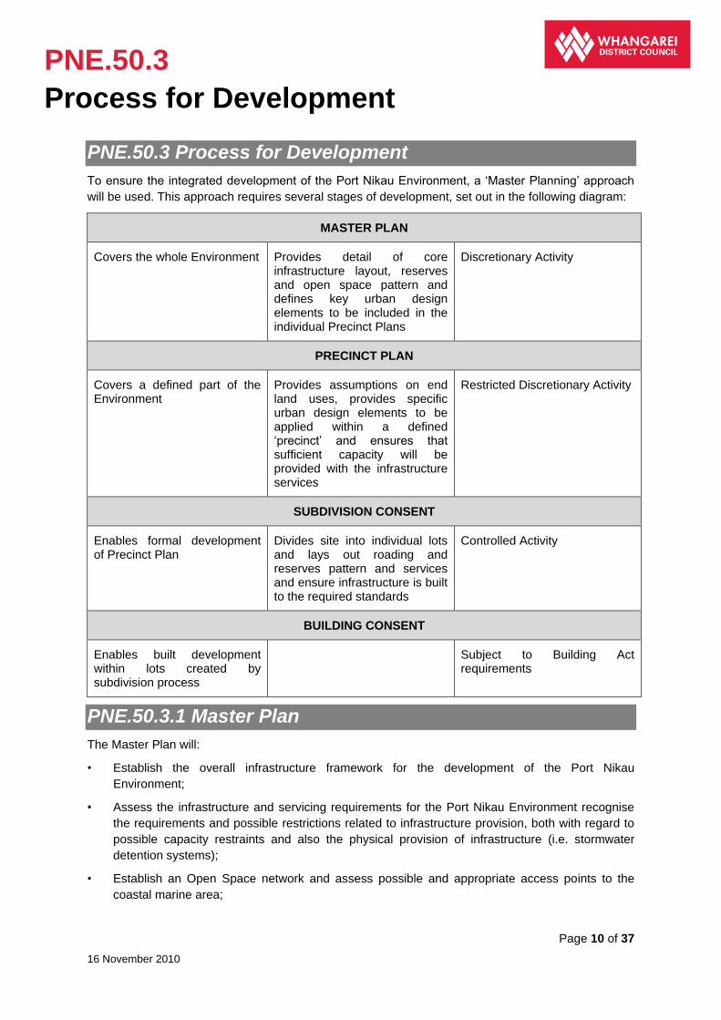
PNE.50.3 Process for Development
To ensure the integrated development of the Port Nikau Environment, a ‘Master Planning’ approach
will be used. This approach requires several stages of development, set out in the following diagram:
MASTER PLAN
Covers the whole Environment Provides detail of core infrastructure layout, reserves and open space pattern and defines key urban design elements to be included in the individual Precinct Plans
Discretionary Activity
PRECINCT PLAN
Covers a defined part of the Environment
Provides assumptions on end land uses, provides specific urban design elements to be applied within a defined ‘precinct’ and ensures that sufficient capacity will be provided with the infrastructure services
Restricted Discretionary Activity
SUBDIVISION CONSENT
Enables formal development of Precinct Plan
Divides site into individual lots and lays out roading and reserves pattern and services and ensure infrastructure is built to the required standards
Controlled Activity
BUILDING CONSENT
Enables built development within lots created by subdivision process
Subject to Building Act requirements
PNE.50.3.1 Master Plan
The Master Plan will:
• Establish the overall infrastructure framework for the development of the Port Nikau
Environment;
• Assess the infrastructure and servicing requirements for the Port Nikau Environment recognise
the requirements and possible restrictions related to infrastructure provision, both with regard to
possible capacity restraints and also the physical provision of infrastructure (i.e. stormwater
detention systems);
• Establish an Open Space network and assess possible and appropriate access points to the
coastal marine area;

PNE.50.3
Process for Development
Page 11 of 37
16 November 2010
• Detail the overall urban design framework for the Environment;
• Be consistent with the Port Nikau rules;
• Protection of environmentally sensitive areas; and
• Establish buffers to insulate the development from sensitive activities on sites both within and
outside the Port Nikau Environment.
PNE.50.3.2 Precinct Plans
Precinct Plans will:
• Apply to a defined area within the Port Nikau Environment;
• Be consistent with the Master Plan;
• Detail the location of possible land uses;
• Detail specific urban design standards and bulk and location requirements to be applied within a
particular Precinct;
• Assess the servicing requirements (both physical and capacity wise) of land uses and ensure
that the infrastructure requirements of a particular Precinct are in accordance with the servicing
requirements/capacity allowance established at the Master Plan level;
• Specifically detail the provision of public and private Open Space and access to the coastal
marine area;
• Make provision for specific, defined matters such as reverse sensitivity, ecological protection etc
within the appropriate Precinct; and
• Be consistent with the Port Nikau rules.
PNE.50.3.3 Subdivision and Built Development
Except as provided for below, subdivision and/or built development following the approval of a Master
Plan and/or Precinct Plan can only occur once the relevant Plans have been granted consent. Such
works will be in accordance with the Master and/or Precinct Plan and the Port Nikau Environment
Rules.
Note: A subdivision consent may be undertaken after the Master Plan and before the Precinct Plan(s) to give
effect to identified elements of the Master Plan i.e. establishing main roads, subdividing the site into the
Precinct blocks etc.
A subdivision consent may only be undertaken after the Master Plan and before the Precinct Plan(s) to
establish infrastructure such as roads and subdividing the site into the precinct blocks.
Note: There are also Transitional Provisions that apply to development on the site prior to a Master Plan being
approved – refer 50.6.1
PNE.50.3.4 Changes to a Master Plan and/or Precinct Plan
Any change to a Master Plan and/or Precinct Plan will require either new resource consent, or a change to the conditions of an existing consent.

PNE.50.4
Master Plan Applications
Page 12 of 37
16 November 2010
PNE.50.4 Master Plan Applications
PNE.50.4.1 Discretionary Activities
Any application for a Master Plan in the Port Nikau Environment will be a discretionary activity and shall include the following information.
1. Urban Design and Open Space
a) A report is to be provided, prepared by an urban designer/planner/architect, who is a signatory to the New Zealand Urban Design Protocol, detailing general urban design elements that are to be applied over the entire site, developed in accordance with the New Zealand Urban Design Protocol; being:
i) General urban design principles that maybe applied in specified Precinct(s);
ii) Roading cross sections for arterial (main) roads specifically detailing any provision to be made for car parking;
iii) An overall Open Space network detailing in general terms:
(1) The location of Open Space to be provided, including those areas adjacent to the Coastal Marine Area;
(2) Connections to be provided between areas of Open Space;
(3) Locations where public access will be provided to the Coastal Marine Area;
iv) Planting guidelines for road reserves and areas of Open Space;
v) Guidelines for the provision of private open space including balconies and service provisions to be provided with residential development where applicable.
Note: The provision of Open Space will require that areas of Open Space be provided in such a way that enables unrestricted public access in the same manner as a public park and/or reserve, but enables if desired, or necessary for Open Space land to remain in private ownership.
The provision of Open Space adjacent to the Coastal Marine Area may not result in one contiguous strip of Open Space being provided along the Coastal Marine edge, as it may be necessary to restrict public access from some areas of the coastal edge for the purposes of protection of the neighbouring ecological values, the maintenance of health and safety, to allow the siting of buildings and/or other activities that have an operational necessity to be on the edge of/or over the Coastal Marine Area, or the design of the Open Space areas may have determined that it is desirable to provide other built form on the edge of the Coastal Marine Area.
2. Infrastructure
a) An infrastructure framework is to be provided, prepared by registered engineers detailing the layout and required capacity of main trunk services to be provided for:
i. Roading (including provision for public transport, alternative modes and access to the state highway);
ii. Wastewater;
iii. Stormwater;
iv. Water;
v. Retention of the railway line and its ongoing use;
vi. Other infrastructure.
b) The infrastructure framework will detail where necessary those areas within the Port Nikau Environment required to be set aside (approximately) for the physical provision of infrastructure and network utility services and also detail any staging proposed as a means of managing and avoiding potential effects related to the provision of capacity within

PNE.50.4
Master Plan Applications
Page 13 of 37
16 November 2010
services external to the Port Nikau Environment to accommodate the assessed future demand.
3. Hazards
a) An assessment is to be provided of the extent any areas subject to natural hazards, as well as any geotechnical and ground contamination issues and methods to be applied to manage these hazards.
4. Ecology
a) The Master Plan is to include an ecological buffer along the boundary of the site, as detailed in Appendix A.
b) An assessment as to how the ecological areas are to be protected on an ongoing basis.
5. Reverse Sensitivity
a) An assessment and plan of the indicative land use pattern recognising the prohibited activities and the impacts on sensitive sites within and outside the Port Nikau Environment. In particular it will include an analysis of potential noise and dust effects and impacts on sites which contain dangerous goods.
6. Traffic Management
A report examining the traffic implications of the Master Plan.
7. Railway Line
An assessment of how the railway line is to be retained and to continue to operate.
8. Assessment Criteria
a) Whether the Master Plan sets out the key urban design qualities at a site wide level that ensure that physical development at a Precinct level in the Port Nikau Environment will adhere to the principles of the New Zealand Urban Design Protocol, in particular the key urban design qualities of: Context; Character; Choice; Connections; Creativity; Custodianship; and Collaboration.
b) Whether the design standards proposed reinforce and assist in achieving the key urban design elements of the Master Plan.
c) Whether the Open Space network enables unrestricted access by the public to open spaces; and is designed so that open spaces are accessible, readily usable, able to cater for a range of uses and users and linked in a legible manner; and where appropriate be adjacent to and provide access to the Coastal Marine Area.
d) Whether providing public open space particularly adjacent to the Coastal Marine area, takes into consideration health and safety issues, particularly with regard to the safe and efficient operation of marine based industrial and commercial activities.
e) Whether the Infrastructure Framework accompanying the Master Plan accurately assesses the servicing requirements of the proposed development of the Port Nikau Environment and the capacity of infrastructure and services external to the Port Nikau Environment and how adverse effects arising are avoided, remedied or mitigated.
f) Whether the assessment of natural hazards and/or ground contamination accurately defines those hazards that are applicable, or likely to be applicable to the development of the site and the methods to avoid, remedy or mitigate the effects of those hazards.
g) Whether the assessment of and management of hazards on the site ensures that future development will not be negatively impacted upon by hazards and that development will not exacerbate the effects of known hazards.
h) Whether the traffic assessment adequately deals with circulation within the site and any other related issues.

PNE.50.4
Master Plan Applications
Page 14 of 37
16 November 2010
i) Whether reverse sensitivity issues including impacts on sites within and outside the environment can be mitigated particularly in relation to sensitive uses including noise, dust and dangerous goods.
j) Whether the railway line is protected and can continue to operate.
PNE.50.4.2 Controlled Activities
A subdivision consent may be undertaken after the Master Plan and before the Precinct Plan(s) to give effect to identified elements of the Master Plan i.e. establishing main roads, subdividing the site into the Precinct blocks etc.
A subdivision consent may only be undertaken after the Master Plan and before the Precinct Plan(s) to establish infrastructure such as roads and subdividing the site into the precinct blocks.
PNE.50.4.3 Discretionary Activities
The Master Plan Process complying with the information requirements of Rule 50.4.
PNE.50.4.4 Non-Complying Activities
Any master plan application that:
a) Does not provide all of the information required above; and/or
b) Is not consistent with the Port Nikau Environment Rules.
Shall be assessed to be a non-complying activity.
Note: There are also Transitional Provisions that apply to development on the site prior to a Master Plan being approved – refer 50.6.1.

PNE.50.5
Precinct Plan Applications
Page 15 of 37
16 November 2010
PNE.50.5 Precinct Plan Applications
PNE.50.5.1 Restricted Discretionary Activities
Any application for a Precinct Plan in the Port Nikau Environment will be a restricted discretionary activity. It shall include the following information and be assessed against the matters over which discretion is restricted and be guided by the relevant assessment criteria.
1. Master Plan
a) The Precinct Plan must give effect to the relevant conditions of the Master Plan and any conditions of other relevant granted consents/approvals including subdivision consents.
2. Area and Location
a) The exact area that is to be the subject of the Precinct Plan must be detailed.
3. Development Schedule
a) A schedule of the maximum level of development to be permitted within the Precinct expressed as:
i. Gross floor area of retail activities;
ii. Gross floor area of office activities;
iii. Gross floor area of industrial activities;
iv. Gross floor area of other activities;
v. Total number of household units.
4. Urban Design and Open Space
a) A report is to be provided, prepared by an urban designer/planner/architect, who is a signatory to the New Zealand Urban Design Protocol, detailing specific urban design principles that are to be applied within the particular Precinct. These design elements will be developed in accordance with the New Zealand Urban Design Protocol; being:
i. Specific urban design principles to be applied within the Precinct, including bulk and location and amenity controls;
ii. Design standards for streetscapes, including the design of street furniture (bollards, lighting poles etc);
iii. Roading cross sections for collector and local roads including intersections specifically detailing any provision to be made for car parking;
iv. The location, dimensions and area of any shared/common and public car parking areas to be provided within the Precinct;
v. Specific provisions for the servicing of buildings including rubbish, storage and mail deliveries;
vi. Specific details of the Open Space and vested Reserve network to be created within the individual Precinct, detailing in specific terms:
1. The location, dimensions and area of Open Space to be provided, including those areas adjacent to the Coastal Marine Area;
2. Connections to be provided between areas of Open Space and how those areas of Open Space relate to both the Master Plan and any adjacent Precinct Plans already approved;
3. Specific locations where public access will be provided adjacent to and to the Coastal Marine Area.
PNE.50.5
Precinct Plan Applications
Page 16 of 37
16 November 2010
vii. Specific details of the amount, area and type of private open space to be provided for residential and quasi residential activities.
viii. Methods for implementing the planting guidelines for road reserves and areas of Open Space.
ix. The proposal is to comply with the Port Nikau Environment Rules.
Note: The provision of Open Space will require that areas of Open Space be provided in such a way that enables unrestricted public access in the same manner as a public park and/or reserve, but enables if desired, or necessary for Open Space land to remain in private ownership.
The provision of Open Space adjacent to the Coastal Marine Area may not result in one contiguous strip of Open Space being provided along the Coastal Marine edge, as it may be necessary to restrict public access from some areas of the coastal edge for the purposes of protection of the neighbouring ecological values, the maintenance of health and safety, to allow the siting of buildings and/or other activities that have an operational necessity to be on the edge of/or over the Coastal Marine Area, or the design of the Open Space areas may have determined that it is desirable to provide other built form on the edge of the Coastal Marine Area.
5. Infrastructure Framework / Roading
a) An Integrated Traffic Assessment prepared by a suitably qualified and experienced traffic engineer shall be provided with a Precinct Plan application that includes all the following:
i. An assessment of vehicle trip generation and distribution based on the maximum development that can take place in terms of this Precinct Plan and any other consented Precinct Plans within the Port Nikau Environment. The assessment shall detail the assumptions upon which the assessment is made.
ii. In addition to the above:
The proposed development must take account of the approved Master Plan, other existing or consented Precinct Plans and resource consents and any other existing or approved development and the impacts to and on the roading network including:
1) Port Road from the Port Nikau Environment to the intersection with Kioreroa Road.
2) Port Road from Kioreroa Road to the intersection with Okara Drive (southern intersection).
3) Okara Drive from the intersection with Port Road to Porowini Ave intersection (under construction).
4) Okara Drive from Porowini Avenue to Port Road (North intersection).
5) Okara Drive from Port Road (North intersection) to Reyburn Street / Herekino Street intersection.
6) Kioreroa Road from the intersection with Port Road to Rewa Rewa Road.
7) Rewa Rewa Road from the intersection with Kioreroa Road to State Highway 1.
8) Intersection of Gumdigger Place and Kioreroa Road.
Note: The roads and intersections detailed above shall be considered to be the maximum extent of the roading network potentially affected by the development of all or part of the Port Nikau Environment and therefore any requirements for upgrading shall be the result of assessed impacts on this portion of the roading network only. Any assessment of the impacts of the roading network are to firstly consider the current level of service that the road and / or intersection is performing at, to ensure that only new effects are considered.
iii. An analysis of the impacts of the full development of the Port Nikau Environment in terms of (i) above on traffic operations on existing local roads and State Highways including intersections.
iv. Consideration of any current roading strategies prepared by or on behalf of the WDC and the NZ Transport Agency, including any relevant Regional and National Transport strategies.

PNE.50.5
Precinct Plan Applications
Page 17 of 37
16 November 2010
v. Consideration of alternative means of transport (e.g. public transport, provision for walking and cycling) that will reduce reliance on single occupancy motor vehicle trips.
vi. All proposed internal roading networks, connections to existing roads and any additional new roading links external to the Port Nikau Environment which are necessary to support the permitted levels of development identified in (i) above.
vii. A peer review of the assessment undertaken by or on behalf of the NZTA which confirms that there is sufficient capacity or planned capacity within the State Highway network to accommodate the predicted increase in traffic.
b) The Traffic Impact Assessment required in terms of (a) above shall demonstrate that traffic generation by the proposed development which is the subject of the application, shall not cause a reduction in the existing Level of Service for traffic movements at the intersection on State Highway 1.
c) An infrastructure framework is to be provided, prepared by registered engineers detailing the layout and required capacity of services to be provided for within the Precinct for:
i. Roading (including provision of public transport and alternative modes);
ii. Wastewater;
iii. Stormwater;
iv. Water; and
v. Other services.
d) The infrastructure framework will detail where necessary with those areas within the Port Nikau Environment required to be set aside (approximately) for the physical provision of infrastructure and network utility services and also detail any staging proposed as a means of managing and avoiding potential effects related to the provision of infrastructure and service capacity both within the Port Nikau Environment and infrastructure and services external to the Port Nikau Environment to accommodate the assessed future demand as identified within the approved Master Plan.
e) The infrastructure network within the Precinct Plan is to detail the car parking standards to be applied in the assessment of the car parking requirements for shared/common and public car parking areas, including assessment methods to be applied where car parking areas serve multiple uses/sites and also detail the management/maintenance of shared/common car parking areas, which may include the vesting of such car parking areas in the Council once developed.
f) Roading - In addition to the information required in 4(a) above, with respect to roading and traffic effects:
i. For the intersection of SH1 and Rewarewa Road, the existing and predicted development must ensure the LOS for the traffic movements remain at Level C or better.
Note: For the purpose of this rule, LOS means Level of Service based on the average control delay per vehicle as defined in The Transportation Research Boards Highway Capacity Manual (HCM). Also any intersection upgrade does not have to be undertaken by the developer of the Precinct Plan under assessment as it is recognised that other parties have an interest in the upgrading of this intersection and other parties/uses generate traffic that has an effect on this intersection. Any requirement to upgrade maybe offset by a financial contribution or could be undertaken by others (refer to the requirements of Scheduled Activity Site or Overlay Area No. 21), including NZTA and/or WDC.
This should be dealt with as a condition on any approved resource consent.
6. Hazards
PNE.50.5
Precinct Plan Applications
Page 18 of 37
16 November 2010
a) Detail is to be provided of areas within the Precinct subject to hazards, including any geotechnical and ground contamination issues and methods to be applied to manage these hazards.
7. Ecology
a) The relevant Precinct Plan(s) are to include provision for an ecological buffer along the boundary of the site (location defined in Appendix A), that will be established prior to the development of the adjoining Precinct(s).
b) The ecological buffer will:
i. Be established between the development area and the south western boundary with the Coastal Marine Area, which encompasses a wader bird habitat;
ii. Create an open water separation between the Coastal Marine Area and the development area as shown in Appendix B; and
iii. Enable the protection of the pre-development ecological values of the land adjacent to the Port Nikau Environment (but beyond the buffer) along the boundary of the site (location defined in Appendix A).
8. Matters over which Discretion is Restricted
a) That the Precinct Plan implements the conditions/outcomes of the approved Master Plan;
b) The provision of appropriate Open Space;
c) The provision of appropriate Open Space adjacent to the Coastal Marine Area;
d) The provision of servicing all activities;
e) The provision of public access to the Coastal Marine Area;
f) The provision of private open space with residential activities;
g) Parking loading and access;
h) The provision of infrastructure services necessary to meet assessed demand;
i) The impact of the proposal on adjacent public wastewater, stormwater and water supply infrastructure and networks and connections to those services;
j) The impact of the proposal on adjacent and linking public roading infrastructure and networks as defined by 50.5.5(a);
k) The sequencing, timing and staging of development to meet the availability of capacity within infrastructure services required to meet assessed demand;
l) The provision of infrastructure services necessary to avoid adverse environmental effects and ensure public health and safety is maintained;
m) The protection of the railway line;
n) The remediation of identified contaminated land if required;
o) The identification and avoidance of effects of hazards;
p) Public access to areas assessed to be ecologically sensitive;
q) The requirement to obtain other consents and/or permissions;
r) The requirements/conditions of other consents and/or permissions;
s) The impact of the proposal on the intersection of State Highway and Rewa Rewa Road if the level of service defined in 50.5.5(f) is proposed to be exceeded; and
t) Reverse sensitivity effects.
9. Assessment Criteria

PNE.50.5
Precinct Plan Applications
Page 19 of 37
16 November 2010
a) Whether the Precinct Plan complies with the approved Master Plan.
b) Whether the Precinct Plan set outs the specific key urban design qualities at a Precinct level that ensure that development within the Precinct will adhere to the principles of the New Zealand Urban Design Protocol, in particular the key urban design qualities of: Context, Character, Choice, Connections, Creativity, Custodianship, and Collaboration.
c) Whether the design standards proposed reinforce and assist in achieving the key urban design elements and any other conditions included in the approved Master Plan.
d) Whether the Open Space network is linked to assessed demand, enables unrestricted access by the public to open spaces; is designed so that open spaces are accessible, readily usable, able to cater for a range of uses and users and linked in a legible manner and where appropriate be adjacent to and provide access to the Coastal Marine Area.
e) Whether there is the provision of Open Space connectivity through and across the site particularly from roads.
f) Whether the provision of public access to and adjacent to the Coastal Marine area does not risk endangering public health and safety.
g) Whether the provision of public access to and adjacent to the Coastal Marine Area includes consented structures, wharves etc.
h) Whether the Infrastructure Framework accompanying the Precinct Plan accurately assesses the servicing requirements of the proposed development, both internal to the Precinct and external to the Precinct and can demonstrate that adequate infrastructure services can, or will be provided to meet estimated and agreed demand.
i) Whether the staging of development is considered to be an acceptable means of managing the potential effects of development and there may be a deficiency in the capacity of services external to the Precinct to accommodate the demand on services created by the development within the Precinct.
j) Whether the servicing arrangements are appropriate given the type of activities proposed.
k) Whether the parking / loading arrangements are appropriate given the type of activities proposed.
l) Whether the railway line can continue to operate.
m) Whether the assessment of hazards accurately defines those hazards applicable, or likely to be applicable to areas of the Precinct and details methods to avoid, remedy or mitigate the effects of hazards on future development and ensures that future building development does not exacerbate the effects of any known hazard.
n) Whether future development of any Precinct does not result in the ecological characteristics of the site, or the immediately surrounding area, directly impacted upon by the Precinct, deteriorating below pre-development levels and where possible and whether the ecological characteristics of the site and the surrounding area should be enhanced and protected.
o) Where appropriate, the Precinct(s) adjacent to the ecological buffer must detail methodologies to avoid effects on the ecology adjacent to that part of the site and must ensure that future building development does not negatively impact on that ecology.
p) Whether the assessment of the numbers of vehicle movements in the peak hour includes assessments of actual vehicle movements, measured on Lower Port Road at the northern boundary of the Port Nikau Environment, assessed vehicle movements associated with approved and unimplemented, or partially implemented Precinct Plans and the assessed number of vehicle movements that will be generated by the Precinct Plan.
q) Whether the activities within the buffer and transition area are appropriate with regards to activities outside the Port Nikau Environment.

PNE.50.5
Precinct Plan Applications
Page 20 of 37
16 November 2010
PNE.50.5.2 Prohibited Activities
The relevant Precinct Plan(s) shall prohibit the following activities within the ‘Buffer Areas’ defined in Appendix A:
i. Residential activities;
ii. Activities involving the care of elderly or sick people, or the education or care children;
iii. A provision of outdoor eating, dining or reception areas associated with any retail activities or commercial activities (for the avoidance of doubt, it is acknowledged that retail activities and commercial activities without outdoor eating, dining or reception areas are permitted); and
iv. Visitor accommodation.
Note: The relevant Precinct Plan(s) shall not provide for residential activities within the ‘Transition Area’ defined in Appendix A.
PNE.50.5.3 Non-Complying Activity
Any Precinct Plan application that does not meet the standards above.
PNE.50.5.4 Discretionary Activity
Any Precinct Plan application that:
i. Does not provide all of the information required, or satisfy the relevant thresholds under 50.5.1; and
ii. Does not give effect to the relevant conditions of the Master Plan and any conditions of other relevant granted consent/approvals.
PNE.50.5.5 Restricted Discretionary Activity
Any Precinct Plan.
PNE.50.5.6 Controlled Activity
Subdivision within any approved precinct plans.
PNE.50.5.7 Standards for Permitted Activities
Permitted activities may only be carried out within a consented Precinct Plan area and must not result
in the standards in the development schedule for the Precinct being exceeded.

PNE.50.6
Port Nikau Environment Rules
Page 21 of 37
16 November 2010
PNE.50.6 Port Nikau Environment Rules
PNE.50.6.1 Transitional Provisions
Notwithstanding any of the rules contained in Chapter 50, the rules of the Business 4 Environment,
both land use and subdivision will apply to the Port Nikau Environment until a Master Plan is
approved for the Port Nikau Environment.

PNE.50.7
Port Nikau Environment – Activity Rule
Table
Page 22 of 37
16 November 2010
PNE.50.7 Port Nikau Environment – Activity Rule Table
PNE.50.7.A Prohibited Activities
The following are prohibited activities, for which no resource consent shall be granted:
a. Use, storage or disposal of radioactive material with an activity exceeding 1000 terabequerels.
b. Certain land uses/activities as detailed in Rule 50.7.2.
The following are prohibited activities within the ‘Buffer Areas’ defined in Appendix A:
i. Residential activities;
ii. Activities involving the care of elderly or sick people, or the education or care children;
iii. A provision of outdoor eating, dining or reception areas associated with any retail activities
or commercial activities (for the avoidance of doubt, it is acknowledged that retail activities
and commercial activities without outdoor eating, dining or reception areas are permitted);
and
iv. Visitor accommodation.
PNE.50.7.B Non Complying Activities
Residential activities are non-complying activities within the ‘Transition Area’ defined in Appendix A.
Note: The activity status of Master and Precinct Plans and Subdivision Application is specified above.
PNE.50.7.1 Master Plan and Precinct Plan Compliance
The following activity is a permitted activity in the Port Nikau Environment:
a) Any activity provided for within an approved Master Plan and an approved Precinct Plan.
Any activity that does not comply with a condition for a permitted activity is a discretionary activity.
PNE.50.7.2 Activities Generally
Notwithstanding the rules below, any activity involving
a) Residential Activities;
b) Activities involving the care of elderly or sick people, or the education or care children;
c) A provision of outdoor eating, dining or reception areas associated with any retail activities or commercial activities (for the avoidance of doubt, it is acknowledged that retail activities and commercial activities without outdoor eating, dining or reception areas are permitted); and
Any activity that does not comply with a condition for a permitted activity is a discretionary activity if:
a) It does not involve intensive livestock farming; and
b) It is not an activity that involves food irradiation; and
c) It is not an activity involving any of the following on a commercial basis: bone boiling or crushing; fish cleaning; curing and processing; flax pulping; flock manufacturing or teasing of textiles; refuse accumulation; disposal of sewage; storage, drying or

PNE.50.7
Port Nikau Environment – Activity Rule
Table
Page 23 of 37
16 November 2010
d) Visitor accommodation;
Is a Prohibited Activity in the Buffer Area (defined in Appendix 1) of the Port Nikau Environment.
Any activity involving:
a) Residential Activities.
Is a Non-Complying Activity in the Transitional Area (defined in Appendix 1) of the Port Nikau Environment.
Taking into account the rules above, any activity in the Port Nikau Environment is a permitted activity if:
a) It does not involve intensive livestock farming, mineral extraction, food irradiation; and
b) It is not an activity involving any of the following on a commercial basis: bone boiling or crushing; fish cleaning, curing and processing; flax pulping; flock manufacturing or teasing of textiles; refuse accumulation; disposal of sewage; storage, drying or preserving of bones, hides, hooves, or skins; tallow melting, tanning; wood pulping; wool scouring; and
c) It is not an activity that is classified as an offensive trade in the Health Act 1956.
preserving of bones, hides, hooves, or skins; tallow melting; tanning; wood pulping; wool scouring; and
d) It is not an activity that is classified as an offensive trade in the Health Act 1956.
Any activity that does not comply with the standards for a discretionary activity is a non-complying activity.
Note: Rules 50.7.9 and 50.7.10 impact on the location of activities within the Port Nikau Environment with regard to noise effects and should therefore be consulted in conjunction with Rule 50.7.2
PNE.50.7.3 Network Utility Operations
The following activities related to Network Utility Operations excluding electricity infrastructure are a permitted activity:
a) The establishment of junction boxes, substations and other equipment cabinets required as part of a utility network that have a height no greater than 2.5m and a ground coverage not exceeding 4.5m2; and
b) The establishment of, or extension to, overhead telecommunication lines located on single poles; and
c) The establishment of network utility operations for the purposes of wireless communication, or the measurement, collection and distribution of meteorological
Network utility operations that do not comply with a condition for a permitted activity are a restricted discretionary activity.
Discretion is restricted to:
i. Scale, bulk and form of the installation(s) above ground;
ii. Cumulative effects of additional structures;
iii. Shading effects;
iv. Effects on amenity values;
v. Effects on landscape/ streetscape values;
vi. Effects on ecological values;
vii. Effects on heritage values;

PNE.50.7
Port Nikau Environment – Activity Rule
Table
Page 24 of 37
16 November 2010
information, that comply with the rules for Aerials and Aerial Support Structures; and
d) The minor upgrading, replacement, removal and maintenance of existing facilities; and
e) The establishment of, or extension to, underground Network utility operations, including gas lines that have a maximum operating pressure not exceeding 2000 kilopascals.
viii. Effects on cultural values;
ix. Effects on public health and safety;
x. Issues of reverse sensitivity.
PNE.50.7.4 Provision of Parking Spaces
Any activity is a permitted activity if:
a) Parking spaces are provided in accordance with Chapter 47.
Any activity that does not comply with a condition for a permitted activity is a restricted discretionary activity.
Discretion is restricted to:
i. Those matters listed in Chapter 47 Road Transport Rules.
PNE.50.7.5 Traffic Movements
Any activity is a permitted activity if:
a) It does not generate more than 200 traffic movements in any 24-hour period; or
b) The activity complies with Appendix 6I where it gains access to a Collector or Arterial Road; and
c) It does not generate traffic movements in excess of those allowed for in the approved Master and/or Precinct Plan.
Notes:
1. Where access is gained to a Limited Access Section of State Highway, it may be necessary to liaise with Transit New Zealand.
Any activity that does not comply with a condition for a permitted activity is a restricted discretionary activity.
Control is reserved over:
i. The effects of parking, loading and manoeuvring on existing public roads;
ii. Need for acceleration and deceleration lanes;
iii. Access design;
iv. Number, location and design of vehicle crossing;
v. Safety of pedestrians;
vi. Efficiency and safety of roads;
vii. Traffic safety and visibility;
viii. Effects of dust;
ix. The effect on roads in the vicinity of the site and their ability to carry the traffic that the proposal will generate;
x. Need for traffic control, including signs, signals and traffic islands.

PNE.50.7
Port Nikau Environment – Activity Rule
Table
Page 25 of 37
16 November 2010
PNE.50.7.6 Signs
a) The construction and placement of a signs which is not visible from a public place or neighbouring property(s) is a permitted activity.
b) The construction or placement of a sign which is visible from a public place or neighbouring property(s) is a permitted activity if:
i. The sign is required under health and safety legislation; or
ii. The sign is erected by a road traffic authority for the purposes of traffic control or public safety and it is located within the legal road reserve; or
iii. The sign does not obscure any official signs or traffic signals; and
iv. The sign is static, and not flashing;
v. If illuminated, the added illuminance (horizontal or vertical) onto any other site measured at the boundary does not exceed 10 lux at any receiving property boundary or 15 lux at any road reserve boundary; and
vi. If illuminated, the sign is not within 20.0m of any road intersection; and
vii. Where the road has a speed limit of 70kph or greater, the sign is located so as to provide an unrestricted view to the motorist for a minimum distance of 250.0m.
Note:
1. Signs within the legal road boundary or on road verges and road reserves are regulated by Council Bylaws.
2. Temporary signs, and signs on vehicles are regulated by Council Bylaws.
Signs located in public places are regulated by Council Bylaws.
The construction or placement of a sign that does not comply with a condition for a permitted activity is a restricted discretionary activity.
Discretion is restricted to:
i) Traffic safety;
ii) The visual amenity of the locality.

PNE.50.7
Port Nikau Environment – Activity Rule
Table
Page 26 of 37
16 November 2010
PNE.50.7.7 Fences
Any activity is a permitted activity if:
a) Fences within 4.5m of the road boundary are no higher than 3.0m.
Any activity that does not comply with a condition for a permitted activity is a restricted discretionary activity.
Discretion is restricted to:
i. Effects on amenity values;
i. Effects on visual amenity;
ii. Effects on traffic safety;
iii. Effects on health and safety.

PNE.50.7
Port Nikau Environment – Activity Rule
Table
Page 27 of 37
16 November 2010
PNE.50.7.8 Artificial Lighting
Artificial lighting is a permitted activity if
either:
a) The lighting is required under health and safety legislation; or
b) The light is a street light, navigation light, or traffic signal; or
c) The following standards are complied with
i. The added illuminance onto any other site measured at the boundary does not exceed 10 lux at any receiving property boundary, or 15 lux at any road reserve boundary; and
ii. The artificial light is shielded in such a manner that light emitted by the fixture is projected below a horizontal plane running through the lowest point on the fixture; and
iii. The lower edge of the shield, as required by ii) above, is to be at or below the centreline of the light source; and
d) The light is static, and is not flashing; and
e) The artificial lighting complies with AS/NZS 1158/1996.
Notes:
1. If the object or device that contains Artificial Lighting is a sign, then Rule 50.7.6 Signs is solely applicable.
2. See Appendix 15 for illustration of c) (ii) and (iii) above.
Any activity that does not comply with a condition for a permitted activity is a restricted discretionary activity.
Discretion is restricted to:
i. Orientation, strength, intensity, colour, frequency of flashing of the light;
ii. Effects on traffic safety;
iii. Positive effects on pedestrian safety;
iv. Effect on amenity values.
PNE.50.7.9 Noise Zone 1
(Deleted – refer to Noise and Vibration Chapter)
PNE.50.7.10 Noise Zone 2
(Deleted – refer to Noise and Vibration Chapter)
PNE.50.7.11 Internal Noise Environment
(Deleted – refer to Noise and Vibration Chapter)

PNE.50.7
Port Nikau Environment – Activity Rule
Table
Page 28 of 37
16 November 2010
PNE.50.7.12 Construction Noise
(Deleted – refer to Noise and Vibration Chapter)
PNE.50.7.13 Vibration
(Deleted – refer to Noise and Vibration Chapter)
PNE.50.7.14 Electromagnetic Radiation
Any activity is a permitted activity if:
a) Exposures comply with NZS 2772.1:1999,
Radio Frequency Fields Part 1: Maximum
Exposure Levels 3 kHz – 300 GHz.
Any activity that does not comply with a condition for a permitted activity is a discretionary activity.
PNE.50.7.15 Outdoor Storage
Any activity is a permitted activity if:
a) Outdoor areas of storage or stockpiles of
materials or equipment comply with
building height, setbacks and daylight angle
rules; and
b) Outdoor areas of storage or stockpiles of
materials or equipment are contained or
maintained to prevent the dispersal of dust
or airborne contaminants beyond the site;
and
c) Materials are stored in a way that does not
provide a food source for vermin; and
d) The best practicable option is adopted to
prevent or minimise contaminants from
stockpiles entering watercourses or water
bodies.
Any activity that does not comply with a condition for a permitted activity is a restricted discretionary activity.
Discretion is restricted to:
i. Dust effects;
ii. Smell effects;
iii. Visual effects;
iv. Amenity effects;
v. Effects on amenity values;
vi. Effects on health and safety;
vii. Quality of stormwater runoff.
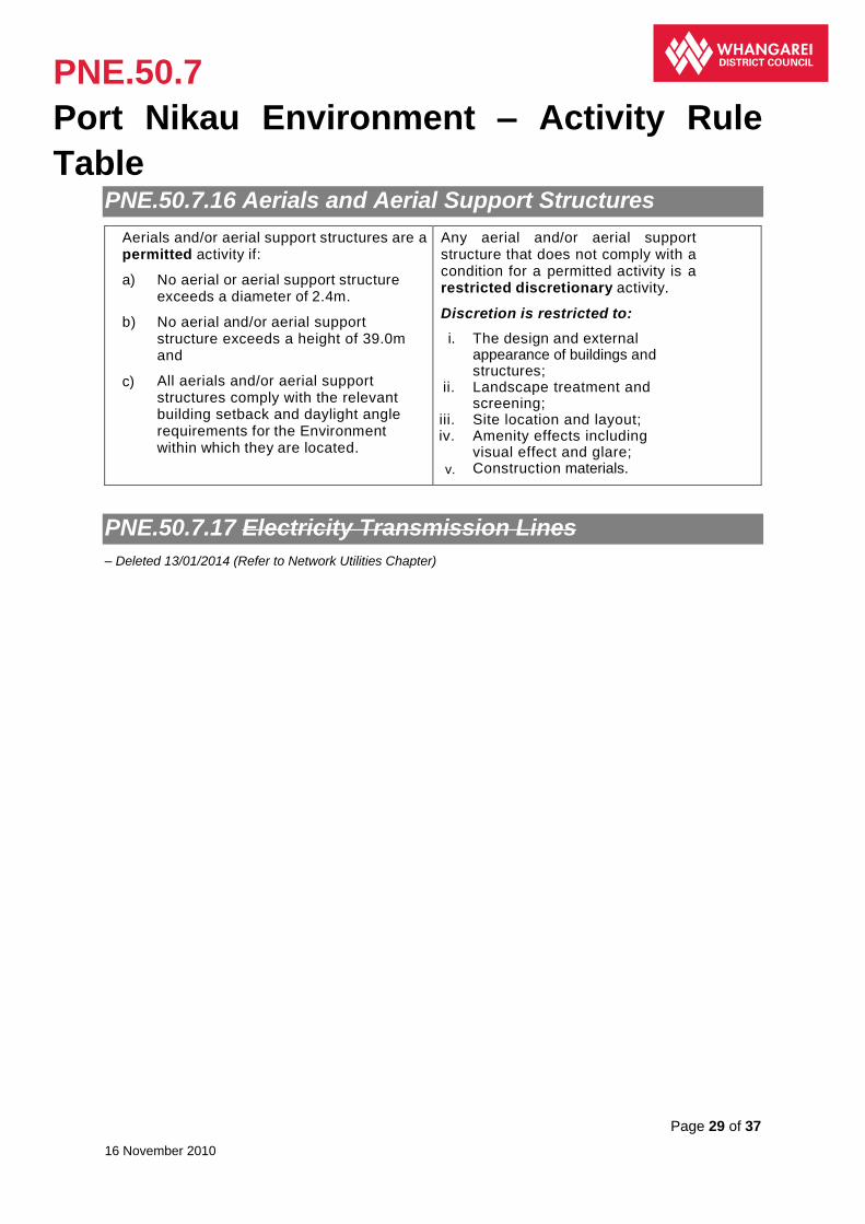
PNE.50.7
Port Nikau Environment – Activity Rule
Table
Page 29 of 37
16 November 2010
PNE.50.7.16 Aerials and Aerial Support Structures
Aerials and/or aerial support structures are a permitted activity if:
a) No aerial or aerial support structure exceeds a diameter of 2.4m.
b) No aerial and/or aerial support structure exceeds a height of 39.0m and
c) All aerials and/or aerial support structures comply with the relevant building setback and daylight angle requirements for the Environment within which they are located.
Any aerial and/or aerial support structure that does not comply with a condition for a permitted activity is a restricted discretionary activity.
Discretion is restricted to:
i. The design and external appearance of buildings and structures;
ii. Landscape treatment and screening;
iii. Site location and layout; iv. Amenity effects including
visual effect and glare; v. Construction materials.
PNE.50.7.17 Electricity Transmission Lines
– Deleted 13/01/2014 (Refer to Network Utilities Chapter)

PNE.50.8
Port Nikau Environment – Building Rule
Table
Page 30 of 37
16 November 2010
PNE.50.8 Port Nikau Environment – Building Rule Table
PNE.50.8.1 Building Height
Construction or alteration of a building is a
permitted activity if:
a) No part of the building exceeds 20.0m in
height; but
b) A building may exceed a height of 20.0m
provided that:
i. No part of a building exceeds a height
of 35.0m; and
ii. No more than 25% of the net site area
of the site is occupied by buildings that
exceed 20.0m in height.
Construction or alteration of a building that does not comply with a condition for a permitted activity is a restricted discretionary activity.
Discretion is restricted to:
i. The scale and bulk of the building in relation to the site;
ii. The built characteristic of the neighbourhood;
iii. The extent to which the effects of the height can be mitigated by setbacks, planting, design or the topography of the site;
iv. Effects on landscape values;
v. Effects on availability of daylight;
vi. Effects on amenity values.
PNE.50.8.2 Building Setbacks
Construction or alteration of a building is a
permitted activity if the building is setback at
least:
a) 2.5m from arterial road boundaries, or any
building line restriction shown on the
Planning Maps; and
b) 3.0m from any boundary a Business 4
Environment; and
c) 20.0m from any boundary of a Living,
Countryside or Open Space Environment;
and
d) 35.0m from any boundary of a Living,
Countryside or Open Space Environment,
where the building is in excess of 20.0m in
height.
Note:
The provisions of Rules 58.3.6 and 59.3.3 also apply
to building setbacks.
Construction or alteration of a building that does not comply with a condition for a permitted activity is a restricted discretionary activity.
Discretion is restricted to:
i. The outlook and privacy of adjoining and adjacent properties;
ii. Shading of adjoining properties;
iii. Effects on natural character;
iv. Effects on landscape values;
v. Effects on heritage values;
vi. Effects on natural functioning of ecosystems.
PNE.50.8
Port Nikau Environment – Building Rule
Table
Page 31 of 37
16 November 2010
PNE.50.8.3 Landscaping
Construction of a building, or site
redevelopment, is a permitted activity if:
a) All land within 2.0m of the road boundary
on arterial roads, other than accesses, is
planted in trees, shrubs or grass; and
b) The planting is completed within 6 months
of occupation of the building and is
maintained continuously thereafter.
Construction of a building or site redevelopment that does not comply with a condition for a permitted activity is a restricted discretionary activity.
Discretion is restricted to:
i. Effects on neighbours;
ii. Effects on the amenity of the locality;
iii. Alternative means of landscaping or screening.
PNE.50.8.4 Coastal Minimum Floor Level
Construction or alteration of a building or
structure is a permitted activity if:
a) There is a minimum floor level of 2.5m
above One Tree Point Datum Mean Sea
Level 1964.
The construction or alteration of a building or structure that does not comply with a condition for a permitted activity is a restricted discretionary activity.
Discretion is restricted to:
i. Construction or alteration of a building or structure in relation to its location;
ii. The avoidance, remediation or mitigation of coastal hazards;
iii. Floor level in relation to One Tree Point Datum Mean Sea Level 1964.

PNE.50.9
Principal Reasons for Rules/Explanations
Page 32 of 37
16 November 2010
PNE.50.9 Principal Reasons for Rules/Explanations
Activities Generally This rule names various activities for which resource consent is required. The benefit of activity lists is that they are relatively easy to use. Where activities are grouped on the basis of like effects on differing Environments, the Plan can still reflect the effects based approach required by the Resource Management Act 1991.
The listed activities are all associated with effects that are considered to be unacceptable in this Environment without careful management. Effects of these activities are not consistent with the character, aims and values of this Environment and many of these activities have effects such that they require an offensive trade licence under the Health Act 1956.
Some particular land use activities have either been detailed as prohibited or non-complying particularly within the buffer and transition areas respectively, that apply to the Port Nikau Environment. The control of these land uses in these areas is to ensure that reverse sensitivity effects on industrial activities in the vicinity resulting from potentially sensitive uses establishing in the Port Nikau Environment do not eventuate.
Provision of Parking Spaces See Chapter 58.
Traffic Movements The Port Nikau Environment has the potential to be very busy in terms of vehicle movements and significant increases in traffic can result in adverse effects on amenity, noise levels, pedestrian safety, road safety and efficiency, dust, odour and parking. This is particularly the case where access is gained directly from an arterial road, due to the existing volumes of traffic. This rule seeks to control activities that will result in significant increases in traffic to any area (including traffic that parks on or off the site or drives through the site), while allowing those activities that will not result in large volumes of traffic.
Signs Signs may adversely affect the visual amenity and traffic safety in this Environment. They are therefore controlled, with regard to positioning to avoid conflict with traffic and also illumination.
Artificial Lighting Lighting can interfere with the enjoyment of a property and the sleep of occupants. Direct spill light and glare are consequences of outdoor lighting used to illuminate property. The effect of the rule is to state lighting levels that are compatible with the existing lighting character of this Environment. Street lights, navigation lights and traffic signals are exempted from the rule to preserve traffic and personal safety.
Electromagnetic Radiation Certain utilities and other activities emit electromagnetic radiation or create electric fields, which are a health concern to some people living near them. Radio Frequency Fields (RF) are produced by broadcasting and microwave transmission activity. It is the antennae used for sending the signal which produce the Electromagnetic Radiation (EMR), which is within the 3 kHz to 300 GHz range of non-ionising radiation. This Plan is taking a cautious approach to the location of such activities within any Environments. An acceptable public level of exposure for EMR has been adopted from the New Zealand Standard, which has been thoroughly researched and based upon scientific evidence. Setting a minimum distance enables provision for access, maintenance and public safety.
Outdoor Storage The storage of materials outside can have an adverse visual effect, as well as contributing to air emissions. The rule aims to lessen the effects of this and thus reduce the effect on the amenity of the Port Nikau Environment.
Aerials and Aerial Support Structures The size and location of aerials and aerial support structures is controlled due to the visual intrusion or dominance that aerials and aerial support structures can have. Chapter HH of the
PNE.50.9
Principal Reasons for Rules/Explanations
Page 33 of 37
16 November 2010
Plan also seeks to control the visual impact that aerials and aerial support structures can have on Built Heritage.
Building Height The height of buildings is an important factor in maintaining built amenity. Building height is limited to a scale generally considered acceptable in the Port Nikau Environment, with the permitted activity rule allowing for the development of commercial buildings, particularly those associated with boat building. Higher buildings require further assessment as to their suitability, and a resource consent application is required.
Building Setbacks Building setbacks play an important role in the overall amenity of a neighbourhood. Setbacks are required adjacent to arterial roads to provide for and maintain a degree of spaciousness in an area and to maintain the existing streetscape. Side yard and rear yard setbacks from other Environments are intended to provide adjacent properties with some protection from the bulk of buildings in close proximity, and also to assist in the provision of open space between sites. Setbacks from water bodies and the coast are not specifically detailed as they are in other parts of the District Plan, but setbacks from the coast will be provided through the requirement in the Master Plan and associated Precinct Plans to provide Open Space adjacent to the Coastal Marine Area.
This design led approach to the provision of Open Space will ensure that public access to the coast and the coastal marine area is provided, in conjunction with the overall Open Space network for the Port Nikau Environment. Also, having no building setbacks from the Coastal Marine area will allow the siting of buildings and/or other activities that have an operational necessity to be on the edge of/or over the Coastal Marine Area to be located in this area, but the location of such buildings will have to be taken into consideration with the provision and design of Open Space areas and the overall urban design of the site.
Landscaping This rule is to ensure activities maintain a high standard of amenity, and to mitigate the adverse visual effects of expanses.
Coastal Minimum Floor Level Coastal flooding is a hazard that needs to be addressed and this hazard is not restricted to those areas covered by the Coastal Hazard Areas. By ensuring that the floor level of structures and buildings is at least 2.5m above One Tree Point Datum Mean Sea Level 1964, this risk will be significantly reduced. The 2.5m will take into account a rise in sea level of 0.5m, plus the instances of a spring tide and the surges associated with coastal storms.
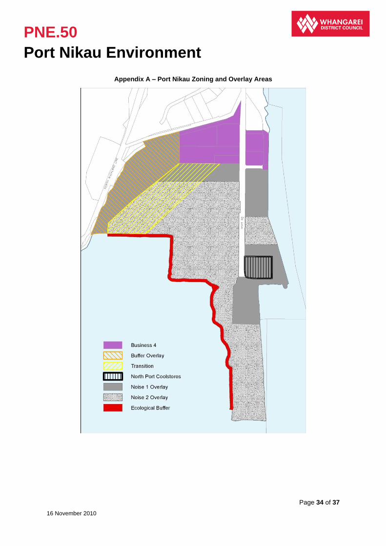
PNE.50
Port Nikau Environment
Page 34 of 37
16 November 2010
Appendix A – Port Nikau Zoning and Overlay Areas

PNE.50
Port Nikau Environment
Page 35 of 37
16 November 2010
Appendix A – North Port Cool Store Noise Levels and Buffer Zone

PNE.50
Port Nikau Environment
Page 36 of 37
16 November 2010
Appendix B – Ecological Buffer
PNE.50
Port Nikau Environment
Page 37 of 37
16 November 2010
Revision and Sign-off Sheet
Date Approved
Editor Paragraph Change Reference Decision Date Approved By
4 November 2010
FP/NW New Chapter Approved Plan Change 78 Port Nikau Environment – Operative on 16 November 2010
Council 27 October 2010
NW
11 December 2013
MD 50.7.3 50.7.14 50.9
Plan Change 123A consequential changes ‘Electricity Infrastructure’
Operative Date 13 January 2014 TRIM 14/4071
NW
10 May 2016 TB Whole Chapter Re-formatting of Chapter to ensure consistency.
Clause 20A Memo TRIM 16/55469
MM
11 May 2016 TB 50.7.9 50.7.10 50.7.11 50.7.12 50.7.13
Deletion of Rules as a result of Plan Change 110 becoming operative.
Operative Date 24 May 2016 TRIM 16/52692
MM
12 May 2016 TB Various Clause 20A amendment to correct minor errors.
Clause 20A Memo TRIM 16/21658
MM
14
September
2016
JM 50.7.16
50.9
Plan Change 124 becoming
operative.
Operative date 28 September 2016 TRIM 16/106480
MM
Editor France Prevost (FP)
Melanie Donaghy (MD) Taya Baxter (TB) Jane Murdoch (JM)
Editor Position Team Administrator Policy Division
Approved By Paul Waanders (PW) Nick Williamson (NW) Melissa McGrath (MM)
Approver Position Policy and Monitoring Manager (PW) District Plan Team Leader (NW and MM)