Plethodon stormi Conservation Strategy
56
Conservation Agreement for the Siskiyou Mountains Salamander (Plethodon stormi) in Jackson and Josephine Counties of Southwest Oregon Rogue River -Siskiyou National Forest, Medford District of the Bureau of Land Management, and the U.S. Fish and Wildlife Service I. SPECIES ADDRESSED Plethodon stormi (Siskiyou Mountains Salamander) I 7 2007 II. INVOLVED PARTIES U.S. Forest Service Scott Conroy, Forest Supervisor Rogue River-Siskiyou National Forest 333 West 8th Street Medford, OR 97501 541-858-2200 Attn: David Clayton Bureau of Land Management Tim Reuwsaat, District Manager Medford District, Bureau of Land Management 3040 Biddle Road Medford, OR 97501 541-618-2200 Attn: Carole Jorgensen U.S. Fish and Wildlife Service Craig Tuss, Field Supervisor Roseburg Field Office 2900 NW Stewart Parkway Roseburg, OR 97470 541-957-3474 Attn: Cynthia Donegan III. AUTHORITY, PURPOSE, OBJECTIVES, AND GOALS A. Authority The authority for the U.S. Fish and Wildlife Service's (Service) Roseburg Field Office (Office) to enter into this voluntary Conservation Agreement derives from the Endangered Species Act of 1973 (Act), as amended; the Fish and Wildlife Act of 1956, as amended; and the Fish and Wildlife Coordination Act, as amended. The Rogue River- Siskiyou National Forest (Forest) has the authority to enter into this agreement from the Act and the National Forest Management Act of 1976. The Medford District Bureau of
Transcript of Plethodon stormi Conservation Strategy
Conservation Agreement for the Siskiyou Mountains Salamander (Plethodon stormi) in Jackson and Josephine Counties of Southwest Oregon
Rogue River -Siskiyou National Forest Medford District of the Bureau of Land Management and the US Fish and Wildlife Service
I SPECIES ADDRESSED
Plethodon stormi (Siskiyou Mountains Salamander) I 7 2007
II INVOLVED PARTIES
US Forest Service Scott Conroy Forest Supervisor Rogue River-Siskiyou National Forest 333 West 8th Street Medford OR 97501 541-858-2200 Attn David Clayton
Bureau of Land Management Tim Reuwsaat District Manager Medford District Bureau of Land Management 3040 Biddle Road Medford OR 97501 541-618-2200 Attn Carole Jorgensen
US Fish and Wildlife Service Craig Tuss Field Supervisor Roseburg Field Office 2900 NW Stewart Parkway Roseburg OR 97470 541-957-3474 Attn Cynthia Donegan
III AUTHORITY PURPOSE OBJECTIVES AND GOALS
A Authority The authority for the US Fish and Wildlife Services (Service) Roseburg Field Office (Office) to enter into this voluntary Conservation Agreement derives from the Endangered Species Act of 1973 (Act) as amended the Fish and Wildlife Act of 1956 as amended and the Fish and Wildlife Coordination Act as amended The Rogue RivershySiskiyou National Forest (Forest) has the authority to enter into this agreement from the Act and the National Forest Management Act of 1976 The Medford District Bureau of
2 Conservation Agreement for Siskiyou Mt Salamanders_2007
Land Management (District) has the authority to enter into this agreement from the Act and the Federal Land Policy and Management Act of 1976 as amended
B Purpose The purpose of this Conservation Agreement is to formally document the intent of the parties involved to protect conserve and contribute to the conservation of the Siskiyou Mountains salamander by implementing conservation actions for the species and its habitat on federal lands within Jackson and Josephine Counties in southwest Oregon This Conservation Agreement represents a program-level agreement that outlines how conservation actions will be approached and what research needs to be done in support of these efforts Site-specific management will occur as described in the Conservation Strategy (USDA USDI 2007) (Appendix A)
C Objectives The Conservation Strategy describes conservation objectives identified at three spatial scales (site scale intermediate and at the Rogue River-Siskiyou National Forest Siskiyou Mountains Ranger District and Medford BLM Ashland Resource Area northern portion of the species range scale) Conservation objectives include I) establishing the initial extent of selected managed known sites 2) selecting managed known sites based upon location of animals suitable habitat risk factors federal land allocations and proximity to other sites and 3) managing these sites in a manner that will provide well-distributed habitat to support reproductive individuals that can interact in tbe planning area in an effort to maintain viable populations such that there are estimated numbers and distribution of reproductive individuals to insure their continued existence in the planning area (for detailed description of the Conservation Strategy objectives see Appendix A)
D Goals The Conservation Strategy describes the management actions necessary to maintain a high likelihood of well-distributed populations across the northern portion of the species range within the Applegate River 4h Field watershed on federal lands administered by the Rogue River-Siskiyou National Forest Siskiyou Mountains Ranger District and the Oregon Bureau of Land Management Medford District Ashland Resource Area in the northern portion of its range the Applegate River 4h field watershed and avoid a trend toward federal listing under the Endangered Species Act
For Oregon Bureau of Land Management (BLM) administered lands the Special Status Species policy details the need to manage for species conservation Conservation is defined as the use of all methods and procedures which are necessary to improve the condition of Special Status Species and their habitats to a point where their Special Status recognition is no longer warranted In addition implementation of the policy is intended to ensure that actions funded authorized or carried out by the BLM do not contribute to the need to list species under the Act
For Region 6 of the Forest Service Sensitive Species policy requires the agency to maintain viable populations of all native and desired non-native wildlife fish and plant species in habitats distributed throughout their geographic range on National Forest
3 Conservation Agreement for Siskiyou Mt Salamanders_ 2007
System lands Management should also preclude a trend towards federal listing for any identified Sensitive Species
For the US Fish and Wildlife Service the Act (section IO(a)(l)(A) provides an avenue for the Service to enter into voluntary agreements that benefit non-listed species These agreements are intended to further the purposes of the Act by supporting actions that may improve the status of an individual species and which may preclude the need to list the spec1es
IV STATUS AND DISTRIBUTION
On March 29 2007 the Service issued a 90 day finding on a petition to list the Siskiyou Mountains salamander (USFWS 2007) The Service determined the petition presented substantial scientific or commercial information indicating that listing the species may be warranted Therefore the Service has initiated a status review of the species and will issue a 12shymonth finding to determine if the petitioned action is warranted
The Siskiyou Mountains salamanders range encompasses approximately 337037 acres (136500 ha) in three counties (Jackson Josephine and Siskiyou Counties) of southwestern Oregon and in northern California (Clayton and Nauman 2005) More specifically this species has been detected in the Applegate River drainage of southern Oregon south to the Klamath River watershed of northern California In California recent genetic analyses indicate the species range is bounded to the west by the Indian Creek drainage and to the east by the Horse Creek drainage (see DeGross 2004 Mahoney 2004 Mead et al 2005 Mead 2006) It is known from sites ranging from 1600 feet (488 meters) (Nussbaum et al 983) to approximately 1800 meters (6000 feet) in elevation (Clayton et al 1999) Approximately 90 percent of the Siskiyou Mountains salamanders range occurs on federal lands managed under the Northwest Forest Plan (Plan) (USDA USDI 994) Within the Plan area 36 percent of the salamanders range occurs in reserves (Late-Successional Reserves Administratively Withdrawn Areas and Congressionally Reserved Areas) where timber harvest and other ground-disturbing activities are severely restricted I 0 percent occurs within Matrix lands generally available for timber harvest and 44 percent occurs in Adaptive Management Areas (AMA) where habitat management guidelines are flexible and some timber harvest is expected to occur The remaining 10 percent of the species range occurs on private lands
In the Applegate Watershed covered by the Conservation Strategy (Olsen et al 2007) there are 201 sites on District administered lands (on the Ashland and Grants Pass Resource Areas) 115 sites on public lands administered by the Forest (on the Applegate Ranger District) and 14 sites on private lands These sites occur within all federal land allocations (Adaptive Management Areas (AMA) Administratively Withdrawn areas Congressionally Reserved areas Late Successional Reserves and Matrix lands) Distributions of sites within the Applegate watershed portion of the range are primarily on AMA lands (67) some reserves (18) and private lands ( 16) (Nauman and Olson 1999)
The Siskiyou Mountains salamander is found on forested slopes where rocky soils and talus outcrops occur Occupied habitat for the Siskiyou Mountains salamander can range from small
4 Conservation Agreement for Siskiyou Mt Salamanders~2007
isolated rock outcrops to entire hillsides (Clayton et al 2004) Occasionally these salamanders can be found under other types of cover such as bark limbs or logs but only during wet weather when moisture is high and only ifthere are talus outcrops nearby (Nussbaum 1974 Nussbaum et al 1983) Nussbaum (1974) characterized optimal habitat for the Siskiyou Mountains salamander as stabilized talus in old-growth forest stands on north-facing slopes However more recently populations of the species have been found in rock outcrops in all forest age classes and on all slope aspects (Clayton eta 2004) as well as in managed stands (CDFG 2004)
Additional detailed information regarding status range and distribution of the species may be found in the Conservation Strategy (Appendix A)
V THREATS
Activities that may pose threats to this species are those that disturb the surface microhabitats andor microclimate conditions Disturbance of surface microhabitats is of primary concern because alteration of the microhabitat and microclimatic conditions can negatively impact these salamanders Typically these negative impacts involve actions that remove canopy andor disturb the substrate
Examples of threats include timber harvest road construction rock pit mining and development oflarge recreation sites Wildland fire is also a primary threat to this species Other activities such as prescribed fire trail construction and chemical applications may pose somewhat lesser or localized threats to the species and do not likely pose a threat to species persistence All these are presumed threats to this salamander as no studies have been published to document losses from specific anthropogenic disturbances in this species (USFWS 2007) These activities and their impacts to these salamanders are discussed in the Conservation Strategy (Appendix A)
VI CONSERVATION ACTIONS TO BE CARRIED OUT
The District and the Forest agree to
I Adopt and implement the final Conservation Strategy for the Siskiyou Mountains salamander under which Siskiyou Mountains salamander populations and habitats within Jackson and Josephine Counties will be managed to protect their significant biological and ecological values consistent with current law regulations policies existing and future management plans
2 A 5-year monitoring plan will address implementation and effectiveness of the Conservation Strategy This plan will be developed by the field unit representatives and will include an implementation and effectiveness monitoring plan to be completed within the first year of acceptance of the conservation plan Costs for initial development should be approximately $600000
3 In year two through five effectiveness monitoring of the activities management proposed in the conservation plan would occur by the field units Questions would include l) Have the
5 Conservation Agreement for Siskiyou Mt Salamanders_2007
proposed management strategies occurred within sites 2) Has there been discretion to field validate and delineate sites as needed 3) Are there animals present post-activity at the site Distributional surveys in priority areas and in potential connectivity areas could also occur at this time Costs for this should be approximately $500000 or less
4 In support of Adaptive Management a review of this conservation strategy will be conducted every five years where new species knowledge science findings habitat information and strategy implementation are evaluated Revision of the Conservation Strategy may follow the 5-year reviews to refine the plan or address emerging issues if deemed necessary by the cooperating parties
5 Between the 5-year reviews the following changes may trigger an immediate review
bull A significant change in the number of known sites within a sixth field watershed so that the understanding of the distribution of the species has changed to the extent that sites may be added or re-prioritized
bull A significant range change or extension has occurred such as a site found north of the Applegate River or in another 6th field watershed not previously known to harbor the species
bull Significant changes in Forest Service or BLM Land-Use Allocations as determined by the field unit within the area of the conservation strategy or a significant management direction change on F ederallands within the area of the conservation strategy
bull A significant change in habitat conditions due to large-scale fire that may change our assumptions as to the persistence of high-priority sites identified within the conservation strategy This might occur when more than half of one 6th field watershed occupied by the species is affected by the disturbance
bull New science that changes the understanding of the ecology of the species or its habitats
6 Identify research needs for the conservation of the species
The Service agrees to
I Assist the District and the Forest in managing Siskiyou Mountains salamander populations and habitats within Jackson and Josephine Counties and to protect their significant biological and ecological values consistent with current law regulations policies and existing management plans
6 Conservation Agreement for Siskiyou Mt Salamanders_2007
2 Review monitoring data and conservation activities in cooperation with the District and Forest and recommend changes in the status of the Siskiyou Mountains salamander as appropriate
3 Meet annually or as needed with District and the Forest to discuss Siskiyou Mountains salamander status and management needs
4 Forward all new information on the Siskiyou Mountains salamander to the District and the Forest
5 Cooperate in the updating of the Siskiyou Mountains salamander Conservation Strategy as needed
6 Support implementation of conservation actions that may preclude the need to list the species
VIII FUNDING AND IMPLEMENTATION OF CONSERVATION MEASURES
This Conservation Agreement is subject to available funding and staffing This does not impose financial obligations beyond appropriations The parties to this agreement are committed to seeking funding to implement this conservation agreement each year
VIII DURATION OF AGREEMENT
This agreement shall become effective with the signature of the last approving agency official and shall remain in effect until terminated It can be terminated in writing at any time that the District the Forest or the Service determines that the agreement is no longer necessary with a 30 day written notice to all parties
VIII SIGNATURES
7 z7 tJ7 Date
0lt2~~L4~- JY)ltro 7
District Manager Medford District Bureau of Land Management Date
J) J C 7 Field Supervmiddot or Roseburg Field Office CS Fish and Wildlife Service Dlfe
7 Conservation Agreement for Siskiyou Mt Salamanders_2007
References
California Department of Fish and Game 2004 Draft Status Review Siskiyou Mountains Salamander (Plethodon stormi) February 272004
Clayton eta 1999 Survey Protocol for the the Siskiyou Mountains Salamander Version 30 37 pages
Clayton eta 2004 Conservation Assessment for the the Siskiyou Mountains Salamander Version 13 34 pages
Clayton and Nauman 2005 Siskiyou Mountains Salamanders Article published in Amphibians of the Pacific Northwest Pages 137 amp 138
DeGross 2004 Gene Flow and the Relationship of Plethodon stormi and P elongatus Assessed with 11 Novel Microstellite Loci Thesis abstract61 pages
Mahoney 2004 Molecular systematics and phylogeography of the Plethodon elongates species group combining phylogenetic and population genetic methods to investigate species history Journal of Molecular Ecology (2004) 13 149-166
Mead eta 2005 Newly Discovered Populations of Salamanders from Siskiyou County Represent a Species Distinct form Plethodon Stormi Herptologica Volume 61 Number 2 158-177
Mead 2006 Plethodon Salamanders of the Applegate Klamath and Scott River Areas Report on Genetic Variation and Species Status 27 pages
Nussbaum 1974 A Report on the Distributional Ecology and Life History of the Siskiyou Mountains Salamander Plethodon stormi in relation to the Potential Impact of the Proposed Applegate Reservoir on this species 70 pages
Nussbaum eta 1983 Amphibians and Reptiles of the Pacific Northwest University ofldaho Press Moscow Idaho 72-7390-91 102 -105
Olsen eta 2007 Conservation Strategy for the Siskiyou Mountains Salamander(Plethodon stormi) Northern Portion of the Range Version 10
USDAUSDI (US Forest Service Bureau of Land Management) 1994 Record of decision for amendments to Forest Service and Bureau of Land Management planning documents within the range of the northern spotted owl US Forest Service Bureau of Land Management Portland OR 2 vols and appendices
USFWS (US Fish and Wildlife Service) 2007 Endangered and threatened wildlife and plants 90-Day Finding on a Petition to List the Siskiyou Mountains Salamander and Scott Bar Salamander as Threatened or Endangered Federal Register 50 CFR 17 7214750-14759
8 Conservation Agreement for Siskiyou Mt Salamanders_2007
Appendix A Conservation Strategy for the Siskiyou Mountains Salamander in Jackson and Josephine Counties of southwest Oregon
Conservation Strategy for the Siskiyou Mountains Salamander (Plethodon stormi)
Northern Portion of the Range
Version 10
7272007
Photo by William Leonard
Deanna H Olson David Clayton Edward C Reilly Richard S Nauman Brenda Devlin
and Hartwell H Welsh Jr
1
Authors
DEANNA H OLSON is a research ecologist USDA Forest Service Pacific Northwest Research Station 3200 SW Jefferson Way Corvallis OR 97331
DAVID CLAYTON is a wildlife biologist USDA Forest Service Region 6 Rogue-Siskiyou National Forest 333 W 8th St Medford OR 97501
EDWARD C REILLY is a forest planner USDI Bureau of Land Management Medford District 3040 Biddle Road Medford OR 97504
RICHARD S NAUMAN is an ecologist USDA Forest Service Pacific Northwest Research Station 3200 SW Jefferson Way Corvallis OR 97331
BRENDA DEVLIN is a wildlife biologist USDA Forest Service Region 5 Klamath National Forest Gasquet CA
HARTWELL H WELSH Jr is a research wildlife biologist USDA Forest Service Pacific Southwest Research Station Arcata CA
Contributors
This conservation strategy is the product of several yearsrsquo work by a dynamic team of interagency personnel and species experts Key contributors to the development of concepts resulting in this strategy include
Steve Morey US Fish and Wildlife Service Portland OR John Guetterman USDI Bureau of Land Management Coos Bay OR Lisa Ollivier USDA Forest Service Pacific Southwest Research
Station Arcata CA Nobuya Suzuki Department of Zoology Oregon State University
Corvallis OR Howard Stauffer Humboldt State University Foundation and USDA
Forest Service Pacific Southwest Research Station Arcata CA
Disclaimer
This Conservation Strategy was prepared to compile the published and unpublished information on the Siskiyou Mountains salamander (Plethodon stormi) Although the best scientific information available was used and subject experts were consulted in preparation of this document it is expected that new information will arise If you have information that will assist in conserving this species or questions concerning this Conservation Strategy please contact the interagency Conservation Planning Coordinator for Region 6 Forest Service BLM ORWA
2
Executive Summary
Species Siskiyou Mountains salamander (Plethodon stormi)
Taxonomic Group Amphibian
Purpose This Conservation Strategy describes the management actions necessary to manage for this species to maintain well-distributed populations across the known range of the species on federal lands administered by Forest Service Region 6 Rogue River-Siskiyou National Forest Siskiyou Mountains Ranger District and the Oregon Bureau of Land Management Medford District Ashland Resource Area in the northern portion of itrsquos range the Applegate River 4th field watershed and to avoid a trend towards listing under the Endangered Species Act
Management Status USDA Forest Service Region 6 - Sensitive Region 5 - Sensitive USDI Bureau of Land Management Oregon - Sensitive California - no status California State Threatened species Oregon State Sensitive-Vulnerable species US Fish and Wildlife Service Species of Concern The Natural Heritage Program ranks this species as Globally imperiled (G2G3Q) California State Critically imperiled or imperiled (S1S2) Oregon State imperiled (S2) and ORNHIC List 1 taxa that are threatened with extinction or presumed to be extinct throughout their entire range Management of the species follows Forest Service 2670 Manual policy and BLM 6840 Manual direction (Additional information is available on the Interagency Special Status and Sensitive Species website httpwwwfsfedusr6sfpnwissssp)
Range The Siskiyou Mountains salamander is only found in an approximately 150000 ha area of northwestern California and southwestern Oregon It occurs primarily in northern Siskiyou County California southern Jackson County Oregon and extreme southeast Josephine County Oregon It has been found from 488 to 1830 m (1488-6000 ft) elevation recent surveys have found new locations and extended the range
Specific Habitat Siskiyou Mountains salamanders are typically found in forested habitats with deep rocky soils or talus and rocky outcrops They also can be found under bark logs or other debris but always in association with rocky soils Individuals are most often found by searching under rocks on the forest floor during wet weather In the dry summer season they retreat into the substrate Using habitat associationsrsquo research a high potential habitat map has been developed for this species in the northern portion of its range the Applegate Valley 4th field watershed (Figure 2)
Threats Habitat loss degradation and additional fragmentation of discrete populations are all potential threats to this species Activities that may pose threats are those that disturb the surface microhabitats andor microclimate conditions Typically these involve actions that remove canopy andor disturb the substrate Removal of canopy overstory may cause desiccation of the rocky substrates and loss of the moss ground cover a microhabitat feature of Siskiyou Mountain salamander sites Disturbing the
3
substrate can result in substrate compaction and deconsolidation of the stabilized talus which reduces or eliminates substrate interstices used by salamanders as refuges and for their movements up and down through the substrate Examples of the types of activities that may cause impacts include certain types of timber harvest such as regeneration harvest with associated road construction and ground-based harvest systems Other types of activities such as recreation projects rock quarry management and construction and prescribed as well as wildland fire may pose somewhat lesser potential threats to the species As the majority of known sites occur on Federal lands Federal land management activities have the highest likelihood to adversely impact the species
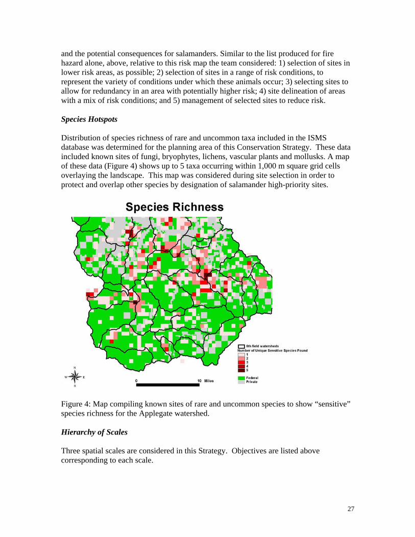
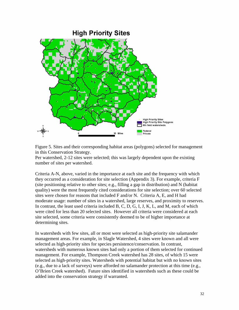
Conservation elements Sites identified for Siskiyou Mountains salamander conservation were selected by a panel of scientists and natural resource managers from records in the ISMS and GeoBOB databases These sites are referred to as ldquohigh-priorityrdquo sites The potential role of a site was reviewed at the Applegate River 4th field watershed 6th field watershed and individual site scales At the Applegate River 4th field watershed scale each site was evaluated based on the distribution of known sites federal land allocations the predictions of a habitat model and the predicted risk to persistence from natural (fire) and anthropogenic disturbances Within each 6th field watershed sites were selected for protection to reduce extinction likelihood within the watershed and to contribute to well-distributed interacting sub-populations When possible we selected localities that occurred in or near existing federal reserve land allocations as defined in the Medford District Resource Management Plan and the Rogue River National Forest Plan Land allocations include large LSR owl cores botanical set-asides and riparian reserves
This Conservation Strategy covers all or part of 19 6th field watersheds within the Applegate River watershed Within these watersheds 110 ISMSGeoBOB site locations were identified as high-priority (range 2-12watershed) for long-term site protection A preliminary delineation of these high-priority sites was conducted using existing maps of habitat elements Field units will review and refine the final delineation of high-priority sites during project planning
One of two management strategies is recommended for each high-priority site The first strategy focuses on maintaining habitat conditions for this species at the high-priority site by limiting activities that may have adverse effects on substrate ground cover forest condition or microhabitat and microclimate The second strategy allows for greater latitude in activities at the high-priority site by applying the existing Fire Management Recommendations to the high-priority site The 2-tiered approach attempts to integrate the fire ecology of the area current stand conditions fuel loads and proximity to populated areas while providing for the long-tem persistence of Siskiyou Mountains salamander populations
Inventory Research and Monitoring
Data and information gaps for this species include
4
bull Some gaps in known site distribution within the known range in the Applegate Valley
bull The potential effects of fuels treatments within suitable habitat and high priority sites
bull Microclimate conditions required by the species in surface and subsurface refugia and microclimate changes with vegetation management including edge effects
bull The response of the species to various land management activities that typically occur within the range of the species including timber harvest activities (density management and regeneration harvest) and natural and prescribed fire
bull Reproduction movement dispersal and foraging bull Geographic boundaries of discrete populations connectivity among populations and
connectivity among selected high priority sites bull Effects of multiple hazards or risks to species across landscapes and populations
Inventory and Monitoring Guidelines
bull Inventories will be conducted to fill gaps in distribution and assess habitat conditions and salamander occupancy in areas with planned projects in order to finalize high priority site selection within 6th field watersheds
bull Implementation monitoring will include an annual compilation of projects conducted and priority sites selected for the two management strategies
bull Effectiveness monitoring projects will be developed for each 5-year interval to assess success of the two management strategies in retaining species at priority sites and assumptions of the Conservation Strategy including the occupancy of animals in areas other than high priority sites
Adaptive Management
A review of this conservation strategy will be conducted every five years where new species knowledge science findings habitat information and strategy implementation are evaluated Revision of the Conservation Strategy may follow the 5-year reviews to refine the plan or address emerging issues
Between the 5-yr reviews the following may trigger an immediate review
bull A significant change in the number of known sites within a sixth field watershed so that the understanding of the distribution of the species has changed to the extent that sites may be added or re-prioritized
bull A significant range change or extension has occurred such as a site found north of the Applegate River or in another 6th field watershed not previously known to harbor the species
bull Significant changes in Forest Service or BLM Land-Use Allocations as determined by the field unit within the area of the conservation strategy or
5
a significant management direction change on Federal lands within the area of the conservation strategy
bull A significant change in habitat conditions due to large-scale fire that may change our assumptions as to the amount of habitat available and contributing to the persistence of high-priority sites identified within the conservation strategy This might occur when more than half of one 6th
field watershed occupied by the species is affected by the disturbance bull New science that changes our understanding of the ecology of the species or
its habitats
6
Table of Contents
I INTRODUCTION 8
Goal 8 Scope 8 Management Status 8 II CLASSIFICATION AND DESCRIPTION 9
Systematics 9 Species Description 10
III BIOLOGY AND ECOLOGY
Life History 11 Movements 11
Breeding Biology 11 Range Distribution and Abundance 11
Population Trends 13 Habitat 13 Ecological Considerations 14
III CONSERVATION 15
Threats 15 Species Conservation Objectives 18
Selection of Management Areas 23 Management Area Objectives 33
Inventory Monitoring and Research 36 Adaptive Management 39
IV ACKNOWLEDGEMENTS 40
V DEFINITIONS 40
VI REFERENCES 42
APPENDICES 1 Spatial Model of Optimal Habitat for the Siskiyou Mountains
Salamanders north of the Siskiyou Crest 2 Assessment of Risk to Conservation of Siskiyou Mountains
Salamanders in the Applegate Watershed 3 High Priority site Identification and Selection Criteria 4 Managing for the Siskiyou Mountains Salamander (Plethodon stormi)
in Fuel Treatment Areas around At-Risk Communities
7
I Introduction
Goal
This Conservation Strategy describes the management actions necessary to maintain a high likelihood of well-distributed populations across the northern portion of the Siskiyou Mountains salamanderrsquos range within the Applegate River 4th Field watershed on federal lands administered by the Rogue River-Siskiyou National Forest Siskiyou Mountains Ranger District and the Oregon Bureau of Land Management Medford District Ashland Resource Area in the northern portion of itrsquos range the Applegate River 4th field watershed and avoid a trend toward federal listing under the Endangered Species Act
For Oregon Bureau of Land Management (BLM) administered lands SSS policy details the need to manage for species conservation Conservation is defined as the use of all methods and procedures which are necessary to improve the condition of Special Status Species and their habitats to a point where their Special Status recognition is no longer warranted In addition implementation of the policy is intended to ensure that actions funded authorized or carried out by the BLM do not contribute to the need to list species under the Endangered Species Act
For Region 6 of the Forest Service Sensitive Species policy requires the agency to maintain viable populations of all native and desired non-native wildlife fish and plant species in habitats distributed throughout their geographic range on National Forest System lands Management should also preclude a trend towards federal listing for any identified Sensitive species
This Conservation Strategy provides the most up-to-date information known about this species including life history habitat and potential threats This information has been compiled from range-wide studies This species is a rare endemic vertebrate with a known range restricted to a small portion of the Siskiyou Mountains in southern Oregon and northern California Additional information is available on the Interagency Special Status Species website (httpwwwfsfedusr6sfpnwissssp)
Scope
The geographic scope of this Strategy includes the range of the species coincident with Forest Service Region 6 and Oregon BLM lands including the Rogue River-Siskiyou National Forest and the Medford District of the Bureau of Land Management This area is encompassed within the 4th field Applegate watershed However background species information is compiled for the entire species range which includes both Oregon and California in Jackson and Josephine Counties in Oregon and Siskiyou County in California In California the Klamath National Forest is within the range
8
Management Status
The Siskiyou Mountains salamander is identified by the USDA Forest Service Regions 5 and 6 as Sensitive and by the USDI Bureau of Land Management Oregon as Sensitive This species is not known on BLM lands in California In addition the species is listed by California State as Threatened Oregon State as Sensitive-Vulnerable species and by the US Fish and Wildlife Service as a Species of Concern The Natural Heritage Program ranks this species as ORNHIC List 1 taxa that are threatened with extinction or presumed to be extinct throughout their entire range Globally imperiled (G2G3Q) California State Critically imperiled or imperiled (S1S2) Oregon State imperiled (S2) Management of the species on Forest Service Region 6 and Oregon BLM lands follows Forest Service 2670 Manual policy and BLM 6840 Manual direction
In recent years this species has had variable consideration in two other federal rare species programs First from 1994 to 2004 and from 2006 to present this species was included on the federal Survey and Manage list a component of the Northwest Forest Plan (USDA and USDI 1994) The Survey and Manage program was eliminated in 2004 (USDA and USDI 2003 2004) then reinstated by court order in 2006 At this writing a Final Supplement to the 2004 Supplemental Environmental Impact Statement to Remove or Modify the Survey and Manage Mitigation Measure Standards and Guidelines has been released (USDA and USDI 2007) and the preferred alternative again removes the Survey and Manage standards and guidelines from federal land and resource management plans A Record of Decision and court ruling on this are pending Second in 2004 this species was petitioned for listing as Threatened or Endangered under the US Endangered Species Act In April 2006 the US Fish and Wildlife Service released a finding that listing was not warranted This was reversed in March 2007 whereupon a 12-month review was initiated to determine if listing is needed INCLUDE recent listing decisions
II Classification and Description
Systematics
The Siskiyou Mountains salamander (Plethodon stormi) is a member of the family Plethodontidae the lungless salamanders and the genus Plethodon the Woodland Salamanders These animals respire entirely through their skin complete their entire life cycle in terrestrial environments and are found on the forest floor in moist microhabitats Like other Plethodon they are slim and elongate with relatively short legs The Siskiyou Mountains salamander along with the Del Norte salamander (P elongatus) composes the elongatus group of western Plethodon (Brodie 1970)
The Siskiyou Mountains salamander is morphologically and genetically distinct from both the Del Norte salamander and the recently discovered Scott Bar salamander (Plethodon asupak) (Mahoney 2004 Mead et al 2005 DeGross 2004) Together the Siskiyou Mountains and Del Norte salamanders seem to be descended from a single common ancestral form that is a sister taxa to the basal Scott Bar Salamander (Mahoney 2004 Mead et al 2005) Because its status was uncertain until recently localities of the
9
Scott Bar salamander have been treated as Siskiyou Mountains salamanders by land management and regulatory agencies
The Siskiyou Mountains salamander appears to be most closely related to the Del Norte salamander (Brodie 1970 Mahoney 2004) The 2 species are in close proximity along the western edge of the Siskiyou Mountain salamanders range The Siskiyou Mountains salamander is composed of two parapatrically distributed monophyletic mtDNA groups (Pfrender and Titus 2001 Mahoney 2004) Recent work with nuclear markers indicates that some limited gene flow may have recently occurred or may be ongoing along the contact between the 2 mtDNA clades in California but not in Oregon (DeGross 2004) Because the 2 mtDNA groups of the Siskiyou Mountains salamander meet the criteria outlined by Moritz (1994 reciprocally monophyletic mtDNA haplotypes and significant differences in allele frequencies at nuclear genes) DeGross (2004) suggested that they be managed as separate Evolutionarily Significant Units [ESU] One ESU occupies the majority of the range of the Siskiyou Mountains salamander while the other is limited specifically to California in a small area north and south of the Klamath River immediately east of Happy Camp
Species Description
The Siskiyou Mountains salamander is similar in appearance to the Del Norte salamander (P elongatus) Recent surveys have uncovered populations of both Siskiyou Mountains salamanders and Del Norte salamanders within one mile of each other north and south of the Klamath River near Happy Camp California (Mahoney 2004) There is also evidence of sympatry of the two species at two sites near Happy Camp and Grider Creek (Louise Mead pers comm 2005)
Siskiyou Mountains salamanders are slim and long-bodied (approximately 14-70 mm snout-vent length) and are chocolate-brown to purplish-brown dorsally with varying amounts of light flecking on the head sides and limbs Adults may have a faint lighter brown dorsal stripe and the ventral color is grayish-purple Juveniles tend to be black or very dark brown with flecking often exhibit a light brown or tan dorsal stripe and are gray ventrally An adult P stormi is distinguished from this close relative by having a modal number of 17 costal grooves and 4 to 55 intercostal folds between adpressed limbs while the Del Norte has 18 and 55-75 respectively (Jones et al 2004 Leonard et al 1993 Nussbaum et al 1983) Moreover the Del Norte Salamander may have a reddish dorsal stripe and juvenile Del Norte salamanders differ from juvenile Siskiyou Mountains salamanders in that juvenile Del Norte salamanders usually possess a bright coppery dorsal stripe that can fade with age However within the contact zone of these two species and P asupak (Mead et al 2004) morphological characters such as dorsal stripe and intercostal folds potentially may not be characteristics that will identify species readily
10
III BIOLOGY AND ECOLOGY
Life History
Siskiyou Mountains salamanders are active on the ground surface primarily at night when it is cool and moist Peak active periods occur during the wet season with periods of inactivity during freezing temperatures They may forage at the surface during the dry summer (Nussbaum et al 1983) They adopt a sit-and-wait foraging behavior and prey on a variety of small terrestrial invertebrates including spiders pseudoscorpions mites ants collembolans and beetles (Nussbaum et al 1983) Ants may be an important dietary component in the spring while millipedes appear to be eaten by larger adults in the fall (Nussbaum 1974) Predators are largely unknown but may include sympatric snake and shrew species Potential competitors may include ensatina and black salamanders which also occur in similar habitat Nothing is known of parasites and disease or symbiotic and mutualistic interactions with other species
Movements
Siskiyou Mountains salamanders are thought to have limited dispersal ability They make daily to seasonal vertical migrations in the ground surface as microclimate conditions change but not extensive horizontal movements Genetic analyses indicate limited gene flow and suggest that populations may have been on isolated evolutionary pathways for a very long time
Breeding biology
These salamanders are entirely terrestrial they do not require standing or flowing water at any stage of their life cycle Eggs are thought to be laid in nests below the ground deep in rocky substrate Courtship probably occurs during the spring rainy season on the talus surface (Nussbaum et al 1983) In the early spring females retreat down into the talus and establish nests Dissected females (sample of 37) had clutches of 2-18 eggs with an average of 9 eggs per clutch (Nussbaum et al 1983) The eggs are laid in a grape-like cluster and are tended by the female until hatching in the fall Juveniles emerge in late fall and early spring Welsh and Lind (1992) reported that juveniles captured in mid-spring were significantly larger than would be expected if newly hatched They mature at 5-6 years and appear to be relatively long-lived (up to 15 years) Females appear to breed every other year
Range Distribution and Abundance
The Siskiyou Mountains salamander occurs in an approximately 150000 ha area in southwestern Oregon and northwestern California (Nauman and Olson 1999 Figure 1) It has been found in southern Jackson County the extreme southeast portion of Josephine County Oregon and northern Siskiyou County California It is known from sites ranging from 488 m (1488 ft) (Nussbaum et al 1983) to about 1800 m (6000 ft) (Clayton et al 1999) in elevation To date there are approximately 380 localities known for the
11
species (USDA and USDI 2006 Nauman and Olson 1999 Reilly pers comm) The knowledge of this speciesrsquo distribution has grown considerably in the last 20 years a prior reference distribution of this species is unknown
The Siskiyou Mountains salamander occurs primarily on federal lands within the KlamathSiskiyou Mountains In the Applegate Watershed covered by this Conservation Assessment there are 201 sites on BLM lands (191 on OampC lands) 115 sites on Forest Service lands and 14 sites on private lands It is found within all federal land allocations (Adaptive Management Areas (AMA) Administratively Withdrawn areas Congressionally Reserved areas Late Successional Reserves and Matrix lands) This species has been documented to occur on the Medford Bureau of Land Management Ashland Resource Area the Applegate Ranger District of the Rogue and Siskiyou National Forest and the Happy Camp and Scott River Ranger Districts of the Klamath National Forest The majority of the known and suspected range of the species is on federal lands and most known sites occur on two federal land allocations Adaptive Management Areas (67) and Late-Successional Reserves (27) (Nauman and Olson 1999) Seven percent (7) of sites occur on non-federal lands Distributions of sites within the Applegate watershed portion of the range are primarily on AMA lands (67) some reserves (18) and private lands (16) (Nauman and Olson 1999) In the southwest portion of the range in California site distribution is primarily on reserve lands (67) with 31 of sites on Matrix land This Conservation Strategy covers only the northern portion of the range within the Applegate Valley 4th field watershed
Within the suspected range of P asupak most occurrences are on Matrix or private lands (60) with the remaining sites occurring on reserved lands (40) (Nauman and Olson 1999) Genetic work has not been conducted on these occurrences to determine if they are P asupak or not The California Department of Fish and Game reported approximately 45 localities from within the suspected range of P asupak but these have not been confirmed by genetic analysis and may actually represent fewer distinct occurrences (California Dept of Fish and Game 2004)
12
Figure 1 Distribution of known sites of Siskiyou Mountains salamanders in the Applegate watershed the area covered by this Conservation Strategy
An inventory of all known Siskiyou Mountains salamander sites on the Applegate Ranger District in 1992 yielded abundances of salamanders ranging from 03 to 11 captures per person-hour (D Clayton unpubl data 1993) A habitat associations study from 1994 to 1997 yielded densities of salamanders ranging from 1 to 16 animals per 49 square meter search plot (ie 002-033 animalsm2 Ollivier et al 2001) Nauman and Olson (2004) reported an average of 001 salamandersm2 and 239 salamandersperson-hour in California with lower elevations having higher capture rates In comparison other plethodontid capture rates in the western United States can be much higher (Nussbaum et al 1984)
Population Trends
Nothing is known about population trends in this species
Habitat
Siskiyou Mountains salamanders are exclusively found in association with rocky substrates (Nussbaum et al 1983) These substrates may range from gravelly soils to talus but there is always some component of rock Although exceptions exist most known sites consist of forested areas Individuals are found by searching under rocks bark logs or other debris on the forest floor during wet weather (Petranka 1998)
13
Factors that create a cool moist microclimate appear to strongly influence the distribution and abundance of the Siskiyou Mountains salamander Shading provided by vegetation aspect and topography appears to play a significant role in creating the conditions associated with Plethodon salamanders Forested stands with high canopy closure and larger conifers when associated with rocky soils often harbor abundant populations of Siskiyou Mountains salamander (Nussbaum et al 1983 Ollivier et al 2001 Welsh et al 2007) Welsh et al (2007) considered mature to late-seral forest stands to provide optimal conditions for this species These stands are most common on north-facing slopes where this species reaches its highest abundances (Nussbaum et al 1983) and is most commonly encountered (Farber et al 2001) However populations are known from all seral stages and aspects (Farber et al 2001 Ollivier et al 2001) In younger stands and more southerly aspects micro-site topography may provide shading allowing salamanders to exist in areas that otherwise would be inhospitable Welsh et al (2007) utilized an ldquoilluminationrdquo index of topographic shading to help describe occupied sites This approach offers great promise in untangling the complex interaction of vegetation aspect and topography that appear to interact to create suitable conditions for Siskiyou Mountains salamanders
Precipitation also has been associated with the presence of Siskiyou Mountain salamanders (Ollivier et al 2001 Welsh et al 2007) Dry conditions likely limit the species eastward extent In one study conducted in California Siskiyou Mountains salamanders were encountered at a greater proportion of sample points and in greater abundances in the wet western side of the range when compared to the much drier eastern side of the range (Nauman and Olson 2004) Siskiyou Mountains salamanders need a moist relatively cool habitat Precipitation canopy cover aspect and topographic shading directly affect salamanders by creating the conditions necessary for persistence The abundance of moss and ferns deep litter the number of hardwood trees and years since disturbance (Ollivier et al 2001 Welsh et al 2007) are associated with salamanders because they likely reflect the stable existence of cool moist conditions over longer periods of time
Ecological Considerations
Plethodontid salamanders are thought to have important roles in forest ecosystems including being a significant trophic link between small ground-dwelling invertebrates and larger vertebrate predators They also comprise a considerable portion of the forest vertebrate biomass in some areas (eg Burton and Likens 1975a 1975b) but the specific role of P stormi in local communities or ecosystem processes has not been addressed Their general ecology and life history traits suggest they are ideal indicators of forest ecosystem integrity as many are associated with mature forests (Welsh and Droege 2001)
IV Conservation
14
Threats
Optimal habitat for these animals includes late-seral forest conditions with rocky substrates and cool moist microclimates (eg Welsh et al 2007) Activities that may pose threats to this species are those that disturb the surface microhabitats andor microclimate conditions Disturbance of surface microhabitats is of primary concern because alteration of the microhabitat and microclimatic conditions can negatively impact these salamanders Typically these involve actions that remove canopy andor disturb the substrate
Examples of threats include timber harvest road construction rockpit mining and development of large recreation sites Wildland fire is also a primary threat to this species Other activities such as prescribed fire trail construction and chemical applications may pose somewhat lesser or localized threats to the species and do not likely pose a threat to species persistence All these are presumed threats to this salamander as no studies have been published to document losses from specific anthropogenic disturbances in this species These activities and their impacts to these salamanders are discussed below
Timber Harvest
Timber harvest is the primary current land management practice in forested ecosystems in this geographic region Several disturbances of salamander habitat conditions can result from timber harvest practices Removal of overstory may cause desiccation of the rocky substrates and loss of the moss ground cover a microhabitat feature of Siskiyou Mountain salamander sites Tree-felling and ground-based logging systems disturb the substrate which can result in substrate compaction and deconsolidation of the stabilized talus which reduces or eliminates substrate interstices used by salamanders as refugia and for their movements up and down through the substrate Site preparation practices such as broadcast burning removes the moss covering that helps to stabilize the talus
Within the range of the Siskiyou Mountains salamander the landscape is somewhat fragmented by past timber harvest practices and current fire regimes and is a patchwork of stands of different seral stages from early seral to mature forests Siskiyou Mountains salamanders and their habitat are found nested within this patchy forested regime There are no real estimates of how much potential suitable habitat has been impacted by timber harvest activities but using soil mapping as a basis for projecting potential habitat 10 of the total potential habitat (10000 acres 4047 ha) on the Applegate Ranger District Rogue River National Forest had been harvested between 1984 and 1994 (D Clayton unpubl data)
Although no studies have been completed specifically for this species many studies have reported effects to plethodontid salamanders from timber harvest in particular regeneration or clearcut harvest practices (eg Ash 1997 Dupuis et al 1995 deMaynadier and Hunter 1995 Herbeck and Larsen 1999 Grialou et al 2000) DeMaynadier and Hunter (1995) reviewed 18 studies of salamander abundance after
15
clearcut timber harvest and found median abundance of amphibians was 35 times greater on controls over clearcuts Petranka et al (1993) found that Plethodon abundance and richness in mature forest were five times higher than those in recent clearcuts and they estimated that it would take as much as 50-70 years for clearcut populations to return to pre-clearcut levels A comparison of recent (lt5 years) regeneration harvest units and mature (120 years) forests also suggested salamanders are eliminated or reduced to very low numbers when mature forests are clearcut (Petranka et al 1994)
Alternative silvicultural practices may not always have adverse effects on the ground-dwelling salamander assemblage Messere and Ducey (1998) found no significant differences in abundance of northern red-backed salamanders in forest canopy gaps in stands that had been selectively logged in New York indicating that limited logging may have little effect on that species In contrast Knapp et al (2003) found reduced abundances of terrestrial salamanders in stands with leave tree group selection or shelterwood cuts compared to uncut stands in Virginia and West Virginia
Studies in the Pacific Northwest documented greater salamander abundance in old-growth compared to clearcuts or early seral forest (eg Bury and Corn 1988 Raphael 1988 Welsh and Lind 1988 and 1991 Welsh 1990 Corn and Bury 1991 Dupuis et al 1995 Ollivier et al 2001) Alternatively Diller and Wallace (1994) found P elongatus in managed young stands in northwestern California and found no relationship of salamander presence to forest age However they sampled stands that were from zero to 90 years old The areas surveyed were also in the coastal redwoods that have a milder wetter climate than interior sites sampled by others (Ollivier et al 2001 Welsh and Lind 1991) and are similar to areas where the Siskiyou Mountains salamander is found More recently Karraker and Welsh (2006) found clearcutting affected plethodontid numbers up to 25 years post-harvest in northwestern California Karraker and Welsh (2006) also found similar abundances of plethodontid salamanders in thinned and unthinned forests but body condition of most species was lower in thinned stands Rundio and Olson (2007) found reduced abundances of plethodontid salamanders following thinning at one of two study sites and suggested site conditions (eg down wood substrate) may have ameliorated effects of canopy reduction at one site
Although no published studies address the direct affects of timber harvest activities on the Siskiyou Mountains salamander using a well-designed approach with pre- and post-treatment data and reference stands surveys in timber sale units after harvest have shown marked reductions in capture rates A site adjacent to the type locality was surveyed in 1993 immediately after a clearcut harvest and broadcast burn (D Clayton unpubl data) and a high number of individuals (10+capturesperson-hour) were found Subsequent surveys showed a rapid loss of individuals detected at the site and since 1995 no salamanders were found at the site until 1999 when one was found (California Department of Fish amp Game 2004) In 2003 two searches conducted by the California Department of Fish and Game yielded 3 salamanders in 17 minutes and 5 salamanders in 75 minutes (California Department of Fish amp Game 2004) These data are inconclusive but may indicate some recolonization of the site or a sink habitat into which individuals are dispersing from a nearby source habitat and may not subsequently survive
16
Federal timber management practices have changed significantly since most studies of timber harvest effects on amphibians have been conducted Clear-cut logging is no longer carried out on Forest Service or BLM lands within the range of this species as regeneration harvests now maintain large down logs large snags and 15 of the original stand as green retention trees Substrate impacts are still likely but must meet agency standards generally less than 20 of the harvest unit Given the wide range of study results on a variety of Plethodon species it is difficult to know at what level canopy reduction is significant enough to render an area unsuitable However based on scatter plot data from the Ollivier et al work (2001) salamander capture rates declined significantly when canopy closures were below approximately 70 percent
Roads
Many roads have been constructed for easy access to existing rock sources to use as road-surfacing material and to access timber harvest operations Road construction in suitable habitat directly removes overstory and compacts the substrate The intensity of impacts are more intense and longer lasting than timber harvest Road construction likely causes direct mortality to individuals and some amount of habitat loss however due to the scale of impact and the linear nature of the action the impacts to the species may be significantly less than timber harvest or stand-replacement fire Roads are not generally known to be barriers to plethodontid salamanders and P stormi has been found in road cuts Road kill is not well documented for this species
Rockpit Mining
Rock sources are mined for a variety of uses These operations remove large amounts of material far back into a hillside or mountain Overstory and substrate may be removed Such operations undoubtedly remove both surface and subsurface refugia permanently and likely have impacted local populations However due to the scale of this action across the range of this species this action is not considered to be a primary threat
Developed RecreationDispersed Camping
Construction of camping areas access roads boat ramps and other developed recreation sites have likely impacted Siskiyou Mountains salamanders particularly around Applegate Lake by the direct alteration of substrate as well as canopy loss due to overstory vegetation removal Dispersed campsites also may have had an impact from soil compaction and vegetation alteration although it is expected to be somewhat limited
Chemical Applications
Herbicides pesticides fire retardants and fertilizers may have a direct impact on Siskiyou Mountains salamanders These animals breathe through their skin which must be moist and permeable for gas exchange It is not known to what extent these substances may have affected Siskiyou Mountains salamander populations in the past However this type of activity only occurs on a very limited basis on FS and BLM lands and then
17
usually only at disturbed sites with invasive species concerns It is not likely a high concern for this species
Fire
Impacts to Siskiyou Mountains salamanders from either natural or prescribed fire are unstudied however given that fire exclusion in recent years has resulted in an increased risk of large stand-replacement fire in the region large fires that remove overstory from suitable habitat may be of highest concern for this species (an example of this is the Biscuit Fire) Although the Siskiyou Mountains salamander has persisted in a fire disturbance landscape there is concern that the intensity of the local fire regime has changed and when burned may have adverse effects on the species The historical fire regime in the area was one of high frequency and low intensity fire which consisted of very frequent underburning of the forest in the summer and early fall and few stand-replacement events at least at the lower elevations (Agee 1993) At higher elevations longer fire return intervals and high intensity fires occurred historically and likely resulted in more stand-replacement events (Agee 1993) The effects of a more intense level of fire disturbance due to fire suppression and fuel loading is of concern in that stand-replacement fire represents a higher potential for disturbance to flora and fauna In particular relative to salamander habitat it removes overstory canopy that serves to moderate surface microclimates from extremes (eg high temperatures and low moisture)
Recent federal management strategies emphasize fuel prescriptions to remove the unnaturally high fuel loading Fuel reduction prectices include various combinations of understory thinning slashing piling andor prescribed burning Most prescribed burning occurs in the moister and cooler time of the year to avoid escapement risks and smoke concerns Springwinter burning may increase the chance of direct mortality of Siskiyou Mountains salamanders during a time of year when they are active above the surface and vulnerable to fire However fuels reduction activities may contribute to the long-term persistence of the species by reducing the potential for stand-replacement fire which likely has a higher potential for adverse effects to the species than the fuels reduction activities
Species Conservation Objectives
The objective of this Conservation Strategy is to provide for a high likelihood of long-term persistence of well-distributed populations of Siskiyou Mountains salamanders within the range of the species in US Forest Service Region 6 and Oregon BLM lands and to avoid a trend toward federal listing under the Endangered Species Act
Applegate Watershed 4th field range-wide scale objectives
1) Maintain viable populations such that there are sufficient numbers and distribution of reproductive individuals to ensure their continued existence within the Applegate River 4th field watershed
18
2) Provide well-distributed habitat to support reproductive individuals that can interact in the planning area
3) Utilize the existing federal reserved land allocations as a foundation for providing a high likelihood of continued species persistence
4) Minimize impact to federal non-reserve land allocations and other resources when possible
Intermediate scale objectives
1) Provide for the maintenance of Siskiyou Mountains salamanders within each 6th field watershed where they occur within the Applegate River 4th field watershed
2) Within 6th field watersheds establish finer-scale assessments of need for restoration and protective approaches
3) Within 6th field watershed select sites to manage for long term conservation (high-priority sites) based upon location of animals and criteria including suitable habitat risk factors federal land allocations and proximity to other sites such that protections are tiered to population rarity risk to persistence and connectivity potential
Site scale objectives
1) Establish initial extent of selected high-priority sites from existing known site habitat geographic and topographic data
2) Consider fire ecology stand conditions and the distribution of existing reserves when designing management guidelines for each high-priority site
Underlying Assumptions and Definitions
Reference Distribution The reference distribution of a species needs to be identified in order to develop strategies to provide for well-distributed populations The term ldquowell-distributedrdquo is defined as the ldquodistribution sufficient to permit normal biological function and species interactions considering life history characteristics of the species and habitats for which it is specifically adaptedrdquo (USDA and USDI 2001 p 86) ldquoWell-distributedrdquo may be inferred from the historic (prior to European settlement) distribution (USDA and USDI 2000 p 342) The historic distribution can sometimes be derived from habitat associations occupancy rates in suitable habitat historic habitat distribution potential past disturbance signatures and other knowledge about the species If these factors are not well known and historic distribution cannot be inferred the current distribution can be taken as the reference distribution (USDA and USDI 2000 p 342)
For the Siskiyou Mountains salamander the current known range is the reference distribution for species conservation objectives While some historical locations may have been lost due to relatively recent disturbances the species range boundaries appear to be driven by natural environmental conditions such as lack of rocky substrate or harsh microclimate conditions for salamanders More is known today about this speciesrsquo
19
distribution than ever before The known range has approximately tripled between 1980 and today doubling between 1993 and 1998 (Nauman and Olson 1999) However current knowledge is not complete and in several areas covered by this conservation strategy surveys have not been conducted for this species Lack of a population within a patch of apparently suitable habitat may indicate lack of surveys or lack of salamanders New distribution information should be incorporated into this strategy by considering selection of additional known sites for conservation management or by reconsideration of sites within an area for site re-selection
For purposes of management of this species under FS Region 6 and BLM Oregon Sensitive and Special Status Species policies the range-wide area under consideration for this Strategy is the 4th field Applegate watershed which includes the Rogue River-Siskiyou National Forest Siskiyou Mountains Ranger District and the Medford BLM Ashland Resource Areas
Desired Outcome The desired outcome of this conservation strategy is to provide habitats occupied by sub-populations of Siskiyou Mountains salamanders distributed across the northern range of the species within the Applegate watershed The pattern should reflect current knowledge of occupancy rates and optimal habitat conditions but should not neglect the range of conditions under which this organism exists While optimal habitat conditions are desired as an outcome for each high-priority site selected sites selected as high-priority include areas central and peripheral to the range in low and high fire hazard zones on ridgelines and in riparian areas and on all aspects The proximity of the selected high priority sites and the conditions between them should permit some gene flow although some sub-population isolation or gaps in distribution may occur The distribution pattern of high priority sites should reflect two additional considerations spatial extent of historical fire disturbances in this landscape and site redundancy Given previous fires have occurred across portions of the species range high priority sites are chosen in a pattern that would facilitate potential recolonization post-disturbance to fire Related to this the concept of site redundancy was considered particularly within or adjacent to areas of high fire hazard The Selection Criteria section below fully itemizes considerations for high priority site selection
Population demography and dynamics are little known for this animal Thus the decision for how much area may be needed for each site selected as high priority to maintain sub-population persistence has little baseline knowledge for guidance However there are existing sites that appear to occur in variable spatial extents of surface rock ranging from a handful to hundreds or thousands of acres In selecting high priority site areas in this strategy conservative approaches are used with a range of areas across each 6th field watershed selected to hedge uncertainties Juxtaposition of high priority sites with existing federal reserves substantially boosts protected areas for potential sub-population occupancy
The ldquoanchor habitat conceptrdquo (eg Olson 1998) can be applied to this conservation strategy This concept includes flexibility in spatial designation of habitats identified for species conservation over time such that optimal areas for species conservation can be
20
selected or adjusted as they become recognized (eg from new knowledge or from restoration of conditions over time) The anchor analogy is that the ldquoanchorrdquo habitat is retained but may move to new positions to best-provide for its designed purpose The intent in the high-priority site selection process identified herein is to provide well-distributed sub-populations across the planning area yet the recommended sites and site-delineated boundaries are now selected largely from remote sensing data of landscape attributes at the intermediate spatial scale Field reconnaissance may result in a better understanding of ground conditions such that selected sites may move or site boundaries adjusted Over time as new sites are found or site conditions are changed by natural disturbances or are restored the anchor habitats to provide for the species may again need to be adjusted This is the key component of flexibility provided in this strategy While over a hundred known sites have been identified in this Strategy for the goal of conservation management and habitat conservation areas have been provided in general terms for each of these sites ground-truthing to adjust these recommendations is expected and new habitat or other conditions over time should result in a re-examination of high-priority site selection in some areas
The high-priority sites identified in this Conservation Strategy are expected to anchor the population but not to impose an artificial metapopulation over the managed landscape This Strategy is designed so that salamanders are likely to thrive at high-priority sites but they are also expected to persist to a large degree in federal reserve allocations with suitable habitat and possibly in many sectors of the managed landscape having suitable habitat conditions without reserve status Risk to persistence of salamanders in these other areas is greater due to the potential for activities that may impact populations and uncertainty but that does not preclude their occurrence or the functional role intervening lands between high-priority sites may have for connectivity across the landscape and overall viability of the species High-priority sites are not envisioned to be acting as island reserves across the expanse of the Applegate watershed the risk analysis (below) speaks to this However this is an aspect of the strategy that may require monitoring If intervening lands become highly disturbed and unsuitable habitat conditions predominate connectivity to retain interacting individuals across the landscape may need to be re-addressed
Management Limitations Limitations on the capability of federal management actions to provide for well-distributed populations of this species include the following considerations First non-federal lands fragment some parts of the species range and consequences of disturbances on non-federal lands for salamander persistence is only addressed by recommendations for management practices on the adjacent federal lands Also long-term effects on the species from federal land management of occupied salamander sites that are not chosen as high priority sites are unknown Both federal and non-federal land management of salamander habitats may fragment the speciesrsquo range and disrupt population integrity more than is currently considered in this Strategy Cumulative effects of federal and non-federal land management require monitoring and adaptive management Second due to our limited knowledge of speciesrsquo distribution and population structure and dynamics a conservative approach may be warranted for this vertebrate species This is addressed through the numbers of sites recommended as high-
21
priority sites which allows for redundancy and adjacency of sites and the spatial extent of these high-priority sites in turn allowing for potentially high numbers of salamanders to occur at each high-priority site Third there is limited knowledge of the effects of forest management activities on these salamanders While options for managing high-priority sites are included in this Strategy a conservative approach to site management may be warranted until the resiliency of these animals to site-specific activities is better known Fourth it is acknowledged that the detectability of these salamanders may be an issue for determining occupancy patterns Under appropriate environmental conditions for surveys there is a chance of not detecting the salamanders when they are present at a site because they are subsurface While this chance is not quantified the result is that many known sites detected from single survey efforts may reflect the subpopulations with greater abundances or surface activities and the knowledge of salamander distribution may be conservative (ie there may be a pattern of greater occupancy than is realized by survey detections) Finally the region is in a zone of relatively high natural fire frequency While that is taken into account in the conservative approach taken here it is expected that adaptive management in terms of the strategy design or site-management approaches may be needed in response to fire locations and severity
Risk Level of the Strategy Implementation of this conservation strategy is designed to have a low to extremely low risk to the continued persistence of this species At the site level the recommended fuels management activities have not been examined relative to their effects on salamanders Hence there may be a risk of losses to individuals or subpopulations of these activities However the risk of sub-population extirpation is relatively low and contrasts sharply with a higher risk of losses if a fire disturbance event were to occur and result in altered forest canopy and ground microclimate conditions Losses of individuals from fuels reduction activities may be recouped over time as habitat conditions for salamanders likely improve due to these restoration practices Again however the resiliency of these salamanders to disturbances of this type has not been studied so there is uncertainty in how well they would respond to changing conditions with time Effects monitoring is suggested At the intermediate scale site redundancy and a mix of protective and restoration approaches suggests an extremely low risk to persistence Also disturbances from fires or site management activities are likely to be staggered spatially and temporally and risk of losses would not occur synchronously for all subpopulations in a neighborhood The aggregate of 19 6th field watersheds allows the concepts of redundancy and a mix of approaches to be applied to the species range scale in the planning area A large disturbance such as fire or disease may occur in the area but it is likely that it would not have severe effects across the entire landscape due to its naturally fragmented nature and patchy occurrences of habitats and animals Subpopulations within watersheds and sites are likely to be retained under this worst case scenario Risk to persistence at the range wide scale is extremely low This strategy is designed to provide persistence for this species for at least 100 years Risk assessment is addressed in a later section also
22
Selection of Management Areas
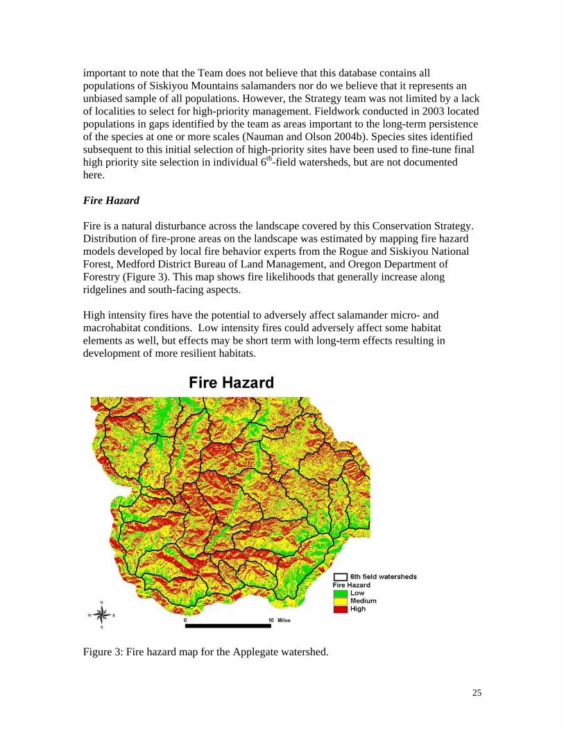
Selection of high-priority sites for salamander conservation was conducted by a panel of scientists and resource managers and considered existing federal standards and guidelines for the planning area distribution of habitat and known localities of salamanders Potential risk factors to salamander persistence were also assessed including fire hazard location relative to the populated areas proximity to other private lands and road density In addition maps of species richness from the federal Interagency Species Management System (ISMS) database were examined These factors were evaluated at both the landscape and 6th field watershed scales Also digital elevation maps and aerial photographs were used as sites and watersheds were evaluated
Federal land allocations and forest plans
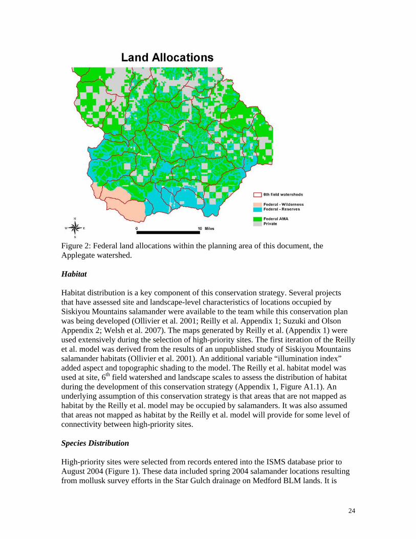
The Siskiyou Mountains salamander conservation strategy builds upon the existing reserve systems and the Standards and Guidelines established under the Rogue River NF Land and Resource Management Plan the Medford BLM Resource Management Plan and the Northwest Forest Plan In this area the reserve system includes congressionally withdrawn areas riparian reserves owl habitat areas botanical reserves late-successional reserves and special emphasis areas (Figure 2)
Not all reserved lands were assumed to provide protection for the Siskiyou Mountains salamanders Many federal reserved areas have been managed in the past may be managed in the future and all are subject to natural disturbances in the future For example density management or fuels reduction activities in riparian reserves or late successional reserves may have adverse effects on salamanders However an assumption was made for this Strategy that most reserved lands will be managed in a way that is either neutral or beneficial for this species
Before development of this conservation strategy an initial risk assessment was conducted to qualitatively assess the likelihood of persistence of the Siskiyou Mountains salamander in the Applegate watershed based on provisions within existing federal forest plans and their standards and guides (see Risk Assessment section below) The development of this strategy was initiated due to relatively low and variable persistence likelihoods among 6th field watersheds in this zone in addition to high uncertainty regarding future management and disturbance scenarios and their effects on salamanders and their habitats
23
Figure 2 Federal land allocations within the planning area of this document the Applegate watershed
Habitat
Habitat distribution is a key component of this conservation strategy Several projects that have assessed site and landscape-level characteristics of locations occupied by Siskiyou Mountains salamander were available to the team while this conservation plan was being developed (Ollivier et al 2001 Reilly et al Appendix 1 Suzuki and Olson Appendix 2 Welsh et al 2007) The maps generated by Reilly et al (Appendix 1) were used extensively during the selection of high-priority sites The first iteration of the Reilly et al model was derived from the results of an unpublished study of Siskiyou Mountains salamander habitats (Ollivier et al 2001) An additional variable ldquoillumination indexrdquo added aspect and topographic shading to the model The Reilly et al habitat model was used at site 6th field watershed and landscape scales to assess the distribution of habitat during the development of this conservation strategy (Appendix 1 Figure A11) An underlying assumption of this conservation strategy is that areas that are not mapped as habitat by the Reilly et al model may be occupied by salamanders It was also assumed that areas not mapped as habitat by the Reilly et al model will provide for some level of connectivity between high-priority sites
Species Distribution
High-priority sites were selected from records entered into the ISMS database prior to August 2004 (Figure 1) These data included spring 2004 salamander locations resulting from mollusk survey efforts in the Star Gulch drainage on Medford BLM lands It is
24
important to note that the Team does not believe that this database contains all populations of Siskiyou Mountains salamanders nor do we believe that it represents an unbiased sample of all populations However the Strategy team was not limited by a lack of localities to select for high-priority management Fieldwork conducted in 2003 located populations in gaps identified by the team as areas important to the long-term persistence of the species at one or more scales (Nauman and Olson 2004b) Species sites identified subsequent to this initial selection of high-priority sites have been used to fine-tune final high priority site selection in individual 6th-field watersheds but are not documented here
Fire Hazard
Fire is a natural disturbance across the landscape covered by this Conservation Strategy Distribution of fire-prone areas on the landscape was estimated by mapping fire hazard models developed by local fire behavior experts from the Rogue and Siskiyou National Forest Medford District Bureau of Land Management and Oregon Department of Forestry (Figure 3) This map shows fire likelihoods that generally increase along ridgelines and south-facing aspects
High intensity fires have the potential to adversely affect salamander micro- and macrohabitat conditions Low intensity fires could adversely affect some habitat elements as well but effects may be short term with long-term effects resulting in development of more resilient habitats
Figure 3 Fire hazard map for the Applegate watershed
25
During the process for planning this salamander Conservation Strategy fuel hazard mapping was reviewed to consider the potential risk of fire and of high intensity fires in a neighborhood around each site The team considered 1) selection of sites in lower fire risk areas as possible 2) selection of sites in a range of fire conditions to represent the variety of conditions under which these animals occur 3) selecting sites to allow for redundancy in an area with potentially higher fire risk 4) site delineation of areas with a mix of fire hazards and 5) management of selected sites to reduce risk of catastrophic high intensity fires These elements were part of the site selection criteria below and fire was a component further modeled in the risk assessment procedure
Risk Assessment
An integration of the above four conservation elements (land ownerships and federal allocations modeled habitat species distribution fire hazard) was used to assess the risk to species persistence on the landscape
At the beginning of the conservation planning process such an assessment was done for watersheds with only the federal land ownerships and allocations used as land management standards and guidelines for salamanders Land allocation fire hazard distribution and habitat maps were overlaid per watershed and panelists were asked to estimate the probability of persistence over a 100 year time span Due to a variety of land management activities possible and unknown longevity of current forest plans there was a strong element of uncertainty voiced by panelists during these assessments Uncertain trajectories of fire disturbances also weighed on panelistsrsquo minds especially with recent knowledge of the Biscuit Fire (July 2002 500000 acres) and Timbered Rock Fire (July 2002 27000 acres) in southwestern Oregon A worst case scenario of highly altered habitat conditions relative to salamanders was considered possible by most panelists This led to variable and sometimes low likelihoods of persistence assessments within watersheds As these watershed assessments were aggregated across the landscape most of the range of the species occupied watersheds with a potentially low chance of persistence This appeared to be partially a result of the large spatial extent of the AMA allocation in which gt1 rotation of regeneration harvest activities were conceivable over a 100 year timeframe This early result supported the notion that identification of salamander management areas and high-priority sites was needed even within federal reserved land allocations due to uncertainty in the future management and natural disturbance trajectories on federal lands Subsequent panel assessments after the selection of high-priority sites began substantially raised assessments of likelihood of persistence per watershed usually greater than about 80 As these were aggregated across the landscape an overall ldquohigh likelihood of persistencerdquo rating resulted
A more formalized process of assessing risk to persistence was developed and applied to the landscape (Suzuki and Olson Appendix 2) This procedure resulted in a landscape risk map relative to this salamander species (Appendix 2 Figure A22) The map shows a mix of risk conditions across the landscape with some patterns emerging with known habitat attributes land allocations and fire hazard This map was used during site selection and 6th field watershed assessments to re-address aggregation of multiple factors
26
and the potential consequences for salamanders Similar to the list produced for fire hazard alone above relative to this risk map the team considered 1) selection of sites in lower risk areas as possible 2) selection of sites in a range of risk conditions to represent the variety of conditions under which these animals occur 3) selecting sites to allow for redundancy in an area with potentially higher risk 4) site delineation of areas with a mix of risk conditions and 5) management of selected sites to reduce risk
Species Hotspots
Distribution of species richness of rare and uncommon taxa included in the ISMS database was determined for the planning area of this Conservation Strategy These data included known sites of fungi bryophytes lichens vascular plants and mollusks A map of these data (Figure 4) shows up to 5 taxa occurring within 1000 m square grid cells overlaying the landscape This map was considered during site selection in order to protect and overlap other species by designation of salamander high-priority sites
Figure 4 Map compiling known sites of rare and uncommon species to show ldquosensitiverdquo species richness for the Applegate watershed
Hierarchy of Scales
Three spatial scales are considered in this Strategy Objectives are listed above corresponding to each scale
27
Species Range The range of the species in the planning area is the largest scale of consideration At this scale well-distributed populations are intended to be managed for long-term persistence and sub-populations identified at the intermediate spatial scale are managed so that they may interact This is the scale that geographic coverages of federal land allocations habitat elements fire hazard and species localities were compiled This scale was revisited throughout the site selection process to address concepts of connectivity among smaller scale units and conflicting landscape priorities of species persistence timber production and fire suppression The area of the species range for this northern population is approximately 100000 ha (250000 acres)
6th Field Watershed The intermediate scale of the 6th field watershed was chosen to help develop a Conservation Strategy that could provide for well-distributed sub-populations of salamanders Aggregation of well-distributed sites selected for management at the intermediate scale was intended to meet the range-wide objective The 6th field watershed was chosen as an intermediate scale due to its size and current use in federal planning While the Siskiyou Mountains salamanders may not occur on the landscape in a pattern corresponding to watersheds watersheds are useful units to consider relative to some elements of salamander habitat or disturbance factors For example hill shading may change with aspect and ridgelines denoting watershed boundaries Ridgelines may have higher fire hazard as well The high-priority site selection process described below piggy-backed protections on existing federal reserves which often occur within 6th field watersheds Particularly riparian reserve distributions follow a watershed pattern and many of the salamander high-priority site management areas are delineated contiguous to riparian reserves or the spatial areas between two neighboring headwater tributaries Also the sizes of 6th field watersheds in this area were suitable to potentially harbor many salamander subpopulations Within 6th field watersheds with multiple known salamander locations the team was able to prioritize among locations to select high-priority sites for continued salamander management
Thus high-priority site selection occurred at this intermediate scale (see criteria below) Distribution of sites habitats federal lands federal reserved lands and other considerations weighed heavily into the high-priority site selection processes As a watershed was analyzed neighboring watershed conditions and proximity of sites across watershed boundaries were included as considerations for site selection Similarly a finer scale look at site conditions was conducted on a site-by-site basis The intermediate scale is a focal point of the Conservation Strategy but is a scale at which integration across scales was important and iteratively addressed Nineteen 6th field watersheds were analyzed in the development of this Conservation Strategy All of these watersheds have at least one known Siskiyou Mountains salamander location
Sites At the smallest spatial scale salamander sites were prioritized for managementhigh-priority site selection Per site one of two outcomes was chosen the site would be managed for site-level persistence of salamanders or not Only known sites of Siskiyou Mountains salamanders were considered for management optimal habitat areas without known detections of animals were not considered for high-priority site selection Every known site was considered separately as a potential location to identify
28
as a high-priority site during the development of this Strategy Known conditions and values of each site were listed Expert knowledge of each site was discussed aerial photographs displayed and existing data on populations or communities examined The spatial habitat model was used to estimate the geographic extent of optimal habitat elements near each site while photographs or other geographic coverages were used to further estimate vegetation or single habitat element distributions or quality relative to salamanders Some neighboring site locations in ISMS were merged for management consideration especially as adjacent sites appeared to occupy contiguous habitat patches Trade-offs of range-wide objectives to permit land management activities on the landscape for economic or ecological objectives or to piggy-back protections on federal reserved lands often were considered as site values were weighed Over 300 sites within the watershed were considered in the development of this strategy Nearly one-third were chosen as high-priority sites to manage for continued salamander persistence
Site Selection Process
High-priority sites were selected based on the need to maintain a well-distributed population across the landscape The multiplicity principle of many protected areas rather than a few was used Identifying high-priority sites in a wide range of areas based on elevational geographical and habitat condition (patch size edge effects etc) gradients allows for maintenance of sub-populations throughout the range despite potential large-scale disturbances Sites were selected on a watershed-by-watershed basis using 6th field watersheds as the intermediate scale planning area This ensured that sites would be designated across the known range of the species in the planning area Site selection was an iterative process Site level assessments included examination of fire hazard maps optimal habitat maps topography aspect maps of known sites distribution of Wildland-Urban Interface lands land ownerships and allocations and aerial photographs Maps of species hotspots and risk also were evaluated on a site-by-site basis Site value assessment may have been conducted for multiple sites at a time if locations occurred in clusters The evaluation included zooming-out to watershed and larger spatial scales for pattern evaluation Using this thought process criteria or considerations were developed to identify high-priority site salamander management areas
Criteria or Considerations for High-priority Site (HPS) Selection Fourteen criteria (A-N below) were developed for high-priority site selection Some are conceptual or qualitative assessments while others rely on geographic positioning relative to available spatial coverages or other available data Criteria are not mutually exclusive
A Total number sites per watershed - a site may have been chosen as a watershed representative because the entire watershed had very few known sites B Redundancy - a site may have been chosen in or near a high (fire) risk area where one HPS may be lost but others may persist C Connectivity - locations where habitat or sites may connect to adjacent watersheds D Acres of habitat - large patches of contiguous habitat were emphasized in site choice E Proximity to large reserves were emphasized in site choice F Distribution of site in watershed in relation to other known sites (gap cluster edge center)
29
G Distribution of habitat in watershed ndash a site may have been chosen due to its position relative to habitat H Distribution of reserve in watershed ndash a site may have been chosen due to its position relative to federal reserve lands I Fire hazard - high-risk areas were displayed and may have affected site choice for either redundance or likelihood of persistence J Communities at risk of fire (WUI = Wildland Urban Interface) ndash sites within and outside of WUI were considered for management with acknowledgement of uncertain risk of WUI land management K Centralperipheral within range - geographical gradient considered L Herptile community high biodiversity ndash number of herpetofaunal species or Survey and Manage species detected at site if known was considered in site selection Some ldquohotspotsrdquo were chosen M Center of canyon ridgetop - elevational gradient a variety of slope positions were chosen N High quality habitat ndash tree density and tree size as available higher quality habitats were chosen
Additional considerations were discussed but did not result in formal ldquocriteriardquo for site selection Age of the site record came up in a few cases when an odd location was assessed perhaps in apparently unsuitable habitat These sites may have been old records in areas that were subsequently managed to reduce forest overstory Or old records may have low precision in location due to historical field notes citing general directions to the sites or only township range and section locators Whether or not salamanders were extant at sites with old records and apparently changed conditions was a concern Also some sites occurred in areas known to have high human use patterns Sites near roads or recreation areas could be more prone to use patterns having adverse effects on salamanders
During site by site evaluations additional assessments were conducted For sites selected as high-priority the area identified as needed for management of the high-priority sites was determined from available maps and spatial coverages (see below) These areas were calculated mapped and land allocations evaluated Also per selected high-priority sites management alternatives were considered and the need for potential restoration was determined
After sites were selected within a 6th field watershed the pattern within the entire watershed was considered Spatial coverages of habitat fire hazard and land allocation were reconsidered at the intermediate spatial scale with selected and non-selected sites Potential interactions with selected sites in neighboring watersheds were considered
After sites were selected as high-priority within every 6th field watershed the pattern within the entire range in the planning area was considered At this time several topics were evaluated Were sites selected at the edge of the species range Were sites central to the species range selected Were low and high elevation sites selected Are sites in isolated habitat patches selected as well as those in areas of more continuous optimal
30
habitat at the range-wide scale How well does optimal habitat appear to connect selected sites Overlaying species richness data are areas with high species richness represented in high-priority site salamander management areas Overlaying the risk analyses are a range of risk areas represented including sites in low risk likelihood landscapes What is the distance between selected sites Might animals be able to move among sites in this dispersion pattern In areas with apparent clusters of selected sites is redundancy a selection criterion Is the redundancy concept used near high risk areas
Site Area Determination
The spatial extents of high-priority site salamander management areas were determined using multiple geographic coverages of site characteristics Optimal habitat maps known site distributions watershed boundaries topography aspect fire hazard and land ownershipallocation maps were consulted Aerial photographs also were used
Habitat maps reserve boundaries and aerial photographs were the primary data used to delineate high-priority site boundaries for salamander management areas Also boundaries were adjusted with natural or anthropogenic breaks in site conditions including roads ridgelines streams and aspect
Although a range of sizes were considered the size of a habitat patch needed to sustain a subpopulation of salamanders is not known Density estimates are crude at best for this species At a highly productive site Nussbaum (1974) estimated densities of up to approximately 6660 animals per hectare (ie 066 salamandersm2) A habitat associations study from 1994 to 1997 yielded densities of salamanders ranging from 1 to 16 animals per 49 square meter search plot (ie 002-033 animalsm2 Ollivier et al 2001) Due to the relatively high densities seen in this species larger habitats may be more resilient to disturbances and could have reduced edge effects Larger areas may be particularly relevant to consider for isolated areas that may not have the potential for a ldquorescue effectrdquo from adjacent salamander sites
Site Selection Results
Of 316 known federal sites evaluated 151 (48) were included in 110 high-priority site salamander management areas for this Conservation Strategy (Figure 5 compare to all sites in Figure 1 page 11) Of the 110 selected sites 44 are on BLM land and 66 are on Forest Service land
31
Figure 5 Sites and their corresponding habitat areas (polygons) selected for management in this Conservation Strategy Per watershed 2-12 sites were selected this was largely dependent upon the existing number of sites per watershed
Criteria A-N above varied in the importance at each site and the frequency with which they occurred as a consideration for site selection (Appendix 3) For example criteria F (site positioning relative to other sites eg filling a gap in distribution) and N (habitat quality) were the most frequently cited considerations for site selection over 60 selected sites were chosen for reasons that included F andor N Criteria A E and H had moderate usage number of sites in a watershed large reserves and proximity to reserves In contrast the least used criteria included B C D G I J K L and M each of which were cited for less than 20 selected sites However all criteria were considered at each site selected some criteria were consistently deemed to be of higher importance at determining sites
In watersheds with few sites all or most were selected as high-priority site salamander management areas For example in Slagle Watershed 4 sites were known and all were selected as high-priority sites for species persistenceconservation In contrast watersheds with numerous known sites had only a portion of them selected for continued management For example Thompson Creek watershed has 28 sites of which 15 were selected as high-priority sites Watersheds with potential habitat but with no known sites (eg due to a lack of surveys) were afforded no salamander protection at this time (eg OrsquoBrien Creek watershed) Future sites identified in watersheds such as these could be added into the conservation strategy if warranted
32
Distances between sites selected as high-priority averaged about a half mile Although this distance did not result from a scientific understanding of dispersal distances or salamander life history there was consensus among the panelists that salamander connectivity might be achieved by this pattern In many cases habitat features in the intervening areas are likely to functionally connect sites facilitating gene flow among the high-priority sitesmanaged subpopulations Spatial layers of individual habitat elements such as rocky substrates canopy closure large trees and limited solar exposure often show contiguous patches over large areas The combined model of all four features also shows continuity of ldquooptimal habitatrdquo conditions between many sites For example Middle Fork Applegate and Joe Creek watersheds have large contiguous blocks of good habitat that might serve as source areas for salamanders Much of this area is within federal reserve allocations and thus redundancy and lower risk to salamanders might also be achieved However upon inspection of this area the team noted a gap in distribution and thus selected an additional site The team also noted there were some potential topographic barriers between sites perhaps reducing the potential for habitat contiguity Selected sites spaced one-quarter to one-third mile apart were re-assessed The team considered whether this closer spacing reflected a choice for redundancy or occurred incidentally during site selection In a couple of cases the team de-selected or moved the selected site to increase spacing The team also looked at areas with spacing greater than one-half mile and examined known site data to see if localities were available to decrease such spacing
Management Area Objectives
Each high-priority site salamander management area is intended to maintain a subpopulation of Siskiyou Mountains salamanders over the long term The aggregate of high-priority site salamander management areas within the entire landscape covered by the conservation strategy is intended to maintain well-distributed populations of this species and prevent a trend towards listing
Connectivity among many high-priority site salamander management areas to maintain interacting individuals across the landscape is assumed to occur via the occupancy of animals in intervening areas that are not managed specifically for salamanders but are likely to continue to have optimal habitat conditions (eg Appendix 1 Figure A11) or subsets of suitable habitat conditions provided by rocky substrate canopy large diameter conifer trees or dark illumination
Spatial Extent of Management Area
Per high-priority site areas for salamander management ranged from 8 to 181 acres (Appendix 3) averaging 435 acres Overall 4774 acres were identified for salamander management 1950 acres on BLM lands and 2824 acres on Forest Service lands Of these 2313 acres (484) are in existing federal reserve land allocations (Forest Service LSR - 310 acres Owl Cores ndash 676 acres [BLM ndash 340 ac Forest Service ndash 336 ac] Interim Riparian Reserves ndash 1087 acres [BLM ndash 436 ac Forest Service ndash 651 ac] Forest Service no harvest allocation ndash 240 acres) and the remaining 2461 acres (515) are in
33
the AMAMatrix allocation (BLM ndash 1174 ac Forest Service ndash 2824 ac) About 40 of these salamander management areas occur within the Wildland-Urban Interface boundary Restoration management actions are described below for these areas
Habitat Management Strategies
It is expected that management activities may need to occur within the high-priority site salamander management areas to provide for the long-term persistence of the species in these locations Current fuel loadings create an increased risk of crown fires that may affect habitats and animals at sites Two management strategies were developed in order to protect the sites from fire but still maintain the microclimatic conditions of the site
Management Strategy 1 This is a conservative approach appropriate for sites with apparently suitable quality habitat conditions for this organism without high risk of fire due to fuels loading Under this approach no canopy reduction or heavy equipment use is recommended within the high-priority site salamander management area Non-commercial thinning adjacent to sites in order to reduce fire risk is recommended however Ground brush and ladder fuels (trees less than 8rdquo dbh brush lower limbs) should be removed using hand tools (eg chainsaws) Piling and burning should occur outside of rock substrate if possible Sites managed under Strategy 1 are hoped to act as refugia for this species as well many other species likely to be found in this habitat type
Management Strategy 2 This is an active forest management approach recommended for sites with high fuel loading outside of desired conditions that could lead to high intensity fire (these sites were identified during site evaluations) areas where restoration is needed to improve salamander habitat and for sites managed for fuels reduction in the Wildland Urban Interface This strategy was developed to allow forest management priorities at the landscape scale to proceed while hopefully improving habitats for salamanders This strategy has some risk to salamanders because the effects of the recommended forest management activities have not been assessed Appendix 4 outlines these ldquoFire Management Recommendationsrdquo
General Conservation Guidance For both management strategies 1 and 2 maintenance of substrate and vegetation integrity at P stormi sites is important and should be considered for this species Maintenance of the integrity of stabilized talus and associated rock outcrops should be considered so that the microhabitat conditions required for the species are not affected Cool moist microclimate conditions are thought to be needed for this species these attributes should be considered during any proposed activity so that these conditions are not compromised In particular retention of canopy closure is likely important in the maintenance of sub-surface microclimates needed by this animal
Any proposed activities within high-priority site salamander management areas should be assessed to identify the potential hazards specific to the site The hazards and exposure to salamanders of some activities relative to ground disturbance microclimate shifts and incidental mortality may be minimal A minimal or short-term risk may be inappropriate at a small isolated population whereas it may be possible in part of a large occupied
34
habitat Restoration activities should be assessed in addition to other disturbances Thus both current and predicted future site conditions of the site and its habitat should be considered during risk assessment procedures If the risk hazards or exposure to actions are unknown or cannot be assessed conservative measures are recommended
Land-use practices proposed for areas within Siskiyou Mountains salamander sites should take the seasonal activity patterns of this species into consideration Disturbance of animals and their habitats during wet periods (fallspring) when animals have increased surface activities could result in direct mortality to individuals Within these high-priority sites a seasonal restriction for any ground disturbing activity should be considered from October 1 to May 30 to reduce direct mortality of animals However it may be possible to conduct activities during the winter as these animals retreat to below-surface refuges during freezing conditions If conditions remain dry in the fall or cold in the winter surveys could be considered to determine whether or not the animals are active at the surface if they are not activities could continue
Management Flexibility
Management discretion of high-priority salamander sites is expected Although specific sites have been selected and delineated as high-priority salamander management areas there is considerable flexibility to fine tune these recommendations during project planning As projects are proposed within watersheds there is an opportunity to field validate assumptions used for site selection Ground-truthing of habitat conditions within selected salamander sites is needed and boundary delineation should be revisited An example of site ground-truthing has recently occurred by Medford BLM Figures 6 and 7 show two sites selected in this strategy as high-priority site salamander management areas Field validation of site conditions largely supported the remote assessment that was used in this Strategy which used GIS coverages and aerial photographs Fine-tuning of site boundaries occurred however (Figures 6 and 7)
New knowledge should be reviewed periodically by the Rogue River-Siskiyou National Forest Siskiyou Mountains District and Medford BLM Ashland Resource Area field unit representatives (biologists planners other resource specialists and managers) especially new known sites of salamanders or changes in habitat conditions Re-selection and re-delineation of high-priority site salamander management areas is possible by the field unit representatives if sufficient information on any new proposed priority sites is available The same selection criteria as was used for original site selection should be used to determine if new sites are suitable as high priority sites
35
Figures 6 and 7 Maps showing two sites selected for management with the initial habitat areas delineated by this Conservation Strategy for site management using GIS data (purple cross hatch) and final area delineated by field crews after site reconnaissance to validate habitat quality and site conditions (red hatching)
Inventory Monitoring and Research
Surveys to compile new information and assess effectiveness of management approaches are an important part of this Conservation Strategy for the northern population of the Siskiyou Mountains salamander Inventories for species distribution are particularly relevant in areas with little knowledge of salamander occupancy Also as projects are planned field reconnaissance of habitat conditions and surveys for species occupancy will help to fine-tune finalization of any high priority site within the project area in a given 6th field watershed Monitoring is needed relative to the implementation and effectiveness of the two management strategies outlined and to examine the assumption that areas between high priority sites are occupied by the salamander and may serve as habitat for connectivity across the larger landscape In addition we recommend studies to fill critical information gaps be implemented because these may have important implications for the adaptive management of the Strategy
Inventory
Survey or inventory approaches may vary A standardized survey protocol has been developed to assess P stormi presence prior to habitat disturbing activities associated with land management (Clayton et al 1999 available at httpwwwblmgovorplanssurveyandmanageSPAmphibians99protochpdf) The protocol outlines survey procedures and environmental conditions that optimize
36
detection probabilities This protocol is recommended to be used if surveys were to be conducted as potential projects are planned and refinement of high priority site selection is conducted
Surveys to increase knowledge of the species occupancy in current gaps in distribution can effectively advance the adaptive management of this Strategy Survey approaches for this purpose may follow the established protocol but also may include opportunistic searches with non-standard procedures or purposive searches of selected areas Purposive surveys in optimal habitats in gaps previously yielded about a 60 success rate in detecting salamanders and greatly expanded our knowledge of species distribution in the Applegate watershed (Nauman and Olson 2004b) Sixth field watersheds that would be high priority for surveys to increase occupancy and distribution knowledge include OrsquoBrian Creek Sturgis Fork Steversquos Fork Slagle Creek and Yale Creek
In addition studies addressing species-habitat associations habitat model validation or occupancy patterns in areas not designated as high priority sites may have inference to the sampled population if random site selection is used Nonrandom site selection results in case studies with implications only to the sampled sites biased samples and results may occur The current survey protocol (Clayton et al 1999) relies on a streamlined approach of timed surveys for occupancy with multiple site visits under restricted environmental conditions Mark-recapture methods may be effective approaches for long-term site or population studies (Heyer et al1994) and can help to address species detectability issues The success of artificial cover boards to survey for terrestrial salamanders has been limited in xeric forest habitats of southern Oregon (K McDade unpublished data) such as those occupied by P stormi Nocturnal surveys may be effective but may be hazardous to surveyors in remote areas
If surveys are conducted documentation is essential As possible survey locations should be located with Geographic Positioning Systems (latitude and longitude Universal Transverse Mercator [UTM] grid coordinates) and data forms should be used to consistently capture survey methods and results including ambient temperature and relative humidity Electronic data entry into a database is crucial for rare species management and status assessments Locality data for P stormi on federal lands resides in GeoBOB for the BLM or NRIS for the Forest Service databases Annual electronic entry of new survey data both from surveys of species-detections and surveys with no species-detections should be conducted These well-maintained databases can contribute to species management decisions as locations of managed sites can be analyzed to address species rarity questions and species persistence objectives
Monitoring
A 5-year monitoring plan will address implementation and effectiveness of the Strategy This plan will be developed by the Rogue River-Siskiyou National Forest Siskiyou Mountains District and Medford BLM Ashland Resource Area field unit representatives (biologists planners other resource specialists and managers) and will include an
37
implementation and effectiveness monitoring plan to be completed within the first year of acceptance of the conservation plan Costs for initial development should be approximately $600000
In year two through five effectiveness monitoring of the activities management proposed in the conservation plan would occur by the field units Questions would include have the proposed management strategies occurred within sites has there been discretion to field validate and delineate sites as needed are there animals present post-activity at the site Distributional surveys in priority areas and in potential connectivity areas could also occur at this time Costs for this should be approximately $500000 or less
As impacts to sites occur annual accomplishment reporting should be conducted and electronic data entry in BLM GeoBOBFS NRIS provides a standard format for documentation All applicable GeoBOBNRIS data fields should be completed (eg site management status non-standard conservation action threat type and threat description) With later monitoring for effectiveness of management approaches surveys can assess impacts to habitats or species and results can be recorded into GeoBOBNRIS or other local or regional sensitive species databases in order to facilitate persistence assessments
Resurveys of past-populations are also needed in addition to both implementation and effectiveness monitoring of past management actions Have populations changed in the last few decades How has land-use changed in the area over the last twenty years What population-specific threats were present in the 1970s and how have they changed today Do current timber practices continue to threaten this species at the same level as previously perceived What protective measures have been implemented and what were the results of this management
Data Gaps and Information Needs
Additional data are needed to refine microhabitat and microclimate conditions suitable for this species Both monitoring and research studies may contribute to knowledge gaps In particular information is lacking in these major areas
bull Some gaps in known site distribution within the known range in the Applegate Valley
bull The potential effects of fuels treatments within suitable habitat and high priority sites
bull Microclimate conditions required by the species in surface and subsurface refugia such as ambient and soil temperature and relative humidity minimum canopy closures needed and microclimate changes with vegetation management including edge effects
38
bull The response of the species to various land management activities that typically occur within the range of the species including timber harvest activities (density management and regeneration harvest) and natural and prescribed fire
bull Reproduction behavior and timing distances for movement dispersal and foraging
bull Geographic boundaries of discrete populations connectivity among populations and connectivity among selected high priority sites
bull Effects of multiple hazards or risks to species across landscapes and populations
bull Speciesrsquo role in communities and ecosystem processes
Research
The data gaps discussed above each relate to needed research on this animal The microclimate requirements of these animals are of particular concern Site considerations for this species should address microclimate conditions because this is conceptually of high importance yet there are no data demonstrating this is an important limiting factor for these animals in a managed forest landscape In addition there is little information on how various management practices may affect microclimates or populations of these salamanders It is also of particular importance to investigate gene flow capability among discrete lineages and to determine lineage boundaries
The use of the Federal GeoBOBNRIS databases will allow several questions of the spatial distribution of this species to be addressed for the development of landscape-level design questions and the further assessment of habitat associations The literature also lists sites at which no salamanders have been found during previous surveys If these unoccupied sites were also mapped relationships in salamander distributions relative to the spatial distribution of rocky substrates rock outcrop size vegetation types slope aspect topography elevation riparian areas land allocation land ownership historical disturbances and current disturbances could begin to be assessed A risk assessment is being developed between these factors and the long-term persistence of populations to assist in answering such questions as are there populations or areas where stronger or relaxed protective measures may be warranted or where adaptive management might be attempted Development of strategies to address these questions of conservation biology is a critical research need
Adaptive Management
A regular review of this conservation strategy will be conducted every five years by the field units A large portion the known range of this species occurs within the Applegate AMA where action-based planning monitoring and research is encouraged with the objective of improving implementation and achieving the goals of the standards and guidelines of the Northwest Forest Plan Given the
39
relatively large number of locations of this species the current known distribution and the genetics of the species within the AMA there are opportunities to test our assumptions as to the habitat requirements and effects of land management activities on the species A primary area of interest is whether or not fuels management and current timber management practices impact this species Information on these issues will be particularly relevant to compile and evaluate during the 5-year reviews
Additional activities or changes that should trigger an immediate review include
bull A significant change in the number of known sites within a sixth field watershed so that the understanding of the distribution of the species has changed to the extent that sites may be added or re-prioritized
bull A significant range change or extension has occurred such as a site found north of the Applegate River or in another 6th field watershed not previously known to harbor the species
bull Significant changes in Forest Service or BLM Land-Use Allocations as determined by the field unit within the area of the conservation strategy or a significant management direction change on Federal lands within the area of the conservation strategy
bull A significant change in habitat conditions due to large-scale fire that may change our assumptions as to the persistence of high-priority sites identified within the conservation strategy This might occur when more than half of one 6th field watershed occupied by the species is affected by the disturbance
bull New science that significantly alters our understanding of the ecology of this species or its habitats
V ACKNOWLEDGMENTS
We are grateful for comments on previous federal known site management recommendations for this species from a host of both resource managers and species-experts We have sincerely enjoyed working with all of the great people in the Survey and Manage and USFSBLM Sensitive Species Programs over the last ten years
VI DEFINITIONS
Persistence The likelihood that a species will continue to exist or occur within a geographic area of interest over a defined period of time Includes the concept that the species is a functioning member of the ecological community of the area
40
Site (Occupied) The location where an individual or population of the target species (taxonomic entity) was located observed or presumed to exist and represents individual detections reproductive sites or local populations Specific definitions and dimensions may differ depending on the species in question and may be the area (polygon) described by connecting nearby or functionally contiguous detections in the same geographic location This term also refers to those located in the future (USDA USDI 1994a)
Oregon and California Natural Heritage Program Definitions
Globally Imperiled
G2 ndash Imperiled because of rarity or because other factors demonstrably make it very vulnerable to extinction typically with 6-20 occurrences
G3 ndash Rare uncommon or threatened but not immediately imperiled typically with 21-100 occurrences
Q ndash Questionable taxonomy
State Imperiled
S1 ndash Critically imperiled because of extreme rarity or because it is extremely vulnerable to extinction with 5 or fewer occurrences
S2 - Imperiled because of rarity or because other factors demonstrably make it very vulnerable to extinction typically with 6-20 occurrences
Oregon Heritage Ranking
List 1 contains taxa that are threatened with extinction or presumed to be extinct throughout their entire range These are the taxa most at risk and should be the highest priority for conservation action
41
VII REFERENCES
Agee JK 1993 Fire ecology of Pacific Northwest forests Island Press Washington DC
Ash AN 1997 Disappearance and return of Plethodontid salamanders to clearcut plots in the southern Blue Ridge Mountains Conservation Biology 11 983-989
Burton TM Likens GE 1975a Energy flow and nutrient cycling in salamander populations in the Hubbard Brook Experimental Forest New Hampshire Ecology 56 1068-1080
Burton TM Likens GE 1975b Salamander populations and biomass in the Hubbard Brook Experimental Forest New Hampshire Copeia 1975 541-546
Bury RB 1973 Western Plethodon systematics and biogeographic relationships Herpetological Information Search Systems News-Journal 1 56-57
Bury RB Corn PS 1988 Douglas-fir forests in the Oregon and Washington Cascades relation of the herpetofauna to stand age and moisture In Szaro RC Severson KE Patton DR eds Management of amphibians reptiles and small mammals in North America Gen Tech Rep RM-166 Ft Collins CO USDA Forest Service Rocky Mountain Forest and Range Experiment Station 11-22
Bury RB Corn PS Aubry KB [and others] 1991a Regional patterns of terrestrial amphibian communities in Washington and Oregon In Ruggiero Leonard F Aubry Keith B Carey Andrew B Huff Mark H tech coords Wildlife and vegetation of unmanaged Douglas-fir forests Gen Tech Rep PNW-GTR-285 Portland OR US Department of Agriculture Forest Service Pacific Northwest Research Station 341-352
California Department of Fish and Game 2004 Draft Status Review Siskiyou Mountains Salamander (Plethodon stormi) February 27 2004
Clayton DR Ollivier LM Welsh HH Jr 1999 Survey protocol for the Siskiyou Mountains salamander (Plethodon stormi) Version 30 Chapter IV pp 125-162 in Olson DH (Ed) Survey protocols for amphibians under the Survey amp Manage provision of the Northwest Forest Plan Version 30 October 1999 Interagency Publication of the Regional Ecosystem Office Portland OR BLM Publ BLMORWAPT-00033+1792 US GPO 2000-589-12404022 Region No 10 310 p [available at httpwwworblmgovsurveyandmanageSPAmphibians99protochpdf]
Corkran CC Thoms C 1996 Amphibians of Oregon Washington and British Columbia A field identification guide Lone Pine Publishing Redmond Washington 175 pp
42
Corn PS Bury RB 1991 Terrestrial amphibian communities in the Oregon Coast Range In Ruggiero L Aubry K Carey A Huff M (tech coords) Wildlife and Vegetation of Unmanaged Douglas-fir Forests USDA Forest Service Gen Tech Rep PNW-285 Pacific Northwest Research Station Portland Oregon 304-317
DeGross DJ 2004 Gene Flow and the Relationship of Plethodon stormi and P elongatus Assessed with 11 Novel Microsatellite Loci Masterrsquos Thesis Oregon State University Corvallis Oregon
deMaynadier PG Hunter ML Jr 1995 The relationship between forest management and amphibian ecology a review of the North American literature Environmental Review 3 230-261
Diller LV Wallace RL 1994 Distribution and habitat of Plethodon elongatus on managed young growth forests in North Coastal California Journal of Herpetology 28 310-318
Dupuis LA Smith JNM Bunnell F 1995 Relation of terrestrial-breeding amphibian abundance to tree-stand age Conservation Biology 9 645-653
Farber S Hawkins R Whitaker J 2001 Habitat relationships of Siskiyou Mountains salamander (Plethodon stormi) on Timber Products Forestlands in Northern California Prepared for the California Dept Fish and Game during their status review of the Siskiyou Mountains salamander 23 p
Grialou A West SD Wilkins RN 2000 The effects of forest clearcut harvesting and thinning on terrestrial salamanders Journal of Wildlife Management 64(1) 105-113
Herbeck LA Larsen DR 1999 Plethodontid salamander response to silvicultural practices in Missouri Ozark Forests Conservation Biology 13 623-632
Herrington RE 1988 Talus use by amphibians and reptiles in the Pacific Northwest In Szaro RC Severson KE Patton DR tech coords Management of amphibians reptiles and small mammals in North America Gen Tech Rep RM-166 Ft Collins CO US Department of Agriculture Forest Service Rocky Mountain Forest and Range Experiment Station 216-221
Heyer WR Donnelly MA McDiarmid RW Hayek LC Foster MS 1994 Measuring and monitoring biological diversity standard methods for amphibians Smithsonian Institution Press Washington DC 364 p
Highton R Brahme A 1965 Plethodon stormii species November Amphibian Urodela Plethodontidae Pilot Register of Zoology Card No 20
43
Jones LLC Leonard WP Olson DH (eds) 2004 (in press) Amphibians of the Pacific Northwest Seattle Audubon Society Seattle WA
Karraker NE Welsh HH Jr 2006 Long-term impacts of even-aged timber management on abundance and body condition of terrestrial amphibians in Northwestern California Biol Conserv 131 132-140
Knapp SM Haas CA Harpole DN Kirkpatrick RL 2003 Initial effects of clearcutting and alternative silvicultural practices on terrestrial salamander abundances Conserv Biol 17 752-762
Lehmkuhl JF Ruggiero LF 1991 Forest fragmentation in the Pacific Northwest and its potential effects on wildlife In Ruggiero LF Aubry KB Carey AB Huff M tech coords Wildlife and vegetation of unmanaged Douglas-fir forests Gen Tech Rep PNW-GTR-285 Portland OR US Department of Agriculture Forest Service Pacific Northwest Research Station 35-46
Leonard WP Brown HA Jones LLC [and others] 1993 Amphibians of Washington and Oregon Seattle WA Seattle Audubon Society Seattle 168 p
Mahoney MJ 2004 Molecular systematics and phylogeography of the Plethodon elongatus species group combining phylogenetic and population genetic methods to investigate species history Molecular Ecology 13 149-166
Marshall DB Chilcote M Weeks H 1996 Species at risk sensitive threatened and endangered vertebrates of Oregon 2nd edition Portland Oregon Oregon Department of Fish and Wildlife
Mead L Clayton D Nauman R Olson D Pfrender M 2005 Newly discovered populations of salamanders from Siskiyou County California represent a species distinct from Plethodon stormi Herpetologica 61 158-177
Messere M Ducey PK 1998 Forest floor distribution of northern redback salamanders Plethodon cinereus in relation to canopy gaps first year following selective logging Forest Ecology and Management 107 319-324
Nauman RS Olson DH 1999 Survey and Manage salamander known sites Version 30 Chapter II pp 43-78 in Olson DH (Ed) Survey protocols for amphibians under the Survey amp Manage provision of the Northwest Forest Plan Version 30 October 1999 Interagency Publication of the Regional Ecosystem Office Portland OR BLM Publ BLMORWAPT-00033+1792 US GPO 2000-589-12404022 Region No 10 310 p [available at httpwwworblmgovsurveyandmanageSPAmphibians99protochpdf]
Nauman RS Olson DH 2004a Strategic survey annual report Siskiyou Mountains salamander southern population USDA Forest Service Pacific Northwest Research Station Corvallis OR
44
Nauman RS Olson DH 2004b Strategic survey annual report Siskiyou Mountains salamander northern population USDA Forest Service Pacific Northwest Research Station Corvallis OR
Nussbaum RA 1974 A report on the distributional ecology and life history of the Siskiyou Mountain salamander Plethodon stormi in relation to the potential impact of the proposed Applegate Reservoir on this species Unpublished report submitted to US Army Corps of Engineers Portland Division Portland Oregon 70 p
Nussbaum RA Brodie ED Storm RM 1983 Amphibians and reptiles of the Pacific Northwest Moscow ID University of Idaho Press 332 p
Ollivier LM Welsh HH Jr Clayton DR 2001 Habitat correlates of the Siskiyou Mountains salamander Plethodon stormi with comments on the speciesrsquo range US Department of Agriculture Forest Service Redwood Science Laboratory 1700 Bayview Drive Arcata CA 95521 June 2001
Olson DH 1998 Review of Oregon Department of Forestrys proposed western Oregon State forests Habitat Conservation Plan In Hayes JP 1998 An independent scientific review of Oregon Department of Forestrys proposed western Oregon State forests Habitat Conservation Plan Presented to the Oregon Department of Forestry 322 p
Petranka James W Eldridge Mathew E Haley Katherine E 1993 Effects of timber harvesting on southern Appalachian salamanders Conservation Biology 7 363-370
Petranka James W Brannon M Patrick Hopey Mack E Smith Charles K 1994 Effects of timber harvesting on low elevation southern Appalachian salamanders Forest Ecology and Management 67 135-147
Pfrender Michael E Titus Thomas 2001 Genetic structure biogeographic patterns and founder events in the Siskiyou Mountains salamander (Plethodon stormi) Report to the USFS Rogue River National Forest Contract Number 43-04N7-0126
Raphael MG 1988 Long-term trends in abundance of amphibians reptiles and mammals in Douglas-fir forests of northwestern California In Szaro RC Severson KE Patton DR eds Management of amphibians reptiles and small mammals in North America Gen Tech Rep RM-166 Ft Collins CO USDA Forest Service Rocky Mountain Forest and Range Experiment Station 23-31
Ruggiero LF Holthausen RS Marcot BG [and others] 1988 Ecological dependency the concept and its implications for research and management Trans 53rd NA Wildl and Nat Res Conf 115-126
Rundio DE Olson DH 2007 Influence of headwater site conditions and riparian buffers on terrestrial salamander response to forest thinning Forest Science 53 320-330
45
Stebbins Robert C 1985 Peterson Field Guides Western amphibians and reptiles Boston MA Houghton Mifflin Co 336 p Welsh HH Jr 1990 Relictual amphibians and old-growth forests Conservation Biology 4 309-319
Welsh HH Jr Droege S 2001 A case for using plethodontid salamanders for monitoring biodiversity and ecosystem integrity of North American forests Conservation Biology 15 558-569 Welsh HH Jr Lind AJ 1988 Old growth forests and the distribution of the terrestrial herpetofauna In Szaro RC Severson KE Patton DR eds Management of amphibians reptiles and small mammals in North America Gen Tech Rep RM-166 Ft Collins CO USDA Forest Service Rocky Mountain Forest and Range Experiment Station 439-458
Welsh HH Jr Lind AJ 1991 The structure of the herpetofaunal assemblage of the Douglas-fir forests of Northwestern California and Southwestern Oregon In Ruggiero L Aubry K Carey A Huff M (tech coords) Wildlife and Vegetation of Unmanaged Douglas-fir Forests USDA Forest Service Gen Tech Rep PNW-285 Pacific Northwest Research Station Portland Oregon 394-413
Welsh HH Jr Lind AJ 1992 Population ecology of two relictual salamanders from the Klamath Mountains of northwestern California In Ruggiero LF Aubry KB Carey AB Huff MH tech coords Wildlife and vegetation of unmanaged Douglas-fir forests Gen Tech Rep PNW-GTR-285 Portland OR US Department of Agriculture Forest Service Pacific Northwest Research Station 419-437
Welsh HH Jr Lind AJ 1995 Habitat correlates of the Del Norte salamander Plethodon elongatus (Caudata Plethodontidae) in northwestern California Journal of Herpetology 29(2) 198-210
Welsh HH Jr Stauffer H Clayton DR Ollivier LM 2007 Strategies for modeling habitat relationships of uncommon species an example using the Siskiyou Mountains salamander (Plethodon stormi) Northwest Science 81 15-36
[USDA and USDI] US Department of Agriculture and US Department of Interior1994 Record of decision on management of habitat for late-successional and old-growth forest related species within the range of the northern spotted owl [Northwest Forest Plan] Portland OR
[USDA and USDI] US Department of Agriculture and US Department of Interior 2004a Final supplemental environmental impact statement to remove or modify the survey and manage mitigation measure standards and guidelines Portland OR 2 vols Available at httpwwworblmgovnwfpnepaindexhtmMarch 23 2004 Accessed 30 August 2005
46
[USDA and USDI] US Department of Agriculture and US Department of Interior 2004b Record of decision to remove or modify the survey and manage mitigation measure standards and guidelines in Forest Service and Bureau of Land Management planning documents within the range of the northern spotted owl Portland OR
[USDA and USDI] US Department of Agriculture and US Department of Interior 2007 Final supplement to the 2004 supplemental environmental impact statement to remove or modify the survey and manage mitigation measure standards and guidelines Portland OR 2 vols
47
August 22 2007
Errata Sheet
For
Conservation Agreement for the Siskiyou Mountains Salamander (Plethodon stormi) in Jackson and Josephine Counties of Southwest Oregon and in Siskiyou County of Northern California
Page 1 Title
Conservation Agreement for the Siskiyou Mountains Salamander (Plethodon stormi) in Jackson and Josephine Counties of Southwest Oregon
Should read Conservation Agreement for the Siskiyou Mountains Salamander (Plethodon stormi) in Jackson and Josephine Counties of Southwest Oregon and in Siskiyou County of Northern California
Page 2 Purpose
The purpose of this Conservation Agreement is to formally document the intent of the parties involved to protect conserve and contribute to the conservation of the Siskiyou Mountains salamander by implementing conservation actions for the species and its habitat on federal lands within Jackson and Josephine Counties in southwest Oregon This Conservation Agreement represents a program-level agreement that outlines how conservation actions will be approached and what research needs to be done in support of these efforts Site-specific management will occur as described in the Conservation Strategy (USDA USDI 2007) (Appendix A)
Should read The purpose of this Conservation Agreement is to formally document the intent of the parties involved to protect conserve and contribute to the conservation of the Siskiyou Mountains salamander by implementing conservation actions for the species and its habitat on federal lands within Jackson and Josephine Counties in southwest Oregon and within Siskiyou County in northern California This Conservation Agreement represents a program-level agreement that outlines how conservation actions will be approached and what research needs to be done in support of these efforts Site-specific management will occur as described in the Conservation Strategy (USDA USDI 2007) (Appendix A)
2 Conservation Agreement for Siskiyou Mt Salamanders_2007
Land Management (District) has the authority to enter into this agreement from the Act and the Federal Land Policy and Management Act of 1976 as amended
B Purpose The purpose of this Conservation Agreement is to formally document the intent of the parties involved to protect conserve and contribute to the conservation of the Siskiyou Mountains salamander by implementing conservation actions for the species and its habitat on federal lands within Jackson and Josephine Counties in southwest Oregon This Conservation Agreement represents a program-level agreement that outlines how conservation actions will be approached and what research needs to be done in support of these efforts Site-specific management will occur as described in the Conservation Strategy (USDA USDI 2007) (Appendix A)
C Objectives The Conservation Strategy describes conservation objectives identified at three spatial scales (site scale intermediate and at the Rogue River-Siskiyou National Forest Siskiyou Mountains Ranger District and Medford BLM Ashland Resource Area northern portion of the species range scale) Conservation objectives include I) establishing the initial extent of selected managed known sites 2) selecting managed known sites based upon location of animals suitable habitat risk factors federal land allocations and proximity to other sites and 3) managing these sites in a manner that will provide well-distributed habitat to support reproductive individuals that can interact in tbe planning area in an effort to maintain viable populations such that there are estimated numbers and distribution of reproductive individuals to insure their continued existence in the planning area (for detailed description of the Conservation Strategy objectives see Appendix A)
D Goals The Conservation Strategy describes the management actions necessary to maintain a high likelihood of well-distributed populations across the northern portion of the species range within the Applegate River 4h Field watershed on federal lands administered by the Rogue River-Siskiyou National Forest Siskiyou Mountains Ranger District and the Oregon Bureau of Land Management Medford District Ashland Resource Area in the northern portion of its range the Applegate River 4h field watershed and avoid a trend toward federal listing under the Endangered Species Act
For Oregon Bureau of Land Management (BLM) administered lands the Special Status Species policy details the need to manage for species conservation Conservation is defined as the use of all methods and procedures which are necessary to improve the condition of Special Status Species and their habitats to a point where their Special Status recognition is no longer warranted In addition implementation of the policy is intended to ensure that actions funded authorized or carried out by the BLM do not contribute to the need to list species under the Act
For Region 6 of the Forest Service Sensitive Species policy requires the agency to maintain viable populations of all native and desired non-native wildlife fish and plant species in habitats distributed throughout their geographic range on National Forest
3 Conservation Agreement for Siskiyou Mt Salamanders_ 2007
System lands Management should also preclude a trend towards federal listing for any identified Sensitive Species
For the US Fish and Wildlife Service the Act (section IO(a)(l)(A) provides an avenue for the Service to enter into voluntary agreements that benefit non-listed species These agreements are intended to further the purposes of the Act by supporting actions that may improve the status of an individual species and which may preclude the need to list the spec1es
IV STATUS AND DISTRIBUTION
On March 29 2007 the Service issued a 90 day finding on a petition to list the Siskiyou Mountains salamander (USFWS 2007) The Service determined the petition presented substantial scientific or commercial information indicating that listing the species may be warranted Therefore the Service has initiated a status review of the species and will issue a 12shymonth finding to determine if the petitioned action is warranted
The Siskiyou Mountains salamanders range encompasses approximately 337037 acres (136500 ha) in three counties (Jackson Josephine and Siskiyou Counties) of southwestern Oregon and in northern California (Clayton and Nauman 2005) More specifically this species has been detected in the Applegate River drainage of southern Oregon south to the Klamath River watershed of northern California In California recent genetic analyses indicate the species range is bounded to the west by the Indian Creek drainage and to the east by the Horse Creek drainage (see DeGross 2004 Mahoney 2004 Mead et al 2005 Mead 2006) It is known from sites ranging from 1600 feet (488 meters) (Nussbaum et al 983) to approximately 1800 meters (6000 feet) in elevation (Clayton et al 1999) Approximately 90 percent of the Siskiyou Mountains salamanders range occurs on federal lands managed under the Northwest Forest Plan (Plan) (USDA USDI 994) Within the Plan area 36 percent of the salamanders range occurs in reserves (Late-Successional Reserves Administratively Withdrawn Areas and Congressionally Reserved Areas) where timber harvest and other ground-disturbing activities are severely restricted I 0 percent occurs within Matrix lands generally available for timber harvest and 44 percent occurs in Adaptive Management Areas (AMA) where habitat management guidelines are flexible and some timber harvest is expected to occur The remaining 10 percent of the species range occurs on private lands
In the Applegate Watershed covered by the Conservation Strategy (Olsen et al 2007) there are 201 sites on District administered lands (on the Ashland and Grants Pass Resource Areas) 115 sites on public lands administered by the Forest (on the Applegate Ranger District) and 14 sites on private lands These sites occur within all federal land allocations (Adaptive Management Areas (AMA) Administratively Withdrawn areas Congressionally Reserved areas Late Successional Reserves and Matrix lands) Distributions of sites within the Applegate watershed portion of the range are primarily on AMA lands (67) some reserves (18) and private lands ( 16) (Nauman and Olson 1999)
The Siskiyou Mountains salamander is found on forested slopes where rocky soils and talus outcrops occur Occupied habitat for the Siskiyou Mountains salamander can range from small
4 Conservation Agreement for Siskiyou Mt Salamanders~2007
isolated rock outcrops to entire hillsides (Clayton et al 2004) Occasionally these salamanders can be found under other types of cover such as bark limbs or logs but only during wet weather when moisture is high and only ifthere are talus outcrops nearby (Nussbaum 1974 Nussbaum et al 1983) Nussbaum (1974) characterized optimal habitat for the Siskiyou Mountains salamander as stabilized talus in old-growth forest stands on north-facing slopes However more recently populations of the species have been found in rock outcrops in all forest age classes and on all slope aspects (Clayton eta 2004) as well as in managed stands (CDFG 2004)
Additional detailed information regarding status range and distribution of the species may be found in the Conservation Strategy (Appendix A)
V THREATS
Activities that may pose threats to this species are those that disturb the surface microhabitats andor microclimate conditions Disturbance of surface microhabitats is of primary concern because alteration of the microhabitat and microclimatic conditions can negatively impact these salamanders Typically these negative impacts involve actions that remove canopy andor disturb the substrate
Examples of threats include timber harvest road construction rock pit mining and development oflarge recreation sites Wildland fire is also a primary threat to this species Other activities such as prescribed fire trail construction and chemical applications may pose somewhat lesser or localized threats to the species and do not likely pose a threat to species persistence All these are presumed threats to this salamander as no studies have been published to document losses from specific anthropogenic disturbances in this species (USFWS 2007) These activities and their impacts to these salamanders are discussed in the Conservation Strategy (Appendix A)
VI CONSERVATION ACTIONS TO BE CARRIED OUT
The District and the Forest agree to
I Adopt and implement the final Conservation Strategy for the Siskiyou Mountains salamander under which Siskiyou Mountains salamander populations and habitats within Jackson and Josephine Counties will be managed to protect their significant biological and ecological values consistent with current law regulations policies existing and future management plans
2 A 5-year monitoring plan will address implementation and effectiveness of the Conservation Strategy This plan will be developed by the field unit representatives and will include an implementation and effectiveness monitoring plan to be completed within the first year of acceptance of the conservation plan Costs for initial development should be approximately $600000
3 In year two through five effectiveness monitoring of the activities management proposed in the conservation plan would occur by the field units Questions would include l) Have the
5 Conservation Agreement for Siskiyou Mt Salamanders_2007
proposed management strategies occurred within sites 2) Has there been discretion to field validate and delineate sites as needed 3) Are there animals present post-activity at the site Distributional surveys in priority areas and in potential connectivity areas could also occur at this time Costs for this should be approximately $500000 or less
4 In support of Adaptive Management a review of this conservation strategy will be conducted every five years where new species knowledge science findings habitat information and strategy implementation are evaluated Revision of the Conservation Strategy may follow the 5-year reviews to refine the plan or address emerging issues if deemed necessary by the cooperating parties
5 Between the 5-year reviews the following changes may trigger an immediate review
bull A significant change in the number of known sites within a sixth field watershed so that the understanding of the distribution of the species has changed to the extent that sites may be added or re-prioritized
bull A significant range change or extension has occurred such as a site found north of the Applegate River or in another 6th field watershed not previously known to harbor the species
bull Significant changes in Forest Service or BLM Land-Use Allocations as determined by the field unit within the area of the conservation strategy or a significant management direction change on F ederallands within the area of the conservation strategy
bull A significant change in habitat conditions due to large-scale fire that may change our assumptions as to the persistence of high-priority sites identified within the conservation strategy This might occur when more than half of one 6th field watershed occupied by the species is affected by the disturbance
bull New science that changes the understanding of the ecology of the species or its habitats
6 Identify research needs for the conservation of the species
The Service agrees to
I Assist the District and the Forest in managing Siskiyou Mountains salamander populations and habitats within Jackson and Josephine Counties and to protect their significant biological and ecological values consistent with current law regulations policies and existing management plans
6 Conservation Agreement for Siskiyou Mt Salamanders_2007
2 Review monitoring data and conservation activities in cooperation with the District and Forest and recommend changes in the status of the Siskiyou Mountains salamander as appropriate
3 Meet annually or as needed with District and the Forest to discuss Siskiyou Mountains salamander status and management needs
4 Forward all new information on the Siskiyou Mountains salamander to the District and the Forest
5 Cooperate in the updating of the Siskiyou Mountains salamander Conservation Strategy as needed
6 Support implementation of conservation actions that may preclude the need to list the species
VIII FUNDING AND IMPLEMENTATION OF CONSERVATION MEASURES
This Conservation Agreement is subject to available funding and staffing This does not impose financial obligations beyond appropriations The parties to this agreement are committed to seeking funding to implement this conservation agreement each year
VIII DURATION OF AGREEMENT
This agreement shall become effective with the signature of the last approving agency official and shall remain in effect until terminated It can be terminated in writing at any time that the District the Forest or the Service determines that the agreement is no longer necessary with a 30 day written notice to all parties
VIII SIGNATURES
7 z7 tJ7 Date
0lt2~~L4~- JY)ltro 7
District Manager Medford District Bureau of Land Management Date
J) J C 7 Field Supervmiddot or Roseburg Field Office CS Fish and Wildlife Service Dlfe
7 Conservation Agreement for Siskiyou Mt Salamanders_2007
References
California Department of Fish and Game 2004 Draft Status Review Siskiyou Mountains Salamander (Plethodon stormi) February 272004
Clayton eta 1999 Survey Protocol for the the Siskiyou Mountains Salamander Version 30 37 pages
Clayton eta 2004 Conservation Assessment for the the Siskiyou Mountains Salamander Version 13 34 pages
Clayton and Nauman 2005 Siskiyou Mountains Salamanders Article published in Amphibians of the Pacific Northwest Pages 137 amp 138
DeGross 2004 Gene Flow and the Relationship of Plethodon stormi and P elongatus Assessed with 11 Novel Microstellite Loci Thesis abstract61 pages
Mahoney 2004 Molecular systematics and phylogeography of the Plethodon elongates species group combining phylogenetic and population genetic methods to investigate species history Journal of Molecular Ecology (2004) 13 149-166
Mead eta 2005 Newly Discovered Populations of Salamanders from Siskiyou County Represent a Species Distinct form Plethodon Stormi Herptologica Volume 61 Number 2 158-177
Mead 2006 Plethodon Salamanders of the Applegate Klamath and Scott River Areas Report on Genetic Variation and Species Status 27 pages
Nussbaum 1974 A Report on the Distributional Ecology and Life History of the Siskiyou Mountains Salamander Plethodon stormi in relation to the Potential Impact of the Proposed Applegate Reservoir on this species 70 pages
Nussbaum eta 1983 Amphibians and Reptiles of the Pacific Northwest University ofldaho Press Moscow Idaho 72-7390-91 102 -105
Olsen eta 2007 Conservation Strategy for the Siskiyou Mountains Salamander(Plethodon stormi) Northern Portion of the Range Version 10
USDAUSDI (US Forest Service Bureau of Land Management) 1994 Record of decision for amendments to Forest Service and Bureau of Land Management planning documents within the range of the northern spotted owl US Forest Service Bureau of Land Management Portland OR 2 vols and appendices
USFWS (US Fish and Wildlife Service) 2007 Endangered and threatened wildlife and plants 90-Day Finding on a Petition to List the Siskiyou Mountains Salamander and Scott Bar Salamander as Threatened or Endangered Federal Register 50 CFR 17 7214750-14759
8 Conservation Agreement for Siskiyou Mt Salamanders_2007
Appendix A Conservation Strategy for the Siskiyou Mountains Salamander in Jackson and Josephine Counties of southwest Oregon
Conservation Strategy for the Siskiyou Mountains Salamander (Plethodon stormi)
Northern Portion of the Range
Version 10
7272007
Photo by William Leonard
Deanna H Olson David Clayton Edward C Reilly Richard S Nauman Brenda Devlin
and Hartwell H Welsh Jr
1
Authors
DEANNA H OLSON is a research ecologist USDA Forest Service Pacific Northwest Research Station 3200 SW Jefferson Way Corvallis OR 97331
DAVID CLAYTON is a wildlife biologist USDA Forest Service Region 6 Rogue-Siskiyou National Forest 333 W 8th St Medford OR 97501
EDWARD C REILLY is a forest planner USDI Bureau of Land Management Medford District 3040 Biddle Road Medford OR 97504
RICHARD S NAUMAN is an ecologist USDA Forest Service Pacific Northwest Research Station 3200 SW Jefferson Way Corvallis OR 97331
BRENDA DEVLIN is a wildlife biologist USDA Forest Service Region 5 Klamath National Forest Gasquet CA
HARTWELL H WELSH Jr is a research wildlife biologist USDA Forest Service Pacific Southwest Research Station Arcata CA
Contributors
This conservation strategy is the product of several yearsrsquo work by a dynamic team of interagency personnel and species experts Key contributors to the development of concepts resulting in this strategy include
Steve Morey US Fish and Wildlife Service Portland OR John Guetterman USDI Bureau of Land Management Coos Bay OR Lisa Ollivier USDA Forest Service Pacific Southwest Research
Station Arcata CA Nobuya Suzuki Department of Zoology Oregon State University
Corvallis OR Howard Stauffer Humboldt State University Foundation and USDA
Forest Service Pacific Southwest Research Station Arcata CA
Disclaimer
This Conservation Strategy was prepared to compile the published and unpublished information on the Siskiyou Mountains salamander (Plethodon stormi) Although the best scientific information available was used and subject experts were consulted in preparation of this document it is expected that new information will arise If you have information that will assist in conserving this species or questions concerning this Conservation Strategy please contact the interagency Conservation Planning Coordinator for Region 6 Forest Service BLM ORWA
2
Executive Summary
Species Siskiyou Mountains salamander (Plethodon stormi)
Taxonomic Group Amphibian
Purpose This Conservation Strategy describes the management actions necessary to manage for this species to maintain well-distributed populations across the known range of the species on federal lands administered by Forest Service Region 6 Rogue River-Siskiyou National Forest Siskiyou Mountains Ranger District and the Oregon Bureau of Land Management Medford District Ashland Resource Area in the northern portion of itrsquos range the Applegate River 4th field watershed and to avoid a trend towards listing under the Endangered Species Act
Management Status USDA Forest Service Region 6 - Sensitive Region 5 - Sensitive USDI Bureau of Land Management Oregon - Sensitive California - no status California State Threatened species Oregon State Sensitive-Vulnerable species US Fish and Wildlife Service Species of Concern The Natural Heritage Program ranks this species as Globally imperiled (G2G3Q) California State Critically imperiled or imperiled (S1S2) Oregon State imperiled (S2) and ORNHIC List 1 taxa that are threatened with extinction or presumed to be extinct throughout their entire range Management of the species follows Forest Service 2670 Manual policy and BLM 6840 Manual direction (Additional information is available on the Interagency Special Status and Sensitive Species website httpwwwfsfedusr6sfpnwissssp)
Range The Siskiyou Mountains salamander is only found in an approximately 150000 ha area of northwestern California and southwestern Oregon It occurs primarily in northern Siskiyou County California southern Jackson County Oregon and extreme southeast Josephine County Oregon It has been found from 488 to 1830 m (1488-6000 ft) elevation recent surveys have found new locations and extended the range
Specific Habitat Siskiyou Mountains salamanders are typically found in forested habitats with deep rocky soils or talus and rocky outcrops They also can be found under bark logs or other debris but always in association with rocky soils Individuals are most often found by searching under rocks on the forest floor during wet weather In the dry summer season they retreat into the substrate Using habitat associationsrsquo research a high potential habitat map has been developed for this species in the northern portion of its range the Applegate Valley 4th field watershed (Figure 2)
Threats Habitat loss degradation and additional fragmentation of discrete populations are all potential threats to this species Activities that may pose threats are those that disturb the surface microhabitats andor microclimate conditions Typically these involve actions that remove canopy andor disturb the substrate Removal of canopy overstory may cause desiccation of the rocky substrates and loss of the moss ground cover a microhabitat feature of Siskiyou Mountain salamander sites Disturbing the
3
substrate can result in substrate compaction and deconsolidation of the stabilized talus which reduces or eliminates substrate interstices used by salamanders as refuges and for their movements up and down through the substrate Examples of the types of activities that may cause impacts include certain types of timber harvest such as regeneration harvest with associated road construction and ground-based harvest systems Other types of activities such as recreation projects rock quarry management and construction and prescribed as well as wildland fire may pose somewhat lesser potential threats to the species As the majority of known sites occur on Federal lands Federal land management activities have the highest likelihood to adversely impact the species
Conservation elements Sites identified for Siskiyou Mountains salamander conservation were selected by a panel of scientists and natural resource managers from records in the ISMS and GeoBOB databases These sites are referred to as ldquohigh-priorityrdquo sites The potential role of a site was reviewed at the Applegate River 4th field watershed 6th field watershed and individual site scales At the Applegate River 4th field watershed scale each site was evaluated based on the distribution of known sites federal land allocations the predictions of a habitat model and the predicted risk to persistence from natural (fire) and anthropogenic disturbances Within each 6th field watershed sites were selected for protection to reduce extinction likelihood within the watershed and to contribute to well-distributed interacting sub-populations When possible we selected localities that occurred in or near existing federal reserve land allocations as defined in the Medford District Resource Management Plan and the Rogue River National Forest Plan Land allocations include large LSR owl cores botanical set-asides and riparian reserves
This Conservation Strategy covers all or part of 19 6th field watersheds within the Applegate River watershed Within these watersheds 110 ISMSGeoBOB site locations were identified as high-priority (range 2-12watershed) for long-term site protection A preliminary delineation of these high-priority sites was conducted using existing maps of habitat elements Field units will review and refine the final delineation of high-priority sites during project planning
One of two management strategies is recommended for each high-priority site The first strategy focuses on maintaining habitat conditions for this species at the high-priority site by limiting activities that may have adverse effects on substrate ground cover forest condition or microhabitat and microclimate The second strategy allows for greater latitude in activities at the high-priority site by applying the existing Fire Management Recommendations to the high-priority site The 2-tiered approach attempts to integrate the fire ecology of the area current stand conditions fuel loads and proximity to populated areas while providing for the long-tem persistence of Siskiyou Mountains salamander populations
Inventory Research and Monitoring
Data and information gaps for this species include
4
bull Some gaps in known site distribution within the known range in the Applegate Valley
bull The potential effects of fuels treatments within suitable habitat and high priority sites
bull Microclimate conditions required by the species in surface and subsurface refugia and microclimate changes with vegetation management including edge effects
bull The response of the species to various land management activities that typically occur within the range of the species including timber harvest activities (density management and regeneration harvest) and natural and prescribed fire
bull Reproduction movement dispersal and foraging bull Geographic boundaries of discrete populations connectivity among populations and
connectivity among selected high priority sites bull Effects of multiple hazards or risks to species across landscapes and populations
Inventory and Monitoring Guidelines
bull Inventories will be conducted to fill gaps in distribution and assess habitat conditions and salamander occupancy in areas with planned projects in order to finalize high priority site selection within 6th field watersheds
bull Implementation monitoring will include an annual compilation of projects conducted and priority sites selected for the two management strategies
bull Effectiveness monitoring projects will be developed for each 5-year interval to assess success of the two management strategies in retaining species at priority sites and assumptions of the Conservation Strategy including the occupancy of animals in areas other than high priority sites
Adaptive Management
A review of this conservation strategy will be conducted every five years where new species knowledge science findings habitat information and strategy implementation are evaluated Revision of the Conservation Strategy may follow the 5-year reviews to refine the plan or address emerging issues
Between the 5-yr reviews the following may trigger an immediate review
bull A significant change in the number of known sites within a sixth field watershed so that the understanding of the distribution of the species has changed to the extent that sites may be added or re-prioritized
bull A significant range change or extension has occurred such as a site found north of the Applegate River or in another 6th field watershed not previously known to harbor the species
bull Significant changes in Forest Service or BLM Land-Use Allocations as determined by the field unit within the area of the conservation strategy or
5
a significant management direction change on Federal lands within the area of the conservation strategy
bull A significant change in habitat conditions due to large-scale fire that may change our assumptions as to the amount of habitat available and contributing to the persistence of high-priority sites identified within the conservation strategy This might occur when more than half of one 6th
field watershed occupied by the species is affected by the disturbance bull New science that changes our understanding of the ecology of the species or
its habitats
6
Table of Contents
I INTRODUCTION 8
Goal 8 Scope 8 Management Status 8 II CLASSIFICATION AND DESCRIPTION 9
Systematics 9 Species Description 10
III BIOLOGY AND ECOLOGY
Life History 11 Movements 11
Breeding Biology 11 Range Distribution and Abundance 11
Population Trends 13 Habitat 13 Ecological Considerations 14
III CONSERVATION 15
Threats 15 Species Conservation Objectives 18
Selection of Management Areas 23 Management Area Objectives 33
Inventory Monitoring and Research 36 Adaptive Management 39
IV ACKNOWLEDGEMENTS 40
V DEFINITIONS 40
VI REFERENCES 42
APPENDICES 1 Spatial Model of Optimal Habitat for the Siskiyou Mountains
Salamanders north of the Siskiyou Crest 2 Assessment of Risk to Conservation of Siskiyou Mountains
Salamanders in the Applegate Watershed 3 High Priority site Identification and Selection Criteria 4 Managing for the Siskiyou Mountains Salamander (Plethodon stormi)
in Fuel Treatment Areas around At-Risk Communities
7
I Introduction
Goal
This Conservation Strategy describes the management actions necessary to maintain a high likelihood of well-distributed populations across the northern portion of the Siskiyou Mountains salamanderrsquos range within the Applegate River 4th Field watershed on federal lands administered by the Rogue River-Siskiyou National Forest Siskiyou Mountains Ranger District and the Oregon Bureau of Land Management Medford District Ashland Resource Area in the northern portion of itrsquos range the Applegate River 4th field watershed and avoid a trend toward federal listing under the Endangered Species Act
For Oregon Bureau of Land Management (BLM) administered lands SSS policy details the need to manage for species conservation Conservation is defined as the use of all methods and procedures which are necessary to improve the condition of Special Status Species and their habitats to a point where their Special Status recognition is no longer warranted In addition implementation of the policy is intended to ensure that actions funded authorized or carried out by the BLM do not contribute to the need to list species under the Endangered Species Act
For Region 6 of the Forest Service Sensitive Species policy requires the agency to maintain viable populations of all native and desired non-native wildlife fish and plant species in habitats distributed throughout their geographic range on National Forest System lands Management should also preclude a trend towards federal listing for any identified Sensitive species
This Conservation Strategy provides the most up-to-date information known about this species including life history habitat and potential threats This information has been compiled from range-wide studies This species is a rare endemic vertebrate with a known range restricted to a small portion of the Siskiyou Mountains in southern Oregon and northern California Additional information is available on the Interagency Special Status Species website (httpwwwfsfedusr6sfpnwissssp)
Scope
The geographic scope of this Strategy includes the range of the species coincident with Forest Service Region 6 and Oregon BLM lands including the Rogue River-Siskiyou National Forest and the Medford District of the Bureau of Land Management This area is encompassed within the 4th field Applegate watershed However background species information is compiled for the entire species range which includes both Oregon and California in Jackson and Josephine Counties in Oregon and Siskiyou County in California In California the Klamath National Forest is within the range
8
Management Status
The Siskiyou Mountains salamander is identified by the USDA Forest Service Regions 5 and 6 as Sensitive and by the USDI Bureau of Land Management Oregon as Sensitive This species is not known on BLM lands in California In addition the species is listed by California State as Threatened Oregon State as Sensitive-Vulnerable species and by the US Fish and Wildlife Service as a Species of Concern The Natural Heritage Program ranks this species as ORNHIC List 1 taxa that are threatened with extinction or presumed to be extinct throughout their entire range Globally imperiled (G2G3Q) California State Critically imperiled or imperiled (S1S2) Oregon State imperiled (S2) Management of the species on Forest Service Region 6 and Oregon BLM lands follows Forest Service 2670 Manual policy and BLM 6840 Manual direction
In recent years this species has had variable consideration in two other federal rare species programs First from 1994 to 2004 and from 2006 to present this species was included on the federal Survey and Manage list a component of the Northwest Forest Plan (USDA and USDI 1994) The Survey and Manage program was eliminated in 2004 (USDA and USDI 2003 2004) then reinstated by court order in 2006 At this writing a Final Supplement to the 2004 Supplemental Environmental Impact Statement to Remove or Modify the Survey and Manage Mitigation Measure Standards and Guidelines has been released (USDA and USDI 2007) and the preferred alternative again removes the Survey and Manage standards and guidelines from federal land and resource management plans A Record of Decision and court ruling on this are pending Second in 2004 this species was petitioned for listing as Threatened or Endangered under the US Endangered Species Act In April 2006 the US Fish and Wildlife Service released a finding that listing was not warranted This was reversed in March 2007 whereupon a 12-month review was initiated to determine if listing is needed INCLUDE recent listing decisions
II Classification and Description
Systematics
The Siskiyou Mountains salamander (Plethodon stormi) is a member of the family Plethodontidae the lungless salamanders and the genus Plethodon the Woodland Salamanders These animals respire entirely through their skin complete their entire life cycle in terrestrial environments and are found on the forest floor in moist microhabitats Like other Plethodon they are slim and elongate with relatively short legs The Siskiyou Mountains salamander along with the Del Norte salamander (P elongatus) composes the elongatus group of western Plethodon (Brodie 1970)
The Siskiyou Mountains salamander is morphologically and genetically distinct from both the Del Norte salamander and the recently discovered Scott Bar salamander (Plethodon asupak) (Mahoney 2004 Mead et al 2005 DeGross 2004) Together the Siskiyou Mountains and Del Norte salamanders seem to be descended from a single common ancestral form that is a sister taxa to the basal Scott Bar Salamander (Mahoney 2004 Mead et al 2005) Because its status was uncertain until recently localities of the
9
Scott Bar salamander have been treated as Siskiyou Mountains salamanders by land management and regulatory agencies
The Siskiyou Mountains salamander appears to be most closely related to the Del Norte salamander (Brodie 1970 Mahoney 2004) The 2 species are in close proximity along the western edge of the Siskiyou Mountain salamanders range The Siskiyou Mountains salamander is composed of two parapatrically distributed monophyletic mtDNA groups (Pfrender and Titus 2001 Mahoney 2004) Recent work with nuclear markers indicates that some limited gene flow may have recently occurred or may be ongoing along the contact between the 2 mtDNA clades in California but not in Oregon (DeGross 2004) Because the 2 mtDNA groups of the Siskiyou Mountains salamander meet the criteria outlined by Moritz (1994 reciprocally monophyletic mtDNA haplotypes and significant differences in allele frequencies at nuclear genes) DeGross (2004) suggested that they be managed as separate Evolutionarily Significant Units [ESU] One ESU occupies the majority of the range of the Siskiyou Mountains salamander while the other is limited specifically to California in a small area north and south of the Klamath River immediately east of Happy Camp
Species Description
The Siskiyou Mountains salamander is similar in appearance to the Del Norte salamander (P elongatus) Recent surveys have uncovered populations of both Siskiyou Mountains salamanders and Del Norte salamanders within one mile of each other north and south of the Klamath River near Happy Camp California (Mahoney 2004) There is also evidence of sympatry of the two species at two sites near Happy Camp and Grider Creek (Louise Mead pers comm 2005)
Siskiyou Mountains salamanders are slim and long-bodied (approximately 14-70 mm snout-vent length) and are chocolate-brown to purplish-brown dorsally with varying amounts of light flecking on the head sides and limbs Adults may have a faint lighter brown dorsal stripe and the ventral color is grayish-purple Juveniles tend to be black or very dark brown with flecking often exhibit a light brown or tan dorsal stripe and are gray ventrally An adult P stormi is distinguished from this close relative by having a modal number of 17 costal grooves and 4 to 55 intercostal folds between adpressed limbs while the Del Norte has 18 and 55-75 respectively (Jones et al 2004 Leonard et al 1993 Nussbaum et al 1983) Moreover the Del Norte Salamander may have a reddish dorsal stripe and juvenile Del Norte salamanders differ from juvenile Siskiyou Mountains salamanders in that juvenile Del Norte salamanders usually possess a bright coppery dorsal stripe that can fade with age However within the contact zone of these two species and P asupak (Mead et al 2004) morphological characters such as dorsal stripe and intercostal folds potentially may not be characteristics that will identify species readily
10
III BIOLOGY AND ECOLOGY
Life History
Siskiyou Mountains salamanders are active on the ground surface primarily at night when it is cool and moist Peak active periods occur during the wet season with periods of inactivity during freezing temperatures They may forage at the surface during the dry summer (Nussbaum et al 1983) They adopt a sit-and-wait foraging behavior and prey on a variety of small terrestrial invertebrates including spiders pseudoscorpions mites ants collembolans and beetles (Nussbaum et al 1983) Ants may be an important dietary component in the spring while millipedes appear to be eaten by larger adults in the fall (Nussbaum 1974) Predators are largely unknown but may include sympatric snake and shrew species Potential competitors may include ensatina and black salamanders which also occur in similar habitat Nothing is known of parasites and disease or symbiotic and mutualistic interactions with other species
Movements
Siskiyou Mountains salamanders are thought to have limited dispersal ability They make daily to seasonal vertical migrations in the ground surface as microclimate conditions change but not extensive horizontal movements Genetic analyses indicate limited gene flow and suggest that populations may have been on isolated evolutionary pathways for a very long time
Breeding biology
These salamanders are entirely terrestrial they do not require standing or flowing water at any stage of their life cycle Eggs are thought to be laid in nests below the ground deep in rocky substrate Courtship probably occurs during the spring rainy season on the talus surface (Nussbaum et al 1983) In the early spring females retreat down into the talus and establish nests Dissected females (sample of 37) had clutches of 2-18 eggs with an average of 9 eggs per clutch (Nussbaum et al 1983) The eggs are laid in a grape-like cluster and are tended by the female until hatching in the fall Juveniles emerge in late fall and early spring Welsh and Lind (1992) reported that juveniles captured in mid-spring were significantly larger than would be expected if newly hatched They mature at 5-6 years and appear to be relatively long-lived (up to 15 years) Females appear to breed every other year
Range Distribution and Abundance
The Siskiyou Mountains salamander occurs in an approximately 150000 ha area in southwestern Oregon and northwestern California (Nauman and Olson 1999 Figure 1) It has been found in southern Jackson County the extreme southeast portion of Josephine County Oregon and northern Siskiyou County California It is known from sites ranging from 488 m (1488 ft) (Nussbaum et al 1983) to about 1800 m (6000 ft) (Clayton et al 1999) in elevation To date there are approximately 380 localities known for the
11
species (USDA and USDI 2006 Nauman and Olson 1999 Reilly pers comm) The knowledge of this speciesrsquo distribution has grown considerably in the last 20 years a prior reference distribution of this species is unknown
The Siskiyou Mountains salamander occurs primarily on federal lands within the KlamathSiskiyou Mountains In the Applegate Watershed covered by this Conservation Assessment there are 201 sites on BLM lands (191 on OampC lands) 115 sites on Forest Service lands and 14 sites on private lands It is found within all federal land allocations (Adaptive Management Areas (AMA) Administratively Withdrawn areas Congressionally Reserved areas Late Successional Reserves and Matrix lands) This species has been documented to occur on the Medford Bureau of Land Management Ashland Resource Area the Applegate Ranger District of the Rogue and Siskiyou National Forest and the Happy Camp and Scott River Ranger Districts of the Klamath National Forest The majority of the known and suspected range of the species is on federal lands and most known sites occur on two federal land allocations Adaptive Management Areas (67) and Late-Successional Reserves (27) (Nauman and Olson 1999) Seven percent (7) of sites occur on non-federal lands Distributions of sites within the Applegate watershed portion of the range are primarily on AMA lands (67) some reserves (18) and private lands (16) (Nauman and Olson 1999) In the southwest portion of the range in California site distribution is primarily on reserve lands (67) with 31 of sites on Matrix land This Conservation Strategy covers only the northern portion of the range within the Applegate Valley 4th field watershed
Within the suspected range of P asupak most occurrences are on Matrix or private lands (60) with the remaining sites occurring on reserved lands (40) (Nauman and Olson 1999) Genetic work has not been conducted on these occurrences to determine if they are P asupak or not The California Department of Fish and Game reported approximately 45 localities from within the suspected range of P asupak but these have not been confirmed by genetic analysis and may actually represent fewer distinct occurrences (California Dept of Fish and Game 2004)
12
Figure 1 Distribution of known sites of Siskiyou Mountains salamanders in the Applegate watershed the area covered by this Conservation Strategy
An inventory of all known Siskiyou Mountains salamander sites on the Applegate Ranger District in 1992 yielded abundances of salamanders ranging from 03 to 11 captures per person-hour (D Clayton unpubl data 1993) A habitat associations study from 1994 to 1997 yielded densities of salamanders ranging from 1 to 16 animals per 49 square meter search plot (ie 002-033 animalsm2 Ollivier et al 2001) Nauman and Olson (2004) reported an average of 001 salamandersm2 and 239 salamandersperson-hour in California with lower elevations having higher capture rates In comparison other plethodontid capture rates in the western United States can be much higher (Nussbaum et al 1984)
Population Trends
Nothing is known about population trends in this species
Habitat
Siskiyou Mountains salamanders are exclusively found in association with rocky substrates (Nussbaum et al 1983) These substrates may range from gravelly soils to talus but there is always some component of rock Although exceptions exist most known sites consist of forested areas Individuals are found by searching under rocks bark logs or other debris on the forest floor during wet weather (Petranka 1998)
13
Factors that create a cool moist microclimate appear to strongly influence the distribution and abundance of the Siskiyou Mountains salamander Shading provided by vegetation aspect and topography appears to play a significant role in creating the conditions associated with Plethodon salamanders Forested stands with high canopy closure and larger conifers when associated with rocky soils often harbor abundant populations of Siskiyou Mountains salamander (Nussbaum et al 1983 Ollivier et al 2001 Welsh et al 2007) Welsh et al (2007) considered mature to late-seral forest stands to provide optimal conditions for this species These stands are most common on north-facing slopes where this species reaches its highest abundances (Nussbaum et al 1983) and is most commonly encountered (Farber et al 2001) However populations are known from all seral stages and aspects (Farber et al 2001 Ollivier et al 2001) In younger stands and more southerly aspects micro-site topography may provide shading allowing salamanders to exist in areas that otherwise would be inhospitable Welsh et al (2007) utilized an ldquoilluminationrdquo index of topographic shading to help describe occupied sites This approach offers great promise in untangling the complex interaction of vegetation aspect and topography that appear to interact to create suitable conditions for Siskiyou Mountains salamanders
Precipitation also has been associated with the presence of Siskiyou Mountain salamanders (Ollivier et al 2001 Welsh et al 2007) Dry conditions likely limit the species eastward extent In one study conducted in California Siskiyou Mountains salamanders were encountered at a greater proportion of sample points and in greater abundances in the wet western side of the range when compared to the much drier eastern side of the range (Nauman and Olson 2004) Siskiyou Mountains salamanders need a moist relatively cool habitat Precipitation canopy cover aspect and topographic shading directly affect salamanders by creating the conditions necessary for persistence The abundance of moss and ferns deep litter the number of hardwood trees and years since disturbance (Ollivier et al 2001 Welsh et al 2007) are associated with salamanders because they likely reflect the stable existence of cool moist conditions over longer periods of time
Ecological Considerations
Plethodontid salamanders are thought to have important roles in forest ecosystems including being a significant trophic link between small ground-dwelling invertebrates and larger vertebrate predators They also comprise a considerable portion of the forest vertebrate biomass in some areas (eg Burton and Likens 1975a 1975b) but the specific role of P stormi in local communities or ecosystem processes has not been addressed Their general ecology and life history traits suggest they are ideal indicators of forest ecosystem integrity as many are associated with mature forests (Welsh and Droege 2001)
IV Conservation
14
Threats
Optimal habitat for these animals includes late-seral forest conditions with rocky substrates and cool moist microclimates (eg Welsh et al 2007) Activities that may pose threats to this species are those that disturb the surface microhabitats andor microclimate conditions Disturbance of surface microhabitats is of primary concern because alteration of the microhabitat and microclimatic conditions can negatively impact these salamanders Typically these involve actions that remove canopy andor disturb the substrate
Examples of threats include timber harvest road construction rockpit mining and development of large recreation sites Wildland fire is also a primary threat to this species Other activities such as prescribed fire trail construction and chemical applications may pose somewhat lesser or localized threats to the species and do not likely pose a threat to species persistence All these are presumed threats to this salamander as no studies have been published to document losses from specific anthropogenic disturbances in this species These activities and their impacts to these salamanders are discussed below
Timber Harvest
Timber harvest is the primary current land management practice in forested ecosystems in this geographic region Several disturbances of salamander habitat conditions can result from timber harvest practices Removal of overstory may cause desiccation of the rocky substrates and loss of the moss ground cover a microhabitat feature of Siskiyou Mountain salamander sites Tree-felling and ground-based logging systems disturb the substrate which can result in substrate compaction and deconsolidation of the stabilized talus which reduces or eliminates substrate interstices used by salamanders as refugia and for their movements up and down through the substrate Site preparation practices such as broadcast burning removes the moss covering that helps to stabilize the talus
Within the range of the Siskiyou Mountains salamander the landscape is somewhat fragmented by past timber harvest practices and current fire regimes and is a patchwork of stands of different seral stages from early seral to mature forests Siskiyou Mountains salamanders and their habitat are found nested within this patchy forested regime There are no real estimates of how much potential suitable habitat has been impacted by timber harvest activities but using soil mapping as a basis for projecting potential habitat 10 of the total potential habitat (10000 acres 4047 ha) on the Applegate Ranger District Rogue River National Forest had been harvested between 1984 and 1994 (D Clayton unpubl data)
Although no studies have been completed specifically for this species many studies have reported effects to plethodontid salamanders from timber harvest in particular regeneration or clearcut harvest practices (eg Ash 1997 Dupuis et al 1995 deMaynadier and Hunter 1995 Herbeck and Larsen 1999 Grialou et al 2000) DeMaynadier and Hunter (1995) reviewed 18 studies of salamander abundance after
15
clearcut timber harvest and found median abundance of amphibians was 35 times greater on controls over clearcuts Petranka et al (1993) found that Plethodon abundance and richness in mature forest were five times higher than those in recent clearcuts and they estimated that it would take as much as 50-70 years for clearcut populations to return to pre-clearcut levels A comparison of recent (lt5 years) regeneration harvest units and mature (120 years) forests also suggested salamanders are eliminated or reduced to very low numbers when mature forests are clearcut (Petranka et al 1994)
Alternative silvicultural practices may not always have adverse effects on the ground-dwelling salamander assemblage Messere and Ducey (1998) found no significant differences in abundance of northern red-backed salamanders in forest canopy gaps in stands that had been selectively logged in New York indicating that limited logging may have little effect on that species In contrast Knapp et al (2003) found reduced abundances of terrestrial salamanders in stands with leave tree group selection or shelterwood cuts compared to uncut stands in Virginia and West Virginia
Studies in the Pacific Northwest documented greater salamander abundance in old-growth compared to clearcuts or early seral forest (eg Bury and Corn 1988 Raphael 1988 Welsh and Lind 1988 and 1991 Welsh 1990 Corn and Bury 1991 Dupuis et al 1995 Ollivier et al 2001) Alternatively Diller and Wallace (1994) found P elongatus in managed young stands in northwestern California and found no relationship of salamander presence to forest age However they sampled stands that were from zero to 90 years old The areas surveyed were also in the coastal redwoods that have a milder wetter climate than interior sites sampled by others (Ollivier et al 2001 Welsh and Lind 1991) and are similar to areas where the Siskiyou Mountains salamander is found More recently Karraker and Welsh (2006) found clearcutting affected plethodontid numbers up to 25 years post-harvest in northwestern California Karraker and Welsh (2006) also found similar abundances of plethodontid salamanders in thinned and unthinned forests but body condition of most species was lower in thinned stands Rundio and Olson (2007) found reduced abundances of plethodontid salamanders following thinning at one of two study sites and suggested site conditions (eg down wood substrate) may have ameliorated effects of canopy reduction at one site
Although no published studies address the direct affects of timber harvest activities on the Siskiyou Mountains salamander using a well-designed approach with pre- and post-treatment data and reference stands surveys in timber sale units after harvest have shown marked reductions in capture rates A site adjacent to the type locality was surveyed in 1993 immediately after a clearcut harvest and broadcast burn (D Clayton unpubl data) and a high number of individuals (10+capturesperson-hour) were found Subsequent surveys showed a rapid loss of individuals detected at the site and since 1995 no salamanders were found at the site until 1999 when one was found (California Department of Fish amp Game 2004) In 2003 two searches conducted by the California Department of Fish and Game yielded 3 salamanders in 17 minutes and 5 salamanders in 75 minutes (California Department of Fish amp Game 2004) These data are inconclusive but may indicate some recolonization of the site or a sink habitat into which individuals are dispersing from a nearby source habitat and may not subsequently survive
16
Federal timber management practices have changed significantly since most studies of timber harvest effects on amphibians have been conducted Clear-cut logging is no longer carried out on Forest Service or BLM lands within the range of this species as regeneration harvests now maintain large down logs large snags and 15 of the original stand as green retention trees Substrate impacts are still likely but must meet agency standards generally less than 20 of the harvest unit Given the wide range of study results on a variety of Plethodon species it is difficult to know at what level canopy reduction is significant enough to render an area unsuitable However based on scatter plot data from the Ollivier et al work (2001) salamander capture rates declined significantly when canopy closures were below approximately 70 percent
Roads
Many roads have been constructed for easy access to existing rock sources to use as road-surfacing material and to access timber harvest operations Road construction in suitable habitat directly removes overstory and compacts the substrate The intensity of impacts are more intense and longer lasting than timber harvest Road construction likely causes direct mortality to individuals and some amount of habitat loss however due to the scale of impact and the linear nature of the action the impacts to the species may be significantly less than timber harvest or stand-replacement fire Roads are not generally known to be barriers to plethodontid salamanders and P stormi has been found in road cuts Road kill is not well documented for this species
Rockpit Mining
Rock sources are mined for a variety of uses These operations remove large amounts of material far back into a hillside or mountain Overstory and substrate may be removed Such operations undoubtedly remove both surface and subsurface refugia permanently and likely have impacted local populations However due to the scale of this action across the range of this species this action is not considered to be a primary threat
Developed RecreationDispersed Camping
Construction of camping areas access roads boat ramps and other developed recreation sites have likely impacted Siskiyou Mountains salamanders particularly around Applegate Lake by the direct alteration of substrate as well as canopy loss due to overstory vegetation removal Dispersed campsites also may have had an impact from soil compaction and vegetation alteration although it is expected to be somewhat limited
Chemical Applications
Herbicides pesticides fire retardants and fertilizers may have a direct impact on Siskiyou Mountains salamanders These animals breathe through their skin which must be moist and permeable for gas exchange It is not known to what extent these substances may have affected Siskiyou Mountains salamander populations in the past However this type of activity only occurs on a very limited basis on FS and BLM lands and then
17
usually only at disturbed sites with invasive species concerns It is not likely a high concern for this species
Fire
Impacts to Siskiyou Mountains salamanders from either natural or prescribed fire are unstudied however given that fire exclusion in recent years has resulted in an increased risk of large stand-replacement fire in the region large fires that remove overstory from suitable habitat may be of highest concern for this species (an example of this is the Biscuit Fire) Although the Siskiyou Mountains salamander has persisted in a fire disturbance landscape there is concern that the intensity of the local fire regime has changed and when burned may have adverse effects on the species The historical fire regime in the area was one of high frequency and low intensity fire which consisted of very frequent underburning of the forest in the summer and early fall and few stand-replacement events at least at the lower elevations (Agee 1993) At higher elevations longer fire return intervals and high intensity fires occurred historically and likely resulted in more stand-replacement events (Agee 1993) The effects of a more intense level of fire disturbance due to fire suppression and fuel loading is of concern in that stand-replacement fire represents a higher potential for disturbance to flora and fauna In particular relative to salamander habitat it removes overstory canopy that serves to moderate surface microclimates from extremes (eg high temperatures and low moisture)
Recent federal management strategies emphasize fuel prescriptions to remove the unnaturally high fuel loading Fuel reduction prectices include various combinations of understory thinning slashing piling andor prescribed burning Most prescribed burning occurs in the moister and cooler time of the year to avoid escapement risks and smoke concerns Springwinter burning may increase the chance of direct mortality of Siskiyou Mountains salamanders during a time of year when they are active above the surface and vulnerable to fire However fuels reduction activities may contribute to the long-term persistence of the species by reducing the potential for stand-replacement fire which likely has a higher potential for adverse effects to the species than the fuels reduction activities
Species Conservation Objectives
The objective of this Conservation Strategy is to provide for a high likelihood of long-term persistence of well-distributed populations of Siskiyou Mountains salamanders within the range of the species in US Forest Service Region 6 and Oregon BLM lands and to avoid a trend toward federal listing under the Endangered Species Act
Applegate Watershed 4th field range-wide scale objectives
1) Maintain viable populations such that there are sufficient numbers and distribution of reproductive individuals to ensure their continued existence within the Applegate River 4th field watershed
18
2) Provide well-distributed habitat to support reproductive individuals that can interact in the planning area
3) Utilize the existing federal reserved land allocations as a foundation for providing a high likelihood of continued species persistence
4) Minimize impact to federal non-reserve land allocations and other resources when possible
Intermediate scale objectives
1) Provide for the maintenance of Siskiyou Mountains salamanders within each 6th field watershed where they occur within the Applegate River 4th field watershed
2) Within 6th field watersheds establish finer-scale assessments of need for restoration and protective approaches
3) Within 6th field watershed select sites to manage for long term conservation (high-priority sites) based upon location of animals and criteria including suitable habitat risk factors federal land allocations and proximity to other sites such that protections are tiered to population rarity risk to persistence and connectivity potential
Site scale objectives
1) Establish initial extent of selected high-priority sites from existing known site habitat geographic and topographic data
2) Consider fire ecology stand conditions and the distribution of existing reserves when designing management guidelines for each high-priority site
Underlying Assumptions and Definitions
Reference Distribution The reference distribution of a species needs to be identified in order to develop strategies to provide for well-distributed populations The term ldquowell-distributedrdquo is defined as the ldquodistribution sufficient to permit normal biological function and species interactions considering life history characteristics of the species and habitats for which it is specifically adaptedrdquo (USDA and USDI 2001 p 86) ldquoWell-distributedrdquo may be inferred from the historic (prior to European settlement) distribution (USDA and USDI 2000 p 342) The historic distribution can sometimes be derived from habitat associations occupancy rates in suitable habitat historic habitat distribution potential past disturbance signatures and other knowledge about the species If these factors are not well known and historic distribution cannot be inferred the current distribution can be taken as the reference distribution (USDA and USDI 2000 p 342)
For the Siskiyou Mountains salamander the current known range is the reference distribution for species conservation objectives While some historical locations may have been lost due to relatively recent disturbances the species range boundaries appear to be driven by natural environmental conditions such as lack of rocky substrate or harsh microclimate conditions for salamanders More is known today about this speciesrsquo
19
distribution than ever before The known range has approximately tripled between 1980 and today doubling between 1993 and 1998 (Nauman and Olson 1999) However current knowledge is not complete and in several areas covered by this conservation strategy surveys have not been conducted for this species Lack of a population within a patch of apparently suitable habitat may indicate lack of surveys or lack of salamanders New distribution information should be incorporated into this strategy by considering selection of additional known sites for conservation management or by reconsideration of sites within an area for site re-selection
For purposes of management of this species under FS Region 6 and BLM Oregon Sensitive and Special Status Species policies the range-wide area under consideration for this Strategy is the 4th field Applegate watershed which includes the Rogue River-Siskiyou National Forest Siskiyou Mountains Ranger District and the Medford BLM Ashland Resource Areas
Desired Outcome The desired outcome of this conservation strategy is to provide habitats occupied by sub-populations of Siskiyou Mountains salamanders distributed across the northern range of the species within the Applegate watershed The pattern should reflect current knowledge of occupancy rates and optimal habitat conditions but should not neglect the range of conditions under which this organism exists While optimal habitat conditions are desired as an outcome for each high-priority site selected sites selected as high-priority include areas central and peripheral to the range in low and high fire hazard zones on ridgelines and in riparian areas and on all aspects The proximity of the selected high priority sites and the conditions between them should permit some gene flow although some sub-population isolation or gaps in distribution may occur The distribution pattern of high priority sites should reflect two additional considerations spatial extent of historical fire disturbances in this landscape and site redundancy Given previous fires have occurred across portions of the species range high priority sites are chosen in a pattern that would facilitate potential recolonization post-disturbance to fire Related to this the concept of site redundancy was considered particularly within or adjacent to areas of high fire hazard The Selection Criteria section below fully itemizes considerations for high priority site selection
Population demography and dynamics are little known for this animal Thus the decision for how much area may be needed for each site selected as high priority to maintain sub-population persistence has little baseline knowledge for guidance However there are existing sites that appear to occur in variable spatial extents of surface rock ranging from a handful to hundreds or thousands of acres In selecting high priority site areas in this strategy conservative approaches are used with a range of areas across each 6th field watershed selected to hedge uncertainties Juxtaposition of high priority sites with existing federal reserves substantially boosts protected areas for potential sub-population occupancy
The ldquoanchor habitat conceptrdquo (eg Olson 1998) can be applied to this conservation strategy This concept includes flexibility in spatial designation of habitats identified for species conservation over time such that optimal areas for species conservation can be
20
selected or adjusted as they become recognized (eg from new knowledge or from restoration of conditions over time) The anchor analogy is that the ldquoanchorrdquo habitat is retained but may move to new positions to best-provide for its designed purpose The intent in the high-priority site selection process identified herein is to provide well-distributed sub-populations across the planning area yet the recommended sites and site-delineated boundaries are now selected largely from remote sensing data of landscape attributes at the intermediate spatial scale Field reconnaissance may result in a better understanding of ground conditions such that selected sites may move or site boundaries adjusted Over time as new sites are found or site conditions are changed by natural disturbances or are restored the anchor habitats to provide for the species may again need to be adjusted This is the key component of flexibility provided in this strategy While over a hundred known sites have been identified in this Strategy for the goal of conservation management and habitat conservation areas have been provided in general terms for each of these sites ground-truthing to adjust these recommendations is expected and new habitat or other conditions over time should result in a re-examination of high-priority site selection in some areas
The high-priority sites identified in this Conservation Strategy are expected to anchor the population but not to impose an artificial metapopulation over the managed landscape This Strategy is designed so that salamanders are likely to thrive at high-priority sites but they are also expected to persist to a large degree in federal reserve allocations with suitable habitat and possibly in many sectors of the managed landscape having suitable habitat conditions without reserve status Risk to persistence of salamanders in these other areas is greater due to the potential for activities that may impact populations and uncertainty but that does not preclude their occurrence or the functional role intervening lands between high-priority sites may have for connectivity across the landscape and overall viability of the species High-priority sites are not envisioned to be acting as island reserves across the expanse of the Applegate watershed the risk analysis (below) speaks to this However this is an aspect of the strategy that may require monitoring If intervening lands become highly disturbed and unsuitable habitat conditions predominate connectivity to retain interacting individuals across the landscape may need to be re-addressed
Management Limitations Limitations on the capability of federal management actions to provide for well-distributed populations of this species include the following considerations First non-federal lands fragment some parts of the species range and consequences of disturbances on non-federal lands for salamander persistence is only addressed by recommendations for management practices on the adjacent federal lands Also long-term effects on the species from federal land management of occupied salamander sites that are not chosen as high priority sites are unknown Both federal and non-federal land management of salamander habitats may fragment the speciesrsquo range and disrupt population integrity more than is currently considered in this Strategy Cumulative effects of federal and non-federal land management require monitoring and adaptive management Second due to our limited knowledge of speciesrsquo distribution and population structure and dynamics a conservative approach may be warranted for this vertebrate species This is addressed through the numbers of sites recommended as high-
21
priority sites which allows for redundancy and adjacency of sites and the spatial extent of these high-priority sites in turn allowing for potentially high numbers of salamanders to occur at each high-priority site Third there is limited knowledge of the effects of forest management activities on these salamanders While options for managing high-priority sites are included in this Strategy a conservative approach to site management may be warranted until the resiliency of these animals to site-specific activities is better known Fourth it is acknowledged that the detectability of these salamanders may be an issue for determining occupancy patterns Under appropriate environmental conditions for surveys there is a chance of not detecting the salamanders when they are present at a site because they are subsurface While this chance is not quantified the result is that many known sites detected from single survey efforts may reflect the subpopulations with greater abundances or surface activities and the knowledge of salamander distribution may be conservative (ie there may be a pattern of greater occupancy than is realized by survey detections) Finally the region is in a zone of relatively high natural fire frequency While that is taken into account in the conservative approach taken here it is expected that adaptive management in terms of the strategy design or site-management approaches may be needed in response to fire locations and severity
Risk Level of the Strategy Implementation of this conservation strategy is designed to have a low to extremely low risk to the continued persistence of this species At the site level the recommended fuels management activities have not been examined relative to their effects on salamanders Hence there may be a risk of losses to individuals or subpopulations of these activities However the risk of sub-population extirpation is relatively low and contrasts sharply with a higher risk of losses if a fire disturbance event were to occur and result in altered forest canopy and ground microclimate conditions Losses of individuals from fuels reduction activities may be recouped over time as habitat conditions for salamanders likely improve due to these restoration practices Again however the resiliency of these salamanders to disturbances of this type has not been studied so there is uncertainty in how well they would respond to changing conditions with time Effects monitoring is suggested At the intermediate scale site redundancy and a mix of protective and restoration approaches suggests an extremely low risk to persistence Also disturbances from fires or site management activities are likely to be staggered spatially and temporally and risk of losses would not occur synchronously for all subpopulations in a neighborhood The aggregate of 19 6th field watersheds allows the concepts of redundancy and a mix of approaches to be applied to the species range scale in the planning area A large disturbance such as fire or disease may occur in the area but it is likely that it would not have severe effects across the entire landscape due to its naturally fragmented nature and patchy occurrences of habitats and animals Subpopulations within watersheds and sites are likely to be retained under this worst case scenario Risk to persistence at the range wide scale is extremely low This strategy is designed to provide persistence for this species for at least 100 years Risk assessment is addressed in a later section also
22
Selection of Management Areas
Selection of high-priority sites for salamander conservation was conducted by a panel of scientists and resource managers and considered existing federal standards and guidelines for the planning area distribution of habitat and known localities of salamanders Potential risk factors to salamander persistence were also assessed including fire hazard location relative to the populated areas proximity to other private lands and road density In addition maps of species richness from the federal Interagency Species Management System (ISMS) database were examined These factors were evaluated at both the landscape and 6th field watershed scales Also digital elevation maps and aerial photographs were used as sites and watersheds were evaluated
Federal land allocations and forest plans
The Siskiyou Mountains salamander conservation strategy builds upon the existing reserve systems and the Standards and Guidelines established under the Rogue River NF Land and Resource Management Plan the Medford BLM Resource Management Plan and the Northwest Forest Plan In this area the reserve system includes congressionally withdrawn areas riparian reserves owl habitat areas botanical reserves late-successional reserves and special emphasis areas (Figure 2)
Not all reserved lands were assumed to provide protection for the Siskiyou Mountains salamanders Many federal reserved areas have been managed in the past may be managed in the future and all are subject to natural disturbances in the future For example density management or fuels reduction activities in riparian reserves or late successional reserves may have adverse effects on salamanders However an assumption was made for this Strategy that most reserved lands will be managed in a way that is either neutral or beneficial for this species
Before development of this conservation strategy an initial risk assessment was conducted to qualitatively assess the likelihood of persistence of the Siskiyou Mountains salamander in the Applegate watershed based on provisions within existing federal forest plans and their standards and guides (see Risk Assessment section below) The development of this strategy was initiated due to relatively low and variable persistence likelihoods among 6th field watersheds in this zone in addition to high uncertainty regarding future management and disturbance scenarios and their effects on salamanders and their habitats
23
Figure 2 Federal land allocations within the planning area of this document the Applegate watershed
Habitat
Habitat distribution is a key component of this conservation strategy Several projects that have assessed site and landscape-level characteristics of locations occupied by Siskiyou Mountains salamander were available to the team while this conservation plan was being developed (Ollivier et al 2001 Reilly et al Appendix 1 Suzuki and Olson Appendix 2 Welsh et al 2007) The maps generated by Reilly et al (Appendix 1) were used extensively during the selection of high-priority sites The first iteration of the Reilly et al model was derived from the results of an unpublished study of Siskiyou Mountains salamander habitats (Ollivier et al 2001) An additional variable ldquoillumination indexrdquo added aspect and topographic shading to the model The Reilly et al habitat model was used at site 6th field watershed and landscape scales to assess the distribution of habitat during the development of this conservation strategy (Appendix 1 Figure A11) An underlying assumption of this conservation strategy is that areas that are not mapped as habitat by the Reilly et al model may be occupied by salamanders It was also assumed that areas not mapped as habitat by the Reilly et al model will provide for some level of connectivity between high-priority sites
Species Distribution
High-priority sites were selected from records entered into the ISMS database prior to August 2004 (Figure 1) These data included spring 2004 salamander locations resulting from mollusk survey efforts in the Star Gulch drainage on Medford BLM lands It is
24
important to note that the Team does not believe that this database contains all populations of Siskiyou Mountains salamanders nor do we believe that it represents an unbiased sample of all populations However the Strategy team was not limited by a lack of localities to select for high-priority management Fieldwork conducted in 2003 located populations in gaps identified by the team as areas important to the long-term persistence of the species at one or more scales (Nauman and Olson 2004b) Species sites identified subsequent to this initial selection of high-priority sites have been used to fine-tune final high priority site selection in individual 6th-field watersheds but are not documented here
Fire Hazard
Fire is a natural disturbance across the landscape covered by this Conservation Strategy Distribution of fire-prone areas on the landscape was estimated by mapping fire hazard models developed by local fire behavior experts from the Rogue and Siskiyou National Forest Medford District Bureau of Land Management and Oregon Department of Forestry (Figure 3) This map shows fire likelihoods that generally increase along ridgelines and south-facing aspects
High intensity fires have the potential to adversely affect salamander micro- and macrohabitat conditions Low intensity fires could adversely affect some habitat elements as well but effects may be short term with long-term effects resulting in development of more resilient habitats
Figure 3 Fire hazard map for the Applegate watershed
25
During the process for planning this salamander Conservation Strategy fuel hazard mapping was reviewed to consider the potential risk of fire and of high intensity fires in a neighborhood around each site The team considered 1) selection of sites in lower fire risk areas as possible 2) selection of sites in a range of fire conditions to represent the variety of conditions under which these animals occur 3) selecting sites to allow for redundancy in an area with potentially higher fire risk 4) site delineation of areas with a mix of fire hazards and 5) management of selected sites to reduce risk of catastrophic high intensity fires These elements were part of the site selection criteria below and fire was a component further modeled in the risk assessment procedure
Risk Assessment
An integration of the above four conservation elements (land ownerships and federal allocations modeled habitat species distribution fire hazard) was used to assess the risk to species persistence on the landscape
At the beginning of the conservation planning process such an assessment was done for watersheds with only the federal land ownerships and allocations used as land management standards and guidelines for salamanders Land allocation fire hazard distribution and habitat maps were overlaid per watershed and panelists were asked to estimate the probability of persistence over a 100 year time span Due to a variety of land management activities possible and unknown longevity of current forest plans there was a strong element of uncertainty voiced by panelists during these assessments Uncertain trajectories of fire disturbances also weighed on panelistsrsquo minds especially with recent knowledge of the Biscuit Fire (July 2002 500000 acres) and Timbered Rock Fire (July 2002 27000 acres) in southwestern Oregon A worst case scenario of highly altered habitat conditions relative to salamanders was considered possible by most panelists This led to variable and sometimes low likelihoods of persistence assessments within watersheds As these watershed assessments were aggregated across the landscape most of the range of the species occupied watersheds with a potentially low chance of persistence This appeared to be partially a result of the large spatial extent of the AMA allocation in which gt1 rotation of regeneration harvest activities were conceivable over a 100 year timeframe This early result supported the notion that identification of salamander management areas and high-priority sites was needed even within federal reserved land allocations due to uncertainty in the future management and natural disturbance trajectories on federal lands Subsequent panel assessments after the selection of high-priority sites began substantially raised assessments of likelihood of persistence per watershed usually greater than about 80 As these were aggregated across the landscape an overall ldquohigh likelihood of persistencerdquo rating resulted
A more formalized process of assessing risk to persistence was developed and applied to the landscape (Suzuki and Olson Appendix 2) This procedure resulted in a landscape risk map relative to this salamander species (Appendix 2 Figure A22) The map shows a mix of risk conditions across the landscape with some patterns emerging with known habitat attributes land allocations and fire hazard This map was used during site selection and 6th field watershed assessments to re-address aggregation of multiple factors
26
and the potential consequences for salamanders Similar to the list produced for fire hazard alone above relative to this risk map the team considered 1) selection of sites in lower risk areas as possible 2) selection of sites in a range of risk conditions to represent the variety of conditions under which these animals occur 3) selecting sites to allow for redundancy in an area with potentially higher risk 4) site delineation of areas with a mix of risk conditions and 5) management of selected sites to reduce risk
Species Hotspots
Distribution of species richness of rare and uncommon taxa included in the ISMS database was determined for the planning area of this Conservation Strategy These data included known sites of fungi bryophytes lichens vascular plants and mollusks A map of these data (Figure 4) shows up to 5 taxa occurring within 1000 m square grid cells overlaying the landscape This map was considered during site selection in order to protect and overlap other species by designation of salamander high-priority sites
Figure 4 Map compiling known sites of rare and uncommon species to show ldquosensitiverdquo species richness for the Applegate watershed
Hierarchy of Scales
Three spatial scales are considered in this Strategy Objectives are listed above corresponding to each scale
27
Species Range The range of the species in the planning area is the largest scale of consideration At this scale well-distributed populations are intended to be managed for long-term persistence and sub-populations identified at the intermediate spatial scale are managed so that they may interact This is the scale that geographic coverages of federal land allocations habitat elements fire hazard and species localities were compiled This scale was revisited throughout the site selection process to address concepts of connectivity among smaller scale units and conflicting landscape priorities of species persistence timber production and fire suppression The area of the species range for this northern population is approximately 100000 ha (250000 acres)
6th Field Watershed The intermediate scale of the 6th field watershed was chosen to help develop a Conservation Strategy that could provide for well-distributed sub-populations of salamanders Aggregation of well-distributed sites selected for management at the intermediate scale was intended to meet the range-wide objective The 6th field watershed was chosen as an intermediate scale due to its size and current use in federal planning While the Siskiyou Mountains salamanders may not occur on the landscape in a pattern corresponding to watersheds watersheds are useful units to consider relative to some elements of salamander habitat or disturbance factors For example hill shading may change with aspect and ridgelines denoting watershed boundaries Ridgelines may have higher fire hazard as well The high-priority site selection process described below piggy-backed protections on existing federal reserves which often occur within 6th field watersheds Particularly riparian reserve distributions follow a watershed pattern and many of the salamander high-priority site management areas are delineated contiguous to riparian reserves or the spatial areas between two neighboring headwater tributaries Also the sizes of 6th field watersheds in this area were suitable to potentially harbor many salamander subpopulations Within 6th field watersheds with multiple known salamander locations the team was able to prioritize among locations to select high-priority sites for continued salamander management
Thus high-priority site selection occurred at this intermediate scale (see criteria below) Distribution of sites habitats federal lands federal reserved lands and other considerations weighed heavily into the high-priority site selection processes As a watershed was analyzed neighboring watershed conditions and proximity of sites across watershed boundaries were included as considerations for site selection Similarly a finer scale look at site conditions was conducted on a site-by-site basis The intermediate scale is a focal point of the Conservation Strategy but is a scale at which integration across scales was important and iteratively addressed Nineteen 6th field watersheds were analyzed in the development of this Conservation Strategy All of these watersheds have at least one known Siskiyou Mountains salamander location
Sites At the smallest spatial scale salamander sites were prioritized for managementhigh-priority site selection Per site one of two outcomes was chosen the site would be managed for site-level persistence of salamanders or not Only known sites of Siskiyou Mountains salamanders were considered for management optimal habitat areas without known detections of animals were not considered for high-priority site selection Every known site was considered separately as a potential location to identify
28
as a high-priority site during the development of this Strategy Known conditions and values of each site were listed Expert knowledge of each site was discussed aerial photographs displayed and existing data on populations or communities examined The spatial habitat model was used to estimate the geographic extent of optimal habitat elements near each site while photographs or other geographic coverages were used to further estimate vegetation or single habitat element distributions or quality relative to salamanders Some neighboring site locations in ISMS were merged for management consideration especially as adjacent sites appeared to occupy contiguous habitat patches Trade-offs of range-wide objectives to permit land management activities on the landscape for economic or ecological objectives or to piggy-back protections on federal reserved lands often were considered as site values were weighed Over 300 sites within the watershed were considered in the development of this strategy Nearly one-third were chosen as high-priority sites to manage for continued salamander persistence
Site Selection Process
High-priority sites were selected based on the need to maintain a well-distributed population across the landscape The multiplicity principle of many protected areas rather than a few was used Identifying high-priority sites in a wide range of areas based on elevational geographical and habitat condition (patch size edge effects etc) gradients allows for maintenance of sub-populations throughout the range despite potential large-scale disturbances Sites were selected on a watershed-by-watershed basis using 6th field watersheds as the intermediate scale planning area This ensured that sites would be designated across the known range of the species in the planning area Site selection was an iterative process Site level assessments included examination of fire hazard maps optimal habitat maps topography aspect maps of known sites distribution of Wildland-Urban Interface lands land ownerships and allocations and aerial photographs Maps of species hotspots and risk also were evaluated on a site-by-site basis Site value assessment may have been conducted for multiple sites at a time if locations occurred in clusters The evaluation included zooming-out to watershed and larger spatial scales for pattern evaluation Using this thought process criteria or considerations were developed to identify high-priority site salamander management areas
Criteria or Considerations for High-priority Site (HPS) Selection Fourteen criteria (A-N below) were developed for high-priority site selection Some are conceptual or qualitative assessments while others rely on geographic positioning relative to available spatial coverages or other available data Criteria are not mutually exclusive
A Total number sites per watershed - a site may have been chosen as a watershed representative because the entire watershed had very few known sites B Redundancy - a site may have been chosen in or near a high (fire) risk area where one HPS may be lost but others may persist C Connectivity - locations where habitat or sites may connect to adjacent watersheds D Acres of habitat - large patches of contiguous habitat were emphasized in site choice E Proximity to large reserves were emphasized in site choice F Distribution of site in watershed in relation to other known sites (gap cluster edge center)
29
G Distribution of habitat in watershed ndash a site may have been chosen due to its position relative to habitat H Distribution of reserve in watershed ndash a site may have been chosen due to its position relative to federal reserve lands I Fire hazard - high-risk areas were displayed and may have affected site choice for either redundance or likelihood of persistence J Communities at risk of fire (WUI = Wildland Urban Interface) ndash sites within and outside of WUI were considered for management with acknowledgement of uncertain risk of WUI land management K Centralperipheral within range - geographical gradient considered L Herptile community high biodiversity ndash number of herpetofaunal species or Survey and Manage species detected at site if known was considered in site selection Some ldquohotspotsrdquo were chosen M Center of canyon ridgetop - elevational gradient a variety of slope positions were chosen N High quality habitat ndash tree density and tree size as available higher quality habitats were chosen
Additional considerations were discussed but did not result in formal ldquocriteriardquo for site selection Age of the site record came up in a few cases when an odd location was assessed perhaps in apparently unsuitable habitat These sites may have been old records in areas that were subsequently managed to reduce forest overstory Or old records may have low precision in location due to historical field notes citing general directions to the sites or only township range and section locators Whether or not salamanders were extant at sites with old records and apparently changed conditions was a concern Also some sites occurred in areas known to have high human use patterns Sites near roads or recreation areas could be more prone to use patterns having adverse effects on salamanders
During site by site evaluations additional assessments were conducted For sites selected as high-priority the area identified as needed for management of the high-priority sites was determined from available maps and spatial coverages (see below) These areas were calculated mapped and land allocations evaluated Also per selected high-priority sites management alternatives were considered and the need for potential restoration was determined
After sites were selected within a 6th field watershed the pattern within the entire watershed was considered Spatial coverages of habitat fire hazard and land allocation were reconsidered at the intermediate spatial scale with selected and non-selected sites Potential interactions with selected sites in neighboring watersheds were considered
After sites were selected as high-priority within every 6th field watershed the pattern within the entire range in the planning area was considered At this time several topics were evaluated Were sites selected at the edge of the species range Were sites central to the species range selected Were low and high elevation sites selected Are sites in isolated habitat patches selected as well as those in areas of more continuous optimal
30
habitat at the range-wide scale How well does optimal habitat appear to connect selected sites Overlaying species richness data are areas with high species richness represented in high-priority site salamander management areas Overlaying the risk analyses are a range of risk areas represented including sites in low risk likelihood landscapes What is the distance between selected sites Might animals be able to move among sites in this dispersion pattern In areas with apparent clusters of selected sites is redundancy a selection criterion Is the redundancy concept used near high risk areas
Site Area Determination
The spatial extents of high-priority site salamander management areas were determined using multiple geographic coverages of site characteristics Optimal habitat maps known site distributions watershed boundaries topography aspect fire hazard and land ownershipallocation maps were consulted Aerial photographs also were used
Habitat maps reserve boundaries and aerial photographs were the primary data used to delineate high-priority site boundaries for salamander management areas Also boundaries were adjusted with natural or anthropogenic breaks in site conditions including roads ridgelines streams and aspect
Although a range of sizes were considered the size of a habitat patch needed to sustain a subpopulation of salamanders is not known Density estimates are crude at best for this species At a highly productive site Nussbaum (1974) estimated densities of up to approximately 6660 animals per hectare (ie 066 salamandersm2) A habitat associations study from 1994 to 1997 yielded densities of salamanders ranging from 1 to 16 animals per 49 square meter search plot (ie 002-033 animalsm2 Ollivier et al 2001) Due to the relatively high densities seen in this species larger habitats may be more resilient to disturbances and could have reduced edge effects Larger areas may be particularly relevant to consider for isolated areas that may not have the potential for a ldquorescue effectrdquo from adjacent salamander sites
Site Selection Results
Of 316 known federal sites evaluated 151 (48) were included in 110 high-priority site salamander management areas for this Conservation Strategy (Figure 5 compare to all sites in Figure 1 page 11) Of the 110 selected sites 44 are on BLM land and 66 are on Forest Service land
31
Figure 5 Sites and their corresponding habitat areas (polygons) selected for management in this Conservation Strategy Per watershed 2-12 sites were selected this was largely dependent upon the existing number of sites per watershed
Criteria A-N above varied in the importance at each site and the frequency with which they occurred as a consideration for site selection (Appendix 3) For example criteria F (site positioning relative to other sites eg filling a gap in distribution) and N (habitat quality) were the most frequently cited considerations for site selection over 60 selected sites were chosen for reasons that included F andor N Criteria A E and H had moderate usage number of sites in a watershed large reserves and proximity to reserves In contrast the least used criteria included B C D G I J K L and M each of which were cited for less than 20 selected sites However all criteria were considered at each site selected some criteria were consistently deemed to be of higher importance at determining sites
In watersheds with few sites all or most were selected as high-priority site salamander management areas For example in Slagle Watershed 4 sites were known and all were selected as high-priority sites for species persistenceconservation In contrast watersheds with numerous known sites had only a portion of them selected for continued management For example Thompson Creek watershed has 28 sites of which 15 were selected as high-priority sites Watersheds with potential habitat but with no known sites (eg due to a lack of surveys) were afforded no salamander protection at this time (eg OrsquoBrien Creek watershed) Future sites identified in watersheds such as these could be added into the conservation strategy if warranted
32
Distances between sites selected as high-priority averaged about a half mile Although this distance did not result from a scientific understanding of dispersal distances or salamander life history there was consensus among the panelists that salamander connectivity might be achieved by this pattern In many cases habitat features in the intervening areas are likely to functionally connect sites facilitating gene flow among the high-priority sitesmanaged subpopulations Spatial layers of individual habitat elements such as rocky substrates canopy closure large trees and limited solar exposure often show contiguous patches over large areas The combined model of all four features also shows continuity of ldquooptimal habitatrdquo conditions between many sites For example Middle Fork Applegate and Joe Creek watersheds have large contiguous blocks of good habitat that might serve as source areas for salamanders Much of this area is within federal reserve allocations and thus redundancy and lower risk to salamanders might also be achieved However upon inspection of this area the team noted a gap in distribution and thus selected an additional site The team also noted there were some potential topographic barriers between sites perhaps reducing the potential for habitat contiguity Selected sites spaced one-quarter to one-third mile apart were re-assessed The team considered whether this closer spacing reflected a choice for redundancy or occurred incidentally during site selection In a couple of cases the team de-selected or moved the selected site to increase spacing The team also looked at areas with spacing greater than one-half mile and examined known site data to see if localities were available to decrease such spacing
Management Area Objectives
Each high-priority site salamander management area is intended to maintain a subpopulation of Siskiyou Mountains salamanders over the long term The aggregate of high-priority site salamander management areas within the entire landscape covered by the conservation strategy is intended to maintain well-distributed populations of this species and prevent a trend towards listing
Connectivity among many high-priority site salamander management areas to maintain interacting individuals across the landscape is assumed to occur via the occupancy of animals in intervening areas that are not managed specifically for salamanders but are likely to continue to have optimal habitat conditions (eg Appendix 1 Figure A11) or subsets of suitable habitat conditions provided by rocky substrate canopy large diameter conifer trees or dark illumination
Spatial Extent of Management Area
Per high-priority site areas for salamander management ranged from 8 to 181 acres (Appendix 3) averaging 435 acres Overall 4774 acres were identified for salamander management 1950 acres on BLM lands and 2824 acres on Forest Service lands Of these 2313 acres (484) are in existing federal reserve land allocations (Forest Service LSR - 310 acres Owl Cores ndash 676 acres [BLM ndash 340 ac Forest Service ndash 336 ac] Interim Riparian Reserves ndash 1087 acres [BLM ndash 436 ac Forest Service ndash 651 ac] Forest Service no harvest allocation ndash 240 acres) and the remaining 2461 acres (515) are in
33
the AMAMatrix allocation (BLM ndash 1174 ac Forest Service ndash 2824 ac) About 40 of these salamander management areas occur within the Wildland-Urban Interface boundary Restoration management actions are described below for these areas
Habitat Management Strategies
It is expected that management activities may need to occur within the high-priority site salamander management areas to provide for the long-term persistence of the species in these locations Current fuel loadings create an increased risk of crown fires that may affect habitats and animals at sites Two management strategies were developed in order to protect the sites from fire but still maintain the microclimatic conditions of the site
Management Strategy 1 This is a conservative approach appropriate for sites with apparently suitable quality habitat conditions for this organism without high risk of fire due to fuels loading Under this approach no canopy reduction or heavy equipment use is recommended within the high-priority site salamander management area Non-commercial thinning adjacent to sites in order to reduce fire risk is recommended however Ground brush and ladder fuels (trees less than 8rdquo dbh brush lower limbs) should be removed using hand tools (eg chainsaws) Piling and burning should occur outside of rock substrate if possible Sites managed under Strategy 1 are hoped to act as refugia for this species as well many other species likely to be found in this habitat type
Management Strategy 2 This is an active forest management approach recommended for sites with high fuel loading outside of desired conditions that could lead to high intensity fire (these sites were identified during site evaluations) areas where restoration is needed to improve salamander habitat and for sites managed for fuels reduction in the Wildland Urban Interface This strategy was developed to allow forest management priorities at the landscape scale to proceed while hopefully improving habitats for salamanders This strategy has some risk to salamanders because the effects of the recommended forest management activities have not been assessed Appendix 4 outlines these ldquoFire Management Recommendationsrdquo
General Conservation Guidance For both management strategies 1 and 2 maintenance of substrate and vegetation integrity at P stormi sites is important and should be considered for this species Maintenance of the integrity of stabilized talus and associated rock outcrops should be considered so that the microhabitat conditions required for the species are not affected Cool moist microclimate conditions are thought to be needed for this species these attributes should be considered during any proposed activity so that these conditions are not compromised In particular retention of canopy closure is likely important in the maintenance of sub-surface microclimates needed by this animal
Any proposed activities within high-priority site salamander management areas should be assessed to identify the potential hazards specific to the site The hazards and exposure to salamanders of some activities relative to ground disturbance microclimate shifts and incidental mortality may be minimal A minimal or short-term risk may be inappropriate at a small isolated population whereas it may be possible in part of a large occupied
34
habitat Restoration activities should be assessed in addition to other disturbances Thus both current and predicted future site conditions of the site and its habitat should be considered during risk assessment procedures If the risk hazards or exposure to actions are unknown or cannot be assessed conservative measures are recommended
Land-use practices proposed for areas within Siskiyou Mountains salamander sites should take the seasonal activity patterns of this species into consideration Disturbance of animals and their habitats during wet periods (fallspring) when animals have increased surface activities could result in direct mortality to individuals Within these high-priority sites a seasonal restriction for any ground disturbing activity should be considered from October 1 to May 30 to reduce direct mortality of animals However it may be possible to conduct activities during the winter as these animals retreat to below-surface refuges during freezing conditions If conditions remain dry in the fall or cold in the winter surveys could be considered to determine whether or not the animals are active at the surface if they are not activities could continue
Management Flexibility
Management discretion of high-priority salamander sites is expected Although specific sites have been selected and delineated as high-priority salamander management areas there is considerable flexibility to fine tune these recommendations during project planning As projects are proposed within watersheds there is an opportunity to field validate assumptions used for site selection Ground-truthing of habitat conditions within selected salamander sites is needed and boundary delineation should be revisited An example of site ground-truthing has recently occurred by Medford BLM Figures 6 and 7 show two sites selected in this strategy as high-priority site salamander management areas Field validation of site conditions largely supported the remote assessment that was used in this Strategy which used GIS coverages and aerial photographs Fine-tuning of site boundaries occurred however (Figures 6 and 7)
New knowledge should be reviewed periodically by the Rogue River-Siskiyou National Forest Siskiyou Mountains District and Medford BLM Ashland Resource Area field unit representatives (biologists planners other resource specialists and managers) especially new known sites of salamanders or changes in habitat conditions Re-selection and re-delineation of high-priority site salamander management areas is possible by the field unit representatives if sufficient information on any new proposed priority sites is available The same selection criteria as was used for original site selection should be used to determine if new sites are suitable as high priority sites
35
Figures 6 and 7 Maps showing two sites selected for management with the initial habitat areas delineated by this Conservation Strategy for site management using GIS data (purple cross hatch) and final area delineated by field crews after site reconnaissance to validate habitat quality and site conditions (red hatching)
Inventory Monitoring and Research
Surveys to compile new information and assess effectiveness of management approaches are an important part of this Conservation Strategy for the northern population of the Siskiyou Mountains salamander Inventories for species distribution are particularly relevant in areas with little knowledge of salamander occupancy Also as projects are planned field reconnaissance of habitat conditions and surveys for species occupancy will help to fine-tune finalization of any high priority site within the project area in a given 6th field watershed Monitoring is needed relative to the implementation and effectiveness of the two management strategies outlined and to examine the assumption that areas between high priority sites are occupied by the salamander and may serve as habitat for connectivity across the larger landscape In addition we recommend studies to fill critical information gaps be implemented because these may have important implications for the adaptive management of the Strategy
Inventory
Survey or inventory approaches may vary A standardized survey protocol has been developed to assess P stormi presence prior to habitat disturbing activities associated with land management (Clayton et al 1999 available at httpwwwblmgovorplanssurveyandmanageSPAmphibians99protochpdf) The protocol outlines survey procedures and environmental conditions that optimize
36
detection probabilities This protocol is recommended to be used if surveys were to be conducted as potential projects are planned and refinement of high priority site selection is conducted
Surveys to increase knowledge of the species occupancy in current gaps in distribution can effectively advance the adaptive management of this Strategy Survey approaches for this purpose may follow the established protocol but also may include opportunistic searches with non-standard procedures or purposive searches of selected areas Purposive surveys in optimal habitats in gaps previously yielded about a 60 success rate in detecting salamanders and greatly expanded our knowledge of species distribution in the Applegate watershed (Nauman and Olson 2004b) Sixth field watersheds that would be high priority for surveys to increase occupancy and distribution knowledge include OrsquoBrian Creek Sturgis Fork Steversquos Fork Slagle Creek and Yale Creek
In addition studies addressing species-habitat associations habitat model validation or occupancy patterns in areas not designated as high priority sites may have inference to the sampled population if random site selection is used Nonrandom site selection results in case studies with implications only to the sampled sites biased samples and results may occur The current survey protocol (Clayton et al 1999) relies on a streamlined approach of timed surveys for occupancy with multiple site visits under restricted environmental conditions Mark-recapture methods may be effective approaches for long-term site or population studies (Heyer et al1994) and can help to address species detectability issues The success of artificial cover boards to survey for terrestrial salamanders has been limited in xeric forest habitats of southern Oregon (K McDade unpublished data) such as those occupied by P stormi Nocturnal surveys may be effective but may be hazardous to surveyors in remote areas
If surveys are conducted documentation is essential As possible survey locations should be located with Geographic Positioning Systems (latitude and longitude Universal Transverse Mercator [UTM] grid coordinates) and data forms should be used to consistently capture survey methods and results including ambient temperature and relative humidity Electronic data entry into a database is crucial for rare species management and status assessments Locality data for P stormi on federal lands resides in GeoBOB for the BLM or NRIS for the Forest Service databases Annual electronic entry of new survey data both from surveys of species-detections and surveys with no species-detections should be conducted These well-maintained databases can contribute to species management decisions as locations of managed sites can be analyzed to address species rarity questions and species persistence objectives
Monitoring
A 5-year monitoring plan will address implementation and effectiveness of the Strategy This plan will be developed by the Rogue River-Siskiyou National Forest Siskiyou Mountains District and Medford BLM Ashland Resource Area field unit representatives (biologists planners other resource specialists and managers) and will include an
37
implementation and effectiveness monitoring plan to be completed within the first year of acceptance of the conservation plan Costs for initial development should be approximately $600000
In year two through five effectiveness monitoring of the activities management proposed in the conservation plan would occur by the field units Questions would include have the proposed management strategies occurred within sites has there been discretion to field validate and delineate sites as needed are there animals present post-activity at the site Distributional surveys in priority areas and in potential connectivity areas could also occur at this time Costs for this should be approximately $500000 or less
As impacts to sites occur annual accomplishment reporting should be conducted and electronic data entry in BLM GeoBOBFS NRIS provides a standard format for documentation All applicable GeoBOBNRIS data fields should be completed (eg site management status non-standard conservation action threat type and threat description) With later monitoring for effectiveness of management approaches surveys can assess impacts to habitats or species and results can be recorded into GeoBOBNRIS or other local or regional sensitive species databases in order to facilitate persistence assessments
Resurveys of past-populations are also needed in addition to both implementation and effectiveness monitoring of past management actions Have populations changed in the last few decades How has land-use changed in the area over the last twenty years What population-specific threats were present in the 1970s and how have they changed today Do current timber practices continue to threaten this species at the same level as previously perceived What protective measures have been implemented and what were the results of this management
Data Gaps and Information Needs
Additional data are needed to refine microhabitat and microclimate conditions suitable for this species Both monitoring and research studies may contribute to knowledge gaps In particular information is lacking in these major areas
bull Some gaps in known site distribution within the known range in the Applegate Valley
bull The potential effects of fuels treatments within suitable habitat and high priority sites
bull Microclimate conditions required by the species in surface and subsurface refugia such as ambient and soil temperature and relative humidity minimum canopy closures needed and microclimate changes with vegetation management including edge effects
38
bull The response of the species to various land management activities that typically occur within the range of the species including timber harvest activities (density management and regeneration harvest) and natural and prescribed fire
bull Reproduction behavior and timing distances for movement dispersal and foraging
bull Geographic boundaries of discrete populations connectivity among populations and connectivity among selected high priority sites
bull Effects of multiple hazards or risks to species across landscapes and populations
bull Speciesrsquo role in communities and ecosystem processes
Research
The data gaps discussed above each relate to needed research on this animal The microclimate requirements of these animals are of particular concern Site considerations for this species should address microclimate conditions because this is conceptually of high importance yet there are no data demonstrating this is an important limiting factor for these animals in a managed forest landscape In addition there is little information on how various management practices may affect microclimates or populations of these salamanders It is also of particular importance to investigate gene flow capability among discrete lineages and to determine lineage boundaries
The use of the Federal GeoBOBNRIS databases will allow several questions of the spatial distribution of this species to be addressed for the development of landscape-level design questions and the further assessment of habitat associations The literature also lists sites at which no salamanders have been found during previous surveys If these unoccupied sites were also mapped relationships in salamander distributions relative to the spatial distribution of rocky substrates rock outcrop size vegetation types slope aspect topography elevation riparian areas land allocation land ownership historical disturbances and current disturbances could begin to be assessed A risk assessment is being developed between these factors and the long-term persistence of populations to assist in answering such questions as are there populations or areas where stronger or relaxed protective measures may be warranted or where adaptive management might be attempted Development of strategies to address these questions of conservation biology is a critical research need
Adaptive Management
A regular review of this conservation strategy will be conducted every five years by the field units A large portion the known range of this species occurs within the Applegate AMA where action-based planning monitoring and research is encouraged with the objective of improving implementation and achieving the goals of the standards and guidelines of the Northwest Forest Plan Given the
39
relatively large number of locations of this species the current known distribution and the genetics of the species within the AMA there are opportunities to test our assumptions as to the habitat requirements and effects of land management activities on the species A primary area of interest is whether or not fuels management and current timber management practices impact this species Information on these issues will be particularly relevant to compile and evaluate during the 5-year reviews
Additional activities or changes that should trigger an immediate review include
bull A significant change in the number of known sites within a sixth field watershed so that the understanding of the distribution of the species has changed to the extent that sites may be added or re-prioritized
bull A significant range change or extension has occurred such as a site found north of the Applegate River or in another 6th field watershed not previously known to harbor the species
bull Significant changes in Forest Service or BLM Land-Use Allocations as determined by the field unit within the area of the conservation strategy or a significant management direction change on Federal lands within the area of the conservation strategy
bull A significant change in habitat conditions due to large-scale fire that may change our assumptions as to the persistence of high-priority sites identified within the conservation strategy This might occur when more than half of one 6th field watershed occupied by the species is affected by the disturbance
bull New science that significantly alters our understanding of the ecology of this species or its habitats
V ACKNOWLEDGMENTS
We are grateful for comments on previous federal known site management recommendations for this species from a host of both resource managers and species-experts We have sincerely enjoyed working with all of the great people in the Survey and Manage and USFSBLM Sensitive Species Programs over the last ten years
VI DEFINITIONS
Persistence The likelihood that a species will continue to exist or occur within a geographic area of interest over a defined period of time Includes the concept that the species is a functioning member of the ecological community of the area
40
Site (Occupied) The location where an individual or population of the target species (taxonomic entity) was located observed or presumed to exist and represents individual detections reproductive sites or local populations Specific definitions and dimensions may differ depending on the species in question and may be the area (polygon) described by connecting nearby or functionally contiguous detections in the same geographic location This term also refers to those located in the future (USDA USDI 1994a)
Oregon and California Natural Heritage Program Definitions
Globally Imperiled
G2 ndash Imperiled because of rarity or because other factors demonstrably make it very vulnerable to extinction typically with 6-20 occurrences
G3 ndash Rare uncommon or threatened but not immediately imperiled typically with 21-100 occurrences
Q ndash Questionable taxonomy
State Imperiled
S1 ndash Critically imperiled because of extreme rarity or because it is extremely vulnerable to extinction with 5 or fewer occurrences
S2 - Imperiled because of rarity or because other factors demonstrably make it very vulnerable to extinction typically with 6-20 occurrences
Oregon Heritage Ranking
List 1 contains taxa that are threatened with extinction or presumed to be extinct throughout their entire range These are the taxa most at risk and should be the highest priority for conservation action
41
VII REFERENCES
Agee JK 1993 Fire ecology of Pacific Northwest forests Island Press Washington DC
Ash AN 1997 Disappearance and return of Plethodontid salamanders to clearcut plots in the southern Blue Ridge Mountains Conservation Biology 11 983-989
Burton TM Likens GE 1975a Energy flow and nutrient cycling in salamander populations in the Hubbard Brook Experimental Forest New Hampshire Ecology 56 1068-1080
Burton TM Likens GE 1975b Salamander populations and biomass in the Hubbard Brook Experimental Forest New Hampshire Copeia 1975 541-546
Bury RB 1973 Western Plethodon systematics and biogeographic relationships Herpetological Information Search Systems News-Journal 1 56-57
Bury RB Corn PS 1988 Douglas-fir forests in the Oregon and Washington Cascades relation of the herpetofauna to stand age and moisture In Szaro RC Severson KE Patton DR eds Management of amphibians reptiles and small mammals in North America Gen Tech Rep RM-166 Ft Collins CO USDA Forest Service Rocky Mountain Forest and Range Experiment Station 11-22
Bury RB Corn PS Aubry KB [and others] 1991a Regional patterns of terrestrial amphibian communities in Washington and Oregon In Ruggiero Leonard F Aubry Keith B Carey Andrew B Huff Mark H tech coords Wildlife and vegetation of unmanaged Douglas-fir forests Gen Tech Rep PNW-GTR-285 Portland OR US Department of Agriculture Forest Service Pacific Northwest Research Station 341-352
California Department of Fish and Game 2004 Draft Status Review Siskiyou Mountains Salamander (Plethodon stormi) February 27 2004
Clayton DR Ollivier LM Welsh HH Jr 1999 Survey protocol for the Siskiyou Mountains salamander (Plethodon stormi) Version 30 Chapter IV pp 125-162 in Olson DH (Ed) Survey protocols for amphibians under the Survey amp Manage provision of the Northwest Forest Plan Version 30 October 1999 Interagency Publication of the Regional Ecosystem Office Portland OR BLM Publ BLMORWAPT-00033+1792 US GPO 2000-589-12404022 Region No 10 310 p [available at httpwwworblmgovsurveyandmanageSPAmphibians99protochpdf]
Corkran CC Thoms C 1996 Amphibians of Oregon Washington and British Columbia A field identification guide Lone Pine Publishing Redmond Washington 175 pp
42
Corn PS Bury RB 1991 Terrestrial amphibian communities in the Oregon Coast Range In Ruggiero L Aubry K Carey A Huff M (tech coords) Wildlife and Vegetation of Unmanaged Douglas-fir Forests USDA Forest Service Gen Tech Rep PNW-285 Pacific Northwest Research Station Portland Oregon 304-317
DeGross DJ 2004 Gene Flow and the Relationship of Plethodon stormi and P elongatus Assessed with 11 Novel Microsatellite Loci Masterrsquos Thesis Oregon State University Corvallis Oregon
deMaynadier PG Hunter ML Jr 1995 The relationship between forest management and amphibian ecology a review of the North American literature Environmental Review 3 230-261
Diller LV Wallace RL 1994 Distribution and habitat of Plethodon elongatus on managed young growth forests in North Coastal California Journal of Herpetology 28 310-318
Dupuis LA Smith JNM Bunnell F 1995 Relation of terrestrial-breeding amphibian abundance to tree-stand age Conservation Biology 9 645-653
Farber S Hawkins R Whitaker J 2001 Habitat relationships of Siskiyou Mountains salamander (Plethodon stormi) on Timber Products Forestlands in Northern California Prepared for the California Dept Fish and Game during their status review of the Siskiyou Mountains salamander 23 p
Grialou A West SD Wilkins RN 2000 The effects of forest clearcut harvesting and thinning on terrestrial salamanders Journal of Wildlife Management 64(1) 105-113
Herbeck LA Larsen DR 1999 Plethodontid salamander response to silvicultural practices in Missouri Ozark Forests Conservation Biology 13 623-632
Herrington RE 1988 Talus use by amphibians and reptiles in the Pacific Northwest In Szaro RC Severson KE Patton DR tech coords Management of amphibians reptiles and small mammals in North America Gen Tech Rep RM-166 Ft Collins CO US Department of Agriculture Forest Service Rocky Mountain Forest and Range Experiment Station 216-221
Heyer WR Donnelly MA McDiarmid RW Hayek LC Foster MS 1994 Measuring and monitoring biological diversity standard methods for amphibians Smithsonian Institution Press Washington DC 364 p
Highton R Brahme A 1965 Plethodon stormii species November Amphibian Urodela Plethodontidae Pilot Register of Zoology Card No 20
43
Jones LLC Leonard WP Olson DH (eds) 2004 (in press) Amphibians of the Pacific Northwest Seattle Audubon Society Seattle WA
Karraker NE Welsh HH Jr 2006 Long-term impacts of even-aged timber management on abundance and body condition of terrestrial amphibians in Northwestern California Biol Conserv 131 132-140
Knapp SM Haas CA Harpole DN Kirkpatrick RL 2003 Initial effects of clearcutting and alternative silvicultural practices on terrestrial salamander abundances Conserv Biol 17 752-762
Lehmkuhl JF Ruggiero LF 1991 Forest fragmentation in the Pacific Northwest and its potential effects on wildlife In Ruggiero LF Aubry KB Carey AB Huff M tech coords Wildlife and vegetation of unmanaged Douglas-fir forests Gen Tech Rep PNW-GTR-285 Portland OR US Department of Agriculture Forest Service Pacific Northwest Research Station 35-46
Leonard WP Brown HA Jones LLC [and others] 1993 Amphibians of Washington and Oregon Seattle WA Seattle Audubon Society Seattle 168 p
Mahoney MJ 2004 Molecular systematics and phylogeography of the Plethodon elongatus species group combining phylogenetic and population genetic methods to investigate species history Molecular Ecology 13 149-166
Marshall DB Chilcote M Weeks H 1996 Species at risk sensitive threatened and endangered vertebrates of Oregon 2nd edition Portland Oregon Oregon Department of Fish and Wildlife
Mead L Clayton D Nauman R Olson D Pfrender M 2005 Newly discovered populations of salamanders from Siskiyou County California represent a species distinct from Plethodon stormi Herpetologica 61 158-177
Messere M Ducey PK 1998 Forest floor distribution of northern redback salamanders Plethodon cinereus in relation to canopy gaps first year following selective logging Forest Ecology and Management 107 319-324
Nauman RS Olson DH 1999 Survey and Manage salamander known sites Version 30 Chapter II pp 43-78 in Olson DH (Ed) Survey protocols for amphibians under the Survey amp Manage provision of the Northwest Forest Plan Version 30 October 1999 Interagency Publication of the Regional Ecosystem Office Portland OR BLM Publ BLMORWAPT-00033+1792 US GPO 2000-589-12404022 Region No 10 310 p [available at httpwwworblmgovsurveyandmanageSPAmphibians99protochpdf]
Nauman RS Olson DH 2004a Strategic survey annual report Siskiyou Mountains salamander southern population USDA Forest Service Pacific Northwest Research Station Corvallis OR
44
Nauman RS Olson DH 2004b Strategic survey annual report Siskiyou Mountains salamander northern population USDA Forest Service Pacific Northwest Research Station Corvallis OR
Nussbaum RA 1974 A report on the distributional ecology and life history of the Siskiyou Mountain salamander Plethodon stormi in relation to the potential impact of the proposed Applegate Reservoir on this species Unpublished report submitted to US Army Corps of Engineers Portland Division Portland Oregon 70 p
Nussbaum RA Brodie ED Storm RM 1983 Amphibians and reptiles of the Pacific Northwest Moscow ID University of Idaho Press 332 p
Ollivier LM Welsh HH Jr Clayton DR 2001 Habitat correlates of the Siskiyou Mountains salamander Plethodon stormi with comments on the speciesrsquo range US Department of Agriculture Forest Service Redwood Science Laboratory 1700 Bayview Drive Arcata CA 95521 June 2001
Olson DH 1998 Review of Oregon Department of Forestrys proposed western Oregon State forests Habitat Conservation Plan In Hayes JP 1998 An independent scientific review of Oregon Department of Forestrys proposed western Oregon State forests Habitat Conservation Plan Presented to the Oregon Department of Forestry 322 p
Petranka James W Eldridge Mathew E Haley Katherine E 1993 Effects of timber harvesting on southern Appalachian salamanders Conservation Biology 7 363-370
Petranka James W Brannon M Patrick Hopey Mack E Smith Charles K 1994 Effects of timber harvesting on low elevation southern Appalachian salamanders Forest Ecology and Management 67 135-147
Pfrender Michael E Titus Thomas 2001 Genetic structure biogeographic patterns and founder events in the Siskiyou Mountains salamander (Plethodon stormi) Report to the USFS Rogue River National Forest Contract Number 43-04N7-0126
Raphael MG 1988 Long-term trends in abundance of amphibians reptiles and mammals in Douglas-fir forests of northwestern California In Szaro RC Severson KE Patton DR eds Management of amphibians reptiles and small mammals in North America Gen Tech Rep RM-166 Ft Collins CO USDA Forest Service Rocky Mountain Forest and Range Experiment Station 23-31
Ruggiero LF Holthausen RS Marcot BG [and others] 1988 Ecological dependency the concept and its implications for research and management Trans 53rd NA Wildl and Nat Res Conf 115-126
Rundio DE Olson DH 2007 Influence of headwater site conditions and riparian buffers on terrestrial salamander response to forest thinning Forest Science 53 320-330
45
Stebbins Robert C 1985 Peterson Field Guides Western amphibians and reptiles Boston MA Houghton Mifflin Co 336 p Welsh HH Jr 1990 Relictual amphibians and old-growth forests Conservation Biology 4 309-319
Welsh HH Jr Droege S 2001 A case for using plethodontid salamanders for monitoring biodiversity and ecosystem integrity of North American forests Conservation Biology 15 558-569 Welsh HH Jr Lind AJ 1988 Old growth forests and the distribution of the terrestrial herpetofauna In Szaro RC Severson KE Patton DR eds Management of amphibians reptiles and small mammals in North America Gen Tech Rep RM-166 Ft Collins CO USDA Forest Service Rocky Mountain Forest and Range Experiment Station 439-458
Welsh HH Jr Lind AJ 1991 The structure of the herpetofaunal assemblage of the Douglas-fir forests of Northwestern California and Southwestern Oregon In Ruggiero L Aubry K Carey A Huff M (tech coords) Wildlife and Vegetation of Unmanaged Douglas-fir Forests USDA Forest Service Gen Tech Rep PNW-285 Pacific Northwest Research Station Portland Oregon 394-413
Welsh HH Jr Lind AJ 1992 Population ecology of two relictual salamanders from the Klamath Mountains of northwestern California In Ruggiero LF Aubry KB Carey AB Huff MH tech coords Wildlife and vegetation of unmanaged Douglas-fir forests Gen Tech Rep PNW-GTR-285 Portland OR US Department of Agriculture Forest Service Pacific Northwest Research Station 419-437
Welsh HH Jr Lind AJ 1995 Habitat correlates of the Del Norte salamander Plethodon elongatus (Caudata Plethodontidae) in northwestern California Journal of Herpetology 29(2) 198-210
Welsh HH Jr Stauffer H Clayton DR Ollivier LM 2007 Strategies for modeling habitat relationships of uncommon species an example using the Siskiyou Mountains salamander (Plethodon stormi) Northwest Science 81 15-36
[USDA and USDI] US Department of Agriculture and US Department of Interior1994 Record of decision on management of habitat for late-successional and old-growth forest related species within the range of the northern spotted owl [Northwest Forest Plan] Portland OR
[USDA and USDI] US Department of Agriculture and US Department of Interior 2004a Final supplemental environmental impact statement to remove or modify the survey and manage mitigation measure standards and guidelines Portland OR 2 vols Available at httpwwworblmgovnwfpnepaindexhtmMarch 23 2004 Accessed 30 August 2005
46
[USDA and USDI] US Department of Agriculture and US Department of Interior 2004b Record of decision to remove or modify the survey and manage mitigation measure standards and guidelines in Forest Service and Bureau of Land Management planning documents within the range of the northern spotted owl Portland OR
[USDA and USDI] US Department of Agriculture and US Department of Interior 2007 Final supplement to the 2004 supplemental environmental impact statement to remove or modify the survey and manage mitigation measure standards and guidelines Portland OR 2 vols
47
August 22 2007
Errata Sheet
For
Conservation Agreement for the Siskiyou Mountains Salamander (Plethodon stormi) in Jackson and Josephine Counties of Southwest Oregon and in Siskiyou County of Northern California
Page 1 Title
Conservation Agreement for the Siskiyou Mountains Salamander (Plethodon stormi) in Jackson and Josephine Counties of Southwest Oregon
Should read Conservation Agreement for the Siskiyou Mountains Salamander (Plethodon stormi) in Jackson and Josephine Counties of Southwest Oregon and in Siskiyou County of Northern California
Page 2 Purpose
The purpose of this Conservation Agreement is to formally document the intent of the parties involved to protect conserve and contribute to the conservation of the Siskiyou Mountains salamander by implementing conservation actions for the species and its habitat on federal lands within Jackson and Josephine Counties in southwest Oregon This Conservation Agreement represents a program-level agreement that outlines how conservation actions will be approached and what research needs to be done in support of these efforts Site-specific management will occur as described in the Conservation Strategy (USDA USDI 2007) (Appendix A)
Should read The purpose of this Conservation Agreement is to formally document the intent of the parties involved to protect conserve and contribute to the conservation of the Siskiyou Mountains salamander by implementing conservation actions for the species and its habitat on federal lands within Jackson and Josephine Counties in southwest Oregon and within Siskiyou County in northern California This Conservation Agreement represents a program-level agreement that outlines how conservation actions will be approached and what research needs to be done in support of these efforts Site-specific management will occur as described in the Conservation Strategy (USDA USDI 2007) (Appendix A)
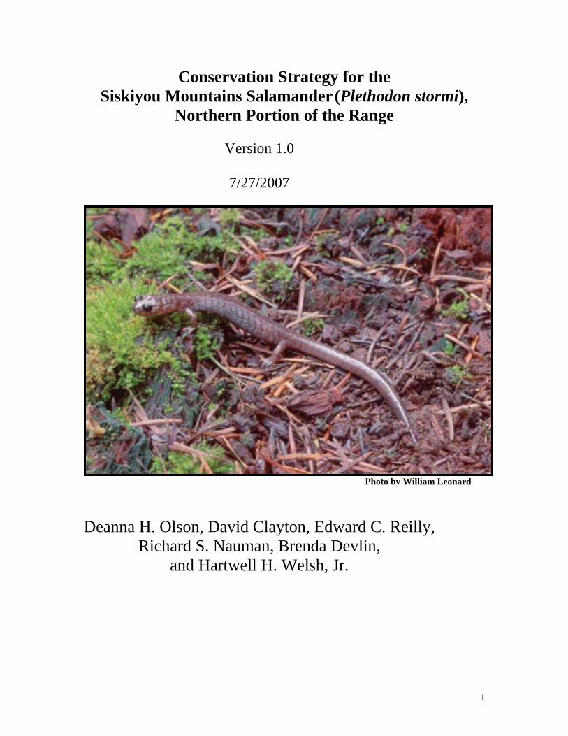
bull Some gaps in known site distribution within the known range in the Applegate Valley
bull The potential effects of fuels treatments within suitable habitat and high priority sites
bull Microclimate conditions required by the species in surface and subsurface refugia and microclimate changes with vegetation management including edge effects
bull The response of the species to various land management activities that typically occur within the range of the species including timber harvest activities (density management and regeneration harvest) and natural and prescribed fire
bull Reproduction movement dispersal and foraging bull Geographic boundaries of discrete populations connectivity among populations and
connectivity among selected high priority sites bull Effects of multiple hazards or risks to species across landscapes and populations
Inventory and Monitoring Guidelines
bull Inventories will be conducted to fill gaps in distribution and assess habitat conditions and salamander occupancy in areas with planned projects in order to finalize high priority site selection within 6th field watersheds
bull Implementation monitoring will include an annual compilation of projects conducted and priority sites selected for the two management strategies
bull Effectiveness monitoring projects will be developed for each 5-year interval to assess success of the two management strategies in retaining species at priority sites and assumptions of the Conservation Strategy including the occupancy of animals in areas other than high priority sites
Adaptive Management
A review of this conservation strategy will be conducted every five years where new species knowledge science findings habitat information and strategy implementation are evaluated Revision of the Conservation Strategy may follow the 5-year reviews to refine the plan or address emerging issues
Between the 5-yr reviews the following may trigger an immediate review
bull A significant change in the number of known sites within a sixth field watershed so that the understanding of the distribution of the species has changed to the extent that sites may be added or re-prioritized
bull A significant range change or extension has occurred such as a site found north of the Applegate River or in another 6th field watershed not previously known to harbor the species
bull Significant changes in Forest Service or BLM Land-Use Allocations as determined by the field unit within the area of the conservation strategy or
5
a significant management direction change on Federal lands within the area of the conservation strategy
bull A significant change in habitat conditions due to large-scale fire that may change our assumptions as to the amount of habitat available and contributing to the persistence of high-priority sites identified within the conservation strategy This might occur when more than half of one 6th
field watershed occupied by the species is affected by the disturbance bull New science that changes our understanding of the ecology of the species or
its habitats
6
Table of Contents
I INTRODUCTION 8
Goal 8 Scope 8 Management Status 8 II CLASSIFICATION AND DESCRIPTION 9
Systematics 9 Species Description 10
III BIOLOGY AND ECOLOGY
Life History 11 Movements 11
Breeding Biology 11 Range Distribution and Abundance 11
Population Trends 13 Habitat 13 Ecological Considerations 14
III CONSERVATION 15
Threats 15 Species Conservation Objectives 18
Selection of Management Areas 23 Management Area Objectives 33
Inventory Monitoring and Research 36 Adaptive Management 39
IV ACKNOWLEDGEMENTS 40
V DEFINITIONS 40
VI REFERENCES 42
APPENDICES 1 Spatial Model of Optimal Habitat for the Siskiyou Mountains
Salamanders north of the Siskiyou Crest 2 Assessment of Risk to Conservation of Siskiyou Mountains
Salamanders in the Applegate Watershed 3 High Priority site Identification and Selection Criteria 4 Managing for the Siskiyou Mountains Salamander (Plethodon stormi)
in Fuel Treatment Areas around At-Risk Communities
7
I Introduction
Goal
This Conservation Strategy describes the management actions necessary to maintain a high likelihood of well-distributed populations across the northern portion of the Siskiyou Mountains salamanderrsquos range within the Applegate River 4th Field watershed on federal lands administered by the Rogue River-Siskiyou National Forest Siskiyou Mountains Ranger District and the Oregon Bureau of Land Management Medford District Ashland Resource Area in the northern portion of itrsquos range the Applegate River 4th field watershed and avoid a trend toward federal listing under the Endangered Species Act
For Oregon Bureau of Land Management (BLM) administered lands SSS policy details the need to manage for species conservation Conservation is defined as the use of all methods and procedures which are necessary to improve the condition of Special Status Species and their habitats to a point where their Special Status recognition is no longer warranted In addition implementation of the policy is intended to ensure that actions funded authorized or carried out by the BLM do not contribute to the need to list species under the Endangered Species Act
For Region 6 of the Forest Service Sensitive Species policy requires the agency to maintain viable populations of all native and desired non-native wildlife fish and plant species in habitats distributed throughout their geographic range on National Forest System lands Management should also preclude a trend towards federal listing for any identified Sensitive species
This Conservation Strategy provides the most up-to-date information known about this species including life history habitat and potential threats This information has been compiled from range-wide studies This species is a rare endemic vertebrate with a known range restricted to a small portion of the Siskiyou Mountains in southern Oregon and northern California Additional information is available on the Interagency Special Status Species website (httpwwwfsfedusr6sfpnwissssp)
Scope
The geographic scope of this Strategy includes the range of the species coincident with Forest Service Region 6 and Oregon BLM lands including the Rogue River-Siskiyou National Forest and the Medford District of the Bureau of Land Management This area is encompassed within the 4th field Applegate watershed However background species information is compiled for the entire species range which includes both Oregon and California in Jackson and Josephine Counties in Oregon and Siskiyou County in California In California the Klamath National Forest is within the range
8
Management Status
The Siskiyou Mountains salamander is identified by the USDA Forest Service Regions 5 and 6 as Sensitive and by the USDI Bureau of Land Management Oregon as Sensitive This species is not known on BLM lands in California In addition the species is listed by California State as Threatened Oregon State as Sensitive-Vulnerable species and by the US Fish and Wildlife Service as a Species of Concern The Natural Heritage Program ranks this species as ORNHIC List 1 taxa that are threatened with extinction or presumed to be extinct throughout their entire range Globally imperiled (G2G3Q) California State Critically imperiled or imperiled (S1S2) Oregon State imperiled (S2) Management of the species on Forest Service Region 6 and Oregon BLM lands follows Forest Service 2670 Manual policy and BLM 6840 Manual direction
In recent years this species has had variable consideration in two other federal rare species programs First from 1994 to 2004 and from 2006 to present this species was included on the federal Survey and Manage list a component of the Northwest Forest Plan (USDA and USDI 1994) The Survey and Manage program was eliminated in 2004 (USDA and USDI 2003 2004) then reinstated by court order in 2006 At this writing a Final Supplement to the 2004 Supplemental Environmental Impact Statement to Remove or Modify the Survey and Manage Mitigation Measure Standards and Guidelines has been released (USDA and USDI 2007) and the preferred alternative again removes the Survey and Manage standards and guidelines from federal land and resource management plans A Record of Decision and court ruling on this are pending Second in 2004 this species was petitioned for listing as Threatened or Endangered under the US Endangered Species Act In April 2006 the US Fish and Wildlife Service released a finding that listing was not warranted This was reversed in March 2007 whereupon a 12-month review was initiated to determine if listing is needed INCLUDE recent listing decisions
II Classification and Description
Systematics
The Siskiyou Mountains salamander (Plethodon stormi) is a member of the family Plethodontidae the lungless salamanders and the genus Plethodon the Woodland Salamanders These animals respire entirely through their skin complete their entire life cycle in terrestrial environments and are found on the forest floor in moist microhabitats Like other Plethodon they are slim and elongate with relatively short legs The Siskiyou Mountains salamander along with the Del Norte salamander (P elongatus) composes the elongatus group of western Plethodon (Brodie 1970)
The Siskiyou Mountains salamander is morphologically and genetically distinct from both the Del Norte salamander and the recently discovered Scott Bar salamander (Plethodon asupak) (Mahoney 2004 Mead et al 2005 DeGross 2004) Together the Siskiyou Mountains and Del Norte salamanders seem to be descended from a single common ancestral form that is a sister taxa to the basal Scott Bar Salamander (Mahoney 2004 Mead et al 2005) Because its status was uncertain until recently localities of the
9
Scott Bar salamander have been treated as Siskiyou Mountains salamanders by land management and regulatory agencies
The Siskiyou Mountains salamander appears to be most closely related to the Del Norte salamander (Brodie 1970 Mahoney 2004) The 2 species are in close proximity along the western edge of the Siskiyou Mountain salamanders range The Siskiyou Mountains salamander is composed of two parapatrically distributed monophyletic mtDNA groups (Pfrender and Titus 2001 Mahoney 2004) Recent work with nuclear markers indicates that some limited gene flow may have recently occurred or may be ongoing along the contact between the 2 mtDNA clades in California but not in Oregon (DeGross 2004) Because the 2 mtDNA groups of the Siskiyou Mountains salamander meet the criteria outlined by Moritz (1994 reciprocally monophyletic mtDNA haplotypes and significant differences in allele frequencies at nuclear genes) DeGross (2004) suggested that they be managed as separate Evolutionarily Significant Units [ESU] One ESU occupies the majority of the range of the Siskiyou Mountains salamander while the other is limited specifically to California in a small area north and south of the Klamath River immediately east of Happy Camp
Species Description
The Siskiyou Mountains salamander is similar in appearance to the Del Norte salamander (P elongatus) Recent surveys have uncovered populations of both Siskiyou Mountains salamanders and Del Norte salamanders within one mile of each other north and south of the Klamath River near Happy Camp California (Mahoney 2004) There is also evidence of sympatry of the two species at two sites near Happy Camp and Grider Creek (Louise Mead pers comm 2005)
Siskiyou Mountains salamanders are slim and long-bodied (approximately 14-70 mm snout-vent length) and are chocolate-brown to purplish-brown dorsally with varying amounts of light flecking on the head sides and limbs Adults may have a faint lighter brown dorsal stripe and the ventral color is grayish-purple Juveniles tend to be black or very dark brown with flecking often exhibit a light brown or tan dorsal stripe and are gray ventrally An adult P stormi is distinguished from this close relative by having a modal number of 17 costal grooves and 4 to 55 intercostal folds between adpressed limbs while the Del Norte has 18 and 55-75 respectively (Jones et al 2004 Leonard et al 1993 Nussbaum et al 1983) Moreover the Del Norte Salamander may have a reddish dorsal stripe and juvenile Del Norte salamanders differ from juvenile Siskiyou Mountains salamanders in that juvenile Del Norte salamanders usually possess a bright coppery dorsal stripe that can fade with age However within the contact zone of these two species and P asupak (Mead et al 2004) morphological characters such as dorsal stripe and intercostal folds potentially may not be characteristics that will identify species readily
10
III BIOLOGY AND ECOLOGY
Life History
Siskiyou Mountains salamanders are active on the ground surface primarily at night when it is cool and moist Peak active periods occur during the wet season with periods of inactivity during freezing temperatures They may forage at the surface during the dry summer (Nussbaum et al 1983) They adopt a sit-and-wait foraging behavior and prey on a variety of small terrestrial invertebrates including spiders pseudoscorpions mites ants collembolans and beetles (Nussbaum et al 1983) Ants may be an important dietary component in the spring while millipedes appear to be eaten by larger adults in the fall (Nussbaum 1974) Predators are largely unknown but may include sympatric snake and shrew species Potential competitors may include ensatina and black salamanders which also occur in similar habitat Nothing is known of parasites and disease or symbiotic and mutualistic interactions with other species
Movements
Siskiyou Mountains salamanders are thought to have limited dispersal ability They make daily to seasonal vertical migrations in the ground surface as microclimate conditions change but not extensive horizontal movements Genetic analyses indicate limited gene flow and suggest that populations may have been on isolated evolutionary pathways for a very long time
Breeding biology
These salamanders are entirely terrestrial they do not require standing or flowing water at any stage of their life cycle Eggs are thought to be laid in nests below the ground deep in rocky substrate Courtship probably occurs during the spring rainy season on the talus surface (Nussbaum et al 1983) In the early spring females retreat down into the talus and establish nests Dissected females (sample of 37) had clutches of 2-18 eggs with an average of 9 eggs per clutch (Nussbaum et al 1983) The eggs are laid in a grape-like cluster and are tended by the female until hatching in the fall Juveniles emerge in late fall and early spring Welsh and Lind (1992) reported that juveniles captured in mid-spring were significantly larger than would be expected if newly hatched They mature at 5-6 years and appear to be relatively long-lived (up to 15 years) Females appear to breed every other year
Range Distribution and Abundance
The Siskiyou Mountains salamander occurs in an approximately 150000 ha area in southwestern Oregon and northwestern California (Nauman and Olson 1999 Figure 1) It has been found in southern Jackson County the extreme southeast portion of Josephine County Oregon and northern Siskiyou County California It is known from sites ranging from 488 m (1488 ft) (Nussbaum et al 1983) to about 1800 m (6000 ft) (Clayton et al 1999) in elevation To date there are approximately 380 localities known for the
11
species (USDA and USDI 2006 Nauman and Olson 1999 Reilly pers comm) The knowledge of this speciesrsquo distribution has grown considerably in the last 20 years a prior reference distribution of this species is unknown
The Siskiyou Mountains salamander occurs primarily on federal lands within the KlamathSiskiyou Mountains In the Applegate Watershed covered by this Conservation Assessment there are 201 sites on BLM lands (191 on OampC lands) 115 sites on Forest Service lands and 14 sites on private lands It is found within all federal land allocations (Adaptive Management Areas (AMA) Administratively Withdrawn areas Congressionally Reserved areas Late Successional Reserves and Matrix lands) This species has been documented to occur on the Medford Bureau of Land Management Ashland Resource Area the Applegate Ranger District of the Rogue and Siskiyou National Forest and the Happy Camp and Scott River Ranger Districts of the Klamath National Forest The majority of the known and suspected range of the species is on federal lands and most known sites occur on two federal land allocations Adaptive Management Areas (67) and Late-Successional Reserves (27) (Nauman and Olson 1999) Seven percent (7) of sites occur on non-federal lands Distributions of sites within the Applegate watershed portion of the range are primarily on AMA lands (67) some reserves (18) and private lands (16) (Nauman and Olson 1999) In the southwest portion of the range in California site distribution is primarily on reserve lands (67) with 31 of sites on Matrix land This Conservation Strategy covers only the northern portion of the range within the Applegate Valley 4th field watershed
Within the suspected range of P asupak most occurrences are on Matrix or private lands (60) with the remaining sites occurring on reserved lands (40) (Nauman and Olson 1999) Genetic work has not been conducted on these occurrences to determine if they are P asupak or not The California Department of Fish and Game reported approximately 45 localities from within the suspected range of P asupak but these have not been confirmed by genetic analysis and may actually represent fewer distinct occurrences (California Dept of Fish and Game 2004)
12
Figure 1 Distribution of known sites of Siskiyou Mountains salamanders in the Applegate watershed the area covered by this Conservation Strategy
An inventory of all known Siskiyou Mountains salamander sites on the Applegate Ranger District in 1992 yielded abundances of salamanders ranging from 03 to 11 captures per person-hour (D Clayton unpubl data 1993) A habitat associations study from 1994 to 1997 yielded densities of salamanders ranging from 1 to 16 animals per 49 square meter search plot (ie 002-033 animalsm2 Ollivier et al 2001) Nauman and Olson (2004) reported an average of 001 salamandersm2 and 239 salamandersperson-hour in California with lower elevations having higher capture rates In comparison other plethodontid capture rates in the western United States can be much higher (Nussbaum et al 1984)
Population Trends
Nothing is known about population trends in this species
Habitat
Siskiyou Mountains salamanders are exclusively found in association with rocky substrates (Nussbaum et al 1983) These substrates may range from gravelly soils to talus but there is always some component of rock Although exceptions exist most known sites consist of forested areas Individuals are found by searching under rocks bark logs or other debris on the forest floor during wet weather (Petranka 1998)
13
Factors that create a cool moist microclimate appear to strongly influence the distribution and abundance of the Siskiyou Mountains salamander Shading provided by vegetation aspect and topography appears to play a significant role in creating the conditions associated with Plethodon salamanders Forested stands with high canopy closure and larger conifers when associated with rocky soils often harbor abundant populations of Siskiyou Mountains salamander (Nussbaum et al 1983 Ollivier et al 2001 Welsh et al 2007) Welsh et al (2007) considered mature to late-seral forest stands to provide optimal conditions for this species These stands are most common on north-facing slopes where this species reaches its highest abundances (Nussbaum et al 1983) and is most commonly encountered (Farber et al 2001) However populations are known from all seral stages and aspects (Farber et al 2001 Ollivier et al 2001) In younger stands and more southerly aspects micro-site topography may provide shading allowing salamanders to exist in areas that otherwise would be inhospitable Welsh et al (2007) utilized an ldquoilluminationrdquo index of topographic shading to help describe occupied sites This approach offers great promise in untangling the complex interaction of vegetation aspect and topography that appear to interact to create suitable conditions for Siskiyou Mountains salamanders
Precipitation also has been associated with the presence of Siskiyou Mountain salamanders (Ollivier et al 2001 Welsh et al 2007) Dry conditions likely limit the species eastward extent In one study conducted in California Siskiyou Mountains salamanders were encountered at a greater proportion of sample points and in greater abundances in the wet western side of the range when compared to the much drier eastern side of the range (Nauman and Olson 2004) Siskiyou Mountains salamanders need a moist relatively cool habitat Precipitation canopy cover aspect and topographic shading directly affect salamanders by creating the conditions necessary for persistence The abundance of moss and ferns deep litter the number of hardwood trees and years since disturbance (Ollivier et al 2001 Welsh et al 2007) are associated with salamanders because they likely reflect the stable existence of cool moist conditions over longer periods of time
Ecological Considerations
Plethodontid salamanders are thought to have important roles in forest ecosystems including being a significant trophic link between small ground-dwelling invertebrates and larger vertebrate predators They also comprise a considerable portion of the forest vertebrate biomass in some areas (eg Burton and Likens 1975a 1975b) but the specific role of P stormi in local communities or ecosystem processes has not been addressed Their general ecology and life history traits suggest they are ideal indicators of forest ecosystem integrity as many are associated with mature forests (Welsh and Droege 2001)
IV Conservation
14
Threats
Optimal habitat for these animals includes late-seral forest conditions with rocky substrates and cool moist microclimates (eg Welsh et al 2007) Activities that may pose threats to this species are those that disturb the surface microhabitats andor microclimate conditions Disturbance of surface microhabitats is of primary concern because alteration of the microhabitat and microclimatic conditions can negatively impact these salamanders Typically these involve actions that remove canopy andor disturb the substrate
Examples of threats include timber harvest road construction rockpit mining and development of large recreation sites Wildland fire is also a primary threat to this species Other activities such as prescribed fire trail construction and chemical applications may pose somewhat lesser or localized threats to the species and do not likely pose a threat to species persistence All these are presumed threats to this salamander as no studies have been published to document losses from specific anthropogenic disturbances in this species These activities and their impacts to these salamanders are discussed below
Timber Harvest
Timber harvest is the primary current land management practice in forested ecosystems in this geographic region Several disturbances of salamander habitat conditions can result from timber harvest practices Removal of overstory may cause desiccation of the rocky substrates and loss of the moss ground cover a microhabitat feature of Siskiyou Mountain salamander sites Tree-felling and ground-based logging systems disturb the substrate which can result in substrate compaction and deconsolidation of the stabilized talus which reduces or eliminates substrate interstices used by salamanders as refugia and for their movements up and down through the substrate Site preparation practices such as broadcast burning removes the moss covering that helps to stabilize the talus
Within the range of the Siskiyou Mountains salamander the landscape is somewhat fragmented by past timber harvest practices and current fire regimes and is a patchwork of stands of different seral stages from early seral to mature forests Siskiyou Mountains salamanders and their habitat are found nested within this patchy forested regime There are no real estimates of how much potential suitable habitat has been impacted by timber harvest activities but using soil mapping as a basis for projecting potential habitat 10 of the total potential habitat (10000 acres 4047 ha) on the Applegate Ranger District Rogue River National Forest had been harvested between 1984 and 1994 (D Clayton unpubl data)
Although no studies have been completed specifically for this species many studies have reported effects to plethodontid salamanders from timber harvest in particular regeneration or clearcut harvest practices (eg Ash 1997 Dupuis et al 1995 deMaynadier and Hunter 1995 Herbeck and Larsen 1999 Grialou et al 2000) DeMaynadier and Hunter (1995) reviewed 18 studies of salamander abundance after
15
clearcut timber harvest and found median abundance of amphibians was 35 times greater on controls over clearcuts Petranka et al (1993) found that Plethodon abundance and richness in mature forest were five times higher than those in recent clearcuts and they estimated that it would take as much as 50-70 years for clearcut populations to return to pre-clearcut levels A comparison of recent (lt5 years) regeneration harvest units and mature (120 years) forests also suggested salamanders are eliminated or reduced to very low numbers when mature forests are clearcut (Petranka et al 1994)
Alternative silvicultural practices may not always have adverse effects on the ground-dwelling salamander assemblage Messere and Ducey (1998) found no significant differences in abundance of northern red-backed salamanders in forest canopy gaps in stands that had been selectively logged in New York indicating that limited logging may have little effect on that species In contrast Knapp et al (2003) found reduced abundances of terrestrial salamanders in stands with leave tree group selection or shelterwood cuts compared to uncut stands in Virginia and West Virginia
Studies in the Pacific Northwest documented greater salamander abundance in old-growth compared to clearcuts or early seral forest (eg Bury and Corn 1988 Raphael 1988 Welsh and Lind 1988 and 1991 Welsh 1990 Corn and Bury 1991 Dupuis et al 1995 Ollivier et al 2001) Alternatively Diller and Wallace (1994) found P elongatus in managed young stands in northwestern California and found no relationship of salamander presence to forest age However they sampled stands that were from zero to 90 years old The areas surveyed were also in the coastal redwoods that have a milder wetter climate than interior sites sampled by others (Ollivier et al 2001 Welsh and Lind 1991) and are similar to areas where the Siskiyou Mountains salamander is found More recently Karraker and Welsh (2006) found clearcutting affected plethodontid numbers up to 25 years post-harvest in northwestern California Karraker and Welsh (2006) also found similar abundances of plethodontid salamanders in thinned and unthinned forests but body condition of most species was lower in thinned stands Rundio and Olson (2007) found reduced abundances of plethodontid salamanders following thinning at one of two study sites and suggested site conditions (eg down wood substrate) may have ameliorated effects of canopy reduction at one site
Although no published studies address the direct affects of timber harvest activities on the Siskiyou Mountains salamander using a well-designed approach with pre- and post-treatment data and reference stands surveys in timber sale units after harvest have shown marked reductions in capture rates A site adjacent to the type locality was surveyed in 1993 immediately after a clearcut harvest and broadcast burn (D Clayton unpubl data) and a high number of individuals (10+capturesperson-hour) were found Subsequent surveys showed a rapid loss of individuals detected at the site and since 1995 no salamanders were found at the site until 1999 when one was found (California Department of Fish amp Game 2004) In 2003 two searches conducted by the California Department of Fish and Game yielded 3 salamanders in 17 minutes and 5 salamanders in 75 minutes (California Department of Fish amp Game 2004) These data are inconclusive but may indicate some recolonization of the site or a sink habitat into which individuals are dispersing from a nearby source habitat and may not subsequently survive
16
Federal timber management practices have changed significantly since most studies of timber harvest effects on amphibians have been conducted Clear-cut logging is no longer carried out on Forest Service or BLM lands within the range of this species as regeneration harvests now maintain large down logs large snags and 15 of the original stand as green retention trees Substrate impacts are still likely but must meet agency standards generally less than 20 of the harvest unit Given the wide range of study results on a variety of Plethodon species it is difficult to know at what level canopy reduction is significant enough to render an area unsuitable However based on scatter plot data from the Ollivier et al work (2001) salamander capture rates declined significantly when canopy closures were below approximately 70 percent
Roads
Many roads have been constructed for easy access to existing rock sources to use as road-surfacing material and to access timber harvest operations Road construction in suitable habitat directly removes overstory and compacts the substrate The intensity of impacts are more intense and longer lasting than timber harvest Road construction likely causes direct mortality to individuals and some amount of habitat loss however due to the scale of impact and the linear nature of the action the impacts to the species may be significantly less than timber harvest or stand-replacement fire Roads are not generally known to be barriers to plethodontid salamanders and P stormi has been found in road cuts Road kill is not well documented for this species
Rockpit Mining
Rock sources are mined for a variety of uses These operations remove large amounts of material far back into a hillside or mountain Overstory and substrate may be removed Such operations undoubtedly remove both surface and subsurface refugia permanently and likely have impacted local populations However due to the scale of this action across the range of this species this action is not considered to be a primary threat
Developed RecreationDispersed Camping
Construction of camping areas access roads boat ramps and other developed recreation sites have likely impacted Siskiyou Mountains salamanders particularly around Applegate Lake by the direct alteration of substrate as well as canopy loss due to overstory vegetation removal Dispersed campsites also may have had an impact from soil compaction and vegetation alteration although it is expected to be somewhat limited
Chemical Applications
Herbicides pesticides fire retardants and fertilizers may have a direct impact on Siskiyou Mountains salamanders These animals breathe through their skin which must be moist and permeable for gas exchange It is not known to what extent these substances may have affected Siskiyou Mountains salamander populations in the past However this type of activity only occurs on a very limited basis on FS and BLM lands and then
17
usually only at disturbed sites with invasive species concerns It is not likely a high concern for this species
Fire
Impacts to Siskiyou Mountains salamanders from either natural or prescribed fire are unstudied however given that fire exclusion in recent years has resulted in an increased risk of large stand-replacement fire in the region large fires that remove overstory from suitable habitat may be of highest concern for this species (an example of this is the Biscuit Fire) Although the Siskiyou Mountains salamander has persisted in a fire disturbance landscape there is concern that the intensity of the local fire regime has changed and when burned may have adverse effects on the species The historical fire regime in the area was one of high frequency and low intensity fire which consisted of very frequent underburning of the forest in the summer and early fall and few stand-replacement events at least at the lower elevations (Agee 1993) At higher elevations longer fire return intervals and high intensity fires occurred historically and likely resulted in more stand-replacement events (Agee 1993) The effects of a more intense level of fire disturbance due to fire suppression and fuel loading is of concern in that stand-replacement fire represents a higher potential for disturbance to flora and fauna In particular relative to salamander habitat it removes overstory canopy that serves to moderate surface microclimates from extremes (eg high temperatures and low moisture)
Recent federal management strategies emphasize fuel prescriptions to remove the unnaturally high fuel loading Fuel reduction prectices include various combinations of understory thinning slashing piling andor prescribed burning Most prescribed burning occurs in the moister and cooler time of the year to avoid escapement risks and smoke concerns Springwinter burning may increase the chance of direct mortality of Siskiyou Mountains salamanders during a time of year when they are active above the surface and vulnerable to fire However fuels reduction activities may contribute to the long-term persistence of the species by reducing the potential for stand-replacement fire which likely has a higher potential for adverse effects to the species than the fuels reduction activities
Species Conservation Objectives
The objective of this Conservation Strategy is to provide for a high likelihood of long-term persistence of well-distributed populations of Siskiyou Mountains salamanders within the range of the species in US Forest Service Region 6 and Oregon BLM lands and to avoid a trend toward federal listing under the Endangered Species Act
Applegate Watershed 4th field range-wide scale objectives
1) Maintain viable populations such that there are sufficient numbers and distribution of reproductive individuals to ensure their continued existence within the Applegate River 4th field watershed
18
2) Provide well-distributed habitat to support reproductive individuals that can interact in the planning area
3) Utilize the existing federal reserved land allocations as a foundation for providing a high likelihood of continued species persistence
4) Minimize impact to federal non-reserve land allocations and other resources when possible
Intermediate scale objectives
1) Provide for the maintenance of Siskiyou Mountains salamanders within each 6th field watershed where they occur within the Applegate River 4th field watershed
2) Within 6th field watersheds establish finer-scale assessments of need for restoration and protective approaches
3) Within 6th field watershed select sites to manage for long term conservation (high-priority sites) based upon location of animals and criteria including suitable habitat risk factors federal land allocations and proximity to other sites such that protections are tiered to population rarity risk to persistence and connectivity potential
Site scale objectives
1) Establish initial extent of selected high-priority sites from existing known site habitat geographic and topographic data
2) Consider fire ecology stand conditions and the distribution of existing reserves when designing management guidelines for each high-priority site
Underlying Assumptions and Definitions
Reference Distribution The reference distribution of a species needs to be identified in order to develop strategies to provide for well-distributed populations The term ldquowell-distributedrdquo is defined as the ldquodistribution sufficient to permit normal biological function and species interactions considering life history characteristics of the species and habitats for which it is specifically adaptedrdquo (USDA and USDI 2001 p 86) ldquoWell-distributedrdquo may be inferred from the historic (prior to European settlement) distribution (USDA and USDI 2000 p 342) The historic distribution can sometimes be derived from habitat associations occupancy rates in suitable habitat historic habitat distribution potential past disturbance signatures and other knowledge about the species If these factors are not well known and historic distribution cannot be inferred the current distribution can be taken as the reference distribution (USDA and USDI 2000 p 342)
For the Siskiyou Mountains salamander the current known range is the reference distribution for species conservation objectives While some historical locations may have been lost due to relatively recent disturbances the species range boundaries appear to be driven by natural environmental conditions such as lack of rocky substrate or harsh microclimate conditions for salamanders More is known today about this speciesrsquo
19
distribution than ever before The known range has approximately tripled between 1980 and today doubling between 1993 and 1998 (Nauman and Olson 1999) However current knowledge is not complete and in several areas covered by this conservation strategy surveys have not been conducted for this species Lack of a population within a patch of apparently suitable habitat may indicate lack of surveys or lack of salamanders New distribution information should be incorporated into this strategy by considering selection of additional known sites for conservation management or by reconsideration of sites within an area for site re-selection
For purposes of management of this species under FS Region 6 and BLM Oregon Sensitive and Special Status Species policies the range-wide area under consideration for this Strategy is the 4th field Applegate watershed which includes the Rogue River-Siskiyou National Forest Siskiyou Mountains Ranger District and the Medford BLM Ashland Resource Areas
Desired Outcome The desired outcome of this conservation strategy is to provide habitats occupied by sub-populations of Siskiyou Mountains salamanders distributed across the northern range of the species within the Applegate watershed The pattern should reflect current knowledge of occupancy rates and optimal habitat conditions but should not neglect the range of conditions under which this organism exists While optimal habitat conditions are desired as an outcome for each high-priority site selected sites selected as high-priority include areas central and peripheral to the range in low and high fire hazard zones on ridgelines and in riparian areas and on all aspects The proximity of the selected high priority sites and the conditions between them should permit some gene flow although some sub-population isolation or gaps in distribution may occur The distribution pattern of high priority sites should reflect two additional considerations spatial extent of historical fire disturbances in this landscape and site redundancy Given previous fires have occurred across portions of the species range high priority sites are chosen in a pattern that would facilitate potential recolonization post-disturbance to fire Related to this the concept of site redundancy was considered particularly within or adjacent to areas of high fire hazard The Selection Criteria section below fully itemizes considerations for high priority site selection
Population demography and dynamics are little known for this animal Thus the decision for how much area may be needed for each site selected as high priority to maintain sub-population persistence has little baseline knowledge for guidance However there are existing sites that appear to occur in variable spatial extents of surface rock ranging from a handful to hundreds or thousands of acres In selecting high priority site areas in this strategy conservative approaches are used with a range of areas across each 6th field watershed selected to hedge uncertainties Juxtaposition of high priority sites with existing federal reserves substantially boosts protected areas for potential sub-population occupancy
The ldquoanchor habitat conceptrdquo (eg Olson 1998) can be applied to this conservation strategy This concept includes flexibility in spatial designation of habitats identified for species conservation over time such that optimal areas for species conservation can be
20
selected or adjusted as they become recognized (eg from new knowledge or from restoration of conditions over time) The anchor analogy is that the ldquoanchorrdquo habitat is retained but may move to new positions to best-provide for its designed purpose The intent in the high-priority site selection process identified herein is to provide well-distributed sub-populations across the planning area yet the recommended sites and site-delineated boundaries are now selected largely from remote sensing data of landscape attributes at the intermediate spatial scale Field reconnaissance may result in a better understanding of ground conditions such that selected sites may move or site boundaries adjusted Over time as new sites are found or site conditions are changed by natural disturbances or are restored the anchor habitats to provide for the species may again need to be adjusted This is the key component of flexibility provided in this strategy While over a hundred known sites have been identified in this Strategy for the goal of conservation management and habitat conservation areas have been provided in general terms for each of these sites ground-truthing to adjust these recommendations is expected and new habitat or other conditions over time should result in a re-examination of high-priority site selection in some areas
The high-priority sites identified in this Conservation Strategy are expected to anchor the population but not to impose an artificial metapopulation over the managed landscape This Strategy is designed so that salamanders are likely to thrive at high-priority sites but they are also expected to persist to a large degree in federal reserve allocations with suitable habitat and possibly in many sectors of the managed landscape having suitable habitat conditions without reserve status Risk to persistence of salamanders in these other areas is greater due to the potential for activities that may impact populations and uncertainty but that does not preclude their occurrence or the functional role intervening lands between high-priority sites may have for connectivity across the landscape and overall viability of the species High-priority sites are not envisioned to be acting as island reserves across the expanse of the Applegate watershed the risk analysis (below) speaks to this However this is an aspect of the strategy that may require monitoring If intervening lands become highly disturbed and unsuitable habitat conditions predominate connectivity to retain interacting individuals across the landscape may need to be re-addressed
Management Limitations Limitations on the capability of federal management actions to provide for well-distributed populations of this species include the following considerations First non-federal lands fragment some parts of the species range and consequences of disturbances on non-federal lands for salamander persistence is only addressed by recommendations for management practices on the adjacent federal lands Also long-term effects on the species from federal land management of occupied salamander sites that are not chosen as high priority sites are unknown Both federal and non-federal land management of salamander habitats may fragment the speciesrsquo range and disrupt population integrity more than is currently considered in this Strategy Cumulative effects of federal and non-federal land management require monitoring and adaptive management Second due to our limited knowledge of speciesrsquo distribution and population structure and dynamics a conservative approach may be warranted for this vertebrate species This is addressed through the numbers of sites recommended as high-
21
priority sites which allows for redundancy and adjacency of sites and the spatial extent of these high-priority sites in turn allowing for potentially high numbers of salamanders to occur at each high-priority site Third there is limited knowledge of the effects of forest management activities on these salamanders While options for managing high-priority sites are included in this Strategy a conservative approach to site management may be warranted until the resiliency of these animals to site-specific activities is better known Fourth it is acknowledged that the detectability of these salamanders may be an issue for determining occupancy patterns Under appropriate environmental conditions for surveys there is a chance of not detecting the salamanders when they are present at a site because they are subsurface While this chance is not quantified the result is that many known sites detected from single survey efforts may reflect the subpopulations with greater abundances or surface activities and the knowledge of salamander distribution may be conservative (ie there may be a pattern of greater occupancy than is realized by survey detections) Finally the region is in a zone of relatively high natural fire frequency While that is taken into account in the conservative approach taken here it is expected that adaptive management in terms of the strategy design or site-management approaches may be needed in response to fire locations and severity
Risk Level of the Strategy Implementation of this conservation strategy is designed to have a low to extremely low risk to the continued persistence of this species At the site level the recommended fuels management activities have not been examined relative to their effects on salamanders Hence there may be a risk of losses to individuals or subpopulations of these activities However the risk of sub-population extirpation is relatively low and contrasts sharply with a higher risk of losses if a fire disturbance event were to occur and result in altered forest canopy and ground microclimate conditions Losses of individuals from fuels reduction activities may be recouped over time as habitat conditions for salamanders likely improve due to these restoration practices Again however the resiliency of these salamanders to disturbances of this type has not been studied so there is uncertainty in how well they would respond to changing conditions with time Effects monitoring is suggested At the intermediate scale site redundancy and a mix of protective and restoration approaches suggests an extremely low risk to persistence Also disturbances from fires or site management activities are likely to be staggered spatially and temporally and risk of losses would not occur synchronously for all subpopulations in a neighborhood The aggregate of 19 6th field watersheds allows the concepts of redundancy and a mix of approaches to be applied to the species range scale in the planning area A large disturbance such as fire or disease may occur in the area but it is likely that it would not have severe effects across the entire landscape due to its naturally fragmented nature and patchy occurrences of habitats and animals Subpopulations within watersheds and sites are likely to be retained under this worst case scenario Risk to persistence at the range wide scale is extremely low This strategy is designed to provide persistence for this species for at least 100 years Risk assessment is addressed in a later section also
22
Selection of Management Areas
Selection of high-priority sites for salamander conservation was conducted by a panel of scientists and resource managers and considered existing federal standards and guidelines for the planning area distribution of habitat and known localities of salamanders Potential risk factors to salamander persistence were also assessed including fire hazard location relative to the populated areas proximity to other private lands and road density In addition maps of species richness from the federal Interagency Species Management System (ISMS) database were examined These factors were evaluated at both the landscape and 6th field watershed scales Also digital elevation maps and aerial photographs were used as sites and watersheds were evaluated
Federal land allocations and forest plans
The Siskiyou Mountains salamander conservation strategy builds upon the existing reserve systems and the Standards and Guidelines established under the Rogue River NF Land and Resource Management Plan the Medford BLM Resource Management Plan and the Northwest Forest Plan In this area the reserve system includes congressionally withdrawn areas riparian reserves owl habitat areas botanical reserves late-successional reserves and special emphasis areas (Figure 2)
Not all reserved lands were assumed to provide protection for the Siskiyou Mountains salamanders Many federal reserved areas have been managed in the past may be managed in the future and all are subject to natural disturbances in the future For example density management or fuels reduction activities in riparian reserves or late successional reserves may have adverse effects on salamanders However an assumption was made for this Strategy that most reserved lands will be managed in a way that is either neutral or beneficial for this species
Before development of this conservation strategy an initial risk assessment was conducted to qualitatively assess the likelihood of persistence of the Siskiyou Mountains salamander in the Applegate watershed based on provisions within existing federal forest plans and their standards and guides (see Risk Assessment section below) The development of this strategy was initiated due to relatively low and variable persistence likelihoods among 6th field watersheds in this zone in addition to high uncertainty regarding future management and disturbance scenarios and their effects on salamanders and their habitats
23
Figure 2 Federal land allocations within the planning area of this document the Applegate watershed
Habitat
Habitat distribution is a key component of this conservation strategy Several projects that have assessed site and landscape-level characteristics of locations occupied by Siskiyou Mountains salamander were available to the team while this conservation plan was being developed (Ollivier et al 2001 Reilly et al Appendix 1 Suzuki and Olson Appendix 2 Welsh et al 2007) The maps generated by Reilly et al (Appendix 1) were used extensively during the selection of high-priority sites The first iteration of the Reilly et al model was derived from the results of an unpublished study of Siskiyou Mountains salamander habitats (Ollivier et al 2001) An additional variable ldquoillumination indexrdquo added aspect and topographic shading to the model The Reilly et al habitat model was used at site 6th field watershed and landscape scales to assess the distribution of habitat during the development of this conservation strategy (Appendix 1 Figure A11) An underlying assumption of this conservation strategy is that areas that are not mapped as habitat by the Reilly et al model may be occupied by salamanders It was also assumed that areas not mapped as habitat by the Reilly et al model will provide for some level of connectivity between high-priority sites
Species Distribution
High-priority sites were selected from records entered into the ISMS database prior to August 2004 (Figure 1) These data included spring 2004 salamander locations resulting from mollusk survey efforts in the Star Gulch drainage on Medford BLM lands It is
24
important to note that the Team does not believe that this database contains all populations of Siskiyou Mountains salamanders nor do we believe that it represents an unbiased sample of all populations However the Strategy team was not limited by a lack of localities to select for high-priority management Fieldwork conducted in 2003 located populations in gaps identified by the team as areas important to the long-term persistence of the species at one or more scales (Nauman and Olson 2004b) Species sites identified subsequent to this initial selection of high-priority sites have been used to fine-tune final high priority site selection in individual 6th-field watersheds but are not documented here
Fire Hazard
Fire is a natural disturbance across the landscape covered by this Conservation Strategy Distribution of fire-prone areas on the landscape was estimated by mapping fire hazard models developed by local fire behavior experts from the Rogue and Siskiyou National Forest Medford District Bureau of Land Management and Oregon Department of Forestry (Figure 3) This map shows fire likelihoods that generally increase along ridgelines and south-facing aspects
High intensity fires have the potential to adversely affect salamander micro- and macrohabitat conditions Low intensity fires could adversely affect some habitat elements as well but effects may be short term with long-term effects resulting in development of more resilient habitats
Figure 3 Fire hazard map for the Applegate watershed
25
During the process for planning this salamander Conservation Strategy fuel hazard mapping was reviewed to consider the potential risk of fire and of high intensity fires in a neighborhood around each site The team considered 1) selection of sites in lower fire risk areas as possible 2) selection of sites in a range of fire conditions to represent the variety of conditions under which these animals occur 3) selecting sites to allow for redundancy in an area with potentially higher fire risk 4) site delineation of areas with a mix of fire hazards and 5) management of selected sites to reduce risk of catastrophic high intensity fires These elements were part of the site selection criteria below and fire was a component further modeled in the risk assessment procedure
Risk Assessment
An integration of the above four conservation elements (land ownerships and federal allocations modeled habitat species distribution fire hazard) was used to assess the risk to species persistence on the landscape
At the beginning of the conservation planning process such an assessment was done for watersheds with only the federal land ownerships and allocations used as land management standards and guidelines for salamanders Land allocation fire hazard distribution and habitat maps were overlaid per watershed and panelists were asked to estimate the probability of persistence over a 100 year time span Due to a variety of land management activities possible and unknown longevity of current forest plans there was a strong element of uncertainty voiced by panelists during these assessments Uncertain trajectories of fire disturbances also weighed on panelistsrsquo minds especially with recent knowledge of the Biscuit Fire (July 2002 500000 acres) and Timbered Rock Fire (July 2002 27000 acres) in southwestern Oregon A worst case scenario of highly altered habitat conditions relative to salamanders was considered possible by most panelists This led to variable and sometimes low likelihoods of persistence assessments within watersheds As these watershed assessments were aggregated across the landscape most of the range of the species occupied watersheds with a potentially low chance of persistence This appeared to be partially a result of the large spatial extent of the AMA allocation in which gt1 rotation of regeneration harvest activities were conceivable over a 100 year timeframe This early result supported the notion that identification of salamander management areas and high-priority sites was needed even within federal reserved land allocations due to uncertainty in the future management and natural disturbance trajectories on federal lands Subsequent panel assessments after the selection of high-priority sites began substantially raised assessments of likelihood of persistence per watershed usually greater than about 80 As these were aggregated across the landscape an overall ldquohigh likelihood of persistencerdquo rating resulted
A more formalized process of assessing risk to persistence was developed and applied to the landscape (Suzuki and Olson Appendix 2) This procedure resulted in a landscape risk map relative to this salamander species (Appendix 2 Figure A22) The map shows a mix of risk conditions across the landscape with some patterns emerging with known habitat attributes land allocations and fire hazard This map was used during site selection and 6th field watershed assessments to re-address aggregation of multiple factors
26
and the potential consequences for salamanders Similar to the list produced for fire hazard alone above relative to this risk map the team considered 1) selection of sites in lower risk areas as possible 2) selection of sites in a range of risk conditions to represent the variety of conditions under which these animals occur 3) selecting sites to allow for redundancy in an area with potentially higher risk 4) site delineation of areas with a mix of risk conditions and 5) management of selected sites to reduce risk
Species Hotspots
Distribution of species richness of rare and uncommon taxa included in the ISMS database was determined for the planning area of this Conservation Strategy These data included known sites of fungi bryophytes lichens vascular plants and mollusks A map of these data (Figure 4) shows up to 5 taxa occurring within 1000 m square grid cells overlaying the landscape This map was considered during site selection in order to protect and overlap other species by designation of salamander high-priority sites
Figure 4 Map compiling known sites of rare and uncommon species to show ldquosensitiverdquo species richness for the Applegate watershed
Hierarchy of Scales
Three spatial scales are considered in this Strategy Objectives are listed above corresponding to each scale
27
Species Range The range of the species in the planning area is the largest scale of consideration At this scale well-distributed populations are intended to be managed for long-term persistence and sub-populations identified at the intermediate spatial scale are managed so that they may interact This is the scale that geographic coverages of federal land allocations habitat elements fire hazard and species localities were compiled This scale was revisited throughout the site selection process to address concepts of connectivity among smaller scale units and conflicting landscape priorities of species persistence timber production and fire suppression The area of the species range for this northern population is approximately 100000 ha (250000 acres)
6th Field Watershed The intermediate scale of the 6th field watershed was chosen to help develop a Conservation Strategy that could provide for well-distributed sub-populations of salamanders Aggregation of well-distributed sites selected for management at the intermediate scale was intended to meet the range-wide objective The 6th field watershed was chosen as an intermediate scale due to its size and current use in federal planning While the Siskiyou Mountains salamanders may not occur on the landscape in a pattern corresponding to watersheds watersheds are useful units to consider relative to some elements of salamander habitat or disturbance factors For example hill shading may change with aspect and ridgelines denoting watershed boundaries Ridgelines may have higher fire hazard as well The high-priority site selection process described below piggy-backed protections on existing federal reserves which often occur within 6th field watersheds Particularly riparian reserve distributions follow a watershed pattern and many of the salamander high-priority site management areas are delineated contiguous to riparian reserves or the spatial areas between two neighboring headwater tributaries Also the sizes of 6th field watersheds in this area were suitable to potentially harbor many salamander subpopulations Within 6th field watersheds with multiple known salamander locations the team was able to prioritize among locations to select high-priority sites for continued salamander management
Thus high-priority site selection occurred at this intermediate scale (see criteria below) Distribution of sites habitats federal lands federal reserved lands and other considerations weighed heavily into the high-priority site selection processes As a watershed was analyzed neighboring watershed conditions and proximity of sites across watershed boundaries were included as considerations for site selection Similarly a finer scale look at site conditions was conducted on a site-by-site basis The intermediate scale is a focal point of the Conservation Strategy but is a scale at which integration across scales was important and iteratively addressed Nineteen 6th field watersheds were analyzed in the development of this Conservation Strategy All of these watersheds have at least one known Siskiyou Mountains salamander location
Sites At the smallest spatial scale salamander sites were prioritized for managementhigh-priority site selection Per site one of two outcomes was chosen the site would be managed for site-level persistence of salamanders or not Only known sites of Siskiyou Mountains salamanders were considered for management optimal habitat areas without known detections of animals were not considered for high-priority site selection Every known site was considered separately as a potential location to identify
28
as a high-priority site during the development of this Strategy Known conditions and values of each site were listed Expert knowledge of each site was discussed aerial photographs displayed and existing data on populations or communities examined The spatial habitat model was used to estimate the geographic extent of optimal habitat elements near each site while photographs or other geographic coverages were used to further estimate vegetation or single habitat element distributions or quality relative to salamanders Some neighboring site locations in ISMS were merged for management consideration especially as adjacent sites appeared to occupy contiguous habitat patches Trade-offs of range-wide objectives to permit land management activities on the landscape for economic or ecological objectives or to piggy-back protections on federal reserved lands often were considered as site values were weighed Over 300 sites within the watershed were considered in the development of this strategy Nearly one-third were chosen as high-priority sites to manage for continued salamander persistence
Site Selection Process
High-priority sites were selected based on the need to maintain a well-distributed population across the landscape The multiplicity principle of many protected areas rather than a few was used Identifying high-priority sites in a wide range of areas based on elevational geographical and habitat condition (patch size edge effects etc) gradients allows for maintenance of sub-populations throughout the range despite potential large-scale disturbances Sites were selected on a watershed-by-watershed basis using 6th field watersheds as the intermediate scale planning area This ensured that sites would be designated across the known range of the species in the planning area Site selection was an iterative process Site level assessments included examination of fire hazard maps optimal habitat maps topography aspect maps of known sites distribution of Wildland-Urban Interface lands land ownerships and allocations and aerial photographs Maps of species hotspots and risk also were evaluated on a site-by-site basis Site value assessment may have been conducted for multiple sites at a time if locations occurred in clusters The evaluation included zooming-out to watershed and larger spatial scales for pattern evaluation Using this thought process criteria or considerations were developed to identify high-priority site salamander management areas
Criteria or Considerations for High-priority Site (HPS) Selection Fourteen criteria (A-N below) were developed for high-priority site selection Some are conceptual or qualitative assessments while others rely on geographic positioning relative to available spatial coverages or other available data Criteria are not mutually exclusive
A Total number sites per watershed - a site may have been chosen as a watershed representative because the entire watershed had very few known sites B Redundancy - a site may have been chosen in or near a high (fire) risk area where one HPS may be lost but others may persist C Connectivity - locations where habitat or sites may connect to adjacent watersheds D Acres of habitat - large patches of contiguous habitat were emphasized in site choice E Proximity to large reserves were emphasized in site choice F Distribution of site in watershed in relation to other known sites (gap cluster edge center)
29
G Distribution of habitat in watershed ndash a site may have been chosen due to its position relative to habitat H Distribution of reserve in watershed ndash a site may have been chosen due to its position relative to federal reserve lands I Fire hazard - high-risk areas were displayed and may have affected site choice for either redundance or likelihood of persistence J Communities at risk of fire (WUI = Wildland Urban Interface) ndash sites within and outside of WUI were considered for management with acknowledgement of uncertain risk of WUI land management K Centralperipheral within range - geographical gradient considered L Herptile community high biodiversity ndash number of herpetofaunal species or Survey and Manage species detected at site if known was considered in site selection Some ldquohotspotsrdquo were chosen M Center of canyon ridgetop - elevational gradient a variety of slope positions were chosen N High quality habitat ndash tree density and tree size as available higher quality habitats were chosen
Additional considerations were discussed but did not result in formal ldquocriteriardquo for site selection Age of the site record came up in a few cases when an odd location was assessed perhaps in apparently unsuitable habitat These sites may have been old records in areas that were subsequently managed to reduce forest overstory Or old records may have low precision in location due to historical field notes citing general directions to the sites or only township range and section locators Whether or not salamanders were extant at sites with old records and apparently changed conditions was a concern Also some sites occurred in areas known to have high human use patterns Sites near roads or recreation areas could be more prone to use patterns having adverse effects on salamanders
During site by site evaluations additional assessments were conducted For sites selected as high-priority the area identified as needed for management of the high-priority sites was determined from available maps and spatial coverages (see below) These areas were calculated mapped and land allocations evaluated Also per selected high-priority sites management alternatives were considered and the need for potential restoration was determined
After sites were selected within a 6th field watershed the pattern within the entire watershed was considered Spatial coverages of habitat fire hazard and land allocation were reconsidered at the intermediate spatial scale with selected and non-selected sites Potential interactions with selected sites in neighboring watersheds were considered
After sites were selected as high-priority within every 6th field watershed the pattern within the entire range in the planning area was considered At this time several topics were evaluated Were sites selected at the edge of the species range Were sites central to the species range selected Were low and high elevation sites selected Are sites in isolated habitat patches selected as well as those in areas of more continuous optimal
30
habitat at the range-wide scale How well does optimal habitat appear to connect selected sites Overlaying species richness data are areas with high species richness represented in high-priority site salamander management areas Overlaying the risk analyses are a range of risk areas represented including sites in low risk likelihood landscapes What is the distance between selected sites Might animals be able to move among sites in this dispersion pattern In areas with apparent clusters of selected sites is redundancy a selection criterion Is the redundancy concept used near high risk areas
Site Area Determination
The spatial extents of high-priority site salamander management areas were determined using multiple geographic coverages of site characteristics Optimal habitat maps known site distributions watershed boundaries topography aspect fire hazard and land ownershipallocation maps were consulted Aerial photographs also were used
Habitat maps reserve boundaries and aerial photographs were the primary data used to delineate high-priority site boundaries for salamander management areas Also boundaries were adjusted with natural or anthropogenic breaks in site conditions including roads ridgelines streams and aspect
Although a range of sizes were considered the size of a habitat patch needed to sustain a subpopulation of salamanders is not known Density estimates are crude at best for this species At a highly productive site Nussbaum (1974) estimated densities of up to approximately 6660 animals per hectare (ie 066 salamandersm2) A habitat associations study from 1994 to 1997 yielded densities of salamanders ranging from 1 to 16 animals per 49 square meter search plot (ie 002-033 animalsm2 Ollivier et al 2001) Due to the relatively high densities seen in this species larger habitats may be more resilient to disturbances and could have reduced edge effects Larger areas may be particularly relevant to consider for isolated areas that may not have the potential for a ldquorescue effectrdquo from adjacent salamander sites
Site Selection Results
Of 316 known federal sites evaluated 151 (48) were included in 110 high-priority site salamander management areas for this Conservation Strategy (Figure 5 compare to all sites in Figure 1 page 11) Of the 110 selected sites 44 are on BLM land and 66 are on Forest Service land
31
Figure 5 Sites and their corresponding habitat areas (polygons) selected for management in this Conservation Strategy Per watershed 2-12 sites were selected this was largely dependent upon the existing number of sites per watershed
Criteria A-N above varied in the importance at each site and the frequency with which they occurred as a consideration for site selection (Appendix 3) For example criteria F (site positioning relative to other sites eg filling a gap in distribution) and N (habitat quality) were the most frequently cited considerations for site selection over 60 selected sites were chosen for reasons that included F andor N Criteria A E and H had moderate usage number of sites in a watershed large reserves and proximity to reserves In contrast the least used criteria included B C D G I J K L and M each of which were cited for less than 20 selected sites However all criteria were considered at each site selected some criteria were consistently deemed to be of higher importance at determining sites
In watersheds with few sites all or most were selected as high-priority site salamander management areas For example in Slagle Watershed 4 sites were known and all were selected as high-priority sites for species persistenceconservation In contrast watersheds with numerous known sites had only a portion of them selected for continued management For example Thompson Creek watershed has 28 sites of which 15 were selected as high-priority sites Watersheds with potential habitat but with no known sites (eg due to a lack of surveys) were afforded no salamander protection at this time (eg OrsquoBrien Creek watershed) Future sites identified in watersheds such as these could be added into the conservation strategy if warranted
32
Distances between sites selected as high-priority averaged about a half mile Although this distance did not result from a scientific understanding of dispersal distances or salamander life history there was consensus among the panelists that salamander connectivity might be achieved by this pattern In many cases habitat features in the intervening areas are likely to functionally connect sites facilitating gene flow among the high-priority sitesmanaged subpopulations Spatial layers of individual habitat elements such as rocky substrates canopy closure large trees and limited solar exposure often show contiguous patches over large areas The combined model of all four features also shows continuity of ldquooptimal habitatrdquo conditions between many sites For example Middle Fork Applegate and Joe Creek watersheds have large contiguous blocks of good habitat that might serve as source areas for salamanders Much of this area is within federal reserve allocations and thus redundancy and lower risk to salamanders might also be achieved However upon inspection of this area the team noted a gap in distribution and thus selected an additional site The team also noted there were some potential topographic barriers between sites perhaps reducing the potential for habitat contiguity Selected sites spaced one-quarter to one-third mile apart were re-assessed The team considered whether this closer spacing reflected a choice for redundancy or occurred incidentally during site selection In a couple of cases the team de-selected or moved the selected site to increase spacing The team also looked at areas with spacing greater than one-half mile and examined known site data to see if localities were available to decrease such spacing
Management Area Objectives
Each high-priority site salamander management area is intended to maintain a subpopulation of Siskiyou Mountains salamanders over the long term The aggregate of high-priority site salamander management areas within the entire landscape covered by the conservation strategy is intended to maintain well-distributed populations of this species and prevent a trend towards listing
Connectivity among many high-priority site salamander management areas to maintain interacting individuals across the landscape is assumed to occur via the occupancy of animals in intervening areas that are not managed specifically for salamanders but are likely to continue to have optimal habitat conditions (eg Appendix 1 Figure A11) or subsets of suitable habitat conditions provided by rocky substrate canopy large diameter conifer trees or dark illumination
Spatial Extent of Management Area
Per high-priority site areas for salamander management ranged from 8 to 181 acres (Appendix 3) averaging 435 acres Overall 4774 acres were identified for salamander management 1950 acres on BLM lands and 2824 acres on Forest Service lands Of these 2313 acres (484) are in existing federal reserve land allocations (Forest Service LSR - 310 acres Owl Cores ndash 676 acres [BLM ndash 340 ac Forest Service ndash 336 ac] Interim Riparian Reserves ndash 1087 acres [BLM ndash 436 ac Forest Service ndash 651 ac] Forest Service no harvest allocation ndash 240 acres) and the remaining 2461 acres (515) are in
33
the AMAMatrix allocation (BLM ndash 1174 ac Forest Service ndash 2824 ac) About 40 of these salamander management areas occur within the Wildland-Urban Interface boundary Restoration management actions are described below for these areas
Habitat Management Strategies
It is expected that management activities may need to occur within the high-priority site salamander management areas to provide for the long-term persistence of the species in these locations Current fuel loadings create an increased risk of crown fires that may affect habitats and animals at sites Two management strategies were developed in order to protect the sites from fire but still maintain the microclimatic conditions of the site
Management Strategy 1 This is a conservative approach appropriate for sites with apparently suitable quality habitat conditions for this organism without high risk of fire due to fuels loading Under this approach no canopy reduction or heavy equipment use is recommended within the high-priority site salamander management area Non-commercial thinning adjacent to sites in order to reduce fire risk is recommended however Ground brush and ladder fuels (trees less than 8rdquo dbh brush lower limbs) should be removed using hand tools (eg chainsaws) Piling and burning should occur outside of rock substrate if possible Sites managed under Strategy 1 are hoped to act as refugia for this species as well many other species likely to be found in this habitat type
Management Strategy 2 This is an active forest management approach recommended for sites with high fuel loading outside of desired conditions that could lead to high intensity fire (these sites were identified during site evaluations) areas where restoration is needed to improve salamander habitat and for sites managed for fuels reduction in the Wildland Urban Interface This strategy was developed to allow forest management priorities at the landscape scale to proceed while hopefully improving habitats for salamanders This strategy has some risk to salamanders because the effects of the recommended forest management activities have not been assessed Appendix 4 outlines these ldquoFire Management Recommendationsrdquo
General Conservation Guidance For both management strategies 1 and 2 maintenance of substrate and vegetation integrity at P stormi sites is important and should be considered for this species Maintenance of the integrity of stabilized talus and associated rock outcrops should be considered so that the microhabitat conditions required for the species are not affected Cool moist microclimate conditions are thought to be needed for this species these attributes should be considered during any proposed activity so that these conditions are not compromised In particular retention of canopy closure is likely important in the maintenance of sub-surface microclimates needed by this animal
Any proposed activities within high-priority site salamander management areas should be assessed to identify the potential hazards specific to the site The hazards and exposure to salamanders of some activities relative to ground disturbance microclimate shifts and incidental mortality may be minimal A minimal or short-term risk may be inappropriate at a small isolated population whereas it may be possible in part of a large occupied
34
habitat Restoration activities should be assessed in addition to other disturbances Thus both current and predicted future site conditions of the site and its habitat should be considered during risk assessment procedures If the risk hazards or exposure to actions are unknown or cannot be assessed conservative measures are recommended
Land-use practices proposed for areas within Siskiyou Mountains salamander sites should take the seasonal activity patterns of this species into consideration Disturbance of animals and their habitats during wet periods (fallspring) when animals have increased surface activities could result in direct mortality to individuals Within these high-priority sites a seasonal restriction for any ground disturbing activity should be considered from October 1 to May 30 to reduce direct mortality of animals However it may be possible to conduct activities during the winter as these animals retreat to below-surface refuges during freezing conditions If conditions remain dry in the fall or cold in the winter surveys could be considered to determine whether or not the animals are active at the surface if they are not activities could continue
Management Flexibility
Management discretion of high-priority salamander sites is expected Although specific sites have been selected and delineated as high-priority salamander management areas there is considerable flexibility to fine tune these recommendations during project planning As projects are proposed within watersheds there is an opportunity to field validate assumptions used for site selection Ground-truthing of habitat conditions within selected salamander sites is needed and boundary delineation should be revisited An example of site ground-truthing has recently occurred by Medford BLM Figures 6 and 7 show two sites selected in this strategy as high-priority site salamander management areas Field validation of site conditions largely supported the remote assessment that was used in this Strategy which used GIS coverages and aerial photographs Fine-tuning of site boundaries occurred however (Figures 6 and 7)
New knowledge should be reviewed periodically by the Rogue River-Siskiyou National Forest Siskiyou Mountains District and Medford BLM Ashland Resource Area field unit representatives (biologists planners other resource specialists and managers) especially new known sites of salamanders or changes in habitat conditions Re-selection and re-delineation of high-priority site salamander management areas is possible by the field unit representatives if sufficient information on any new proposed priority sites is available The same selection criteria as was used for original site selection should be used to determine if new sites are suitable as high priority sites
35
Figures 6 and 7 Maps showing two sites selected for management with the initial habitat areas delineated by this Conservation Strategy for site management using GIS data (purple cross hatch) and final area delineated by field crews after site reconnaissance to validate habitat quality and site conditions (red hatching)
Inventory Monitoring and Research
Surveys to compile new information and assess effectiveness of management approaches are an important part of this Conservation Strategy for the northern population of the Siskiyou Mountains salamander Inventories for species distribution are particularly relevant in areas with little knowledge of salamander occupancy Also as projects are planned field reconnaissance of habitat conditions and surveys for species occupancy will help to fine-tune finalization of any high priority site within the project area in a given 6th field watershed Monitoring is needed relative to the implementation and effectiveness of the two management strategies outlined and to examine the assumption that areas between high priority sites are occupied by the salamander and may serve as habitat for connectivity across the larger landscape In addition we recommend studies to fill critical information gaps be implemented because these may have important implications for the adaptive management of the Strategy
Inventory
Survey or inventory approaches may vary A standardized survey protocol has been developed to assess P stormi presence prior to habitat disturbing activities associated with land management (Clayton et al 1999 available at httpwwwblmgovorplanssurveyandmanageSPAmphibians99protochpdf) The protocol outlines survey procedures and environmental conditions that optimize
36
detection probabilities This protocol is recommended to be used if surveys were to be conducted as potential projects are planned and refinement of high priority site selection is conducted
Surveys to increase knowledge of the species occupancy in current gaps in distribution can effectively advance the adaptive management of this Strategy Survey approaches for this purpose may follow the established protocol but also may include opportunistic searches with non-standard procedures or purposive searches of selected areas Purposive surveys in optimal habitats in gaps previously yielded about a 60 success rate in detecting salamanders and greatly expanded our knowledge of species distribution in the Applegate watershed (Nauman and Olson 2004b) Sixth field watersheds that would be high priority for surveys to increase occupancy and distribution knowledge include OrsquoBrian Creek Sturgis Fork Steversquos Fork Slagle Creek and Yale Creek
In addition studies addressing species-habitat associations habitat model validation or occupancy patterns in areas not designated as high priority sites may have inference to the sampled population if random site selection is used Nonrandom site selection results in case studies with implications only to the sampled sites biased samples and results may occur The current survey protocol (Clayton et al 1999) relies on a streamlined approach of timed surveys for occupancy with multiple site visits under restricted environmental conditions Mark-recapture methods may be effective approaches for long-term site or population studies (Heyer et al1994) and can help to address species detectability issues The success of artificial cover boards to survey for terrestrial salamanders has been limited in xeric forest habitats of southern Oregon (K McDade unpublished data) such as those occupied by P stormi Nocturnal surveys may be effective but may be hazardous to surveyors in remote areas
If surveys are conducted documentation is essential As possible survey locations should be located with Geographic Positioning Systems (latitude and longitude Universal Transverse Mercator [UTM] grid coordinates) and data forms should be used to consistently capture survey methods and results including ambient temperature and relative humidity Electronic data entry into a database is crucial for rare species management and status assessments Locality data for P stormi on federal lands resides in GeoBOB for the BLM or NRIS for the Forest Service databases Annual electronic entry of new survey data both from surveys of species-detections and surveys with no species-detections should be conducted These well-maintained databases can contribute to species management decisions as locations of managed sites can be analyzed to address species rarity questions and species persistence objectives
Monitoring
A 5-year monitoring plan will address implementation and effectiveness of the Strategy This plan will be developed by the Rogue River-Siskiyou National Forest Siskiyou Mountains District and Medford BLM Ashland Resource Area field unit representatives (biologists planners other resource specialists and managers) and will include an
37
implementation and effectiveness monitoring plan to be completed within the first year of acceptance of the conservation plan Costs for initial development should be approximately $600000
In year two through five effectiveness monitoring of the activities management proposed in the conservation plan would occur by the field units Questions would include have the proposed management strategies occurred within sites has there been discretion to field validate and delineate sites as needed are there animals present post-activity at the site Distributional surveys in priority areas and in potential connectivity areas could also occur at this time Costs for this should be approximately $500000 or less
As impacts to sites occur annual accomplishment reporting should be conducted and electronic data entry in BLM GeoBOBFS NRIS provides a standard format for documentation All applicable GeoBOBNRIS data fields should be completed (eg site management status non-standard conservation action threat type and threat description) With later monitoring for effectiveness of management approaches surveys can assess impacts to habitats or species and results can be recorded into GeoBOBNRIS or other local or regional sensitive species databases in order to facilitate persistence assessments
Resurveys of past-populations are also needed in addition to both implementation and effectiveness monitoring of past management actions Have populations changed in the last few decades How has land-use changed in the area over the last twenty years What population-specific threats were present in the 1970s and how have they changed today Do current timber practices continue to threaten this species at the same level as previously perceived What protective measures have been implemented and what were the results of this management
Data Gaps and Information Needs
Additional data are needed to refine microhabitat and microclimate conditions suitable for this species Both monitoring and research studies may contribute to knowledge gaps In particular information is lacking in these major areas
bull Some gaps in known site distribution within the known range in the Applegate Valley
bull The potential effects of fuels treatments within suitable habitat and high priority sites
bull Microclimate conditions required by the species in surface and subsurface refugia such as ambient and soil temperature and relative humidity minimum canopy closures needed and microclimate changes with vegetation management including edge effects
38
bull The response of the species to various land management activities that typically occur within the range of the species including timber harvest activities (density management and regeneration harvest) and natural and prescribed fire
bull Reproduction behavior and timing distances for movement dispersal and foraging
bull Geographic boundaries of discrete populations connectivity among populations and connectivity among selected high priority sites
bull Effects of multiple hazards or risks to species across landscapes and populations
bull Speciesrsquo role in communities and ecosystem processes
Research
The data gaps discussed above each relate to needed research on this animal The microclimate requirements of these animals are of particular concern Site considerations for this species should address microclimate conditions because this is conceptually of high importance yet there are no data demonstrating this is an important limiting factor for these animals in a managed forest landscape In addition there is little information on how various management practices may affect microclimates or populations of these salamanders It is also of particular importance to investigate gene flow capability among discrete lineages and to determine lineage boundaries
The use of the Federal GeoBOBNRIS databases will allow several questions of the spatial distribution of this species to be addressed for the development of landscape-level design questions and the further assessment of habitat associations The literature also lists sites at which no salamanders have been found during previous surveys If these unoccupied sites were also mapped relationships in salamander distributions relative to the spatial distribution of rocky substrates rock outcrop size vegetation types slope aspect topography elevation riparian areas land allocation land ownership historical disturbances and current disturbances could begin to be assessed A risk assessment is being developed between these factors and the long-term persistence of populations to assist in answering such questions as are there populations or areas where stronger or relaxed protective measures may be warranted or where adaptive management might be attempted Development of strategies to address these questions of conservation biology is a critical research need
Adaptive Management
A regular review of this conservation strategy will be conducted every five years by the field units A large portion the known range of this species occurs within the Applegate AMA where action-based planning monitoring and research is encouraged with the objective of improving implementation and achieving the goals of the standards and guidelines of the Northwest Forest Plan Given the
39
relatively large number of locations of this species the current known distribution and the genetics of the species within the AMA there are opportunities to test our assumptions as to the habitat requirements and effects of land management activities on the species A primary area of interest is whether or not fuels management and current timber management practices impact this species Information on these issues will be particularly relevant to compile and evaluate during the 5-year reviews
Additional activities or changes that should trigger an immediate review include
bull A significant change in the number of known sites within a sixth field watershed so that the understanding of the distribution of the species has changed to the extent that sites may be added or re-prioritized
bull A significant range change or extension has occurred such as a site found north of the Applegate River or in another 6th field watershed not previously known to harbor the species
bull Significant changes in Forest Service or BLM Land-Use Allocations as determined by the field unit within the area of the conservation strategy or a significant management direction change on Federal lands within the area of the conservation strategy
bull A significant change in habitat conditions due to large-scale fire that may change our assumptions as to the persistence of high-priority sites identified within the conservation strategy This might occur when more than half of one 6th field watershed occupied by the species is affected by the disturbance
bull New science that significantly alters our understanding of the ecology of this species or its habitats
V ACKNOWLEDGMENTS
We are grateful for comments on previous federal known site management recommendations for this species from a host of both resource managers and species-experts We have sincerely enjoyed working with all of the great people in the Survey and Manage and USFSBLM Sensitive Species Programs over the last ten years
VI DEFINITIONS
Persistence The likelihood that a species will continue to exist or occur within a geographic area of interest over a defined period of time Includes the concept that the species is a functioning member of the ecological community of the area
40
Site (Occupied) The location where an individual or population of the target species (taxonomic entity) was located observed or presumed to exist and represents individual detections reproductive sites or local populations Specific definitions and dimensions may differ depending on the species in question and may be the area (polygon) described by connecting nearby or functionally contiguous detections in the same geographic location This term also refers to those located in the future (USDA USDI 1994a)
Oregon and California Natural Heritage Program Definitions
Globally Imperiled
G2 ndash Imperiled because of rarity or because other factors demonstrably make it very vulnerable to extinction typically with 6-20 occurrences
G3 ndash Rare uncommon or threatened but not immediately imperiled typically with 21-100 occurrences
Q ndash Questionable taxonomy
State Imperiled
S1 ndash Critically imperiled because of extreme rarity or because it is extremely vulnerable to extinction with 5 or fewer occurrences
S2 - Imperiled because of rarity or because other factors demonstrably make it very vulnerable to extinction typically with 6-20 occurrences
Oregon Heritage Ranking
List 1 contains taxa that are threatened with extinction or presumed to be extinct throughout their entire range These are the taxa most at risk and should be the highest priority for conservation action
41
VII REFERENCES
Agee JK 1993 Fire ecology of Pacific Northwest forests Island Press Washington DC
Ash AN 1997 Disappearance and return of Plethodontid salamanders to clearcut plots in the southern Blue Ridge Mountains Conservation Biology 11 983-989
Burton TM Likens GE 1975a Energy flow and nutrient cycling in salamander populations in the Hubbard Brook Experimental Forest New Hampshire Ecology 56 1068-1080
Burton TM Likens GE 1975b Salamander populations and biomass in the Hubbard Brook Experimental Forest New Hampshire Copeia 1975 541-546
Bury RB 1973 Western Plethodon systematics and biogeographic relationships Herpetological Information Search Systems News-Journal 1 56-57
Bury RB Corn PS 1988 Douglas-fir forests in the Oregon and Washington Cascades relation of the herpetofauna to stand age and moisture In Szaro RC Severson KE Patton DR eds Management of amphibians reptiles and small mammals in North America Gen Tech Rep RM-166 Ft Collins CO USDA Forest Service Rocky Mountain Forest and Range Experiment Station 11-22
Bury RB Corn PS Aubry KB [and others] 1991a Regional patterns of terrestrial amphibian communities in Washington and Oregon In Ruggiero Leonard F Aubry Keith B Carey Andrew B Huff Mark H tech coords Wildlife and vegetation of unmanaged Douglas-fir forests Gen Tech Rep PNW-GTR-285 Portland OR US Department of Agriculture Forest Service Pacific Northwest Research Station 341-352
California Department of Fish and Game 2004 Draft Status Review Siskiyou Mountains Salamander (Plethodon stormi) February 27 2004
Clayton DR Ollivier LM Welsh HH Jr 1999 Survey protocol for the Siskiyou Mountains salamander (Plethodon stormi) Version 30 Chapter IV pp 125-162 in Olson DH (Ed) Survey protocols for amphibians under the Survey amp Manage provision of the Northwest Forest Plan Version 30 October 1999 Interagency Publication of the Regional Ecosystem Office Portland OR BLM Publ BLMORWAPT-00033+1792 US GPO 2000-589-12404022 Region No 10 310 p [available at httpwwworblmgovsurveyandmanageSPAmphibians99protochpdf]
Corkran CC Thoms C 1996 Amphibians of Oregon Washington and British Columbia A field identification guide Lone Pine Publishing Redmond Washington 175 pp
42
Corn PS Bury RB 1991 Terrestrial amphibian communities in the Oregon Coast Range In Ruggiero L Aubry K Carey A Huff M (tech coords) Wildlife and Vegetation of Unmanaged Douglas-fir Forests USDA Forest Service Gen Tech Rep PNW-285 Pacific Northwest Research Station Portland Oregon 304-317
DeGross DJ 2004 Gene Flow and the Relationship of Plethodon stormi and P elongatus Assessed with 11 Novel Microsatellite Loci Masterrsquos Thesis Oregon State University Corvallis Oregon
deMaynadier PG Hunter ML Jr 1995 The relationship between forest management and amphibian ecology a review of the North American literature Environmental Review 3 230-261
Diller LV Wallace RL 1994 Distribution and habitat of Plethodon elongatus on managed young growth forests in North Coastal California Journal of Herpetology 28 310-318
Dupuis LA Smith JNM Bunnell F 1995 Relation of terrestrial-breeding amphibian abundance to tree-stand age Conservation Biology 9 645-653
Farber S Hawkins R Whitaker J 2001 Habitat relationships of Siskiyou Mountains salamander (Plethodon stormi) on Timber Products Forestlands in Northern California Prepared for the California Dept Fish and Game during their status review of the Siskiyou Mountains salamander 23 p
Grialou A West SD Wilkins RN 2000 The effects of forest clearcut harvesting and thinning on terrestrial salamanders Journal of Wildlife Management 64(1) 105-113
Herbeck LA Larsen DR 1999 Plethodontid salamander response to silvicultural practices in Missouri Ozark Forests Conservation Biology 13 623-632
Herrington RE 1988 Talus use by amphibians and reptiles in the Pacific Northwest In Szaro RC Severson KE Patton DR tech coords Management of amphibians reptiles and small mammals in North America Gen Tech Rep RM-166 Ft Collins CO US Department of Agriculture Forest Service Rocky Mountain Forest and Range Experiment Station 216-221
Heyer WR Donnelly MA McDiarmid RW Hayek LC Foster MS 1994 Measuring and monitoring biological diversity standard methods for amphibians Smithsonian Institution Press Washington DC 364 p
Highton R Brahme A 1965 Plethodon stormii species November Amphibian Urodela Plethodontidae Pilot Register of Zoology Card No 20
43
Jones LLC Leonard WP Olson DH (eds) 2004 (in press) Amphibians of the Pacific Northwest Seattle Audubon Society Seattle WA
Karraker NE Welsh HH Jr 2006 Long-term impacts of even-aged timber management on abundance and body condition of terrestrial amphibians in Northwestern California Biol Conserv 131 132-140
Knapp SM Haas CA Harpole DN Kirkpatrick RL 2003 Initial effects of clearcutting and alternative silvicultural practices on terrestrial salamander abundances Conserv Biol 17 752-762
Lehmkuhl JF Ruggiero LF 1991 Forest fragmentation in the Pacific Northwest and its potential effects on wildlife In Ruggiero LF Aubry KB Carey AB Huff M tech coords Wildlife and vegetation of unmanaged Douglas-fir forests Gen Tech Rep PNW-GTR-285 Portland OR US Department of Agriculture Forest Service Pacific Northwest Research Station 35-46
Leonard WP Brown HA Jones LLC [and others] 1993 Amphibians of Washington and Oregon Seattle WA Seattle Audubon Society Seattle 168 p
Mahoney MJ 2004 Molecular systematics and phylogeography of the Plethodon elongatus species group combining phylogenetic and population genetic methods to investigate species history Molecular Ecology 13 149-166
Marshall DB Chilcote M Weeks H 1996 Species at risk sensitive threatened and endangered vertebrates of Oregon 2nd edition Portland Oregon Oregon Department of Fish and Wildlife
Mead L Clayton D Nauman R Olson D Pfrender M 2005 Newly discovered populations of salamanders from Siskiyou County California represent a species distinct from Plethodon stormi Herpetologica 61 158-177
Messere M Ducey PK 1998 Forest floor distribution of northern redback salamanders Plethodon cinereus in relation to canopy gaps first year following selective logging Forest Ecology and Management 107 319-324
Nauman RS Olson DH 1999 Survey and Manage salamander known sites Version 30 Chapter II pp 43-78 in Olson DH (Ed) Survey protocols for amphibians under the Survey amp Manage provision of the Northwest Forest Plan Version 30 October 1999 Interagency Publication of the Regional Ecosystem Office Portland OR BLM Publ BLMORWAPT-00033+1792 US GPO 2000-589-12404022 Region No 10 310 p [available at httpwwworblmgovsurveyandmanageSPAmphibians99protochpdf]
Nauman RS Olson DH 2004a Strategic survey annual report Siskiyou Mountains salamander southern population USDA Forest Service Pacific Northwest Research Station Corvallis OR
44
Nauman RS Olson DH 2004b Strategic survey annual report Siskiyou Mountains salamander northern population USDA Forest Service Pacific Northwest Research Station Corvallis OR
Nussbaum RA 1974 A report on the distributional ecology and life history of the Siskiyou Mountain salamander Plethodon stormi in relation to the potential impact of the proposed Applegate Reservoir on this species Unpublished report submitted to US Army Corps of Engineers Portland Division Portland Oregon 70 p
Nussbaum RA Brodie ED Storm RM 1983 Amphibians and reptiles of the Pacific Northwest Moscow ID University of Idaho Press 332 p
Ollivier LM Welsh HH Jr Clayton DR 2001 Habitat correlates of the Siskiyou Mountains salamander Plethodon stormi with comments on the speciesrsquo range US Department of Agriculture Forest Service Redwood Science Laboratory 1700 Bayview Drive Arcata CA 95521 June 2001
Olson DH 1998 Review of Oregon Department of Forestrys proposed western Oregon State forests Habitat Conservation Plan In Hayes JP 1998 An independent scientific review of Oregon Department of Forestrys proposed western Oregon State forests Habitat Conservation Plan Presented to the Oregon Department of Forestry 322 p
Petranka James W Eldridge Mathew E Haley Katherine E 1993 Effects of timber harvesting on southern Appalachian salamanders Conservation Biology 7 363-370
Petranka James W Brannon M Patrick Hopey Mack E Smith Charles K 1994 Effects of timber harvesting on low elevation southern Appalachian salamanders Forest Ecology and Management 67 135-147
Pfrender Michael E Titus Thomas 2001 Genetic structure biogeographic patterns and founder events in the Siskiyou Mountains salamander (Plethodon stormi) Report to the USFS Rogue River National Forest Contract Number 43-04N7-0126
Raphael MG 1988 Long-term trends in abundance of amphibians reptiles and mammals in Douglas-fir forests of northwestern California In Szaro RC Severson KE Patton DR eds Management of amphibians reptiles and small mammals in North America Gen Tech Rep RM-166 Ft Collins CO USDA Forest Service Rocky Mountain Forest and Range Experiment Station 23-31
Ruggiero LF Holthausen RS Marcot BG [and others] 1988 Ecological dependency the concept and its implications for research and management Trans 53rd NA Wildl and Nat Res Conf 115-126
Rundio DE Olson DH 2007 Influence of headwater site conditions and riparian buffers on terrestrial salamander response to forest thinning Forest Science 53 320-330
45
Stebbins Robert C 1985 Peterson Field Guides Western amphibians and reptiles Boston MA Houghton Mifflin Co 336 p Welsh HH Jr 1990 Relictual amphibians and old-growth forests Conservation Biology 4 309-319
Welsh HH Jr Droege S 2001 A case for using plethodontid salamanders for monitoring biodiversity and ecosystem integrity of North American forests Conservation Biology 15 558-569 Welsh HH Jr Lind AJ 1988 Old growth forests and the distribution of the terrestrial herpetofauna In Szaro RC Severson KE Patton DR eds Management of amphibians reptiles and small mammals in North America Gen Tech Rep RM-166 Ft Collins CO USDA Forest Service Rocky Mountain Forest and Range Experiment Station 439-458
Welsh HH Jr Lind AJ 1991 The structure of the herpetofaunal assemblage of the Douglas-fir forests of Northwestern California and Southwestern Oregon In Ruggiero L Aubry K Carey A Huff M (tech coords) Wildlife and Vegetation of Unmanaged Douglas-fir Forests USDA Forest Service Gen Tech Rep PNW-285 Pacific Northwest Research Station Portland Oregon 394-413
Welsh HH Jr Lind AJ 1992 Population ecology of two relictual salamanders from the Klamath Mountains of northwestern California In Ruggiero LF Aubry KB Carey AB Huff MH tech coords Wildlife and vegetation of unmanaged Douglas-fir forests Gen Tech Rep PNW-GTR-285 Portland OR US Department of Agriculture Forest Service Pacific Northwest Research Station 419-437
Welsh HH Jr Lind AJ 1995 Habitat correlates of the Del Norte salamander Plethodon elongatus (Caudata Plethodontidae) in northwestern California Journal of Herpetology 29(2) 198-210
Welsh HH Jr Stauffer H Clayton DR Ollivier LM 2007 Strategies for modeling habitat relationships of uncommon species an example using the Siskiyou Mountains salamander (Plethodon stormi) Northwest Science 81 15-36
[USDA and USDI] US Department of Agriculture and US Department of Interior1994 Record of decision on management of habitat for late-successional and old-growth forest related species within the range of the northern spotted owl [Northwest Forest Plan] Portland OR
[USDA and USDI] US Department of Agriculture and US Department of Interior 2004a Final supplemental environmental impact statement to remove or modify the survey and manage mitigation measure standards and guidelines Portland OR 2 vols Available at httpwwworblmgovnwfpnepaindexhtmMarch 23 2004 Accessed 30 August 2005
46
[USDA and USDI] US Department of Agriculture and US Department of Interior 2004b Record of decision to remove or modify the survey and manage mitigation measure standards and guidelines in Forest Service and Bureau of Land Management planning documents within the range of the northern spotted owl Portland OR
[USDA and USDI] US Department of Agriculture and US Department of Interior 2007 Final supplement to the 2004 supplemental environmental impact statement to remove or modify the survey and manage mitigation measure standards and guidelines Portland OR 2 vols
47
August 22 2007
Errata Sheet
For
Conservation Agreement for the Siskiyou Mountains Salamander (Plethodon stormi) in Jackson and Josephine Counties of Southwest Oregon and in Siskiyou County of Northern California
Page 1 Title
Conservation Agreement for the Siskiyou Mountains Salamander (Plethodon stormi) in Jackson and Josephine Counties of Southwest Oregon
Should read Conservation Agreement for the Siskiyou Mountains Salamander (Plethodon stormi) in Jackson and Josephine Counties of Southwest Oregon and in Siskiyou County of Northern California
Page 2 Purpose
The purpose of this Conservation Agreement is to formally document the intent of the parties involved to protect conserve and contribute to the conservation of the Siskiyou Mountains salamander by implementing conservation actions for the species and its habitat on federal lands within Jackson and Josephine Counties in southwest Oregon This Conservation Agreement represents a program-level agreement that outlines how conservation actions will be approached and what research needs to be done in support of these efforts Site-specific management will occur as described in the Conservation Strategy (USDA USDI 2007) (Appendix A)
Should read The purpose of this Conservation Agreement is to formally document the intent of the parties involved to protect conserve and contribute to the conservation of the Siskiyou Mountains salamander by implementing conservation actions for the species and its habitat on federal lands within Jackson and Josephine Counties in southwest Oregon and within Siskiyou County in northern California This Conservation Agreement represents a program-level agreement that outlines how conservation actions will be approached and what research needs to be done in support of these efforts Site-specific management will occur as described in the Conservation Strategy (USDA USDI 2007) (Appendix A)