Pledge Nature Reserve, Knysna: a precious gem for urban ... · Pledge Nature Reserve, Knysna: a...
10
Pledge Nature Reserve, Knysna: a precious gem for urban drainage Dr Kevin Winter 1 , Dr Kirsty Carden 1 and Prof Sue Charlesworth 2 1 Future Water Institute, University of Cape Town 2 Centre for Agroecology, Water and Resilience, Coventry University A short report on the opportunities for implementing sustainable urban drainage and building a more water sensitive Knysna. This report follows a day workshop held at the Knysna Municipality on 1 December 2016 followed by field visit to the Pledge Nature Reserve. Introduction Ecosystems in southern African estuaries are most threatened by human encroachment along the surrounding shores, and this includes human activities in the estuary itself and as well as impacts caused by poor land use management in feeder catchments (Branch et al. 1985). The Knysna Lagoon and estuary are a declared National Lake area of exceptional conservation importance, but development and human pressures are likely to cause substantial deterioration in the future (Allanson, 2000). Over the past 40 years researchers such as Allanson, Grindley, Largier et al., Schumann and Marker, have described the hydrographic structure of the Knysna estuary, and have explored the influence of off-shore events and changing patterns of sediment movements within the Knysna Lagoon. A common thread is that the inflow from surrounding rivers has a profound influence on the estuarine ecosystem by altering the hydraulics, water quality, sedimentation and morphology. Allanson (2000) pointed out that the immediate danger was the repeated ingress and accretion of suspended material from the Salt River and stormwater points that discharge urban runoff into the Knysna Lagoon thereby introducing elevated levels of nutrients into the water column. Total suspended solids that are introduced into the lagoon via stormwater and contaminated streams decreases the transparency of the water during summer and are considered a serious threat to the long-term survival, for example, of the extensive eelgrass meadows (Allanson, et al 2000). The Knysna Lagoon system has also been disturbed by periods of extreme drought and floods. According to Marker (2000), in 1996 Knysna experienced the worst drought in at least 100 years. By September of that year only 40% of the total annual rainfall had fallen in the region, but shortly thereafter was followed by three storm events in October and November resulting in 1:100 to 150 year floods. The lower lying sections of the town were flooded. A large volume of yellow sediment (cover sands) was observed entering the lagoon from the Salt River and other point sources and this caused widespread siltation (Marker, 2000). Similarly, in 2009, a hydrological drought affected the southern Cape region resulting in a 63% reduction in the cumulative river flow in the Knysna region (Public Contributor, 2013). The first substantial rains only occurred in June 2011, however observations of siltation were not recorded or published. One of the lessons observed from the 1996 flood event was that the Knysna Estuary was
Transcript of Pledge Nature Reserve, Knysna: a precious gem for urban ... · Pledge Nature Reserve, Knysna: a...

Pledge Nature Reserve, Knysna: a precious gem for urban drainage
Dr Kevin Winter1, Dr Kirsty Carden1 and Prof Sue Charlesworth2
1Future Water Institute, University of Cape Town
2Centre for Agroecology, Water and Resilience, Coventry University
A short report on the opportunities for implementing sustainable urban drainage and building a more
water sensitive Knysna. This report follows a day workshop held at the Knysna Municipality on 1
December 2016 followed by field visit to the Pledge Nature Reserve.
Introduction
Ecosystems in southern African estuaries
are most threatened by human
encroachment along the surrounding
shores, and this includes human activities
in the estuary itself and as well as impacts
caused by poor land use management in
feeder catchments (Branch et al. 1985).
The Knysna Lagoon and estuary are a
declared National Lake area of exceptional
conservation importance, but development
and human pressures are likely to cause
substantial deterioration in the future
(Allanson, 2000).
Over the past 40 years researchers such as
Allanson, Grindley, Largier et al.,
Schumann and Marker, have described the
hydrographic structure of the Knysna
estuary, and have explored the influence of
off-shore events and changing patterns of
sediment movements within the Knysna
Lagoon. A common thread is that the
inflow from surrounding rivers has a
profound influence on the estuarine
ecosystem by altering the hydraulics,
water quality, sedimentation and
morphology. Allanson (2000) pointed out
that the immediate danger was the
repeated ingress and accretion of
suspended material from the Salt River
and stormwater points that discharge urban
runoff into the Knysna Lagoon thereby
introducing elevated levels of nutrients
into the water column. Total suspended
solids that are introduced into the lagoon
via stormwater and contaminated streams
decreases the transparency of the water
during summer and are considered a
serious threat to the long-term survival, for
example, of the extensive eelgrass
meadows (Allanson, et al 2000).
The Knysna Lagoon system has also been
disturbed by periods of extreme drought
and floods. According to Marker (2000),
in 1996 Knysna experienced the worst
drought in at least 100 years. By
September of that year only 40% of the
total annual rainfall had fallen in the
region, but shortly thereafter was followed
by three storm events in October and
November resulting in 1:100 to 150 year
floods. The lower lying sections of the
town were flooded. A large volume of
yellow sediment (cover sands) was
observed entering the lagoon from the Salt
River and other point sources and this
caused widespread siltation (Marker,
2000). Similarly, in 2009, a hydrological
drought affected the southern Cape region
resulting in a 63% reduction in the
cumulative river flow in the Knysna region
(Public Contributor, 2013). The first
substantial rains only occurred in June
2011, however observations of siltation
were not recorded or published. One of the
lessons observed from the 1996 flood
event was that the Knysna Estuary was
‘incapable of clearing the land-derived
sediment even when floods occur, as river
flow is attenuated before it reaches The
Knysna Heads’ (Marker, 2000 p139). This
statement confirms Reddering’s (1994)
earlier observation that the estuary is
classified as being in an immature state
which features sedimentary deposits and
minimal scour.
The Knysna Basin is a product of erratic
weather events, but alterations to the
feeder catchment is increasingly
responsible for influencing the quality and
quantity of discharge into the lagoon with
potential long term impacts on the
conservation value and worth of the
Knysna estuary ecosystem. These threats
are magnified in areas where there are
steep slopes and where cover sands cap the
ridges and upper slopes of the Knysna
Basin.
The site, situation and current condition of
the Knysna Basin is an opportunity for
building a climate resilient, water sensitive
town that could contribute to the
restoration and enhancement of its greatest
natural asset – the Knysna Lagoon and
estuary. This brief report is intended to
highlight a site of concern with in the
town, and to start a discussion to do things
differently in the future: to forge new plans
and thinking plan as if water really
mattered.
Sustainable Drainage Systems theory
Worldwide, increased urbanisation has
turned permeable landscapes into
impermeable surfaces. These hardened
surfaces are fitted with conventional
drainage infrastructure consisting of pipes
and concrete channels that are designed to
remove surface water away from the built
environment as quickly as possible. Thus
elevated sediment loads are being
transported over urban land surfaces and
deposited in the lower lying areas
consisting of rivers, wetlands, lakes and
estuaries. Fine sediments can be a
significant source of instream turbidity and
contamination of urban waters while heavy
metals and toxins are often bound to fine
particles compared to coarse-grained
sediments.
Sustainable Urban Drainage Systems
(SuDS) is a relatively new way of thinking
about how to address the problems that are
caused by conventional drainage systems.
Typically SuDS intervention are designed
to restore or mimic natural infiltration
patterns and has the potential to reduce the
risk of urban flooding by decreasing runoff
volumes and attenuating peak flows. In
general, SuDs interventions are divided
into 3 main categories:
a) Source controls – e.g. green
roofs, rainwater harvesting, rain
gardens, soakaways, permeable
pavements. All these efforts are
premised on the ability to prevent
or limit rainfall from leaving the
property.
b) Local controls – e.g. filter strips,
bioretention areas, sand filters. In
this control, all water cannot be
managed on site but is allowed to
slowly flow via filter strips or
swales, to some other larger
devices.
c) Regional controls – e.g.
detention / retention ponds and
constructed wetlands. Here water
from larger areas, generally
downstream, are slowly conveyed
to SuDS devices whose large size
precludes their use as either source
or local controls.

All the above examples can be designed
together into a SuDS management train
which aims to deliver on at least five basic
principles as defined by Charlesworth
(2016 p5):
(a) reducing damage from
flooding;
(b) improving water quality;
(c) protecting and improving the
environment;
(d) protecting health and safety;
(e) ensuring the stability and
durability of drainage systems.
Together these aims reflect a growing shift
in urban design and planning towards the
building of water sensitive cities. These
are cities and towns that are investing in
the modification of existing water-based
infrastructure, and the implementation of
new ‘green’ technologies that are set to
increase the resilience of urban settlements
to climate change and feature an adaptive
response to building an integrated
approach to urban water management.
SuDS is one contribution to addressing
urban water imbalances by focusing on
water efficiencies, localised treatment, and
a new respect for the value of ecosystems
and ecosystem services in managing and
treating runoff.
The design of a SuDS management train at
any site needs to take account of local
climate, topography, soil type and
underlying lithology. Some site conditions
will allow infiltration, some will not.
Where infiltration is not possible, e.g. on
clay soils, or steep slopes, detention or
engineered solutions (e.g. tanked porous
paving or engineered bioretention) should
be used. Vegetated devices such as rain
gardens, green roofs or swales are usually
planted with indigenous species.
The Pledge Nature Reserve situated in
the Brickelbos sub-catchment
The foregoing provides some background
information to position the case of the
Brickelbos stream sub-catchment, the role
of the Pledge Nature Reserve and the
intervention of public works at the Trotter
Street Canal.
Pledge Nature Reserve is a 10ha nature
reserve overlooking the business centre of
Knysna. It is surrounded by residential
development and offers residents some of
the best vistas of the Knysna Lagoon and
Knysna Heads. It is rare to find public
open space and a nature reserve in the
midst of an area where the demand for
property is high.
Pledge Nature Reserve is a declared Local
Nature Reserve that is managed by a
community-based trust. The reserve was
borne out of a set of events and the
extraordinary vision and commitment of
local community interests over a long
history. The story begins nearly 100 years
ago when two sections of Knysna
experienced mini-housing boom. The
boom lead to the demand for kiln-dried
bricks and the subsequent rise in a number
of brickfield operations around the edges
of the two settlements in close proximity
to the present day centre of Knysna. One
of these brickfields was called Bok-se-
Kloof situated in what became known as
the Brickelbos stream catchment and the
present day Pledge Nature Reserve (see
Plates 1 & 2). The brickfield closed down
in the early 1920s, but not before the river
had become polluted by the operation and
subsequently became the dumping ground
for builders’ rubble
(www.pledgenaturereserve.org).

In was the foresight of Daisy Eberhard,
whose family was among the pioneers of
the area, who took over the "Brownie"
movement in Knysna in 1927. She began
with a quest to find a suitable meeting
place for the group and approached the
Knysna Town Council at time to her to use
a portion of Bok-se-Kloof
(www.pledgenaturereserve.org). An
agreement was reached and in 1929 an
area was fenced off to enable the brownie
group to use the upper slopes and valley
floor – present day Pledge Park. Thus a
generation of Knysna's youth were able to
discover the diversity of the botanical
heritage close to the centre of the town.
However from the 1970s onwards the slow
creep of urban development in the area
surrounding Bok-se-Kloof resulted in the
stream silting up and the flow regularly
stopped by various obstacles. The banks of
the stream became denuded and sterile,
ravaged further by flash flooding
following heavy rain. Inevitably, this lead
to silt and solid waste being discharged
into the Knysna lagoon
(www.pledgenaturereserve.org). It appears
that the Kloof and the enclosed area once
used for the Brownies became infested
with invader vegetation. Once again civic-
minded individuals came to the rescue. In
1988, Kito Erasmus, a local forest officer
and town councillor, asked the public to
assist in an Arbour Day project in helping
to eradicate the weeds that were infesting
the enclosed area of Bok-se-Kloof
(www.pledgenaturereserve.org). This was
the catalyst for the Pledge Nature Reserve.
In 1991 it was declared a Local Nature
Reserve in a Provincial Government
Gazette and a community trust was formed
to carry out a long-term lease agreement
with the Knysna Municipality. Since this
agreement there has been a concerted
effort by townsfolk to eradicate invader
vegetation and to restore the biodiversity
of the reserve. Two detention ponds were
established in the lower parts (see Plate 3).
It was envisaged that these two ponds
would act as silt traps and could also
perform some biological treatment of the
stream before it left the Reserve and
became contained in a series of
conventional stormwater pipes and
channels, ultimately discharging into the
Knysna Lagoon.
Plate 1: View from Bok-se-Kloof
overlooking the lagoon and Knysna Heads
Plate 2: View towards the head and
watershed of the Bok-se-Kloof catchment

Plate 3 Two detention ponds excavated in the lower
Pledge Nature Reserve.
Pledge Nature reserve has been widely
acknowledged as a haven of biodiversity
and as one officer of the South African
Botanical Society pointed out: the Reserve
is "... both unique and of such value to
Knysna that it should never be
underestimated"
(www.pledgenaturereserve.org).
The beauty and value of the flora and
fauna in the Pledge Nature reserve has
been widely recognised, but ecological
services of the reserve are underrated and
undervalued. During the recent workshop
in December 2016, the reserve was
described as a gem that is ripe for the
application of SuDS where there is
potential for improving water quality and
reducing peak flows of the Brickelbos
stream before it discharges into the
Knysna Lagoon.
Brickelbos stream
Sadly the Brickelbos stream disappears
once it leaves the Reserve. It is captured
by a large stormwater channel (see Plates 4
& 5) that flows under a car parking area
serving two recently-developed apartment
blocks.
Plate 4: A view of the new
apartments and parking area
with Pledge Nature Reserve in
the background.
Plate 5: A stormwater channel directs the Brickelbos
stream under an impermeable car parking area.

The underground channel diverts the flow along the gradient in a south-westerly direction
until it reaches the Main Road (Figure 1). Once at the Main Road, the stormwater channel is
exposed and no longer flows along a defined gradient as it reaches the floodplain of the
Knysna Lagoon that once formed the ancient shorelines of the present-day lagoon system.
Figure 1. Central Knysna and the stormwater channel that captures the Brickelbos stream.
The case of the Trotter Street Canal
The potential to manage the Pledge Nature
Reserve as water sensitive zone and a
SuDS strategy located near the centre of
town lies in sharp contrast to the second
site of interest on the lower reaches of the
Brickelbos stream and situated between
Trotter and Rawson Streets. The site
shows two biophysical soil-based drainage
channels that were in the process of being
engineering from vegetated channels into a
narrow stormwater channel made from
bricks and mortar (see Plate 6), a planned
intervention under the supervision of the
Knysna Municipality.
Plate 6: Channelisation of the section from Rawson
to Trotter Streets
Plate 6: Recent channelisation of the
lower reaches of the Brickelbos stream
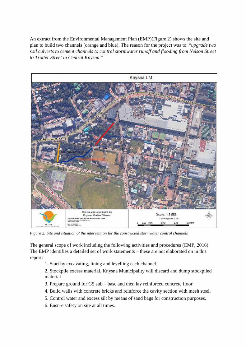
An extract from the Environmental Management Plan (EMP)(Figure 2) shows the site and
plan to build two channels (orange and blue). The reason for the project was to: “upgrade two
soil culverts to cement channels to control stormwater runoff and flooding from Nelson Street
to Trotter Street in Central Knysna.”
Figure 2: Site and situation of the intervention for the constructed stormwater control channels
The general scope of work including the following activities and procedures (EMP, 2016)
The EMP identifies a detailed set of work statements – these are not elaborated on in this
report:
1. Start by excavating, lining and levelling each channel.
2. Stockpile excess material. Knysna Municipality will discard and dump stockpiled
material.
3. Prepare ground for G5 sub – base and then lay reinforced concrete floor.
4. Build walls with concrete bricks and reinforce the cavity section with mesh steel.
5. Control water and excess silt by means of sand bags for construction purposes.
6. Ensure safety on site at all times.

The project was still in progress when the
workshop participants visited the site. The
‘upgrade’ illustrates how planers continue
to use conventional drainage systems as
the preferred design and tool in sharp
contrast to SuDS and a water sensitive
approach to integrated urban water
management. The connection between
Pledge Nature reserve and construction in
the Trotter Street appeared to be the
missing link and this raised many obvious
questions among the workshop
participants who visited the two sites:
1. How should the design of the
stormwater infrastructure enhance
infiltration and reduce flow
velocities?
2. What is the hydraulic capacity of
the stormwater channels in the
Trotter Street area? What is the
capacity for Bok-se-Kloof
catchment as a whole? Is data
adequate to inform the current
construction?
3. What opportunities were
considered in the Bok-se-Kloof
catchment to mitigate flow
velocities, attenuate the stream,
reduce erosion and capture
sediment in the upper reaches?
4. What storm frequencies were used
to establish the hydraulic capacity
of the channel?
5. How will sediment be trapped and
managed in the current design?
6. Was any consideration given to
developing an alternative approach
to channelling the stormwater
before the concrete channel and
design was proposed?
7. How will the channel deal with
solid waste and urban contaminants
such as oils, grease, washoffs and
chemical compounds?
8. Are plans in place to monitor flow
and water quality?
9. What would an alternative SuDS
design look like in the area for the
Nelson/Trotter Street area if the
whole catchment was integrated
into the plan?
It starts at the top
Best practice in SuDS usually aims to
establish a series of treatments trains that
start at source control, then local and
finally regional controls. In this instance,
Pledge Nature reserve is where the source
control should begin by managing the
upper reaches of the stream. It would make
sense therefore to invest in improving the
local control in Pledge Nature Reserve that
could significantly raise the potential to
improve water quality and flood control. A
number of obvious actions would need to
be done to improve the management of the
reserve which include:
- Clearing of invasive weed from the
surrounding outside of the fenced
off reserve
- Constructing a series of ‘leaky
dams’ at various intervals along the
Brickelbos stream and to locate
these so that the management of
valuable sediment can be collected
and can be extracted and re-used
where possible
- Assessing the role and capacity of
the two existing abatement dams /
ponds in the Reserve to determine
their ability to attenuate stormwater
- Developing a management plan to
harvest reed and macrophyte plant
growth in the abatement ponds
- Establishing various SuDS
interventions downstream of the
nature reserve – e.g. permeable
paving; biofilters; swales, among

others to enable improved local
control
- Raising interest and awareness
about the role of the Pledge Nature
reserve in contributing to urban
drainage, e.g. education campaigns
targeting municipal officials,
ratepayers and public; workshops
and applied research projects
- Establishing monitoring systems,
e.g. continuous data reporting
systems on water flow and quality
to measure that are capable of
collecting data on the effectiveness
of interventions.
Discussion
Knysna’s greatest natural asset was its
lagoon and estuary which supports a
biodiversity of fauna and flora – a natural
beauty that supports its tourism economy.
This natural environment has undeniable
value but at the same time demands a
concerted effort to protect and manage the
asset for future generations.
Hence, it was disappointing to observe the
implementation of more conventional
canalisation of stormwater in an effort to
mitigate against flooding in the lower
Brickelbos stream – actions that omit the
management of containing flow,
improving water quality and aesthetics,
and enhancing ecological systems and
services. The disconnection with
catchment as a whole appears as an
obvious missed opportunity. It must also
be acknowledged that flooding is risk.
There is unlikely to be single solution to
these events. Even a SuDS design and the
maintenance of such a system is not
without its challenges.
The game changer in the progression of
SuDS is unlikely to reside in SuDS
technologies but in a collaborative,
adaptive governance system that draws on
the strengths of a ‘community of practice’
that is characterised by shared learning
that aims to integrate urban water
management within the town, and in this
case, in Bok-se-Kloof catchment as a
whole. From our observations, it appears
that some elements of this governance is
already in place: a willingness on the part
of municipal officials and politically
elected officials to consider SuDS as an
option (hence the workshop); a strong
interest from local stakeholders; and a
history of public engagement that is
characterised by a rich set of skills and
local knowledge the Knysna socio-
ecological environment. The diagram
(Figure 3) identifies other elements of an
integrated urban water management
governance system. Thus, from reflection
on the workshop and interactions with
participants, it is recommended that more
attention should be given to: collaborative
planning; financial models that include the
benefits and returns of investing in SuDS;
a commitment to implement best
management practices; and the need to
exercise bold leadership and a stronger
commitment to build Knysna as a water
sensitive, climate resilient town that will
ensure the long term sustainability of
water quality and its impact of water on
the Knysna lagoon.
Figure 3: Elements for developing a community of
practice in integrated urban water management.

References
ALLANSON, B. R (2000) The Knysna Basin Project reviewed—research findings and
implications for management, Transactions of the Royal Society of South Africa, 55:2, 97-
100, DOI: 10.1080/00359190009520435
ALLANSON B.R, MAREE, B. and GRANGE, N. (2000) An introduction to the chemistry of
the water column of the Knysna Estuary with particular reference to nutrients and suspended
solids, Transactions of the Royal Society of South Africa, 55:2, 141-162, DOI:
10.1080/00359190009520440
KNYSNA MUNICIPALITY (2016) Environmental Management Programme for the
construction of two stormwater channels from Nelson Street to Trotter Street, Central
Knysna, Knysna Municipality Environmental Management Department.
MARKER, M. E. (2000) A descriptive account of sand movement
in the Knysna Estuary, Transactions of the Royal Society of South Africa, 55:2, 129-139,
DOI:10.1080/00359190009520439
PUBLIC CONTRIBUTOR (2013) The Scramble for Water in Eden & the Central Karoo
(Part 2) http://www.knysnakeep.org/scramble-water-eden-central-karoo-2/
THE PLEDGE NATURE RESERVE (n.d.)
http://www.pledgenaturereserve.org/history/index.html