Planning Together – Character Plans for Oak Park Commercial
85
Character Plans for Oak Park Commercial Districts Planning Together: Funded by: Village of Oak Park, Illinois University of Illinois at Chicago College of Urban Planning and Public Affairs Fall 2003
-
Upload
hoangkhanh -
Category
Documents
-
view
215 -
download
0
Transcript of Planning Together – Character Plans for Oak Park Commercial

Character Plans for Oak Park Commercial DistrictsPlanning Together:
Funded by:Village of Oak Park, Illinois
University of Illinois at ChicagoCollege of Urban Planning and Public Affairs Fall 2003


Character Plans for Oak Park Commercial DistrictsPlanning Together:
Funded by:Village of Oak Park, Illinois
University of Illinois at ChicagoCollege of Urban Planning and Public Affairs Fall 2003
Contact: Charles Hoch, Project Director
Urban Planning and Public PolicyUniversity of Illinois at Chicago
412 South Peoria Street, Suite 241Chicago, IL 60607-7065
ph: 312.996.2156fax: 312.413.2314


Credits and Acknowledgements
The UIC Project Team thanks and gratefully acknowledges the contributions of the citizens of Oak Park who worked with us over the past year to bring this participatory action research project to a successful conclusion. In particular, we wish to recognize the efforts of Village of Oak Park Trustees including President Joanne Trapani, Village Manager, Carl Swenson, Stakeholder Chairs, Bill Arnold and Lynn Kamenitsa.
The UIC Project Team (August 2002 to August 2003)Faculty Research Assistants VolunteersCharles Hoch Sara Beth Coffey (until Jan 2003) Howard Fink Saurav Bhatta Yukun Dong Praveen ShangunathanBridget Brown (until Jan 2003) Helen Edwards Ramki SrinivasanKazuya Kawamura Xin Li Ginger WhiteAimee Quinn Nina Martin Crystal WilsonLaxmi Ramasubramanian Amanda Perkins Jeromie Winsor Rachel Weber Jennifer McNeil Ting Wei Zhang William Neuendorf Nidhi Vaid
Michael Shiffer served as a special advisor to the project as a volunteer.
The final report was designed by Rachel Scheu with support from Xin Li.
The final project CD was designed by Laxmi Ramasubramanian, Nidhi Vaid and Crystal Wilson from the Great Cities Urban Data Visualization Program and Lab at UIC.


Introduction
I. Overview and Purpose 1
The Planning Context
Planning Goals and Objectives
II. Project Organization and Timeline 11
Background
Brief Summary of the Project Year
III. Creating Character Plans for Harrison Street and South Oak Park/Ike 17
What is a Character Plan?
Guidelines for Future Development
The Harrison Street Character Plan 21
South Oak Park Avenue/Ike Character Plan 37
Table of Contents
IV. Process, Participation, and Communication 49
Principles The UIC Process in Practice V. Innovations in Electronic Visualization and Communication 55
Why Use Electronic Visualization Tools
Creating Interactive Digital Applications Benefits and Constraints Associated with the Use of Digital Technologies
VI. Planning for Implementation 59 Unique Opportunities - Capping the “Ike” Planning and Regulatory Strategies
Transportation and Parking Improvements
Fiscal and Economic Strategies Citizen Participation
Adoption and Use of Digital Technologies Knowledge Management


ProjectThe Village of Oak Park, Illinois (VOP) and the College of Urban Planning and Public Affairs at the University of Illinois at Chicago (UIC) conducted a joint year-long collaborative planning process using new visualization and communication tools. The joint effort produced commercial character plans for the Harrison Street and South Oak Park Avenue-Eisenhower commercial districts, as well as guidelines and tools to prepare additional commercial plans in the future.ProcessThe collaboration tapped a variety of participants including local property owners, renters, business people and youth; Village elected officials, appointed commissioners and staff; and University of Il-linois graduate planning students and faculty. The collaboration proceeded in three phases. Fall 2002 involved extensive information collection, brainstorming and idea development that set the stage for making commercial district plans informed by extensive public input. Stakeholder groups formed in Spring 2003 reviewed and modified the initial plan alternatives proposed by the UIC team through Spring 2003. The UIC team developed the final plan recommendations during Summer 2003. ProductThe commercial plans for Harrison Street and the Oak Park/Ike districts recommend future changes in each area drawing on the analysis of current trends, the goals of different stakeholders and esti-mates of anticipated economic, traffic and parking impacts. The plans provide guidelines for Village trustees and others to use to anticipate and prepare for future development tailored to these two dis-tricts, as well as other districts throughout the Village. Village staff received training in some of the new electronic communication and visualization tools used to conduct the planning process and produce this report. The Village will receive an electronic version of this report for placement on the Oak Park Home Page. This visually attractive and user friendly plan will improve the accessibility and usefulness of the plan ideas and recommendations.Reading this Report The report has six parts: Chapter I describes the planning issues; Chapter II offers detailed accounts of the goals and objectives of the collaboration; Chapter III lays out the planning recommendations and impacts for each district; Chapter IV describes the participatory process, Chapter V describes the innovations in electronic visualization and communication and Chapter VI offers some ideas about implementation.
Introduction


1Planning Together: Character Plans for Oak Park Commercial DistrictsOverview and Purpose
The Pull of Convenience, Diversity and AmenityIn the last decade or so, demand for walkable, mixed-use urban-type development near rail transit stops has increased, especially in suburban areas across the entire United States. More single person, empty nester and young couple households want access to smaller dwellings requiring less upkeep and diverse amenities a short walk away from public transit.
The Push of Traffi c and Build OutBedroom suburbs, once resistant to all things urban, now embrace plans for new rail lines and stations. These built out communities face increasing traffi c congestion and few prospects for new peripheral development. Future development must go up and not out. More travel by train and bus must replace auto trips to alleviate impending grid lock.
The Planning Context
Push and Pull in Oak ParkOak Park already enjoys excellent fi xed rail and bus transit access. But this excellent capacity remains woefully underutilized. Recent project proposals brought before Village offi cials by developers provide evidence of demand for urban style mixed use residential living. The commercial aspects of such development remain relatively unplanned, especially for the two districts bordering the Ike. How can the Village best shape the market forces pulling the physical re-development of these two commercial areas toward an uncertain future? How can Oak Park balance the desire for a sustainable residential community with the increasing demand for diversifi ed commercial and residential services?
Oak Park
...at the center of themetropolitan region

2 Overview and Purpose
Planning Goals and ObjectivesBridge the Gap at the Ike
Almost half a century ago, the State of Illinois sliced Oak Park into two separate parts with the construction of the Eisenhower Expressway. The improvement for the entire region ripped apart the physical fabric of several existing neighborhoods, deepening the separation caused by surface rail lines. While the freeway improved access to the region for many Oak Parkers, it also disrupted commercial activity along Harrison Street and the shopping area on Oak Park Avenue at the Ike. At the same time the popularity of the automobile was growing along with the increasing decentralization of employment. The auto proved more convenient as a way to get to work than the train or bus. As a result, transit lost a large share of commuting trips to automobiles over the last several decades. In contrast, statistics show a steady growth in both the number of automobiles owned by the village residents and the average automobiles per household during the same time period.
The bridges constructed along with the Ike were designed to move traffic across and provide vehicle access to the expressway, not provide a graft that might help close the social, economic and aesthetic wound left behind. For decades Oak Parkers accommodated themselves to the rupture, accepting the separation as a necessary accommodation to the demands for greater accessibility. The quality and value of the housing stock near the freeway diminished relative to similar stock elsewhere in the Village. The commercial districts lost local customers and attention as places worthy of new private investment. The growth of strip shopping centers and regional malls took off across the region, and most Oak Parkers like other suburbanites, hopped in their cars, to do their shopping elsewhere.
The Eisenhower Expressway divides the neighborhoods of the VillagePhoto courtesy Village of Oak Park
View from Lombard Avenue BridgeUIC photo
[Bridge the Gap]
3Planning Together: Character Plans for Oak Park Commercial DistrictsOverview and Purpose
[Brid
ge the G
ap]In the past ten years or so local land owners, artists, designers, crafts people and assorted entrepreneurs have taken steps to reclaim and improve commercial properties in both the Harrison Street and Oak Park Ike Commercial Districts. Village officials have encouraged such investment and taken steps to improve infrastructure and parking. Residents, owners, employers and investors have gained confidence in the future prospects for each district. Many hope to build upon the recent improvements and take more ambitious actions to go beyond coping with the legacy of the expressway gap and try to find ways to fill it. Developing character plans provides a way to organize these interests and energies to help leverage Village support for joint improvement efforts.
Planning Goals and ObjectivesBridge the Gap at the Ike
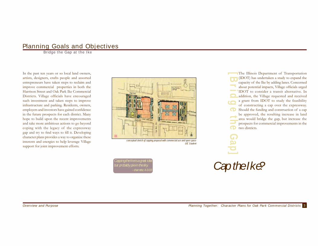
The Illinois Department of Transportation (IDOT) has undertaken a study to expand the capacity of the Ike by adding lanes. Concerned about potential impacts, Village officials urged IDOT to consider a transit alternative. In addition, the Village requested and received a grant from IDOT to study the feasibility of constructing a cap over the expressway. Should the funding and construction of a cap be approved, the resulting increase in land area would bridge the gap, but increase the prospects for commercial improvements in the two districts.
Capping the Ike is a great idea but probably pie in the sky.
- charrette, 4-3-03
conceptual sketch of capping proposal with commercial use and open spaceUIC Student
Cap the Ike?

4 Overview and Purpose
Planning Goals and ObjectivesTap Underutilized Transit Opportunities
Oak Park enjoys the service of two train lines and seven stations: three Blue Line stations at Austin, Oak Park and Harlem and four along the Green Line elevated tracks at Austin, Ridgeland, Oak Park and Harlem. Few suburbs in the region enjoy such extensive access to fixed rail transit. At the same time auto traffic continues to grow along suburban arterials and freeways – especially at peak commuting times. The best traffic reduction strategy finds ways to convince people to use alternative modes of travel.
Transit commuting held steady among Oak Parkers during the 1990s at about 22 percent of all trips. Although above average for most communities, local reliance on transit remains well below current transit capacity. Transit use could rise quickly if the right incentives are applied to enhance demand. In addition, since commuting accounts for only about one in four trips, attracting demand for shopping, social and recreational trips could also increase transit ridership.
Developing housing and commercial activity near rail transit stops that caters to residents and customers from outside Oak Park who already travel by rail represents another strategy. Attracting newcomers requires changes to the current mix of residential and commercial uses in the districts adjoining each station. The crucial ingredients include increased density and attention to public amenities. If people need only walk a short distance from their home to take the train the convenience level remains high. Additionally, people will be more likely to walk where they feel secure and the surroundings offer interesting and beautiful things to see along the way.
New development near rail stations does increase densities, but increasing density alone does little to improve a commercial district and surrounding neighborhood. There are many innovative ways to organize the scale, form and texture of developments to weave increased density into the fabric of the existing infrastructure and housing. Good planning offers useful advice about how to envision and implement these innovations. Good development takes the planning to heart and proceeds in a deliberate and phased manner. The long term sustainability of suburban communities relies crucially upon a mix of residential and commercial densities tied to alternative transportation modes.
The two commercial districts are in close proximity to the Blue Line transit stations and the Ike

5Planning Together: Character Plans for Oak Park Commercial DistrictsOverview and Purpose
Planning Goals and ObjectivesPark Cars Conveniently Without Attracting More Cars
Drivers and commercial business owners routinely complain about the lack of parking near shops. Homeowners routinely complain about people parking on residential streets. Renters complain about the lack of on-street parking near their residence. Retailers want to minimize the friction any customer might face finding their way to the store. Convenient parking plays a crucial role in the success of attracting drive by shoppers. It is no accident that franchise food restaurants and convenience shops favor corner locations surrounded by small seas of parking spaces. Services and shops that cater to destination customers do not require that parking be visible and abundant – but adequate and accessible.
Many of the homes and apartment buildings in Oak Park were built more than sixty years ago before the automobile established dominance in the urban landscape. Newly constructed multifamily buildings include parking spaces for cars. Requiring two spaces per residential unit reduces demand for on street parking, but also reduces the amount of space available for living space. Also, providing too plentiful parking may also discourage reliance on public transit.
Many commercial establishments conduct business during daytime hours when most residents take their cars to work. The residential parking is empty as demand for local commercial parking increases. Developing commercial districts that combine residential and commercial buildings offers the opportunity to create shared parking areas that customers can use during daytime business hours and that residents can use to park their cars over night.
The two (commercial) districts have inadequate parking. I only go there mid-day when parking will be free. Otherwise, I go elsewhere.
- volunteer sheet, 9-18-02
[commercial]
[res ident ia l ]
Residential parking on Oak Park Avenue south of the Eisenhower is a big issue, and slots allocated for businesses are underutilized.
- studio, 12-04-02
[m u n i c i p a l ]
A parking garage is a better solution than removing buildings for surface parking. - charrette, 4-3-02
All parking garages are ugly. They will only attract more cars and congestion. - public meeting, 4-3-03 ANY parking improvement will help
in the long-run. - studio, 12-04-02
The parking signs in Oak Park are confusing. New signs were installed and the old signs weren’t taken down.
- studio, 10-9-02
The Oak Park comprehensive plan indicates parking priority: 1-Residents, 2- Businesses and 3- Commuters. Parking in Oak Park is not designed to accommodate commuters. - studio, 10-9-02
Lalo’s Restaurant on Oak Park AvenueUIC photo
UIC photo

6 Overview and Purpose
Enhance and Expand Viable Commercial Activity
Oak Park households have grown in prosperity in the decades since the expressway was built. But today, unlike fifty years ago, Oak Parkers make most of their commercial purchases somewhere other than Oak Park. Moreover, retail practices have changed dramatically since the Village’s business districts were first developed. Auto-oriented convenience stores require much larger lots and floor areas than the current parcels and building footprints allow. Many aging suburban communities face the same problem and seek to carve out space for big box retail stores. But there are recent examples of successful commercial business ventures such as, at Lake and Harlem in Oak Park and River Forest that seek to capitalize on local assets without trying to offer what other suburban locales do better.
Commercial improvements in the two Ike districts should focus on a combination of destination retail and local-serving retail and service businesses. Creating an identity that attracts customers becomes an important part of such improvement. The ‘character’ in the character plans speaks to this identity and helps give it shape. Part of the character building includes careful attention to the scale and physical organization of new buildings and other physical improvements. Part also includes making room for a merchandising mix that Oak Parkers and others from nearby communities (including Chicago) will want to patronize. Destination retail will generate the consumerdensitynecessary to support ancillary businesses, such as convenience stores and quirkier, specialty retailers. Some of these kinds of businesses are already in place,
Commercial growth on Harrison Street and Oak Park Ike could also have “spillover” effects on those businesses and properties
elsewhere in Oak Park. Economic spillovers depend on the linkages between the new businesses in the corridors and those in related sectors located nearby. For example, the addition of a landscaping company that purchased its flower beds from an existing Oak Park business would increase the volume of sales at
the existing business, generating sales tax revenues and potentially warranting the creation of new employment opportunities.
Planning Goals and Objectives
but currently not enough to make either locale a thriving commercial district.
More commercial uses will also translate into new employment opportunities and increased tax revenues from the new sales and property values that can offset some of the increasing property tax burden on Oak Park residents. Extending the draw of the
businesses beyond the Village will allow the municipality to “export” some of its fiscal burden (i.e., sales tax revenue could be derived from other taxpayers who do not live in the Oak Park).
We hope the charm and diversity of Oak Park will not be replaced by a slicked-up corporate mall look. Small businesses that provide useful services are used by the community, and really loved by those of us who are long-time residents of the area. We like the diversity and relative affordability of the area and would hate to see that lost. - internet form, 03-30-03
Oak Park Avenue storefronts - UIC photo
Oak Park Avenue - UIC photo
We should not recreate downtown OP on Harrison. Businesses on a smaller scale-restaurants, used book stores, music store, along with practical businesses like hardware or grocery store (as long as not huge chain)—seem appropriate. - email, 04-04-03
Harrison Avenue - UIC photo

7Planning Together: Character Plans for Oak Park Commercial DistrictsOverview and Purpose
Identify the Right Mix of Residential and Retail Use
Proposals for increased density are frequently met with resitance because so many of us have witnessed community improvement efforts that impose density increases that disrupt the physical fabric of the surrounding locale. Worse still are those projects that repeat the same homogenous form that allows only one use, for instance, clusters of public housing apartment towers surrounded by a wasteland of open space. Contrast this memory of ugly and unworkable density with the tall residential buildings arrayed along portions of Lake Shore Drive in Chicago. Unlike the homogeneous public housing blocks, the lakefront buildings fit the fabric of their locale, exhibiting a variety of shapes and designs built up over a century. Obtaining attractive and workable density requires careful attention to fit and diversity over time. Oak Park has many older buildings that are functional, beautiful, and deserve preservation. But many other structures lack such qualities and might be removed in time to make way for new construction. Developing a character plan for a geographic area or district provides a framework for making judgments about the scale of the new buildings, as well as how well the building fits the surrounding locale, contributes to visual diversity and improves aesthetic appeal.
The tradition of separating uses in urban and suburban spaces emerged for reasons of public health. For instance, concentrate industrial uses in areas separated from residential areas to reduce the unhealthy and undesirable side effects of industrial activity such as soot, noise, stench and safety hazards. But the idea has expanded greatly since its inception to extend to virtually every type of land use. Separating, segregating and concentrating different uses have fostered the formation of expensive and inefficient clusters linked solely by roadways.
Mixed-use development refers to single buildings that include multiple uses, for instance, retail shops on the first floor, professional offices on the second floor and apartments on the third and fourth floors. The concept also includes the mix of uses within a block, for example, a retail store next to an apartment building that adjoins a restaurant. The two commercial districts already include some mixed use, but the character plans point out ways to alter this mix over time to increase both the quality and quantity of residential, commercial, open space and parking over time.
The mutually reinforcing relationship between residential and commercial growth provides economic justification for mixed-use development. Vibrant commercial areas often attract new residents, and in order for a business to thrive, a sufficient market of local and non-local consumers must exist. An increase in population (due to the new housing units) provides a potentially larger consumer base for any business growth, but the
demographic characteristics of the new residents would determine the degree to which they would be likely to patronize local businesses. Developing single-bedroom condominiums, for example, will likely attract smaller and younger households whose consumption patterns will differ from that of large families or seniors. If there is no consistency between the kinds of new commercial and residential development, the different kinds of growth may have no (positive) impact on each other.
The principles of fit and diversity also prove useful in assessing the right mix of use. However, fit in this case refers to judgments about the compatibility of activities. Economically this includes the market demand for each business as well as an assessment of the interactive benefits of each in relation to one another. Diversity refers to the variety of commercial activities needed for a district to pass a threshold of economic viability. The threshold might be measured using the rate of growth in sales, stability of tenure, or other indicators of economic success.
Planning Goals and Objectives
mixed-use buildings along Oak Park AveUIC photos
Santa Cruz, CACalifornia APA

8 Overview and Purpose
Planning Goals and ObjectivesProvide Design Guidelines to Encourage the New with Respect for the Old
Oak Park enjoys a variety of attractive physical and architectural features that not only include the Frank Lloyd Wright buildings, but many other fi ne buildings, parks and places. Oak Park has few of the physical ailments that plague local offi cials in suburban communities of similar style and age. Rapidly increasing residential property values and home prices has fueled a boom in local home improvement efforts. The abundance of trees and paved sidewalks provides an attractive and functional pedestrian friendly environment that many post war suburbs long for and that some of the newest and most innovative suburban subdivisions now provide. These Oak Park physical assets provide an important foundation for future improvements within the two commercial districts.
Fostering commercial economic growth and improvement in the two districts will mean adapting and changing the organization, density, scale and use of spaces, building and infrastructure within each area. Some of the current buildings may be modifi ed to make room for future commercial ventures, but the small size, age and confi guration of others precludes such modifi cation. In some places old buildings need be replaced with new. In some spaces lots may need to be joined to provide space for new buildings to attractively house both businesses and residents. Most of this kind of improvement will occur project by project over decades. Planning guidelines provide a framework for judging project proposals over time to ensure that improvement to any one site contributes to the improvement of the district and the Village.
all photos this page courtesy of Village of Oak Park

9Planning Together: Character Plans for Oak Park Commercial DistrictsOverview and Purpose
Improve Village Capacity
Village trustees, officials and staff share a deep commitment to citizen participation and service. The Village has a well-deserved reputation for possessing a vibrant socially and politically active civic life. But participation has its costs. Deliberation and debate about the location, scale and value of proposed improvements, whether private developments or public facilities, takes time and often generates frustration among participants who feel their ideas have no impact. Specific experiences and ideas cannot readily find a place in adversarial debates except as evidence for one position or another. Ironically, public officials also find themselves frustrated because adversarial debates tend to harden positions without identifying common or shared interests or benefits.
Planning cannot resolve adversity directly, nor does it seek to substitute for important differences of belief or opinion. Planning introduces conceptual frameworks and techniques for improving the quality of deliberation among relevant participants. Planning that works well improves the intelligence of participatory democracy by helping participants learn how to evaluate and anticipate the shared consequences of proposed projects for the future. When people start planning they attend to the consequences of different elements of a proposal rather than focusing exclusively on their own interests. Planning makes sense in urban settings where the individual decisions of each of us impacts so readily upon our neighbors. Plans help public officials intelligently balance the interests and needs of each individual against the collective welfare of us all. When local citizens participate in the planning this improves the quality of the judgments and the advice that officials will use to make decisions about development proposals or infrastructure improvements.
The planning activity and recommendations described in this report directly build upon the 1990 Comprehensive Plan for the Village. The recommendations elaborate and implement many of the goals, objectives and policies approved in the Comprehensive Plan. See Appendix 1 for a summary of the 1990 Comprehensive Plan’s Goals and Objectives.
Ensure renters, homeowners equally included. -email, Fall 02
[create a process that can be replicated]
If the local folks do not buy into this process it is doomed from the start. By the way, watch for my letter to the editor in either the Oak Leaves or the Wednesday Journal. - email, Fall 02
Consider me a resource, I will have comments throughout the process. - email, Fall 02
Kudos to your team for taking a big first step toward inviting broad public input to the planning process! It’s my hope that you’ll be able to follow up and refine the tools to better ensure full comment and easy, assure participation. - email, Fall 02
I like the idea of internet/intranet. Information will need to be updated often. The tools are a great asset for the Village to have if efforts are not duplicated. How do we maintain the database in the future? - email, Fall 02
Planning Goals and Objectives

10 Project Organization and Timeline

11Planning Together: Character Plans for Oak Park Commercial DistrictsProject Organization and Timeline
The project began as a result of a conversation in March 2002 between two Oak Park neighbors —a Village elected official and a professor in the Urban Planning Program at the University of Illinois at Chicago (UIC). Their discussion about new innovations in planning communication using digital technologies and the potential for improving professional planning prompted the President to enquire if faculty would be willing to contribute professional services to improve the Village’s planning capacity. Since many of the UIC faculty are also Oak Park residents, this project provided UIC planners a wonderful opportunity to contribute to the development of their community by sharing their professional expertise.
Subsequently, the Village invited UIC to respond to a request for a proposal to improve planning capacity. In summer 2002, the UIC-Oak Park project team comprising of five faculty (Bhatta, Hoch, Kawamura, Weber, Zhang) from the Urban Planning department, a research faculty member (Ramasubramanian) from the Great Cities Urban Data Visualization Program and Laboratory — a UIC research center, and a faculty member (Quinn) from the UIC Library agreed to collaborate on this participatory action research project. The project was intended to:
Project Description and TimelinesProject Organization, Participation and Background
[ b a c k g r o u n d ]

12 Project Organization and Timeline
Project Description and Timelines
Design a process by which neighborhood buisness district plans can be developed using "best practices" in public process and technical planning theory.
Develop a set of tools for creating the processs using innovative electronic media, financial models, and other state-of-the-art methodologies.
Produce two neighborhood business district plans as a product of the process that will articulate the values of the community and the design character of the two districts.
After several meetings with Village staff and trustees, the Village of Oak Park and the University of Illinois approved a contract to begin in August 2002.
August 2002 to August 2003Seven UIC faculty, an academic staff person, and twelve graduate research assistants worked on this project over the course of the year (see credits page). Students from two graduate studio classes also actively participated in the projcet. (Appendix 2).
The team began work on the project in late August 2002. The project was organized into three phases to fit the tempo of academic life:
Phase I/Fall semester (September through December 2002), Phase II/Spring semester (January to May 2003), and Phase III/Summer (June to August 2003).
September through December 2002During the Fall semester, UIC faculty organized two studio courses, and with the Village's collaboration, organized a studio space in the community at 828 S. Oak Park Avenue to eoncourage citizen involvement in the planning and design activities on a day-to-day basis.
The Urban Design Studio generated a database of best practices and other related design examples relevant to the Oak Park project. The students also documented the existing conditions of the two retail business corridors, both with digital photographs and traditional notation that included a compilation and analysis of census data, zoning regulations, urban design problems and opportunities, and a preliminary analysis regarding barriers to economic development. Design concepts that directly addressed the transformation of the two commercial districts and design guidelines written to shape new development also emerged through this studio.
The Participatory Planning and Information Technology (IT) Studio generated two interactive digital applications to facilitate spatial planning. The first proposal was a internet-based
mapping tool to link available census data and other specialized local information (community assets). The second proposal was a web-based planning portal designed for the use of community groups such economic development organizations. Both these applications are available on the companion CD-ROM. A more detailed summary of each of these applications is available in Appendix 3.
The Great Cities Urban Data Visualization Program and Lab (GCUDV) is a research center at UIC that seeks to inform urban planning and policy discourse at a variety of scales (ranging from neighborhood to city/regional scale) through the innovative use of digital spatial multimedia applications. For the Oak Park project, the Lab developed web-based surveys, an annotated map application, and two interactive internet-based computerized sketch tools.
During UIC’s intersession, the UIC team reviewed all the data gathered by the students in the two studios in order to develop an analytical model to interactively balance the mix between residential and retail development in each business district and assess resultant impacts. Appendix 4 describes the data available in the model and the spreadsheets are downloadable from the companion CD-ROM. At this time, broad planning and design themes were developed for each business district
Background, Summary and Phase I[phase I - fall]
[ s u m m a r y ]
[ p r o j e c t g o a l s ]
urban design studio graduate students in studio in Oak ParkUiC photo
1
2
3
13Planning Together: Character Plans for Oak Park Commercial DistrictsProject Organization and Timeline
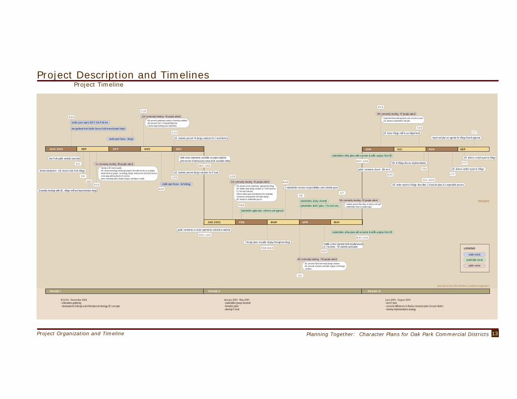
Project Description and TimelinesProject Timeline
AUG 2002
PHASE I PHASE II PHASE III
SEP OCT NOV DEC
JAN 2003 FEB MAR APR MAY
JUN JUL AUG SEP
text-only version of this timeline is available in Appendix 5
8/26
9/1
9/4
9/18SEP
NOV
11/5
12/4
12/5
DEC-JAN
studio space opens 828 S Oak Park Ave
studio open house - design
FEB
stakeholder application, selection and approval
studio open house - technology
UIC students present 18 design solutions for 2 retail districts
public comments on vision statements solicited on website
DEC-JAN
-draft vision statements available on project website-pilot version of web-based survey tools available online
FEB-MAR
MAY-JUN7 design plans on public display throughout village
UIC students present design solutions for IT tools
4/5
stakeholders draft 2 plans; 1 for each area
4/25
5/7
6/19
middle school charrette held simultaneouslyin 2 locations ~50 students participate
7/29
UIC & Village discuss implementation
8/25*
9/15*
UIC delivers written report to Village
9/08*
UIC delivers verbal report to Village
6/30
public comments closed - 204 rec'd
stakeholders refine plans with economic & traffic analysis from UIC
MAY-JUN
stakeholders refine plans with economic & traffic analysis from UIC
JUL-AUG
UIC writes report to Village: describes 2 character plans & a repeatable process
stakeholders all day charrette
7/28
UIC trains Village staff to use digital toolsreport and plan on agenda for Village Board approval
MAR
2 stakeholder sessions-responsibilities and schedule given
two graduate level studio classes built around project begin
Oak Park public website launched
formal introduction - UIC team to Oak Park Village
bi-weekly meetings with UIC, village staff and representatives begin
-introduce UIC team to public-UIC shows technology and design projects from other locales as examples-break into focus groups - technology, design, Harrison Ave and Oak Park Ave-come away with laundry list of concerns-leave community with schedule of topics and dates in studio
-UIC presents vision statements, approved by Village-UIC whittles down design solutions to 7 (4 for HarrisonSt, 3 for Oak Park Ave)-citizens outline goals and objectives for residential,commercial, transportation and urban design-UIC introduces stakeholder process
-UIC presents preliminary analysis of existing conditions-UIC presents Tool 1: Annotated Map Tool-Citizens begin drafting vision statements
-UIC presents high & low imapct design solutions-UIC presents economic and traffic analysis of all designsolutions
1st community meeting ~80 people attend
4/3
2nd community meeting ~50 people attend
1/29
3rd community meeting ~45 people attend
4th community meeting ~150 people attend
-moderated forum with questions and concerns to team-UIC presents stakeholders' final plan
6th community meeting ~47 people attend
-students present their ideas to citizens and staff-stakeholders listen to student input
5th community meeting ~50 people attend *anticipated
- information gathering- development of design and information technology (IT) concepts
- stakeholder groups involved- formalize plans- develop IT tools
- test IT tools- reconcile differences to finalize character plans for each district- develop implementation strategy
studio events
stakeholder events
public events
LEGEND

14 Project Organization and Timeline
Project Description and Timelines
Over the Fall semester, UIC also began a collaborative planning process that combined formal public meetings with Village trustees and local residents with informal gatherings with individuals and small groups in the local studio space, routine meetings with key Village staff. UIC faculty used on-line communication extensively through a project web-site that was launched in early September 2002.
scratch, but used planning tools and information provided by the UIC team to refine the goals, objectives, and ideas proposed by participants during the numerous community meetings held between September 2002 and January 2003. The UIC project team believes that a working group of stakeholders was essential to pare down the many ideas into a program that is practical to implement and reflective of diverse community concerns. This group met several times in Spring-Summer 2003 to help bring shape to final recommendations contained in this report. Appendix 6 includes plans developed by stakeholders for each district.
The UIC team solicited participation and invited individuals to apply to become stakeholders. Extraordinary efforts were made to publicize the creation of this group including announcements in the Wednesday Journal, on the UIC project website and the Village’s newsletters; mailings to participants in previous meetings as well as 600 local residents living adjacent to the districts; posters displayed in storefront windows in each district; and more than 100 handbills distributed to shoppers, workers, and residents of the areas.
More than 70 people responded to the invitation and volunteered to join the stakeholder group. From this pool, UIC staff identified thirty participants and four alternates, taking care to maintain a balance between local interests (the two business districts) and the interests of the village at large. The final selection was made
Phase II, Phase III and Stakeholders
Spring Semester January to May 2003In the Spring semester, the UIC project team began the task of focusing the wide range of planning ideas and interests generated during public meetings into planning recommendations. The UIC team proposed formation of stakeholder groups for each district to help prepare planning recommendations based on the extensive input collected from citizens at large.
by the Village Trustees. The stakeholder group included representatives from among the residents, property owners and business owners within each district, as well as citizens from outside the two study areas including members from the Historic Preservation Commission, the Plan Commission, the Community Design Committee, and the I-290/Eisenhower Citizens Committee.
While the stakeholder group was being organized UIC also distilled the broad planning themes into two planning alternatives (scenarios) for each district. One alternative was labeled “low impact” and contained minimal changes to the existing built environment. The second alternative “high impact” scenario pushed the envelope and took the comments made at the earlier public meetings to their logical conclusion. The alternatives were designed to provoke conversation, comment, and debate. The one hundred fifty or so citizens who came together to review the project’s progress on April 3rd, 2003 at a public meeting held at the Percy Julian Middle School certainly expressed their opinions in no uncertain terms about which plan they preferred.
Stakeholders listened to the citizens at large and then deliberated intensively in a one-day Charrette held on April 5th 2003. Those deliberations resulted in a stakeholder plan for each of the districts which was reviewed and refined between April and June. The UIC team met with each stakeholder group to explain and
[phase II - spring]
[stakeholders]
clarify the economic and transportation impacts of their proposals.
The project’s web page expanded to include transcripts of the discussions at public meetings and citizens could download plans that showed changes that were being made to the designs. UIC faculty also ran two separate planning charrettes in both Middle Schools to involve youth in the planning process. At a special community meeting, the young participants presented their planning and design ideas to the adults in the community.
Summer Semester June to August 2003 The sumer opened with the last formal meeting inviting participants to offer feedback on the stakeholder prepared plans and planning process. UIC organized a moderated question and answer forum in which representatives from UIC, the village staff, and the stakeholders participated. The project web site closed on June 30th, 2003. The UIC team and Village staff entered the final phase of plan preparation. In July 2003, UIC students designed and ran a one-day training session for Village staff on the use of the electronic visualization tools developed for the project. In addition, UIC faculty also held meetings with Village staff to discuss issues related to plan implementation.(A graphic timeline of the project is on page 13. A text version of the timeline is in Appendix 5.)
Stakeholder Group’s Mission: The stakeholder group consists of thirty citizens who collectively represent diverse Village interests, but all share a commitment to improving plans for the future of commercial activity in Oak Park. They advised the UIC planning team on the desirability, relevance and feasibility of draft planning guidelines and proposals for each district. The stakeholders did not start from
[phase III-summer]

15Planning Together: Character Plans for Oak Park Commercial DistrictsProject Organization and Timeline
Project Description and TimelinesParticipationTimeline
PHASE I - 8/02 thru 12/02 PHASE II - 1/03 thru 5/03 PHASE III - 6/03 thru 8/03
200
100
150
50
AUG 2002 SEP
NU
MB
ER
OF
PAR
TIC
IPA
NT
S
OCT NOV DEC JAN 2003 FEB MAR APR MAY JUN JUL AUG SEP
6/30 public comments closed - 204 rec'd
PUBLIC PARTICIPATION 8/02 THRU 8/03

16 Character Plans for Harrison Street and South Oak Park Avenue/Ike

17Planning Together: Character Plans for Oak Park Commercial DistrictsCharacter Plans for Harrison Street and South Oak Park Avenue/Ike
What is a Character Plan?
Character plans offer advice for guiding the future physical development of a distinct geographic district within a larger community. In built out districts such as the districts selected for study through the UIC-Oak Park project, the advice centers on the relationship between the current physical landscape and future changes. Alternative development schemes for the future are compared and evaluated using a combination of publicly expressed desires and professional expertise. Once adopted, a character plan informs the expectations of residents, owners, investors, visitors and developers. The plan also helps frame and guide the decisions by the local public authority responsible for regulating and approving changes to the built environment.
Good character plans are:
Fair: involve relevant stakeholders without giving anyone unfair advantage.
Balanced: include the expectations and interests of current and future residents.
Contextual: build upon current physical assets and make way for future improvements.
Comprehensive: consider the plan effects on both those inside and outside the district.
Sustainable: adapt economic and social improvements to important environmental limits.
The UIC team spent more than nine months listening to the residents of Oak Park share their ideas about what the character plans for each district should include. The plans below include many, but not all, of these ideas. The plans that follow represent a distillation of widespread public input, not a rigid crystallization.
The visions and goals presented herein remain largely faithful to the testimony and feedback of the participants who played an active role in the planning process. Two stakeholder groups helped us apply these goals along with important planning principles to create and assess draft character plans for each district The UIC team refined these draft alternatives to ensure that all the critical development issues were addressed in the final plans.
I’m a proponent of high density for areas like Oak Park Avenue and the Harrison Street district. They are close to the El and make good candidates as areas for high density housing and small commercial establishments. -S. Oak Park Ave. resident - public meeting, 4-3-03historic Oak Park home
UIC photo
stakeholders’ meetingsphotos courtesy of Village of Oak Park
Increasing density is not what Oak Park needs. It will increase traffic, create a need for ugly parking garages and ultimately result in the loss of precious green space. Moreover, it seems unlikely that high-end condo buyers will be interested in purchasing a unit that backs up to the Ike. The risks created by increasing density are great. - email, Spring 03

18 Character Plans for Harrison Street and South Oak Park Avenue/Ike
Planning and Design Guidelines for Two Commercial DistrictsGeneral Guidelines
The Purpose and Limits of Guidelines
The following guidelines for commer-cial district plans in Oak Park combine professional planning principles with the local knowledge of Oak Park residents, stakeholders, staff and officials. These guidelines translate this combination of experience into a practical shorthand for improving judgements about changes in the physical character of commercial dis-tricts in Oak Park.Guidelines inform public deliberation about the location, intensity, use, scale and form of commercial development. They do not function as standards. Standards define rules about the design and use of specific features of the build environment. For instance, we follow guidelines to pre-pare food safely in our kitchen, and these function differently than specific standards regarding refrigeration or cleanliness for specific foods.
Commercial-The economic viability of commercial establish-ments ultimately relies upon market demand and not simply physical improvements.
-Improvement to Village commercial areas should support a mix of convenience and destination com-mercial activity that will foster economic growth.
-Physical signs or symbols created to represent a unique district identity can attract consumers from outside the Village. -Reward development proposals that combine com-mercial and residential use and allow for more density. -Foster an organic mix of businesses (moderate and small scale, new and old, local and franchise) that improves customer service while enhancing local character.
-Attract a few high-profile destination retailers should attract additional customers to the small shops and bring in expenditures from outside the Village. -Tenants should offer goods and services that appeal to a younger demographic.
-Reward commercial site design features that soften and buffer the edge between commercial and residen-tial uses.
Residential-Reward mixed residential project proposals that combine housing types (e.g., multi-family and town homes)
-Discourage uses that will diminish residential property values.
-Increase the number and proportion of multi-family dwellings. -Ensure a balanced and diverse mix of hous-ing to ensure affordability across of wide range of income groups
Transportation-Create an environment where people are presented with a variety of feasible transportation alternatives to satisfy their travel needs. -New or improved establishments should be friendly to pedestrians and bicyclists as well as drivers.
-The effectiveness of transit-oriented-development and other urban designs on affecting travel behavior should be evaluated based on valid empirical studies.
-Every effort should be made to present transit as an attractive and competitive alternative to driving alone especially in the area with excellent transit access.
-Provide sufficient parking to meet demand and avoid over-supply of parking. -Commercial and some residential off-site parking acceptable if the walk between destination and park-ing safe, short and pleasant. -New parking additions and improvements should favor shared parking arrangements to maximizes parking space use.
-For local and some collector streets various traffic calming measures should be used to create a pedes-trian-friendly environment.

19Planning Together: Character Plans for Oak Park Commercial DistrictsCharacter Plans for Harrison Street and South Oak Park Avenue/Ike
Planning and Design Guidelines for Two Commercial DistrictsGeneral Guidelines
Design-Building heights along the linear blocks should be the same height to encourage visual continuity and balance along commercial cor-ridors.
-District corridor gateways should designate the boundaries of each district.
-Rehabilitation and new construction of buildings should build upon and respect the best physical features of existing buildings.
-Each commercial area should have a physical focal point that makes room for diverse civic activities. The focal point might include open space, a park, a fountain, statue or sculpture or some combination of physical features that invites pedestrian use and facilitates a mix of commercial and public activity. Public plazas or squares offer a familiar example.
-Signs placed over sidewalks should extent no further than 50% of the distance from the face of the building to the curb line
-Signs should not obscure architectural details of commercial buildings.
-Sidewalk cafes and other merchandising amenities should be encouraged but care should be taken that these improvements do not impede pedestrian traffic.
-A minimum of 15 feet sidewalk width is needed to accomodate outdoor cafe activities so that at least 6 feet width is available for pedestrian movement.
-Set backs on upper floors of new commercial buildings can be set back at least 15 feet above the prevailing cornice line to preserve the visual integrity of the existing street wall.
All sketches this page from City of Chicago Design Guidelines for Neighborhood Commercial Districts

20 Character Plans for Harrison Street and South Oak Park Avenue/Ike

21Planning Together: Character Plans for Oak Park Commercial DistrictsCharacter Plans for Harrison Street and South Oak Park Avenue/Ike
Harrison Street Retail Business District Character PlanVision and Goals
Harrison Street is a thriving destination that balances the needs of its residents, business owners, and visitors. Arts activity continues to define the character of the district, but has now diversified to include a wider mix of destination and convenience commercial activity. The scale and character of the neighborhood’s buildings and landscaping should maintain strong continuity with the rich historical and architectural traditions of Oak Park.
Harrison Street stakeholdersphoto courtesy Village of Oak ParkHarrison Street stakeholders
photo courtesy Village of Oak Park
Vision statements developed by citizens, refined by stakeholders and UIC.
[vision statement]
Commercial−Increase diversity of commercial activity while retaining unique arts focus.
−Attract mix of consumers (income, age, and residence – i.e., local vs regional)
−Promote select destination retailers.
−Improve pedestrian and auto access to businesses. Residential−Increase density to support successful transit oriented mixed use development.
−Foster family-oriented residential uses.
−Encourage a mix of multi-family dwellings. −Retain a viable mix of rental and owner occupied dwellings.
Transportation−Reduce through traffic.
−Increase use of transit.
−Increase bicycle and pedestrian use.
−Remedy parking shortage.
−Improve safety for travelers within the district.
Design Character−Highlight arts and craft theme to create visual interest.
−New construction complements existing scale and form.
−Create spaces and buildings for performing arts.
−Increase green spaces to offset and relieve increases in density.
−Create pedestrian friendly improvements.

22 Character Plans for Harrison Street and South Oak Park Avenue/Ike
Harrison Street Retail Business District Character PlanExisting Conditions: Commercial and Residential
The Harrison Street district enjoys a unique identity as an Arts District: it stands out from neighboring districts through its unique arts-related retail offerings which serve as a destination for residents outside of Oak Park that support and foster local talent. This corridor serves as a gateway to the Village of Oak Park due to its location on the border of Chicago, and proximity to the Eisenhower Expressway. The area includes many active residents and business-owners seeking to improve the physical quality and economic vitality of the area. Commercial
The Harrison Street corridor includes more than 40 business establishments in mixed and exclusive commercial properties that account for about a fifth of the total land use. Over the past decade artists and gallery entrepreneurs wisely capitalized on the inexpensive rents and older buildings to create a locale for local and some regional arts activity and commerce. Ironically, the social and cultural success of their efforts has increased the value of the land within the district creating economic pressure to raise rents. The relatively small size of most businesses and their scattered location along the corridor has not fostered significant improvement in local commercial growth. Most customers come from the surrounding residential neighborhood and the modest stream of commuters using public transit.
ResidentialApproximately 9,000 people lived in the two census tracts surrounding the Harrison Street District in 2000. Population declined slightly over the decade due mainly to reductions in household size. Household incomes increased more for those living north of the expressway exceeding the average for the Village, while increases for households south of the freeway lagged. Residents were younger and more likely to rent compared to Oak Parkers in general. But overall households were increasingly middle aged – reflecting the larger demographic trend of aging baby boomers in the U.S.
Signage identifies Harrison Street Arts District UIC photo
facade on Harrison StreetUIC photo
Harrison Street area demographics2000 census

23Planning Together: Character Plans for Oak Park Commercial DistrictsCharacter Plans for Harrison Street and South Oak Park Avenue/Ike
TrafficAustin Boulevard, the prime arterial route that links the district with the adjacent expressway handles a minimum of 26,000 cars per day. Harrison Street serves as a collector route. Traffic along Harrison between Austin Boulevard and Ridgeland Avenue averages between 9,000 and 10,000 cars per day. Ridgeland Avenue, also a collector, carries about 18,000 cars per day. While Madison Avenue provides much greater capacity for east-west travel, many drivers access the expressway using Harrison, contributing to the traffic. Current commercial and residential activity in the Harrison district generates an estimated 7,800 trips a day (6,300 by auto).UIC conducted a traffic count at the Austin Boulevard and Harrison Street intersection during peak evening travel in Fall 2002. Among the 1,400 cars traveling north on Austin during a single hour; 35 percent turned left onto Harrison Street, and 65 percent continued north. During the same interval, of the 900 cars traveling south on Austin; only 6 percent turned right onto Harrison, while 94 percent continued south. Most eastbound travelers using Harrison Street turned south on Austin, while only 15 percent turned to travel north. This peak hour activity puts the intersection at sixty five percent of capacity earning an acceptable “B” level of service. But the direction of the flow to and from Harrison Street documents how the corridor carries through traffic from outside the District to the expressway entrance at Austin.
Harrison Street Retail Business District Character PlanExisting Conditions: Transportation - Traffic, Transit and Parking
TransitThe CTA Blue Line station at Austin Boulevard and the Ike serves approximately 1,500 to 1,800 riders each weekday. Weekend ridership is slightly lower and more variable ranging from 400 to 950 passengers per day. Most travelers use the eastern Austin Boulevard rather than western Lombard entrance. Although train ridership was stable between 2000 and 2002, bus ridership declined slightly during this period. Between 6,500 and 9,000 passengers traveled on the Austin Boulevard bus each week day with a third as many on weekends. Despite excellent transit access, use of mass transit for work trips declined from 26 percent in 1990 to 17 percent in 2000 among the residents living in the census tracts surrounding the Harrison Street District. In contrast, nearly 25 percent of suburban Evanston residents used transit to get to work. Thus, it is safe to say there is an untapped potential for transit services for this area.
ParkingThe Harrison Street District includes approximately 600 parking spaces. Nine Village parking lots (Lots 33, 49, 54, 76, 77, 78, 93, 103 and 114) account for a third of this total. The remaining spaces include on street and private parking. UIC analysis uncovered a shortage of about 60 parking spaces. Additional parking frustration occurs as drivers may not find convenient on street parking given the combination of spread out shops and parallel parking. Finally, parking restrictions and business hours do not always correspond.
DISTRICT YEAR DROVE ALONE CARPOOL TRANSIT WALK OTHER WORK @ HOME
Harrison 1990 58.2 % 9.2 % 25.5 % 3.3 % 1.0 % 2.9 %Harrison 2000 63.7 % 8.4 % 17.3 % 4.9 % .3 % 5.4 %
traffic along Austin BoulevardUIC photo
existing transit stationUIC photo

24 Character Plans for Harrison Street and South Oak Park Avenue/Ike
Design CharacterThe Harrison District enjoys many pedestrian friendly features such as commercial buildings built to the sidewalk with large storefront windows. The streetscape includes well maintained sidewalk extensions, elevated planters, benches, signs, and street lights. The mix of residential and commercial buildings along the corridor reflects a much earlier era of commercial activity marked by less reliance on auto trips to supermarkets and big box retail outlets. Most of the commercial establishments do not meet standards for auto friendly convenience commercial activity. Many buildings languish, unable to meet the location and space needs of contemporary commercial investors.
The Harrison Street Corridor exhibits differences in streetscape, building type, architectural style and mixed land use that currently fragment rather than unify the district. The parts seem to work against one another rather than enhance one another. The negative impacts of the Ike remain dominant: creating a massive physical separation in the local market and tempting commuters to use Harrison as a speedy access route to the expressway. These impacts currently outweigh the benefits of resident access to public transit and visitor access to destination commercial establishments.
Harrison Street Retail Business District Character PlanExisting Conditions: Design Character
blank facades on Harrison Street need improvement
UIC photo
pedestrian friendly features need nurturingUIC photo
25Planning Together: Character Plans for Oak Park Commercial DistrictsCharacter Plans for Harrison Street and South Oak Park Avenue/Ike
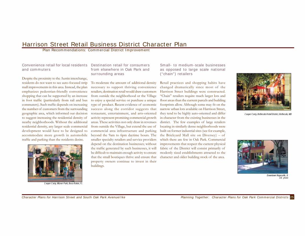
Convenience retail for local residents and commuters
Despite the proximity to the Austin interchange, residents do not want to see auto-focused strip mall improvements in this area. Instead, the plan emphasizes pedestrian-friendly convenience shopping that can be supported by an increase in foot traffic (particularly from rail and bus commuters). Such traffic depends on increasing the number of customers from the surrounding geographic area, which informed our decision to suggest increasing the residential density of nearby neighborhoods. Without the additional residential density, any larger scale commercial development would have to be designed to accommodate more growth in automobile traffic and parking than the residents desire.
Harrison Street Retail Business District Character PlanPlan Recommendations: Commercial District Improvement
Destination retail for consumers from elsewhere in Oak Park and surrounding areas
To moderate the amount of additional density necessary to support thriving convenience retailers, destination retail would draw customers from outside the neighborhood or the Village to enjoy a special service or purchase a unique type of product. Recent evidence of economic success along the corridor suggests that restaurant, entertainment, and arts-oriented activity represent promising commercial growth areas. These activities not only draw in revenues from outside the Village, but extend the use of commercial area infrastructure and parking beyond the 9am to 6pm daytime hours. The smaller specialty retailers and service providers depend on the destination businesses; without the traffic generated by such businesses, it will be difficult to maintain enough activity to ensure that the small boutiques thrive and ensure that property owners continue to invest in their buildings.
Small- to medium-scale businesses as opposed to large scale national (“chain”) retailers
Retail practices and shopping habits have changed dramatically since most of the Harrison Street buildings were constructed. “Chain” retailers require much larger lots and floor areas than the current parcels and building footprints allow. Although some may fit on the narrow urban lots available on Harrison Street, they tend to be highly auto-oriented and differ in character from the existing businesses in the district. The few examples of large retailers locating in similarly dense neighborhoods were built on former industrial sites (see for example, the Brickyard Mall site on Diversey) – of which there are few in Oak Park. Commercial improvements that respect the current physical fabric of the District will consist primarily of modestly sized establishments attracted to the character and older building stock of the area.
Cooper Carry, Mizner Park, Boca Raton, FL
Cooper Carry, Bethesda Retail District, Bethesda, MD
Downtown Naperville, ILUIC photo

26 Character Plans for Harrison Street and South Oak Park Avenue/Ike
Harrison Street Retail Business District Character PlanPlan Recommendations: Commercial District Improvement
The commercial space will be distributed along the following three nodes:
27Planning Together: Character Plans for Oak Park Commercial DistrictsCharacter Plans for Harrison Street and South Oak Park Avenue/Ike
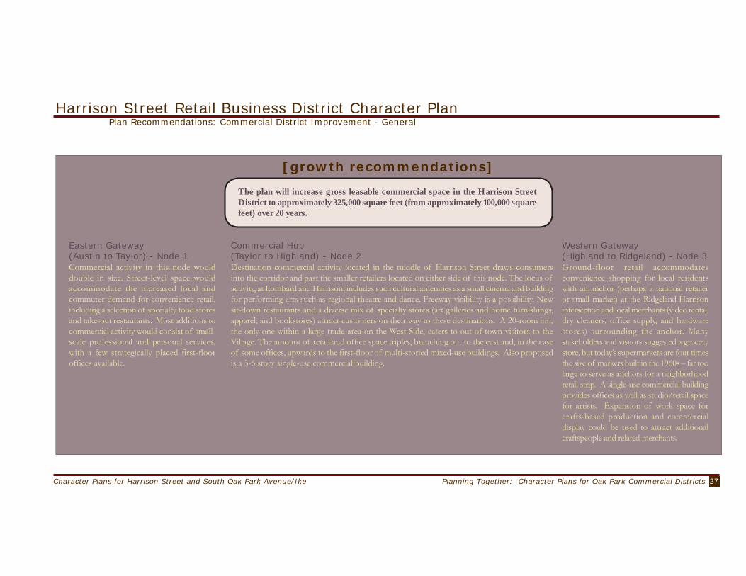
[growth recommendations]
The plan will increase gross leasable commercial space in the Harrison Street District to approximately 325,000 square feet (from approximately 100,000 square feet) over 20 years.
Harrison Street Retail Business District Character PlanPlan Recommendations: Commercial District Improvement - General
Eastern Gateway (Austin to Taylor) - Node 1Commercial activity in this node would double in size. Street-level space would accommodate the increased local and commuter demand for convenience retail, including a selection of specialty food stores and take-out restaurants. Most additions to commercial activity would consist of small-scale professional and personal services, with a few strategically placed first-floor offices available.
Western Gateway (Highland to Ridgeland) - Node 3Ground-floor retail accommodates convenience shopping for local residents with an anchor (perhaps a national retailer or small market) at the Ridgeland-Harrison intersection and local merchants (video rental, dry cleaners, office supply, and hardware stores) surrounding the anchor. Many stakeholders and visitors suggested a grocery store, but today’s supermarkets are four times the size of markets built in the 1960s – far too large to serve as anchors for a neighborhood retail strip. A single-use commercial building provides offices as well as studio/retail space for artists. Expansion of work space for crafts-based production and commercial display could be used to attract additional craftspeople and related merchants.
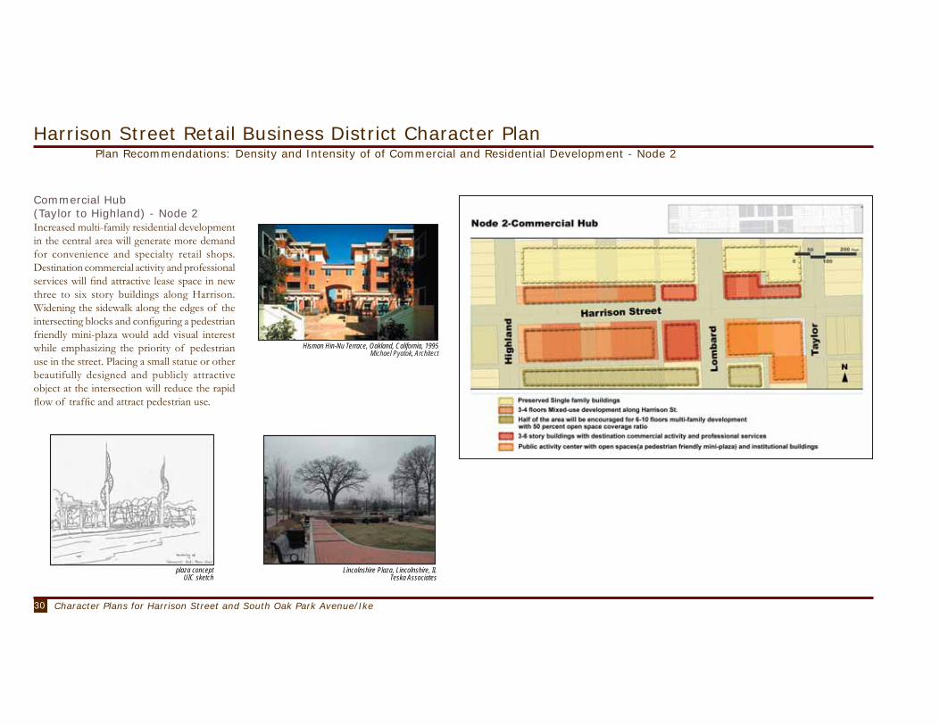
Commercial Hub (Taylor to Highland) - Node 2Destination commercial activity located in the middle of Harrison Street draws consumers into the corridor and past the smaller retailers located on either side of this node. The locus of activity, at Lombard and Harrison, includes such cultural amenities as a small cinema and building for performing arts such as regional theatre and dance. Freeway visibility is a possibility. New sit-down restaurants and a diverse mix of specialty stores (art galleries and home furnishings, apparel, and bookstores) attract customers on their way to these destinations. A 20-room inn, the only one within a large trade area on the West Side, caters to out-of-town visitors to the Village. The amount of retail and office space triples, branching out to the east and, in the case of some offices, upwards to the first-floor of multi-storied mixed-use buildings. Also proposed is a 3-6 story single-use commercial building.

28 Character Plans for Harrison Street and South Oak Park Avenue/Ike
Harrison Street Retail Business District Character PlanPlan Recommendations: Commercial District Improvement - General

29Planning Together: Character Plans for Oak Park Commercial DistrictsCharacter Plans for Harrison Street and South Oak Park Avenue/Ike
Harrison Street Retail Business District Character PlanPlan Recommendations: Density and Intensity of of Commercial and Residential Development - Node 1
The Harrison Street district should allow six to eight story residential or mixed use buildings for up to half of the land area between Harrison Street and the Eisenhower Expressway. The buildings adjacent to Harrison Street to the north would not exceed four stories to buffer the impact of the higher densities on the single family dwellings farther north.
Eastern Gateway(Austin to Taylor) - Node 1The Harrison – Austin intersection should be treated as an important entryway to the Village. The beautiful eastward vistas provided by Columbus Park will be captured by residents in higher density buildings at the intersection and along Austin Boulevard. The eventual re-location of one or both service stations replaced with high rise mixed use buildings would mark the entry to the district placing the highest density at the edge of large open park space. Increased density of six to ten stories on the southern block [limited to about half the total area] should encourage pedestrian access to CTA trains and buses. Density increases of six to ten stories north of Harrison should be limited to buildings adjacent to Austin. Other buildings facing Harrison Street on the north side should not exceed four stories.
Improvements in pedestrian access and safety at the Austin CTA station on the expressway bridge should be made. The design and construction of these improvements should be tied to the development of high density mixed use projects at the Harrison - Austin intersection. Planning and funding for such improvements would combine resources from CTA, IDOT, the Village and developer. Pedestrian walkway improvements and associated public open spaces could be linked with increased density bonuses for mixed use project developers. The Village should work with the City of Chicago and the Chicago Park District to foster creation of park improvements at the Austin intersection that increase pedestrian related activity, while enhancing the physical beauty of this edge. For instance, creating a memorial site for the park designer Jens Jensen that includes pedestrian friendly landscaping and seating.
Congress for New Urbanism Church Street Plaza, Evanston, Illinois Teska Associates
30 Character Plans for Harrison Street and South Oak Park Avenue/Ike
Commercial Hub(Taylor to Highland) - Node 2 Increased multi-family residential development in the central area will generate more demand for convenience and specialty retail shops. Destination commercial activity and professional services will find attractive lease space in new three to six story buildings along Harrison. Widening the sidewalk along the edges of the intersecting blocks and configuring a pedestrian friendly mini-plaza would add visual interest while emphasizing the priority of pedestrian use in the street. Placing a small statue or other beautifully designed and publicly attractive object at the intersection will reduce the rapid flow of traffic and attract pedestrian use.
Harrison Street Retail Business District Character PlanPlan Recommendations: Density and Intensity of of Commercial and Residential Development - Node 2
plaza conceptUIC sketch
Lincolnshire Plaza, Lincolnshire, ILTeska Associates
Hisman Hin-Nu Terrace, Oakland, California, 1995Michael Pyatok, Architect

31Planning Together: Character Plans for Oak Park Commercial DistrictsCharacter Plans for Harrison Street and South Oak Park Avenue/Ike
Harrison Street Retail Business District Character PlanPlan Recommendations: Density and Intensity of of Commercial and Residential Development - Node 3
Western Gateway(Highland to Ridgeland) - Node 3
This area should be developed for professional office space and commercial space for artisans and craftspeople. Reliance on transit friendly pedestrian traffic will diminish at this end of the district, so attention will be needed to ensure pedestrian access. Room for residential improvements diminishes as the expressway right of way erodes the area south of Harrison. Densities of 6 to 10 stories should continue south of Harrison and four stories on the north side. Mixed use buildings offering commercial space for personal services and professional services would also be a desirable addition.
The Ridgeland-Harrison intersection should include physical features to mark the transition to a pedestrian friendly commercial district. This would include some street widening features and building improvements at the corners to slow traffic entering Harrison from the west and to announce the transition to drivers and potential customers. Additional architectural improvements to new buildings at the corners would contribute to a visual recognition of the district’s edge. These might include modest or more dramatic improvements that function to visually frame the entryway to the commercial corridor.
Santa Row, San Jose, CACongress for the New Urbanism
Courtyard HousingCongress for the New Urbanism

32 Character Plans for Harrison Street and South Oak Park Avenue/Ike
Harrison Street Retail Business District Character PlanPlan Recommendations: Transportation and Parking
Transportation & ParkingThe current roadway structure will remain intact across the length and breadth of the district. Harrison Street will continue to serve as a collector street. Physical improvements to the Lombard-Harrison intersection can be undertaken to calm traffic flow and provide a physical focal point for the district. Widening the sidewalks along Harrison for blocks bordering Austin, Ridgeland and Lombard, for instance, would make room for a mix of public and commercial uses and signal motorists to slow down. The Harrison-Ridgeland intersection will need to be widened with extra turning lanes to accommodate the projected increase in traffic. At the same time, aggressive traffic calming efforts should be implemented along Harrison to slow traffic. This will improve pedestrian safety and discourage through traffic seeking quick access to and from the expressway. However, automobile traffic is best reduced when travelers use alternative modes of travel. Increasing the density of mixed use developments that include desirable pedestrian access to trains and buses will attract residents who prefer to travel using public transit.
Widening sidewalks will reduce street parking
by approximately 10 percent. But overall parking supply within the district will increase. First, new parking will come with approval of new multi-family and commercial buildings that will need to meet Village parking requirements. Most of the buildings in the district were built before there were any requirements for off street parking. Second, mixed use projects should include shared parking agreements that enable customers who visit during the day to use parking vacated by residents who commute to work by car. Third, two parking structures with a combined capacity of 350 spaces will be constructed within the central node (i.e. Commercial Hub) to accommodate the demand associated with commercial developments and households with more than one vehicle. The Village should avoid providing excess parking capacity near CTA stations since this would encourage park-and-ride users who contribute little to the improvement of the Harrison Street district.
Harrision Street with new parking garage and retail on the first floorUIC rendering
33Planning Together: Character Plans for Oak Park Commercial DistrictsCharacter Plans for Harrison Street and South Oak Park Avenue/Ike
Harrison Street Retail Business District Character PlanPlan Recommendations: Design Character
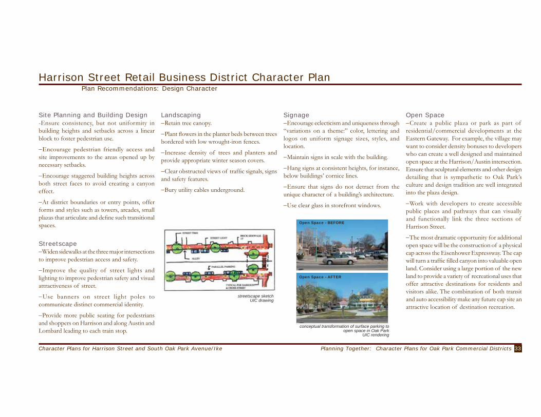
Site Planning and Building Design-Ensure consistency, but not uniformity in building heights and setbacks across a linear block to foster pedestrian use.
−Encourage pedestrian friendly access and site improvements to the areas opened up by necessary setbacks.
−Encourage staggered building heights across both street faces to avoid creating a canyon effect.
−At district boundaries or entry points, offer forms and styles such as towers, arcades, small plazas that articulate and define such transitional spaces.
Streetscape−Widen sidewalks at the three major intersections to improve pedestrian access and safety.
−Improve the quality of street lights and lighting to improve pedestrian safety and visual attractiveness of street.
−Use banners on street light poles to communicate distinct commercial identity.
−Provide more public seating for pedestrians and shoppers on Harrison and along Austin and Lombard leading to each train stop.
Landscaping−Retain tree canopy.
−Plant flowers in the planter beds between trees bordered with low wrought-iron fences.
−Increase density of trees and planters and provide appropriate winter season covers.
−Clear obstructed views of traffic signals, signs and safety features.
−Bury utility cables underground.
Open Space−Create a public plaza or park as part of residential/commercial developments at the Eastern Gateway. For example, the village may want to consider density bonuses to developers who can create a well designed and maintained open space at the Harrison/Austin intersection. Ensure that sculptural elements and other design detailing that is sympathetic to Oak Park’s culture and design tradition are well integrated into the plaza design.
−Work with developers to create accessible public places and pathways that can visually and functionally link the three sections of Harrison Street.
−The most dramatic opportunity for additional open space will be the construction of a physical cap across the Eisenhower Expressway. The cap will turn a traffic filled canyon into valuable open land. Consider using a large portion of the new land to provide a variety of recreational uses that offer attractive destinations for residents and visitors alike. The combination of both transit and auto accessibility make any future cap site an attractive location of destination recreation.
Signage−Encourage eclecticism and uniqueness through “variations on a theme:” color, lettering and logos on uniform signage sizes, styles, and location.
−Maintain signs in scale with the building.
−Hang signs at consistent heights, for instance, below buildings’ cornice lines.
−Ensure that signs do not detract from the unique character of a building’s architecture.
−Use clear glass in storefront windows.
Open Space - BEFORE
Open Space - AFTER
conceptual transformation of surface parking to open space in Oak Park
UIC rendering
streetscape sketchUIC drawing

34 Character Plans for Harrison Street and South Oak Park Avenue/Ike
Harrison Street Retail Business District Character PlanAssessing Plan Impacts - Residential and Commercial
Impact estimates do not describe what will happen, but offer plausible descriptions of likely plan outcomes based on current behavioral evidence. The impacts described here are projected to occur over a ten to twenty year time frame. The methodology is described in Appendix 5 and includes the assumptions and calculations for each plan use recommendation. The impacts we describe should not be used to accept or reject a specific planning recommendation, but can be used to prioritize and provide direction for implementation activities. The implementation section (Chapter VI. Planning for Implementation) describes some of the strategies that the Village can use to operationalize planning recommendations.
Residential and Commercial ImpactsThe addition of new residential space would enlarge the economic and fiscal base and dramatically transform the character of the Harrison Street district. Complete build out at the proposed densities in twenty years would double current residential living space at approximately 2 million square feet (from 900,000). We expect that the majority of new units will be in multi-family apartment buildings: some exclusively residential and others with commercial uses on the street level. We assume dwelling unit space is
1,650 square feet, which includes common areas and one parking spot per unit. The additional supply of housing would attract an increasing number of residents to the area. We assume that household size in the new units will be approximately 2 individuals per unit (smaller than the average of 2.6 people recorded in the 2000 Census), which would translate into approximately 1,900 new local residents, adjusting for the small loss of single-family houses. This would reverse the trend of population decline currently reflected in the census figures for the tracts surrounding the Harrison Street area. The new mixed-use multi-family buildings will cater mainly to middle-income households including young singles or couples seeking a transit-friendly suburban location close to Chicago. Additionally, empty nesters, many from Oak Park, abandoning the burdens of maintaining a single-family dwelling, will find a transit and freeway accessible Oak Park address attractive. Specific steps need be taken to ensure that a mix of affordable housing accompanies these improvements. The new residents alone would generate approximately $3,000,000 in property taxes on an annual basis. Such a figure does not take into account the capital expenditures for roadway, transit stations, and site improvements that the
Village would fund nor does it account for the sequencing of development or the time value of money (i.e., the calculations assume entire build out takes place within next few years instead of phased over the next twenty years). The adoption of the character plan is likely to generate increases in land values in this area than for the Village as a whole. If the cap improvements for the Eisenhower Expressway prove a feasible and popular option, land values and property values will increase even more, helping pave the way for development activity in the adjacent Harrison Street District. If the new residents were similar demographically to the existing residents of the area (between 35 and 59 years of age, well-educated, and with increasing household income), they would create a market of consumers that would have broad appeal to potential commercial developers and tenants. The current demographic trends are supportive of substantial retail and business services growth. The plan maintains the same ratio of commercial space to the total developed area (approximately 8 percent of Harrison Street Corridor is and will remain dedicated to commercial uses).Retail employment opportunities could benefit residents of the area, particularly younger residents, retired residents, and those looking for
the more flexible schedules (and fewer hours) that retail affords. However, wages in retail tend to be low. A potentially negative consequence of the new developments in the area is that existing business tenants would experience increases in rents. This could displace the very kind of businesses that have contributed to the unique and organic character of the Harrison Street District in the first place. The Village, by targeting existing assistance programs carefully may be able to assist existing businesses to increase their capacity so that they can benefit from the influx of new consumers. If the new retail space finds tenants who thrive in this environment, the Village will benefit from additional property and sales tax revenues as well as new of business opportunities for Village residents. The addition of commercial space will increase the aggregate equalized assessed value and generate approximately $1,800,000 in property tax revenues annually (before exemptions). Sales taxes on the additional goods and services sold could total approximately $270,000 annually. This figure represent one percent of the sales tax provided to the state as well as the one percent home-rule-imposed sales tax. It does not account for foregone revenues from the two service stations on Austin and Harrison.

35Planning Together: Character Plans for Oak Park Commercial DistrictsCharacter Plans for Harrison Street and South Oak Park Avenue/Ike
proposed intersection treatmentfor intersection of Ridgeland and Harrison
Harrison Street Retail Business District Character PlanAssessing Plan Impacts - Transportation
Transportation ImpactsBased on the standard trip generation rates published by the Institute of Traffic Engineers we estimate that in twenty years, if current travel behavior remained the same, the number of automobile trips generated in the study area will more than double to 17,000 per day. Including all modes of transportation locally generated travel will reach more than 22,000 trips. The estimate for the automobile trips assumes that twenty percent of all the trips originated from or destined to the study area will be by transit. Combining the trip generation data with traffic count data from a 1998 traffic study, we estimated the impact of the additional trips on Harrison Street. It is likely that build out and resulting trips by new residents and shoppers would create congestion problems along Harrison – especially at peak commuting times. If the amount of through traffic that currently uses Harrison to access the Ike Expressway remains the same, it is estimated that some 21,500 automobiles per day will be on Harrison. This level of volume is beyond the capacity of a two-lane collector street. There are several “hot
spots” in the study area that will likely to emerge as bottlenecks. The intersection of Harrison Street and Ridgeland Avenue will likely to experience congestion during the peak periods. The congestion level at the intersection at Austin Boulevard and Harrison Street is projected to rise to the level that is unacceptable by the national standard for urban areas. Also, the congestion at the I-290 Interchange will likely to increase considerably especially during the morning peak periods. Analyses indicate there will be a shortage of about 130 parking spaces during weekday evenings when the demand reaches the highest level, even after considering the effects of shared-use, and day-of-the-week and time-of-the-day variations. The projected shortage represents approximately eight percent of peak demand. Thus, at build out, the level of shortage will be about the same as the current shortage of sixty spaces, which is also about eight percent of demand. Approximately 80 percent of the demand for parking will likely come from multi-family residential and retail businesses.

36 Character Plans for Harrison Street and South Oak Park Avenue/Ike

37Planning Together: Character Plans for Oak Park Commercial DistrictsCharacter Plans for Harrison Street and South Oak Park Avenue/Ike
[vision statement]
Oak Park Avenue/Ike Retail Business District Character PlanVision and Goals
The Oak Park Ike District provides a successful mixed use corridor and shopping destination linking both sides of the Eisenhower Expressway. Diverse commercial businesses interspersed among a variety of residential dwellings serve the needs of consumers from nearby, the Village and surrounding communities. Increased commercial activity enhances the quality of life in the neighborhood. Customers from near and far take advantage of improved transit facilities and use the pedestrian friendly walkways to browse and shop. Increased density will not compromise the neighborhood scale, preservation of valued buildings and a pedestrian friendly streetscape.
Oak Park Avenue stakeholdersphoto courtesy Village of Oak Park
Commercial−Increase customer traffic (pedestrian, transit, bicycle, and automobile.)
−Attract a diverse mix of businesses, emphasizing businesses that serve neighborhood residents.
−Increase entertainment options without creating additional nuisances for residents.
−Promote continuity between north and south sides of district.
−Balance needs of businesses and residents.
Residential−Increase and manage density to ensure neighborhood integrity.−Maintain family-focus.−Maintain “child-safe” corridor.−Provide sufficient transit for residents .−Provide sufficient parking for residents.
Transportation−Increase parking.−Reduce parking demand.−Accommodate non-drivers.−Provide bicycle lanes.−Increase pedestrian flow.
Design Character−Create bridge improvements to link north and south portions of district (independent of capping plans.)
−Use façade and other building improvements to attract customers.
−Provide distinct gateways to mark the north and south district entryways.
−Enhance and protect current diversity of building forms.
−Create open spaces that will attract pedestrians and invite public activity.
−Design improvements to ensure access for all ages and the disabled
Oak Park Avenue stakeholdersphoto courtesy Village of Oak Park
Vision statements developed by citizens, refined by stakeholders and UIC.

38 Character Plans for Harrison Street and South Oak Park Avenue/Ike
mixed use building on Oak Park AvenueUIC photo
Existing Conditions: Commercial and Residential
Oak Park Avenue/Ike Retail Business District Character Plan
CommercialThe Oak Park/Ike district lies at the center of a stable and prosperous residential neighborhood split in two by an expressway. Commercial shops include services (e.g., two banks and two restaurants), as well as convenience (e.g., grocery store, florist, laundromat) and destination (e.g., cigar, glass and arts stores and children-related) retail. In general, new business activity in the district has not kept pace with increasing prosperity of nearby residents.
mixed use building on Oak Park AvenueUIC photo
ResidentialLike the Village as a whole, the residents near the Oak Park Ike business corridor exhibit more racial diversity, and possessed more education than they did 10 years ago. They have aged in place. Population between 35 and 59 years of age increased the most. In contrast, the number of people 20 to 34 years old, as well as those over 60 declined, as it has for the Village as a whole. Household size continued to decline while median income increased.

39Planning Together: Character Plans for Oak Park Commercial DistrictsCharacter Plans for Harrison Street and South Oak Park Avenue/Ike
Existing Conditions: TransportationOak Park Avenue/Ike Retail Business District Character Plan
TransportationVillage Traffic studies conducted in 1997 and 1998 counted 15,000 to 17,000 cars per day using Oak Park Avenue between the Ike and Van Buren Street. Daily ridership on the CTA line ranges from 1,100 to 1,600 passengers on weekdays to 200 to 650 passengers on weekends. The transit mode share for commuting trips for the residents in the study area, which usually have the highest transit share among all types of trips, also remained constant between 1990 and 2000 at 19 percent. In contrast, nearly 25 percent of Evanston residents used transit to commute.
The Oak Park Ike district includes approximately 500 parking spaces; 150 located in four Village owned parking lots (Numbers 1, 11, 29 & 15) and 240 on street spaces (metered and un-metered). The remaining spaces include private residential and business parking spaces. As of 1999 studies report that the Village lots rarely experienced maximum occupancy while on-street parking averages about 60 percent occupancy. On-street parking on the Avenue was, however, rarely vacant.
analysis of existing parking guidelinesOak Park Avenue
UIC photo
DISTRICT YEAR DROVE ALONE CARPOOL TRANSIT WALK OTHER WORK @ HOME
Oak Park 1990 59.4 % 12.0 % 18.4 % 6.3 % .6 % 3.2 %Oak Park 2000 60.9 % 9.2 % 19.0 % 3.6 % .3 % 7.1 %
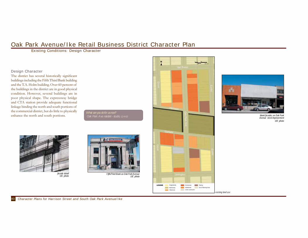
40 Character Plans for Harrison Street and South Oak Park Avenue/Ike
Design CharacterThe district has several historically significant buildings including the Fifth Third Bank building and the T.A. Holm building. Over 60 percent of the buildings in the district are in good physical condition. However, several buildings are in poor physical shape. The expressway bridge and CTA station provide adequate functional linkage binding the north and south portions of the commercial district, but do little to physically enhance the north and south portions.
Existing Conditions: Design CharacterOak Park Avenue/Ike Retail Business District Character Plan
existing land use
blank facades on Oak Park Avenue need improvement
UIC photo
Fifth/Third Bank on Oak Park AvenueUIC photo
What can you do for us now? Oak Park Ave. resident - studio, 12-4-02
facade detailUIC photo
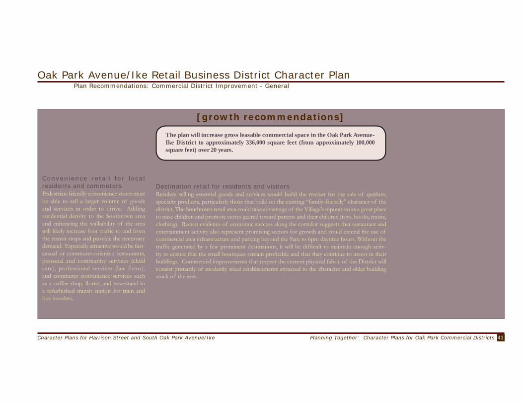
41Planning Together: Character Plans for Oak Park Commercial DistrictsCharacter Plans for Harrison Street and South Oak Park Avenue/Ike
Convenience retail for local residents and commutersPedestrian-friendly convenience stores must be able to sell a larger volume of goods and services in order to thrive. Adding residential density to the Southtown area and enhancing the walkability of the area will likely increase foot traffic to and from the transit stops and provide the necessary demand. Especially attractive would be fast-casual or commuter-oriented restaurants, personal and community services (child care), professional services (law firms), and commuter convenience services such as a coffee shop, florist, and newsstand in a refurbished transit station for train and bus travelers.
Plan Recommendations: Commercial District Improvement - General
Destination retail for residents and visitorsRetailers selling essential goods and services would build the market for the sale of quirkier, specialty products, particularly those that build on the existing “family-friendly” character of the district. The Southtown retail area could take advantage of the Village’s reputation as a great place to raise children and promote stores geared toward parents and their children (toys, books, music, clothing). Recent evidence of economic success along the corridor suggests that restaurant and entertainment activity also represent promising sectors for growth and could extend the use of commercial area infrastructure and parking beyond the 9am to 6pm daytime hours. Without the traffic generated by a few prominent destinations, it will be difficult to maintain enough activ-ity to ensure that the small boutiques remain profitable and that they continue to invest in their buildings. Commercial improvements that respect the current physical fabric of the District will consist primarily of modestly sized establishments attracted to the character and older building stock of the area.
Oak Park Avenue/Ike Retail Business District Character Plan
[growth recommendations]
The plan will increase gross leasable commercial space in the Oak Park Avenue-Ike District to approximately 336,000 square feet (from approximately 100,000 square feet) over 20 years.

42 Character Plans for Harrison Street and South Oak Park Avenue/Ike
Plan Recommendations: Commercial District Improvement - General
Oak Park Avenue/Ike Retail Business District Character Plan
The commercial space increase includes the addition of approximately three sit-down restaurants and 25 to 40 new retail establishments, depending on the size of the merchant and the merchandising mix. Some of these retailers would occupy ground-floor locations while others would find space in the 3-4 story single-use commercial building. The plan also increases the amount of office space by 150 percent, some of which would be located on first-floor of the mixed-use buildings.
mixed-use treatment of cornerLake Oswego, Oregon
Professional services
commercial activity
enience retail
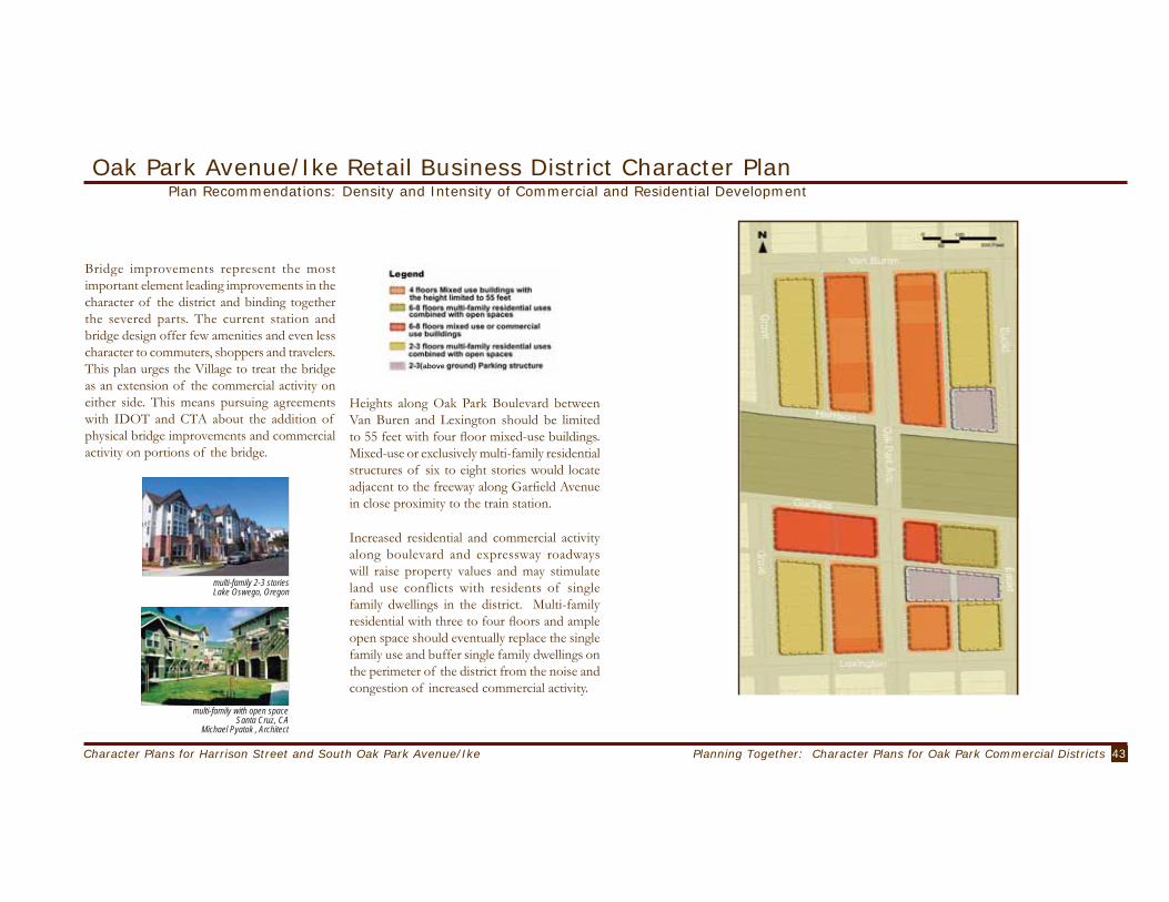
43Planning Together: Character Plans for Oak Park Commercial DistrictsCharacter Plans for Harrison Street and South Oak Park Avenue/Ike
above
Oak Park Avenue/Ike Retail Business District Character PlanPlan Recommendations: Density and Intensity of Commercial and Residential Development
Bridge improvements represent the most important element leading improvements in the character of the district and binding together the severed parts. The current station and bridge design offer few amenities and even less character to commuters, shoppers and travelers. This plan urges the Village to treat the bridge as an extension of the commercial activity on either side. This means pursuing agreements with IDOT and CTA about the addition of physical bridge improvements and commercial activity on portions of the bridge.
Heights along Oak Park Boulevard between Van Buren and Lexington should be limited to 55 feet with four floor mixed-use buildings. Mixed-use or exclusively multi-family residential structures of six to eight stories would locate adjacent to the freeway along Garfield Avenue in close proximity to the train station.
Increased residential and commercial activity along boulevard and expressway roadways will raise property values and may stimulate land use conflicts with residents of single family dwellings in the district. Multi-family residential with three to four floors and ample open space should eventually replace the single family use and buffer single family dwellings on the perimeter of the district from the noise and congestion of increased commercial activity.
multi-family 2-3 storiesLake Oswego, Oregon
multi-family with open spaceSanta Cruz, CA
Michael Pyatok , Architect

44 Character Plans for Harrison Street and South Oak Park Avenue/Ike
Eisenhower
Plan Recommendations: Transportation and Parking
Oak Park Avenue/Ike Retail Business District Character Plan
Transportation and ParkingTraffic through the district can be busy, so some traffic calming strategy is needed that will slow down traffic and encourage a more pedestrian friendly environment. However, Oak Park Avenue provides much-needed north-south access through the Village and it is important to strike a balance between controlling the traffic flow and preserving the traffic carrying capacity of the corridor. Traffic calming crosswalks at the both ends of the district and at cross sections on the bridge would shift the district from auto friendly to pedestrian friendly without severely disrupting the flow of traffic. Bus drop-off lanes at the CTA station improve movement and safety for all travelers. It will be prudent to encourage east-west traffic to use Madison Street since even a modest increase in the cross street traffic may lead to a formation of bottlenecks along Oak Park Avenue during peak periods. Traffic calming measures should be applied to the local streets, including Jackson Boulevard, Van Buren Street, and Harrison Street, to both create a safe environment for pedestrians to walk along Oak Park Avenue and also to minimize through traffic on those streets.
New mixed use building construction over the next twenty years will produce additional private off-street parking spaces that most current sites lack. Widening streets will reduce on-street parking availability along Oak Park Avenue. Since on-street parking offers the most desirable and convenient parking choice for drivers using convenience stores, overall street widening should not reduce the number of on street parking spaces along the Oak Park Avenue corridor by more than half. Remaining spaces should have parking times reduced to enforce rapid turnover. Additional parking spaces will be provided by construction of new parking garages on both north and south sides of the bridge. These parking garages will need to provide 310 or more parking spaces to meet the projected demand. Potential locations include the sites of current Public Lot 1 and Public Lot 15. Public access parking might be negotiated as part of larger mixed use development projects adjacent to the expressway. Major rehabilitation or new construction of mixed use buildings should include shared parking arrangements to enhance the efficient daytime use of the
parking spaces vacated by resident commuters. Since commuters and shoppers must walk from the parking lots to their destinations, sometimes across the Ike overpass, it is imperative to provide a safe and pleasant environment for pedestrians even during the night-time.
parking garage with retail on first floorWalnut Creek, CA
Urban Land Institute

45Planning Together: Character Plans for Oak Park Commercial DistrictsCharacter Plans for Harrison Street and South Oak Park Avenue/Ike
Plan Recommendations: Design CharacterOak Park Avenue/Ike Retail Business District Character Plan
Bridge and CTA Station Improvements
− Redesign and expand sidewalks, street lighting, and bridge railing improvements, color and street furniture to provide a visual and functional link between north and south parts of the district.
− Improve transit access and safety making room for bus to serve passengers without blocking through traffic.
− Expand the size and design of CTA station to include room for small commercial service shops.
− Create storage space for bicycles.
Create Attractive Retail Opportunities for Pedestrians
− Provide seating for pedestrians and shoppers on each commercial block face.
− Create a distinctive retail identity.
− Customized brick pavers at crosswalks.
− Widened sidewalks along Oak Park Avenue between Van Buren and Lexington.
− Banners on street lights to announce district entry.
− Clear storefront windows.
− Store windows that are parallel to the street edge, rather than at an angle with consistent setbacks.
− Improve the quality of street lights and lighting to improve pedestrian safety and visual attractiveness of street.
Landscaping
− Create small landscaped open spaces wherever possible, working with developers to ensure that these spaces are well lighted and maintained (e.g., Lake Street.)
− Green the street – introduce additional trees, preferably one every twenty-five feet.
− Place small year round planters at the entrance of each business.
Signage
− Encourage eclecticism and uniqueness through “variations on a theme:” color, lettering and logos on uniform signage sizes, styles, and location.
− Maintain signs in scale with the buildings.
− Hang signs at consistent heights, for instance, below buildings’ cornice lines.
− Ensure that signs complement the physical character of the District.
− Use clear glass in storefront windows.
− Clear obstructed views of traffic signals and signs.

46 Character Plans for Harrison Street and South Oak Park Avenue/Ike
Assessing Plan Impacts - Commercial and ResidentialOak Park Avenue/Ike Retail Business District Character Plan
Impact estimates do not describe what will happen, but offer plausible descriptions of likely plan outcomes based on current behavioral evidence. The impacts described here are projected to occur over a ten to twenty year time frame. The methodology is described in Appendix 5 and includes the assumptions and calculations for each plan use recommendation. The impacts we describe should not be used to accept or reject a specific planning recommendation, but can be used to prioritize and provide direction for implementation activities. The implementation section (Chapter VI. Planning for Implementation) describes some of the strategies that the Village can use to operationalize planning recommendations.
Residential and Commercial ImapactsThe bulk of the new residential space would be multi-family units, increasing the density of the area’s built environment. The plan for the South Oak Park Avenue district not only adds more multi-family housing, but also increases the share of residential land uses (from 57% to 73% of total area). The plan calls for approximately 680,000 additional square feet of multi-family housing or approximately 414 new units.
Because of the likely size of the units (on average, 1,650 square feet including communal areas and one parking spot) and the desire to attract younger households and empty-nesters, we can assume that the households inhabiting the new units will be smaller than the average household size in the area (2.6 as recorded in the 2000 Census). If, on average, two individuals reside in each unit, the additional multi-family housing will attract approximately 830 new residents. This scenario would reverse the trend of population decline currently reflected in the census figures for the tracts surrounding the South Oak Park Avenue district. The new housing would enlarge the fiscal base of the Village considerably, generating approximately $1,763,000 annually in property taxes (a 200% increase over the existing revenues). This amount does not take into account any capital expenditures that the Village would fund nor does it account for the phasing of development (i.e., the calculations assume entire build out takes place within next few years instead of phased over the next twenty years).
The plan also adds approximately 200,000 gross leasable square feet of new commercial space to the area to be supported by the existing as well as new residents. If the new residents were similar demographically to the existing residents of the area (between 35 and 59 years of age, well-educated, and with increasing household income), they would create a market of consumers that would have broad appeal to potential commercial developers and tenants. The plan increases the ratio of residential-to-commercial space, which
reflects an expanded local market for the goods and services sold here. The owners and tenants in the new retail space will contribute to the Village’s sales and property tax bases. Specifically, the additional commercial space will increase the aggregate equalized assessed value and generate approximately $1,280,000 in property tax revenues annually (before exemptions). Additional sales taxes on the new goods and services sold could total about $207,000 annually.

47Planning Together: Character Plans for Oak Park Commercial DistrictsCharacter Plans for Harrison Street and South Oak Park Avenue/Ike
Transportation ImpactsThe proposed changes in land use will increase residential and commercial density significantly over the current conditions in the Oak Park / Eisenhower corridor. As a result, there will be significant changes in traffic and parking needs in the community. Based on the standard trip generation rates published by the Institute of Traffic Engineers, we estimate that the proposed land use will result in approximately 7,500 additional automobile trips a day in the study area. We assumed a conservative measurement of 20 percent transit use, based on current transit use behavior of Oak Parkers. If all the additional trips use Oak Park Avenue, this will increase the total daily traffic on Oak Park Avenue from current 17,000 to approximately 24,500, a number similar to the traffic on primary arterials such as Austin Avenue. At such volume, the traffic condition on Oak Park Avenue may deteriorate noticeably especially during morning and evening peak periods. Heavy traffic will also have adverse impact on the pedestrian-friendly nature of the neighborhood. However, depending on the design of the Ike expansion and also the access points to the development on the cap, a considerable portion of the additional
traffic can be diverted to the Ike without using Oak Park Avenue. It is also likely that even a small amount of additional traffic on Oak Park Avenue will have some impacts on the locations elsewhere in the Village, such as the intersections at Oak Park Avenue and South Boulevard, or Oak Park Avenue and Lake Street.
Parking ImapctsBased on the Urban Land Institute’s Shared Parking methodology, we estimate that the development will more than double demand for parking to approximately 1,100 spaces, over current needs of 480 spaces. Two existing public parking lots will be closed to make way for a new parking structure and a mixed-use development, resulting in the loss of nearly 100 current spaces. However, the additional demand can be met by providing two public access parking structures with a combined supply of 310 spaces, and private parking for new multi-family apartment and condominium buildings of approximately 420 spaces. As a whole, it is projected that there will be a shortage of approximately 95 spaces for the study area during the peak demand period. The plan does not assume any parking spaces for commercial uses within the mixed-use buildings. Also, it should be understood that the plan inherently assumes that people are willing to accept walking at most two blocks from the parking spot to the final destination, which may not be the current mindset of the public based on the comments received. However, creating a pedestrian-friendly environment to provide incentive for walking, as proposed in this plan, will help change the attitude and expectation of the public.
Oak Park Avenue/Ike Retail Business District Character PlanAssessing Plan Impacts - Transportation

48 Process, Participation and Collaboration

49Planning Together: Character Plans for Oak Park Commercial DistrictsProcess, Participation and Collaboration
Civic engagement and activism is essential to the success of representative democracy. Local government offers a particularly promising arena for citizen participation because local residents experience the “planning issues” on a day-to-day basis and have direct personal experience in coping with the situation. The benefits of citizen participation are fully realized only when the public recognizes that planning – an essentially future-oriented activity – is a civic and community endeavor and an on-going process. Good planning continually strives to balance between individual interests and community well-being, for the present and for years to come.
The Village of Oak Park enjoys a strong tradition of civic engagement. Both the 1979 and the 1990 Comprehensive Plans consciously recognize and emphasize citizen participation as one of the critical elements of Oak Park’s commitment to improve the quality of life for its citizens. The Village leadership routinely recruits citizens to serve on advisory boards, commissions and other special bodies. They also solicit advice and request feedback from citizens when important issues are being debated. The UIC team shares this commitment and dedicated much time and effort to improving the scope and quality of citizen participation in community planning over the course of this project.
The UIC team developed and implemented a planning process guided by the following principles:
Fairness Ensure that all participants have equal opportunity to express opinions, offer ideas and advice.
Respect Acknowledge and recognize the participation of individuals and groups, regardless of their views.
Inclusion Include interests and voices of those directly affected by the plans, but also those who did not participate, or whose participation did not receive meaningful attention.
Relevance Focus citizens’ testimony, advice, and deliberation on issues related to the purpose and context of the project.
Competence Solicit, support, and use the skills and knowledge of participants to improve the quality of the process and the creation of the plans.
Work from the bottom-upThe process of planning and design began immediately, with the urban design studio. In the studio, graduate students developed design ideas for the revitalization of the two districts based on their analysis of data and information gathered from readily available sources. The data collection phase was not artificially separated from the planning and design phase. As students listened to opinions and preferences of immediate neighbors, they began to design proposals
that were based on precedent (best practices from other communities) and the expressed preferences of active stakeholders and neighbors who were likely to be directly affected by any type of physical change. Student ideas encompassed a wide range – some were modest proposals for a block of buildings or store-fronts in one of the districts while some proposed radical changes for the entire area. None of the design ideas were bounded by impact analyses.
The UIC team organized the design ideas into two scenarios – a high impact and a low impact scenario. The impacts analyzed included economic and fiscal impacts, traffic and transportation impacts, and the visual changes that were likely in the physical environment. These scenarios were presented to the community at large. These scenarios were then reviewed by a group of stakeholders who used these scenarios to develop a more comprehensive plan for each district. The final plans presented in this report resulted from an interactive process where the physical changes proposed (e.g., increasing the percentage of retail business activity) were adjusted depending on the potential positive and negative impacts that could result. In the end, the UIC team made professional judgments about the intensity and type of development in each business district which were informed by feedback from citizens with very diverse and sometimes conflicting agendas.
[ p r i n c i p l e s ]
Process, Participation and Collaboration Principles

50 Process, Participation and Collaboration
Work from the inside-outInstead of reacting to proposals for commercial improvements shaped by outside developers, the creation of character plans enables Village residents, stakeholders and officials to anticipate development. Plans that build upon the goals and interests of local residents provide a more attractive framework for assessing and approving future development proposals than plans based solely on developer input. The process started with the interests and expectations of the residents, owners, investors and consumers who live, work and shop in the two districts and moved outward to include Village staff, leadership and residents from other parts of Oak Park. Those who will most likely face the immediate consequences of any planned changes played a crucial, but not exclusive role in shaping the goals and objectives of the plans.
These principles guided the UIC team in designing a process that is transparent, flexible and adaptable to different situations. Conceptually, the process worked to:− identify critical issues early on in the
process,− listen to many different voices and identify
community dynamics, − clarify value statements,− review differences of opinion,− express conflicts, and− negotiate consensus.In addition, the principles and the process helped the UIC team find a balance between the temptations of some individuals and groups who sought to turn the process into an end in itself and the desire of others to tailor the participatory process to fit their pre-conceived outcomes.
[organizing and communicating project information]The UIC team made sure early on to invite as many of the residents (renters and owners) living in or adjacent to each planning district as we could. Additionally, UIC team members actively contacted different groups and organizations throughout Oak Park, inviting their members to participate in the planning process. A complete list of organizations contacted appears in Appendix 7. UIC team members gratefully listened to anyone who would talk about the plans or the process. The UIC team used a wide assortment of techniques to place participation at the heart of the planning effort. These included a variety of approaches to organize and communicate information. We posted handbills, distributed flyers, placed ads in local newspapers, used email listservs, mailed invitations, called on the telephone and spoke face to face. As residents, the faculty team members talked about the project at backyard barbeques, block parties, the gym, grocery stores and other gathering places in the Village. The UIC-Oak Park website was launched the week the project began. The website was designed to evolve as the project unfolded. The website was widely publicized using bookmarks distributed at community events and placed in the library and local bookstores.
Public MeetingsFive public meetings were held at the Village Hall on September 18, 2002, November 5, 2002, January 29, 2003, May 7, 2003, and June 19, 2003. Each meeting typically lasted two hours. During the first hour, we shared project findings with citizens through short presentations and responded to questions from the audience. These presentations were televised and rebroadcast on the local television channel. During the second half of the meeting, we typically engaged attendees in a discussion or activity that was appropriate to the needs of the project. For example, in the first community-wide meeting held on September 18, 2002, we organized citizens into different focus groups so that they could talk about their expectations and concerns. In the last community meeting, held on June 19, 2003, we organized a moderated community forum where citizens could ask questions of the UIC team, stakeholder representatives, and Village staff.
Process, Participation and Collaboration - UIC Process in PracticeOrganizing and Communicating Project Information
UIC photo

51Planning Together: Character Plans for Oak Park Commercial DistrictsProcess, Participation and Collaboration
Community Meeting - CharretteIn April 2003, the UIC presented the first draft plans for each district at a Community meeting-Charrette. Two distinct but inter-linked events took place at the cafeteria of the Percy Julian Middle School on the evening of April 3, 2003 and then all day of April 5, 2003. The meeting on the 3rd gave the Oak Park community an opportunity to review the first draft of plans for each district. Over 150 citizens attended this meeting. After presentations by the UIC team, stakeholders led discussions among small groups of citizens. Each group began the process of plan review and helped to identify the trade-offs that were needed to build community consensus. The thirty stakeholders came together again on April 5, 2003. They worked in two groups in a structured process to develop a stakeholder plan that took into account the voluminous feedback gathered from citizens and based on their analysis of the community’s needs. Village staff were invited to provide clarifications regarding existing design guidelines, parking and zoning regulations. In addition the UIC team provided immediate response to impact analysis questions so that the stakeholders were able to create a draft plan for each district at the end of the day. These plans were refined over a series of meetings held
between May and June. Final plans developed by stakeholders can be seen in Appendix 6.
[public meetings]
[stakeholders]
Stakeholder MeetingsBetween March and June, five stakeholder meetings were organized. The first meeting took place in the Oak Park Conservatory. The other meetings took place in the studio space at 828 S. Oak Park Avenue. All meetings were open to any member of the public. The agenda for these meetings was advertised by the Village approximately 48 hours in advance of each meeting. Oak Parkers are familiar with a sense of geographic community in that they live in an urban village – accessible to many amenities and offering an excellent quality of life for its residents. The stakeholder meetings were intended to create a sense of community and provide opportunities for stakeholders to work together as a group.
Process, Participation and Collaboration - UIC Process in PracticeMeeting Citizens
photos courtesy Village Of Oak Park

52 Process, Participation and Collaboration
Studio EventsAt the start of this project, the Village provided UIC with a work space at 828 S. Oak Park Avenue. The space was critical to the development of our model of participatory planning process. It allowed us to open our planning process to the community. Urban planning and design, especially when it involves the physical redevelopment of a neighborhood is often a mysterious process for residents and ordinary citizens. What they often see is the finished product – a report, a plan, a drawing, a perspective rendering. Often these plans or drawings are presented as expert-driven solutions that have emerged from a rational planning processes supported by evidence and analysis. However, the reality of planning is that it is messy, iterative, and often influenced by values and desires that may conflict with hard evidence. In the initial stages, anyone who wandered into the studio was able to get a sense of how the students were developing their ideas and solutions to address perceived needs of each of the corridors.
The studio was open during pre-specified hours on some weekdays, weekends, and evening hours. While resource constraints precluded permanent staffing of the studio, a phone with voicemail was installed to receive comments and questions.
A computer with Internet access provided citizens with an opportunity to receive training on how to use the project website and receive customized training on the use of the digital applications developed for this project. Several events were scheduled in the studio over the course of the project year. In Fall 2002, there were focused presentations on a particular topic – e.g., presentation of existing design conditions.
In Spring 2003, faculty staffed the studio on designated days and were available to discuss any aspect of the project.
One-on-One conversationsAlong the way, UIC team members had many one-on-one conversations about substantial issues concerning the project with many individuals. Some of these individuals eventually became part of the stakeholder process because of our discussions. Others opened their doors to offer space to hold meetings, and helped us in other ways. These conversations were informal, but were conducted on the phone, by email, in person. At each public meeting, we spent time before and after the meeting, lingering to be available to residents who wished to discuss a specific issue with us.
Meeting with Village Staff & LeadershipIn addition to meetings described above, UIC team members met on a bi-weekly basis with village staff to provide them with updates and discuss specific issues related to the project as it evolved. UIC team members also presented project progress at study sessions of the Board at three different occasions.
[studio]
courtesy Village of Oak Park
Process, Participation and Collaboration - UIC Process in PracticeMeeting Citizens
review
conversations
reactions

53Planning Together: Character Plans for Oak Park Commercial DistrictsProcess, Participation and Collaboration
inquisitive
I am also concerned about the level of input that community members will be afforded. Specifically, I am worried that because of the open invitation to citizens to participate in the UIC study, that the village board will limit citizen input in the decision-making process, claiming instead that citizens already had an opportunity to voice their opinion...The citizens affected should be included in every step of the way, and will be heard. - email
Youth InvolvementAlthough too young to vote, middle school and high school youth possess plenty of ideas about improving their local neighborhoods and the Village. We wanted to tap some of this imagination and insight. We invited sixth, seventh and eighth grade students from the Percy Julian and Gwendolyn Brooks Middle Schools to offer their ideas about the two districts. Approximately 50 students prepared plans in April 2003. They publicly shared their ideas at the Village Hall on May 7, 2003. Stakeholders, Village staff, residents and UIC team members learned in many ways the importance of including places and spaces where young people can gather and play.
[youth]
surprising
articulate
creative
challenging
Process, Participation and Collaboration - UIC Process in PracticeMeeting Citizens
photos courtesy Village of Oak Park

54 Innovations in Electronic Visualization and Communication

55Planning Together: Character Plans for Oak Park Commercial DistrictsInnovations in Electronic Visualization and Communication
Electronic Visualization ToolsWhy Use Visualization Tools?
Why Use Electronic Visualization Tools?The interactive digital applications or computer-mediated communication tools developed for the UIC Oak Park project are designed to facilitate public discourse about local planning issues.Electronic visualization and communication tools enhance and complement traditional methods of citizen participation at different stages of the plan development process. Interactive applications improve access to both qualitative (images, plan drawings), and quantitative (spreadsheets, tables, charts) information that participants can access before they attend meetings or other public discussions. Additionally, the tools enable participants to interact directly with the information and products displayed as electronic movies, images, maps, tables and reports available on line. In this planning process, the technology also enhanced the quality, speed and convenience of communication among participants who used email and web postings to reach the UIC team. Citizens and staff were able to view maps that were annotated with images in small group settings or on-line. Citizens also used web-based surveys that combined both still and panoramic movie images to provide an assessment of existing physical conditions in the two business districts and comment on the suitability and appropriateness of different design/planning solutions.
Creating Interactive Digital ApplicationsThree types of interactive digital applica-tions were developed over the course of the project. The applications were developed by faculty and research assistants at the Great Cit-ies Urban Data Visualization Lab (GCUDV), a research center within the College of Urban Planning and Public Affairs. See Appendix 8 for a brief description of a profi le of GCUDV Lab’s research activities. These applications are described here and are also available for view-ing through the accompanying CD-ROM.
Visual Preference SurveysCitizens need to have conversations about existing conditions of any planning area as they plan for change. Typically, citizens have these conversations at a meeting without the support of visual information. The visual preferences survey can facilitate a more comprehensive discussion about planning issues such as character, density, and safety concerns. It can be adapted for use in group settings or it can function like a traditional on-line survey that provides feedback directly to the planning staff. The two surveys designed and tested through this project provided citizens a simple way to convey their ideas regarding design issues in the study areas.
1
Survey of Existing ConditionsFunctionality and Use during the ProjectThrough the Survey of Existing Conditions, citizens responded to photographs and panoramic views of existing retail business district. The survey presented 18 photos for Harrison Street and 17 for Oak Park Avenue. Each of the photographs addressed planning and design issues such as the appearance of buildings, types of businesses, environment, traffi c, and safety. Users were able to react to the photographs by selecting “like” or “dislike” buttons and then, were then provided with an opportunity to add a brief comment about their reasons for their preference.
Survey of Best PracticesFunctionality and Use during the ProjectThe Best Practices Survey had photos and draw-ings from various sources showing examples of successful urban design from locations facing simi-lar challenges to Oak Park Avenue and Harrison Street. These examples helped people understand the range of design solutions which could be con-sidered for Oak Park. Both surveys were tested between December 2002 and March 2003 and were offi cially launched on March 10th, 2003. The Existing Conditions sur-vey received 84 responses while the Best Practices survey received 45 responses. The results of the survey can be found in Appendix 9. Potential Future UsesThe survey is extremely adaptable and can be easily modifi ed to accommodate the needs of subsequent planning projects. For example, Village staff can maintain the current survey confi guration but simply change the pictures and criteria by which people rate the pictures. Over a period of time, the Village will gather an image database. It will then be possible to create a searchable on-line image database of existing conditions that is available on-line and through an in-ternal local area network. This database can be used to facilitate discussions during meetings of Village staff, appointed commissions such as the Planning Com-mission and during meetings of the Village leadership.
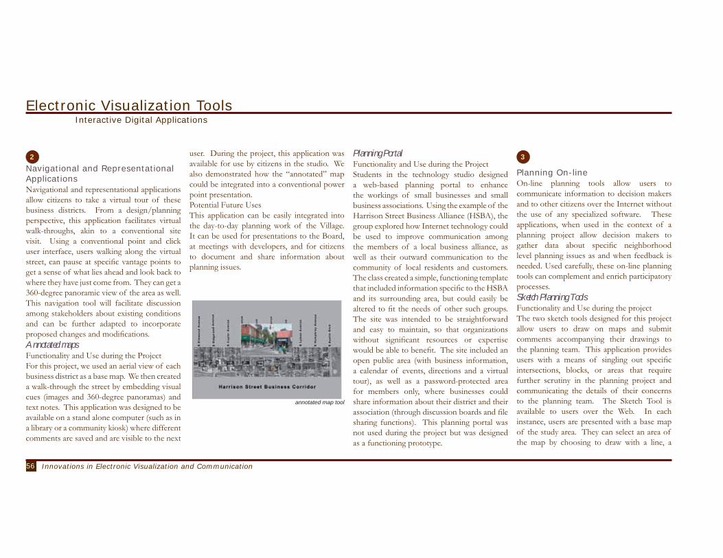
56 Innovations in Electronic Visualization and Communication
Navigational and Representational ApplicationsNavigational and representational applications allow citizens to take a virtual tour of these business districts. From a design/planning perspective, this application facilitates virtual walk-throughs, akin to a conventional site visit. Using a conventional point and click user interface, users walking along the virtual street, can pause at specific vantage points to get a sense of what lies ahead and look back to where they have just come from. They can get a 360-degree panoramic view of the area as well. This navigation tool will facilitate discussion among stakeholders about existing conditions and can be further adapted to incorporate proposed changes and modifications. Annotated mapsFunctionality and Use during the ProjectFor this project, we used an aerial view of each business district as a base map. We then created a walk-through the street by embedding visual cues (images and 360-degree panoramas) and text notes. This application was designed to be available on a stand alone computer (such as in a library or a community kiosk) where different comments are saved and are visible to the next
user. During the project, this application was available for use by citizens in the studio. We also demonstrated how the “annotated” map could be integrated into a conventional power point presentation.Potential Future UsesThis application can be easily integrated into the day-to-day planning work of the Village. It can be used for presentations to the Board, at meetings with developers, and for citizens to document and share information about planning issues.
Planning PortalFunctionality and Use during the ProjectStudents in the technology studio designed a web-based planning portal to enhance the workings of small businesses and small business associations. Using the example of the Harrison Street Business Alliance (HSBA), the group explored how Internet technology could be used to improve communication among the members of a local business alliance, as well as their outward communication to the community of local residents and customers. The class created a simple, functioning template that included information specific to the HSBA and its surrounding area, but could easily be altered to fit the needs of other such groups. The site was intended to be straightforward and easy to maintain, so that organizations without significant resources or expertise would be able to benefit. The site included an open public area (with business information, a calendar of events, directions and a virtual tour), as well as a password-protected area for members only, where businesses could share information about their district and their association (through discussion boards and file sharing functions). This planning portal was not used during the project but was designed as a functioning prototype.
Planning On-lineOn-line planning tools allow users to communicate information to decision makers and to other citizens over the Internet without the use of any specialized software. These applications, when used in the context of a planning project allow decision makers to gather data about specific neighborhood level planning issues as and when feedback is needed. Used carefully, these on-line planning tools can complement and enrich participatory processes. Sketch Planning ToolsFunctionality and Use during the projectThe two sketch tools designed for this project allow users to draw on maps and submit comments accompanying their drawings to the planning team. This application provides users with a means of singling out specific intersections, blocks, or areas that require further scrutiny in the planning project and communicating the details of their concerns to the planning team. The Sketch Tool is available to users over the Web. In each instance, users are presented with a base map of the study area. They can select an area of the map by choosing to draw with a line, a
Electronic Visualization ToolsInteractive Digital Applications
2 3
annotated map tool

57Planning Together: Character Plans for Oak Park Commercial DistrictsInnovations in Electronic Visualization and Communication
point, or a rectangle shape. Once they have selected an area on the map, they are then asked to type comments which correspond to the area that they have selected. They submit this information which is saved in a database. They can also see “other views” which shows them areas that other users have selected and the comments that were submitted. These applications were developed during the course of the planning project and were presented to the public in April 2003.Potential Future Uses:By changing the base map, the Sketch tool can be easily used in other geographical locations. The application could also have creative applications for other projects, where the Village solicits citizens to submit ideas with a place-specific aspect.
Oak Park Community MappingFunctionality and Use during the projectThe Oak Park Community Mapping Tool was designed to improve community decision-making by giving local stakeholders access to various kinds of data and information through an interactive community mapping website. Through these applications users can view maps ranging from census data, consumer ex-penditure data, land use, businesses, and public amenities. The information provided through the community mapping tool is generally avail-able to the public, but this tool would give people access to unique “local” information in a simple, accessible, and convenient format. This application was conceptualized as a studio project but it was not fully developed or used in the UIC Oak Park project.
BenefitsInnovations in communication and visualization offer great promise to enhance citizen participation. However, they cannot and should not be seen as a substitute for face to face meetings or other forms of direct citizen involvement. When used creatively, these technologies improve the quality and the efficiency of public discussions and debates and help build community consensus around specific planning issues.In a pragmatic sense, the use of these interactive applications can increase participation among those citizens who are unable to attend face to face meetings. However, the tools collectively offer additional advantages. These applications protect the privacy of respondents and therefore allow citizens to share “unpopular” or “minority” opinions without the fear of personal attacks or criticism. For instance, the survey of existing conditions contained an image of a popular neighborhood amenity which was also perceived as an unwanted land use by residents who lived in the area. The web-based survey suggested that a majority of respondents actually appreciated the neighborhood amenity! The outcomes of the survey do not imply that there are no problems associated with this particular amenity. However, it provides additional information to planners and decision-makers who are considering approvals
of similar land uses in the same area. Interactive applications make it possible for users to become proactive rather than just reactive in thinking about the future of their community. The applications developed for these two business districts can be readily adapted for use in other business districts. ConstraintsThe interactive tools are likely to place an additional burden on limited staff resources since the presence of interactive technologies are likely to raise expectations among citizens who anticipate personalized and immediate responses to questions and complaints.Citizens and users need to be educated about the value and benefits associated with these technologies. Although the Oak Park community has a high level of access to technology, some people are likely to feel overwhelmed and intimidated. The adoption and use of digital technologies must be accompanied with educational support and training programs for citizens to use the new tools. Through this project, UIC worked with a core group of staff in developing their skills to use and work with the applications developed for this project. However, additional support for training staff will be necessary to realize the complete benefits of technology adoption.
Benefits and Constraints Associated with the Use of Digital Technologies
sketch tool
Electronic Visualization ToolsInteractive Digital Applications
UIC photo

58 Planning for Implementation

59Planning Together: Character Plans for Oak Park Commercial DistrictsPlanning for Implementation
Implementation turns plans into action. Turning plans into action requires action on many fronts with the support of many different agencies and individuals. Fortunately Oak Park already enjoys a strong tradition of active government and citizen input. We offer some suggestions about how to take the planning ideas offered in this report toward completion. These include important tools and programs Oak Park already has on hand to complete the plans for commercial district improvement. Additionally we identify and describe some action ideas that will enhance the coordinated use of existing tools, as well as introduce new strategies. Implementation will require careful study, informed public debate and strong support from local public officials. Such coordinated efforts are necessary to overcome the following obstacles:1. Difficulties convincing residents, especially those in the district, that future changes to ownership and land use will benefit them and others in the Village.2. Difficulties faced in assembling parcels of land large enough to attract new mixed use development able to meet the ambitious goals of the district plans.3. Difficulties financing infrastructure and other public improvements needed to expand commercial activity, improve residential quality,
increase parking, calm traffic, and enhance pedestrian access and so on.4. Difficulties assessing the financial and market risks of commercial and residential developments within the districts.
Unique Opportunities - Capping the Ike The addition of a cap on either side of the current expressway bridge would be especially beneficial to the future improvement of the two Commercial Districts. The additional land would create opportunity for more ambitious station improvement plans. Assuming the prohibition of large structures from the cap surface, low density park and open space friendly uses will likely prevail. In such a scenario the currently depressed land values for property adjoining the freeway will skyrocket in value making the construction of higher density mixed use buildings more attractive and less detrimental to current neighbors as new resident activity will be less concentrated along the commercial corridor. The cap would provide opportunities to foster destination recreation and entertainment uses that would enhance commercial activity along the corridor. The future impacts of some of the difficult tradeoffs between improvements in density and accessibility that accompany the character plan recommendations would be reduced with the large increase in land area.
The plan recommendations, however, do not rely upon the approval and development of the cap.
Planning and Regulatory StrategiesStaging Plan ImprovementsThe timing and order of implementing the character plans depends upon careful administrative review and coordination with current Village development priorities. Participants in the planning process envisioned changes over a twenty year period. We recommend that in both districts that efforts to implement the plans start with the areas adjacent to the rail transit stations at Austin, Lombard and Oak Park Avenues. These properties offer the greatest opportunity for attracting developers and investors who can balance density and quality of life on valuable transit accessible sites.
Planning for Other Commercial DistrictsThe approval of this plan could stimulate the adoption of similar character plan development activities for the remaining commercial districts in the Village. The tools and process ideas generated through the year long process provide resources that staff can use to improve collaboration with each other and citizens, as well as guide preparation of Requests for Proposals to hire consultants.
Zoning The Village should revise the zoning ordinance to enable owners, investors and developers to carry out the commercial district plan improvements in a fair, consistent and effective manner. In some cases parcels within the character plan districts need to be re-zoned to allow for different uses in the future. Such re-zoning might be done by changing the existing zoning or creating an overlay district that would identify additional uses and regulatory requirements within the boundaries of each commercial district. These changes would allow for:-Mixed uses in areas currently zoned for exclusive residential or commercial use. -Shared parking agreements to meet commercial and residential parking standards-Street facing setback requirements along commercial corridors -Density bonus awards for open space and pedestrian friendly improvements
Transportation and Parking ImprovementsLinking Commercial Development Improvements to Infrastructure ImprovementsAs a whole, the plans at build out will have considerable impact on the operation of the road system in the Village. Mitigating traffic impact within the study areas will not by itself remedy
Planning for ImplementationOpportunities and Strategies

60 Planning for Implementation
improve other parts of the roadway network. We expect that a comprehensive traffic analysis will identify locations for spot improvements such as intersection widening or installation of traffic signals and stop signs; and perhaps require major changes in the functional classification of streets or generous use of one-way couplings. The cap may provide an excellent opportunity to address some of the circulation issues that have prevented the one-way couple involving Harrison Street and Garfield Street in the past.Planned improvements at other commercial districts will also require additional traffic study. The Village should consider using local transportation management associations (TMAs) for neighborhoods to provide ride-matching, transit information, telecommuting-support, parking management, high-occupancy-vehicle (HOV) preferential parking, transit use subsidy, showers and lockers for cyclists, shuttle bus service and guaranteed ride home service. The Village should also coordinate closely with the CTA and PACE to ensure that transit services are satisfying the needs of the residents. Changing long standing attachments to auto reliance will, at a minimum, require sustained efforts to promote the use of practical alternatives.
Accessing the IkeStreets in both commercial districts, but especially Harrison Street, accommodate a large amount of through traffic accessing the Ike. The traffic problem on Harrison could be greatly mitigated by diverting most of the through traffic to other East-West streets, especially Madison Avenue. This might require use of aggressive traffic calming methods such as chicanes, raised intersections, chokers, and cul-de-sacs.
Traffic at the I-290 interchange at Austin Avenue will experience severe congestion during peak periods. IDOT plans to widen the Ike should include rebuilding the Austin interchange to properly handle the expected increases in volume.
Parking ImpactsParking deficits remain at build out for each plan. The plan assumes commercial parking demand for stores in mixed use buildings will be met by new garages. However, height limitations limit the number of spaces in the new garages. One alternative would be to require additional parking spaces based on the square footage of commercial floor space in each new mixed use development. Such spaces would be reserved for commercial patrons during the daytime and for the residents overnight. Also, using market based
strategies such as charging extra fees for second parking spaces, and time-variable parking prices can be used to curb the demand for parking without harming the businesses. Ultimately, the construction of parking garages needs to be phased to accompany expansion and increase in commercial activity, but such supply should not lead development.
Fiscal and Economic StrategiesImplementing the proposed character plans will require a substantial amount of private and public investment. The Village must determine whether it should offer inducements to developers and if so, how much financial assistance it is willing to provide. The answer to this question is likely to depend on the type of land use in question. Given the shortage of vacant land, high housing prices, steady appreciation, and the attractiveness of Oak Park as a cosmopolitan and easily accessible suburb on Chicago’s border, it is likely that the market will take care of the proposed residential development on its own. With interest rates at historic lows and property values high, returns are likely to be sufficiently high to attract developers for the multi-family component, and the new condominiums and rental units be absorbed quickly. The Village could provide some of the suggested open space and infrastructure, or
it could require the developer to provide it in exchange for zoning variances, density bonuses, or assistance with parcel assembly. In order to preserve affordability in the area, however, the Village may have to offer some inducement or partner with area non-profits to access Low Income Housing Tax Credits or other source of gap financing. Affordability is critical to the success of these projects because the housing and commercial activity must appeal to the younger households upon whom the future of the Village depends to replace the current surplus of mid stream family households as they become empty nesters. The relatively low commercial rents in the two business districts and surplus of underutilized space means that the Village could consider different forms of public assistance for the proposed commercial development. In order to make the retail and office space more attractive to potential destination tenants or developers, the Village will need to solicit and review land acquisition and parcel assembly for potential development projects. It could market existing financing programs (below-market loans and grants for façade improvements and commercial rehabilitation) to potential developers. Designating the areas as Tax Increment Financing (TIF) districts would provide the Village with the power to use property tax revenues as (or
Planning for ImplementationOpportunities and Strategies

61Planning Together: Character Plans for Oak Park Commercial DistrictsPlanning for Implementation
even before) they are generated. Such a move, however, would need to be weighed against the potential impact on school districts and other overlapping jurisdictions.
Even without TIF, the Village could access capital markets at competitive rates to float bonds to finance the rehabilitation or redevelopment of select portions of each district. The Village could float non-referendum, special service area bonds for the payments of public improvements, the benefits of which include moving some of the developer’s costs from a taxable borrowing rate to a tax-exempt rate; allowing amortization over 20 year period and reducing the amount of private mortgage on the property. The Village could also experiment with other innovative techniques, such as co-development/profit-sharing and sales tax rebates.
Citizen ParticipationThe UIC-Oak Park project has successfully demonstrated that it is possible to integrate different voices into the typically contentious processes of plan-making in a diverse and dynamic community such as Oak Park. In order to implement this process in other planning projects and communities, the Village (as it has done this past year), must continue to embrace and adopt open and inclusive planning processes.
Our process provided citizens and elected officials the tools and strategies to understand the trade offs that citizens and elected officials must make together to plan the future of the community. We have provided many opportunities for citizens understand the reasoning and logic behind a particular plan as it was being developed and help them identify the trade-offs that are being made to accommodate competing demands. In order to implement the character plans developed for the two business districts, the village must continue to work closely with the stakeholder group in its current form. Changes or additions at this stage are likely to be detrimental to the sense of community that has developed over the past few months.The Village can apply this process to the planning and revitalization of other retail business districts in Oak Park by considering the following issues. The planning department needs additional support and resources to be able to sustain the level of activity that is prescribed in these guidelines.
Information and CommunicationThe community planning project should maintain a dedicated and refined database that includes property owners, business owners, as well as residential and commercial renters. The database’s accuracy must be verified periodically.
In the absence of a complete database, conventional organizing techniques should be used to encourage citizen participation. For the UIC-Oak Park project, students and faculty walked the two districts before every major event putting up flyers, knocking on doors of business owners and renters, and sending out emails to discussion groups.
Digital Communication PortalThe project should build and launch a digital communication portal (website) for each specific project that is directly linked and accessible to the main village page. The website should be available and ready for use before the first project meeting. The website should provide opportunities for interaction such as on-line discussion forums, surveys etc. The website should opportunities for citizens to provide direct feedback to planners, not only for one-way information dissemination. The UIC-Oak Park project maintained a project website starting September 2002 until June 2003. Participation TechniquesThe project should create different opportunities for meaningful participation. There should be a mix of activities that occur at different levels of scale. For example, some meetings can be among small groups to work through a specific aspect of the project while other meetings can be
focused on information sharing to a larger group. Moderated forums can also be used to make sure that citizens who are not always directly involved have an opportunity to be heard. Each meeting must be widely advertised. A more complete description of the participation process and details about different activities and levels of participation are described in Chapter IV.
StakeholdersThe selection and establishment of a stakeholder group must not be seen as an automatic and bureaucratic process. Each project must go through a stakeholder selection process. The act of applying to become a stakeholder prompts citizens to think about the time commitment they would make to participate in the project and help planners understand individual motivations for wanting to become involved. It is imperative that the Village staff get to know the community before the formation of the stakeholder group so that new participants are included. The Village staff must ensure that individuals who are over-burdened with other community responsibilities are not involved in the stakeholder group. No stakeholder should serve on more than two official village committees at any given time.In addition to maintaining economic and racial diversity, the stakeholder group must be balanced to include younger residents and older citizens,
Planning for ImplementationOpportunities and Strategies

62 Planning for Implementation
new comers to the neighborhood and long time residents, youth, as well as professionals with different experiences and skills. Once the stakeholder group is established, staff must work with stakeholders as a group, resisting demands to meet with them one-on-one. Staff must encourage stakeholders to work through and with the group and conform to group norms.
Adoption and Use of Digital TechnologiesThe project and process have been built on the premise that access to information and appropriate forms of interactive digital communication will enrich traditional methods of citizen participation and provide a more satisfying experience for those citizens who typically are not involved in participatory processes.Over the course of the year, three types of interactive applications were developed Visual Preference Surveys, Navigational and Representational Applications, and On-Line Planning Applications, more completely described in Chapter V. These applications can be used both individually and as a complete suite of tools to facilitate a planning process. Their adoption and use cannot be separated from other planning activities. The experiences gained over the course of the project year must be firmly embedded into the day-to-day life of the Village.In addition, technology implementation must
consider:TrainingStaff have received preliminary training in the use of the various applications developed for the project. However, it is useful for staff to have refresher courses in the next six months and also become involved in the development of a pilot project to test the applications in another planning context in order to solidify the learning that occurred over the past few months.
Hardware and SoftwareThe village will need to invest in appropriate software to run the various applications that have been developed. This investment must be distributed among all staff involved in planning activities. In addition, the Village will need to invest in laptops, digital cameras, and high resolution data projectors to facilitate collaborative planning in community meetings.
Maintenance, Updating and SecurityAdditional resources and technical staff will be needed to support the maintenance and updating and analysis of data that is generated through these interactive digital applications. Project websites will need to be updated in order to be responsive to citizens’ expectations. The implementation of surveys or other analysis tools must take into account issues related to individual
privacy as well as the security of the system as a whole.In summary, The UIC team recommends that the Village continue to invest in further strengthening of the capacity of its staff to use interactive digital technologies by identifying a pilot project that would allow staff from different departments to work together to use these applications as part of a planning process. Reflections on Knowledge ManagementWe live in a time when employees, consumers and citizens expect information to serve their needs and answer their questions. The combination of vast computational power and speed feeds this expectation as it favors digital information. Local municipalities face difficulties trying to meet the increasing public demand for speedy digital information delivery given the legacy of printed materials. Anticipating and coping with this demand not only requires a thoughtful shift to digital forms of information collection, reporting, storing and retrieval, but also changing how different organizational units of a municipality create and use information. Major improvements in information management require that different units learn to coordinate and share data that was previously an exclusive possession. Overcoming longstanding attachments to such possession requires strong evidence of improved benefits
from coordination and sharing. Over the course of the year, we learned that:The planning efforts tapped participation and expertise in many different functional domains (e.g., engineering, economic development, community relations, planning, etc…). However, the wealth of information in the Village, the Oak Park Public Library, the Township office and the Historical Society of Oak Park and River Forest proved difficult and challenging to find and gather. There was little coherent coordination and sharing of data across government units. Additionally, there were similar problems among departments within the Village. UIC team members spent much time and energy hunting down maps, reports and other important documents in the files of individual staff. Creation of a public web site early in the project generated disappointment as promised information proved more difficult to find and deliver than first anticipated.The Village would benefit from an overall records management system complete with an online catalog of materials providing location and description. Also, the Village would profit from a partnership between Village Hall, the OPPL, and the Historical Society to design and implement an overall knowledge management program for official data, information products including born digital documents, and public records. This system potentially could improve
Planning for ImplementationOpportunities and Strategies

63Planning Together: Character Plans for Oak Park Commercial DistrictsPlanning for Implementation
access between the Village and businesses by linking grants, small business loans, regulations, standards, etc. The system also would provide a communication channel for the Village and its commissions and citizens.The large quantities of paper documents produced by local government often pose a serious problem not only due to the volume of storage required, but the difficulty in classifying and cataloging the information for changes in use and users over time. As we move to the digital age, physical storage becomes less of an issue, while classifying and cataloging grow in importance. It is not enough to simply digitize physical documents for easy storage. We must also develop intelligent means for identifying, sorting and selecting the information in the future.
Since digital information is quick and easy to store, the temptation to store everything will prove hard to resist. One strategy for local governments is to distinguish official public records from other unofficial information. Public records deserve both preservation and access. The Illinois Compiled Statutes, Municipal Adoption of Codes and Records Act1(50 ILCS 220/1) offers the following definition in section 1 (c) and 1 (d):(c) “Public record” means any municipal, state, or
federal statute, rule, or regulation adopted prior to the exercise by any municipality of the authority to incorporate by reference herein granted; provided, however, that this definition shall not include the municipal ordinances, rules or regulations of any municipality except those of the municipality which is exercising the right to incorporate by reference,nor shall this definition include the state laws, rules, or regulations of any state other than the State of Illinois;(d) “Published” means printed, lithographed, multigraphed, mimeographed, or otherise reproduced (Source: Laws 1961, p. 1369)Ironically, this legal definition will not satisfy the growing public appetite for knowledge about local government activities, policies and reports. So local governments would be wise to develop a system for identifying and classifying what they keep; and then make the effort to have staff learn how to use the system on a routine basis. Initially these changes might be introduced using internal committees with benefit of outside consulting. Eventually, it may prove necessary to employ a full time information manager or Chief Information Officer (CIO).Adopting a more robust set of information definitions and policies would also improve the quality of public use. For instance, the Village Web Page would continue as an electronic vehicle
for delivering official information. However, non official information would be communicated using an intermediate shared web space with other public partners. This Village endorsed but non-official site would circulate draft policies, preliminary plans, and other works in progress that would benefit from public review and input – not only from Village employees and local residents, but from interested web users. The UIC team librarian will leave the Village with taxonomy and structure for organizing the information collected and created during the development of the year long planning project. The information includes a mix of electronic and printed material that will be stored at the UIC Library, accessible via the internet through the University Library web site. We recommend that the Village adopt and use this taxonomy to organize and manage planning project information for future projects.
1http://www.legis.state.il.us/legislation/ilcs/ch50/ch50act220.htm
Planning for ImplementationOpportunities and Strategies


Housing GoalPreserve and enhance Oak Park’s stable residential environment so persons of all ages, races and incomes can continue to live here in sound, affordable housing
Housing Objective BSupport an economically diverse housing stock for all income and age groups living or working in Oak Park
Policy 5Preserve and expand a variety of housing types to help meet the shelter needs of existing income groups living and working in Oak Park.
Housing Objective FStabilize the Size of Oak Park’s Population
Policy 19Encourage construction of multi-family units to meet needs of households not served by existing housing
Policy 20Permit higher density residential building at reasonable intervals in accord with development principles of plan.
Transportation GoalPreserve the residential character of neighborhoods and improve the health of business districts while achieving the safe, fuel-efficient, and cost-effective movement of people and goods within and through Oak Park
Transportation Objective AMaintain residential nature of neighborhoods
while allowing for safe flow of traffic within Oak Park
Policy 1Encourage through traffic to use primary arterial streets and encourage internally – originated traffic to use arterial and collector streets where possible.
Transportation Objective BProvide adequate parking for residents, shoppers, employees, commuters and visitors, including persons with disabilities
Policy 4Parking needs of different kinds of parkers should be given priority depending on the nature of the area.
Policy 5Require provision of adequate off street parking in new construction, and replace off-street parking lost to new construction.
Policy 6Provide off-street parking facilities in neighborhoods with extensive multi-family housing built prior to the imposition of zoning requirements for parking, and in commercial areas in need of additional parking.
Transportation Objective CEnhance public transportation opportunities for all residents, including those with limited mobility; and encourage more use of public transportation and less use of automobiles.
Policy 7Improve accessibility to rapid transit and other
forms of public transportation for the elderly and those with limited mobility.
Transportation Objective DUse Oak Park’s excellent mass transportation facilities as an economic development tool.
Economic Development GoalExpand the Village tax base in order to maintain a high level of services, programs and facilities
Objective AMaximize the potential for establishing tax-generating commercial and residential development and redevelopement
Policy 1Regularly review the Village land use controls and other regulations to allow for more effective re-use of land.
Policy 2Enhance Oak Park’s image as a desirable place to invest and do business
Policy 3Improve efforts to facilitate and attract new business by serving as a catalyst to the private sector
Economic Development GoalEncourage a broad range of convenient retail and service facilities to serve Oak Park residents and others.
Objective CEncourage existing businesses to remain and expand, and to attract new businesses that improve the mix of retain and service
establishments.
Objective DAttract a larger proportion of retail purchases from the Oak Park market area
Policy 5Retain and increase local employment opportunities
Policy 6Encourage new development and expansion in an orderly manner
Citizen Participation GoalMaintain a high and representative level of citizen involvement in Village affairs
Objective: Maximize opportunities for citizen involvement in the decision-making process.
Policy 1Seek and utilize the talent and expertise of citizens on advisory boards
Policy 3Seek out citizen views on major issues
Policy 4Encourage discussion of all issues in an open and frank manner
Policy 5The comprehensive plan should be widely distributed so that both public and private parties are aware of the Village goals, objectives and policies.
Appendix 11990 Comprehensive Plan Objectives Relevant to the Project

UPP 507(Participatory Planning Using Information Technologies Studio)Heather Donoghue Helen Edwards Kathleen Gems Nina Martin Lidia Ehrman Courtney OwenAntony ParteeAmanda PerkinsTynnetta QaiyimNidhi VaidMary White Jeromie Winsor
UPP556(Urban Design Studio)Michael AndersonMichael CassataArnab ChakrabortyAbraham DeletiogluJoshua DethDavid Fronczak Martha GlasCynthia HallinDavid HusemollerKevin LawlerXin LiJohn O’NealVeronica OvalleElvira ReyesClaudia SaraviaJohn SchneiderTimothy ScottKali SipesEileen Tunney
Appendix 2Roster of Graduate Student Participants in Studio Classes

This class was taught in the fall semester 2002, by Professor Laxmi Ramasubramanian. Twelve students working in two groups developed proposals for a digital application that would aid the planning process in Oak Park. Each tool was designed to provide citizens with new ways to review and access information. The following is a brief summary of each group’s work.
Small-Business Association Planning Portal to enhance Economic Development The planning portal was designed to enhance the workings of small businesses and small business associations. Using the example of the Harrison Street Business Alliance (HSBA), the group explored how Internet technology could be used to improve communication among the members of a local business alliance, as well as their outward communication to the community of local residents and customers. The class created a simple, functioning template that included information specific to the HSBA and its surrounding area, but could easily be altered to fit the needs of other such groups. The site was intended to be straightforward and easy to maintain, so that organizations without significant resources or expertise would be able to benefit. The site included an open public area (with business information, a calendar of events, directions and a virtual tour), as well as a password-protected area for members only, where businesses could share information about their district and their association (through discussion boards and file sharing functions).
Oak Park Community Mapping Application
The Oak Park Community Mapping Application was designed to run as an internet mapping service to improve community decision-making. Through this application, local stakeholders would have access to various kinds of data and maps based on the data, exhibited in a simple, visual display of the information. The user could specify the types of maps that they wish to view, ranging from maps of census data, consumer expenditure data, land use, businesses, and public amenities. The information provided through the community mapping application is generally available to the public, but this application would have given Oak Park citizens access to this information in a simple, accessible, and convenient format.
Appendix 3Summary of Student Proposals - Participatory Planning Using Information Technologies Studio

Appendix 4Description of Impact Analysis Tool Developed for this Project
OverviewThe impact analysis tool is an Excel-based computer program that allows us to estimate the village-wide fiscal and transportation impacts of the proposed corridor designs. The tool was an integral part of the design process. As an interactive program, it allowed us to determine how different land use patterns would influence government revenues, traffic conditions, and parking availability. Upon studying the impacts, we made further changes to the land use patterns, viewed the new impacts, and fine-tuned the design.
Fiscal impactsInformation about the corridor’s existing conditions in terms of square footage and number of units devoted to each land use formed the baseline scenario. Proposed design changes were entered as either percent changes or absolute (number of units) changes in the various land use categories (for example, the addition of a new restaurant or the demolition of a single-family home). The government revenue change derived from two sources—changes in property taxes and changes in sales taxes. Land use changes resulted in changes in equalized assessed property values, which in turn translated into changes in property tax revenue. At the same time, the addition of commercial land uses increased economic activity and corresponding sales tax increases.
We computed the fiscal impacts of these changes based on certain assumptions about the size of the new development, approximate sales and equalized assessed values per unit area, and Village tax rates. Information on property values was provided by the Oak Park Township Assessor’s Office while information on the sales tax rate, home rule tax rate, and the proportion returned to the Village was provided by the Village of Oak Park. The Urban Land Institute (ULI) publication Dollars and Cents of US Shopping Centers contained data on median rents, gross leasable area, and sales per building square foot by tenant classification. The values used were derived from the 1995 and 2002 figures.
Transportation impactsWe mainly relied on the total number of trips generated within the study area to measure the transportation impacts of the proposed land uses. By overlaying the projected amount of increase in trips on the existing traffic volume, we estimated traffic impacts of proposed land uses. The relationship between the land use type and intensity and the number of trips generated was quantified using the “trip generation rates” published by the Institute of Transportation Engineers (ITE). Trip generation rates are factors that estimate how many visits people will typically take to a specific land use, such as a store, office, park, etc. These factors were estimated by the Institute of Traffic Engineers (ITE), based on the analysis of many years’ data relating travel behavior and land uses. Trip generation rates are available in units of daily traffic, morning and evening peak, or morning and evening trips into and out of a place. Accordingly, we could estimate average daily traffic volumes, morning and evening peak period volumes, or morning and evening trips in and out. Units of measurement for the land use categories vary, and may be measured in terms of square footage, numbers of employees, number of customer features (theater seats, for example), and many others. Thus, it was sometimes necessary to convert a land use plan into equivalent units that can be used with the ITE database.
In addition to the trip generation, we conducted a planning level evaluation of intersection performance for the Austin/Harrison intersection. We used the Intersection Capacity Utilization (ICU) analysis1, a methodology widely used in California for traffic impact studies. We determined the current and projected intersection levels of service (LOS), which is an industry standard for measuring the degree of congestion with “A” being the best and “F” being the worst.
Industry guidelines2 accept LOS of “C” or “D” as adequate operating conditions in urban areas during peak hours.
Parking impactsParking demand was estimated using Urban Land Institute (ULI) parking demand factors, derived from analysis empirical data on the relationship between land uses and parking needs. The parking demand for each particular land use was estimated by multiplying the size of the facility by the related ULI factor. The total stand-alone parking demand for the study area was calculated by adding all the individual land uses’ parking demands. Opportunities exist, especially in highly dense areas to reduce the amount of physical space dedicated to automobile parking by employing a Shared Parking strategy. This approach recognizes that there are peaks and valleys in parking demand according to mixes of local business, the time of day, day of the week, and month of the year. The Urban Land Institute’s research in this area has resulted in additional factors that we can apply to stand-alone land use parking demand, to account for peak and off-peak parking needs.Parking supply is the sum of all available parking spots within the study area. The scope of supply includes privately-owned residential parking, privately-owned business parking, on-street parking (metered and free), public-use lots (metered, pay, and free), and privately-owned pay-lots and structures. We calculated both parking demand and parking supply for existing conditions, as well as for the proposed plans. The difference between the parking demand and supply numbers for any of the scenarios (existing, proposed) illustrates a parking shortage or surplus in the study area. The difference between the figures for the current state and for the proposal is the impact that the proposal will have on the community.
LimitationsWhile the tool was adequate for the purpose in hand, it has its limitations. These limitations need to be considered if the Village decides to make it a generic tool to estimate impacts of changes to its other business corridors. First, the computations are based on the assumption that sales and assessed property values increase linearly with the increase in the size of the commercial or residential units. Depending on market demand, this may not be true. Second, the Urban Land Institute data for sales and rent per unit area used as computation parameters may overestimate sales and rents, especially in the Harrison St. Corridor, where it is reported that building owners have subsidized rents in order to encourage the arts-related businesses in the area. Third, the estimates of assessed property values for new construction are based on current average assessed values. It may be possible to derive better estimates. In addition, there are differences in the way condominiums, town-homes, and apartments in multi-family units are assessed and occupied that are not captured in the calculations. Fourth, the fiscal impacts we consider in this model are limited to impacts on revenue and not on expenditures. In other words, it does not estimate the increased demand on public services resulting from the increases in economic activity and population. Fifth, although we used generic land use categories for retail and office spaces for transportation and parking analyses, actual trip generation and parking demand rates are influenced by the specific type and operation of each business. Thus, the use of generic land use categories may not be appropriate in some situations. Sixth, while the ICU method is useful for planning level analysis of independent (i.e. uncoordinated) signalized intersections, it cannot be used for assessing the effectiveness of complex signal control strategies or intelligent traffic systems. And finally, it is worth emphasizing that this is a fiscal (and transportation) impact analysis tool. Hence, it is not designed to address the feasibility of the designs being analyzed.

Appendix 5Project Timeline
Date Events 08/26/02 Studio space opened at 828 S. Oak Park Avenue Two studio classes structured around the project begin09/01/02 UIC-OAK PARK PROJECT WEBSITE GOES LIVE! Public Comment period begins09/04/02 UIC TEAM FORMALLY INTRODUCED TO VILLAGE STAFF Bi-weekly meetings with staff and UIC representatives begin09/18/02 1st Community Meeting Over 80 people attend UIC introduces project philosophy, approach and research team UIC demonstrates examples of how digital technologies can be used to
support planning Key dates for Phase I (September to December) circulated Citizens break into focus group (Themes: Technology for Planning, Urban
Design, Harrison Street, S. Oak Park Avenue) Each focus group generates a “list of concerns/issues”October-02 Studio open house - design 25 people attendNovember-02 Studio open house - technology 15 people attend11/05/02 2nd COMMUNITY meeting - 50 people attend UIC presents preliminary analysis of existing conditions for both districts UIC demonstrates use of interactive digital applications to document and
analyze existing conditions in both districts Citizens break into two groups and begin crafting vision statements for
each district12/04/02 Studio open house - UIC students present design proposals, citizens and
staff offer critique 30 people attend12/05/02 Studio open house - UIC students present integrated technology solutions
to assist citizens in planning 15 people attend12/7/2002 -12/14/02 UIC research assistants conduct informal survey of market trends in two
districts Dec 02 - Jan 03 DRAFT VISION STATEMENTS AVAILABLE ON PROJECT WEB SITE PILOT VERSION OF WEB-BASED SURVEYS AVAILABLE ON-LINE01/29/03 3rd Community meeting - 45 people attend UIC presents Phase II (January to May) timeline and describes stakehold-
er process UIC presents REVISED vision statements (based on public comment and
feedback) Four design ideas for revitalizing Harrison street unveiled Three design ideas for revitalizing S. Oak Park Avenue unveiled Citizens clarify vision statements working with five themes (Residen-
tial, Commercial, Transportation/Parking, Open Space, Urban Design/Character)
February-03 Stakeholder application, selection and approvalFeb-03 - March- 03 7 design plans on public display throughout village
Date Events
March-03 2 meetings of stakeholders Stakeholders review vision statements, propose modifications Stakeholders study seven design proposals, considering economic, fiscal,
and traffic impacts04/03/03 4th Community Meeting - 200 people attend UIC presents two extreme (High and Low Impact) development scenarios
for each retail district UIC discusses process of making trade-offs in evaluating each scenario UIC presents results of web-based survey of existing conditions Citizens engaged in a review and discussion of high impact and low im-
pact scenarios Interested citizens received training on the use of interactive digital ap-
plications and completed web-based surveys04/05/03 Stakeholders participate in all-day charrette, working in two groups Draft Plan developed for Harrison Street and S. Oak Park Avenue Stakeholders provide feedback on interactive applications under develop-
ment04/25/03 Middle School Charrette held simultaneously in two locations - 50 attendMay-03 Each stakeholder group refines plans considering economic and traffic
impact analyses from UIC05/07/03 5th Community meeting ~ 50 people attend Students present their ideas to citizens and staff Stakeholders listen to student input
06/19/03 6th Community meeting - Moderated Town Hall Meeting ~ 60 people at-tend
Stakeholder proposals for each district available for review and comment UIC, Village staff, Stakeholders answer questions from citizens (com-
ments received by email, phone, and in person)06/30/03 UIC-OAK PARK PROJECT WEBSITE GOES OFF-LINE Public Comment Period EndsJuly 03-Aug 03 UIC Report Writing - Character Plans, Description of Process, Interactive
Digital Applcations07/28/03 UIC students design and run one-day training session for Village staff07/29/03 UIC and Village meet to discuss implementation strategies08/25/03 - anticipated UIC delivers written report to Village that addresses 2 character plans and
describes a repeatable process09/08/03 - anticipated UIC delivers verbal report to Village09/15/03 - anticipated Report and plan on agenda for approval by Village Board
Letter from the Oak Park Avenue-Eisenhower Business District Stakeholders Committee
21 August 2003
Dear Village Board Members,
As members of the Oak Park community, the Stakeholders Committee for the Oak Park Avenue-Eisenhower Business District represents a variety of perspectives for this business dis-trict. The stakeholder process has enabled us to build consensus around a feasible character and development plan. Many of our views are represented in the attached report prepared by the team from the University of Illinois at Chicago. We would like to take this opportunity to highlight several of our key concerns about and proposals for the future of the district.
All of our recommendations center on a desire to retain the neighborhood focus of the business district. Our plan seeks to build upon its many strengths: the strong anchor businesses, busi-nesses that want to expand, public transportation availability, a diverse mix of locally-owned businesses, and the local residents who support them. We seek, furthermore, to preserve existing notable architecture and make sure future development is compatible with it. We want to channel future growth and development in ways that are in keeping with the above even as they revitalize and introduce new elements into the district. At the same time, we identify grave existing problems: the bifurcation caused by the expressway and the inadequacy of ex-isting parking. Our plan includes viable proposals for addressing each of these.
The following issues were central to our plan for revitalizing the district:
Re-connecting the north and south portions of the district: The current division of the district by the expressway is problematic for all stakeholders. The existing bridge is unfriendly to all pedestrians (business patrons, residents, children walking to school, commuters walking to the train), and thus to businesses, as well as to bus, car, stroller, and bike users. For this study, we strongly support the capping of the expressway at least from Euclid Avenue to Grove Avenue. This would allow for continuous ground level retail, additional centralized parking and greenspace, traffic congestion relief with bus drop-off lanes, safer pedestrian access with wider sidewalks and the development of a modernized, multi-modal transit station. These elements will contribute significantly to the revitalization of this business district.
Appendix 6Stakeholder Plans - Oak Park Avenue - Eisenhower Business District
Parking improvements: All participants agreed that the district needs more parking, particu-larly in evening hours. Parking needs to be located on both the north and south sides of the expressway, be convenient for business customers, and be perceived as accessible and safe. At the same time, it must be in keeping with the neighborhood character of the district. Measures must be taken to ensure that all parking needs generated by existing and new businesses are accommodated within the business district rather than on surrounding residential streets.
Neighborhood character and scale: We strongly recommend adhering to existing zoning height requirements for most areas of the district. We limit increases in commercial/multifamily density that exceed existing zoning to specified sectors of the district, i.e., those where changes would have the least negative impact on current residents and neighbors. Single-family zoning on Grove and Euclid Avenues should not be changed. We also support measures to improve pedestrian access throughout the district.
Building upon existing businesses: We advocate efforts to retain and support existing lo-cally-owned businesses that anchor this mixed-use district. Measures should be taken to build upon this current base by attracting new family-friendly and commuter-focused businesses. Any new mixed-use development should include commercial use on the ground-level.
Aesthetics: We see a need to continue streetscaping improvements and beautification efforts that do not interfere with pedestrian traffic. We advocate façade and signage elements that unify the district visually, while preserving noteworthy buildings. All improvements in this area need to be timeless in design, and require little maintenance over time. The Village should consider the findings of this report when developing the revised Village Comprehensive Plan. The ideas, concepts, and elements described in this report should be implemented in some type of master plan and then “phased-in” in a fiscally efficient manner.
We thank you for the opportunity to be a part of this innovative process of involving citizens in village planning and development. We believe the stakeholder format could be an effective one for the meaningful inclusion of community members in future planning projects. Serious consideration of the attached report and timely village action on its recommendations are key to such future successes.
Sincerely,The Oak Park Avenue-Eisenhower Business District Stakeholders Committee

Appendix 6Stakeholder Plans - Oak Park Avenue - Eisenhower Business District

Appendix 6Stakeholder Plans - Harrison Street

Bead in HandBusinesses and Residents United to Serve Harrison Street (BRUSH)Buzz CafeECOS PropertiesHarrison Street Business AllianceLeague of Women VotersOak Park Development CorporationOak Park Residence CorporationOak Park River Forest Historical SocietyResponsible Economic Development. Citizens of Oak Park (REDCOOP)Seven Generations AheadVillage Managers Association
Appendix 7List of Organizations that Contacted or were Contacted by UIC

Description of the Great Cities Urban Data Visualization Program and Lab
The Great Cities Urban Data Visualization Program and Lab (GCUDV Lab) is a research center within the College of Urban Planning and Public Affairs at UIC. The GCUDV Lab applies interactive visualization technologies to describe, represent, explain, and analyze urban issues. Its mission is to inform urban planning and policy discourse at a variety of scales (ranging from neighborhood to city/regional scale) through the innovative use of digital spatial multimedia applications and to support researchers, practitioners, and policy makers by developing a sustainable spatial data infrastructure and accompanying software, media, and analytic innovations.
Three types of innovative technology applications were developed by GCUDV Lab. These applications (more fully described in Chapter V) were designed to enhance public participation by providing citizens with new ways to communicate their ideas to each other and to the UIC planning team. The applications allowed citizens more flexible methods of community involvement. The interactive applications are also available for review on the accompanying CD-ROM.
Appendix 8Description of the Great Cities Urban Data Visualization Program and Lab

Appendix 9Results of Visual Preference Surveys
Summary Statistics Related to Visual Preference SurveysAfter an extensive review and testing period, two web-based surveys, a survey of existing conditions and a survey of best practices were available on-line between March 10th and June 2nd 2003.
Survey of Existing ConditionsHarrison Street: 15 photos and 3 panoramasS. Oak Park Avenue: 15 photos and 2 panoramas
Total # of Responses 03/10/03-06/02/03 84 Resident Yes 83 No 1 Business Owner Yes 29 No 55 Primary Area of Interest Oak Park Avenue 20 Harrison Street 31 Both 33
Survey of Best PracticesPhoto CategoriesDowntown Revitalization: 13 imagesMixed Use: 9 imagesTraffic: 8 imagesStreetscaping: 9 images
Total # of Responses 03/10/03-06/02/03 45 Resident Yes 43 No 2 Business Owner Yes 18 No 27 Primary Area of Interest Oak Park Avenue 9 Harrison Street 24 Both 12
(Footnotes)1 For detailed discussion of the methodology, see “Intersection Capacity Utilization 2000: A Procedure for Evaluating Signalized Intersections” by David Husch, Trafficware Corporation2 “A Policy on Geometric Design of Highways and Streets”. 4th Ed. American Association of State Highway and Transportation Officials, Washington D.C., 2001: pp. 84