PLANNING PROPOSAL FOR rezoning of certain land adjacent to ...
32
PLANNING PROPOSAL FOR rezoning of certain land adjacent to the Katoomba Golf Course
Transcript of PLANNING PROPOSAL FOR rezoning of certain land adjacent to ...
PLANNING PROPOSAL
FOR
rezoning of certain land adjacent to the Katoomba Golf Course
Page 1
TABLE OF CONTENTS
PART 1 OBJECTIVES OR INTENDED OUTCOMES 2
PART 2 EXPLANATION OF PROVISIONS 6
PART 3 JUSTIFICATION: 7
SECTION A - A NEED FOR THE PLANNING PROPOSAL 7 1. IS THE PLANNING PROPOSAL A RESULT OF ANY STRATEGIC STUDY OR REPORT? 7 2. IS THE PLANNING PROPOSAL THE BEST MEANS OF ACHIEVING THE OBJECTIVES OR INTENDED
OUTCOMES, OR IS THERE A BETTER WAY? 7 3. IS THERE A NET COMMUNITY BENEFIT? 9 SECTION B - RELATIONSHIP TO STRATEGIC PLANNING FRAMEWORK 13 4. IS THE PLANNING PROPOSAL CONSISTENT WITH THE OBJECTIVES AND ACTIONS CONTAINED
WITHIN THE APPLICABLE REGIONAL OR SUB – REGIONAL STRATEGY (INCLUDING THE SYDNEY METROPOLITAN STRATEGY AND EXHIBITED DRAFT STRATEGIES)? 13
5. IS THE PLANNING PROPOSAL CONSISTENT WITH THE LOCAL COUNCIL’S COMMUNITY STRATEGIC PLAN, OR OTHER LOCAL STRATEGIC PLAN? 14
6. IS THE PLANNING PROPOSAL CONSISTENT WITH APPLICABLE STATE ENVIRONMENTAL PLANNING POLICIES? 15
7. IS THE PLANNING PROPOSAL CONSISTENT WITH APPLICABLE MINISTERIAL DIRECTIONS (S.117 DIRECTIONS) 16
SECTION C - ENVIRONMENTAL, SOCIAL AND ECONOMIC IMPACT 17 8. IS THERE ANY LIKELIHOOD THAT CRITICAL HABITAT OR THREATENED SPECIES, POPULATIONS OR
ECOLOGICAL COMMUNITIES, OR THEIR HABITATS, WILL BE ADVERSELY AFFECTED AS A RESULT OF THE PROPOSAL? 19
9. ARE THERE ANY OTHER LIKELY ENVIRONMENTAL EFFECTS A RESULT OF THE PLANNING PROPOSAL AND HOW ARE THEY PROPOSED TO BE MANAGED? 22
10. HOW HAS THE PLANNING PROPOSAL ADEQUATELY ADDRESSED ANY SOCIAL AND ECONOMIC EFFECTS? 23
SECTION D - STATE AND COMMONWEALTH INTERESTS 23 11. IS THERE ADEQUATE PUBLIC INFRASTRUCTURE FOR THE PLANNING PROPOSAL? 23 12. WHAT ARE THE VIEWS OF STATE AND COMMONWEALTH PUBLIC AUTHORITIES CONSULTED IN
ACCORDANCE WITH THE GATEWAY DETERMINATION? 23
PART 4 COMMUNITY CONSULTATION 24
ATTACHMENT 1 – MAP PANELS 24 ATTACHMENT 2 – PRECINCT PROVISIONS 26

Page 2
PART 1 OBJECTIVES OR INTENDED OUTCOMES
The objective of this Planning Proposal is to rezone a parcel of land from Recreation – Open Space and Recreation – Private to Village – Housing with the aim of permitting dwellings.
The subject land includes the following allotments:
Lot 1 DP 1026915, No. 142 – 150 Narrow Neck Road Katoomba, currently zoned Recreation – Open Space
Lot 2 DP 1026915, No 152 – 156 Narrow Neck Road Katoomba, currently zoned Recreation – Open Space
Lots 1 to 5 and Lots 8 to 17 DP 270422, No.s 1 to 18 and 22 to 24 The Escarpments, Katoomba, currently zoned Recreation – Private Note: Lot 7 of the original planning proposal was subdivided into 4 lots on 28/7/10 and created Lots 14-17.
Strata Plan 74576, No. 25 The Escarpments, Katoomba currently zoned Recreation - Private
Locality Plan
Aerial Photo
Page 3
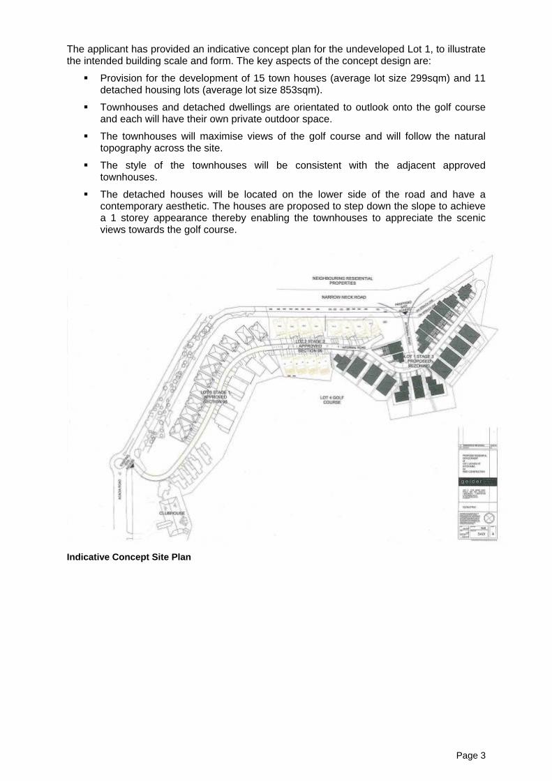
The applicant has provided an indicative concept plan for the undeveloped Lot 1, to illustrate the intended building scale and form. The key aspects of the concept design are:
Provision for the development of 15 town houses (average lot size 299sqm) and 11 detached housing lots (average lot size 853sqm).
Townhouses and detached dwellings are orientated to outlook onto the golf course and each will have their own private outdoor space.
The townhouses will maximise views of the golf course and will follow the natural topography across the site.
The style of the townhouses will be consistent with the adjacent approved townhouses.
The detached houses will be located on the lower side of the road and have a contemporary aesthetic. The houses are proposed to step down the slope to achieve a 1 storey appearance thereby enabling the townhouses to appreciate the scenic views towards the golf course.
Indicative Concept Site Plan

Page 4
Site viewed from the internal road (The Escarpments) looking north towards the undeveloped Lot 1.
Existing vegetation on the northern corner of the site.
Narrow Neck Road looking north (subject land on right of photo)

Page 5
Glencoe Road looking west (subject land on left of photo)
Existing Stage 1 residential development with earthworks for Stage 2 in foreground
Subject land viewed from Parke Street, Katoomba

Page 6
PART 2 EXPLANATION OF PROVISIONS
Amendment of the following map panels of the Blue Mountains Local Environmental Plan 2005:
Map Panel A: Zones, Precincts and Provisions
Map Panel B: Protected Areas
Map Panel C: Heritage Conservation and Special Use
in the form shown in Attachment 1.
Map Panel B and C are not altered by this proposal.
Amend the Blue Mountains Local Environmental Plan 2005 by the inclusion of Precinct Provisions in Schedule 1, Part 4 – Division 18 – Katoomba Precinct VH-KA09 – Katoomba Golf Course.

Page 7
PART 3 JUSTIFICATION:
Section A - A Need for the Planning Proposal 1. Is the planning proposal a result of any strategic study or report?
The planning proposal is not the result of any strategic study or report.
This planning proposal results from an application to rezone the subject land from Recreation – Open Space and Recreation – Private to Village – Housing. The subject land has approval for the construction of dwelling units and tourist accommodation in 3 stages. Upgrades to the Katoomba Golf Course and Clubhouse were part of the development consent. The land containing the Katoomba Golf Course and Clubhouse are not the subject of this proposal.
A development comprising 102 residential units, a 120 room hotel and subdivision was approved under a previous planning instrument, Blue Mountains Local Environmental Plan No. 4 where such development was permissible with consent. The proposal was approved in 3 stages. Approval for the staged development was issued by Blue Mountains City Council in 2001 and construction commenced at the southern portion of the holding, being Stage 1. An amended approval was issued in 2008 for modification to multi dwelling units on Lot 2 DP 1026915, being Stage 2.
This rezoning has been sought to allow the development of medium density residential housing on Lot 1. The original proposal and subsequent approvals were for a hotel on Lot 1 (Stage 3) however a recent detailed market assessment by the owner has shown the development of the land for a hotel is unviable. Therefore, having regard to the approved residential use of adjoining land, the proposed residential use constitutes an extension of the development already commenced around the perimeter of the golf course.
Since the use of the adjoining land is not consistent with the current zone it has been decided to rezone the subject area which will make the transition of this site into the Standard Instrument a more straight forward process. The proposed zone will align existing, approved and proposed land uses with the appropriate zoning.
Precinct Provisions will be applied to the subject land. The proposed Precinct Provisions reflect the provisions of the Katoomba Golf Course Development Control Plan (DCP 19) which applies to the land and has been applied to each of the relevant proposals during assessment. Should the rezoning proceed, the Katoomba Golf Course DCP 19 can be repealed by the Council.
Precinct Provisions are the most appropriate method of applying development controls over the subject land. The inclusion of Precinct Provisions is consistent with other similar zones within LEP 2005.
2. Is the planning proposal the best means of achieving the objectives or intended outcomes, or is there a better way?
Part of the subject land is currently zoned Recreation – Private and the remainder is zoned Recreation – Open Space. The following table lists development permissible with consent and without consent within these zones and development permissible with consent and without consent in the proposed zone, Village – Housing. Recreation – Private Recreation – Open Space Village - Housing Accessible housing Accessible housing Advertising structures Advertising structures Advertising structures Animal establishment Arts & crafts gallery Bed & breakfast
establishments Boarding houses

Page 8
Bush regeneration Bush regeneration Bush regeneration Bush fire hazard reduction Bush fire hazard reduction Bush fire hazard reduction Camping sites Camping sites Caravan parks Caravan parks Caretakers’ dwellings Caretakers’ dwellings Child care centre Child care centre Child care centres Clubs Clubs Community buildings Community buildings Community buildings Community centres Community centres Dams Dams Development ancillary to a
dwelling house Display garden Display gardens Display garden Domestic swimming pools Domestic swimming pools Dual occupancies Dwelling houses Educational establishments Educational establishments Exhibition homes General stores Granny flats Health care practices Holiday lets Home businesses Home businesses Home employment Home occupations Home occupations Home occupations Hospitals Integrated housing Land management works Land management works Land management works Medical centres Multi-dwelling housing Nature-based recreation Nature-based recreation Parking Parking Parking Permaculture Permaculture Permaculture Places of assembly Places of assembly Places of worship Places of worship Places of worship Public buildings Public buildings Public buildings Public utility undertaking Public utility undertakings Public utility undertakings Recreation areas Recreation areas Recreation facilities Recreation facilities Refreshment rooms Refreshment rooms Refreshment rooms Remediation of contaminated land
Remediation of contaminated land
Remediation of contaminated land
roads roads Roads Special uses Special uses Special uses Telecommunication facilities Telecommunication facilities Telecommunications facilities Utility installations Utility installations Utility installations Visitor facilities Visitor facilities Visitor facilities
It is the express intention of the proponent to develop the undeveloped portion of the subject land for multi-dwelling housing, however should the development fail to proceed in the manner proposed alternate permissible development may be considered and assessed.
With regards to Lot 1, an approval exists for a 120 room hotel and apartments. This consent remains current by virtue of the commencement of the original development consent. While the hotel and apartments can be constructed under the current approval it is not a permissible development under the current zone. Given the restrictive nature of the existing Recreation – Open Space zoning, with limited permissible land uses, a rezoning is considered the best method of aligning the approved land use with the appropriate zone. A rezoning is the only method of achieving a zone where residential accommodation is permissible.

Page 9
The applicant has provided a Hotel Market Demand Survey supporting the application and the proposal to amend the current proposal of a 120 room hotel and apartments to residential accommodation. The survey concluded that a 120 room hotel at Katoomba does not appear supportable due to reasons including the limited exposure of the site to passing traffic, overnight visitor numbers to the Blue Mountains are stagnant and most visitors to the Blue Mountains either stay with friends or have day trips to the mountains.
With regard to Lot 2, an approval exists for residential development which will be developed once the first stage of the development has been completed.
With regards to Lots 1 to 5 and Lots 7 to 13 DP 270422 and Strata Plan 74576, development of this land is nearing completion.
3. Is there a net community benefit?
The following table addresses the evaluation criteria for conducting a “net community benefit test” within the Draft Centres Policy (2009) as required by the guidelines for preparing a planning proposal.
Evaluation Criteria Y/N Comment
Will the LEP be compatible with agreed State and regional strategic direction for development in the area (e.g. land release, strategic corridors, development within 800m of a transit node)?
Y The proposed rezoning is compatible with the Metropolitan Strategy and Draft North West Subregional Strategy for the following reasons:
It will contribute to achieving the housing growth target for Council of 7,000 new dwellings by 2031 (page 78).
It aligns with the direction to minimise Greenfield development and encourage the majority of dwelling growth as infill development in established areas (C1.3)
It will constitute a focus of housing within the Katoomba town area where jobs, transport and services are within the locality (C2.1).
It will facilitate the creation of a mix of housing that will provide choice for residents to meet future housing needs of the community (C2.3).
It will protect the highly significant biodiversity of plants and animals in the nearby national park as the site has been determined not to have any significant impact on any threatened species, populations or endangered communities. The existing timbered portion of the site will remain undeveloped.
Is the LEP located in a global/regional city, strategic centre or corridor nominated within the Metropolitan Strategy or other regional/subregional strategy?
Y The subject site is not identified within a key strategic centre or corridor.
The site is situated within the urban area of the suburb of Katoomba. The site is peripheral to Katoomba town centre which is categorised as a “town centre” in the North West Draft Subregional Strategy.
Whilst the site is not situated immediately within or adjacent to the town centre, the

Page 10
Evaluation Criteria Y/N Comment
site offers an opportunity to provide for additional residential development to support the centre’s role and function and avoid isolating development that is distanced from existing infrastructure and services. The site also adjoins existing medium density housing adjacent to the Katoomba golf course land and single dwellings further to the west.
Is the LEP likely to create a precedent or create or change the expectations of the landowner or other landholders?
N The proposed rezoning is unlikely to create a precedent within the locality or change the expectations of the site as it previously had approval for short stay hotel accommodation, which constitutes an ‘urban’ and intensive land use.
This proposal will see the development of the lot to a lesser intensity than the hotel use and one that is more in keeping with the character of existing development on the peripheral golf course lands (Lots 2 and 3) and the established surrounding neighbourhood.
Have the cumulative effects of other spot rezoning proposals in the locality been considered? What was the outcome of these considerations?
Y There is a spot rezoning at the Leura Golf Course, however this is not in the locality and no cumulative impacts are likely.
As discussed above, the site will not have a cumulative effect, as the land is located within an area that is suitable for the development proximate to the town centre and with access to existing services and infrastructure. The rezoning will facilitate a natural extension of the residential dwellings that flank the western boundary of the golf course.
Will the LEP facilitate a permanent employment generating activity or result in a loss of employment lands?
N The site is not zoned to facilitate employment, nor will it result in a loss of employment land.
The proposal will create employment through the construction jobs to install the infrastructure and build the homes therefore delivering an economic benefit to the community.
The approved hotel would have generated employment through construction jobs and, once completed, through staffing, however the Katoomba Hotel Demand Study identified that a hotel is unlikely to be economically viable.
Will the LEP impact upon the supply of residential land and therefore housing supply and affordability?
Y The proposal will have a positive impact on the residential supply by adding to the amount of available residential land.

Page 11
Evaluation Criteria Y/N Comment
The proposal will increase the housing choice and type of housing on the land and contribute to meeting the Blue Mountains residential targets.
Is the existing public infrastructure (roads, rail, utilities) capable of servicing the proposed site? Is there good pedestrian and cycling access? Is public transport currently available or is there infrastructure capacity to support future transport?
Y The existing public infrastructure is adequate to meet the needs of the proposal. The site is fully serviced and is contained within an established urban area.
The residential development will support the Katoomba town centre. The site is around 1.5km from Katoomba Railway Station which has express services to Sydney. Local buses service the area however they are limited and primarily cater to school children.
Will the proposal result in changes to the car distances travelled by customers, employees and suppliers? If so, what are the likely impacts in terms of greenhouse gas emissions, operating costs and road safety?
N/A N/A
Are there significant Government investments in infrastructure or services in the area where patronage will be affected by the proposal? If so, what is the expected impact?
N No. The proposal does not require further investment in public infrastructure, it will utilise the existing infrastructure and services. The developer will extend and upgrade infrastructure to service the development at no cost to government.
Will the proposal impact on land that the Government has identified a need to protect (e.g. land with high biodiversity values) or have other environmental impacts? Is the land constrained by environmental factors such as flooding?
N The site is currently open space and not ‘environmental conservation’.
The environmental capability of the land to support an urban land use (the hotel development) has been previously assessed and approved.
More recent investigations have formed part of this proposal to determine whether the land contains any known critical habitat, threatened species or contain significant biodiversity values. The Flora and Fauna report, prepared by Travers Bushfire and Ecology, is contained in this rezoning submission. The report concluded that the rezoning is unlikely to result in a significant impact on any threatened species, populations or endangered ecological communities or their habitats. As such no further assessments are considered to be required under the relevant legislation.
Will the LEP be compatible/ complementary with surrounding adjoining land uses? What is the impact on the amenity in the location and wider
Y The proposal is compatible with adjoining land uses including the townhouse development immediately adjoining on Lots 2 and 3 and the detached housing

Page 12
Evaluation Criteria Y/N Comment
community? Will the public domain improve?
further to the west. The site is not an isolated residential development and is well serviced and proximate to the town centre.
The indicative building envelopes illustrated in this planning proposal are considered appropriate for the site and surrounds and will be designed to consider the surrounding development including retention of views and protection of the scenic quality of the area.
Will the proposal increase choice and competition by increasing the number of retail and commercial premises operating in the area?
N/A N/A
If a stand-alone proposal and not a centre, does the proposal have the potential to develop into a centre in the future?
N/A N/A
What are the public interest reasons for preparing the draft plan? What are the implications of not proceeding at that time?
- The proposal will provide additional housing in a variety of forms to assist in the delivery of meeting the housing growth and dwelling mix actions from the Subregional strategy.
If the rezoning was not supported, the site would remain vacant and the provision of additional housing would not be realised. In addition the land would not be maintained and over time would detract from the amenity of the golf course and surrounds, therefore undermining the significant investment in the upgrade works on the golf course.
Overall, the proposal will provide a net community benefit for the following reasons: It constitutes a balanced and appropriate use of land that is more in keeping with
the surrounding residential character than the original approved hotel use.
The proposal will contribute to Council’s requirement to facilitate new dwelling growth, in accordance with the Subregional Strategy target.
The proposal will facilitate a mix of dwelling types that aim to encourage social mix and provide housing choice to meet the needs of the community.
It is located within the existing Katoomba town area and has adequate infrastructure to support the development.
The proposal will not result in any significant environmental impacts as assessed in the flora and fauna assessment report.
It will create local employment opportunities through the construction jobs to carry out the civil and building works to the benefit of the local economy.
Page 13
Finally, the site will offer a pleasant outlook over the Katoomba Golf Course for the future residents. It will constitute a logical extension to the existing pattern of residential development on Lots 2 and 3 to create a desirable living environment.
Section B - Relationship to strategic planning framework 4. Is the planning proposal consistent with the objectives and actions contained within the
applicable regional or sub – regional strategy (including the Sydney Metropolitan Strategy and exhibited draft strategies)?
The key strategic planning framework at the State level is embodied in the 2005 “City of Cities: A Plan for Sydney’s Future”, known as the Metropolitan Strategy.
The Metropolitan Strategy provides a broad framework for promoting and managing Sydney’s growth over the next 25 years, in which it is expected that such growth will entail an additional 1.1 million people, requiring 640,000 new homes and capacity for 550,000 new jobs by 2031. A key outcome of the Metropolitan Strategy was the preparation of Subregional Strategies.
The Blue Mountains LGA is one of 5 LGAs that fall within the Draft North West Subregional Strategy. The Strategy contains directions and actions to guide each Council’s strategic planning in a regional focus. Achieving the housing and employment targets are key directions that are shaping strategic planning for all Councils in order to meet the needs of the forecast population growth over the next 20 years.
The Draft North West Subregional Strategy states that the Blue Mountains LGA has experienced minor negative population growth in recent years. The Blue Mountains area is also identified as a major tourist destination, being one of the top three top tourist destinations in Australia.
The key directions for Subregion are embodied within seven key outcomes. The two relevant directions are outlined below:
Plan to meet employment and housing capacity targets
The North West Subregion has a target to accommodate 140,000 new dwellings by 2031. Whilst 60,000 dwellings are to be accommodated within the North West Growth Centre the remaining 80,000 dwellings are to be located in other areas, with the majority to be located within close proximity to centres to ensure accessibility to jobs and services. The Blue Mountains LGA is expected to accommodate a capacity target of 7,000 new dwellings to year 2031.
In terms of employment, the subregion is targeted to achieve 130,000 new jobs. The improved road access to the subregion has contributed to the North West becoming a prime area for the relocation of manufacturing and other industries from established industrial areas and includes a strongly growing labour force. The Blue Mountains LGA is expected to accommodate a capacity target of 7,000 new jobs to year 2031.
Katoomba is identified as the largest employment land area in the Blue Mountains LGA with potential for capacity for expansion and growth, dependent on constraints on spatial expansion.
The North West Subregion has one of the lower housing densities in the Sydney Region and the highest percentage of separate houses. State government is seeking Councils to plan for a greater range of housing forms, especially within centres close to public transport to contribute to increasing mix of housing to accommodate the changing demands of existing residents and support a diverse workforce.
The above directions identify the growth anticipated for the subregion and highlight the significance of the future role of Katoomba as both a place for employment and residential growth.
The site is located only a short distance from the town centre and is within the existing ‘urban footprint’ of the suburb of Katoomba. The future development of Lot 1 for residential development will assist in meeting the housing growth target for in the Blue Mountains LGA. Furthermore, it will satisfy another housing action by facilitating the

Page 14
development of a mix of housing that will encourage social mix and potentially meet the needs of the ageing community.
The site is also able to offer a unique position, being located immediately adjacent to the Katoomba Golf Course (a significant recreational facility), which would add further appeal to a site already within proximity to a public transport node (namely Katoomba Railway Station), employment and services. Therefore, the proposal satisfies this policy direction.
Strengthen the Role of the Centres
To maximise potential around existing and future centres, future urban growth is encouraged to be located in and around existing centres and close to public transport infrastructure. The strategy also notes that existing suburban centres are to be revitalised to provide a range of housing, employment and transport options within open space for residents.
Katoomba categorised as a “town centre” which is the largest in the hierarchy of local centres. Katoomba is serviced by a railway station and is the largest centre in the Blue Mountains LGA, reflecting the importance in strengthening it’s viability with anticipated enhanced employment activities and services.
Particular directions under the strategy are for consideration to planning for housing growth in centres, particularly those well serviced by public transport. Town centres are specifically identified as places for enhanced vibrancy by provision of much needed housing choice for the ageing and changing population.
These directions demonstrate the importance of enhancing the vibrancy of town centres and ensuring the viability of town centres is retained for the benefit of local population. As Katoomba is well serviced by public transport and is the largest town centre of the Blue Mountains LGA, it is logical that Katoomba should be the focus of housing growth. The site is situated only a short distance away from the centre of the town. It offers an opportunity to provide for additional residential development to support the centres’ role and function and avoid creating isolated development that is distant to existing infrastructure and services. Therefore, the proposal satisfies this policy direction.
5. Is the planning proposal consistent with the local council’s Community Strategic Plan, or other local strategic plan?
The 2007 Blue Mountains Community Plan is a relevant consideration. The planning proposal is consistent with the housing aims of this plan because:
The proposal will enhance the provision of a variety of housing types and provide residential development in a recreational setting. Residential developments on golf courses are becoming increasingly popular due to the increased amenity afforded and scenic quality.
The housing could appeal to market segments such as the ageing population in the local area as well as the working population, offering the opportunity to ‘age in place’.
The strategic position of the site and the surrounding area means that the site suitably fits as residential housing. The land is serviced and is not isolated and is proximate to the Katoomba town centre.

Page 15
6. Is the planning proposal consistent with applicable state environmental planning policies? Note: 1 Not Relevant: This provision or planning instrument does not apply to land within the Draft Amendment to Draft
LEP 2005 2 Consistent: This provision or planning instrument applies; the Draft Amendment to Draft LEP 2005 meets the
relevant requirements and is in accordance with the provision or planning instrument. 3 Justifiably Inconsistent: This provision or planning instrument applies, and is considered to be locally
inappropriate.
State Environmental Planning Policies in force
NO
T R
ELE
VA
NT
1
CO
NS
ISTE
NT
2
JU
STI
FIA
BLY
IN
CO
NS
ISTE
NT
3
SEPP 1 Development Standards
SEPP 4 Development without Consent and Miscellaneous Complying Development
SEPP 6 Number of Storeys in a Building
SEPP 14 Coastal Wetlands
SEPP 15 Rural Landsharing Communities
SEPP 19 Bushland in Urban Areas
SEPP 21 Caravan Parks
SEPP 22 Shops and Commercial Premises
SEPP 26 Littoral Rainforests
SEPP 29 Western Sydney Recreation Area
SEPP 30 Intensive Agriculture
SEPP 32 Urban Consolidation (Redevelopment of Urban Land)
SEPP 33 Hazardous and Offensive Development
SEPP 36 Manufactured Home Estates
SEPP 39 Spit Island Bird Habitat
SEPP 41 Casino/Entertainment complex
SEPP 44 Koala Habitat Protection
SEPP 47 Moore Park Showground
SEPP 50 Canal Estate Development
SEPP 52 Farm Dams and Other Works in Land and Water Management Plan Areas
SEPP 53 Metropolitan Residential Development
SEPP 55 Remediation of Land
SEPP 59 Central Western Sydney Economic and Employment Area
SEPP 60 Exempt and Complying Development
SEPP 62 Sustainable Aquaculture
SEPP 64 Advertising and Signage

Page 16
State Environmental Planning Policies in force
NO
T R
ELE
VA
NT
1
CO
NS
ISTE
NT
2
JU
STI
FIA
BLY
IN
CO
NS
ISTE
NT
3
SEPP 65 Design quality of Residential Flat Development
SEPP 70 Affordable Housing (Revised Schemes)
SEPP 71 Coastal Protection
SEPP (Housing for Seniors or People with a Disability) 2004
SEPP (Building Sustainability Index: BASIX) 2004
SEPP (Development on Kurnell Peninsula) 2005
SEPP (Major Development) 2005
SEPP (Sydney Region Growth Centres) 2006
SEPP (Mining, Petroleum Production and Extractive Industries) 2007
SEPP (Temporary Structures) 2007
SEPP (Kosciuszko National Park – Alpine Resorts) 2007
SEPP (Infrastructure) 2007
SEPP (Rural Lands) 2008
SEPP (Exempt and Complying Development Codes) 2008
SEPP (Western Sydney Parklands) 2009
SEPP (Western Sydney Employment Area) 2009
SEPP Sydney Regional Environmental Plan No. 20 Hawkesbury – Nepean River (No. 2 – 1997)
SEPP Drinking Water Catchments Regional Environmental Plan No 1
SEPP State Environmental Planning Policy (Affordable Rental Housing) 2009
7. Is the planning proposal consistent with applicable Ministerial Directions (s.117
directions) Note: 1 Not Relevant: This provision or planning instrument does not apply to land within the Draft Amendment to Draft
LEP 2005 2 Consistent: This provision or planning instrument applies; the Draft Amendment to Draft LEP 2005 meets the
relevant requirements and is in accordance with the provision or planning instrument. 3 Justifiably Inconsistent: This provision or planning instrument applies, and is considered to be locally
inappropriate.
Directions under Section 117(2)
NO
T R
ELE
VA
NT
1
CO
NS
ISTE
NT
2
JUS
TIFI
AB
LY
INC
ON
SIS
TEN
T 3
1. EMPLOYMENT AND RESOURCES 1.1 Business and Industrial Zones
1.2 Rural Zones

Page 17
Directions under Section 117(2)
NO
T R
ELE
VA
NT
1
CO
NS
ISTE
NT
2
JUS
TIFI
AB
LY
INC
ON
SIS
TEN
T 3
1.3 Mining, Petroleum Production and Extractive Industries
1.4 Oyster Aquaculture
1.5 Rural Lands
2. ENVIRONMENT AND HERITAGE 2.1 Environmental Protection Zones 2.2 Coastal Protection
2.3 Heritage Conservation
2.4 Recreation Vehicle Areas
3. HOUSING, INFRASTRUCTURE AND URBAN DEVELOPMENT 3.1 Residential Zones 3.2 Caravan Parks and Manufactured Home Estates
3.3 Home Occupations 3.4 Integrating Land Use and Transport 3.5 Development Near Licensed Aerodromes
4. HAZARD AND RISK 4.1 Acid Sulfate Soils
4.2 Mine Subsidence and Unstable Land
4.3 Flood Prone Land
4.4 Planning for Bushfire Protection 5. REGIONAL PLANNING
5.1 Implementation of Regional Strategies
5.2 Sydney Drinking Water Catchments 5.3 Farmland of State and Regional Significance on the NSW Far
North Coast
5.4 Commercial and Retail Development along the Pacific Highway, North Coast
5.5 Development in the vicinity of Ellalong, Paxton and Millfield (Cessnock LGA)
5.6 Sydney to Canberra Corridor (Revoked 10 July 2008. See amended Direction 5.1)
5.7 Central Coast (Revoked 10 July 2008. See amended Direction 5.1)
5.8 Second Sydney Airport: Badgerys Creek
6. LOCAL PLAN MAKING 6.1 Approval and Referral Requirements 6.2 Reserving Land for Public Purposes 6.3 Site Specific Provisions
7. METROPOLITAN PLANNING 7.1 Implementation of the Metropolitan Strategy
The Section Ministerial Directions are to be considered in a rezoning of land.
The relevant considerations are:
Direction 2.1 – Environmental Protection Zones
Direction 3.1 – Residential Zones
Direction 3.4 – Integrating Land use and Transport
Direction 4.4 – Planning for Bushfire Protection
Direction 6.1 – Approval and Referral Requirements

Page 18
The rezoning proposal is consistent with the Ministerial Directions, pursuant to Section 117(2) of the EP&A Act as demonstrated by the following:
With respect to the Direction 2.1 Environment Protection Zones, the following information is provided:
Lot 1 DP 1026915 is currently zoned Recreation –Open Space with Protected Area for Water Catchment 100% and Protected Area of Slope Constraint 31%. The land is undeveloped.
Lot 2 DP 1026915 is currently zoned Recreation – Open Space with Protected Area for Water Supply Catchment 100% and Protected Area of Slope Constraint 42%. Consent has been issued for the development of Lot 2 for residential accommodation.
Lots 1-5 and 7-13 DP 270422 and SP 74576 are zoned Recreation – Private with Protected Area for Water Supply Catchment, Protected Area of Escarpment Area of 100% and Protected Area of Slope Constraint 2%. The site has been developed with residential accommodation.
Under the provisions of LEP 2005, Development Excluded land is land mapped as Protected Area of Slope Constraint. The area relevant to this component of the assessment is the area within Lot 1 DP 1026915 which is Slope Constraint area and undeveloped. The relevant land has an area comprising approximately 5,400m2. The land is considered to meet the objectives of the Clause 2 of the Section 117(2) Directions as it is considered to be of minor significance.
The site is consistent with the Direction 3.1 – Residential zones direction because:
The proposal does not seek to reduce the amount of residential land but rather contribute to additional lands that may assist Blue Mountains in reaching its housing targets.
The site is located adjacent to medium density development on the perimeter of the Katoomba golf course and also proximate to surrounding residential development and Katoomba town centre.
The site is serviced with the appropriate road and utility infrastructure to enable residential development.
The site is consistent with the Direction 3.4 – Integrating Land use and Transport direction because:
The site is around 1.5km from Katoomba town centre which is well serviced by public transport.
The site is accessible to public bus services (although irregular) on the surrounding roads.
The site is consistent with the ‘Direction 4.4 – Planning for Bushfire Protection’ direction because:
The site has previously been approved for an urban use and therefore is considered acceptable for development although it is bushfire prone land.
The development will result in the removal of a number of existing trees that contribute to the bushfire classification of the land, therefore reducing fuel loads.
Finally, appropriate mitigation measures and hazards controls can be implemented as part of the detailed development proposal to ensure bushfire hazard has been adequately considered and designed for in accordance with the relevant policies.

Page 19
The subject land is on land within the drinking water catchment and therefore maintenance of water quality is a significant environmental issue. The proposal is consistent with the ‘Direction 5.2 – Sydney Drinking Water Catchments’ direction because:
Cl 48 Protected Area – Water Supply Catchment, of the Blue Mountains Local Environmental Plan 2005 (Blue Mountains LEP 2005) applies to any development on the subject land. Cl 48 requires any development on land within a Water Supply Catchment area is to comply with the objectives for a protected area, have a neutral or beneficial effect on water quality and to incorporate water quality management practices that are sustainable in the long term.
Cl. 94 General Provision of Services, of the Blue Mountains LEP 2005 applies to development on the subject land. Cl. 94 requires that comments from Sydney Catchment Authority will be taken into account thereby ensuring that SCA current recommended practices will be applied to any relevant development on the subject land.
Cl. 95 Provision of Services for Specific Land Uses, of the Blue Mountains LEP 2005 applies to residential and tourist development. Cl. 95 requires that any noted development must be connected to a reticulated sewerage system where there is adequate capacity for a development.
The Drinking Water Catchment Regional Environmental Plan applies to the subject land and any development on the land will be required to comply with the provisions contained therein.
The Strategic Land & Water Capability Assessment maps note that the subject land has high to moderate land capability in terms of sewered residential development representing a low to moderate risk to water quality.
The proponent has provided written confirmation acknowledging that any new development on the subject land will be connected to the reticulated sewer system.
Cl. 57 Stormwater Management, of the Blue Mountains LEP 2005 applies to development on land.
The site is consistent with the ‘Direction 6.1 – Approval and Referral Requirements’ direction because:
The proposal does not alter the provisions relating to approval and referral requirements.
Section C - Environmental, Social and Economic Impact 8. Is there any likelihood that critical habitat or threatened species, populations or
ecological communities, or their habitats, will be adversely affected as a result of the proposal? A flora and fauna assessment has been undertaken on Lot 1, being the undeveloped part of the subject land, which considered if future development of the site is likely to have a significant effect on threatened species, populations and/or endangered ecological communities. In summary, the ecological assessment found:
124 flora species were observed within the subject site.
3 vegetation communities were identified, being open forest, regrowth native vegetation and cleared land.
No threatened flora species or endangered ecological communities were observed during the survey.
The site is not likely to contain threatened flora species habitat.
No koala habitat species were found on the site.

Page 20
No threatened fauna species were recorded on the site.
No habitat suitable for threatened aquatic species were observed within the subject site.
The actions associated with the development are not likely to significantly affect any nationally listed threatened fauna species or nationally listed migratory fauna species.
Subject to further design considerations, is it generally recommended that vegetation on slopes greater than 20% is retained where practical.
A 7 part test of significance was also undertaken on the site.
The conclusions and recommendations of the report include: No threatened or nationally significant migratory fauna species were recorded
within the subject site; No threatened flora species were recorded within or in close proximity to the
subject site; and No endangered populations or ecological communities were recorded within or
in close proximity to the subject site. Accordingly, the proposed development was not considered to have a
significant impact on matters of National Environmental Significance. As such a referral to Department of the Environment, Water, Heritage & the Arts is not being required.
It is concluded that the proposed rezoning of Lot 1 DP 1026915 Katoomba is unlikely to result in a significant impact on any threatened species, populations or endangered ecological communities or their habitats. As such no further assessments are considered to be required under the EP&A Act 1979, EPBC Act 1999 or FM Act 1994. The report recommends the following: The Blue Mountains City Council LEP (2005) identifies the site as “Protected Area – Slope Constrained”. In accordance with the requirements of the Blue Mountains City Council LEP (2005), development, including the erection of buildings, carrying out of alterations to buildings, clearing of native vegetation on land to which this clause applies, is to:
retain and maintain all existing native vegetation outside the area immediately required for the development, and
subject to further design considerations, the bushfire and ecology generally recommends that native vegetation is retained on any portions of land with a gradient of greater than 20%, and
be undertaken only where an assessment, which may include the preparation of a geotechnical report, demonstrates that the soil characteristics and structural elements of the protected land are suitable for the proposed development, and
Be sited outside protected land unless no other practicable alternative is available.
It is noted in the Map Panel 2 in Part 2 of this Planning Proposal that Protected Areas exist within Lot 1 and Lot 2 of the subject land. It is not the intention of this proposal to alter this provision. The Protected Area – Slope Constraint are limited by clause 45 of LEP 2005 being:
45 Protected Area—Slope Constraint Area
(1) Consent shall not be granted to development on any land within a Protected Area—Slope Constraint Area that has contiguous areas of slope greater than 20 per cent (protected land) unless the consent authority is satisfied, by means of a detailed environmental assessment,

Page 21
that the development complies with the objectives and other provisions within this clause.
(2) The objectives for a Protected Area—Slope Constraint Area are: (a) to restrict development of land that has contiguous areas of slope
greater than 20 per cent or physical characteristics that render the land inappropriate for development, and
(b) to ensure that development on land that has contiguous areas of slope greater than 20 per cent is designed and sited to minimise vegetation clearing and soil disturbance, and
(c) to encourage the retention, restoration and maintenance of disturbed native vegetation on steep land.
(3) Development, including the erection of buildings, carrying out of alterations to buildings, clearing of native vegetation, and the carrying out of works that disturb the soil or alter the natural drainage pattern, on land to which this clause applies, is to: (a) retain and maintain all existing native vegetation outside the area
immediately required for the development, and (b) incorporate measures to regenerate native vegetation on all land with
slopes greater than 20 per cent that has already been cleared and does not form part of the site of existing development or the proposed development, and
(c) not adversely impact on the rate, volume or quality of water leaving the site, and
(d) be undertaken only where an assessment, which may include the preparation of a geotechnical report, demonstrates that the soil characteristics and structural elements of the protected land are suitable for the proposed development, and
(e) be sited outside protected land unless no other practicable alternative is available.
(4) When considering whether development could be sited outside protected land in accordance with subclause (3) (e), the consent authority shall consider: (a) the design, type and site coverage of the proposed development, and (b) the physical characteristics of the area on which the development is
proposed to be carried out, and (c) the suitability of the land for the proposed development.
Given that there are records of threatened species within 10 km of the site, such as Glossyblack Cockatoo, Gang-gang Cockatoo, Grey-headed Flying-fox, Barking Owl, Powerful Owl, and Eastern Bentwing-bat, the existing vegetation has foraging value for these species. In order to protect fauna habitat in general and minimise impacts of future development onsite, the following habitat management practices are recommended:-
Hollow-bearing trees are to be retained wherever possible in the post development landscape. Hollows requiring removal should be replaced with artificial nest boxes at a 1:1 ratio in trees being retained.
Refugia for animals should also be retained including hollow-bearing trees, litter, rocks and logs.
Any landscaping should preferably utilise locally growing native species. Foraging species such as Eucalypts, Banksias, Xanthorrhea (Grass Tree), Telopea (Waratah), Allocasuarina (Black Sheoak) and a variety of flowering native shrubs should be used in landscaping.
The felling of all hollow-bearing trees is to be conducted under the supervision of a Fauna Ecologist. Hollows of high quality or with fauna recorded residing within should be sectionally dismantled and all hollows should be inspected for occupation, activity and potential for reuse. Re-used hollows or those with likely occupation are to be relocated to natural areas within close proximity to the site.

Page 22
All noxious and invasive environmental weeds should be removed as a high priority for example English Broom, Holly & Blackberry.
Clause 54 Preservation of Trees, of LEP 2005 requires that any tree that is a likely habitat tree will require development consent prior to cutting down, lopping, pruning or removing. The assessment of such an application will require the detailed assessment of any impact on flora or fauna of such an action. Clause 55 Weed Management, of LEP 2005 notes that the removal of noxious weeds on a development site. Reference is made to the Better Living Development Control Plan (DCP), where Part C provides additional information on minimizing the spread of weeds, weed removal and part F lists Weeds of the Blue Mountains.
The recommendations of the flora and fauna assessment are consistent with the existing controls within the Blue Mountains LEP 2005 and the Better Living DCP for the proposed zones.
9. Are there any other likely environmental effects as a result of the planning proposal and how are they proposed to be managed? The land suitability has been considered as part of the previous site development approval for an urban use including the provision of an Environmental Study. Accordingly the findings are summarised as follows:
In terms of soil erosion, the highly erodible high risk soils in the eastern area of the golf course site will not be impacted upon by the proposed development of the site. Appropriate erosion controls on the site can be implemented if required during construction.
There is no evidence of land slip or subsidence that would affect development of the land.
A Stage 1 geotechnical report was submitted with the previous development application assessing the proposed hotel (on Lot 1) and residential townhouses on lots 2 and 3. The report assessed the surface and sub surface conditions, in order to provide recommendations on the design and construction of water quality control basins. The report found that the site is unlikely to have acid sulphate soils, the soil is assessed to not be saline or sodic. In relation to the proposed residential development, the report anticipates the appropriate footing system may comprise pad or strip footings founded on bedrock.
Flooding of the site is unlikely due to the significant slope across the land, allowing water to drain easily.
The associated traffic impact of the previous development proposal was assessed to have a limited impact on the existing network in terms of highway link capacity, existing intersection performance and road safety. It is therefore likely that the proposed residential development will have a similar impact on the proposed network. This will be assessed in detail as part of a future detailed development application for the site.
The future development on Lot 1 is likely to increase stormwater run off from the site. Appropriate stormwater plans and water control measures to minimise the risk of water pollution will be designed as part of a future development application when the detailed design of the townhouses is known.
In terms of bushfire risk, Lot 1 is identified as part category 1 bushfire prone and part ‘buffer’. A detailed bushfire assessment will be carried out to inform the final concept design for DA lodgement, having regard to the relevant policies. The adjoining residential lands on Lots 2 and 3 are identified as category 1 land and have been designed to satisfactory standards. Therefore there is no reason why the site cannot satisfy the relevant requirements. In terms of the slope conditions, the site is identified as having areas of slope of less than 20% and areas of slope between 20-33%. The geotechnical report previously submitted to the Council for the original consent determined that the site was suitable for development, and accordingly a hotel was approved. The consideration of slope will be considered further at the detailed design phase in support for future development
Page 23
applications for the dwellings and the road extension. In summary the slope is not considered to impede the development of the site. Therefore in conclusion, an assessment has determined that the site is capable of development for the use proposed. Further technical studies will need to be carried out at an appropriate stage when designing the subdivision and building layouts to address the issues of bushfire protection, geotechnical stability and traffic access.
10. How has the planning proposal adequately addressed any social and economic effects? The proposal will have a positive social and economic benefit through the
provision of additional housing stock. The intended development will cater for the changing demographic and offer diversity of housing choice in the Blue Mountains City Council to encourage social mix and diversity.
The land proposed to be rezoned is not actively used for active or passive recreation and accordingly will not represent a loss of useable open space. The development of the site will positively contribute to the ongoing operation of the golf course which is an important recreational facility for the community.
The proposed development will generate employment through the construction of the residential housing and civil works to service the development which will provide a stimulus to the local economy.
The proposal will ensure that the development of Lot 1 for residential development will assist in funding the maintenance and upgrade of the golf course over time. This will in turn benefit the broader community.
A market demand report has been undertaken and provided with the application to determine the economic viability of the previously approved hotel use and whether this use is now considered an appropriate use for the site. The report concluded that for a wide rage of reasons, there was not sufficient market depth to support hotel accommodation on the site. The development and subsequent failure of a hotel would have a negative economic impact on the region.
Section D - State and Commonwealth Interests 11. Is there adequate public infrastructure for the planning proposal?
The existing public infrastructure is adequate to meet the needs of the proposal. The site has ready access to all the necessary utilities which will be extended onto the site. It is contained within an established urban area and will not place unnecessary or additional demands on the public infrastructure.
In terms of social infrastructure, the site is proximate to all the retail, medical and professional services on offer in Katoomba town centre.
12. What are the views of State and Commonwealth public authorities consulted in accordance with the gateway determination? This section of the proposal is completed following consultation with State and Commonwealth public authorities indentified in the gateway determination. Due process will be undertaken by Council.

Page 24
PART 4 COMMUNITY CONSULTATION
The Council will undertake the exhibition and notification of the proposal in accordance with the Gateway Determination. The Council suggests that a minimum exhibition period of 28 days, notified in the local newspaper and in writing to the adjoining land owners.

Page 25
ATTACHMENT 1
MAP PANELS
FOR
Rezoning of certain land adjacent to the Katoomba Golf Course

Page 26

Page 27
ATTACHMENT 2
PRECINCT PROVISIONS
FOR
Rezoning of certain land adjacent to the Katoomba Golf Course

Page 28
Division 18 Katoomba Golf Course — Village Housing Precinct 1 Consideration of Precinct
(1) This Division applies to land shown edged heavy black on the locality plan below named “Katoomba Precinct VH-KA09 — Katoomba Golf Course Precinct” and shown by distinctive edging and annotated “VH-KA09” on Map Panel A.
(2) Consent shall not be granted to development within the Katoomba Precinct VHKA09 unless the development proposed to be carried out: (a) complies, to the satisfaction of the consent authority, with the precinct
objectives in achieving the precinct vision statement within this Division, and
(b) complies with the building envelope within this Division, and (c) is consistent, to the satisfaction of the consent authority, with the
design considerations within this Division.
2 Desired Future Character
(1) Precinct vision statement This precinct will accommodate a mix of attached townhouse style dwellings and detached dwellings that contribute to meeting housing demand in accordance with changing demographics within the Blue Mountains. Development to include high quality urban design principles in response to environmental constraints and the opportunities provided by its location

Page 29
adjacent to a ridgeline overlooking the Katoomba Golf Course, Katoomba urban area and the Blue Mountains National Park. New building works to reflect the general pattern, scale and architectural style of existing adjacent residential development.
(2) Precinct objectives (a) To provide opportunities for a range of housing options and a variety of
dwelling sizes. (b) To promote high levels of residential amenity for both future residents and
existing neighbouring properties. (c) To create a residential character within the site that is consistent or
compatible with the general scale, bulk and architectural character of existing residential development in the locality.
(d) To control building height, setbacks and forms to minimise visual impact of development when viewed from a public place and to maximise residential amenity and take advantage of scenic views.
(e) To retain the bushland frontages to the street and to provide landscaping that filters views of the buildings from the golf course and from distant viewpoints.
(f) To promote future development of residential buildings within garden settings that retain the existing pattern of tall canopy trees as a scenically distinctive backdrop along the ridge line of Narrow Neck road and creates a buffer to Glencoe Road.
(g) To provide on-site parking that does not dominate the street frontage, and that is integrated with the design of surrounding garden areas.
(h) To provide vehicular and pedestrian access to the existing street network. (i) To ensure development is consistent with the maintenance or improvement of
water quality within local water catchments.
3 Building Envelope
(1) Building height (a) Buildings shall not exceed a maximum building height of 11.7 metres
for townhouses and 11.2 metres for dwelling houses. (b) Buildings shall not exceed a maximum eave height of 8.7 metres for
townhouses and 8.2 metres for dwelling houses. (c) Notwithstanding paragraphs (a) and (b) above, the highest part of any
building erected on the land shall not protrude above a horizontal plane lying 2.5 metres below the level of the canopy height calculated for that building.
(d) The height above ground for the lowest habitable floor level shall not exceed 3 metres.
(e) Maximum cut of 2 metres for townhouses and 1 metre for detached dwellings.
(f) Maximum fill of 2 metres for townhouses and 2.5 metres for detached dwellings.
(2) Building setback
(a) The minimum setback from The Escarpments street frontage is 5 metres for townhouses and 6 metres for dwelling houses.
(b) The minimum setback from the internal road street frontage (that intersects with Narrow Neck Road is 5 metres for townhouses and 6 metres for dwelling houses.
(c) Side boundary setbacks shall be a minimum of 1 metre for townhouses and 1.5 metres for the houses.
(d) The minimum building setback from the Narrow Neck Road boundary and the Glencoe Road boundary shall be 12 metres. A minor departure from this provision could be permitted subject to Council being satisfied that the intent of the Precinct Provisions will be achieved.

Page 30
(e) Apart from the provision of an access road, pedestrian pathways, fences, mailboxes and the like, the existing vegetation within 12 metres of the boundaries of the reserves of Narrow Neck Road or Glencoe Road shall not be disturbed.
(f) All setback areas shall be landscaped.
(3) Site coverage (a) The maximum site cover for buildings is 40 per cent of the total
allotment area. (b) The minimum area to be retained as soft, pervious or landscaped area
(excluding hard surfaces) is 40 per cent of the total allotment area.
4 Design Considerations
(1) Landscaping, built form and finishes (a) Development shall be sited, designed and constructed to minimise
impacts upon surrounding areas. (b) Landscaping shall be compatible with native bushland and exotic plant
communities on adjacent properties as well as minimise bushfire hazard.
(c) Stormwater and urban runoff shall be managed to ensure a neutral or beneficial effect on water quality consistent with Drinking Water Catchment Regional Environmental Plan.
(d) A landscaped area not less than 5 metres wide shall be provided between any building and the golf course. That area will be planted with species which will, at maturity, provide to the satisfaction of Council, a soft filtered view of the building from the golf course. The species used to achieve this screening will be either endemic to the area or exotics compatible to those presently used in the golf course.
(e) Provision shall be made around and between any building for the planting of trees which grow to sufficient heights to provide a canopy which will reduce, to Council’s satisfaction, the prominence of such buildings in the landscape when viewed from distant viewpoints.
(f) Plant species which minimise bushfire hazard are preferred. Buildings should incorporate architectural features that reflect the general pattern, scale and architectural style of existing residential development having particular regard to: (i) development shall take into consideration the retention of
views from buildings and should retain view corridors. (ii) orientation of living spaces and private open spaces to
maximise daylight access. (iii) articulation of external walls and roof forms. (iv) external walls should be finished in neutral/earthy tones with
low reflectivity. (g) Driveways, parking areas and garages:
(i) should not dominate any street frontage, and (ii) should be integrated with the design of surrounding
landscaped areas.
(2) Amenity and safety (a) Passive surveillance is to be promoted throughout public places by
appropriate orientation of verandahs, balconies, entrance doors and the windows to living rooms.
(b) Design of the buildings shall minimise overlooking between habitable rooms of adjoining or adjacent dwellings and between habitable rooms and outdoor living areas of adjoining or adjacent dwellings.
(3) Parking and vehicle access

Page 31
(a) Parking shall be provided in accordance with the relevant part of the Council’s Better Living DCP.
(b) No more that two vehicular accesses will be permitted to the combined development. Each access shall incorporate a round-about in the existing public road and will be located and designed to Council’s satisfaction.
(c) A combined cycleway/footpath shall be provided from the junction of Glencoe and Narrow Neck Roads to the existing golf clubhouse.