Planning Policy 3.2.2 - Development Policy Plan - Smart ...
62
1 City of Rockingham Smart Village Sector Development Policy Plan Planning Policy No.3.2.2
Transcript of Planning Policy 3.2.2 - Development Policy Plan - Smart ...

1
City of Rockingham
Smart Village SectorDevelopment Policy Plan
Planning PolicyNo.3.2.2
Client Insert Date
Campaign Size (HxW)
Description
Filename Proof/Alt #
Publication Date/Time
Prod Mgr
Studio Mgr
Studio Op
Acc Dir
Acc Coor
Art Dir
Writer
Notes: Grey fields for internal sign off on hard copy proof.
PDF may appear on screen not at actual size.
Rockingham, City of (ROC005, ROCPROD) 2012-04-18
ROCK000104 Planning Policy - Smart Village 297.0 x 210.0
2011
ROCK000104_A4_BOOKV3_1-1 1
A4 Book 2012-08-06 17:03

Client Insert Date
Campaign Size (HxW)
Description
Filename Proof/Alt #
Publication Date/Time
Prod Mgr
Studio Mgr
Studio Op
Acc Dir
Acc Coor
Art Dir
Writer
Notes: Grey fields for internal sign off on hard copy proof.
PDF may appear on screen not at actual size.
Rockingham, City of (ROC005, ROCPROD) 2012-04-18
ROCK000104 Planning Policy - Smart Village 297.0 x 210.0
2011
ROCK000104_A4_BOOKV3_2-2 1
A4 Book 2012-08-06 17:04

3
Table of Contents
1. INTRODUCTION 5
1.1 Background 6
1.2 Centre Plan Status - Strategic Metropolitan Centre 6
2. STRATEGIC METROPOLITAN CENTRE PLANNING FRAMEWORK 8
2.1 Vision for the Strategic Metropolitan Centre 9
2.2 Planning and Development Principles 9
2.3 Concept Plan 11
2.4 Framework Plan 12
2.5 Transit Oriented Development 14
2.6 Adopted Access and Movement Network 17
2.7 Endorsed Sector Planning Guidelines for the Smart Village 23
3. SMART VILLAGE INDICATIVE DEVELOPMENT PLAN 24
3.1 The Indicative Development Plan 25
3.2 Relevant Residential and Mixed Use Building Typologies 28
3.3 Other Considerations 28
3.4 Residential Density 31
3.5 Building Height 32
3.6 Frontage Types 32
3.7 Car Parking 34
4. PRECINCT POLICIES 35
4.1 Village Centre Precinct Policy 38
4.2 Dixon South Precinct Policy 41
4.3 Central Park Precinct Policy 44
4.4 Smart Village West Precinct Policy 47
4.5 Smart Village East Precinct Policy 50
5. SUPPLEMENTARY POLICIES 53
5.1 Central Arts Policy 54
5.2 Security Policy 55
6. DELEGATION 56
7. ADOPTION AND OPERATION 56
APPENDICES 57
A1 Car Parking 58
A2 Interpretations 59
Client Insert Date
Campaign Size (HxW)
Description
Filename Proof/Alt #
Publication Date/Time
Prod Mgr
Studio Mgr
Studio Op
Acc Dir
Acc Coor
Art Dir
Writer
Notes: Grey fields for internal sign off on hard copy proof.
PDF may appear on screen not at actual size.
Rockingham, City of (ROC005, ROCPROD) 2012-04-18
ROCK000104 Planning Policy - Smart Village 297.0 x 210.0
2011
ROCK000104_A4_BOOKV3_3-3 1
A4 Book 2012-08-06 17:06

4
Table of Contents
FIGURES
1.1 Rockingham Strategic Metropolitan Centre Planning Envelope 6
1.2 Rockingham Strategic Metropolitan Centre Sector Plan 7
2.1 Rockingham Strategic Metropolitan Centre Concept Plan 11
2.2 Rockingham Strategic Metropolitan Centre Framework Plan 13
2.3 Adopted Movement Network 18
2.4 Proposed Principal Public Transport Routes 20
2.5 Walkable Catchment - Central Transit System 21
2.6 Combined Public Transport Services Catchment 22
3.1 Smart Village Indicative Development Plan 27
3.2 Residential Density 31
3.3 Building Height 32
3.4 Frontage Types 33
4.1 Precinct Boundaries 37
4.2 Village Centre Precinct Concept Plan 39
4.2.1 Village Centre Cross Section 40
4.3 Dixon South Precinct Concept Plan 42
4.4 Central Park Precinct Concept Plan 45
4.4.1 Central Park Cross Section 46
4.5 Smart Village West Precinct Concept Plan 48
4.5.1 Smart Village West Cross Section 49
4.6 Smart Village East Precinct Concept Plan 51
Client Insert Date
Campaign Size (HxW)
Description
Filename Proof/Alt #
Publication Date/Time
Prod Mgr
Studio Mgr
Studio Op
Acc Dir
Acc Coor
Art Dir
Writer
Notes: Grey fields for internal sign off on hard copy proof.
PDF may appear on screen not at actual size.
Rockingham, City of (ROC005, ROCPROD) 2012-04-18
ROCK000104 Planning Policy - Smart Village 297.0 x 210.0
2011
ROCK000104_A4_BOOKV3_4-4 1
A4 Book 2012-08-06 17:07

5
1. Introduction
Client Insert Date
Campaign Size (HxW)
Description
Filename Proof/Alt #
Publication Date/Time
Prod Mgr
Studio Mgr
Studio Op
Acc Dir
Acc Coor
Art Dir
Writer
Notes: Grey fields for internal sign off on hard copy proof.
PDF may appear on screen not at actual size.
Rockingham, City of (ROC005, ROCPROD) 2012-04-18
ROCK000104 Planning Policy - Smart Village 297.0 x 210.0
2011
ROCK000104_A4_BOOKV3_5-5 1
A4 Book 2012-08-06 17:09
6
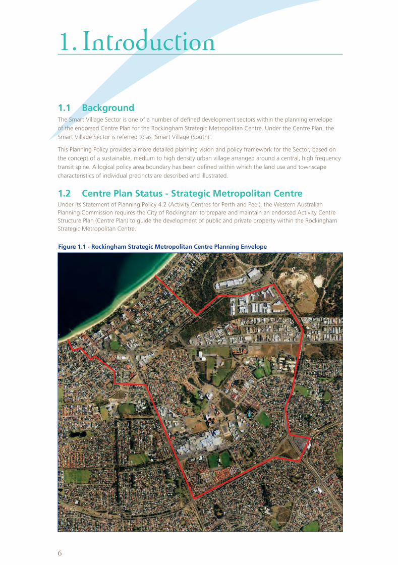
1. Introduction
1.1 BackgroundThe Smart Village Sector is one of a number of defined development sectors within the planning envelope
of the endorsed Centre Plan for the Rockingham Strategic Metropolitan Centre. Under the Centre Plan, the
Smart Village Sector is referred to as ‘Smart Village (South)’.
This Planning Policy provides a more detailed planning vision and policy framework for the Sector, based on
the concept of a sustainable, medium to high density urban village arranged around a central, high frequency
transit spine. A logical policy area boundary has been defined within which the land use and townscape
characteristics of individual precincts are described and illustrated.
1.2 Centre Plan Status - Strategic Metropolitan Centre Under its Statement of Planning Policy 4.2 (Activity Centres for Perth and Peel), the Western Australian
Planning Commission requires the City of Rockingham to prepare and maintain an endorsed Activity Centre
Structure Plan (Centre Plan) to guide the development of public and private property within the Rockingham
Strategic Metropolitan Centre.
Figure 1.1 - Rockingham Strategic Metropolitan Centre Planning Envelope
Client Insert Date
Campaign Size (HxW)
Description
Filename Proof/Alt #
Publication Date/Time
Prod Mgr
Studio Mgr
Studio Op
Acc Dir
Acc Coor
Art Dir
Writer
Notes: Grey fields for internal sign off on hard copy proof.
PDF may appear on screen not at actual size.
Rockingham, City of (ROC005, ROCPROD) 2012-04-18
ROCK000104 Planning Policy - Smart Village 297.0 x 210.0
2011
ROCK000104_A4_BOOKV3_6-6 1
A4 Book 2012-08-06 17:10

7
The City commissioned a review of its endorsed 1995 Centre Plan with the goal of producing a new Centre
Plan that would cover the full extent of the area to be serviced by the Rockingham City Centre Transit
System (RCCTS). The scope of the Centre Plan project covers an area of almost 600 hectares between the
Rockingham Train Station and Rockingham Beach and includes the area covered by the existing Central City
Area zone in the Metropolitan Region Scheme, within which the Smart Village Sector is located.
Stage 1 of the Centre Plan Review was advertised for public comment in December 2007. It laid down an
overall Concept Plan that addressed the priority issues of: a better connected access and movement network;
and a land use pattern based on contemporary ‘Main Street’ and ‘Transit Oriented Development’ principles.
A Framework Plan translated the Concept Plan into a general arrangement of legible street blocks, built form
and public space.
The overall Centre Plan area was divided into 11 Sectors (refer to figure 1.2) as follows:-
• CityCentre
• WaterfrontVillage
• SmartVillage(South)
• SmartVillage(North)
• NorthernGateway
• Campus
• Eastern
• Leeuwin
• NorthernWaterfront
• SouthernGateway
• RockinghamStation
In February 2008, following a review of stakeholder and public submissions, the City of Rockingham endorsed
the long term planning framework and transport network recommendations for the Strategic Metropolitan
Centre, as proposed in the Stage 1 Report.
Stage 2 of the Centre Plan Review updated the Development Policy Plan for the City Centre sector, with a
revised Indicative Development Plan and related Precinct Policies and Guidelines. The Council endorsed the
Stage 2 Final Reports at its ordinary Meeting held on the 22 September 2009.
On the 10 November 2009, the WAPC Statutory Planning Committee considered the Stage 2 Final Reports on
the Review of the Rockingham Strategic Metropolitan Centre and resolved to endorse the documents as an
appropriate Centre Plan to guide future planning and development.
Figure 1.2 - Rockingham Strategic Metropolitan Centre Sector Plan
1
Generalised Land Use
Mixed use
Retail
Residential (medium density)
Residential (medium to high density)
Civic, education
Service commercial
Parkland
Central, transit route
Transit stop
Carpark
2
3
4
5
6
7
8
9
1011
1 City Centre
2 Waterfront Village
3 Smart Village (South)
4 Smart Village (North)
5 Northern Gateway
6 Campus
7 Eastern
8 Leeuwin
9 Northern Waterfront
10 Southern Gateway
11 Rockingham Station
Client Insert Date
Campaign Size (HxW)
Description
Filename Proof/Alt #
Publication Date/Time
Prod Mgr
Studio Mgr
Studio Op
Acc Dir
Acc Coor
Art Dir
Writer
Notes: Grey fields for internal sign off on hard copy proof.
PDF may appear on screen not at actual size.
Rockingham, City of (ROC005, ROCPROD) 2012-04-18
ROCK000104 Planning Policy - Smart Village 297.0 x 210.0
2011
ROCK000104_A4_BOOKV3_7-7 1
A4 Book 2012-08-06 17:11

8
2. Strategic Metropolitan Centre Planning Framework
Client Insert Date
Campaign Size (HxW)
Description
Filename Proof/Alt #
Publication Date/Time
Prod Mgr
Studio Mgr
Studio Op
Acc Dir
Acc Coor
Art Dir
Writer
Notes: Grey fields for internal sign off on hard copy proof.
PDF may appear on screen not at actual size.
Rockingham, City of (ROC005, ROCPROD) 2012-04-18
ROCK000104 Planning Policy - Smart Village 297.0 x 210.0
2011
ROCK000104_A4_BOOKV3_8-8 1
A4 Book 2012-08-06 17:13
9
2.1 Vision for the Strategic Metropolitan Centre The following vision has been endorsed in the endorsed Centre Plan for the Rockingham Strategic
Metropolitan Centre:-
The vision is for a modern, distinctly coastal centre offering a wide range of mixed uses including retail,
commercial, office, civic, residential, education and recreation within an accessible and highly inter-
connected, urban-scaled townscape, comprising a major activity centre and related urban villages based on
‘Main Street’ principles.
This vision builds on the principles of the Network City (2004) regional planning framework and the objectives
and concepts of the adopted 1995 Rockingham City Centre Development Policy Plan. It has a wider scope to
encompass higher education campuses and urban villages along the route of the Rockingham City Centre Transit
System through to Rockingham Beach.
Development in the Rockingham Strategic Metropolitan Centre will be defined and
characterised by:-
•Mediumtohighdensitydevelopmentbasedonactivated,‘MainStreet’principles.
•Aconfigurationofgenerallycontiguousstreetfrontbuildingsandamixofusesthatgeneratehighlevelsof
pedestrian activity and a sense of vitality.
•Astreet-basedtransitsystem,withcloselyspacedstops.
•Apermeablenetworkofstreets,laneways,arcadesandpublicspacesthatprovidehighqualitylinkages,
particularly for pedestrians, to Centre activities from transit stops, street and off-street car parking and from
the surrounding walkable catchment.
•AnidentifiableCityCentrehubtoprovidemajorCBDfunctions.
•ConnectedurbanvillagesbetweentheCityCentreandRockinghamBeachalongtherouteofthetransit
system. The new urban villages will make provision for mixed and consolidated education (university),
technology, commercial and medium to high density residential development, based on sustainable planning
principles and design criteria.
2.2 Planning and Development PrinciplesThe following planning and development principles apply across the Strategic Metropolitan Centre:-
2.2.1 Built Form and Urban Design
Principles:-
•Developinaccordancewith‘MainStreet’designprinciples.
•Incorporateadiversityofactivitiesandhumanscaleinstreetfrontdevelopment.
•Developlocalareasinaccordancewithspecificprecinctdesignanddevelopmentguidelinesandcontrols.
•Locateandconfigurebuildingstoaddressthestreetandprogressivelyfacilitatecontinuousandcontained
streetscapes which provide interest and interaction between buildings and pedestrians at street level.
•Makepublicbuildingsandspacesuniversallyaccessible.
•Designbuildingsandpublicspacesthatcontributetoacomfortablepedestrianenvironment,providing
opportunities for weather protection, including shelter from prevailing strong wind conditions.
•Minimiseanydetrimentalimpactsonneighbouringproperties.
•Encourageagradualsteppingupofthebuiltformattheinterfaceoflowandhighrisedevelopment.
2. Strategic Metropolitan Centre Planning Framework
Client Insert Date
Campaign Size (HxW)
Description
Filename Proof/Alt #
Publication Date/Time
Prod Mgr
Studio Mgr
Studio Op
Acc Dir
Acc Coor
Art Dir
Writer
Notes: Grey fields for internal sign off on hard copy proof.
PDF may appear on screen not at actual size.
Rockingham, City of (ROC005, ROCPROD) 2012-04-18
ROCK000104 Planning Policy - Smart Village 297.0 x 210.0
2011
ROCK000104_A4_BOOKV3_9-9 1
A4 Book 2012-08-06 17:14
10
2.2.2 Access and Parking
Principles:-
•MakewalkingthemostimportantmodeoftransportwithintheSmartVillage.Streets,publicplacesand
adjacent development should be designed to provide a safe, secure, stimulating and pleasant walking
environment.
•Linkthemajorregionalandsub-regionalroadsystemtotheSmartVillagebyarangeofdirectandlegible
street connections.
•EnsurethattheSmartVillageandrelatedactivitycentrestreetnetworksare‘finegrained’toprovideamultiple
choice of routes for pedestrians, cyclists and vehicles.
•Integratethestreet-basedcentraltransitsystemtolinktheSmartVillagewithRockinghamBeach,theCity
Centre and the Rockingham railway station.
•Ensurethatappropriatelandusesarelocatedadjacenttothetransitroute.
•AdoptanintegratedurbandesignandtrafficmanagementapproachwithintheSmartVillagetodeliveralow
speed traffic environment and a high level of interest and amenity.
•Manageprovisionofadequateparkingfacilitiesandencourageintegrationofcarparkingwithadjoiningsites
which are convenient, safe and sustainable.
•Locateparkingareastominimiseadverseimpactsonthestreetscape.
•Controlnewdevelopmentsothataccesswaysandparkingfacilitiesdonotvisuallydominatethepublicrealm
or create obstructions to the pedestrian environment and minimise potential pedestrian/vehicle conflicts.
•Avoidsemi-basementcarparkingsolutionswheretheywouldimpactnegativelyonthegroundlevelactivation
of adjoining streets.
2.2.3 Public Domain
Principles:-
•Integratedifferentprecinctsthroughtheuseofasimpleandconsistentpaletteofvegetation,paving,signage
and street furniture.
•Designnewdevelopmentsoastocontributetothequalityofthepublicdomainandtheframingand
activation of the public space network.
•Provideforwell-designedandintegratedtoilets,seating,lightingandpublicartwithinthepublicdomain.
2.2.4 Land Uses
Principles:-
•EnsurethatnewusessupportandenhancetheroleoftheStrategicMetropolitanCentreastheprimary
‘Main Street’ activity centre in the South West Perth Region.
•Reinforcethe‘MainStreet’modelfortheCentrebygivingprioritytoactivestreet-orientedlanduses.
•Encouragelandusesanddevelopmentsthatemployandattracthighnumbersofpeople,andhavethe
potential to activate the central spine of the Smart Village by day and night along the route of the principal,
street based public transport system. Such uses should include medium to high density residential, short stay
accommodation, retail, civic and community facilities, educational and cultural facilities, cafes, restaurants,
hotels, offices and other intensive employment uses.
•Avoidlandusesanddevelopmentsthatgeneratehighvolumesofcarsandtrucksandhavelowemployment
intensities.
•Encourageandpromoteadiversemixofusesinpreferencetomono-functionallandusesonlargersites.
•EnhancetheactivityappealoftheSmartVillagetobothlocalandregionalvisitors.
•Encourageattractiveandsafealfrescodiningfacilitiestofosteralivelystreetscape.
•PromoteappealinganddistinctiveretailusesreflectingthecoastalnatureandlifestyleofRockinghamandits
community.
•Ensurethatresidentialusesareintegratedwiththeretail,commercialandhospitalitypotentialofthe
Smart Village.
•Encouragetheaggregationoffacilitiesalong‘MainStreet’corridors,pedestrianlinksandmajorpublicspaces
that are characterised by high levels of pedestrian activity during normal shopping hours.
•Encouragenewdevelopmenttoprovideoptionsforfutureflexibilityandchangesinlanduse.
Client Insert Date
Campaign Size (HxW)
Description
Filename Proof/Alt #
Publication Date/Time
Prod Mgr
Studio Mgr
Studio Op
Acc Dir
Acc Coor
Art Dir
Writer
Notes: Grey fields for internal sign off on hard copy proof.
PDF may appear on screen not at actual size.
Rockingham, City of (ROC005, ROCPROD) 2012-04-18
ROCK000104 Planning Policy - Smart Village 297.0 x 210.0
2011
ROCK000104_A4_BOOKV3_10-10 1
A4 Book 2012-08-06 17:16
11
2.2.5 Safety and Security
Principles:-
•Designbuildingstoprovideasafeenvironmentforallusers,contributepositivelytotheenhancementofpublic
safety, and minimise the need for intrusive surveillance technologies.
•Incorporateunobtrusivesecuritymeasuresintobuildingdesignthatisinkeepingwiththebuilding’s
architectural style and materials.
•Designpublicspacestofacilitatesafepedestrianuseandcreateasenseofpublicownership.
2.2.6 Sustainability
Principles:-
•EnsuretimelyandefficientprovisionofphysicalandsocialinfrastructuretoenabletheCentretoserviceits
strategic functions.
•Promoteenvironmentallysustainablepractices,includingresourceefficiency(energy,water,waste,airquality,
material selection), at all stages of development – planning, subdivision design, building construction and
maintenance.
•Providesufficientlandforemploymentopportunitiesandtosupportlocalandregionaleconomicgrowth.
•Expandsustainableandefficienttransportoptionswhilecreatingopportunitiestoreducesingleoccupancy
vehicle trips.
•Ensuretimelyprovisionofservicesandfacilitiesthatareequitable,durable,accessible,ofahigh-qualityand
that promote community well-being and health.
•Promotearangeofhousingchoices(densities,floorarea,ownershippatterns,priceandbuildingtypes)to
ensure a diverse population can be housed, including designing buildings to be adaptable over time.
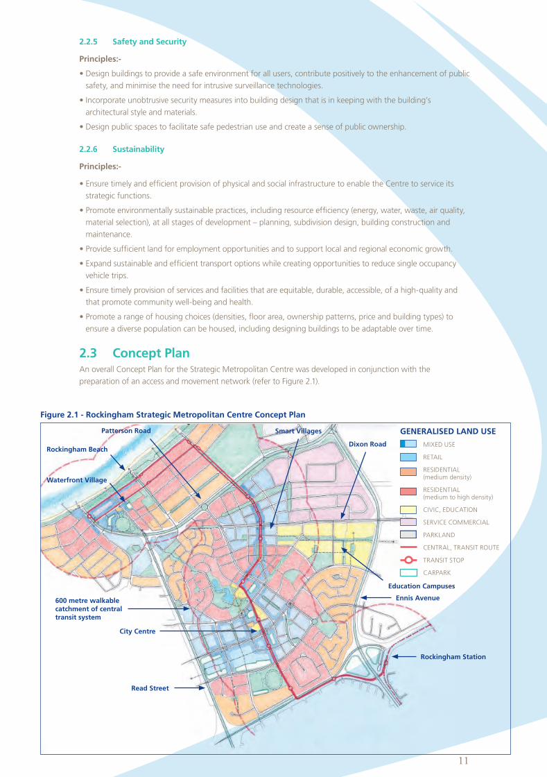
2.3 Concept PlanAn overall Concept Plan for the Strategic Metropolitan Centre was developed in conjunction with the
preparation of an access and movement network (refer to Figure 2.1).
Figure 2.1 - Rockingham Strategic Metropolitan Centre Concept Plan
Rockingham BeachDixon Road
Read Street
Ennis Avenue
City Centre
Waterfront Village
Education Campuses
Smart VillagesPatterson Road
Rockingham Station
600 metre walkable catchment of central transit system
GENERALISED LAND USE
MIXED USE
RETAIL
RESIDENTIAL (medium density)
RESIDENTIAL (medium to high density)
CIVIC, EDUCATION
SERVICECOMMERCIAL
PARKLAND
CENTRAL,TRANSITROUTE
TRANSIT STOP
CARPARK
Client Insert Date
Campaign Size (HxW)
Description
Filename Proof/Alt #
Publication Date/Time
Prod Mgr
Studio Mgr
Studio Op
Acc Dir
Acc Coor
Art Dir
Writer
Notes: Grey fields for internal sign off on hard copy proof.
PDF may appear on screen not at actual size.
Rockingham, City of (ROC005, ROCPROD) 2012-04-18
ROCK000104 Planning Policy - Smart Village 297.0 x 210.0
2011
ROCK000104_A4_BOOKV3_11-11 1
A4 Book 2012-08-06 17:18

12
The Plan makes provision for improved road connectivity and a more legible road network with particular
emphasis given to improved north-south connectivity. Moreover, the Plan makes the local transit system the
focus of an intensified corridor of mixed use development between the City Centre, education campuses and
the beachfront.
The foundation of the Plan is the ongoing development of land within the existing City Centre Zone, with the
expectation that development will consolidate around the commercial and civic core of the City, with progressive
expansion along streetfronts, to the north.
Between the designated City Centre and the Waterfront Village, there are opportunities to develop two new
activity centres north and south of Dixon Road, along the route of the local transit system. The vacant land south
of Dixon Road presents an opportunity to integrate the western end of the Murdoch University campus with
other mixed uses (including residential) in a consolidated, ‘Main Street’ configuration.
Between Dixon Road and Patterson Road, an opportunity exists to extend the ‘Main Street’, activity corridor to
directly connect with Victoria Street and the fast redeveloping Rockingham Waterfront.
Further expansion of the Waterfront Village is envisaged, particularly to the west of Patterson Road. An
intensification of residential development to the east of the Waterfront Village would follow the coastal route
of the transit system.
Figure 1 divides the Strategic Metropolitan Centre into sectors and overlays them on the Concept Plan base
to provide a convenient means of describing and further detailing the strategy. While the boundaries are
indicative, they are consistent with the boundaries of existing zones, Policy areas and Precincts within the
Town Planning Scheme.
2.4 Framework PlanA Framework Plan (refer to Figure 2.2) has been prepared over the Strategic Metropolitan Centre to illustrate a
generalised arrangement of built form, movement networks and public and private spaces consistent with the
strategic arrangement of functions illustrated in the Concept Plan.
The Plan is also consistent with the potential for Transit Oriented Development (TOD) described in Section
2.5 and builds on the adopted access and movement network described in Section 2.6. The Framework Plan
illustrates a long term (i.e. greater than 10 years) view of development and redevelopment potential. While the
Plan shows possible new road links over privately owned property, it is acknowledged that such improvements
would be subject to the agreement and co-operation of affected property owners.
The Framework Plan provides a platform for more detailed conceptual planning, urban design and planning
policy within each of the Centre Plan Sectors.
Consistent with the scope of the Centre Plan, the Framework Plan focuses its detail on areas where there is the
greatest potential and/or priority for integrated development or redevelopment in the near term, including land
in the City Centre, in the Waterfront Village and along the route of the City Centre Transit System.
Outside of the more detailed parts of the Plan, existing residential and service commercial areas have been
simply shaded in yellow and purple tones consistent with the strategic intent of the Concept Plan. These areas
are likely to undergo change on a site-by-site basis over an extended period. Development in these areas will be
guided by separate Sector Development Policy Plans and relevant guidelines.
Client Insert Date
Campaign Size (HxW)
Description
Filename Proof/Alt #
Publication Date/Time
Prod Mgr
Studio Mgr
Studio Op
Acc Dir
Acc Coor
Art Dir
Writer
Notes: Grey fields for internal sign off on hard copy proof.
PDF may appear on screen not at actual size.
Rockingham, City of (ROC005, ROCPROD) 2012-04-18
ROCK000104 Planning Policy - Smart Village 297.0 x 210.0
2011
ROCK000104_A4_BOOKV3_12-12 1
A4 Book 2012-08-06 17:21

13
Fig
ure
2.2
- R
ock
ing
ham
Str
ate
gic
Metr
op
oli
tan
Cen
tre F
ram
ew
ork
Pla
n
Ro
ckin
gh
am
Be
ach
Dix
on
Ro
ad
Re
ad
Str
ee
t
En
nis
Aven
ue
Cit
y C
en
tre
Wate
rfro
nt
Vil
lag
e
Ed
uca
tio
n C
am
pu
ses
Sm
art
Vil
lag
es
Pa
tters
on
Ro
ad
Ro
ckin
gh
am
Sta
tio
n
Client Insert Date
Campaign Size (HxW)
Description
Filename Proof/Alt #
Publication Date/Time
Prod Mgr
Studio Mgr
Studio Op
Acc Dir
Acc Coor
Art Dir
Writer
Notes: Grey fields for internal sign off on hard copy proof.
PDF may appear on screen not at actual size.
Rockingham, City of (ROC005, ROCPROD) 2012-04-18
ROCK000104 Planning Policy - Smart Village 297.0 x 210.0
2011
ROCK000104_A4_BOOKV3_13-13 1
A4 Book 2012-08-06 17:23
14
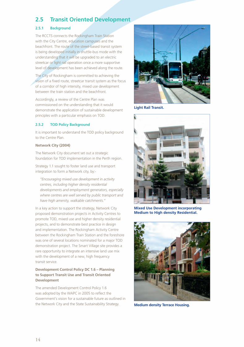
2.5 Transit Oriented Development
2.5.1 Background
The RCCTS connects the Rockingham Train Station
with the City Centre, education campuses and the
beachfront. The route of the street-based transit system
is being developed initially in shuttle-bus mode with the
understanding that it will be upgraded to an electric
streetcar or light rail operation once a more supportive
level of development has been achieved along the route.
The City of Rockingham is committed to achieving the
vision of a fixed route, streetcar transit system as the focus
of a corridor of high intensity, mixed use development
between the train station and the beachfront.
Accordingly, a review of the Centre Plan was
commissioned on the understanding that it would
demonstrate the application of sustainable development
principles with a particular emphasis on TOD.
2.5.2 TOD Policy Background
It is important to understand the TOD policy background
to the Centre Plan.
Network City (2004)
The Network City document set out a strategic
foundation for TOD implementation in the Perth region.
Strategy 1.1 sought to foster land use and transport
integration to form a Network city, by:-
“Encouraging mixed use development in activity
centres, including higher density residential
developments and employment generators, especially
where centres are well served by public transport and
have high amenity, walkable catchments.”
In a key action to support the strategy, Network City
proposed demonstration projects in Activity Centres to
promote TOD, mixed use and higher density residential
projects, and to demonstrate best practice in design
and implementation. The Rockingham Activity Centre
between the Rockingham Train Station and the foreshore
was one of several locations nominated for a major TOD
demonstration project. The Smart Village site provides a
rare opportunity to integrate an intensive land use mix
with the development of a new, high frequency
transit service.
Development Control Policy DC 1.6 – Planning
to Support Transit Use and Transit Oriented
Development
The amended Development Control Policy 1.6
was adopted by the WAPC in 2005 to reflect the
Government’s vision for a sustainable future as outlined in
the Network City and the State Sustainability Strategy.
Light Rail Transit.
Mixed Use Development incorporating Medium to High density Residential.
Medium density Terrace Housing.
Client Insert Date
Campaign Size (HxW)
Description
Filename Proof/Alt #
Publication Date/Time
Prod Mgr
Studio Mgr
Studio Op
Acc Dir
Acc Coor
Art Dir
Writer
Notes: Grey fields for internal sign off on hard copy proof.
PDF may appear on screen not at actual size.
Rockingham, City of (ROC005, ROCPROD) 2012-04-18
ROCK000104 Planning Policy - Smart Village 297.0 x 210.0
2011
ROCK000104_A4_BOOKV3_14-14 1
A4 Book 2012-08-06 17:26

15
The Policy notes that:-
“As the public transport system is further refined and extended, there will be emerging opportunities for
new development that is focused upon, and maximizes the benefits derived from significant new public
investments in transit infrastructure.”
The Policy has direct application to the planning and development of property along the route of the RCCTS.
Policy measures include:-
•Transit-supportivedevelopmentpatterns
•Landusetosupporttransit
•Thepublicdomainintransitorientedprecincts
•Transitsupportivedesign
•Integratingtransitinfrastructure
•Precinctplanning
2.5.3 TOD Catchment
The TOD catchment encompasses land within a walkable distance of the transit system. At Rockingham the
catchment follows the route of the City Centre Transit System between the train station and the beachfront. It is
approximately 600 metres wide (each side) along the transit route (to service a future tram or streetcar system).
2.5.4 Land Use Distribution and Development Intensity
The following land use assumptions were generated in conjunction with the draft Concept Plan, the modelling
of transport network options and the selection of a preferred transport network.
A mix of active, high intensity uses are appropriate for land within the walkable catchment of the transit route.
The intensity and mix of uses should reflect local characteristics along the activity corridor.
The City Centre and the Waterfront Village are established Activity Centres which have to date been planned to
accommodate the bulk of retail, office, hospitality and higher density residential development. The 2009 Centre
Plan allows for a more balanced distribution of activity-generating uses along the transit corridor where there
are significant opportunities for sustainable TOD.
Retail floorspace has been notionally allocated as follows:-
•CityCentre 85,000m2
•WaterfrontVillage 18,000m2
•SmartVillages 12,000m2
Office floorspace has been notionally allocated as follows:-
•CityCentre 60,000m2
•WaterfrontVillage 8,000m2
•SmartVillages 32,000m2
The majority of office floorspace allocated to the Smart Villages should be situated in a mixed use, ‘Main Street’
environment close to the transit spine and its intersection with Dixon Road.
Residential land use is typically a major component of mixed use TOD. Given that the Waterfront Village project
has demonstrated a demand for high amenity, urban-scaled residential development, it has been assumed that
medium to high density residential development will be a major driver of the TOD process. It has the capacity to
shape and populate the desired activity corridor.
Within the defined TOD catchment, existing residential densities match the suburban norm of Rockingham with
the exception of pockets of higher density along the Rockingham beachfront (200+ dwellings per hectare along
Rockingham Beach Road and up to 100 dwellings per hectare in the adjoining Waterfront Village) and in clusters
of group housing around the City Centre (typically 50 dwellings per hectare).
Over recent years, the City has received proposals for medium rise, multi-residential apartment developments
on City Centre zoned land. This has been driven by strong sales in the Waterfront Village and the realisation
that the elevated apartment building model in central Rockingham could achieve expansive views around the
entire Rockingham coastline. There appears to be latent potential for higher rise, multi-residential apartment
development beyond the coastal fringe.
The advent of the TOD concept along the transit corridor provides the planning and amenity context for an
orderly arrangement and distribution of medium to higher density residential development.
Client Insert Date
Campaign Size (HxW)
Description
Filename Proof/Alt #
Publication Date/Time
Prod Mgr
Studio Mgr
Studio Op
Acc Dir
Acc Coor
Art Dir
Writer
Notes: Grey fields for internal sign off on hard copy proof.
PDF may appear on screen not at actual size.
Rockingham, City of (ROC005, ROCPROD) 2012-04-18
ROCK000104 Planning Policy - Smart Village 297.0 x 210.0
2011
ROCK000104_A4_BOOKV3_15-15 1
A4 Book 2012-08-06 17:28

16
Since the late 1980’s there has been an international consensus among researchers and transit operators that
the gross average residential density threshold for light rail transit is approximately 50 persons per hectare. More
recently, planners have also recognised that a greater intensity and massing of development is needed to create
the urban context for successful TOD.
TOD’s at Subiaco are being planned to achieve an average residential density of 120 dwellings per hectare with a
net yield of 60 to 200 dwellings per hectare on defined blocks. Similar TOD densities are being implemented in
GovernmentfostereddevelopmentprojectsatLeighton,CockburnCentralandMurdoch.
In the case of the Rockingham TOD, residential densities could range between 60 and 200+ dwellings per
hectare (as is currently being developed in parts of the Waterfront Village).
It has been assumed that car parking generated by various land uses and activities will be self-contained within
the relevant traffic zones to avoid an over-concentration in any one sector.
2.5.5 Urban Design and Built Form
While the overall TOD concept is for a consolidated, generally contiguous corridor of development along the
transit route, it is essential that TOD at Rockingham has a varied and geographically appropriate character that
offers multiple choices in lifestyle and convenience.
TOD with a commercial content will range from the expanded shopping centre that will be sleeved to
connect with streetfront tenancies and an adjacent entertainment complex, through to individual mixed use
developments on freehold sites.
A variety of residential dwelling types and tenures will be encouraged, including traditional streetfront
townhouses, contemporary row houses, mews housing, low rise apartment blocks and medium to high-
rise multiple apartments with a lifestyle focus ranging in height from three to ten or more storeys, subject
to precinct-specific guidelines. Drawing on recent good practice, a range of urban-scaled dwelling sizes will
also be encouraged (and possibly mandated) to ensure that a wide spectrum of household types and levels of
affordability can be accommodated.
Particular emphasis will be given to shaping the form of development along the edge of the transit route
and around transit stops. In particular, there is a need for design measures to optimize the safety and amenity
of stops along the route, including achieving adequate levels of activation and passive surveillance from
adjoining properties.
2.5.6 Residential Yields
Estimates of residential potential within the RCCTS catchment (600 metres) each side of the transit route) vary
according to density assumptions.
Without TOD intervention, the overall area of the Strategic Metropolitan Centre (about 580 hectares) would
yield approximately 6,000 dwellings (at a gross average 10 dwellings per hectare) and a population of
approximately 12,000 based on a household occupancy of 2.0. This allows for continued intensification in and
around the Waterfront Village, but no significant residential consolidation in the City Centre and along the
transit route.
With TOD intervention and average net block densities of 100 dwellings per hectare applied along the activity
spine, the subject area could yield approximately 20,000 dwellings and a population of 36,000 (based on 1.8
persons per household) at a gross average density of 62 persons per hectare. This scenario could achieve the
light rail transit threshold density of 50 persons per hectare.
With TOD, there is the potential to ultimately triple the anticipated population within the walkable catchment of
the RCCTS.
Within the Smart Village South, there is a TOD potential for approximately 1,500 residential units, housing
around 2,700 people.
Client Insert Date
Campaign Size (HxW)
Description
Filename Proof/Alt #
Publication Date/Time
Prod Mgr
Studio Mgr
Studio Op
Acc Dir
Acc Coor
Art Dir
Writer
Notes: Grey fields for internal sign off on hard copy proof.
PDF may appear on screen not at actual size.
Rockingham, City of (ROC005, ROCPROD) 2012-04-18
ROCK000104 Planning Policy - Smart Village 297.0 x 210.0
2011
ROCK000104_A4_BOOKV3_16-16 1
A4 Book 2012-08-06 17:31

17
2.6 Adopted Access and Movement NetworkA preferred movement network has been adopted by the City. Particular attention has been given to the TOD
potential of the Strategic Metropolitan Centre and traffic modelling outputs which indicate that there is more
than sufficient street capacity on the proposed fine grained network within the centre.
2.6.1 Street Types
A number of different street types are commonly found in city centres, mixed use urban villages and on access
streets to, through and around these centres.
Street types relevant to the development of the Strategic Metropolitan Centre include:-
Major Traffic Routes - the main traffic carrying roads in the area. They include Ennis Avenue, Patterson Road,
Dixon Road, Read Street and Rae Road. They are dual carriageways designed to carry high volumes of traffic and
do not penetrate the City Centre or adjoining mixed use town or village centres.
Transit Street and Transit Priority Streets - custom designed to provide priority for public transport along major
transit routes and avoid undue delay to public transport services. Transit priority is proposed along significant
sections of the RCCTS route. The design varies to meet local design constraints. Access for other traffic is
permitted within the street reservation, but this is not always the case. They are designed to provide for safe,
convenient pedestrian movement.
City and Town Centre Streets - pedestrian movement and circulation is very important on these streets.
Design permits two-way traffic movement but at a slow speed to provide for safe pedestrian movement.
Kerbside parking is normally permitted. A central median is sometimes provided to improve the streetscape,
but is not mandatory.
Green Parking Streets - to be constructed around the periphery of the City Centre and on sections of Patterson
Road near the foreshore. Their function is to assist with the provision of public parking whilst allowing the street
to function normally for both pedestrian and vehicular access. Right angle median and parallel kerbside parking
is normally permitted. An example of this type of street exists along part of Patterson Road near the foreshore.
Streets of this type are quite common in areas of Melbourne (eg Carlton).
Connector Streets - provided outside the major activity nodes to link areas within and adjacent to the City Centre.
They can pass through areas with different land uses (eg residential, business or education). Indented kerbside
parking and appropriately designed pedestrian crossing areas would normally be incorporated into the design.
Access Streets - found outside of the highly trafficked areas of city, town and village centres. The primary purpose
of these streets is to provide access to properties for motorists, pedestrians and cyclists. In light industrial and
commercial areas (and in residential areas on an infrequent basis) they also cater for delivery vehicles.
Pedestrian Malls/Accessways - provide essential pedestrian connectivity in areas where the street network is not
well-connected. An internal network of pedestrian malls exists within the Rockingham shopping centre. A major
purpose of such pedestrian malls is to provide a sheltered and controlled retail environment. Beyond the private
domain of the shopping centre, pedestrian laneways and pathways through public space connect a wide array
of mixed uses.
2.6.2 The Adopted Network
The adopted access and movement network is illustrated in Figure 2.3. It includes a wide range of street
types which enable different functions to be undertaken in different areas in and around the Strategic
Metropolitan Centre.
The network has been developed around the modified route of the street based public transport system,
connecting the City Centre to Rockingham Beach. Key aspects of the network include:-
•ThestreetnetworkprovideswellconnectedlinkagesthroughtheproposedSmartVillagesbetweentheCity
Centre and the Rockingham foreshore.
•ThestreetnetworkintheCityCentreandintheproposedSmartVillagesisfinegrainedandhighlyconnected,
providing a high degree of robustness and flexibility for future planning.
Client Insert Date
Campaign Size (HxW)
Description
Filename Proof/Alt #
Publication Date/Time
Prod Mgr
Studio Mgr
Studio Op
Acc Dir
Acc Coor
Art Dir
Writer
Notes: Grey fields for internal sign off on hard copy proof.
PDF may appear on screen not at actual size.
Rockingham, City of (ROC005, ROCPROD) 2012-04-18
ROCK000104 Planning Policy - Smart Village 297.0 x 210.0
2011
ROCK000104_A4_BOOKV3_17-17 1
A4 Book 2012-08-06 17:31
18
Fig
ure
2.3
- A
do
pte
d M
ovem
en
t N
etw
ork
Le
ge
nd
St
reet
base
d t
ran
sit
syst
em
Tr
an
sit
stati
on
s
M
ajo
r tr
affi
c ro
ute
s
C
ity
cen
tre a
ccess
str
eets
Tr
affi
c lig
hts
R
ou
nd
ab
ou
t
Tr
an
sit
bo
ule
vard
an
d t
ran
sit
pri
ori
ty s
treets
C
ity
cen
tre / t
ow
n c
en
tre
stre
ets
Lowspeedparkroad
(c
lose
d a
t ce
rtain
tim
es)
Park
ing
str
eets
C
on
nect
or
stre
ets
Ped
est
rian lin
ks
Client Insert Date
Campaign Size (HxW)
Description
Filename Proof/Alt #
Publication Date/Time
Prod Mgr
Studio Mgr
Studio Op
Acc Dir
Acc Coor
Art Dir
Writer
Notes: Grey fields for internal sign off on hard copy proof.
PDF may appear on screen not at actual size.
Rockingham, City of (ROC005, ROCPROD) 2012-04-18
ROCK000104 Planning Policy - Smart Village 297.0 x 210.0
2011
ROCK000104_A4_BOOKV3_18-18 1
A4 Book 2012-08-06 17:33

19
2.6.3 Traffic Modelling and Traffic Predictions
Traffic modelling has been undertaken by Uloth and Associates.
One of the key findings from the traffic modelling was:-
•Longtermestimatedtrafficvolumesonthesurroundingarterialroadnetwork(EnnisAvenue,ReadStreet
and Patterson Road) are high. This is due to an impermeable street network on approach to the Rockingham
Metropolitan Centre, especially from the south. Traffic volumes on the fine grained street network within the
Metropolitan Centre are fairly low.
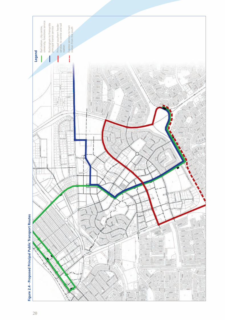
2.6.4 Public Transport Network Planning
There are three main elements to public transport network planning in Rockingham:-
•Theprincipalcustomdesignedstreetbasedpublictransportsystem(theRCCTS),linkingthetrainstationwith
the City Centre, Murdoch University and the Rockingham foreshore. This is the major linking element through
the City Centre supporting the proposed transit oriented development.
•TheRockingham/Fremantleprincipaltransitservice.Thishighfrequencyservicewouldeitherenter
Rockingham through the educational precinct and travel through the City Centre, terminating at the railway
station, or enter the city through the railway station, terminating in the education campus sector (near the
TAFE).
•ServicesfromthesouthenteringtheCityCentreviaReadStreetandCentralPromenade.Theseservicescould
proceed through the City Centre to the train station. Some peak hour services could travel in a more direct
route via Read Street and Rae Road to the train station.
The potential public transport network is shown in Figure 2.4.
Figure 2.5 shows the walking catchment around the proposed stops along the principal street based public
transport system, linking the railway station, the City Centre, the University and the foreshore. The outer line is
based on a 750 metre walking distance (depicted by a 600 metre radius) applicable to a streetcar or very high
frequency bus service. The inner shaded area depicts a walking catchment within the City Centre and adjacent
Smart Villages for retail and entertainment uses within a vibrant, mixed use centre. This is based on a 500 metre
walking distance (depicted by a 400 metre radius).
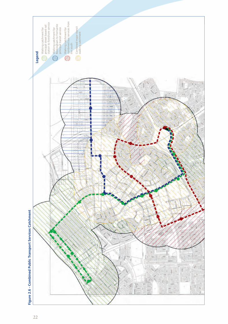
Figure 2.6 shows the walking catchment for the proposed combined major transit services for Rockingham. It
can be seen that the Strategic Metropolitan Centre will be very well served by high frequency transit. This level
of coverage by high frequency services means that Rockingham could be described as a ‘Transit City’ rather than
a city with transit.
2.6.5 Parking Policy and Principles
In city and town centres and TOD’s, it is important that a balance is achieved between meeting the access and
parking needs for vehicles and the movement needs of pedestrians in the context of overall urban design.
The distribution of car parking in the Smart Village should be based on the following principles:-
•Wherepossibleprovidepublicparkinginpreferencetoprivateparking.
•Maximisetheamountofon-street,shorttermparking,subjecttotrafficandpedestriansafety,andother
urban design considerations.
•Providearangeofoff-streetpublicparkingfacilitieswithineasywalkingdistanceofcommercial,retail
entertainment and other facilities, but limit vehicle access to car parks where such traffic would be in conflict
with high levels of pedestrian movement.
Client Insert Date
Campaign Size (HxW)
Description
Filename Proof/Alt #
Publication Date/Time
Prod Mgr
Studio Mgr
Studio Op
Acc Dir
Acc Coor
Art Dir
Writer
Notes: Grey fields for internal sign off on hard copy proof.
PDF may appear on screen not at actual size.
Rockingham, City of (ROC005, ROCPROD) 2012-04-18
ROCK000104 Planning Policy - Smart Village 297.0 x 210.0
2011
ROCK000104_A4_BOOKV3_19-19 1
A4 Book 2012-08-06 17:35
20
Fig
ure
2.4
- P
rop
ose
d P
rin
cip
al
Pu
bli
c Tr
an
spo
rt R
ou
tes
Le
ge
nd
R
ail
stati
on
, ci
ty c
en
tre,
un
ivers
ity,
fo
resh
ore
serv
ice
R
ock
ing
ham
to F
rem
an
tle
pri
nci
pal tr
an
sit
serv
ice
Pri
nci
pal so
uth
ern
feed
er
serv
ices
to c
en
tre a
nd
rail
stati
on
Exp
ress
serv
ices
to t
rain
st
ati
on
fro
m t
he s
ou
th
Client Insert Date
Campaign Size (HxW)
Description
Filename Proof/Alt #
Publication Date/Time
Prod Mgr
Studio Mgr
Studio Op
Acc Dir
Acc Coor
Art Dir
Writer
Notes: Grey fields for internal sign off on hard copy proof.
PDF may appear on screen not at actual size.
Rockingham, City of (ROC005, ROCPROD) 2012-04-18
ROCK000104 Planning Policy - Smart Village 297.0 x 210.0
2011
ROCK000104_A4_BOOKV3_20-20 1
A4 Book 2012-08-06 17:35

21
Fig
ure
2.5
- W
alk
ab
le C
atc
hm
en
t -
Cen
tral
Tran
sit
Syst
em
Le
ge
nd
W
alk
ing
catc
hm
en
t fo
r re
sid
en
tial an
d m
ed
ium
in
ten
sity
mix
ed
use
alo
ng
th
e r
ou
te o
f th
e p
rin
cip
al
stre
et
base
d p
ub
lic
tran
spo
rt s
yste
m
C
ore
are
a s
uit
ab
le f
or
hig
her
inte
nsi
ty m
ixed
use
wit
hin
an
exp
an
ded
cen
tre
Client Insert Date
Campaign Size (HxW)
Description
Filename Proof/Alt #
Publication Date/Time
Prod Mgr
Studio Mgr
Studio Op
Acc Dir
Acc Coor
Art Dir
Writer
Notes: Grey fields for internal sign off on hard copy proof.
PDF may appear on screen not at actual size.
Rockingham, City of (ROC005, ROCPROD) 2012-04-18
ROCK000104 Planning Policy - Smart Village 297.0 x 210.0
2011
ROCK000104_A4_BOOKV3_21-21 1
A4 Book 2012-08-06 17:37
22
Fig
ure
2.6
- C
om
bin
ed
Pu
bli
c Tr
an
spo
rt S
erv
ices
Catc
hm
en
t
Le
ge
nd
W
alk
ing
catc
hm
en
t fo
r p
rin
cip
al st
reet
base
d r
ail
stati
on t
o f
ore
sho
re s
erv
ice
W
alk
ing
catc
hm
en
t fo
r R
ock
ing
ham
to F
rem
an
tle
pri
nci
pal tr
an
sit
serv
ice
W
alk
ing
catc
hm
en
t fo
r co
mb
ined
bu
s se
rvic
es
fro
m
the s
ou
th
C
om
bin
ed
majo
r tr
an
sit
walk
ing
catc
hm
en
t
Client Insert Date
Campaign Size (HxW)
Description
Filename Proof/Alt #
Publication Date/Time
Prod Mgr
Studio Mgr
Studio Op
Acc Dir
Acc Coor
Art Dir
Writer
Notes: Grey fields for internal sign off on hard copy proof.
PDF may appear on screen not at actual size.
Rockingham, City of (ROC005, ROCPROD) 2012-04-18
ROCK000104 Planning Policy - Smart Village 297.0 x 210.0
2011
ROCK000104_A4_BOOKV3_22-22 1
A4 Book 2012-08-06 17:38

23
2.7 Endorsed Sector Planning Guidelines for the Smart Village Section 10.3 in Volume 1 of the endorsed Centre Plan sets out broad Sector Planning Guidelines within which
more detailed planning of the Smart Village South Sector should be undertaken in accordance with the adopted
Planning Framework for the Strategic Metropolitan Centre. The following text is an extract from the Centre Plan:-
Desired Future Character
The 24 hectare site, which is vested in the City of Rockingham, represents a strategic TOD opportunity at the
junction of the transit route and Dixon Road. A contemporary mixed use, higher density development will
embody sustainable development principles and high quality urban design. It will build on the market profile
and amenity foundation of the nearby Waterfront Village and will include a village Main Street and central
park around which the higher density TOD will be assembled. Contemporary residential apartments and
offices will be situated over street front retail in a built form that ranges from 2 to 20 plus storeys.
Preferred Uses
•AppropriateTODusesliningtheTransitRoute
•Streetfrontmixedusesofurbanscaleincludingofficesandcommercial
•Localserviceretail
•University-relateduses
•Mediumtohighdensityresidential
•PossibleContemporaryArtsCentre
•PassiveParkland
Elements
•Plananddesignthesectoraspartofagenerallycontiguous,transit-orienteddevelopmentbridgebetweenthe
City Centre, Campus and Waterfront sectors.
•FacilitatethepriorityconstructionofamoredirectaccessandmovementcorridorbetweenDixonRoadand
the City Centre.
•Establishacommercialgatewayandcommerciallyactivatedvillage‘MainStreet’immediatelysouthofthe
junction of the transit route and Dixon Road.
•Retaincommunityrecreationbuildingsforaslongasnecessary.
•Developacentral,linearparkalongthetransitroutespineasanamenityfocusforthedevelopmentofhigh
density residential apartments and offices.
•Examineopportunitiestolocatelandmarkcivicbuildingsalongthetransitrouteaspartoftheplace-making
agenda.
•DesigntheinterfacebetweenthevillageMainStreetandtheCampusSectortoallowforagenerallyseamless
transition in built form.
•Providealegibleandwellconnectedarrangementofstreets,lanewaysandpublicspaces.
•Framestreetblockswithgenerallycontiguous,urbanscaledbuildingsofhigharchitecturalquality.
•Developadistinctandappealingtownscapewithhighlevelsofamenityandinterestforpedestrians.
•Gradeandarrangetheheightofbuildingstovisuallydefinethetransitroute,orientmovementtowardsthe
activity spine and exploit expansive views of the coastal landscape.
•EnsurethatallnewdevelopmentisplannedinaccordancewiththesustainabilityprincipleslistedinSection
3.1.6 (Centre Plan Vol.1) and designed in detail to meet any applicable sustainability Key Performance Indicators
endorsed by the City of Rockingham.
Client Insert Date
Campaign Size (HxW)
Description
Filename Proof/Alt #
Publication Date/Time
Prod Mgr
Studio Mgr
Studio Op
Acc Dir
Acc Coor
Art Dir
Writer
Notes: Grey fields for internal sign off on hard copy proof.
PDF may appear on screen not at actual size.
Rockingham, City of (ROC005, ROCPROD) 2012-04-18
ROCK000104 Planning Policy - Smart Village 297.0 x 210.0
2011
ROCK000104_A4_BOOKV3_23-23 1
A4 Book 2012-08-06 17:40

24
3. Smart Village Indicative
Development Plan
Client Insert Date
Campaign Size (HxW)
Description
Filename Proof/Alt #
Publication Date/Time
Prod Mgr
Studio Mgr
Studio Op
Acc Dir
Acc Coor
Art Dir
Writer
Notes: Grey fields for internal sign off on hard copy proof.
PDF may appear on screen not at actual size.
Rockingham, City of (ROC005, ROCPROD) 2012-04-18
ROCK000104 Planning Policy - Smart Village 297.0 x 210.0
2011
ROCK000104_A4_BOOKV3_24-24 1
A4 Book 2012-08-06 17:41

25
3. Smart Village Indicative Development Plan
3.1 The Indicative Development PlanThe Smart Village Indicative Development Plan (IDP) (refer to Figure 3.1), illustrates a more detailed
interpretation of the planning framework described and illustrated in Section 2. While the Smart Village
IDP has been derived from the overall Framework Plan, it includes modifications and refinements that
demonstrate how the Centre Plan could be expected to evolve within particular sectors and precincts,
consistent with the endorsed Sector Planning Guidelines listed under Section 3.2 below.
The street network has been modified as necessary: to improve road geometries; to better align the street
grid with the layout of the existing Murdoch University campus; to accommodate new development (including
a possible aquatic facility) around the existing indoor recreation centre; and to make provision for a wide
range of development types, from tall residential apartment towers on podiums to pockets of terrace housing
on the periphery.
The IDP incorporates a strong, central spine of mixed use development along the transit route and it is
envisaged that a lively pedestrian environment will be fostered by significant investment in high amenity
place-making.
Central Park will be the spatial focus of the Smart Village and the road network has been carefully laid out
to radiate out from this green heart to provide direct and legible connections with the surrounding urban
context. The formally landscaped park will provide a fitting setting for the development of high density
residential and office buildings around its perimeter. Accommodation in these buildings around the park could
conceivably be related to the functions and users of the University, including possible partners in research and
development (e.g. marine science, resources, defence). Taller towers to possibly 20 or more storeys could be
located along the western flank of the park where they would not cast morning shadows over the space.
Consistent with the intent of the adopted Access and Movement Network in the Centre Plan, the Smart
Village ‘High Street’ has been planned as a prominent, yet human-scaled node of development that will draw
traffic from Dixon Road through the business core of the Smart Village and then through to the City Centre
a northerly extension of Chalgrove Avenue. This will satisfy the need for improved access to the City Centre
from Dixon Road as well as providing an essential stream of traffic to sustain street front commerce.
Smart Village High Street.
Client Insert Date
Campaign Size (HxW)
Description
Filename Proof/Alt #
Publication Date/Time
Prod Mgr
Studio Mgr
Studio Op
Acc Dir
Acc Coor
Art Dir
Writer
Notes: Grey fields for internal sign off on hard copy proof.
PDF may appear on screen not at actual size.
Rockingham, City of (ROC005, ROCPROD) 2012-04-18
ROCK000104 Planning Policy - Smart Village 297.0 x 210.0
2011
ROCK000104_A4_BOOKV3_25-25 1
A4 Book 2012-08-06 17:43

26
A secondary link to the City Centre via an easterly extension of Market Street will pave the way for a visual
connection between the proposed Central Park and the existing City Park. The central transit system will
follow this Market Street link and it is envisaged that development sites along both sides of this route will be
developed at high density, with landmark residential apartment and office towers taking advantage of the
amenity and proximity to a wide range of central area facilities.
Midway along the proposed ‘High Street’, an east-west cross street will visually and physically connect the
existing Murdoch University campus with a redeveloped recreation centre. The IDP shows how a new main
entry to the recreation centre could be created in conjunction with the development of new community and
commercial accommodation, with a possible, predominantly indoor aquatic facility on the northern side of the
entrance lobby and a possible gymnasium and fitness centre on the south side.
This arrangement of public spaces and built form between the existing University campus and the existing
recreation centre at the northern end of the Smart Village will allow for a seamless integration of the various
functions, with a critical mass of development and activity that makes each of the components more likely
to be viable. The strategy embodies the beneficial and enduring characteristics of historic University towns in
many parts of the world.
Provision has been made on the eastern side of the Smart Village ‘High Street’ for a range of possible
mixed use developments, including retail, commercial, office and education tenancies. The plan also
illustrates a site option for a possible Contemporary and Performing Arts Centre (CAPAC). While the
development of a CAPAC in the Smart Village is considered unlikely at this stage, it is nonetheless important
to show how such a facility could be sleeved with other tenancies to satisfy the street framing
and activation requirements of the planning framework for the Village. The development of a CAPAC in
this location could bolster the physical development and identity of the Smart Village, with the University
as a key user and possible funding contributor.
Within the scope and meaning of the Planning and Development Principles listed in Section 2, there is
scope for flexibility in the interpretation of the DPP requirements that could result in acceptable alternative
development configurations to those illustrated in the IDP, particularly in relation to the scale and
configuration of individual developments.
Client Insert Date
Campaign Size (HxW)
Description
Filename Proof/Alt #
Publication Date/Time
Prod Mgr
Studio Mgr
Studio Op
Acc Dir
Acc Coor
Art Dir
Writer
Notes: Grey fields for internal sign off on hard copy proof.
PDF may appear on screen not at actual size.
Rockingham, City of (ROC005, ROCPROD) 2012-04-18
ROCK000104 Planning Policy - Smart Village 297.0 x 210.0
2011
ROCK000104_A4_BOOKV3_26-26 1
A4 Book 2012-08-06 17:44

27
Fig
ure
3.1
- S
mart
Villa
ge In
dic
ati
ve D
evelo
pm
en
t Pla
n
122
3
4
5
6
7
8
8
88
8
88
8
8
9
9
10
10
10
11
11
12
12
12
13
13
14
15
15
Exis
tin
g M
urd
och
U
niv
ers
ity C
am
pu
s
Go
dd
ard
Str
ee
t
Dix
on
Ro
ad
1
Cen
tral Park
wit
h h
igh a
men
ity
pla
ce-m
akin
g
2
‘Main
Str
eet’
mix
ed u
se d
eve
lop
men
t
3
Seam
less
deve
lop
men
t in
terf
ace
wit
h U
niv
ers
ity
4
Exi
stin
g in
do
or
are
na a
nd r
ecr
eati
on c
en
tre
5
Po
ssib
le f
utu
re a
qu
ati
c ce
ntr
e, g
ym a
nd m
ixed u
ses
6
Main
en
tran
ce t
o c
on
solid
ate
d r
ecr
eati
on c
en
tre
7
Inte
gra
ted C
ult
ura
l/R
esi
den
tial w
ith
Pu
blic
Car
Park
ing
8
Hig
h d
en
sity
mix
ed u
se d
eve
lop
men
t
9
Terr
ace
sty
le m
ed
ium
den
sity
resi
den
tial
10
Pre
ferr
ed s
treet-
fram
ing d
eve
lop
men
t m
od
el
11
Infi
ll d
eve
lop
men
t to
fra
me s
treet
blo
ck
12
Sh
are
d c
arp
ark
13
Majo
r st
reets
cap
e e
nh
an
cem
en
t
14Linearparkalongunmaderoadreserve
15
R
ock
ing
ham
Cit
y C
en
tre T
ran
sit
Sys
tem
ro
ute
Client Insert Date
Campaign Size (HxW)
Description
Filename Proof/Alt #
Publication Date/Time
Prod Mgr
Studio Mgr
Studio Op
Acc Dir
Acc Coor
Art Dir
Writer
Notes: Grey fields for internal sign off on hard copy proof.
PDF may appear on screen not at actual size.
Rockingham, City of (ROC005, ROCPROD) 2012-04-18
ROCK000104 Planning Policy - Smart Village 297.0 x 210.0
2011
ROCK000104_A4_BOOKV3_27-27 1
A4 Book 2012-08-06 17:46

28
3.2 Relevant Residential and Mixed Use Building TypologiesThe endorsed Centre Plan provides the planning framework that governs more detailed planning for the City
Centre and the urban villages (including the Smart Village). This framework requires a medium to high density
TOD outcome that has much in common with inner-city development and urban regeneration projects in
other parts of metropolitan Perth and elsewhere in Australia.
To ensure that the types of development proposed within the Centre Plan area are based upon relevant
development models and building typologies, the characteristics of a representative range of residential
and mixed use developments were surveyed, with a particular focus on Activity Centre locations where
GovernmentdevelopmentagenciessuchasLandcorpareinvolved.Developmentsincludecompletedand
proceeding projects in Midland, Cockburn Central, Northbridge, Floreat, Melbourne and Rockingham Beach.
Characteristics relevant to the detailed planning and urban design of the Smart Village are summarised
as follows:-
Development Forms/Typologies
•Mediumdensityresidentialdevelopmentsshouldtaketheformof2to4storeymultipledwellings.Asmaller
component of narrow frontage, 2 to 3 storey terrace housing could be incorporated in peripheral locations.
•Highdensityresidentialdevelopments(includingmixeduse)shouldpredominantlytaketheformofstreet
framing (‘doughnut’) developments with internal landscaped courtyards located over basement and/or off-
street car parking areas. Developments over 4 storeys in height should be sited on 3 to 4 storey podiums,
with upper floors setback from the street front building line of the podium and set back from the adjoining
lot boundaries.
Subdivision Design
•Lotsshouldbeofsufficientareawithdimensionstopermitafeasible,functionaldevelopment.The
dimensions of multiple dwelling and mixed use lots should permit conventional car parking layouts. Typically,
this requires a minimum lot width of 38 to 40 metres.
•Multipledwellingandmixedusedevelopmentlotsshouldgenerallybeaminimumof2,500m2 in area.
•Newmultipledwellingandmixedusedevelopmentlotsshouldbeprovidedwithvehicularaccess(public
roads, laneways) on a minimum of two sides.
3.3 Other Considerations Retention of Indoor Recreation Centre
The Smart Village site was developed and used as a district recreation centre until 2008 when the existing
outdoorsportingfieldsandrelatedfacilitieswererelocatedtothe270hectareLarkHillSportsplex.
The existing indoor recreation centre, associated outdoor netball courts and paved car park have been
retained in the north-west corner of the Smart Village site. The indoor facilities are likely to be retained in this
location in one form or another for the foreseeable future. It is anticipated that the number of outdoor netball
courts will be reduced as the Smart Village develops and will be replaced by more intensive development in
the medium term. It is anticipated that an upgraded indoor recreation centre will be integrated with the urban
design of the remainder of the new Smart Village.
Possible Aquatic Facility
The existing Rockingham Aquatic Centre on Council Avenue is located on the proposed alignment of an
extended Goddard Street. This alignment was selected on the expectation that the Aquatic Centre would
likely be either decommissioned or relocated, once it reached the end of its service life (ie. when a major
re-construction was needed).
A modern, predominantly indoor aquatic facility could be located within the proposed Smart Village in
the vicinity of the existing indoor recreation centre buildings where it could share common infrastructure
and management. With a contemporary, consolidated design befitting the planning context, the project
could act as a catalyst to further, complementary street front urban development, including inner-city offices
and apartments.
Key urban design assumptions:-
•Thefacilitywouldbeamorecompact,essentiallyindoorfacility,withanoutdoorwaterplayground,
integrated with the planning framework and street oriented urban design principles of the overall Centre
Plan and Smart Village South Sector Guidelines.
•Therearepotentiallytwoalternativesiteoptionsadjoiningtheindoorcomplexthatcouldaccommodatea
new Aquatic Facility, with one site adjoining Dixon Road to the east of the indoor complex and a second site
adjoining Goddard Street to the south west.
Client Insert Date
Campaign Size (HxW)
Description
Filename Proof/Alt #
Publication Date/Time
Prod Mgr
Studio Mgr
Studio Op
Acc Dir
Acc Coor
Art Dir
Writer
Notes: Grey fields for internal sign off on hard copy proof.
PDF may appear on screen not at actual size.
Rockingham, City of (ROC005, ROCPROD) 2012-04-18
ROCK000104 Planning Policy - Smart Village 297.0 x 210.0
2011
ROCK000104_A4_BOOKV3_28-28 1
A4 Book 2012-08-06 17:47

29
•Thedesignshouldbefunctionallyintegratedwiththeindoorcomplex,withpotentiallysharedentrance,kiosk
and related amenities.
•ThedevelopmentshouldbeplannedanddesignedtomarkanimportantgatewaytotheCityfollowing
significant street upgrades. The architecture of the development should also serve to mask, articulate and
activate the blank, box-like presence of the existing structures.
•RelevantmodelsofcontemporaryAquaticFacilitydesignincludetheindoorsectionofthenewEastVictoria
Park(Somerset)aquaticcentre,theKwinanaLeisurecomplex(includingindoorpool)andthenewBalgaPool
LeisurePark,eachofwhichfitswithinaplanningenvelopeofbetween75mX75mand100mX100m.The
Kwinana indoor pool is a relevant case study because it was integrated with an existing recreation centre
which has subsequently undergone a major re-build and upgrade.
•Theprojectcouldactasacatalysttofurther,complementaryurbandevelopment,includinginner-city
offices and apartments.
•Carparkingshouldbelocatedandarrangedbehindagenerallycontiguouslineofbuildingsthataddress
the street.
Analysis of Alternative Aquatic Centre Locations in Smart Village
Site Option 1 – Goddard Street (adjoining southern side of existing indoor arena)
Strengths•Convenientlylocatednexttotheexistingentrance,
kiosk and amenities.
•Locatedadjacenttothecurrent(interim)routeof
the central transit system.
•Wellservicedbyexistingcarparking.
•Goodsiteexposure.
•Wouldcomplementtheupgradingofthissection
of Goddard Street to dual carriage-way status.
•Wouldhelptomaskthebox-likeappearanceofthe
existing Mike Barnett (MB) complex from Goddard
Street.
Weaknesses•Relativelyremoteandvisuallyfragmentedfromthe
investment core of the village.
•Relativelyremotefromtherouteoffinalrouteof
the central transit system.
Opportunities•Developmentofthissitewouldpreserve
Dixon Road sites for predominantly mixed use
development.
•Facilitatesaneconomicalstagingofdevelopment
around the MB complex, including subsequent
mixed use building infill around the perimeter of
the street block.
Threats•Dayandnighttimeactivity(particularlyinthe
water playground), lighting and traffic could
impact on nearby residential amenity.
•Initialdevelopmentwouldreducethenumberof
bays available in the existing car park.
Site Option 2 – Dixon Road Eastern (adjoining eastern side of existing indoor arena)
Strengths•Placesahighcalibrepublicbuildingclosetothe
core of the village where significant development
is anticipated.
•Locatedclosetothefinalrouteofthecentral
transit system.
•Preservesexistingpubliccarparkingonthe
western side of the MB complex.
Weaknesses•Relativelyremoteandvisuallyfragmentedfromthe
investment core of the village.
•Relativelyremotefromtherouteoffinalrouteof
the central transit system.
Opportunities•Thenewbuildinghasthepotentialtoscreenthe
box-like presence of the existing MB complex and
provide an activated outlook to Dixon Road.
Threats•Reliantonsitesubdivisionandpartconstructionof
a north south access from Dixon Road.
Client Insert Date
Campaign Size (HxW)
Description
Filename Proof/Alt #
Publication Date/Time
Prod Mgr
Studio Mgr
Studio Op
Acc Dir
Acc Coor
Art Dir
Writer
Notes: Grey fields for internal sign off on hard copy proof.
PDF may appear on screen not at actual size.
Rockingham, City of (ROC005, ROCPROD) 2012-04-18
ROCK000104 Planning Policy - Smart Village 297.0 x 210.0
2011
ROCK000104_A4_BOOKV3_29-29 1
A4 Book 2012-08-06 17:56

30
Following consideration of the two site options by project officers and consultants involved in both the
Smart Village DPP and the Aquatic Facility projects, the Dixon Road site on the eastern side of the indoor
recreation centre was selected as the preferred Smart Village option. A final decision by the Council on a
redevelopment strategy for the Aquatic Centre will need to consider the merits of a Smart Village site versus
the consequences of any decision to retain and upgrade the existing facility on Council Avenue.
Interface with Murdoch University
The Smart Village site was formerly seen as the area into which the adjoining, embryonic Murdoch University
campus would grow, with the expectation that the campus would eventually become a land use bridge
between the City Centre Sector and the Waterfront Village.
After its initial development phase more than 10 years ago, further growth of the University campus has
stalled. A more pragmatic and ultimately more likely transit oriented development model for this strategic land
was devised in conjunction with the master planning of the high frequency central transit system. This TOD
driven development strategy was further refined, described and illustrated through each phase of preparing
the new Centre Plan for the Strategic Metropolitan Centre.
Under the endorsed Centre Plan, the Smart Village will play a crucial role in consolidating development between
the City Centre and the Waterfront Village. It also has the potential to deliver a significant proportion of the
development intensity needed to support the operation of a light rail system between the Rockingham Station
and the Waterfront Village. This form of development could complement the development of the University.
The strategy is to plan and develop a high density, mixed use urban village into which the University campus can
seamlessly grow. This could be accomplished through joint venture development of buildings and/or the leasing
of floorspace alongside a diverse array of other public and private sector tenancies.
Site Option for Contemporary and Performing Arts Centre (CAPAC)
The sites in the Smart Village and Waterfront Village have been evaluated in the course of preparing a feasibility
study into the development of a Contemporary and Performing Arts Centre at Rockingham. In October 2010, the
Final Report of the consultant Feasibility Study illustrated costed planning scenarios for each of the site options.
The conceptual plans in the CAPAC feasibility study positioned the complex on the nominated site at the south
west end of the Smart Village High Street. The CAPAC was configured so that it would address the section of
curved street frontage facing the proposed linear park to the south with an entry foyer, box office and cafe.
Various blank walls, car parking and service docks were arranged along the remaining street boundaries. Such
an outcome would not comply with the planning and urban design principles that underpin the Centre Plan.
While there has been no subsequent action taken by the State Government or the City of Rockingham to
proceed with further detailed design work or to fund the implementation of the CAPAC on either of the
alternative sites, it is understood that there is a strategic preference amongst stakeholders for the Waterfront
Village site option.
The City generally concurs with this sentiment but nevertheless understands the need to demonstrate how
such a facility could be better integrated with the Smart Village and adjoining land uses to cover the unlikely
event that a decision is taken to build such a facility in the Smart Village. This option should not be left open
indefinitely because protecting a vacant site of this size could stymie urban consolidation in a critical part of
the village.
Important factors to be addressed in any re-working of the 2010 CAPAC conceptual design for the
Smart Village include:-
•Re-sitingthefacilitytotheeastoftheVillageHighStreetspinewhereitcouldperhapsbeintegratedwith
and partly funded in capital and operational terms by the University.
•Providingoff-streetcarparkingwithinpubliccarparkingstationsthataresharedandpartlyfundedbyother
land uses in the vicinity.
•Sleevinganyservicingorbigboxelementssuchastheauditoriumwithstreetactivatingtenancies.
Client Insert Date
Campaign Size (HxW)
Description
Filename Proof/Alt #
Publication Date/Time
Prod Mgr
Studio Mgr
Studio Op
Acc Dir
Acc Coor
Art Dir
Writer
Notes: Grey fields for internal sign off on hard copy proof.
PDF may appear on screen not at actual size.
Rockingham, City of (ROC005, ROCPROD) 2012-04-18
ROCK000104 Planning Policy - Smart Village 297.0 x 210.0
2011
ROCK000104_A4_BOOKV3_30-30 1
A4 Book 2012-08-06 17:57

31
3.4 Residential Density Figure 3.2 illustrates a Residential Density overlay to the Smart Village IDP which is designed to manage the
density of development in general accordance with the planning principles and the adopted TOD model
described and illustrated in Section 2.
The distribution of residential density in the Smart Village responds to the particular functions, amenity and
levels of mixed use activity anticipated in the Sector. In general, high density residential development should
be located within 250 metres of the Central Transit route, with particular concentrations around the Central
Park and links to the City Centre Sector.
The urban design intent of the residential density framework is reflected and refined as necessary in the IDP
and in more detailed Precinct Concept Plans and Guidelines described and illustrated in Section 4.
Where residential development is proposed, the R-AC0 density code of State Planning Policy 3.1 – Residential
Design Codes (as amended) (R-codes) will apply.
Figure 3.2 - Residential Density
Preferred Residential Density
Dwellings Per Hectare
80 - 160
100 - 200
Client Insert Date
Campaign Size (HxW)
Description
Filename Proof/Alt #
Publication Date/Time
Prod Mgr
Studio Mgr
Studio Op
Acc Dir
Acc Coor
Art Dir
Writer
Notes: Grey fields for internal sign off on hard copy proof.
PDF may appear on screen not at actual size.
Rockingham, City of (ROC005, ROCPROD) 2012-04-18
ROCK000104 Planning Policy - Smart Village 297.0 x 210.0
2011
ROCK000104_A4_BOOKV3_31-31 1
A4 Book 2012-08-06 17:59

32
3.5 Building Height Figure 3.3 illustrates a Building Height Overlay to the Smart Village IDP, with permitted building heights rising
as development gets closer to the Central Transit route and activity generators.
3.6 Frontage TypesThe Framework Plan, as it applies to the Smart Village Sector, has been formulated in accordance with
consolidated ‘Main Street’ development principles that require buildings to frame, address and activate an
interconnected, hierarchical street network.
Figure 3.4 illustrates an orderly arrangement of ‘Frontage Types’ in ‘Main Street’ and mixed use areas based
on the common principle that building frontages to all streets, major laneways and public spaces should be
activated.
At least four ‘Frontage Types’ are envisaged, with building frontages positioned and managed according to
the desired level of level of street activation and streetscape character as follows:-
Type 1 – High Level of Activation, Nil Setback
A highly activated frontage with retail and commercial uses at ground level and a 2 to 3 storey, contiguous
facade positioned at the streetfront boundary. At the ground level, buildings should address the street
with a primary business entrance and a shopfront façade that is transparent over at least 75% of the area
of the facade.
Figure 3.3 - Building Height
Maximum Heights
19.0m / 5 storeys
30.0m / 8 storeys
52.0m / 15 storeys + subject to approval
Client Insert Date
Campaign Size (HxW)
Description
Filename Proof/Alt #
Publication Date/Time
Prod Mgr
Studio Mgr
Studio Op
Acc Dir
Acc Coor
Art Dir
Writer
Notes: Grey fields for internal sign off on hard copy proof.
PDF may appear on screen not at actual size.
Rockingham, City of (ROC005, ROCPROD) 2012-04-18
ROCK000104 Planning Policy - Smart Village 297.0 x 210.0
2011
ROCK000104_A4_BOOKV3_32-32 1
A4 Book 2012-08-06 17:59

33
Type 2 – Medium Level of Activation, Nil Setback
A medium level of frontage activation with secondary retail, customer oriented offices, inner-city commercial
tenancies and residential lobbies at ground level and a 2 to 3 storey façade positioned at the streetfront
boundary. At the ground level, buildings should address the street with a primary business entrance and a
commercial façade that is transparent over at least 60% of the area of the facade.
Type 3 - Moderate Level of Activation, 2 Metre Setback
A moderate level of frontage activation with a mix of inner-city commercial tenancies and residential
apartments at ground level and a 2 to 3 storey façade positioned behind a 2 metre, green landscaped
setback. At the ground level, the facades of mixed use buildings would address the street with a commercial
shopfront, primary business entrance and/or residential entry lobby that is transparent over at least 60% of
the area of the facade. The ground level of inner-city residential units would address the street with a façade
that is transparent over at least 30% of its area.
Type 4 – Moderate Level of Activation, 2-3.5 Metre ‘green’ Setback
A moderate level of frontage activation with a mix of inner-city commercial tenancies and residential
apartments at ground level and a 2 to 3 storey façade positioned behind a 2 to 3.5 metre, green landscaped
setback. At the ground level, the facades of mixed use buildings would address the street with a commercial
shopfront, primary business entrance and/or residential entry lobby that is transparent over at least 60% of its
facade. Ground level inner-city residential units would address the street with a façade that is transparent over
at least 30% of its area.
Figure 3.4 - Frontage Types
Frontages
TYPE 1 High activation, nil setback
TYPE 2 Medium activation, nil setback
TYPE 3 Moderate activation, 2m setback
TYPE 4 Moderate activation, 2 - 3.5m ‘green’ setback
Client Insert Date
Campaign Size (HxW)
Description
Filename Proof/Alt #
Publication Date/Time
Prod Mgr
Studio Mgr
Studio Op
Acc Dir
Acc Coor
Art Dir
Writer
Notes: Grey fields for internal sign off on hard copy proof.
PDF may appear on screen not at actual size.
Rockingham, City of (ROC005, ROCPROD) 2012-04-18
ROCK000104 Planning Policy - Smart Village 297.0 x 210.0
2011
ROCK000104_A4_BOOKV3_33-33 1
A4 Book 2012-08-06 18:02
34
3.7 Car ParkingIn addition to Section 2.6.5, the management of carparking distribution and its impact on townscape quality
is an important issue addressed in the Policy Statement.
To facilitate contiguous streetfront development and to limit the visual impact of carparks, parking areas shall
be consolidated and located behind generally contiguous buildings or an appropriate colonnade or structural
screening device (other than a blank wall). Such devices are intended to maintain street facade continuity and
in general should not comprise more than 25% of the length of any individual street frontage.
Where individual Precinct development standards allow for some variation to this principle parking areas
should be screened from the street by an appropriate structural screening device (other than a blank wall),
hedge or planting of an appropriate urban character.
Where restructuring of existing streets or the provision of new streets is possible, provision for on-street
parking embayments should be made.
The number of crossovers and driveways serving a development will be limited by the City to maintain
streetscape continuity.
Client Insert Date
Campaign Size (HxW)
Description
Filename Proof/Alt #
Publication Date/Time
Prod Mgr
Studio Mgr
Studio Op
Acc Dir
Acc Coor
Art Dir
Writer
Notes: Grey fields for internal sign off on hard copy proof.
PDF may appear on screen not at actual size.
Rockingham, City of (ROC005, ROCPROD) 2012-04-18
ROCK000104 Planning Policy - Smart Village 297.0 x 210.0
2011
ROCK000104_A4_BOOKV3_34-34 1
A4 Book 2012-08-06 18:03

35
4. Precinct Policies
Client Insert Date
Campaign Size (HxW)
Description
Filename Proof/Alt #
Publication Date/Time
Prod Mgr
Studio Mgr
Studio Op
Acc Dir
Acc Coor
Art Dir
Writer
Notes: Grey fields for internal sign off on hard copy proof.
PDF may appear on screen not at actual size.
Rockingham, City of (ROC005, ROCPROD) 2012-04-18
ROCK000104 Planning Policy - Smart Village 297.0 x 210.0
2011
ROCK000104_A4_BOOKV3_35-35 1
A4 Book 2012-08-06 18:04

36
4. Precinct Policies
An important objective of the planning and development process is to encourage mixed use development
and diversity within the Smart Village. Diversity and administrative flexibility will continue to be facilitated by
dealing with property in the Smart Village Sector under a single zone in the Scheme.
Ongoing planning and development will be controlled by reference to the IDP and the framework plans relating
to Density and Building Height and ‘Frontage Types’ (referred to in Section 3) and the following Precinct
Policies and Sub-Precinct Design Guidelines and any supplementary development guidelines and related Policy
Statements, which Council may adopt from time to time.
The Smart Village Sector has been divided into five Precincts, comprising:-
• VillageCentre
• DixonSouth
• CentralPark
• SmartVillageEast
• SmartVillageWest
The Smart Village Precincts are based on areas where a particular geographic identity, activity mix and/or
townscape character is envisaged. The location and boundaries of the Precincts are illustrated in Figure 4.1.
The desired future character, preferred uses and required elements of development within each of these
Precincts are further described in the following sections.
Client Insert Date
Campaign Size (HxW)
Description
Filename Proof/Alt #
Publication Date/Time
Prod Mgr
Studio Mgr
Studio Op
Acc Dir
Acc Coor
Art Dir
Writer
Notes: Grey fields for internal sign off on hard copy proof.
PDF may appear on screen not at actual size.
Rockingham, City of (ROC005, ROCPROD) 2012-04-18
ROCK000104 Planning Policy - Smart Village 297.0 x 210.0
2011
ROCK000104_A4_BOOKV3_36-36 1
A4 Book 2012-08-06 18:06

37
Fig
ure
4.1
- P
reci
nct
Bo
un
dari
es
Dix
on
So
uth
Villa
ge C
en
tre
Cen
tral
Park
Sm
art
Villa
ge
We
st
Sm
art
Vil
lag
e E
astE
xis
tin
g M
urd
och
Un
ive
rsit
y C
am
pu
s
Go
dd
ard
Str
ee
t
Dix
on
Ro
ad
Client Insert Date
Campaign Size (HxW)
Description
Filename Proof/Alt #
Publication Date/Time
Prod Mgr
Studio Mgr
Studio Op
Acc Dir
Acc Coor
Art Dir
Writer
Notes: Grey fields for internal sign off on hard copy proof.
PDF may appear on screen not at actual size.
Rockingham, City of (ROC005, ROCPROD) 2012-04-18
ROCK000104 Planning Policy - Smart Village 297.0 x 210.0
2011
ROCK000104_A4_BOOKV3_37-37 1
A4 Book 2012-08-06 18:07

38
4.1 Village Centre Precinct Policy
4.1.1 Application
This Policy applies to the Village Centre Precinct as defined in the Precinct Plan (refer to Figure 4.1). The Village
Centre Precinct encompasses properties bounded by Dixon Road, proposed Crocker Street (south), proposed
LeeuwinParade(east)andtheproposednorth/southroadtotheeastoftheindoorrecreationcomplex.
4.1.2 Desired Future Character
The Village Centre will be developed around contemporary ’Main Street’ townscape characteristics as a
consolidated hub of street oriented activity that complements and merges the commercial and residential functions
of a high density urban village and the education functions of an adjoining inner-city University campus.
The Dixon Road edge to the Precinct will be framed by high calibre, gateway architecture that responds to the
prominence of a Dixon Road address and the civic context of the adjoining University campus.
The scale, density and levels of activity in new development should reflect the opportunity afforded by
proximity to a high frequency, street-based transit system and convenient road access.
4.1.3 Preferred Uses
Within the Village Centre Precinct the preferred uses are:-
•retail
•entertainment
•eatinganddrinkingplaces
•officesandcommercial
•education
•short-stayaccommodation
•recreation
•multipledwellings/residential
Other permissible uses listed under the Scheme are not preferred.
4.1.4 Required Elements – Village Centre Precinct
The IDP (refer to Figure 3.1) and the Village Centre Precinct Concept Plan (refer to Figure 4.2) show the
general location and pattern of development envisaged by the City and preferred under this Policy. Within
the scope and meaning of the planning and development principles listed in Section 2.2, there is scope for
further flexibility in the interpretation of the Centre Plan in relation to the scale and configuration of particular
developments. Notwithstanding the indicative intent of these plans, development is to be required to
incorporate and maintain the following elements, as applicable:-
(a) The Precinct is to be developed as a high quality, mixed use area, framed by generally contiguous,
street front buildings which address the street with a mix of tenancies in a manner consistent with a
contemporary ‘Main Street’ townscape discipline.
(b) Buildings are to be located, configured and activated to frame and address street frontages, laneways and
other public spaces in a way that is generally consistent with the Precinct Concept Plan, relevant ‘Frontage
Types’ as indicated in Section 3.6.
(c) Buildings shall be designed to achieve an appropriate use profile along the designated ‘Main Street’
spine of the precinct, with an active, ground floor street frontage to retail tenancies, cafes, restaurants
and similar uses. Offices, education accommodation, short-stay and student accommodation, multiple
dwellings, function rooms, arts and community purposes are preferred upper floor uses.
(d) Consistent with Figure 3.2 ‘Density’, in Section 3.4, residential development within the Precinct is to be
developed to accommodate a balanced mix of dwelling sizes at preferred densities ranging from 100 to
200 dwellings per hectare, with a minimum density of 80 dwellings per hectare in any development which
includes a residential component.
Client Insert Date
Campaign Size (HxW)
Description
Filename Proof/Alt #
Publication Date/Time
Prod Mgr
Studio Mgr
Studio Op
Acc Dir
Acc Coor
Art Dir
Writer
Notes: Grey fields for internal sign off on hard copy proof.
PDF may appear on screen not at actual size.
Rockingham, City of (ROC005, ROCPROD) 2012-04-18
ROCK000104 Planning Policy - Smart Village 297.0 x 210.0
2011
ROCK000104_A4_BOOKV3_38-38 1
A4 Book 2012-08-06 18:08

39
Fig
ure
4.2
- V
illa
ge C
en
tre P
reci
nct
Co
nce
pt
Pla
n
1
2
2
2
2
3
4
5 6
7
88
9
9
10
10
11
11
12
12
13
14
15
Exis
tin
g M
urd
och
U
niv
ers
ity C
am
pu
s
1
Cen
tral Park
wit
h h
igh
am
en
ity
p
lace
-makin
g
2
‘Main
Str
eet’
mix
ed
use
deve
lop
men
t
3
Seam
less
deve
lop
men
t in
terf
ace
wit
h U
niv
ers
ity
4
Exi
stin
g in
do
or
are
na a
nd
recr
eati
on
cen
tre
5
Po
ssib
le f
utu
re a
qu
ati
c ce
ntr
e, g
ym a
nd
mix
ed
use
s
6
Main
en
tran
ce t
o c
on
solid
ate
d r
ecr
eati
on
cen
tre
7
Inte
gra
ted
Cu
ltu
ral/
Resi
den
tial w
ith
Pu
blic
Car
Park
ing
8
Hig
h d
en
sity
mix
ed
use
deve
lop
men
t
9
Terr
ace
sty
le m
ed
ium
den
sity
resi
den
tial
10
Pre
ferr
ed
str
eet-
fram
ing
deve
lop
men
t m
od
el
11
Infi
ll d
eve
lop
men
t to
fra
me s
treet
blo
ck
12
Sh
are
d c
arp
ark
13
Majo
r st
reets
cap
e e
nh
an
cem
en
t
14Linearparkalongunmaderoadreserve
15
R
ock
ing
ham
Cit
y C
en
tre T
ran
sit
Sys
tem
ro
ute
Client Insert Date
Campaign Size (HxW)
Description
Filename Proof/Alt #
Publication Date/Time
Prod Mgr
Studio Mgr
Studio Op
Acc Dir
Acc Coor
Art Dir
Writer
Notes: Grey fields for internal sign off on hard copy proof.
PDF may appear on screen not at actual size.
Rockingham, City of (ROC005, ROCPROD) 2012-04-18
ROCK000104 Planning Policy - Smart Village 297.0 x 210.0
2011
ROCK000104_A4_BOOKV3_39-39 1
A4 Book 2012-08-06 18:10

40
Figure 4.2.1 - Village Centre Cross Section
Podium level courtyard
Elevated offices and apartments over ground level commercial
Decked car park with podium level courtyard above
Local ‘High Street’
Mixed use development to provide seamless interface with building to anchor civic piazza
(e) Consistent with Figure 3.3 ‘Building Height’, in Section 3.5, buildings are to present a minimum 2 storey
or equivalent parapet height to the street or relevant public space subject to the maintenance of a
12.5 metre height limit along street frontages, with any additional height to be setback a minimum of
3.5 metres. The scale and massing of buildings are to be designed to minimise any overshadowing of
adjoining properties and public spaces.
(f) Podium level courtyard gardens may provide private open space over car parks located behind streetfront
buildings. Examples of this form of development are located at Rockingham Beach, Mandurah Marina,
Joondalup City Centre, Subi-Centro Subiaco and in Northbridge over the Graham Farmer Freeway.
(g) Car parking is to be provided in accordance with Table 3 of Town Planning Scheme No.2, refer to
Appendix 1.
(h) Car parking is not to be permitted between the road reserve boundary and building frontages.
(i) Semi-basement car parks are to be avoided wherever a medium to high level of frontage activation is
indicated on the ‘Frontage Types’ plan in Section 3.6.
(j) To complement the City’s townscape objectives for the Smart Village, the massing, articulation and facade
treatments of all development will be required to adhere to a quality, urban townscape aesthetic.
(k) The frontage of any building is to incorporate and maintain the required area of transparent facade with
suitably glazed shopfronts, windows and doors, consistent with the applicable ‘Frontage Types’ set down
in Section 3.6.
(l) Variety and high design standards will be encouraged in the fit-out, awning treatments, signage and
private street furniture attached to individual premises. Where appropriate, the City will encourage
businesses to use the public footpaths for streetside dining, subject to private street furniture meeting
design and quality standards acceptable to the City.
(m) Any subdivision application is to be prepared in conjunction with an Integrated Development Guide Plan
(IDGP), to be prepared by or on behalf of the land owner. The IDGP shall illustrate building envelopes,
indicative building configurations, setbacks, pedestrian and vehicular access, indicative car parking layouts
and any rights of way or access easements required. In general, a rectilinear subdivision pattern will be
preferred with a minimum lot size of 2500m2 to allow for a simple and cohesive layout.
(n) In lieu of the normal landscaping requirements of the Scheme, developers may be required to contribute
to the cost of streetscape and/or landscape works within the public domain in the general vicinity of their
development site.
Client Insert Date
Campaign Size (HxW)
Description
Filename Proof/Alt #
Publication Date/Time
Prod Mgr
Studio Mgr
Studio Op
Acc Dir
Acc Coor
Art Dir
Writer
Notes: Grey fields for internal sign off on hard copy proof.
PDF may appear on screen not at actual size.
Rockingham, City of (ROC005, ROCPROD) 2012-04-18
ROCK000104 Planning Policy - Smart Village 297.0 x 210.0
2011
ROCK000104_A4_BOOKV3_40-40 1
A4 Book 2012-08-06 18:11

41
4.2 Dixon South Precinct Policy
4.2.1 Application
This Policy applies to the Dixon South Precinct as defined in the Precinct Plan (refer to Figure 4.1). The Dixon
SouthPrecinctencompassespropertiesboundedbyGoddardStreet,DixonRoad,proposedLeeuwinParade
(east) and the proposed north/south road to the east of the indoor recreation complex.
4.2.2 Desired Future Character
The Precinct will be developed around the nucleus of the existing indoor recreation centre with new, mixed
use development framing and activating the street edges of the Precinct and masking the box-like appearance
of the existing, off-street buildings with articulated buildings and attractive streetscapes.
The Dixon Road and Goddard Street edges to the Precinct will be framed by substantial, high calibre buildings
that respond to the prominence of a prestigious distributor road address and the civic context of the nearby
University campus. The scale, density and levels of activity in new development should reflect the opportunity
afforded by proximity to a high frequency, street-based transit system and convenient road access.
4.2.3 Preferred Uses
Within the Dixon South Precinct the preferred uses are:-
•officesandcommercial
•education
•short-stayaccommodation
•recreation
•multipledwellings/residential
Other permissible uses listed under the Scheme are not preferred.
4.2.4 Required Elements – Dixon South Precinct
The IDP (refer to Figure 3.1) and the Dixon South Precinct Concept Plan (refer to Figure 4.3) show the general
location and pattern of development envisaged by the City and preferred under this Policy. Within the scope
and meaning of the planning and development principles listed in Section 2.2, there is scope for further
flexibility in the interpretation of the Centre Plan in relation to the scale and configuration of particular
developments. Notwithstanding the indicative intent of these plans, development is to be required to
incorporate and maintain the following elements, as applicable:-
(a) The Precinct is to be developed as a high quality, mixed use area, consistent with a contemporary urban
townscape discipline.
(b) Buildings are to be located, configured and activated to frame and address street frontages, laneways and
other public spaces in a way that is generally consistent with the Precinct Concept Plan, relevant ‘Frontage
Types’ as indicated in Section 3.6.
(c) Buildings shall be designed to achieve an appropriate use profile with active, ground floor retail tenancies
and commercial tenancies. Offices, education accommodation, short-stay and student accommodation,
multiple dwellings, function rooms, arts and community purposes are preferred upper floor uses.
(d) Consistent with Figure 3.2 ‘Density’, in Section 3.4, residential development within the Precinct is to be
developed to accommodate a balanced mix of dwelling sizes at preferred densities ranging from 80 to
200 dwellings per hectare, with a minimum density of 80 dwellings per hectare in any development which
includes a residential component.
(e) Consistent with Figure 3.3 ‘Building Height’, in Section 3.5, buildings are to present a minimum 2 storey or
equivalent parapet height to the street or relevant public space subject to the maintenance of a 12.5 metre
height limit along street frontages, with any additional height to be setback a minimum of 3.5 metres. The
scale and massing of buildings are to be designed to minimise any overshadowing of adjoining properties
and public spaces.
(f) Podium level courtyard gardens may provide private open space over car parks located behind streetfront
buildings. Examples of this form of development are located at Rockingham Beach, Mandurah Marina,
Joondalup City Centre, Subi-Centro Subiaco and in Northbridge over the Graham Farmer Freeway.
Client Insert Date
Campaign Size (HxW)
Description
Filename Proof/Alt #
Publication Date/Time
Prod Mgr
Studio Mgr
Studio Op
Acc Dir
Acc Coor
Art Dir
Writer
Notes: Grey fields for internal sign off on hard copy proof.
PDF may appear on screen not at actual size.
Rockingham, City of (ROC005, ROCPROD) 2012-04-18
ROCK000104 Planning Policy - Smart Village 297.0 x 210.0
2011
ROCK000104_A4_BOOKV3_41-41 1
A4 Book 2012-08-06 18:13

42
Fig
ure
4.3
- D
ixo
n S
ou
th P
reci
nct
Co
nce
pt
Pla
n
12 2
4
5
6
88
88
9
10
11
11
11
12
12
13
15
Go
dd
ard
Str
ee
t
Dix
on
Ro
ad
10
1
Cen
tral Park
wit
h h
igh a
men
ity
pla
ce-m
akin
g
2
‘Main
Str
eet’
mix
ed u
se d
eve
lop
men
t
3
Seam
less
deve
lop
men
t in
terf
ace
wit
h U
niv
ers
ity
4
Exi
stin
g in
do
or
are
na a
nd r
ecr
eati
on c
en
tre
5
Po
ssib
le f
utu
re a
qu
ati
c ce
ntr
e, g
ym a
nd m
ixed u
ses
6
Main
en
tran
ce t
o c
on
solid
ate
d r
ecr
eati
on c
en
tre
7
Inte
gra
ted C
ult
ura
l/R
esi
den
tial w
ith P
ub
lic
Car
Park
ing
8
Hig
h d
en
sity
mix
ed u
se d
eve
lop
men
t
9
Terr
ace
sty
le m
ed
ium
den
sity
resi
den
tial
10
Pre
ferr
ed s
treet-
fram
ing d
eve
lop
men
t m
od
el
11
Infi
ll d
eve
lop
men
t to
fra
me s
treet
blo
ck
12
Sh
are
d c
arp
ark
13
Majo
r st
reets
cap
e e
nh
an
cem
en
t
14Linearparkalongunmaderoadreserve
15
R
ock
ing
ham
Cit
y C
en
tre T
ran
sit
Sys
tem
ro
ute
Client Insert Date
Campaign Size (HxW)
Description
Filename Proof/Alt #
Publication Date/Time
Prod Mgr
Studio Mgr
Studio Op
Acc Dir
Acc Coor
Art Dir
Writer
Notes: Grey fields for internal sign off on hard copy proof.
PDF may appear on screen not at actual size.
Rockingham, City of (ROC005, ROCPROD) 2012-04-18
ROCK000104 Planning Policy - Smart Village 297.0 x 210.0
2011
ROCK000104_A4_BOOKV3_42-42 1
A4 Book 2012-08-06 18:14

43
(g) Car parking is to be provided in accordance with Table 3 of Town Planning Scheme No.2, refer to Appendix 1.
(h) Car parking is not to be permitted between the road reserve boundary and building frontages.
(i) Semi-basement car parks are to be avoided wherever a medium to high level of frontage activation is
indicated on the ‘Frontage Types’ plan in Section 3.6.
(j) To complement the City’s townscape objectives for the Smart Village, the massing, articulation and facade
treatments of all development will be required to adhere to a quality, urban townscape aesthetic.
(k) The frontage of any building is to incorporate and maintain the required area of transparent facade with
suitably glazed shopfronts, windows and doors, consistent with the applicable ‘Frontage Types’ set down in
Section 3.6.
(l) Variety and high design standards will be encouraged in the fit-out, awning treatments, signage and private
street furniture attached to individual premises. Where appropriate, the City will encourage businesses to
use the public footpaths for streetside dining, subject to private street furniture meeting design and quality
standards acceptable to Council.
(m) Any subdivision application is to be prepared in conjunction with an Integrated Development Guide Plan
(IDGP), to be prepared by or on behalf of the land owner. The IDGP shall illustrate building envelopes,
indicative building configurations, setbacks, pedestrian and vehicular access, indicative car parking layouts
and any rights of way or access easements required. In general, a rectilinear subdivision pattern will be
preferred with a minimum lot size of 2500m2 to allow for a simple and cohesive layout.
(n) In lieu of the normal landscaping requirements of the Scheme, developers may be required to contribute
to the cost of streetscape and/or landscape works within the public domain in the general vicinity of their
development site.
Client Insert Date
Campaign Size (HxW)
Description
Filename Proof/Alt #
Publication Date/Time
Prod Mgr
Studio Mgr
Studio Op
Acc Dir
Acc Coor
Art Dir
Writer
Notes: Grey fields for internal sign off on hard copy proof.
PDF may appear on screen not at actual size.
Rockingham, City of (ROC005, ROCPROD) 2012-04-18
ROCK000104 Planning Policy - Smart Village 297.0 x 210.0
2011
ROCK000104_A4_BOOKV3_43-43 1
A4 Book 2012-08-06 18:15

44
4.3 Central Park Precinct Policy
4.3.1 Application
This Policy applies to the Central Park Precinct as defined in the Precinct Plan (refer to Figure 4.1). The Central
ParkPrecinctencompassespropertiesboundedtheproposedLeeuwinParade(east)andtheproposedloop
road extension of Crocker Street to the south and west.
4.3.2 Desired Future Character
This Precinct, which is at the core of the Smart Village will feature high density Transit Oriented Development
around the place-making nucleus of an attractive park with recognisably urban landscape characteristics.
The scale, density and quality of building design should reflect the opportunity afforded by proximity to a high
frequency, street-based transit system and convenient road access. It is anticipated that residential apartment
buildings will be a significant driver of development, with elevated towers on low rise podiums taking
advantage of coastal views.
4.3.3 Preferred Uses
Within the Central Park Precinct the preferred uses are:-
•officesandcommercial
•education
•short-stayaccommodation
•recreation
•multipledwellings/residential
Other permissible uses listed under the Scheme are not preferred.
4.3.4 Required Elements – Central Park Precinct
The IDP (refer to Figure 3.1) and the Central Park Precinct Concept Plan (refer to Figure 4.4) show the general
location and pattern of development envisaged by the City and preferred under this Policy. Within the scope
and meaning of the planning and development principles listed in Section 2.2, there is scope for further
flexibility in the interpretation of the Centre Plan in relation to the scale and configuration of particular
developments. Notwithstanding the indicative intent of these plans, development is to be required to
incorporate and maintain the following elements, as applicable:-
(a) The Precinct is to be developed as a high quality, mixed use area, consistent with a contemporary urban
townscape discipline.
(b) Buildings are to be located, configured and activated to frame and address street frontages, laneways and
other public spaces in a way that is generally consistent with the Precinct Concept Plan, relevant ‘Frontage
Types’ as indicated in Section 3.6.
(c) Buildings shall be designed to achieve an appropriate use profile with active, ground floor retail tenancies
and commercial tenancies. Offices, education accommodation, short-stay and student accommodation,
multiple dwellings, function rooms, arts and community purposes are preferred upper floor uses.
Transit Route through Smart Village Central Park.
Client Insert Date
Campaign Size (HxW)
Description
Filename Proof/Alt #
Publication Date/Time
Prod Mgr
Studio Mgr
Studio Op
Acc Dir
Acc Coor
Art Dir
Writer
Notes: Grey fields for internal sign off on hard copy proof.
PDF may appear on screen not at actual size.
Rockingham, City of (ROC005, ROCPROD) 2012-04-18
ROCK000104 Planning Policy - Smart Village 297.0 x 210.0
2011
ROCK000104_A4_BOOKV3_44-44 1
A4 Book 2012-08-06 18:17
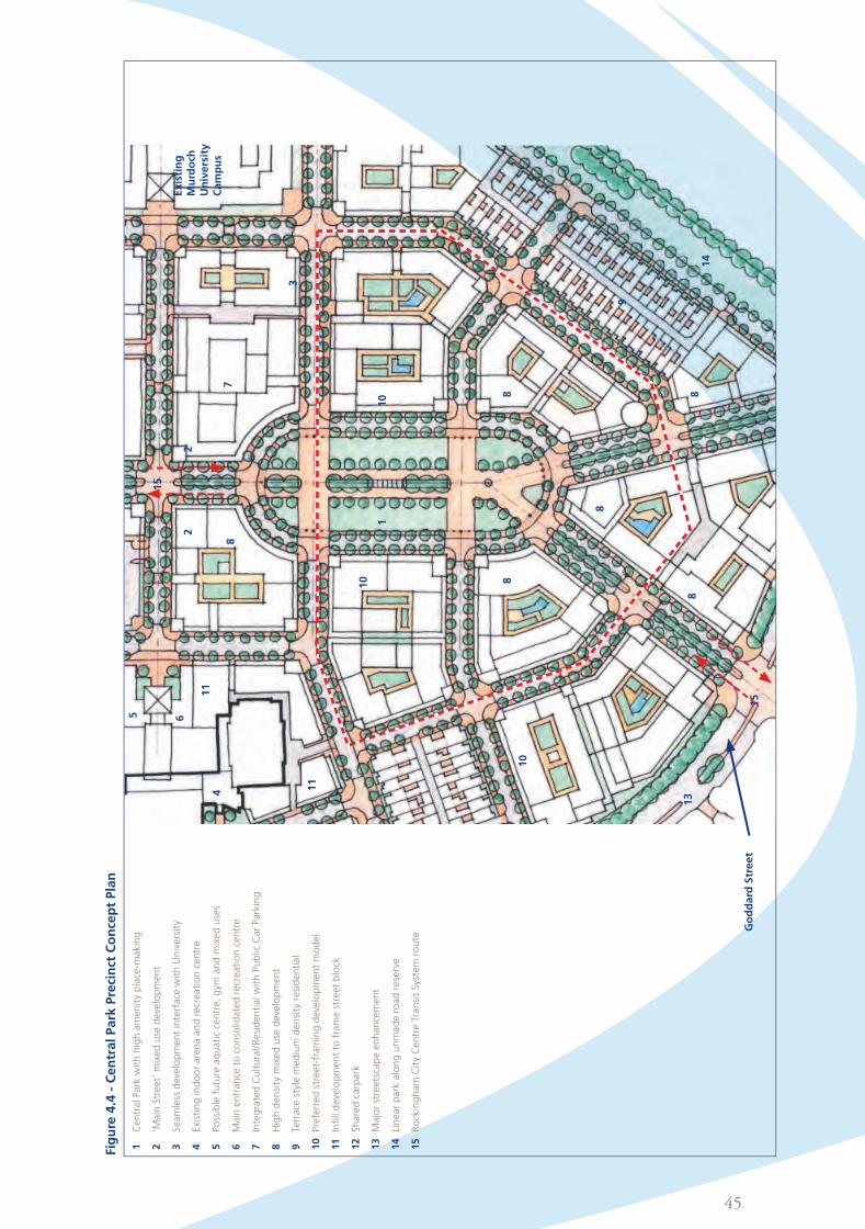
45
Fig
ure
4.4
- C
en
tral Park
Pre
cin
ct C
on
cep
t Pla
n
1
22
3
4
5 6
78
8
8
8
88
9
10
10
10
11
13
14
15
Exis
tin
g
Mu
rdo
ch
Un
ivers
ity
Cam
pu
s
15
Go
dd
ard
Str
ee
t
11
1
Cen
tral Park
wit
h h
igh a
men
ity
pla
ce-m
akin
g
2
‘Main
Str
eet’
mix
ed u
se d
eve
lop
men
t
3
Seam
less
deve
lop
men
t in
terf
ace
wit
h U
niv
ers
ity
4
Exi
stin
g in
do
or
are
na a
nd r
ecr
eati
on c
en
tre
5
Po
ssib
le f
utu
re a
qu
ati
c ce
ntr
e, g
ym a
nd m
ixed u
ses
6
Main
en
tran
ce t
o c
on
solid
ate
d r
ecr
eati
on c
en
tre
7
Inte
gra
ted C
ult
ura
l/R
esi
den
tial w
ith P
ub
lic C
ar
Park
ing
8
Hig
h d
en
sity
mix
ed u
se d
eve
lop
men
t
9
Terr
ace
sty
le m
ed
ium
den
sity
resi
den
tial
10
Pre
ferr
ed s
treet-
fram
ing d
eve
lop
men
t m
od
el
11
Infi
ll d
eve
lop
men
t to
fra
me s
treet
blo
ck
12
Sh
are
d c
arp
ark
13
Majo
r st
reets
cap
e e
nh
an
cem
en
t
14Linearparkalongunmaderoadreserve
15
R
ock
ing
ham
Cit
y C
en
tre T
ran
sit
Sys
tem
ro
ute
Client Insert Date
Campaign Size (HxW)
Description
Filename Proof/Alt #
Publication Date/Time
Prod Mgr
Studio Mgr
Studio Op
Acc Dir
Acc Coor
Art Dir
Writer
Notes: Grey fields for internal sign off on hard copy proof.
PDF may appear on screen not at actual size.
Rockingham, City of (ROC005, ROCPROD) 2012-04-18
ROCK000104 Planning Policy - Smart Village 297.0 x 210.0
2011
ROCK000104_A4_BOOKV3_45-45 1
A4 Book 2012-08-06 18:18

46
(d) Consistent with Figure 3.2 ‘Density’, in Section 3.4, residential development within the Precinct is to be
developed to accommodate a balanced mix of dwelling sizes at preferred densities ranging from 100
to 200 dwellings per hectare, with a minimum density of 100 dwellings per hectare in any development
which includes a residential component.
(e) Consistent with Figure 3.3 ‘Building Height’, Section 3.5, buildings are to present a minimum 2 storey or
equivalent parapet height to the street or relevant public space subject to the maintenance of a 12.5 metre
height limit along street frontages, with any additional height to be setback a minimum of 3.5 metres. The
scale and massing of buildings are to be designed to minimise any overshadowing of adjoining properties
and public spaces.
(f) Podium level courtyard gardens may provide private open space over car parks located behind streetfront
buildings. Examples of this form of development are located at Rockingham Beach, Mandurah Marina,
Joondalup City Centre, Subi-Centro Subiaco and in Northbridge over the Graham Farmer Freeway.
(h) Car parking is not to be permitted between the road reserve boundary and building frontages.
(i) Semi-basement car parks are to be avoided wherever a medium to high level of frontage activation is
indicated on the ‘Frontage Types’ plan in Section 3.6.
(j) To complement the City’s townscape objectives for the Smart Village, the massing, articulation and facade
treatments of all development will be required to adhere to a quality, urban townscape aesthetic.
(k) The frontage of any building is to incorporate and maintain the required area of transparent facade with
suitably glazed shopfronts, windows and doors, consistent with the applicable ‘Frontage Types’ set down
in Section 3.6.
(l) Variety and high design standards will be encouraged in the fit-out, awning treatments, signage and private
street furniture attached to individual premises. Where appropriate, the City will encourage businesses to
use the public footpaths for streetside dining, subject to private street furniture meeting design and quality
standards acceptable to Council.
(m) Any subdivision application is to be prepared in conjunction with an Integrated Development Guide Plan
(IDGP), to be prepared by or on behalf of the land owner. The IDGP shall illustrate building envelopes,
indicative building configurations, setbacks, pedestrian and vehicular access, indicative car parking layouts
and any rights of way or access easements required. In general, a rectilinear subdivision pattern will be
preferred with a minimum lot size of 2500m2 to allow for a simple and cohesive layout.
(n) In lieu of the normal landscaping requirements of the Scheme, developers may be required to contribute
to the cost of streetscape and/or landscape works within the public domain in the general vicinity of their
development site.
Figure 4.4.1 - Central Park Cross Section
Preferred street-framing development model that provides internal courtyards and off-street car parks
Street blocks framed by urban scaled, medium to high density, mixed use development
Elevated apartments over ground level commercial
Transit route through central park
Client Insert Date
Campaign Size (HxW)
Description
Filename Proof/Alt #
Publication Date/Time
Prod Mgr
Studio Mgr
Studio Op
Acc Dir
Acc Coor
Art Dir
Writer
Notes: Grey fields for internal sign off on hard copy proof.
PDF may appear on screen not at actual size.
Rockingham, City of (ROC005, ROCPROD) 2012-04-18
ROCK000104 Planning Policy - Smart Village 297.0 x 210.0
2011
ROCK000104_A4_BOOKV3_46-46 1
A4 Book 2012-08-06 18:20

47
4.4 Smart Village West Precinct Policy
4.4.1 Application
This Policy applies to the Smart Village West Precinct as defined in the Precinct Plan (refer to Figure 4.1). The
SmartVillageWestPrecinctencompassespropertiesboundedbyGoddardStreet,theproposedLeeuwin
Parade (east) and the proposed loop road extension of Crocker Street and the proposed Chalgrove Avenue
(north) extension.
4.4.2 Desired Future Character
This Precinct, which forms the western edge of the Smart Village will feature medium to high density
development along the main north-south road corridor through the Strategic Metropolitan Centre.
The scale, density and quality of building design should reflect the opportunity afforded by proximity to a
formally landscaped dual carriageway. It is anticipated that commercial and residential apartment buildings will
be a significant driver of development, with elevated towers taking advantage of coastal and City Park views.
4.4.3 Preferred Uses
Within the Smart Village West Precinct the preferred uses are:-
•officesandcommercial
•education
•short-stayaccommodation
•recreation
•multipledwellings/residential
Other permissible uses listed under the Scheme are not preferred.
4.4.4 Required Elements – Smart Village West Precinct
The IDP (refer to Figure 3.1) and the Smart Village West Precinct Concept Plan (refer to Figure 4.5) show the
general location and pattern of development envisaged by Council and preferred under this Policy. Within
the scope and meaning of the planning and development principles listed in Section 2.2, there is scope for
further flexibility in the interpretation of the Centre Plan in relation to the scale and configuration of particular
developments. Notwithstanding the indicative intent of these plans, development is to be required to
incorporate and maintain the following elements, as applicable:-
(a) The Precinct is to be developed as a quality, mixed use area, consistent with a contemporary urban
townscape discipline.
(b) Buildings are to be located, configured and activated to frame and address street frontages, laneways and
other public spaces in a way that is generally consistent with the Precinct Concept Plan, relevant ‘Frontage
Types’ as indicated in Section 3.6.
(c) Buildings shall be designed to achieve an appropriate use profile with active, ground floor retail tenancies and
commercial tenancies. Offices, education accommodation, short-stay and student accommodation, multiple
dwellings, function rooms, arts and community purposes are preferred upper floor uses.
(d) Consistent with Figure 3.2 ‘Density’, in Section 3.4, residential development within the Precinct is to be
developed to accommodate a balanced mix of dwelling sizes at preferred densities ranging from 80 to 200
dwellings per hectare, with a minimum density of 60 dwellings per hectare in any development which
includes a residential component.
Client Insert Date
Campaign Size (HxW)
Description
Filename Proof/Alt #
Publication Date/Time
Prod Mgr
Studio Mgr
Studio Op
Acc Dir
Acc Coor
Art Dir
Writer
Notes: Grey fields for internal sign off on hard copy proof.
PDF may appear on screen not at actual size.
Rockingham, City of (ROC005, ROCPROD) 2012-04-18
ROCK000104 Planning Policy - Smart Village 297.0 x 210.0
2011
ROCK000104_A4_BOOKV3_47-47 1
A4 Book 2012-08-06 18:21

48
Fig
ure
4.5
- S
mart
Villa
ge W
est
Pre
cin
ct C
on
cep
t Pla
n
1
Cen
tral Park
wit
h h
igh a
men
ity
pla
ce-m
akin
g
2
‘Main
Str
eet’
mix
ed u
se d
eve
lop
men
t
3
Seam
less
deve
lop
men
t in
terf
ace
wit
h U
niv
ers
ity
4
Exi
stin
g in
do
or
are
na a
nd r
ecr
eati
on c
en
tre
5
Po
ssib
le f
utu
re a
qu
ati
c ce
ntr
e, g
ym a
nd m
ixed u
ses
6
Main
en
tran
ce t
o c
on
solid
ate
d r
ecr
eati
on c
en
tre
7
Inte
gra
ted C
ult
ura
l/R
esi
den
tial w
ith P
ub
lic C
ar
Park
ing
8
Hig
h d
en
sity
mix
ed u
se d
eve
lop
men
t
9
Terr
ace
sty
le m
ed
ium
den
sity
resi
den
tial
10
Pre
ferr
ed s
treet-
fram
ing d
eve
lop
men
t m
od
el
11
Infi
ll d
eve
lop
men
t to
fra
me s
treet
blo
ck
12
Sh
are
d c
arp
ark
13
Majo
r st
reets
cap
e e
nh
an
cem
en
t
14Linearparkalongunmaderoadreserve
15
R
ock
ing
ham
Cit
y C
en
tre T
ran
sit
Sys
tem
ro
ute
1
4
8
8
8
88
8
9
10
10
10
11
11
13
14
15
Go
dd
ard
Str
eet
8
Client Insert Date
Campaign Size (HxW)
Description
Filename Proof/Alt #
Publication Date/Time
Prod Mgr
Studio Mgr
Studio Op
Acc Dir
Acc Coor
Art Dir
Writer
Notes: Grey fields for internal sign off on hard copy proof.
PDF may appear on screen not at actual size.
Rockingham, City of (ROC005, ROCPROD) 2012-04-18
ROCK000104 Planning Policy - Smart Village 297.0 x 210.0
2011
ROCK000104_A4_BOOKV3_48-48 1
A4 Book 2012-08-06 18:23

49
(e) Consistent with Figure 3.3 ‘Building Height’, Section 3.5, buildings are to present a minimum 2 storey or
equivalent parapet height to the street or relevant public space subject to the maintenance of a 12.5 metre
height limit along street frontages, with any additional height to be setback a minimum of 3.5 metres. The
scale and massing of buildings are to be designed to minimise any overshadowing of adjoining properties
and public spaces.
(f) Podium level courtyard gardens may provide private open space over car parks located behind streetfront
buildings. Examples of this form of development are located at Rockingham Beach, Mandurah Marina,
Joondalup City Centre, Subi-Centro Subiaco and in Northbridge over the Graham Farmer Freeway.
(g) Car parking is to be provided in accordance with Table 3 of Town Planning Scheme No.2, refer to Appendix 1.
(h) Car parking is not to be permitted between the road reserve boundary and building frontages.
(i) Semi-basement car parks are to be avoided wherever a medium to high level of frontage activation is
indicated on the ‘Frontage Types’ plan in Section 3.6.
(j) To complement the City’s townscape objectives for the Smart Village, the massing, articulation and facade
treatments of all development will be required to adhere to a quality, urban townscape aesthetic.
(k) The frontage of any building is to incorporate and maintain the required area of transparent facade with
suitably glazed shopfronts, windows and doors, consistent with the applicable ‘Frontage Types’ set down in
Section 3.6.
(l) Variety and high design standards will be encouraged in the fit-out, awning treatments, signage and private
street furniture attached to individual premises. Where appropriate, the City will encourage businesses to
use the public footpaths for streetside dining, subject to private street furniture meeting design and quality
standards acceptable to Council.
(m) Any subdivision application is to be prepared in conjunction with an Integrated Development Guide Plan
(IDGP), to be prepared by or on behalf of the land owner. The IDGP shall illustrate building envelopes,
indicative building configurations, setbacks, pedestrian and vehicular access, indicative car parking layouts
and any rights of way or access easements required. In general, a rectilinear subdivision pattern will be
preferred with a minimum lot size of 2500m2 to allow for a simple and cohesive layout.
(n) In lieu of the normal landscaping requirements of the Scheme, developers may be required to contribute
to the cost of streetscape and/or landscape works within the public domain in the general vicinity of their
development site.
Figure 4.5.1 - Smart Village West Cross Section
Preferred street-framing development model that provides internal courtyards and off-street car parks
Local access street
Development above podium height setback from street to maintain an appropriate streetscape profile
Client Insert Date
Campaign Size (HxW)
Description
Filename Proof/Alt #
Publication Date/Time
Prod Mgr
Studio Mgr
Studio Op
Acc Dir
Acc Coor
Art Dir
Writer
Notes: Grey fields for internal sign off on hard copy proof.
PDF may appear on screen not at actual size.
Rockingham, City of (ROC005, ROCPROD) 2012-04-18
ROCK000104 Planning Policy - Smart Village 297.0 x 210.0
2011
ROCK000104_A4_BOOKV3_49-49 1
A4 Book 2012-08-06 18:24

50
4.5 Smart Village East Precinct Policy
4.5.1 Application
This Policy applies to the Smart Village East Precinct as defined in the Precinct Plan (refer to Figure 4.1). The Smart
VillageEastPrecinctencompassespropertiesboundedbytheproposedLeeuwinParade(east),LeghornStreet,the
proposed loop road extension of Crocker Street and the proposed Chalgrove Avenue (north) extension.
4.5.2 Desired Future Character
This Precinct, which forms the south eastern edge of the Smart Village will feature medium to high density
developmentalongtheformerLeghornStreetroadreservewhichbacksontoanexistingsinglestorey
Residential R20 housing area.
The northern end of the Precinct adjoins the Murdoch University campus and development should reflect the
opportunity that lies in accommodating land uses that will complement the civic qualities, physical design and
functions of the institution.
The southern end of the Precinct lies at the interface between the Smart Village and City Centre Cectors and
it is envisaged that mixed use development fronting the Chalgrove Avenue extension will contribute to the
activation of pedestrian pavements in the vicinity.
4.5.3 Preferred Uses
Within the Smart Village East Precinct the preferred uses are:-
•officesandcommercial
•education
•short-stayaccommodation
•recreation
•multipledwellings/residential
Other permissible uses listed under the Scheme are not preferred.
4.5.4 Required Elements – Smart Village East Precinct
The IDP (refer to Figure 3.1) and the Smart Village West Precinct Concept Plan (refer to Figure 4.6) show the
general location and pattern of development envisaged by the City and preferred under this Policy. Within
the scope and meaning of the planning and development principles listed in Section 2.2, there is scope for
further flexibility in the interpretation of the Centre Plan in relation to the scale and configuration of particular
developments. Notwithstanding the indicative intent of these plans, development is to be required to
incorporate and maintain the following elements, as applicable:-
(a) The Precinct is to be developed as a high quality, mixed use area, consistent with a contemporary urban
townscape discipline.
(b) Buildings are to be located, configured and activated to frame and address street frontages, laneways and
other public spaces in a way that is generally consistent with the Precinct Concept Plan, relevant ‘Frontage
Types’ as indicated in Section 3.6.
(c) Buildings shall be designed to achieve an appropriate use profile with active, ground floor retail tenancies
and commercial tenancies. Offices, education accommodation, short-stay and student accommodation,
multiple dwellings, function rooms, arts and community purposes are preferred upper floor uses.
(d) Consistent with Figure 3.2 ‘Density’, in Section 3.4, residential development within the Precinct is to be
developed to accommodate a balanced mix of dwelling sizes at preferred densities ranging from 80 to
160 dwellings per hectare, with a minimum density of 60 dwellings per hectare in any development which
includes a residential component.
(e) Consistent with Figure 3.3 ‘Building Height’, in Section 3.5, buildings are to present a minimum 2 storey or
equivalent parapet height to the street or relevant public space subject to the maintenance of a 12.5 metre
height limit along street frontages, with any additional height to be setback a minimum of 3.5 metres. The
scale and massing of buildings are to be designed to minimise any overshadowing of adjoining properties
and public spaces to the satisfaction of the City.
Client Insert Date
Campaign Size (HxW)
Description
Filename Proof/Alt #
Publication Date/Time
Prod Mgr
Studio Mgr
Studio Op
Acc Dir
Acc Coor
Art Dir
Writer
Notes: Grey fields for internal sign off on hard copy proof.
PDF may appear on screen not at actual size.
Rockingham, City of (ROC005, ROCPROD) 2012-04-18
ROCK000104 Planning Policy - Smart Village 297.0 x 210.0
2011
ROCK000104_A4_BOOKV3_50-50 1
A4 Book 2012-08-06 18:25
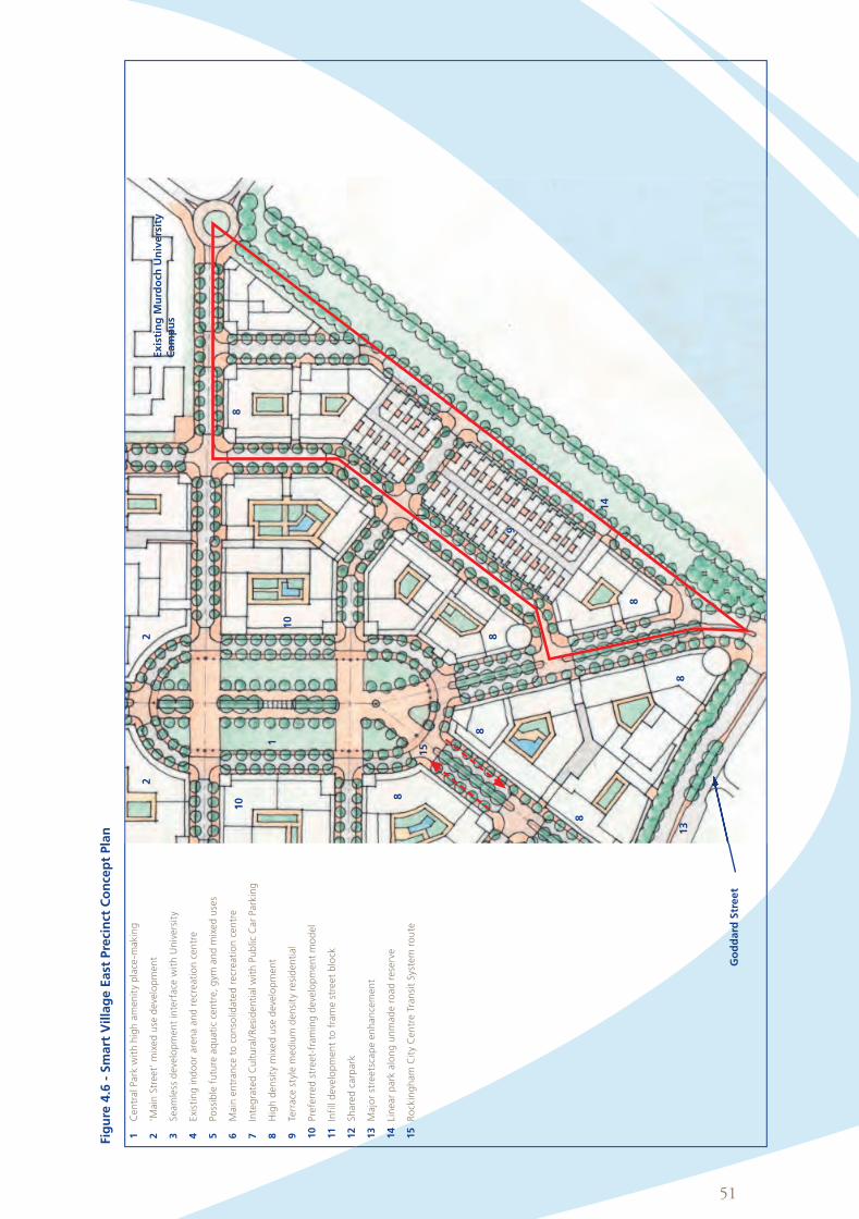
51
Fig
ure
4.6
- S
mart
Villa
ge E
ast
Pre
cin
ct C
on
cep
t Pla
n
1
Cen
tral Park
wit
h h
igh a
men
ity
pla
ce-m
akin
g
2
‘Main
Str
eet’
mix
ed u
se d
eve
lop
men
t
3
Seam
less
deve
lop
men
t in
terf
ace
wit
h U
niv
ers
ity
4
Exi
stin
g in
do
or
are
na a
nd r
ecr
eati
on c
en
tre
5
Po
ssib
le f
utu
re a
qu
ati
c ce
ntr
e, g
ym a
nd m
ixed u
ses
6
Main
en
tran
ce t
o c
on
solid
ate
d r
ecr
eati
on c
en
tre
7
Inte
gra
ted
Cu
ltu
ral/
Resi
den
tial w
ith P
ub
lic C
ar
Park
ing
8
Hig
h d
en
sity
mix
ed u
se d
eve
lop
men
t
9
Terr
ace
sty
le m
ed
ium
den
sity
resi
den
tial
10
Pre
ferr
ed s
treet-
fram
ing d
eve
lop
men
t m
od
el
11
Infi
ll d
eve
lop
men
t to
fra
me s
treet
blo
ck
12
Sh
are
d c
arp
ark
13
Majo
r st
reets
cap
e e
nh
an
cem
en
t
14Linearparkalongunmaderoadreserve
15
R
ock
ing
ham
Cit
y C
en
tre T
ran
sit
Sys
tem
ro
ute
Go
dd
ard
Str
ee
t
1
Exis
tin
g M
urd
och
Un
ivers
ity
Cam
pu
s
22
8
8
88
8
8
8
9
10
10
13
14
15
Client Insert Date
Campaign Size (HxW)
Description
Filename Proof/Alt #
Publication Date/Time
Prod Mgr
Studio Mgr
Studio Op
Acc Dir
Acc Coor
Art Dir
Writer
Notes: Grey fields for internal sign off on hard copy proof.
PDF may appear on screen not at actual size.
Rockingham, City of (ROC005, ROCPROD) 2012-04-18
ROCK000104 Planning Policy - Smart Village 297.0 x 210.0
2011
ROCK000104_A4_BOOKV3_51-51 1
A4 Book 2012-08-06 18:27

52
(f) Podium level courtyard gardens may provide private open space over car parks located behind streetfront
buildings. Examples of this form of development are located at Rockingham Beach, Mandurah Marina,
Joondalup City Centre, Subi-Centro Subiaco and in Northbridge over the Graham Farmer Freeway.
(g) Car parking is to be provided in accordance with Table 3 of Town Planning Scheme No.2 a copy of which is
set out in Appendix 1.
(h) Car parking is not to be permitted between the road reserve boundary and building frontages.
(i) Semi-basement car parks are to be avoided wherever a medium to high level of frontage activation is
indicated on the ‘Frontage Types’ plan in Section 3.6.
(j) To complement the City’s townscape objectives for the Smart Village, the massing, articulation and
facade treatments of all development will be required to adhere to a quality, urban townscape aesthetic.
(k) The frontage of any building is to incorporate and maintain the required area of transparent facade with
suitably glazed shopfronts, windows and doors, consistent with the applicable ‘Frontage Types’ set down
in Section 3.6.
(l) Variety and high design standards will be encouraged in the fit-out, awning treatments, signage and
private street furniture attached to individual premises. Where appropriate, the City will encourage
businesses to use the public footpaths for streetside dining, subject to private street furniture meeting
design and quality standards acceptable to Council.
(m) Any subdivision application is to be prepared in conjunction with an Integrated Development Guide Plan
(IDGP), to be prepared by or on behalf of the land owner. The IDGP shall illustrate building envelopes,
indicative building configurations, setbacks, pedestrian and vehicular access, indicative car parking layouts
and any rights of way or access easements required. In general, a rectilinear subdivision pattern will be
preferred with a minimum lot size of 2500m2 to allow for a simple and cohesive layout.
(n) In lieu of the normal landscaping requirements of the Scheme, developers may be required to contribute
to the cost of streetscape and/or landscape works within the public domain in the general vicinity of their
development site.
Client Insert Date
Campaign Size (HxW)
Description
Filename Proof/Alt #
Publication Date/Time
Prod Mgr
Studio Mgr
Studio Op
Acc Dir
Acc Coor
Art Dir
Writer
Notes: Grey fields for internal sign off on hard copy proof.
PDF may appear on screen not at actual size.
Rockingham, City of (ROC005, ROCPROD) 2012-04-18
ROCK000104 Planning Policy - Smart Village 297.0 x 210.0
2011
ROCK000104_A4_BOOKV3_52-52 1
A4 Book 2012-08-06 18:28

53
5. Supplementary Policies
Client Insert Date
Campaign Size (HxW)
Description
Filename Proof/Alt #
Publication Date/Time
Prod Mgr
Studio Mgr
Studio Op
Acc Dir
Acc Coor
Art Dir
Writer
Notes: Grey fields for internal sign off on hard copy proof.
PDF may appear on screen not at actual size.
Rockingham, City of (ROC005, ROCPROD) 2012-04-18
ROCK000104 Planning Policy - Smart Village 297.0 x 210.0
2011
ROCK000104_A4_BOOKV3_53-53 1
A4 Book 2012-08-06 18:30

54
5. Supplementary Policies
5.1 Central Arts Policy
5.1.1 Objective
The objective of the Central Arts Policy is to integrate the arts and culture into the built fabric and the day-to-
day functioning of the Strategic Metropolitan Centre.
5.1.2 Aspects of the Policy
•TheCentralArtsPolicywillfosterongoingdevelopmentofanartsculturethroughtheprovisionoffacilities,
the programming of arts and cultural activities and the incorporation of an arts component into the
planning, development and operation of the Strategic Metropolitan Centre.
•Apublicartcomponentistobeincorporatedintomajorpublicbuildingandtownscapecommissions.
•TheCitywillfacilitatetheexecutionofpublicartbeyondthefamiliarstand-alonesculptureorpaintingto
encompass integral contributions to the form and aesthetics of public spaces, building facades, landscape
and street furniture.
•PublicartmayactassignificantlandmarksatkeyentrypointstotheCityorspecificspacesandbuildingsor
it may be employed to reinforce localised identity as has, for example, already occurred in the City Square, in
the forecourt of the Justice complex and more recently at the gateway to the Waterfront Village.
•Anongoingprogrammeofartsandculturalactivitiesandcommunityinvolvementwillbepursuedby
Council to ensure that a wide cross section of interests and age groups is catered for in the development
and functioning of the City Centre.
•Artsandcommunityfestivalswillprovideopportunitiesforperiodicexpressionandtheenlivenmentofthe
public domain.
5.1.3 Funding of Public Art
A diverse range of funding options is to be pursued for the ongoing development of arts facilities, the running
of arts programmes and the incorporation of public art within development.
One percent of the capital cost of public buildings and other appropriate public works is intended to be set
aside for the integration of an arts component.
Council will work with other tiers of Government and the private sector to achieve similar funding for public art.
Client Insert Date
Campaign Size (HxW)
Description
Filename Proof/Alt #
Publication Date/Time
Prod Mgr
Studio Mgr
Studio Op
Acc Dir
Acc Coor
Art Dir
Writer
Notes: Grey fields for internal sign off on hard copy proof.
PDF may appear on screen not at actual size.
Rockingham, City of (ROC005, ROCPROD) 2012-04-18
ROCK000104 Planning Policy - Smart Village 297.0 x 210.0
2011
ROCK000104_A4_BOOKV3_54-54 1
A4 Book 2012-08-06 18:31

55
5.2 Security Policy
5.2.1 Objective
The objective of the Security Policy is to integrate a passive approach to crime prevention through appropriate
planning and environmental design measures to minimise both the actual and perceived incidence of crime.
5.2.2 Passive Security Principles
In assessing planning and development proposals, the City will have regard for the incorporation of the
following passive security principles:-
•IncorporateresidentialoccupationintoasmuchoftheSmartVillageaspossibletoprovideextendedhours,
low key surveillance of public space and buildings.
•ActivatethegroundorstreetleveloftheSmartVillageasmuchaspossible.
•Avoidgradeseparatedmovementnetworkswhichremovepedestrianactivityfromthestreets.
•Framestreets,pedestrianroutesandpublicspaceswithactivebuildingfrontagestominimisetheareaof
exposed, blank walls and the prevalence of pockets of unclaimed space.
•Giveprioritytogroundfloorbuildingtenancies(usuallyretail)whichgeneratepeoplemovementand
incorporate glazed shopfronts etc with a minimum of blank wall surface.
•Encouragecommercialandcommunityoccupationofpublicpedestrianpavements-whetheritbeinthe
form of outdoor restaurants, cafes, charity stalls, buskers or street theatre.
•Makepublicspaces,pedestrianpavementsandparksandgardensattractive,comfortableandwelllit.
•Orientresidentialdevelopmenttowardspublicstreetsandlanewayssuchthattheoutlookoverseesthe
public domain and a defensible pattern of built form and space is established.
•Selectdurableandeasilycleanedmaterialsandfinisheswherepubliccontactisenvisaged.
Client Insert Date
Campaign Size (HxW)
Description
Filename Proof/Alt #
Publication Date/Time
Prod Mgr
Studio Mgr
Studio Op
Acc Dir
Acc Coor
Art Dir
Writer
Notes: Grey fields for internal sign off on hard copy proof.
PDF may appear on screen not at actual size.
Rockingham, City of (ROC005, ROCPROD) 2012-04-18
ROCK000104 Planning Policy - Smart Village 297.0 x 210.0
2011
ROCK000104_A4_BOOKV3_55-55 1
A4 Book 2012-08-06 18:33

56
6. DelegationThe Council has the authority to delegate the determination of any application for planning approval. An
applicant wishing to know whether the Council or one of the City’s officers will determine an application
should contact the City.
7. Adoption and OperationThis Planning Policy was adopted by the Council at its ordinary Meeting held on the 24 April 2012.
This Planning Policy is to come into operation at the same time that Amendment No.113 to the Scheme comes
into operation.
Client Insert Date
Campaign Size (HxW)
Description
Filename Proof/Alt #
Publication Date/Time
Prod Mgr
Studio Mgr
Studio Op
Acc Dir
Acc Coor
Art Dir
Writer
Notes: Grey fields for internal sign off on hard copy proof.
PDF may appear on screen not at actual size.
Rockingham, City of (ROC005, ROCPROD) 2012-04-18
ROCK000104 Planning Policy - Smart Village 297.0 x 210.0
2011
ROCK000104_A4_BOOKV3_56-56 1
A4 Book 2012-08-06 18:35

57
Appendices
Client Insert Date
Campaign Size (HxW)
Description
Filename Proof/Alt #
Publication Date/Time
Prod Mgr
Studio Mgr
Studio Op
Acc Dir
Acc Coor
Art Dir
Writer
Notes: Grey fields for internal sign off on hard copy proof.
PDF may appear on screen not at actual size.
Rockingham, City of (ROC005, ROCPROD) 2012-04-18
ROCK000104 Planning Policy - Smart Village 297.0 x 210.0
2011
ROCK000104_A4_BOOKV3_57-57 1
A4 Book 2012-08-06 18:35

58
A1 Car Parking
Table A.1 Car Parking Requirements / Allowances
USEMINIMUM PARKING REQUIREMENT (AND MAXIMUM PARKING ALLOWABLE - IN BRACKETS)
Residential The provisions of the Residential Design Codes are taken to apply
Cinema, Theatre 1 bay per 8 (6) seats
Consulting Rooms 3 (4) bays per consultant
Fast Food Outlet 1bayper14(11)m²NLA
Health Studio1bayper20(15)m²NLAavailabletothepublic,includingswimming
pools
Office 1bayper60(40)m²NLA
Private Recreation, Restaurant,
Reception Centre1 bay for every 8 (6) persons the building is designed to accommodate
Shop 1bayper22(17)m²NLA
Showroom, Warehouse 1bayper80(60)m²NLA
Hotel, Motel, Tavern1 bay per bedroom plus 1 bay for every 5 (4) m² of bar and public areas
including lounges, beer gardens and restaurants
Child Care Premises 1 bay per employee and 1 bay per eight children
Public Assembly, Public Worship 1 bay per 8 (6) seats
Short Stay AccommodationThe provisions of the Residential Design Codes with respect to multiple
dwellings are taken to apply
Client Insert Date
Campaign Size (HxW)
Description
Filename Proof/Alt #
Publication Date/Time
Prod Mgr
Studio Mgr
Studio Op
Acc Dir
Acc Coor
Art Dir
Writer
Notes: Grey fields for internal sign off on hard copy proof.
PDF may appear on screen not at actual size.
Rockingham, City of (ROC005, ROCPROD) 2012-04-18
ROCK000104 Planning Policy - Smart Village 297.0 x 210.0
2011
ROCK000104_A4_BOOKV3_58-58 1
A4 Book 2012-08-06 18:38

59
A2 Interpretations
Active or Interactive Frontages
Refers to street frontages where there is an active
visual and physical engagement between people in
the street and those on the ground floors of buildings.
This quality is assisted where the building facades
include the main entrances, and the ground floor uses
(such as shops, cafes, offices and residential dwellings)
face and open towards the street. Refer to Section 4.4,
for an explanation of the various levels of activation
related to ‘Frontage Types’.
Amenity
Means all those factors which combine to form the
character of an area and includes the present and
likely future amenity.
Articulation
An element of building design which means the
breaking up of a façade into individual elements
to provide a modulated effect aimed at enhancing
individual building identity, variety and interest. This
can be achieved through the use of such elements
as window projections, balconies, awnings, minor
recesses and/or projections of walls or parts of walls
to provide visual interest, and to enhance the ‘fine
grained’ scale of development.
Building Envelope
Means an area of land within a lot marked on a plan
approved by the responsible authority, within which
all buildings must be contained.
Built Form
The configuration of the aggregate of all buildings,
structures, etc., which make up a town or city.
Bulk
The size or mass of a building, referring to structures
which in their context appear relatively large.
Character
Character is essentially the combination of the public
and private domains. Every property, public place
or piece of infrastructure makes a contribution,
whether large or small. It is the cumulative impact
of all these contributions that establishes Precinct or
neighbourhood character.
Centre Plan
Means the Rockingham Strategic Metropolitan
Centre - Centre Plan, Volumes 1 and 2 as adopted
by Council on the 22 September 2009 and the
Western Australian Planning Commission on the
10 November 2009.
City Centre
Means the major retail, commercial, civic and
mixed use activity centre and the major social and
employment hub of the Strategic Metropolitan
Centre. In this instance, the existing extent of the
City Centre Sector is defined in Figure 3.2.
Façade
Means the exposed face(s) of a building towards
roads or open space, or the frontal outward
appearance of a building.
Fine Grain
Refers to horizontal strips of development broken
into a vertical rhythm by individual shop fronts and
windows. This is usually a reflection of the original
subdivision pattern of narrow lot frontages. A similar
visual effect can be created for new, wide frontage
development if the building is broken up into narrow
modules by the use of architectural detailing and
different colours.
Client Insert Date
Campaign Size (HxW)
Description
Filename Proof/Alt #
Publication Date/Time
Prod Mgr
Studio Mgr
Studio Op
Acc Dir
Acc Coor
Art Dir
Writer
Notes: Grey fields for internal sign off on hard copy proof.
PDF may appear on screen not at actual size.
Rockingham, City of (ROC005, ROCPROD) 2012-04-18
ROCK000104 Planning Policy - Smart Village 297.0 x 210.0
2011
ROCK000104_A4_BOOKV3_59-59 1
A4 Book 2012-08-06 18:38

60
Height
Means the measurement taken from the natural
ground level immediately in front of the centre of
the face of the building to a level at the top of the
ridge, parapet, or flat roof, whichever is the highest,
but does not include any lift plant, water tower or
similar utility or service, not exceeding 3 metres in
height, or any architectural feature or decoration
(other than a freestanding sign) not used for any
form of accommodation, which may be approved by
the Council.
Human Scale
Buildings of a size or comprising a range of
architectural elements which are of a magnitude and
proportion related to our bodily dimensions.
Laneway
Means a narrow or very narrow local ’street’, usually
paved without a verge, located along the rear and/
or side property boundary. Might be used exclusively
by pedestrians, or shared by both pedestrians and
vehicles, depending upon the circumstances.
Legibility
Is where the design of a street system provides
a sense of direction and connection, giving clear
signals regarding the spatial layout and geography of
an area.
Light Rail or Streetcar
A modern electric tram system which usually runs on-
street, but may also be capable of being segregated
from road traffic.
‘Main Street’
Means mixed land use developments fronting a
street in a manner whereby pedestrian access to the
majority of individual businesses can be achieved
directly from the street, and/or where customer car
parks on private property do not separate the road
reserve boundary from the front of a building.
Massing
The size and volume of a building.
Mixed Use Development
Good mixed use development involves the ‘fine
grain’ mixing of compatible land uses in a balanced
blend, integrated in close proximity to each other.
Physically it includes both vertical and horizontal
mixing of uses. No single use should dominate other
uses, although residential use is often the major
component. Good mixed use development has the
potential to improve the efficiency and amenity of
neighbourhoods, reduce travel demand, increase
walkability, and make more efficient use of available
space and buildings.
Precinct
Means a local area defined for the purposes of
describing and managing the preservation and/or
development of specific urban characteristics.
Public Realm or Public Domain
Means spaces that are physically accessible to the
public,
and those aspects of other spaces that are visible
from
physically accessible spaces. It incorporates features
such as streets, parks, shops, community buildings
and the street facades of other buildings.
Scale
The size of a building and its relationship with its
surrounding buildings or landscape.
Sector
Means a distinct geographic area within a Centre
that may reflect an established local identity,
co-ordinated ownership, zoning and/or policy
characteristics. A sector may be comprised of one or
a number of precincts.
Smart Village
Means the area defined in Figure 3.2 and it includes
the land formerly used for the sporting grounds on
Dixon Road.
Strategic Metropolitan Centre
Means the area as defined by the Centre Plan as
the Rockingham Strategic Metropolitan Centre. The
boundary is defined in Figure 3.2.
Client Insert Date
Campaign Size (HxW)
Description
Filename Proof/Alt #
Publication Date/Time
Prod Mgr
Studio Mgr
Studio Op
Acc Dir
Acc Coor
Art Dir
Writer
Notes: Grey fields for internal sign off on hard copy proof.
PDF may appear on screen not at actual size.
Rockingham, City of (ROC005, ROCPROD) 2012-04-18
ROCK000104 Planning Policy - Smart Village 297.0 x 210.0
2011
ROCK000104_A4_BOOKV3_60-60 1
A4 Book 2012-08-06 18:40

Street Alignment
Means the common boundary between the land
comprising a street (i.e. the road reserve), and the
land abutting it.
Street Setback
Means the horizontal distance between the street
alignment and a building, measured at right angles
to the street alignment. The ‘street setback area’ is
the area between the street alignment and the street
setback line.
Streetscape
(a) means the total visual impression gained from any
one location within a street including the natural
and man-made elements; and
(b) is made up of the appearance of, and the
relationships between, buildings in terms of
design, scale, materials, colours, finishes, signs,
external furniture, paving materials for roads,
footpaths and landscaping.
Surveillance
Means the presence of passers-by or the ability of
people to be seen in public spaces from surrounding
windows, decks, balconies or the like. ‘Casual
surveillance’ means “eyes on the street” provided by
local people going about their daily activities.
Sustainability
Is meeting the needs of current and future
generations through an integration of environmental
protection, social advancement and economic
prosperity.
Sustainable Development
Means development that meets the needs of the
present without compromising the ability of future
generations to meet their own needs.
Traffic Calming
Means the introduction of physical traffic
management measures or techniques into a road or
street aimed at reducing the impact of traffic on that
road or street.
Transit Oriented Development (TOD)
Means a compact, mixed use community within
the walkable catchment of a transit place, blending
housing, shopping, employment and public uses
in a pedestrian-friendly environment that makes
it convenient and practicable for residents and
employees to travel by public transport instead of by
private car.
Urban Form
Means the broad shape and structure of an urban
community and the distribution of its major features.
Walkability
Means the ease with which a person can walk in
an area.
Walkable Catchment
Means the actual area served within a 600m (5 to
10 minute) walking distance along the street system
from a central transit system stop or an 800m
walking distance from the City Centre.
Client Insert Date
Campaign Size (HxW)
Description
Filename Proof/Alt #
Publication Date/Time
Prod Mgr
Studio Mgr
Studio Op
Acc Dir
Acc Coor
Art Dir
Writer
Notes: Grey fields for internal sign off on hard copy proof.
PDF may appear on screen not at actual size.
Rockingham, City of (ROC005, ROCPROD) 2012-04-18
ROCK000104 Planning Policy - Smart Village 297.0 x 210.0
2011
ROCK000104_A4_BOOKV3_61-61 1
A4 Book 2012-08-06 18:41

62
Client Insert Date
Campaign Size (HxW)
Description
Filename Proof/Alt #
Publication Date/Time
Prod Mgr
Studio Mgr
Studio Op
Acc Dir
Acc Coor
Art Dir
Writer
Notes: Grey fields for internal sign off on hard copy proof.
PDF may appear on screen not at actual size.
Rockingham, City of (ROC005, ROCPROD) 2012-04-18
ROCK000104 Planning Policy - Smart Village 297.0 x 210.0
2011
ROCK000104_A4_BOOKV3_62-62 1
A4 Book 2012-08-06 18:43