PLANNING, HERITAGE & ECONOMIC DEVELOPMENT STANDING ...
97
PLANNING, HERITAGE & ECONOMIC DEVELOPMENT STANDING COMMITTEE AGENDA (available also at www.citywindsor.ca ) Monday, July 11, 2016 4:30 o’clock p.m. Council Chambers, 3rd Floor, Windsor City Hall Members: Ward 8 – Councillor Bill Marra (Chairperson) Ward 4 - Councillor Chris Holt Ward 7 - Councillor Irek Kusmierczyk Ward 9 - Councillor Hilary Payne Ward 5 - Councillor Ed Sleiman Member Lynn Baker Member Barb Bjarneson Member Simon Chamely Member Michael DiMaio Member Andrew Foot Member Anthony Gyemi Member John Miller Member Dorian Moore 1. CALL TO ORDER
Transcript of PLANNING, HERITAGE & ECONOMIC DEVELOPMENT STANDING ...

PLANNING, HERITAGE &
ECONOMIC DEVELOPMENT
STANDING COMMITTEE
AGENDA (available also at www.citywindsor.ca)
Monday, July 11, 2016 4:30 o’clock p.m.
Council Chambers, 3rd Floor, Windsor City Hall
Members: Ward 8 – Councillor Bill Marra (Chairperson) Ward 4 - Councillor Chris Holt Ward 7 - Councillor Irek Kusmierczyk Ward 9 - Councillor Hilary Payne Ward 5 - Councillor Ed Sleiman
Member Lynn Baker Member Barb Bjarneson Member Simon Chamely
Member Michael DiMaio Member Andrew Foot
Member Anthony Gyemi Member John Miller Member Dorian Moore
1. CALL TO ORDER

P l a n n i n g , H e r i t a g e & E c o n o m i c D e v e l o p m e n t S t a n d i n g C o m m i t t e e P a g e | 2
Monday, July 11, 2016
2. DISCLOSURES OF PECUNIARY INTEREST AND THE GENERAL NATURE THEREOF
3. REQUEST FOR DEFERRALS, REFERRALS OR WITHDRAWALS
4. COMMUNICATIONS
5. ADOPTION OF THE PLANNING ACT MINUTES
5.1. Minutes of the Planning, Heritage & Economic Development Standing
Committee meeting held June 13, 2016 (Planning Act Matters) (SCM 102/2016)
6. PRESENTATION & DELEGATIONS (PLANNING ACT MATTERS)
7. PLANNING ACT MATTERS
7.1. Zoning By-law Amendment Application to add "Haunted House" use as
additional permitted use on the property known as 1441 McDougall; Applicant – S. Lippert, Ward 3 (S 113/2016)
8. ADOPTION OF THE MINUTES
8.1. Minutes of the Planning, Heritage & Economic Development Standing Committee meeting held June 13, 2016 (SCM 101/2016)
9. PRESENTATIONS AND DELEGATIONS (COMMITTEE & ADMINISTRATIVE
MATTERS)

P l a n n i n g , H e r i t a g e & E c o n o m i c D e v e l o p m e n t S t a n d i n g C o m m i t t e e P a g e | 3
Monday, July 11, 2016
10. HERITAGE ACT MATTERS
10.1. Ontario Heritage Conference 2016 Report, City of Stratford and Town of St Mary’s, May 12 – May 15, 2016 (Citywide) (S 115/2016)
10.2. Additional Listings in the Windsor Municipal Heritage Register; Designation
Correction (S 120/2016)
11. ADMINISTRATIVE ITEMS
11.1. Conveyance of part of closed Clairview Avenue abutting 429 Fairview – Ward 6 (S110/2016)
11.2. Brownfield Redevelopment Community Improvement Plan (CIP) Application Submitted by Valente Development Corp. for 325 Devonshire Road (S 125/2016)
12. COMMITTEE MATTERS
13. QUESTION PERIOD
14. ADJOURNMENT

Page 1 of 1
COMMITTEE MATTERS
PHED Standing Committee
July 11, 2016 Subject: Minutes of the Planning, Heritage & Economic Development Standing
Committee Meeting held June 13, 2016 (Planning Act Matters)
toldob
Text Box
Item No. 5.1
Planning Act Minutes Planning, Heritage & Economic Development Standing Committee
City of Windsor
Monday, June 13, 2016 4:30 PM
Members Present: Chairperson Ward 8—Councillor Marra Councillors Ward 5 – Councillor Sleiman (Vice Chairperson) Ward 4 – Councillor Holt Ward 7 – Councillor Kusmierczyk Ward 9 – Councillor Payne (departed at 5:00 pm) Planning Act Citizens Anthony Gyemi Barb Bjarneson Members absent: Dorian Moore
Delegations None
ALSO PRESENT ARE THE FOLLOWING FROM ADMINISTRATION: Wira Vendrasco, Deputy City Solicitor Thom Hunt, Executive Director Planning, Building Services/City Planner Don Wilson, Manager of Development Applications Adam Szymczak, Planner III Justina Nwaesei, Planner II Greg Atkinson, Planner III Kristina Tang, Planner II John Calhoun, Heritage Planner Adam Pillon, Engineering John Revell, Chief Building Official Anna Ciacelli, Supervisor of Council Services Marianne Sladic, Senior Steno Clerk, Planning

Planning Act Minutes Planning, Heritage & Economic Development Standing Committee Monday, June 13, 2016 Page 2 of 13
1. CALL TO ORDER The Chairperson calls the meeting of the Planning, Heritage and Economic Development Standing Committee to order at 4:30 o’clock p.m. 2. DISCLOSURES OF PECUNIARY INTEREST AND THE GENERAL NATURE
THEREOF None 3. REQUEST FOR DEFERRALS, REFERRALS OR WITHDRAWALS None 4. COMMUNICATIONS None 5. ADOPTION OF THE PLANNING ACT MINUTES 5.1. Minutes of the Planning, Heritage & Economic Development Standing
Committee meeting held May 9, 2016 (Planning Act Matters) Ms. Bjarneson requests it be noted that her association with the United Way be listed as Volunteer Chair of Major Gifts Cabinet. Moved by Member Bjarneson Seconded by Councillor Holt
6. PRESENTATION & DELEGATIONS (PLANNING ACT MATTERS)

Planning Act Minutes Planning, Heritage & Economic Development Standing Committee Monday, June 13, 2016 Page 3 of 13
7. PLANNING ACT MATTERS 7.1. Z-001/16 [ZNG/4628] – City of Windsor – Housekeeping Amendment 2016-1 –
Re-Zoning City Wide
Mr. Szymczak introduces the report and is available to answer questions and provide clarification. Mr. Craig Alexander Kondruk – 11060 Riverside Dr. E. – brings forth a situation regarding elevations to a residence next door to his father’s home. The addition to the residence appears to be three (3) stories in height. The situation was brought forth at a PEDSC Meeting a few years ago. Mr. Kondruk posed several questions. Mr. Szymczak advises that the change in the by-law addressing storeys to metres should eliminate any misunderstandings in the future. The Chair also has the resident speak with the Chief Building Official, John Revell, privately regarding further information and to answer the questions posed. Mr. Kondruk wishes to be notified in future and is grateful to have been notified regarding this report. Councillor Kusmierczyk inquires what prompted the change in definition, specifically regarding building heights, and does the change in definition prevent something like the situation mentioned, from happening again? Mr. Szymczak cannot address Mr. Kondruk’s situation given that he was not involved in the review of that property. Mr. Revell advises the change in the by-law as relating to this situation, will prevent something similar happening in the future by more clearly defining storeys and maximum heights. Councillor Kusmierczyk requests clarification as to how the change will prevent a similar situation from happening again. Mr. Szymczak clarifies the definition itself, stating the height in metres as opposed to storeys which will help eliminate differences in interpretation. The height will be based on the outer part of the building structure in metres. Ms. Bjarneson inquires whether illustrations could be added to the by-law along with the descriptions? Also requests clarification on the difference between a deck and a porch? Mr. Szymczak advises a porch has a roof over it and provides the description within the by-law. Mr. Szymczak also advises there will be illustrations in the new comprehensive Zoning By-law. Ms. Bjarneson seeks clarification between swimming pool and splash pad. Mr. Szymczak advises the swimming pools are regulated under the Ontario Building Code and mention depth and square metres which would differentiate a swimming pool from a splash pad. Councillor Sleiman recalls an amendment brought forth regarding heights and asks why it is being brought forth again? Mr. Szymczak advises that an administrative recommendation to change heights from storeys to metres was removed from a previous housekeeping amendment. A definition is now presented with clear language to prevent misinterpretation.

Planning Act Minutes Planning, Heritage & Economic Development Standing Committee Monday, June 13, 2016 Page 4 of 13
Councillor Holt inquires about page 15, recommendation 10 (a) & (b) regarding shipping containers not permitted on residential properties. Councillor Holt asks if this also pertains to containers being converted as residential units? Mr. Revell advises the intent is to allow containers to be used as residential units provided they adhere to permit regulations and plans are received under the stamp of a certified engineer and/or architect. The prohibition is in regards to accessory or storage use. Councillor Kusmierczyk asks if there is a possibility of a resident having a neighbour living in a shipping container? Mr. Revell advises the container would have aesthetic features to improve its appearance and be subject to the building permit process and adhere to zoning regulations, stamped and certified by an engineer/architect. Councillor Kusmierczyk inquires whether the city is seeing a lot of these shipping containers in residential areas? Mr. Revell advises the city is seeing many being used as accessory for storage in residential areas. Councillor Kusmierczyk asks what would quantify a shipping container as a residential unit? Mr. Revell advises there would be structural changes, such as plumbing, sectioned rooms, washroom and deemed as a primary residential use versus a secondary or accessory use. Member Gyemi clarifies further stating it’s a means to monitor and control use of shipping containers within residentially zoned areas. Member Gyemi seeks clarification regarding garage roofs. Mr. Szymczak notes that was also an item with several interpretations but had been changed in a previous amendment to also be measured in metres to the top of the roof. Member Gyemi inquires whether digging a structure would be considered a pool? Seeks clarification from pool and pond. Mr. Revell advises the excavation of any property requires a permit from the Building Department. Member Gyemi inquires about the encroachments regarding decks and seeks clarification on whether a deck can come up to the lot line? Mr. Szymczak advises there is minimum separation from the lot lines. Member Gyemi notes concern over one resident having a taller deck and being able to look over into the neighbour’s yard. Mr. Szymczak advises most decks are level to the patio doors. Member Gyemi inquires whether a recommendation can be made to eliminate the possibility of higher decks? Mr. Szymczak advises that further additions/amendments would cause more misinterpretations. Member Bjarneson comments to Member Gyemi’s comment, noting people have balconies, therefore, the issue of seeing into a neighbour’s yard remains. The Chair advises if further investigation or changes are requested, it can be made as part of the motion. The Chair asks if there are any further questions, motion or anyone in the audience wish to comment on the report.

Planning Act Minutes Planning, Heritage & Economic Development Standing Committee Monday, June 13, 2016 Page 5 of 13
Moved by Councillor Sleiman Seconded by Member Bjarneson Decision Number: XXX
THAT Zoning By-law 8600 BE AMENDED on the following basis:
1. That the METRIC CONVERSION CHART be deleted.
2A. That Section 1.10 be amended by adding the following provision after Section 1.10.1:
“1.10.5 A revision may be made to this by-law without a zoning by-law amendment as follows:
.1 Correction of numbering, cross-referencing, grammar, punctuation or a typographical error, or revision to format in a manner that does not change the intent of a provision;
.2 Adding or revising technical information on a map or a schedule that does not affect the zoning classification, zoning district or specific zoning exception of a lot including, but not limited to, colors, keys, legends, notes, scale or title blocks, or the updating and correcting of infrastructure information; and
.3 Revision to an item that does not form a part of this by-law and is editorially inserted for clarification, convenience or reference purpose only.”
2B. That Section 1.20.1 be deleted and replaced with the following: “.1 SEQUENCE - This by-law shall be read in its entirety. The chapters, sections, regulation,
provisions and tables in this by-law intentionally do not follow in consecutive numerical sequence in order to reserve space for the placement of future enactments. Reference should be made to the Table of Contents to determine the intended numerical sequence of the provisions of this by-law. [ZNG/4628]”
2C. That Section 1.20 be amended by adding the following provision after Section 1.20.1:
“.2 GENERAL, SUPPLEMENTARY, PARKING SPACE AND PARKING AREA PROVISIONS – All general, supplementary, parking space or parking area provisions apply to all zoning districts, site specific provisions, temporary use provisions and heritage conservation districts. [ZNG/4628]”
2D. That Section 1.20 be amended by adding the following provision after Section 1.20.3:
“.4 NOT FORMING PART OF THIS BY-LAW – The following items and any associated text are for the purpose of clarification, convenience or reference and do not form part of this by-law: Appendix, Example, Footer, Footnote, Header, Heading, Historical or Reference Information, Illustration, Index, Marginal Note, page numbering and Table of Contents. [ZNG/4628]”
3. That Section 7 is amended by replacing paragraph 17 with the following:
“(17) "Building Height" means:

Planning Act Minutes Planning, Heritage & Economic Development Standing Committee Monday, June 13, 2016 Page 6 of 13
(a) For any building or part thereof, with a flat roof or a roof having a slope of less than
20.0 degrees, the vertical distance in metres between the grade and the highest point of the roof.
Where a building height provision is expressed in storeys, the building height in metres shall be the number of storeys permitted multiplied by 4.0 metres. [ZNG/4628] Example: If the minimum building height is 2 storeys and the maximum building height is 3 storeys, multiplying 2 storeys by 4.0 metres results in a minimum building height of 8.0 metres and multiplying 3 storeys by 4.0 metres results in a maximum building height of 12.0 metres.
(b) For a main building, or part thereof, with a roof other than that described in clause (a) of this subsection, the vertical distance in metres between the grade and the mid-point between the lowest eaves and the highest point of the roof. Where building height is expressed in storeys, the minimum building height in metres shall be the number of storeys required multiplied by 4.0 metres, and the maximum building height in metres shall be the number of storeys permitted multiplied by 4.0 metres plus an additional 2.0 metres for the roof. [ZNG/4628] Example: If the maximum building height is 2 storeys, multiplying 2 storeys by 4.0 metres plus 2.0 metres for the roof, results in a maximum building height of 10.0 metres. Example: If the minimum building height is 2 storeys and the maximum building height is 3 storeys, multiplying 2 storeys by 4.0 metres results in a minimum building height of 8.0 metres and multiplying 3 storeys by 4.0 metres plus 2.0 metres for the roof results in a maximum building height of 14.0 metres.
(c) For an accessory building or that part of an accessory building with a roof other
than that described in clause (a) of this subsection, the vertical distance in metres between the grade and the highest point of the roof. [ZNG/4249]”
4A. That Section 7 be amended by deleting paragraph 18 and replacing it with the following:
“(18) "Business Office" means an office of any one or more of the following: commercial business; financial services including a bank, credit union, payday lender, savings and loan office and trust company; government; industrial business; non-profit or charitable organization; professional person. A financial office is a business office. A medical office, veterinary clinic or veterinary office is not a business office. [ZNG/4628]”
4B. That Section 7 be amended by deleting paragraph 50 and replacing it with the following:
“(50) "Financial Office" means a business office. [ZNG/4628]”

Planning Act Minutes Planning, Heritage & Economic Development Standing Committee Monday, June 13, 2016 Page 7 of 13
5A. That Section 21(12)(a)(iv) be deleted and replaced with the following:
“(iv) The erection of a building, structure or dwelling on a lot except where all of the following are available:
1. A street paved to the satisfaction of the City Engineer;
2. Municipal storm water outlet;
3. Municipal sanitary sewer;
4. Municipal electrical service; and
5. Municipal water service.
Notwithstanding the foregoing, a building permit may be issued for a building, structure or dwelling provided that the lot upon which the building, structure or dwelling is proposed to be located is within a registered plan of subdivision in which the street has not been assumed by the City of Windsor but in which the street is to be assumed under the terms of a registered subdivision agreement or a servicing agreement. [ZNG/4628]”
5B. That Sections 10(1)(b)(ix), 10(2)(b)(ix), 10(3)(b)(ix), 10(4)(b)(ix), 10(6)(b)(vii), 11(1)(b)(viii),
11(2)(b)(viii), 11(3)(b)(viii), 11(4)(b)(viii) and 21(12)(a)(vi) be deleted.
6A. That Sections 13(1)(a)(ii) and 13(2)(a)(ii) be deleted and each be replaced with the following:
“(ii) A school; day nursery; a business office of a non-profit or charitable organization; [ZNG/4628]”
6B. That Section 13(3)(a)(iii) be deleted and replaced with the following:
“(iii) A day nursery; a business office of a non-profit or charitable organization; [ZNG/4628]”
7. That Section 20 be amended by adding the following paragraph:
“368. For the lands comprising Part of Farm Lot 85, Concession 1, designated as Parts 1 and 2, Plan 12R-10279, Part of Farm Lot 85, Concession 1, and Part of Park Lots 24 and 28 and Park Lot 26, Registered Plan 125, as delineated by a heavy black line on Schedule ‘A’ to By-law 379-2001, situated on the south side of Shepherd Street East, between McDougall Street and Mercer Street, a private hall, a health studio, a restaurant, provided there is no facility for drive-through service, a business office, a contractor’s office, a financial office, a personal service shop and a convenience store shall be additional permitted uses and that the required number of parking spaces for a private hall shall be 165. [ZDM 14; ZNG/4628]”
8. That Section 21(3)(a)(iii) be deleted.
9A. That Section 7 be amended by adding the following paragraph after paragraph 140a:

Planning Act Minutes Planning, Heritage & Economic Development Standing Committee Monday, June 13, 2016 Page 8 of 13
“(140b) “Swimming Pool” means a structure, filled or capable of being filled with water, that has a minimum depth of water at any point of 610 mm and with more than 2.0 square metres in potential liquid surface area and that is, or capable of being, used for swimming, diving and/or other recreational purposes.
It may include a vessel designed or intended for therapeutic or bathing purposes commonly referred to as a hot tub, whirlpool, hydro massage pool, jetted tub or spa, a pond with a depth of 0.15 metres, and any equipment that circulates, heats, or treats the water in a swimming pool, hot tub or pond. It does not include a body of water, pond or a reservoir designed for storm water retention, utilized for agricultural purposes, or as part of a golf course; a privately or publicly owned storm water management facility; a swimming pool regulated by the Ontario Building Code; or an existing natural body of water or stream. [ZNG/4628]”
9B. That Section 21(8) be deleted and replaced with the following:
“(8) Swimming Pool
(B/L 9057, Jul 7/1987; B/L 10358, Jul 16/1990; B/L 324-1999, Dec 1/1999; ZNG/4628)
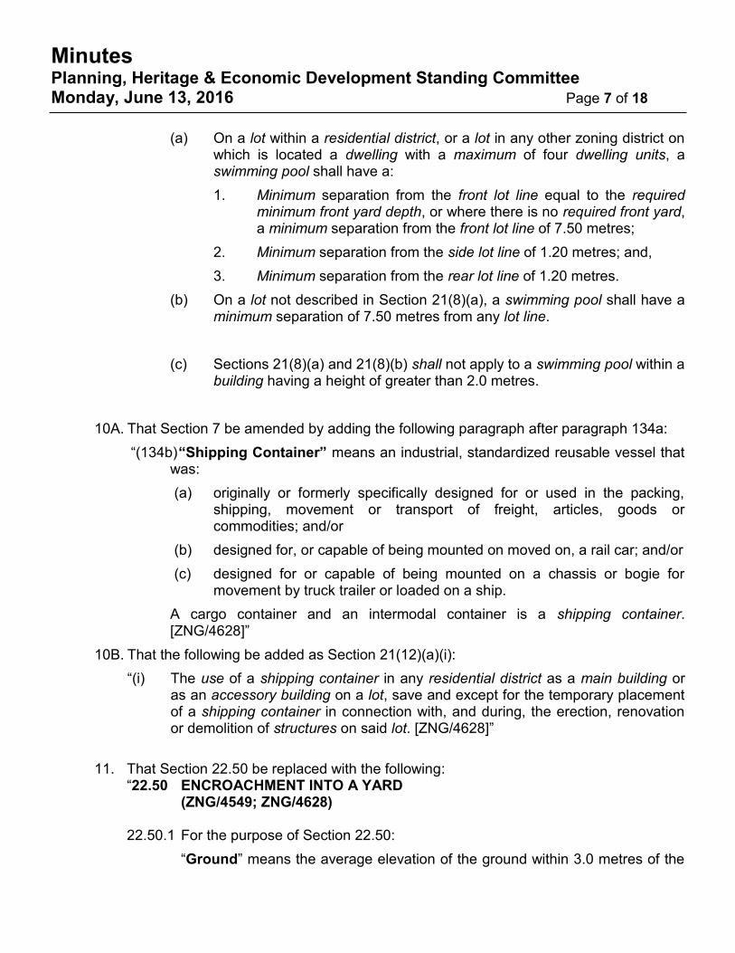
(a) On a lot within a residential district, or a lot in any other zoning district on which is
located a dwelling with a maximum of four dwelling units, a swimming pool shall have a:
1. Minimum separation from the front lot line equal to the required minimum front yard depth, or where there is no required front yard, a minimum separation from the front lot line of 7.50 metres;
2. Minimum separation from the side lot line of 1.20 metres; and,
3. Minimum separation from the rear lot line of 1.20 metres.
(b) On a lot not described in Section 21(8)(a), a swimming pool shall have a minimum separation of 7.50 metres from any lot line.
(c) Sections 21(8)(a) and 21(8)(b) shall not apply to a swimming pool within a building having a height of greater than 2.0 metres.
10A. That Section 7 be amended by adding the following paragraph after paragraph 134a:
“(134b) “Shipping Container” means an industrial, standardized reusable vessel that was:
(a) originally or formerly specifically designed for or used in the packing, shipping, movement or transport of freight, articles, goods or commodities; and/or
(b) designed for, or capable of being mounted on moved on, a rail car; and/or
(c) designed for or capable of being mounted on a chassis or bogie for movement by truck trailer or loaded on a ship.
A cargo container and an intermodal container is a shipping container. [ZNG/4628]”

Planning Act Minutes Planning, Heritage & Economic Development Standing Committee Monday, June 13, 2016 Page 9 of 13
10B. That the following be added as Section 21(12)(a)(i):
“(i) The use of a shipping container in any residential district as a main building or as an accessory building on a lot, save and except for the temporary placement of a shipping container in connection with, and during, the erection, renovation or demolition of structures on said lot. [ZNG/4628]”
11. That Section 22.50 be replaced with the following:
“22.50 ENCROACHMENT INTO A YARD (ZNG/4549; ZNG/4628)
22.50.1 For the purpose of Section 22.50:
“Ground” means the average elevation of the ground within 3.0 metres of the main building on the lot.
“n/a” means that a minimum separation is not required.
“No Limit” means that an encroachment is permitted into the specified yard subject to the minimum separation provisions in Table 22.50.10 and any other applicable provisions for that encroachment.
“Required Yard” means any of required front yard, required rear yard, required side yard or required landscaped open space yard.
22.50.5 Unless otherwise specified in Table 22.50.10, an encroachment is permitted into any
yard not required by this by-law subject to the minimum separation provisions in table 22.50.10 and any other applicable provisions in this By-law for that encroachment. Example: A homeowner wants to build a deck with a height of 1.30 metres in their rear yard. The dwelling is zoned RD1.1, which requires a minimum rear yard depth of 7.50 metres. Therefore, the required rear yard is 7.50 metres measured from the rear lot line. The nearest wall of the dwelling is located 11.0 metres from the rear lot line. A deck is permitted within this 3.50 metre deep rear yard area subject to the minimum separation provisions for that encroachment and any applicable provisions such as lot coverage. Per Table 22.50.10.37, that deck may extend a further 2.50 metres into the required rear yard subject to the minimum separation provisions and any other applicable provisions, creating a deck with a maximum depth of 6.0 metres in the rear yard.
22.50.7 Notwithstanding the provisions of Section 22.50:
.1 An encroachment, except for a building projection located a minimum of 3.0 metres above the ground, is prohibited into a access area, driveway, parking area or parking space.

Planning Act Minutes Planning, Heritage & Economic Development Standing Committee Monday, June 13, 2016 Page 10 of 13
.3 If a required yard is not specified in Table 22.50.10, the encroachment is prohibited within that unspecified required yard.
.5 If a lot line is not specified in Table 22.50.10, no separation is required from that unspecified lot line.
22.50.10 The permitted encroachments are specified in Table 22.50.10.
TABLE 22.50.10 – ENCROACHMENT INTO A YARD
Type of Encroachment Maximum Encroachment Into
Minimum Separation
From
Yard Metres Lot Line Metres
.1 Architectural Feature
into a required yard of less than
1.20 metres in width or depth
Any required yard 0.30 m n/a n/a
.2 Architectural Feature
into a required yard of 1.20 metres
or more in width or depth
Any required yard 0.60 m n/a n/a
.10 Balcony
Required front yard or
required rear yard 1.50 m
n/a n/a
Required side yard
25% of the
required side
yard width
.15 Bay Window
Required front yard or
Required rear yard 1.00 m
Side lot line 1.20 m
Required side yard 0.30 m
.20 Below Grade Entrance Pad and
Steps Leading Thereto
Required front yard or
Required rear yard 2.50 m
Side lot line 1.20 m
Required side yard No Limit
.25
Central Air Conditioning Unit
including the components of a
heating, ventilation or air
conditioning (HVAC) system
Required rear yard
or
Required side yard
No Limit Side lot line 0.60 m
.35
Deck – part of a deck having a floor
height of 0.30 metres or less above
the ground
Any required yard No Limit n/a n/a
.36
Deck – part of a deck having a floor
height of greater than 0.30 metres
and less than 1.20 metres above
the ground
Required front yard 2.50 m
Any lot line 1.20 m Required rear yard or
Required side yard No Limit
.37
Deck – part of a deck having a floor
height of 1.20 metres or more
above the ground
Any front yard
or
Required rear yard
2.50 m
Front lot line
Rear lot line 1.20 m
Side lot line
Minimum side
yard width
required by
Zoning District
Planning Act Minutes Planning, Heritage & Economic Development Standing Committee Monday, June 13, 2016 Page 11 of 13
TABLE 22.50.10 – ENCROACHMENT INTO A YARD
Type of Encroachment Maximum Encroachment Into
Minimum Separation
From
Yard Metres Lot Line Metres
.40 Fire Escape Required rear yard 2.50 m Side Lot Line 1.20 m
.60 Porch
Any front yard
or
Required rear yard
2.50 m
Front lot line
Rear lot line 1.20 m
Side lot line
Minimum side
yard width
required by
Zoning District
A porch, that is lawfully in existence on the effective date of this provision and which is located in whole or in part in a
front yard, may be repaired or replaced by a new porch with the same dimensions or less into the front yard subject to
above the minimum separation requirements.
.70 Solar Panel and Supporting
Structure – Residential District Required rear yard No Limit Side lot line 1.20 m
.71 Solar Panel and Supporting
Structure - Other Zoning District Any required yard No Limit n/a n/a
.75 Steps – Having a maximum height
of 0.30 metres above the ground Any required yard No Limit n/a n/a
.76 Steps – Having a height of greater
than 0.30 metres above the ground
Any required yard No Limit Any Lot Line 1.20 m
Maximum total tread area of 5.0 square metres within a required yard.
.80 Sunroom
Required rear yard 3.75 m
Side Lot Line
Minimum side
yard width
required by
Zoning District Maximum floor area of 15.0 sq. m within
the required rear yard
.90 Wheelchair Ramp or Lift Any required yard No Limit Any Lot Line 1.20 m
12. That Section 24.40.20.2 be deleted and replaced with the following:
“.2 A loading space may be located within a parking area or may have direct access from either a parking aisle or a collector aisle, provided, that the loading space is located and designed so as not to hamper the safe movement of people and operation of vehicles within the parking area and the loading space and access area complies with Section 25.5 in this By-law. [ZNG/4628]”
13. That the zoning of Part of Block Z, Registered Plan 927, further described as PIN 012644967,
situated on the north side of Sprucewood Avenue, east of Matchette Road and known municipally as 1490 Sprucewood Avenue, be changed from GD1.1 to DRD1.1.
Motion CARRIED, UNANIMOUSLY.
Planning Act Minutes Planning, Heritage & Economic Development Standing Committee Monday, June 13, 2016 Page 12 of 13
7.2. Z-006/16 [ZNG/4647] – Mid South Land Development Corp – 55 Edinborough St.
– Re-Zoning Ward 10
Ms. Justina Nwaesei presents the item. Karl Tanner (Consultant) – Dillon Consulting and Steve Cheifetz (Attorney) representing Dino Maggio (Applicant) – Mid South Land Development. They are available to answer any questions. The Chair asks if there is anyone in the audience to speak on the matter. Seeing none, the Chair turns it over to the Members for questions. Member Bjarneson inquires how the sleep clinic will be affected given the proximity to the rail line and Zalev Brothers nearby? Do they still intend to have a sleep clinic? Is there an intent to sever the soccer field in the future? And to Administration, will the Site Plan process address parking lot landscape? Mr. Cheifetz responds in regards to the sleep clinic, there is special insulation used in the development that limits outside noise. The doctors are aware of the situation nearby. Mr. Tanner addresses the question pertaining to the soccer field advising the intent is to take care of the site presently and depending on its prosperity, to possibly add to the facility in the future. Regarding the parking lot, Mr. Tanner advises the development is tied into the Site Plan process and will be addressed in order to meet current standards. Councillor Sleiman to Mr. Tanner, sees there will be a pharmacy on site for the specific availability of the patients of the clinic. Councillor Sleiman asks why is it only for the patients of the clinic? Mr. Tanner advises the pharmacy is an accessory use and is on site to provide convenient and immediate availability for its patrons, but anyone can utilize the pharmacy. The Chair gives another example of a similar situation, noting the pharmacy within the Ziter Complex, noting convenience for the patrons. The Chair asks if there are any further questions of Administration or delegates. Moved by Councillor Kusmierczyk Seconded by Councillor Sleiman Decision Number: XXX
I. That an amendment to the Zoning By-law 8600 BE APPROVED to change the zoning of the land located on the south side of Edinborough Street, west of Howard Avenue, described as Plan 707, Pt Block A, closed Victoria Street, by adding a site specific holding zoning provision allowing “a Medical Office” and “a Pharmacy as an accessory use to the Medical Office” to be listed as additional permitted uses in an existing building on the subject land; and
II. That the holding (‘H’) symbol BE REMOVED when the applicant/owner submits an
application to remove the ‘H’ symbol and when the following conditions have been satisfied:
Planning Act Minutes Planning, Heritage & Economic Development Standing Committee Monday, June 13, 2016 Page 13 of 13
1. The property owner has signed the required Site Plan Agreement with The Corporation of the City of Windsor for the proposed redevelopment on the subject land, and the Agreement is registered; and
2. A Transportation Impact Study, acceptable to the City Engineer, be submitted by the property owner; and any mitigation measures required/recommended by the Study be implemented at the owner‘s expense, to the satisfaction of the City Engineer and City Planner prior to finalizing the Site Plan Approval.
Motion CARRIED, UNANIMOUSLY. There being no further business, the meeting of the Planning, Heritage and Economic Development Standing Committee is adjourned at 5:10 o’clock p.m
Ward 8 Councillor Marra (Chairperson)
Don Wilson Secretary
Page 1 of 11
Planning & Building Services
MISSION STATEMENT
Our City is uilt on relationships – between citizens and their government, businesses and public institutions, city
and region – all interconnected, mutually supportive, and focused on the brightest future we an reate together
REPORT #: S 113/2016 Report Date: 5/31/2016
Author’s Contact: Justina Nwaesei, MCIP, RPP Planner II - Development Review
519-255-6543, ext. 6165 [email protected]
Date to Council: 7/11/2016
Clerk’s File #: ZB/12562
To: Mayor and Members of City Council
Subject: Zoning Bylaw Amendment Application to add "Haunted House" use as additional permitted use on the property known as 1441 McDougall; Applicant -
Shawn Lippert; File No.: Z-007/16; ZNG/4681; Ward # 3
RECOMMENDATION:
I. That an amendment to the Zoning By-law 8600 BE APPROVED to change the
zoning of the land located on the west side of McDougall Street, south side of
Ellis Street East and north side of Shepherd Street East, described as Pt Lot 85, Concession 1, and Part 3 on Plan 12R 14001, by adding a site specific zoning
provision allowing “a haunted house” as additional permitted use in an existing building on the subject land;
II. That the City Planner BE DIRECTED to conduct a study of the area affected by
Special Zoning Provision s.20(1)50 of By-law 8600 and prepare a Planning
Report for Council’s consideration.
EXECUTIVE SUMMARY:
N/A
toldob
Text Box
Item No. 7.1

Page 2 of 11
BACKGROUND:
1. KEY MAP
Page 3 of 11
2. APPLICATION INFORMATION
LOCATION: West side of McDougall Street, south side of Ellis Street East, and north
side of Shepherd Street East; Municipally known as 1441 McDougall Street.
APPLICANT: Shawn Lippert AGENT: n/a
REGISTERED OWNER: Algo Capital Holdings Inc. CONTACT: Luigi Albano
PROPOSAL: The applicant is requesting an amendment to Zoning By-law 8600 for
the lands located on the west side of McDougall Street, south side of Ellis Street
East, and north side of Shepherd Street East; described as Pt Lot 85, Concession 1, and Part 3 on Plan 12R 14001. The property is municipally known as 1441
McDougall Street and 255 Ellis Street East. The subject land is designated Industrial in the Land Use Schedule of the Windsor
Official Plan, and zoned Manufacturing District 1.2 (MD1.2) with special zoning provision S.20(1)50 under By-law 8600. The site is currently used for a variety of
purposes including courier service, and office use (CS Logistics). There appears to be some vacant units.
The applicant wishes to use some units within the property for a new business called “haunted house”. A detailed description and background of the proposed use
is attached as Schedule “A”. The applicant proposes to keep the existing MD1.2 zoning of the subject land and
add additional permitted use namely “Haunted House” on the subject land. The proposed new use (haunted house) is not defined in the zoning by-law and does not
appear synonymous with any of the terms currently defined by by-law 8600. The applicant’s conceptual site plan shows there are additional 36 on-site parking
spaces proposed within an existing gravelled yard on the west side of the property.
SUBMISSIONS BY APPLICANT:
Parking Study Site Plan drawing Property Deed Introductory Information on the Haunted House operation
3. SITE INFORMATION
OFFICIAL PLAN ZONING & ZDM CURRENT USE PREVIOUS USE
South Central Planning District Industrial Land Use
Manufacturing District 1.2
(MD1.2); ZDM7
Laundry, Courier service, off ices
(CS Logistics), & vacant units Unknow n
FRONTAGE DEPTH AREA SHAPE
150.61m (494.14ft) 55.77m (182.98ft) 0.84 hectares (2.07acres.) Rectangular
Note: All measurements are approximate.

Page 4 of 11
4. REZONING MAP

Page 5 of 11
5. NEIGHBOURHOOD CHARACTERISTICS
NEIGHBOURHOOD MAP

Page 6 of 11
SURROUNDING LAND USE
The subject land is within an employment area and is surrounded by industrial uses to the north, south, east and west. Municipal right-of-ways abut the northerly, southerly
and easterly limits of the subject land. The westerly limit of the subject land is a mutual interior boundary with the property abutting west of the subject land. The owner of the
subject land also owns the westerly abutting property known as 200 Shepherd Street East. Further west and west of Windsor Avenue, the lands are residential and contain low density residential dwellings.
There is a business office and a health studio within the industrial lands to the south
known as 1507 -1537 McDougall Street.
MUNICIPAL INFRASTRUCTURE The City’s records show that there is a 600mm diameter combined sewer along McDougall Avenue frontage of the subject land. The subject land is currently
serviced with connections to the sewer. Ellis Street East, Windsor Avenue, and Shepherd Street East are classified as Local Roads in the Official Plan, requiring a right-of-way width of 20m. The
existing right-of-way widths meet or exceed the 20m requirement. McDougall Avenue is classified as a Class I Collector Road in the Official Plan, requiring a right-of-way width of 24m. The existing right-of-way width is much less than the required width. The subject land is well serviced by Windsor Transit Buses within 5 to 10 minutes walking distance (400m – 800m) of the subject land. Transway 1A Bus provides
north and south bound services through Ouellette Avenue and Tecumseh Road East, Transway 1C Bus provides east and west bound services through Ouellette Avenue and Tecumseh Road East, Ottawa 4 Bus provides east and west bound
services through Giles Street East.
DISCUSSION:
1. PLANNING ACT
The Planning Act under section 34(1) prohibits the use of land, for or except for
such purposes as may be set out in the by-law within the municipality or within any defined area or areas or abutting on any defined highway or part of a highway.
This application has been submitted to satisfy the above section of the Planning Act.
The proposed amendment contains a site plan showing parking modifications that
meet the definition of a “development” per section 41(1) of the Planning Act.

Page 7 of 11
2. PROVINCIAL POLICY STATEMENT (PPS) 2014
Section 1.3.2.1 of PPS 2014 requires planning authorities to plan for, protect and preserve employment areas for current and future uses and ensure that the necessary infrastructure is provided to support current and projected needs.
The proposed amendment will maintain the current industrial designation of the
subject employment area and also maintain the present industrial zoning of the subject land. Therefore, s.1.3.2.1 of the PPS 2014 is satisfied.
The proposed amendment is for a use (Haunted House), which appears compatible with industrial uses. The industrial Land Use designation permits ancillary uses
some of which operate in a manner similar to the way a Haunted House is operated. An analysis of the Official Plan policies and Zoning provisions below, confirms that
the proposed zoning by-law amendment is consistent with the PPS.
3. OFFICIAL PLAN
Section 6.4 of the Official Plan states that “employment lands provide the main
locations for business and industrial activities.” Employment land uses are provided under two designations: (i)Industrial and (ii)Business Park.
The subject land is designated Industrial in the land use schedule of the Official Plan Volume 1. The objectives and policies set out under sections 6.4.1, 6.4.2 and
6.4.3 are applicable to the subject land. The proposed “Haunted House” use can be deemed to “serve or otherwise
complement the industrial function of the area” [s.6.4.3.1(h)].
The operation of the proposed “Haunted House” has an entertainment component as well as a sports/game component to it. If viewed from the sports/game perspective, it would fit into the permitted ancillary uses [s.6.4.3.2(d)] of the OP.
The ancillary use policy s.6.4.3.2(d) was not in effect until Council adopted OPA
#22. In 2002, OPA #22 added more permitted ancillary uses, which include club, athletic or sports facility.
The proposed amendment meets the evaluation criteria set out under section 6.4.3.4 of the OP Volume 1. The proposed additional use (“Haunted House”) is
a) Feasible with regard to the other provisions of the OP, provincial legislation,
and policies;
b) There is no secondary plan or guideline plan affecting the subject
surrounding area;
c) The subject land is capable of being provided with full municipal services and
emergency services;

Page 8 of 11
d) There appears to be adequate off-street parking for the proposed redevelopment on the subject land. A Parking Study was submitted and
deemed satisfactory by the City’s Transportation Planning Division.
e) The proposed redevelopment is compatible with the surrounding area. The building footprint is not changing; therefore, the siting, orientation and setbacks shall remain as is, with minor modifications to parking and
landscaped areas.
In addition to the above analysis, the evaluation criteria set out under section 11.6.3.3 of the OP Volume 1 has also been considered. The amendment is in conformity with the Official Plan.
4. ZONING
The subject land is zoned Manufacturing District 1.2 (MD1.2) by By-law 8600. Appendix “A” attached to this report, contains an extract from Zoning By-law 8600
regarding permitted uses within the MD1.2 zoning. In 1994, a rezoning application was approved to allow “paint ball games” as additional permitted use on the subject land. The existing uses of the subject land are Laundry, Courier service, offices (CS Logistics), & vacant units. The “haunted house” use is a fitting mix with the aforementioned uses. In the consolidated zoning by-law 8600, uses such as “club”, “health studio”, “restaurant”, “business offices”, are all listed as permitted uses within the Manufacturing District 1.2 (MD1.2). However, the subject land has a special zoning
provision [s.20(1)50] which states the following: “For the blocks bounded on the north by Ellis Street, on the south by Hanna Street,
on the east by McDougall Street and on the west by Windsor Avenue, the west side of McDougall Street from Ellis Street to the north limit of Lot 27, Registered Plan
110, as well as the lands on the east side of McDougall Street, immediately north of the former Essex Terminal Railway right-of-way, all zoned MD1.2 on Zoning District Map 7, the following uses shall not be permitted: club; health studio, restaurant.”
The above special provision does not conform with the current Official Plan policy
s.6.4.3.2 (b) & (d). The City Planner should be directed to initiate a Study of the area containing the lands affected by the above zoning provision to determine whether the above zoning provision is still appropriate.
5. SITE PLAN
The proposed redevelopment meets the definition of a “development” per City of Windsor Site Plan Control By-law 1-2004. Appendix “B” attached contains a site
plan provided by the applicant, and the site plan shows 36 additional parking spaces proposed in westerly part of the property. Also, the existing gravel parking will need to be paved. The applicant is required to submit an application to the
planning department for Site Plan Approval.

Page 9 of 11
As part of the Site Plan Approval, the requirements of Engineering Division and Transportation Planning Division noted in Appendix “C” attached will be considered. The applicant will be required to enter into a site plan agreement with the City of
Windsor.
6. APPLICABLE MASTER PLAN
Shepherd Street East is designated to have a signed route by the Bicycle Use Master Plan (BUMP). That means Shepherd Street East is a roadway specifically
signed to encourage bicycle use.
7. ISSUES TO BE RESOLVED
None
8. ALTERNATIVES FOR CONSIDERATION
n/a
RISK ANALYSIS:
There is no obvious risk for the City; however, the current state of the subject property needs to be addressed to lessen the possibility of accidents on-site. There are broken
pavements on site, outdoor storage of materials (including steel) and garbage bins.
FINANCIAL MATTERS:
N/A
CONSULTATIONS:
1. DEPARTMENT AND AGENCIES
Comments from the municipal departments and external agencies are attached as Appendix “C” to this report. There are no objections to the subject amendment. Below are some important points arising from the comments shown in Appendix “C”: A Parking Study was requested of the applicant during the pre-submission stage and Transportation Planning has reviewed and approved the Parking Study.
The Site Plan Approval process is the appropriate means for addressing the following
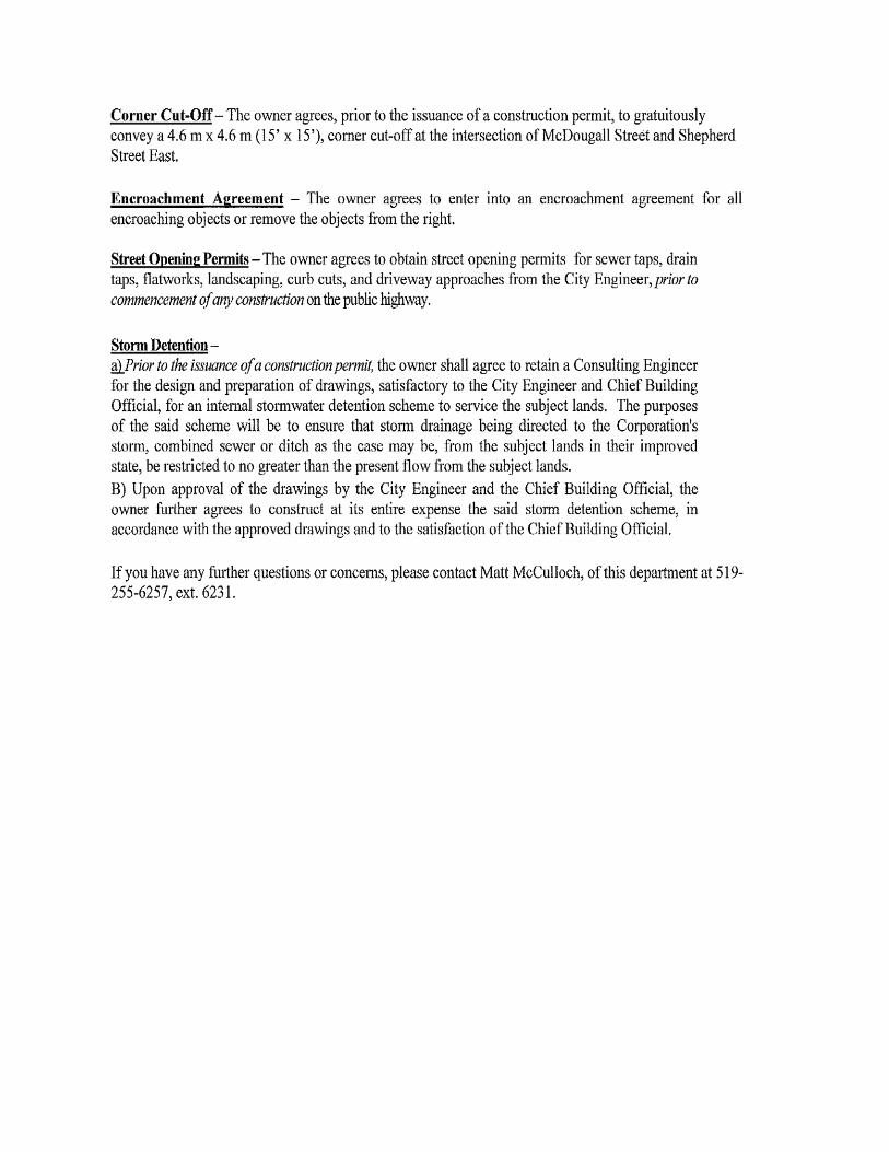
requirements/concerns from Engineering Division of Public Works: Construction of Driveway Approaches Requirement for Corner Cut-Off at the intersection of McDougall Street and Shepherd Street East

Page 10 of 11
Requirement for Encroachment Agreement Request for Street Opening Permits Submission of Storm Detention Scheme
2. PUBLIC NOTICE
The official notice will be advertised in the Windsor Star Newspaper as mandated by the
Planning Act.
All properties within 120m (400 feet) of the subject parcel will receive courtesy notice by mail prior to the Planning Heritage and Economic Development Standing Committee (PHEDSC) meeting.
CONCLUSION:
The requested zoning by-law amendment for the purpose of reusing the existing industrial building on the subject land to accommodate a “haunted house” use is consistent with the PPS 2014. The subject amendment maintains conformity with the
Official Plan and constitutes good planning.
The Planning Division recommends approval of the applicant’s request.
PLANNING ACT MATTERS:
Justina Nwaesei, MCIP, RPP
Planner II – Development Review
I concur with the above comments and opinion of the Registered Professional Planner. Donald Wilson, MCIP, RPP
Manager of Development Applications Thom Hunt, MCIP, RPP
City Planner
I am not a registered Planner and have reviewed as a Corporate Team Leader SAH, City Solicitor
OC, Chief Administrative Officer

Page 11 of 11
APPROVALS:
Name Title Don Wilson, MCIP, RPP Manager of Development Applications
Thom Hunt, MCIP, RPP City Planner
Wira Vendrasco Deputy City Solicitor
Shelby Askin Hager City Solicitor
Onorio Colucci Chief Administrative Officer
NOTIFICATIONS: Name Address Email Abutting property owners within 120
meter (400 feet) radius of the subject land
Algo Capital Holdings Inc., (Owner);
Contact: Luigi Albano
1190 Walker Road, Windsor
ON N8Y 2N7
Shawn Lippert (Applicant and Tenant) 3483 Dominion Boulevard, Windsor ON N9E 2N8
Councillor Rino Bortolin 350 City Hall Square West 3rd
Floor, Windsor, ON, N9A 6S1
APPENDICES:
1. Schedule "A" – Detailed description & background of proposed use (from applicant) 2. Appendix "A" - Extract from Zoning By-law 8600 3. Appendix "B"- Site Plan
4. Appendix "C" - Consultations, Comments received 5. Appendix “D” – Site Photos 6. Appendix “E” – Draft Amending By-law
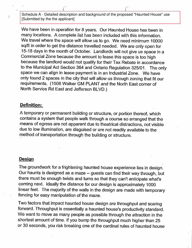
Schedule A - Detailed description and background of the proposed "Haunted House" use
[Submitted by the the applicant]


SECTION 18 - MANUFACTURING DISTRICTS l. (MD1.)
(2) Manufacturing District l.2 (MD1.2)
(a) Permitted Uses
(i) In this sub-section, any product described as small shall not exceed
a maximum weight of 50 kilograms and a maximum volume of one
cubic metre;
(ii) Any one (l) or more of the following industrial uses:
Food and l. A food catering service; preparation packaging and
Beverage processing of food products, including a bakery, but
Industries not including any of the following activities: rendering
of fats or oils; slaughtering or processing of poultry, fish
or meat products; processing of sauerkraut, vinegar, or
yeast; flour milling;
Secondary 2. Manufacturing from any of the following materials:
Manufacturing textiles; fur; glass; leather; paper; plastics; wood;
yarns; tobacco; rubber and rubberized products;
Pharmaceutical 3. Manufacture of cosmetics, drugs, pharmaceutical
Products products, toiletries;
Electrical 4. Construction of electrical products, the
Appliances manufacture of small parts
Motor Vehicle 5. Manufacture of small parts for motor vehicles;
Parts
Scientific, 6. Construction of scientific or professional
Professional equipment; the construction of industrial
and Industrial equipment;
Equipment
Signs 7. Construction or repair of electrical or other signs,
billboards or other commercial advertising
structures;
Tool and 8. Manufacture of moulds, dies, patterns; machine tools,
Die jigs, fixtures;
Miscellaneous 9. Manufacture of musical instruments, ceramics,
Manufacturing jewellery, toys, cutlery or other small metal products;
manufacture and application of protective coatings;
Warehousing 10. Warehouse; storage tanks; self-storage facility;
Repairs/ 11. A light repair shop, a heavy repair shop;
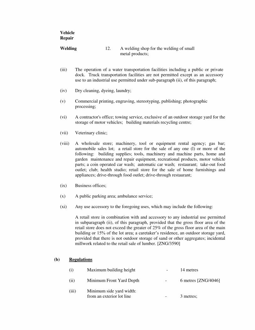
Vehicle
Repair
Welding 12. A welding shop for the welding of small
metal products;
(iii) The operation of a water transportation facilities including a public or private
dock. Truck transportation facilities are not permitted except as an accessory
use to an industrial use permitted under sub-paragraph (ii), of this paragraph;
(iv) Dry cleaning, dyeing, laundry;
(v) Commercial printing, engraving, stereotyping, publishing; photographic
processing;
(vi) A contractor's office; towing service, exclusive of an outdoor storage yard for the
storage of motor vehicles; building materials recycling centre;
(vii) Veterinary clinic;
(viii) A wholesale store; machinery, tool or equipment rental agency; gas bar;
automobile sales lot; a retail store for the sale of any one (l) or more of the
following: building supplies; tools, machinery and machine parts, home and
garden maintenance and repair equipment, recreational products, motor vehicle
parts; a coin operated car wash; automatic car wash; restaurant; take-out food
outlet; club; health studio; retail store for the sale of home furnishings and
appliances; drive-through food outlet; drive-through restaurant;
(ix) Business offices;
(x) A public parking area; ambulance service;
(xi) Any use accessory to the foregoing uses, which may include the following:
A retail store in combination with and accessory to any industrial use permitted
in subparagraph (ii), of this paragraph, provided that the gross floor area of the
retail store does not exceed the greater of 25% of the gross floor area of the main
building or 15% of the lot area; a caretaker’s residence, an outdoor storage yard, provided that there is not outdoor storage of sand or other aggregates; incidental
millwork related to the retail sale of lumber. [ZNG/3590]
(b) Regulations
(i) Maximum building height - 14 metres
(ii) Minimum Front Yard Depth - 6 metres [ZNG/4046]
(iii) Minimum side yard width:
from an exterior lot line - 3 metres;

from a dwelling - 6 metres;
(iv) Minimum landscaped open - 15% of the lot area;
space yard
(v) The required yards shall be maintained exclusively as landscaped open
space yards, except that an access area may cross a required yard.
(vi) Supplementary Regulations:
- See Section
2l re: Supplementary Use Regulations
22 re: Supplementary Lot Regulations
23 re: Supplementary Building Regulations
24 re: Parking Space Regulations
25 re: Parking Area Regulations

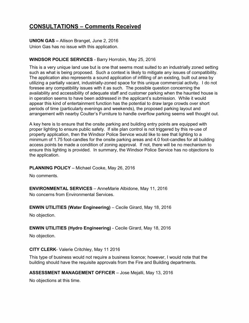
CONSULTATIONS – Comments Received UNION GAS – Allison Branget, June 2, 2016 Union Gas has no issue with this application.
WINDSOR POLICE SERVICES - Barry Horrobin, May 25, 2016
This is a very unique land use but is one that seems most suited to an industrially zoned setting such as what is being proposed. Such a context is likely to mitigate any issues of compatibility. The application also represents a sound application of infilling of an existing, built out area by utilizing a partially vacant, industrially-zoned space for this unique commercial activity. I do not foresee any compatibility issues with it as such. The possible question concerning the availability and accessibility of adequate staff and customer parking when the haunted house is in operation seems to have been addressed in the applicant’s submission. While it would appear this kind of entertainment function has the potential to draw large crowds over short periods of time (particularly evenings and weekends), the proposed parking layout and arrangement with nearby Coulter’s Furniture to handle overflow parking seems well thought out. A key here is to ensure that the onsite parking and building entry points are equipped with proper lighting to ensure public safety. If site plan control is not triggered by this re-use of property application, then the Windsor Police Service would like to see that lighting to a minimum of 1.75 foot-candles for the onsite parking areas and 4.0 foot-candles for all building access points be made a condition of zoning approval. If not, there will be no mechanism to ensure this lighting is provided. In summary, the Windsor Police Service has no objections to the application.
PLANNING POLICY – Michael Cooke, May 26, 2016
No comments.
ENVIRONMENTAL SERVICES – AnneMarie Albidone, May 11, 2016 No concerns from Environmental Services.
ENWIN UTILITIES (Water Engineering) – Cecile Girard, May 18, 2016
No objection.
ENWIN UTILITIES (Hydro Engineering) - Cecile Girard, May 18, 2016
No objection. CITY CLERK- Valerie Critchley, May 11 2016
This type of business would not require a business licence; however, I would note that the building should have the requisite approvals from the Fire and Building departments. ASSESSMENT MANAGEMENT OFFICER – Jose Mejalli, May 13, 2016
No objections at this time.
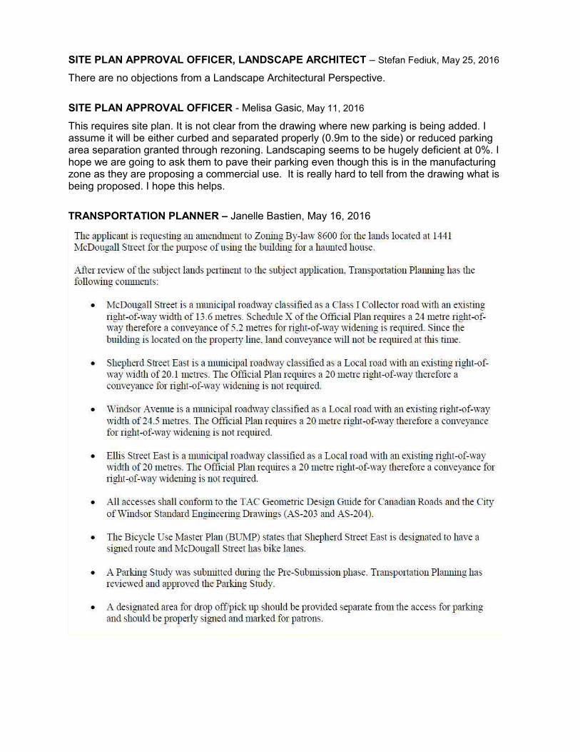
SITE PLAN APPROVAL OFFICER, LANDSCAPE ARCHITECT – Stefan Fediuk, May 25, 2016
There are no objections from a Landscape Architectural Perspective. SITE PLAN APPROVAL OFFICER - Melisa Gasic, May 11, 2016
This requires site plan. It is not clear from the drawing where new parking is being added. I assume it will be either curbed and separated properly (0.9m to the side) or reduced parking area separation granted through rezoning. Landscaping seems to be hugely deficient at 0%. I hope we are going to ask them to pave their parking even though this is in the manufacturing zone as they are proposing a commercial use. It is really hard to tell from the drawing what is being proposed. I hope this helps.
TRANSPORTATION PLANNER – Janelle Bastien, May 16, 2016
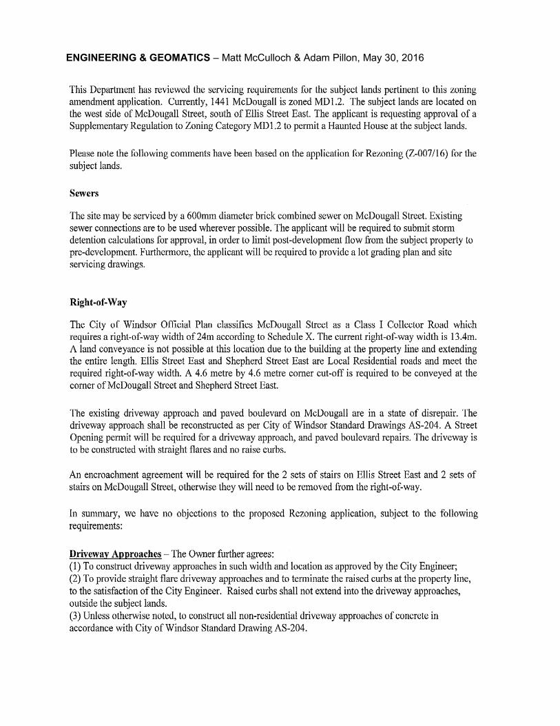
ENGINEERING & GEOMATICS – Matt McCulloch & Adam Pillon, May 30, 2016

B Y - L A W N U M B E R -2016
A BY-LAW TO FURTHER AMEND BY-LAW NUMBER
8600 CITED AS THE "CITY OF WINDSOR ZONING BY-
LAW"
Passed the day of , 2016.
WHEREAS it is deemed expedient to further amend By-law Number 8600 of the Council of The
Corporation of the City of Windsor, cited as the "City of Windsor Zoning By-law" passed the 31st day of
March, 1986, as heretofore amended:
THEREFORE the Council of The Corporation of the City of Windsor enacts as follows:
1. That subsection 1 of Section 20, of said by-law, is amended by adding the following paragraph:
“331. For the lands described as Pt Lot 85, Concession 1, and Part 3 on Plan 12R 14001, located
on the west side of McDougall Street, south side of Ellis Street East and north side of Shepherd
Street East ‘a Haunted House’ shall be additional permitted use in an existing building on the
subject land. [ZDM 7; ZNG-4681]”
2. The said by-law is further amended by changing the District Maps or parts thereof referred to in
Section 3, of said by-law and made part thereof, so that the lands described in Column 3 are delineated by
a broken line and further identified by the zoning symbol shown in Column 5:
1. 2. 3. 4. 5.
Item
Number
Zoning
District
Map Part
Lands Affected Official Plan
Amendment
Number
Zoning Symbol
1 7 Pt Lot 85, Concession 1, and Part 3 on
Plan 12R 14001, (located on the west side
of McDougall Street, south side of Ellis
Street East, and north side of Shepherd
Street East and municipally known as
1441 McDougall St./255 Ellis St. E.)
n/a S.20(1)331
DREW DILKENS, MAYOR
CLERK
First Reading - , 2016
Second Reading - , 2016
Third Reading - , 2016

SCHEDULE 2
1. By-law has the following purpose and effect:
To amend the zoning of the lands located on the west side of McDougall Street, south side of Ellis
Street East, and north side of Shepherd Street East, described as Pt Lot 85, Concession 1, and Part
3 on Plan 12R 14001, and municipally known as 1441 McDougall Avenue/255 Ellis Street East,
by allowing a “Haunted House” as additional permitted use(s) on the subject land to facilitate the
reuse/redevelopment of the existing industrial building.
This amendment restricts the “Haunted House” use to the existing building, thereby discouraging
demolition and promoting the reuse of the vacant units within the existing building. In addition,
the amendment will bring about a redevelopment of the existing graveled area on site for parking.
2. Key map showing the location of the lands to which By-law applies.

Page 1 of 2
APPENDIX D – SITE PHOTOS (taken June 2, 2016) Z-007/16
View of the West Side of Subject land View of the East side of the subject land
View of the north side of the subject property from Ellis Street East
View of the south side of the subject property from Shepherd Street East

Page 2 of 2
Easterly view of Shepherd St. E. from McDougall St. Southerly view of McDougall St. from Shpherd St. E.
View of the north side of the subject property at McDougall St. & Ellis St. E., intersection
Southerly view of McDougall Street from Shepherd St. E.

Page 1 of 1
COMMITTEE MATTERS
PHED Standing Committee
July 11, 2016 Subject: Minutes of the Planning, Heritage & Economic Development Standing
Committee Meeting held June 13, 2016
toldob
Text Box
Item No. 8.1

Minutes Planning, Heritage & Economic Development Standing Committee
City of Windsor
Monday, June 13, 2016 4:30 o’clock p.m.
Members Present: Chairperson Ward 8 – Councillor Marra Councillors Ward 4 - Councillor Holt Ward 7 - Councillor Kusmierczyk Ward 9 - Councillor Payne Ward 5 - Councillor Sleiman Members Member Baker Member Bjarneson Member Chamely Member DiMaio Member Foot Member Gyemi Member Miller Regrets—Members Member Moore ALSO PRESENT ARE THE FOLLOWING FROM ADMINISTRATION: Thom Hunt, Executive Director Planning, Building Services/City Planner Don Wilson, Manager Development Applications Wira Vendrasco, Deputy City Solicitor
John Revell, Chief Building Official Adam Pillon, Right of Way Supervisor John Calhoun, Heritage Planner Adam Szymczak, Planner III—Zoning Kristina Tang, Planner II—Revitalization & Policy Initiative Justina Nwaesei, Planner II—Development Review
Anna Ciacelli, Supervisor of Council Services Marianne Sladic, Steno Clerk
Minutes Planning, Heritage & Economic Development Standing Committee Monday, June 13, 2016 Page 2 of 18
Delegations
Craig Kondruk, resident of Ward 7 (Item 7.1) Karl Tanner, Dillon Consulting Limited representing the owner (Item 7.2) Steve Cheifetz, representing property owner (Item 7.2) Joe Montaleone, representing property owner (Item 10.3) Anneke Rachel Smit, property owner (Item 10.2)
1. CALL TO ORDER The chairperson calls the meeting of the Planning, Heritage & Economic Development Standing Committee to order at 4:30 o’clock p.m. 2. DISCLOSURES OF PECUNIARY INTEREST AND THE GENERAL NATURE
THEREOF None disclosed. 3. REQUEST FOR DEFERRALS, REFERRALS OR WITHDRAWALS None requested. 4. COMMUNICATIONS None presented. 5. ADOPTION OF THE PLANNING ACT MINUTES
5.1. Minutes of the PHED Standing Committee (Planning Act Matters) meeting held
May 9, 2016 Moved by: Member Bjarneson Seconded by: Councillor Holt That the Minutes of the Planning, Heritage and Economic Development Standing Committee (Planning Act Matters) meeting held May 9, 2016 BE ADOPTED as amended to note that Ms. Bjarneson is associated with the United Way Neighbourhood Renewals as Volunteer Chair for the Major Gifts Cabinet. Carried. Report Number: SCM 85/2016

Minutes Planning, Heritage & Economic Development Standing Committee Monday, June 13, 2016 Page 3 of 18
6. PRESENTATION & DELEGATIONS (PLANNING ACT MATTERS)
7. PLANNING ACT MATTERS 7.1. Rezoning - City of Windsor - Housekeeping Amendment 2016-1 - Z-001/16
ZNG/4628; City Wide Moved by: Councillor Sleiman Seconded by: Member Bjarneson Decision Number: PHED 382
THAT Zoning By-law 8600 BE AMENDED on the following basis: 1. That the METRIC CONVERSION CHART be deleted. 2A. That Section 1.10 be amended by adding the following provision after Section 1.10.1:
“1.10.5 A revision may be made to this by-law without a zoning by-law amendment as follows:
.1 Correction of numbering, cross-referencing, grammar, punctuation or a typographical error, or revision to format in a manner that does not change the intent of a provision;
.2 Adding or revising technical information on a map or a schedule that does not affect the zoning classification, zoning district or specific zoning exception of a lot including, but not limited to, colors, keys, legends, notes, scale or title blocks, or the updating and correcting of infrastructure information; and
.3 Revision to an item that does not form a part of this by-law and is editorially inserted for clarification, convenience or reference purpose only.”
2B. That Section 1.20.1 be deleted and replaced with the following: “.1 SEQUENCE - This by-law shall be read in its entirety. The chapters, sections,
regulation, provisions and tables in this by-law intentionally do not follow in consecutive numerical sequence in order to reserve space for the placement of future enactments. Reference should be made to the Table of Contents to determine the intended numerical sequence of the provisions of this by-law. [ZNG/4628]”
2C. That Section 1.20 be amended by adding the following provision after Section 1.20.1:
“.2 GENERAL, SUPPLEMENTARY, PARKING SPACE AND PARKING AREA PROVISIONS – All general, supplementary, parking space or parking area

Minutes Planning, Heritage & Economic Development Standing Committee Monday, June 13, 2016 Page 4 of 18
provisions apply to all zoning districts, site specific provisions, temporary use provisions and heritage conservation districts. [ZNG/4628]”
2D. That Section 1.20 be amended by adding the following provision after Section 1.20.3:
“.4 NOT FORMING PART OF THIS BY-LAW – The following items and any associated text are for the purpose of clarification, convenience or reference and do not form part of this by-law: Appendix, Example, Footer, Footnote, Header, Heading, Historical or Reference Information, Illustration, Index, Marginal Note, page numbering and Table of Contents. [ZNG/4628]”
3. That Section 7 is amended by replacing paragraph 17 with the following:
“(17) "Building Height" means:
(a) For any building or part thereof, with a flat roof or a roof having a slope of less than 20.0 degrees, the vertical distance in metres between the grade and the highest point of the roof.
Where a building height provision is expressed in storeys, the building height in metres shall be the number of storeys permitted multiplied by 4.0 metres. [ZNG/4628]
Example: If the minimum building height is 2 storeys and the maximum building height is 3 storeys, multiplying 2 storeys by 4.0 metres results in a minimum building height of 8.0 metres and multiplying 3 storeys by 4.0 metres results in a maximum building height of 12.0 metres.
(b) For a main building, or part thereof, with a roof other than that described in
clause (a) of this subsection, the vertical distance in metres between the grade and the mid-point between the lowest eaves and the highest point of the roof.
Where building height is expressed in storeys, the minimum building height in metres shall be the number of storeys required multiplied by 4.0 metres, and the maximum building height in metres shall be the number of storeys permitted multiplied by 4.0 metres plus an additional 2.0 metres for the roof. [ZNG/4628]
Example: If the maximum building height is 2 storeys, multiplying 2 storeys by 4.0 metres plus 2.0 metres for the roof, results in a maximum building height of 10.0 metres. Example: If the minimum building height is 2 storeys and the maximum building height is 3 storeys, multiplying 2 storeys by 4.0 metres results in a minimum building height of 8.0 metres and multiplying 3 storeys by 4.0

Minutes Planning, Heritage & Economic Development Standing Committee Monday, June 13, 2016 Page 5 of 18
metres plus 2.0 metres for the roof results in a maximum building height of 14.0 metres.
(c) For an accessory building or that part of an accessory building with a roof other than that described in clause (a) of this subsection, the vertical distance in metres between the grade and the highest point of the roof. [ZNG/4249]”
4A. That Section 7 be amended by deleting paragraph 18 and replacing it with the
following:
“(18) "Business Office" means an office of any one or more of the following: commercial business; financial services including a bank, credit union, payday lender, savings and loan office and trust company; government; industrial business; non-profit or charitable organization; professional person. A financial office is a business office. A medical office, veterinary clinic or veterinary office is not a business office. [ZNG/4628]”
4B. That Section 7 be amended by deleting paragraph 50 and replacing it with the
following:
“(50) "Financial Office" means a business office. [ZNG/4628]”
5A. That Section 21(12)(a)(iv) be deleted and replaced with the following:
“(iv) The erection of a building, structure or dwelling on a lot except where all of the following are available:
1. A street paved to the satisfaction of the City Engineer;
2. Municipal storm water outlet;
3. Municipal sanitary sewer;
4. Municipal electrical service; and
5. Municipal water service.
Notwithstanding the foregoing, a building permit may be issued for a building, structure or dwelling provided that the lot upon which the building, structure or dwelling is proposed to be located is within a registered plan of subdivision in which the street has not been assumed by the City of Windsor but in which the street is to be assumed under the terms of a registered subdivision agreement or a servicing agreement. [ZNG/4628]”
5B. That Sections 10(1)(b)(ix), 10(2)(b)(ix), 10(3)(b)(ix), 10(4)(b)(ix), 10(6)(b)(vii),
11(1)(b)(viii), 11(2)(b)(viii), 11(3)(b)(viii), 11(4)(b)(viii) and 21(12)(a)(vi) be deleted.
6A. That Sections 13(1)(a)(ii) and 13(2)(a)(ii) be deleted and each be replaced with the
following:

Minutes Planning, Heritage & Economic Development Standing Committee Monday, June 13, 2016 Page 6 of 18
“(ii) A school; day nursery; a business office of a non-profit or charitable organization; [ZNG/4628]”
6B. That Section 13(3)(a)(iii) be deleted and replaced with the following:
“(iii) A day nursery; a business office of a non-profit or charitable organization; [ZNG/4628]”
7. That Section 20 be amended by adding the following paragraph:
“368. For the lands comprising Part of Farm Lot 85, Concession 1, designated as Parts 1 and 2, Plan 12R-10279, Part of Farm Lot 85, Concession 1, and Part of Park Lots 24 and 28 and Park Lot 26, Registered Plan 125, as delineated by a heavy black line on Schedule ‘A’ to By-law 379-2001, situated on the south side of Shepherd Street East, between McDougall Street and Mercer Street, a private hall, a health studio, a restaurant, provided there is no facility for drive-through service, a business office, a contractor’s office, a financial office, a personal service shop and a convenience store shall be additional permitted uses and that the required number of parking spaces for a private hall shall be 165. [ZDM 14; ZNG/4628]”
8. That Section 21(3)(a)(iii) be deleted. 9A. That Section 7 be amended by adding the following paragraph after paragraph 140a:
“(140b) “Swimming Pool” means a structure, filled or capable of being filled with water, that has a minimum depth of water at any point of 610 mm and with more than 2.0 square metres in potential liquid surface area and that is, or capable of being, used for swimming, diving and/or other recreational purposes.
It may include a vessel designed or intended for therapeutic or bathing purposes commonly referred to as a hot tub, whirlpool, hydro massage pool, jetted tub or spa, a pond with a depth of 0.15 metres, and any equipment that circulates, heats, or treats the water in a swimming pool, hot tub or pond. It does not include a body of water, pond or a reservoir designed for storm water retention, utilized for agricultural purposes, or as part of a golf course; a privately or publicly owned storm water management facility; a swimming pool regulated by the Ontario Building Code; or an existing natural body of water or stream. [ZNG/4628]”
9B. That Section 21(8) be deleted and replaced with the following: “(8) Swimming Pool
(B/L 9057, Jul 7/1987; B/L 10358, Jul 16/1990; B/L 324-1999, Dec 1/1999; ZNG/4628)
Minutes Planning, Heritage & Economic Development Standing Committee Monday, June 13, 2016 Page 7 of 18
(a) On a lot within a residential district, or a lot in any other zoning district on
which is located a dwelling with a maximum of four dwelling units, a swimming pool shall have a:
1. Minimum separation from the front lot line equal to the required minimum front yard depth, or where there is no required front yard, a minimum separation from the front lot line of 7.50 metres;
2. Minimum separation from the side lot line of 1.20 metres; and,
3. Minimum separation from the rear lot line of 1.20 metres.
(b) On a lot not described in Section 21(8)(a), a swimming pool shall have a minimum separation of 7.50 metres from any lot line.
(c) Sections 21(8)(a) and 21(8)(b) shall not apply to a swimming pool within a building having a height of greater than 2.0 metres.
10A. That Section 7 be amended by adding the following paragraph after paragraph 134a:
“(134b) “Shipping Container” means an industrial, standardized reusable vessel that was:
(a) originally or formerly specifically designed for or used in the packing, shipping, movement or transport of freight, articles, goods or commodities; and/or
(b) designed for, or capable of being mounted on moved on, a rail car; and/or
(c) designed for or capable of being mounted on a chassis or bogie for movement by truck trailer or loaded on a ship.
A cargo container and an intermodal container is a shipping container. [ZNG/4628]”
10B. That the following be added as Section 21(12)(a)(i):
“(i) The use of a shipping container in any residential district as a main building or as an accessory building on a lot, save and except for the temporary placement of a shipping container in connection with, and during, the erection, renovation or demolition of structures on said lot. [ZNG/4628]”
11. That Section 22.50 be replaced with the following: “22.50 ENCROACHMENT INTO A YARD
(ZNG/4549; ZNG/4628) 22.50.1 For the purpose of Section 22.50:
“Ground” means the average elevation of the ground within 3.0 metres of the

Minutes Planning, Heritage & Economic Development Standing Committee Monday, June 13, 2016 Page 8 of 18
main building on the lot.
“n/a” means that a minimum separation is not required.
“No Limit” means that an encroachment is permitted into the specified yard subject to the minimum separation provisions in Table 22.50.10 and any other applicable provisions for that encroachment.
“Required Yard” means any of required front yard, required rear yard, required side yard or required landscaped open space yard.
22.50.5 Unless otherwise specified in Table 22.50.10, an encroachment is permitted
into any yard not required by this by-law subject to the minimum separation provisions in table 22.50.10 and any other applicable provisions in this By-law for that encroachment.
Example: A homeowner wants to build a deck with a height of 1.30 metres in their rear yard. The dwelling is zoned RD1.1, which requires a minimum rear yard depth of 7.50 metres. Therefore, the required rear yard is 7.50 metres measured from the rear lot line. The nearest wall of the dwelling is located 11.0 metres from the rear lot line. A deck is permitted within this 3.50 metre deep rear yard area subject to the minimum separation provisions for that encroachment and any applicable provisions such as lot coverage. Per Table 22.50.10.37, that deck may extend a further 2.50 metres into the required rear yard subject to the minimum separation provisions and any other applicable provisions, creating a deck with a maximum depth of 6.0 metres in the rear yard.
22.50.7 Notwithstanding the provisions of Section 22.50:
.1 An encroachment, except for a building projection located a minimum of 3.0 metres above the ground, is prohibited into a access area, driveway, parking area or parking space.
.3 If a required yard is not specified in Table 22.50.10, the encroachment is prohibited within that unspecified required yard.
.5 If a lot line is not specified in Table 22.50.10, no separation is required from that unspecified lot line.
22.50.10 The permitted encroachments are specified in Table 22.50.10.

Minutes Planning, Heritage & Economic Development Standing Committee Monday, June 13, 2016 Page 9 of 18
TABLE 22.50.10 – ENCROACHMENT INTO A YARD
Type of Encroachment
Maximum Encroachment Into
Minimum Separation From
Yard Metres Lot Line Metres
.1
Architectural Feature
into a required yard of less than 1.20 metres in width or depth
Any required yard
0.30 m n/a n/a
.2
Architectural Feature
into a required yard of 1.20 metres or more in width or depth
Any required yard
0.60 m n/a n/a
.10 Balcony
Required front yard or
required rear yard
1.50 m
n/a n/a
Required side yard
25% of the
required side yard
width
.15 Bay Window
Required front yard or
Required rear yard
1.00 m Side lot
line 1.20 m
Required side yard
0.30 m
.20 Below Grade Entrance Pad and Steps Leading Thereto
Required front yard or Required
rear yard 2.50 m
Side lot line
1.20 m
Required side yard
No Limit
.25
Central Air Conditioning Unit including the components of a heating, ventilation or air conditioning (HVAC) system
Required rear yard or
Required side yard
No Limit Side lot
line 0.60 m

Minutes Planning, Heritage & Economic Development Standing Committee Monday, June 13, 2016 Page 10 of 18
TABLE 22.50.10 – ENCROACHMENT INTO A YARD
Type of Encroachment
Maximum Encroachment Into
Minimum Separation From
Yard Metres Lot Line Metres
.35
Deck – part of a deck having a floor height of 0.30 metres or less above the ground
Any required yard
No Limit n/a n/a
.36
Deck – part of a deck having a floor height of greater than 0.30 metres and less than 1.20 metres above the ground
Required front yard
2.50 m
Any lot line 1.20 m Required rear yard or
Required side yard
No Limit
.37
Deck – part of a deck having a floor height of 1.20 metres or more above the ground
Any front yard or
Required rear yard
2.50 m
Front lot line
Rear lot line
1.20 m
Side lot line
Minimum side yard width required by
Zoning District
.40 Fire Escape Required rear
yard 2.50 m
Side Lot Line
1.20 m
.60 Porch
Any front yard or
Required rear yard
2.50 m
Front lot line
Rear lot line
1.20 m
Side lot line
Minimum side yard width required by
Zoning District
A porch, that is lawfully in existence on the effective date of this provision and which is located in whole or in part in a front yard, may be repaired or replaced by a new porch with the same dimensions or less into the front yard subject to above the minimum separation requirements.
.70 Solar Panel and Supporting Structure – Residential District
Required rear yard
No Limit Side lot
line 1.20 m
.71 Solar Panel and Supporting Structure - Other Zoning District
Any required yard
No Limit n/a n/a
.75 Steps – Having a Any required No Limit n/a n/a

Minutes Planning, Heritage & Economic Development Standing Committee Monday, June 13, 2016 Page 11 of 18
TABLE 22.50.10 – ENCROACHMENT INTO A YARD
Type of Encroachment
Maximum Encroachment Into
Minimum Separation From
Yard Metres Lot Line Metres
maximum height of 0.30 metres above the ground
yard
.76
Steps – Having a height of greater than 0.30 metres above the ground
Any required yard
No Limit Any Lot
Line 1.20 m
Maximum total tread area of 5.0 square metres within a required yard.
.80 Sunroom
Required rear yard
3.75 m
Side Lot Line
Minimum side yard width required by
Zoning District Maximum floor area of 15.0
sq. m within the required rear yard
.90 Wheelchair Ramp or Lift
Any required yard
No Limit Any Lot
Line 1.20 m
12. That Section 24.40.20.2 be deleted and replaced with the following:
“.2 A loading space may be located within a parking area or may have direct access from either a parking aisle or a collector aisle, provided, that the loading space is located and designed so as not to hamper the safe movement of people and operation of vehicles within the parking area and the loading space and access area complies with Section 25.5 in this By-law. [ZNG/4628]”
13. That the zoning of Part of Block Z, Registered Plan 927, further described as PIN
012644967, situated on the north side of Sprucewood Avenue, east of Matchette Road and known municipally as 1490 Sprucewood Avenue, be changed from GD1.1 to DRD1.1.
Carried. Councillor Payne was absent when the vote was taken on this matter.
Report Number: S 93/2016 Clerk’s File: ZB/12453
7.2. Zoning By-law Amendment Application by Mid South Land Development Corp. for the lands known as 55 Edinborough Street; File No. Z-006/16, ZNG/4647; Ward 10

Minutes Planning, Heritage & Economic Development Standing Committee Monday, June 13, 2016 Page 12 of 18
Moved by: Councillor Kusmierczyk Seconded by: Councillor Sleiman Decision Number: PHED 383
I. That an amendment to the Zoning By-law 8600 BE APPROVED to change the zoning of the land located on the south side of Edinborough Street, west of Howard Avenue, described as Plan 707, Pt Block A, closed Victoria Street, by adding a site specific holding zoning provision allowing “a Medical Office” and “a Pharmacy as an accessory use to the Medical Office” to be listed as additional permitted uses in an existing building on the subject land; and
II. That the holding (‘H’) symbol BE REMOVED when the applicant/owner submits an application to remove the ‘H’ symbol and when the following conditions have been satisfied:
1. The property owner has signed the required Site Plan Agreement with The Corporation of the City of Windsor for the proposed redevelopment on the subject land, and the Agreement is registered; and
2. A Transportation Impact Study, acceptable to the City Engineer, be submitted by the property owner; and any mitigation measures required/recommended by the Study be implemented at the owner‘s expense, to the satisfaction of the City Engineer and City Planner prior to finalizing the Site Plan Approval.
Carried. Councillor Payne was absent when the vote was taken on this matter.
Report Number: S 91/2016 Clerk’s File: ZB/12479
The meeting of the Planning, Heritage and Economic Development Standing Committee (Planning Act Matters) portion is adjourned at 5:10 o’clock p.m. The meeting of the Planning, Heritage and Economic Development Standing Committee (Heritage Act Matters) is called to order at 5:13 o’clock p.m. 8. ADOPTION OF THE MINUTES
8.1. Minutes of the Planning, Heritage & Economic Development Standing
Committee meeting held May 9, 2016 Moved by: Member Foot Seconded by: Member Chamely That the Minutes of the Planning, Heritage and Economic Development Standing Committee held May 9, 2016 BE ADOPTED as presented.

Minutes Planning, Heritage & Economic Development Standing Committee Monday, June 13, 2016 Page 13 of 18
Carried. Councillor Payne was absent when the vote was taken on this matter.
Report Number: SCM 84/2016
9. PRESENTATIONS AND DELEGATIONS (COMMITTEE & ADMINISTRATIVE
MATTERS)
See Heritage items 10.2 and 10.3. 10. HERITAGE ACT MATTERS 10.1. Bell-Coulter House, 793 Devonshire Road- Request for Heritage Designation
(Ward 4) Kristina Tang, Planner II Revitalization & Policy Initiatives Kristina Tang, Planner II Revitalization & Policy Initiatives, appears before the Planning, Heritage & Economic Development Standing Committee and provides a brief outline of the administrative report regarding Bell-Coulter House, 793 Devonshire Road-Heritage Designation. She provides a brief history of the reasons for designation. Councillor Holt inquires about designating some of the landscape around the building. Ms. Tang indicates that the hedge is a contributing factor common to the designation, and routine maintenance would be allowed but they would have to adhere to heritage component of the property standards by-law. Councillor Holt inquires what would happen if the hedge was damaged by an accident of some kind. Ms. Tang explains that the hedge doesn’t form part of the designation by-law, it is simply a recommendation for the property owner to maintain the hedge as part of the designation. Moved by: Councillor Sleiman Seconded by: Member DiMaio Decision Number: PHED 384 That the City Clerk BE AUTHORIZED to publish a Notice of Intention to Designate the Bell-Coulter House, at 793 Devonshire Road, in accordance with Part IV of the Ontario Heritage Act for the reasons attached in Appendix ‘A’. Carried. Councillor Payne was absent when the vote was taken on this matter.
Report Number: S 77/2016 Clerk’s File: MBA/2274

Minutes Planning, Heritage & Economic Development Standing Committee Monday, June 13, 2016 Page 14 of 18
10.2. The Ambery-Isaacs House - "Foxley", 811 Devonshire Road- Request for Heritage Designation (Ward 4)
Kristina Tang, Planner II Revitalization & Policy Initiatives provides a brief outline of the administrative report The Ambery-Isaacs House – Foxley, 811 Devonshire Road-Request for Heritage Designation and concludes by highlighting the change that was requested by the owner regarding the designation. Anneke Rachel Smit, property owner Anneke Rachel Smit, property owner, appears before the Planning, Heritage and Economic Development Standing Committee and indicates that she is in agreement with the administrative recommendation in the report The Ambery-Isaacs House – Foxley, 811 Devonshire Road-Request for Heritage Designation although she has some concerns regarding the landscape features that make up part of the designation. Member Chamely is concerned with including interior features in the potential designation. Mr. Calhoun indicates these features are right inside the front door and are very important to the overall structure. Councillor Holt suggests that administration speak to the homeowners concern regarding the tree or if a tree by-law will come forward to address these types of concerns with trees making up part of the heritage designation. Thom Hunt, City Planner, appears before the Planning, Heritage and Economic Development Standing Committee and indicates that administration is considering whether to include heritage trees as part of a tree by-law or make it into its own by-law and adds that more information will come forward in the future regarding this issue. Member DiMaio inquires about the neighbourhood being designated. Administration indicates the Walkerville area is considered a heritage area under the Heritage Act. They add that Heritage conservation districts allow for attributes of neighbourhoods to be protected. Member Miller expresses concern with Willistead Manor and park as designated areas and trees have been removed. Administration indicates that the grounds make up the designation and assures the committee that viable trees would never be removed with the expertise of the forester ensuring this. The particular trees that Mr. Miller referred to were not viable and had to be removed. Mr. Calhoun indicates that normal maintenance issues would not have to be brought forward to Council, but major alterations to viable landscaping would have to be approved by Council for Willistead Manor and Park.

Minutes Planning, Heritage & Economic Development Standing Committee Monday, June 13, 2016 Page 15 of 18
Moved by: Councillor Holt Seconded by: Councillor Sleiman Decision Number PHED 385 THAT the City Clerk BE AUTHORIZED to publish a Notice of Intention to Designate the Ambery-Isaacs House - "Foxley", at 811 Devonshire Road, in accordance with Part IV of the Ontario Heritage Act for the reasons attached in Appendix ‘A’, excluding points 3 and 4 from the section entitled Other Special Landscape Features as follows:
o Low hedge surrounding front porch platform of house o Majestic deciduous trees framing the building
Carried. Councillor Payne was absent when the vote was taken on this matter. Moved by: Councillor Holt Seconded by: Member Foot Decision Number PHED 386 THAT Administration BE REQUESTED to report back to the Planning, Heritage and Economic Standing Committee regarding the implementation of a comprehensive Heritage Tree By-Law. Carried. Councillor Payne was absent when the vote was taken on this matter.
Report Number : S 97/2016 Clerk’s File: MBA/2274
10.3. International Playing Card Co., 1123 Mercer Street - Request for Demolition of Heritage Register-Listed Property
John Calhoun, Heritage Planner John Calhoun, Heritage Planner, appears before the Planning, Heritage & Economic Development Standing Committee regarding the administrative report International Playing Card Co., 1123 Mercer Street—Request for Demolition of Heritage Register-Listed property, and provides some background information including details of the building and a brief history. Mr. Calhoun also explains the recommendation as listed in the report. Joe Montaleone, representing property owner Joe Montaleone, representing property owner, appears before the Planning, Heritage & Economic Development Standing Committee regarding the administrative report International Playing Card Co., 1123 Mercer Street—Request for Demolition of Heritage Register-Listed property, and requests that the committee select recommendation III and allow the demolition.

Minutes Planning, Heritage & Economic Development Standing Committee Monday, June 13, 2016 Page 16 of 18
Councillor Sleiman inquires about the ceiling height and whether there are cranes in the building. Mr. Montaleone indicates that the height is 22 feet, and he is requesting demolition as he has a potential interested client in the property. Councillor Holt inquires about the structure and its condition. Administration indicates that the City hasn’t received any complaints and hasn’t been asked to investigate. Member Foot inquires if the potential interested client doesn’t materialize would the owner leave the building as is or would it be demolished. Mr. Montaleone indicates that the building will probably not be demolished if this deal falls through but they may ask the City to reconsider this decision if they are approached by another party who would be interested in the property and not the building. Member Chamely inquires about whether the tenants in the building have been lost due to the condition of the building. Mr. Montaleone indicates the owner has been keeping up with the maintenance issues but that there would be a substantial cost to replacing the whole roof. Councillor Sleiman inquires whether the applicant is eligible for financial assistance to assist in updating the building. Mr. Calhoun provides information regarding the funding which exists and the applicant would be eligible to apply for this funding when there is a designation of the property. John Revell, Chief Building Official appears before the Planning, Heritage & Economic Development Standing Committee regarding the administrative report International Playing Card Co., 1123 Mercer Street—Request for Demolition of Heritage Register-Listed property and indicates the property must be maintained according to existing standards as set out in the property standards by-law. If a complaint regarding the property is received, it will be investigated and an order to repair will be issued if warranted. Councillor Sleiman inquires whether this is the first request to designate this type of building in the City. Administration indicates the Ford building would be an example, the request to demolish was granted a number of years ago. Member Miller inquires whether just the administration building could be integrated into future plans by the potential buyer. Mr. Montaleone indicates he doesn’t think that it would fit their design intentions. Councillor Kusmierczyk inquires as to a recent example of the City working with a designated building and incorporating renovations into the designated building. Administration indicates this has been done with the Windsor Star building, working with the University of Windsor. Also the reuse of John Campbell School and St. Bernard School, elements of the existing building were incorporated into the new structure.

Minutes Planning, Heritage & Economic Development Standing Committee Monday, June 13, 2016 Page 17 of 18
Moved by: Councillor Sleiman Seconded by: Councillor Kusmierczyk THAT City Council RECEIVE this report for information, thus allowing demolition of the International Playing Card Co., 1123 Mercer Street, a property listed on the Windsor Municipal Heritage Register; and THAT Administration BE REQUESTED to meet with the owner and other interested parties to consider retaining some of the external features of the existing building in a future redevelopment in advance of the determined timelines, before this report is considered by City Council. The motion is put and is lost. Aye Votes: Councillors Sleiman, Kusmierczyk, Marra and member DiMaio Nay Votes: Councillor Holt and members Baker, Miller, Chamely, Foot Councillor Payne was absent when the vote was taken on this matter. Moved by: Member Foot Seconded by: Councillor Holt Decision Number: PHED 387 THAT the Clerk BE AUTHORIZED to issue a Notice of Intention to Designate the International Playing Card Co., 1123 Mercer Street; and THAT Administration BE REQUESTED to enter into a working committee with the concerned parties to determine whether there is an opportunity for redevelopment of the existing building. Carried. Councillors Marra, Kusmierczyk, Sleiman and member DiMaio voting nay. Councillor Payne was absent when the vote was taken on this matter. Report Number: S 107/2016
Clerk’s File: MBA2016 11. ADMINISTRATIVE ITEMS None presented. 12. COMMITTEE MATTERS
None presented.

Minutes Planning, Heritage & Economic Development Standing Committee Monday, June 13, 2016 Page 18 of 18
13. QUESTION PERIOD None requested. 14. ADJOURNMENT There being no further business the meeting of the Planning, Heritage and Economic Development Standing Committee is adjourned at 6:34 o’clock p.m.
Ward 8 Councillor Marra (Chairperson)
Supervisor of Council Services

Page 1 of 4
Planning & Building Services
MISSION STATEMENT
Our City is uilt on relationships – between citizens and their government, businesses and public institutions, city
and region – all interconnected, mutually supportive, and focused on the brightest future we an reate together
REPORT #: S 115/2016 Report Date: 6/2/2016
Author’s Contact: Kristina Tang, Planner II-Revitalization & Policy Initiatives
519 255 6543 ext. 6435 [email protected]
John R. Calhoun, Heritage Planner 519 255 6543 ext. 6179 [email protected]
Date to Council: 7/11/2016
Clerk’s File #: MBA2016
To: Mayor and Members of City Council
Subject: Ontario Heritage Conference 2016 Report, City of Stratford and Town of
St. Marys - May 12 – May 15, 2016 (Citywide)
RECOMMENDATION: Receive for Information.
EXECUTIVE SUMMARY:
N/A
BACKGROUND:
The 2016 Ontario Heritage Conference hosted by the City of Stratford and the Town of St. Marys, was jointly organized by the Architectural Conservancy Ontario, Community
Heritage Ontario, and the Ontario Association of Heritage Professionals. For more than the past eight years, the City has funded the costs of the Heritage Planner and one
Committee member to attend; in 2016 the member was John Miller. Policy planner, Kristina Tang, who has been involved in the department’s heritage planning work program was also delegated to attend the conference.
DISCUSSION:
The theme for the 2016 conference was "Preservation in a changing world". There were
general speeches, a range of conference sessions, walking tours and evening events, and networking opportunities with people from across Ontario with heritage concerns. Windsor delegates had the opportunity to visit the historic downtowns of Stratford and
toldob
Text Box
Item No. 10.1

Page 2 of 4
St. Marys as part of the Walking Tours; both of the downtowns are part of designated Heritage Conservation Districts.
Some of the highlights of the conference include the opening speech by David Prosser,
Director of Communications of the world renowned Stratford Festival. He described how communities can embrace changes that may seem economically devastating to the benefit of the community. Prosser recounted Stratford’s historical heavy dependence on the rail and furniture industry. The rail industry threatened to convert the Avon River Parkland for the expansion of train rail in the 1950s. Ultimately, the community rejected
the rail proposal and chose to keep the public recreational space, which provided the setting for the Stratford Festival venture beginning in 1953. Thereafter, when those industrial industries waned, Stratford was able to harness the cultural and heritage
spaces it had to sustain cultural economies and successfully diversify its economy.
Another useful session was a panel by developers involved in
rehabilitation/reuse/restoration of heritage buildings. Although these developers spoke from the context of fast-growing real estate markets in the Greater Toronto Area, there
were several points that would be applicable to the market in Windsor. One of the developers noted that for adaptive reuse projects to succeed, heritage features need to be assets to tenants. Since most heritage projects would incur unexpected delays
during the project and are much higher in costs than non-heritage projects, developers often look to a variety of funding sources (such as Heritage Tax Incentives, Downtown
Revitalization Grant, joint venture crowd sourcing through non-profit organizations, etc.) to make the project financially feasible. Another developer pointed out that properly done architectural conservation which has addressed air leakage issues can result in
cost savings in energy efficiencies. Due to the technology of construction in past centuries, heritage buildings are often constructed with thick brick walls which provide
an “adobe” effect of moderating internal space temperatures from the variations in external temperatures.
“Modern construction integrated with heritage buildings” session was presented by Marianne McKenna, who has received The Order of Canada for her contributions as an
architect in designing structures that enrich the public realm. McKenna stated that heritage buildings were generally designed more enclosed than modern buildings and have to be re-imagined in order to connect the building with the public realm. Some
demolition and juxtaposition of modern and contemporary structures may be required to signalize the changes. In a similar theme, renowned urban designer Ken Greenberg
quoted from Jane Jacobs that “Old ideas can sometimes use new buildings. New ideas must use old buildings.” Greenberg’s speech on the “Value of Collective Memory in a Perpetually Unfinished City” conceptualized the development of cities as “palimpsests”, which are constantly reinventing and layering on what had existed. He challenged cities to take advantage of their unique histories and allow experimentation and
transformation in old spaces.
Lastly, the session on “Designation Lessons- a case study with pointers of handling the
process” by Eileen Costello of Aird & Berlis LLP was most informative. Costello explained that heritage property designation applies to the entire real property and explained the criteria that qualify for a heritage property to be designated under Ontario
Regulation 9/06. Costello emphasized that the Provincial Policy Statements and Official
Page 3 of 4
Plan policies have to be read in conjunction, and that heritage has to be seen as an asset from the outset of the development process. She explored the issues of places of
worship and the obligations and interest of the public towards these privately owned properties, many of which are struggling to maintain their rich heritage structures due to
shrinking congregations. Costello also advised that the reasons for designation in older designations by-law often contain few details and may have to be revisited to strengthen their protection. She also emphasized the importance of educating the community as
well as the development industry on heritage matters, and for municipal staff and heritage advocates to engage in the design phase of the development process.
Windsor delegates also attended the annual general meeting of Community Heritage Ontario (CHO) and the Architectural Conservancy of Ontario (ACO). The CHO
members consist of heritage committees across the Province, and the meeting included Windsor representatives as voting members. It appears from the meetings that CHO
and ACO will be planning separate conferences for the year of 2017. However, both conferences are expected to be held in the City of Ottawa for the celebration of Canada’s 150th anniversary.
RISK ANALYSIS:
N/A
FINANCIAL MATTERS:
The costs associated with 2 staff and a member of the Planning Heritage and Economic
Standing Committee to attend the Ontario Heritage Conference in the Stratford/St
Marys area were covered by accounts associated with training and professional
development.
CONSULTATIONS:
N/A
CONCLUSION:
Receive the report.
PLANNING ACT MATTERS:
N/A

Page 4 of 4
APPROVALS:
Name Title
Michael Cooke Manager, Planning Policy
Thom Hunt City Planner
Wira Vendrasco Deputy City Solicitor
Shelby Askin Hager City Solicitor and Corporate Leader Economic Development & Public Safety
Onorio Colucci Chief Administrative Officer
NOTIFICATIONS:
N/A
APPENDICES:
N/A .

Page 1 of 15
Planning & Building Services
MISSION STATEMENT
Our City is uilt on relationships – between citizens and their government, businesses and public institutions, city
and region – all interconnected, mutually supportive, and focused on the brightest future we an reate together
REPORT #: S 120/2016 Report Date: 6/15/2016
Author’s Contact: John R. Calhoun, AICP, Heritage
Planner [email protected] 519-255-6543 x6179
Date to Council: 7/11/2016
Clerk’s File #: MBA2016
To: Mayor and Members of City Council
Subject: Additional Listings in the Windsor Municipal Heritage Register;
Designation Corrections
RECOMMENDATION: I. THAT the following 20 properties of cultural heritage value or interest BE ADDED
to the Windsor Municipal Heritage Register: 1206-08-10-12 Argyle Road & 2115-23-35-37 Ontario Street – Terrace – c1913 – 8 two-storey stuccoed units around corner – Walkerville 2050 Devonshire Court – House – c1926 – Picturesque English Revival – Walkerville 1055-59 Felix Avenue – Walkerside Dairy – 1920 – Arch. David J. Cameron – Sandwich 3983 Howard Avenue – Allen House – c1880 – Farm house – South Windsor 1033 Huron Church Road – House – c1855 – Frame two-storey – Sandwich 808 Marion Avenue – Jeanne d’Arc School – c1920 – One-storey masonry –
Core 804 McDougall St – Burroughs Building – 1920 – Arch. Albert Kahn – Core 189 McEwan Avenue – Donald A. Banwell House – c1922 – Arch. Gilbert J.P. Jacques – Core 1519 Ouellette Avenue – Commercial 2-storey – c1969 – Arches – Core 166 Randolph Place – Alphonse Nestman House – c1924 – Arch. Gilbert J.P.
Jacques; Tudor Revival – Sandwich ~3150 Riverside Drive East – Ford Powerhouse Screen House – 1923 –
Arch. Albert Kahn – Ford City 5375 Riverside Drive East – House – c1935 – Tudor Revival; massive chimney – Riverside
toldob
Text Box
Item No. 10.2

Page 2 of 15
5970 Riverside Drive East – J.C. Gelling House – 1960 – Arch. Harold C.
Beckett – Riverside 3370 Sandwich St – House – c1910 – Brick bungalow with Tudor Revival
elements – Sandwich 1658-94 Tecumseh Road East – Windermere Block – c1925 – Commercial 2-
storey brick – South Walkerville 815 Victoria Avenue – James W. Brien House – 1937 – Late Tudor Revival – Core 923 Victoria Avenue – House – 1924 – Prairie School – Core 939 Victoria Avenue – W.W. Moxley House – 1914 – Bungalow / Craftsman –
Core 1005 Victoria Avenue – Alfred G. Bellinger House – c1920 – Arch. Gilbert J.P.
Jacques – Core 3424 Victoria Boulevard – Arthur S. Pearson House – 1928 – Arch. Albert J. Lothian – South Windsor
and II. THAT the following property BE IDENTIFIED as not listed on the Windsor
Municipal Heritage Register: 229 Rossini Boulevard – House – 2014 – Raised Ranch – Ford City
and III. THAT the Clerk BE AUTHORIZED to issue a Notice of Intention to Amend the
Designation for the Miers-Fraser House, 841 Kildare Road.
BACKGROUND: Windsor has designated heritage properties beginning in 1976. For non-designated properties the “Windsor Heritage Properties Inventory” was a non-binding planning tool to flag properties with cultural heritage value. The Ontario Heritage Act was amended
in 2005 to allow municipalities to include non-designated properties of cultural heritage value or interest on an official Municipal Heritage Register and provided protection
against quick demolition of these undesignated properties. Then the City undertook a comprehensive review of properties on the Inventory, and in August 2007 City Council approved the first Register listings; most others were added in June 2008. Several
properties have been added since then, and some removed; several have been designated. Council approved the most recent listings in October 2015. The current
Windsor Municipal Heritage Register is available on the City’s website, linked from: http://www.citywindsor.ca/residents/planning/Plans-and-Community-Information/Know-Your-Community/Heritage-Planning/Pages/Windsor-Municipal-Heritage-Register.aspx
A severance of part of a Register-listed property did not explicitly remove the listing from
the severed part at 229 Rossini Boulevard, which is presently a new build and does not contain cultural heritage value. Also, an error in the name of the Miers-Fraser House designation has been discovered. The Ontario Heritage Act provides an abbreviated
procedure for minor amendments, which is recommended here.
Page 3 of 15
DISCUSSION: Proposal
The recommendations set out in this report would add properties to the Windsor
Municipal Heritage Register, clear a property from unintended heritage listing, and correct errors in an existing designation by-law. Legal Provisions
Part IV, Section 27 of the Ontario Heritage Act states that “the register may include property ... that the council of the municipality believes to be of cultural heritage value or interest”, without being designated. Also, “Where the council of a municipality has appointed a municipal heritage committee, the council shall, before including a property
... or removing the reference to such a property from the register, consult with its municipal heritage committee.” Ontario Regulation 9/06 provides criteria for designation under the Ontario Heritage Act. While it is good practice to observe the same reasons for municipal register listing, it is
not legally required. Part 1.(2) of the regulation is underlined for emphasis:
“A property may be designated under section 29 of the [Ontario Heritage] Act if it meets one or more of the following criteria for determining whether it is of cultural heritage value or interest:
1. The property has design value or physical value because it,
i. is a rare, unique, representative or early example of a style, type, expression, material or construction method,
ii. displays a high degree of craftsmanship or artistic merit, or
iii. demonstrates a high degree of technical or scientific achievement.
2. The property has historical value or associative value because it,
i. has direct associations with a theme, event, belief, person, activity, organization or institution that is significant to a community,
ii. yields, or has the potential to yield, information that contributes to an understanding of a community or culture, or
iii. demonstrates or reflects the work or ideas of an architect, artist, builder, designer
or theorist who is significant to a community.
3. The property has contextual value because it, i. is important in defining, maintaining or supporting the character of an area, ii. is physically, functionally, visually or historically linked to its surroundings, or
iii. is a landmark.”
The Heritage Planner makes editorial corrections to the Municipal Heritage Register as new information is found without announcing each change to the Planning, Heritage & Economic Development Standing Committee. However, additions or deletions of
property must be considered by the Committee and approved by Council.

Page 4 of 15
The Ontario Heritage Act requires the owner of a property listed on the register to give
the City sixty days notice of proposed demolition. This notice now requires a completed submission of historic information about the property. During the sixty days notice period City Council (after standing committee consultation) may initiate designation or
decide to take no action.
A new heritage designation requires consideration from Council in two steps: The Notice of Intention to Designate (current step), which provides direction for the City Clerk to give notice to the owner, a newspaper and others of Council’s intent to initiate the heritage designation. After thirty days, and if there is no objection, Council may pass a by-law to designate the property in accordance with the Ontario Heritage Act.
The procedures for amendments are in the Act (30.1). Property Descriptions (to be added to the Register): (“c.” is approximate date) Several properties on this list were designed by Windsor architect Gilbert J.P. Jacques (1887-1956). His works included the original 1921 design for the Sandwich Fire Hall.
Also on the Register are the Provincial Bank at 999 Drouillard Road and the William C. Kennedy House at 801 Victoria Avenue. However, many of his buildings have been demolished or severely modified; these include Begley School, Ford City Town Hall, the
1921 Police Station next to City Hall and St. Angela School (second floor still visible).
These properties are recommended for addition to the Register: 1206-08-10-12 Argyle Road & 2115-23-35-37 Ontario Street – Terrace – c1913 – 8 two-
storey stuccoed units around corner – Walkerville This is an L-shaped building with eight individually owned residences, with half the
fronts facing Argyle Road and half Ontario Street. The hipped roof is punctuated with two projected front-facing gables and three wall dormers on each side. The walls are stucco, now painted in different pastel colours.
2050 Devonshire Court – House – c1926 – Picturesque English Revival – Walkerville
This house is two-storey brick, with a small City park on its side. It has a hipped roof with a gable at the peak with detailed scroll work. An arched hood flanked by pent roof
sections is over the center-right entry. The façade features wide windows on both floors.

Page 5 of 15
1055-59 Felix Avenue – Walkerside Dairy – 1920 – Arch. David J. Cameron – Sandwich Windsor architect David J. Cameron designed several heritage-designated buildings, including the Royal Bank (606 Devonshire Rd), G. Tate Easton House (2011 Willistead
Cres) and the John Richardson Library, and other properties such as Lowe and Kennedy high schools and the Bartlet House (2079 Niagara St). The building on Felix
Avenue was a dairy distribution centre for Sandwich, with spaces for offices, wagons, warehouse and stables. Notable features include triple arches on the front, a large side chimney, brickwork over the corner entry and a pillar with finial. The property now has
several apartments.
3893 Howard Avenue – Allen House – c1880 – Farm house – South Windsor
Howard Avenue was a 19th century rural road connecting Windsor with Talbot Road, the main east-west corridor in the County. Howard became the dividing line between Sandwich West and Sandwich East (later South) townships. Farms located on the road
had good access for crops and supplies. The Allen house is in the former Roseland community, which had a post office. The 1½-storey house has a cross-gabled roof with
no eaves, a pent roof across the front, and a corner entrance. There are several additions. A side entrance faces the side street, Salina Avenue.

Page 6 of 15
1033 Huron Church Road – House – c1855 – Frame two-storey – Sandwich
This 160-year-old house was built near the corner of Sandwich Park Lot IV, which was subdivided in 1926, leaving this home on two lots. The two-storey house is of a vernacular design, with cross-gabled roof with small eaves, horizontal siding, off-centre
entry and front bay window.
808 Marion Avenue – Jeanne d’Arc School – c1920 – One-storey masonry – Core
This was a Catholic school, then by 1937 it was a hall for a St-Jean-Baptiste organization. Recently it was St. Casimir (Catholic) Church, which closed in 2009; now it is Life Gate Fellowship Church. The building is one-storey, red-brick, T-shaped, with
a symmetrical façade with centered entry up a half-flight of steps.

Page 7 of 15
804 McDougall St – Burroughs Building – 1920 – Arch. Albert Kahn – Core Albert Kahn could be considered the foremost Detroit architect of the early 20th century. He was a pioneering designer of large factory buildings, many for Ford Motor Company,
where natural light could reach the interiors. He designed the Fisher Building in Detroit. His Windsor designs included Willistead, Foxley, the Stephen Griggs House, Walkerville
Town Hall, Strathcona Building, and the addition to the Hiram Walker offices. This building for the Burroughs business machines manufacturer is two-storey, with red brick and many cast details. The original corner at Elliott Street remains visible, but it is
understood that much of the detailing remains underneath blue metal siding along the rest of the street frontages.
(photo from Windsor Star)
189 McEwan Avenue – Donald A. Banwell House – c1922 – Arch. Gilbert J.P. Jacques – Core
This is a one-storey brick house with a hipped roof and shed dormers. The entry is at the left corner. Architect Gilbert J.P. Jacques designed this house for contractor Donald
A. Banwell. A front porch has been extended with a modern concrete block foundation.
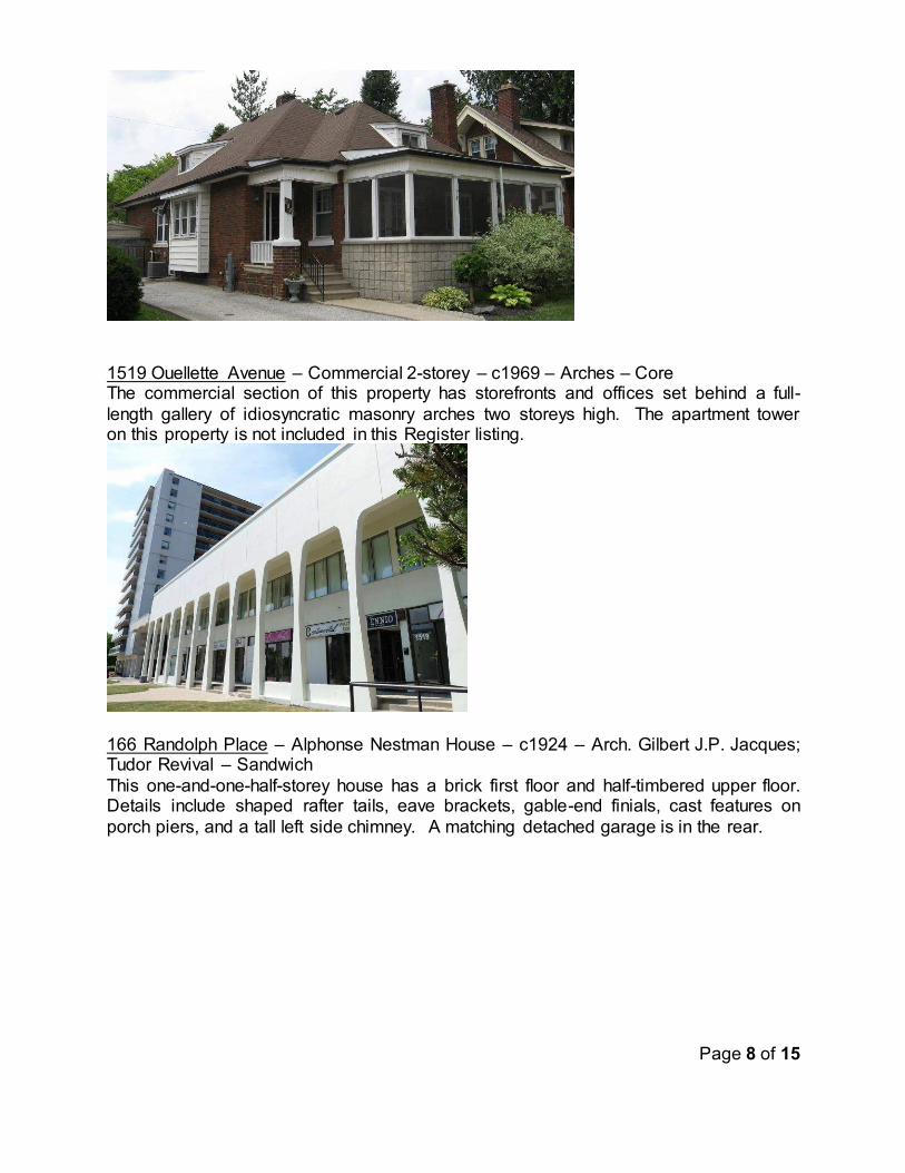
Page 8 of 15
1519 Ouellette Avenue – Commercial 2-storey – c1969 – Arches – Core The commercial section of this property has storefronts and offices set behind a full-
length gallery of idiosyncratic masonry arches two storeys high. The apartment tower on this property is not included in this Register listing.
166 Randolph Place – Alphonse Nestman House – c1924 – Arch. Gilbert J.P. Jacques; Tudor Revival – Sandwich
This one-and-one-half-storey house has a brick first floor and half-timbered upper floor. Details include shaped rafter tails, eave brackets, gable-end finials, cast features on
porch piers, and a tall left side chimney. A matching detached garage is in the rear.

Page 9 of 15
~3150 Riverside Drive East – Ford Powerhouse Screen House – 1923 – Arch. Albert Kahn – Ford City
Kahn designed the Ford Powerhouse between Riverside Drive East and Wyandotte Street. This utilitarian building for the powerhouse, located on the north side of
Riverside Drive, includes some of the same detailing in a one-storey building.
5375 Riverside Drive East – House – c1935 – Tudor Revival; massive chimney – Riverside The large front tapered brick chimney is between the main front wall and a ski-slope
extension of the entry vestibule. The wall pattern includes bricks extending beyond the plane. There are heavy cast lintels and sills, and a cross-gabled roof with minimal
eaves and gable details.

Page 10 of 15
5970 Riverside Drive East – J.C. Gelling House – 1960 – Arch. Harold C. Beckett –
Riverside Harold C. Beckett (1890-1970) was an architect in Windsor and Detroit, whose designs included the Banff National Park Administration Building, several houses in Grosse
Pointe and ammunition factories for World War II. This house is one-storey, brick, hipped roof, U-shaped around a courtyard, with a large patio facing the Detroit River.
Drawings are on file.
(photo from Bing maps) 3370 Sandwich St – House – c1910 – Brick bungalow with Tudor Revival elements –
Sandwich This 1½-storey house is cross-gabled with shed dormers to the sides. Its right corner
entry is from a small porch with “ski-slope” roof and an arch. The projected main front window has a flared metal hood.
1658-94 Tecumseh Road East – Windermere Block – c1925 – Commercial 2-storey brick – South Walkerville
This two-storey red-brick commercial building features banding between the floors and below the parapet, which also has dentils. The second-floor sash windows, mostly in groups of three, have another band at the sills, and there are keystones above. A name
plate is centred on the parapet. Some brick remains between storefronts.

Page 11 of 15
815 Victoria Avenue – James W. Brien House – 1937 – Late Tudor Revival – Core This 1½-storey brick and concrete block house is designed in the Tudor revival style with steeply pitched cross gabled roof and large prominent corbelled chimney with stone
appliqué at the base. The house features a stone front arched door entrance in the center, flanked by two small stained glass windows. On the front facade, quoins
surround the multi-sash casement windows with concrete block lintels and sills. The first owner of house, Dr James W. Brien, was a distinguished physician and served at the Metropolitan Hospital for 17 years as the chief of surgery.
923 Victoria Avenue – House – 1924 – Prairie School – Core This 2½-storey Prairie house is constructed of yellow brick. The front facade features a
center porch supported by large square pillars protruding the roofline, covered by a low-pitched hipped roof across the full length of the front first floor, and multiple
symmetrically-balanced windows. It has wide eave overhangs and a low-pitched gabled dormer on the attic floor, as well as through-cornice gabled faux dormers side windows on the second storey.
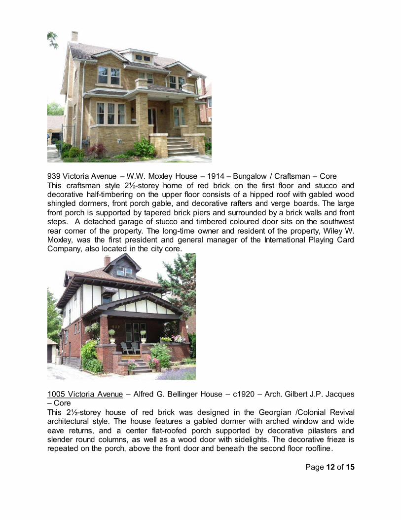
Page 12 of 15
939 Victoria Avenue – W.W. Moxley House – 1914 – Bungalow / Craftsman – Core
This craftsman style 2½-storey home of red brick on the first floor and stucco and decorative half-timbering on the upper floor consists of a hipped roof with gabled wood shingled dormers, front porch gable, and decorative rafters and verge boards. The large
front porch is supported by tapered brick piers and surrounded by a brick walls and front steps. A detached garage of stucco and timbered coloured door sits on the southwest
rear corner of the property. The long-time owner and resident of the property, Wiley W. Moxley, was the first president and general manager of the International Playing Card Company, also located in the city core.
1005 Victoria Avenue – Alfred G. Bellinger House – c1920 – Arch. Gilbert J.P. Jacques – Core
This 2½-storey house of red brick was designed in the Georgian /Colonial Revival architectural style. The house features a gabled dormer with arched window and wide
eave returns, and a center flat-roofed porch supported by decorative pilasters and slender round columns, as well as a wood door with sidelights. The decorative frieze is repeated on the porch, above the front door and beneath the second floor roofline.

Page 13 of 15
3424 Victoria Boulevard – Arthur S. Pearson House – 1928 – Arch. Albert J. Lothian –
South Windsor This Georgian/Colonial Revival house has a formal symmetrical façade with centred
entry under a flat-roof porch, evenly spaced windows, quarter-round gable windows, side gabled roof with side chimney, and a one-storey extension to the right side.
Not to be included on the Register:
229 Rossini Boulevard – House – 2014 – Raised Ranch – Ford City The detached garage for the Register-listed Montreuil-Buckland-Vichos House, 4187 Riverside Drive East, faced Rossini Boulevard at this location. Council approved
demolition of the garage and severance of this parcel with several conditions, including the request for designation of the Riverside Drive house. Designation by-law No. 102-
2015 was approved on August 4, 2015, but the severed parcel with a new house was not explicitly removed from the Register. This action would do so. Heritage designation amendment:
841 Kildare Road – Miers-Fraser House – 1904 – Edwardian; Alfred Miers, Magistrate –
Walkerville This property was designated with by-law No. 5-2011 on January 10, 2011 as the “Meirs-Fraser House”. The spelling error of the name Miers was discovered that year
and changed on the Register available on the City’s website, but the designation has

Page 14 of 15
not been corrected. Appendix ‘A’ is the Statement of Significance for the by-law, with
the corrected spelling. The property legal description is unchanged. The process for amendment is similar to a new designation, where Council authorizes the Clerk to issue a Notice of Intention to Designate (here to amend a designation), appropriate notices
are sent, a 30-day time for objections passes, Council passes a by-law, then the by-law is registered on the land title.
Design or Physical Considerations; Historical or Associative Value; Contextual
Considerations
These are stated briefly in the above descriptions.
Official Plan:
The Windsor Official Plan includes (9.0) “A community’s identity and civic pride is rooted in physical and cultural links to its past. In order to celebrate Windsor’s rich history, Council is committed to recognizing, conserving and enhancing heritage resources.” Also, (9.3.2.1) “Council will identify Windsor’s heritage resources by: ... (c) Researching and documenting the history and architectural and contextual merit of potential heritage
resources on an individual property basis; … 9.3.3.4.(a) maintaining and updating the list of built heritage resources known as the Windsor Municipal Heritage Register”.
RISK ANALYSIS: There is a risk of quick demolition if the recommended properties are not added to the
Municipal Heritage Register. While being on the register does not provide outright protection of heritage resources from demolition, it provides Council with additional time
to decide whether to designate a property.

Page 15 of 15
FINANCIAL MATTERS:
There are no direct costs to private property owners. City costs will be for record keeping and information to the owners, and for filing the designation by-law
amendment.
CONSULTATIONS:
Heritage Planner files compiled over several years from multiple sources were utilized. Some research was derived from Committee Member Andrew Foot’s website, www.International Metropolis.com. The Heritage Planner will send letters to owners after Council’s decision.
CONCLUSION: Twenty properties should be added to the Windsor Municipal Heritage Register.
Several properties designed by architect Gilbert J.P. Jacques will receive Register protection. The removal of a parcel with no cultural heritage value and corrections for one designation should be initiated.
PLANNING ACT MATTERS: N/A
APPROVALS: Name Title
Michael Cooke Manager of Planning Policy
Thom Hunt City Planner
Wira Vendrasco Deputy City Solicitor
Shelby Askin Hager City Solicitor
Onorio Colucci Chief Administrative Officer
NOTIFICATIONS: Name Address Email
Carol & Bill Lester 841 Kildare Rd
Windsor ON N8Y 3H3
APPENDICES:
‘A’ – Heritage designation by-law description for Miers-Fraser House
.

From By-law No. 5-2011, January 10, 2011 Modified By-law No. ----2016, -------, 2016
SCHEDULE “B”
REASONS FOR DESIGNATION:
DESCRIPTION OF HISTORIC PLACE
The Miers-Fraser House is located on the west side of Kildare Road where it curves into St.
Mary’s Gate. The house was built in 1904 in the Edwardian style, and has been in continuous use.
HISTORICAL VALUE
This home was built in 1904 during rapid expansion of the town of Walkerville. The first owner was Albert Miers, the Secretary-Treasurer of the Walkerville Malleable Iron Company (whose
president, Harrington Walker built across the street). Albert Miers also served on the Walkerville Town Council and as police chief. After Miers died in 1935, the house was sold to criminal lawyer Gordon Fraser, whose family lived there into the 1960s. The present owners acquired it in
1989.
DESIGN VALUE
This house is two-storey, with smooth red brick, stone foundation, and an asymmetrical facade.
This house has an unbroken, overhanging pediment on the main front gable, which has a shingled wall; there are two small side gables, one of which has a broken pediment. Windows on
the main floors are all rectangular, with stone sills and lintels of rough brick in a slightly flared pattern; all have original or replicated wood sashes and wood storm windows; some have multiple panes; beveled glass is in two upper panes in front. A tall, square brick chimney is just
front of the left side gable. The half-width front porch is L-shaped with smooth Doric columns; the door is panelled with a large single pane; the skirt is of shingles matching the attic gable.
The owners have identified the style as “Edwardian”, noting the style elements used for fine buildings during and shortly after the reign of King Edward VII (1901-1910). In some ways the
style is an understatement of Victorian styles, on this house with moderate-to-wide eaves, some articulation of the main walls, gables, detailed window surrounds, broken pediment, classical
columns, and spindle work. (Other Edwardian features not used on this house are exuberant door surrounds and eave brackets.) The identity of the architect is unknown.
CONTEXTUAL VALUE
This location in the former town of Walkerville is surrounded by homes recognized for historic and architectural heritage. The subject house is located where the street curves into St. Mary’s
Gate; thus its setback is in-between those of its neighbours. To the south is a heritage designated house “The Cobbles”, at 849 Kildare Road; to the north is the F. Allum house (heritage listed) at 833. To the east is a large lot with the Harrington Walker House at 1948 St. Mary’s Gate (heritage listed).
CHARACTER DEFINING ELEMENTS
Feature that contributes to the historical value of the Miers-Fraser House include:
Its association with Albert Miers, a civic and corporate leader in the Town of Walkerville, and with prominent attorney Gordon Fraser.
Exterior features that contribute to the architectural value of Miers-Fraser House include:
Two and one-half storeys. Smooth orange-red brick, and stone foundation. Overhanging front gable with shingles and unbroken pediment. Windows with lintels of rough-surface bricks in flared soldier-course, and stone sills
wider than the frames. Wood windows on the front and sides of the main floors, with original or replica wood
sashes and storm windows. Front bay with inset brick panels between the floors. Tall square brick chimney on the south side. Front porch half-width, with L-shaped floor pattern.
Characteristic that contributes to the contextual value of Miers-Fraser House includes:
Its location along a curve in the former Walkerville among several prominent heritage
houses.

1 of 3
Planning & Building Services
MISSION STATEMENT
Our City is uilt on relationships – between citizens and their government, businesses and public institutions, city
and region – all interconnected, mutually supportive, and focused on the brightest future we an reate together
REPORT #: S 110/2016 Report Date: 5/30/2016
Author’s Contact: Donald Wilson 519 255-6543 ext. 6392 [email protected]
Date to Council: 7/11/2016
Clerk’s File #: SAA2016
To: Mayor and Members of City Council Subject: Conveyance of part of closed Clairview Avenue abutting 429 Fairview –
PIN 01070-0173 SAS/4677
RECOMMENDATION: I. That former Town of Riverside conveyance By-law 2791 BE AMENDED to
authorize the conveyance of part of closed Clairview Avenue described as Part
Clairview Avenue, Plan 1164, Riverside, closed by R310550 abutting Lots 1, 2, 3, Plan
1164; Windsor, being PIN 01070-0173 closed by former Town of Riverside By-law 2760
registered on title August 19, 1964 as Instrument Number R310550 to the owners of
429 Fairview, and the lands BE CONVEYED at $1.00 plus deed preparation costs.
II. Easements, subject to their being accepted in the City’s standard form and in accordance with the City standard practice BE GRANTED to:
i. Enwin Utilities Ltd. and Bell Canada
III. That the City Solicitor BE DIRECTED to prepare the amending by-law for
Council’s consideration; and further, the Chief Administrative Officer and City Clerk BE
AUTHORIZED to sign all necessary documents approved as to form and content
satisfactory to the City Solicitor, and any subsequent transactions BE COMPLETED
electronically pursuant to By-law Number 366-2003.
EXECUTIVE SUMMARY:
N/A
toldob
Text Box
Item No. 11.1

2 of 3
BACKGROUND:
By-law 2760 of the former Town of Riverside approved the closure for diversion
purposes parts of Clairview Avenue between Isabelle Place and Eastlawn Avenue,
including the lands proposed for conveyance in this report. By-law 2791 of the former
Town of Riverside dated November 23, 1964 approved the conveyance of various
portions of Clairview Avenue. For an unknown reason, the portion proposed for
conveyance in this report was not authorized for conveyance.
The owners of 429 Fairview Avenue have requested conveyance of this portion of
Clairview Avenue. Since the Town of Riverside conveyance by-law did not specify this
portion, approval is being sought with this report.
DISCUSSION:
Since this portion abuts the Ganatchio Trail, input was sought from Parks Development.
They have no objection to the conveyance of this portion to the owners of 429 Fairview.
Legal Department, Real Estate Division has advised that for lands abutting properties
zoned RD1.1, $1.00 plus deed preparation and proportionate share of survey costs is
the appropriate land value. In this case, a survey is not required, since the remnant
lands are on one PIN.
Comments were also sought from various utility companies to determine if easements
are required prior to transferring the lands into private ownership. Enwin Utilities Ltd.
and Bell Canada have requested easement protection.
The Planning Department has also discussed with the applicant regarding closing the
north/south alley between Fairview Avenue and Belleperche Place under the Alley
Closing Subsidy Program since there are various encroachments into this alley by the
abutting owners.
RISK ANALYSIS:
There is no known risk associated with this conveyance.
FINANCIAL MATTERS:
The costs to prepare and register the amending by-law will be borne by the City.
CONSULTATIONS:
Planning staff have consulted with Mike Clement, Manager of Parks Development and
Denise Wright, Coordinator, Real Estate Services. Comments were also sought from
various utility companies to determine easement requirements.
3 of 3
CONCLUSION:
The former Town of Riverside closed the subject lands allowing the conveyance of
some portions to other owners. In order to convey this remnant portion, the former
Town of Riverside by-law requires amendment.
PLANNING ACT MATTERS:
N/A
APPROVALS:
Thom Hunt City Planner
Denise Wright Coordinator, Real Estate Services
Shelby Askin Hager City Solicitor
Onorio Colucci CAO
NOTIFICATIONS:
Name Address Email
Stanley and Carol Anne Winters 429 Fairview Boulevard
Windsor, Ontario N8S 3E3
APPENDICES:
1. Appendix A - Drawing of Portion to be conveyed to 429 Fairview 2. Appendix B - Riverside Conveyance By-law 2791
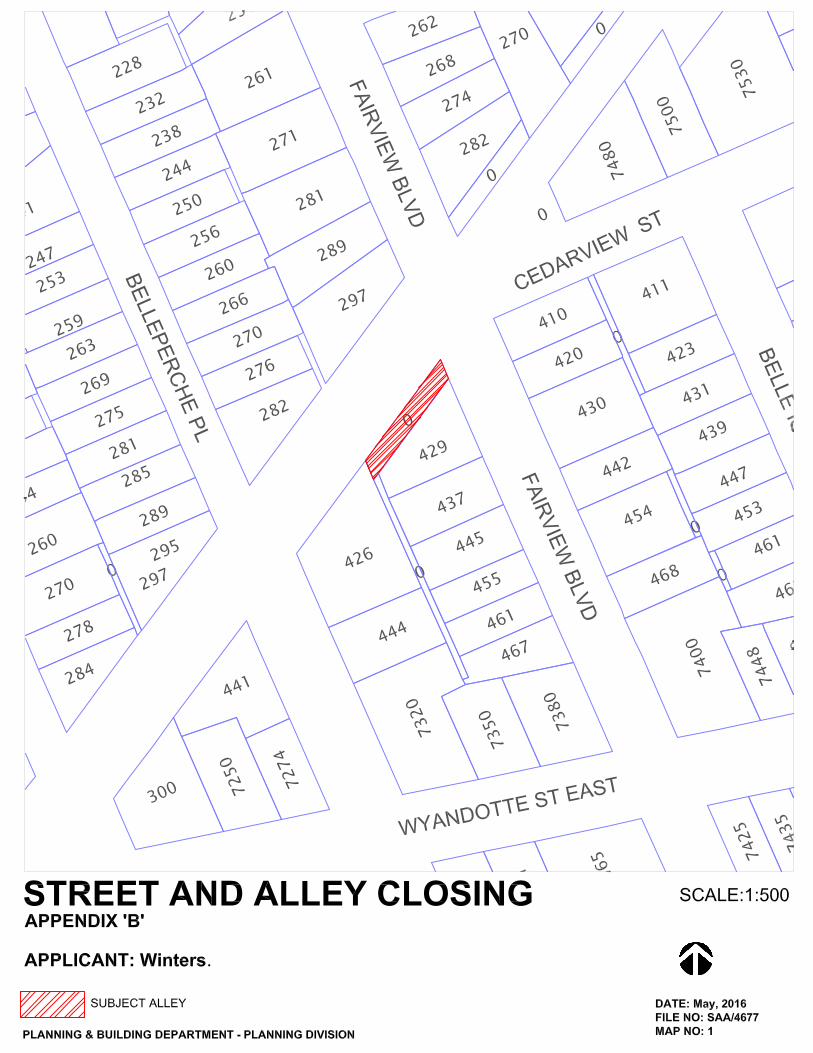
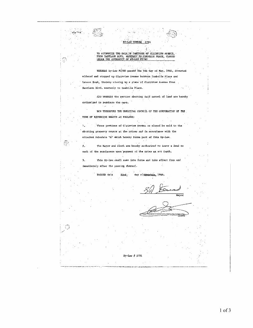
1 of 3
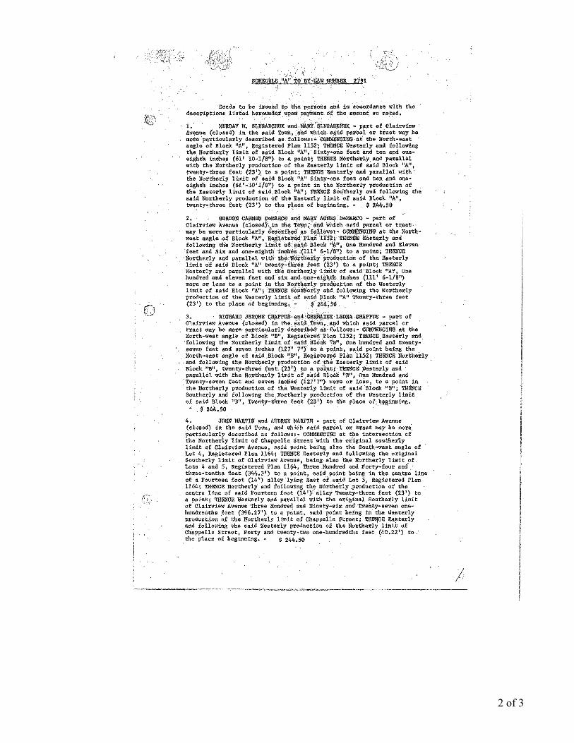
2 of 3
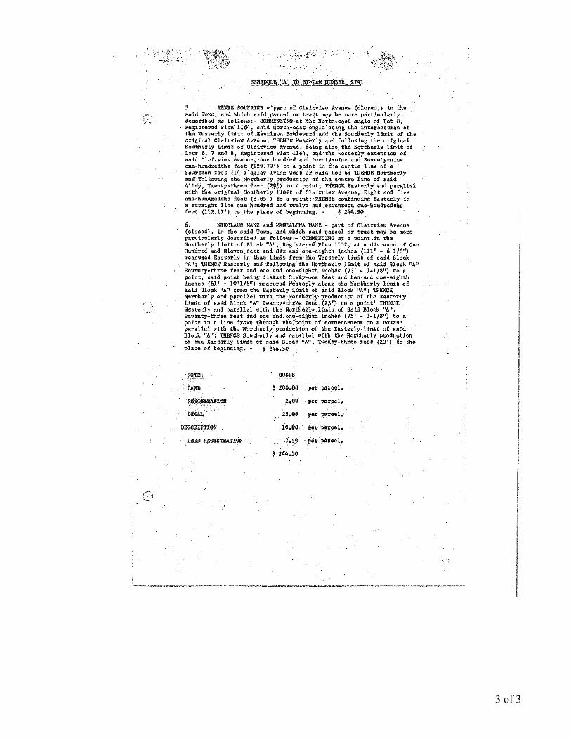
3 of 3
Page 1 of 7
Planning & Building Services
MISSION STATEMENT
Our City is uilt on relationships – between citizens and their government, businesses and public institutions, city
and region – all interconnected, mutually supportive, and focused on the brightest future we an reate together
REPORT #: S 125/2016 Report Date: 23/06/2016
Author’s Contact: Greg Atkinson 519-255-6543 ext. 6582
Date to Council: 7/11/2016
Clerk’s File #: Z/8955
To: Mayor and Members of City Council Subject: Brownfield Redevelopment Community Improvement Plan (CIP)
Application Submitted by Valente Property Corp. for 325 Devonshire Road (Ward 4)
RECOMMENDATION:
THAT the request made by Valente Property Corp. to participate in the Feasibility Study
Grant Program BE APPROVED for the proposed feasibility study at 325 Devonshire
Road pursuant to the City of Windsor Brownfield Redevelopment Community
Improvement Plan;
THAT the request made by Valente Property Corp. to participate in the Environmental
Study Grant Program BE APPROVED for the proposed Phase II Environmental Site
Assessment Study and Remedial Work Plan/Risk Assessment at 325 Devonshire Road
pursuant to the City of Windsor Brownfield Redevelopment Community Improvement
Plan; and
THAT the City Treasurer BE AUTHORIZED to issue payment upon the completion and
submission of a Feasibility Study and/or Phase II Environmental Site Assessment Study
and Remedial Work Plan/Risk Assessment in a form acceptable to the City Planner and
City Solicitor.
EXECUTIVE SUMMARY:
N/A
toldob
Text Box
Item No. 11.2
Page 2 of 7
BACKGROUND:
Brownfield Redevelopment Community Improvement Plan
Brownfield sites are properties that may be contaminated due to previous industrial or
commercial uses such as a manufacturing facility or gas station. City Council approved
a Brownfield Redevelopment CIP at its April 19, 2010 meeting for the purpose of
encouraging the study, clean-up, and redevelopment of contaminated properties.
The approval of the CIP was the result of nearly five years of study and consultation,
which began in October 2005. The Brownfield Redevelopment CIP contains a number
of financial incentive programs that encourage the study, clean up, and redevelopment
of brownfield sites. The applications submitted by Dillon Consulting on behalf of
Valente Property Corp. are the eighth request the City has received for incentives under
the Brownfield Redevelopment CIP.
Importance of Brownfield Redevelopment
In 2009 the City’s Planning Department identified 137 brownfield properties (i.e. 226 hectares or 559 acres) that are available for redevelopment. While the inventory is not
exhaustive, it illustrates the significance of Windsor’s brownfield stock and the need to work with land owners to put these properties back into productive use. 325 Devonshire
Road was identified as a priority redevelopment site within the inventory.
Historically, there has been little interest in redeveloping brownfield sites due to the
uncertainty surrounding the extent of contamination and the potential cost of clean-up.
The Brownfield CIP provides financial incentives to undertake the necessary studies
and remedial work necessary to redevelop brownfield sites and reduce the potential
negative impacts to the City's environment and neighbourhoods.
The benefits associated with brownfield redevelopment go far beyond the boundaries of
the property. For example, they are often strategically located within existing built up
areas of the City where services and other infrastructure, such as roads, schools,
community facilities and public transit are already available, therefore additional
infrastructure costs are not incurred to service these areas. The redevelopment of these
sites also remove the negative stigma often associated with some brownfield properties,
which increases the value of the subject property and adjacent properties.
Brownfield sites also represent a significant underutilization of the land base. According
to the National Round Table on the Environment and the Economy (2003), every
hectare redeveloped through a brownfield project saves up to an estimated 4.5 hectares
of greenfield land from being developed (i.e. agricultural land on the edge of the City);

Page 3 of 7
and for every dollar invested in a brownfield redevelopment, it is estimated that $3.80 is
invested in the economy.
Site Background
The four storey, 63,000 square foot building facing Riverside Drive between Devonshire
Road and Chilver Road (see Map 1) was constructed in 1911 as part of the Hiram
Walker Co. Power Department. It was surrounded to the north and south by railway
tracks for most of the past 105 years. The building was designed by Detroit architect
J.E. Kinsey and is on the Municipal Heritage Register, which means it cannot be
demolished without Council’s endorsement. The building has been vacant for more
than ten years as the building has been deemed unsafe for occupation by the Building
Department.
Figure 1: Former Hiram Walker Co. power building located at 325 Devonshire Rd
A number of potential purchasers have investigated the redevelopment potential of the
building, however several challenges have prevented anyone from moving forward with
a reuse plan. The environmental condition of the property and unknown cost of
remediation is one such challenge that needs to be addressed before any purchaser
would be willing to take ownership of the building and property. Valente Property Corp.
has made an offer to purchase the building and property subject to a number of
conditions, which include verifying the environmental condition and estimated clean-up
cost to redevelop the property.

Page 4 of 7
The property is currently designated ‘Business Park’ in the City’s Official Plan and zoned MD 1.1 (Manufacturing District), which permits a range of light industrial, office,
and service commercial uses. Planning staff anticipate applications to amend the
Official Plan and Zoning By-law as part of a mixed use redevelopment proposal.
DISCUSSION:
Feasibility Grant Program
The Feasibility Study Grant program offers a matching grant to property owners of
brownfield sites to conduct studies on the feasibility of reusing, rehabilitating, retrofitting
and constructing buildings on these sites. The program offers 50% of the cost of an
eligible feasibly study up to a maximum grant of $7,500.
A study of the former Hiram Walker Co. Power Building property is proposed to assess
the feasibility of reusing the building for commercial, office, and residential purposes.
The applicant has indicated the study will focus on market analysis, urban design, and
preparation of conceptual plans and drawings. Identifying a feasible reuse for any
brownfield site is the first step in crafting an economically viable redevelopment plan.
Environmental Study Grant Program
The Environmental Study Grant program offers a matching grant to property owners of
brownfield sites to conduct environmental studies that provide information on the type
and extent of contamination and potential remediation costs. The program offers 50%
of the cost of up to two eligible studies (i.e. per property/project) up to a total maximum
grant value of $25,000.
Valente Property Corp. proposes to undertake two eligible studies:
1. A Phase II Environmental Site Assessment (ESA) study is required to characterize
the site and delineate the extent of any contamination. The study will build on
recently completed Phase I ESA and II ESA work completed by a previous
prospective purchaser.
2. A Remedial Work Plan and/or Risk Assessment will set out the work required and
estimate the cost to file a Record of Site Condition, which would be required prior to
any residential redevelopment.
Clearly identifying the type and delineating the extent of contamination as well as the
cost to clean up the property are essential steps in moving forward with clean up and
redevelopment of the site. Upon completion, the City would retain a copy of the final
studies and should Valente Property Corp. not purchase the property—the CIP requires
Page 5 of 7
that permission be given to share the study with subsequent owners and interested
parties.
CIP Goals
City staff is supportive of the application as it meets all of the eligibility requirements
specified within the Brownfield Redevelopment CIP. The proposed study of 325
Devonshire Road supports the following CIP goals:
• To promote the remediation, rehabilitation, adaptive re-use and redevelopment of
brownfield sites throughout the City of Windsor in a fiscally responsible and
sustainable manner over the long term;
• Improve the physical and visual quality of brownfield sites;
• Improve environmental health and public safety;
• Provide opportunities for new housing, employment uses, and commercial uses;
• Increase tax assessment and property tax revenues;
• Promote Smart Growth, including the reduction of urban sprawl and its related
costs, energy efficiency through the construction of buildings that meet Leadership
in Energy and Environmental Design (LEED) standards, and green planning and
building practices;
• Improving the land use compatibility of potential brownfield sites with surrounding
land uses;
• Increase community awareness of the economic, environmental and social benefits
of brownfield redevelopment; and
• Utilize public sector investment to leverage significant private sector investment in
brownfield remediation, rehabilitation, adaptive re-use, and redevelopment.
Policy Support
The study of brownfield sites to support clean up and redevelopment is supported by
numerous policies within the 2014 Provincial Policy Statement, the City’s Official Plan, the City’s Environmental Master Pan, and Community Strategic Plan.
RISK ANALYSIS:
As with all brownfield sites, there is a high degree of risk associated with the property
remaining contaminated and vacant. Uncertainty related to the feasibility of building
reuse, the extent of contamination, and cleanup cost will continue to act as a barrier to
redevelopment if not addressed. If the site remains contaminated and vacant it will
continue to have a negative effect on the surrounding area. The proposed studies will
Page 6 of 7
assist in mitigating the above noted risks by establishing next steps in the cleanup
process.
FINANCIAL MATTERS:
The cost estimates (excluding HST) for completing the proposed studies are as follows:
• Phase II ESA $60,000
• Risk Assessment/Remedial Work Plan $155,000
• Feasibility Study $15,000
If approved the requested grant programs would provide a total of $32,500 toward the
completion of the three studies (i.e. $15,000 toward the Phase II ESA; $10,000 toward
the Remedial Work Plan/Risk Assessment; and $7,500 toward the feasibility study).
The grants would be paid out of the Brownfield Strategy/Remediation Account, which
currently has $1,155,603 available.
CONSULTATIONS:
The development and approval of the Brownfield Redevelopment CIP was subject to
extensive stakeholder and public consultation, which sought input from a wide range of
stakeholders and internal City departments.
Planning staff have consulted with the applicant prior to accepting the application for the
Feasibility Study and Environmental Study Grant programs. Staff from the Planning,
Finance, and Legal Departments were consulted in the preparation of this report.
CONCLUSION:
City Staff recommend Council approve the request from Valente Property Corp. to
participate in the Feasibility Study and Environmental Study Grant Programs. In the
opinion of planning staff, the proposed study of this brownfield site conforms to the
Brownfield Redevelopment CIP, assists the City in the achievement of a number of the
CIP goals, and exemplifies the intent of the both study grant programs.
PLANNING ACT MATTERS:
N/A

Page 7 of 7
APPROVALS:
Name Title
Thom Hunt City Planner
Don Nantais Financial Planning Administrator
Janice Guthrie Deputy Treasurer
Wira Vendrasco Deputy City Solicitor
Shelby Askin Hager City Solicitor
Janice Guthrie for Joe Mancina Chief Financial Officer
Onorio Colucci Chief Administrative Officer
NOTIFICATIONS:
Name Address Email
Karl Tanner [email protected]
Peter Valente [email protected]
APPENDICES:
1 Location Map

RIVERSIDE DR E
ASSUMPTION ST
CH
ILVE
R R
D
DEV
ON
SHIR
E R
D
LOCATION MAP - 325 DEVONSHIRE ROAD
°SUBJECT AREA 0 30 6015
Meters