Planning for States and Nation-States in the U.S. and Europe · PDF filePLANNING FOR STATES...
552
PLANNING FOR STATES AND NATION-STATES IN THE U.S. AND EUROPE Edited by Gerrit-Jan Knaap, Zorica Nedović-Budić, and Armando Carbonell
Transcript of Planning for States and Nation-States in the U.S. and Europe · PDF filePLANNING FOR STATES...

PL
AN
NIN
G F
OR
ST
AT
ES
AN
D N
AT
ION
-ST
AT
ES
IN T
HE
U.S
. AN
D E
UR
OP
E
P L A N N I N G F O R S TAT E S
A N D N AT I O N - S TAT E S
I N T H E U . S . A N D E U R O P E
Edited by Gerrit-Jan Knaap, Zorica Nedović-Budić, and Armando Carbonell
Knaap, N
edović-Budić,
and Carbonell“This timely transatlantic dialogue between planning researchers and policy makers provides
a wealth of information and insights into the planning frameworks and institutions in changing economic, environmental, social, and political contexts. There are no silver bullets, but the international lessons learned provide a formidable foundation for innovative and implementable responses to the governance challenges and opportunities in spatial planning.”
ROBERT FREESTONEProfessor of Planning
University of New South Wales
“The case studies in this volume document the rise of regionalism in the United States and Europe, yet they reveal that successful regional planning remains elusive. This book is a must-read for land use planners, proponents of regionalism, and advocates of sustainable development, to learn about many of the exciting spatial planning initiatives being pursued in the United States and Europe.”
TIM CHAPINAssociate Dean for Development, College of Social Sciences and Public Policy
Professor, Department of Urban and Regional PlanningFlorida State University
“Planning for States and Nation-States is an authoritative resource on the evolution of contemporary planning policies, processes, and institutions in the United States and Europe.”
DOMINIC STEADAssociate Professor in Urban and Regional Development
Delft University of Technology
“The book is essential reading to understand the complex processes of land use planning and regulation at the state and nation-state levels in the United States and Europe. It explores how the processes fit–or fail to fit–in a regional context in the United States and Europe.”
DAVID L. CALLIES, FAICPBenjamin Kudo Professor of Law, William S. Richardson School of Law
The University of Hawaii at Manoa
“Top planning scholars from the United States and several European countries provide a long-awaited exchange of knowledge across the Atlantic. Although many of the countries in this volume share similar traditions and challenges, each country has a unique planning story.”
RACHELLE ALTERMANProfessor of Architecture
Technion-Israel Institute of Technology
PLANNING FOR STATES AND NATION-STATES IN THE U.S. AND EUROPE
Edited by Gerrit-Jan Knaap, Zorica Nedović-Budić, and Armando Carbonell

Planning for StateS
and nation- StateS


Planning for StateS and nation- StateSin the U.S. and eu rope
Edited by
gerrit- Jan Knaap
Zorica nedović- Budić
armando Carbonell

© 2015 by the Lincoln Institute of Land Policy
All rights reserved.
Library of Congress Cataloging- in- Publication Data
Planning for states and nation- states in the U.S. and Eu rope / edited by Gerrit- Jan Knaap, Zorica Nedović- Budić, and Armando Carbonell. 1 online resource. Includes index. Description based on print version record and CIP data provided by publisher; resource not viewed. ISBN 978-1-55844-292-4 (prc) — ISBN 978-1-55844-311-2 (epub) — ISBN 978-1-55844-312-9 (ibook) — ISBN 978-1-55844-313-6 (pdf) — ISBN 978-1-55844-291-7 (alk. paper) 1. Land use— United States— States. 2. Land use— European Union countries. 3. Regional planning— United States— States. 4. Regional planning— European Union countries. I. Knaap, Gerrit, 1956– HD205 333.73'13094— dc23
2015003027
Designed by Robin Artz
Composed in JansonPrint version printed and bound by Puritan Press Inc., in Hollis, New Hampshire.The paper is Rolland Enviro100, an acid- free, 100 percent PCW recycled sheet.
MANUFACTURED IN THE UNITED STATES OF AMERICA
/ v /
Contents
list of illustrations ix
introdUCtion 1
1 Land Use Regulation in the United States: An Intergovernmental Framework 27PatriCia e. SalKin
Commentary 49armando CarBonell
2 Land Use Planning in Oregon: The Quilt and the Strug gle for Scale 53ethan SeltZer
Commentary 90riChard Whitman
3 Will Climate Change Save Growth Management in California? 97William fUlton
Commentary 123miKe mCKeever
4 The New Jersey State Planning Experience: From Ambitious Vision to Implementation Quagmire to Goal Redefinition 131martin a. BierBaUm
Commentary 185franK J. PoPPer

vi / CONTENTS
5 Using Incentives to Combat Sprawl: Mary land’s Evolving Approach to Smart Growth 189gerrit- Jan KnaaP
Commentary 223riChard hall
6 Delaware’s Quiet Emergence into Innovative State Planning 227reBeCCa leWiS
Commentary 254ConStanCe C. holland
7 The Eu ro pean Union Context of National Planning 259andreaS falUdi
Commentary 291Brendan WilliamS
8 The National Spatial Strategy for The Netherlands 297Barrie needham
Commentary 333henriëtte BerSee
9 The Danish National Spatial Planning Framework: Fluctuating Capacities of Planning Policies and Institutions 339daniel galland and Stig enemarK
Commentary 376Jane Kragh anderSen
10 Planning Without a Spatial Development Perspective? The French Case 381anna gePPert
Commentary 411Jean Peyrony
11 National Planning in the United Kingdom 419marK teWdWr- JoneS
Commentary 447leonora roZee
12 The Irish National Spatial Strategy 453Berna griSt
Commentary 497niall CUSSen

CONTENTS / vii
ConClUSion 503
Contributors 517
index 521
about the lincoln institute of land Policy 535


/ ix /
Illustrations
figUreS
2.1 Map of Oregon 553.1 Metropolitan Planning Organizations of California 1064.1 Policy Map of the New Jersey State Development and
Redevelopment Plan, 2014 1625.1 Statewide Priority Funding and Rural Legacy Areas in
Mary land, 2011 2026.1 State Strategies for Policies and Spending in Delaware, 2010 2447.1 Eu ro pean Union, 2014 2628.1 Areas Subject to Flooding in The Netherlands 3008.2 Municipalities and Provinces in The Netherlands 3018.3 Different Government Levels and Different Planning
Policies for Same Location 3048.4 Official Agencies Involved in Dutch National Planning 3108.5 Policy for Development According to the Fifth National
Policy Document, 2000 3168.6 Policy for Development According to the National
Spatial Strategy, 2004 3198.7 Ambitions for The Netherlands, 2040 3219.1 Map of Denmark 3409.2 Government Map of Denmark in the National Planning
Report, 2013 3499.3 Danish Planning System, 2015 3549.4 Fin ger Plan Directive for Greater Copenhagen, 2013 36410.1 Incomplete Coherence of the Planning System, 2013 39310.2 DATAR’s Vision of a Desirable National Development
Perspective 39811.1 United Kingdom, 2014 42011.2 National Vision for Wales, 2004 429
x / ILLUSTRATIONS
11.3 National Vision for Scotland, 2009 43012.1 Island of Ireland, 2013 45412.2 Settlement Patterns in Ireland, 15th–17th Centuries 45812.3 Strategic Spatial Roles and Urban Places
in the National Spatial Strategy, 2002 47512.4 Midlands Gateway, 2013 47812.5 Proposed Regional Configuration of Ireland, 2013 491
taBleS
I.1 Case Study States and Nation- States Profiles 71.1 Institutions, Agencies, and Organizations Active in Land Use
Planning in the United States 442.1 Oregon State Planning Goals 622.2 Institutions, Agencies, and Organizations Active in Land Use
Planning in Oregon 682.3 Milestones in Oregon Land Use Planning 713.1 Milestones in California Land Use Planning 1003.2 Institutions, Agencies, and Organizations Active in Land Use
Planning in California 1023.3 Approved Regional Green house Gas Emissions- Reduction
Targets 1134.1 Institutions, Agencies, and Organizations Active in Land Use
Planning in New Jersey 1394.2 Milestones in New Jersey Land Use Planning 1495.1 Milestones in Mary land Land Use Planning 1935.2 Institutions, Agencies, and Organizations Active in Land Use
Planning in Mary land 1976.1 Milestones in Delaware Land Use Planning 2326.2 Institutions, Agencies, and Organizations Active in Land Use
Planning in Delaware 2356.3 Select Strategies for State Policies and Spending in Investment
Levels 2417.1 Milestones in Eu ro pean Spatial Planning 2717.2 Institutions, Agencies, and Organizations Active in Spatial
Planning in the Eu ro pean Union 2868.1 Milestones in the Dutch National Spatial Strategy 3068.2 Main Changes in Dutch National Spatial Strategy 3259.1 Five New Administrative Regions in Denmark 3429.2 Milestones in Denmark’s National Spatial Planning 3469.3 Factors Shaping Spatial Planning in Eu ro pean Contexts
since the 1990s 352

ILLUSTRATIONS / xi
9.4 Overview of the Danish National Spatial Planning Policy Framework after the Reform of Local Government Structure, 2007 356
9.5 Timeline of the Reconfiguration of National- Level Planning Authorities within the Ministry of the Environment 357
9.6 Planning and Land Use Policy Instruments 36010.1 Milestones in French Planning 38310.2 Dual Governance Structure at Territorial Levels 39211.1 Changing Purposes of Planning, 1900–1980 42311.2 Changes in Planning Since 1980 42411.3 Current Statutory Context of Planning in the
United Kingdom 42811.4 Planning in the United Kingdom Today 43512.1 Milestones in the Development of Ireland’s National
Planning System 46212.2 Institutions, Agencies, and Organizations Active in Land
Use Planning in Ireland 464


Planning for StateS
and nation- StateS


/ 1 /
The fundamental challenges of building and sustaining human settle-ments have not changed significantly for centuries. Humans need shel-
ter, sanitation, transportation, nutrition, social interaction, and economic production. The relative urgency of these challenges, however, has changed over time, as have the planning and public policy approaches to address them. Since the turn of the last century, climate change, economic devel-opment, social justice, and community revitalization have risen to the top of the planning agenda. To address these issues, planners have conducted extensive research, developed and marshaled new technologies, and ad-opted a variety of new tools and policy instruments. In addition, planners and policy makers in some Eu ro pean nations and some U.S. states have significantly changed the relative roles of international organizations and national, state, regional, and local governments. That is the focus of this volume.
As demonstrated in the case studies that follow, changes have occurred in the planning roles of governments at multiple levels on both sides of the Atlantic. In the United States, during the first term of the Obama ad-ministration, the federal government launched several new initiatives to facilitate collaborative planning at the metropolitan scale. Beginning in the 1970s, some states strengthened and then loosened oversight of local planning, some assigned new responsibilities to regional governments, and still others prepared and adopted statewide development plans. In Eu rope,
Introduction

2 / InTrOdUcTIOn
changes in the roles of governments have been more dramatic and wide-spread, beginning with the creation of the Eu ro pean Union (EU) and the emergence of pan- European planning frameworks (Hooghe and Marks 2001; newig and Koontz 2014). To foster unity and economic growth, the EU promulgated principles of spatial development for its member nations. Some Eu ro pean nations adopted national spatial development strategies, while others delegated more responsibilities to regional and local govern-ments. In addition to internal adjustments, there was a transfer of ap-proaches and practices between some of the states, which, along with other changes, made spatial planning, including land use planning, more complex. Because many of these institutional changes are relatively new, it is nearly impossible to determine what effects they have had on the ef-ficacy of plans or on the quality of human settlements. nevertheless, these nations and states serve as valuable laboratories in which to explore alter-native strategies for planning at the supralocal scale.
A Meeting of Minds
The opportunity to examine and discuss the institutional foundations of planning and the relative roles of governments brought scholars, prac ti-tion ers, students, and others to dublin, Ireland, in October 2012 for a two- day symposium presented by the Lincoln Institute of Land Policy and or ga nized by the School of Geography, Planning and Environmental Pol-icy at University college, dublin, and the national center for Smart Growth research and Education at the University of Mary land. The con-ference, titled “Planning for States and nation- States: A Transatlantic Exploration,” was held in the historic newman House on St. Stephen’s Green and featured overview papers on the structure of planning in the United States and Eu rope and case studies of five U.S. states and five Eu ro pean nations. Each pre sen ta tion was followed by commentary from a se nior official from the corresponding state or nation.1
The conference in dublin extended ongoing conversations about re-gional planning, spatial planning, smart growth, sustainability, and state growth management on both sides of the Atlantic. Particularly germane to the discussion in dublin was a series of books published by the Lincoln Institute on state and regional planning in the United States (deGrove and Miness 1992, 2005; Seltzer and carbonell 2011), state- level smart
1 This statement is generally true for most cases, although in some, the practitioner had sig-nificant academic experience. In the case of new Jersey, the author was primarily a practitioner, and the commentator was an academic.

InTrOdUcTIOn / 3
growth (Ingram et al. 2009), and Eu ro pean spatial planning (Faludi 2002, 2007, 2008).2 The conversations in dublin also extended work by scholars at University college, dublin, on Irish spatial strategy (Fox- rogers, Murphy, and Grist 2011; Grist 2011, 2012a, 2012b; Williams 2011; Wil-liams and Boyle 2012; Williams, Walsh, and Boyle 2010), and by scholars at the national center for Smart Growth research and Education on state planning in Mary land (Frece 2008; Lewis, Knaap, and Sohn 2009). Thus, the sponsoring organizations came to dublin steeped in the sub-ject matter and eager for new insights and productive dialogue about the role of states and nation- states in land use and spatial planning.
The Case Studies
The papers presented in dublin included case studies of plans and plan-ning frameworks in california, delaware, Mary land, new Jersey, and Oregon in the United States and in denmark, France, Ireland, The nether-lands, and the United Kingdom in Eu rope. These states and nation- states were not chosen randomly or to be representative. Instead, each was se-lected because it took a new and innovative approach to planning, espe-cially at the supralocal scale. The presumption was that an examination of planning institutions and planning practices in these 10 states and nation- states would provide insights into new institutional approaches to planning and offer valuable lessons for other states and nation- states— especially for the nation of Ireland, which was updating its national spa-tial strategy, and the state of Mary land, which was constructing its first state development plan.
The Approach
The chapters included in this book address the changing foci, scales, and approaches taken by states and nation- states to adapt to the ongoing trans-formations of global and local societal contexts and circumstances. Broad suprastate and national institutions tend to be inert (although the EU con-text has generally been more dynamic than that in the United States, in part because legal responsibility for land use planning formally belongs to states in the United States and to nations in Eu rope), but some states
2 Other important works on Eu ro pean spatial planning include dühr, colomb, and nadin 2010; Faludi 2010; reimer, Getimis, and Blotevogel 2014; Stead and cotella 2011; and Water-hout 2008. The work most similar to ours is the comparative study by Alterman (2001), which includes 10 national case studies and the United States as a single entity.
4 / InTrOdUcTIOn
and nation- states are quite active in their efforts to guide and influence spatial development. comparing planning frameworks in an international context is always difficult, especially among nations that have different sociopo liti cal, legal, administrative, and cultural contexts and speak different languages. All these differences pose challenging methodologi-cal and terminology problems (nadin and Stead 2013). Literal translations are often misleading because words have meaning only in their own lin-guistic context. Seemingly simple concepts, like land use planning, can connote a wide variety of activities and pro cesses depending on the constitutional, cultural, and geographic context. Further, comparative approaches can be biased when they are written from the perspective of a given nation. It is important, therefore, to define a few terms, express some under lying presumptions, and describe the scope of this book’s exploration.
Friedmann (1987) defines planning practice broadly as “a social and po-liti cal pro cess in which many actors, representing many different inter-ests, participate in a refined division of labor” (25). He views planning as one ele ment in the public domain, which is defined as the territorially based system of social relations that include po liti cal, legal, and bureaucratic practices. As a societal activity, planning is heavily dependent on a mix of cognitive, cultural, social, economic, and po liti cal institutions (Alden, Albrechts, and rosa Pires 2001). Verma (2007) suggests that “institutions such as government or market provide the framework within which plan-ning operates; other institutions rooted in cultural norms, mores, and practices, also provide the context for planning” (1).3
In this book, planning frameworks are first defined as the laws, regula-tions, and norms that frame the planning activities of all levels of govern-ment, where planning activities include both land development controls (e.g., comprehensive planning and zoning in the United States and spatial and comprehensive urban planning in Eu rope) and plans that address the spatial aspects of functional areas, such as transportation, water and wastewater disposal, economic development, or climate change. These plans are sometimes called functional plans in the United States and sec-toral plans in Eu rope. This framing of the scope of planning comports
3 March and Olsen (1989) define institution as “a stable collection of rules and practices defin-ing appropriate behavior for specific groups of actors in specific situations” (1). The rules reduce uncertainties and increase reliability of expectations in daily interactions and activities between all societal players in the private, public, and nonprofit sectors. Peterson and Shackleton (2002) add legal status (laws) and powers to the construct of institutions. In the spirit of neo- institutionalism, the authors suggest that institutions develop their own interests, agendas, priorities, and group loyalties by influencing po liti cal debates.

InTrOdUcTIOn / 5
with the term “spatial planning,” which, when stripped of its normative content, is defined by the Eu ro pean Union as follows: “Spatial planning refers to the methods used largely by the public sector to influence the future distribution of activities in space . . . to co- ordinate the spatial im-pact of other sectoral policies, . . . and to regulate the conversion of land and property uses” (cEc 1997, 24).
Second, there is a par tic u lar interest in the plans and spatial policies of supralocal levels of government: unions of nations, nation-states, and regions. This is not to dismiss the significance of local land use or func-tional plans. Analyses in this book affirm that most of what is considered land use or spatial planning occurs at the local level on both sides of the Atlantic. But it is the laws, regulations, and practices of higher levels of government that give those local plans validity, legal standing, and poten-tial to influence policy.
Perhaps most important, there is a basic assumption that in the context of planning, it is instructive to contrast the EU with the U.S. federal gov-ernment and to compare Eu ro pean nations with states in the United States. There are many reasons why such comparisons are problematic. Faludi identifies several in his chapter, and Masser (1992) highlighted the prob-lem of transferability in his early discussion of mutual learning between Eu rope and United States. Yet, such comparisons are apt for two reasons: (1) the EU, like the U.S. federal government, has an explicit interest in the spatial distribution of activity, but no express authority to engage in the planning or regulation of land; and (2) the authority to plan and regu-late land use belongs to the in de pen dent Eu ro pean nations, as it does, ac-cording to the U.S. Supreme court, to the individual states in the United States. Within these pa ram e ters, the EU, the U.S. federal government, Eu ro pean nations, and states in the United States have taken widely dif-fering approaches to land use and spatial development, as described in the chapters that follow. The differences in these approaches reflect large vari-ances in geography, resources, governance structures, languages, percep-tions, and cultures, as well as the perceived importance and urgency of specific issues (e.g., competitiveness, environmental protection) and their designation as being of state or national interest. Those differences, too, are addressed in the chapters that follow. What is more, exploring the sim-ilarities and differences in these approaches offers useful insights con-cerning the roles and the influence of planning at the state and nation- state levels. Our intent is not to offer a comprehensive analy sis of alternative planning frameworks in Eu rope and the United States or to develop some grand synthesis or taxonomy. These cases are clearly insufficient for such a task. Instead, our goal is to document what is happening in some interest ing

6 / InTrOdUcTIOn
nations and states and to see what trends can be identified and what les-sons can be drawn from these selected cases. The concluding chapter presents some trends and lessons, but the primary insights from this collec-tion come from the individual case studies, not from the short summaries or the attempts at synthesis.
To facilitate comparative analy sis, the authors of the case studies were asked to address the following:
• Geographic context and general structure of government.
• Structure of land use governance and roles of the local, regional, and national governments.
• Factors that shaped the development of the plan, planning frame-work, or development strategy.
• Planning participants, information foundations, and planning pro cesses.
• Key elements of the plan, planning framework, or development strategy content.
• Vertical and horizontal coordination.
• Plan implementation tools and pro cesses.
• Key outcomes and lessons.
The detailed structuring of the case materials, however, was left to the au-thors, with the understanding that the nature of the case would dictate the emphasis and or ga ni za tion of the contents.
Before turning to planning frameworks and practice, it is worth ask-ing how comparable U.S. states and Eu ro pean nation- states are with re-gard to size and population density. It is well known that the United States as a whole has more than twice the land area of the EU and just more than half the population, which suggests wide disparity. However, a review of population, land area, and population density for the selected states and nation- states reveals more congruity ( table I.1).
california, the third- largest state in area, lies between the United King-dom and France (the largest Eu ro pean country) in territorial extent and has just more than half the population of each. Mary land is comparable to The netherlands in land area but has only a bit more than one- third the population; new Jersey, although somewhat lower in population density than The netherlands, has a higher density than the other four Eu ro pean countries. Oregon is the outlier in its very low aggregate density, and del-aware is exceptionally small.

InTrOdUcTIOn / 7
Overview of the Book
At the dublin conference, case studies from the United States and Eu rope were presented in alternating fashion to facilitate transatlantic compari-son and conversation. This highlighted the many similarities and chal-lenges faced by U.S. states and Eu ro pean nation- states. This book, how-ever, presents first the case studies from the United States, and then the case studies from Eu rope. This or ga ni za tion offers the larger perspective of practices and trends on each of the two continents and leaves a discus-sion of international contrasts for the concluding chapter.
TABle I.1
Case Study States and Nation- States Profiles
Country / State
Area (Square Kilometers [km²] / Square Miles [mi²]) Population
Density ( People per km² / per mi²)
Per Capita Income (US$)
denmark 43,000 km² / 16,602 mi²
5,534,738 129 per km² / 333 per mi²
56,210
The netherlands 37,000 km² / 14,286 mi²
16,574,989 485 per km² / 1,160 per mi²
46,054
France 550,000 km² / 212,365 mi²
64,658,856 118 per km² / 304 per mi²
39,772
United Kingdom 243,610 km² / 94,058 mi²
62,471,264 256 per km² / 664 per mi²
38,514
Ireland 69,825 km² / 26,959 mi²
4,467,854 64 per km² / 149 per mi²
45,863
new Jersey 22,588 km² / 8,722 mi²
8,791,894 389 per km² / 1,008 per mi²
56,477
Mary land 32,133 km² / 12,407 mi²
5,773,552 179 per km² / 465 per mi²
51,724
delaware 6,447 km² / 2,489 mi²
897,934 139 per km² / 361 per mi²
69,667
Oregon 254,805 km² / 98,380 mi²
3,831,074 15 per km² / 39 per mi²
44,447
california 423,970 km² / 163,695 mi²
37,253,956 89 per km² / 228 per mi²
51,914
Note: Areas of U.S. states include land and water.sources: U.S. census (2010) (population and area of U.S. states); Eurostat (2010) (population and area of EU countries); World Bank (2012) (per capita income of EU countries); U.S. Government revenue (2013) (per capita income of U.S. states, $47,482).

8 / InTrOdUcTIOn
The Framework for Planning in the United States
As described in the opening chapter by Patricia Salkin, dean and profes-sor of law at the Jacob d. Fuchsberg Law center at Touro college, the U.S. federal government has the authority to exercise only those powers ex-pressly granted in the U.S. constitution. Planning and regulating land use are not among them; land use planning and regulation, therefore, re-main the responsibility solely of states. But although the federal govern-ment has no authority to plan and manage land, it has great influence on the location and nature of human activity. It spends billions of dollars per year, for example, on transportation, housing, and public infrastructure and owns more than 650 million acres of land. A survey of planning schol-ars, for example, identified the 1956 Federal Highway Act as the most in-fluential determinant of urban form in the United States over the past 50 years (Fishman 2000).
Federal regulations are also highly influential. The clean Air and Water Acts, for example, impose no restrictions on land use, but by establishing targets for ambient air quality and nutrient loadings to rivers, lakes, and streams, both acts profoundly influence local land use plans, regulations, and development patterns. The national Environmental Policy Act (nEPA) promulgated a U.S. national policy to protect the environment and estab-lished the President’s council on Environmental Quality. nEPA’s most significant effect was to set up procedural requirements for all federal government agencies to prepare environmental assessments and envi-ronmental impact statements that outline the environmental effects of proposed federal agency actions, including major investments in trans-portation, energy, housing, and other projects that influence development patterns. As Salkin describes, many other policies and programs of federal agencies also have major impacts on land use and development patterns.
More recently, the Obama administration has established a new channel of federal influence on land use planning and metropolitan development. In 2009, the secretaries of the department of Transportation and the department of Housing and Urban development and the administrator of the Environmental Protection Agency signed a memorandum of understanding (MOU) establishing the Sustainable communities Part-nership. The MOU served as the foundation for a number of new grant programs, including regional sustainable communities planning grants. regional sustainable community planning is now under way in 74 metro-politan areas across the country. The stated purposes of these pathbreak-ing grants include urban revitalization, environmental protection, social justice, and sustainable development, but an equally important purpose is
InTrOdUcTIOn / 9
to establish new interinstitutional relationships and promote greater in-clusion and participation in metropolitan- level planning.
As Salkin also describes, the U.S. Supreme court has held that land use planning and regulation are legitimate means by which states can meet their responsibilities to promote the health and welfare of their citizens. Subsequently, after the department of commerce published model zon-ing and planning enabling acts in 1924 and 1928, respectively, most states delegated responsibility for land use planning and regulation to local gov-ernments. State agencies have frequently prepared and adopted functional plans for transportation, economic development, and, most recently, climate change, but few states ever became directly involved in land use planning and regulation.
Some states, however, did become engaged. Vermont, Hawaii, califor-nia, Minnesota, Maine, and others led what Bosselman and callies (1971) famously called a “quiet revolution in land use control” to describe the growing intervention of state and regional governments in land use plan-ning and regulation. These states required local governments to plan, as-serted the state’s authority to regulate areas of statewide concern, created statewide land use commissions, and in other ways sought to limit or usurp local land use authority.
In her concluding comments on the future of land use control in the United States, Salkin asserts that the federal government will never have a controlling role in land use regulation, and she expresses optimism about the ability of local governments to fill the gap. She does not address the future of the quiet revolution. Armando carbonell, se nior fellow and chairman of the department of Planning and Urban Form at the Lincoln Institute of Land Policy, in his response to Salkin, identifies several other avenues through which the federal government influences land use and the location of human activity, often indirectly, and usually without careful consideration. For this reason, he characterizes the failure to pass a na-tional land use act as a significant “missed opportunity.” Further, although he recognizes the substantial re sis tance to passing such an act, he argues that the need to address large- scale problems such as climate change should strengthen our resolve to challenge such re sis tance.
State Case Studies
In the absence of a federal framework for planning and zoning, the prac-tice of planning and zoning in the United States is prescribed in state land use statutes and regulations. These prescriptions vary widely. After the publication of the model planning and zoning enabling acts, most states

10 / InTrOdUcTIOn
simply delegated responsibility for planning and zoning to local govern-ments. Others, however, including those discussed here, have taken a far more active role.
OregOn
As described by Ethan Seltzer, professor of urban studies and planning at Portland State University, Oregon has long been regarded as having the best- performing land use program in the United States. In 1973, Oregon’s Senate Bill 100 required local governments to prepare comprehensive land use plans and adopt regulatory instruments consistent with those plans. A newly established state Land conservation and development commission (Lcdc) was required to review and acknowledge every local plan. If the Lcdc determined that a local plan did not meet the state’s 19 land use goals and guidelines, the state could withhold state funds and rescind the authority of that local government to issue building permits. Over time, and through the ac know ledg ment pro cess, administrative rules refined the 19 goals into a highly detailed set of statewide regulations.
Senate Bill 100 also established several unique land use institutions to support the Oregon planning system, including a state- level department of Land conservation and development and a land use court of appeals. In addition, by referendum, the Portland metropolitan area established the nation’s only directly elected regional government and charged it with overseeing local planning in that area. despite these unique and influen-tial state and regional institutions, planning in Oregon is state supervised but remains predominantly local in character.
Although Oregon’s planning framework is simple in structure and has been challenged frequently in the courts and at the ballot box, empirical evidence suggests that it has been effective in several regards, especially farmland preservation and urban growth containment. But, as Seltzer notes, Oregon has no statewide land use or development plan, and although it has periodically adopted plans for transportation, economic develop-ment, and, most recently, climate action, these plans are not well integrated with local plans or with one another. Since the 1980s, state agencies have not prepared functional plans.
In his conclusion, Seltzer expresses concern that Oregon’s exclusive reliance on local plans could impede its ability to address climate change, economic revitalization, or social equity. In his response, richard Whitman, natural resources policy director in the Oregon Office of the Governor, demurs. According to Whitman, a large part of Oregon’s success may lie in not trying to plan everything. rather, the success of the Oregon pro-gram stems from a policy framework where local institutions are given space to develop their own specific solutions.
InTrOdUcTIOn / 11
CAlIFOrnIA
As described by William Fulton, formerly of Smart Growth America and now director of the Kinder Institute for Urban research at rice Univer-sity, california is among the states that delegated most but not all land use authority to local governments. In 1971, california required local governments to plan, and sub sequently required those plans to contain housing elements that prescribed how local governments were to meet their share of affordable housing. In 1970, california adopted the califor-nia Environmental Quality Act, modeled on the national Environmental Quality Act, which required large development projects to pass a complex environmental review pro cess. The california coastal commission, es-tablished in 1972, was also an innovative new regional institution in its day. But planning in california remains dominated by local governments and the state government exercises very little oversight.
In 2008, however, the state of california adopted a bold new initiative to address climate change. Specifically, Governor Arnold Schwarzenegger signed Senate Bill 375, which required metropolitan planning organiza-tions (MPOs) to develop transportation and land use plans that meet green house gas targets adopted by the california Air Quality resource Board.4 Senate Bill 375 did not, however, reduce the authority of local gov-ernments to plan and manage land use. california’s dilemma, as a result, is that local governments retain near- complete authority over land use, but MPOs are required to meet green house gas targets through land use plan-ning. To address this conundrum and to encourage cooperation, the state and the MPOs offer incentives for local governments to follow MPO plans, but it remains uncertain whether the combination of financial and other incentives is sufficient to motivate local governments to cooperate.
Fulton is skeptical that incentives will be sufficient, rather dismissively calling the influence of state and regional governments the power to “nudge.” Mike McKeever, executive director of the Sacramento Associa-tion of Governments, is more optimistic. According to McKeever, MPO plans have the power to change behavior, contain mea sur able per for mance standards, were developed using advanced tools and techniques, and have national implications. As a result, he asserts, these plans will be a game changer in several of california’s largest regions.
4 A metropolitan planning or ga ni za tion (MPO) is a federally mandated and federally funded transportation policy- making or ga ni za tion in the United States that is made up of representa-tives from local government and governmental transportation authorities (Wikipedia). MPOs represent local governments and work in coordination with state departments of transportation and major providers of transportation ser vices to conduct regional transportation planning for urban areas of the United States (U.S. General Accounting Office 2009).
12 / InTrOdUcTIOn
new JerSey
In 1935, new Jersey enabled local governments to plan, as has been done by every other state in the nation. But as described by Martin Bierbaum, who has held several key positions in new Jersey state government, new Jersey has perhaps the best- known and longest- standing state development plan in the nation. In 1986 the Governor of new Jersey signed the new Jersey State Planning Act, which established a state planning commission and required it to develop, adopt, and implement the new Jersey State de-velopment and redevelopment Plan. The state development plan did not replace local plans. Instead, to ensure coordination between the state and local plans, the legislature prescribed a complex cross- acceptance proce-dure for identifying and resolving differences between state and local plans. Before long, however, the pro cess grew cumbersome and po liti cally charged and took years to complete.
Since the adoption of the state development plan, its influence and the attention it has received have vacillated in successive gubernatorial admin-istrations. As Bierbaum tells it, however, the ride has been rough, and it is clear that the new Jersey plan has failed to meet the lofty objectives of its original supporters. Most recently, the administration of Governor chris christie developed an entirely new state plan, focused primarily on eco-nomic development and lacking the cross- acceptance pro cess and a state plan map. Although the State Planning commission has yet to adopt the new plan, and there have been few formal changes in state policy or plan-ning law, it is clear that the weight of the planning pro cess in new Jersey has moved again from the state to the local level.
Bierbaum closes with a long list of lessons drawn from his extended ex-perience with the new Jersey state plan. He never says that the benefits were not worth the effort. In his summary, however, he describes the ex-perience as moving from “ambitious goals” to “implementation quagmire” to “scaled- down redefinition.” Frank Popper, professor of planning and public policy at rutgers and professor of environmental studies at Prince-ton University, is much less diplomatic in his commentary. According to Popper, the saga of the new Jersey state plan is only a meta phor for plan-ning in the United States in general and state planning in par tic u lar. Ac-cording to Popper, in the American approach of low- regulation capital-ism, higher- level planning is unnecessary if the economy is growing and may be counterproductive if it is not.
MAry lAnD
According to Gerrit- Jan Knaap, director of the national center for Smart Growth research and Education at the University of Mary land, Mary-

InTrOdUcTIOn / 13
land is the only state that rivals california and Oregon in its adoption of bold new approaches to planning, and it has an equally long tradition of leadership in land use and environmental policy. Mary land established the first state planning commission in 1933, required local governments to plan in 1992, and adopted the pathbreaking Smart Growth and neigh-borhood conservation Act in 1997. The act required local governments to designate priority funding areas, to which the state would target urban- related expenditures; it also encouraged local governments to designate rural legacy areas, to which the state would direct land preservation ex-penditures. Ever since, the targeting of state expenditures has been the signature feature of Mary land’s approach to smart growth.
Long before anyone in Mary land uttered the words “smart growth,” however, the state passed legislation in 1959 that required the Mary land department of Planning to develop and adopt a state development plan. More than 50 years later, Governor Martin O’Malley signed PlanMary land, the first new state development plan in the United States in de cades. The plan established six place designations and invited local governments to designate land for any or all such designations. According to the plan, once the Smart Growth Subcabinet approves these designated places, state agencies will then target program funds toward them. Since the plan was adopted, state agencies have been developing and refining implementation strategies, and local governments have begun submitting requests for place certification.
As of december 2013, however, only two local governments had sub-mitted applications for place designation, and the state implementation strategies remain incomplete. Further, the 2012 General Assembly, at the behest of the Mary land Association of counties, passed HB1201, which prohibits the state from making any bud getary or regulatory decision based on PlanMary land, thus quelling local opposition but also severely limit-ing its potential efficacy. richard Hall, Mary land secretary of planning, acknowledges that PlanMary land has its limitations, but asserts that the O’Malley administration has established an important “beachhead” that future administrations can enhance and strengthen.
DelAwAre
With little fanfare or national attention, delaware crafted a state planning framework that combines elements of the Oregon, new Jersey, and Mary-land planning systems. As described by rebecca Lewis, assistant profes-sor of urban planning, public policy, and management at the University of Oregon, delaware required local governments to plan in 1988 and in 1994 created the cabinet committee on State Planning Issues to review and certify those plans. In 1999, the state adopted its first state development
14 / InTrOdUcTIOn
plan, called “delaware Strategies for State Policies and Spending,” now in its third iteration. The key component of the plan, targeted state spend-ing, has remained intact through three gubernatorial administrations. The plan essentially divides the state into four tiers of investment and targets expenditures from specific state government programs toward each of those tiers. The state also reviews major land use decisions— such as comprehensive plans, some types of rezoning, and large subdivisions— through a pro cess called the Preliminary Land Use Ser vice. The frame-work is multifaceted and still young, but thus far, it has survived for two de cades with remarkably little local controversy or national exposure.
According to Lewis, a number of factors have contributed to delaware’s low profile. First, delaware is a very small state, with just three counties and fifty- seven municipalities. The potential for conflict diminishes when the participants are few and know one another well. Second, delaware is relatively wealthy, and the state bears the lion’s share of expenditure on schools, roads, and some healthcare ser vices. Targeted spending works best when the spending at stake is large. Finally, because the program is young, it has underdeveloped monitoring systems, and thus has under gone little rigorous analy sis by scholars or policy activists. As a result, little is known about whether or how it works.
In her conclusion, Lewis asserts that the state plan was developed with little public participation, fails to address climate change, and is nearly silent on issues of equity, but she closes with a quite favorable assessment of delaware’s approach to state and local planning. In her reply to Lewis, constance Holland, director of the delaware Office of State Planning co-ordination, disagrees with the contention that the public lacked opportu-nities for participation, observing that the creation of local plans involved multiple public meetings and opportunities for public comment. She also notes that the state has focused on sea- level rise as the most important con-sequence of climate change; she does not address the issue of equity.
Together, the overview of the role of the federal government and the five state case studies provide very different stories about the evolution of supralocal institutional structures of planning in the United States. Again, these five states are not a representative sample, but it is clear that some interest ing experiments in institutional reform are occurring in them, and that the ascendant influence of state governments proclaimed by Bossel-man and callies (1971) is long past. This issue is discussed in the conclud-ing chapter.
The Frameworks for Planning In eu rope
As described by Andreas Faludi, emeritus professor and guest researcher of spatial policy systems in Eu rope at delft University of Technology, the

InTrOdUcTIOn / 15
Eu ro pean Union, like the federal government in the United States, has no authority to engage in spatial or land use planning, but influences land development and the spatial distribution of activity through regional de-velopment initiatives, environmental directives, and structural and cohe-sion funding with the intent to foster pan- European cooperation, coordi-nation, and integration. Thus, as in the United States, local governments predominantly perform land use planning, but Eu ro pean nations have a much longer heritage of spatial, sectoral, and development planning for larger regions. This heritage, however, is quite diverse and consists of many kinds of planning systems. Within each system, national plans often pro-vide broad national development strategies and guidelines for plans at lower levels of government; regional plans integrate physical development with social, economic, and environmental policies; and local plans are site specific and address the physical and urban design elements of the built environment. This hierarchical ideal, however, is rarely achieved.
The tradition of national planning in Eu rope dates to the end of World War II, when national development or reconstruction plans were neces-sary for postwar rebuilding. Several Eu ro pean nations still have national development plans and complementary national spatial strategies, but the influence and importance of those plans has diminished steadily since reconstruction. In the past de cade, in par tic u lar, nations once known for their ambitious and extensive commitment to planning, for example, France, denmark, The netherlands, and England, have failed to adopt new national plans or have expressly placed greater emphasis on regional and local plans.
In Eu rope, each sovereign nation establishes the formal foundations of planning. As a result, these foundations reflect a variety of traditions and governance structures. Faludi, drawing on Esping- Anderson (1990) and Stead and nadin (2009), identifies a nordic model (which includes den-mark), an Anglo- Saxon model (which includes Ireland and the United Kingdom), and continental/corporatist models (which include France). The netherlands and denmark, he claims, are sometimes considered part of the nordic model and sometimes part of the conservative/corpo-ratist model but have more recently moved toward the liberal Anglo- Saxon model. Within these governance frameworks, a variety of planning cultures and traditions has evolved: comprehensive- integrated planning, land use management, regional economic planning, and urbanism, as described in The EU Compendium of Spatial Planning Systems and Policies (cEc 1997). Except for the urbanism tradition, the archetypes are represented by Eu ro pean case studies. Even though the planning systems have changed (in some cases substantially) since the Compendium was published, these traditions and their relevant representatives are introduced in Faludi’s chapter, particularly given their relevance as the European Spatial Development

16 / InTrOdUcTIOn
Perspective (ESDP) was prepared. The diversity of traditions is reflected in terminology as well, ranging from aménagement du territoire in France to “town and country planning” in England, Raumordnung in Germany, and ruimtelijke ordening in The netherlands. Although these terms generally connote what “urban planning” means in the United States, there are important and nuanced differences.
In addition to strong national frameworks where they still exist, pan- European– level policies, although not land use plans of any kind, are form-ing increasingly influential frameworks for planning and policy at all levels, from state to local, and multistate regions in par tic u lar. These frameworks have been developed with the establishment and subsequent enlargements of the Eu ro pean Union and major policy initiatives— agricultural, transportation, environmental, regional development, and cohesion policies— that require harmonization and integration across the EU territory. They also prompt the need to translate these policies into spatial terms and make them coherent.
According to Waterhout (2008), Eu ro pean spatial planning is based on the ESDP (cEc 1999); the InTErrEG program to stimulate trans-national cooperation; the Eu ro pean Spatial Planning Observation net-work (ESPOn), which monitors spatial development trends in member countries; and the Territorial Agenda that was adopted in 2007 and fol-lowed by Territorial Agenda 2011 in support of Eu rope 2020— A Strategy for Smart, Sustainable and Inclusive Growth (cEc 2010). Waterhout argues that Eu ro pean spatial planning is in the pro cess of institutional-izing, although not without challenges and divergences from the com-mon path. The concept of territorial cohesion succeeding the concepts of spatial planning and spatial development is intended to make pan- European development policy more spatially explicit. Territorial cohe-sion and equity in development are embedded in the Eu ro pean model of society, but they run against the conflicting aims of global competitive-ness and territorial cohesion at the national scale as well as sustainability (Faludi 2007).
More specifically, the EU’s development policies were aimed at (1) eco-nomic and social cohesion; (2) conservation and management of natural resources and cultural heritage; and (3) more balanced competitiveness of the Eu ro pean territory. The ESDP, which was adopted in 1999 by the ministers responsible for spatial planning in the member states and the members of the Eu ro pean commission responsible for regional policy, spatially articulated and supported these goals (cEc 1999).
The ESDP was broadly construed to provide policy frameworks to ad-dress the spatial impacts of sectoral policies of the Eu ro pean community and the member states, including the community competition Policy;

InTrOdUcTIOn / 17
Trans- European networks (TEn); regional Policy; the common Agri-cultural Policy (cAP); Environmental Policy; research, Technology, and development; and lending activities of the Eu ro pean Investment Bank. The ESDP was also to offer general guidelines to regional and local au-thorities to achieve balanced and sustainable development of the Eu ro pean territory. The spatial development guidelines promote the following:
1. Polycentric and balanced urban systems as well as the strengthening of the partnership between urban and rural areas.
2. Integrated transport and communication concepts that support the polycentric development and parity of access for cities and regions to infrastructure and knowledge to be realized gradually.
3. development and conservation of natural and cultural heritage through wise management.
The guidelines were intended to be applied in such a way that cultural diversity and identity would be maintained and regionally adaptable ap-proaches were encouraged and expected. The ESDP was not an attempt to replace national policies and plans and to impose a unified planning sys-tem approach or compulsory solution. In any case, the ESDP, which was only informally adopted, had only marginal and mostly indirect influence on planning activity in every member nation. The territorial agendas of 2007 and 2011 (the latter developed in conjunction with the Eu rope 2020 strategic document) had a similarly marginal effect. In contrast to those optional policy guides, the EU directives and programs (InTErrEG, ESPOn, UrBAcT, and structural and cohesion funds) seem to have re-ceived more tangible consideration by national and subnational planners in member states.
In the end, Faludi is not optimistic about the role of the EU or Eu ro pean spatial planning in general. The EU, he suggests, will continue to address spatial issues, at least indirectly, as a result of its continuing focus on eco-nomic competitiveness and territorial cohesion. But the biggest advances in spatial planning among EU members, and Eu rope in general, will con-tinue to be through the pro cess of mutual learning and unified or harmo-nized Eu ro pean planning will increasingly lose its influence.
In his remarks on Faludi’s chapter, Brendan Williams, lecturer in the School of Geography, Planning, and Environmental Policy at University college, dublin, does not dispute Faludi’s central thesis, but argues that Faludi does not address the key globalization trends that may transcend the EU and its influence on nation- states and their planning and development systems. These include international financing of the urban development

18 / InTrOdUcTIOn
pro cess, which subjects development plans and policies to wider fluctua-tions in international capital flows.
national eu ro pean Spatial Strategies and Frameworks
In Eu rope, responsibility for land use and development control lies with individual nations. To a large extent, this is true for spatial planning as well. But Eu ro pean nations differ even more than U.S. states in heritage, culture, and language. Additionally, as Faludi makes clear, they also do not share a common constitutional framework. Thus, in many respects, land use and spatial planning in Eu rope vary more extensively than in the United States.
FrAnCe
According to Anna Geppert, professor of urban and regional planning at the University of Paris– Sorbonne, the Eu ro pean Spatial Development Per-spective is based largely on the French concept of aménagement du terri-toire, a term that has no accurate En glish translation, but generally con-notes strategic spatial planning. The French focus on regional economic planning reflects, in part, the long- standing attempt to distribute economic activity throughout the nation, not just in and around Paris. To imple-ment the regional planning pro cess, in 1967 France established a hier-archical system of land use planning in which the national government established guidelines for planning urban regions to which detailed local land plans by municipalities must conform.
In 1982, however, nearly all planning functions were devolved to regional and municipal governments. Ever since, France has had several coordina-tion and visioning attempts but no formally adopted national spatial strat-egy, only a series of sectoral plans for transportation, culture, energy, natural resources, and other matters. These national plans are typically sector specific, provide little spatial detail, and seldom include a compre-hensive map. At the local level, municipalities must produce detailed plans for their par tic u lar jurisdictions, and voluntary associations of munici-palities prepare plans for the larger metropolitan area in which they are located, as well as sectoral plans for metropolitan areas in such areas as transportation and housing.
Since the push to decentralize, France has experimented with a num-ber of bottom-up spatial planning pro cesses, but according to Geppert, these typically produce joint investment strategies rather than shared spa-tial visions or common objectives. The results, Geppert concludes, lack a coherent national spatial strategy or vision. In his reply to Geppert, Jean Peyrony, director general of Mission Opérationnelle Transfrontalière,
InTrOdUcTIOn / 19
concedes that the French national government has not for many years pro-vided strong leadership in either sectoral or land use planning. He main-tains, however, that beneath the long trend toward decentralization and local, bottom-up voluntary planning, France exhibits more continuity and coherence than Geppert suggests.
DenMArK
As described by daniel Galland, associate professor of urban and regional planning in the department of development and Planning at Aalborg University, and Stig Enemark, professor of land management at Aal-borg University, planning in denmark has historically featured a compre-hensive national planning framework implemented in a highly structured hierarchy of national, regional, and local plans. Over the past two de-cades, however, as a result of interrelated po liti cal and economic factors, the land use roles of local, regional, and national governments have sig-nificantly transformed the scope and structure of danish spatial planning. In 2007, as part of a radical reconfiguration of denmark’s administrative and po liti cal structure, the sectoral planning functions of counties were transferred to the national level, and land use planning functions were transferred to the municipal level. With the exception of the plan for Greater copenhagen, which is still prepared by the national government, municipalities became responsible for both urban and rural planning within their region.
Under the current danish planning system, regional governments have no planning responsibilities except healthcare administration. As economic development and competitiveness have become the overarching national interests and goals, regional growth forums have been established to fos-ter business development strategies. The national Ministry of the Envi-ronment continues to issue national planning reports and directives as needed to promote national interests in critical infrastructure and main-tains a dominant role in the Fin ger Plan directive for Greater copenha-gen. The reports have been issued by each new government, with the latest ones in 2006 and 2010, but they have failed to include any explicitly spatial expression.
In their conclusion, Galland and Enemark lament the loss of the co-herent and integrated features of the danish planning system and their replacement by one that pays less attention to the integration and coordi-nation of policies and strategies, lacks the potential for strategic and geo-graphic thinking, and has less power to make plans matter. Moreover, they suggest that the abolition of the county role in 2007 has increased the risk of spatial fragmentation and has decreased coherence across diverse policy institutions and instruments. Jane Kragh Andersen, a geographer
20 / InTrOdUcTIOn
in the danish Ministry of the Environment, does not agree. She claims instead that the Planning Act has strengthened the strategic aspects of national, regional, and local plans and has increased po liti cal interest and public participation.
The neTherlAnDS
According to Barrie needham, emeritus professor of spatial planning at radboud University, The netherlands has perhaps the longest and best- known tradition of national spatial planning, based in no small part on its centuries- old battle against the sea. For years, its national spatial plans in-cluded national industrial and infrastructure strategies and detailed land use plans nested in a hierarchy of national, provincial, and local plans. For several de cades, as a result, dutch national plans had significant influence on the allocation of national resources and the distribution of people and activities throughout the country.
In the first de cades after World War II, national, provincial, and mu-nicipal governments worked cooperatively to implement the national spa-tial plan. In the 1990s, however, as cooperation and coordination became more difficult and costly, the national government passed legislation that strengthened its powers over local governments (a form of centralization), but at the same time, it reduced its efforts to pursue a national spatial strat-egy (a form of decentralization).
The first four national spatial plans maintained a remarkably consis-tent and prescient set of principles for spatial development. A fifth national development plan was published in 2000, but the conservative government elected shortly after the plan was prepared never adopted it. reflecting the expression “decentralize when possi ble, centralize what must,” the last three cabinets (since 2006) have pursued an explicit policy of decentral-ization, giving local governments more autonomy and expressly respond-ing more vigorously to market forces. As a result, the current approach to national spatial planning in The netherlands is limited only to those is-sues deemed of national significance and includes only conceptual desig-nations of land uses, relies on regional governments to prepare investment plans, and articulates a division of planning responsibilities for use only if voluntary agreements cannot be formed.
needham offers few personal views on the merits of this devolution of planning responsibilities, but he states that national planning “has been successful in many respects” and “is not a hopeless cause.” He notes, how-ever, that it is too early to assess the efficacy of the new decentralized approach. Henriëtte Bersee, head of policy studies in the directorate for Spatial development at the Ministry of Infrastructure and the Environ-ment, similarly offers no assessment. Instead, she elucidates the challenges
InTrOdUcTIOn / 21
facing the national government of The netherlands and lists national spa-tial interests.
UnITeD KIngDOM
In the United Kingdom in the early 1900s, Parliament did not retain direct powers to plan; instead, the powers of intervention, new state housing development, and regulation of private housing development were handed to local governments. In the following de cades, the central gov-ernment acquired planning powers of its own, but only as a consequence of World War II and the need to rebuild cities, infrastructure, and the economy in the national interest. Since 1945, the central government has retained these powers, while also permitting the monitoring of local authorities in their operation of the planning system.
Mark Tewdwr- Jones, professor of town and country planning at new-castle University, describes how these powers have changed dramatically over the past 70 years. After 1999, devolution in Wales, Scotland, and northern Ireland further fragmented the meaning of the word “national” in policy and planning terms. In the 21st century, the push toward regional spatial planning in England has also rebalanced national planning mat-ters in favor of subnational interests. Scotland, Wales, and northern Ire-land are in the pro cess of creating new national planning frameworks, na-tional spatial plans, and subnational spatial policies. England is not doing the same. Instead, after a brief attempt to plan at the regional level, plan-ning responsibilities at that level were abolished, but were retained at the local- government level along with the introduction of new sublocal ar-rangements that gave more power to neighborhoods and citizen groups under the guise of localism.
Because of this trend toward devolution, decentralization, regionalism, and localism over the past 20 years, Tewdwr- Jones argues that it is increas-ingly questionable whether the United Kingdom now possesses anything that could be regarded as a national planning system, since so much has changed spatially and within policy- making institutions and pro cesses across different parts of the country. He also fears that although England’s place- based intelligence holds a potential for growth, the removal of struc-tures that link the localized and diverse community planning approaches will make spatial coherence and coordination more difficult. Leonora rozee, OBE, chartered planner, and visiting professor in the Bartlett School of Planning at University college London, adds that the lack of any spatial dimension in national policy creates serious doubt about the effectiveness of a pro cess designed to make decision making quicker and clearer and to base it on effective early engagement with communities, at least in England. At the same time, Scotland, Wales, and northern Ireland

22 / InTrOdUcTIOn
are strengthening their spatial frameworks and making national land use planning and evidence- based planning prominent features of the evolv-ing systems.
IrelAnD
Ireland is one of the few Eu ro pean nations that is not fully following the trend toward decentralization of planning authority, according to Berna Grist, se nior lecturer in the School of Geography, Planning, and Envi-ronmental Policy at University college, dublin. Beginning in 1989, Ire-land adopted a series of national development plans, largely following EU guidelines. Subsequently, in 2002, the department of the Environment and Local Government developed the Irish national Spatial Strategy, which was based on recommendations in the third national plan. This strategy identified critical gateways and hubs and articulated explicit in-tentions to decentralize economic activity away from dublin and through-out the state. Because the 2008 collapse of the Irish economy is blamed in part on lax planning policies, Ireland is now rethinking that strategy, strengthening regional development guidelines, and imposing new con-sistency requirements on local governments. Under the new evidence- based planning regime, local plans must conform more closely to regional planning guidelines, and local plans will have quantitative limits on how much development can be allowed. The future role of the national Spa-tial Strategy is currently in flux as the new government, elected after the property crash, examines policy and planning issues that prevailed dur-ing the property bubble.
niall cussen, se nior planning adviser in the department of Environ-ment, community, and Local Government, acknowledges that the imple-mentation of the national Spatial Strategy had both high points and low points, including both the unfortunate loss of funds to support its imple-mentation and the re sis tance to the strategy even by some of the national agencies. He argues, however, that a more enduring benefit of the imple-mentation pro cess has been the building of a more coordinated and evidence- based system of planning at the national, regional, and local lev-els. Further, the institutional context for planning in Ireland is receiving much- needed attention as work on the development of a successor to the national Spatial Strategy advances.
As this overview illustrates, the frameworks for land use and spatial plan-ning vary extensively across Western Eu rope and the United States. On both sides of the Atlantic, local governments carry much of the load, es-pecially with res pect to community development, neighborhood revital-ization, and development control. Yet, the role of regions, states, and na-

InTrOdUcTIOn / 23
tions remains important, especially in sectoral or functional planning. Land use planning in many Eu ro pean nations has been extensively decen-tralized to the local level, much as it has in the United States. Few Eu ro-pean nations still prepare ambitious national plans that guide national investments or local land use plans and regulations. Instead, land use planning in Eu rope, while still far more comprehensive in its sectoral de-tail than in the United States, has come to resemble its north American counterpart more than ever. An interest ing exception is Ireland, which continues to expand the role of regional authorities, largely following the principles of spatial planning formally promoted by the Eu ro pean Union’s spatial policy framework and guidelines.
In the United States, neither state development planning nor state intervention in local planning is growing rapidly. Indeed, despite the dem-onstrated success of the Oregon program and the growing recognition of the need to break down silos and to integrate policies horizontally and vertically, land use planning in the United States remains a fiercely local affair— perhaps increasingly so. In Eu rope, national spatial planning practices are changing their foci from national comprehensive planning to limited interventions in selected areas of national interest, and national governments are devolving most land management activities to localities. That said, the case studies suggest that national governments in Eu rope have retained extensive planning authority for themselves, especially with regard to sectoral planning.
Although several states and the federal government in the United States, and the EU and national governments in Eu rope, are providing financial and other incentives for intergovernmental coordination and planning at the regional or metropolitan scale, it remains far from certain that incen-tives alone will generate the changes in local plans and regulations required to institute meaningful changes in land consumption, travel behavior, and access to opportunities— changes that are needed to make cities and met-ropolitan areas more productive, equitable, and environmentally sustain-able. If such challenges cannot be addressed, other kinds of experiments in institutional planning reforms may become more common on both sides of the Atlantic Ocean. These issues are explored in the conclusion of this volume.
References
Alden, J., L. Albrechts, and A. da rosa Pires. 2001. “In Search of new Approaches for Planning.” In The Changing Landscape of Planning, ed. L. Albrechts, J. Alden, and A. da rosa Pires, 1–7. Aldershot, U.K.: Ashgate.
Alterman, r. 2001. National- Level Planning in Demo cratic Countries: An International Comparison of City and Regional Policy- Making. Liverpool: Liverpool University Press.

24 / InTrOdUcTIOn
Bosselman, F., and d. L. callies. 1971. The Quiet Revolution in Land Use Control. Washington, dc: council on Environmental Quality and council of State Governments.
cEc (commission of the Eu ro pean communities). 1997. The EU Compendium of Spa-tial Planning Systems and Policies. Luxembourg: Office of Official Publications of the Eu ro pean commission.
— — —. 1999. Eu ro pean Spatial Development Perspective (ESDP): Towards Balanced and Sustainable Development of the Territory of the Eu ro pean Union. Luxembourg: Office for Official Publications of the Eu ro pean communities.
— — —. 2010. “Eu rope 2020: A Strategy for Smart, Sustainable and Inclusive Growth.” http:// ec . europa . eu / eu2020 / pdf / COMPLET%20EN%20BARROSO%20%20%20007%20 - %20Europe%202020%20 - %20EN%20version . pdf
deGrove, J. M. 2005. Planning, Policy, and Politics: Smart Growth and the States. cam-bridge, MA: Lincoln Institute of Land Policy.
deGrove, J. M., and d. A. Miness. 1992. The New Frontier for Land Policy: Planning and Growth Management in the States. cambridge, MA: Lincoln Institute of Land Policy.
dühr, S., c. colomb, and V. nadin. 2010. Eu ro pean Spatial Planning and Territorial Cooperation. new York: routledge.
Esping- Anderson, G. 1990. The Three Worlds of Welfare Capitalism. Prince ton, nJ: Prince ton University Press.
Faludi, A., ed. 2002. Eu ro pean Spatial Planning. cambridge, MA: Lincoln Institute of Land Policy.
— — — , ed. 2007. Territorial Cohesion Policy and the Eu ro pean Model of Society. cam-bridge, MA: Lincoln Institute of Land Policy.
— — — , ed. 2008. Eu ro pean Spatial Research and Planning. cambridge, MA: Lincoln Institute of Land Policy.
— — —. 2010. Cohesion, Coherence, Cooperation: Eu ro pean Spatial Planning in the Mak-ing? London: routledge.
Fishman, r. 2000. “The American Metropolis at century’s End: Past and Future In-fluences.” Housing Policy Debate 11(1): 199–213.
Fox- rogers, L., E. Murphy, and B. Grist. 2011. “Legislative change in Ireland: A Marxist Po liti cal Economy critique of Planning Law.” Town Planning Review 82(6): 639–668.
Frece, J. W. 2008. Sprawl and Politics: The Inside Story of Smart Growth in Mary land. Albany: State University of new York Press.
Friedmann, J. 1987. Planning in the Public Domain: From Knowledge to Action. Prince-ton, nJ: Prince ton University Press.
Grist, B. 2011. “Politicians and the Irish Planning Pro cess: Po liti cal culture and Impediments to a Strategic Approach.” Journal of Irish and Scottish Studies 4(2): 159–172.
— — —. 2012a. “development Plans, core Strategies and Planning compensation.” Irish Planning and Environmental Law Journal 19(2): 77–85.
— — —. 2012b. Introduction to Irish Planning Law. 2nd ed. dublin: Institute of Public Administration.

InTrOdUcTIOn / 25
Hooghe, L., and G. Marks. 2001. Multi- Level Governance and Eu ro pean Integration. Lan-ham, Md: rowman & Littlefield.
Ingram, G. K., A. carbonell, Y.- H. Hong, and A. Flint, eds. 2009. Smart Growth Poli-cies: An Evaluation of Programs and Outcomes. cambridge, MA: Lincoln Institute of Land Policy.
Lewis, r., G. Knaap, and J. Sohn. 2009. “Managing Growth with Priority Funding Areas: A Good Idea Whose Time Has Yet to come.” Journal of the American Plan-ning Association 75(4): 457–478.
March, J., and J. Olsen. 1984. “The new Institutionalism: Or gan i za tional Factors in Po liti cal Life.” American Po liti cal Science Review 78: 734–749.
— — —. 1989. Rediscovering Institutions: The Or ga ni za tion Basis of Politics. new York: The Free Press.
Masser, I. 1992. “Learning from Eu rope.” Journal of the American Planning Association 58: 3–8.
nadin, V., and d. Stead. 2013. “Opening Up the compendium: An Evaluation of In-ternational comparative Planning research Methodologies.” Eu ro pean Planning Studies 21(10): 1542–1561.
newig, J., and T. M. Koontz. 2014. “Multi- Level Governance, Policy Implementation and Participation: The EU’s Mandated Participatory Planning Approach to Im-plementing Environmental Policy.” Journal of Eu ro pean Public Policy 21(2): 248–267.
Peterson, J., and M. Shackleton. 2002. The Institutions of the Eu ro pean Union. new York: Oxford University Press.
reimer, M., P. Getimis, and H. Blotevogel. 2014. Spatial Planning Systems and Practices in Eu rope: A Comparative Perspective on Continuity and Changes. new York: routledge.
Seltzer, E., and A. carbonell, eds. 2011. Regional Planning in America: Practice and Prospect. cambridge, MA: Lincoln Institute of Land Policy.
Stead, d., and G. cotella. 2011. “differential Eu rope.” Special issue, disP— The Plan-ning Review 186(3).
Stead, d., and V. nadin. 2009. Planning cultures between models of society and plan-ning systems. In Planning Cultures in Eu rope: Decoding Cultural Phenomena in Ur-ban and Regional Planning, ed. J. Knieling and F. Othengrafen, 283–300. Surrey, UK: Ashgate.
TA. 2007. Territorial Agenda of the Eu ro pean Union: Towards a More competitive and Sustainable Eu rope of diverse regions. www . eu - territorial - agenda . eu / Reference%20Terri torial - Agenda - of - the - European - Union - Agreed - on - 25 - May - 2007 . pdf
— — —. 2011. Territorial Agenda of the Eu ro pean Union 2020: Towards an Inclusive, Smart and Sustainable Eu rope of diverse regions. www . eu2011 . hu / files / bveu / docu ments / TA2020 . pdf
U.S. General Accounting Office. 2009. Metropolitan Planning Organizations: Options Ex-ist to Enhance Transportation Planning Capacity and Federal Oversight. Washington, dc: USGAO.
Verma, n. 2007. Institutions and Planning. Oxford and Amsterdam: Elsevier.
Waterhout, B. 2008. The Institutionalisation of Eu ro pean Spatial Planning. Amsterdam: IOS Press.

26 / InTrOdUcTIOn
Wikipedia. Metropolitan Planning Organization. http:// en . wikipedia . org / wiki / Metro politan_ planning _ organization
Williams, B. 2011. “Planning and development Policy and the recession in Ireland.” Planning Theory and Practice 12(3): 441–445.
Williams, B., and I. Boyle. 2012. “The role of Property Tax Incentives in Urban re-generation and Property Market Failure in dublin.” Journal of Property Tax Assess-ment & Administration 9(2): 5–21.
Williams, B., c. Walsh, and I. Boyle. 2010. “The development of the Functional Urban region of dublin: Implications for regional development Markets and Planning.” Journal of Irish Urban Studies 7–9: 5–29.

/ 27 /
1
land Use regulation in the United States
An Intergovernmental Framework
PATrICIA e. SAlKIn
In the United States, the federal government regulates land use on feder-ally owned lands, but outside those lands, its involvement in land use reg-
ulation is limited to areas involving the environment. A small number of state governments have embraced a state- level role in land use regulation, but local governments across the country make most of the very basic, but important decisions with res pect to how land uses are allocated and regulated.
The current system of land use control in the United States is relatively new compared with those of its Eu ro pean counter parts. It was not until 1916 that the first comprehensive zoning ordinance in the United States was adopted by the city of new York.1 In the 1920s, the U.S. department of commerce drafted model planning and zoning enabling acts. These models shaped the early regulatory regime for local land use control in the United States and still influence the design and implementation of most land use laws today.
To meet pre sent sustainability demands, the fragmented system of U.S. land use control and land resource allocation must be better managed.
1 “As happened in England after the great fire of 1666, the march of unwanted land uses up-town precipitated a crisis leading to the creation of a commission which recommended stricter land use controls to protect the city’s economy, private property values, and public health and safety” (nolon and Salkin 2006).

28 / PATrIcIA E. SALKIn
This will require leadership at all levels of government and a commitment to building trust and relationships that will enable all levels of government to determine the most appropriate level at which to control decision mak-ing on specific issues.
early System of land Use Control in the United States
Under the U.S. constitution, the federal government has only limited powers. Specifically, the 10th Amendment’s reserve clause holds that all powers not given to the federal government in the constitution are re-served to the states. Among those powers not listed in the constitution and thus left to the states are the oft- mentioned police powers that affect the health, safety, and welfare of residents. The constitutions of all 50 states authorize the various state governments to adopt laws that enforce the police power of the states. Zoning and other land use tools are among the most widely accepted legislative and regulatory tools of state police power. despite the broad grant of power this may appear to give states, land use planning is traditionally delegated, legislatively, to localities because of the traditional belief that land use control and zoning are primarily matters of local concern.
Before the 20th century, local land use planning as we know it did not exist. Urban settlers and developers shaped the landscape through their “own sweet will” (Village of Lynbrook v. Cadoo, 252 n.Y. 308, 315 [1929]), and restrictive covenants, common- law nuisance provisions, and a few mu-nicipal actions to promote safety (such as fire and building codes) were all that limited the improvement and development of land (Salkin 2011). In partial reaction to this uncoordinated, haphazard practice, which had var-ious and sometimes undesirable economic impacts, municipal governments began to institute land use controls, such as zoning.
Land use regulation in the form of zoning in the United States is most often traced to the protests of new York city merchants concerned with the proximity of factories to their retail establishments. Manhattan bor-ough president George McAneny created the Fifth Ave nue commission in 1911 to study the problem, and a proposal emerged to limit the height of buildings in the area. Soon after, contemporary reformers saw the ben-efits of this idea for smarter growth throughout a city that was inundated with new citizens every day. This led the city council to enact the new York city Zoning resolution of 1916, which contained three provisions with three sets of restrictions for building within the city: (1) use restric-tions; (2) bulk restrictions; and (3) administrative restrictions. The use re-strictions separated city land into four kinds of districts: (1) residential; (2) business; (3) unrestricted; and (4) undetermined. These designations
LAnd USE rEGULATIOn In THE UnITEd STATES / 29
prohibited incompatible uses from locating within these districts (Makiel-ski 1966). The bulk restrictions instituted prohibitions on the height and size of buildings according to their use districts. These regulations in-cluded five levels of height districts, each of which “limited the height of the building at the street line to a varying multiple of the street width” (Meck, Wack, and Zimet 2000, 344). Finally, the administrative restric-tions of the resolution contained enforcement provisions, including the Board of Standards and Appeals, to hear appeals from zoning restrictions, and the Board of Estimate, to amend the code when necessary.2 In 1920, the new York court of Appeals (the state’s highest court) upheld this res-olution as a proper exercise of the state’s police power (Lincoln Trust Co. v. Williams Building Corp, 229 n.Y. 313 [1920]).
The new York city Zoning resolution was the catalyst for a larger movement by local governments across the country to control the devel-opment of land within their jurisdictions. The resolution’s recognition that certain land uses were incompatible with, and should be separated from, one another quickly caught on in other states. Within five years of the passage of the new York city Zoning resolution, “roughly twenty states had authorized some or all municipalities to pass compre-hensive zoning ordinances,” and within ten years that number doubled, resulting in vast increases in the number of local zoning ordinances (Wolf 2008, 29).
The National Response to local land Use Regulation
By the end of the 1920s, nearly 800 municipalities nationwide had adopted land use mea sures (Toll 1969). In response to this phenomenon, as well as public health concerns about urban dwellers in unzoned cities and the belief that home own ership would have economic and social benefits, the U.S. department of commerce created a committee to draft model zoning and planning acts and another to draft a state housing code (Meck, Wack, and Zimet 2000). It is important to note that the model acts re-inforced the idea that the role of the federal government was simply to encourage and support local control in land use regulation. In retrospect, the existence of these model acts served to achieve some degree of national uniformity in approach while permitting variation among states and localities.
2 The Board of Estimate also had to abide by the Twenty Percent rule: if 20 percent of prop-erty owners affected by a change in the zoning code objected to the change, the board was re-quired to pass an amendment to the zoning code unanimously, rather than by a simple majority (Makielski 1966).

30 / PATrIcIA E. SALKIn
The Standard State Zoning enabling Act and the Standard City Planning enabling Act
The federal government released the Standard State Zoning Enabling Act (SZEA) in 1924 and published a revised version in 1926 (Wolf 2008). The SZEA “was intended to delegate the state’s police power to municipalities to remove any question over their authority to enact zoning ordinances” (Meck, Wack, and Zimet 2000, 344). All 50 states adopted the act (Villa-vaso 1999), and scholars continue to document the profound and lasting impact that the model planning and zoning enabling acts have had on cur-rent state and local land use regulatory regimes. The SZEA provided a blueprint for local municipalities to enact zoning laws by creating a sys-tem where localities could regulate land uses within their jurisdictions while also respecting the property rights of landowners.3 The SZEA fur-ther showed municipalities how to enact and amend zoning ordinances, as well as how to authorize a zoning commission to propose proper legis-lation for zoning (Meck, Wack, and Zimet 2000).
The Standard city Planning Enabling Act (ScPEA) was drafted in 1928 as a companion to the SZEA. The primary purpose of the ScPEA was to develop a “master plan for the physical development of the munici-pality, including any areas outside of its boundaries which, in the drafting commission’s judgment, bear relation to the planning of the municipality” (American Planning Association 2002, 7–11). The ScPEA was fur-ther intended to “transform the pro cess of land division from one that merely provided a more efficient and uniform method for selling land and recording . . . land to one in which local governments could control urban development” (Meck, Wack, and Zimet 2000, 346).
By 1930, 47 states had adopted zoning enabling legislation. Thirty- five states had adopted enabling legislation based on the SZEA, and 10 states had used the ScPEA. Today, the enabling legislation in nearly every state reflects the influence of either the SZEA or the ScPEA (Meck, Wack, and Zimet 2000).
Failed Attempt to enact a national land Use law
The national Land Use Policy Act (nLUPA) was introduced in 1970 with the intent of supplementing and enhancing the coordination of govern-
3 This was first referenced in Standard State Zoning Enabling Act Under Which Municipalities May Adopt Zoning Regulations by the Advisory committee on Zoning, department of com-merce (1926), www . planning . org / growingsmart / pdf / SZEnablingAct1926 . pdf. A second model act, A Standard City Planning Enabling Act, was published in 1928 but was never as pop u lar as the SZEA, likely because it gave less authority to planning authorities (Villavaso 1999).

LAnd USE rEGULATIOn In THE UnITEd STATES / 31
ment action at the state level (Kayden 2000), but it was never adopted.4 The legislation would have created a federal agency to ensure that all fed-eral agencies were complying with state plans and would have provided incentives for states to create similar agencies to coordinate with their lo-cal municipalities. States would have been eligible to receive federal fund-ing, and the proposal would have created a national data system to help state and local governments engage in more sophisticated land use planning— conditioned on a state creating a land use plan. These state plans were meant to operate as evolving blueprints, allowing “broad local input and constant revision as more was known and as conditions changed” (nolon 1996, 552). Together, these provisions of the nLUPA would have resulted in coordination and integration and would have lessened conflicts and confusion among land use authorities at the federal, state, and local levels (nolon 1996).
despite the name of the act, which implies that the federal government would have had even stronger influence over local land use planning, the proposed legislation did not give the federal government the express au-thority to plan or regulate land use and development. Instead, it was meant to ensure a more collaborative pro cess among the federal, state, and local governments in land use planning and development.
examples of Federalism and local land Use regulation
A number of federal environmental statutes, such as the national Envi-ronmental Policy Act, the clean Water Act, and the Endangered Species Act, may be implicated in reviewing land development applications, but none of these environmental laws provide for direct federal control of the local land use pro cess. There are, however, a handful of federal laws that impose specific zoning standards on local governments (davis 1986; Lam-bert 1982; Sax 1977). One of these is the Fire Island national Seashore (FInS) Act of 1964, which creates a framework intended to allow limited private development along with the preservation of natural resources and public recreational opportunities. congress granted the secretary of the interior broad powers over Fire Island, including over the local land use authorities originally in place there.5 The secretary has authority to acquire property in the area, through purchase or condemnation, “ ‘improved prop-erty,’ zoned in a manner not ‘satisfactory to the Secretary,’ or which had been ‘subject to any variance, exception, or use that fails to conform to any
4 The act passed the Senate twice, but died in the House of representatives.5 However, in drafting the act, “congress carefully avoided interfering with the power of the
municipalities on the Seashore to enact zoning ordinances or grant zoning variances” (Biderman v. Morton, 497 F.2d 1141, 1144 [2d cir. 1974]).
32 / PATrIcIA E. SALKIn
applicable standard contained in regulations [issued by] the Secretary” (Biderman v. Morton 1974, p. 1144). The secretary also has the power to “issue regulations . . . specifying standards that are consistent with the purposes of this Act for zoning ordinances which must meet his ap-proval,” and is required to review local zoning ordinances to determine whether the local ordinances comply with federal regulations. The secre-tary is prohibited from approving any zoning ordinances or amendments to zoning ordinances that are adverse to the purpose of the act.
Less direct is the coastal Zone Management Act (cZMA) of 1972, de-signed to increase state involvement in efforts by the federal government to protect the coastline (Weaver 2002). The act was a response to a grow-ing concern that the nation’s coasts were becoming polluted because of the piecemeal development of coastal ecosystems without an overall strategy for comprehensive coastal management (Straub 1992). Some of its support-ers felt that the cZMA should have been part of a larger national land use management initiative. Pursuant to the act, the national Oceanic and Atmospheric Administration provides states with funds necessary to en-hance their waterfronts. States then are authorized to allocate a portion of the grants to local governments, area- wide agencies, a regional agency, or an interstate agency. State governments typically regrant the federal dollars they receive under the act to local governments for a variety of land use planning and zoning initiatives, including (1) development of local land use plans; (2) feasibility and natural features studies; (3) drafting of related provisions in local zoning ordinances; and (4) waterfront redevel-opment studies.6 To access the federal pass- through dollars from their re-spective states for the development of local waterfront revitalization plans, local governments must agree to follow the federally approved state coastal policies and to have the state government review and approve their local plans. Although local governments retain some level of flexi-bility in the design of the local waterfront plan and must ensure consis-tency with future local land use regulations, federal control rests in the required consistency with the federally approved state policies or man-agement plans (Salkin 2005a).
reemergence of Federal Influence on local land Use Control in the 1990s
Since 1990, the federal government has enacted a series of federal laws that continue to influence local land use decision making, but none of them
6 See new York department of State, division of coastal resources, “Local Waterfront revitalization Program (LWrP),” http:// nyswaterfronts . com / aboutus _ lwrp . asp .

LAnd USE rEGULATIOn In THE UnITEd STATES / 33
set forth a national policy or plan. Taken as a group, however, they sug-gest that the federal government believes that it has some role to play in the land use regulatory pro cess. For example, congress enacted the Amer-icans with disabilities Act (AdA) in 1990 to ensure that individuals with disabilities have equal access to facilities and activities. Although the lan-guage of the statute does not specifically indicate that it applies to local land use planning and regulatory decision making, the department of Justice made it clear in early guidance documents that the AdA does in-deed apply to local land use regulations (dalton and Miller 2006).
exAMPleS OF FeDerAl STATUTeS ThAT InFlUenCe lOCAl lAnD COnTrOl
In 2000, the religious Land Use and Institutionalized Persons Act (rLUIPA) was enacted, in part to eliminate discrimination in land use regulation. Section 2 of the law provides in part, “no government shall impose or implement a land use regulation in a manner that imposes a substantial burden on the religious exercise of a person, including a reli-gious assembly or institution, unless the government demonstrates that . . . [the regulation] is in furtherance of a compelling governmental interest” (42 U.S. code 2000, et. seq). The rLUIPA also prohibits governments from treating religious groups on “less than equal terms” with nonreligious groups and precluding religious uses. There is little doubt that rLUIPA has had a profound impact on land use planning and control. According to a report issued by the U.S. department of Justice, in the first 10 years after rLUIPA was enacted, the department opened 51 investigations of communities, filed seven lawsuits, participated in 10 amicus briefs to de-fend the constitutionality of the statute, and collected millions of dollars in damages from violators (U.S. department of Justice 2010).
congress enacted the Telecommunications Act of 1996 (TcA) with the intent of reducing the effect that disparate or piecemeal local land use reg-ulation had on the broad implementation of a wireless communications network. The TcA preempts state and local zoning and land use regu-lation “that materially limits transmission or reception by satellite earth station antennas or imposes more than minimal costs on users of such antennas . . . unless the promulgating authority can demonstrate that such regulation is reasonable” (Pub. L. no. 104 1996).7
Among other things, the TcA bars local governments from com-pletely banning wireless towers within their jurisdictions, prohibits
7 “reasonable” means that the local regulation has “clearly defined health, safety or aesthetic objective[s] that [are] stated in the text of the ordinance” and does not unduly burden access to satellite ser vice.

34 / PATrIcIA E. SALKIn
discriminatory or preferential zoning by a local government in favor of one provider over another where substantially the same ser vices are pro-vided, and forbids localities from banning the siting of radio towers on the basis of environmental factors, such as radio frequency emissions. Further, the TcA requires local land use boards and commissions to make a timely response to applications and mandates that any denial must be in writing and “supported by substantial evidence contained in the written rec ord.” The statute further mandates that decision makers must render a decision in a reasonable period.
The Energy Policy Act of 2005 (EnPA) affects local land use planning in communities by allowing the use of eminent domain to obtain a right- of- way for the siting of electric transmission facilities and by giving the federal government extensive control over the interstate siting of such fa-cilities. Specifically, the Federal Energy regulatory commission (FErc) can issue construction permits for interstate transmission facilities in ar-eas the secretary of energy has designated as “national interstate electronic transmission corridors,” preempting the local siting pro cess by giving the FErc the exclusive authority to site electric transmission lines and inter-state natural- gas pipelines, storage facilities, and terminals.8 Although a com pany seeking to place transmission lines must abide by state and local zoning ordinances, where there is a conflict between the ordinances and the FErc regulations, the FErc requirements will prevail (Federal En-ergy regulatory commission 2001). The EnPA also grants operators of interstate energy transmission facilities the authority to obtain a right- of- way on private land. If a facility operator cannot come to terms with a land-owner to obtain a right- of- way to construct or modify the transmission facility, the operator may initiate eminent domain proceedings in court. Exercise of this right further preempts local land use plans and zoning regulations.
InCreASIng TrenD OF FeDerAl AgenCy InFlUenCe
The federal government has continued to take notice of the importance of the land use regulatory regime, the control or influence over which may be integral to the accomplishment of various policies and goals. This re-ality is manifested in a growing number of programs enacted by federal agencies that seek to influence local land use decision making through the use of a variety of tools and techniques, including fiscal incentives, such as grants. Equally strong, however, is the reality that certain agencies, such as the department of defense, can make decisions about the siting or
8 16 USc 824(p)(a) and 15 USc 717b–1(b) mandate that a state agency be consulted by the commission. note that this does not include wind energy facilities.

LAnd USE rEGULATIOn In THE UnITEd STATES / 35
removal of federal installations that could have profound economic impacts on communities. When these decisions are based in part on local land use regulatory regimes, the federal government can significantly influence changes in the local regime. Although most of the federal programmatic activity is uncoordinated and is initiated solely by an individual agency, several of these programs have been developed and administered through a collaborative and comprehensive effort among multiple federal agencies that strive to fulfill a unitary purpose (table 1.1).
The DePArTMenT OF DeFenSe
The department of defense (dod) owns several thousand buildings and facilities throughout the United States, which cumulatively occupy over 30 million acres of land. despite being one of the largest landholders in the United States, the dod is often overlooked in the context of local land use planning and control, but its influence, particularly through its economic impact on local communities, is im mense. The dod has expressed con-cerns that “the encroachment of civilian land use activities too near an in-stallation negatively affect dod missions and operations, expose the public to potential health and safety risks, and become a national defense issue” (department of defense Office of Economic Adjustment 2005). As a result, with the cyclical Base realignment and closure (BrAc), many localities find that they have inadequate land use regulations to prevent a base clo-sure or to deal with the sudden disappearance of a dod installation.
Through its Office of Economic development (OEd), the dod offers the opportunity to engage in joint land use studies ( JLUSs). JLUSs are basic collaborative planning pro cesses funded by the dod whereby de-partment representatives and the local government identify encroachment issues around a military base, and subsequently the local government up-dates its zoning and land use regulations to address these concerns. JLUSs are aimed at promoting “cooperation in land use planning between the military and civilian communities as a way to reduce adverse impacts on both military and civilian activities” (Santicola 2006, 1). The dod is also authorized to enter into agreements with local governments or private entities to restrict incompatible land uses close to military installations. Although the dod does not encroach on local land use control in the traditional sense, the reality is that failure to address dod needs in local land use regulations can have devastating economic impacts on its host communities.
The envIrOnMenTAl PrOTeCTIOn AgenCy
The President (nixon) and congress established the Environmental Pro-tection Agency (EPA) in 1970 to set and enforce environmental standards,
36 / PATrIcIA E. SALKIn
monitor and analyze the environment, and assist state and local govern-ment in controlling pollution. The EPA has stated that it “recognizes that land use planning is within the authority of local governments,” but it further notes that “land use planning plays a critical role in state and local activities to both mitigate green house gases and adapt to a changing cli-mate,” and that “although land use planning is an integral responsibility of local governments, state- level policies and support for local efforts . . . are critically important” (EPA 2015). The EPA funds a variety of pro-grams that may influence local land use planning.
The DePArTMenT OF hOUSIng AnD UrbAn DevelOPMenT
In the 1930s, congress established the Federal Housing Administration and the Public Housing Administration to deal with home own ership and low- income rental assistance (Thompson 2006). These federal agencies be-gan to shift their focus to urban development. “To address the multiple problems of people living in the nation’s burgeoning cities that had grown rapidly and haphazardly in the first half of the twentieth century,” con-gress passed the Housing Act of 1949 (Thompson 2006). The centerpiece of this act was the so- called slum- clearance program, which authorized federal grants to local land use authorities for the acquisition, de mo li tion, and redevelopment of blighted areas and further established a direct rela-tionship between local municipalities and what would soon be the depart-ment of Housing and Urban development (HUd).
In the 1950s and 1960s, HUd’s focus on urban development was broad-ened. In 1954, the HUd 701 Program provided federal funds for urban planning, land use studies, surveys, and other local land use plans to pro-mote the healthier growth and redevelopment of population centers. In 1966 the federal government enacted the Model cities program, which gave funding to municipalities to implement five- year comprehensive plans for cities. The program, administered through HUd, required local citi-zen participation in the preparation and implementation of the five- year comprehensive plans for each designated city. recognizing the intersec-tion of affordable housing and local land- use planning and regulatory con-trols, HUd continues to provide incentive- based funds conditioned in part on localities engaging in comprehensive planning of development (Thompson 2006).
In 1991, the Kemp commission, appointed by HUd Secretary Jack Kemp, released a report, Not in My Backyard: Regulatory Barriers to Affordable Housing, which launched an attack on local land use controls as a leading cause of increased housing costs. In addition to the creation of a clearing-house on regulatory barriers to affordable housing, in 1994, as part of HUd’s Affordable America’s Affordable communities Initiative, the

LAnd USE rEGULATIOn In THE UnITEd STATES / 37
department launched the Bringing Homes Within reach Through reg-ulatory reform Program, “designed to encourage some 25,000 local gov-ernment officials and community leaders throughout the country to work together to identify solutions to the housing affordability challenge.” This effort targeted zoning tools viewed as exclusionary.
The DePArTMenT OF TrAnSPOrTATIOn
congress created the department of Transportation (dOT) in 1966 to ensure a fast, safe, efficient, accessible, and con ve nient transportation sys-tem that meets our vital national interests and enhances the quality of life of the American people. The federal transportation planning infrastruc-ture, which includes the dOT’s Federal Highway Administration (FHA), has specific, statutorily defined land use planning requirements, includ-ing consulting with local land use planning authorities. This further re-flects the dOT’s enabling legislation, which recognizes that it is in the national interest to encourage the growth of a safe national transporta-tion infrastructure that will “foster economic growth and development within and between States and urbanized areas.” Transportation regula-tions are intended “to be consistent with local comprehensive land use planning and urban development objectives” (USc 134[a][1]).
InTerAgenCy COllAbOrATIOn
As noted here, for the most part, individual federal agencies engage in relationships with local governments in regard to the aspects of land use regulatory control that are relevant to an agency’s mission. More recently, several agencies have collaborated, pooling fiscal and programmatic re-sources to promote greater sustainability through an intergovernmental partnership aimed at influencing local land use planning and control be-haviors. The secretaries of HUd and the dOT and the administrator of the EPA founded the Partnership for Sustainable communities (PSc) in 2009 to enable more prosperous communities.9
Under the PSc, each agency uses federal grants and programs to fur-ther their shared interests in the form of programs that affect the sustain-ability of towns, cities, and regions.10 Additionally, the PSc has removed
9 “developing more sustainable communities is important to our national goals of strengthen-ing our economy, creating good jobs now while providing a foundation for lasting prosperity, using energy more efficiently to secure energy in de pen dence, and protecting our natural envi-ronment and human health” (U.S. Environmental Protection Agency, Partnership for Sustain-able communities 2010). www . sustainablecommunities . gov / .
10 Each member of the PSc has a role to fill for the comprehensive venture to be a success. HUd’s role is to provide resources to assist in the implementation of sustainable development; the dOT uses funding to integrate transportation in ways that directly support sustainable communities; and the EPA uses funding and resources to provide technical assistance to
38 / PATrIcIA E. SALKIn
regulatory and policy barriers that would impede the goals of the part-nership. Finally, the PSc adheres to six livability principles that guide the goals and funding allocation of this partnership.11 The PSc provides this assistance in the form of various federal programs and initiatives, such as the Transportation Investment Generating Economic recovery (TIGEr) program, the Sustainable communities regional Planning Grant pro-gram, and the Smart Growth Implementation Assistance program. Each of these programs includes provisions affecting the control of land use and zoning by local and state governments.
The TIGEr program was originally created through the American re-covery and reinvestment Act of 2009.12 Administered by the dOT, TI-GEr grants are for the purpose of improving the nation’s infrastructure. The grants are discretionary and are awarded to local municipalities that submit applications addressing both primary and secondary goals under the program, including sustainability, economic stimulus, innovation, and the collaborative nature of the pro ject. Although the se lection criteria do not directly call for the revision of local and regional planning, certain as-pects of TIGEr projects could affect local and state land use regulations and policies and could require localities to indicate a willingness to make changes.13 rezoning and variances may be necessary to satisfy certain TIGEr criteria. For example, a successful applicant must attempt to fully integrate transportation not only in residential neighborhoods and com-munities, but also in places of interest, such as places of employment and
communities implementing sustainable planning, as well as assisting in the development of “en-vironmental sustainability metrics and practices.” notice of Funding Availability (nOFA) for HUd’s Fiscal Year 2010 Sustainable communities regional Planning Grant Program (2010), http:// archives . hud . gov/ funding/2010/scrpgsec.pdf.
11 The first guiding princi ple is to develop additional transportation opportunities within a community, reducing green house gas emissions and reliance on foreign oil, as well as lowering transportation costs. The second princi ple is to promote the use of equitable and affordable housing, creating such housing in new locations and with increased energy efficiency. The PSc also strives to enhance economic competitiveness through creating “reliable and timely access to employment centers, educational opportunities, ser vices and other basic needs by workers, as well as expanded business access to markets.” Of par tic u lar importance to local government of-ficials is the guiding princi ple of supporting existing communities. Through this princi ple, the federal government will fund programs that revitalize communities, such as increasing trans-portation, “mixed- use development and land recycling.” Additionally, the partnership’s livabil-ity principles seek to promote the sixth livability princi ple, to fund programs that value and en-hance the unique characteristics of neighborhoods by promoting “healthy, safe, and walkable neighborhoods.” Last, the partnership will also strive to coordinate federal funding.
12 notice of Funding Availability for Supplemental discretionary Grants for capital Invest-ments in Surface Transportation Infrastructure under the American recovery and reinvest-ment Act, 74 Fed. reg. 28,755, 28,757 ( June 17, 2009), http:// edocket . access . gpo . gov / 2009 / pdf / E9 - 14262 . pdf .
13 Land use decisions, regulations, and plans can have a profound impact on many of the se-lection criteria, such as revitalizing existing transportation opportunities and creating new ones, as well as promoting environmental sustainability.
LAnd USE rEGULATIOn In THE UnITEd STATES / 39
locations to purchase commodities.14 In addition to transportation inte-gration, local planners may also need to implement a strategy of reducing transportation altogether. This effort would be facilitated by the rezon-ing of communities on a large scale, breaking from exclusionary methods of contemporary zoning, and integrating retail, commercial, and other nonresidential uses within neighborhoods. Therefore, the competitive bid-ding pro cess to win these funds may provide incentives for more sustain-able local land use regulations.
The PSc also supports the community challenge Grants (ccG) pro-gram, administered by HUd. The ccG program is aimed at fostering reform and reducing “barriers to . . . affordable, eco nom ically vital, and sustainable communities.” It directly affects and influences land use plan-ning because it states in the overview on its website that efforts to obtain these grants “may include amending or replacing local master plans, zon-ing codes, and building codes, either on a jurisdiction- wide basis or in a specific neighborhood, district, corridor, or sector to promote mixed- use development, affordable housing, the reuse of older buildings and struc-tures for new purposes.” ccG grants are awarded on the basis of six liv-ability criteria determined by the PSc. Further, eligibility for funding is conditioned on seven activities designated by HUd. These activities di-rectly influence land use planning; some even require a complete revision of the town’s zoning for mixed use or altered zoning for the sake of en-ergy or transportation efficiency.15
Another initiative of the PSc is the Sustainable communities regional Planning Grant (ScrPG) program, which is administered by HUd but coordinated in conjunction with the dOT and the EPA. The ScrPG program is aimed at “planning efforts that integrate housing, land use,
14 The notice states, “Par tic u lar attention will be paid to the degree to which such projects contribute significantly to broader traveler mobility through intermodal connections, enhanced job commuting options, or improved connections between residential and commercial areas.”
15 notice of Funding Availability for the department of Housing and Urban development’s community challenge Planning Grants and the department of Transportation’s TIGEr II Planning Grants, 75 Fed. reg. 36,246, 36,248-49 (2010), http:// edocket . access . gpo . gov / 2010 / pdf / 2010 - 15353 . pdf. HUd designated seven activities required for funding: (1) the creation of a master or comprehensive plan that promotes low- income housing areas with retail and business uses, as well as “discourag[ing] development not aligned with sustainable transportation plans or disaster mitigation analyses”; (2) mirroring the goals of the partnership, a focus on the align-ment of planning and the goals of livability and sustainability; (3) calls for a wholesale revision of local zoning, requiring movement toward inclusionary mixed- use zoning as well as using inclu-sionary and form- based codes to promote the interests of fair housing; (4) alteration of zoning codes to increase energy efficiency, affordability, and the salubriousness of housing options; (5) creation of strategies to locate low- income housing in mixed- use neighborhoods and transit corridors; (6) integration of low- income housing into areas with few existing affordable housing options; and (7) “planning, establishing, and maintaining acquisition funds and/or land banks for development, redevelopment, and revitalization that reserve property for the development of affordable housing within the context of sustainable development.”
40 / PATrIcIA E. SALKIn
economic and workforce development, transportation, and infrastructure investments.” consortia made up of local governments, regional planning agencies, nonprofit organizations, and private industries must be created to receive funding from ScrPG. Again, the program is based on the PSc’s six livability principles. The ScrPG parallels the TIGEr program in that there is no mandatory requirement for revision to the local zoning or land use planning of the consortium municipalities seeking the funds, although program criteria make it clear that the localities that are stronger candi-dates for the grant should demonstrate their willingness to be flexible in terms of land use and planning in its application. These three federal pro-grams are not the only ones that have the effect, if not the stated goal, of influencing local land use planning and regulatory control, but they are good examples of how federal agencies can, absent preemptive mandates from congress, have a profound impact on zoning and land use regulatory regimes.
Today, the federal government exerts varying degrees of influence over local land use controls through approaches ranging from incentive- based programs to preemptive legislation and regulation. At one end of this spec-trum are legislative and programmatic initiatives that simply serve to provide guidance or perhaps to reward certain local land use planning and implementation strategies; at the other end of the spectrum, new laws have emerged that go beyond mere encroachment on local land use policy and preempt local control. Still another set of statutes neither provides incen-tives nor entirely preempts local control, but the directive influence ex-erted in these approaches results in decisions that are not based entirely on local desires and plans. Federal programs that construct or pay for the construction of federal facilities strongly influence surrounding land uses as well (Bosselman, Feurer, and richter 1977).
Although neither congress nor the president has articulated a national land use policy to inform local zoning or other land use controls, a de facto and perhaps ad hoc policy exists that continues to be implemented through numerous laws and funding programs with incentives (Salkin 2008). John r. nolon explains that “there is confusion over the role that each level of government should play regarding land use planning and regula-tion,” and that to move forward with any meaningful reform, there must be clarification of the appropriate role of each level of government and how these roles should be coordinated (nolon 2005). Fred Bosselman’s admo-nition from more than three de cades ago remains true today: “Land use is a changing and controversial area of the law, in which federal policy could move in one of several different directions in the coming years” (Bosselman, Feurer, and richter 1977, 7). We are left with a complex patch-work of both direct and indirect regulations and policies at all levels of

LAnd USE rEGULATIOn In THE UnITEd STATES / 41
government that challenges the traditional notion of local land use control.
The Role of the States
Historically, localities in the United States have promulgated land use controls on their own initiative through local planning pro cesses de-signed to address matters of local concern, but regional and state govern-ments began exercising more control over local land use by the 1970s. This increased control was due in large part to the belief that the local po liti-cal pro cess that controls land use decision making is incapable of address-ing challenges that span municipal boundaries and therefore demand a broader view.
The Quiet revolution
Fred Bosselman and david callies first recognized the phenomenon of de-localization in land use controls in their seminal report for the commis-sion on Environmental Quality, The Quiet Revolution in Land Use Control (1971). Bosselman and callies found that land use in the United States, dominated by a local government decision- making pro cess, had developed into a feudal system in which municipalities deci ded land use issues for their own egocentric benefit, increasing their tax base and alleviating their perceived social problems.16 They explained that locally dominated systems provided municipal officials with paltry incentives to consider the land use needs of nearby communities or even the regions of which the munici-pal governments were a part. This self- protecting behavior by the localities was noticed by state and regional authorities, who began to encroach upon municipal land use authority.
A number of regional and statewide statutory models emerged to ad-dress issues of larger geographic significance, such as the environment and pollution.17 Bosselman and callies characterized this creeping, but steady encroachment on traditional local land use authority as “the Quiet revo-lution.” Since the 1970s, states and, more notably, the federal government have adopted statutes and initiated programs that have significantly
16 “It has become increasingly apparent that the local zoning ordinance, virtually the sole means of land use control in the United States for over half a century, has proved woefully inadequate to combat a host of social problems of statewide significance, social problems as well as problems involving environmental pollution and destruction of vital ecological systems, which threaten our very existence” (Bosselman and callies 1971, p. 3).
17 In many instances, local officials may not address issues of larger geographic significance because of the lack of perspective, funding, or support (U.S. General Accounting Office, Envi-ronmental Protection 2001).

42 / PATrIcIA E. SALKIn
influenced and encroached on local land use control, setting the stage for an ongoing power strug gle over control of policy and decision making with regard to community planning and the land use regulatory regime. In addition to preempting local land use in certain areas, many states also engage in state- level land use planning, or “state planning,” which is mostly concerned with broad land use issues that have statewide implications, such as economic development, environmental issues, infrastructure, housing, and coordination among different municipalities.
State planning came onto the scene during the early 20th century, around the same time as modern land use controls. In the 1930s and 1940s, the federal government promoted state planning and sought professional state planning boards in consideration for federal financial assistance. This movement disappeared by the early 1950s, when the belief that localities were the best authorities to make land use decisions gained general ac cep-tance. However, as The Quiet Revolution revealed, a number of states qui-etly began taking a proactive approach to land use planning again in the 1950s and 1960s.
emergence of Smart growth
After unsuccessful attempts to address the inefficiencies of the system of land use control, smart growth emerged in the 1990s as a lightning rod focusing attention on creative ways to rethink and redefine an almost century- old system (Salkin 2002a). The movement attempted to convince states that fragmented local land use regulation was inadequate to address sustainable development or smart growth concerns, but it stopped short of clearly advocating for state or federal control of land use regulation. rather, the smart growth movement can be credited with creating the im-petus for many states to modernize their outdated planning and zoning enabling acts (Salkin 2002a). An overriding theme in the smart growth movement is that no single approach works best for every region and com-munity, and as a result, each locality has taken an individual approach to designing and implementing new land use systems to produce more favorable land sustainability patterns.
From 1991 to 2001, 17 governors issued 19 executive orders on plan-ning and smart growth, and more than 2,000 land use or planning bills were introduced in state houses across the country, of which approximately 20 percent were enacted into law (Salkin 2002a). The movement may have peaked in 2001, when 27 governors initiated planning and smart growth proposals. Some of this activity can be traced to the modernization efforts initiated by the American Planning Association through the publication of Stewart Meck’s Growing Smart Legislative Guidebook (2004). Although a

LAnd USE rEGULATIOn In THE UnITEd STATES / 43
number of governors continued to list smart growth actions among their initiatives in the early years of the 21st century, framing sustainable de-velopment purely around smart growth may have proved to be short- lived at both the federal and state levels as grant programs and new smart growth initiatives have diminished in number and size. Furthermore, ballot ini-tiatives in support of smart growth were pop u lar in 2000, but by 2007 the pendulum had swung in the opposite direction with a series of ballot initiatives designed to promote agendas in opposition to zoning, land use controls, and eminent domain.
Strong evidence exists of continuing interest and active implementa-tion of smart growth principles and strategies at the local government level (although they are not always labeled as such). Perhaps this can be attrib-uted to the trickle- down effect of policies and programs adopted earlier. Furthermore, social equity issues are finally being linked to land use plan-ning and controls, and there is a growing realization that sustainable land use policies are the key to dealing effectively with many of the challenges presented by climate change. These two major issues also provide an op-portunity to address a missing ingredient of success: better- integrated co-operation and coordination among all levels of government. Updated state planning mechanisms allow states to articulate policy and goals not only for the state government, but also for municipalities and regional authorities. Additionally, effective state planning can coordinate policy throughout governments and agencies at all levels to ensure that land use is managed efficiently and effectively, and that the goals of the state and the locality are realized. State planning can coordinate all aspects of lo-calized land use planning— economic development, infrastructure, pub-lic welfare, and natural resources, to name a few—so that local land use policies are implemented in a manner that is consistent with state and re-gional goals and policies.
Regionalism and land Use Regulation
during the 1970s and 1980s, several states began examining and imple-menting new strategies to encourage regional growth management. Some states required that regional impacts be evaluated as part of the local plan-ning pro cess, and that local plans be consistent with those of neighboring jurisdictions, as well as with those of regional entities, which were respon-sible for reviewing the local plans. Vermont and rhode Island require by statute a certification pro cess to ensure that local plans are consistent with regional and state plans. Additionally, Vermont’s Land Use and develop-ment Act, commonly known as Act 250, requires special procedures for the approval of projects with regional impacts.

44 / PATrIcIA E. SALKIn
In addition to the concept of regionalism contained within a local land use planning scheme, some states have created regional entities designed specifically to protect significant cultural, natural, or environmental re-sources. These include the cape cod commission, established by the commonwealth of Mas sa chu setts to work with the region’s 15 towns and, among other things, prepare a regional land use plan. The commission is also tasked with approving development proposals that have regional
TABle 1.1
Institutions, Agencies, and Organizations Active in Land Use Planning in the United States
Federal Government: The federal government consists of the executive, judicial, and legislative branches. It carries out governmental powers and functions, but has limited land use control.
States: The states enforce the police power, as authorized in all 50 state constitutions.
U.S. Department of Commerce: The U.S. department of commerce created a committee to draft model zoning and planning acts.
U.S. Department of Justice: The U.S. department of Justice enforces the elimination of discrimination in the land use regulatory context.
U.S. Department of Defense (DoD): The U.S. department of defense makes decisions regarding federal installations and is one of the largest landholders in the United States.
U.S. Department of Housing and Urban Development (HUD): The U.S. department of Housing and Urban development manages federal funds to create affordable housing, as well as comprehensive planning of urban development.
U.S. Department of Transportation (DOT): The U.S. department of Transportation has the responsibility of ensuring an efficient and accessible transportation network.
Metropolitan planning organizations (MPOs): Metropolitan planning organizations develop and manage transportation plans and funding. The federal government requires that they be established in metropolitan areas with a population of 50,000 or more.
Environmental Protection Agency (EPA): The Environmental Protection Agency establishes and enforces environmental standards.
Federal Energy Regulatory Commission (FERC): The Federal Energy regulatory commission has exclusive authority to site electric transmission lines, pipelines, storage facilities, and terminals.
Partnership for Sustainable Communities: The Partnership for Sustainable communities promotes sustainable communities. It is a partnership of HUd, the dOT, and the EPA.

LAnd USE rEGULATIOn In THE UnITEd STATES / 45
impacts and must weigh the benefits of proposed developments against ex-pected negative impacts. In new York, the Adirondack Park Agency was established as an in de pen dent state agency to conserve, protect, preserve, and develop the park and forest preserve lands. The park is spread over 12 counties and 105 town and village governments and occupies six million acres filled with unique scenic, aesthetic, wildlife, recreational, open- space, historic, ecological, and natural resources. The legislation directs the agency to develop and implement a regional land use and development plan for the park. regulatory control is divided between the agency and local governments, which can assume jurisdiction for certain regional land use decisions if the agency approves their local land use programs.
A number of states have updated their planning laws over the past few years to require local comprehensive plans to address regional issues and intergovernmental planning. Smaller states, such as delaware and new Jersey, have created state planning maps that identify the growth policies to be encouraged in specific areas. In addition to these efforts, incentives for intergovernmental planning have played an important role in encour-aging regional cooperation.
Today, much of the regional planning taking place across the United States is a result of the work of approximately 400 metropolitan planning organizations (MPOs). Federal transportation law requires state, county, and local governments to create MPOs in metropolitan areas with a population of 50,000 or more. MPOs are charged with developing trans-portation improvement plans to guide the expenditure of federal surface transportation funds and must consider local land use planning as they create their plans. This federal law attempts to achieve both vertical inte-gration among federal, state, and local levels and horizontal integration, for example, between the EPA and the federal dOT. Within metropolitan areas, MPOs provide an opportunity for local governments and state agen-cies to coordinate land use planning and regulation, which dictate where people live and at what densities, and transportation planning, which must accommodate the population as it grows and resettles on the landscape (nolon and Salkin 2006).
The Future of land Use Control in the United States
It has been well accepted throughout the history of land use regulation in the United States that some issues may demand an intergovernmental agenda, while others may be better addressed by a single governmental en-tity. It is not likely that there will ever be a controlling federal role in land use regulation. This is not a negative story, however, because history re-veals much innovation and accomplishment at the local government level

46 / PATrIcIA E. SALKIn
with regard to sustainability agendas. despite calls for national direction and policy on land use regulation, the reality is that diversity of geogra-phy and attending pressures and opportunities demand greater flexibility to best address these challenges. However, sustainability challenges, es-pecially in the areas of energy, the environment, and social justice, neces-sitate a renewed commitment to meaningful interjurisdictional coopera-tion. Business as usual, with uncoordinated and sometimes diametrically opposed policies, is simply not conducive to a sustainable future. In the federalism schematic, it is most appropriate for the federal government to recommend broad policies and incentives for implementation and to pro-vide state and local governments with the authority to engage in neces-sary planning and the development of area- appropriate regulatory regimes. Effort is needed to ensure that these state and local plans are coordinated horizontally and vertically to produce a system of effective and sustain-able land use control.
References
American Planning Association. Growing Smart Legislative Guidebook. www . planning . org / growingsmart / guidebook / four01 . htm#4101
— — —. 2002. Growing Smart Legislative Guidebook: Model Statutes for Planning and The Management of change. www . planning . org / growingsmart / guidebook / seven02 . htm
— — —. Standard city Planning Enabling Act (ScPEA). https:// www . planning . org/grow ingsmart / enablingacts . htm
— — —. Standard State Zoning Enabling Act (SZEA). https:// www . planning . org/grow ingsmart / enablingacts . htm
Biderman v. Morton, 497 F.2d 1141 (2d cir. 1974).
Bosselman, F., and d. callies. 1971. The Quiet Revolution in Land Use Control. Wash-ington, dc: council on Environmental Quality. december.
Bosselman, F., d. Feurer, and T. richter. 1977. Federal Land Use Regulation. Practising Law Institute. Ann Arbor: University of Michigan.
Building Zone resolution of 1916. city of new York Board of Estimate and Appor-tionment. http:// www . nyc . gov / html / dcp / pdf / history _ project / 1916 _ zoning _ resolution . pdf
Butler, T. A. 2005. Strategies to Encourage Compatible Development Near Military Instal-lations, Zoning and Planning. new York: Thomson/West.
council on Environmental Quality. 1970. First Annual report.
dalton, d. P., and B. J. Miller. 2006. The Ever Expanding Scope of the Americans with disabilities Act: Whether Title II of the AdA Applies to Zoning Issues. 38 Urb. Law. 613 (Summer).
davis, J. S. 1986. The national Trails System Act and the Use of Protective Federal Zoning. 10 Harv. Envtl. L. Rev. 189.
LAnd USE rEGULATIOn In THE UnITEd STATES / 47
department of defense Office of Economic Adjustment. 2005. Practical Guide to compatible civilian development near Military Installations.
Federal Energy regulatory commission. 2001. A Guide to the FErc Electric Trans-mission Facilities Permit Pro cess. www . ferc . gov / for - citizens / citizen - guides / electric / guide - transmission . pdf
Kayden, J. S. 2000. national Land- Use Planning in America: Something Whose Time Has never come. 3 Wash. U. J. L. & Pol’y 445. http:// openscholarship . wustl . edu / law_ journal _ law _ policy / vol3 / iss1 / 18
Lambert, J. F., Jr. 1982. “Private Landholdings in the national Parks: Examples from Yosemite national Park and Indiana dunes national Lakeshore.” 6 Harv. Envtl. L. Rev. 35.
Lincoln Trust Co. v. Williams Building Corp. (1920). 229 n.Y. 313 (n.Y. 1920).
Makielski, S. J., Jr. 1966. The Politics of Zoning: The New York Experience. new York: columbia University Press.
Meck, S. 2004. Growing Smart Legislative Guidebook: Model Statutes for Planning and the Management of Change. chicago: American Planning Association.
Meck, S., P. Wack, and M. J. Zimet. 2000. Zoning and Subdivision Regulations: The Practice of Local Government Planning. Washington, dc: International city/county Management Association.
national Land Use Policy Act (nLUPA). 1970. S. 3354, 9lst cong., 2d Sess.
new York department of State. division of coastal resources. “Local Waterfront re-vitalization Program.” http:// nyswaterfronts . com / aboutus _ lwrp . asp
nolon, J. r. 1996. “The national Land Use Policy Act. 13.” Pace Envtl. L. Rev. 519. http:// digitalcommons . pace . edu / lawfaculty / 182 /
— — —. 2005. “Paradigms of Positive change: reordering the nation’s Land- Use System” in Planning Reform in the New Century, ed. d. r. Mandelker. American Planning Association.
nolon, J. r., and P. Salkin. 2006. Land Use Law in a Nutshell. Mn: West Academic Publishing.
Salkin, P. 1993. “Barriers to Affordable Housing: Are Land- Use controls the Scape-goat?” Land Use Law and Zoning Digest 45(4): 3–7.
— — —. 2002a. “From Euclid to Growing Smart: The Transformation of the Ameri-can Local Land Use Ethic into Local Land Use and Environmental controls.” 20 Pace Envtl. L. Rev. 109; Touro Law center Legal Studies research Paper Series. http:// ssrn . com / abstract=2484828
— — —. 2002b. Using Smart Growth to Achieve Sustainable Land Use Policies. Mn: West Academic Publishing.
— — —. 2005a. “Integrating Local Waterfront revitalization Planning into Local comprehensive Planning and Zoning.” 22 Pace Envtl. L. Rev. 207.
— — —. 2005b. “Land Use” in Stumbling Towards Sustainability, ed. J. c. dernbach. Washington, dc: Environmental Law Institute.
— — —. 2008. “Smart Growth and Sustainable development: Threads of a na-tional Land Use Policy.” 36 Val. U. L. Rev. 381. http:// scholar . valpo . edu / vulr / vol36 / iss2 / 3

48 / PATrIcIA E. SALKIn
— — —. 2011. 2011. American Law of Zoning §1:3. 5th ed. Scholarly Works. Paper 524. http:// digitalcommons . tourolaw . edu / scholarlyworks / 524
Santicola, r. 2006. “Encroachment: Where national Security, Land Use, and the Environment collide.” Albany Law 10.
Sax, J. L. 1977. “Helpless Giants: The national Parks and the regulation of Private Lands.” Mich. L. Rev. 75: 239–274.
Straub, M. J. 1992. “The West coast of new England: A case for the Inclusion of Lake champlain in the Federal coastal Zone Management Program.” 16 Vt. L. Rev. 749.
Thompson, L. L. 2006. A History of HUD. http:// www . hudnlha . com / housing _ news / hud _ history . pdf
Toll, S. I. 1969. Zoned American. new York: Grossman Publishers.
U.S. department of Housing and Urban development. “HUd Helping communities Expand Affordable Housing Through regulatory reform.” http:// / archives . hud . gov / news / 2004 / pr04 - 025 . cfm
— — —. 2011. “Frequently Asked Questions About HUd’s FY2011 community challenge Planning Grant Program.” http:// portal . hud . gov / hudportal / documents/ huddoc ?id=FY11 ComChPlanFAQ.pdf
U.S. department of Justice. 2010. Report on the Tenth Anniversary of the Religious Land Use and Institutionalized Persons Act.
U.S. department of Transportation. “What We do.” www . dot . gov / about . html#whatwedo
— — —. 2009. “dOT Information related to the American recovery and reinvest-ment Act.” www . dot . gov/ recovery / ost / faqs . htm
U.S. Environmental Protection Agency. Partnership for Sustainable communities. 2010. A Year of Progress for American Communities.
— — —. State and Local climate and Energy Program. www . epa . gov / stateandlocalclmiate / state / topics / land . html
U.S. General Accounting Office, Environmental Protection. 2001. “Federal Incen-tives could Help Promote Land Use That Protects Air and Water Quality.” www . gao . gov / new . items / d0212 . pdf
Village of Lynbrook v. Cadoo. 252 n.Y. 308 (1929).
Villavaso, S. d. 1999. “Planning Enabling Legislation in Louisiana: A retrospective Analy sis.” Loyola Law Review 45(655).
Weaver, S. B. 2002. “Local Management of natural resources: Should Local Gov-ernments Be Able to Keep Oil Out?” Harvard Environmental Law Review 26(231).
Wolf, M. A. 2008. The Zoning of America: Euclid v. Ember. Lawrence: University Press of Kansas.

/ 49 /
Patricia Salkin sees a generally weak land use role of the federal govern-ment in the United States, with the exception of broad federal envi-
ronmental laws and the control of federally owned lands. Without dis-puting this characterization, I argue that one should not underestimate the significant existing and potential future impacts on land use of the federal government’s environmental regulatory powers and its direct man-agement of federal lands. The chapter also describes the national govern-ment’s more recent active intervention in local land use regulation in such areas as ensuring access to facilities by those with disabilities, preventing unreasonable burdens on religious institutions, and preempting poten-tially disruptive or inefficient local regulation of the telecommunications infrastructure. A wide range of federal incentive programs and subsidies, as well as grants for infrastructure development, housing, and metropolitan planning, also have implications for land use.
Salkin’s chapter describes the role of the individual states in both neg-ative and positive terms: negative in preempting local authority in areas of statewide interest (e.g., mining, agriculture, and special categories of housing), and positive in engaging in state planning, which had its heyday in the 1930s and 1940s with federal encouragement but died down by the 1950s, only to revive partially during the 1960s with the so- called quiet revolution. There can be no argument that the United States has a
Commentary
ArMAnDO CArbOnell
50 / ArMAndO cArBOnELL
fragmented and highly decentralized planning system in which only a small number of states take a strong role in land use regulation and control, while most land use decisions are left to 39,000 units of local government.
According to the congressional research Ser vice, the federal govern-ment owns 650 million acres, or 28 percent of the total U.S. land area. Federal land dominates in the American West, which paradoxically hap-pens to be the home of the fiercest defenders of private property rights: 84.5 percent of the land in nevada is federally owned; 69 percent in Alaska; and more than 50 percent in Utah, Oregon, and Idaho. The chapter cites a number of environmentally oriented federal statutes, including the national Environmental Policy Act (nEPA), the clean Water Act, and the Endangered Species Act (ESA), as being “implicated” in land development regulation, although they do not directly control the local development re-view pro cess. Some of these federal regulations have had an im mense impact on land use.
Here is a closer look at just one example, as described in Bruce Babbitt’s book Cities in the Wilderness (2005): the death grip that a small bird, the california gnatcatcher, had for a time on the development of approxi-mately 800 square miles (207,000 hectares) in Southern california under the federal ESA. Listing the bird as endangered under the ESA was pro-posed in 1993 and would have imposed a freeze on much of the poten-tially developable land between Los Angeles and San diego. Babbitt ex-plains that a 1982 amendment to the ESA authorized the U.S. Fish and Wildlife Ser vice to negotiate habitat conservation plans that “would give landowners permission to develop land, even though it would mean some incidental destruction of species, provided that enough space were set aside to give the affected species a fair chance of survival” (Babbitt 2005, 62). Babbitt (then U.S. secretary of the interior and the boss of the Fish and Wildlife Ser vice) worked with the state natural resources secretary and a large private landowner to secure habitat protection areas for more than 30,000 acres on one unusually large private landholding, the Irvine ranch. This was followed by the designation of 200,000 acres of pro-tected habitat in bordering San diego county, all motivated by a regula-tory stick issuing from a piece of federal legislation charged with prevent-ing the extinction of a little gray bird. In spite of this success, Babbitt laments, “The San diego plan was hardly perfect, either in coping with evolving patterns of urban development or for preserving the endangered species and biological diversity of the coastal plain ecosystem. The land-scape planning, driven by the Endangered Species Act, came mostly after the highways and subdivision tracts had already fragmented much of the landscape” (Babbitt 2005, 74).

cOMMEnTArY / 51
As Patricia Salkin notes, although the federal government has taken an increasing role in usurping local land use control over the past 40 years, this has not been based on an articulated national land use policy. What a missed opportunity! Since 1990, in the absence of a national policy or plan, some of the most power ful effects on local decision making have come from the Americans with disabilities Act, the Telecommunications Act, the religious Land Use and Institutionalized Persons Act, and the Energy Policy Act. Are these in effect stealth policies and plans? Would they not benefit from explicit policy debate and coordination? The chap-ter goes on to describe recent efforts of federal agencies, individually or collaboratively, to have a programmatic influence on land use control. These agencies include the department of defense (dod), the Environmental Protection Agency (EPA), the department of Housing and Urban devel-opment (HUd), and the department of Transportation (dOT).
One failure of the quiet revolution can be seen in the inability to pass the national Land Use Policy Act of 1970, which was based on principles of consistency across federal agencies, between federal and state plans, and between local and state plans; a national data system; and federal funding to the states. As Salkin points out, this would not have amounted to giving more authority to the federal government to plan or regulate land use and development. It was more about coordination and integra-tion. A notable recent development in this vein can be found in the col-laborative working relationship forged by the self- named “three amigos” heading HUd, the EPA, and the dOT in the first Obama administra-tion. The subsequent Sustainable communities regional Planning Grants program, which encouraged joint proposals by multiple planning juris-dictions, was administered by HUd, but there was significant involvement by the other two agencies. The funding for this program ($250 million), while not large in relation to infrastructure expenditure or indeed almost any federal program, nonetheless was sufficient to ignite the interest of planning entities around the country, who came together in multijuris-dictional consortia proposing many times the amount of funding avail-able. This suggests an appetite for planning throughout the United States that has yet to be sated.
In the end, Salkin cites the challenge of sustainability in the areas of energy, the environment, and social justice as calling for “a renewed com-mitment to meaningful interjurisdictional cooperation.” Her prescrip-tion is for a federalist approach: the national government should set broad policy and provide incentives; state and local governments should do the specific planning; and all plans should be coordinated horizontally and vertically. Even with a limited federal role and explicit accommodation of

52 / ArMAndO cArBOnELL
localism, this approach would likely face strong opposition, with echoes of the failed national Land Use Planning Act of 1970. nevertheless, seri-ous planning challenges of the 21st century, perhaps foremost the need to deal with climate change, may yet give us the resolve to overcome such re sis tance.
Reference
Babbitt, B. 2005. Cities in the Wilderness: A New Vision of Land Use in America. Wash-ington, dc: Island Press.

/ 53 /
2
land Use Planning in Oregon
The Quilt and the Strug gle for Scale
eThAn SelTZer
Plans rarely stand alone. Whether in time or space, plans are shaped by and in the context— the physical, institutional, po liti cal, policy, eco-
nomic, cultural, historical, and social contexts— within which they are cre-ated. However, that larger context often exists in uneasy tension with the local focus and authority for most American planning pro cesses, if it is ac-knowledged at all. Being accountable to larger frames is a long- standing tension in U.S. city planning (Hise 2009).
Yet, many, if not all, of the key issues of our time— climate change and instability, growing in e qual ity, globalization, environmental protection, urbanization, and the adequacy of water and energy supplies— are char-acterized by the absolute requirement for plans at different scales not merely to be coordinated, but to seek collectively some higher level of outcome (Seltzer and carbonell 2011). Stated another way: the scale of our impacts on natural pro cesses, economies, and culture in the United States ranges far beyond the boundaries of any single planning pro cess or implementing jurisdiction.
On one hand, planning in the America tradition involves the delegation of powers from se nior levels of government— the nation and the states— directly to local communities. On the other hand, regions, states, and
The author gratefully acknowledges helpful comments from Sy Adler and richard Whitman on an earlier draft. All errors and omissions are the responsibility of the author.

54 / ETHAn SELTZEr
occasionally the nation have regularly sought ways to affect local planning goals, planning pro cesses, and implementing actions. A large part of the strug gle for effective planning arrangements is a product of these mis-matches between the scale of the issues and the institutions given the authority to address them (McKinney and Johnson 2009).
One might argue that in an earlier time, the impacts of growth and change across boundaries did not seem so pressing. As McLaughlin (2012) points out, land use regulation has been part of the U.S. story since colo-nial times, although, before the 20th century, it was directed at promot-ing or creating growth rather than restricting or shaping it. In earlier de-cades, cities were smaller and suburbs more discontinuous.
However, even early in the emergence of U.S. city planning, regional impacts were known and discussed (Hise 2009; McKenzie 1933 [1967]; Mumford and MacKaye 1931). The issues and the challenges emanating from the complex institutional environment in city regions are not new. Over time, our plans have grown smaller in the United States while the scale and scope of the impacts and issues have grown larger.
One response to the need for bigger plans has been the emergence of statewide growth management planning in the United States. John de-Grove describes three distinct waves of statewide, state- scaled growth management activity, going back to the early 1970s (2005). Those earlier developments were an outgrowth of their times, responding to the chal-lenges of environmental protection, urban sprawl, and the incorporation of smart growth principles into local and regional plans. Today, new is-sues are being discussed and described at the regional and statewide scales. For example, Ingram et al. have proposed that we may be on the cusp of a “fourth wave” of statewide planning, one motivated by the need to seek meaningful ways to respond to climate change and to limit carbon emissions at the local and metropolitan scales (2009, 9).
Similarly, contemporary scholars have stated that the turn to equity as a central community and planning goal requires, at minimum, a metro-politan response (Pastor and Benner 2011; Pastor, Benner, and Matsuoka 2009). The effort to reclaim scale in U.S. planning, to delegate planning to institutions whose geographic scope of authority and operations better approximates actual geographic scope of the issues at hand, has taken on new urgency as attention has shifted to metropolitan areas as the right scale for economic development, equity, sustainability, and regional growth management (Seltzer and carbonell 2011).
This chapter outlines one example of the strug gle to match the scale of the planning with the scale of the issues— the experience of the state of Oregon. The history of planning at the state level in Oregon is one of the oldest in the United States at that level, and planning there has survived

LAnd USE PLAnnInG In OrEGOn / 55
relatively intact for over four de cades. Although Oregon is one of deGrove’s “first wave” states, it has retained and continued to develop its planning program in the context of both evolving local needs and national trends as-sociated with growth management, smart growth, and climate change.
Oregon
The western states, including Oregon, are large in area and diverse in settlement and landscape (figure 2.1). Oregon ranks 10th among the 50 states in area, covering a total of 98,380 square miles (Hibbard et al. 2011; Oregon State Archives 2012). Interstate 5, from the northern boundary with Washington to the southern boundary with california, spans a dis-tance of 308 miles. The cascade Mountains run from north to south in the state and divide the land area into about one- third on the western, coastal side and two- thirds to the east. Much of the land west of the cas-cades is part of the northern temperate rain forest, which has some of the highest rates of forest productivity in the world. East of the cascades, Oregon consists of desert, high desert, rangeland, and arid forests, along with other mountain ranges and the microclimates that go with them. El-evations in the state range from 11,250 feet at the top of Mount Hood to sea level.
Figure 2.1 Map of OregonSource: National Center for Smart Growth Research and Education (2014).

56 / ETHAn SELTZEr
Oregon has been an abundant place for people to live for over 12,000 years (robbins 2005). The oldest artifacts associated with human pres-ence in the region date to over 14,000 years ago. The highest population densities continue to be in the western third of the state. Today, approxi-mately 70 percent of Oregon’s population and employment is concentrated in the Willamette river valley. About 42 percent of the population of Oregon lives in the Portland metropolitan area, and nearly 80 percent lives along Interstate 5 in the Willamette valley and the southern Oregon counties bordering the highway.
The Willamette valley is also the agricultural heartland of Oregon, as well as the home of most of its largest cities (the exceptions are Medford in southern Oregon and Bend in central Oregon). The combination of ex-traordinary soils, plentiful water, river- borne transportation, and major urban ser vice centers made the valley the epicenter of pioneer settlement in the 19th century and of conflicts between agriculturalists and urban de-velopment in the mid- to late 20th century.
Oregon’s largest industries before 1980 were agriculture and forest products. After 1980, high tech (micropro cessors, printers, display tech-nologies, and software) became the largest industry in the state, although agriculture and forest products have remained the second and third larg-est, and agriculture has continued to grow in economic importance to the state. High tech is also concentrated in the Willamette valley and helps reinforce its role as the epicenter of Oregon’s population and economic growth. Stable or declining population and high unemployment, largely as a result of substantial declines in timber production on federal lands, characterize much of eastern Oregon and parts of central and southern Oregon.
Oregon has 36 counties and 242 cities. The federal government owns and manages about 52 percent of Oregon, including 60 percent of Ore-gon’s forest lands. For the most part, 18 of the 36 counties are in the dry, eastern part of Oregon, and 9 are in the Willamette valley, with the rest in southern Oregon and along the Pacific coast. In addition to its cities and counties, Oregon uses special districts to provide ser vices to areas comprising multiple jurisdictions, and school districts exist as separate, di-rectly elected entities. In the Portland metropolitan area, Metro is the only directly elected regional government in the United States. Six other councils of governments in Oregon have regional planning responsibili-ties, and there are 17 directly elected community college boards for local- tax- supported community colleges.
Oregon has no sales tax. A constitutionally limited property tax pays for local- government ser vices and schools; an income tax funds state ser-vices. Although the income tax is a notoriously unstable revenue source,

LAnd USE PLAnnInG In OrEGOn / 57
the absence of a built-in incentive for local governments to compete for sales- tax- generating enterprises like car lots and big box stores has some-what dampened commercial sprawl in the state. Simply put, local govern-ments have little incentive to actively outcompete one another for auto- dominated suburban commercial sprawl.
In sum, Oregon is composed of very different landscapes with different histories and prospects. Its population is concentrated in the same places that have best served people for millennia. And, like all U.S. states, it is institutionally complex. Its economy is highly dependent both on the pro-ductivity of its farms and forests and on its links to the knowledge econ-omy. Over time, declining economic interdependence between urban and rural Oregon has led to weaker economic and po liti cal ties among Ore-gon’s diverse regions (Hibbard et al. 2011). nonetheless, all Oregonians across the state revere the natural beauty of Oregon: its snow- capped peaks, the columbia river gorge, its ocean shores, the big skies of the high desert, and the great basin. Every Oregonian feels in some sense defined by the stunning landscapes for which the state is known (Oregon Values 2002).
land Use Planning in Oregon
comprehensive city planning in Oregon emerged with the growth of Portland into one of the largest cities on the West coast in the late 19th and early 20th centuries. notably, the Olmsted bro th ers prepared a plan for parks and boulevards in Portland in 1904. In 1912, Edward Bennett, a protégé of daniel Burnham, prepared the Greater Portland Plan, a city Beautiful– inspired grand vision for Portland in the coming age of the au-tomobile (Abbott 1983). In 1923, the Oregon legislature took the final step to empower cities in the state to plan and zone (Knaap and nelson 1992). The construction of the Bonneville dam inspired a new round of inquiry into how the city and state should grow, with Lewis Mumford making his one and only visit to Oregon in 1938 to consult on the best way of hosting the new growth to come as a result of the abundant elec-tricity to be provided by the columbia river (Mumford 1939).
Planning After world war II
Portland boomed as a major shipbuilding and industrial center on the West coast during World War II. In 1947, in response to chaotic urban fringe growth in unincorporated parts of counties, the Oregon legislature em-powered counties to zone. However, in what was to become a pattern lead-ing up to the contemporary institution of statewide land use planning, few counties chose to use the new tools provided by the state.

58 / ETHAn SELTZEr
The modern era of state interest in planning in Oregon began to take shape in the 1960s, when growing concern about rapid and uncoordinated suburban growth became more pressing in the Willamette valley, on the Pacific coast, and in central Oregon. The population of Oregon grew by 18 percent during the 1960s; 86 percent of that growth took place in the Willamette valley, and 54 percent in the Portland metropolitan area (Adler 2012). Farmland was being lost at an alarming rate in the Willamette val-ley, the most important agricultural district in a state whose economy de-pended on agriculture and forest products. Industrial development and urbanization had severely degraded water quality in the Willamette valley. Governor Mark Hatfield remarked in 1964 that the so- called 20 Miracle Miles of the Oregon coast around Lincoln city should be renamed the “20 Miserable Miles” because of its “junky” appearance (Terry 2011).
In response, the Oregon legislature developed a number of innovative programs to address growing concerns about the quality of the environ-ment. In 1961, the state enacted legislation to allow reduced property taxes for farmland zoned for exclusive farm use ( Sullivan and Eber 2009). If counties exercised their authority to plan and zone and identified exclu-sive farm use zones, farms within those zones could apply to have their property taxes limited. This could be a huge break for farmers, or per-haps farm landowners, but at local expense. At the time, property taxes were the most significant source of revenue to support local- government ser vices and schools. However, few counties in the state were interested in creating the plans needed to develop the zoning.
In 1965, Oregon instituted one of the first clean water acts in the na-tion that required permits for point- source discharges into state waterways. A bottle bill imposed a refundable deposit on all beverage containers, a direct response to the rising tide of roadside litter. The Oregon Beach Bill guaranteed public access to the dry sand beaches along the entire Oregon coast and prevented the encroachment of private development on what is arguably one of the nation’s most spectacular landscapes. The legislature also dedicated 1 percent of the state highway fund to the creation of bike paths, and the state instituted programs to restore water quality in the Willamette valley and to secure parks for public access to the river. All these mea sures helped establish Oregon’s reputation as an environ-mental leader in advance of the landmark federal environmental legisla-tion to come.
Senate bill 10 (1969)
In response to growing concern about what later became known as “ur-ban sprawl” and in light of the failure by local governments to exercise the

LAnd USE PLAnnInG In OrEGOn / 59
planning and zoning authority already granted to them, the legislature passed Senate Bill 10 (SB 10) in 1969, which required all cities and coun-ties to adopt comprehensive plans and zoning by the end of 1971 (Adler 2012). Local planning and zoning were controversial, and many cities and counties viewed them as detrimental to efforts to compete with other ju-risdictions to attract the growth needed to increase local tax bases. none-theless, SB 10 focused on getting cities and counties to create and imple-ment comprehensive plans, not on the creation of plans by the state. In fact, Governor Tom Mccall and his staff viewed planning carried out by the state as neither possi ble nor desirable, and the focus in SB 10, as in the legislation to follow, was solely on the development of plans and imple-menting actions by local governments, not by the state (Sy Adler, personal communication).
SB 10 made Oregon the second state in the nation, after california, to require local governments to create comprehensive land use plans. The bill mandated the development and application of zoning to implement the plans and included 10 goals that the state could use to determine whether the local plans met the objectives of the law, should the state so desire. The goals required the state to identify prime farmland for the production of crops and to create exclusive farm use zoning to protect it. Many local of-ficials opposed the mandatory requirement for planning and zoning, but voters rejected a ballot mea sure to repeal SB 10 in 1970.
However, despite the provision in SB 10 that allowed the governor to provide plans for communities that did not meet their responsibilities to plan, the response at the local level was a combination of inaction and of little consequence. SB 10 incorporated no clear role for supervision by the state, no funding or technical assistance for local governments (most of which had no planners on staff), and no mechanism for coordinating plans or for resolving conflicts. Most plans adopted under SB 10 requirements simply reiterated existing land use trends and agreements.
Throughout this 50- year progression of state action— from empower-ing city zoning in 1919 to enabling county planning and zoning in 1947, linking farm tax deferral to planning and zoning in the early 1960s, and finally enacting SB 10 in 1969— Oregon gradually stepped up its engage-ment with local land use planning, zoning, and resource management. However, although a handful of cities undertook substantial planning ef-forts directed at local land use issues, local governments largely failed to address exurban sprawl and the loss of agricultural land (Adler 2012). The state’s interest in local comprehensive planning and zoning to counter the impacts of urbanization and the conflicts between farming practices and new residents still had not been served, particularly as the pace of change accelerated during the 1960s.

60 / ETHAn SELTZEr
Senate bill 100 (1973)
With little to show from SB 10, by 1971 Governor Tom Mccall launched several projects to bring new attention and a sense of urgency to the need for comprehensive land use planning. Population growth forecasts sug-gested that by the year 2000, the population of Oregon would increase by a million, a shocking number in a state with barely two million residents in 1970. One of the most significant products of those efforts was the work directed by Lawrence Halprin that resulted in The Willamette Valley: Choices for the Future, a set of future growth scenarios for the valley and an invita-tion to all Oregonians to participate in planning for its future (Halprin and Associates 1972).
In 1970, Mccall was elected to a second term as governor on a platform that included the need to correct the flaws of SB 10 and to develop effective comprehensive planning and zoning initiatives at the local level, where the land use decisions were being made. despite the acknowledged in effec tive-ness of SB 10, opposition to planning by the state remained strong. At-tention focused less on the role of the state as a planner and more on the role of the state to create accountability, extend funding to local govern-ments for planning, and coordinate the plans of neighboring jurisdictions.
Much has been written about the development of new legislation for the 1973 session of the Oregon legislature, and in par tic u lar, the creation of Senate Bill 100 (SB 100) and accompanying bills to remedy the defects of SB 10 (Abbott, Adler, and Howe 1994; Adler 2012; Knaap and nelson 1992; Leonard 1983; Liberty 1992). A co ali tion of urban environmental-ists and rural agricultural interests shepherded SB 100 through the legis-lature. rural republicans and urban demo crats, along with republican governor Tom Mccall, provided legislative leadership for the bill. SB 100 continued the requirements of SB 10 for cities and counties to write man-datory comprehensive land use plans and to adopt zoning based on the plans, but it added several elements that would prove key to its long- term success (Oregon Legislature 2013).
The first ele ment directed the state executive branch to develop and adopt statewide planning goals. SB 100 specified several policy subjects that the state planning goals must address, but it also created the depart-ment of Land conservation and development (dLcd) and a policy- making body, the Land conservation and development commission (Lcdc), with the authority to adopt additional goals. The degree of policy- making authority the legislature granted to Lcdc was unusually broad, but that authority has been used sparingly.
Another key ele ment of the legislation was that it set a deadline for lo-cal adoption of comprehensive plans and specified that if local governments failed to meet the deadlines, the state goals would directly control land
LAnd USE PLAnnInG In OrEGOn / 61
use decisions. SB 100 also included additional fiscal penalties for non-compliance. Although most local governments failed to meet the initial deadlines, all had complied by the mid-1980s.
Like SB 10, SB 100 was constructed on the assumption that plan-ning, zoning, and land use decision making would continue to be local- government activities. In Oregon, the state sets a planning framework in its statewide planning goals, but there is no formal state- level compre-hensive land use plan. Instead, a quilt composed of city and county com-prehensive land use plans implements the statewide goals, addresses any additional local concerns, and, collectively, the adopted and acknowl-edged comprehensive plans of cities and counties address land use on 100 percent of the state’s land area.
Provisions in SB 100 as it was originally proposed in 1973 called for the identification of areas of critical statewide concern and of activities of state-wide significance and for regional planning and plan coordination. Al-though these provisions were eliminated in the legislative pro cess because of the perception that they enabled the state to engage in planning that would conflict with or supersede local concerns, a special provision was included to allow the columbia region Association of Governments (crAG) in the Portland metropolitan region to develop a regional com-prehensive plan. That provision was eliminated upon the creation of the Metropolitan Ser vice district in 1979. Subsequent legislation has enabled regional agencies in Oregon to develop plans for issues of regional con-cern and, in some cases, critical statewide concern. However, by law, only cities and counties in Oregon can create a legally recognized comprehen-sive land use plan.
SB 100 also created the Lcdc to adopt the statewide land use plan-ning goals; create and adopt administrative rules to implement the program; review the plans created by cities, counties, state agencies, and special dis-tricts; and create policy to guide the work of the dLcd (Oregon un-dated). consistency between local plans and the state goals was imple-mented through an ac know ledg ment pro cess in which the Lcdc reviewed and approved local plans or sent them back for revisions. nineteen statewide planning goals were written between 1974 and 1976 with the involvement of thousands of Oregonians from across the state (Adler 2012).
goals, Pro cess, rules, and Appeals
At the heart of the Oregon statewide planning program is the Oregon Statewide Planning Goals. The state expressed its interest in the con-tents of local comprehensive plans in the form of the 19 goals ( table 2.1). cities and counties can address any issues they want in their comprehen-

TABle 2.1
Oregon State Planning Goals
1. Pro cess goals:Goal 1. citizen Involvement. requires meaningful citizen involvement in all phases of plan preparation and implementation, a hallmark of the Oregon system.
Goal 2. Land Use Planning. Explains how comprehensive land use planning is to be done, calls for planning and implementing decision making to be based on facts, and provides guidance for taking an exception to the requirements of a goal when local conditions dictate other wise.
2. Conservation goals:Goal 3. Agricultural Lands.
Goal 4. Forest Lands. The heart of the Oregon program. require jurisdictions with rural resources lands, in this case the counties, to show both where those land resources are and how they are to be protected.
Goal 5. natural resources, Scenic and Historic Areas, and Open Spaces. Asks all communities to inventory and identify protective actions for natural resources, scenic and historic resources, and open space.
Goal 6. Air, Water, and Land resources Quality. Speaks to the protection of the quality of air, water, and land resources.
Goal 7. Areas Subject to natural Hazards. directs that lands subject to natural hazards be addressed in plans.
Goal 13. Energy conservation. Identifies energy conservation as a par tic u lar aim for the state.
Goal 15. Willamette river Greenway. calls for the identification and protection of the Willamette river Greenway in the plans of jurisdictions bordering the Willamette river.
3. Development goals:Goal 8. recreational needs. Is principally directed at counties and is primarily concerned with the siting of destination resorts.
Goal 9. Economic development. Goal 10. Housing. Goal 11. Public Facilities and Ser vices. Goal 12. Transportation. Specifically address meeting the requirements for urbanization and the development of infrastructure in efficient and equitable ways.
Goal 14. Urbanization. calls for the creation of an urban growth boundary (UGB) surrounding land to be set aside to meet urban, nonresource purposes over the time horizon of the plan, by convention and, for residentially zoned urban land, by law, 20 years. Goal 14 is probably the best known of the Oregon statewide planning goals because of its requirement for UGBs, but it is at root a requirement for urban growth management by making the conversion of rural land into urban land uses a decision that is both conscious and based on the factual demonstration that the land is needed for urban purposes, that the proposed uses cannot be accommodated elsewhere, that the impacts on nearby farmland will be minimized, and that the overall efficiency of existing urban lands and ser vice systems will be maintained, if not enhanced.

LAnd USE PLAnnInG In OrEGOn / 63
sive plans as long as they address all applicable statewide planning goals and demonstrate with findings of fact that their plans will further the state’s interests.
during the planning pro cess, the county government (or Metro in the case of jurisdictions inside Metro’s boundary) reviews proposed plans for conflicts with adjacent comprehensive plans, and to the extent possi ble, tries to reconcile differences. In Metro’s case, particularly, city and county comprehensive plans sharing the Metro urban growth boundary were re-viewed to see that they supported the assumptions and objectives associ-ated with that boundary.
Two Oregon land use planning statutes— chapter 197: comprehensive Land Use Planning coordination and chapter 195: Local Government Planning coordination— address the state’s interest in coordination as the focal point of the planning program. OrS chapter 197.015 provides defi-nitions for both OrS 197 and OrS 195 and defines a plan as “ ‘coordinated’ when the needs of all levels of governments, semipublic and private agen-cies, and the citizens of Oregon have been considered and accommodated as much as possi ble” (Oregon Legislature 197.015[5]). For example, OrS 195 specifically addresses the development of coordinated population fore-casts and urban ser vice agreements, both of which are critical elements of planning and implementation.
Once a community adopts a comprehensive plan, including implemen-tation tools and ordinances, it submits the entire package to the dLcd for an initial review and then to the Lcdc for final state approval. In the ac know ledg ment pro cess, the Lcdc determines whether the plan (on the whole) is consistent with the requirements of the goals. Once the state ac-knowledges that the plan is consistent with the goals, most local land use
TABle 2.1 (continued )
4. Coastal goals:Goal 16. Estuarine resources.
Goal 17. coastal Shorelands.
Goal 18. Beaches and dunes.
Goal 19. Ocean resources.
In 1976, four goals (16–19) applying to Oregon’s coast, estuaries, beaches and dunes, and territorial sea (the first three miles offshore) were adopted by the Land conservation and development commission. In 1991, the Oregon legislature approved Oregon’s Ocean resources Management Act (OrS 196.405–415), and three years later Lcdc adopted Oregon’s Territorial Sea Plan, which implements elements of Goal 19.

64 / ETHAn SELTZEr
decision making applies the local plan and code rather than the statewide goals. This removes the state from management of day- to- day decisions.
Subsequent amendments to local plans or implementation tools must be submitted to the Lcdc for a postac know ledg ment review for consis-tency with the statewide planning goals. Although the state identifies co-ordination as a priority during the initial phases of planning, this is largely accomplished by the dLcd and the Lcdc in their postac know ledg ment reviews of plan amendments, through specific applications added to the law in recent years to address urban and rural reserves outside urban growth boundaries (OrS 195.137–145), or through regional problem solv-ing as a means for fine- tuning responses to the goals in par tic u lar parts of the state (OrS 197.652–659).
communities that make decisions in conflict with adopted and acknowl-edged plans are subject to state sanctions, including the requirement to apply the state planning goals directly until their local plan is acknowl-edged. Other state sanctions can include suspending the jurisdiction’s au-thority to grant building or subdivision permits, requiring permits to be issued when a community is engaging in a de facto development morato-rium, or even withholding state transfers of tax revenues distributed to localities on a formula basis.
Oregon provides direct grants to localities to support the creation and periodic update of plans, codes, and procedures. In the early years of the Oregon planning program, the majority of the funding allocated to the planning program was used for this purpose. In more recent years, state grants have been reduced, and most jurisdictions now depend on a com-bination of local tax revenues and permit fees to support planning. Once local plans are adopted and acknowledged, larger cities must update their plans through periodic review. In 2003, the legislature directed that peri-odic reviews focus on whether larger cities are meeting development ob-jectives rather than on conservation issues. Periodic reviews now occur on a schedule set by the Lcdc. The documents are submitted to the dLcd and the Lcdc for review, and any plan or code changes coming out of the periodic review pro cess are acknowledged in that review pro cess.
The Oregon planning program is rule based. That is, the heart of the statewide planning program is the goals, and the state writes the rules used to determine whether the goals are being adequately served. Goal 1, citi-zen Involvement, leads the program, and participation is intended to be broad- based, as is the classification of who may appeal any local decision. In the landmark Fasano v. Board of County Commissioners of Washington County (1973) decision, the Oregon Supreme court established that quasi- judicial land use decisions, like legislative decisions, must also include procedural protections designed to ensure fair and open decision making.

LAnd USE PLAnnInG In OrEGOn / 65
Among other protections, the court ruled that decisions must include written and adequate findings and prior notice of applicable standards and procedures so that all affected persons can participate effectively ( Sullivan and Eber 2009). The Fasano decision also clearly established the princi ple that zoning was subservient to and intended to implement the county’s comprehensive plan. In a later decision, Baker v. City of Milwaukie (1975), the court extended this link between zoning and plans to city comprehen-sive plans.
In addition, the princi ple has been defended and established through the courts that the development allowed by right in plans should not be impeded by any actions that contravene plans. Oregon planning has pro-vided owners, neighbors, and communities with certainty and has made plan implementation the product of predictable institutional pro cesses rather than protracted and contentious negotiations or cozy backroom deals developed out of public sight. In Oregon, plans are not trivialized; they must be directly and publicly addressed in land use decision making, and carry with them specific expectations and responsibilities.
In 1979, the legislature created the Land Use Board of Appeals (LUBA), a three- judge panel composed of attorneys appointed by the governor and confirmed by the state senate. LUBA is a special land use appeals court that bypasses the county- level state cir cuit courts, which can thus focus on other issues. Further, LUBA is staffed by experienced land use attor-neys who provide the expertise needed to understand and rule on compli-cated issues of making plans and implementing procedures.
Advocates, elections, and Challenges
Advocates have played an essential role in the evolution and operation of the planning program since its inception (Adler 2012). SB 100 was passed because of the efforts of a co ali tion of agricultural and environmental in-terest groups, as well as others. Industry groups— for example, the Asso-ciated General contractors, the Oregon Home Builders Association, the Home Builders Association of Metropolitan Portland, and the Oregon Farm Bureau— and advocacy organizations such as 1000 Friends of Ore-gon and Oregonians in Action have engaged with one another and the pro-gram through planning, rulemaking, legislation, and campaigns associ-ated with initiatives brought forth by advocates to change and in some case repeal the planning program. By most accounts, 1000 Friends, created ex-plicitly by Governor Tom Mccall and Henry richmond to watch over and safeguard the program enacted by SB 100, has played an essential role in ensuring that the fundamental objectives of the program are met lo-cally and statewide.
66 / ETHAn SELTZEr
Like SB 10, SB 100 has been challenged directly at the polls. An early referral effort in 1973, the year the bill was signed, failed because of a lack of signatures. counting efforts following the passage of SB 10, repeal cam-paigns went to the voters in 1970, 1976, 1978, and 1982, but failed each time. In 1998, Oregon Ballot Mea sure 65 to repeal the statewide planning goals went to the voters, but it also failed. However, in recent years, mea-sures to assert rights to private property, as well as a direct challenge to the ability of local jurisdictions to use regulation as a mechanism for plan implementation, have passed. These will be discussed later in this chapter.
Although 1000 Friends and the builder groups started out as antago-nists, they were able to find common ground when it became clear that the value of mandating planning and consistency among implementation tools and decisions with plans was the provision of certainty for landown-ers and developers. rather than negotiating conditions with every pro-posal, those negotiations were intended to take place in the planning, not the permitting, pro cess.
Unlike neighboring california and Washington, which followed the na-tional lead and adopted state- level requirements for environmental im-pact analy sis, Oregon expected that environmental impacts would be iden-tified and addressed early in the planning pro cess. This meant that in Oregon, types of land uses often subject to lengthy and complicated per-mitting pro cesses in other states— multifamily development, commercial development, and other types associated with urban development in rap-idly growing communities— were allowed by right. This provided a level of certainty heretofore unknown.
consequently, although the home- builder groups supported repeal ef-forts in 1976 and 1978, they opposed repeal in 1982 because the value of the program for saving them time and for enabling development to occur by right had become apparent. To codify this relationship between plan-ning and certainty as a program benefit, the Oregon legislature enacted a statute in 1983 requiring a local decision on a permit request within 120 days of application for all submitted permits that were consistent with adopted and acknowledged local plans, codes, and rules.
It took much longer than expected to acknowledge the plans submit-ted by the cities and counties. Although most plans were adopted and ac-knowledged by the early 1980s, the last appeal of the initial set of plan ac know ledg ments took place in 1986. More recently, two new cities have been incorporated and are proceeding through the ac know ledg ment pro-cess. All of Oregon’s 36 counties and 242 cities have adopted and acknowl-edged comprehensive land use plans, which provide guidance for all land use decision making at the local level. Together, the plans of all Oregon- incorporated cities and counties create a quilt that serves as the statewide outcome of Oregon’s land use planning program.
LAnd USE PLAnnInG In OrEGOn / 67
Most state agencies and special districts engaged in making land use decisions (as clarified through the courts and subsequent legislative and rule- making actions) also have adopted and acknowledged agreements with the dLcd. Those agreements outline the ways in which agency and district activities will comply with the goals and are consistent with the adopted and acknowledged plans of cities and counties, although in prac-tice they have mostly been forgotten since their initial adoption in the early 1980s. In Oregon, only cities and counties can adopt comprehensive land use plans, although Metro, the regional government in the Portland met-ropolitan area, can and has adopted functional and growth management plans that create a regional context for planning within its jurisdiction, consistent with the statewide goals and linked to city and county plans in the Portland area ( table 2.2).
More recently, Jackson county and a consortium of cities in southern Oregon have developed and adopted a regional growth management and transportation plan, which will be implemented through city and county plan amendments that are consistent with the regional plan (and which, in turn, must be consistent with state goals). The Lcdc recently acknowl-edged this regional plan, using legislation adopted to encourage volun-tary efforts to plan at a regional scale by allowing local governments more flexibility in compliance with state planning requirements (rogue Valley council of Governments 2012).
Scale reclaimed: The reassertion of State Interests
In the 1940s, urbanization in and around fast- growing Willamette valley communities threatened farming, which was one of the foundations of Oregon’s resource- based economy and the basis for creating and main-taining the working landscape that had defined a sense of place for many Oregonians. The history of reclaiming scale in Oregon planning began in 1947 when counties were allowed to plan and zone to protect farm and forest land. However, by the early 1960s, county inaction left gaping holes in the fabric for managing growth, and stronger tools were needed. The state acted to provide relief to local property tax assessments for farmland owners, enabling farmers to secure property tax assessments based on farm use rather than speculative development value if that land was zoned for exclusive farm use as a consequence of an adopted county land use plan.
county inaction persisted, and SB 10, a mandatory requirement for lo-cal planning and zoning by both cities and counties, was the state’s new-est attempt to corral local land use decision making, which some viewed as having run amok. Again, local governments failed to act, and with no real oversight or enforcement powers in SB 10 or clear roles assigned at the state level, little happened.

TABle 2.2
Institutions, Agencies, and Organizations Active in Land Use Planning in Oregon
Department of Land Conservation and Development (DLCD): This is the administrative home of the Oregon Statewide Planning Program and staffs the Land conservation and development commission. It implements statewide planning program policies and rules; monitors and assesses the land use planning activity of cities, counties, metropolitan planning organizations, councils of governments, Metro, and state agencies; and engages advocates and others interested in and affected by land use planning and plan implementation in the state.
Land Conservation and Development Commission (LCDC): This is the policy- making and review body for the Oregon statewide planning program. It formally acknowledges the plans and implementation tools developed by cities, counties, other agencies, and state agencies.
Land Use Board of Appeals (LUBA): This is a three- judge panel that specializes in land use issues and procedures. It hears all land use appeals that move beyond the internal appeal procedures developed by individual cities, counties, or others having adopted and acknowledged land use plans. Appeals are deci ded based on facts developed through pro cesses at the local level. Appeals from LUBA go to the State court of Appeals and ultimately to the Oregon Supreme court. It is the only such court in the United States.
Cities: Oregon has 242 incorporated cities. They have the legal authority to develop comprehensive land use plans and, therefore, act as the primary implementers of land use objectives. Incorporated cities develop comprehensive land use plans for the area within their boundaries, submit their plans and implementing ordinances to the Land conservation and development commission for ac know ledg ment, and coordinate their plans with those of their neighboring jurisdictions.
Counties: Oregon has 36 counties. Like cities, counties have the legal authority to develop comprehensive land use plans. counties develop comprehensive land use plans for the unincorporated urban and rural areas within their boundaries, submit their plans and implementing ordinances to the Land conservation and development commission for ac know ledg ment, and provide plan coordination for cities located within their jurisdiction (except for those cities within Metro’s jurisdiction).
Metro: Metro is the only directly elected regional government in America. It engages in plan coordination for cities and counties within its jurisdiction and serves as the metropolitan planning or ga ni za tion for transportation planning in the Oregon portion of the Portland- Vancouver metropolitan region. It can adopt functional plans that address issues of metropolitan concern and can require that the comprehensive plans of cities and counties within its jurisdiction be consistent with regional functional plans.
Councils of Government (COGs) and Metropolitan Planning Organizations (MPOs): Oregon has six cOGs and ten MPOs. The cOGs provide a forum for discussing and developing strategies for acting on shared interests and issues. The MPOs serve as the transportation planning organizations for federal purposes.

LAnd USE PLAnnInG In OrEGOn / 69
TABle 2.2 (continued )
Both cOGs and MPOs provide technical assistance and, occasionally, contract planning ser vices for local and regional land use planning efforts.
Interest groups: not- for- profit organizations and advocacy groups have long been important participants in creating and shaping both the Oregon statewide planning program and local comprehensive land use plans and implementation actions. One particularly important group is 1000 Friends of Oregon, a land use advocacy group. Other influential statewide groups include the following:
• Oregon Home Builders Association• Associated General contractors• Oregon Farm Bureau• Oregon Environmental council• defenders of Wildlife• League of Oregon cities• Association of Oregon counties• League of Women Voters
Citizens and Neighborhood Associations: Through court cases and state policy, citizens and neighborhood organizations are given broad standing in land use cases and are recipients of notices that explain, in plain En glish, not only what is being proposed, but what rights of participation and appeal the citizens have.
However, what happened next occurred in an entirely new environment. The 1960s were a time of profound questioning of existing institutional and social relations. The nascent national environmental quality move-ment took off, and Earth day in 1970 became a rallying point for citizens concerned about the unaccounted- for and unaddressed impacts of human activity on the environment. Federal laws governing air quality, water quality, and the preproject assessment of environmental impacts were en-acted, but similar legislation for land resources failed to pass. Together, these social and po liti cal forces made the environment for SB 100 pro-foundly different from the circumstances for SB 10. The notion of a much stronger state role, intended to achieve state- level goals that expressed clear ambitions for core values held by state residents, was now both possi ble and desirable, although it did not entail rewriting constitutional expecta-tions of rights to property or giving the state a free hand in planning and land use decision making.
The move in four short years from SB 10, with its weak overtures to local jurisdictions in control of planning and land use decision making, to SB 100, with its relatively strong role for the state in concerns that had heretofore been local, is amazing. Through SB 100, Oregon found a way both to preserve the central role of cities and counties as the loci for com-prehensive land use planning and decision making and, at the same time,

70 / ETHAn SELTZEr
to reassert a broader state interest in local activity and a common vision for the state, its landscape, and its future. However, both the unfinished business of growth management and new challenges like climate change make it likely that the state will continue to seek ways to see its interests reflected in what are still regarded as largely local concerns and responsibilities.
nonetheless, in Oregon, during this era of postac know ledg ment plan-ning and land use decision making, the dLcd and the Lcdc do not plan, do not zone, and do not issue permits. The state provides oversight, the goals, and a consistent set of rules that apply to everyone. Achieving the outcomes envisioned in the statewide planning goals is left to literally thousands of decisions made by local governments and state agencies pur-suant to their adopted and acknowledged plans and agreements, without the direct engagement of the dLcd or the Lcdc. Whether this all adds up to a coherent vision of the future as envisioned in the goals is the topic of the remainder of this chapter ( table 2.3).
Results
In a comparison between smart growth states and states that have not ad-opted a statewide approach to achieving smart growth outcomes, Ingram et al. found that “smart growth states tend to perform well in an area that is a high priority for that state” (2009, 146). That is, statewide growth management programs, like that of Oregon, can accomplish the goals for which they are created, but they will not accomplish all the goals associ-ated with smart growth without a specific commitment and focus.
The Oregon Statewide Planning Program was clearly directed at stop-ping urban sprawl, preserving farm and forest land, and ensuring that plans and planning influenced land use outcomes. Though other concerns— housing, housing affordability, habitat preservation, and other issues ad-dressed by the 19 statewide planning goals— had to be addressed through local comprehensive planning, it is these three central issues that Oregon is perhaps best known for, and for which it has the greatest accomplish-ments to show.
Oregon demonstrates its concern with plans and planning in several ways. First, every city and county has a comprehensive land use plan, col-lectively addressing land use management on all nonfederal lands in the state. The county plans, in par tic u lar, have accomplished what earlier ef-forts could not: exclusive farm use and forest land zoning, which are needed in one form or another for counties to meet the requirements of Goal 3, Agricultural Lands, and Goal 4, Forest Lands. Farmers and forestland

TABle 2.3
Milestones in Oregon Land Use Planning
1859 Oregon becomes the 33rd State.
1918 city of Portland establishes Oregon’s first land use ordinances.
1919 Oregon legislature allows cities to enact zoning.
1925 Oregon Supreme court upholds city of Portland zoning ordinance.
1947 Oregon legislature allows counties to enact zoning.
1955 Oregon legislature creates subdivision and land partition statute.
1961 Oregon legislature allows farm tax deferral for land that is actively being farmed and is located in an exclusive farm use zone.
1969 Oregon legislature adopts Senate Bill 10, which requires every city and county in the state to adopt a comprehensive land use plan that meets state standards and furthers state land use goals.
1973 Oregon legislature adopts Senate Bill 100, which creates the Land conservation and development commission (Lcdc) and the department of Land conservation and development (dLcd).
1974 The Land conservation and development commission adopts the first 14 statewide planning goals.
1975 Oregon Supreme court rules in Baker v. City of Milwaukie that a local comprehensive plan is the controlling land use document.
1976 Medford and central Point become the first cities to have their comprehensive plans acknowledged by the Lcdc. Voters defeat mea sure to repeal Senate Bill 100 by 57% to 43%.
1977 Gilliam county becomes the first county to have its comprehensive plan acknowledged.
1978 Voters defeat mea sure to eliminate state oversight of land use planning by 61% to 39%.
1979 Metro, the nation’s first and only directly elected regional government, is created by a vote of the people in the Portland metropolitan region.
1982 Voters defeat mea sure to repeal Senate Bill 100 by 55% to 45%.
1986 Lcdc acknowledges the last comprehensive plans.
2000 Voters, by 54% to 46%, pass Ballot Mea sure 7, a property rights mea sure that amends the Oregon constitution to provide landowner compensation when government land use regulation decreases the value of property.
2002 Oregon Supreme court rules Mea sure 7 unconstitutional because it addresses more than one issue.
2004 Voters pass Ballot Mea sure 37, a statute to replace Ballot Mea sure 7, by 61% to 39%.
2007 Voters, by 62% to 38%, pass Ballot Mea sure 49, which curtails Ballot Mea sure 37 and limits the claims that property owners can make.
(continued )

72 / ETHAn SELTZEr
owners throughout Oregon now have access to farm and forest tax deferral programs that help make their resource- based uses of the land eco nom-ically sustainable.
Urban growth boundaries
Another signature accomplishment of the Oregon system is its impact on sprawl and on local land use plans created pursuant to SB 100. The center-piece of this effort is the creation of urban growth boundaries (UGBs) around all incorporated cities and previously urbanized portions of coun-ties. Originally proposed before the development of statewide land use planning in 1973 with the goal of addressing sprawl through better co-ordination, UGBs under SB 100 emerged as a means to make the conver-sion of land from rural to urban use a conscious and planned decision (Selt-zer 2009). They were intended to contain urban development and manage the relationship between such development and adjacent resource lands just across the urban boundary.
Several aspects of this approach are notable. First, unlike other ap-proaches to preservation of resource lands that identify valuable resource lands and protect them by a boundary, here, urban land has to make a case for its existence; all other lands outside UGBs are planned and managed to further farm, forest, and range use. In essence, Oregon’s Goal 14, Ur-banization, recognizes that once resource lands are converted to urban uses, they are lost forever.
Second, as has been established in the courts, a demonstration of need must be based on facts pertaining to population growth or to specific land needs associated with a par tic u lar use (for example, land for ports can be found only adjacent to rivers and bays). It may be nice or even easy to de-velop land adjacent to highway interchanges or large flat tracts currently
TABle 2.3 (continued )
2009 The Lcdc adopts new rules for streamlining and updating urban growth boundary amendment procedures.
2011 Metro adopts urban and rural reserve designations for lands outside its urban growth boundary, a 50- year plan for managing regional growth. The dLcd adopts a 5- year plan and obtains funding to overhaul data systems and improve citizen access to planning information.
2012 dLcd receives funding and authorization to begin work with groups of counties on region- specific rules for farmland and forestland protection.
2013 House Bill 2254 provides a new and streamlined option for facilitating urban growth boundary amendments for smaller cities.

LAnd USE PLAnnInG In OrEGOn / 73
used for farming, but the proposed urbanization must be necessary, and it must demonstrate that any adverse effects on resource uses and other key interests are minimized.
Third, Oregon’s supply of land for urban development grows in an in-tentional, coordinated fashion. UGBs were never intended to be fixed lim-its imposed forever. Although they use regulation similarly to the ways in which greenbelts use time and distance to separate urban from rural areas, UGBs are intended to change as new land needs are demonstrated. Since 1970, Oregon’s population has practically doubled, and the UGBs within which most of that growth has occurred have expanded to varying degrees to accommodate that population growth. However, each of those changes represents a conscious decision, made in concert with existing plans and according to the statewide planning goals.
This approach has been controversial from the start. It affects the abil-ity of individual rural landowners to enter speculative land markets. In the opinion of opponents of the UGB concept, it creates an artificial scarcity of urban land that drives up housing prices. For others, it represents an erosion of local control over land use because the expansions are subject to state review and approval. Local communities cannot simply expand outward in the name of local economic development.
In 1981, faced with a deep and prolonged recession and cutbacks in state bud gets that threatened the ability of the state to fund local planning ef-forts and expeditiously complete the ac know ledg ment pro cess, republi-can governor Victor Atiyeh created the Governor’s Task Force on Land Use in Oregon to “conduct an impartial evaluation of both the positive and negative impacts of Oregon’s land use planning program” (Governor’s Task Force on Land Use, 1982, 4). The task force held hearings through-out the state to listen to a wide range of citizens, developers, lawyers, ad-vocates, and elected officials. As the task force noted, comments ranged from the claim that land use planning was a communist plot to the notion that the system was perfect and should not be touched. In the end, the task force could find no evidence that land use planning had either dissuaded a single firm from locating in Oregon or enticed a single firm to locate within the state. In response to its findings, the task force issued recom-mendations covering a range of topics, including actions to streamline state review of local plans and decisions, to speed the completion of compre-hensive planning, and to enforce a final deadline for plan completion. The recommendations issued by the task force became the basis for wide- ranging revisions of the program, but in the end, the task force ratified the core elements and the value of the program, and did not find cause to lay the state’s economic problems at its feet.

74 / ETHAn SELTZEr
In the late 1990s, as prosperity and growth returned to the urban cen-ters in the state, new concerns were raised about the extent to which UGBs were artificially preventing the development of needed housing and need-lessly increasing the cost of housing. The committee to Study Housing Affordability, a broad- based co ali tion of builders, advocates, cities, coun-ties, and state agencies, was created in 1998. The committee commissioned the “Oregon Housing cost Study” to determine why housing prices, par-ticularly in the Portland metropolitan area, had increased so rapidly in the 1990s and to examine the trends influencing prices and the actions that could be taken to moderate price increases and make housing more afford-able. The study found that “the data included in this study does not prove or disprove any par tic u lar theory about the cause of rapidly increasing housing prices in Oregon during the mid-1990s” (committee to Study Housing Affordability 1998, 70), although many interests involved in the committee had their own theories about why prices had increased.
rather than indicting UGBs as a simple explanation for rising home prices and increasing cost burdens, the committee found that a wide range of factors— rapid population growth, low rates of single- family home pro-duction, the declining proportion of first- time buyers among all buyers, weak income growth, the small size of Oregon home-building companies, and rising land costs— all had an impact on market prices during the study period. It also suggested that the perception of land scarcity, the frag-mented nature of the home- building industry, lagging incomes, builders targeting move-up markets, the low rate of production of attached single- family infill, and system development charges were all important topics for future research. However, as in the previous study, UGBs alone could not be shown to have the impact claimed by opponents.
In 2008, at the request of the legislature and the dLcd, the Institute of natural resources at Oregon State University convened an inter-university group of scholars to review the per for mance of a selected group of the statewide planning goals, including Goal 14, Urbanization. Ellen Bassett and George Zaninovich (2008) contributed a chapter that reviewed the lit erature pertaining to the use of UGBs and containment more gen-erally. They or ga nized their review to study the primary impacts associ-ated with constraining or limiting the amount of available land, including the following:
• The rate of land conversion.
• Increasing compactness and population density.
• Increasing land values inside UGBs and decreasing values outside.
• decreasing public ser vice costs due to constraints on sprawl.
LAnd USE PLAnnInG In OrEGOn / 75
• Impacts on choice of transportation mode and on system per for mance.
They found that there was a sizable lit erature, although the mix of meth-ods and time periods made it challenging to assess the per for mance and impacts of UGBs statewide. The lit erature generally supported the con-tention that UGBs had impacts on land markets, as was intended in order to change the land economics to support higher urban development den-sities, making land more valuable inside UGBs compared with adjacent rural land.
From very early in the Oregon experience, there has been an ongoing and robust debate about whether the increases in land prices exceeded what was intended and whether they were creating unintended and undesired distortions in land markets. However, the impacts in Oregon were very similar to those observed in Washington, which adopted a growth man-agement act in the 1990s that is generally viewed as less restrictive than Oregon’s program and has not had as much time to take effect. More im-portant, Bassett and Zaninovich found that the academic lit erature did not clearly associate housing price increases with UGBs and pointed in-stead to economic growth and income growth as more significant causes of upward pressure on housing prices. Similarly, in a study of housing price impacts in the Portland metropolitan region, Jaeger, Pantinga, and Grout (2012) concluded that the UGB in the Portland metropolitan area could not be implicated as the cause of distorted or rising housing prices.
In a comparative study of two groups of states between 1970 and 2005, one consisting of states, including Oregon, that engaged in smart growth practices and the other consisting of states that did not, Ingram et al. (2009) found that Oregon was more successful in promoting denser de-velopment. They stated that “Oregon is the only state in the study— and Portland the only metropolitan area— where the population became more concentrated. . . . Moreover, the share of population growth in urban areas was higher than in any other case- study state, while the share of population growth in rural areas was the second lowest” (Ingram et al. 2009, 195). They also found that of the states in the study, Oregon had the highest share of population growth in areas that were already urbanized.
richard Whitman and Tyler Evilsizer (2012) similarly compared urban growth patterns in Oregon, Idaho, Washington, and california for the period from 2000 to 2010. Using 2010 census data, they found that the proportion of Oregon urban areas with an increasing population density exceeded that of the other states, and that the proportion of population growth occurring outside urban areas over this period was substantially less than in the other states. They also found that, unlike in neighboring

76 / ETHAn SELTZEr
states, the land area of cities in Oregon, particularly in the Willamette valley, was increasing at a rate substantially below the rate of population growth.
The Sightline Institute found similar results in a study comparing the Oregon and Washington portions of the Portland- Vancouver Metropoli-tan Statistical Area, a single metropolitan area with two similar but not identical planning regimes (Williams- derry 2012). In a comparative study of suburban growth and urban gentrification in the United States, Orfield and Luce (2012) pointed to the Portland metropolitan area as one where urbanized land and population increased at about the same rate, an un-usual outcome for many U.S. metropolitan regions, growing or not.
In sum, UGBs in Oregon have been shown to be effective tools for focusing population and housing growth within urban areas and for pre-venting sprawl onto farmland and forestland, as intended by the passage of SB 100 in 1973. The arguments by opponents that UGBs would distort markets and artificially create land shortages that would drive up housing prices substantially have not been sustained. However, by creating UGBs, Oregon has chosen to intervene in certain market transactions, and that action undoubtedly has costs that work their way through land and hous-ing markets. Through its planning goals (particularly Goal 10, Housing), Oregon has made the exclusionary zoning found in other states illegal, thereby avoiding at least one of the most common market distortions in America.
Preserving Agricultural land
As is the case for the impact of UGBs on sprawl, urban form, and housing affordability, both exogenous and endogenous factors complicate conclu-sions regarding Oregon’s progress toward preserving agricultural and forest lands and the agricultural and forest products industries. In a lit-erature review of the research conducted on Oregon’s progress toward meeting the preservation objectives in Statewide Planning Goal 3, Agri-cultural Lands, Gosnell et al. (2011) noted that the wide range of factors affecting agriculture— economic, physical, geographic, cultural, geo-politi cal, and federal— coupled with the ongoing evolution of Oregon plan-ning law and requirements over the past 50 years, makes it difficult to draw definitive causal conclusions. nonetheless, because of Oregon’s long- standing and relatively comprehensive approach to farmland preserva-tion, research results shed light on Oregon’s progress to date. Gosnell et al. (2011) reported on three kinds of studies: those that use readily available data from sources like the U.S. census of Agriculture, those that develop and apply indicators or metrics to assess the status and trends for both

LAnd USE PLAnnInG In OrEGOn / 77
agriculture and forestry in the state, and those that use primary data of actual changes in land use as a means for analy sis and model building. Their review of the lit erature led them to conclude that “the Program has resulted in a mea sur able degree of forest and farmland protection since its inception in 1973” (191). However, they cautioned that the complexity of assessing causal factors for observed effects at the scale of the state of Oregon, coupled with notable data gaps and time lags, should encourage further research in order to understand definitively the impacts of Goals 3 and 4 in the planning program.
Sullivan and Eber (2009) reviewed the history of agricultural land pres-ervation in Oregon from 1961 to 2009. They noted that the approach taken in the state, linking tax incentives to land use planning, has evolved throughout that period, gradually becoming more prescriptive as volun-tary and incentive- based approaches have proved to be in effec tive. They concluded that the objectives of Goal 3 have been met, particularly with important and substantial legislative amendments to the land use program in 1993, but that Oregon could employ a host of other approaches and tools as it attempts to preserve agricultural land and production in the face of continued population growth, particularly in the Willamette valley. They stated that historically, land use planning, which has accommodated ever- increasing urban growth and development, has been hostile to agricultural land preservation in the first place. Agricultural land preservation chal-lenges prevailing desires to further urban growth and historical, cul-tural U.S. relationships to land, along with expectations for the good life. Although they identified notable successes in Oregon’s approach, they noted that “agricultural land is not unused, undeveloped open space” (2009, 64). Policy and planning in the future need to explicitly address agricul-tural use as an important ele ment of Oregon’s economy in its own right, not as a surrogate for either controlling urban sprawl or forestalling nonfarm rural uses.
Similarly, in a report to the Metro council, Jim Johnson, of the Oregon department of Agriculture, concluded that the assumption that agricul-tural land preservation trumped all other proposed uses was false ( Johnson 2007). In 2005, when Metro was considering how to accommodate a fore-cast additional one million residents in the metropolitan region over the coming 30 years, the Metro council asked the Oregon department of Ag-riculture for an assessment of ways to better engage and serve the needs of agriculture in the region. Two of Oregon’s ten most highly productive counties, as mea sured by farm gate receipts, are part of Metro’s jurisdic-tion, and the list expands to four of ten if the consolidated metropolitan statistical area is considered. Agriculture continues to be a viable, valuable part of the economy in the most urban, rapidly growing parts of Oregon.

78 / ETHAn SELTZEr
However, like Sullivan and Eber, Johnson (2007) found that statutory and administrative requirements for sustaining the urban land supply and accommodating urban growth took pre ce dence over desires to preserve agricultural land, despite the pop u lar notion that Oregon’s statewide land use planning program privileged agricultural land. Johnson developed a hierarchy of agricultural land types in the metropolitan region to enable Metro to maintain agricultural land resources and activities more effec-tively and to meet its obligations to provide sufficient land for urban de-velopment within the metropolitan UGB. Subsequent planning by Metro has resulted in the adoption of rural reserves, areas that are off limits for urban growth for the next 50 years, and urban reserves, places where Metro will look to supply additional urban land, should it be needed, and which are located and managed to minimize impacts on farming and farmland resources.
More recently, in a report to the Oregon legislature, the Oregon State Board of Agriculture documented a continued loss of farmland as popu-lation continued to grow (Oregon State Board of Agriculture 2011). Al-though this is due, in part, to the conversion of farmland within UGBs to urban uses, the loss of important agricultural land continues to be a cause for concern to the agricultural community. The board recommended that the state actively discourage expansion of UGBs and urban reserves into high- value farmland, and that when UGBs and urban reserves are ex-panded into active farming areas, protections be enacted to protect agri-cultural activities, right- to- farm laws be strengthened, and nonfarm uses of agricultural land be reexamined and limited, including events and other consumer- oriented activities that conflict with farming activities.
The research here is both validating and inconclusive, as is the research on the impact of UGBs and Oregon’s efforts to stop sprawl. Oregon agri-culture, both within the populous Willamette valley and in other parts of the state, is doing well. Oregon is losing farmland at rates substantially lower than those of its neighboring states and the national averages, and per farm and per acre income is rising, as is agriculture’s share of state domestic product. The effort to protect Oregon farmland is measurably succeeding, but the overall cause- and- effect relationship between Goal 3, Agricultural Lands, and the future of agriculture awaits further research, better data, and inevitable po liti cal redefinition. Furthermore, the legacy of agricultural land preservation in Oregon is clearly linked to the use and impacts of UGBs in the state. That is, these goals do not stand alone; they both support and are in tension with each other over time. Without Goals 3 and 4, Oregon would not be able to sustain UGBs. Without UGBs, Or-egon would not be able to stem the tide of sprawling growth at the edge that is characteristic of metropolitan development patterns in the United States.

LAnd USE PLAnnInG In OrEGOn / 79
Property rights at the ballot box
Land use planning has always been controversial. In addition to the four direct efforts to repeal the program at the ballot box reported earlier in this chapter, in recent years, opponents have seized on a more basic issue, namely, the degree to which land use planning conflicts with the rights of landowners to do what they want with their land.
In 1993, the Oregon legislature took steps to strengthen and expand the rules and regulations affecting the use of agricultural land. A lack of clarity in the language of the original goal, coupled with a lack of desire at the county level to insist on strict adherence to the goal, led to a press-ing need to revise Oregon’s rules for agricultural land. As reported by Sullivan and Eber (2009), this had the effect of mobilizing a committed core of activists who focused on the weakening, if not the outright repeal, of Oregon’s land use planning efforts. However, this time, rather than di-rectly repealing the state program, they shifted the focus to reclaiming what activists believed to be lost property rights, the longest- standing core issue for program opponents.
In 2000, Ballot Mea sure 7 was put before the Oregon electorate. Since the 1970s, when SB 100 was passed, leadership by moderate republicans had long since ceased, and the center had shifted to the right. The Oregon legislature, reflecting these changes, passed a mea sure aimed at strength-ening the rights of property owners at the expense of the land use planning program. After the governor vetoed that legislation, program opponents deci ded to go directly to the electorate with Ballot Mea sure 7, which would effectively implement the vetoed legislation.
Mea sure 7 did not speak to SB 100, the Oregon land use planning pro-gram, the dLcd, the comprehensive land use planning, or any of the other central elements of the Oregon land use planning approach. Instead, it amended the Oregon constitution to require that state and local gov-ernments pay for any loss of value that occurred as a result of the imposi-tion of any governmental regulations. The Oregon constitution already required that the public provide compensation when private property was taken for public purposes. Mea sure 7 would have gone much further by requiring compensation for any rule, law, or ordinance that restricted the use of property. It thus promised to bring many governmental programs to a halt, including land use regulation at the state and local levels.
Mea sure 7 passed with 53 percent of the vote, but the Oregon Supreme court overturned it for violating the procedural one- topic requirement of the Oregon initiative and referendum system. However, its passage “[was] a power ful indicator of sentiment and confusion” about Oregon’s land use planning program ( Sullivan and Eber 2009, 50).

80 / ETHAn SELTZEr
As Bassett (2009) found, the language of the ballot mea sures changed markedly between the first four attempts and Mea sure 7. The earlier efforts appealed to voters to reject the legitimacy of land use planning, something they were unwilling to do. Mea sure 7 and its successors took a different tack by addressing the impacts of government regulation, including land use planning, and appealing to the fundamental belief that all citizens should be treated fairly. In the first four campaigns, proplanning forces could argue the importance of planning for preserving important and valued public goods. In this new environment, proplanning forces had to defend per-ceived losses and the specter of governmentally imposed unfair treatment with facts and figures, a decidedly weak and unpersuasive weapon.
The demise of Mea sure 7 in the Supreme court set the stage for Ballot Mea sure 37 in 2004, which was modeled on Mea sure 7, but was proposed as a statute, not a constitutional amendment. Mea sure 37 focused some-what more narrowly on land use planning. It specifically required that any government implementing a land use regulation either pay owners for any loss of value or waive the requirements of the regulation. Mea sure 37 passed, this time with 61 percent of the vote, and the state and local gov-ernments began to receive a wave of claims for compensation. Analyses of those claims soon demonstrated that most were located in rural areas, some 51 percent in farm use zones in the Willamette valley. Mea sure 37 required no factual basis for the claim and explicitly did not allocate or provide any funding for paying claims. consequently, all claims, with one exception, were met with a waiver of the relevant regulations.
The impact of these claims and the inability of governments to do any-thing other than waive regulations on a spot basis led to relatively clear patterns that both communities and neighbors of the claimants soon saw as harmful (Martin and Shriver 2006). case- study research on Mea sure 37 claims, coupled with mapping of the locations of claims, particularly in the Willamette valley, illustrated the connection between the mea sure’s reputed aim of fairness and its direct attack on the statewide planning goals and the long- standing, now widely held interests served by the planning program, both in substance and in pro cess.
In par tic u lar, maps of areas with the most claims, along with informa-tion about the potential levels of development, led the Oregon legislature to put Ballot Mea sure 49 before voters in november 2007. Mea sure 49 at-tempted to address the perceptions of unfairness by allowing a limited number of new residential development permits, but only within a finite time period. It also required evidence of losses, particularly for larger claims, a provision not included in Mea sure 37. Mea sure 49 passed with 62 percent of the vote, leaving the state program largely intact.
Walker and Hurley (2011) provide a counterinterpretation of these events. In their book Planning Paradise, they pre sent Oregon as a planned

LAnd USE PLAnnInG In OrEGOn / 81
place that has benefited greatly from the planning that it has undertaken, particularly as a result of SB 100. However, they view the passage of Mea-sures 7 and 37 as shots across the bow of an entrenched, inflexible plan-ning regime, wedded to a system based on po liti cal and economic condi-tions that no longer exist. In their view, Mea sure 49 did not save the program; rather, it conceded the fundamental point put forward by op-ponents of planning: that government should pay for diminished value due to planning and regulation. They suggest that tone- deaf planners and ad-vocates have ignored dynamics that have enabled opponents to get the upper hand in a state where landowners want both to have planning and to be left alone. Oregon’s planning program has always been hanging in the balance between these two poles, and in recent years, the balance has tipped. The authors offer no concrete suggestions for what comes next and state only that the system needs to better embrace nonregulatory tools and recommit to broad citizen participation.
What Walker and Hurley, Bassett, and others have identified is that the fundamental tension in U.S. society between public and private interests, particularly in the context of land use planning, has always been pre sent in Oregon despite the existence of the statewide planning program. claims of unfairness will always exist. After the voters approved Mea sure 49 in 2007 and the legislature passed Senate Bill 1049 to implement it in 2010, the leading property rights group in the state, Oregonians in Action, pub-licly proclaimed that its battle to repeal the planning program was over for now, and that it was focusing its efforts on improving the economic options for individual owners of small- scale rural lands. nonetheless, the issue is far from settled. If anything, as Bassett (2009) has noted, the battle over land use planning has moved to a new and volatile environment where arguments are framed more by values and not by appeals to reason or institutional arrangements, a reflection of the po liti cal climate gripping Oregon and the nation.
In sum, as a consequence of the adoption of SB 100 and the creation of a statewide planning program, Oregon has witnessed careful and un-prece dented land use planning by all cities and counties, the creation of more compact development forms at the city and metropolitan scales re-sulting from the use of UGBs, the preservation of important farmland, and the maintenance of Oregon’s working landscape. That said, not all UGBs in the state are as successful as those in the Willamette valley (Bassett and Zaninovich 2008).
In addition, although greater emphasis on accessibility at the expense of mobility has resulted in declining vehicle miles traveled per capita in the Portland region since 1996, the state remains profoundly auto-mobile dependent. degraded habitats, the result of generations of resource use and abuse, continue to threaten important Oregon fish and wildlife

82 / ETHAn SELTZEr
populations. Again, Oregon’s program was predicated on comprehensive planning for reasons that were anything but comprehensive. The 19 state-wide planning goals have not yielded equally impressive outcomes across all Oregon communities.
lessons learned
The Oregon planning experience is often cited as a model for the nation because Oregon has accomplished many things that other states have tried and failed to do. However, Oregon engaged in land use planning not to create a model, but to solve a set of interrelated problems that were unique to its economic and po liti cal geography and, therefore, were limited in scope. The planning program addresses some issues well and many others not at all. Today, elements of the system put in place by SB 100 in 1973 have become not just central parts of the civic discourse of the state, but part of the cultural life of the communities of Oregon (Abbott and Mar-gheim 2008). Several clear lessons can be learned from this experience:
1. Planning Matters. Land use patterns in Oregon have changed, and urban form in Oregon differs from that in neighboring states. citi-zens have a role in the pro cess, and the purpose of the pro cess is to enable development to occur, guided by plans based on facts, in a transparent and fair manner. Facts and the meaning of words matter in the land use planning program, and aspirations have been and continue to be translated into implementable actions.
2. Change Takes Time. The modern era of planning in Oregon has its roots in almost 100 years of state and regional activity. Oregon en-gaged in a program of statewide land use planning in the 1970s as a consequence of its strug gle with issues extending back to the be-ginning of the 20th century. Further, Oregon’s efforts to shape its future through planning and public policy are far from finished. The Oregon Statewide Planning Program enacted by SB 100 in 1973 is best viewed as a key moment in an ongoing and robust con-tinuum of effort.
3. Controversy Never Ends. Land use planning has been and continues to be contentious, and it will always be so. Fundamentally, the United States is a nation endowed with abundant land resources and created, in part, to extend the rights of own ership broadly. Government in-tervention, at any level, in the use of private property has never come easy. This heritage is further complicated in a state like Oregon, where the urban- rural divide adds additional tension to any attempt to engage the state in the management of land and natural resources. As rural sociologists have pointed out, rural communities depend on relationships, while urban communities depend on rules. rules-

LAnd USE PLAnnInG In OrEGOn / 83
based institutions intervening in largely rural land use issues invoke a vast collision of cultures and expectations before even beginning to deal with the more technical issues of land use and planning.
4. Progress Requires Collaboration and Compromise. Everything that Or-egon has accomplished has occurred through the creation of co ali-tions. Urban environmentalists and rural farmers pressed for some-thing better than SB 10. Land use advocates joined numerous times with development interests to insist that communities live by their plans or engage in a public pro cess to change them. These co ali tions, made up of interest groups that sometimes collaborate and sometimes conflict, require that the outcomes of the politics of land use result from pro cesses within which compromises can be struck. The only way to ensure that this occurs is for all concerned to take the long view.
5. The Landscape Keeps Us Honest. At the end of the day, it is the land-scape of Oregon that creates Oregonians’ common frame of refer-ence (Hibbard et al. 2011). Once the ramifications of Mea sure 37 be-came apparent, for example, and its potential impact on the working landscape of the rural Willamette valley became clear, Mea sure 49 emerged as a solution and passed with a slightly larger margin than did the mea sure that instigated it and that it replaced. Oregonians enjoy an unusual and diverse set of landscapes and experiences, and in a state that grows primarily through in- migration, those land-scapes and experiences are critical reasons that in- migrants move to the state in the first place. Oregonians are proud of what they have found and of how they have responded to it, not solely or predomi-nantly about what they have created. notable Oregon innovations— for example, SB 100, the bottle bill, and the beach bill— tend to be innovations of preservation rather than innovations of creation.
6. Many Issues Remain. This story is far from over.
a. As Sullivan and Eber (2009) document, even the definition of ag-ricultural land remains in flux, and many key terms and relation-ships need clearer definition.
b. regulation is only one tool for accomplishing the goals set forth in Oregon’s planning program. Investment, tax, and other policy actions at the local, regional, and statewide levels are necessary. Oregon has made great strides in land use policy, but it has yet to match its land use policy with integrated, coordinated sectoral policies (e.g, on the preservation of the agricultural economy and the practice of agriculture) and objectives that connect actions on the local, regional, and statewide scales.
c. Key questions regarding the impact of planning on the economy and the use of planning to promote economic development
84 / ETHAn SELTZEr
continue to be debated. Every time the economy slows down, calls for loosening land use requirements get louder.
d. Big infrastructure projects continue to raise questions about sprawl and to generate discussions about presumed trade- offs be-tween jobs and the economy. Of great concern today is the fact that infrastructure is no longer paid for by the state or the fed-eral government. Local sources are required and difficult to find. Plan implementation requires more than regulation. Without in-vestment, the very premises of plans are called into question.
e. Oregon planning is known for agricultural land preservation and the use of UGBs; it is not known for creating greater conditions of equity and justice in society and for making social justice as important a statewide planning goal as the efficient establishment of urban transportation systems. Goal 10, Housing, requires all Oregon communities to make a range of housing types available, but the link between land use planning and equal access of all citi-zens to the opportunities of the state is only now receiving sys-tematic attention in the context of comprehensive land use plan-ning at the local level (city of Portland 2012).
f. The property rights battle continues, but it is using new language and tactics. “Fairness” is the new battleground in Oregon: how much and how far should land use planning, particularly its im-plementing regulations articulated in zoning, affect private and local decisions? Often opposition is expressed in relation to the plan, not to zoning. Without the zoning, however, the plans lack meaning and a clear role in local decision- making pro cesses. Ef-forts to make zoning less onerous have consequent effects on the plans. driving zoning through planning, and not the other way around, remains a complicated po liti cal and conceptual strug gle.
g. regionalism and regional planning, rejected in the adoption of SB 100, are issues in Oregon that never go away. The regions of the state regard themselves as being profoundly different and, therefore, beyond the easy application of a set of rules created by the state. The tension between conforming to the statewide pro-gram and goals and tailoring them to the regions of Oregon is reflected in a memo from the Oregon department of Land con-servation and development that articulates the flexibility for re-gions that is already built into the existing program (Oregon de-partment of Land conservation and development 2008). The fact that the department felt compelled to draft the memo is emblem-atic of the tension between urban and rural regions in Oregon. The Oregon chapter of the American Planning Association (2010) called for a new generation of regional approaches as a

LAnd USE PLAnnInG In OrEGOn / 85
means for enabling the program to better address long- standing and emerging planning issues in the state, issues perceived to be shaped and defined by their location. The quest for regional (if not a reversion to local) approaches set within the desire for a statewide system continues, and will probably always be shaping the planning dialogue in Oregon.
h. The goals are almost 40 years old, and most comprehensive plans are now between 25 and 30 years old. Although the state system calls for periodic review of all acknowledged plans, the challenge remains to keep plans alive and functioning as vital elements of local thought and action when communities and conditions change, which may require new responses.
i. As fiscal pressures on state and local governments increase, there is a growing desire to simplify and streamline planning, both to reduce costs and to focus citizen engagement on key policy issues rather than on battles over numbers and models.
j. Many issues that are being included in planning systems in other states, such as climate change, species recovery, and globalizing economies, are not being addressed directly through land use planning in Oregon. Instead, these issues are being addressed through other means and pro cesses that intersect with land use planning when SB 100’s goals of preventing sprawl and preserv-ing resource land are affected. How and when to refocus land use planning in Oregon on emerging issues remains a topic of on-going conversation and occasional initiatives, but little agreement. Whether continuing to do what it does well is enough, or not changing to accommodate and incorporate new issues represents failure is far from settled.
Although much has been accomplished, much remains to be done. To re-gard Oregon’s land use planning as settled and done, rather than as an engaging set of questions that continues to evolve, is risky at best.
Oregon’s land use planning program is statewide in scope, but it is not a state planning program. Instead, most planning is done by cities and coun-ties, just as it has been done since city planning began in the United States in the early years of the 20th century. Oregon has a quilt composed of com-prehensive plans developed by cities and counties, plans of operating state agencies, and the planning efforts of Metro and other regional bodies. These plans are stitched together by the requirement that they be consis-tent with the common framework provided by the statewide planning goals.

86 / ETHAn SELTZEr
Whether this is a more effective route than an actual state plan, as is the case in new Jersey or Mary land, remains to be seen. This approach is rightfully regarded more as a coordinated program of local planning than as an exercise of state- level planning, but its per sis tence and results, shaped by statewide, state- level concerns, are clear.
One way to view the statewide planning program in Oregon is to re-gard it as a work- in- progress aimed at addressing problems that cannot be resolved within the geographic boundaries of single jurisdictions. The pro-gram is not about creating new scales for planning, but about inserting, in a meaningful way, an extrajurisdictional scale of interest in how plans are made and acted on. At every turn, Oregon did not fundamentally change the roles of different scales— city, county, region, and state. Instead, it changed the context.
As Hise (2009) has pointed out, it is inaccurate to regard the history of city planning in America as having no room for regional or other larger scales of planning. To the contrary, he sees the history of U.S. city planning as profoundly shaped by regional concerns and regional planning. In es-sence, U.S. city planning has been shaped by the issues and concerns of the next- largest scale. In Oregon, the difference has been that those larger- scale concerns are transmitted through a legally binding framework, thereby ensuring that local plans are not developed and implemented in isolation.
certainly, Oregon is not the only state to attempt to contextualize lo-cal planning in some way. However, the way in which Oregon has done this is a reflection of the links among landscape, politics, economy, and geography in the state. The important contribution that Oregon has made is not that it uses UGBs, ties zoning to plans, or even links farm tax as-sessments to the presence of exclusive farm use zones. rather, Oregon’s contribution is to demonstrate the necessity of real and accountable rela-tionships among local, regional, and state scales of interest and concern, and to show that even in those links among scales, local concerns can be featured and promoted. Multiple scales can coexist successfully and even, on occasion, work together.
References
Abbott, c. 1983. Portland: Planning, Politics, and Growth in a Twentieth- Century City. Lincoln: University of nebraska Press.
Abbott, c., S. Adler, and d. Howe, eds. 1994. Planning the Oregon Way: A Twenty- Year Evaluation. corvallis: Oregon State University Press.
Abbott, c., and J. Margheim. 2008. “Imagining Portland’s Urban Growth Boundary: Planning regulation as cultural Icon.” Journal of the American Planning Association 74(2): 196–208.

LAnd USE PLAnnInG In OrEGOn / 87
Adler, S. 2012. Oregon Plans: The Making of an Unquiet Land- Use Revolution. corvallis: Oregon State University Press.
Bassett, E. 2009. “Framing the Oregon Land Use debate: An Exploration of Oregon Voters’ Pamphlets, 1970–2007.” Journal of Planning Education and Research 29(2): 157–172.
Bassett, E., and G. Zaninovich. 2008. “Goal 14 Urbanization” in The Institute for Nat-ural Resources, “The Oregon Land Use Program: An Assessment of Selected Goals— draft Final report.” Prepared for the Oregon department of Land con-servation and development by the Institute of natural resources, Oregon State University, corvallis, Or (August).
city of Portland. 2012. “The Portland Plan: Prosperous, Educated, Healthy, and Eq-uitable.” Portland, Or: city of Portland, Bureau of Planning and Sustainability. www . portlandonline . com / portlandplan /
committee to Study Housing Affordability. 1998. “Oregon Housing cost Study: Fi-nal report.” (december).
deGrove, J. M. 2005. Planning, Policy, and Politics: Smart Growth and the States. cam-bridge, MA: Lincoln Institute of Land Policy.
Gosnell, H., J. Kline, G. chrostek, and J. duncan. 2011. “Is Oregon’s Land Use Plan-ning Program conserving Forest and Farm Land? A review of the Evidence.” Land Use Policy 28: 185–192.
Governor’s Task Force on Land Use. 1982. “Governor’s Task Force on Land Use in Oregon: report to Governor Vic Atiyeh.” Salem, Or: Oregon Executive department.
Halprin, L., and Associates. 1972. The Willamette Valley: Choices for the Future. Pre-pared for the Willamette Valley Environmental Protection and development Plan-ning council, Executive department, State of Oregon. Salem, Or.
Hibbard, M., E. Seltzer, B. Weber, and B. Emshoff. 2011. Toward One Oregon: Rural- Urban Interdependence and the Evolution of a State. corvallis: Oregon State Univer-sity Press.
Hise, G. 2009. “Whither the region? Periods and Periodicity in Planning History.” Journal of Planning History 8(4): 295–307.
Ingram, G. K., A. carbonell, Y.- H. Hong, and A. Flint, eds. 2009. Smart Growth Poli-cies: An Evaluation of Programs and Outcomes. cambridge, MA: Lincoln Institute of Land Policy.
Jaeger, W. K., A. Pantinga, and c. Grout. 2012. “How Has Oregon’s Land Use Plan-ning System Affected Property Values?” Land Use Policy 29(1): 62–72.
Johnson, J. 2007. “Identification and Assessment of Long- Term commercial Viability of Metro region Agricultural Lands.” Submitted to Metro by the Oregon depart-ment of Agriculture. ( January).
Knaap, G., and A. nelson. 1992. The Regulated Landscape: Lessons on State Land Use Plan-ning from Oregon. cambridge, MA: Lincoln Institute of Land Policy.
Leonard, H. J. 1983. Managing Oregon’s Growth: The Politics of Development Planning. Washington, d.c.: The conservation Foundation.
Liberty, r. 1992. “Oregon’s comprehensive Growth Management Program: An Im-plementation review and Lessons for Other States.” Environmental Law Reporter 22(6): 10367–10391.

88 / ETHAn SELTZEr
Martin, S., and K. Shriver. 2006. “documenting the Impact of Mea sure 37: Selected case Studies.” Portland, Or: Institute of Portland Metropolitan Studies, Portland State University. http:// pdx . edu / sites / www . pdx . edu . ims / files / ims _ M37brainerdreport . pdf
McKenzie, r. d. 1933 (1967). The Metropolitan Community. new York: russell and russell.
McKinney, M., and S. Johnson. 2009. Working Across Boundaries: People, Nature, and Regions. cambridge, MA: Lincoln Institute of Land Policy.
McLaughlin, r. 2012. “Land Use regulation: Where Have We Been, Where Are We Going?” Cities 29: S50– S55.
Mumford, L. 1939. “regional Planning in the Pacific northwest.” Memorandum pro-vided to the northwest regional council, Portland, Or. ( January 23).
Mumford, L., and B. MacKaye. 1931. “Townless Highways for the Motorist: A Pro-posal for the Automobile Age.” Harper’s Magazine (August), 347–356.
Oregon. Undated. Oregon department of Land conservation and development: Administrative rules. http:// cms . oregon . gov / LCD / Pages / adminrules . aspx
Oregon chapter of the American Planning Association. 2010. “regional Planning for the 21st century.” www . oregonapa . org / databaseshowitem . aspx ? id=77433
Oregon department of Land conservation and development. 2008. “Oregon’s Land Use Planning Program: Providing regional Solutions for a diverse State.” Memo produced by the Oregon department of Land conservation and development. (May 14).
— — —. 2012. “Statewide Planning Goals.” http:// cms . oregon . gov / LCD / Pages / goals . aspx
Oregon Legislature. 2013. “Oregon revised Statutes chapter 195: Local Government Planning.” https:// www . oregonlegislature . gov / bills _ laws / ors / ors195 . html
— — —. 2013. “Oregon revised Statutes chapter 197: comprehensive Land Use.” https:// www . oregonlegislature . gov / bills _ laws / ors / ors197 . html
Oregon State Archives. 2012. “Oregon Blue Book: Almanac and Fact.” http:// bluebook . state . or . us /
Oregon State Board of Agriculture. 2011. “State of Oregon Agriculture: Industry re-port from the State Board of Agriculture.” Salem, Or. ( January).
Oregon Values. 2002. “Oregon Values and Beliefs Survey.” www . oregonvalues . org /
Orfield, M., and T. Luce. 2012. “America’s racially diverse Suburbs: Opportunities and challenges.” Minneapolis: Institute on Metropolitan Opportunity, University of Minnesota Law School. www . law . umn . edu / uploads / e0 / 65 / e065d82a1c1da0bfef7d86172ec5391e / Diverse _ Suburbs _ FINAL . pdf
Pastor, M., and c. Benner. 2011. “Planning for Equity, Fighting for Justice: Planners, Organizers, and the Strug gle for Metropolitan Inclusion.” In Regional Planning in America: Practice and Prospect, ed. E. Seltzer and A. carbonell. cambridge, MA: Lin-coln Institute of Land Policy.
Pastor, M., c. Benner, and M. Matsuoka. 2009. This Could Be the Start of Something Big: How Social Movements for Regional Equity Are Reshaping Metropolitan America. Ithaca, nY: cornell University Press.
robbins, W. 2005. Oregon: This Storied Land. Portland: Oregon Historical Society Press.

LAnd USE PLAnnInG In OrEGOn / 89
rogue Valley council of Governments. 2012. “Greater Bear creek Valley regional Problem Solving (rPS) Plan.” http:// www . co . jackson . or . us / Page . asp ? NavID=3708
Seltzer, E. 2009. “Maintaining the Working Landscape: The Portland Metro Urban Growth Boundary.” In Out in the Open: Limitations to Markets and Governments for Preserving Open Space, ed. A. J. J. Van der Valk and T. van dijk. London: routledge.
Seltzer, E., and A. carbonell, eds. 2011. Regional Planning in America: Practice and Pros-pect. cambridge, MA: Lincoln Institute of Land Policy.
Sullivan, E., and r. Eber. 2009. “The Long and Winding road: Farmland Protection in Oregon, 1961–2009.” San Joaquin Agricultural Law Review 18(1): 1–69.
Terry, J. 2011. “A Mark Hatfield Memory: The Governor and a cub reporter.” Orego-nian. (August 13). www . oregonlive . com / O / index . ssf / 2011 / 08 / a _ mark _ hatfield _ memory _ the _ gov . html
Walker, P., and P. Hurley. 2011. Planning Paradise: Politics and Visioning of Land Use in Oregon. Tucson: University of Arizona Press.
Whitman, r., and T. Evilsizer. 2012. “Urban Growth Management in Oregon: com-parative Analy sis of Oregon, Washington, Idaho, and california.” Memo. Gover-nor’s Office, State of Oregon. ( July 15).
Williams- derry, c. 2012. “rural Sprawl in Metropolitan Portland: A comparison of Growth Management in Oregon and Washington.” Sightline Institute. www . sightline . org / wp - content / uploads / downloads / 2012 / 07 / sprawl _ 7 _ 12 . pdf

/ 90 /
ethan Seltzer characterizes Oregon’s land use system as a “quilt” of local plans, knit together by a statewide land use program. Although he rec-
ognizes that the state’s system has effectively achieved its original objec-tives of farmland and forestland conservation and has improved efficiency of urbanization, he suggests that Oregon’s system may be too decentral-ized and dependent on local (as opposed to state- level) planning to ad-dress emerging larger- scale issues, such as climate change, in e qual ity, and environmental quality. I am more optimistic.
Seltzer raises three important issues in his chapter: (1) the level of state control over local land use planning and the role that the tension between centralized state control and local self- determination has in determining the long- term success of land use programs; (2) the need for effective plan-ning programs to incorporate horizontal (sectoral) integration, as well as vertical (among po liti cal and geographic scales) integration; and (3) whether a more nuanced state- level planning program, such as the one in Oregon, can effectively address future larger- scale challenges, including climate change and species conservation.
Vertical Coordination Versus a Unified State- level Plan
Seltzer describes Oregon’s land use planning program as “more [of ] a co-ordinated program of local planning than . . . an exercise of state- level
Commentary
rIChArD whITMAn

cOMMEnTArY / 91
planning.” He specifically notes that Oregon does not have a state- level plan, in contrast to new Jersey and Mary land. This characterization of Oregon’s land use system echoes periodic efforts of some planners in Oregon to advocate for a high- level state office of planning, along with a state plan.
This description of Oregon’s system overlooks the fact that the state has established and has met planned- for spatial and economic goals for how land uses should be arranged and the roles those uses play in the econ-omy. does the absence of a detailed spatial plan mean that Oregon is not planning? My opinion is that it does not. Further, Seltzer’s description misses an important po liti cal nuance and lesson from Oregon— that state- level and local- level planning can work in a complementary fashion if each focuses on an appropriate level of outcome and implementation.
Seltzer describes in detail how Oregon has achieved the primary state-wide outcomes that its land use laws were designed to accomplish. com-parative long- term spatial data clearly show that the growth in the spatial extent of urban and rural development over the last forty years, on both an absolute and per capita basis, has been substantially less in Oregon than in neighboring states. The corollary fact is that Oregon has been more effective than its neighbors in conserving its resource lands (Lettman 2013; Whitman and Evilsizer 2012). That success resulted from Oregon’s state planning program.
Oregon’s first set of state planning goals expressly directed new devel-opment to locate primarily in urban areas, as well as the conservation of farmland and forest- lands for agricultural and forest uses. controls over dwellings on rural lands were tightened significantly in 1993 after reports showed that development in rural areas had slowed, but was still well above sustainable levels. This system, made up of state- level spatial goals and rules that control statewide outcomes but also leave room for individual decisions (and the opportunity for some local variation), is the key aspect of Oregon’s program. It is the foundational princi ple that provides long- term adaptability and po liti cal stability.
Whether such a system is a unified state land use plan or something else is beside the point. If the system establishes spatially appropriate state- level goals and desired outcomes; monitors per for mance toward those outcomes; adapts its tools for achieving those outcomes as needed over time; and updates those desired outcomes, it can be successful over the long term regardless of what it is called. The key in such a system is the delicate po liti cal art of vertical integration and the degree of tension and control among state, regional, and local governing entities. Too heavy a touch will cause po liti cal backlash, and the dismantling of the system, while too little control will allow local governments to avoid hard decisions

92 / rIcHArd WHITMAn
and result in the failure to achieve outcomes such as the conservation of farm and forest-lands. While Oregon has vacillated between each of these po liti cal ruins, to date it has avoided the rocks.
Horizontal Integration
One of the most interest ing aspects of the dublin conference “Planning for States and nation- States: A Transatlantic Exploration” was the reported experiences of other U.S. states and Eu ro pean nations in using horizontal integration of investment, transportation, and energy planning to achieve desired land use outcomes. As Seltzer notes, Oregon initially attempted to incorporate horizontal integration into its statewide planning program through its “state agency coordination program,” an ele ment requiring state agencies and special districts to enter into agreements with the state’s depart-ment of Land conservation and development, or to adopt rules specifying how their respective programs would be operated consistently with the state planning program. Although coordination rules and agreements were ad-opted and accompanied by initial attempts to enforce them, this aspect of Oregon’s land use system has largely atrophied, with one major exception.
In the mid-1990s, Oregon governor John Kitzhaber established the state’s Transportation and Growth Management (TGM) program to align transportation and land use investments and planning. The TGM program has had a number of successes, and the state’s Transportation Planning rule remains one of the land use system’s most important accomplishments in terms of urban planning in the state.
Over the past 15 years, however, the degree of integration has dimin-ished as local development interests, along with more power ful commercial and transportation lobbies, have dominated policy making. As a result, with two notable exceptions, there is relatively little consideration of using state investments in transportation, wastewater, water, and other community and state infrastructure to achieve state, regional, or local land use goals. The two exceptions are in the Portland metro area and in the Medford region in southern Oregon. In each of these areas, and particu-larly within the Portland metro area, transportation (and to a lesser ex-tent water and wastewater) investments are being used very deliberately to drive long- term regional plans.
Can a State Planning Program effectively Address Future large- Scale Societal Challenges Using local Institutions?
Seltzer suggests that local institutions, policies, and programs cannot effectively meet larger- scale challenges, such as climate change, equity in

cOMMEnTArY / 93
housing and employment, and continued population growth. I agree that local institutions and plans are not a sufficient basis for these larger- scale issues, but they are necessary. In other words, both state (and, in some cases, national) and local institutions and plans are essential in achieving outcomes at these scales. Two large- scale challenges illustrate my point.
Oregon was an early adopter of state policies to reduce green house gas (GHG) emissions. It adopted a GHG mitigation requirement for new ther-mal power plants in 1997 and a renewable portfolio standard for its elec-tric utilities in 2007. Oregon also worked early on to reduce GHG emis-sions from vehicles. Its Transportation Planning rule (adopted in 1991 and discussed above) included as a central ele ment a goal to reduce vehicle miles traveled (VMT) by 20 percent over a 30- year period (Bianco and Adler 1998). That goal was then implemented through more specific rules that pushed communities to plan for mixed land uses in core areas, pro-vide alternative modes of travel, and increase residential and employment densities along transit routes.
This effort in Oregon has been relatively successful. In the Portland metro area, VMT per capita peaked in 1996 and then declined from 21.5 miles per day to 19.0 miles per day in 2009. In 1996, Portland was at the national average for VMT per capita. By 2009, Portland was nearly 20 percent below the national average (Horowitz 2010). Statewide, VMT per capita in Oregon declined from 5,800 annual miles to 5,000 from 1996 to 2011, a decrease of 14 percent (central Lane Metropolitan Planning Or-ga ni za tion 2012). Whether there is a causal connection between Oregon’s Transportation Planning rule, along with other elements of the state’s land use program, and reduced VMT awaits future analy sis. But the state-wide and urban- area data suggest that something is going on in Oregon that is not occurring in most other states in the United States.
Another large- scale societal challenge that Oregon faces today is species conservation. Particularly in rural parts of the state, federal regu-lation of land and water uses in order to protect federally listed threatened or endangered species has significantly restricted traditional extractive industries, particularly timber harvest on federal lands. More recently, the federal government has proposed to list the Greater sage grouse as a threatened species in southern and eastern Oregon. Such a listing could severely restrict traditional ranching and livestock industries in this part of the state.
Unlike other states in the range of the sage grouse, however, Oregon has the advantage of being able to document that its land use program has effectively controlled one of the major threats to sage grouse habitat: habitat fragmentation through development. development threatens sage grouse habitat not only through the direct impacts of land clearing and

94 / rIcHArd WHITMAn
construction, but also through the proliferation of roads and utility lines that accompany rural development (bringing with them predators and in-vasive plants). Oregon is able to show that its land use program has effec-tively controlled these threats by severely limiting dispersed development. In addition, by working both at the county and range- wide scales, the state and local governments are identifying additional tools to address the threats to this species. This effort may well allow Oregon, or parts of Or-egon, to work cooperatively with the federal government to avoid the list-ing of sage grouse or to make a federal listing in Oregon include provi-sions that allow traditional economic activities to continue in a sustainable fashion.
These two examples, GHG reduction and species conservation, illus-trate that Oregon’s system continues to combine vertical integration of federal, state, and local programs with horizontal integration across mul-tiple sectors to achieve desired societal outcomes. Oregon’s ability to work closely with local and community partners is key to successful implemen-tation of programs that are designed in broad strokes at the state level (with local input) and then carried out locally. Oregon’s experience suggests that its institutional framework is matched to both larger- scale planning issues and smaller- scale problems of par tic u lar communities.
Seltzer is correct that Oregon’s land use program is not comprehensive. Oregon’s program is shaped by the economic, po liti cal, and geographic context in which it operates. A large part of its success may lie in not trying to plan everything. Its lessons for other states lie in its more limited aspira-tion to focus on key state- level outcomes and its ability to create a frame-work where local institutions are given space to develop the specifics of their own solutions while the overall system is still held responsible for achieving those outcomes. In the end, Oregon’s land use program shows that a state- scale effort can succeed if it focuses on a limited set of key out-comes that are central to how the state defines and distinguishes itself, and if it leaves the details of comprehensive planning to local values, so long as they are consistent with the state’s framework. Oregon’s land use program has shown that the unique balance of state and local aspirations can work.
References
Bianco, M. J., and S. Adler. 1998. “The Politics of Implementation: Oregon’s State-wide Transportation Planning rule— What’s Been Accomplished and How.” dis-cussion Paper 98-8. Portland, Or: center for Urban Studies, Portland State University.

cOMMEnTArY / 95
central Lane Metropolitan Planning Or ga ni za tion. “research and data.” www . thempo . org / what _ we _ do / research _ data . cfm
Horowitz, d. 2010. “daily VMT (Vehicle Miles of Travel) Per Person—1990 to 2009 Portland, Or Only, Portland- Vancouver OrWA, and the U.S. national Average data.” Portland Metro ( July 1). http:// dc . streetsblog . org / wp - content / uploads / 2013 / 02 / 1990 - 2009 _ dvmt - portland - us . pdf
Lettman, G. 2012. Personal communication, 9/13/2012.
— — —, ed. 2013. “Land Use change on non- Federal Land in Oregon and Washing-ton.” corvallis, Or: Oregon department of Forestry and U.S. Forest Ser vice, Pacific northwest research Station. (September.)
Whitman, r., and T. Evilsizer. 2012. “Urban Growth Management in Oregon: com-parative Analy sis of Oregon, Washington, Idaho, and california.” Working Paper. Office of the Governor, State of Oregon.

/ 97 /
The idea of regional planning is not new in california, but the passage of the state’s pathbreaking climate change laws— Assembly Bill (AB)
32, the Global Warming Solutions Act of 2006, and Senate Bill (SB) 375, the regional planning law passed in 2008— has brought new urgency to the topic. climate change holds the potential to inflict great damage on human settlements unless quick action is taken. The new laws, especially SB 375, have lit a fire under a system of regional planning that has long strug gled to succeed in a huge American state with a long history of strong local land use planning, a frustrating lack of implementation of state laws and policies associated with growth, and an inability to find a successful formula for regional or statewide growth management. Since the passage of SB 375, the state’s regional planning agencies have mostly adopted the regional sustainable communities strategies required by the law. The chal-lenge now is to implement this ambitious set of regional plans while re-specting the state’s tradition of local control, and to do so at a time when it is difficult for the state to coordinate (much less fund) its own agencies’ growth management actions.
California: The Great exception
california’s history is unique among U.S. states. It was the first terri-tory in the American West to become a state after the gold rush in 1850.
3
will Climate Change Save growth Management in California?
wIllIAM FUlTOn
98 / WILLIAM FULTOn
california covers most of the West coast of the United States and is lo-cated almost 2,000 miles west of the Mississippi. At 163,000 square miles— larger than Italy or Germany—it is the second- largest state in the con-tinental U.S. after Texas. And with a population of more than 38 million, it is by far the most populous of all U.S. states.
In California: The Great Exception, a book published for the centennial of statehood in 1950, the legendary california writer carey McWilliams explained that because the gold rush created huge amounts of wealth instan-taneously, the state skipped the traditional agrarian phase of development. Instead of beginning with farms and moving on to urban development, cali-fornia developed the other way around: cities such as San Francisco and Sacramento emerged before farming, and the mercantile wealth of the cities built agricultural empires in the state’s many rural valleys (McWilliams 1949).
In Southern california, now the most populous part of the state, the first wave of growth and development was not based on any under lying industry or economic driver. Instead, beginning in the 1880s, a complex web of land developers, transportation infrastructure builders, and huck-sters and promoters sold the benign climate of the region as a commodity and lured hundreds of thousands of people to the Los Angeles and San diego areas (see, e.g., Fulton 1984).
From the beginning, therefore, california had a fast- growing and mostly urban population. In the 20th century, in contrast to most other populous urban states in the United States, this rapid rate of population growth accelerated and was sustained over a very long period. california’s modern growth period began during World War II, when the state emerged as the supply and manufacturing center for the war in the Pa-cific, and continued during the postwar suburban prosperity boom and into the late 20th century. From 1940 to 2010, california grew from 7 mil-lion to 37 million people, an increase, on average, of 440,000 persons per year, or approximately the same population as American cities such as At-lanta and cleveland and cities in the British Isles such as dublin and Liverpool.
The nature of this population growth has changed over time. during the postwar era, most population growth came from in- migration from other U.S. states. For at least the past 20 years, virtually all population growth has come from foreign immigration and natural increase, mostly in immigrant families; there has been a net out- migration to other U.S. states, especially other states in the West. Population growth slowed dur-ing the economic bust of 2008 partly because of lower fertility rates among new californians and partly because many immigrants moved either to
cLIMATE cHAnGE And GrOWTH MAnAGEMEnT In cALIFOrnIA / 99
other U.S. states or back to their home countries. Although many critics of california assert that this proves that the state has lost its luster and its competitiveness, the population slowdown is not unpre ce dented; similar slumps occurred in the late 1970s and early 1990s. california has seen an overall decline in median income, but the state remains a leader in the na-tion and the world in certain fast- growing industries, including software, high tech, and entertainment. It is difficult to predict how quickly the state’s population will grow in the future, but it is unlikely that it will stag-nate or decline.
The pattern of urban development that emerged in california during this 70- year period was both distinctive and cutting- edge. The modern metropolitan suburb and production home-building were in ven ted in the northeast, but they were certainly perfected in california. The common characteristics of postwar california development were
• large- scale subdivision of land and widespread use of superblocks;
• master- planned communities of single- family homes with small single- family lot size by national standards; and
• auto orientation, tethered closely to the freeway system, which was developed mostly in the 1950s and 1960s.
Around 1980, this suburban pattern began to change somewhat. Because of current market conditions and increasing land cost, houses began to get bigger, while lots began to get smaller. Most older suburbs immedi-ately adjacent to central cities were built out, so new subdivisions were developed farther away, in areas that might best be described as suburbs to suburbs. Finally, the amount of growth began to exceed the capacity of the postwar infrastructure, especially the freeway system. It is not too much of a stretch to say that postwar california planned for a population of approximately 25 million people, a figure that was reached in the early 1980s, and, at least with regard to constructing infrastructure, did not plan effectively for the next generation of population growth.
Planning and Growth Management in California
california has a long planning history and has been a leader among Amer-ican states ( table 3.1). Subdivision laws date back to 1893. The state in ven-ted the modern American “general plan”— a municipal- level comprehen-sive plan—in state legislation in 1927 (Fulton and Shigley 2012).
Modern concerns about growth in california date back to the late 1950s, when neighborhood opponents stopped the completion of the

100 / WILLIAM FULTOn
Embarcadero Freeway in San Francisco. At about the same time, a news-paper publisher from the Sierra nevada foothills created an or ga ni za tion called california Tomorrow, which published a magazine called Cry Cali-fornia that called attention to problems associated with urban growth (see, e.g., Heller 1972). Following in quick succession were laws providing for state regulation of annexation (the creation of local agency formation commissions in 1963), environmental review (the california Environmen-tal Quality Act [cEQA] in 1970), and a mandate to make general plans and zoning consistent (1971). (In california, the only general local gov-ernments with land use regulatory power are cities and counties; there are
TABle 3.1
Milestones in California Land Use Planning
1850 california becomes the 31st state.
1893 california’s first subdivision law is adopted.
1927 california’s general plan law is adopted.
1965–1968 councils of governments are created in california, partly in response to state plan to create regional planning agencies. Many are later designated as metropolitan planning organizations.
1970 california Environmental Quality Act is adopted.
1971 Major overhaul of the general plan law requires seven elements (sections) and consistency with zoning.
1988 Major effort to enact a statewide growth management law fails.
2002 AB 857, which requires coordinated state action on land use, is adopted.
2003 Governor Gray davis is recalled. Arnold Schwarzenegger is elected governor, but does little to implement AB 857.
2004 Sacramento Area council of Governments adopts the Sacramento Blueprint plan promoting compact, mixed- use development and more transit choices as an alternative to low- density development.
2005 Governor Schwarzenegger issues Executive Order S-03-05, calling for sharp reductions in green house gas emissions statewide.
2006 AB 32, the Global Warming Solutions Act of 2006, is adopted.
2008 SB 375, the regional planning law designed to implement AB 32, is adopted.
2010 california Air resources Board adopts per capita green house gas emissions- reduction targets for each MPO region under SB 375.
2011 Governor Jerry Brown abolishes all state redevelopment agencies.
2011–2012 Most metropolitan planning organizations in california adopt sustainable communities strategies.
cLIMATE cHAnGE And GrOWTH MAnAGEMEnT In cALIFOrnIA / 101
no towns, townships, villages, hamlets, or other units of local govern-ment.) In par tic u lar, cEQA and the general plan law were procedurally oriented and provided citizens with unusually broad opportunities not only to participate in planning pro cesses, but also to file lawsuits on pro-cedural grounds (Fulton and Shigley 2012).
At the same time, in the late 1960s, local citizens in some municipali-ties began taking advantage of the state’s initiative and referendum sys-tem, which had been adopted in the Progressive po liti cal era in 1911, to place land use issues on the ballot. Beginning in the late 1970s, the cali-fornia Supreme court issued a series of favorable rulings on ballot- box zoning, thus allowing local residents to bring development projects and planning policies to the ballot. Easy access to the courts and to the ballot has made it possi ble for local citizens to reject the outcome of the pro cess of po liti cal compromise and, instead, to hold out for an outcome more to their liking.
By and large, these planning and environmental review pro cesses are highly localized. General plans do not require local governments to take regional issues into consideration, although the cEQA review does allow neighboring localities the opportunity to comment on, and sometimes sue over, development impacts that cross jurisdictional boundaries. The state’s extensive planning law is mostly procedural; only in the case of affordable housing does state law attempt to require local governments to produce an actual planning outcome rather than engage in a pro cess or consider topics (california Government code Section 65580, the so- called hous-ing ele ment law). Partly for this reason, california does not have a strong history of regional planning.
The so- called quiet revolution of the early 1970s left a legacy in cali-fornia through the creation of three land use regulatory agencies that op-erate at the regional level to protect natural resources: the San Francisco Bay conservation and development commission, the california coastal commission, and the Tahoe regional Planning Agency, which holds land use authority within the Tahoe Basin in both california and nevada (table 3.2). But quiet- revolution efforts virtually ceased after voters created the coastal commission via initiative in 1972. In 1992, the state created the San Joaquin– Sacramento delta Protection commission. This commission has some power to override local decisions, but its power is weaker than those of the three other agencies, and the commission’s planning apparatus as-sumes that the five counties located in the delta region will do most of the regulatory heavy lifting (Fulton and Shigley 2012).
The state’s 18 councils of governments (cOGs), which range in size from the 180- member Southern california Association of Governments

TABle 3.2
Institutions, Agencies, and Organizations Active in Land Use Planning in California
Cities: california has 482 municipalities. california state law requires cities and counties to develop comprehensive plans or blueprints for physical development. The comprehensive plan is the guiding policy for zoning in each city or county. The city council or the county board of supervisors is responsible for adopting the plan and implementing the policies within the comprehensive plan. Each city writes and adopts its own plan, regardless of the surrounding cities’ plans.
Counties: california has 58 counties, each of which is required to prepare a comprehensive land use plan.
Councils of Government (COGs): california has 37 councils of government composed of elected officials from their member cities and counties. cOGs engage in transportation and housing planning, but are not responsible for land use planning.
Metropolitan Planning Organizations (MPOs): Eigh teen cOGs are also officially designated metropolitan planning organizations. Each MPO must create a sustainable communities strategy as part of its regional transportation plan that guides policies and investments for transportation within the region.
California Strategic Growth Council (SGC): The california Strategic Growth council is a cabinet- level committee that coordinates state agency activities to ensure the improvement of air and water quality, natural resource protection, availability of affordable housing, public health, transportation, and the revitalization of community centers.
San Francisco Bay Conservation and Development Commission: The San Francisco Bay conservation and development commission conducts research and policy development that implement the San Francisco Bay Plan.
California Coastal Commission: The california coastal commission, established by the california coastal Act of 1976, plans and regulates land and water use within the coastal zone.
Tahoe Regional Planning Agency: The Tahoe regional Planning Agency works to improve and enhance the quality of the natural environment and communities that surround Lake Tahoe.
California Air Resources Board (CARB): The california Air resources Board ensures compliance with air pollution regulations to maintain clean and healthy air.
Regional Target Advisory Committee (RTAC): The regional Targets Advisory committee provides recommendations for the reduction of green house gas emissions from vehicles. The california Air resources Board appoints members of this committee.
Local Agency Formation Commissions: Local agency formation commissions are composed of elected officials from counties, cities, and special districts to regulate and approve requests for city annexations and incorporations.
cLIMATE cHAnGE And GrOWTH MAnAGEMEnT In cALIFOrnIA / 103
in Los Angeles to small cOGs in rural counties, were created in the 1960s, when the state threatened to establish stronger regional planning agencies. Like their equivalents elsewhere in the United States, these cOGs have important federally funded transportation planning functions if they are designated as metropolitan planning organizations (MPOs) under federal transportation law, as most are. The major exception is the San Francisco Bay Area, where the Association of Bay Area Governments is the cOG and the Metropolitan Transportation commission (MTc) is the MPO, but these agencies are housed in the same building and share resources.
The cOGs are also responsible for implementing the controversial housing ele ment law. This law creates a complicated pro cess by which local governments are allocated a certain amount of housing, including low- and moderate- income housing, for which they must plan in the future. Working with demographers in the state department of Finance, the state department of Housing and community development (Hcd) is respon-sible for calculating a statewide forecast of needed housing units every five years and allocating that need to each cOG. This estimated need is typically in the hundreds of thousands of units. The cOGs, in turn, must allocate the forecast housing need (including the need for low- and moderate- income housing) to each city and county located within their regions. This pro cess, known as the regional Housing needs Assessment (rHnA) pro cess, is often controversial, putting a cOG at odds with its member cities and counties. Local governments often file formal appeals with the cOG in hopes of lowering their housing allocation and occasion-ally sue the cOG as well.
Once these allocations have been made, each city and county must up-date the housing ele ment of its general plan in a manner that articulates a clear plan to accommodate the forecast housing need. Housing elements are then submitted to the Hcd for review and certification; if they are not certified, cities and counties may be ineligible for certain state hous-ing funds and, in theory, can be stripped of their power to issue land use permits by a court. (Such court action has occurred very rarely.) Local gov-ernments usually base their housing plan on the identification of specific parcels that could accommodate high- density housing, although the hous-ing ele ment law also articulates how state and federal housing funds will be used. Obviously, the larger the allocation a local government receives from the cOG, the more po liti cally difficult it is for that government to identify enough high- density sites to satisfy the Hcd (Fulton and Shig-ley 2012). Although state law contains no provision specifying how often a local government must update its general plan, traditionally the law said that housing elements must be updated every five years, consistent with the state- mandated rHnA cycle.

104 / WILLIAM FULTOn
But the cOGs are also voluntary membership organizations whose boards consist of local elected officials. These officials do not always buy into the idea of regional planning. Traditionally, cOGs have walked a deli-cate tightrope between implementing state and federal housing, trans-portation, and air quality laws, on one hand, and keeping their member local governments happy, on the other hand (Fulton 2001).
For most of the past 40 years, this has meant that california has missed the opportunity to move past other U.S. states to regain its once- vaunted position as the nation’s policy leader in growth management. during the 1980s and 1990s, the state proved unable to enact major land use policy reform even when po liti cal conditions seemed favorable. For example, in 1988, a major development boom had set the stage for reform. Local bal-lot initiatives around the state were slamming the brakes on growth (Glick-feld and Levine 1992). There was a revival of state- level land use reform in other states, including new Jersey and Florida. But in the end, the state’s po liti cal leaders could not cash in on the opportunity. In subsequent years, the regional imbalances that resulted from locally driven growth manage-ment efforts only worsened.
Furthermore, as John Landis has noted, the trend toward local growth management, along with the pro ject- level orientation of the state’s envi-ronmental review law, has made california a permit- driven state, as opposed to a plan- driven state such as Oregon. Instead of proactively planning for the future, communities in california, despite the extensive general plan requirements, tend to be reactive, in part because they are hamstrung by requirements of the california Environmental Quality Act (cEQA). As Landis stated to california’s Little Hoover commission some years ago:
cEQA has given us high- quality development projects, lower resi-dential densities, and site- based environmental impact mitigation, but it has done little to enhance the overall environment. Quite the contrary, our use of cEQA, with its pro ject- specific focus, has done little to enhance the overall environment and has distracted us from the need for large scale, long- term ecosystem and habitat planning, statewide long- term water planning and regional land conservation. While we have myopically focused on the environment in our respec-tive backyards, the quality of the natural environment has contin-ued to decline. (Landis et al. 1995)
during the early years of the 21st century, california actually succeeded in adopting some new legislation designed to move state- level growth management forward. For example, in 2002, Governor Gray davis signed

cLIMATE cHAnGE And GrOWTH MAnAGEMEnT In cALIFOrnIA / 105
AB 857, which required all state agency actions to promote three goals that today would be known as smart growth goals: infill development, com-pact greenfield development, and protection of agricultural land and nat-ural resources. Unfortunately, the davis administration submitted the AB 857 implementation plan to the legislature just hours before davis left office after an effort to recall him succeeded, and his successor, Arnold Schwarzenegger, did little to implement the law (Fulton 2003).
The Rise of MPOs in California Before AB 32 and SB 375
As stated here, most of the cOGs in california are also federally desig-nated MPOs (figure 3.1). With growth management reform blocked at the state level, it is not surprising, therefore, that the first moves toward strong regional planning resulted from the changing role of MPOs under fed-eral transportation law.
The clamor for change in federal transportation law began in the 1980s in the Bay Area, when the MTc demanded more power, control, and flex-ibility over how federal transportation money was spent in the region. This radical impulse first led california to give the MTc more control (at the expense of the state department of Transportation) and then em-bedded this reform in federal law with the passage of the Intermodal Sur-face Transportation Efficiency Act (ISTEA) of 1991. Although President George H. W. Bush touted the ISTEA as a jobs bill when he signed it, in fact, it was nothing less than a revolution in the way federal transporta-tion dollars were spent. MPOs across the country gained more power and flexibility— for example, to spend some federal transportation money on transit instead of roads— just as the MTc had done. As Thomas Horan, Hank dittmar, and daniel Jordan have written, the ISTEA revolution gave MPOs the ability to take a “place- based approach” to their regional transportation plans (rTPs), which they are required to produce under federal transportation law (Horan, dittmar, and Jordan 1999).
california MPOs immediately used this new authority in order to leverage a different kind of transportation planning pro cess, commonly known as a regional blueprint. In different ways, each of the state’s four large MPOs— those in Los Angeles, San Francisco/Oakland, San diego, and Sacramento— all pursued blueprint strategies. The Sacramento Area council of Governments’ (SAcOG) blueprint strategy was perhaps the most illustrative. Using then- new geographic information systems tech-nology, SAcOG devised a series of future growth scenarios for the region; the growth differences were depicted on maps, and the resulting impacts (land consumption, vehicle miles traveled, infrastructure cost) for each scenario were precisely mea sured. Both Portland and Salt Lake city had

Figure 3.1 Metropolitan Planning Organizations of CaliforniaSource: National Center for Smart Growth Research and Education (2014).

cLIMATE cHAnGE And GrOWTH MAnAGEMEnT In cALIFOrnIA / 107
previously used this technique in regional planning efforts (calthorpe and Fulton 2001).
For example, SAcOG’s base- case scenario, which simply projected re-cent development trends into the future, assumed that 68 percent of all new residential development would consist of large- lot single- family homes, 25 percent would be multifamily, and only 2 percent would be small- lot single- family homes. The preferred scenario assumed that only 45 percent of new development would be large- lot single- family homes, 35 percent would be multifamily, and 17 percent would be small- lot single- family homes. (The actual mix at the time was 63 percent, 29 percent, and 3 percent.) The estimated population increase in the two scenarios was the same: approximately one million people. Two other middle- ground scenarios were examined.
SAcOG’s modeling estimated that the base- case scenario would result in the urbanization of an additional 660 square miles, including 166 square miles of farmland. By contrast, the preferred scenario would lead to ur-banization of 304 square miles, including 102 square miles of farmland. The percentage of people living in pedestrian- friendly neighborhoods was 34 percent for the base- case scenario, but 69 percent for the preferred sce-nario. Traffic, infrastructure cost, and green house gas emissions showed similar reductions in the preferred growth scenario.
The board adopted the preferred scenario in 2004. The following year, the SAcOG adopted a regional Transportation Plan for 2035 that con-formed to the blueprint (Sacramento Area council of Governments 2005). Although SAcOG cannot implement the land use aspects of the regional blueprint, it can implement the transportation aspects. Over time, SAcOG promoted both the benefits and the cachet of projects that fit into the blue-print scenario (Fulton 2008a). However, local governments did not al-ways follow the preferred scenario in approving development in subsequent years.
The Passage of AB 32 and SB 375
Although Schwarzenegger did not aggressively pursue implementation of state planning laws such as AB 857, the moderate republican governor did push hard for pathbreaking policy on climate change and the reduction of green house gas (GHG) emissions. On June 1, 2005, he issued Execu-tive Order S-03-05, calling for a 20 percent reduction by 2020 and an 80 percent reduction by 2050— figures very much in keeping with the cli-mate change conversation at the time.
The following year, working with demo crats in the legislature, Schwarzenegger signed AB 32, the Global Warming Solutions Act. AB

108 / WILLIAM FULTOn
32 assigned the task of creating overall GHG emissions- reduction targets to the california Air resources Board (cArB), the state’s air pollution regulatory agency. In its so- called Scoping Plan, released in 2009, cArB assumed a business- as- usual baseline emissions forecast of 596 million metric tons per year in 2020 and set a target of 427 million metric tons— a reduction of 169 million metric tons per year, or 28 percent (california Air resources Board). The passage of AB 32 inevitably led state policy makers and policy implementers back to the regional development and transportation patterns that had been the subject of ongoing debate in the legislature for more than 20 years.
Some 35 to 40 percent of california’s GHG emissions result from the burning of transportation fuels. This means that meeting the target in AB 32 requires a reduction in pollution resulting from burning those fuels. In identifying strategies to lower GHG emissions by a significant amount, state policy makers first attacked the amount of carbon in the fuel by adopt-ing the so- called Low carbon Fuel Standard, which ethanol producers soon subjected to legal attack (Barringer 2011). Then the Schwarzeneg-ger administration attacked the amount of fuel used by passing a tough new fuel efficiency standard for california cars. This led to a fight with the Bush administration over california’s legal ability to do this under fed-eral law (Young 2008).
Most experts agreed, however, that reducing the amount of carbon and increasing gas mileage would not be enough. To hit the AB 32 target, california would also have to do something once considered unthinkable: figure out how to get california drivers to drive fewer miles. Low carbon, increased gas mileage, and lower vehicle miles traveled (VMT) were con-sidered the “three legs of the stool” of reducing GHG emissions in the transportation sector (Fulton 2008b).
Indeed, many environmentalists argued that unless VMT could be re-strained, california would face the same problem with GHG emissions that had emerged after the state had adopted strict regulation of more con-ventional tailpipe emissions. Technological improvements in fuel and other sectors would reduce individual vehicle emissions, but this reduction would be offset by an overall increase in driving. Over a 40- year period, this had been the trend for conventional tailpipe emissions, especially precursors to smog, such as carbon monoxide. The state had absorbed an enormous increase in population, economic activity, vehicles, and driving without increasing tailpipe emissions, but the reduction in overall emissions had been small. If implementation of AB 32 followed this same pattern, the state would not meet its ambitious overall emissions- reduction goal.
This problem was the genesis of SB 375, the Sustainable communities and climate Protection Act of 2008, which, in essence, requires california’s

cLIMATE cHAnGE And GrOWTH MAnAGEMEnT In cALIFOrnIA / 109
MPOs to create plans that will reduce the amount of driving per capita. Adopted in 2008, SB 375, like many environmental laws, is complicated and procedural, but the basic pro cess it lays out is clear: The state gives each MPO— that is, each region in california— a GHG emissions- reduction target. The MPO is then required to create a plan, known as the sustain-able communities strategy (ScS), that will reduce per capita VMT enough to hit an emissions- reduction target provided by the state. Those ScSs must be incorporated into each MPO’s rTP so that transportation investments do not work at cross- purposes with the GHG emissions- reduction goal. In the 2009 Scoping Plan, cArB included a placeholder emissions- reduction target of 5 million metric tons through SB 375– related activities.
Under SB 375, an ScS must undertake the following eight activities:
• Identify existing land use.
• Identify areas to accommodate long- term housing needs.
• Identify areas to accommodate eight- year housing needs.
• Identify transportation needs and the planned transportation network.
• consider resource areas and farmland.
• consider statutory housing goals and objectives.
• Lay out a future growth and development pattern.
• comply with federal law for developing an rTP.
Because ScSs are tied to the federally mandated rTPs, they must have objectives that can be achieved given the MPO’s real- world financial con-straints on transportation investment. This means that in some cases, they may not hit the target. In those cases, the MPO is also obligated to create an alternative planning strategy— a nonbinding alternative that achieves the target even if the ScS cannot.
SB 375 also creates better coordination between the federally mandated rTPs and the state- mandated rHnA pro cess, which previously were on different time cycles. The rTP is typically updated every four years, while traditionally the rHnA pro cess was repeated every five years. Obviously, this disconnect made regional modeling more difficult because the regional transportation demand identified in the rTP was dependent on the regional distribution of housing identified in the rHnA. SB 375 changed the rHnA update cycle (and the local requirement to update Housing Elements) to once every eight years to calibrate it with rTP updates.
110 / WILLIAM FULTOn
Getting to the point where the MPOs could produce ScSs took a lot of time and effort. SB 375 is fundamentally an air pollution emissions- reduction law. It focuses on carbon dioxide and other contributors to GHG, rather than carbon dioxide, particulates, and other air pollutants that have more traditionally been regulated, but the pro cess is similar: the MPOs must identify specific steps that will reduce emissions of carbon di-oxide and other GHG pollutants.
Although AB 32 created specific statewide GHG emissions- reduction goals for 2020 and 2035, SB 375 did not create specific reduction goals for the transportation and land use sectors. rather, it created a pro cess over-seen by cArB, which regulates air pollution in the state, to determine what those emissions- reduction goals should be. Specifically, SB 375 directed cArB to create the regional Targets Advisory committee (rTAc) to set a goal for each region. This goal is to be met not through technological improvements, but by altering the development pattern so that emissions are further reduced beyond the level required by cArB as a result of such technological changes as greater fuel efficiency and low- carbon fuels.
Although it was not often stated publicly, the goal of SB 375 was to re-duce the overall amount of driving done by californians. GHG emissions are closely linked to VMT— the more VMT, the more GHG emissions—so the only way to reduce GHG emissions by altering development patterns would be to reduce VMT. Although a wide variety of techniques were available to pursue this goal, the SB 375 discussion focused extensively on greater use of compact development patterns and development around transit stations.
The rTAc consisted of 21 members, including representatives from MPOs, local transportation commissions, air districts, the League of cal-ifornia cities, the california State Association of counties, and several other organizations, mostly nongovernmental, involved with land use and transportation. The rTAc engaged in a lengthy and often highly techni-cal pro cess in deliberating on goals for MPO modeling, best management practices, and other aspects. It undertook significant outreach to the pub-lic, and because several members of the rTAc focused on environmental justice, it also debated the question of social equity at considerable length. In the end, however, the rTAc had one core purpose: to create targets for GHG emissions reduction for each of california’s 18 MPO regions. The informal motto adopted by cArB and the rTAc was “ambitious but achievable”; that is, that the targets should be a stretch to reach, but not unrealistic to achieve.
It is important to note that california’s MPOs are an unusually varied group. Most MPOs in the United States, even in large metropolitan areas, cover relatively small geographic areas. In the new York region, for

cLIMATE cHAnGE And GrOWTH MAnAGEMEnT In cALIFOrnIA / 111
example, there are more than two dozen MPOs. In california, however, some 80 percent of the people in the state live in four major metropolitan regions: Los Angeles, San diego, the San Francisco Bay Area, and Sacra-mento. Each one of these metropolitan areas has only one MPO.
Most significantly, metropolitan Los Angeles is home to the largest MPO in the United States, the Southern california Association of Gov-ernments (ScAG). ScAG covers six counties (Los Angeles, Orange, Ven-tura, riverside, San Bernardino, and Imperial) and 180 cities in an area populated by approximately 18 million people. The ScAG region is so large that it is administratively divided into fourteen subregions, eight of which are in Los Angeles county alone. SB 375 contained special language for the ScAG region permitting the agency to delegate authority to pre-pare the ScS to each subregion that chose to take on the task. (Most did not, largely because of the cost of transportation modeling.)
These large MPOs are often known as the Big Four, and they exercised considerable clout in the rTAc pro cess. All of california’s 14 other MPOs are single- county entities in areas with relatively small populations. Eight of these are located in the San Joaquin Valley, a fast- growing inland re-gion that includes some of the most fertile farmland in the world. These eight often work so collaboratively that they are collectively known as the Fifth of the Big Four. The remaining six MPOs cover regions with small populations outside california’s big metropolitan regions, mostly along the central coast and in mountain areas.
Because of this great variety, it was difficult to apply a single target to all regions in the state. Therefore, the rTAc devised different targets for each region. As important as the target itself, however, was the metric that the rTAc agreed to use to mea sure GHG emissions reductions. The Scoping Plan contained an ambitious target of a 28 percent reduction by 2020. Given the likelihood of increased population, economic activity, and fossil- fuel consumption, this target will be very difficult to hit without ex-treme mea sures, such as a dramatic reduction in the use of fossil fuels to generate electricity.
The rTAc, however, chose not to provide an overall emissions- reduction target for each region. In its report to cArB, delivered in Sep-tember 2009, the rTAc recommended the use of a percentage per capita emissions- reduction target (from the base year of 2005) for each region. In other words, instead of recommending that a region reduce its GHG emissions attributable to the land use sector by, say, 100 metric tons by 2020, the rTAc might recommend that the region reduce emissions by 10 percent per capita by 2020.
In recommending the use of a per capita approach, the rTAc reasoned: “This metric is preferred for its simplicity, since it is easily understood by

112 / WILLIAM FULTOn
the public, can be developed with currently available data, and remains a widely used metric by MPOs today” (regional Targets Advisory com-mittee 2009, 24). The rTAc also noted that a percentage per capita tar-get helped resolve two issues of conflict: the fact that different regions are growing at different rates and the fear that regions would not be credited for emissions- reduction mea sures already undertaken. regarding the growth rate, the rTAc said: “The relative characteristic of the metric en-sures that both fast and slow growth regions take reasonable advantage of any established transit systems and infill opportunity sites to reduce their average regional green house gas emissions.” regarding the “early actions,” the rTAc reasoned that “the percent reduction characteristic of the met-ric gives regions that have taken early actions and, as a result have a low level of green house gas emissions per person, responsibility for a lower to-tal reduction compared to regions that start with a higher level of green-house gas emissions per person” (rTAc 2009, 24).
What the rTAc report did not say, of course, was that a per capita target would be easier to hit; thus, it would take pressure off the entire SB 375 pro cess. A numerical target— most likely expressed, as noted here, as a decrease in the number of metric tons of emissions attributable to de-velopment patterns— would have required a reduction in emissions even if population and economic activity increased. This approach would most likely have required very severe mea sures in order to meet the target. By using a per capita approach, the rTAc implicitly acknowledged that, at least in fast- growing regions, overall emissions might increase even if the MPO hit its per capita target. It is true that this approach puts more pres-sure on technological improvements and other methods than altering the development pattern in order to hit the AB 32 target. But it also puts a ceiling on emissions from driving, which should help avoid the problem of having technological improvements offset by an increase in driving.
Once cArB approved the idea of a per capita target, the rTAc went back to work and created recommendations for percentage per capita emissions- reduction targets for 2020 and 2035 for each MPO. Adopted by cArB toward the end of 2010, these targets varied widely, depending in large part on population density and the size and scope of the public tran-sit system.
The three major coastal MPOs— the MTc in the Bay Area1, ScAG in Los Angeles, and the San diego Association of Governments (SAn-dAG) in San diego— all received ambitious double- digit targets, reflect-
1 The MTc is the Bay Area’s MPO, but unlike the other three big MPOs, it is not the Bay Area’s council of Governments. That responsibility lies with the Association of Bay Area Gov-ernments (ABAG), which shares an office and often works collaboratively with MTc.

cLIMATE cHAnGE And GrOWTH MAnAGEMEnT In cALIFOrnIA / 113
ing high densities and robust transit systems (by california standards) ( table 3.3). Smaller MPOs, especially the eight in the San Joaquin Val-ley, received modest targets, reflecting the fact that these metropolitan areas, generally speaking, are sprawling and auto oriented (california Air resources Board 2011). This variation had the effect of concentrating needed reductions in the coastal area, where the combination of higher tar-gets and the per capita metric meant that a much more aggressive approach was required in those regions than in the central Valley.
Crafting and Defending the Sustainable Communities Strategies
Once the rTAc recommended the targets, and cArB adopted them, cal-ifornia’s MPOs spent 2011 and 2012 crafting their ScSs. The approaches varied across the state. SAcOG built on its 2004 blueprint, while the MTc similarly built on previous scenario exercises. SAndAG deci ded to co-ordinate its ScS with its rTP. Perhaps the most aggressive approach was that of the MTc in the San Francisco Bay Area, which had been out in front on transit and land use planning since the 1980s, as noted in this chapter. dubbing the regional effort “Plan Bay Area,” the MTc and ABAG took advantage of the combined rTP/rHnA pro cess to aggressively re-arrange housing targets to conform with transit investments, although the agencies backed off on some of these proposals after public view (Metro-politan Transportation commission and Association of Bay Area Govern-ments 2012).
TABle 3.3
Approved Regional Green house Gas Emissions- Reduction Targets
MPO region 2020 2035
ScAG −8 −13MTc −7 −15SAndAG −7 −13SAcOG −7 −168 San Joaquin Valley MPOs −5 −10Tahoe −7 −5Shasta 0 0Butte +1 +1San Luis Obispo −8 −8Santa Barbara 0 0Monterey Bay 0 −5
Source: california Air resources Board resolution (2010).

114 / WILLIAM FULTOn
ScAG faced a series of unique challenges in crafting its ScS. The big-gest issue was how to deal with subregional differences across a vast and diverse region. ScAG includes virtually every possi ble development con-text, from the Manhattan- like densities of central Los Angeles to small farming communities in the Imperial Valley and classic Southern cali-fornia suburban subdivisions in riverside and San Bernardino counties. Under SB 375, all fourteen ScAG subregions had to decide whether to take delegation and do their own ScS. Only two chose to do so: Orange county and the Gateway cities, along the I-710 and I-5 corridors between down-town Los Angeles and Long Beach.2 These two subregions approached their efforts differently, and as a result, ScAG faced several major challenges in calibrating SB 375 implementation in such a large region.
The Gateway cities subregion engaged in a rigorous quantitative analy sis that considered a wide range of strategies, not just land use. The Gateway cities ScS included an analy sis of how regional transportation infra-structure projects— both road projects and transit projects— would affect GHG emissions in the subregion. On the land use side, many of the cities in the subregion used a sustainability tool created by ScAG to analyze the effectiveness of possi ble land use strategies. The Gateway cities ScS laid out a strategy to reduce per capita GHG emissions by 8.43 percent by 2020 and 14.98 percent by 2035. However, most of this reduction was due to im-provements in the local and regional transportation network. Only about 3 percent of the reduction was due to changes in land use patterns (Gate-way cities council of Governments 2011).
Orange county, by contrast, did not engage in a detailed and rigorous quantitative analy sis of GHG emissions- reduction strategies. rather, the Orange county ScS consisted mostly of identifying and reinforcing the need for the transportation projects already contained in the rTP. It was approved by both the Orange county Transportation Authority and the Orange county council of Governments and forwarded to ScAG (Kempton 2011).
Subsequently, ScAG had to combine the Orange county and Gateway cities input with its own modeling and calibrate the results with a series of land use scenarios for the Southern california region. ScAG chose not
2 At the time of the delegation decision, the author was an elected official in the city of Ven-tura and a member of the Ventura county Transportation commission, which is affiliated with but technically a separate entity from the ScAG subregional entity, the Ventura council of Governments (VcOG). In those capacities, he participated informally in the delegation issue. VcOG’s decision not to take delegation, typical of other subregions, was based primarily on the costs of transportation modeling and public outreach. By not taking delegation, the Ventura county subregion avoided those costs, which ScAG absorbed. Of course, Ventura county sac-rificed some influence over the content of the ScS as well.

cLIMATE cHAnGE And GrOWTH MAnAGEMEnT In cALIFOrnIA / 115
to create an emissions- reduction target for each subregion, which could have caused po liti cal unrest in the fast- growing, auto- oriented inland parts of the region. Furthermore, instead of a business- as- usual scenario such as the one SAcOG had undertaken in its 2004 blueprint, ScAG’s base-line scenario was built out of existing general plans in the region. The re-maining scenarios were all variations on a theme, altering the housing mix within communities but making few changes in the housing mix among communities. The final scenario was a mixture of existing general plans with some changes in housing density, but because the ScAG region is so large, the scale of the scenario was extremely coarse (Southern cali-fornia Association of Governments 2012).
Meanwhile, SAndAG, a single- county agency that had perhaps the best rec ord of regional cooperation of any large MPO in the state, took a very different approach. Instead of creating the ScS as a freestanding doc-ument, SAndAG simply included it as a chapter in its rTP. SAndAG also took an unusual approach in pushing the ScS out to 2050 (San diego Association of Governments 2011). SAndAG produced an environmen-tal impact report under cEQA showing that the ScS would reduce per capita GHG emissions by 14 percent by 2020. However, critics of the plan claim that after 2020, per capita emissions will actually increase, resulting in a net decrease in per capita emissions of 9 percent by 2050 (cohen 2011). Whether or not that is true, it would appear that SAndAG’s strategy was to use 2050 to wait out both SB 375 and AB 32. However, several environ-mental groups, led by the center for Biological diversity, a well- known and highly successful nonprofit environmental law firm, soon challenged the agency’s methodology in court.
Throughout 2006–2008, Governor Schwarzenegger had kept stating that the goal of the GHG emissions- reduction effort was to reduce emis-sions by 80 percent as of 2050, although neither AB 32 nor SB 375 set tar-gets for 2050. In the target- setting pro cess, cArB set targets only for 2020 and 2035. Presumably, then, SAndAG thought that there was no re-quired GHG reduction target for 2050. However, in Cleveland National Forest v. SANDAG, the environmental lawyers persuaded San diego Su-perior court Judge Timothy Taylor that Schwarzenegger’s 2005 Execu-tive Order S-03-05 still applied. That executive order prefigured AB 32 almost exactly, stating that “the following green house gas emission reduc-tion targets are hereby established for california: by 2010, reduce GHG emissions to 2000 levels; by 2020, reduce GHG emissions to 1990 levels; by 2050, reduce GHG emissions to 80 percent below 1990 levels.” Because Executive Order S-03-05 has never been rescinded and no subsequent legislation has ever addressed the 2050 question, Judge Taylor upheld the

116 / WILLIAM FULTOn
center’s argument that Schwarzenegger’s edict about 2050 was still in force. Thus, SAndAG’s clever attempt to push the ScS out to 2050 ran into the executive order.
It is unclear at this time whether Taylor’s decision will be struck down on appeal, or whether the ruling will have any impact on other ScSs, since other MPOs did not use the 2050 approach. But the SAndAG case illus-trates two realities about planning in california that will undoubtedly affect future implementation of SB 375: first, litigation is easy to bring and often successful; and second, cEQA is such a muscular law that it can af-fect planning in all kinds of ways. cEQA has the potential either to hold up implementation of SB 375 or force that implementation to be more stringent. It also often slows down infill development because neighbor-hood organizations use it to try to block projects, although some recent legal changes, such as SB 226, passed in 2011, attempt to make it easier for infill projects to move through the cEQA pro cess.
The Challenge of Implementing SB 375 and the Sustainable Communities Strategies
In theory, california now has the policy apparatus required to implement the ScSs and, in the pro cess, reduce per capita VMT over the next 20 years. All regional transportation investments must conform to ScSs. Most MPOs are providing planning grants to local governments to create new plans that conform to the ScSs. In 2008, the state also created the Stra-tegic Growth council (SGc), an interagency cabinet- level body charged with ensuring that california creates sustainable communities. The cre-ation of the SGc increases the likelihood that AB 857 will be implemented; the council provides a central vehicle for coordinating a wide variety of state and regional actions; and it is charged with doling out $90 million in planning funds to MPOs and local governments under Proposition 84, a 2006 bond issue approved by the voters.
The SGc holds great potential to coordinate state action on managing growth and implementing SB 375. Whereas cArB is an agency that reg-ulates air pollution, the SGc is a cross- agency coordinating entity made up of four of the governor’s cabinet secretaries (business, transportation, and housing; environmental protection, the parent agency of cArB; nat-ural resources; and health and human ser vices), as well as the director of the Governor’s Office of Planning and research and a public member appointed by the governor. By and large, the SGc has administered the Prop. 84 money in ways intended to encourage the implementation of SB 375 (california Strategic Growth council 2011). In this sense, the SGc can be seen as the implementing agency of SB 375, providing state- funded

cLIMATE cHAnGE And GrOWTH MAnAGEMEnT In cALIFOrnIA / 117
incentives to MPOs and local governments to comply, while cArB is the regulatory agency.
Under the SGc’s coordination, the state is engaging in a variety of other efforts that will assist SB 375 implementation, such as calibrating state geographic information systems data. However, like many multia-gency commissions and task forces, the SGc must compete for the atten-tion of the agency secretaries, who have many other priorities. Further-more, under the california state government system, agency secretaries oversee a variety of departments, and department directors often have considerable freedom to run their departments as they wish. And the SGc’s future role is uncertain because the Proposition 84 bond funds that have been funding the council’s staff operations will expire by the end of 2014.
In addition, california’s serious bud get challenges have made it more difficult for the state to support the infill development called for in SB 375. Mostly for bud getary reasons, Governor Edmund G. Brown Jr.— better known as Jerry Brown— eliminated the state’s $6 billion redevelopment (tax increment financing) program, which has funded most infill develop-ment over the past 30 years, as well as many other economic development efforts and public infrastructure projects. The state has also had to cut assistance to public transit. This makes it more difficult for local transit agencies to maintain their current level of rail and bus ser vice.
In 2012, california voters approved a temporary tax increase that bal-anced the bud get, so it is possi ble that some of these cuts will be restored, but so far, Brown has been reluctant to do so. At the end of 2012, the leg-islature passed a bill that would have reinstituted tax increment financing on a limited basis and tied it to SB 375 implementation, but Brown vetoed it. In addition, although recent legislation, such as SB 226, has sought to streamline cEQA analy sis of infill projects, the cEQA remains a compli-cated law that has the potential to slow down any pro ject and make its approval much more expensive. SB 375 contains cEQA streamlining for certain types of infill projects that conform to the ScS, but a pro ject must meet many criteria in order to qualify.
In addition to the state’s bud getary woes, perhaps the biggest challenge to SB 375 and ScS implementation is the simple fact that local general plans do not have to follow the ScS (Higgins 2009). This decoupling of local plans from regional plans is not an oversight. rather, it is the result of a deliberate lobbying effort by the League of california cities to en-sure that california’s 480 cities are not bound in their land use decisions by a regional plan.
concern over compromises to local land use authority was common among local officials in california while SB 375 was being debated. Even
118 / WILLIAM FULTOn
after the bill was adopted, many local elected officials— especially those who were deniers of climate change— expressed great anger at the state for passing the law. In most cases, these elected officials calmed down after they learned that the law would not directly affect cities’ land use decisions.
The debate over the cordova Hills pro ject in Sacramento county is a good example. SAcOG has been rightly praised for adopting a forward- looking ScS in a region with great potential for sprawl. cordova Hills is an 8,000- unit development pro ject on the suburban fringe, which SAcOG officials said could make it more difficult to meet the GHG emissions- reduction goals set by the state. However, in January 2013, the Sacramento county Board of Supervisors voted 4 to 1 to revise the county general plan to permit the pro ject, claiming that it was a possi ble site of a new university (Brennan 2013). Although the cordova Hills pro ject is noteworthy because it is a large and high- profile pro ject, its approval is not unusual. Local elected officials often choose parochial or developer interests rather than regional interests under the california system.
The decoupling of ScSs from general plans continues a trend in the United States dating back to the 1990s, in which states are unwilling to take land use regulation power away from local governments in order to accomplish regional or statewide planning goals. Following the smart growth lead of Mary land in the late 1990s, states nowadays are much more comfortable using financial incentives and disincentives to encourage lo-cal governments to do the right things (Frece 2008).
So, both the state of california and its MPOs must use carrots instead of the stick of regulation to implement SB 375 and reduce the overall amount of driving in california. But, in a state that seems to be in per-petual financial difficulty, carrots are hard to come by. This problem was apparent from the beginning of SB 375’s implementation, when a Schwar-zenegger administration official joked that she would have to find a carrot so big it was real ly a “carrot- stick.”
The most power ful tool the MPOs can use is the implementation of the rTPs, which, under SB 375, must conform to the ScSs. In theory, this requirement means that regions cannot make major transportation invest-ments unless they promote a smart growth approach and reduce per cap-ita driving. In practice, using the rTPs for this purpose is a little tricky. rTPs often contain many unfunded projects, and they do not control lo-cal transportation investments made by cities and developers. In a place like Los Angeles, which is currently doubling the size of its rail transit system, using transportation investments to achieve SB 375’s goals will probably not be hard. In a place like the San Joaquin Valley, where most

cLIMATE cHAnGE And GrOWTH MAnAGEMEnT In cALIFOrnIA / 119
new development is of the conventional suburban type and there is little transit, the rTPs may prove to be less useful.
If the SGc is aggressive, of course, the state can adopt the Mary land approach of putting its own money and actions behind the implementa-tion of the ScSs. After all, california may have less money than it used to, but it still spends $85 billion a year out of the general fund and has bil-lions more in unexpended bond revenue for infrastructure. Past experi-ence in california suggests that adopting the Mary land approach will be easier said than done, but AB 857 and the SGc provide at least a statutory and administrative framework for such an approach. The experience in most American states, however, is that this type of effort will succeed only if a forceful and pop u lar governor uses all his influence. Brown is certainly forceful and pop u lar and has been out front on climate change for many years, but the state’s bud get constraints, along with competing demands on general fund dollars, have made it difficult for him to move the entire state bud get in the direction of implementing SB 375 and the ScSs.
In addition, both the state and the MPOs are currently distributing hundreds of millions of dollars in planning money to local governments. This money is especially important at a time when cities and counties in california are strapped for cash and have little planning money of their own. This approach is also fraught with potential problems, especially if the MPOs put their own popularity with local governments ahead of their commitment to their ScSs and do not rigorously police their grantees about the outcome of the plans created with grants.
In the end, successful implementation of SB 375 in california is likely to come down more to influence and persuasion than to coercion. Yes, local governments can, in theory, do what ever they want. But if regional transportation investments, state actions, and state and regional planning money are all moving in a par tic u lar direction, it may be that local gov-ernments will be successfully nudged in the same direction in creating their plans and making their land use decisions. de cades of frustratingly slow progress toward successful regional planning in california, however, show that persuasion may be all that is possi ble.
* * *
This chapter was originally written in 2012. Since then, several important changes have occurred.
Almost all of the MPOs in california adopted Sustainable communities Plans that met or exceeded the per- capita green house gas emissions reduc-tion targets adopted by the state. The most heavily litigated ScS was “Plan Bay Area,” adopted by the Metropolitan Transportation commission,

120 / WILLIAM FULTOn
which was subject to sometimes conflicting legal challenges from environ-mentalists, property rights advocates, the Tea Party, and the building indus-try association. MTc settled or won all the cases at the trial court level, al-though at the time of this writing in late 2014 one of the Tea Party cases is pending on appeal. Environmentalists also sued the Merced council of Governments over their ScS, which did not meet the state- imposed target.
At the same time, however, SAndAG lost the Cleveland National For-est Association case at the appellate level, though an appeal to the califor-nia Supreme court is still pending. The appellate court did not say that SAndAG had to follow Executive Order S-3-05’s 2050 target, but it did say that SAndAG had to consider the target and explain in its environ-mental impact report why it is not hitting the target.
Meanwhile, the state continued to move policy and some funding toward implementation of the ScSs. The Strategic Growth council re-mained alive with a robust new source of revenue. As part of the imple-mentation of AB 32, california adopted a so- called “cap- and- trade” pro-gram, which essentially required some GHG polluters to pay fees to the state. The state set aside 20 percent of those funds— $130 million in the first year— for sustainable communities purposes, to be administered by the SGc. The state also expanded the SGc’s membership to include two representatives appointed by the legislature. Another 15 percent of the cap- and- trade money will go to transit agencies for capital improvements and operations. Meanwhile, Gov. Brown signed a bill in 2014— SB 628, the En-hanced Infrastructure Financing district bill—to bring back tax- increment financing in a much more limited way to help pay for infrastructure and private development designed to implement a sustainable communities strategy and for other purposes.
In 2013, Brown signed another bill— SB 743— which provided more in-fill and transit- oriented development streamlining under the california Environmental Quality Act and called for a change in cEQA implemen-tation that would use vehicle miles traveled, rather than the traditional traffic level of ser vice, as the basic traffic standard to be analyzed for many infill projects.
All of this activity still adds up to nudging, however. Both the cap- and- trade funds and the limited tax- increment authority give local govern-ments some financial incentive to implement the ScSs. The cEQA streamlining and the move away from Level of Ser vice traffic analy sis are likely to push the locals further in the direction of implementing SB 375. Ultimately, california’s approach is incentive- based on the land use side, and with local governments so protective of their land use power, it is still not clear how quickly the state will proceed toward a sustainable land use future.

cLIMATE cHAnGE And GrOWTH MAnAGEMEnT In cALIFOrnIA / 121
References
Barringer, F. 2011. “Judge Blocks california’s Low carbon Fuel Standards.” New York Times, december 30. www . nytimes . com / 2011 / 12 / 30 / us / judge - blocks - californias - low - carbon - fuel - standard . html
Brennan, B. 2013. “Sacramento county Supervisors Approve cordova Hills develop-ment.” Sacramento Bee, January 30. www . sacbee . com / 2013 / 01 / 30 / 5150770 / sacramento - county - supervisors . html
california Air resources Board. “Status of Scoping Plan recommended Mea sures.” www . arb . ca . gov / cc / scopingplan / status _ of _ scoping _ plan _ measures . pdf
— — —. 2011. “ArB Executive Order no. G-11-024.” www . arb . ca . gov / cc / sb375 / sb375 . htm
california Strategic Growth council. 2011. “Strategic Plan Public review draft.” (de-cember 3). www . sgc . ca . gov / docs / SGC - plan - public - draft . pdf
calthorpe, P., and W. Fulton. 2001. The Regional City: Planning for the End of Sprawl. Washington, dc: Island Press.
Cleveland National Forest v. SANDAG. San diego Superior court case no. 2011-00101593, ruling on Petitions for Writ of Mandamus. december 3, 2012.
cohen, S. 2011. “Safe routes california: comments on the rTP to Further the San diego dialogue on Transit Planning.” (May 23). www . saferoutescalifornia . word press . com / 2011 / 06 / 08 / sandag _ transformcomment
Frece, J. 2008. Sprawl and Politics: The Inside Story of Smart Growth in Mary land. Al-bany: State University of new York Press.
Fulton, W. 1984. “Those Were Her Best days: The Streetcar and the development of Hollywood Before 1910.” Southern California Quarterly (Fall) 242–252.
— — —. 1993. “Sliced On The cutting Edge: Growth Management and Growth control in california.” In Growth Management: The Planning Challenge of the 1990s, ed. J. Stein. newbury Park, cA: Sage.
— — —. 2001. The Reluctant Metropolis: The Politics of Urban Growth in Los Angeles. Baltimore: Johns Hopkins University Press.
— — —. 2003. “new State Growth Policy could Accompany new Governor.” cali-fornia Planning & development report. (September 1). www . cp - dr . com / node / 729
— — —. 2008a. “Smart Growth realism in Sacramento.” california Planning & de-velopment report. (March 3). www . cp - dr . com / node / 1953
— — —. 2008b. “SB 375 Is now Law— But What Will It do?” california Planning and development report. (October 1). www . cp - dr . com / node / 2140
— — —. 2012. “Simplifying cEQA Is real ly complicated.” california Planning and development report. (October 23). www . cp - dr . com / node / 3279
Fulton, W., and P. Shigley. 2012. Guide to California Planning. 4th ed. Point Arena, cA: Solano Press.
Gateway cities council of Governments. 2011. Gateway Cities Council of Governments Subregional Sustainable Communities Strategy in Accordance with California Senate Bill 375. (April 27).
Glickfeld, M., and n. Levine. 1992. Regional Growth . . . Local Reaction: The Enactment and Effects of Local Growth Control and Management Mea sures in California. cam-bridge, MA: Lincoln Institute of Land Policy.
122 / WILLIAM FULTOn
Heller, A. 1972. The California Tomorrow Plan. Los Angeles: William Kaufmann.
Higgins, B. 2009. “Transportation and Land Use Planning Under SB 375.” Western City (March). www . westerncity . com / Western - City / March - 2009 / Transportation - and - Land - Use - Planning - Under - SB - 375
Horan, T., H. dittmar, and d. Jordan. 1999. “ISTEA and the new Era in Transpor-tation Policy: Sustainable communities from a Federal Initiative.” In Toward Sus-tainable Communities: Transitions and Transformations in Environmental Policy, ed. d. Mazmanian and M. craft. cambridge, MA: MIT Press.
Kempton, W. 2011. “Staff report to OcTA Board of directors regarding Approval of ScS.” ( June 27). www . atb . octa . net / AgendaPDF / 7192 . pdf
Landis, J.d., r. Pendall, r. Olshansky, and W. Huang. 1995. Fixing CEQA, Options and Opportunities for Reforming the California Environmental Quality Act. Berkeley, cA: california Policy Seminar.
Little Hoover commission. 1995. “Making Land Use Work: rules to reach Our Goals.” report 136. Sacramento, cA: Little Hoover commission (november).
McWilliams, c. 1949. California: The Great Exception. new York: current Books.
Metropolitan Transportation commission and Association of Bay Area Governments. 2012. “Memo and PPOT to MTc Planning committee & ABAG Administrative committee re Plan Bay Area Preferred Land Use Scenario/Transportation Invest-ment Strategy.” (March 3). www . apps . mtc . ca . gov / meeting _ packet _ documents / agenda _ 1875 / Item _ 4a _ Pref . _ Land _ Use _ Scenario _ Transp . _ Invest . _ Strategy . pdf
regional Targets Advisory committee. 2009. “recommendations of the regional Tar-gets Advisory committee Pursuant to Senate Bill 375: A report to the california Air resources Board.” (September). www . arb . ca . gov / cc / sb375 / rtac / report / 092909 / final report . pdf
Sacramento Area council of Governments. 2005. “regional Blueprint.” www . sac regionblueprint . org
— — —. 2010. “Special report: Blueprint’s Impact on the region and residents Qual-ity of Life.” www . sacregionblueprint . org / implementation / pdf / blueprint - book . pdf
San diego Association of Governments. 2011. “Forging a Path Toward More Sustain-able Living: A Sustainable communities Strategy.” In 2050 Regional Transportation Plan and Sustainable Communities Strategy. www . sandag . org / uploads / 2050RTP / F20 50rtp3 . pdf
Southern california Association of Governments. 2012. 2012–2035 Regional Transpor-tation Plan/Sustainable Communities Plan: Toward a Sustainable Future. www . scagrtp . net / download
State of california. 2007. “SB 97.” www . opr . ca . gov / docs / SB _ 97 _ bill _ 20070824 _ chaptered . pdf
Young, S. 2008. “calif. Sues EPA over Tailpipe rules.” USA Today, January 3. www . usatoday . com / news / nation / 2008 - 01 - 02 - 3222629824 _ x . html

/ 123 /
w illiam Fulton does an excellent job of describing california’s SB 375 and putting it in the context of prior planning initiatives in the state
of california and the nation. He concludes that the new law represents a nudge in the right direction. I suggest that the first round of plans devel-oped under the law indicates that it is a very power ful nudge indeed.
The law itself is unlike anything else in the planning landscape in the United States. It is not a classic planning regulatory law that establishes many absolute requirements regional and local plans must meet. It con-tains several important requirements that define how the planning pro-cess must occur, including the following:
• The pro cess must develop multiple planning scenarios, seek broad input from the public and local governments, use clear models and visual materials to promote understanding of scenario impacts before the preferred scenario is selected.
• certain impacts on urbanization, such as farmland and natural resource conversion rates, must be analyzed.
• The plan must meet the california Air resources Board’s (cArB) adopted green house gas (GHG) emissions- reduction target for the region if it is feasible to do so.
Commentary
MIKe MCKeever

124 / MIKE McKEEVEr
• The state- mandated regional housing plans must be consistent with the sustainable communities strategies (ScSs).
• All transportation investments funded over the next several de cades through these multibillion- dollar plans must be consistent with the ScSs.
As the author of the legislation, Senate President Pro Tem darrell Stein-berg, says, the law is mainly based on carrots, but very strong carrots.
At this juncture, several years into the implementation of the law, cArB has established what most consider the “most ambitiously achievable” GHG emissions- reduction targets for california’s 18 metropolitan plan-ning organizations (MPOs). Three of the four largest MPOs in the state have adopted their first round of plans (which must be updated every four years). The power of the law to change behavior is undoubtedly most evi-dent in the Southern california Association of Governments (ScAG) region. There, vocal opposition to the new law and initial attempts to per-suade the regional Targets Advisory committee (rTAc) and cArB to set very modest GHG emissions- reduction targets metamorphosed into the adoption of a very progressive plan that embraces sustainability prin-ciples, exceeds the targets established by cArB, and has been widely praised as transformative for the region (see www . nrdc . org / globalwarming / sb375 / implementation - report / ). Of course, much remains to be done dur-ing the implementation phase, but a bold vision and a broad consensus to achieve it are prerequisites of every great plan. The largest and seemingly most unwieldy MPO in the United States has met these marks. no one doubts that SB 375 is the reason.
Six important elements of SB 375’s implementation stand out.
1. The power of a planning versus a regulatory law to change behavior. Oregon’s system is the country’s premier example of a regulatory approach to planning. Oregon law requires local governments to adopt comprehensive plans that meet state- adopted goals; zoning codes and individual land use decisions must be consistent with those comprehensive plans; and a separate legal system has been established to address lawsuits alleging violations of these require-ments. The Portland regional government is the only one in the country with a voter- adopted home rule charter, a directly elected policy board, and an explicit requirement that local- government comprehensive plans must also be consistent with the regional framework plan. As Ethan Seltzer’s chapter clearly articulates, this system has worked exceedingly well for Oregon over many de cades.

cOMMEnTArY / 125
The three regional plans adopted under SB 375 do not have this regulatory foundation, but they all are great improvements over prior plans. Most notably, they call for much more compact growth footprints, major increases in medium- and higher- density housing products, and significant shifts in the transportation investment portfolio from conventional highway projects to mass transit, walking, biking, and complete streets. In the San diego and Sacramento regions, land use components of the ScSs are nearly entirely consistent with adopted local general plans. ScAG’s land use component is substantially consistent with the local general plans, but it also projects explicit changes to them to increase densities and proximity to transit. Those changes were transparent to the region’s local governments during the develop-ment of the plan, which ScAG’s large governing board unani-mously adopted. Many of those local governments, with ScAG’s assistance, are already embarking on initiatives to update their general plans to be consistent with ScAG’s ScS.
The Metropolitan Transportation commission, the MPO for the San Francisco Bay Area, adopted its first ScS in April 2013. Its draft ScS exceeded the GHG emissions- reduction targets established by cArB and yielded even more GHG reductions than the three previously adopted plans, all of which also outper-formed the cArB targets. The eight MPOs in the central Valley have somewhat less aggressive cArB targets than the four largest MPOs and are on a slower ScS adoption schedule. However, the best information suggests that all eight are likely at least to meet their targets, and some are estimating that they will exceed them.
How effective implementation of both the land use and trans-portation elements of the plans will be remains to be seen. none-theless, the new law deserves credit for nudging these regions toward substantial change and improvement in their regional plans compared with prior efforts.
2. The power of a per for mance standard to spur better decisions. Although SB 375 does not have conventional regulatory teeth, it explicitly requires the regions to meet a GHG emissions- reduction target established by a state regulatory board if it is feasible to do so. It is up to each region to determine feasibility, but the law requires that regions develop and consider certain information in making that determination. The law allows a region to adopt an ScS that does not meet the GHG emissions- reduction target if it concludes that meeting the target is not feasible, but it can do so only if it

126 / MIKE McKEEVEr
prepares an alternative planning scenario (APS) that illustrates what additional land use and transportation actions would need to be taken to meet the target. Probably the strongest proof of SB 375’s strong carrot is the fact that none of the MPOs that have adopted or are actively developing their first ScSs have the slightest interest in an APS. It is not clear how much of the disdain for an APS is based on the perceived negative po liti cal consequences or the litigation risk that might be created if an MPO chose to prepare an APS, but what is crystal clear is how strongly MPOs wish to avoid the use of this provision in the statute.
Although public dialogue during development and adoption of the ScS is broad- based (GHG reduction is only one of many public policy objectives advanced by the plans), the requirement to achieve a specific GHG emissions- reduction target has had a major impact on the planning pro cesses. Each region has put a great deal of technical and policy effort into analyzing the feasibility of a broad range of mea sures it could implement to meet the targets. Substantial changes to those plans, big and small, have resulted.
The focus and precision that result from planning to meet a specific numerical target are quite different from those in most planning pro cesses. Most plans express the goals they value very generally, for example, improving air quality or conserving valuable natural resources. Sometimes they state the metric that will be used to determine whether the goal is being met is stated (e.g., amount of reduction in criteria pollutants or acres of wet-lands conserved), but they rarely establish a specific numerical figure at the outset. Even more rarely are specific consequences known at the outset if the plan does not meet or exceed the specific metric. The SB 375 requirement that cArB set per for-mance metrics for every MPO plan in the state is unique and has proved to be very power ful in driving change.
3. Increased capacity of regional planning agencies. A wave of activity, innovation, and change is sweeping through MPOs in california. Fulton notes the importance of prior law in california that devolved from the state to regions much more decision- making authority for transportation investments. With more responsibil-ity came more accountability, which ultimately improved per for-mance. As a group, california’s regions may have been readier for the kind of enhanced responsibilities that came with SB 375 than many other regions in the country. What ever the reasons, a flurry of positive activity has ensued over the past four years. Most
cOMMEnTArY / 127
notably, there has been much greater day- to- day collaboration among the executives and se nior staffs of the four largest MPOs (covering 85 percent of the state’s population), as well as signifi-cant upgrades to the quality of data and analytic capabilities. All four of the largest MPOs were represented on the rTAc. They advocated that its report recommend that cArB allow the regions the time to go through a collaborative bottom-up scenario planning pro cess so they could develop a joint recommendation to cArB on what their targets should be. This pro cess resulted in a remarkable amount of learning, moves toward standardization, and recommendations from the MPOs for GHG emissions- reduction targets that were much more aggressive than many people had hoped for during the rTAc pro cess.
The collaborative pro cess was both collegial and competitive as the regions challenged one another to find practical ways to improve the per for mance of their scenarios. The amount of cross- learning and collaborative action was so substantial that, to use an economist phrase of the day, a cluster of regional planning knowledge was developed in the state. Part of the theory of economic clusters is that when they reach a certain critical mass, the speed of knowledge building and capacity continually increases. It was remarkable that during an era of economic collapse and reductions in government staff and capacity across the board, regional planning was such a center of activity in california. cArB endorsed each of the four MPO’s target recommendations without change. The collaborative pro cess created the beginnings of a culture of constructive partnership between cArB and the regions.
Again, ScAG is worthy of special mention. It covers six counties, each with a power ful county transportation commission, and thirteen subregional councils of governments. In the past, ScAG was relegated to rubber- stamping the actions of these various subregional actors and seldom, if ever, was regarded as a significant player in advancing a regional agenda or driving change. Since the enactment of SB 375, it has been transformed in a very significant way. Through development of its ScS, ScAG adopted a plan that departs in fundamental ways from its prior plans. Implementation of its ScS will require significant changes to local- government general plans. ScAG accomplished this with the support of its members and many of its key environmental and business stakeholders, despite the active objections of its home- building industry. ScAG’s story is emblematic of perhaps

128 / MIKE McKEEVEr
the biggest legacy of SB 375 to date: the increased importance of regional planning and action. It is likely that the law will be a precursor to other regional approaches to public policy making.
4. National implications. In 2012, the federal government approved a two- year federal transportation bill. Significant national changes often start in california, and the passage and early signs of success of SB 375 led many environmental interest groups to advocate that the bill include strong provisions for performance- based scenario planning and funding. Although much of the detail of early proposals (some of which were included in the House global warming bill and the original Senate transportation bill) did not remain in the bill that passed, language was included that established the basic framework to upgrade the per for mance and scenario planning requirements for state transportation departments and MPOs. Guidance was written post- haste to implement these portions of the bill, and MPOs and departments of transportation across the country had serious conversations about these elements in the law. Most assumed that at a minimum, they would be included in what was expected to be a longer- term bill after the election. Some people were hoping these provisions would be expanded in President Obama’s second term. Others speculated that after the president was reelected, his administration’s Sus-tainability communities Initiative (ScI), a partnership of the department of Housing and Urban development, the depart-ment of Transportation, and the Environmental Protection Agency, would use executive authority to promote integrated, performance- based scenario planning regardless of whether new legislation was passed and funding was provided. In the first term of the administration, the ScI awarded substantial grants to most of the MPOs in the country that chose to embark voluntarily on performance- based scenario planning in more comprehensive ways than those required by SB 375.
In summary, the economic, social, and environmental forces that nat-urally focus on a regional geography are getting stronger. Historically, regional governmental agencies have too often been weak players, inef-fectual at helping either private or public sector entities plan and act in a way that channels regional forces to produce meaningful benefits for their regions. SB 375 represents an innovative approach to regional action on transportation, land use, housing, and climate change. Implementa-tion is still in the early stage, but the track rec ord to date is very encour-

cOMMEnTArY / 129
aging. Planning, of course, is a never- ending pro cess, and there will al-ways be setbacks and actions that seem inconsistent with the goals of good planning. The fact that the first round of SB 375 regional plans has not solved all problems in the three regions should not be taken as evi-dence that the law is not working. Fulton’s intent is to point out the re-maining difficult work. Some of that may be accomplished if laws are enacted to reestablish some portion of redevelopment funding and fur-ther streamline the california Environmental Quality Act to help imple-ment ScSs. The outcome of the court cases in San diego on its regional plan and in Sacramento on the cordova Hills development pro ject may also influence the future trajectory of implementation. california’s SB 375 may be the nudge that changes the game in many of the state’s largest regions. If the early trend holds, it may lead to meaningful regional ac-tion on other issues in the state and provide impetus for the federal gov-ernment to pursue integrated, performance- based regional actions more aggressively.
* * *
While Mr. Fulton still believes SB 375 is no more than a nudge, I think the implementing actions over the two years since our original comments were written clearly indicate SB 375 is becoming an even more important and effective statute. It is noteworthy that the State of california has added two important new financing mechanisms connected to SB 375 implemen-tation (restored tax increment financing and substantial cap and Trade funds) and continues to reform cEQA in important ways that are explic-itly linked to helping successfully implement the Sustainable communi-ties Strategies required by SB 375. These are major actions. They clearly signal the State’s commitment to building on the strong foundation of the original statute to ensure successful implementation.
The strong per for mance of nearly all the 18 MPOs who have now ad-opted plans, their green house gas emissions reductions added together clearly exceeding the “most ambitiously achievable” targets set by the cal-ifornia Air resources Board, is another tangible sign of the statute’s ef-fectiveness. As a practitioner and active member of the MPO statewide or ga ni za tion, cALcOG, I can provide first- hand testimony that all MPOs are treating successful SB 375 implementation as a very high priority. It most definitely has changed our day to day planning world in significant ways. We are generating new and better data, developing and using new and better analytical models, and challenging ourselves through friendly peer competition to improve the per for mance of our plans. These plans must be updated every four years and there is every reason to believe they will continue to improve. The california Air resources Board has signaled

130 / MIKE McKEEVEr
that they expect to make the targets even more ambitious for the third round of plans, which will begin in 2018.
It is a little more difficult to draw conclusions from the legal actions yet, in part because some important cases are still under appeal. However, it is worth noting that:
• it is reasonable to expect that with a big new law there will be litigation to test its limits and make case law;
• only 3 of the 18 MPOs drew legal challenges;
• nearly all of the challenges relate to the state’s pre- existing environ-mental quality law (i.e. not SB 375); and
• the two challenges that related directly to SB 375 (both MTc tea- party cases) were rejected by the trial court.
At the minimum, these legal challenges so far have in no way weakened the statute. One could make an argument that they have strengthened it. The evidence is much stronger today than it was two years ago that SB 375 is a game changer for effective regional planning in california.
/ 131 /
4
The new Jersey State Planning experience
From Ambitious Vision to Implementation
Quagmire to Goal Redefinition
MArTIn A. bIerbAUM
A fter more than 25 years of a state plan effort in new Jersey, a sober examination is in order. Throughout its history from 1986 to 2012,
except for two relatively brief periods (1998–2001 and 2002–2003), the new Jersey State Plan has been incapable of finding its way on to the cen-ter stage. Why did the state plan have so much difficulty gaining atten-tion when it seemed so important?
The state plan’s impetus was a thoughtful, if controversial, new Jersey Supreme court decision, the Mt. Laurel II decision (Southern Burlington County N.A.A.C.P. v. Mount Laurel Township, 92 n.J. 158 [1983]). The de-cision included developing a sound planning practice to erode new Jer-sey’s suburban exclusionary zoning barriers and provide for affordable housing opportunities.
This chapter examines the new Jersey State Plan that was developed in response to that judicial decision and investigates what the plan achieved, what it failed to accomplish, and what valuable lessons might be drawn from the experience. An effort is made to understand the roles played by the planners, including the State Planning commission, its staff, and others with whom they interacted. In general, the new Jersey state plan-ning experience began with the expenditure of substantial energy and re-sources on a plan with an expansive vision and ambitious set of goals, moved into a quagmire of implementation, and eventually saw the redefinition

132 / MArTIn A. BIErBAUM
and scaling back of those earlier ambitious goals.1 This chapter traces the public policy pro cess as the state plan passed through these stages. It will resonate with those who participated in the state plan pro cess, and also with those who have studied planning and have long wrestled with the diverse descriptions of what it is that planners actually do.
The Compelling Case for New Jersey State Planning
“ ‘Make me a plan,’ someone will say, expecting to be presented with a document that rationally plots a course of action in relation to specified goals” (Friedmann 1987, 47). Yet, the planning reality is much more elu-sive. rarely, if ever, does it follow a linear path. The pro cess does not fall within precisely mea sured boundaries punctuated by predictable mile-stones. Its forward movement is bound to occasionally slow or even stall, at times lapsing into lateral direction. It is part of a game that never seems to end. This describes the course of the development of the new Jersey State Plan.
“Bringing knowledge to action in the public domain” may have an alluring ring, but it is too deceptively simple (Friedmann 1987, 40). com-plexity is an inherent aspect of this game because “planning that changes nothing of substance is scarcely worth talking about” (44). State planners might preserve their self- esteem by developing a full appreciation of the tasks they face. Once they have homed in on their mission’s true nature, they may be better equipped to match their expectations with what is feasible.
A quarter of a century ago, few state planners suspected that they were proposing anything very radical, although they knew that innovation would be part of the mix. They were excited about serving as agents of change, but actually, state planning began with a few basic conservative ideas. Then, state planning was simply about making state government more efficient and effective. At the outset, those involved believed that “the goal of planning should be to inform decision- making without overwhelm-ing it. Planning was going to help ask the right questions and create a positive vision for the future” (Brake interview 2003). State planning would provide essential technical tools to guide land use, growth, and future de-velopment. It would incorporate and extend traditional planning tools and approaches that local jurisdictions were already practicing (Porter 2008).
A state plan would transform planning into something more proactive, more integrated in form, and more extended in scale than traditional local-
1 Aaron Wildavsky characterizes these public policy trends: “The age of design is over; the era of implementation is passing; the time to modify objectives has come” (1987, 43).

nEW JErSEY STATE PLAnnInG ExPErIEncE / 133
government planning. State planning would improve horizontal coordi-nation and consistency on the state and also local levels of government; and also stop the cross municipal boundary nonsense of “we take the rat-able and you get the school kids and traffic” (Ashmun interview 2012).
Alhough novel, the approach seemed eminently reasonable to state plan-ners. After all, the private sector had already learned about the benefits of strategic planning (Kaplan and norton 1996, 2001; Mintzberg 1994). If corporate managers acknowledged the benefits of adjusting and readjust-ing strategies and policies to be more or gan i za tion ally efficient and effec-tive as circumstances changed, why not similarly augment the public sec-tor repertoire to meet the needs of an expanded state government? Strategic planning was an alternative to good luck (Kaufman 1992). data- defined needs would lead to a data- driven plan based on a set of reasonably de-rived priorities through a consensus- building pro cess.
new Jersey’s state government had grown substantially since the 1960s to nearly 20 departments and more than 60,000 employees by the late 1980s. Its bud get by the mid-1980s exceeded $10.5 billion annually for di-rect ser vices and state aid to local governments and school districts. The state bud get grew by 10.5 percent each year throughout the 1980s (new Jersey department of State 1988). Its public investments, spending pro-grams, and rule- making powers were having significant impacts on the state’s economy and its local jurisdictions’ activities.
The state plan’s value was embedded in its purposes: to shape a prefer-able future, to bring knowledge to action, to better inform public deci-sion making, and to spur the government’s many moving pieces to work together more smoothly in a coordinated fashion. At minimum, a state plan would be instrumental in requiring the state government departments to communicate with one another and with local levels. Although the mar-ket works reasonably well in many situations, the state plan was a public policy tool that might compensate for what markets might miss, either through externalities or because of their social equity deficiencies.
In addition, the state plan proposed a carefully considered framework to strengthen new Jersey’s edge in an increasingly competitive, rapidly changing world. The state plan, in part premised on a legislatively man-dated infrastructure needs assessment, was intended to provide a guide for the state’s 21st- century public investments to increase productivity. The state plan could be a data- driven alternative that enhanced the role of plan-ners and simultaneously reduced the role of politicians and po liti cal pork barrel. The conservative touchstones of efficiency and effectiveness would be achieved through such judicious planning.
At the outset, few thought that state planning would be simple or speedy. Indeed, it was bound to be controversial. Strains would emerge because

134 / MArTIn A. BIErBAUM
the state plan inevitably posed society’s core questions: Where should boundaries be drawn between private property rights and the public in-terest? Which level of government should be responsible for doing what? Where should the balance be struck between economic development and the protection of natural and cultural resources? And how should the costs and benefits of these arrangements be distributed in order to consider fun-damental social equity concerns?
State planning is always contentious because these issues are tied to re-source control and allocation. Moreover, too often, planning erroneously presumes that decisions are made as if a single mind were supporting a single set of preferences, as if “centralization and comprehensiveness would be valued because they are possi ble and desirable” (Wildavsky 1987, 121). Yet, no single set of preferences with res pect to these fundamental issues exists; and the unfolding pro cess too often reveals that not all concerned parties automatically value centralization and comprehensiveness.
State planning was also likely to be provocative because the discussion was expected to occur in full public view, not in an ivory tower or labora-tory, or even in a proverbial smoke- filled back room. Its operating theater was to be a public stage with the active participation of a lively audience— “A living theater.” The public would scrutinize every move. Open State Plan-ning commission meetings would punctuate the pro cess.
“remarkable,” is the word deputy Attorney General daniel reynolds used to describe state plan deliberations. reynolds was assigned to repre-sent the State Planning commission on and off for nearly two de cades. He asserted that no other state government department or commission worked with the transparency that was commonplace for the State Plan-ning commission. reynolds was also struck by the large number of people who regularly attended meetings of the State Planning commission and its subcommittees for at least the first de cade. “Hundreds of people attended State Planning commission meetings during that time. They showed up because they had serious concerns about the ways that the State Plan would affect their interests” (reynolds interview 2010).
conversations that might have seemed humdrum in planners’ back of-fices became explosive when they were aired in public. The lines drawn on the State Plan Policy Map had vivid implications for local public offi-cials and property owners alike. discussions of changing house hold sizes, demographic shifts, economic trends, employment projections, potential affordable- housing locations, and property owners’ legal rights combined to complicate the State Planning commission’s work. The challenge was to ensure that the state plan served as a solution and not another public policy problem (O’connor- Houstoun interview 2007).
To be effective, the state plan required a commitment by the state to invest in public infrastructure and spending programs while adopting ap-

nEW JErSEY STATE PLAnnInG ExPErIEncE / 135
propriate rules to create the incentives and disincentives to change devel-opment locations and modify the nature of the state’s settlement pattern. The state plan’s recommended remedies reached far beyond inclusionary zoning and addressed development trends already extending into the state’s shrinking suburban- rural fringe where city and country collided (daniels 1999). disincentives would have to be strong enough to discourage devel-opment on the periphery; inducements would have to be potent enough to penetrate already developed areas with infill and redevelopment or to encourage development in adjacent areas that presumably already had ad-equate infrastructure capacity. constitutionally backed affordable- housing requirements would also have to be met.
Welcome to New Jersey
Even hostile audiences could be calmed by asking where they thought the next million people and the 800,000 projected new jobs should go by 2010. Should people move back to new Jersey’s cities, continue to stream out to the state’s rapidly growing suburbs, or spread out even farther across new Jersey’s dwindling countryside? new Jersey’s population was 7.7 million when the state planning conversation began in 1990. Twenty years later, the state plan’s horizon year, the population was expected to be 8.8 mil-lion people. In 2010, new Jersey’s population was actually 8,791,894.
These questions led to follow-up questions. Audiences began to think of the big picture, well beyond the latest proposed subdivision and its lo-cal impacts on water and sewer capacities, school enrollments, or traffic hot spots. What would municipal zoning build- out look like in 2010 if the master plan and zoning ordinances were followed? did the community de-sire this vision? What would be the regional impacts?
new Jersey is well known for its geographic and demographic diver-sity. It sits on the mid- Atlantic coast, wedged between new York city and Philadelphia. The state includes 127 miles of Atlantic Ocean shore and an additional 50 miles of coastline along the delaware Bay. It serves as a ma-jor transportation corridor for people and goods between its two neigh-boring metropolitan regions, as well as an important link in the larger northeastern corridor that stretches north to Boston and south to richmond. Its port in newark and Elizabeth, which is part of the new York Harbor system, is a major gateway to the entire north American continent.
new Jersey is the fourth- smallest state, with an area of a bit more than 8,722 square miles. However, with 8.8 million people, it is the 11th most populous state. Its population was still growing at approximately 3 to 4 percent each year at the end of the 20th century, fueled in recent years by significant numbers of immigrants from Asia and Latin America. The
136 / MArTIn A. BIErBAUM
state contains about 3 percent of the nation’s population, with a density of 1,210 people per square mile. It is the most densely populated state in the United States.
Although new Jersey is often characterized as an urban state because of its population density, most of its residents live in relatively small, in-corporated suburbs, many of which developed after World War II. The state has no remaining unincorporated land. Its high- density settlement is concentrated in a wide swath that begins in its northeast, works south-west through central new Jersey to the state’s capital in Trenton, and then swings south beyond camden to include the portion of the Philadelphia metropolitan area that lies on the delaware river’s eastern bank. The northwestern and southern parts of the state remain relatively less densely developed.
new Jersey’s residents are among the most ethnically and religiously diverse in the country. nearly one- fifth of the state’s residents are foreign born. Approximately 14 percent of its population is African American; nearly 18 percent of new Jersey residents report Hispanic roots. The state has significant Portuguese and Brazilian populations. It has the second- largest Jewish population after new York, the second- largest Muslim pop-ulation after Michigan, and the second- largest cuban population after Florida; it ranks third in the country in the total number of Asians and Italians. Italians are the state’s largest single ethnic group.
new Jersey has long been known for its high standard of living and ap-pealing quality of life. despite the lingering economic recession and the relatively high unemployment rate since 2008, new Jersey still ranks among the wealthiest states in the country. Its median annual house hold income is $71,180, the second highest in the country.
new Jersey’s high- growth industry clusters— health, high tech, logis-tics, finance, tourism, and entertainment— continue to perform well de-spite current cyclical strains and signs of structural weakness. Its work-force is relatively well educated and highly skilled. However, high taxes, especially property taxes, and overregulation are chronic complaints about new Jersey, frequently voiced by its business community and residents.
despite the state’s substantial wealth and the fact that several of new Jersey’s counties have reputations as being among the wealthiest in the nation, “Its communities are profoundly divided by income and race. Its cities are some of the most troubled in the country and it has a growing group of older or inner ring suburbs recently experiencing similar social strains” (Orfield and Luce 2003, 1). For example, newark, the state’s larg-est city, is the fourth- poorest city in the United States. camden, consid-erably smaller than newark, outranks it in poverty. camden also has the dubious distinction of being considered the most dangerous city in the

nEW JErSEY STATE PLAnnInG ExPErIEncE / 137
country. camden’s unemployment rate nudges 20 percent, and more than a third of its population lives in poverty.2 Trenton, the state’s capital and its 10th- largest city, continues to lose population, and nearly 25 percent of its house holds live below the poverty line. Suburbs that are beginning to experience similar stress ring each of these urban cores.
new Jersey also has the country’s highest density of local governments. When the State Planning Act was signed into law in 1986, new Jersey had 1,740 units of local government: 21 counties, 567 municipalities, 616 school districts, and 536 local public authorities or special taxing districts. The state had an additional 25 state authorities (new Jersey department of State 1988). A former leader of the new Jersey Assembly who wrote a book on this subject characterized the state’s predicament as “multiple municipal madness” (Karcher 1998). “new Jersey has traditionally been governed mainly at the local level by a myriad of small units financed by a locally imposed property tax” (new Jersey department of State 1988, 14). Land use, property taxes, and education are jealously guarded and remain mainly subject to local control.3
The state’s less attractive qualities include its 19th- century industrial legacy, long memories of its racial urban social unrest during the 1960s and 1970s, and a per sis tent perception that the state is associated with po liti cal corruption and or ga nized crime.4 The combination of continued population growth, high population density, limited land area, and previous industrial activities has placed unusual pressures on the state’s environment and natural resources.
new Jersey’s geographic location has influenced its po liti cal culture. new York city to its northeast and Philadelphia on its southwest over-shadow or at least divert attention from the state’s own weak media cover-age. “A keg tapped at both ends” was the way Benjamin Franklin allegedly described the state. new Jersey residents acknowledge an invisible bound-ary that splits the state at its midsection between resident loyalties to either new York or Philadelphia. The state’s lack of a central urban focus exacerbates this confusion.
2 Zernike (2012) reported that camden was laying off its entire police force of 273 officers in november 2012 and replacing them with a nonunionized county police force of 400, an ac know-ledg ment that the police force had been in effec tive in fighting crime in the city.
3 referring to the probability of changing new Jersey’s predicament with res pect to land use and housing, an early analyst opined that “most municipalities in new Jersey were small, rela-tively homogeneous and highly localistic. reinforcing parochialism was the heavy dependence of local governments on property taxes” (danielson 1976, 290).
4 The pop u lar media have reinforced these perceptions through tele vi sion series such as The Sopranos and Boardwalk Empire, as have books that focus on or ga nized crime, such as The Soprano State (Ingle and Mcclure 2008), and po liti cal corruption, such as The Jersey Sting (Sherman and Margolin 2011).
138 / MArTIn A. BIErBAUM
This impaired identity combines with state government’s historic def-erence to its municipalities to impede an assertive state role (Levin, rose, and Slavet 1974). The purpose of the state plan was, at least in part, to miti-gate this predicament. From a planning perspective, the sheer number of government units and their adherence to a home- rule philosophy pre sent extraordinary planning and public policy challenges. This situation has indeed been characterized as new Jersey’s “central po liti cal challenge” (Salmore and Salmore 2008, 261) ( table 4.1).
Expectations of landowners are another aspect of the state’s po liti cal culture that weighs heavily on the state plan. One former government of-ficial characterized the situation as “Everyone in new Jersey gets their turn.” With the creation of a state plan, “the state was threatening to take away people’s turns!” new Jersey landowners purchased land with the ex-pectation that after land was held for a time, its value would appreciate, and it would be developed. “Landowners only have to wait long enough.” Large property owners operated under the assumption that “all land in the state eventually gets developed once the population and public im-provements catch up to it.” The state plan represented a threat to what was perceived as a “property owners’ entitlement,” an entitlement that was only strengthened as sprawling development pushed out from older urban areas (Pfeiffer interview 2012).
new Jersey’s development community doubted that state government could muster the muscle required to engage in effective state planning. A representative of the new Jersey Builders Association recalled that from the outset, builders were skeptical of state plan success, but felt that they had little choice but to go along. They wanted greater predictability and less delay in approval pro cesses that had grown out of control. “Too many decisions at too many levels” was the way she described it. There seemed to be “no way to insert some common sense into the decision- making pro-cess” (Harkins interview 2012). Would a state plan improve matters? The builders doubted that “the state would ever put its money where its mouth was; that State departments would ever engage in the necessary regula-tory reform; or that municipalities would ever accept essential infringe-ments on home rule. Yet all were important for the State Plan’s success” (Harkins interview 2012). The builders, like some others, participated in the planning pro cess largely out of fear, seeking protection from what the state might do to them.
However important breaking down zoning barriers and enhancing affordable housing opportunities might have been even when backed by ju-dicial mandate, these priorities would soon be competing with others in the new forum created by the state plan. After the enactment of the new Jersey Fair Housing Act and the establishment of the council on Affordable
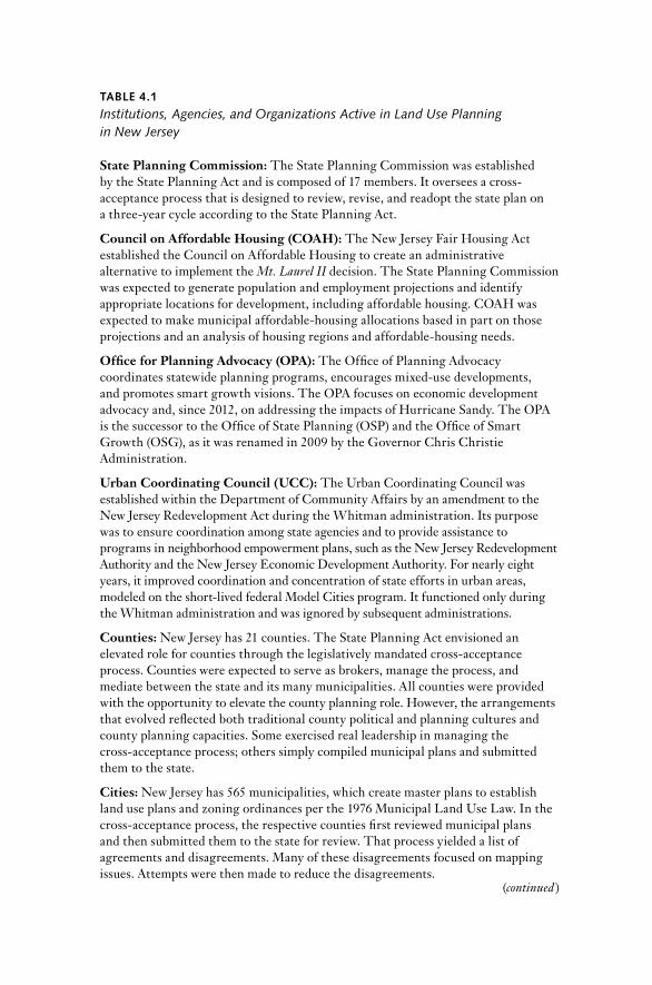
TABle 4.1
Institutions, Agencies, and Organizations Active in Land Use Planning in New Jersey
State Planning Commission: The State Planning commission was established by the State Planning Act and is composed of 17 members. It oversees a cross- acceptance pro cess that is designed to review, revise, and readopt the state plan on a three- year cycle according to the State Planning Act.
Council on Affordable Housing (COAH): The new Jersey Fair Housing Act established the council on Affordable Housing to create an administrative alternative to implement the Mt. Laurel II decision. The State Planning commission was expected to generate population and employment projections and identify appropriate locations for development, including affordable housing. cOAH was expected to make municipal affordable- housing allocations based in part on those projections and an analy sis of housing regions and affordable- housing needs.
Office for Planning Advocacy (OPA): The Office of Planning Advocacy coordinates statewide planning programs, encourages mixed- use developments, and promotes smart growth visions. The OPA focuses on economic development advocacy and, since 2012, on addressing the impacts of Hurricane Sandy. The OPA is the successor to the Office of State Planning (OSP) and the Office of Smart Growth (OSG), as it was renamed in 2009 by the Governor chris christie Administration.
Urban Coordinating Council (UCC): The Urban coordinating council was established within the department of community Affairs by an amendment to the new Jersey redevelopment Act during the Whitman administration. Its purpose was to ensure coordination among state agencies and to provide assistance to programs in neighborhood empowerment plans, such as the new Jersey redevelopment Authority and the new Jersey Economic development Authority. For nearly eight years, it improved coordination and concentration of state efforts in urban areas, modeled on the short- lived federal Model cities program. It functioned only during the Whitman administration and was ignored by subsequent administrations.
Counties: new Jersey has 21 counties. The State Planning Act envisioned an elevated role for counties through the legislatively mandated cross- acceptance pro cess. counties were expected to serve as brokers, manage the pro cess, and mediate between the state and its many municipalities. All counties were provided with the opportunity to elevate the county planning role. However, the arrangements that evolved reflected both traditional county po liti cal and planning cultures and county planning capacities. Some exercised real leadership in managing the cross- acceptance pro cess; others simply compiled municipal plans and submitted them to the state.
Cities: new Jersey has 565 municipalities, which create master plans to establish land use plans and zoning ordinances per the 1976 Municipal Land Use Law. In the cross- acceptance pro cess, the respective counties first reviewed municipal plans and then submitted them to the state for review. That pro cess yielded a list of agreements and disagreements. Many of these disagreements focused on mapping issues. Attempts were then made to reduce the disagreements.
(continued )

140 / MArTIn A. BIErBAUM
Housing (cOAH) in 1985, just before the passage of the State Planning Act, housing advocates concentrated their energies more on the new fo-rum and put distance between themselves and the state plan. An early attempt was made to coordinate cOAH and State Planning commission activities through a much- hailed memorandum of understanding. Over time, interest in cooperation waned and was even forgotten. A former cOAH director could not recall any time at which cOAH and state plan policies and activities were ever aligned (Vandenberg interview 2011).
new Jersey environmental advocates, from their vantage point, would gradually groan, even as activists for affordable housing came to view them as the less worthy victors in the battle brewing between competing goods— affordable housing and environmental protection. Why did the new Jersey environmental movement distance itself from the state plan? “Environ-mental advocates did not move away so much as they were never there” was the assessment of one of the state’s leading environmental spokeswomen and a former state plan commissioner (Ashmun interview 2012). The envi-ronmental community typically paid less attention to land use. The state plan included too much about real estate and economic development to interest them seriously. Some simply rejected any growth. Others found that more prescriptive government regulation, while not entirely satisfying, better served their needs. Large- lot zoning became an easy means to pro-tect the environment, even though it encouraged sprawl.
Furthermore, whereas clean water and clean air programs had federal backing and benefited from the full force and effect of state rule- making powers, the state plan came to this contest as a constrained contrivance.
TABle 4.1 (continued )
Interest Groups: Interest groups that are active in land use politics in new Jersey include new Jersey Future, Plan Smart, the new Jersey Farm Bureau, the new Jersey Builders Association, and the new Jersey League of Municipalities. Important environmental groups include the new Jersey Environmental Federation, the Association of new Jersey Environmental commissions, the new Jersey conservation Foundation, the American Littoral Society, Audubon of new Jersey, and the Sierra club. Other planning groups include the APA– new Jersey chapter and the new Jersey Planning Officials, which represents citizen planners sitting on planning boards and zoning boards of adjustment throughout the state. Other business groups include the new Jersey Business and Industry Association, the new Jersey chamber of commerce, and the national Association of Industrial Office Parks– new Jersey chapter. county planning directors were extensively involved through the county Planning directors Association; the new Jersey Association of counties was active to a lesser extent.
nEW JErSEY STATE PLAnnInG ExPErIEncE / 141
It was entirely a state government initiative and lacked federal legitimacy. By design, its policy recommendations were only advisory. “In the State Planning Act, nothing was required— there was no ‘must do’ ” (Ashmun interview 2012). Its niche would have to be more precisely defined.5
In contrast, state planners, some of whom approached their work with missionary- like zeal, could not understand how anyone could disagree with what they were proposing. After all, sprawl was the result of either un-planned or poorly planned land use decision making. Who could argue in favor of the obvious aesthetic assaults created by these formless agglom-erations that respected neither the land nor its people, but rather seemed to be driven by an irrational automobile de pen dency? To state planners, well- designed, compact, mixed- use, walkable communities with a range of housing types at different prices and with built-in environmental ame-nities were unquestionably preferable to the disconnected designs and social isolation wrought by subdivisions and strip malls. Furthermore, an argument could be made for state intervention in land use decision mak-ing to curtail local corruption. The public perception of widespread po-liti cal corruption in new Jersey was harmful. In 2003, a poll showed that 77 percent of new Jersey residents believed that the state had “a lot” or “some” po liti cal corruption, while only 15 percent said that there was “only a little” or “none” (Gale 2006, 118). State officials were aware of this situ-ation. There was a sense that public corruption grew from a system in which there were simply too many jurisdictions, too many public officials, and inadequate media coverage (richman and Paul interview 2010).
Only gradually did state planners come to grips with the fact that a set-tlement pattern is the physical manifestation of an under lying culture, a reflection of accustomed behaviors and established benefit streams. cul-tures raise questions about the ways in which resources are applied to goals: “knowledge, power, money, talent, trust, and others— necessary to achieve the objectives” (Wildavsky 1987, 42). In the absence of challenges to the under lying culture, existing development patterns would remain, for the most part, business as usual.
5 One academic observer of this scene forecast the way environmentally minded suburbanites might react to a state plan, although he was writing after Mt. Laurel I and before Mt. Laurel II or the enactment of the State Planning Act. He expected that “to maintain the quality of life for residents of the par tic u lar suburban community, the powers of local governments over land use and housing have been widely employed to prevent outsiders from sharing the local environ-ment with those who already live there. As in the case of the local property tax, ecological con-cerns tend to be mixed with other exclusionary motivations as the typical suburb seeks to maxi-mize internal benefits.” He also predicted that “increasingly, suburban officials are confronted by aroused constituents who want their local government to find a means of shielding them from change” (danielson 1976, 49).

142 / MArTIn A. BIErBAUM
The New Jersey State Planning Act
despite sitting governor Tom Kean’s initially strong negative reaction to Mt. Laurel II, W. cary Edwards, the governor’s special counsel and sub-sequently his attorney general, signaled that the governor would entertain a state planning bill if it remained relatively noncontroversial. The State Plan Ad Hoc committee was established in the summer of 1983 to test the potential for building a co ali tion in support of a state planning act.
Planners, once they were pulled into this pro cess through the enact-ment of the State Planning Act, found that the new Jersey Supreme court’s thinking about exclusionary zoning was too confining. The court’s main concern was to expand the definition of the general welfare to prohibit ways in which suburban municipalities used their delegated zoning powers to restrict low- and moderate- income housing opportunities. The state plan was expected to provide the numbers: population, employment, and housing projections and preferred locations based on sound housing prin-ciples. Under the new Jersey Fair Housing Act, cOAH would coordinate its activities with the State Planning commission to ensure that munici-palities created the required affordable housing opportunities to meet their respective regional fair- share obligations (Shostack interview 2011).6 The planners had a wider vision supported by more ambitious goals.
In discussing the ways to develop a state plan, the Ad Hoc committee made an early determination that it was important to gain the support of the League of Municipalities. Eventually, that committee agreed on a unique pro cess, dubbed “cross- acceptance,” to enlist the league’s support (Hamill interview 2010). The pro cess was ultimately written into the State Planning Act (1986). The cross- acceptance pro cess was a means to ensure that local jurisdictions would be active participants in the planning pro-cess. It involved comparing and contrasting local plans with a preliminary draft of the state plan.
Within the state legislature, Senator Gerald r. Stockman, a demo crat from Mercer county, whose constituents hailed from both Prince ton’s well- groomed neighborhoods and Trenton’s gritty streets, sponsored the
6 The Kean administration played an important role in getting the bill drafted and enacted. At the same time, the administration labored on the Fair Housing Act (n.J.S.A.52:27d-301 et seq.), attempting to design both bills to work in tandem as a response to the new Jersey Supreme court’s Mt. Laurel II decision. The notion understood, at least by professional planners and some developers, was that if the State Planning commission adopted meaningful population and employment projections tied to its policy map, then the cOAH would drive the “amount and look of the resulting development.” cOAH would be the implementation agent of the state plan. The State Planning Act did not address the question of implementation directly. Some may have believed it unnecessary because it was paired with the Fair Housing Act (rahen-kamp email 2012); others viewed the lack of attention to implementation as a flaw in the State Planning Act.

nEW JErSEY STATE PLAnnInG ExPErIEncE / 143
committee’s draft bill. His district mirrored new Jersey’s uneven devel-opment and polarization, which he tried to bridge. Stockman, who had grown up in Trenton, insisted that redevelopment be included in the act’s title to ensure the prominence of urban issues. He enlisted the assistance of state legislators from around the state to gain the support required for its passage (Stockman interview 2011).
Governor Kean signed the bill into law in January 1986 after it passed through the state legislature with only mild re sis tance. The law became effective immediately. The Fair Housing Act had been enacted six months earlier. Together, the laws were expected to create an administered ap-proach to allocate low- and moderate- income housing to municipalities on the basis of a standard of regional fair share. The pairing created an escape or safety valve for municipalities to avoid the more onerous judi-cial remedy imposed on them by Mt. Laurel II.7
The state legislature was faced with a dilemma to which it was expected to respond. The new Jersey Supreme court Mt. Laurel decision pointed to the harsh realities of new Jersey’s planning and zoning practices and required an expansion of the state’s land use role as an antidote. Yet, the state legislature was reluctant to undermine traditional local land use pre-rogatives (new Jersey State Planning Act 1986, n.J.S.A. 52:18A-196[e]; rose 1988). The cross- acceptance pro cess was a result of this legisla-tive dance, a cooperative planning pro cess that encouraged substantial local contributions, guaranteed to soften the impact of any state gov-ernment plan.
Beyond this pro cess, in further concessions to municipalities, the state legislature limited any changes to the Municipal Land Use Law (n.J.S.A. 40:55d-1 et seq.; rose 1988) enacted a de cade earlier. That law required local jurisdictions to adopt municipal master plans. Zoning ordinances had to be consistent with land use and housing elements of those plans. However, notably, the state legislature avoided mandating consistency be-tween municipal plans and the state plan (rose 1988).8 Instead, the State Planning Act focused on state government action. It established a State Planning commission, prescribed its membership, defined its scope, and
7 The legislative findings in the State Planning Act made no mention of Mt. Laurel I or Mt. Laurel II. Instead, the State Planning Act declared that the state needed sound and integrated statewide planning and the coordination of statewide planning with local and regional planning; it also emphasized the importance of responding to judicial mandates with res pect to low- and moderate- income housing in ways that would require sound planning and prevent sprawl (new Jersey State Planning Act, n.J.S.A. 52:18A-196[a]; rose 1988). The state legislature’s findings provided that statewide planning was essential to conserve natural resources, to revitalize new Jersey’s urban centers, to protect the quality of its environment, and to provide needed housing and public ser vices while promoting economic growth (n.J.S.A. 52:18A-196[h]; rose 1988).
8 Just as important, the state legislature in the Fair Housing Act did not require that municipal housing elements be consistent with cOAH regional fair- share housing allocations.

144 / MArTIn A. BIErBAUM
assigned it tasks that included the preparation, adoption, review, revision, and readoption of the state plan on a three- year cycle through the cross- acceptance pro cess.9
The establishment of the 17- member State Planning commission, which included members of the governor’s cabinet, representatives of county and municipal governments, and six public members, represented a major policy decision that elevated the state planning function far be-yond what had formerly existed.10 The administration retained significant influence in light of the representatives of the governor’s cabinet on the State Planning commission and the fact that the state planning director and his staff were to be part of the department of Trea sury,11 reporting to the state trea surer.
Framing the Issue
In policy making, framing the issue is as important to the pro cess as the search for solutions. State planning is not just or mainly a technical exer-cise. There is no simple re cipe. “Before we can consider options and choices, we must have a decent sense of what is at stake, . . . to whom and to what do we need to pay attention” (Forester 1999, 40). Yet, “We do our-selves a great disser vice if we think about planning and design delibera-tions as mere ‘pro cess,’ periods of potentially distracting and draining ‘talk,’ a necessary evil accompanying the ‘real work’ of planning and de-sign” (Forester 1999, 63). “When a practitioner sets a problem, he chooses and names the things he will notice” (Schon 1987, 4). The problem framed in this way is not foreordained. Instead, “depending on our disciplinary backgrounds, or gan i za tional roles, past histories, interests, and po liti cal/
9 An issue from the beginning was that the cross- acceptance pro cess was too restrictive in that it did not permit an adequately robust role for the private sector. This view was advanced by the development community, which was especially suspicious of the municipal role because it viewed municipalities as the major issue of concern from the Mt. Laurel II perspective (rahenkamp in-terview 2011).
10 curiously, the State Planning commission and its staff were preoccupied with the develop-ment of the State development and redevelopment Plan and managing the cross- acceptance pro cess. They paid relatively little attention to other more general planning functions, includ-ing ways in which a state planning office might provide planning- related research, planning, or ancillary ser vices to other state departments and agencies or build planning capacity with res-pect to local jurisdictions or the public at large.
11 The department of Trea sury was likely selected because of the trea sur er’s interest in growth management at the time of enactment. The location was also viewed as an advantage in that placing it within any of the state government’s functional departments would put the State Plan-ning commission at a disadvantage vis- à- vis other functional departments. The State Planning commission was intended to sit above those functional departments. This situation later be-came a problem when the State Planning commission was moved from the department of Trea sury to the department of community Affairs during the Whitman administration.
nEW JErSEY STATE PLAnnInG ExPErIEncE / 145
economic perspectives, we frame problematic situations in different ways” (Schon 1987, 4).
At the outset, the State Planning commission had to draw boundaries around the problem it wished to address. It identified the substantive con-cerns to which it would pay more or less attention. At first, it was guided by the State Planning Act’s legislatively established goals and by the new Jersey Supreme court’s affordable- housing mandate, but subsequently, it was guided by the commission’s deliberations as informed by pre sen ta tions made to it by state departments, local jurisdictions, and interested parties, supple-mented by Office of State Planning (OSP) staff. However, as it became obvi-ous that the state plan was going to be about much more than the new Jersey Supreme court had envisioned, housing advocates became wary (Bisgaier interview 2012). The State Planning commission’s imagination stretched far beyond affordable housing. It considered ways to preserve natural re-sources and to protect the environment. Planning for economic develop-ment, capital facilities, highway access, and farmland preservation also fell within its ken. Even a quick reading of the State Planning Act made it clear that the act provided an expansive vision structured by eight legislative goals.
rather than digging deeply, the State Planning commission was in-tended to operate on the edges of these policy fields. The commission was a forum created to strike an appropriate balance among these competing concerns. “It has to be a place where common sense can enter the pro cess and prevail” (Zellner interview 2012). The nature of its reforms would be tied to its ability to transcend parochial interests in pursuit of a more broadly defined public interest. In trying to strike that balance, the state plan beamed a light on sprawl even before the concepts of smart growth and new urbanism became part of the planning vernacular.
Sprawl was never precisely defined, but it played out on the state’s land-scape in practical ways, producing benefits for some and generating costs for others. connections between cause and effect were often subtle and obscure. The expense was only occasionally calculated. combating sprawl was distinguishable from cleaning water or air. reducing sprawl raised questions about whether the state could effectively plan and manage new Jersey’s rapidly changing landscape.
Traffic congestion was sprawl’s most conspicuous consequence in this heavily traveled corridor state. Working house holds typically “drive until they qualify,” mirroring multiplying mismatches between employment and affordable- housing locations that add to the vehicle miles traveled each day. Its effects also included urban disinvestment, threats to water resources and wildlife, and the disappearance of woodlands and farms. The future promised a polarized polity. congestion underscored the prominence of the entangled connections between municipal finance and land use decision

146 / MArTIn A. BIErBAUM
making— the “ratables chase” for short. State planners wondered how these strands might be rearranged into a fabric that made more sense.12
As the 20th century drew to a close, the State Planning commission found itself in an uncomfortable position. It questioned the sustainability of the American suburban dream in overwhelmingly suburban new Jersey. demographic and employment projections and rising energy costs pro-pelled the inquiry. The State Planning commission was at the forefront, posing profound questions about where new Jersey was headed.13
despite the decision to frame the issue in this way, combating sprawl was not an easy sell. Sprawl was difficult to define. cause- and- effect rela-tionships were unclear or contradicted by what passed for common sense. If highways were congested, why not simply widen them? If managing storm water was a problem, why not just zone for low density? The sprawl issue also fell to what social scientists sometimes label as wicked problems, those social ills that are not easily amenable to solution.14
One early prognosticator questioned the prospects for a successful state planning experience. He urged that expectations be lowered and warned that “success will continue to be elusive until the system of municipal finance is reformed and until the princi ple of home rule is subordinated to the general welfare of new Jersey residents” (rose 1988, 170). He ex-pected that a state plan erected on a flawed foundation would inevitably disappoint.
These obstacles were not lost on State Planning commission members, but what they could do was limited. candace Ashmun recalled that once Governor Kean admonished the commission early in the pro cess that the state plan should avoid any mention of property taxes, commissioners knew that the “State Plan was painted into a box” (Ashmun interview 2012). Fur-
12 In addition to the judicial decisions that touched on these issues, the new Jersey state legis-lature authorized the convening of the new Jersey State and Local Expenditure and revenue Policy commission (the SLErP commission) in 1985. It conducted hearings and issued re-ports, completing its work just as the State Planning commission’s efforts were commencing. The SLErP commission pointed to a fundamental imbalance in the state’s fiscal system, which relied too heavily on local governments to provide ser vices but failed to provide sufficient reve-nues for those governments. It also found that the tax system burdened those new Jersey resi-dents who were least able to pay. The state legislature did not receive the report enthusiastically. The Kean administration drew a distinction between state plan efforts and the SLErP com-mission recommendations.
13 For a general survey of states exploring sprawl issues and smart growth, see Flint (2006). Flint fails to accord new Jersey its prominent place as a pioneer in identifying and addressing these issues in the 1980s.
14 Wicked problems have no stopping rule, ultimate test, or solution. They raise profound so-cial values issues. They never quite go away; instead, they are more likely displaced. “Once the patient’s temperature has been lowered by incomplete treatment, attention is diverted and an-other problem surfaces in its place” (Friedmann 1987, 218). race and economic class integration and thorny public finance issues are wicked problems. changing suburban land use patterns and combating sprawl would likely prove indistinguishable from these problems.
nEW JErSEY STATE PLAnnInG ExPErIEncE / 147
thermore, by the time the State Planning Act was enacted, the state con-text of planning had already changed. The new Jersey state legislature had previously enacted legislation in piecemeal fashion that would overlap and infringe on state planning as it was beginning to take shape (rose 1988). Legislation had carved out substantial public policy areas that would in-evitably affect state planning, but it had circumscribed the State Planning commission’s authority by statutorily empowering other state depart-ments, agencies, and regional jurisdictions.15 The state plan was expected to coordinate, integrate, and align its activities with others. However, there seemed to be no corresponding reciprocal expectation written into these previously enacted laws. How would cooperation and collaboration be assured?
With res pect to local jurisdictions, they did not just spout home- rule rhe toric. They faced real fiscal concerns. To local officials, the state plan looked like one more unfunded mandate imposed by state government. Local public officials predictably pushed back. Operating on government’s front lines, municipalities often serve as government’s retail operation. Local jurisdictions get to see and hear from their customers. “Too often municipalities lack the resources to absorb all the costs that they are ex-pected to absorb” (rahenkamp interview 2011). Local public officials readily viewed the state plan as raising costs without providing offsetting revenues (rahenkamp interview 2011).16
In light of these circumstances, for the state plan to gain attention, state planners would have to elbow their way onto this already crowded stage. To secure their place, they would have to become more familiar with pre-existing statutes, rules, policies, procedures, and other cultural artifacts
15 Among the growing list of statutory authorities that would fall beyond the direct influence of the State Planning commission were the following: the new Jersey Municipal Land Use Law (n.J.S.A. 40:55d-1 et seq.); the new Jersey county Planning Act (n.J.S.A. 40:27-1 et seq.); the new Jersey Freshwater Wetlands Protection Act (n.J.S.A.13:9b et seq.); the Water Pollution control Act (n.J.S.A.58:11A-1 et seq.); the new Jersey Water Quality Planning Act (n.J.S.A. 58:11A-1 et seq.); the new Jersey Flood Hazard Area control Act (n.J.S.A.58:16A–50); the new Jersey Solid Waste Management Act (n.J.S.A. 13:1E-1 et seq.); the Hackensack Meadowlands development Act (n.J.S.A. 13:17-1 et seq.); the new Jersey coastal Area Facilities review Act (n.J.S.A.13:19-1 et seq.); and the new Jersey Pinelands Protection Act (n.J.S.A.13:18A-1 et seq.). Beyond environmental concerns, the legislature enacted the new Jersey Agriculture retention and Preservation Act (n.J.S.A. 4:1c et seq.) with res pect to farmland preservation programs and the new Jersey Highway Access Management Act (n.J.S.A. 27:1A-1 et seq.) to manage state highway access. The presumption was that the State Planning commission would provide a forum to coordinate these proliferating statutory authorities. However, there was no onus placed on the agencies established under these wide- ranging acts to coordinate their activi-ties. These multiple initiatives resulted in what was referred to as the state’s “creeping incremen-tal” approach to state and regional planning (rose 1988, 157).
16 When state planners met with county planning directors at monthly meetings, they were regularly peppered with questions about when state departments would get their own houses in order. Illustrations were usually provided of state departments operating at cross- purposes. Other public forums and information sessions also created opportunities for these attacks.

148 / MArTIn A. BIErBAUM
that were bound to constrain them. State planning emerged as a more ten-tative undertaking. State planners had to learn on the job about what al-ready cluttered their terrain while simultaneously marketing their novel planning ideas to local politicians who were less than enthusiastic. rather than working on a clean canvas, they were learning new skills and incor-porating volumes of new information. State planners had less time to de-vote to their bold new vision; instead, they had to shift gears to concen-trate on what they had formerly considered unwanted distractions. They had to learn about and reconcile all the edges. The challenge was to be more practical without reverting to being entirely piecemeal.17
The New Jersey State Plan’s Vision, Goals, and Policies
The new Jersey State Plan eventually emanated from a lengthy new Jer-sey state planning history that reached back at least to the expansive growth in the 1920s. State planning gained momentum during the new deal with federal support, only to be disrupted during World War II and the im-mediate postwar period ( table 4.2). State and regional planning gradually regained traction in the late 1960s and early 1970s, a period of consider-able social urban unrest in new Jersey. The new Jersey department of community Affairs (dcA), established in 1966, with its division of State and regional Planning, was instrumental in these efforts.18 The state plan built on and reinforced the general direction previously provided by the State Development Guide Plan, which the division of State and regional Planning had devised to serve other purposes. The State Development Guide Plan had been cited in the Mt. Laurel II decision as a basis for regional affordable housing needs.
Yet, before the new Jersey State Plan’s first final version was adopted in June 1992, it passed through four iterations. The first, released in April 1987, was a rudimentary working paper that was criticized for being too environmentally oriented. There were loud outcries from developers and large landowners who were incensed by the accompanying State Plan Pol-icy Map, which was covered with large splashes of green indicating agri-cultural and environmentally sensitive areas. Their ire concentrated on a
17 Planning academics have described this approach as “bricolage,” with the planners serving as “bricoleurs.” The work begins with no clear end in sight. Instead, the bricoleur works with a heterogeneous store of materials and tools that are collected over time, often without specific purpose, a veritable garbage can of tools and materials. The goals become clear only through pro cess engagement. Planners learn to piece things together to devise a new strategy based on their collective repertoire (Innis and Booher 2010). In this way, planners work more like restor-ers of fine paintings than artists who work on clean canvases painting fine masterpieces.
18 For a more thorough history of the new Jersey State Plan, see Bierbaum (2007) and Bier-baum and nowicki (1991).

TABle 4.2
Milestones in New Jersey Land Use Planning
1917 The new Jersey State Home rule Act is enacted. It provides for municipalities to have “fullest and most complete powers” for self- governance.
1934 Governor A. Harry Moore establishes the new Jersey State Planning Board. It develops state plans and planning studies and focuses on parks, public lands, water supply, sewage disposal, transportation, and utility ser vices (federally funded).
1947 The new state constitution provides for the delegation of the state’s zoning power to municipalities and a new state government department structure.
1948 The new Jersey State Planning Board is incorporated as part of the new Jersey department of conservation and Economic development as a result of the reorganization of State government.
1951 The new Jersey State Plan is developed to guide postwar development. recommendations include construction of the Garden State Parkway, the new Jersey Turnpike, and the round Valley reservoir; the acquisition of the Wharton and Worthington Tracts; and the acquisition and development of Island Beach State Park.
1955 State planning is elevated to a section within the new Jersey department of conservation and Economic development.
1956 The Bureau of State Planning launches a number of studies, such as the Meadowlands development Study, the Pinelands region Study, and the newark Area Transportation Study, all with regional planning implications.
1960 The Bureau of State Planning receives a federal grant to devise a “horizon plan” that sets 2000 as a horizon year with an anticipated population projection of 20 million, subsequently reduced to 10 million. The Bureau of State Planning also promulgates a report urging that the state bond for land acquisitions.
1961 The State Planning Bureau is expanded and elevated to become the division of State and regional Planning within the new Jersey department of conservation and Economic development; it launches a number of regional planning initiatives.
1964 new Jersey passes the Farmland Assessment Act of 1964 to mitigate the loss of farmland to rapid suburban development through the use of favorable tax assessments.
1964–1970 new Jersey experiences urban social unrest (Elizabeth, Paterson, and Jersey city, 1964; newark and Plainfield, 1967; Passaic, 1969; Asbury Park, 1970).
1965 The State Planning Bureau helps create a statewide guide for open- space acquisition and preservation. The Tri- State Transportation committee is established through a multistate compact to improve transportation in the new York metropolitan region.
(continued )

TABle 4.2 (continued )
1966 The new Jersey department of community Affairs is established to centralize all functions of state government pertaining to local jurisdictions, including a state planning function. The delaware Valley regional Planning commission is established through tristate agreement.
1969 The legislature establishes the Hackensack Meadowlands development commission. The commission continues to serve as a regional planning, zoning, and regulatory body charged with reclaiming the Hackensack Meadowlands and reconciling economic development, environmental protection, and solid waste disposal. It also has tax sharing capacity.
1970 The new Jersey department of Environmental Protection is established.
1972 Governor William T. cahill establishes by executive order the State Planning Task Force, prepares a report recommending the establishment of a state planning commission.
1973 The coastal Area Facility review Act is enacted in response to the 1972 passage of the federal coastal Zone Management Act. new Jersey begins to develop its new Jersey coastal Management Program to address the complex coastal ecosystem.
1975 The new Jersey Supreme court decides the Mount Laurel I case, which establishes a municipal obligation to provide an opportunity for low- and moderate- income housing based on an assessment of regional housing need.
1976 The new Jersey Municipal Land Use Law (MLUL) is enacted, which preserves local zoning and planning prerogatives.
1977 The state legislature approves casino gambling in Atlantic city, which is expected to accelerate development pressure on the new Jersey Pinelands region.
1978 The U.S. department of Housing and Urban development approves the State development Guide Plan, which recognizes new Jersey’s statewide land use ele ment as a guide to allocate federal funding. The U.S. congress enacts legislation establishing the new Jersey Pinelands national Preserve and approves the new Jersey coastal Zone Management Program.
1979 The new Jersey Pinelands Protection Act is enacted, establishing the Pinelands commission to develop and implement a comprehensive management plan with jurisdiction over 22% of the state’s land area.
1981 The new Jersey Agriculture retention and development Act is enacted, which allows the state to purchase farmland and impose deed restrictions on lands that are purchased.
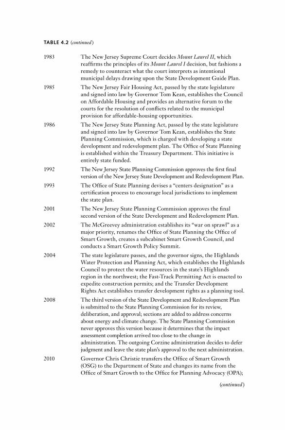
TABle 4.2 (continued )
1983 The new Jersey Supreme court decides Mount Laurel II, which reaffirms the principles of its Mount Laurel I decision, but fashions a remedy to counteract what the court interprets as intentional municipal delays drawing upon the State development Guide Plan.
1985 The new Jersey Fair Housing Act, passed by the state legislature and signed into law by Governor Tom Kean, establishes the council on Affordable Housing and provides an alternative forum to the courts for the resolution of conflicts related to the municipal provision for affordable- housing opportunities.
1986 The new Jersey State Planning Act, passed by the state legislature and signed into law by Governor Tom Kean, establishes the State Planning commission, which is charged with developing a state development and redevelopment plan. The Office of State Planning is established within the Trea sury department. This initiative is entirely state funded.
1992 The new Jersey State Planning commission approves the first final version of the new Jersey State development and redevelopment Plan.
1993 The Office of State Planning devises a “centers designation” as a certification pro cess to encourage local jurisdictions to implement the state plan.
2001 The new Jersey State Planning commission approves the final second version of the State development and redevelopment Plan.
2002 The McGreevey administration establishes its “war on sprawl” as a major priority, renames the Office of State Planning the Office of Smart Growth, creates a subcabinet Smart Growth council, and conducts a Smart Growth Policy Summit.
2004 The state legislature passes, and the governor signs, the Highlands Water Protection and Planning Act, which establishes the Highlands council to protect the water resources in the state’s Highlands region in the northwest; the Fast- Track Permitting Act is enacted to expedite construction permits; and the Transfer development rights Act establishes transfer development rights as a planning tool.
2008 The third version of the State development and redevelopment Plan is submitted to the State Planning commission for its review, deliberation, and approval; sections are added to address concerns about energy and climate change. The State Planning commission never approves this version because it determines that the impact assessment completion arrived too close to the change in administration. The out going corzine administration decides to defer judgment and leave the state plan’s approval to the next administration.
2010 Governor chris christie transfers the Office of Smart Growth (OSG) to the department of State and changes its name from the Office of Smart Growth to the Office for Planning Advocacy (OPA);
(continued )

152 / MArTIn A. BIErBAUM
provision in this version that called for only one dwelling unit per 20 acres of land in those regions.
The draft Preliminary State development and redevelopment Plan, which appeared nine months later, in January 1988, reflected additional mapping and substantial state department contributions. That itera-tion was reviewed by OSP staff, external con sul tants, and ultimately the State Plan commissioners. comments were incorporated from experts, not only from new Jersey, but throughout the country. To make the previous draft more acceptable, the 20- acre zoning requirement was softened and explained.
The Preliminary State Plan was released in January 1989 as a three- volume document.19 It was then subjected to a two- year cross- acceptance pro cess involving negotiations with 21 counties, the then 567 municipali-ties, countless professional planners, a host of concerned interests, and thousands of interested citizens who participated in public meetings or submitted written comments. Eventually, the State Planning commission produced an interim state plan that was to undergo an impact assessment, as required by legislative amendment to the State Planning Act (n.J.S.A. 52:18A-202.1- g, h, i). Its fundamental structure consisted of its vision state-ment, a set of statewide policies that read like a lengthy set of best man-agement practices, a resource management system consisting of planning areas and a centers hierarchy, the State Plan Policy Map, and the cross- acceptance pro cess through which the state plan had been developed. Un-fortunately from a policy perspective, during cross- acceptance, attention shifted from statewide policies to lines on the State Plan Policy Map, which became, in the eyes of many, synonymous with statewide zoning.
19 The first volume presented the rationale for the state plan, its conceptual framework, and its legislative mandates. Volume 2 consisted of 88 strategies and nearly 300 policies. Volume 3 in-cluded technical guidelines, technical reference abstracts, and a mapping protocol.
TABle 4.2 (continued )
develops and releases a new state strategic plan. The current administration decides to devise its own plan and announces an intention to be more focused and strategic, to rely on the prior cross- acceptance pro cess and not a new one, and to deemphasize the use of the State Plan Policy Map.
2012 A draft strategic plan is released but is withdrawn after a determination that the impact of Hurricane Sandy will necessarily alter state plan priorities. The Office of Planning Advocacy has promulgated no subsequent draft.

nEW JErSEY STATE PLAnnInG ExPErIEncE / 153
during the year in which academic experts scrutinized the interim plan, minor changes were made. Agriculture and urban revitalization policies were revised and added. The concept of capacity- based planning was introduced, along with community development boundaries. The State Planning commission also requested a staff implementation report to strengthen the state plan’s impact. When the impact assessment was com-pleted, it bolstered the state plan’s legitimacy by demonstrating that the state plan would yield the state savings when compared with the antici-pated trend scenario (Burchell 1991, 2000, 2008).20
The state plan, titled “communities of Place,” was an aspirational doc-ument. It encouraged a new settlement pattern as an antidote to sprawl, one that offered a sense of place. It also suggested a novel land develop-ment pro cess as an alternative to relying primarily on developer- driven proposals. Its hope was to capture the imaginations of new Jersey resi-dents, especially the numerous public officials who sat on local planning boards and governing bodies (new Jersey State Government 1992).
The state plan seemed especially relevant to the needs of a middle range of the state’s urban centers, more than a few of which were county seats.21 Pre– World War II suburbs with central business districts, mixed uses, af-fordable housing, and often rail connections could also easily identify as “communities of place.”22 In these small to midsized cities and towns, new Jersey residents could experience a newfound urbanity but avoid the rav-ages of new Jersey’s previous urban unrest associated with the state’s larg-est urban centers.
Just how the state plan would assist new Jersey’s neediest cities, where po liti cal leaders expressed less interest in the state plan, remained unclear. despite efforts to reach out to urban po liti cal leaders, they remained skepti-cal. African American po liti cal leaders feared the dilution of their power and of the influence of their constituents. They perceived only a small ad-vantage in a state plan that included a 20- year horizon. Their concerns were more immediate. Because the State Planning Act had omitted improve-ments for older urban areas with res pect to public safety and education, the state plan left such improvements largely unaddressed. The property tax
20 dr. robert Burchell and his teams at the center for Urban Policy research, Edward J. Bloustein School of Planning and Policy, rutgers University, were contracted to do three im-pact assessments on three different state plans in 1991, 2000, and 2008. Each study compared trend and plan scenarios with res pect to the legislatively required pa ram e ters provided by the amendment to the State Planning Act that called for an impact assessment. Burchell noted in each that the plan scenario had advantages over the trend scenario (Burchell 1991, 2000, 2008).
21 Examples include such municipalities as Flemington, Freehold Borough, Morristown, new Brunswick, Somerville, Salem, and Bridgeton.
22 Municipalities in this category included Long Branch, newton, red Bank, South Orange, and Westfield in northern new Jersey; Hopewell Borough in central new Jersey; and collingswood and Haddonfield in southwestern new Jersey.

154 / MArTIn A. BIErBAUM
issue was po liti cally compartmentalized and distanced as well. Communities of Place had little meaning to the most distressed urban areas.
nevertheless, the State Planning commission could take some satis-faction from a few urban success stories, although demonstrating direct causes and effects was not easy. For example, in newark, the state’s larg-est city, hints of a downtown revival began to appear with the construc-tion of the new Jersey Performing Arts center and renovations to nearby commercial office buildings (Tuttle 2009).
A more robust boost to the state’s urban fortunes was evidenced by sub-stantial reinvestment activity in Hudson county. That activity benefited from a strengthened Manhattan housing market overspill. In addition, large- scale land assembly where 19th- century railroads and ferry slips had once crowded the waterfront became possi ble, making redevelopment eco nom ically feasible. The installation of the Hudson- Bergen Light- rail Line by new Jersey Transit augmented these improvements. Hudson county had competent planning professionals who interfaced frequently with OSP staff to devise an effective urban redevelopment strategy (Heyer and Gruel 1989, 1999). Hudson county redevelopment served as the state planners’ riposte to skeptical developers who argued against the viability of a new Jersey urban market as envisioned by the state plan at the time.
The state plan urged an overhaul of the planning pro cess by calling on municipalities to enunciate an affirmative vision to which developers might respond. From the State Planning commission’s perspective, the devel-opment pro cess had become too reactive and adversarial. developers were too frequently told what they could not do, rather than being provided with meaningful guidance. Public values and regional concerns were subordi-nated or ignored as municipalities relied on reactions to developer pro-posals and limited their concerns to what transpired within their own mu-nicipal boundaries.
At the time, the State Planning commission’s approval of the state plan in 1992 seemed like a remarkable achievement. It was distinguishable from previous state planning efforts in important ways. It was neither federally driven nor federally funded; instead, it underscored the state government’s ascendancy. This effort was no longer pro ject oriented. It emphasized a highly interactive pro cess that in interest ing ways paralleled the lessons of private sector strategic planning.
The pro cess for creating the state plan tied together two valuable data streams—an infrastructure needs assessment and a cross- acceptance process— and linked them to a single deliverable, the state plan. The pro-cess elevated the county planning function and enhanced its potential for regional planning. Horizontal and vertical coordination, integration, and alignment of plans across government departments and among the levels

nEW JErSEY STATE PLAnnInG ExPErIEncE / 155
of government were encouraged. Finally, a continuous planning pro cess seemed to be anticipated by requiring in de pen dent evaluation through an impact assessment that compared trend and plan scenarios. In these ways, the state plan reflected the complexity and expanded scope of state gov-ernment; the novel concerns it was expected to address in the future; and the technical sophistication required to comprehend and manage contem-porary state planning issues (Bierbaum and nowicki 1991).23
Politics of New Jersey’s State Plan
despite the enactment of the State Planning Act, the efforts of the State Planning commission, and the adoption of the state plan in 1992, new Jersey’s politics largely remained unreceptive to the plan. The failure of successive new Jersey governors to embrace the plan, as well as the fail-ure of the State Planning commission to devise an effective po liti cal strat-egy in light of disappointing gubernatorial support over time, proved to be a major stumbling block that undermined the state plan’s effectiveness. As one state planning director asserted, “Planning does not create the mes-sage, politics does” (Zellner interview 2012).
The State Planning commission never developed a relationship with the state legislature or adequate support from state legislators, who ques-tioned its value. A state plan with explicit goals, established priorities, and strategies to achieve them seemed antithetical to legislative culture. In ad-dition, local governments appeared increasingly to believe that the state plan, rather than leading to benefits for local jurisdictions, was adding ex-pense.24 This belief was reinforced as state plan pro cesses became more onerous, and as state departments insufficiently realigned their respective programs to provide the incentives and disincentives that were supposed to be designed to change local- jurisdiction behaviors.
State planning is po liti cal, but it is distinguishable from pure politics. Planning, unlike politics, relies more heavily on building and working from a firm knowledge base, framing issues, establishing explicit priorities,
23 curiously, observers of this planning scene had outlined a plan development framework 15 years earlier. The problem was framed a bit differently, but the plan development outline was essentially the same as the one followed by the State Planning commission without explicit reference to this framework. However, the recommended framework hardly conveys the degree of difficulty or the po liti cal distractions that were encountered in trying to achieve it. The prob-lem was a fragmented, disjointed municipal planning pro cess that promised only suboptimal results. The proposed solution to remedy the situation was one that would introduce and apply state standards to be administered by local authorities, but subject to state audit and supervision (Levin, rose, and Slavet 1974).
24 One planning con sul tant cited the example of Plainsboro, new Jersey. The municipality assi-duously adhered to the principles of the state plan, but it still took two years and considerable muni-cipal expense to obtain the State Planning commission’s endorsement (caton interview 2010).

156 / MArTIn A. BIErBAUM
and devising a range of solutions to address the problems framed. Plan-ning is about using knowledge to inform public decision making and about building consensus on a set of fundamental principles from that knowl-edge base. Politics is more about preferences, positions, and values and less about a sound empirical base, carefully framed problems, and deliberately crafted solutions. Instead of offering a single solution, politics is about searching for compromise, cajoling the battling factions, and reconciling conflicting preferences (Wildavsky 1987).
How did the changing politics and policy preferences of eight different governors over a 25- year period affect the new Jersey State Plan? Gover-nor Tom Kean first expressed outrage at what he felt was judicial infringe-ment of executive or municipal prerogatives. He eventually reversed course, lent cautious support to the state planning idea, and signed the State Planning Act into law. Each succeeding administration has had its own spin, paying more or less attention to the state plan and usually pos-ing different planning priorities to distinguish itself from its pre de ces sors. Meanwhile, lacking an effective po liti cal strategy, state plan advocates have had to adjust to the fact that with only brief exceptions, state plan goals have been largely trimmed and transformed by each succeeding administration.
chris christie, new Jersey’s current governor, is no different. He has taken a dim view of earlier state planning efforts. On public occasions, his lieutenant governor, who is now in charge of the Office of Planning Advo-cacy (OPA), heir to the former OSP, has been outspoken in her criticism of the state plan. As an alternative to earlier iterations, the current adminis-tration has proposed a new draft plan that is less comprehensive than previ-ous efforts. The current draft focuses on state, not municipal, activities; steers away from the State Plan Policy Map; and eliminates the cross- acceptance pro cess. Because the governor’s base is closely tied to suburban voters, and he is cultivating support among municipalities, there is no lon-ger talk about exclusionary zoning or affordable- housing opportunities. Governor christie based his reelection campaign for his second term in part on the importance of addressing storm damage caused by Hurricane Sandy’s impact on the Jersey shore in October 2012. The OPA staff played a role in that regard, but the state plan was sidelined once again. This situ-ation is not entirely unexpected. Frequently, when planning fails to secure its purposes adequately, either because of po liti cal or administrative dis-continuities or because of the inherent nature of the problems faced, those in charge try to remain relevant by adapting to the changing situation.25
25 Wildavsky (1987) pointed to this tendency. Yet, the more planning accommodates to poli-tics by shortening its time horizons, reducing the need for prediction, limiting coercive mea-

nEW JErSEY STATE PLAnnInG ExPErIEncE / 157
Florio’s late Arrival
The first state plan was approved in June 1992 during the administration of James Florio (1990–1994), who inherited the state plan from his pre-deces sor, Tom Kean (1982–1990). Florio was less concerned about affordable housing and suburban zoning or the state plan per se. His administration was preoccupied with school reform and distracted throughout by bud-getary issues and a tax revolt. These issues fell beyond the purview of the state plan.
near the conclusion of Florio’s first and only term, the governor issued Executive Order 114, which called on state departments to consider the state plan in adopting their policies, regulations, and functional plans and facilitated the implementation of state plan centers and planning areas. This move, however, seemed little more than an empty gesture because it came just a week before the governor was to leave office. Florio was de-feated by christine Todd Whitman in november 1993 and was hardly in a position to order the implementation of anything, much less a complex and potentially controversial state plan.
nevertheless, an extended staff- driven discussion with the State Planning commission evolved during the last year of the Florio administration. From that discussion, a pro cess emerged that called for “centers’ designa-tion” as a way to implement the state plan. The rules were adopted, and a procedure was established (State Plan rules nJAc:17:32). The OSP en-couraged municipalities to delineate centers that the state would assist in directing future growth. The OSP would provide technical assistance and enlist support from relevant state departments. Two municipalities were pursued initially. Others soon followed (dallessio interviews 2003, 2012).
The lines drawn around centers as part of this designation pro cess were soft.26 center designation was a certification pro cess that included an ini-tial review by OSP staff and further scrutiny by the Plan Implementation committee (PIc), a subcommittee of the State Planning commission. The State Planning commission usually ratified PIc recommendations. The value of this pro cess was that it provided the impetus for dialogue
sures, providing attractive incentives, or exploring different scenarios, the less planning remains distinguishable from public policies achieved through other means. rather than serving to bet-ter inform decision making, planning may default to less thoughtful and comprehensive policy- making modes. Under these circumstances, state planning can be expected to become less vi-sionary and more pro ject oriented, confining itself to more manageable categories. Economic development or shore restoration are simpler than attempting to do research or make the inter-disciplinary, multilevel leaps to solve problems in more penetrating ways (Wildavsky 1987).
26 According to the OSP director, there was insufficient po liti cal support to delineate more mean-ingful urban growth boundaries with real consequences at the time (Simmens interview 2003).

158 / MArTIn A. BIErBAUM
among the State Planning commission and its staff, state departments, counties, and municipalities. Over time, the importance of the pro cess in-creased as local jurisdictions that lacked adequate planning capacity came to rely more heavily on the OSP for financial and technical support. celebrations were held when centers were designated to highlight the value of state certifications and to underscore significant municipal achievements. At its height during the second Whitman term, more than 300 of the state’s 566 municipalities received State Planning commis-sion endorsement.
Although the State Planning commission believed that these actions were significant in implementing the state plan, the development commu-nity continued to be skeptical. “From inside Trenton, the centers desig-nations and their precise boundaries seemed like a small detail. To influ-ential outsiders, especially to the new Jersey Builders Association, the centers designations and their precise boundaries meant a lot” (rahen-kamp interview 2011). According to a credible con sul tant, “Homebuilders were looking for their next pro ject. They wanted assurances that there was adequate and relevant zoning to facilitate the realization of that next pro ject” (rahenkamp interview 2011).
Municipal motives were mixed. Some sought center designation as a way to slow or even stop growth rather than to encourage it. Municipalities self- selected absent State Planning commission priority or strategy. Many municipalities undoubtedly expected to manipulate the pro cess to their own advantage by employing state certifications to cash in on still largely unspecified state largesse.
For the most part, the state’s largest urban centers, experiencing the most stress, continued to avoid the pro cess, perceiving little advantage to an exercise with limited promise and a long- term time horizon. Others joined a growing chorus that pointed to a designation pro cess that had be-come too onerous and underplayed important regional issues in its focus on centers. State department benefits ranging from meager to uncertain only added credence to their criticisms.
developing the state plan had absorbed much time and energy; too little attention was paid to its implementation. The question of outreach to state departments was left to a single OSP assistant director while steps were being taken for the state plan’s final approval. Immediately after the adop-tion of the state plan in June 1992, the assistant director, charles new-comb, tried to cajole state departments and agencies into complying with the state plan. However, much of his initial outreach was limited simply to informing them about what the state plan contained. “It took a long time, and faces kept changing. By the time we got through this year- long pro cess, the Florio administration was on its way out and we were con-

nEW JErSEY STATE PLAnnInG ExPErIEncE / 159
fronted with all new faces brought in by the Whitman crew.” despite his best efforts, the assistant director’s successes were, by his own admission, “spotty” at best (newcomb interview 2003).
Six state departments were represented on the State Planning commis-sion. department representatives participated in state plan deliberations and voted to approve the state plan, but they appeared to achieve little suc-cess in penetrating their respective departments. The OSP acknowledged state departments’ importance for implementing the state plan, but it was perplexed and frustrated by the re sis tance it encountered. It was unclear just how the state plan fit with missions and programs of state departments. Unfortunately, department reactions to the state plan reinforced tenden-cies by the OSP to turn inward, to concentrate on its relations with local jurisdictions, and to complicate its pro cess of centers designation, rather than building more productive relationships with state departments (Purdie interview 2003).
department representatives sitting on the State Planning commission were typically po liti cal appointees, often with only tenuous connections to department programs. They tended to report to their respective com-missioners, but they rarely interacted with career bureaucrats or frontline staff. At least one program director characterized them as drawn from among the cadre of “professional meeting goers.” That director empha-sized that there was no implementation strategy, and “it was unreasonable to expect that a State Plan could be implemented simply by gubernatorial exhortation” (connolly interview 1998). As part of the monitoring and as-sessment pro cess, state departments were asked to submit annual reports to the State Planning commission to document progress in implement-ing the state plan. Governor Florio reiterated this provision in his Execu-tive Order 114. However, failure to report carried no penalty. Only a small number of programs across the large universe of state programs provided reports (OSP 1998). Those that did became skillful in reporting in self- serving ways. The OSP failed to cut through this fog by not pressing for mea sur able objectives to enable a more meaningful assessment. Instead, it expressed satisfaction with the handful of department programs that ap-peared to be going along with the state plan. Herbert Simmens, the OSP director, offered a somber assessment of the state plan’s progress during the Florio administration: “There was no money to give out, little or no cooperation from State agencies, a depleted staff and a slashed bud get. Yet we strug gled on to find ways to make the State Plan relevant” (Simmens interview 2003).
Eight years after the State Planning Act’s passage and two years after the initial State Planning commission approval of the state plan, the means of implementing the plan remained unclear. Summing up this predicament,
160 / MArTIn A. BIErBAUM
one state planner commented, “Someone needed to say that we had a plan. now let’s focus on it and figure out how to do it. But that never happened. In fact, it is difficult to understand how something like that could ever happen in state government” (Purdie interview 2003).
Whitman’s leadership
christine Todd Whitman (1994–2001) sent mixed messages during her first term when she characterized her administration as “open for business.”27 However, from the start of her second term, the governor made the state plan a priority through a campaign of public land acquisition de-signed to prevent or at least significantly slow new Jersey’s inexorable march to build- out and through other less visible moves directed at new Jersey’s older urban areas. The campaign called for saving a million acres over the next 10 years. In addition, the governor devised an urban strat-egy, barely noticed, that included innovative urban design, reinvestment, and revitalization. The department of Transportation also embarked on a program to begin changing the interface between transportation and land use through corridor planning and what transportation engineers re-ferred to as “context- sensitive design.” The latter was important because many state highways serve as main streets in new Jersey.
Simultaneously, the OSP director persuaded the State Planning com-mission to embark on a second cross- acceptance pro cess despite the ob-jections of some state planning commissioners. The objecting minority took their case to the governor’s office, arguing for greater attention to implementation rather than embarking on yet another arduous cross- acceptance pro cess. The OSP director prevailed (Brake interview 2003).
In 1995, the State Planning commission began a reexamination of the state plan as a first step toward embarking on a second cross- acceptance cycle. The preliminary plan included significant changes to cross- acceptance, including the introduction of the concept of sustainable de-velopment, per for mance mea sures, and new statewide policies related to urban design and the coast. In addition, state departments were pressed to explain to the State Planning commission how their respective pro-grams related to the state plan. Finally, the Office of State Planning awarded Smart Growth grants to the state’s largest urban centers to goad them into participating in the cross ac cep tance pro cess (deGrove 2005).
27 Whitman’s critics point out that during her first term, she reduced new Jersey’s income tax and thereby indirectly increased reliance on local property tax revenues, which led to state fiscal difficulties for subsequent administrations. This action also was likely to make state plan imple-mentation more difficult.

nEW JErSEY STATE PLAnnInG ExPErIEncE / 161
Between 1995 and 1999, the second cross- acceptance pro cess was con-ducted, and a revised interim state plan was developed. An impact assessment was completed on the interim state plan, and its findings were submitted to the State Planning commission. In March 2001, the State Planning commission approved the second state plan. The governor had already left for Washington, dc. The second state plan was characterized as an improved version of the 1992 state plan, with its core concepts and frame-work remaining intact (new Jersey State Government 2001; Zorn 2004).
The significant changes between the first and second versions of the state plan had to do with the State Plan Policy Map, in which new lines reflected the continuing trend in the direction of new Jersey’s build- out. calls for reform of the centers designation pro cess into a transformed plan endorsement pro cess were voiced. Improving technologies had substan-tial impacts. The policy map became more fine- grained, a consequence of digitization, and email and word pro cessing changed the nature of the cross- acceptance pro cess by facilitating both horizontal and vertical com-munication (figure 4.1).
Perhaps more important, during the second cross- acceptance pro cess, Whitman expressed a commitment to the state plan. In her second inau-gural address, Whitman directed her cabinet “to use the State Plan as a guide in making permit and funding decisions.” She led a campaign in sup-port of an open- space and farmland- preservation bond issue. She set a goal to triple the state’s pace of land preservation, calling for more than 300,000 acres of preserved land by the end of her administration and an ultimate goal of a million acres of preserved land over the next de cade (Whitman 1998a, 4–5).
Whitman emphasized the connection between preserving open space and strengthening reinvestment in cities. The state plan could serve as a guide to strategic land acquisition combined with improved coordination of the state’s infrastructure investment practices. The passage of an open- space and farmland- preservation referendum and the legislation that followed established a stable funding source for land acquisitions and provided a potent state plan implementation tool. Whitman created a sense of urgency around the state plan, arguing that she was fearful that new Jersey would become the first state to be entirely built- out (Whitman 1998b). Although the development community would have preferred that the governor invest more heavily in the state’s infrastructure in designated growth areas (Tuohey and rodrigues interview 2012), her antidote to sprawl was a two- pronged attack: saving precious open space on the metropoli-tan periphery and promoting smart growth everywhere else. In this way, Whitman fashioned an “inside/outside” strategy: strategies that would both slow land development in more rural agricultural and environmentally

162 / MArTIn A. BIErBAUM
sensitive areas of the state and promote growth in urban and suburban areas that presumably had existing infrastructure capacity closer to the urban core (rusk 1999).
Through administrative reor ga ni za tion, the governor consolidated authority within the dcA commissioner’s Office. The State Planning commission and the OSP were moved from Trea sury to the dcA. The governor’s policy chief, Jane Kenny, moved over to become the dcA com-missioner. The state plan became a tool to concentrate on redevelopment
Figure 4.1 Policy Map of the new Jersey State Development and redevelopment Plan, 2014Source: VERTICES, LLC (2014).

nEW JErSEY STATE PLAnnInG ExPErIEncE / 163
in older urban areas as significant amounts of land were simultaneously acquired in rural areas of the state. In other moves, Kenny consolidated power by bringing other organizations under her aegis within the dcA. The new Jersey redevelopment Authority was wrested from the com-merce commission. Enhanced influence over brownfields redevelopment was pulled in from the dEP through the new Jersey Brownfields Act, which established a new Jersey Brownfields Taskforce chaired by the dcA commissioner. The Urban coordinating council (Ucc) was created by amendment to the new Jersey redevelopment Law. The Ucc also fell within the dcA commissioner’s purview and served to improve coordi-nation of state department and agency efforts in urban areas, as well as enhanced coordination of federal government programs (Bressler inter-view 2010; cancro interview 2010).
These new authorities augmented the existing influence that the dcA commissioner already wielded in her roles as chair of the new Jersey Hous-ing Mortgage Finance Agency and the cOAH (n.J.S.A. 52:27d-301 et seq.). In addition, an Urban rehabilitation code was devised, an urban faith- based initiative was launched, and a homeowners’ mortgage incen-tives program for university employees living in urban centers encouraged urban reinvestment. Simultaneously, the OSP launched a Mayors’ Insti-tute in collaboration with the regional Plan Association and the School of Architecture at Prince ton University to assist mayors in urban prob-lem solving. A community development Institute was also established at rutgers University to enhance urban planning capacity.
A prominent environmental attorney with impressive republican cre-dentials, Joseph Maraziti, was appointed as the new State Planning com-mission chair. He brought new energy to the position, insisting that the commission no longer meet just in Trenton but move monthly commis-sion meetings around the state. Maraziti encouraged public participation and urged a cross- acceptance pro cess for state departments to ensure that their policies were better aligned with the state plan.
In January 2000, the governor promulgated Executive Order no. 109 (Whitman 2000a), which imposed conditions on pending wastewater man-agement plans (Whitman 2000b, 2000c). This order was an interim mea-sure to slow land development in parts of the state that lacked sewers. A month later, the state’s revised coastal Area Facilities review Act (cAFrA) regulations were proposed and subsequently adopted. These rules were authorized pursuant to amendments to the cAFrA Act of 1993 but had long languished. The rules tied development in new Jersey’s coastal zone to the state plan (cAFrA rules).
Initial re sis tance to these rules became even more important because the administration sought and obtained a $3- million legislative appro-priation for smart growth grants for municipalities and counties to calm

164 / MArTIn A. BIErBAUM
local opposition to their adoption. Local jurisdictions were expected to use these grants to promote planning compatible with the state plan. These grants not only provided important incentives to get local jurisdictions involved in state plan implementation, but also served to underwrite work by the state’s professional planning con sul tant community, which for the first time had a stake in the state plan. Whitman’s state bud get for fiscal year (FY) 2000 initially included $3 million approved by the state legislature; she subsequently included another $3 million in the FY 2001 and FY 2002 bud gets, respectively, providing a substantial amount of re-sources related to the state plan for local jurisdictions (deGrove 2005).
In the spring of 1998, the governor’s support for the state plan was ques-tioned. The governor feared that the situation was providing symbolic value for state plan detractors. A rapidly suburbanizing municipality, Washington Township, located seven miles east of Trenton, modified its master plan to obtain state plan center designation. The township received dcA funding to plan for a bypass road to divert traffic around its planned town center. However, the township was thwarted by a cross fire that erupted between the state dOT and the dEP related to the alignment of the proposed road and the amount of permissibly filled wetlands. The gov-ernor’s initial inclination was simply to assign a pro ject manager to com-plete the pro ject, but she subsequently agreed to support a more thorough approach in the six departments represented on the State Planning commission. This pro cess was tantamount to a state department cross- acceptance pro cess similar to what had been called for by State Planning commission members and county planning directors before them. It in-volved changing the culture of state departments by establishing a corps of influential department managers with a vested interest in the state plan for the first time.
This pro cess built in program evaluation and pro cess improvement techniques, with state plan principles as its focus. It commenced with six focus groups to determine the depth of knowledge that state departments had about the state plan and to assess the extent to which the state plan was being implemented. These groups revealed a baseline of state plan awareness and identified the means to implement the state plan more effectively within and across state departments through directors and staff who spoke with authority from within those departments. The state bureaucracy became engaged in novel ways. People in the middle, the bu-reaucratic problem solvers, for the first time became familiar with the state plan and transformed its high- level principles into the state government’s daily working reality.28
28 Perhaps the most telling finding of these group interviews was that not one state department understood its mission to be compatible with that of the state plan. Meanwhile, cabinet members

nEW JErSEY STATE PLAnnInG ExPErIEncE / 165
From an implementation perspective, Whitman’s departure from state to federal government 10 months before her second term was expected to end was unfortunate. State plan implementation was disrupted. Prepara-tions were made to smooth the transition to the next administration in January 2002. no new initiatives were launched. In retrospect, it was dur-ing Whitman’s second term that the state plan reached its pinnacle.29
McGreevey Falls Short
Governor Whitman was succeeded by demo crat James E. McGreevey (2002–2004). His administration began by building on the previous ad-ministration’s state plan momentum but expectedly added new twists and took credit for state plan improvements. Smart growth was substituted for state planning.30 The administration’s policy bias shifted to more urban- leaning constituents and redirected public land acquisition away from rural areas and into urban and older suburban locations.
McGreevey outdid his pre de ces sor by declaring a “war on sprawl.” He took a number of bold visible actions and expressed a desire to be the “smart growth” governor. days after taking office he signed an execu-tive order that established a subcabinet Smart Growth council on the Mary land model and provided attorney- general support for municipali-ties that opposed anti- smart growth development. He presided over a
had been reporting to the governor that they were implementing the state plan. Each focus group concluded with recommendations for multipoint implementation programs for each of the respective departments (Bierbaum 2007). The approach taken drew heavily on the works by Argyris and Schon (Argyris 1982; Argyris and Schon 1974; Schon 1984) to engage prac ti tion ers in “double- loop” learning and to provide a safe place for reflective prac ti tion ers to share their experiences. The objective was to establish communities of practice within and across state departments and agencies represented on the State Planning commission (Snyder and Briggs 2003; Wengen 1998). This approach was especially important in light of the position previously taken and articulated by the state planning director, which had at best marginal impact on state departments and agencies (Purdie interview 2003; Simmens interview 2003).
29 The governor accumulated an impressive list of accomplishments related to the state plan, especially when compared with prior and succeeding administrations (Bressler interview 2010; cancro interview 2010; dallessio interviews 2003, 2012). These state government achievements were bolstered by supportive activities occurring beyond state government (see duany, Plater- Zyberk, and Speck 2000; examples are the establishment of the Office of Smart Growth within the U.S. EPA; the endorsement of smart growth by other state governments, e.g., Mary land; and the development community’s growing perception of value in smart growth, as evidenced by support from the national Association of Home Builders and the Urban Land Institute. The congress of new Urbanism was also established in the 1990s, promoting the concept of new urbanism, which was compatible with the new Jersey State Plan. Simultaneously, the concepts of sustainability and sustainable development were beginning to lend international credibility to new Jersey’s state plan efforts. However, Whitman’s list of state plan accomplishments needs to be qualified by the fact that her administration also reduced the state income tax, which added to the dependence on local property taxes, with expected deleterious impacts on local land use decision making.
30 Perhaps most conspicuously, the OSP underwent a name change to become the Office of Smart Growth (OSG).

166 / MArTIn A. BIErBAUM
“Smart Growth Summit” and lambasted developers in his second State of the State address, identifying them as the enemy in what he promised to be a protracted war (McGreevey 2003). McGreevey also appointed a pol-icy advisor for smart growth issues.
However, the McGreevey administration rapidly unraveled. “Mc-Greevey may have at first appeared to want to do the right thing, but he had the wrong people around him who hurt him” (Kuperus interview 2012). A tug- of- war ensued among cabinet colleagues, with the state plan as its prize. The governor stepped back, overwhelmed by personal scan-dal. He was incapable of providing the leadership necessary to end cabi-net squabbling. McGreevey resigned his post, ostensibly for personal reasons, but per sis tent petulance between Bradley campbell, his dEP commissioner, and Susan Bass- Levin, his dcA commissioner, over who would lead smart growth and who controlled the state plan endured be-yond the governor’s departure.
Adam Zellner, po liti cally well connected and attuned (he had formerly worked as an aide to a power ful state senator), but lacking professional planning credentials, was appointed Office of Smart Growth (OSG) di-rector. He saw through the state plan game that was being played. “It was a contest to see who would control the future of rural new Jersey” (Zell-ner interview 2012). The prize at stake was the state plan. He used his own network to blaze an in de pen dent trail and believed that he could be in-strumental in getting contending parties to say yes, leaving to the dEP its penchant for saying no (Zellner interview 2012). He focused OSG ac-tivities on fewer municipalities, operating more strategically, and concen-trated on projects, especially transit- oriented development and brownfield cleanups.31
campbell tried to extend the governor’s war on sprawl by devising and posting a new map as an alternative to the State Plan Policy Map. He also created a new office within the dEP, the Office of Sustainability, to rival the OSG. Unlike the State Plan Policy Map, which was the result of an interactive pro cess, the dEP consulted with no one. The BIG Map divided the state into color- coded zones: red, amber, and green.32 It was posted on the dEP website and was declared to be the basis to guide dEP’s regula-tory powers.
The BIG Map was a caricature compared with the State Plan Policy Map, which had evolved into a complex mosaic compiled over nearly 15 years through two cross- acceptance pro cesses and a computerized geo-
31 The change in direction was palpable; not only Zellner, but also state planning veterans who remained attested to it (Karp interview 2012; Murray interview 2012).
32 BIG was an acronym that stood for “blueprint for intelligent growth.”
nEW JErSEY STATE PLAnnInG ExPErIEncE / 167
graphic information system. rather than an accurate reflection of new Jersey reality, the BIG Map was little more than an echo of campbell’s views and his estimate of his ability to impose top- down decision making on other state departments and local jurisdictions. The state plan was only advisory; the dEP map threatened to be the basis for statewide regula-tion, based on the dEP’s authority to restrict sewer ser vice and to regu-late specified land uses, such as wetlands. The reaction was swift. Both local jurisdictions and the regulated community pushed back, in favor of what had been a de cade and a half of public dialogue.33
The entire state plan and the smart growth effort suffered damage. Long- standing state plan opponents had witnessed enough to believe that their fears had been fulfilled. For them, the state government’s malicious motives had been unmasked. Painstaking efforts to build trust were de-stroyed in a matter of weeks. The BIG Map was viewed as tantamount to statewide zoning. Any distinction previously nurtured between the state plan and state regulation was obliterated. State plan critics got to say, “I told you so.”
Bass- Levin, the dcA commissioner, who initially supported her cabi-net colleague, backed away in the face of controversy. She repositioned her-self not only as the defender of her dcA turf, but also as the protector of local interests, and challenged campbell. Between the two, the heavy- handed regulator and the defender of local interests, the state plan’s pur-pose was weakened and obscured.
Through an ironic twist, the powers concentrated within the dcA dur-ing the Whitman administration dealt Bass- Levin a controlling hand in this game of intramural arm wrestling (Brake interview 2010; richman and Paul interview 2010; Tuohey and rodrigues interview 2012). Within six months, the governor instructed campbell to remove the BIG Map from the dEP website. Bass- Levin appeared to emerge as the victor, but her victory was at best pyrrhic so far as the state plan was concerned. Ac-cording to the new Jersey Builders Association, the collateral damage was substantial. “In board rooms both within and outside the state, decisions
33 david Fisher, who represented the home builders on the State Planning commission, commented on the “curious alliance” that emerged when he met with the State Planning commission chairman and OSG staff to discuss ways to scuttle the dEP commissioner’s folly (Fisher interview 2011). According to Tim Tuohey, formerly executive director of the new Jersey Builders Association, but then chairman of the State Planning commission, “Bradley campbell did not need the State Plan. He wanted smart growth. As a regulator he did not have to pay attention to anyone else sitting around the table. Environmental regula-tions would drive smart growth. campbell would be in charge. The BIG Map pretended to be rational, but it was based on nothing more than campbell’s whim” (Tuohey and rodrigues interview 2012).

168 / MArTIn A. BIErBAUM
were being made to go elsewhere” (Tuohey and rodrigues interview 2012).
Zellner recalled the “unending conflict between the two departments until McGreevey eventually resigned his office.” He added that through-out his tenure as state planning director, working with state departments remained difficult. “The laborious effort of identifying conflicts across state agencies was left largely undone.” Instead, “State plan implementa-tion was based largely on pro ject- by- pro ject reviews” (Zellner interview 2012). The dialogue within and across state departments was rapidly re-duced, even as lower- level state department representatives continued to meet (requa interview 2012).34
Before McGreevey resigned as governor, he promoted and signed a bill establishing the Highlands Watershed Protection and Planning council as a regional planning entity in the state’s Highlands region, a physio-graphic region that served as a significant source of water supply to the northern half of the state. The legislation promised to elevate and expand regional planning in new Jersey, but as a corollary, it also reduced the state plan’s geographic jurisdiction. Zellner became the Highlands council’s di-rector. Three state planning directors followed him in rapid succession over the next five years. The first was a youthful recent hire, and the sec-ond and third had been mayors of exurban municipalities with strong environmental leanings.35
Absence of leadership Under Corzine
Jon corzine, who was McGreevey’s elected successor after the brief inter-regnum of acting governor richard codey, never seemed to grasp the state plan’s potential to address the state’s long- term needs. corzine was a
34 One signal achievement during the McGreevey administration is worthy of special note. charles Kuperus, who served on the State Planning commission during the Whitman admin-istration (1995–2001), was appointed secretary of agriculture by McGreevey and served in that capacity throughout the McGreevey administration and into the corzine administration (2002–2008). As secretary of agriculture, Kuperus calmed the agricultural community’s antipathy to the state plan. He promoted the idea of a “working landscape” and repositioned the department of Agriculture in the state plan by strengthening links between new Jersey agriculture and consumers, e.g., restaurants, schools, farmers’ markets, and food banks. He also supervised the development of and guided the State Agricultural Board’s approval of the Smart Growth Plan for Agriculture to serve as a guide not only for new Jersey agriculture, but also for farm organi-zations in other states (Kuperus interview 2012).
35 Eileen Swan came from exurban Hunterdon county, where she had been an open space ad-vocate in Lebanon Township and had eventually served as its mayor (Swan interview 2012). Ben Spinelli, a former corporate attorney, came from exurban chester Township in Morris county, where he had been mayor. He served first as Swan’s deputy and legal counsel before becoming OSG director when Swan left to lead the Highlands council, succeeding Adam Zellner in that post.

nEW JErSEY STATE PLAnnInG ExPErIEncE / 169
former Goldman Sachs chief executive and U.S. senator from new Jer-sey. Planning seemed to be alien to his transactional style (Spinelli in-terview 2012). He appeared to be too impatient to appreciate that “at stake was not just consensus building, but the integration of acting and learn-ing, relationship building and world shaping, that reaches far beyond nar-row deal making to the creative practice of deliberative planning and design in the public sphere” (Forester 1999, 84). Ben Spinelli, corzine’s state planning director, believed that corzine viewed the state plan as a republican issue so that he could simply ignore it. Spinelli sputtered as he described his frustration in trying to explain state plan intricacies to the governor and his staff (Spinelli interview 2012). Just getting decisions out of the governor’s office during this time was difficult (richman and Paul interview 2010).
Under corzine, the state plan suffered from gubernatorial neglect. The State Planning commission limped along, hindered by unfilled vacancies and postponed meetings. The Governor’s Office focused on energy and climate change, preempting a role for the state plan in those substantive areas. Meanwhile, the OSG was left reeling from bud get cuts and di-rector and staff turnover. After completing the third round of cross- acceptance, the OSG director deci ded to outsource the writing of the state plan because of his assessment of limited OSG staff capacity.36 Spi-nelli made his top priority mending fences with local officials who were still fuming about the BIG Map. As a former mayor, he felt that he had street credibility in reaching out to local officials. His second priority was to jump- start the cross- acceptance pro cess to produce the state plan’s third version.
Spinelli lamented the absence of any leadership from the governor. re-lations with state departments, including cOAH, with which State Plan-ning shared a floor in the same building, further deteriorated (Spinelli interview 2012). The new dcA commissioner, Joseph doria, to whom Spinelli reported, was a former state legislative leader and mayor of a built- out Hudson county municipality who provided Spinelli with little com-fort. As an urban mayor and legislative leader, doria showed little empa-thy for the state plan or Spinelli’s predicament.37 In the face of the housing market’s collapse, doria opted to concentrate on housing issues. The state
36 The author was enlisted to write the third version of the state plan shortly after the comple-tion of the third cross- acceptance pro cess. The director instructed him to base that version of the state plan on the recently completed cross- acceptance pro cess and to follow a format similar to that of the previous state plan (2001), but to add sections on energy and climate change and to expand the statewide transportation policies. The author conferred with the Governor’s Office on energy and climate change policies.
37 According to Spinelli, doria seemed more interested in pleasing local government constitu-ents than in upholding state plan principles (Spinelli interview 2012). doria, whose expertise was

170 / MArTIn A. BIErBAUM
plan continued to drift (doria interview 2010). The cOAH director at the time remarked that throughout this period, there was little interest in problem solving, and cOAH and OSG staffs rarely met or communi-cated (Vandenberg interview 2011).38
For home builders and advocates of affordable housing, the state plan remained incomplete. They wanted designated centers with appropriate zoning. Assurances they sought that growth would occur at designated locations never materialized. The home builders viewed government on every level as deceitful. In their view, the State Planning Act and the Fair Housing Act were intended to work in tandem as coordinated and com-patible pieces of legislation. “The State Plan would tell us how much growth and where it should go; and cOAH under the new Jersey Fair Housing Act would serve as scorekeeper to ensure that affordable housing was getting built and that municipalities lived up to their constitutional obligations,” but none of the moving pieces worked together as intended (rahenkamp interview 2011).
Spinelli resigned out of frustration before the completion of the third- party impact assessment and submission of the interim state plan to the State Planning commission. He defended his resignation by criticizing the administration, which he believed “lacked the vision, courage, po liti-cal will and commitment to the idea of comprehensive planning” (Spinelli interview 2012). Spinelli was replaced by an acting director for the remain-der of corzine’s term. The impact assessment was still incomplete when corzine lost his bid for reelection to chris christie in november 2009. The State Planning commission, troubled by vacancies and faced with a change in administration, postponed approval of the third version of the state plan while it awaited direction from the new administration.
After two years, the christie administration developed its own draft state plan, which it released for public comment in March 2012. There would be no State Plan Policy Map; no new cross- acceptance pro cess; and no reliance on the infrastructure needs and impact assessments that had been done earlier during the corzine administration for a different state plan. In november 2012, the draft state plan was withdrawn for revisions in light of the substantial damage to the Jersey Shore that resulted from Hurricane Sandy in October 2012, and not to be seen again since then.
in education, admitted that he never fully understood the purpose of the state plan and ranked its importance below that of educational and affordable- housing issues (doria interview 2011).
38 Meanwhile, cOAH’s third- round municipal housing obligations had become entangled in litigation, which further complicated relations among OSG, cOAH, and the state’s local juris-dictions. This situation was largely attributed to the stance taken by former dcA commissioner Bass- Levin, reflecting her long- standing antipathy toward cOAH and to a lesser extent the state plan (Bisgaier interview 2012; Kinsey interview 2011; Shostack interview 2011).
nEW JErSEY STATE PLAnnInG ExPErIEncE / 171
lessons learned
State planners realized that to achieve the state plan’s vision, the existing playing field had to change substantially so that urban redevelopment and infill would become more attractive and cost- competitive with develop-ment on the metropolitan periphery. That was the “what” of state plan-ning. Once the state plan’s vision and goals were articulated, the challenge was to get the disparate government pieces to operate in more coherent and strategic ways. Government would have to refashion its tools— public education, infrastructure investments, technical assistance, grants, regu-lations, and taxes—to provide essential incentives and disincentives to move toward preferred outcomes that were compatible with the state plan. That was the “how” of state planning. The “how” proved at least as chal-lenging as the “what,” but too little time and attention was paid to it. Yet, neither was possi ble without plentiful po liti cal will.
Although the new Jersey state planning experience provides a number of important, if occasionally painful, lessons, the state plan also succeeded in providing benefits that should be mentioned. Moreover, despite the many obstacles faced in developing and implementing the state plan, dur-ing the relatively brief time in which it benefited from gubernatorial at-tention, it was able to mitigate and in some instances overcome those impediments.
Among the less tangible, but still meaningful state plan benefits was the “robust dialogue” that resulted from the cross- acceptance pro cess (Kupe-rus interview 2012). The state plan provided a vision and a public forum for lively discussion and debate on the major issues of the day (Ashmun interview 2012). Planners involved in the pro cess often acted as negotia-tors seeking desirable ends and mediators managing the conflicts inher-ent in this ambitious planning exercise. These participants did far more than chase after compromises; they also contributed to public learning, deliberation, and consensus building.39
The dialogue that ensued heightened awareness of the value of state and regional planning statewide among planning professionals, local public of-ficials, and the public at large. The interactive planning pro cess stood for the proposition that municipal planning, however well intentioned and effective it might have been previously, was inadequate to address impor-tant state and regional concerns, including global competitiveness and social equity and the wicked issues that formed the focus of the new Jersey Supreme court’s concern.
39 John Forester views this role as an important one for planners. It is a thread that runs through many of his writings (Forester 1989, 1999, 2009).
172 / MArTIn A. BIErBAUM
Historically weak and constrained, county planning in new Jersey was reinvented. county planning benefited directly and indirectly from much of what transpired. not only did the state plan strengthen the prospects for regional planning in counties that chose to take advantage of the op-portunities, but also the state planning pro cess encouraged dialogue across counties as they began to share experiences and learn from one another, using the state plan as a focus or point of departure.40
For those demanding more tangible benefits, the state plan also pro-vided accomplishments in that category. It supplied a vision and a ratio-nale for urban reinvestment and redevelopment activity. Signs of success were evident in the state’s largest city and along its “gold coast” in Hud-son county, although it was difficult to prove direct cause- and- effect connections. The state plan’s vision provided support for additional urban reinvestment related to transit- oriented development and for brown-field cleanups. Activities in new Jersey’s small and midsize cities and towns, many of them connected by rail, further reflected the state plan’s influence.
Other tangible achievements may have been less conspicuous because of the indirect role typically played by state planners. For example, the state plan led to specific instances of improved coordination, integration, and alignment within and across state departments and agencies and with local governments that may have gone unnoticed or were not necessarily connected to state plan efforts. Washington Township, mentioned in this chapter, provides just one illustration. There were others. The state plan contributed to the provision of state technical and financial assistance to local jurisdictions throughout the state, enhancing local planning capacity.
The Whitman administration instituted aggressive open- space land acquisition and farmland- preservation programs, touted as new Jersey’s “campaign for one million acres.” Those programs continued through suc-ceeding administrations and will have lasting visible impacts on new Jer-sey’s landscape. Local jurisdictions, echoing the state’s programs, estab-lished their own land acquisition programs. Moreover, the department of Agriculture’s embrace of smart growth became a signal contribution to land stewardship and natural resource conservation not only in new Jer-sey, but also in similarly situated states where farming takes place on the metropolitan edge.
40 An outstanding county in this regard and a model for others was Somerset county, which held charrettes to brainstorm actions later taken with res pect to urban revitalization, transit- oriented development, open- space land acquisitions and farmland preservation, and multi-municipal regional planning (Ashmun interview 2012; Bzik and Katrina interview 2008).

nEW JErSEY STATE PLAnnInG ExPErIEncE / 173
An emphasis on public land acquisition provoked outcries from devel-opers and advocates of affordable housing. Throughout the histories of the cOAH and the State Planning commission, cooperation between them proved difficult. Yet, cOAH continued to function, generating munici-pal housing allocations based on a formula of regional need from its in-ception until the McGreevey administration, when its role was under-mined. nevertheless, the cOAH took credit for approximately 40,000 to 70,000 new low- and moderate- income residential units and an additional 15,000 rehabilitated units between 1987 and 2001 (Henderson interview 2010; Thompson interview 2010; Vandenberg interview 2011). The issue of affordable housing in new Jersey remains controversial (cancro inter-view 2010; caton interview 2010; Henderson interview 2011; Kinsey in-terview 2011; Thompson interview 2011; Vandenberg interview 2011).
In addition, different actions of state departments yielded significant changes that may not be directly attributable to the state plan even though it had a significant influence. Each of the six department State Plan Im-plementation Teams engaged in extensive internal marketing. Other more tangible effects were also obvious. For example, the department of Transportation State Plan Implementation Team focused the dOT on “fix-it first,” improving urban gateways, protecting scenic byways, im-plementing context- sensitive design with res pect to state highway main streets, engaging in multijurisdictional corridor planning, computerizing its rights- of- way and land inventory, and facilitating transit- oriented de-velopment projects in implementing the state plan. The department of community Affairs State Plan Implementation Team sketched an infra-structure investment bank to prioritize and fund portions of projects compatible with the state plan and to streamline related permitting pro-cedures. The department of Environmental Protection State Plan Im-plementation Team concentrated on aligning the state’s coastal rules with the state plan. The department of Trea sury State Plan Implementation Team contracted to digitize state properties and instituted a facilities- siting policy compatible with the state plan.
Two former state plan directors agreed that the value of the state plan pro cess had more to do with good governance than with smart growth. They talked less about smart growth and more about the state plan as a way to coordinate, integrate, and align government actions (Spinelli interview 2012; Zellner interview 2012). Local- government planners, especially county planners, agreed. The problem that they hoped to solve through the state plan was arbitrary and inconsistent decision making by state departments and agencies (Bzik and Katrina interview 2008; Goldschlag interview 2008; Lewis interview 2008). The state plan served as a communications tool horizontally across departments and

174 / MArTIn A. BIErBAUM
vertically among government levels. The fact that the state plan was a written document meant that interested parties could be held more ac-countable than they might other wise have been in the absence of such an instrument.
Spinelli, a former mayor, added that “the State Plan took the right to be stupid away from local public officials by placing some boundaries around what they could and could not do.” For Spinelli, the state plan created a con ve nient scapegoat by providing local officials with some-thing to blame when they had to make locally unpop u lar decisions. He added that the benefits of that function were incalculable (Spinelli inter-view 2012).
What other important lessons were learned from the new Jersey State Plan experience, and what potential pitfalls might others who embark on a similar enterprise be able to avoid? The lessons that follow are not mutually exclusive; rather, they significantly overlap.
1. Calculating Cultural Constraints. calculating cultural constraints and the pa ram e ters that they inevitably set is important in estab-lishing reasonable expectations. The new Jersey State Plan did not begin with a clean slate. Its foundation rested on a preexisting culture that was influenced by a suburban ethos and social and racial cleavages and was reinforced by jurisdictional fragmenta-tion, home rule, a heavy reliance on local property taxes, and a sense of property owners’ entitlement that combined to constrain the state plan’s effectiveness. cultural issues were also important in understanding and attempting to change behaviors of state departments. Each department required special treatment tailored to its par tic u lar cultural norms. The situation was complicated by legislative enactments empowering state authorities, but requiring no reciprocal responsibility to cooperate with the state plan. Yet, state planners learned too slowly about the ways in which they would have to shift their focus from the state plan’s bold vision to reconcile their efforts with work that was already in progress, but was controlled by others who had too little interest in cooperating with them.
2. Framing the Issue. Framing the issue on which the state plan focused may have been more important than its search for solutions. “In the face of power . . . planners must pick their targets carefully” (Forester 1999, 24). The focus on curbing sprawl was not predetermined, although it was a good fit with legislative goals. developers and advocates of affordable housing would have preferred a framing that adhered more closely to the new Jersey

nEW JErSEY STATE PLAnnInG ExPErIEncE / 175
Supreme court’s formulation. Environmental advocates would have liked the state plan to be clear about protecting and preserv-ing resources while slowing growth. Local planners might have been more pleased with a construction that emphasized improved alignment of the state government’s plans, policies, and programs. Still others would have been satisfied with a less ambitious, but more data- driven infrastructure investment guide. Instead, the State Planning commission framed the issue to appeal to a wide public interest. This framing contributed to the commission’s difficulties in shaping an effective po liti cal strategy. Who were the beneficiaries of the state plan? What were its benefits? How would benefits be obtained? “The State Plan has to be translated into what it means to different interests and the ways they will benefit from it” (Zellner interview 2012). That challenge might have been better met if the distribution of its benefits had been more specific. In addition, to the extent that the state plan touched on society’s wicked problems, it may have promised more than it could possibly deliver.
3. Understanding the Value of Po liti cal Leadership. Po liti cal leadership, especially gubernatorial leadership, proved to be essential to state plan efforts, but it proved to be in short supply. More than half a de cade after the approval of the state plan, Governor Whitman in her second term began to provide the leadership necessary to develop and implement it. Before that time and with only minor exceptions since then, po liti cal leadership with res pect to the state plan has been largely absent. Zellner had it right when he quipped that “planning does not create the message, politics does” (Zellner interview 2012). The state plan can provide a useful road map for the state government’s executive branch. The State Planning commission can serve as a vehicle to mediate and mitigate internal and external conflicts, deliberate on the long term, brainstorm priorities for the short term, and still provide the governor with plausible deniability. Po liti cal leadership can either put the tool to good use or fail to understand its usefulness and neglect it. The history of the new Jersey State Plan provides illustrations of both situations.
4. Contending with Controversy. The state plan was bound to generate controversy. The issues that the plan dealt with were contentious; culture clashes with other state government branches, executive departments, and local jurisdictions were inevitable; and the state plan’s public pro cess requires a forum that is capable of
176 / MArTIn A. BIErBAUM
addressing, resolving, and managing conflicts. Addressing these concerns is not “mere pro cess” or “periods of potentially distract-ing and draining ‘talk’ ” (Forester 1999, 63). Instead, it is best viewed as meaningful deliberation to strengthen capacities to listen and engage.
5. Overcoming Own ership and Control Issues. The story of the new Jersey State Plan has been one of strug gle over control among members of the governor’s cabinet, among the different levels of government, and among the various stakeholder groups. These struggles obscured the state plan’s principles and the ways in which they might lead to efficient and effective government. A fundamental question remains: can state government move beyond own ership and control questions to deal with the important substantive policy concerns that the state plan was intended to address (O’connor- Houstoun 2007)? Po liti cal leadership necessarily plays an important role in addressing this issue.
6. Remaining Flexible. A state plan operates best as a leadership document. It poses a vision with goals to provide a general direction. It should be flexible enough to address changes as they occur and capable of being updated in light of shifting priorities. drafting a state plan with an appropriate level of detail is a challenge. How does a state plan remain general enough to provide flexibility, but also detailed enough to serve as a useful decision- making tool? The number of statewide policies, absent specified priorities and battles, that ensued over lines on the State Plan Policy Map led to questions of scale and the level of detail. Future state plans may prove more useful if they pay more attention to appropriate scale and take into account alternative planning scenarios (i.e., if- then statements), rather than being fixed on a single outcome or settling on one solution.
7. Neglecting Key Plan Elements. The new Jersey State Plan was expected to draw from two data streams: an infrastructure needs assessment and the cross- acceptance pro cess. The apparent intention was to provide a data- driven alternative to politics as usual. Time and energy were expended on the labor- intensive cross- acceptance pro cess, but the infrastructure needs assessment failed to develop as a useful decision- making tool. In addition, the state plan was expected to provide population, employment, and

nEW JErSEY STATE PLAnnInG ExPErIEncE / 177
housing projections for various applications, especially the establishment of regional affordable- housing allocations. Many of these projections were not produced; those that were lacked sufficient legitimacy, which limited their application. The inadequacy of key plan elements impaired state plan effectiveness.
8. Focusing on State Plan Implementation. State plan implementation deserves special attention. A state plan needs to be written with implementation in mind. Policy makers, including planners, cannot be presumed to take implementation into account. Imple-mentation required a strategy to guide complex interactions among a host of actors across departments, multiple government levels, and for- profit and not- for- profit organizations. Implemen-tation should have adequate statutory authority and control, sufficient funding, ability to address veto points, and clearly articulated priorities (Mazmanian and Sabatier 1989, 282–285). State plan implementation required attention to internal and external marketing, meaningful guidance, staff training, per for-mance mea sures with explicit targets, monitoring, and evaluation. Too little thought was given to these concerns at the outset.41
9. Mitigating Disruptions. numerous disruptions with each change in administration adversely affected new Jersey’s state planning experience. It is likely no accident that the state plan fared best under a governor who attained a second term, the only governor to accomplish that feat in a span of more than 20 years. Indeed, a state plan may be a second- term rather than a first- term issue, better tied to a governor’s legacy than to a platform plank for the next election campaign. The State Planning commission frequently found itself the target of misunderstandings and assaults with each change in administration. Over the past de cade, frequent director and staff turnovers and reductions in staff have also caused state plan disruptions. Ways to mitigate such disruptions need to be found, for example, strengthening the civic sector; devising an effective, broad- based po liti cal strategy; and identifying and nurturing client groups that will provide continuous support.
41 daniel A. Mazmanian and Paul A. Sabatier provide a framework for implementation in their book Implementation and Public Policy (Mazmanian and Sabatier 1989, 282–284). Application of this framework at the appropriate time would have provided a checklist for state plan implemen-tation and would have identified the numerous ways in which more successful implementation might have been achieved.

178 / MArTIn A. BIErBAUM
10. Addressing Temporal Concerns. neither land use changes nor infrastructure investments easily confine themselves to the short term, but short- term payoffs that elected public officials under-standably seek need to be taken into account in building an effective po liti cal strategy. The short- term calculations of elected public officials should not simply be dismissed. Instead, planners have to strike a balance between the short run and long- term benefits. The cross- acceptance pro cess for the new Jersey State Plan was never completed in the three- year cycle suggested by the State Planning Act. Extending this cycle seems reasonable. A time frame synchronized with the decennial U.S. census may prove to be more workable.
Taking the opportunity to pause and reflect leads to instructive les-sons learned. The analy sis in this chapter provides insight into the ways in which new Jersey’s state plan moved from its initial ambitious goals to an implementation quagmire to a scaled- down redefinition to the point that the state plan is barely mentioned in new Jersey. This analy sis may have future relevance for new Jersey, as well as for other similar enter-prises in other states.
Although there are undeniable benefits to this nearly 25- year state plan exercise, some early state plan advocates have found the state plan less than reliable, its causal connections too tenuous, its level of abstraction too high, its misinterpretation too easy, and its po liti cal manipulations too frequent. Even the more civic- minded, affordable- housing or environ-mental advocates, each clothed in different public interest garb and often at odds with one another, have discovered common ground in the disap-pointment they have expressed about the state plan. This chapter clarifies the state plan’s valued contributions, along with its profound and over-whelming difficulties, while illuminating the role played by the State Planning commission and others who have taken the task of state planning so seriously for so long. The issues that the state plan sought to address have not disappeared and may continue to require revisiting, even in the foreseeable future.
References
Argyris, c. 1982. Reasoning, Learning, and Action: Individual and Or gan i za tion al. San Francisco: Jossey- Bass.
Argyris, c., and d. Schon. 1974. Theory in Practice: Increasing Professional Effectiveness. San Francisco: Jossey- Bass.
Bierbaum, M. 2007. “State Plan and Smart Growth Implementation: The new Jersey case.” In Incentives, Regulations and Plans: The Role of States and Nation States in Smart

nEW JErSEY STATE PLAnnInG ExPErIEncE / 179
Growth Planning, ed. G.- J. Knaap et al. cheltenham, U.K., and northampton, MA: Edward Elgar Publishing Limited.
Bierbaum, M., and L. nowicki. 1991. “State Planning in Historical Perspective: The new Jersey case.” Paper presented at the Fourth national conference on Amer-ican Planning History, richmond, VA (november 7–10).
Burchell, r. 1991. “State development and redevelopment Plan Impact Assessments.” new Brunswick, nJ: center for Urban Policy research, rutgers University.
— — —. 2000. “State development and redevelopment Plan Impact Assessments.” new Brunswick, nJ: center for Urban Policy research, rutgers University.
— — —. 2008. “State development and redevelopment Plan Impact Assessments.” new Brunswick, nJ: center for Urban Policy research, rutgers University.
cAFrA (coastal Area Facilities review Act) rules. n.J.A.c. 7:7E-2.1 et seq.
daniels, T. 1999. Where City and Country Collide: Managing Growth in the Metropolitan Fringe. Washington, dc: Island Press.
danielson, M. 1976. The Politics of Exclusion. new York: columbia University Press.
deGrove, J. 2005. Planning, Policy, and Politics: Smart Growth and the States. cambridge, MA: Lincoln Institute of Land Policy.
duany, A., E. Plater- Zyberk, and J. Speck. 2000. Suburban Nation: The Rise of Sprawl and the Decline of the American Dream. new York: north Point Press.
Flint, A. 2006. This Land: The Battle over Sprawl and the Future of America. Baltimore: Johns Hopkins University Press.
Florio, J. 1993. “Executive Order no. 114.” ( January).
Forester, J. 1989. Planning in the Face of Power. Berkeley: University of california Press.
— — —. 1999. The Deliberative Practitioner. cambridge, MA: MIT Press.
— — —. 2009. Dealing with Differences: Dramas of Mediating Public Disputes. new York: Oxford University Press.
Friedmann, J. 1987. Planning in the Public Domain: From Knowledge to Action. Prince-ton, nJ: Prince ton University Press.
Gale, d. E. 2006. Greater New Jersey: Living in the Shadow of Gotham. Philadelphia: University of Pennsylvania Press.
The Hackensack Meadowlands development Act. n.J.S.A. 13:17-1 et seq.
Haddon, H. 2012. “christie Fends Off right.” Wall Street Journal, September 26.
Heyer, F., and S. Gruel. 1989. “Hudson county— cross- Acceptance report.”
— — —. 1999. “Hudson county Strategic revitalization report.”
Ingle, B., and S. Mcclure. 2008. The Soprano State: New Jersey’s Culture of Corruption. new York: St. Martin’s Press.
Innis, J., and d. E. Booher. 2010. “creating new Strategy through collective Brico-lage.” In Planning with Complexity: An Introduction to Collaborative Rationality for Pub-lic Policy, 136–138. new York: routledge.
Kaplan, r., and d. norton. 1996. The Balanced Scorecard. Boston: Harvard Business School Press.
— — —. 2001. The Strategy- Focused Or ga ni za tion: How Balanced Scorecard Companies Thrive in the New Business Environment. Boston: Harvard Business School Press.
180 / MArTIn A. BIErBAUM
Karcher, A. 1998. New Jersey’s Multiple Municipal Madness. new Brunswick, nJ: rut-gers University Press.
Kaufman, r. 1992. Strategic Planning Plus: An Or gan i za tional Guide. London: Sage Publications.
Lederman, S., ed. 1989. “The SLErP reforms and Their Impact on new Jersey Fis-cal Policy: A report on the Summer Institute Sponsored by the council on new Jersey Affairs.” Prince ton, nJ: Woodrow Wilson School, Prince ton University.
Levin, M., J. rose, and J. Slavet. 1974. New Approaches to State Land- Use Policies. Lex-ington, MA: Lexington Books.
Mazmanian, d., and P. Sabatier. 1989. Implementation and Public Policy. new York: Uni-versity Press of America.
McGreevey, J. 2003. “State of the State Address.” Trenton, nJ ( January 23).
Mintzberg, H. 1994. The Rise and Fall of Strategic Planning: Reconceiving Roles for Plan-ning, Plans, Planners. new York: Free Press.
The new Jersey Agriculture retention and Preservation Act. n.J.S.A. 4:1c et seq.
The new Jersey Brownfields Act. n.J.S.A. 58:10B-1 et seq.
The new Jersey coastal Area Facilities review Act. n.J.S.A.13:19-1 et seq.
The new Jersey county Planning Act. n.J.S.A. 40:27-1 et seq.
new Jersey department of State. 1988. “State and Local Expenditures and revenues commission— Final report.” Trenton. ( July).
— — —. 1992. “communities of Place: The new Jersey State development and re-development Plan.” ( June 12).
— — —. 1998. “n.J. State Planning commission, Implementation report.”
— — —. 2001. “The new Jersey State development and redevelopment Plan.” (March 1).
— — —. 2008. “The new Jersey State development and redevelopment Plan.” 3 vols. (March).
— — —. 2012. “The draft new Jersey State Strategic Plan.” (March).
The new Jersey Flood Hazard Area control Act. n.J.S.A.58:16A–50
The new Jersey Freshwater Wetlands Protection Act. n.J.S.A.13:9b et seq.
The new Jersey Highway Access Management Act. n.J.S.A. 27:1A-1 et seq.
The new Jersey Municipal Land Use Law. n.J.S.A. 40:55d-1 et seq.
The new Jersey Pinelands Protection Act. n.J.S.A.13:18A-1 et seq.
The new Jersey redevelopment Law. n.J.S.A. 55:19–60
The new Jersey Solid Waste Management Act. n.J.S.A. 13:1E-1 et seq.
new Jersey State Government. 1992. “The new Jersey State development and re-development Plan: communities of Place.” Promulgated by the new Jersey department of Trea sury, Office of State Planning, Trenton, n.J.
The new Jersey State Planning Act. n.J.S.A. 52:18A-196 et seq.
The new Jersey Water Pollution control Act. n.J.S.A.58:11A-1 et seq.
Orfield, M., and T. Luce. 2003. new Jersey Metropatterns: A regional Agenda for community Stability in new Jersey. Ameregis.

nEW JErSEY STATE PLAnnInG ExPErIEncE / 181
Porter, d. 2008. Managing Growth in America’s Communities. 2nd ed. Washington, dc: Island Press.
rose, J. G. 1988. “creeping Incrementalism and cumulative Synergism: new Jer-sey’s Approach to Statewide and regional Planning and control of development.” Washington University Journal of Urban and contemporary Law, Volume 34, p. 133.
rusk, d. 1999. Inside Game, Outside Game: Winning Strategies for Saving Urban Ame rica. Washington, dc: Brookings Institution.
Salmore, B., and S. Salmore. 2008. New Jersey Politics and Government: The Suburbs Come of Age. new Brunswick, nJ: rivergate Books.
Schon, d. A. 1984. The Reflective Practitioner: How Professionals Think in Action. new York: Basic Books.
— — —. 1987. Educating the Reflective Practitioner: Toward a New Design for Teaching and Learning in the Professions. San Francisco: Jossey- Bass.
— — —. 1991. The Reflective Practitioner: How Professionals Think in Action. new York: Basic Books.
Sherman, T., and J. Margolin. 2011. The Jersey Sting: Chris Christie and the Most Bra-zen Case of Jersey- Style Corruption— Ever. new York: St. Martin’s Griffin.
Snyder, W., and x. Briggs. 2003. “communities of Practice: A new Tool for Govern-ment Managers.” cambridge, MA: IBM center for Business and Government (november).
Southern Burlington County NAACP v. Township of Mt. Laurel, 67 n.J. 151 (1975).
Southern Burlington County NAACP v. Township of Mt. Laurel, 92 n.J. 158 (1983).
Stansfield, c., Jr. 1998. A Geography of New Jersey: The City in the Garden. 2nd ed. new Brunswick, nJ: rutgers University Press.
State Plan rules. n.J.A.c. 17:32.
Tuttle, B. 2009. How Newark Became Newark: The Rise, Fall and Rebirth of an American City. new Brunswick, nJ: rivergate Books.
U.S. Environmental Protection Agency. 1999. 10 Principles of Smart Growth. Wash-ington, dc: U.S. Environmental Protection Agency.
Wengen, E. 1998. Communities of Practice: Learning, Meaning, Identity. new York: cam-bridge University Press.
Whitman, c. 1998a. “remarks of Governor christine Todd Whitman at regional Plan Association Annual regional Assembly.” new York (May 5).
— — —. 1998b. “Second Inaugural Address.” newark, nJ ( January 20).
— — —. 2000a. “Executive Order no. 109.” ( January).
— — —. 2000b. “remarks of Governor christine Todd Whitman at American Plan-ning Association Awards Luncheon.” new York (April 18).
— — —. 2000c. “remarks of Governor christine Todd Whitman at State and Local Government Speaker Series. Sewers: The Last Frontier of Smart Growth.” Prince ton, nJ: Woodrow Wilson School, Prince ton University (April 27).
Wildavsky, A. 1987. Speaking Truth to Power: The Art and Craft of Policy Analy sis. new Brunswick, nJ: Transaction Books.

182 / MArTIn A. BIErBAUM
Zernike, K. 2012. “To Fight crime, camden Will Trade In Its Police.” New York Times, September 29.
Zorn, J., ed. 2004. Complete Guide to Planning in New Jersey. Trenton, nJ: Trenton Printing.
Interviews
These interviews were conducted over a 14- year period from 1998 through the summer of 2012. Dates are cited along with a very brief biographical description. Some people were in-terviewed more than once.
Ashmun, c. Former state planning commissioner, environmental advocate, and founder of the Association of new Jersey Environmental commissions: Septem-ber 6, 2012.
Bisgaier, c. Attorney at law; former legal ser vices and department of the Public Advocate attorney who brought the Mt. Laurel I and II suits: August 1, 2012.
Brake, d. Former state planning commissioner; former council on Affordable Hous-ing member; and former director of PlanSmart, a planning advocacy nonprofit or ga ni za tion that was preceded by the regional Planning Partnership and the M- S- M Planning Or ga ni za tion before it was PlanSmart. Brake held leadership posts in all these organizations: June 23, 2003; May 5, 2008; november 12, 2010.
Bressler, S. Former policy analyst, new Jersey redevelopment Authority, and staff to Urban coordinating council: december 23, 2010.
Bzik, r. Somerset county planning director: August 12, 2003.
Bzik, r., and Katrina, L. Somerset county planning director and Somerset county assistant director: May 2, 2008.
cancro, A. Former director of housing and chief of staff, new Jersey department of community Affairs; former chief of staff, United States Environmental Protection Agency— region II; currently township administrator, Township of Springfield, nJ: September 8, 2010.
caton, P. Planning con sul tant; Principal, clarke, caton, & Hintz: december 6, 2010.
connolly, W. currently retired; formerly director of codes and standards within the new Jersey department of community Affairs. comments contained herein were made while connolly served as Team Leader of the dcA State Plan Implementa-tion Team throughout 1998 and 1999.
dallessio, T. Former policy analyst in Governor Whitman’s Policy Office in charge of the “Million Acres” campaign; former Office of State Planning area planning manager and public information officer: July 8, 2003; June 18, 2012.
doria, J. Former new Jersey department of community Affairs commissioner; for-mer mayor of Bayonne, nJ; and former Speaker of the new Jersey State Assembly and former state senator: September 24, 2010.
Fisher, d. Former state planning commissioner, new Jersey Builders Association rep-resentative: March 2, 2011.
Fox, E. Former area planning manager, Office of State Planning, camden county planning director: July 20, 2003; May 2, 2008.

nEW JErSEY STATE PLAnnInG ExPErIEncE / 183
Goldschlag, B. Assistant planning director for Monmouth county, nJ: May 14, 2008.
Hamill, S. Former director of Mercer- Somerset- Middlesex Planning Or ga ni za tion, the pre de ces sor of PlanSmart; founding member and former staff member of new Jersey Future, an or ga ni za tion established to support the state plan effort at its inception: december 22, 2010.
Harkins, J. Former policy analyst for the new Jersey Builders Association assigned to the State Planning commission and council on Affordable Housing: telephone interview, April 23, 2012.
Henderson, K. Policy analyst with the new Jersey council on Affordable Housing: August 18, 2010.
Karp, S. First hired as a cartographer by the OSP in 1989 and later trained as a geo-graphic information systems specialist; the last remaining staff member who worked on the 1992 version of the state plan still working as an OPA staff member: May 8, 2012.
Kinsey, d. Planning con sul tant and principal with Kinsey and Hand, Planning con-sul tants; formerly director of coastal resources with the new Jersey department of Environmental Protection: February 4, 2011.
Kuperus, c. Former state planning commission member; Plan development commit-tee chair; former secretary of the new Jersey department of Agriculture: Septem-ber 4, 2012.
Lewis, d. Mercer county planning director: May 7, 2008.
Murray, r. Former deputy director of the Office of Smart Growth who worked with Adam Zellner during the first two years of the McGreevey administration: July 6, 2012.
newcomb, c. Planning con sul tant, Banisch Associates; former assistant director of the Office of State Planning who worked there during the first two cross- acceptance pro cesses: June 19, 2003.
O’connor- Houstoun, F. Trea surer of the State of new Jersey in the administration of Governor Tom Kean (1982–1990). She was a driving force within the adminis-tration for the new Jersey State development and redevelopment Plan. The Office of State Planning (OSP) was placed within the new Jersey department of Trea-sury because of her interest in the State Plan. At the time she was interviewed she was the President of the William Penn Foundation in Philadelphia, Pennsylvania. July 2007.
Pfeiffer, M. Former deputy director of the division of Local Government Ser-vices, new Jersey department of community Affairs: March 18, 2011; May 31, 2012.
Purdie, W. OSP Area Planning Manager: June 4, 2003.
rahenkamp, c. Planning con sul tant, representing builders and municipalities throughout southern new Jersey: February 3, 2011; email correspondence, Octo-ber 11, 2012.
requa, J. Member of the State Plan Implementation Team, who continued as a depart-ment of community Affairs pro ject specialist in meeting with State departments after the author departed to take a post in the Governor’s Policy Office: e mail correspondence; telephone interview; October 2, 2012.
reynolds, d. Former deputy attorney general assigned to represent the State Planning commission for nearly two decades: October 6, 2010.

184 / MArTIn A. BIErBAUM
richman, c. deputy commissioner, new Jersey department of community Affairs; and Joyce Paul, executive assistant, new Jersey department of community Affairs: november 19, 2010; January 6, 2011.
Shostack, H. Former analyst for the Office of Legislative Ser vices who worked on state plan legislation; former special assistant, new Jersey department of community Affairs: March 25, 2011.
Simmens, H. OSP director: June 3, 2003.
Spinelli, B. Attorney at law; former director and deputy director of the Office of Smart Growth at the end of the McGreevey administration and throughout the first half of the corzine administration: April 16, 2012.
Stockman, G. Attorney at law; former new Jersey state senator who proposed the State Planning Act in the new Jersey State Senate: January 31, 2011.
Swan, E. Former director of the Office of Smart Growth during the McGreevey administration: May 3, 2012.
Thompson, S. Acting director of the council on Affordable Housing, former staff member of the council on Affordable Housing: november 22, 2010.
Tuohey, T. Executive director of new Jersey Builders Association and former chair-man of the State Planning commission; and carlos rodrigues, former urban de-signer with the Office of State Planning and currently legislative and regulatory policy analyst with the new Jersey Builders Association: May 2, 2012.
Vandenberg, L. Former director of the council on Affordable Housing during the Mc-Greevey and corzine administrations; former policy analyst with the Governor’s Policy Office during the first two years of the McGreevey administration: March 22, 2011.
Zellner, A. Former director of the Office of Smart Growth at the outset of the Mc-Greevey administration; later deputy commissioner at the dEP and director of the Highlands council before leaving government to work in the private sector: April 24, 2012.
/ 185 /
Martin Bierbaum has written the best account of new Jersey’s on-going strug gle to control growth at the turn of the 21st century. Writ-
ing from the perspective of a lawyer, Ph.d., and civil servant, he conveys a startling, up- close portrait of a visionary, but unformed and ultimately ineffectual, plan. In Bierbaum’s telling, the only plausible meltdown can-didates are the uncountable Garden Staters whose concerns intersected with the state plan— plus the government officials, such as Bierbaum and five state governors who avoided losing their cool during what must have felt like extreme land use planning.
As Bierbaum implies, and as the pre sen ta tions on U.S. states in other chapters show, much of American state planning works this way. It inher-ently intrudes on the traditional operations of local government, devel-opers, state agencies, a few federal ones, and, in new Jersey, several mil-lion often feisty property owners. State planning frustrates large numbers of Americans who are already impatient with planners, paperwork, law-yers, con sul tants, and approval delays. All of these can be viewed as prox-ies for assertive centralized government, which many Americans also cannot stand.
In 2009, the Lincoln Institute of Land Policy funded a study that focused on new Jersey, Mary land, Oregon, and Florida. It was the defini-tive examination of 40 years of state land use planning. The evaluation found ambiguous, sometimes disappointing results much like the ones
Commentary
FrAnK J. POPPer

186 / FrAnK J. POPPEr
Bierbaum describes, and it attributed them largely to cultural and po liti-cal re sis tance. Many Americans dislike top- down planning of any kind, not just in land use. In this regard, Americans resemble Eu ro pe ans who have come to loathe the Eu ro pean Union’s approaches to national sover-eignty. Home rule in Plainfield, new Jersey, and la belle France in Mar-seilles: twin sisters under the skin, feeling marginalized because they are far from the core, united to resist the seeming modernity of large- government rationality.
Bierbaum portrays other disquieting but familiar aspects of American planning. To academics, these regularly defeat hopeful but obtuse attempts to conduct useful comparative national studies of planning. Successful ex-ceptions over the past generation are studies by J. Barry cullingworth and richard Wakeford, both Britons who contrast the United Kingdom with the United States. For prac ti tion ers, the American system’s planning- hostile features are obvious; academic descriptions of them seem plati-tudes or abstractions unlinked to last year’s legislation or tomorrow morn-ing’s bureaucratic hassle.
local governments and state planning are sometimes at odds. In 1966, richard Babcock, a chicago lawyer and the country’s leading zoning expert, called new Jersey “the zoo of municipal governments.” Little has changed. Bierbaum shows that local government repeatedly resists the state plan much more effectively than developers or other businesses do. new Jersey fought the state plan’s creation, cross- acceptance concept and pro-cedures, fair- housing goals, and environmental hopes. In all but the first item, local governments achieved successes. Every American state- level planning effort has seen the same pushback. All states cherish their ver-sion of home rule and believe that it is stronger and broader. They are of-ten right about the nuances of their specific version. The problem goes deeper yet: most American planning remains adamantly local even though newer issues— climate change, alternative forms of energy, public health, ecological restoration— lend themselves to federal- level intervention. Fed-eral agencies like the FBI tend to keep state and especially local agencies at a distance. In the federal system that the U.S. constitution’s creators wanted, no level of government can truly trust another. In Eu ro pean uni-tary systems, all levels of government are not merely theoretically or legally as one; they are one in practice.
Planners as Prufrocks. American planners do not have the influence or impact of their Eu ro pean counter parts, and few Americans want them to be more power ful. Jane Jacobs, Lewis Mumford, and robert Moses, the three figures whom educated Americans might identify as planners, dis-

cOMMEnTArY / 187
avowed the label “planner” because they disliked what planners did. In local land use disputes, other officials, including politicians, engineers, lawyers, con sul tants, and citizen leaders, typically have more power than planners. developers, small and large, nearly always have more power. Bierbaum confirms this pattern at the state level, where the state plan is purely advisory, “a constrained contrivance,” as he calls it. He offers no evidence that this situation will ever change. The most common task of American planners is custodial: cleaning up other people’s messes, not pre-venting them. They usually get responsibility for the job irresponsibly late. All along, they lack jurisdiction over public infrastructure or tax policy— areas that affect how a community looks and feels, which are at the roots of land use planning. Public construction and finance, particu-larly local dependence on the property tax, feature large in Bierbaum’s tale, possibly because they are particularly deficient in new Jersey. These dif-ficulties further inhibit the impact of planners.
Progressivism is not always progress. Bierbaum perceptively notes, “The state plan could be a data- driven alternative that enhanced the role of plan-ners and simultaneously reduced the role of politicians and po liti cal pork. The conservative touchstones of efficiency and effectiveness would be achieved through such judicious planning.” The words might character-ize 1913, when Woodrow Wilson, new Jersey’s governor, became presi-dent. Even today, many American liberals view the plan’s intended coor-dination of public agencies as tedious, illusory, pointless, risky, and neat- freakish. Many Americans in the 21st century are weary of or dis-gusted with government agencies of all kinds and therefore will not sup-port reform programs proposed by those agencies.
environmental absence. The plan’s creators strived for a document that addressed the environment and sprawl, but new Jersey’s highly vocal en-vironmental groups demurred. They regarded the plan mostly as a fair- housing mea sure because that was its judicial origin. To most environmen-talists, especially in mostly suburban places like new Jersey, fair housing is a good cause, but it is not the prime one. Bierbaum quotes one of the longtime leaders of the state’s environmental movement, candace Ash-mun: “Environmental advocates did not move away [from the Plan] so much as they were never there.” American (and Eu ro pean) planners are not necessarily environmentalists, or vice versa. To environmentalists, planners are technicians who are sometimes too neutral and clinical. To planners, environmentalists are insufficiently detached and have many of the same overheated flaws as politicians. Most planners and environ-mentalists do not understand one another.

188 / FrAnK J. POPPEr
“It’s the economy, stupid.” In 1992, Bill clinton’s presidential campaign had a well- publicized mission statement, “It’s the economy, stupid.” This is almost always true in the United States. As a whole, planners have trou-ble convincing others that they understand this. new Jersey planners, for instance, underestimated the reach of the state’s biggest industries, like health, finance, tourism, and entertainment, in addition to the noise ag-grieved private landowners could make. The distinctive American eco-nomic approach of low- regulation capitalism— unlike the Eu ro pean diri-giste, purely Keynesian, and socialist model— offers no po liti cally optimal time to plan. If the economy is growing, a regional or higher- level plan seems unnecessary. If the economy is not growing, such a plan seems mostly pointless. American history suggests that, were it not for Thomas Jefferson (localism) and Herbert Hoover (zoning), the country might not plan its land uses at all. Today’s po liti cally savvy planner knows that it is the economy and growth that count.
America the awful. New Jersey too. Bierbaum points out that the new Jersey State Plan had little to offer the state’s biggest cities or poorest pop-ulations and the racial and ethnic minorities that constituted most of both. Instead, the plan was primarily aimed at fast- growing suburbs and the rural areas they urbanized. The 2009 Lincoln Institute 40- year study showed much the same: state- level land use planning does not improve race or class relations. In fact, it can harm them. On the whole, new Jersey’s culture reflects old industries; aging suburbs; office parks; decaying urban centers; new gentrification; remnant farming; tourist coastlines; second- home vacation areas; Appalachian foothills; and court house and gang cor-ruption, all of which promise little in the way of racial or income equality. This is much the same for the rest of America.
The great French poet, essayist, and editor charles Péguy wrote that everything begins as mysticism and ends as politics. Bierbaum’s state plan story fits this description. As a planner at rutgers University, the school most central in devising and administering the plan, I often read doctoral dissertations that analyze liberal government initiatives and find them comprehensively lacking. Yet, the students reject scaling back the initia-tives or abolishing them. It is a won der that a few students do not rebel and embrace antigovernment conservatism. Yet, they never do. Bierbaum’s account reminds me of this. But then I realize that we are lucky to have current and future civil servants who, like Bierbaum, will work more pos-itively and sagaciously.

/ 189 /
5
Using Incentives to Combat Sprawl
Mary land’s Evolving Approach
to Smart Growth
gerrIT- JAn KnAAP
Maryland has a long- standing reputation as a national leader in land use policy and planning. It established the first state planning com-
mission in the United States in 1933. Since then, the state has enabled lo-cal governments to plan, established a state department of planning, and identified areas of critical environmental concern. Most recently, it began work on a state development plan. But in 1997, the state’s notoriety in land use grew dramatically with the passage of the Smart Growth and neigh-borhood conservation Acts, better known as Smart Growth. What made this approach so innovative and attractive was its reliance on incentives instead of regulation. Local governments would continue to plan and reg-ulate land use, but the state would target its expenditures to locations specifically designated for growth or conservation. For spearheading this new approach, Governor Parris Glendening received the prestigious In-novations in American Government Award from the Kennedy School of Government (Frece 2008).
After the Glendening administration, the state continued to pioneer new approaches and draw national acclaim. In the past de cade, the state has adopted new planning visions, required additional elements in local comprehensive plans, strengthened the connection between local planning and zoning, and placed new restrictions on development on septic systems. Soon after Governor Martin O’Malley was inaugurated in 2007, the Mary-land department of Planning (MdP) began work on PlanMary land, the

190 / GErrIT- JAn KnAAP
first new state development plan in the United States in over two de cades. The governor signed the plan in 2011; in 2012, he received the Outstanding Leadership in Planning Award from the American Planning Association.
State development plans are not common in the United States. Only five small states— Hawaii, new Jersey, connecticut, delaware, and rhode Island— have such plans.1 Perhaps this is not surprising. Every state but Hawaii delegated the power to plan and regulate land use to local govern-ments in the 1930s. As a result, state plans inevitably create tension be-tween state and local governments over land use control. Further, the geographic size and diversity of most states make the task of statewide planning unwieldy at best.
Although statewide planning is not sweeping the nation, interest in re-gional, interagency, intergovernmental, and multistakeholder approaches to land use and sustainability is on the rise. On June 16, 2009, the U.S. department of Housing and Urban development, the U.S. department of Transportation, and the U.S. Environmental Protection Agency signed a memorandum of understanding establishing the Partnership for Sustain-able communities, which was intended to break agency silos and facili-tate a new level of interagency cooperation among three large federal gov-ernment agencies. Subsequently, the U.S. department of Housing and Urban development provided over $150 million in grants to multistake-holder co ali tions to develop regional sustainable communities plans at the metropolitan scale. Mary land’s ongoing effort to prepare and implement a state development plan thus not only represents a bold new experiment in state land use policy, but also offers new insights on regional and inter-governmental approaches to planning for sustainability.
This chapter presents an overview of Mary land’s unique approach to land use, smart growth, and sustainability. The primary focus is PlanMary-land, the state’s emerging and controversial state development plan.
The State of Mary land: Geography, Growth, and Politics
The state of Mary land lies on the Atlantic Seaboard at the southern end of the Boston- Washington megalopolis. It is the fifth most densely popu-lated state in the United States and has been growing steadily but unevenly for several de cades. Most of Mary land’s 5.8 million residents live in the suburbs of Baltimore and Washington, which are only 40 miles apart. The
1 As far as I know, these are the only states with something called a state development plan that includes a spatial strategy expressed in a map. Florida has what it calls a state development plan, but it is essentially a set of goals and guidelines; the state development plan of new Hampshire addresses only economic development.

MArYLAnd’S EVOLVInG APPrOAcH / 191
combined Baltimore- Washington metropolitan area, with over 9 million residents, is the fourth- largest combined statistical area in the United States. Mary land is the wealthiest state in the nation, but there are deep pockets of poverty in Baltimore city, the Appalachian West, and the Southern Eastern Shore. It is demographically diverse, highly segregated, and expected to become majority minority within the next de cade. The state surrounds the largest, most productive, yet highly impaired estuary in the United States: the chesapeake Bay. Much of Mary land’s progres-sive approach to land use and environmental policy builds on its efforts to protect and rehabilitate the chesapeake Bay.
Mary land’s growth patterns, like those of all other states, reflect the structure and dynamics of the state’s economy. Baltimore, the state’s dom-inant urban center, continues to suffer industrial decline. Its loss of popu-lation, from nearly a million residents in 1950 to just over 620,000 today, has slowed and has rebounded in certain parts of the city (national center for Smart Growth 2012). Although it is located in the nation’s richest state and is part of a prosperous metropolitan area (Brookings Institution 2012), 21 percent of its residents lived in poverty in 2010, and one in nine Baltimore housing units was vacant ( J. Hopkins 2012). As employment and house holds left Baltimore city and Washington, dc, suburban development became the dominant land use pattern in the state and remains so today. In part for this reason, Mary land is second in the nation in transit ridership, but it regularly ranks among the most congested states in the nation. And although the state competes for jobs with neigh-boring Virginia, the economy of the Washington suburbs rises and falls with expenditures of the federal government, which tend to rise more of-ten than they fall.
Po liti cally, Mary land is progressive; 60 percent of registered voters are demo crats. demo crats are concentrated in the Baltimore- Washington corridor, especially in predominantly black Baltimore city and Prince George’s county. Western Mary land and the Eastern Shore, meanwhile, are predominantly republican and white. Po liti cal divides on many pol-icy issues, including land use, reflect these geographic and cultural divi-sions. The state has 24 counties and 157 municipalities, but only 10 mu-nicipalities have more than 25,000 people.2 Several Mary land counties have more than half a million residents and substantial planning capacity. Montgomery county, in par tic u lar, has a national reputation for its in-novative approach to planning. The Mary land Association of counties (MAco) is po liti cally power ful and highly protective of local land use
2 By statute, Baltimore city is considered both a city and a county.

192 / GErrIT- JAn KnAAP
control. Much of the po liti cal conflict in Mary land’s General Assembly pits progressive demo crats from the Baltimore- Washington corridor, who favor a stronger role for state government, against republicans from the rural east and west, who favor local control.
land Use Planning and Zoning
Planning and zoning are done in Mary land much as they are in most other states. As authorized by the state legislature in 1927, municipalities and counties in Mary land develop and adopt comprehensive land use plans and implement those plans through zoning ordinances, subdivision regula-tions, transferable development rights, and adequate public facilities ordi-nances (all of which are explicitly authorized by statute), as well as other land use policy instruments ( table 5.1). The 1992 Economic Growth, re-source Protection, and Planning Act did not fundamentally change the relative power of land use governance in the state, but it established the basic framework for planning and zoning that remains today. The 1992 act requires that local governments adopt a comprehensive plan before they adopt a zoning ordinance or subdivision regulations. Plans must contain eight elements3 and must be submitted to the MdP for review on a six- year (now 10-year) cycle. The MdP reviews plans for consistency with 12 land use visions, also articulated in the act.4 The act did not grant the MdP the authority to approve or certify local plans or to withhold state funds if it deems that plans do not further state goals. The state does have the express authority to intervene in land use decision making, but it has rarely exercised that authority and has generally left land use regula-tion and development approval in the hands of local governments.5 Local zoning and subdivision regulations must be consistent with the compre-hensive plan, although the enforcement of such consistency has varied and has recently been contested in the courts. Spending by all state agencies must also be consistent with local plans, a requirement that remains in force but is often forgotten.
3 The elements required in comprehensive plans are land use, transportation, community fa-cilities, mineral resources, implementation, sensitive areas, municipal growth, and water re-sources. Priority preservation areas and workforce housing are optional elements. The last two required elements and the two optional elements were added in 2006 (Mary land code Anno-tated, Article 66B).
4 In the 1992 Act there were seven visions. now there are twelve (Mary land department of Planning 2014).
5 The state has two ways of intervening. First, it has automatic standing in all court cases in-volving land use. The state has used this authority sparingly, but effectively to influence some key land use decisions. The second is automatic standing in local land use proceedings. This is the basis on which the MdP can comment on local comprehensive plans. I thank Amanda conn for this insight.

TABle 5.1
Milestones in Mary land Land Use Planning
1904 Zoning in Mary land begins when the General Assembly grants authority to Baltimore to limit the height of buildings within certain areas; similar authority is subsequently granted to other cities.
1927 The General Assembly enacts a general zoning enabling act authorizing cities of 10,000 or more to zone; it also establishes the Maryland- Washington Metropolitan district under the control of the Maryland– national capital Park and Planning commission.
1933 The General Assembly enacts the Planning Enabling Act, which confers planning and zoning authority on municipalities; it also creates the first state planning commission in the United States to coordinate depression- era public works programs of the national resources Planning Board and the Works Projects Administration.
1938 The Planning commission publishes Five Years of State Planning, which outlines the state’s vision for Mary land in 1970.
1956 The commission on State Programs, Or ga ni za tion, and Finance issues Improving State Planning in Mary land, which emphasizes aid to local jurisdictions, centralized coordination of planning in the executive branch, and increasing the expertise and size of the state planning staff.
1959 Legislation creates the State Planning department; broadens its areas of concern to include the state’s water resources and the protection, development, and maintenance of Assateague Island; and provides the first mention of a state development plan.
1969 The State Planning department becomes a cabinet- level agency and is renamed the Mary land department of State Planning; Program Open Space, focusing on parkland acquisition, is established.
1974 The Mary land Planning Act gives the state authority to intervene in local land use decisions.
1977 The Mary land Agricultural Land Preservation Program is created to preserve agricultural land and woodland in Mary land.
1981 The department of State Planning designates 57 areas of unique character (wetlands and rail services– designated areas) for preservation, conservation, and utilization.
1982 The Stormwater Management Act requires on- site treatment of storm water on new development sites to prevent non- point- source pollution.
1983 Virginia, Mary land, Pennsylvania, the district of columbia, and the U.S. EPA sign a multistate chesapeake Bay agreement. The agreement recognizes that population growth and its associated development patterns are major causes of environmental degradation.
1984 The chesapeake Bay critical Areas Program establishes restrictions on land use activities within a 1,000- foot area along the shoreline of the chesapeake Bay and its tidal tributaries.
(continued )

TABle 5.1 (continued )
1987 The chesapeake Bay agreement starts an interstate effort to protect and restore the chesapeake Bay.
1988 The Year 2020 Panel, created as a result of the regional chesapeake Bay agreement, is directed to produce a report on growth management regulations, environmental programs, and infrastructure requirements to protect the bay while accommodating projected population growth in the bay region through 2020. The department of State Planning becomes the Mary land Office of Planning.
1992 The Economic Growth, resource Protection, and Planning Act is enacted, establishing seven visions for development in Mary land and statewide growth management policies. The Forest conservation Act is adopted to protect Mary land forests.
1997 Brownfields cleanup and redevelopment legislation is enacted; the components of the smart growth initiative (the Smart Growth Areas Act, the rural Legacy Program, Job creation Tax credits, and the Live near Your Work Program) are enacted.
2000 “Smart codes” legislation establishes a statewide rehabilitation building code and model infill and mixed- use development codes. The Mary land Office of Planning is renamed the Mary land department of Planning (MdP). The center for Smart Growth research and Education is established at the University of Mary land.
2001 The GreenPrint Program is created, preserving over 22,000 acres of Mary land’s most valuable ecological land. The community Legacy Program is enacted to provide flexible funding to support local revitalization projects. The Mary land Office of Smart Growth is established as a direct arm of the governor’s office with oversight responsibility for smart growth activities in state agencies.
2003 The Office of Smart Growth is transferred to the MdP. A gubernatorial executive order establishes the Priority Places Program as part of the smart growth effort with MdP oversight.
2004 The General Assembly rejects a gubernatorial effort to abolish the Office of Smart Growth and enacts the “flush tax.”
2006 The General Assembly adds new planning elements required in local- government comprehensive plans: a municipal growth ele ment and a water resources ele ment. A new act requires counties seeking certification of farmland preservation programs to designate priority preservation areas (PPAs) and to include a PPA ele ment in their comprehensive plans.
2009 The Smart and Sustainable Growth Act includes Smart Growth Indicators and Planning Visions, a package that strengthens local- government comprehensive plans, directs local jurisdictions and the state to collect smart growth mea sures, and establishes a statewide land use goal.
2009 Smart, Green, and Growing legislation strengthens statewide planning by linking the MdP to other state agencies, advocates, and stakeholders in implementing the Sustainable communities Act and creates the Mary land Sustainable Growth commission.

MArYLAnd’S EVOLVInG APPrOAcH / 195
In recent years, the state has passed new legislation designed to strengthen planning and zoning at the local level. Specifically, in 2006 the General Assembly passed legislation requiring local governments to in-clude two new elements in their comprehensive plans: a municipal growth ele ment (municipalities only) and a water resources ele ment.6 In addition, the Smart, Green, and Growing Legislation of 2009 strengthened the linkage between zoning and comprehensive plans and required local gov-ernments to adopt goals for urban containment and to submit a series of development indicators to the MdP.
Unlike in most other states, counties, not cities, play the larger role in land use planning and governance. Most Mary land counties are large in area; some have hundreds of thousands of residents and no municipalities. Most counties offer the full range of urban ser vices, including roads, schools, police and fire protection ser vices, and land use planning. This point cannot be overstated. Mary land often ranks high in rankings of state activity in land use and environmental policy, and deservedly so.7 Still, counties— not cities or the state— play the dominant role in land use gov-ernance. The quality of that governance runs from that of Montgomery county, which has perhaps the most storied planning history of any county in the nation, to that of Garrett county, large parts of which are not zoned to this day.
The state has six metropolitan planning organizations. The Baltimore regional Planning council and the Metropolitan Washington council of Governments serve that function for the Baltimore and Washington regions, respectively. Both focus primarily on transportation planning, but each also conducts land use analyses and provides limited technical assistance to member jurisdictions. The state also has six regional planning
6 To be eligible for certain state programs, local governments also had to include priority preservation areas and workforce housing elements in their comprehensive plans.
7 For a ranking of state land use programs, see Insurance Institute for Business and Home Safety (2009).
TABle 5.1 (continued )
2011 Governor Martin O’Malley accepts PlanMary land, the state’s first long- range plan for sustainable growth, and files an executive order to begin the execution of the plan.
2012 The Sustainable Growth and Agricultural Preservation Act limits the spread of septic systems on large- lot residential development to reduce the last unchecked major source of nitrogen pollution in the chesapeake Bay and other waterways.

196 / GErrIT- JAn KnAAP
commissions, one of which serves every county in the state. regional governments in Maryland— including the Baltimore and Washington councils of Government— have never played a major role in land use planning, but a Sustainable communities grant from the U.S. depart-ment of Housing and Urban development has led to new efforts and some optimism for a regional sustainable communities plan for the Bal-timore metropolitan area. Finally, Montgomery and Prince George’s counties are served by the Maryland– national capital Park and Plan-ning commission (M- ncPPc). created in 1927, the M- ncPPc was designed to address the regional land use issues of suburban Washington, dc. In practice, however, the Montgomery and Prince George’s branches of the M- ncPPc perform much like the planning commissions of most other counties in the state.
Institutions of State land Use Governance
Mary land has a number of unusual and interest ing state agencies, offices, and commissions focused on land use and sustainability ( table 5.2). The MdP is a cabinet- level agency with a modest bud get but considerable tech-nical capacity. Together with its sister agencies, the MdP has some of the best statewide data resources in the nation and recently received the Spe-cial Achievement in Geographic Systems Award from the Environmental Systems research Institute. The MdP is also a major contributor to the innovative iMap pro ject and the BayStat Subcabinet, established specifi-cally to monitor progress toward cleaning up the chesapeake Bay. In part for these reasons, sitting Governor Martin O’Malley has a national repu-tation as a leader in performance- based management.
The state has three other unusual smart growth– related government institutions. The Office of Smart Growth (OSG) was established in 2001 to provide leadership, coordinate the work of state agencies, and keep the governor informed on smart growth implementation. Its director re-ported directly to the governor. during the Ehrlich administration, the only republican administration in the past 40 years, the OSG was elimi-nated. In 2007, Governor O’Malley reinstated it and moved it within the MdP. It was then again vacated, however, when the director was reas-signed to head the Governor’s delivery Unit. The position remains va-cant today.
The Smart Growth Subcabinet was created by executive order in 1998 and was codified in legislation along with the OSG in 2001. When the sub-cabinet was established, it included nine cabinet secretaries and the exec-utive director of the national center for Smart Growth. In 2010, it was

TABle 5.2
Institutions, Agencies, and Organizations Active in Land Use Planning in Mary land
Mary land Department of Planning (MDP): The Mary land department of Planning reviews the plans of local governments, certifies priority funding areas, and provides technical assistance. Its comments on local plans are only advisory.
Office of Smart Growth (OSG): The Office of Smart Growth oversees implementation and coordination of smart growth policy throughout the state, recommends changes in policy and state law to the governor, and coordinates among various state agencies. The office has been vacant through the Ehrlich and the O’Malley administrations.
Sustainable Growth Commission: The Sustainable Growth commission is composed of representatives of local and state governments, businesses, and nonprofit organizations. It identifies regional issues for the Smart Growth Subcabinet, recommends avenues of collaboration between state and local agencies, and oversees the implementation of PlanMary land, the state growth plan.
Smart Growth Subcabinet: The Smart Growth Subcabinet includes the secretaries of 15 state agencies or their appointees. It assists in the implementation of smart growth policy; advises the governor of changes in state law relevant to the smart growth policies; and must approve sustainable community designations, adopt PlanMary land, and submit an annual report on the implementation of smart growth policies.
Smart Growth Coordinating Committee: The Smart Growth coordinating committee aids the Smart Growth Subcabinet in the implementation of smart growth policy; recommends changes in laws, regulations, or procedures necessary for the implementation of smart growth policy; and reviews potential projects to be funded as special exceptions and reports such projects to the subcabinet.
Maryland– National Capital Park and Planning Commission (M- NCPPC): The Maryland– national capital Park and Planning commission is a bicounty agency that governs Mary land’s two most populous counties, Prince George’s and Montgomery. It maintains a 52,000- acre regional system of parks, provides land use planning, and administers the public recreation program in Prince George’s county.
Counties: Mary land has 23 counties and Baltimore city (which is treated as both a city and a county). counties in Mary land provide urban ser vices, such as schools, roads, sewers, and water, and play a large role in land use planning. counties that zone (only one does not) must review their plans every five years and must submit comprehensive plans to the MdP every ten years.
Cities: Mary land has 157 cities, but most are small. Most but not all have land use zoning authority. Like counties, cities that zone must review their plans every five years and must submit plans to the MdP every ten years.
Regional Planning Agencies: Mary land has seven regional planning agencies, whose scopes of activities vary extensively. The Baltimore Metropolitan council and the Metropolitan Washington council of Governments provide technical assistance
(continued )

198 / GErrIT- JAn KnAAP
expanded to include 15 members.8 The Smart Growth coordinating committee provides staff support to the Smart Growth Subcabinet. High- level staff from each of the agencies represented on the Smart Growth Sub-cabinet sit on the Smart Growth coordinating committee. For this reason, the meetings of the Smart Growth coordinating committee are where most of the work is done and many of the decisions of the Smart Growth Subcabinet are effectively made. Besides serving as a vehicle for interagency coordination, the Smart Growth coordinating committee is charged with reviewing proposals for exceptions to the Smart Growth Areas Act.
Mary land’s newest institution of land use governance is the Sustainable Growth commission.9 The commission evolved from the Task Force on the Future for Growth and development, which was established in 2007, largely to address an impasse over annexation between the usually kindred
8 The Subcabinet includes the secretaries of planning, agriculture, bud get and management, business and economic development, environment, general ser vices, housing and community development, natural resources, transportation, higher education; Health and Mental Hygiene, department of Labor, Licensing, and regulation, the assistant secretary for neighborhood revi-talization in the department of Housing and community development; the director of the Mary land Energy Administration, and the executive director of the national center for Smart Growth research and Education, University of Mary land, college Park.
9 The former Economic Growth, resource Protection, and Planning commission, created by the 1992 Growth Act, was allowed to sunset in 2003.
TABle 5.2 (continued )
in a variety of policy areas; the others focus primarily on economic development. none have land use authority.
Metropolitan Planning Organizations: Mary land has six metropolitan planning organizations that serve federally designated transportation functions. The two largest are the Baltimore regional Transportation Board, staffed by the Baltimore Metropolitan council of Governments; and the national capital regional Transportation Board, staffed by the Metropolitan Washington council of Governments.
National Center for Smart Growth Research and Education: The national center for Smart Growth research and Education, located at the University of Mary land at college Park, conducts research and provides leadership training on smart growth issues and policies. By statute, the center’s director serves on the Smart Growth Subcabinet and the Sustainable Growth commission.
Interest Groups: Interest groups active in land use policy in Mary land include the Mary land Home Builders Association, the chesapeake Bay Foundation, 1000 Friends of Mary land, the Mary land Municipal League, and the Mary land Association of counties, probably the most influential interest group on land use issues.

MArYLAnd’S EVOLVInG APPrOAcH / 199
Mary land Association of counties and Mary land Municipal League (MML). In 2010, the General Assembly recommissioned the task force and expanded its charge to include evaluating progress toward achieving the state’s planning visions; identifying infrastructure needs; promoting plan-ning coordination; evaluating the implementation of the Smart, Green, and Growing legislation; and “advising on the content and preparation of the State development Plan, State Transportation Plan, and State Hous-ing Plan and the implementation of those plans including the relationship of these plans with local land use plans” (Mary land department of Plan-ning 2009). To perform these and other functions, the commission estab-lished several workgroups, including a workgroup focused exclusively on PlanMary land.
State land Use Policy
Mary land has a long and rich history of state activism in land use policy (see table 5.1). The state’s first planning law, passed in 1927, authorized lo-cal planning commissions to adopt comprehensive plans. Over the ensuing de cades, laws were passed to acquire parkland, protect forests and wetlands, reduce soil erosion, preserve farmland, and regulate storm water runoff. In the 1980s, much of the emphasis turned to the chesapeake Bay after the signing of the chesapeake Bay agreement in 1983. In the 1990s, the Gen-eral Assembly passed the Economic Growth, resource Protection, and Planning Act of 1992 and the highly acclaimed Smart Growth Acts in 1997.
Mary land’s pioneering smart growth program was introduced as legisla-tive and bud getary initiatives in the 1997 session of the Mary land General Assembly. Although there were five pieces of legislation in that initial package, the thrust of Mary land’s new growth management effort was embodied in only two: the Smart Growth Areas Act and the rural Legacy Act. Together, they represented then governor Glendening’s inside- outside strategy to encourage growth and revitalization inside existing cities, towns, and other urbanized areas, and to identify and protect the best farmland, forests, and other natural areas outside the urban envelope. Many other existing programs were grouped under the state’s smart growth banner, and many programs that were added in succeeding years were har-nessed in one way or another to support those two principal approaches.
The centerpiece of Mary land’s smart growth initiative was the Smart Growth Areas Act. Intended to influence development decisions by re-stricting growth- related state spending to areas designated for growth, the Smart Growth Areas Act required local governments to designate pri-ority funding areas (PFAs). By statute, these areas included all of the state’s incorporated municipalities, the developed areas inside the Baltimore

200 / GErrIT- JAn KnAAP
and Washington beltways, and other areas designated by the state’s 23 counties that met specific state criteria.10
As is the case with comprehensive plans, the MdP does not have the authority to require local governments to amend PFAs if they are deemed not to comply with state law. State agencies, however, are required to as-sure that growth- related expenditures are consistent with both local plans and the restrictions imposed by the Smart Growth Areas Act (Knaap and Lewis 2007). When the MdP finds that a PFA submitted by a local gov-ernment does not comply with state law, it designates the objectionable part as a comment area. These comment areas are then not eligible for growth- related expenditures.
Growth- related spending by state agencies consists of certain programs administered by the Mary land departments of Environment, Housing and community development, Business and Economic development, and Transportation. By statute, a “growth- related” expenditure is “any form of assurance, guarantee, grant payment, credit, tax credit, or other assis-tance, including a loan, loan guarantee, or reduction in the principal obligation of, or rate of interest payable on, a loan or a portion of a loan” (Lewis, Knaap, and Sohn, 2009, 460).
The rural Legacy Act, the complement to the Smart Growth Areas Act, was designed to protect agricultural lands and other natural resources from urban development. Under the rural Legacy Program, the state pro-vides funds to local governments and land trusts to purchase the develop-ment rights of large, contiguous tracts of agricultural, forest, and natural areas subject to development pressure. To receive rural Legacy Program funds, local governments and land trusts must prepare rural legacy plans; preference is given to applications that complement existing land conser-vation programs.
The rural Legacy Program added to Mary land’s national reputation as a leader in land preservation. The first land preservation program was established in 1967 and focused specifically on agricultural land preserva-tion; subsequent programs were adopted that fund land preservation for forest use, public open space, and natural habitat. Although funding has ebbed over the course of business cycles and gubernatorial administra-tions, most of these programs remain intact today.11 By statute, the rural
10 For more on these criteria, see cohen (2002). For more on the PFA designation pro cess, see Lewis, Knaap, and Sohn (2009).
11 These programs include the following:• The Mary land Environmental Trust, a statewide land trust, was created in 1967, primar-
ily to buy conservation easements on rural lands.• Program Open Space, created in 1969, provides state funds for parks and conservation
areas and is administered by the department of natural resources.

MArYLAnd’S EVOLVInG APPrOAcH / 201
Legacy Program is funded by the sale of general obligation bonds and the real estate transfer tax, but because the real estate transfer tax has not been raised, funding has been redirected from other land preservation programs in the state. Although the program has preserved nearly 69,000 acres, it remains considerably short of its goal to preserve 200,000 acres, largely because of a lack of dedicated funding (figure 5.1).
Mary land also has a number of innovative affordable- housing, small- business, and community- development programs.12 Like the Priority Funding and rural Legacy Programs, most of these programs are place specific and require local governments to identify targeted areas for state funding. In 2010, the state collapsed two of these programs and a pop u lar historic tax credit program into the Sustainable communities Initiative. Some areas designated under previous programs automatically became designated sustainable communities; the Smart Growth Subcabinet now reviews new applications for sustainable communities by local gov-ernments. Once designated, a sustainable community becomes eligible for funds from a variety of state programs administered by a number of agencies.
The programs of several other state agencies are also place specific. The department of Business and Economic development offers a number of business and economic development incentives that are available or more attractive only in low- income regions of the state or inside PFAs. In 2007, the General Assembly passed legislation creating base realignment and closing zones to address growth expected in Mary land from U.S.
• The Mary land Agricultural Land Preservation Program, created in 1977, is adminis-tered by the Mary land department of Agriculture and established a foundation that pur-chases agricultural preservation easements that permanently restrict development on prime farmland and woodland.
• The conservation reserve Enhancement Program is a voluntary, incentive- based fed-eral program that is capitalized in Mary land through a cooperative agreement.
See Lewis (2011) for more analy sis of these programs.12 These programs include the following:• The Mary land capital Access Program is a revitalization program designed to support
small businesses. It enables private lenders to establish a loan- loss reserve fund from fees paid by lenders, borrowers, and the State of Mary land.
• The neighborhood Business development Program provides financing to new or ex-panding small businesses and nonprofit organizations in eligible neighborhoods.
• community Investment Tax credits are awarded to sponsoring organizations to use as incentives for business contributions.
• The community Legacy Program provides funding to local governments and community- development organizations for projects such as business retention and attraction that foster home own ership and commercial revitalization.
• The Mary land Affordable Housing Trust provides grants to create, preserve, and pro-mote affordable housing throughout the state.
• The Mary land Mortgage Program provides low- interest mortgages for single- family homes.
See Lewis (2011) for more analy sis of these programs.

Figu
re 5
.1 S
tate
wid
e Pr
iorit
y Fu
ndin
g an
d r
ural
leg
acy
Are
as in
Mar
y lan
d, 2
011
Sour
ce: N
atio
nal C
ente
r fo
r Sm
art
Gro
wth
Res
earc
h an
d Ed
ucat
ion
(201
4).

MArYLAnd’S EVOLVInG APPrOAcH / 203
department of defense realignment of domestic activities. In 2008, under the leadership of the Mary land department of Transportation, the Gen-eral Assembly passed legislation that expressly enabled state land and fi-nancial resources to be used for transit- oriented development (TOd), thus strengthening the state’s ability to promote mixed- use, pedestrian- friendly development around existing and future transit stations. Subsequently, the department of Transportation identified 14 priority TOd areas.
Several new initiatives to rehabilitate the chesapeake Bay are currently under way. The U.S. Environmental Protection Agency (EPA), in co-ordination with the bay watershed jurisdictions of Mary land, Virginia, Pennsylvania, delaware, West Virginia, new York, and the district of columbia, developed and, on december 29, 2010, established a nutrient and sediment pollution diet for the bay to guide and assist chesapeake Bay restoration efforts. This pollution diet is known as the chesapeake Bay Total Maximum daily Load (TMdL).13 The chesapeake Bay TMdL is the largest and most complex TMdL ever developed, involving six states and the district of columbia and addressing the impacts of pollution sources throughout a 64,000- square- mile watershed.
In addition to setting TMdLs, the EPA required the bay states to develop watershed implementation plans (WIPs) in phases. Phase I WIPs must allocate the allowable load among different sources, identify state-wide strategies for reducing nutrients, and identify how the bay jurisdic-tions will put mea sures in place by 2025 that will by 2017 achieve at least 60 percent of the necessary nitrogen, phosphorus, and sediment reductions from 2009 levels. The six watershed states and the district of columbia began submitting final Phase I WIPS to the EPA in november 2010.
Phase II WIPs refine Phase I WIPs to include more local detail about where and how nutrient and sediment loads will be reduced to clean up the bay. Although the Phase II WIP is a state document, the state worked closely with local teams to develop it. The local teams, or ga nized at the county level, include representatives of entities with responsibility and authority to control nutrient and sediment loads, such as county and mu-nicipal governments, soil conservation districts, and federal and state agencies.14
13 For more on the chesapeake Bay TMdL, see U.S. EPA (2014).14 Local WIP reports vary in length and detail, but they generally include the following
information:• An overview of the local WIP team pro cess, a description of team membership, and a
summary of Phase II WIP efforts• Local- area narrative strategies to achieve nutrient and sediment reductions • Local- area 2012–2013 milestones• A description of local- area tracking and reporting methods• An optional description of local watershed- planning frameworks
204 / GErrIT- JAn KnAAP
Local governments are encouraged to use their full range of planning, regulatory, and incentive tools to implement the WIPs, including increas-ing urban densities, encouraging infill, promoting low- impact develop-ment designs, establishing storm water utilities, and offsetting the nutri-ent loads of new development.15 Most of these tools will also serve to promote smart growth, but some sticky issues have arisen regarding the relative nutrient load contributions of agriculture compared with those of low- density development and the potential disincentives that the required offsets create for infill development.16
The most recent initiative to rehabilitate the bay is the Sustainable Growth and Agricultural Preservation Act (SB 236), known as the Septic Bill, which was passed in April 2012. Based the authority of the Mary land department of Environment to regulate wastewater disposal, including sewers and septic systems, the act places restrictions on septic systems in major residential developments in certain parts of the state.17 Provisions in the act encourage local governments to identify four development tiers.
• Tier I areas are already served by public sewer systems; no major subdivisions will be allowed on septics in Tier I areas.
• Tier II areas are planned to be served by public sewer systems; no major subdivisions will be allowed on septics in Tier II areas.
• Tier III areas are not planned to be served by public sewer systems; major subdivisions can occur on septics after approval by the local planning board.
• Optional documentation of technical discrepancies and recommended future steps to address concerns.
See Mary land department of Environment (2014).15 As it relates to future land use changes, TMdL implementation guidance can be stated very
simply: In areas that meet water quality standards, new development should strive to ensure that postdevelopment water quality is as good as predevelopment quality. For development where standards are not attained, postdevelopment water quality should be improved over predevelop-ment levels. The latter statement holds true for impaired waters whether or not a TMdL has been developed, and it applies to physical, chemical, and biological aspects of water quality. Where this is not possi ble on- site, it may be necessary to consider off- site mitigation. See Mary land department of Environment (2014) www . mde . state . md . us / programs / Water / TMDL / TMDLImple mentation / Documents / www . mde . state . md . us / assets / document / General _ Guidance . pdf .
16 According to the bay watershed model, farmland contributes more nitrogen to the bay than low- density development. If development decisions are made purely on nutrient- loading criteria, low- density development should be encouraged on farmland. Also, it is much less difficult to manage storm water on greenfield sites than on infill sites. This creates an incentive for green-field development over infill development. Both of these facts create dilemmas for promoting water quality improvement and smart growth.
17 Local governments had until december 31, 2012, to define what constitutes a major subdivi-sion, but a minor subdivision cannot exceed seven units. See www . mdp . state . md . us / PDF / OurWork / SepticsBill / SB236ImplementationGuidanceV2 . pdf .

MArYLAnd’S EVOLVInG APPrOAcH / 205
• Tier IV areas are planned for preservation and conservation; no major residential subdivisions will be allowed to occur on septics in Tier IV areas.
Local governments had until december 31, 2012, to submit their tier maps to the MdP. Mapping tiers and submitting the maps to the MdP are vol-untary, but jurisdictions that do not map and submit tiers will not be able to approve major subdivisions outside areas currently served by public sewer systems. If there is disagreement between the MdP and a local jurisdiction, the local jurisdiction must hold a public hearing, but, as a result of a last- minute compromise in the General Assembly, it is not bound by the recommendations of the state. If local governments do adopt the tiers, they are required to include these tiers in their compre-hensive plans by the next comprehensive plan review.
The Septics Bill is intended to fill a major gap in the Mary land state land use framework. Although the act does not require changes in zoning or comprehensive plans, it is closely tied to local comprehensive plan des-ignations. Proponents of the bill, now that it has passed, describe its im-pact as a downzoning of nearly half the state. At this writing, local gov-ernments are still working with the MdP to prepare their tier maps.
The Mary land department of Environment is also leading the state’s efforts to mitigate and adapt to climate change. In 2009, the Mary land General Assembly passed the Green house Gas Emissions reduction Act of 2009. The law requires the state to develop and implement a plan to reduce green house gas emissions by 25 percent from a 2006 baseline by 2020. The recently released plan includes a set of activities by 11 state agen-cies and seeks to reduce green house gases in four general sectors: energy; agriculture, forestry, and waste; residential, industrial, and commercial buildings; and transportation and land use. Transportation and land use strategies include more compact development, greater mixture of uses, in-creased transit ridership, transit- oriented development, and a variety of other smart growth techniques. The institutional strategy for implement-ing the transportation and land use strategies, however, is not defined.
Has Smart Growth in Mary land Fostered Smarter Growth?
Mary land’s land use policies have been the subject of more academic re-search than those of any other state, with the possi ble exception of Ore-gon. researchers have explored the effects of Mary land’s policies on urban containment, land preservation, urban revitalization, economic development, and other issues. The issue that has received the greatest at-tention is whether growth in Mary land has been contained within PFAs.

206 / GErrIT- JAn KnAAP
In an early study using Landsat data, Shen and Zhang (2007) examined changes in land use before and after the passage of Mary land’s smart growth legislation in 1997. They found that the likelihood of urban de-velopment was higher inside than outside PFAs both before and after they were drawn, but that the density of urban development had fallen since 1973 and fell even more rapidly after 1997.
Lewis, Knaap, and Sohn (2009) examined the designation of PFAs, state expenditures relative to PFAs, and the extent to which development was contained within PFAs both before and after they were adopted. They found that PFAs were drawn generally following growth areas in compre-hensive plans and were certified by the MdP in about a year after the legislation was passed. They also found that although most growth- related expenditures are subject to PFA review, those funds represent only about 5 percent of state expenditures, and that approximately 85 percent of the funds subject to PFA review come from the department of Transporta-tion (Lewis, Knaap, and Sohn 2009). In addition, using data provided and reported by the MdP,18 they found that after 1997, approximately 25 percent of new housing units and 75 percent of residential acres were developed outside PFAs. In most counties, the share of development out-side PFAs did not decrease after 1997, even after the researchers controlled for changes in fuel prices, economic growth, and other external factors.
A study by Hanlon, Howland and McGuire (2012) explored the effects of PFAs on the probability of agricultural land development over the pe-riod from 2000 to 2004 in Frederick county. They found that land inside Frederick county’s PFA was more likely to be developed, but not by much. They concluded that PFAs are not strong enough to preserve agricultural land in many parts of the county where pressures for urban development are strong (Hanlon, Howland, and McGuire 2012).
The efficacy of Mary land’s land preservation programs has also received extensive analy sis. The MdP examined Mary land’s rural preservation programs (Tassone et al. 2004). The MdP study analyzed three issues: (1) public attitudes toward conservation; (2) the impacts of restrictive zon-ing on access to agricultural loans; and (3) the per for mance of Mary land’s conservation tools. The majority of the report, however, focused on the ability of Mary land’s conservation programs to provide permanent pro-tection of large parcels of land. The MdP found that the average size of an eco nom ically viable farm in Mary land was growing, as in all other states; but where zoning permitted, fragmentation of farmland was occurring even in rural legacy areas. Further, the MdP found that easement costs
18 An interactive map of PFAs can be viewed at www . mdp . state . md . us / OurProducts / pfamap . shtml .

MArYLAnd’S EVOLVInG APPrOAcH / 207
rose with development pressure, especially when zoning did not restrict fragmentation. For this reason, the MdP concluded “that state conserva-tion goals for rural land and resources cannot be achieved through public expenditures for easement purchase without supportive zoning” (Tas-sone et al. 2004, v).
Lewis (2011) and Lewis and Knaap (2012) also analyzed Mary land’s land preservation programs, with a par tic u lar focus on the rural Legacy Pro-gram. Like the MdP, they examined many mea sures of land preservation, such as preservation contiguity, land parcelization, and agricultural land conversation. They concluded that, although over 69,000 acres of land have been preserved in rural legacy areas, the success of the program has been mixed. Like the MdP, they found that in rural legacy areas that received a steady stream of preservation funding and had strong agricultural zon-ing, many mea sures, such as fragmentation, parcelization, and land con-versation, were trending in a positive direction, but in others, they were not trending in the right direction. Furthermore, more than 10 years after most rural legacy areas had initially been designated, Lewis and Knaap reported that nearly 66 percent of all land in designated areas remained unpreserved, and that the rate of development in many such areas had yet to slow.
Other elements of Mary land’s smart growth program have received less attention. Sohn and Knaap (2005) analyzed the effects of the Job creation Tax credit Program, which provides greater tax credits and less stringent eligibility requirements for jobs created inside PFAs. They found that the share of jobs in some industrial sectors increased inside PFAs after the Job creation Tax credit was adopted, but that the influence was small and sec-tor specific. Lewis (2011, 2012) examined the effects of the community Legacy Program, a spatially targeted revitalization program, in Baltimore city. The community Legacy Program provided more than $10 million over seven years to support a variety of residential, commercial, and civic revitalization projects in 28 community legacy areas in Baltimore city. Funding levels varied considerably across these areas, and seven designated areas were never awarded funding over the entire study period. She found that location in a community legacy area did raise the probability of resi-dential rehabilitation, and that the probability increased with the levels of public expenditure, but always by a very small amount. Her findings sug-gest that the community Legacy Program was having its intended effects, however, in neighborhoods that received a high, consistent level of funding.
In 2011, the national center for Smart Growth released a report on smart growth indicators in Mary land. This report differed from the other studies in that the indicators were wide ranging, including mea sures of
208 / GErrIT- JAn KnAAP
population, economic development, land preservation, housing, and nat-ural resources, but it did not attempt to assess programmatic impacts by using statistical analy sis. The center found that most indicators were not trending in the right direction. It concluded: “The evidence assembled in this report did not find a compelling level of change in the variables cho-sen to represent the goals of Mary land’s Smart Growth Program.” Fur-ther, “If the indicators here are leaning in any direction, it is that Mary-land has not made substantial progress toward improving its per for mance in many of the areas it says it cares about” (national center for Smart Growth research and Education 2011, 3).
In sum, there are many good examples of smart growth in Mary land, but there is little statistical evidence of smart growth success. To some ex-tent, this is not surprising. changes in state agency procedures, expendi-ture patterns, and regulatory decisions in response to sweeping new state land use policies take time. State bud gets are limited and have steadily de-clined in real terms over the past two de cades. The built environment is durable and responds slowly to policy change. How development patterns would have evolved in the absence of Mary land’s targeted spending ap-proach is impossible to ascertain. The research results must therefore be considered in context. And even if targeted state spending has not altered development patterns to date, it still makes good policy sense to assure that state spending does not subsidize urban sprawl. There is no question that Mary land has expended considerable efforts toward those ends.
PlanMary land: The evolving State Development Plan
Although most of Mary land’s smart growth program and policy instru-ments remain in place today, and a series of new policies were adopted after 2000, the O’Malley administration, which came into office in 2007, was interested in a new approach to smart growth. Providentially, when the MdP was created in 1959, the General Assembly charged it with the fol-lowing task:
Prepare, and from time to time revise, amend, extend or add to, a plan or plans for the development of the State, which plan or plans collectively shall be known as the state development plan. Such plan shall be based on studies of physical, social, economic and govern-mental conditions and trends and shall aim at the coordinated de-velopment of the State in order to promote the general welfare and prosperity of its people. (Mary land department of Planning 2011)
In 1974, the General Assembly added provisions requiring the MdP to identify in the state development plan areas of critical state concern. coun-
MArYLAnd’S EVOLVInG APPrOAcH / 209
ties were to recommend these areas, authorizing MdP to adopt guide-lines, and providing counties an opportunity to comment. These new pro-visions were part of a larger bill that would have created a state land use board to review conflicts between the state development plan and local comprehensive plans. The provision for a state land use board, however, did not survive.
Why a state development plan was never prepared before 2007 is un-certain. Secretary of Planning richard Hall revived the idea and convinced newly elected Governor O’Malley that a state development plan could re-invigorate smart growth. Also, because it had been authorized many years earlier, the governor could do it without the approval of the General As-sembly. The governor was intrigued, and in 2007 the MdP began inter-nal discussions about its long- standing but unfulfilled obligation to adopt and implement such a plan.19
Early on, the MdP floated pieces of the plan before the Task Force on the Future of development in Mary land. Specifically, it introduced three geographic information system layers called GreenPrint, AgPrint, and GrowthPrint as initial state land use designations. The department of natural resources created GreenPrint to identify the most highly valued ecological land in the state. The MdP and the department of Agricul-ture jointly created AgPrint to identify land with high agricultural value that was threatened by urban development. The MdP created Growth-Print, which represents the aggregate of lands currently designated by one of the state’s growth and revitalization programs. There was some discus-sion of using these prints as initial plan designations, but the task force gave little support to this proposal.
While the plan was being prepared, the MdP held a series of nine lis-tening sessions, engaging more than 600 citizens, elected officials, and other community leaders, in the fall of 2008. Thirteen more public fo-rums followed in 2010. In the spring of 2011, the MdP and its sister agen-cies held an additional eight open houses just before the release of the first draft of PlanMary land on April 28, 2011.
In developing the plan, the MdP worked with other state agencies, the Smart Growth coordinating committee, the Smart Growth Subcabinet, and the Sustainable Growth commission. The PlanMary land workgroup of the Sustainable Growth commission met every few weeks for nine months to help shape the final document. A second draft of PlanMary-land was released on September 7, 2011. Shortly thereafter, more than 300
19 In his commentary on this chapter, Secretary Hall disputes my assertion that the governor launched the state planning effort in part because he did not need the approval of the General Assembly. As a member of the governor’s cabinet, Secretary Hall should know. But at a pre sen-ta tion I gave to the governor and his staff, Governor O’Malley interrupted me to ask: “do you mean I can do this without the approval of the General Assembly?” I said yes.

210 / GErrIT- JAn KnAAP
comments, both favorable and unfavorable, were posted online. For fur-ther public exposure, the MdP prepared bumper stickers, launched Twitter feeds and Facebook sites, conducted online surveys, and even created an interactive game to illustrate planning principles. On decem-ber 19, 2011, the MdP formally delivered PlanMary land to Governor O’Malley, who accepted it with great fanfare before an audience of former governors, state officials, local planners, environmental leaders, and other stakeholders.
controversy dogged the plan at every step. The Maryland Association of counties (MAco) and the MML, never enthusiastic about the idea, waited impatiently as the MdP developed the first draft. What concerned MAco and the MML most was the possibility that PlanMary land would undermine local planning and zoning authority and place further restric-tions on funding and permits from state programs. Tensions were not relieved when the Washington Post quoted Governor O’Malley as saying at the annual meeting of MAco, “This is not a wall that prohibits coun-ties from making stupid land- use decisions. They’re still free to do that, but we’re not going to subsidize it any more” (Washington Post 2011).
Through their participation in the workgroup of the Sustainable Growth commission, MAco and the MML were able to get some con-cessions from the MdP on certain elements of the plan. As recommended in the workgroup report, GrowthPrint, AgPrint, and GreenPrint were no longer offered as preliminary planning area designations; an entire chap-ter in the plan titled “Possi ble Future Actions” was deleted; and the plan explicitly stipulated that it would not supplant local zoning or comprehen-sive plans. despite these changes, however, the plan was delivered to the governor without support from many stakeholders, especially MAco and the MML.
PlanMary land was a contentious issue during the 2012 session of the General Assembly. Several rural counties had formed a co ali tion to op-pose the plan or severely limit its influence. A conference or ga nized by rural carroll county leaders and headlined by prominent researchers in-ternationally renowned for their denial of climate change and opposition to smart growth, helped stir controversy and stiffen opposition (Fuller 2011). Over a dozen bills were introduced that in some way limited the influence of the state plan. One bill, HB 1201, passed. It contained the fol-lowing provisions:
Article— State Finance and Procurement 5–606. (A) The plan may not be used to deny: (1) a state- issued permit; or (2) state funding mandated by:

MArYLAnd’S EVOLVInG APPrOAcH / 211
(i) statute or regulation; or (ii) the annual state operating or capital bud get. (b) The plan does not: (1) supersede any state statute or regulation; (2) supersede any local ordinance or regulation; (3) affect the delegation of planning and zoning powers granted by the state to local jurisdictions under articles 23a, 25a, 25b and 66b of the code; or (4) overturn or prevent a decision of a local jurisdiction to fund a pro ject. (c) The plan may not require a local government to change or alter
a local ordinance, regulation, or comprehensive plan.
The O’Malley administration did not oppose HB 1201, maintaining that it did not alter the intent or efficacy of PlanMary land. However, it is hard to deny that local governments won an important symbolic battle that will have uncertain implications for PlanMary land for years to come.
The Structure of PlanMary land
Although the statutory framework for PlanMary land was established in 1959 and affirmed in 1974, the goals, objectives, and framework of the plan reflect 21st- century realities and planning sensibilities. One of the first ac-complishments of the task force and the Sustainable Growth commis-sion, and perhaps still the most significant, was the rewriting of the state’s land use visions, which are intended to serve as the statement of goals for all state and local land use policies. On the basis of the task force’s recom-mendations, the General Assembly adopted these visions in 2009. By de-fault, these became the official goals of PlanMary land. The visions address the usual range of land use goals and objectives, for example, land preser-vation, transportation efficiency, economic development, and affordable housing. As a result, the primary focus of PlanMary land is attacking ur-ban sprawl, and the fundamental attack on sprawl, once again, is to be waged by targeted state spending.20
20 According to the 1959 statutes, since supplanted, the state development plan should contain the following:
• recommendations for the most desirable general pattern of land use within the state, in light of the best available information concerning topography, climate, soil and under-ground condition, water source and bodies of water, and other natural or environmental factors as well as in the light of the best available information concerning the pre sent and prospective economic bases of the state trends of industrial, population, or other devel-opments, the habits and standards of life of the people of the state, and the relation of land use within the state to land uses within surrounding areas.

212 / GErrIT- JAn KnAAP
What was prepared by the MdP and signed by the governor is proba-bly more appropriately characterized as a plan to plan rather than a fully developed plan. Although PlanMary land contained information on devel-opment patterns and trends and overall statements of goals and visions, it did not contain a spatial vision for the future of the state, nor did it spell out plans for transportation, housing, economic development, or capital improvements.21 Instead, it articulated a pro cess by which local govern-ments would nominate areas for five planning- area categories and five preservation/conservation planning- area categories, the state would ap-prove (or deny) those nominations, and the approved designated areas would receive priority under certain state agency programs.
Although the version of PlanMary land signed by the governor laid out a pro cess for designating planning areas, it did not name those planning areas, specify the criteria for their designation, or identify which state pro-grams would link to which planning areas. In the pro cess expressed in the plan, the MdP would later name the planning areas and the criteria for designating each; local governments would then nominate areas for designation; the Smart Growth coordinating committee would review the designations; and the Smart Growth Subcabinet would approve them. Once designations were approved, local governments would be eligible for funds from state programs targeted to those designations. These programs would be determined later.
In April 2012, the MdP submitted draft planning- area guidelines to the Sustainable Growth commission. The PlanMary land workgroup and the full Sustainable Growth commission reviewed them, and the Smart Growth Subcabinet approved them on April 18, 2012. Work on the state agency strategies began immediately thereafter. Preliminary drafts were prepared and submitted to the workgroup of the Sustainable Growth commission. The entire commission reviewed a condensed summary of those strategies, which the Smart Growth Subcabinet approved by con-
• The major circulation pattern recommended for the state including major and minor routes and terminals of the transit transportation and communication facilities whether used for movement within the state or for movement from and to adjoining areas.
• recommendations concerning the need for the proposed general location of major pub-lic and private works, water reservoirs, and pollution control facilities and military or de-fense installations, which works for any other cause are of state as distinguished from purely local concern, or the authorization or jurisdiction of state bodies or officials, or which for any other cause are appropriate subjects for inclusion in the state development plan as distinguished from the local or regional public plans or programs.
21 L. d. Hopkins (2001) suggests that plans typically offer one or more of the following: a vi-sion for the future, an agenda of actions, a set of policies, a carefully worked out design, and a set of contingent decisions. The plan signed by Governor O’Malley can best be described as an agenda of actions.

MArYLAnd’S EVOLVInG APPrOAcH / 213
ference call on August 22, 2012, and submitted to the governor on Sep-tember 23, 2012. As of this writing, that is where things stand. The MdP has created a portal on the PlanMary land website where local governments can submit planning- area designations, but few have done so.
Challenges and Uncertainties
PlanMary land has traveled a great distance over a somewhat rocky road. Under a statutory framework first defined in 1959, PlanMary land became an official state planning document in 2011. That alone is a historically important achievement. If the experience of other states is indicative, the plan will change periodically, and its influence will wax and wane, but it is unlikely that it will go away. Instead, it will likely become an important tool in Mary land’s planning toolbox for years to come. But although a new, important planning document now officially exists, PlanMary land still faces many challenges, including horizontal and vertical integration, in-stitutional foundations, bud geting, and po liti cal support.
Horizontal integration is a pervasive planning problem. Urban devel-opment involves many individuals, firms, organizations, and government agencies. Getting them all on the same page is virtually impossible; but it is partly what state development plans are designed to do. In the case of PlanMary land, the challenge of horizontal integration occurs at both state and local levels.
The pro cess that prescribes how PlanMary land is to evolve makes horizontal integration especially challenging. As described in this chap-ter, local governments are encouraged to nominate areas for one of six planning- area designations, but few have done so, and it is not clear that all of them will. MAco is encouraging counties to wait until the state im-plementation strategies have been finalized. Some could well wait until the end of the O’Malley administration. Even if local governments choose to nominate areas for designation, they are not required to nominate all land within their jurisdiction. This raises the possibility that lands desig-nated in PlanMary land will include only a subset of land from only a sub-set of cities and counties, at least for some time. In addition, when the Smart Growth Subcabinet reviews proposed designations, it must base its review exclusively on the planning- area guidelines for each par tic u lar des-ignation. But because there is not yet an overall spatial strategy for the entire state, the SGc will not be able to assess how the area under consid-eration fits within a larger spatial strategy. In other words, the incremen-tal pro cess by which the area designations in PlanMary land will be ap-proved will make horizontal integration across municipal and county boundaries extremely difficult.

214 / GErrIT- JAn KnAAP
For similar reasons, horizontal integration at the state level, that is, inter-agency coordination, will also be challenging. Each state agency has pro-duced preliminary implementation strategies that, when finalized, will link state investment and regulatory decisions to the state- approved plan-ning areas. Again, these strategies will be reviewed by the Smart Growth coordinating committee and approved by the Smart Growth Subcabi-net. It is through this interagency review and approval pro cess that hori-zontal integration at the state level is designed to occur, and it may do so. But thus far, some state agencies have taken the implementation strate-gies far more seriously than others, and several preliminary implementa-tion strategies are not closely tied to the planning areas nor well integrated across agencies.
Vertical integration is also a pervasive planning problem, and one that PlanMary land is specifically designed to address. The logic of PlanMary-land is based on the presumption that local planning and regulation can-not or will not produce desirable land use patterns, and that targeted state spending can produce more desirable outcomes. Synergies are certainly possi ble when state agencies coordinate their spending and regulatory de-cisions in spatially designated areas. But, as described here, state agency strategies are not yet closely linked to local planning areas, perhaps for good reasons. First, it is difficult to tie implementation strategies to planning- area designations in the abstract. For example, without know-ing whether a growth area is in a small rural enclave or in downtown Bal-timore, it is difficult to prescribe a uniformly appropriate implementation strategy for growth areas. Second, some state implementation strategies, such as those that involve transportation or wastewater networks, are dif-ficult to tie to specific geographic areas because of their inherent network structure. Transportation and wastewater networks include links and nodes that often extend beyond any given planning area and sometimes to multiple counties or states. Finally, there remains considerable uncer-tainty whether targeted state spending has the ability to change local land use regulations or land development decisions.22 The experience with pri-ority funding areas, rural legacy areas, neighborhood revitalization areas, and other state land use instruments built on a targeted spending strategy is not encouraging.
22 The problem here stems in part from what economists call income and substitution effects. When states subsidize infrastructure investment in PFAs, local governments can take some of the funds they would have invested in PFAs and invest them outside PFAs. Like all intergovern-mental grant programs, the magnitude of income and substitution effects depends on the size of the subsidy relative to current levels of expenditures, and on the strength of preferences by the local government for the two alternative investment strategies.
MArYLAnd’S EVOLVInG APPrOAcH / 215
The institutional challenges are also formidable. The state of Mary land has been a pioneer in establishing institutions specifically designed to break government silos and facilitate integrated and coordinated approaches to smart growth. This is the specific mission of the Office of Smart Growth, the Smart Growth Subcabinet, the Smart Growth coordinating commit-tee, and the Sustainable Growth commission. But each of these institu-tions has significant limitations.
The Office of Smart Growth, which once reported directly to the Governor and was highly influential, is currently vacant, and there are no plans for reoccupation under the current administration. The Smart Growth coordinating committee includes staff members from a variety of agencies who work together often, but hesitate to intervene in the pro-grams of other agencies. The Smart Growth Subcabinet includes secre-taries of 11 state agencies, many highly experienced and committed to smart growth. But attendance by cabinet secretaries at subcabinet meet-ings has varied, and cabinet secretaries are even more hesitant to interfere in the programs of other agencies, especially the programs of larger, more power ful agencies than theirs.
The Sustainable Growth commission is Mary land’s newest smart growth institution. It includes four members of the General Assembly, eight representatives of state agencies, four representatives of local gov-ernments, eight representatives of land use and environmental stake-holders, nine representatives of Mary land’s five regions, and three other members. As a result, many of the same individuals who serve on the Smart Growth coordinating committee or who sit for their cabinet sec-retaries at Smart Growth Subcabinet meetings attend meetings of the commission. Besides developing the state’s 12 new visions, the Sustainable Growth commission (or its task force pre de ces sor) has performed several significant tasks. Workgroups of the commission developed much of the substance of the 2009 Smart, Green, and Growing and the 2010 Sustain-able communities legislation. The commission also served as an effective vehicle for vetting issues and educating the public about WIPs and the Septics Bill. Its charge is purely advisory, however, and since it was recon-stituted as a commission, it has adopted a motion or taken a formal vote on only three occasions.
Mary land has established several innovative institutions designed to break silos and integrate the spending and regulatory decisions of state agencies. Although the efficacy of those institutions is limited by their membership, their charge, and their operating culture, horizontal integra-tion within state government is clearly one of Mary land’s great institu-tional strengths. For over a de cade, the staffs of Mary land’s state agencies

216 / GErrIT- JAn KnAAP
have worked closely together, setting an example emulated by other states and the federal government. Staff members of the MdP also work closely with planning staffs of local governments, but the institutions that em-bed state interests in the planning and regulatory decisions of local gov-ernment and engage stakeholders in state policy making are much less developed.23
Bud gets are always a constraint. A successful targeted spending ap-proach requires expenditures to target. State bud gets have not fared well over the past de cade and certainly the past half de cade. If bud gets had been more flush, the targeted spending approach might have had much greater success. The MdP has taken on ever- increasing responsibilities, but has seen its bud get repeatedly cut. no new funds were allocated to the MdP for PlanMary land, and because the agency had never prepared a state plan before, it had very little to build on. Staff members have performed re-markably with the limited resources at their disposal, but several local gov-ernments and many metropolitan planning organizations spend much more on plans for much smaller areas. What is more, the prospects for bud get increases are dim for the foreseeable future.
The final and perhaps most significant challenge is po liti cal. Plan-Maryland is 60 years overdue for good reason: it has few champions. Local governments have been less than enthusiastic since the idea was first pub-licly considered and have stiffened their opposition over time. In response to PlanMary land, the Septics Bill, and other state land use initiatives, six rural counties have formed a co ali tion, have hired a lobbyist, and are ac-tively recruiting other partners. Fresh from the success of HB 1201, they are poised to fight any legislation designed to further implementation of the plan. Within the state government, state agencies other than the MdP continue to support PlanMary land in public, but enthusiasm for the plan among state agency staffs varies widely. The staffs of some state agencies clearly view PlanMary land as a new opportunity for policy implementa-tion; others see it as a pro ject of the MdP and a distraction from the more important work of their own agencies.
The calendar exacerbates the po liti cal problem. Governor O’Malley’s second term expires in January 2015 and he cannot be reelected. What will happen to PlanMary land after O’Malley leaves office is highly uncertain. Because Mary land is a deep blue state, it is likely that its next governor will again be a demo crat. That means that most state po liti cal appointees and civil ser vice staff will stay in place. They may carry the plan forward.
23 Because the state has standing in local land use decision making proceedings, it has the abil-ity to express its view when land use decisions are made; unlike Oregon and delaware, however, it does not have the authority to certify or acknowledge local comprehensive plans.

MArYLAnd’S EVOLVInG APPrOAcH / 217
But staff members cannot carry a plan the leadership does not support, and given the po liti cal travails of the plan in the O’Malley administration, the next administration may decide that it is just not worth the effort.
Further, although the MdP has conducted numerous listening sessions and workshops, has employed the latest social media tools, and has launched several innovative web applications, most public discussion has been at the conceptual level. Stakeholders have yet to engage in the substantive task of identifying place- specific issues, considering alternative strategies, an-alyzing their benefits and costs, weighing alternatives, and selecting plans of action.24 Unless and until external stakeholders become more meaning-fully involved, few of them will be committed to assuring that the plan survives beyond the O’Malley administration.
The history of land use planning in Mary land is unusually interest ing. The combination of a progressive legislature and power ful local govern-ments has produced contentious state po liti cal dynamics, innovative land use policy instruments, and trend- setting state government institutions. Until 1997, land use policy and governance in Mary land evolved much as it did in other states. Planning and zoning were enabled in the late 1920s; state land use commissions were established in the 1930s and 1940s; eco-nomic and transportation authorities were established in the 1950s and 1960s; and local governments were required to plan in the 1970s and 1980s. In the late 1990s, however, Mary land pioneered a new policy direction. Instead of leaving local governments to manage urban growth on their own (as in most other states), instead of deeper engagement in the com-prehensive planning pro cess (as in Oregon), and instead of delegating responsibility to metropolitan governments (as in california), Mary land sought to shape development patterns by targeted state spending on pro-grams related to growth, redevelopment, and conservation.
Over the past 15 years, the state has refined this approach. The Office of Smart Growth, the Smart Growth Subcabinet, the Smart Growth co-ordinating committee, and the Sustainable Growth commission have been established to oversee and implement the targeted spending approach. It is doubtful that there is another state with a land use governance struc-ture better suited to facilitate horizontal integration at the state level. The state has also developed award- winning geographic information systems and communication tools to monitor progress and disseminate informa-tion. But despite the wealth of data and information, evidence of mea sur-able success has been elusive for three reasons. First, the rural areas of the state have ample infrastructure to accommodate additional growth.
24 For a review of public engagement in regional planning, see Knaap and Lewis (2010).

218 / GErrIT- JAn KnAAP
Especially in such a predominantly suburban state, directing expendi-tures to urban areas is not sufficient to prevent growth from continuing in rural areas. Only strong land use regulations can prevent that from happening. Second, the state pays only a small share of the cost of growth- related infrastructure (unlike delaware). According to Howland and Sohn (2007), for example, the state pays only 8 percent of the total cost of water and wastewater infrastructure. Finally, the logic of targeted spending is most compelling when the state pays a significant share of growth- related costs and there are few network externalities. For example, targeted spend-ing makes good sense for community revitalization and business develop-ment where substantial synergies are possi ble in small geographic areas; it makes less sense for urban containment when there is ample infrastructure in rural areas;25 and it makes the least sense for sustaining a statewide transportation system dependent on network connectivity that extends far beyond PFAs and even beyond state borders.
Thus far, PlanMary land has built on the targeted spending strategy. Local governments are encouraged to identify new designated planning areas, and state agencies are required to align their programs with those newly designated areas. In theory, this has the potential to facilitate hori-zontal consistency and coordination at the state level and vertical integra-tion between the state and local governments. It will be interest ing to ob-serve how well PlanMary land serves that purpose. But as Bosselman and callies cautioned over 40 years ago, “A common failing of most of the new state land regulatory systems is that they do not relate in a logical manner to the continuing need for local participation. Most of them tend to by- pass the existing system of local regulation and set up completely in de-pen dent and unrelated systems” (1971, 320). It will be important to pre-vent that from happening in Mary land.
In accordance with the Mary land tradition, PlanMary land is focused heavily on principles of smart growth— that is, promoting compact, mixed- use, transit- friendly, and walkable environments with ample affordable housing. These are laudable goals. But a first princi ple of regional plan-ning is that plans should be made at the scale appropriate to the problems the plan is designed to address. It is appropriate for the state to encourage local governments to plan for mixed- use, compact, and walkable commu-nities, but microscale urban design is not fundamentally an issue that man-ifests at the state scale. Further, although the plan addresses many issues of environmental conservation, it is nearly silent on the other two Es of sustainability: economic prosperity and social equity (campbell 1996).
25 If the state followed the smart growth prescription of directing growth where there is ample infrastructure, it would actually target growth to rural areas, as well as Baltimore city.

MArYLAnd’S EVOLVInG APPrOAcH / 219
Perhaps these will be addressed in the forthcoming plans for transporta-tion, housing, economic development, and workforce development. Per-haps also, PlanMary land can serve to integrate the septic layers, the WIPs, and the climate Action Plan. combined, these perhaps represent a game- changing package.
In sum, Mary land remains very active in land use and sustainability policy. Over the past six years, the O’Malley administration has extended the targeted spending approach, but it has also pioneered another new approach. The Sustainable communities Program and PlanMary land continue to rely on targeted spending, but the Septics Bill, the WIPs, and perhaps the climate plan are embedded in state and federal regulatory authority to protect the environment. This both strengthens their policy influence and creates new opportunities for policy integration.26 If the Sep-tics Bill and WIPs are able to place new constraints on urban sprawl, and the climate plan is able to stimulate additional efforts to achieve transpor-tation and land use integration, both could enable PlanMary land to focus on broader issues of sustainability. Such policy integration would open a new chapter in Mary land’s storied land use history, one that should make an interest ing read.
* * *
Much has happened since this paper was presented in dublin in 2012. The Mary land department of Environment released an updated Green house Gas reduction Plan, the Mary land department of Transportation released its Mary land Transportation Plan, and the Mary land department of Housing and community development released Housing Mary land: A Housing Policy Framework for Today and Tomorrow. Although there are some cross references, it would be a stretch to say the plans are meaning-fully integrated. Five PlanMary land designations by local governments have been endorsed by the State Smart Growth Subcabinet, six are being discussed by the State and local government, and five are in some stage of development. The PlanMary land designations for the first two, Secretary (population 528) and church creek (population 125), were actually pre-pared by MdP because they are too small to have their own planning staff. As a result, the current PlanMary land map is essentially a map of areas designated under existing state programs, such as Priority Fund-ing Areas, rural Legacy Areas, Enterprise Zones, Sustainable communi-ties, and others.
26 The federal backing for WIPs is similar to the federal backing for air quality conformity in metropolitan transportation plans, an interest ing parallel because they both affect land use policy. See the chapter by William Fulton in this volume.

220 / GErrIT- JAn KnAAP
Perhaps most significantly, Lieutenant Governor Anthony Brown was defeated by republican Larry Hogan in the november 2014 gubernatorial election. Although the Governor elect has made no public statements on PlanMary land, he is a partner in a land development firm and ran on a pro- development, anti- regulation platform. Most of his po liti cal support came from the rural areas of the state where opposition to PlanMary land re-mains fervent. It will be interest ing to see what happens to PlanMary land under his administration but further development and implementation seems highly unlikely.
References
Bosselman, F., and d. L. callies. 1971. The Quiet Revolution in Land Use Control. Washington, dc: council on Environmental Quality and council of State Governments.
Brookings Institution. 2012. “Building from Strength: creating Opportunity in Greater Baltimore’s next Economy.” www . brookings . edu / research / reports / 2012 / 04 / 26 - baltimore - economy - vey
campbell, S. 1996. “Green cities, Growing cities, Just cities? Urban Planning and the contradictions of Sustainable development.” Journal of the American Planning Association 62(3): 296–312.
cohen, J. r. 2002. “Mary land’s ‘Smart Growth’: Using Incentives to combat Sprawl.” In Urban Sprawl: Causes, Consequences, and Policy Responses, ed. G. d. Squires. Wash-ington, dc: Urban Institute.
Frece, J. W. 2008. Sprawl and Politics: The Inside Story of Smart Growth in Mary land. Albany: State University of new York Press.
Fuller, n. 2011. “Forum Led by carroll county debates State’s PlanMary land Pro-posal.” Baltimore Sun. www . baltimoresun . com / explore / carroll / news / ph - ce - plan - maryland - 1106 - 20111105,0,1816519 . story
Hanlon, B., M. Howland, and M. McGuire. 2012. “Hotspots of Growth: Land Use change and Priority Funding Area Policy in a Transitional county in the U.S.” Journal of the American Planning Association 78(3): 256–268.
Hopkins, J. 2012. “census Bureau: One in 9 Housing Units in Baltimore Area Is Vacant.” Baltimore Sun. http:// articles . baltimoresun . com / 2012 - 03 - 09 / business / bal - wonk - census - bureau - one - in - 9 - housing - units - in - baltimore - area - are - vacant - 20120308 _ 1 _ baltimore - region - metro - areas - vacancy - rate
Hopkins, L. d. 2001 Urban Development: The Logic of Making Plans. Washington, dc: Island Press.
Howland, M., and J. Sohn. 2007. “Will Mary land’s Priority Funding Areas Initiative contain Urban Sprawl?” Land Use Policy 24(1): 175–186.
Insurance Institute for Business and Home Safety. 2009. “General State Planning Leg-islation.” http:// ofb . ibhs . org / content / data / file / statutes2009 . pdf
Knaap, G.- J., and r. Lewis. 2007. “State Agency Spending Under Mary land’s Smart Growth Areas Act: Who’s Tracking, Who’s Spending, How Much, and Where?”

MArYLAnd’S EVOLVInG APPrOAcH / 221
college Park, Md: national center for Smart Growth research and Education. http:// smartgrowth . umd . edu / assets / documents / research / knaaplewis _ 2007 . pdf
— — —. 2009. “Mary land case Study.” In Smart Growth Policies: An Evaluation of Pro-grams and Outcomes, ed. G. K. Ingram, A. carbonell, Y.- H. Hong, and A. Flint. cambridge, MA: Lincoln Institute of Land Policy.
— — —. 2010. “Metropolitan Planning for Sustainability and the Hegemony of Metro-politan regionalism.” In American Regional Planning: Practice and Prospect, ed. E. Seltzer and A. carbonell, 176–221. cambridge, MA: Lincoln Institute of Land Policy.
Lewis, r. 2011. “do Smart Growth Instruments in Mary land Make a difference?” Ph.d. diss., University of Mary land at college Park.
— — —. 2012. “The determinants of rehabilitation and redevelopment in Baltimore city.” Regional Science Policy and Practice 4(4): 335–354.
Lewis, r., and G.- J. Knaap. 2012. “Targeting Spending for Land conservation: An Evaluation of Mary land’s rural Legacy Program.” Journal of the American Planning Association 78(1): 34–52.
Lewis, r., G.- J. Knaap, and J. Sohn. 2009. “Managing Growth with Priority Funding Areas: A Good Idea Whose Time Has Yet to come.” Journal of the American Plan-ning Association 75(4): 457–478.
Mary land climate change. 2013. “Mary land’s Green house Gas reduction Plan: Ex-ecutive Summary.” http:// climatechange . maryland . gov / site / assets / files / 1184 / mde _ ggrp _ execsummary _ 2013 . pdf
Mary land department of Environment. 2014. development Support for the chesa-peake Bay Phase II WIP. http:// www . mde . state . md . us / programs / Water / TMDL / TMDL Implementation / Pages / PhaseIIBayWIPDev . aspx#keyel
Mary land department of Housing and community development. “Sustainable com-munities: Enhancing Mary land communities by Prioritizing Investment.” www . mdhousing . org / website / programs / dn / default . aspx
Mary land department of Planning. 2009. “2009 Smart, Green and Growing Legisla-tion.” www . mdp . state . md . us / OurWork / 2009Legislation . shtml
— — — . 2012. “PlanMary land Partners.” http:// plan . maryland . gov / partners . shtml
— — —. 2013. “PlanMary land Get Involved.” http:// plan . maryland . gov / GetInvolved / GetInvolved . shtml
— — —. 2014. Mary land Twelve Visions. http:// planning . maryland . gov / pdf / yourpart / 773 / 20110926 / 10smarthgrowthprinciples _ visions092611 . pdf
— — —. 2014. Smart Growth Legislation: Sustainable Growth & Agricultural Preser-vation Act of 2012. http:// www . mdp . state . md . us / OurWork / 2012Legislation . shtml
Mary land department of Transportation. 2009. “TOd designation.” www . mdot . maryland . gov / Of f ice _ of _ Planning _ and _ Capital _ Programming / TOD / TOD _ Designation . html
Mary land PlanMary land. 2011. “PlanMary land Executive Summary.” http:// plan . mary land . gov / PDF / plan / Executive _ Summary . pdf
national center for Smart Growth. 2011. “Indicators of Smart Growth in Mary land.” college Park, Md: national center for Smart Growth research and Education. http:// smartgrowth . umd . edu / assets / documents / indicators / 2011 _ smart _ growth _ indicators _ report . pdf
222 / GErrIT- JAn KnAAP
— — —. 2012. “challenges and Opportunities for Economic Prosperity in the 21st century.” college Park, Md: national center for Smart Growth research and Education. http:// smartgrowth . umd . edu / assets / documents / seed / seed _ d1 . pdf
O’Malley, M. counties Begin Battle over development Plan.” Washington Post, Au-gust 19. www . washingtonpost . com / blogs / maryland - politics / post / omalley - md - counties - begin - battle - over - development - plan / 2011 / 08 / 19 / gIQAN5LWQJ _ blog . ht
Shen, Q., and F. Zhang. 2007. “Land Use changes in a Pro– Smart Growth State: Mary land, USA.” Environment and Planning A 39(6): 1457–1477.
Sohn, J., and G.- J. Knaap. 2005. “does the Job creation Tax credit Program in Mary-land Help concentrate Employment Growth?” Economic Development Quarterly 19(4): 313–326.
Tassone, J., E. Balsley, L. Eisenberg, S. Martins, and r. Hall. 2004. “Maximizing return on Public Investment in Mary land’s rural Land Preservation Programs.” report submitted to the Mary land center for Agro- Ecology, Inc.
U.S. Environmental Protection Agency. 2014. chesapeake Bay TMdL. http:// www . epa . gov / chesapeakebaytmdl /
Washington Post. 2011. “O’Malley, Md. counties Begin Battle over development Plan.” August 19. www . washingtonpost . com / blogs / maryland - politics / post / omalley - md - counties - begin - battle - over - development - plan / 2011 / 08 / 19 / gIQAN5LWQJ _ blog . ht
/ 223 /
Dr. Knaap discusses Mary land’s smart growth issues, research, and his-tory with a focus on PlanMary land. He explains how these efforts
have fared and gives a valuable perspective on the prospects for the near future.
Mary land is well suited to be a smart growth state. It is densely popu-lated, progressive, and diverse in its people, communities, and environ-ment. Many consider the state “America in miniature.” concerns ranging from saving the chesapeake Bay to revitalizing and repopulating Balti-more city, protecting farmland, and managing fast- growing suburbs make smart growth an important and perennial issue in Mary land. The state and its local governments have a long and rich history of planning as Gerrit- Jan Knaap discusses.
There are approximately 100 smart growth– related programs across various state agencies, some of which have been in place for de cades, but Mary land did not create a state development plan until 2011. In a perfect world, the plan would have been developed first, and the programs would have followed. Instead, from the beginning, the plan’s focus was to pro-vide a framework and strategy for existing state programs and to work with stakeholders to refine, improve, and further integrate this strategy with efforts of local and regional governments and other stakeholders. Plan sup-porters also looked to the planning effort to help identify gaps in the state’s overall planning program. It is important to emphasize that the plan
Commentary
rIChArD hAll

224 / rIcHArd HALL
was prepared in an extremely difficult po liti cal climate. Many of Knaap’s criticisms of the plan stem from the need to develop as good a plan as possi-ble under challenging circumstances, and to include a complex conglom-eration of programs spread across several state agencies. Given that a state plan was mandated in 1959, but not created until 2011, a strong case can be made for the wisdom of establishing a beachhead with a good plan and building on it. This was truly a case of not letting the perfect be the enemy of the good. Furthermore, the O’Malley administration was simultane-ously working on advancing tough legislative initiatives to fill long- known and well- documented holes in the state’s overall smart growth effort (e.g., the Sustainable Growth and Agricultural Preservation Act of 2012), which significantly limits subdivisions on farm and forest land. now that the initial plan is complete and the beachhead has been established, work is being done to develop implementation strategies and build on the plan.
Mary land has had smart growth– related programs in place for de cades, ranging from economic development to resource protection to commu-nity revitalization (Mary land department of Planning 2014a). These pro-grams are housed in several state agencies. The hope is that PlanMary-land will help increase the coordination, synergies, and efficiencies of these programs.
PlanMary land
In all of Mary land’s planning history, multitude of programs, and suc-cesses, there has never been one strategy that has tied them together and has set forth an approach for gaining efficiencies and synergies, that is, a game plan for moving forward. That strategy is at the core of PlanMary-land. Many have realized the wisdom of doing this, which is why the Mary land General Assembly passed a law in 1959 requiring the agency that later became the Mary land department of Planning (MdP) to produce a state plan. Yet, it was not until 2007 that Governor Martin O’Malley directed the MdP to work with sister agencies, local governments, and other stakeholders to develop a plan. In december 2011, PlanMary land was delivered to the governor, who signed an executive order accepting the plan and directing his agencies to implement it (Mary land department of Planning, 2014b).
Plan Development
Knaap’s chapter provides background and commentary on the plan’s de-velopment. Early in his administration, Governor O’Malley deci ded that Mary land needed a state development plan to move smart growth forward

cOMMEnTArY / 225
in the state because there was no strategy for integrating existing local gov-ernment plans and state smart growth programs. Knaap indicates that the lack of a requirement for legislative approval was one of the reasons the governor supported the development of PlanMary land. In fact, the governor had already deci ded to move forward with a plan well before he knew that legislative approval was not required.
To develop the plan, the MdP worked with sister agencies, local gov-ernments, and the Sustainable Growth commission (and its task force pre-de ces sor). As in the development of any plan, there were tough issues, especially since the state had never developed a plan before. However, there was broad agreement that the state should have a plan. Much of the out-reach for the plan involved articulating the state’s existing programs and how they related to one another. So many programs had been developed over many de cades that very few people had a sense of what the overall smart growth landscape looked like in Mary land. Simply outlining this information provided a target for those who opposed the state’s existing smart growth efforts. Smart growth advocates, who are often galvanized by proposed new legislation, also found it difficult to be enthusiastic about the plan because it initially focused on better use of existing programs.
Plan Outreach
The three- year pro cess of developing the plan included extensive outreach and communication through several forums and methods. citizens were generally supportive of the plan overall, and specific issues were debated. However, the plan was initially meant to be a broad policy document, and the details were to be developed over time. How the plan would relate to existing local plans and zoning was challenging for some at times (Mary-land department of Planning, 2012).
Initial Spatial Structure of the Plan
Knaap criticizes the plan’s lack of a spatial structure. While work was pro-gressing with local governments on a land designation pro cess to bring together the state’s and local governments’ visions for how specific areas would be planned, the PlanMary land initiative started off with a very clear spatial structure that remains today: PFAs were identified as development areas, and areas outside the PFAs were for preservation. More specifically, the state outlined subsets of PFAs that would be targeted for infill, rede-velopment, and revitalization. These areas have now been folded into the five planning areas in PlanMary land (Mary land department of Planning 2014c).

226 / rIcHArd HALL
Moving Mary land Forward with Smart Growth
As demonstrated by these efforts and Knaap’s chapter, Mary land has a significant smart growth infrastructure. The O’Malley administration is committed to Mary land’s communities ( people and the built environment), rural land for resource protection, resource production, protection and re-habilitation of the chesapeake Bay, and economic development. It would be hard to maintain these priorities without smart growth. The adminis-tration is making the best use of existing programs while addressing the key gaps in the state’s overall smart growth apparatus. PlanMary land is intended to strategically orient the state’s smart growth efforts, and to help link the overall effort to regional and local planning programs. This ad-ministration’s approach has been to tie the state’s efforts together into a planning program, fill in the key gaps, and develop a game plan. Although there is more work to do, this challenge has been met.
The plan needs to move forward by developing its implementation strategy and land designation pro cess. content might be added to the plan that more fully addresses housing, transportation, and economic develop-ment issues. As daniel Burnham once said: “Make no little plans.”
References
Mary land department of Planning. 2012. “Anatomy of communicating a Plan.” http:// plan . maryland . gov / PDF / WhatIsIt / PM _ Outreach . pdf
Mary land department of Planning. 2014a. “50 Years of State Planning 1959–2009.” http:// planning . maryland . gov / OurWork / mdp50years . shtml
Mary land department of Planning. 2014b. “Welcome to PlanMary land.” http:// plan . maryland . gov /
Mary land department of Planning. 2014c. “PlanMary land, The Map.” http:// plan . maryland . gov / theap / planMDiMap . shtml

/ 227 /
6
Delaware’s Quiet emergence into Innovative State Planning
rebeCCA lewIS
A lthough delaware has demonstrated an interest in planning at the state level since the 1960s and is often classified as a second- wave
growth management state, academic research on state planning in dela-ware is limited.1 In the modern era, delaware emerged as a growth management state in 1988 by ratifying the Quality of Life Act, which mandated local comprehensive planning. The Shaping delaware’s Future Act of 1995 created the cabinet committee on State Planning Issues, and required state review of local comprehensive plans (Bolen et al. 2002). In 1999, the state adopted its first state plan, called delaware’s Strategies for State Policies and Spending, which is now in its third version.
despite the lack of scholarly attention, delaware’s model of state plan-ning is exceptional and serves as a robust example of a state relying on hori-zontal and vertical coordination to produce a document and map that state agencies, nonprofits, and local governments generally accept. Still, the del-aware approach is imperfect, and the unique size and financial structure
1 John deGrove describes the evolution of land use policy in the United States in three waves. Beginning in the 1970s, the first wave was rooted in a concern for environmental protection and land preservation and relied on regulatory programs. Beginning in the 1980s, the second wave focused on planning for growth, focusing on the connection between infrastructure and growth. Gaining speed in the 1990s, the third wave (or smart growth) is characterized by growth accommodation and relies on an incentive based approach (deGrove 1984; deGrove 1992; deGrove 2005).
228 / rEBEccA LEWIS
of the state mean that it is difficult to export its approach to other states. However, delaware serves as a rare example of consensus building, consis-tent gubernatorial support, and, ultimately, a largely successful exertion of state influence over the spatial location of growth by investing state funding in accordance with the State Strategies Investment Levels map.
Through two revisions under three governors since 1999, the empha-sis has shifted from protecting the character of delaware while restrict-ing state expenditures on infrastructure during the carper administration to growth control under the Minner administration and to a dual empha-sis on community character and economic development under the Markell administration. The plan coordinates land use decisions at the local level through the provision of infrastructure according to the Strategies for State Policies and Spending. This approach has remained intact across three administrations and plan versions. The model has proven adaptable to various economic climates and resistant to shifts during a time when pop u lar planning approaches have been quickly evolving. The backbone of the plan is directing growth to specific spatial areas by using incentives and disincentives related to infrastructure provision, a model prevalent during the economic boom of the 1990s. Using a pro cess that relies on coordination among state agencies and local governments, the approach has functioned well during economic recession and can be adapted to ad-dress sustainability and economic development.
Context
Located on the Eastern Seaboard in the northeastern corner of the del-marva Peninsula, delaware is small but dense. At 1,982 square miles, it is the second- smallest state in land area. It ranks forty- sixth in total popula-tion, but is the eighth highest in population density. Fewer than one mil-lion people live in delaware (State of delaware 2011b; U.S. census 2012a). delaware is bordered by Pennsylvania, new Jersey, and Mary land, as well as the delaware Bay and Atlantic Ocean. Only one interstate (I-95) tra-verses delaware, providing a critical linkage between the Philadelphia, Washington, dc, Baltimore, and new York metropolitan regions; the state is within a two- hour drive of all of these cities (State of delaware 2011b).
One of the 13 original colonies and the first to ratify the U.S. consti-tution, delaware is known as the First State. delaware has only three counties and fifty- seven municipalities, fifty- four of which have land use authority.2 In the northern tip of the state, adjacent to Pennsylvania and
2 Three municipalities in new castle county— Arden, Ardencroft, and Ardentown— cede land use authority to the county.

dELAWArE’S QUIET EMErGEncE / 229
new Jersey, new castle county is the most industrial and largest in population at 541,971 (U.S. census 2012b). new castle county is home to Wilmington, the largest city in delaware, boasting a population of 71,305 (U.S. census 2012c). Kent and Sussex counties are predominantly agri-cultural. With the smallest population (162,310), Kent county is in the center of the state and includes dover, the state capital. The southernmost county, Sussex (population 200,830), includes increasingly pop u lar vaca-tion destinations along the Atlantic Ocean in rehoboth Beach and Lewes. All three counties face the delaware Bay, but only Sussex county fronts the Atlantic Ocean.
Finance, insurance, and real estate are important industries in the delaware economy, contributing nearly 50 percent of the gross domestic product (U.S. Bureau of Economic Analy sis 2011a). Although finance, in-surance, and real estate provide a large share of jobs and wages in the state, government is the single largest employer, providing 14 percent of the state’s jobs and contributing nearly 15 percent of wages to the state (U.S. Bureau of Economic Analy sis 2011b, 2011c). Agriculture is an important industry in delaware. Livestock, corn, soybeans, and wheat are the major products (delaware department of natural resources and Environmen-tal control). Fishing (crabs and clams), manufacturing, and extractive uses are also important. Under the legacy of the duPont family, chemical and pharmaceutical firms are critical to the delaware economy (State of del-aware 2011a). Wilmington claims to be the chemical capital of the world, hosting duPont, Hercules, and AstraZeneca.
The state’s annual bud get is approximately $3.5 billion. delaware does not have a state sales tax; the primary sources of revenue are personal in-come taxes and corporation franchise taxes, which each constitute approx-imately one- third of total revenue (delaware Economic and Financial Advisory council 2012). A liberal incorporation law, enacted in 1899, has enticed over half of Fortune 500 companies to incorporate in delaware (Information Innovation and Technology Foundation 2010). The adop-tion of the Financial center development Act in 1981 has led many major banks to maintain credit card operations in delaware. The liberal incor-poration law and the Financial center development Act offer a distinc-tive tax structure at the state level in delaware and provide a business- friendly climate in the state, allowing the state to forgo a sales tax. Local governments derive the largest share of their revenue from property taxes, but real estate transfer taxes and ser vice charges provide a high share of revenue as well (Kent county 2012; new castle county 2012; Sussex county 2011).
The state is unusually involved in the provision of infrastructure and ser vices, particularly roads and schools. Although infrastructure funding and provision is typically left to local governments in the United States,

230 / rEBEccA LEWIS
the state of delaware maintains 90 percent of the roads, provides 70 to 80 percent of school operating funds and from 60 to 100 percent of capi-tal funding for educational facilities, covers 90 percent of school transpor-tation costs, and finances 30 percent of paramedic funding for local gov-ernments, in addition to providing paratransit and operating 15 ser vice centers which provide health and social ser vices including emergency ser-vices, individual and family ser vices and community ser vices like eco-nomic development programs (delaware Office of State Planning co-ordination 2010). A mix of public and private utilities provide water ser vice while cities and counties provide sewer ser vice to homes not relying on septic tanks. The unique infrastructure- funding system in delaware en-hances the state’s interest in land use decisions, served as a catalyst for the development of the Strategies for State Policies and Spending, and remains a key justification for state involvement in land use decision making.
Po liti cally, delaware has been under demo cratic gubernatorial leader-ship since Governor Thomas r. carper’s election in 1993. Both the House and the Senate are currently demo cratic, but republicans controlled the House of representatives for several years in the 1990s. Of registered voters, 48 percent are demo crats, 28 percent are republicans, and the rest identify as in de pen dents or with other po liti cal parties (delaware com-missioner of Elections 2014). Interest- group politics in delaware are unique. Although local chapters of large national organizations like the nature conservancy and the League of Women Voters take an interest in land use issues, there is no smart growth or planning- specific advocacy group. The League of Local Governments represents local- government interests. delaware has two metropolitan planning organizations (MPOs), WILMAPcO in Wilmington and the dover/Kent county MPO, that serve traditional functions of MPOs, but they are not fully integrated into the land use decision- making pro cess. However, WILMAPcO in-corporates the state planning framework (for example, the Strategies for State Policies and Spending) into transportation plans at the regional level, including transportation investment areas in its regional Trans-portation Plan.
Several features of the history of delaware provide a foundation for understanding the forces that led to the adoption of a state planning re-gime in delaware and the resultant state planning framework. delaware is small in size and total population, but its geographic location between large metropolitan areas on the Eastern Seaboard enhances its economic im-portance and intensifies the pressure to absorb new residents. The popula-tion of delaware has doubled since 1960 and grew by 15 percent between 2000 and 2010. The state is expected to add 225,000 more residents by 2040, a number equal to 25 percent of the existing population (delaware

dELAWArE’S QUIET EMErGEncE / 231
Office of State Planning coordination 2012c). The unusual portfolio of revenue sources on which the state and local governments depend affects attitudes on population growth and economic development. Perhaps more distinctive than revenue sources is the provision of infrastructure by the state. Thus, while local governments control development decisions, the state government is primarily responsible for providing much of the infrastructure that serves this development. This peculiar arrangement is important for the structure of state planning in delaware.
Structure of land Use Governance
delaware requires local governments to prepare comprehensive plans that include several specified elements and (since 2011) must be reviewed ev-ery five years and updated every ten years. Although land use decisions are ultimately made at the local level, the state plays a critical role in cer-tifying that comprehensive plans are consistent with state land use poli-cies. The state also reviews major land use decisions, such as some types of rezoning and large subdivisions, through a pro cess called the Prelimi-nary Land Use Ser vice (PLUS). Since the mid-1990s, comprehensive plan-ning in delaware has evolved through several legislative acts that have enhanced the role of consistency and coordination, as well as giving legal status to comprehensive plans. Some of these legislative initiatives have resulted in greater flexibility in adhering to state requirements, respect-ing differences among local governments of various sizes in delaware.
County Comprehensive Plans
Although delaware was involved in land use planning in the 1960s, the discussion here focuses on the current structure of land use governance in delaware, beginning with the passage of the Quality of Life Act in 1988 ( table 6.1) Focused on county comprehensive plans, this act was enacted to “utilize and strengthen the existing role, pro cesses and powers of county governments in the establishment and implementation of comprehensive planning programs it guide and control future development” (del. code tit. 9, §4941). Additionally, “the intent of this subchapter is to encourage and assure cooperation between and among municipalities, counties, and the State” (del. code tit. 9, §4941). The Quality of Life Act requires that county comprehensive plans addressing certain elements including: capi-tal improvement programs, future land use, mobility, water and sewer ser-vice, conservation, recreation and open space, housing, intergovernmen-tal coordination, community design, historic preservation, and economic development (del. code tit. 9, §4956). The state is responsible for supplying

TABle 6.1
Milestones in Delaware Land Use Planning
1959 delaware establishes the State Planning council, which is charged with developing the Preliminary comprehensive development Plan, detailing the most desirable pattern of land use, and defining a transportation plan, an open- space plan, and a public facility plan for the state.
1968 The delaware State Planning Office submits its 1967 Preliminary State comprehensive development Plan, which contains a generalized land use map for the entire state.
1976 The delaware Tomorrow commission issues its report. Among the commission’s goals are to discourage sprawl in new community development, to preserve prime farmland, and to encourage the use of existing unused industrial sites and buildings. Supplement original 1971 coastal Zone Act to control industrial uses in a defined coastal area, with a comprehensive statewide land use planning act.
1988 The legislature passes the Quality of Life Act, which stems from Shaping Tomorrow’s Environment Today. The act requires regular revision of county comprehensive plans.
1994 Governor Thomas r. carper establishes the cabinet committee on State Planning Issues.
1995 Governor carper establishes the Office of State Planning coordination and signs Shaping delaware’s Future, an amendment to the Quality of Life Act that requires counties to submit comprehensive plans by december 31, 1996, and every five years thereafter.
1996 Governor carper amends the Land Use Planning Act to strengthen the state’s commenting pro cess on major development proposals.
1998 House Bill 396 contains a new provision that differentiates planning guidelines for small (fewer than 2,000 residents) and large (more than 2,000 residents) municipalities, provides for plans to serve as the basis for development of zoning regulations, gives plans the force of law, and sets timelines for reviews and updates.
1999 The cabinet committee on State Planning Issues approves the First Strategies for State Policies and Spending.
2001 House Bill 255 gives plans legal status and requires that zoning must be consistent with future land use recommendations within eigh teen months. Plans must be updated every five years. Annexation must be consistent with certified plans. The state must certify plans to ensure that local plans are consistent with the Strategies for State Policies and Spending.
2003 Senate Bill 65 replaces the Land Use Planning Act (LUPA) with the Preliminary Land Use Ser vice (PLUS) pro cess. Under the PLUS pro cess, state agencies meet monthly to review and comment on local comprehensive plans and large development proposals.
2004 Senate Bill 305 requires that school siting occur in consistency with the Strategies for State Policies and Spending. The cabinet committee on State Planning Issues approves the Second Strategies for State Policies and Spending.

dELAWArE’S QUIET EMErGEncE / 233
data and information that might influence future land use decisions, including state goals and policies, regulations, financial capability, the state capital Improvements Bud get and Plan, state facility location plans, esti-mates of natural resources, and economic development strategies (del. code tit. 9, §4957). The state also provides long- range plans, per for mance standards, land development policies, facility- siting criteria, and infra-structure impact assessment standards for use in preparation of compre-hensive plans (del. code tit. 9, §4957). counties and the state government jointly establish guidelines for the location and arrangement of public facilities.
Upon adoption, the land use map has the force of law. no development can be permitted except in accordance with the land use map (del. code tit. 9, §4959). Subdivision regulations and zoning must be consistent with the plan within one year and eigh teen months, respectively (del. code tit. 9, §4959).
Municipal Comprehensive Plans
Under state statute, comprehensive planning requirements for counties and municipalities differ. Further, since 1998, local governments with a population less than 2,000 have been required to address fewer ele-ments than larger municipalities. All municipal comprehensive plans must include a development strategy that states the municipality’s position on population and housing growth, boundary expansion, development of ad-jacent areas, redevelopment potential, community character, general land use, and infrastructure issues (del. code tit. 22, §702). As described in House Bill 396 (1998), municipalities with a population of 2,000 and over must also describe physical, demographic, and economic conditions, as well as land use, transportation, economic development, affordable housing, community facilities, open space and recreation, protection of sensitive
TABle 6.1 (continued )
2010 The cabinet committee on State Planning Issues approves the Third Strategies for State Policies and Spending.
2011 Senate Bill 126 clarifies the review and certification pro cess for county and municipal comprehensive plans, eliminates the Governor’s Advisory council on Planning coordination, and transfers its responsibilities to the cabinet committee on State Planning Issues and the Office of State Planning coordination. Senate Bill 138 increases the maximum time between county comprehensive plan updates from five to ten years.
Sources: Timeline adapted from the delaware cabinet committee on State Planning Issues (2011); delaware Office of State Planning coordination (2010).

234 / rEBEccA LEWIS
areas, community design, adequate water and wastewater systems, historic and cultural resources, and annexation (del. code tit. 22, §702). Like county plans, municipal plans have the force of law; zoning regulations must be consistent with the local plan with eigh teen months of adoption; and local plans must be reviewed at least every five years and updated every ten years (del. code tit. 22, §702).3
All local governments report annually on implementation to the Office of State Planning coordination. Specifically, local governments an-swer a questionnaire that addresses how they are implementing the com-prehensive plan, what they have accomplished in the past year, and how the Office of State Planning coordination can help by providing techni-cal assistance.
State- level Organizations
The state- level organizations most prominent in the state planning pro-cess in delaware include the Office of State Planning coordination (OSPc) and the cabinet committee on State Planning Issues ( table 6.2). The OSPc, which reports to the Governor’s Office, is the agency primar-ily responsible for developing and implementing the plan (delaware Office of State Planning coordination 2010). The OSPc is not a cabinet- level agency, but the governor appoints the State Planning director. The office is tasked with assisting in statewide planning matters and serving an advisory, consultative, and coordinating role (del. code tit. 29, §9101). Essentially, the office provides coordination and technical assistance while staffing the cabinet committee on State Planning Issues. The office cur-rently has eight staff members, including three cir cuit- rider planners for each of the three counties. As Boyer (2000) notes, the OSPc was not given any enforcement authority when Governor carper created it. Boyer as-serts that the agency lacked the resources and staff to reach out to the pub-lic, provide technical support to local governments, and perform neces-sary cost- benefit analyses. despite the challenges, the OSPc became increasingly active during carper’s term and has continued this trend under subsequent governors.
The cabinet committee on State Planning Issues (cabinet commit-tee) advises the governor on land use planning, growth, and infrastruc-ture investment policy issues. Governor carper convened the cabinet committee in 1994, one year before he established the OSPc. Like the OSPc, the cabinet committee was not given explicit enforcement author-
3 The maximum time between updates of county and municipal comprehensive plans was in-creased from five to ten years in the 2011 session of the legislature.

dELAWArE’S QUIET EMErGEncE / 235
ity. According to statute, the cabinet committee is tasked with consider-ing “matters related to orderly growth and development of the State,” rec-ommending “the most desirable general pattern of land use within the State,” advising on transportation issues, recommending locations for pub-lic and private facilities, and providing comments on land use planning actions considered through the Preliminary Land Use Ser vice pro cess,
TABle 6.2
Institutions, Agencies, and Organizations Active in Land Use Planning in Delaware
Cabinet Committee on State Planning Issues: The cabinet committee on State Planning Issues is charged with recommending the most desirable land use patterns, advising on transportation issues, providing guidance to direct the location of public and private works facilities like sewage treatment plants, and counseling on land use planning that is subject to review. It is composed of leaders of major state agencies who interact with land use planning and reports annually to the governor and the General Assembly. It advises the governor on land use planning, growth, and infrastructure investment policy issues.
Counties: Each of delaware’s three counties prepares a comprehensive plan. Plans must be reviewed every five years by the cabinet committee on State Planning Issues and updated every ten years. county governments also report annually to the state on progress in implementing their comprehensive plans.
Governor’s Advisory Council on Planning Coordination: The Governor’s Advisory council on Planning coordination was established during Governor Minner’s administration. It advised the Office of State Planning coordination on development of the delaware Strategies for State Policies and Spending in 2004 and was dissolved after the Minner administration.
Metropolitan Planning Organizations: delaware’s two MPOs, WILMAPcO (Wilmington Area) and dover/Kent county, do not play a major role in land use planning.
Municipalities: Each of delaware’s 57 municipalities must prepare, adopt, and implement a comprehensive plan. Plans must be reviewed by the cabinet committee on State Planning Issues every five years and updated every ten years. Municipal governments also report annually to the state on progress in implementing the comprehensive plan.
Office of State Planning Coordination (OSPC): The Office of State Planning coordination coordinates the land use decisions of the state, counties, and municipalities. It reviews major land use proposals, conducts research on land use planning in the state, and reports to the governor and the cabinet committee. It is also responsible for developing and implementing the delaware Strategies for State Policies and Spending.
Interest Groups: Interest groups active in land use politics in delaware include the League of Women Voters and the nature conservancy.

236 / rEBEccA LEWIS
described later in this chapter (del. code tit. 29, §9101). The composition of the cabinet committee has changed slightly over time, but currently it consists of agency heads from the following offices or departments: State Planning coordination, Management and Bud get, Transportation, Finance, Agriculture, Education, natural resources and Environmental control, Safety and Homeland Security, Health and Social Ser vices, the Economic development Office, and the State Housing Authority.
during Governor ruth Ann Minner’s administration, the Governor’s Advisory council on Planning coordination (also called the Livable delaware Advisory council) was created by statute in 2001 and advised the Office of State Planning coordination throughout the development of the 2004 version of the state plan. The following persons were members of the council:
• A chair appointed by the governor.
• The chair of the cabinet committee on State Planning Issues.
• A county administrator or county executive for each county.
• The president or designee of the delaware League of Local Governments.
• The cochairs of the Joint Bond Bill committee.
• Eight members appointed by the governor and representing agricul-ture, home builders, business, real estate and development, environ-mental interests, community development, historic preservation, and civic associations.
• The secretaries of transportation, natural resources and environ-mental control, and agriculture and the director of economic development.
The council was eliminated by statute in 2011, and the cabinet commit-tee assumed its responsibilities.
Statutory Context of the State Plan
The statutory authority for delaware’s state plan lies in the delaware Statutes, Title 29, chapter 91. The cabinet committee on State Planning Issues is charged with preparation of the Strategies for State Policies and Spending document and map, which “serves as the primary policy guide that summarizes the State’s land use goals, policies and strategies into in-vestment levels that support the most efficient use of state resources” (del. code tit. 29, §9101). The statutes explicitly state that local governments maintain autonomy regarding land use designations in comprehensive

dELAWArE’S QUIET EMErGEncE / 237
plans. They require that the state strategies be updated every five years. The state has published three plans according to these statutes, each under a different governor: in 1999, 2004, and 2010.
State review of local Comprehensive Plans and local Projects
Since the adoption of House Bill 255 in 2001, the cabinet committee has reviewed local plans for consistency with criteria outlined in Title 29. The OSPc and other agencies review these plans for consistency with the Strategies for State Policies and Spending, and the governor ultimately cer-tifies them. certification by the state is based on state land use policies and the state’s responsibility to provide infrastructure. The state is not ob-ligated to provide funding or infrastructure to support development if an adopted local comprehensive plan is inconsistent with state policies (del. code tit. 9, §4958). However, nothing prevents the state from providing infrastructure funding in reaction to growth if development proceeds in areas that are inconsistent with state policies.
Since 2003, the state has relied on a pro cess called the Preliminary Land Use Ser vice (PLUS) to assess the regional impact of major development, large subdivision proposals and land use proposals including comprehen-sive plans, comprehensive plan amendments, some rezoning decisions, and annexations inconsistent with local comprehensive plans. In a pro cess fa-cilitated by the OSPc, state agencies review these projects at the begin-ning for consistency with local and state plans. PLUS is intended to miti-gate impacts of development beyond local boundaries, fully integrate state and local plans, and bring agency staff, developers, and local officials to-gether early in the pro cess to illuminate potential issues before a devel-oper invests in a pro ject (delaware cabinet committee on State Planning Issues 2011).
The PLUS pro cess replaced the Land Use Planning Act (LUPA) pro-cess which coordinated the state response to proposed land use changes from 1996 to 2004 (delaware Office of State Planning coordination 2012b). LUPA was criticized for lacking timely decision making, consis-tency, alternatives, and information exchange. The PLUS pro cess was designed to address these issues (delaware cabinet committee on State Planning Issues 2011; delaware Office of State Planning coordination 2012a).
An evolving Framework Under Three Progressive Governors
Although delaware engaged in state planning in the late 1950s and the 1960s through the State Planning council, the well- staffed State Planning Office, and a state comprehensive plan including a generalized land use

238 / rEBEccA LEWIS
map, planning milestones in the 1970s and 1980s were less noteworthy ( see table 6.1). not until the Quality of Life Act in 1988 did delaware begin to take planning seriously again. In 1994, Governor Thomas carper, the first demo cratic governor in nearly 20 years, ushered in the contempo-rary era of state planning in delaware. Subsequent governors have con-tinued and enhanced the model that carper initiated.
during Governor carper’s first administration, a visioning exercise called Shaping delaware’s Future set the stage for reforms in land use decision making in the state. The cabinet committee on State Planning Issues and the OSPc were created. In 1999, the first state plan, the Strat-egies for State Policies and Spending, was adopted. The governor adopted 10 Shaping delaware’s Future goals and guiding principles. Beyond pro-ducing the first state plan and providing the scaffolding of state planning institutions, carper signed several bills altering the composition of local planning in delaware. Legislation established dates by which local gov-ernments must submit plans, added requirements for updating plans, and endorsed transfer of developments rights programs. Additionally, an amendment to the Land Use Planning Act enhanced the state’s role in commenting on development proposals. This newfound emphasis on in-tergovernmental coordination provided a new framework for land use pol-icy in delaware.
Governor Minner ran for office on a platform of controlling growth. during her eight years in office, she coupled the state plan with the Liv-able delaware Agenda, a statewide executive initiative seeking “to curb sprawl and direct growth to areas where the state, counties, and local gov-ernments are most prepared for it in terms of infrastructure investment and thoughtful planning” (delaware department of natural resources and Environmental control, n.d.) A suite of executive orders and legisla-tive bills furthered the Livable delaware Agenda. Key to this agenda was the passage of House Bill 255 in 2001, which elevated the importance of comprehensive planning in delaware. House Bill 255 led to sweeping changes in comprehensive planning by giving plans legal status; requiring that zoning reflect plans within 18 months of plan adoption; and mandating that plans be revisited every five years and updated every ten years, that annexations be consistent with plans, and, finally, that plans be certified as consistent with the growth goals and objectives of the state plan. To complement the provisions of HB 255, Executive Order 14 (2001) re-quired state agencies to implement the Strategies for State Policies and Spending through reviewing bud gets, programs, and policies and aligning them with the five Livable delaware principles:
1. Invest taxpayers’ dollars efficiently while slowing sprawl.2. Preserve farmland and open space.

dELAWArE’S QUIET EMErGEncE / 239
3. Encourage infill and redevelopment that avoids greenfields.4. Facilitate attractive affordable housing.5. Preserve our quality of life through sustainable development.
(Office of State Planning coordination 2004, 5)
Several additional Livable delaware– related bills enacted between 2001 and 2003 addressed local comprehensive planning, open- space acquisition, state agency review of developments of significant impact, and brownfields cleanup.
Governor Jack Markell took office in 2009 and has begun to make his mark on the construct of state planning as well. Governor Markell is seeking to “make government more efficient, promote economic develop-ment, and in general, improve the quality of life for delaware citizens” (delaware cabinet committee on State Planning Issues 2011, 11). The Livable delaware principles, terminology, and agenda have been elimi-nated. The third version of the Strategies for State Policies and Spending was written in 2010 and approved by the governor in 2011 under Execu-tive Order 26 (del. Exec. Order no. 26, 2011). In the 2011 legislative ses-sion, two land use bills emerging from the state senate were signed into law. Senate Bill 126 clarified the pro cess for review and certification of local plans and formally eliminated the Advisory council on Planning coordination. Senate Bill 138 changed the update schedule for local plans. now, counties must review their plans every five years, but are required to update only every ten years.
Each governor provided a unique emphasis within statewide planning, but none have sought to dismantle prior programs. consistency in leader-ship within the OSPc has accompanied progressive leadership in the Governor’s Office. relying on the expertise provided by the OSPc, three gubernatorial administrations have refined and clarified core components, rather than dismantling or weakening the state program. Some initiatives have strengthened the role of the state, while others have made the law more flexible for local governments.
Creating the Strategies for State Policies and Spending
The first version of the delaware plan was approved in 1999, the second version was approved in 2004, and the third version was written in 2010 and signed by executive order in 2011. The pro cess for creating and adopt-ing the state plan has changed slightly in each version. The 2004 plan incorporated local input by relying on state- certified local comprehensive plans. The 2010 plan and map built on the foundation of the 2004 plan. The 2010 plan is or ga nized slightly differently but generally relies on the same mechanisms, both horizontally and vertically.

240 / rEBEccA LEWIS
The statutes direct the cabinet committee on Planning Issues to pre-pare the strategies, but the OSPc ultimately constructed the 2010 update. The OSPc first produced a draft document and circulated it for review by other state agencies, local governments, and interest groups, which pro-vided written comments that the OSPc sought to address in the final version. The OSPc also held six public events (two per county) after the draft was prepared. In these events, citizens were encouraged to comment on the draft maps. Agency staff noted that the events attracted 10 to 40 people. Interestingly, the plan includes a section on citizen involvement and essentially encourages citizens to participate in planning pro cesses and comprehensive plan development at the local level, since the certified lo-cal plans are ultimately reflected in the state investment maps. Specifically, the strategies state: “Most of these (local) bodies hold public hearings or workshops about land- use issues. As a citizen, this is your best opportu-nity to be involved with the land use decision- making pro cess in your area” (delaware Office of State Planning coordination 2010, 34). This del-egation of public engagement to the local level is an interest ing approach and reflects the distinctive roles of the state plan and local plans within delaware.
elements of the State Plan
The purpose of the plan, stated prominently on the first page of the doc-ument, is “to coordinate land- use decision- making with the provision of infrastructure and ser vices in a manner that makes the best use of natural and fiscal resources” (delaware Office of State Planning coordination 2010, 3). This is identical to the statement in 2004 and represents conti-nuity in the approach over time. The text of the plan explicitly focuses on intergovernmental coordination and relates the state plan to local plan-ning pro cesses. In contrast to local plans, the 2010 state plan is remark-ably short, only 50 pages. Unlike local plans, the state plan is not or ga-nized by ele ment or function. Two sections are critical to the document and reflect the core elements of the approach to planning: (1) investment area maps, strategies, and principles for each of four tiers of investment; and (2) a set of goals and objectives centered on themes including collab-orative initiatives, agriculture, economic development, education, hous-ing, natural resources and the environment, transportation, and state fa-cilities and investments. A matrix of policy by agency and by investment area weds these two core elements and provides a clear mechanism for im-plementation ( table 6.3). The investment tiers map is used to direct state investments and review comprehensive plans and projects in the PLUS pro cess.

dELAWArE’S QUIET EMErGEncE / 241
Plan Implementation Tools and Pro cesses
vertical Implementation
delaware relies on a bidirectional mechanism to address vertical imple-mentation of the delaware Strategies for State Policies and Spending. The state uses the policies embedded in the Strategies for State Policies and Spending document to review and certify local comprehensive plans and major projects through the PLUS pro cess. Local policies are reflected in the investment areas map, which is designed to reflect the combination of state and local land use policies. Local governments are required to sub-mit local plans to the state for certification. The state is not obligated to provide funding or infrastructure to support local land use decisions if the
TABle 6.3
Select Strategies for State Policies and Spending in Investment Levels
State Agency
level 1 Investment Areas
level 2 Investment Areas
level 3 Investment Areas
level 4 Investment Areas
All agencies— new facility location
Highest priority for new facilities, especially those serving the public.
Very high priority for new facilities, especially those serving the public.
Future considerations primarily tied to anticipation of growth in these areas and based on actual needs.
Facilities discouraged unless tied to par tic u lar needs and agreed to by appropriate governmental entities.
Agriculture Highest priority for community and urban forestry projects, farmers’ markets, marketing and promotion of agricultural products to the urban community, and fostering agricultural literacy.
community and urban forestry, marketing and promotion of agricultural products to urban and suburban populations, and fostering agricultural literacy.
Targeted agriculture preservation and community forestry, farm markets, identification and development of agricultural support businesses, and fostering agricultural literacy.
Highest priority for farmland preservation and support of the agricultural infrastructure, and fostering agricultural literacy.
Source: delaware Office of State Planning coordination (2010).

242 / rEBEccA LEWIS
county’s comprehensive plan or development approvals are “substantially inconsistent with state development policies” (del. code tit. 9, §4958). In a state that provides a major portion of the infrastructure, this disincen-tive is power ful. As of 2012, all three counties and fifty- one out of fifty- four municipalities with planning authority had certified comprehensive plans.4 The state offers technical assistance and, when funding is avail-able, grants to assist local governments in developing and updating com-prehensive plans. Additionally, the University of delaware Institute for Public Administration provides planning assistance to local governments. To date, the institute has provided assistance to at least 20 local plans. At the regional level, WILMAPcO voluntarily uses the investment tiers in designating transportation investment areas in its regional Transporta-tion Plan. Location within level 1 or 2 earns projects additional points in the prioritization of transportation projects.
horizontal Implementation
Although vertical structures have been relatively stable over time, the framework of horizontal implementation has varied across gubernatorial administrations. Under the Minner administration, state agencies were re-quired to produce Livable delaware Implementation Plans that showed how their missions could be carried out while fulfilling the Livable dela-ware strategies, and to identify impediments to reaching goals. These plans were submitted to the OSPc. State agencies were also required to show how bud get planning could be used with the statewide strategies. These mechanisms were removed when the Markell administration abandoned Livable delaware. According to Executive Order 26, issued by Markell in 2011, state agencies are now required to use the strategies document and map as a guide in policy making, infrastructure investment, and resource management (del. Exec. Order no. 26, 2011). The Office of Management and Bud get is required to use the strategies document and map as a guide for developing and reviewing state agency spending plans. Unlike vertical implementation procedures, however, the mandates for state agencies lie in executive order rather than statute, and the executive order does not outline an enforcement agency or mechanism to ensure that state agen-cies comply with these mandates.
State agencies have input into the strategies before OSPc publishes the final document. Before the OSPc drafted the third update of the plan in 2010, OSPc staff met with state agencies over 18 months to gather sig-
4 Three small jurisdictions in Kent county do not have plans: Hartly, Kenton, and Woodside. Three jurisdictions in new castle county do not have planning authority.

dELAWArE’S QUIET EMErGEncE / 243
nificant contributions to the plan. Specifically, the OSPc sought informa-tion about new laws and regulations and updated data layers. State agen-cies reviewed the final draft of the plan before it was submitted to the cabinet committee and the governor.
Heads of state agencies sit on the cabinet committee, which approves the plan before it is enacted by the governor. The committee considers other planning- related issues as well. Agencies also work together to review projects through the PLUS pro cess. In practice, the strategies are reflected in the state housing and transportation plans, indicative of horizontal in-tegration. The state has not updated its climate action plan since 2000, but it is currently working on a revision. The state does not have a sustainabil-ity plan, but the institutional structure of horizontal coordination should be easily adaptable to ensuring an integrated approach.
State agencies provide evaluations of each program to determine where it should be altered to better reflect the Strategies for State Policies and Spending. Similarly, agencies refrain from constraining spending spatially when restricting funds might result in inequitable impacts, as in the case of loans for new homeowners.
Investment Area Map
The plan map features four tiers of investment that serve as the or ga niz-ing principles of the map (figure 6.1). The investment strategy levels are derived from spatial analy sis of data from state, county, and local agencies and reflect various aspects of land use policies and land use. Specifically, the map was constructed through an analy sis of development suitability, as determined by a number of data sets. Areas were first divided into three parts: (1) lands that are out of play (not available for development or re-development); (2) lands where state and local policies do not favor growth; and (3) lands where state and local policies do favor growth. These areas were then ranked by suitability for preservation and for development. High negative scores (level 4 on the map) indicate high suitability for policies that encourage conservation; high positive areas (level 1 on the map) in-dicate a high suitability for policies that encourage development. Out- of- play areas are state- owned lands and easements, parks, private and public preserved lands, lands for which development rights have been purchased, and tidal wetlands (delaware Office of State Planning coor-dination 2010, 46).
These investment areas are intentionally labeled with level numbers rather than names to avoid misinterpretation. In out- of- play areas, devel-opment cannot happen regardless of own ership. On delaware’s map, in-vestment levels are not prioritized by numerical order, but certain types

Figure 6.1 State Strategies for Policies and Spending in Delaware, 2010Source: Delaware Office of State Planning Coordination (2010).

dELAWArE’S QUIET EMErGEncE / 245
of projects are favored in different levels. The strategies document includes an overarching strategy, as well as various principles or ga nized by subject matter that guide investment decisions in each area. The general level 1 strategy states: “state investments and policies should support and encour-age a wide range of uses and densities, promote other transportation op-tions, foster efficient use of existing public and private investments and enhance community identity and integrity” (delaware Office of State Planning coordination 2010, 19). The general level 4 policy is that “the state’s investments and policies should retain the rural landscape and pre-serve open spaces and farmlands, support farmland- related industries, and establish defined edges to more concentrated development” (26). different programs and principles are or ga nized in accordance with these overarch-ing strategies to guide state spending that influences land use and devel-opment patterns.
Key Outcomes and lessons
Mention of delaware’s state plan in the descriptive lit erature is rare, and academic research on the outcomes of delaware’s approach is practically non ex is tent. The effectiveness of an incentive- based strategy centered on state- level targeting can be mea sured by examining development patterns in investment tiers, state funding in investment tiers, and data on certifi-cation of comprehensive plans and review of PLUS projects. Ideally, it would be useful to compare these data before and after the adoption of the investment tiers map and the plan certification and PLUS pro cesses. The OSPc publishes data that allow insights into the effectiveness of the delaware approach. Unfortunately, the state did not begin publishing data until 2008. The state provides basic data on state funding for infrastruc-ture and the total number of plans and PLUS projects reviewed, but the raw data do not provide sufficient information for a rich analy sis of the effectiveness of the delaware approach. Stakeholder interviews reveal anecdotal evidence on its impacts.
The cabinet committee prepares an annual report for the legislature that includes residential and nonresidential development trends by in-vestment area. Specifically, the OSPc reports aggregate data on building permits and development approvals by investment tier. From 2008 to 2011, 80 percent of residential permits were approved in investment levels 1, 2, and 3. The trends varied statewide. In Kent and new castle counties, over 97 percent of the development was located in investment levels 1, 2, and 3, but in Sussex county, only 50 percent of residential development was lo-cated in investment levels 1, 2, and 3. Between 2008 and 2011, 92 percent of nonresidential development was located in investment levels 1, 2, and 3

246 / rEBEccA LEWIS
(delaware cabinet committee on State Planning Issues 2012). The report does not provide information regarding development in levels 1 and 2 alone, where the state intends to grow during the planning period. Accord-ing to the delaware State Strategies for Policies and Spending, “The state will consider investing in these types of infrastructure in Investment Level 3 Areas once the Investment Level 1 and 2 Areas are substantially built out” (delaware Office of State Planning coordination 2010, 23). Be-cause the annual report aggregates levels 1, 2, and 3, it is difficult to assess whether the state is giving priority to infrastructure spending in levels 1 and 2. disaggregated data are necessary to fully assess the effectiveness of the delaware approach to state planning.
The annual report also provides five years of data on state funding for public education, transportation, wastewater and water systems, public safety, land preservation, and housing (delaware cabinet committee on State Planning Issues 2012). The OSPc staff reports that funding for roads and schools has not occurred in level 4 since 2003. It is important to note that although development- related funds of the state are constrained, it does provide funding in level 4 for health and safety and activities that sup-port open- space and farmland preservation. The spatial data provided do not permit an assessment of whether other types of development- related state spending have occurred in level 4 or of the share of funding in levels 1, 2, and 3. Although these aggregate data provided in the annual report are useful for getting a sense of the state’s role in infrastructure provision, it would be beneficial to tabulate funding by investment tier to examine whether state spending occurs in accordance with the map. As the Mary-land case illustrates, embedding a spatial ele ment into the allocation of state funds is difficult (Knaap and Lewis 2007). If a state’s primary state plan strategy entails spending state funding in designated spatial areas, it is difficult to assess whether the program is having an impact without these data. The OSPc just began working with the University of delaware to develop a spatially specific fiscal component, which will provide valuable information to annual reports.
The annual report also includes aggregate data on the number of PLUS projects reviewed, as well as a table listing the most recent date of com-prehensive plan update or adoption for each jurisdiction. Between Octo-ber 2010 and September 2012, the state reviewed over 100 PLUS projects (delaware cabinet committee on State Planning Issues 2011, 2012). As of October 2010, out of fifty- one jurisdictions with planning authority, only three very small jurisdictions lacked a comprehensive plan. Between October 2010 and October 2011, plans for eight municipalities were up-dated or adopted and certified by the governor. Although these data pro-vide a sense of the role of PLUS and comprehensive plan certification, the

dELAWArE’S QUIET EMErGEncE / 247
state does not provide data on the number of PLUS projects or compre-hensive plans receiving substantial state feedback, or the instances of PLUS projects adapting initial proposals in response to state feedback. Such data would permit greater insights into whether the vertical mechanisms of delaware’s strategy are effective. It would also be beneficial to illustrate and explain how development proceeds in level 4 without state investment and to provide information regarding whether local governments ignore the PLUS pro cess.
Interviews of more than a dozen stakeholders, including representatives from state agencies, local governments, nonprofit interest groups, higher education, and consulting firms, attempted to gauge their perceptions of the state plan. These interviews revealed fairly strong support of the plan but also provided suggestions regarding improvements to the procedural aspects of the delaware strategy. Although silos still exist within state gov-ernment, stakeholders relayed stories of coordination among state agen-cies that would not have occurred before state strategies were enunciated. Further, many long- term state agency staff indicated that horizontal co-ordination has evolved and improved because of the state strategies and the cabinet committee. Specifically, many stakeholders noted examples of collaboration with other agencies to attract large employers, and of working with developers and local governments to facilitate agreements on the location of infrastructure. Also, after the plan went into effect, growth was directed into transportation corridors where infrastructure already existed. The largest MPO in the state, WILMAPcO, altered the prioritization pro cess within its regional Transportation Plan to reflect the state strategies.
Some stakeholders provided examples of initial disputes over certifica-tion of comprehensive plans and PLUS projects that were later resolved. Across the board, agency representatives considered the cabinet commit-tee a useful forum for discussing planning issues, but noted that the body should use its authority to deny projects more frequently. Others thought that the body used its authority appropriately, but felt that it was impor-tant that it have the authority to scrutinize projects and plans and with-hold funding for them. The committee’s abilities to withhold funds and refuse plan certification are power ful cards that the state could employ as necessary. Stakeholders outside the government preferred the more inclu-sive Advisory council, which gave them a say in planning issues. Overall, stakeholders were appreciative of the opportunity to provide feedback on the plan, maps, and projects. They conveyed consistent praise for the leader-ship of the OSPc and illustrated examples of coordination and consensus seeking across many issues. When they were asked about suggestions for improving the model of state planning in delaware, some stakeholders

248 / rEBEccA LEWIS
recommended strengthening both the role of the state in relation to local governments and the role of the OSPc among state agencies. Several stakeholders called for a stronger state planning agency with more re-sources that would interact more extensively with locals, provide model ordinances and codes, and conduct more outreach. Additionally, several stakeholders within state and local governments preferred giving the OSPc and the PLUS pro cess more authority and oversight.
Some stakeholders indicated that state infrastructure provision in level 4 is often reactive. Although the state refuses to fund infrastructure to sup-port development, health and safety concerns often require that the state provide funding for infrastructure after development has occurred. Inter-estingly, many stakeholders suggested shifting the provision of infrastruc-ture from the state level to the local level in order to resolve the issue of disjointed provision of infrastructure and control of land use. Some stakeholders believed that the solution to preventing sprawl lies in financ-ing land preservation programs (an outside approach) rather than restrict-ing infrastructure investment in rural areas.
* * *
The stated purpose of the delaware model is to allocate resources and focus programs effectively to make wise public investments and manage taxpayer resources. While respecting local control of land use, delaware seeks to guide state investment to protect fiscal and natural resources. dela-ware relies on an approach that addresses both local planning and state planning by focusing on strengthening local comprehensive plans and en-suring state agency cooperation through the PLUS pro cess and plan cer-tification. As the name of the OSPc suggests, the centerpiece of the dela-ware approach is coordination. By focusing on complementary horizontal and vertical elements and consistently emphasizing collaboration, coordi-nation, and consensus, delaware has developed a state planning pro cess that is well accepted by various stakeholders and has produced largely de-sirable outcomes. rather than rolling back local planning requirements throughout the varying waves of growth management, the state has clari-fied and enhanced local planning over time. Many groups advocate a stron-ger state role that moves beyond coordination alone, while others suggest an alternative system of infrastructure financing and some emphasis on the importance of land preservation programs. regardless, interviewed stakeholders were generally positive about the state’s approach, and none suggested abolishing the state program. Some suggested that the approach has not been fully tested in a robust economy, because the framework was relatively young before the Great recession, which has affected the rate of development in delaware and elsewhere.

dELAWArE’S QUIET EMErGEncE / 249
The delaware approach has been resilient in the face of shifts in gu-bernatorial leadership and has avoided jumping on the latest bandwagon in terminology and concepts. Although the plan includes components of the second and third waves of growth management, the plan has never been named “growth management” or “smart growth.” The 2010 plan pro-motes sustainable economic development, but the state has resisted over-hauling the entire model for the sake of embracing the next big thing in planning.
Several unique conditions provide the foundation of the par tic u lar type of approach used by delaware and offer insights into the reasons for its relative success. delaware is a very small state with a relatively uncompli-cated institutional structure. Stakeholders are collegial and collaborative as a result of the institutionalized pro cess and the size and nature of the state. Since delaware began taking state planning seriously in the early 1990s, three progressive governors have consistently supported the ap-proach. Although each governor has framed the issues slightly differently and has overseen the enactment of new legislation, the overall framework of state and local planning in delaware has remained intact. Local gov-ernments and private companies provide water and sewer ser vices, but dela-ware is unique in paying the bulk of the infrastructure and ser vice costs for the entire state. This means that the state has a great deal at stake in land use decisions and can threaten to withhold funding for infrastruc-ture. This mechanism has been exercised only once, but the threat seems to encourage compliance with state strategies. When development occurs in areas inconsistent with the state plan, nothing prevents the state from providing infrastructure to respond to growth.
The state plan has some shortcomings. It does not explicitly consider climate change, an issue that has been moving to the forefront of other state models. The discussion of equity is limited mainly to affordable housing. Public participation overall has been weak, although the state is working to improve involvement. Hundreds of citizens did participate in the state’s six sessions on updating the 2010 plan, but the Strategies for State Policies and Spending document aptly suggests that citizens wishing to affect land use decisions should get involved at the local level. Because the model of state planning in delaware relies on a complementary state- local approach, this suggestion has resonance.
The complementary model is not perfect. Because the approach is based on incentives (or disincentives), development still occurs in undesirable areas (primarily in one county), but developers and local governments pay the bill for infrastructure in these areas. The state may ultimately pay for infrastructure in reaction to, rather than in anticipation of, development. As Boyer states, “Seldom have developers failed to achieve what they

250 / rEBEccA LEWIS
wanted” (2000, 159). While the state does not fund infrastructure in level 4 areas except for health and safety reasons or to support land and farm-land preservation, it is difficult to tell how much and what types of fund-ing the state directs into each area because of the lack of spatial data on state expenditures. This issue also plagues other states that rely on an incentive- based approach, as previous studies suggest (Knaap and Lewis 2007; Lewis, Knaap, and Sohn 2009). The OSPc is partnering with the University of delaware to develop a spatial fiscal component of annual re-ports. The state has not extensively exercised its power to withhold funds and to refuse to certify comprehensive plans. However plausible it may be that a vast majority of the plans and projects reviewed by the state are com-pletely consistent with state strategies and promote smart planning, the continuation of development in level 3 and level 4 areas suggests that lo-cal plans and projects are not uniformly consistent with state strategies. Issues of compliance and re sis tance to the state’s role are geo graph i cally specific; Sussex county permits a large share of development in level 4. As some stakeholders suggest, perhaps the state should use a heavier hand in reviewing and commenting on plans and projects. However, the state has relied on a collaborative, consensus- building approach and has cho-sen to pick its battles wisely, rather than risk straining the state- local relationship. Whether a stronger state response is necessary or po liti cally feasible is unclear.
Along horizontal dimensions, the authority granted to the OSPc has never been strong. Inadequate funding constrains its ability to use incen-tives to encourage local planning and limits the sophistication of outreach techniques. As an office rather than an agency and operating with a small staff, the OSPc is not on the same playing field as larger, more established state agencies. However, the agency is most closely linked to the state strat-egies and, through its ser vice to the cabinet committee on State Plan-ning Issues, is responsible for ensuring horizontal consistency in decision making. This relationship can be awkward. Other agencies regularly com-mend the OSPc for its role in encouraging coordination among other agencies; consistent leadership has bolstered this approach. Outsiders see the plan as the state plan, not an OSPc- specific plan. But an OSPc with more authority (perhaps as a cabinet- level agency) might be able to ensure horizontal consistency more effectively. Horizontal mechanisms have changed more frequently than vertical mechanisms across gubernatorial administrations. Operating within a predictable, consistent framework is important for the success of state planning.
Since Governor carper initiated sweeping changes that overhauled the traditional approach to state and local planning in delaware in the early 1990s, three versions of the state strategies have been approved, and fifty-

dELAWArE’S QUIET EMErGEncE / 251
four local plans have been certified. State agencies have jointly reviewed hundreds of projects through the PLUS pro cess. The state refrains from spending money on roads and schools in level 4 areas. Between 2008 and 2011, 80 percent of residential development and 92 percent of com-mercial development occurred in levels targeted for growth.
Although a stronger state role might prevent further development in pristine areas, and a stronger state planning office could ensure greater consistency among state agencies, delaware has quietly created a sophis-ticated, progressive, coordinated system that addresses land use and in-frastructure issues. The model would be difficult to emulate elsewhere be-cause of unique characteristics of the state, but the delaware case provides valuable lessons about coordinating state and local levels in a manner that is generally accepted and effective.
References
Bolen, E., K. Brown, d. Kierman, and K. Konschnick. 2002. “Smart Growth.” Hast-ings West- Northwest Journal of Environmental Law and Policy 8: 145–232.
Boyer, W. 2000. Governing Delaware: Policy Problems in the First State. cranbury, nJ: Associated University Presses.
deGrove, J. M. 1984. Land Growth and Politics. chicago: American Planning Association.
— — —. 1992. The New Frontier for Land Use Policy: Planning and Growth Management in the States. cambridge, MA: Lincoln Institute of Land Policy.
— — —. 2005. Planning Policy and Politics: Smart Growth and the States. cambridge, MA: Lincoln Institute of Land Policy.
delaware cabinet committee on State Planning Issues. 2011. “2011 report on State Planning Issues.” Prepared for the Governor and 146th General Assembly. dover, dE.
— — —. 2012. “draft 2012 report on State Planning Issues.” Prepared for the Gover-nor and 147th General Assembly. dover, dE.
delaware commissioner of Elections. 2014. “Voter registration Totals.” http:// elections . delaware . gov / services / candidate / regtotals . shtml
delaware department of natural resources and Environmental control. “climate change: delaware’s Agriculture.” www . dnrec . delaware . gov / ClimateChange / Pages / ClimateChangeDelawareAgriculture . aspx
— — —. “Land Use and Population.” http:// www . dnrec . delaware . gov / WholeBasin / Documents / ChesBay / LandUseChesBayforWeb . pdf
delaware Economic and Financial Advisory council. 2012. “dEFAc General Fund revenue Worksheet.” http:// finance . delaware . gov / defac / june2012 / revenues . pdf
delaware’s Environmental Legacy. 1988. “Shaping Tomorrow’s Environment Today: A report to the Governor and the People of delware.” http:// www . gpo . gov / fdsys / pkg / CZIC - hc107 - d33 - d45 - 1988 / pdf / CZIC - hc107 - d33 - d45 - 1988 . pdf

252 / rEBEccA LEWIS
delaware Office of State Planning coordination. 2004. “delaware Strategies for State Policies and Spending.”
— — —. 2010. “delaware Strategies for State Policies and Spending.” http:// state plan-ning . delaware . gov / strategies / 2010 _ state _ strategies . pdf
— — —. 2012a. “About the PLUS Pro cess.” http:// stateplanning . delaware . gov / plus / plus . shtml#about
— — —. 2012b. “LUPA reviews.” http:// stateplanning . delaware . gov / lupa /
— — —. 2012c. “news and Updates.” http:// stateplanning . delaware . gov / news . shtml
del. code tit. 9, §4941 The Quality of Life Act of 1988.
del. code tit. 9, §4956 The Quality of Life Act of 1988: required and Optional Ele-ments of comprehensive Plan; Studies and Surveys.
del. code tit. 9, §4957 The Quality of Life Act of 1988: State responsibilities to Local Planning Agencies.
del. code tit. 9, §4958 The Quality of Life Act of 1988: Evaluation and Appraisal of comprehensive Plan.
del. code tit. 9, §4959 The Quality of Life Act of 1988: Status of county compre-hensive Plan.
del. code tit. 22, §702 comprehensive development Plan.
del. code tit. 29, §§9101–9103 State Planning.
de l. Exec. Order no. 14, October 31, 2001. http:// www . deldot . gov / information / pubs _ forms / manuals / livable _ delaware / pdf / exec _ order _ 14 . pdf
del. Exec. Order no. 26, April 1, 2011. http:// governor . delaware . gov / orders / exec _ order _ 26 . shtml
63 del Laws ch. 2, §§2-23: House Bill 28: Financial center development Act. http:// delcode . delaware . gov / sessionlaws / ga131 / chp002 . shtml
73 del. Laws ch. 186, §§ 1-12: House Bill 255: An Act to Amend Title 9, Title 22, Title 29 of the delaware code relating to Land Use, comprehensive Plans, And An-nexations. http:// delcode . delaware . gov / sessionlaws / ga141 / chp186 . shtml
78 del. Laws ch. 92, §§ 1-37: Senate Bill 126: An Act to Amend Titles 9, 22, and 29 of the delaware code relating to the review and certification of comprehensive Plans and the role of the cabinet committee on State Planning Issues and the Of-fice of State Planning coordination. http:// delcode . delaware . gov / sessionlaws / ga146 / chp092 . shtml
78 del. Laws ch. 129, §§ 1-4: Senate Bill 138: An Act to Amend Title 9 relating to comprehensive Land Plans. http:// delcode . delaware . gov / sessionlaws / ga146 / chp129 . shtml
Information Innovation and Technology Foundation. 2010. “The 2010 State new Economy Index.” www . itif . org / files / 2010 - state - new - economy - index . pdf (p. 25).
Knaap, G.-J., and r. Lewis. 2007. “State Agency Spending Under Mary land’s Smart Growth Areas Act: Who’s Tracking, Who’s Spending, How Much, and Where?” college Park, Md: national center for Smart Growth research and Education.
Kent county. 2012. “FY2013 Bud get WebBook.” www . co . kent . de . us / media / 21237 / FY2013BudgetWebBook . pdf

dELAWArE’S QUIET EMErGEncE / 253
Lewis, r., G.- J. Knaap, and J. Sohn. 2009. “Managing Growth with Priority Funding Areas: A Good Idea Whose Time Has Yet to come.” Journal of the American Plan-ning Association 75(4): 457–478.
new castle county. 2012. “new castle county Fiscal Overview.” www2 . nccde . org / finance / Documents / BudgetDocuments / FY13%20Budget%20Overview%20Approved . pdf
State of delaware. 2011a. “delaware Economy and People.” http:// delaware . gov / facts / people . shtml
— — —. 2011b. “delaware Facts and Symbols.” http:// delaware . gov / facts / geo . shtml
Sussex county. 2011. “comprehensive Annual Financial report for Fiscal Year End-ing June 30, 2011.” http:// sussexcountyde . gov / dept / finance / docs / 11CAFR / 11CAFR _ fulltext . pdf
U.S. Bureau of Economic Analy sis. 2011a. “Gross domestic Product by State.” www . bea . gov / iTable / iTableHtml . cfm ? reqid=70 & step =10 & isuri=1 & 7007=2011 & 7093=Levels & 7090 =70 & 7035= - 1 & 7036= - 1 & 7001=1200 & 7002=1 & 7003=200 & 7004=NAICS & 7005= - 1 & 7006=10000
— — —. 2011b. “ Table SA05n: Personal Income by Major Source and Earnings by nAIcS Industry.” www . bea . gov / iTable / iTableHtml . cfm ? reqid=70 & step=30 & isuri=1 & 7028= - 1 & 7040 = - 1 & 7083=Levels & 7031=0 & 7022=2 & 7023=0 & 7024 =NAICS & 7025=0 & 7026=10000 & 7027=2011 & 7001=42 & 7029=28 & 7090=70 & 7033= - 1
— — —. 2011c. “ Table SA25n: Total Full- Time and Part- Time Employment by nA-IcS Industry.” www . bea . gov / iTable / iTableHtml . cfm ? reqid=70 & step=30 & isuri=1 & 7028= - 1 & 7040 = - 1 & 7083=Levels & 7031=0 & 7022=4 & 7023=0 & 7024=NAICS & 7025=0 & 7026=10000 & 7027=2011 & 7001=44 & 7029=30 & 7090=70 & 7033= - 1
U.S. census Bureau. 2012a. “State and county Quick Facts: delaware.” http:// quickfacts . census . gov / qfd / states / 10000 . html
— — —. 2012b. “State and county Quick Facts: new castle county.” http:// quickfacts . census . gov / qfd / states / 10 / 10003 . html
— — —. 2012c. “State and county Quick Facts: Wilmington (city).” http:// quickfacts . census . gov / qfd / states / 10 / 1077580 . html

/ 254 /
rebecca Lewis’s chapter outlines some of the unique or unusual charac-teristics of the state and fairly portrays delaware’s planning program.
Although planning at the state level in delaware has been less turbulent than in other states, it has not been easy. Lewis examines possi ble expla-nations for delaware’s success, some of which may be transferable to other states.
First, delaware’s plan has had support from the last three governors, dating back to 1994. The importance of gubernatorial support for plan-ning cannot be overstated. Second, delaware is a small state. Quite sim-ply, it is easier to get all the stakeholders in the room to discuss planning issues and programs. Lewis also points out that delaware has a unique functional relationship with local governments in that the state funds or directly provides major infrastructure and ser vices. Stakeholders are bound by mutual self- interest to develop workable solutions to planning issues. delaware’s size and unique functional relationships are not easily trans-ferrable, but must be mentioned.
It is said that delaware is a state of neighbors. The close relation-ships that are part of being a small state influence how the Office of State Planning coordination (OSPc) interacts with other levels of government. The OSPc treats other state agencies and local governments as partners and focuses on outreach and coordination. It is very much an on- the- ground or ga ni za tion, and its staff members spend much of their time in
Commentary
COnSTAnCe C. hOllAnD

cOMMEnTArY / 255
the local communities. The office is or ga nized around cir cuit- rider plan-ners whose job is to interact with towns and their citizens on issues re-lated to planning coordination. These planners serve as resources for towns, assisting them with advice on planning issues and coordinating with state agencies on their behalf. The connections they make and the ser vices they provide to local governments enable a level of trust and res-pect that makes the planning pro cess effective.
The OSPc’s approach to planning is perhaps best demonstrated by the state plan, the Strategies for State Policies and Spending (also known as the State Strategies). This is not a plan that the state developed and im-posed on local governments. In order to develop the State Strategies, the OSPc starts with the certified local- government comprehensive plans as a base data layer. The OSPc has worked with each local government in the development of these plans, and they have been thoroughly reviewed by state agencies and certified by the governor. The local governments ap-preciate the OSPc’s ac know ledg ment of their work and their vision for their communities. Then the OSPc adds state data layers, policies, and priorities to develop a composite that becomes the State Strategies.
Some aspects of delaware’s planning approach may be transferrable to other states. A state does not have to be small to treat local governments as partners or to encourage mutual res pect for one another. Visiting local communities and working directly with citizens and elected leaders on their plans and policies may be harder for larger states, but it is important nonetheless. Finally, it is essential to res pect the roles and responsibilities of the state government and the local governments as enabled in the State Statutes. It is important for the state to acknowledge and res pect local government’s role continually as a way to empower local governments to meet their responsibilities to plan for the future. Of course, support from the governor’s office certainly helps and need not be limited to small states.
Some elements of the chapter require response. Lewis states that pub-lic participation has been weak. In the short time in which she was in dela-ware, it would have been difficult for her to fully appreciate the nature of public participation at the state and local levels. Earlier in the chapter, the author says that directing citizens to comment through local government planning pro cesses is an interest ing approach. This framework is designed to educate citizens about how their voices can be heard in the local gov-ernment planning pro cess. It is also an accurate reflection of how the State Statutes direct planning reviews in delaware. As in most states, local gov-ernments are vested with the power (and responsibility) to prepare com-prehensive plans and to implement those plans through land use regula-tions. The creation of those plans and related land use regulations involves public meetings and many opportunities for public comment. This is where

256 / cOnSTAncE c. HOLLAnd
citizens can have the most to say about the future of their communities. The OSPc’s ac know ledg ment of the local governments’ roles leads to res-pect and a sense of partnership.
When the OSPc develops the State Strategies updates, it provides many opportunities for public comment. For the most recent update in 2010–2011, it held six public meetings, two per county. notices for all meetings were published in local newspapers, as required by the state’s Freedom of Information Act, but the OSPc did not stop there. It provided the draft document and maps for review on its website and took comments via email. It scheduled individual meetings with all local governments and interested stakeholders. The press and blogs on the Internet covered the State Strat-egies update and the public meetings. The period for public comment ex-tended for 30 days after the meetings were concluded to be sure that all interested parties had a chance to be heard. The OSPc responded to each comment, and those that were relevant to the document or the maps were considered and included, as applicable. during these meetings, the OSPc not only heard many comments that were highly relevant to the State Strategies, but also comments more pertinent to local governments’ com-prehensive plans and land use regulations. Staff members were happy to direct citizens to the appropriate level of government so that their con-cerns could be addressed. The OSPc is open to suggestions on how the pro cess for future updates can be more transparent and inclusive.
Lewis correctly notes that the state does not have a sustainability plan. Planning for climate change and sustainability go hand in hand in dela-ware. As a low- lying coastal state, this planning pro cess began by address-ing sea- level rise, an immediate concern for delaware’s citizens because parts of the state are already feeling its effects. The department of natu-ral resources and Environmental control led that planning pro cess. There were three years of meetings between 2010 and 2013 with a diverse group of stakeholders and the public. The resulting documents provided accu-rate, scientifically based data that can be used to guide both state actions and the comprehensive plans of local governments. Governor Markell fol-lowed up on this effort when he issued and signed Executive Order 41 in September 2013 to address climate change in a more comprehensive man-ner across all state agencies. The multi- agency team will be concluding their work in december of 2014, and the resulting documents will include recommendations and guidelines for all state agencies and local govern-ments. The OSPc intends to implement EO41 by including climate change and sea- level rise within the next update of the State Strategies, due to begin early in 2015. The OSPc is also providing assistance to local governments who wish to include climate change and sea level rise adap-tation into their comprehensive plans.
cOMMEnTArY / 257
Lewis raises a general concern about the lack of data and per for mance mea sures to track progress on state planning goals and policies. This is a valid criticism. The OSPc would prefer to have more and better data about progress as well. However, it functions with a minimum of staff to per-form its coordination roles, as well as statewide planning. It does not have staff dedicated to data collection or analy sis. Even so, it continually seeks to collect more and better data. Its development trends data pro ject began in 2008 and is yielding some rich analy sis. Preliminary attempts to map the bud get have shown that doing so is easier said than done. Mapping the capital bud get should not be a problem, since each expenditure is tied to a pro ject that has a physical location. The operating bud get is more of a chal-lenge. The bud get is or ga nized so that expenditures are tied to programs. The various government programs manage how and where the money is spent. Often the funding supports employees or ser vices that cannot eas-ily be tied to a physical location. Providing an accurate accounting of where, physically, the operating bud get is spent will require a great deal of research that the OSPc is not funded to undertake at this time.
Lewis also points out that the OSPc’s annual reports do not report development applications or permits in investment level 3. The OSPc’s reports combine these permits with those in levels 1 and 2. From a policy perspective, the level 3 areas are identified for future development, so they are considered to be in compliance. Lewis does have a point, though, be-cause from a timing and phasing standpoint, the level 3 areas are identi-fied for growth and infrastructure investment in the longer- term future. OSPc data are collected using a geographic information system (GIS), so the office can perform any analy sis that is desired. In response to Lewis’s chapter, the OSPc has analyzed level 3 permits. From January 2008 through december 2013, 69 percent of residential building permits state-wide were in levels 1 and 2. residential permits in level 3 accounted for 15 percent. A review of nonresidential building square footage found that 89 percent of the square footage was located in levels 1 and 2, and only 5 percent was in level 3. Although a notable amount of development activ-ity is still occurring in level 3, where infrastructure is less likely to be in place, this analy sis shows that the vast majority of development activity is occurring in levels 1 and 2. The OSPc Annual reports for 2013 and 2014 have included the analy sis of level 3 permits.
Lewis’s chapter does not describe the OSPc’s leadership in the coordi-nation of GIS data. currently, each state agency, each local government, and private entities such as utility companies create and manage their own GIS data. However, all entities need to share data created by other enti-ties even though the data are not kept in a centralized location. This has led to a chaotic web of interrelated information that is rarely up to date
258 / cOnSTAncE c. HOLLAnd
and contains inaccuracies and redundancies. The OSPc has joined the cabinet committee on State Planning Issues in working toward a solu-tion to this issue. The cabinet committee and GIS stakeholders have agreed on a course of action that involves centralized storage of key, shared data layers, along with strategies to allow all parties to access and use these data. Here, it is important to note that consolidation and improved accu-racy of GIS data are expected to improve statewide data analy sis capabili-ties and may also lead to the creation of more accurate per for mance mea-sures to track planning progress.
Lewis’s chapter reports on perceptions of state planning in delaware collected from stakeholder interviews. Many of the stakeholders inter-viewed expressed the desire that the OSPc have a stronger role, more authority, and the ability to approve or deny projects. In some ways, it is nice to hear that others have enough res pect for, and confidence in, the OSPc to consider bestowing this type of authority on it. Yet, delaware’s state planning framework is effective because of partnerships, collabora-tion, and coordination. The OSPc works in concert with local govern-ments and state agencies to develop responses to policy issues that are ac-ceptable to all. It has been effective because its partners do not see it as a top- down or ga ni za tion. Bestowing approval authority on this office may erode the trust that has been developed, and that continues to guide its work. All the most workable solutions are compromises, and compromises are seldom intellectually pure textbook examples of solutions to planning problems. Even so, the solutions the OSPc has developed have lasting value and are effective because the stakeholders believe in them and have had input.

/ 259 /
7
The eu ro pean Union Context of national Planning
AnDreAS FAlUDI
notions of Eu ro pean citizenship, spatial development concepts, vi-sionary cartography, regional policy doctrine, and new governance
paradigms . . . have been woven together within Eu ro pe anising discourses that extoll the virtues of co- operation, networking, social capital and . . . general values” (Scott 2002, 155).
This quotation characterizes attempts over the years to involve, albeit indirectly, the Eu ro pean Union (EU) in national planning. These efforts inevitably have raised governance and identity issues that have not escaped attention in the United States. The national Intelligence council (2012, 79) paints a scenario in which the Eurozone, and perhaps even the EU it-self, will collapse unless there is a “federalist leap” with more joint gover-nance presupposing a more common identity. Maybe so, but this is un-likely to take the form of a United States of Eu rope, the postwar scenario pursued by early integration enthusiasts. In the early years of the 21st century, a kind of federal Eu rope was once more considered when former French president Valéry Giscard d’Estaing, in his capacity as president of the convention on the Future of Eu rope, studied U.S. federalism at the Library of congress (norman 2003). He described the convention he pre-sided over as if it was the same as the Philadelphia convention. However, French and dutch voters defeated the proposed constitutional treaty. rather than a federation in the making, the EU appears to be, as a former

260 / AndrEAS FALUdI
famous president of the Eu ro pean commission, Jacques delors, is reported to have said, an unknown po liti cal object (ross 1995).
The uncertainty which delors refers to about what the EU is compli-cates the exploration of the EU context of national planning. Planning in EU nation- states differs more widely than that in U.S. states, where, as Patricia Salkin reports in this volume, the Standard State Zoning Enabling Act and the Standard city Planning Enabling Act provided blueprints that most U.S. states followed. Together with the unsettled state of the EU, the differences as outlined make cross- Atlantic comparison difficult.
not surprisingly, the EU’s structure is very different from that of the U.S. government. A U.S. governance system structured like that of the EU would be a strange animal. If there were such a system, there would be commissioners, one each from the fifty U.S. states with one appointed as its president, which is how the 28- member Eu ro pean com-mission comes into being: by agreement of the governments of the mem-ber countries. Upon being appointed, however, commissioners are sworn to pursue the common Eu ro pean interest, rather than national or indi-vidual, interests. The U.S. equivalent of the Eu ro pean commission thus formed would have the exclusive right to propose federal legislation for adoption by a council representing state governments. In the EU this is the council of the Eu ro pean Union, commonly referred to as the council of Ministers. So U.S. environmental policy would be deci ded by some members of state governments with responsibility for the en-vironment, and issues affecting interstate trade would be dealt with by others with responsibility for trade, and so with many other areas of policy.
Understanding the institutional structure of the EU casts light on gov-ernance issues which, going by the national Intelligence council’s 2012 report mentioned above, also concern the U.S. national Security coun-cil. There is more. Under the assumption of a United States governed on similar lines as the EU, a council of state governors would give overall direction to U.S. policy; its EU equivalent is the Eu ro pean council of Heads of State and Government. decisions, including those about the bud-get, would need the approval of an elected assembly, but one without the right to initiate legislation, the latter as indicated the prerogative of the appointed commission. Again, this is what the situation in the EU is like; the Eu ro pean Parliament, although popularly elected, merely has the man-date to approve or disapprove what the Eu ro pean commission and the council of Ministers come up with. This is one reason why the EU is said to be suffering from what is called a demo cratic deficit.
If fifty U.S. states bargained over commission proposals as the mem-bers of the EU do, U.S. politics and outcomes would be vastly different
EU rO PEAn UnIOn cOnTExT OF nATIOnAL PLAnnInG / 261
from what they are now. Each state would have to be persuaded to con-sider not only its own interests but also those of the country in facing global competition, global warming, foreign aid, and immigration issues, to name a few. A United States thus constituted would have to pursue such policies on a bud get of barely 1 percent of overall gross domestic product (GdP), the size of the EU bud get. As with the common policies pursued by the EU (mentioned above), defense policy and procurement would be a matter for the individual U.S. states, each of which would pursue its own geo-politi cal interests, forming ad- hoc alliances and/or defense organizations much like some (but not all) EU members belonging to nATO. However, a sizable proportion of the puny common bud get, amounting altogether to much more than what the pre sent U.S. federal government spends to support regional initiatives, would be allocated to poorer regions in ways reminiscent of the new deal. Other wise, the focus would be on regulat-ing interstate trade, seeing to it that neither environmental nor workplace regulations pose nontariff barriers, and so forth. External tariffs would be administered by the commission.
Each nation- state in the EU also assesses each and every proposal for formulating joint policies, estimating the potential impact and trying to optimize any benefits, such as grants, and minimize adaptation costs. This is why conflicts arise between EU members, nation- states in their own right with governments responsive to their electorates.
This is, of course, also true for the planners and for planning in the nation- states. What would it mean for the EU to adopt relevant regula-tions, as it does with environmental protection, for instance, in an attempt to manage EU space overall? What would the attitude of the nation- states be if the EU were to produce some overall planning scheme?
Answering such questions is complicated because EU space itself is un-settled. In the first instance, the EU is the combined territory of coun-tries from all over Eu rope. It has had 28 members since the accession of croatia in mid-2013 (figure 7.1), and additional applicants in the queue. Is it the EU’s manifest destiny to encompass all of Eu rope? If so, since Eu-rope is a mere peninsula of Eurasia (davies 1996), where does one draw the line? Another or ga ni za tion, older and more encompassing than the EU, but lacking executive authority, is the council of Eu rope, which in-cludes the entire rus sian Federation among its members. Eu rope so de-fined is a near neighbor of the United States across the Bering Strait. rus sia has no ambition to join the EU, but another council of Eu rope member, Turkey, is an EU candidate. However, EU members now doubt whether Turkey is Eu ro pean. Most of its territory is in Asia Minor, and it is predominantly Islamic, while in EU discourse (rightly or wrongly), Eu-rope is considered christian by many. Part of the Byzantine Empire in
262 / AndrEAS FALUdI
historic times, of course, Turkey was also christian, which only goes to show the fluidity of Eu ro pe anness, however defined.
despite the subtleties of the concept of Eu rope, it is common to iden-tify the EU with Eu rope. Thus, Eu ro pean spatial planning stands for the planning of and by the EU. The document resulting from the most sus-tained attempt at planning is the Eu ro pean Spatial Development Perspective (ESDP) (cEc 1999e), although it refers only to the 15 members of the EU at the time of its adoption. To further complicate matters, the ESDP con-cerns a joint planning exercise of EU members, not the EU itself, because national planners denied the EU as such a role in matters of spatial plan-
Figure 7.1 eu ro pean Union, 2014Source: Eu ro pean Commission, DG Regional and Urban Policy (2014). © EuroGeographics Association for the Administrative Boundaries.
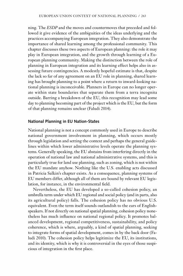
EU rO PEAn UnIOn cOnTExT OF nATIOnAL PLAnnInG / 263
ning. The ESDP and the moves and countermoves that preceded and fol-lowed it give evidence of the ambiguities of the ideas under lying and the practices accompanying Eu ro pean integration. They also demonstrate the importance of shared learning among the professional community. This chapter discusses these two aspects of Eu ro pean planning: the role it may play in Eu ro pean integration, and the growth through learning of a Eu-ro pean planning community. Making the distinction between the role of planning in Eu ro pean integration and its learning effect helps also in as-sessing future contingencies. A modestly hopeful estimate is that, despite the lack so far of any agreement on an EU role in planning, shared learn-ing has brought planning to a point where a return to inward- looking na-tional planning is inconceivable. Planners in Eu rope can no longer oper-ate within state boundaries that separate them from a terra incognita outside. Barring a breakdown of the EU, this recognition may lead some day to planning becoming part of the pro ject which is the EU, but the form of that planning remains unclear (Faludi 2014).
National Planning in eU Nation- States
national planning is not a concept commonly used in Eu rope to describe national government involvement in planning, which occurs mostly through legislation and setting the context and perhaps the general guide-lines within which lower administrative levels operate the planning sys-tems. Generally speaking, the EU abstains from interfering directly in the operation of national law and national administrative systems, and this is particularly true for land use planning, such as zoning, which is not within the EU mandate anyhow. nothing like the U.S. enabling acts discussed in Patricia Salkin’s chapter exists. As a consequence, planning systems of EU members differ, although all of them are bound by relevant EU legis-lation, for instance, in the environmental field.
nevertheless, the EU has developed a so- called cohesion policy, an umbrella term under which EU regional and social policy (and in parts, also its agricultural policy) falls. The cohesion policy has no obvious U.S. equivalent. Even the term itself sounds outlandish to the ears of English- speakers. If not directly on national spatial planning, cohesion policy none-theless has much influence on national regional policy. It promotes bal-anced development, regional competitiveness, sustainability, and policy coherence, which is where, arguably, a kind of spatial planning, seeking to integrate forms of spatial development, comes in by the back door (Fa-ludi 2010). The cohesion policy helps legitimize the EU, its institutions, and its identity, which is why it is controversial in the eyes of those suspi-cious of integration in the first place.

264 / AndrEAS FALUdI
There is much interest in getting a grasp of the variety of Eu ro pean planning systems and their roots in different models of society because of their potential effect on the way in which the cohesion policy works out. With Esping- Andersen (1990), Stead and nadin (2009) distinguish a social- democratic, an Anglo- Saxon, and a conservative, corporatist model. newer research since Esping- Andersen’s seminal study takes account of countries in central and Eastern Eu rope that are not discussed in this vol-ume. Overall, there is always a nordic category with (among the coun-tries discussed in this volume) denmark in it, an Anglo- Saxon one with the United Kingdom and Ireland, and a continental, corporatist one with France and Germany (Germany is included here because its role in Eu ro-pean planning makes it essential to discuss it). The netherlands, finally, can sometimes be found in the nordic group, similarly to denmark, and sometimes in the corporatist group. Presently, The netherlands is mov-ing toward the market- liberal Anglo- Saxon model. Among the countries subscribing to the Anglo- Saxon model, the United Kingdom is consid-ered, especially but not exclusively by the French, an extreme example and a Eu ro pean outpost of U.S. capitalism.
The sometimes radical changes to national planning are discussed in the relevant chapters of this work. In this chapter, the focus is on a num-ber of archetypes, for two reasons. One is that they have been identified in a now- classic study. The other is that, although planning may have changed since, the archetypes described existed when the ESDP was be-ing prepared. Therefore, in explaining Eu ro pean planning, it is these ar-chetypes that are relevant.
The EU Compendium of Planning Systems and Policies (cEc 1997) distin-guishes four such archetypes: comprehensive- integrated planning, land use management, regional- economic planning, and urbanism (the last is not represented in this volume). comprehensive- integrated planning involves a very systematic and formal hierarchy of plans that not only control land use, but also coordinate public sector activity. It requires mature systems and public sector investment to promote plan implementation. Land use management is associated with the narrower task of land use control by local authorities under central- government supervision. regional- economic planning, which is furthest removed from state planning in the United States, but has been the most influential on the EU cohesion policy, con-cerns the pursuit of social and economic objectives, with a dominant role for the central government.
The Compendium includes volumes in En glish on each and every plan-ning system and key planning policies in all 15 member states of the EU at the time it was published. Published in the late 1990s and early 2000s (and thus outdated), they are discussed here because they describe the

EU rO PEAn UnIOn cOnTExT OF nATIOnAL PLAnnInG / 265
starting point from which member states participated in the ESDP pro-cess. Thus, the volume on The netherlands (cEc 1999d) points out the concern of the dutch with their spatial environment and the resulting high demand for public intervention, the standard view of the country having “a weak spot for planning,” as referred to in the title of Faludi (2005). In discussing the EU, the country report details dutch benefits from the EU cohesion policy, including its support for cross- border and transnational planning and the importance of the Trans- European networks— another important EU policy, alongside the cohesion policy, promoting the cre-ation of infrastructure networks spanning EU space.
The denmark volume (cEc 1999a) starts less eloquently by describ-ing responsibility for spatial planning as being shared among all three levels of government. The lower levels work with comprehensive plans, and the Ministry of the Environment publishes planning reports and national perspectives. At the time, denmark was hailed as a key representative, next to The netherlands, of comprehensive- integrated planning in Eu rope.
Germany is another example of comprehensive- integrated planning, but there, the Länder (federal states), rather than the federal government, are responsible for planning, as the Germany volume (cEc 1999e) states at the beginning. Germany also practices regional- economic planning, but the volume hardly mentions it because it is not what planners do. The ten-uous relations between the two systems shape German attitudes toward Eu ro pean planning.
The United Kingdom volume describes town and country planning as mature and rigorous without emphasizing its restricted interpretation under the then conservative government, which disallowed economic and social considerations in planning. In line with its case- law tradition of deciding cases on their merits rather than by the observance of precon-ceived plans and regulations, the system is also discretionary, unlike U.S. zoning, which is more influenced by German examples. The volume says that, “whilst the impact of EU policy can be described as being very dis-parate, there is a growing realization of the importance of the EU for land use planning, reflecting the growing number of offices within local au-thorities with a specific Eu ro pean remit” (cEc 2000b, 27). Indeed, sub-national administrations in the United Kingdom are often more enthusi-astic about integration than the national government is.
Another country where land use control prevails is Ireland, where it is called physical planning, rather than the U.K. term, town and country planning. Planning is primarily a local- government activity (cEc 1999c). Ireland has benefited from EU accession and has been more enthusiastic about it than either the United Kingdom or denmark, which joined at the same time (1973). The report points out the EU influence in almost

266 / AndrEAS FALUdI
all sections of Irish society and the impact of funds and policy directives on spatial planning. It then describes the national development Plan, which is not a spatial plan, as a basis for negotiating EU funding. The Irish case shows most clearly why national planning in the EU is different from state planning in the United States: the concerns can be much broader than just land use.
France, with its regional- economic planning approach, is the country that has taken the EU and its planning most seriously. There is a recogni-tion that “Eu ro pean integration requires a consolidation of national plan-ning policies with a view to reinforcing national cohesion and to prevent the disintegrating effects which could result from the mechanisms of the single market alone” (cEc 2000a, 23). A major concern shared by other EU members is that, embracing liberalization as it does, the EU challenges equitable provision of state- run ser vices throughout the French territory and therefore threatens national cohesion. At times, the French national leadership has devoted much attention to national regional development (Burnham 2009). In the French model, the EU cohesion policy is seen as the antidote to the Anglo- Saxon free- market ideology, so, albeit under a different name, France has godfathered regional- economic planning, which it calls aménagement du territoire, at the level of the EU. The con-tractual approach in the cohesion policy, in which funding is contingent on the participation of national, regional, and local public and, preferably, also private stakeholders specified in multiannual agreements, is also of French origin.
Stead and nadin (2009) signal a general trend in which national plan-ning systems adapt to pressures while remaining fundamentally the same. Thus, “Significant reforms are taking place to systems across Eu rope but outcomes are variable and strongly influenced by the prevalent planning culture and social model” (Burnham 2009, 296). Where there is change, as in The netherlands and denmark, it is the outcome of the victory of market liberals in hegemonic struggles.
eu ro pean Integration and Shared learning
Eu ro pean affinities are older than recent manifestations of Eu ro pe anness focusing on the EU, say clark and Jones (2008). Indeed, “While the inte-gration narrative and Eu ro pe anisation’s under lying pro cesses have tended to be conflated, importantly they are not the same” (clark and Jones 2008, 303). The integration of Eu rope that culminated in the EU as we know it was the outcome of a long, drawn- out pro cess. Putting EU policies in place has led to even more intensive exchanges of information. There are EU programs, such as student and trainee exchanges, and awards, such as the

EU rO PEAn UnIOn cOnTExT OF nATIOnAL PLAnnInG / 267
annual designation of two Eu ro pean capitals of culture, that are explicitly aimed at stimulating shared learning. Such learning is not confined to the EU. The EU is attractive to those outside its borders, which are them-selves constantly in the pro cess of being renegotiated. Thus, the EU seems like an empire (Zielonka 2006) that is assimilating territory, but not by the power of arms. The theme here is how governments have been involved in configuring Eu ro pe anness. referring to what is sometimes called the Eu ro pean civil War, which ended in the mid-20th century, clark and Jones point out that po liti cal elites
were aware of the potency of Eu ro pe anisation’s shared transnational understandings, and devised the integration narrative to harness these pro cesses. . . . crucially this narrative has given contemporary Eu ro pe anisation’s learning and socialisation a renewed direction and purpose, focused since 1957 [the year of the signing of the Treaties of rome, which established, among others, the Eu ro pean Economic community, forerunner of the EU] upon state institutional gover-nance change. (clark and Jones 2008, 303)
Eu ro pe anization as here conceived
is reproduced as much through exchange of specialised codified knowledge peculiar to “EUrope” as it is through the tacit micro-geographies of everyday life. . . . We argue, therefore, that Eu ro pe-anisation proceeds in de pen dently of Eu ro pean integration although over the last 50 years the integration narrative has been critically im-portant in shaping the focus of Eu ro pe anisation’s coordinative . . . pro cesses. (clark and Jones 2008, 304)
clark and Jones’s statement is the justification for looking at shared learning and Eu ro pean integration as separate, but nonetheless related, pro cesses. Shared learning refers to the diffusion of knowledge through the exchange of best practices and through imitation and the rescaling of national identities and interests. Eu ro pean integration means the emer-gence of supranational forms of governance converging on common norms, the reconfiguration of the territorial bases of authority, the multi-directional transformation of statehood through state actors assimilating EU policy, and common responses to global change that lead to adjust-ments in spatial frames of thought. Integration implies multidirectional social transformations through interpenetration and exchanges and also the projection, by means of soft power, of a hegemonic EU identity.
clark and Jones also point out the entanglement of local, regional, na-tional, and global pro cesses in Eu ro pean integration and the importance

268 / AndrEAS FALUdI
of underpinning pro cesses of socialization and learning. Summarizing, they identify Eu ro pe anization as a pro cess
springing from territorial propinquity, comprising myriad socialisa-tion and learning pro cesses that have been configured over centu-ries by distinctive patterns of Eu ro pean government and power. Sup-pression and/or control of these continent- wide pro cesses has been integral to nation- state building, and the inherent tension between states and the supranational po liti cal pro ject of building “EUrope” arises precisely because Eu ro pe anisation pro cesses are both sup-portive of yet transcend national territory- government power bases. (clark and Jones 2008, 313)
Transcending national power bases is central to the narrative of Eu ro pean planning.
eu ro pean and National Planning
Shared learning in planning has been part of international exchanges, in-cluding exchanges across the Atlantic, since before World War I. When Eu ro pean integration appeared on the horizon after World War II, plan-ners, on the basis of their shared understanding, campaigned to get a share in this pro ject. If nothing else, this led to more shared learning.
Planners on the road
German zoning under police powers reached The netherlands and the United Kingdom, where the Vienna Green Belt (as the name suggests, a belt of land to be left free from development around the built-up area of the city of Vienna) was also discussed in the first issues of the Town Plan-ning Review in 1910. As a practical ideal, Ebenezer Howard’s Garden Cities of Tomorrow (1902) conquered the world, including the United States, as did Patrick Geddes’s ongoing advocacy and demonstrations of conduct-ing thorough surveys before starting to plan. Less well known outside The netherlands, Joël de casseres studied in dresden and at the Paris Beaux Arts and took the external examination of the Town Planning Institute, now the royal Town Planning Institute, which made him lecture his more se nior dutch compatriots. At the same occasion, an international congress at Amsterdam in 1924, the example of the pro ject of formulating a Regional Plan for New York and Its Environs inspired dutch planners to propagate regional and eventually national planning. drawing on his travels to the United States, de casseres subsequently also brought the New Deal and the Tennessee Valley Authority to their attention.

EU rO PEAn UnIOn cOnTExT OF nATIOnAL PLAnnInG / 269
representatives of what the EU Compendium would describe as “urban-isme” attended one of a succession of meetings of the congrès Inter-national de l’Architecture Moderne sailing from Marseille to Athens. An Austrian, Otto neurath, presented his method for visualizing survey re-sults. Through conferences and exchanges, planners also learned about spatial planning in the Third reich, the sinister aspects of which were not yet wholly apparent.
Through their travels, spatial planners acquired an international ori-entation, but the real impetus for Eu ro pean integration came from eco-nomic necessity. There was early interest in economic planning. Amster-dam hosted the World Social Economic congress in 1930, which discussed, among other things, the Soviet Five- Year Plan. Like World War I, World War II led to extraordinary resource mobilization, and there were argu-ments for economic planning to continue thereafter. These arguments were anathema to Karl Popper (1966) and Friedrich Hayek (1962), and such planning was soon tainted by its association with Soviet- style regimes. However, the French commissariat Général au Plan, headed by Jean Monnet, who had had wide international experience before and during the war, including experience in managing the joint Allied war effort, prac-ticed indicative planning by industrial sector, known as planification, as the antithesis to Soviet- style planning. It was the learning effect of this kind of cooperation, somewhat remote from land use planning, that was more germane to Eu ro pean integration.
The first postwar steps would not have happened without prompting from the United States, which was concerned that an impoverished and divided Western Eu rope might fall prey to the communists, who had strong electoral support, especially in Italy and France. Thus, from 1947, the Marshall Plan, officially the Eu ro pean recovery Plan, helped Eu ro pean economies reconstruct themselves. A clearing house, the Or ga ni za tion for Eu ro pean Economic cooperation (which later became the Or ga ni za-tion for Economic cooperation and development), propagated planning. Its director, the U.S.- educated Frenchman robert Marjolein, held up the new deal as an example.
Later, while still heading the commissariat Général au Plan, Jean Monnet advised the Luxembourg- born and German- educated French minister of foreign affairs, robert Schuman, on his Eu ro pean initiatives. credited with being one of the fathers of Eu ro pean integration, Schuman announced on May 9, 1950, his government’s intention of creating the Eu-ro pean coal and Steel community. This date is still celebrated as Eu rope day. The community concerned two industrial sectors basic for recovery in which, for reasons of mutual dependence, particularly of the relevant German and French industries, cooperation was essential.
270 / AndrEAS FALUdI
This pioneering effort was followed by the creation of the much more comprehensive Eu ro pean Economic community (EEc) and the Eu ro-pean Atomic Energy community, better known as Euratom, aiming to develop a peaceful joint Eu ro pean nuclear sector, through the 1957 Trea-ties of rome. Both treaties were signed by the six original members of the Eu ro pean coal and Steel community: France, Germany, Italy, and the three Benelux members (Belgium, The netherlands, and Luxembourg, which had been united in an economic union since 1944). The EEc came into operation in 1958 and went through several permutations before the EU came into being in november 1993. The important institutional in-novation was that all these successive organizations held supranational powers in areas specified in the respective treaties, the latest of which is the so- called Treaty of Lisbon that came into operation in december 2009. The need for supranational powers was the chief lesson that Monnet, ac-cording to his memoirs (Monnet 1976), had learned from previous involve-ment in international cooperation.
Albeit indirectly, the arrangement to formulate the relevant powers has already been alluded to when painting the fanciful scenario of a U.S. run along EU lines. Thus, an appointed in de pen dent Eu ro pean commission has the exclusive right to initiate a legislative pro cess based on the man-dates given by the relevant treaties. Proposals go to the council of Min-isters, which represents member- state governments, and to the directly elected Eu ro pean Parliament, which represents the people. Member states are required to implement EU legislation in a pro cess called transposition that gives them some leeway to adapt to national circumstances.
The reality, of course, is vastly more complicated, but the basic design has not changed since its beginning in the early 1950s. despite its supra-national powers, the EU is not a federation; it cannot amend or renegoti-ate the treaties on which it rests. The member states come together to make treaties in so- called intergovernmental conferences, and treaties have to be ratified by each state according to widely different procedures. For ex-ample, under their constitutions, Ireland and denmark hold treaty refer-enda. Predictably, they have insisted on and received privileges.
What has not changed is a bias toward the formation of a single mar-ket, which is why customs barriers were the first to be eliminated in the EEc. The aim is free movement of people, goods, ser vices, and capital, among other things, by bringing down both tariff and so- called nontariff barriers. Inventiveness in identifying nontariff barriers has been great. For instance, minimum environmental and workplace- related health standards have prevented unfair competition between countries. German planners have unsuccessfully mooted minimum levels of planning control (ritter
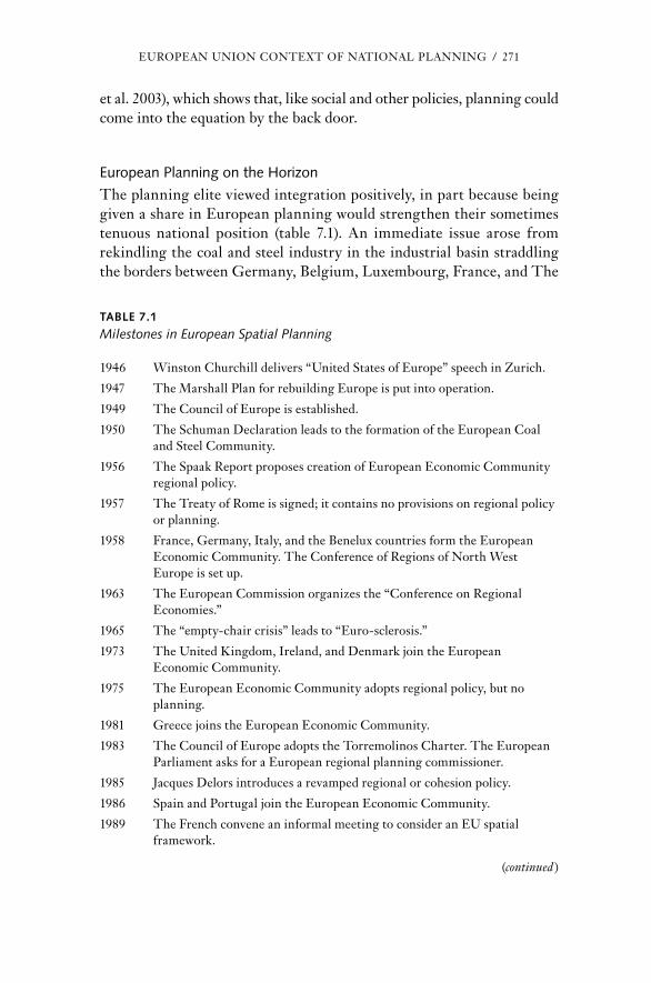
EU rO PEAn UnIOn cOnTExT OF nATIOnAL PLAnnInG / 271
et al. 2003), which shows that, like social and other policies, planning could come into the equation by the back door.
eu ro pean Planning on the horizon
The planning elite viewed integration positively, in part because being given a share in Eu ro pean planning would strengthen their sometimes tenuous national position (table 7.1). An immediate issue arose from rekindling the coal and steel industry in the industrial basin straddling the borders between Germany, Belgium, Luxembourg, France, and The
TABle 7.1
Milestones in Eu ro pean Spatial Planning
1946 Winston churchill delivers “United States of Eu rope” speech in Zu rich.
1947 The Marshall Plan for rebuilding Eu rope is put into operation.
1949 The council of Eu rope is established.
1950 The Schuman declaration leads to the formation of the Eu ro pean coal and Steel community.
1956 The Spaak report proposes creation of Eu ro pean Economic community regional policy.
1957 The Treaty of rome is signed; it contains no provisions on regional policy or planning.
1958 France, Germany, Italy, and the Benelux countries form the Eu ro pean Economic community. The conference of regions of north West Eu rope is set up.
1963 The Eu ro pean commission organizes the “conference on regional Economies.”
1965 The “empty- chair crisis” leads to “Euro- sclerosis.”
1973 The United Kingdom, Ireland, and denmark join the Eu ro pean Economic community.
1975 The Eu ro pean Economic community adopts regional policy, but no planning.
1981 Greece joins the Eu ro pean Economic community.
1983 The council of Eu rope adopts the Torremolinos charter. The Eu ro pean Parliament asks for a Eu ro pean regional planning commissioner.
1985 Jacques delors introduces a revamped regional or cohesion policy.
1986 Spain and Portugal join the Eu ro pean Economic community.
1989 The French convene an informal meeting to consider an EU spatial framework.
(continued )
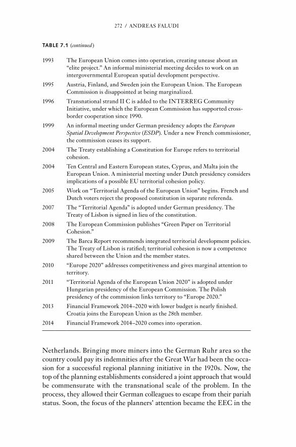
272 / AndrEAS FALUdI
netherlands. Bringing more miners into the German ruhr area so the country could pay its indemnities after the Great War had been the occa-sion for a successful regional planning initiative in the 1920s. now, the top of the planning establishments considered a joint approach that would be commensurate with the transnational scale of the problem. In the pro cess, they allowed their German colleagues to escape from their pariah status. Soon, the focus of the planners’ attention became the EEc in the
TABle 7.1 (continued )
1993 The Eu ro pean Union comes into operation, creating unease about an “elite pro ject.” An informal ministerial meeting decides to work on an intergovernmental Eu ro pean spatial development perspective.
1995 Austria, Finland, and Sweden join the Eu ro pean Union. The Eu ro pean commission is disappointed at being marginalized.
1996 Transnational strand II c is added to the InTErrEG community Initiative, under which the Eu ro pean commission has supported cross- border cooperation since 1990.
1999 An informal meeting under German presidency adopts the Eu ro pean Spatial Development Perspective (ESDP). Under a new French commissioner, the commission ceases its support.
2004 The Treaty establishing a constitution for Eu rope refers to territorial cohesion.
2004 Ten central and Eastern Eu ro pean states, cyprus, and Malta join the Eu ro pean Union. A ministerial meeting under dutch presidency considers implications of a possi ble EU territorial cohesion policy.
2005 Work on “Territorial Agenda of the Eu ro pean Union” begins. French and dutch voters reject the proposed constitution in separate referenda.
2007 The “Territorial Agenda” is adopted under German presidency. The Treaty of Lisbon is signed in lieu of the constitution.
2008 The Eu ro pean commission publishes “Green Paper on Territorial cohesion.”
2009 The Barca report recommends integrated territorial development policies. The Treaty of Lisbon is ratified; territorial cohesion is now a competence shared between the Union and the member states.
2010 “Eu rope 2020” addresses competitiveness and gives marginal attention to territory.
2011 “Territorial Agenda of the Eu ro pean Union 2020” is adopted under Hungarian presidency of the Eu ro pean commission. The Polish presidency of the commission links territory to “Eu rope 2020.”
2013 Financial Framework 2014–2020 with lower bud get is nearly finished. croatia joins the Eu ro pean Union as the 28th member.
2014 Financial Framework 2014–2020 comes into operation.

EU rO PEAn UnIOn cOnTExT OF nATIOnAL PLAnnInG / 273
making. In his capacity as a high- level civil servant, a member of the dutch planning elite participated in the negotiations. The 1957 Treaty of rome on the Eu ro pean Economic community bears his signature as one of the two dutch representatives. He lobbied unsuccessfully that planning be included among the responsibilities of the EEc.
The proponents of regional policies fared little better. during post-war reconstruction, most nation- states engaged in such a policy. Under the Belgian foreign minister, Paul- Henri Spaak, a commission preparing the Eu ro pean Economic community proposed coordinating these national efforts with any future policies of the community. It also suggested a re-gional fund for what it called Eu ro pean projects and for distressed regions. However, national governments negotiating the treaty text paid only lip ser vice to the “harmonious development of the community territory,” a phrase included in the Preamble of the Treaty of rome but without en-tailing concrete mea sures.
Planners formed the conference of regions of north West Eu rope under the presidency of the dutch planning director. In The netherlands, as elsewhere, short- term activity drove out long- term activity after the war. national planning was dwarfed by the reconstruction Ser vice, another dutch government agency which was bent on building, no matter where. The netherlands also embarked on a regional policy promoting industrial development that accorded limited influence to the planners. However, at least there was a confluence of opinion to deflect this development away from the core of the country, the randstad. This would become a defining ele ment of dutch planning doctrine (Faludi and Van der Valk 1994). Planners formed a coherent mental map of their country and its develop-ment. The idea behind the conference of regions of north West Eu rope was to do the same on a larger scale. The conference identified urban de-velopment as forming a corridor from southeast England to northern Italy. This was the Eu ro pean counterpart of the East coast megalopolis in the United States (Gottman 1961). In seeking a Eu ro pean mandate, plan-ners often invoke the existence of transnational corridors (dühr and Zonneveld 2012).
The prospect of the channel Tunnel linking northwestern France with southeastern England provided another argument for transcending bor-ders. A German chief planner produced a sketch plan for the conference of regions of north West Eu rope. The message was that the EEc should take on such challenges, but institutionalization is always a slow pro cess. In the absence of any progress in this direction, The netherlands and Ger-many concluded a bilateral treaty on cross- border planning, and Benelux, a kind of mini- EU, likewise attended to it. This corner of Eu rope forms fertile ground for planning cooperation.

274 / AndrEAS FALUdI
Still, planning had no foothold in the EEc, but the Parliamentary As-sembly, the pre de ces sor of the Eu ro pean Parliament, argued for support-ing distressed regions. An activist Eu ro pean commission— promoting in-tegration is its purpose— organized the Conference on Regional Economies in 1963. commission president Walter Hallstein in person gave an open-ing speech, and robert Marjolein, then its vice president, developed the idea. There was talk about européen (En glish was not yet a community lan-guage) aménagement du territoire— European planning, but obviously of the regional- economic kind. An expert from the Bretagne, a region aggrieved by its treatment at the hands of central- government ser vices (Pierret 1984), played a prominent role. Indeed, regions began to look at the emerging EU as a source of support.
The initiative ran up against the French president, General charles de Gaulle. The immediate issue was voting by qualified majority. This is a method now common in the EU council of Ministers, giving different weights to the member states. At that time such qualified majority voting was foreseen to replace voting by unanimity, which gives each and every member state a veto. Under unanimity, France could thus reject any pro-posal to adopt a bud get for the common Agricultural Policy that failed to continue giving the French government the unique advantages that it was enjoying. Under qualified majority voting, the other member states could insist on a bud get less favorable to France. France responded with a months- long boycott of meetings, known as the empty- chair crisis of 1965. It ended in national vetoes being sustained where matters of national in-terest are concerned. Henceforth, the dialectics between nation- states and Eu rope changed in favor of the former, leading to what was called Euro- sclerosis.
Meanwhile, disappointed planners had already begun to look to the council of Eu rope, created in 1949, as the much looser formation with no executive authority which it is. There, a working group pursued the idea of Eu ro pean planning in 1968. The council eventually approved a non-binding charter for Eu ro pean spatial planning, also called the Torremo-linos charter (conference of Ministers responsible for Spatial/regional Planning 1983) after the Spanish resort where the ministers had met and adopted it.
The departure of de Gaulle, who had rejected the idea of their acces-sion, allowed the enlargement in 1973 of the EEc by the addition of the United Kingdom, Ireland, and denmark. The EEc thus included all countries covered in this volume as members. A regional policy of sorts was introduced for the first time, but despite intentions to the contrary, national administrations saw to it that it remained a mere financial trans-fer mechanism by limiting even such meager planning provisions as were

EU rO PEAn UnIOn cOnTExT OF nATIOnAL PLAnnInG / 275
included in the regulations. In par tic u lar, the United Kingdom was more interested in benefiting from what was then still called the common Market than in integration as such, a fundamentally different perspective from that of some other members that still exists. However, in the early 1980s, just after the Torremolinos charter was adopted, the Eu ro pean Par-liament demanded that policies of what was then already the Eu ro pean community should be coordinated with a view to the planning program in the Torremolinos charter of balanced and integrated development and the preservation of the Eu ro pean heritage. Thus, the shared learning under the umbrella of the council of Eu rope led to new initiatives for Eu ro pean planning. Indeed, the Eu ro pean Parliament asked for a commissioner for regional planning, not just, as was— and still is— the case, regional policy.
The heyday of Eu ro pean integration began under Jacques delors, pres-ident of the Eu ro pean commission from 1985 to 1995. He pulled the Eu ro pean community out of its slumber. A seedbed of renewed planning initiatives was the restyled regional policy increasingly labeled the cohe-sion policy, the term introduced in the Single Eu ro pean Act of 1986 up-dating the Treaty of rome. Since the time of delors, the cohesion policy has pursued a programmatic approach. Beneficiaries are not only least fa-vored regions as identified by GdP per capita adjusted for purchasing power and by unemployment rates, but also, albeit at a much lower rate, all other regions receiving incentives to improve growth and competitiveness.
Under the cohesion policy, the Eu ro pean commission stretches its ten-tacles past national to subnational administrations and private stakeholders to mobilize what delors called the forces vives (life forces). By bringing subnational authorities into the picture— France, which had inspired this approach, had created proper regions in 1982 and, according to a consti-tutional amendment, is a now a decentralized state— this multi- level gov-ernance (Piattoni 2010) has become an EU trademark. States that are net contributors to the bud get tend to dislike the cohesion policy, among others, precisely because it gives their own subnational administrations a voice in spending national taxes flowing into the coffers of the Eu ro pean community. regional and local administrations tend to support the Eu-ro pean commission as a counterweight to the sway national administra-tions hold over them.
The Eu ro pean Spatial Development Perspective (ESDP)
The map of least favored regions, which shifts depending on the makeup of the EU, shapes the geography of the cohesion policy. French and dutch national planners, together with Eu ro pean commission officials, wanted a spatial framework for the cohesion policy that took account of the real

276 / AndrEAS FALUdI
constitution of space and the impacts of other policies of the EU and other levels of government and administration. With their help, the commis-sion should be responsible for formulating and applying this strategic tool to improve policy.
At the time, nobody seems to have considered the failed U.S. attempt in 1970 to pass the national Land Use Policy Act, which, according to Salkin in this volume, had similar intentions: a federal agency ensuring that other federal agencies would comply with state plans and providing federal funding for states to create similar agencies to coordinate with their local authorities. The act would thus have strengthened planning at all levels of government and administration, and a national data system would have been set up for this purpose.
The French- dutch initiative was directed likewise at improving the situation of planning overall, not just adding one more level. For the French planning agency, challenged by a po liti cal leadership that was losing in-terest in rectifying imbalances between Paris and the regions (Burnham 2009; Massardier 1996), this was a strategy of creating a new position for itself as a linchpin between national and Eu ro pean planning at a time when the commission’s president was Jacques delors, a former French minister of finance and an ardent supporter of more integration.
The French national planners were the main initiators of Eu ro pean planning. In their efforts, they employed a tool of their trade, spatial sce-narios. Their identification of the Eu ro pean core in a commissioned study (Brunet 1989) as what would eventually be dubbed the “Blue Banana” shaped Eu ro pean planning discourse. Barely straddling French territory in the northeast, so defined Eu rope’s core bypassed France. With the iron curtain falling, French territory would become even more marginal in a Eu rope opening up to the east. The danger was acute for regions on the Atlantic coast. rectifying imbalances had been a key concern of French regional- economic planning, inspired by an early doomsday scenario, Paris et le désert français (Paris and the French desert) (Gravier 1947). The French state had effective instruments: government funding coordinated by the planners in a pro cess involving the increasingly assertive regions. The Eu-ro pean community policy of including national, regional, and local pub-lic and private stakeholders in multiannual programming of the use of funds was similar. Thus, it was natural for French national planners to see the responsible Eu ro pean commission officials, many of whom were French nationals, as allies.
dutch planners, too, with an eye on the intended completion of the sin-gle market and the elimination of remaining nontariff barriers, consid-ered the position of their small, export- oriented country in Eu ro pean space. dutch national planning had evolved into a vehicle for formulating

EU rO PEAn UnIOn cOnTExT OF nATIOnAL PLAnnInG / 277
strategy. The rhe toric, somewhat similar to that in France, invoked the allegedly marginal position of danish Jutland jutting out from Eu rope’s mainland into the sea as a meta phor and argued that The netherlands would become the same unless its infrastructure connections improved. To address such issues, and following the example of a pioneering dutch study, Perspectives in Eu rope (rijksplanologische dienst 1991), the dutch country report for the EU Compendium of Spatial Planning Systems and Poli-cies already referred to, saw an important role for Eu rope in spatial plan-ning (cEc 1999d). Trust in the welfare state and national planning, as well as enthusiasm for the EU, have all but evaporated since. The diffuse and unpredictable impact of various EU policies prejudging planning issues (ravesteyn and Evers 2004) has created unease.
The French- dutch initiative would become the ESDP, which was not, as might have been expected, a document of the Eu ro pean commission, but one prepared by the nation- states, albeit with help from the Eu ro pean commission. Faludi (2002) and Faludi and Waterhout (2002) have re-counted its making. Yet, even if planning did not become part of the Eu-ro pean pro ject, the shared learning it stimulated has been a bonus.
The initiative first took the form of informal meetings of national min-isters. Eventually, they set up the equally informal committee on Spatial development. national planners on the committee made the creation of the ESDP into a pro cess lasting until 1999, 10 years after the initiative was born. In addition to France and The netherlands, of the nation- states dis-cussed in this volume, denmark participated enthusiastically. It defined itself as what a danish document called the green house in Eu rope (Böhme 2002). denmark had also gained relevant experience by participating in a planning exercise called Vision and Strategies Around the Baltic Sea 2010, a bottom-up initiative exploring spatial implications of the fall of the iron curtain in a corner of the world where, with the reinstatement of three in de pen dent Baltic states, the geopo liti cal situation was undergoing radi-cal change.
However, from the time the Eu ro pean Union came into operation in november 1993, it was viewed with suspicion. A referendum in France had resulted in only a tiny majority in favor of adopting the relevant Treaty of Maastricht. danish voters had rejected it until their country, whose voters were less enthusiastic than the planners, had been granted opt- outs from controversial provisions. The United Kingdom had also been granted opt- outs. For example, neither of the two is under an obligation to adopt the euro. More generally speaking, there was wide suspicion that the EU was an elite pro ject. In their dialectic relation with the Eu ro pean Union, nation- states were regaining the upper hand, and this had effects on planning.

278 / AndrEAS FALUdI
In addition, an EU spatial framework prepared by the Eu ro pean com-mission would have enforced the programmatic approach to the cohesion policy. Indeed, to base EU support for regions on sound spatial analy sis and a spatial strategy rather than on statistical indicators had been the idea. However, such a framework would be unwelcome to the main clientele of the cohesion policy, who were not national spatial planners, but ministers of economics or finance administering the funds received. Even where na-tional planners were positive (not all of them were), more power ful national actors unwilling to listen to the planners were reining them in. relations were at issue not only between the EU and its members, but also among different national bureaucracies.
German planners had other reasons to be apprehensive. As noted in this chapter, Germany pursues a comprehensive- integrated approach in which planners of the Länder (federal states) are chiefly responsible for planning. For the first time, however, serious national planning issues existed. Ger-man reunification had resulted in huge differences within what was now one nation- state. Without prejudice to the distribution of formal powers, federal and Länder planners jointly produced a spatial strategy. This first, informal national document not only dealt with integrating German space, but also re- conceptualized the spatial position of Germany from being at the eastern edge of Western Eu rope to being in the heart of a new Eu-rope. Poland and czech o slo vak i a were viewed as new neighbors with whom to seek cooperation.
This boosted the position of federal planners, who were called on to participate in the emerging Eu ro pean planning initiatives. Here, the other wise dominant German Länder had no standing. Federal planners had to articulate German interests, including the interests of the Länder, but conceding the statutory powers of the Länder to the EU was out of the question. German planners thus seized on the fact that the treaties gave the EU no explicit planning mandate. Instead, their position became that, like the Länder in the Federal republic, in the EU, too, the lower level, that is, the nation- states, should be calling the tune. The German tactic of throwing the rule book at whoever proposed an EU spatial strat-egy changed the relations between national planners and the Eu ro pean commission. Further, apprehension about the EU in general was grow-ing, so an EU spatial strategy became suspect also in other nation- states. A new dutch planning director opined that it would be absurd for the Eu-ro pean commission to rule on a vast, somewhat controversial rotterdam port extension. rotterdam, however, sits on a main transport axis to the Eu ro pean hinterland. Therefore, it has a much wider impact than just on The netherlands. It also competes with other Eu ro pean ports. Thus, a

EU rO PEAn UnIOn cOnTExT OF nATIOnAL PLAnnInG / 279
common concern existed, but the dutch national interest in the success of this main port prevailed.
In France, an EU spatial framework was attractive to the planners and to the ministry responsible because it would beef up the country’s position, but others were less enthusiastic. Anyhow, the Germans had framed the issue in terms of giving up sovereignty, which raised French eyebrows too. As the text of the national anthem, the “Marseillaise” (sung by citi-zen soldiers rallying to the defense of French territory against invading Eu ro pean monarchies and royalist forces trying to undo the French rev-olution), shows, territory had been a defining issue in the formation of na-tional citizenship. Assuming control over territory had not been the idea behind Eu ro pean planning initiatives, but a spatial strategy for the more effective application of the cohesion policy and preferably also of other EU policies with spatial or territorial implications had. Once the issue had been framed in terms of sovereignty, Eu ro pean planning was a stillborn idea.
There were also more mundane reasons for opposing it. An EU spatial strategy would have strengthened the hand of the Eu ro pean commission in administering the cohesion policy. The commission might invoke it to add further conditions, already a bone of contention, to grants offered. re-cipients like Spain were apprehensive that, to meet what they perceived as northwestern Eu ro pean concerns, they would have to modify their pref-erence for using EU funds for infrastructure investments.
The Eu ro pean commission’s idea of preparing a spatial strategy or vi-sion to undergird the cohesion policy, and conceivably other policies with a spatial impact, was thus a nonstarter. At their informal meetings, national ministers responsible deci ded to prepare what was to become the ESDP as an intergovernmental document giving an indicative framework. On the occasion of the next treaty amendment, the Germans, who during their 1994 presidency had taken a strong hand in preparing the ESDP, suggested that it become binding on EU policy makers. In the German federal setup, bottom-up initiatives sometimes become federal policy, but a Eu ro pean commission official who learned about this suggestion in conversations brushed it aside. The commission jealously guards its right of initiative.
nobody could have prevented the commission from formulating a strat-egy strictly for its ongoing policies with a spatial or territorial impact, but for two reasons, it did not do so. One was that it did not have the capacity. The commission would either have to rely on con sul tants, not the best way to prepare an EU- wide strategy that would require much consultation, or on planners from the nation- states. relying on national experts during the preparation and the implementation of EU policies is standard for a Eu ro pean commission strapped for personnel, so presumably, when it
280 / AndrEAS FALUdI
embarked on the exercise, what the commission had in mind was a com-mittee, like many other committees operating in Brussels, of national plan-ners chaired by one of its own staff. Expecting this to be the eventual outcome, the commission gave the informal committee on Spatial devel-opment the same financial and logistical support it gave to official commit-tees, and the committee heavily relied on this support. rather than a com-mission official, as would normally have been the case, the committee was chaired by a representative of the rotating six- month EU presidency. de-pending on the type of planning which it represented and on its attitudes toward and interests in Eu ro pean planning, each presidency thus puts its own stamp on the proceedings. The succession of informal ministerial meetings to which the committee on Spatial development reported was likewise chaired by a national minister of the country that held the EU presidency.
The second reason that the Eu ro pean commission would not develop a spatial strategy without the member states is that the commission’s ex-perts involved were somewhat marginal within the commission’s ser vices. Their director general once described them as the dreamers of his ser vice. However, even if he and his ser vice had thrown their full weight behind such a strategy, they would have faced endless struggles with other branches of the complex or ga ni za tion. The commission is divided into directorates general for specific policy areas that enjoy good contacts with relevant na-tional ministries sharing their ideologies and concerns. Even the director-ate general for regional policy, where planning enthusiasts could be found, was and continues to be divided. The majority of the staff members are involved in administering the cohesion policy, which is complex and po liti-cally controversial. Smooth relations with their clients, who are not always planners, are important, and a planning framework is a potential nuisance. Planning enthusiasts would have had difficulty in getting an EU spatial planning framework accepted, even within the commission. Support from national planners would be essential, but this was in short supply. A com-mon interest between the commission’s planning enthusiasts and national planners— who were confronted with the same type of re sis tance from line ser vices opposed to planning and to planners wanting to get a handle on the spatial impacts of their projects and policies— failed to develop.
When the ESDP (cEc 1999e) finally appeared, it advocated a spatial approach that amounted to integrating policies as they affected space, or territory. Although this idea is central to the comprehensive- integrated approach, it is far from commonplace even in the nation- states pursuing that approach. Line ser vices, called sectors in Eu ro pean planning jargon, are often fiercely in de pen dent and not enamored of spatial planners call-ing for coordination. The unexpected impacts of EU policies with a spa-

EU rO PEAn UnIOn cOnTExT OF nATIOnAL PLAnnInG / 281
tial impact, of which the ESDP gives an overview, in the territories of the nation- states and their subnational administrations was the rationale for the ESDP’s spatial approach, particularly since such impacts became evi-dent at national, regional, and local levels. This justified casting a critical eye on top- down EU sector policies from the bottom up. Integration would be reasserted later, but with a different twist, in the so- called Barca re-port (Barca 2009), which argued for integrated territorial development policies, but did not refer to spatial planning, let alone the ESDP.
The ESDP also identified three spatial policy guidelines that reflected the earlier philosophy of the council of Eu rope: (1) polycentric develop-ment, the counterpoint to the Blue Banana; (2) parity of access to infra-structure and knowledge; and (3) responsible management of the natural and cultural heritage. national planners involved were generally per-suaded, but whether they convinced others is unclear. The ESDP narra-tive is about the parties involved thrashing out a joint position that was internally not quite consistent; a consistent position would have supported a stronger role for the commission.
Shared learning
The effects of the ESDP varied. In Southern Eu rope, planning academics and some prac ti tion ers learned some lessons about governance that amounted to cultural innovations (Giannakourou 2005). The northwestern Eu ro pean nation- states that had promoted the ESDP, The netherlands and Germany in par tic u lar, paid almost no heed to it, and France put its money on a new discourse of territorial cohesion rather than making spatial planning an EU policy. The Labour government in the United Kingdom made attempts to emulate the ESDP’s message, but generally the message seemed destined for others (Faludi 2004). Ireland seemed impressed and produced the national Spatial Strategy in the wake of the ESDP.
There was more of an echo within the planning academia and the plan-ning profession than within practice. The ESDP made planners appreci-ate one another’s positions and the advantages of joint action. However, planners failed to resolve the conundrum of an EU role. recognition that the EU had a role would have strengthened not only the position of the Eu ro pean commission, but also their hands in dealings with others, like line agencies (called sectors) in Eu rope.
The learning effect of engaging in the ESDP pro cess went beyond mu-tual res pect and appreciation among those closely involved. A community Initiative, under which the Eu ro pean commission was allowed to spend some cohesion policy funds more or less at its discretion, led to cross- border, transnational, and, eventually, so- called interregional co operation.

282 / AndrEAS FALUdI
Because of the enthusiastic response, this initiative contributed to creating a veritable learning machine (Faludi 2008) that continues to operate, now in the framework of regular cohesion policy. Of these three strands, the transnational one was introduced specifically to support the efforts un-dertaken in the framework of creating the ESDP in 1996. The idea was to give not only national, but also, and in par tic u lar, regional and local plan-ners and other stakeholders experience in transnational planning and, by so doing, to make them more likely to support Eu ro pean planning. now in its fifth programming period (2014–2020), and although spatial planning as such is no longer on the agenda, all three strands are continuing, shar-ing in the enhanced status of an official cohesion policy objective called Eu ro pean Territorial cooperation. The learning effect is widely recognized (dühr, colomb, and nadin 2010; dühr, Stead, and Zonneveld 2007). Eu-ro pean planning may have stalled, but shared learning continues, with the cohesion policy as its main sponsor.
All this took place against the backdrop of the failed attempt in the early years of the 21st century to give the EU renewed impetus through a treaty framed as a constitution. Its replacement, the Treaty of Lisbon, which fi-nally came into force in late 2009, is in many respects a carbon copy, but the odium of failure sticks. In addition, EU competitiveness, recognized as a key issue since the announcement in 2000 of the Lisbon Strategy, which aimed bravely at turning Eu rope into the most competitive region of the world by 2010, seems impervious to attempts to improve it. This larger narrative envelops all discussions of EU policy.
In the framework of the constitutional debate, the Eu ro pean commis-sion replaced all talk about spatial planning with a new concept reflecting a French discourse in terms of territorial cohesion. Territorial cohesion seemed a logical complement to the existing treaty objectives since the mid-1980s of economic and social cohesion under which the cohesion policy operated. Territorial cohesion thus found its way into the Lisbon Treaty. It is appropriate to ask whether pursuing it means anything else than strategic spatial planning. The French, who injected territorial co-hesion into the debate, have no qualms about seeing it as the same as their aménagement du territoire, or regional- economic planning according to the Compendium. Territorial cohesion was a greater challenge to German plan-ners. They had little voice in administering the cohesion policy in Ger-many, and the very concept was alien to them, as it was to many others. In any case, they saw it as separate from spatial planning. This is true to the extent that territorial cohesion does not concern land use, at least in any regulatory fashion.
Any U.K. government has to take account of widespread Eurosceptic sentiments. In any case, the pre sent co ali tion of conservatives and Liberal-

EU rO PEAn UnIOn cOnTExT OF nATIOnAL PLAnnInG / 283
democrats favors localism and is inimical to strategic planning. There-fore, the U.K. contribution to Eu ro pean planning will continue to be limited to the sterling work of government planners, con sul tants, and academics cooperating with other nationals when they get the chance.
This is the interim position reached in another intergovernmental pro-cess, after a pause of several years, which in the wake of the ESDP led to two further documents of the member states. The first, Territorial Agenda of the Eu ro pean Union (TA 2007), was adopted under the German presi-dency in 2007. It built on the results achieved in the framework of the Eu-ro pean Spatial Planning Observation network (ESPOn), which some-what resembles a national data set, but has wider ambitions to provide a research base for planning.
The twisted story of ESPOn begins with the ESDP. Most prefer to forget the original name. The current name is the Eu ro pean Observation network for Territorial development and cohesion, but the acronym ESPOn remains in use. Faludi (2008; see also Böhme and Schön 2006) talks about the origins and implementation of the idea of evidence- based planning on which ESPOn is based. In fact, ESPOn is not only about collecting evidence pure and simple. Its coordination Unit, based in and supported by the government of Luxembourg, is involved in low politics, including bureau politics, against the backdrop of the high politics of the EU. This is about funding, and to this end, synthesis reports seek to dem-onstrate the relevance of ESPOn to the concerns of the Eu ro pean com-mission, the member states, and their evolving agendas. Any kind of syn-thesis involves making choices, but the timing of the reports suggests that they are intended to influence policy, in par tic u lar concerning ESPOn itself.
concern for building a constituency has led to programs involving not only researchers, but also stakeholders. To date, ESPOn has commis-sioned 23 so- called targeted analyses that pre sent, as the ESPOn website puts it, a new type of projects exploring, in partnership with stakeholders, the potential use of existing findings.1 These projects thus work according to briefs formulated from the bottom up, addressing practical needs rather than researcher priorities. davoudi (2006) has aptly described ESPOn as pursuing evidence- informed rather than evidence- based planning. Because the ESPOn program is approved by a Monitoring committee composed of representatives of member states and the Eu ro pean commis-sion, it is also the outcome of po liti cal bargaining. One can view this committee as a stand-in for a non ex is tent planning group of the commission
1 As of early 2014, the total count of projects started was 66, with a total bud get of €47 million (about $57 million).

284 / AndrEAS FALUdI
(in EU jargon, what is called a comitology committee) where national rep-resentatives can share in the conduct of community planning business.
Presently, under the territorial cohesion flag, ESPOn is the mainstay of Eu ro pean planning. With its well- oiled coordination Unit, and with the Luxembourg government giving support and looking after financial man-agement and control on behalf of the Eu ro pean commission, ESPOn is in fact the only game in town. It stays well clear of the discussion about na-tional and Eu ro pean planning. Instead, it promotes shared learning, not only among expert researchers, hundreds of whom are involved in transnational pro ject groups formed around a lead partner, but also among the prac ti-tion ers involved as stakeholders. Thus, ESPOn has the potential to become a stimulus for a renewed effort to institute Eu ro pean planning of whichever kind. Projects under its first program, like a scenario study (Lennert 2008) and another on Eu rope in the World (Beckouche and Grasland 2008), already held that potential. Under its current program, another scenario study looking forward to 2050 is under way (doucet and drevet 2014).
As indicated here, the 2007 Territorial Agenda sought to build on shared learning in the framework of the ESPOn program, among others. This strengthens the case for giving planners a say in adjusting line or sector policies to local, regional, and national circumstances. Attitudes of the planners involved to EU territorial cohesion were on the whole guardedly positive, but by that time, the commission itself had become less pro-active. Without much conviction, it published the Green Paper on Territorial Cohesion (cEc 2008). Most of the hundreds of reactions were favorable, but some were distinctly less so, notably those of the United Kingdom and the Economics Ministry in Germany, under whose remit the cohesion pol-icy falls. This augurs badly for the prospects of any commission initiative to legislate in matters of territorial cohesion. Other than in the ESDP pro-cess, the objection could never be that there is no EU competence in the matter. However, it is a shared one, meaning that EU members have to agree to any commission proposals. Member states, or at least some of them, are likely to argue that the EU should not assume this par tic u lar competence by invoking the subsidiarity princi ple. Under that princi ple, the EU should assume competences (mandates) only in matters that the member states themselves cannot deal with adequately. Some nation- states would surely invoke this princi ple. Indeed, this is what Germany and the United Kingdom did in their reactions to the Green Paper. Thus, any com-mission proposal would be controversial. controversy on a minor issue like territorial cohesion was the last thing the commission needed at a time when the Financial Framework 2014–2020, and with it the future of the co-hesion policy, was at stake. The controversy has ended, but the commis-sion still refrains from invoking the concept of territorial cohesion.

EU rO PEAn UnIOn cOnTExT OF nATIOnAL PLAnnInG / 285
In another initiative more directly related to the cohesion policy, the commissioner for regional policy invited a group of experts to consider its future. named after its chairman, Fabrizio Barca (2009), without mention-ing spatial planning, the Barca report asked for place- based, integrated territorial development policies. If these were put into practice, they would satisfy a key ambition of the ESDP, that of implementing the spatial ap-proach, and would also come close to one of the key ideas behind territo-rial cohesion, to coordinate policies as they affect territory (table 7.2).
In the meantime, the bigger story is that the commission prepared and the Eu ro pean council approved a master strategy to boost EU competi-tiveness, Eu rope 2020: A Strategy for Smart, Sustainable and Inclusive Growth (cEc 2010). Grudgingly, the final version acknowledges the need to take account of territory, but it does not say how. In parallel, an update of the 2007 Territorial Agenda, Territorial Agenda of the Eu ro pean Union 2020 (TA 2011), addressed the issue of how spatial planning could support smart, sus-tainable, and inclusive growth, which are the express concerns of Eu rope 2020. The Polish EU presidency of the second half of 2011 convened a team of national experts, some of them with ESDP credentials, and did its best to render such suggestions concrete (Zaucha et al. 2014), but none of the successive EU presidencies since then have seemed to care.
What is remarkable about the pro cess just described, from the 2007 Territorial Agenda to Territorial Agenda of the Eu ro pean Union 2020 and the strong Polish stand on such matters, is the role of new actors, mainly, but not exclusively, from the new member states in central and Eastern Eu rope. The 2007 Territorial Agenda was prepared with their full participation, but none of them held an EU presidency during that period. Immediately after the Germans oversaw the adoption of the 2007 Territorial Agenda, Portugal did hold the presidency and launched an action program to take the agenda further. Holding the first presidency ever of a new member state, Slovenia pursued this very actively in 2008, followed by France. Hungary was responsible for the adoption of Territorial Agenda of the Eu-ro pean Union 2020 in 2011, and, as indicated, Poland, following immedi-ately thereafter, made a huge effort to bring the debate closer to main-stream cohesion policy. clearly, this all happened because planners from the new member states had learned about the idea and collaborative prac-tices of Eu ro pean planning. That they were now holding EU presidencies for the first time according to a fairly arbitrary schedule that reflects many po liti cal considerations helped. In 2014, Greece and Italy hold the presi-dency, and their focus has been and still is on the Mediterranean and on the debt crisis that is affecting them badly. 2015 will see Latvia and Luxem-bourg holding this position until The netherlands takes over in early 2016, but as noted, this country is now much less enthusiastic than it used

286 / AndrEAS FALUdI
to be. So whether it will do what has been agreed under the Action Pro-gramme in pursuance of the Territorial Agenda of the Eu ro pean Union 2020 in 2011, which is to revise that document, is still unknown.
Whether and how this whole narrative will continue remains to be seen. Hard pressed as the EU is by the current crisis and with all eyes fixed on the next Financial Framework 2014–2020, the Eu ro pean commission has been soft- pedaling territorial integration and territorial cohesion, let alone acknowledging that there is any mention of Eu ro pean spatial planning. now that this is over, enthusiasts at the commission and among national
TABle 7.2
Institutions, Agencies, and Organizations Active in Spatial Planning in the Eu ro pean Union
Eu ro pean Union (EU): The Eu ro pean Union is an unpre ce dented regional grouping of Eu ro pean nation- states with wide- ranging mandates.
Eu ro pean Community (EC): name before establishment of EU.
Eu ro pean Economic Community (EEC): The Eu ro pean Economic community was established in 1958. Sometimes streamlined as the Eu ro pean community.
Eu ro pean Coal and Steel Community (ECSC): The Eu ro pean coal and Steel community was established in 1950 to create a joint regime for coal and steel production and distribution.
Eu ro pean Commission: The Eu ro pean commission is the executive arm of the Eu ro pean Union and has the sole power to make legislative proposals.
Council of the Eu ro pean Union: The council of the Eu ro pean Union (also known as the council of Ministers) consists of national government representatives who make decisions on proposals.
Eu ro pean Council: The Eu ro pean council is composed of heads of state and governments of all member states giving overall direction to EU policy.
Eu ro pean Parliament: The Eu ro pean Parliament is a directly elected assembly with powers of co- decision- making.
Parliamentary Assembly: A consultative body of the Eu ro pean Economic community, the forerunner of the Eu ro pean Union, composed of national parliamentarians. Subsequent to being directly elected in 1979, reconstituted as the European Parliament.
Informal ministerial meetings: Semipermanent assemblies of national ministers considering the ESDP and the “Territorial Agenda.”
Committee on Spatial Development: An informal committee of national experts who prepared the ESDP and the “Territorial Agenda.”

EU rO PEAn UnIOn cOnTExT OF nATIOnAL PLAnnInG / 287
planners, despite waning support for national planning, may want to re-sume their efforts, and the debates over national and Eu ro pean planning may continue. Meanwhile, the greatest gain has been the shared learning about planning systems and practices and about the new, unusual cross- border and transnational spaces that are emerging and what they may mean for the EU’s chief concern, competitiveness. Indeed, if the initiative is ever restarted, not only by national planners of a select few EU members, but also by others, including the commission, the existing fund of experiences, thanks to ongoing support for cross- border, transnational, and interre-gional planning under Eu ro pean Territorial cooperation, Objective 3 of the cohesion policy, among other factors, this accumulated capital may en-hance its benefits.
These are not, however, propitious times for discussing Eu ro pean plan-ning. True, the EU’s financial framework has been settled before the end of 2013, and, although the multiannual bud get has been cut for the first time in the history of the EU, controversies about the cohesion policy as one of the largest spenders of EU funds have abated. The survival of the cohesion policy may be sufficient for the prospect of some form of Eu ro-pean planning in the future, but certainly not under this name. The Eu-ro pean commission has announced that territory, not territorial cohesion, will play a role in the management of the funds, and some of the regula-tions discussed now point in this direction. Also, new macro- regional strategies for the Baltic Sea area, the danube space, and recently, the Io-nian, Adriatic, and Alpine space, have been announced that will play some role in the future allocation of what is now called the regional and In-vestment Funds. However, the conflict over attitudes toward Eu ro pean in-tegration continues and has dominated the campaign in the Eu ro pean Parliament elections in early 2014. Because of changes to the rules intro-duced in the Lisbon Treaty, these elections have been more important than ever. The impact of these elections on the composition of the Eu ro pean commission coming into office in november 2014 has been strong. One nightmare scenario that Eurosceptic parties will make strong inroads has not come completely true, but the elections posed other issues. Each of the member states has nominated one commissioner, but the Eu ro pean Parliament’s opinion carried weight in the appointment of the commis-sion’s president. In the end, the right- of- center po liti cal faction in the Eu-ro pean Parliament came out on top and its candidate, former Luxem-bourg Prime Minister Jean- claude Juncker, has become the President of the Eu ro pean commission. This pro cess was a messy one even so, creat-ing unease and ill- feelings with some member states. The tension between national and Eu ro pean concerns that has dominated the story of Eu ro-pean planning has taken another twist.
288 / AndrEAS FALUdI
References
Barca, F. 2009. “An Agenda for a reformed cohesion Policy: A Place- Based Approach to Meeting Eu ro pean Union challenges and Expectations” [the Barca report]. In-de pen dent report prepared at the request of danuta Hübner, EU commissioner for regional policy. http:// ec . europa . eu / regional _ policy / archive / policy / future / barca _ en . htm
Beckouche, P., and c. Grasland. 2008. “north- South regionalism: A challenge for Eu rope in a changing World.” In Eu ro pean Spatial Policy and Research, ed. A. Faludi, 197–226. cambridge, MA: Lincoln Institute of Land Policy.
Böhme, K. 2002. Nordic Echoes of Eu ro pean Spatial Planning: Discursive Integration in Practice. Stockholm: nordregio.
Böhme, K., and K. Schön. 2006. “From Leipzig to Leipzig: Territorial research de-livers Evidence for the new Territorial Agenda of the Eu ro pean Union.” In “Evidence- Based Planning,” ed. A. Faludi. Special issue, disP, 42(2): 61–70.
Brunet, r. 1989. Les villes européennes: Rapport pour la DATAR, Délégation à l’Aménagement du Territoire et à l’Action Régionale. Under the supervision of roger Brunet, with the collaboration of Jean- claude Boyer et al. Paris: La documentation Française.
Burnham, J. 2009. Politicians, Bureaucrats and Leadership in Organizations: Lessons from Regional Planning in France. Houndsmill: Palgrave Macmillan.
cEc (commission of the Eu ro pean communities). 1997. The EU Compendium of Spa-tial Planning Systems and Policies. Luxembourg: Office for Official Publications of the Eu ro pean communities.
— — —. 1999a. The EU Compendium of Spatial Planning Systems and Policies: Denmark. Luxembourg: Office for Official Publications of the Eu ro pean communities.
— — —. 1999b. The EU Compendium of Spatial Planning Systems and Policies: Germany. Luxembourg: Office for Official Publications of the Eu ro pean communities.
— — —. 1999c. The EU Compendium of Spatial Planning Systems and Policies: Ireland. Luxembourg: Office for Official Publications of the Eu ro pean communities.
— — —. 1999d. The EU Compendium of Spatial Planning Systems and Policies: The Nether-lands. Luxembourg: Office for Official Publications of the Eu ro pean communities.
— — —. 1999e. Eu ro pean Spatial Development Perspective: Towards a Balanced and Sus-tainable Development of the Territory of the Eu ro pean Union. Luxembourg: Office for Official Publications of the Eu ro pean communities.
— — —. 2000a. The EU Compendium of Spatial Planning Systems and Policies: France. Luxembourg: Office for Official Publications of the Eu ro pean communities.
— — —. 2000b. The EU Compendium of Spatial Planning Systems and Policies: United Kingdom. Luxembourg: Office for Official Publications of the Eu ro pean communities.
— — —. 2008. Green Paper on Territorial Cohesion: Turning Territorial Diversity into Strength. Brussels: commission of the Eu ro pean communities. http:// eur - lex . europa . eu / LexUriServ / LexUriServ . do ? uri=COM:2008:0616:FIN:EN:PDF
— — —. 2010. “Eu rope 2020: A Strategy for Smart, Sustainable, and Inclusive Growth.” Brussels: Eu ro pean commission. http:// ec . europa . eu / eu2020 / pdf / COMPLET%20EN%20BARROSO%20%20%20007%20 - %20Europe%202020%20 - %20EN%20version . pdf

EU rO PEAn UnIOn cOnTExT OF nATIOnAL PLAnnInG / 289
clark, J., and A. Jones. 2008. “The Spatialities of Eu ro pe anisation: Territory, Gov-ernment and Power in Eu rope.” Transactions of the Institute of British Geographers 33: 300–318.
conference of Ministers responsible for Spatial/regional Planning. 1983. Eu ro pean Regional/Spatial Planning Charter. Strasbourg: council of Eu rope. www . coe . int / t / dgap / localdemocracy / cemat / VersionCharte / Charte _ bil . pdf
davies, n. 1996. Eu rope: A History. Oxford: Oxford University Press.
davoudi, S. 2006. “Evidence- Based Planning: rhe toric and reality.” In “Evidence- Based Planning,” ed. A. Faludi. disP 42(2): 14–24.
doucet, P., and J.- F. drevet. 2014. Eu ro pean Territory 2050 Territorial Vision support-ing document. Futuribles International / Vigie 39 Foresight Paper no. 163, April 28.
dühr, S., c. colomb, and V. nadin. 2010. Eu ro pean Spatial Planning and Territorial Cooperation. new York: routledge.
dühr, S., d. Stead, and W. Zonneveld, eds. 2007. “The Eu ro pe anization of Spatial Planning Through Territorial cooperation.” Planning Practice and Research 22(3): 291–471.
dühr, S., and W. Zonneveld. 2012. “Images of Eu rope, Images for Eu rope.” In Eu ro-pean Territorial Governance, ed. W. Zonneveld, L. J. de Vries, and L. Janssen- Jansen, 281–318. Amsterdam: IOS Press.
Esping- Andersen, G. 1990. The Three Worlds of Welfare Capitalism. Prince ton, nJ: Prince ton University Press.
Faludi, A., ed. 2002. Eu ro pean Spatial Planning. cambridge, MA: Lincoln Institute of Land Policy.
— — —. 2004. “Spatial Planning Approaches in Eu rope.” International Planning Stud-ies 9 (2–3): 155–172.
— — —. 2005. “The netherlands: A country with a Soft Spot for Planning.” In Comparative Planning Cultures, ed. B. Sanyal, 285–307. new York and London: routledge.
— — —. 2008. “The Learning Machine: Eu ro pean Integration in the Planning Mir-ror.” Environment and Planning A 40(6): 1470–1484.
— — —. 2010. Cohesion, Coherence, Cooperation: Eu ro pean Spatial Planning in the Making? London: routledge.
— — —. 2014. “Europeanisation or Eu ro pe anisation of Spatial Planning?” Planning Theory and Practice 15(2), 155–169.
Faludi, A., and A. Van der Valk. 1994. Rule and Order: Dutch Planning Doctrine in the Twentieth Century. dordrecht, The netherlands: Kluwer.
Faludi, A., and B. Waterhout. 2002. The Making of the Eu ro pean Spatial Development Perspective: No Masterplan. London: routledge.
Giannakourou, G. 2005. In “Southern Perspectives on Eu ro pean Spatial Planning,” ed. U. Janin- rivolin and A. Faludi. Eu ro pean Planning Studies 13(2): 333–349.
Gottman, J. 1961. Megalopolis. new York: Twentieth century Fund.
Gravier, J. 1947. Paris et le désert français [Paris and the French desert]. Paris: Le Portulan.
Hayek, F. 1962 (1944). The Road to Serfdom. London: routledge & Kegan Paul.

290 / AndrEAS FALUdI
Howard, E. 1902. Garden Cities of Tomorrow. London: Faber and Faber.
Massardier, G. 1996. Expertise et aménagement du territoire. L’Harmattan: Paris.
Monnet, J. 1976. Mémoires. Paris: Fayard.
national Intelligence council. 2012. “Global Trends 2030: Alternative Worlds.” https:// info . publicintelligence . net / GlobalTrends2030 . pdf
norman, P. 2003. The Accidentel Constitution. Brussels: Eurocomment.
Piattoni, S. 2010. The Theory of Multi- Level Goverance: Conceptual, Empirical, and Nor-mative Challenges. Oxford: Oxford University Press.
Pierret, G. 1984. Vivre l’Eu rope . . . autrement: Les régions entrent en scène. Paris: Édi-tions Jean Picollec.
Popper, K. 1966 (1945). The Open Society and its Enemies. London: routledge & Kegan Paul.
ravesteyn, n. van, and d. Evers. 2004. Unseen Eu rope: A Survey of EU Politics and Its Impact on Spatial Development in The Netherlands. The Hague: netherlands Insti-tute of Spatial research; rotterdam: The netherlands Architecture Institute.
rijksplanologische dienst. 1991. Perspectieven in Europa: Een verkenning van opties voor een Europees ruimtelijke beleid voor Noordwest- Europa [Perspectives in Eu-rope]. ’s- Gravenhage: Ministerie van Volkshuisvesting, ruimtelijke Ordening en Milieubeheer.
ritter, E- H., A. Benz, c.- H. david, A. Faludi, E. Schmidt- Aßmann, and r. Wahl. 2003. Raumentwicklungspolitik im Europäischen Verfassungsvertrag: Positionspapier aus der Akademie für Raumforschung und Landesplanung. Studies in Spatial development 3. Hannover: Akademie für raumforschung und Landesplanung.
robert, J. 2007. “The Origins of Territorial cohesion and the Vagaries of its Trajec-tory.” In Territorial Cohesion and the Eu ro pean Model of Society, ed. A. Faludi, 23–36. cambridge, MA: Lincoln Institute of Land Policy.
ross, G. 1995. Jacques Delors and Eu ro pean Integration. cambridge, UK: Polity Press.
Scott, J. 2002. “A networked Space of Meaning? Spatial Politics as Geostrategies of Eu ro pean Integration.” Space and Politics 6: 147–167.
Stead, d., and V. nadin. 2009. “Planning cultures Between Models of Society and Planning Systems.” In Planning Cultures in Eu rope: Decoding Cultural Phenomena in Urban and Regional Planning, ed. J. Knieling and F. Othengrafen, 283–300. Farn-ham, Surrey: Ashgate.
TA. 2007. Territorial Agenda of the Eu ro pean Union: Towards a More Competitive and Sus-tainable Eu rope of Diverse Regions. www . eu - territorial - agenda . eu / Reference%20Docu ments / Territorial - Agenda - of - the - European - Union - Agreed - on - 25 - May - 2007 . pdf
TA 2020. 2011. Territorial Agenda of the Eu ro pean Union 2020: Towards an Inclusive, Smart and Sustainable Eu rope of Diverse Regions. www . eu2011 . hu / files / bveu / documents / TA2020 . pdf
Zaucha, J., T. Komornicki, K. Böhme, d. Swiatek, and P. Zuber. 2014. “Territorial Keys for Bringing closer the Territorial Agenda of the EU and Eu rope 2020.” Eu-ro pean Planning Studies 22(2): 246–267.
Zielonka, J. 2006. Eu rope as Empire: The Nature of the Enlarged Eu ro pean Union. Ox-ford: Oxford University Press.
/ 291 /
Andreas Faludi’s chapter examines the ideas and practices arising from the dialectics among elites involved in the planning and building of
what is termed “Eu ro pe anization,” which is linked to the evolution of member states of the Eu ro pean Union (EU). In examining the successes and failures of the pro cess, Andreas Faludi finds that there has been much shared learning for both the EU and the United States. The future is open, but the Eu ro pe anization of planning will have a lasting effect. The rapid expansion of the EU’s jurisdiction and administrative power seems to lack much critical thinking and can be viewed as overextended in scope from what is practical.
The introduction of the chapter contrasts the fully fledged union of the United States with the still- evolving EU, which does not have clear geo-graphic boundaries or po liti cal limits. It asks whether the many conflicts of interest among the members of the EU, nation- states in their own right, affect policy making, with some countries seeing benefits in an activist EU and others not. Faludi distinguishes between planning and Eu ro-pe anization, the forming of common Eu ro pean outlooks. This distinc-tion aids analy sis of the past and assessment of future contingencies in the face of planning. Faludi concludes that planning has become Eu ro pe-anized to such a degree that a return to inward- looking national planning is inconceivable.
Commentary
brenDAn wIllIAMS

292 / BrEndAn WILLIAMS
The enormous economic recession and financial crisis since 2008 has significantly weakened the ambitions of po liti cal leaders for a more inte-grated Eu rope that were prevalent in the 1990s and earlier periods. Indeed, in recent years, the EU faced serious questions about its future existence and role. The economic recession, the financial crisis, and the austerity policy response have led to ongoing transformations in po liti cal and state regulatory pro cesses, including planning. Most fundamentally in Eu rope, the crisis has rekindled many major po liti cal tensions, both in the EU and within individual member states. The announcement in 2013 by the gov-erning conservative Party in the United Kingdom of a commitment to negotiate a new basis for membership, followed by a future referendum on continuing membership or exiting the EU, has opened a Pandora’s box of potential outcomes. At the same time, Scotland voted no in a referendum on Scottish in de pen dence and leaving the United Kingdom, but the Scot-tish groups promoting separation wish to remain in the EU. Similarly, in Spain, the issue of an in de pen dent catalonia with the capital in Barcelona has been reignited, and similar po liti cal movements in the Basque region are seeking separation from Spain and retaining EU membership. Al-though it is likely that, as in all previous crises, the EU will survive, the previously unthinkable notions of nation- states breaking away from the EU and of internal breakup of nation- states are now at least a possibility.
The chapter excellently covers the role of EU pro cesses in the evolu-tion of Eu ro pean planning systems, but it says little about the key global-ization trends that may transcend the EU and its influence on planning and development systems in its member states. One of these trends is the role of international financing of the urban development pro cess, under which local planning and policy aspirations may no longer be dependent only on local economic inputs, but may become part of a pattern of wider international capital flows. This has moved both the planning and the sup-ply of urban development from being largely linked to and derived from real economic regional growth trends to being subject to large capital flows seeking investment opportunities on a global basis. These trends, coupled with large- scale financial deregulation in peripheral EU economic areas since the era of the Eu ro pean Monetary Union, have produced a more pronounced cyclical pattern with significant booms and busts in Ireland, Spain, Portugal, and Greece.
Faludi notes that shared learning has been part of international ex-changes since before World War I. It should be added that pan- European influences have been evident in planning in every historical period. One might also point out key earlier influential approaches to planning and ur-ban management in the 19th century, such as the Hobrecht Plan in Berlin and Georges- Eugène Haussmann’s renovation of Paris (Hall 2014).
cOMMEnTArY / 293
dealing with the modern period, the chapter outlines an evolution commencing with the Marshall Plan, officially the Eu ro pean recovery Plan, which aided the reconstruction of impoverished Eu ro pean econo-mies. The ruination of Eu rope by the end of World War II is difficult to imagine today; the majority of buildings and most of the infrastructure in cities such as Berlin were totally destroyed. This experience encouraged a generation scarred by war to seek progress through enhanced coopera-tion and cohesion at all levels rather than conflict.
The role of planning as a policy area has been historically sensitive within the Eu ro pean Union because control over territory and the com-petences to plan within it are seen as defining characteristics of a nation- state. Individual national governments may not wish to engage with one another over physical planning, and they have the right to take primary responsibility for such matters. In earlier works, Faludi (2002, 2010) has developed the argument that strategic planning at the EU level informs decision making in practice through exchange of information by experts, rather than as a direct influence on outcomes.
Faludi sees diminished trust in the welfare state and national planning and waning enthusiasm for the EU itself, not just for its planning role. Some success, however, can be seen in the Eu ro pean Spatial Development Perspective and the Eu ro pean Spatial Planning Observation network (ESPOn), which provide a voluntary guidance framework and support policy development by applied research and technical assistance. This lim-ited consensus- driven approach is also necessary because the Eu ro pean commission can not develop a spatial strategy on its own. Like national administrations, it is divided; its directorates general have good contacts with relevant national ministries and share their ideologies and concerns, including, as in many Eu ro pean countries, integration fatigue. In the meantime, the chapter sees important future development in “Eu rope 2020: A Strategy for Smart, Sustainable, and Inclusive Growth” (cEc 2010), a master strategy for boosting EU competitiveness prepared by the Eu ro pean commission and approved by the Eu ro pean council. Faludi concludes that the survival of the cohesion policy may be sufficient for the prospect of some form or other of the Eu ro pe anization of planning.
In par tic u lar, the current Eu ro pean financial crisis has significantly eroded a traditional view of city and state planning as regulating and man-aging conflicting interests to ensure economic and social progress and security. The catastrophic economic and societal consequences of the col-lapse of property markets in peripheral EU states have led to critical eval-uation of planning and development systems from a variety of po liti cal and ideological perspectives. critics with a free- market perspective frequently cite the inefficiencies of state interventions, planning, and controls. Such

294 / BrEndAn WILLIAMS
critics also focus on the role of state subsidies, incentives, and supports in distorting functioning markets. Meanwhile, the left- wing perspective fre-quently argues that the role of the state and planning systems in mediat-ing conflicting interests has become dominated by support of existing and future investor interests, often under the guise of entrepreneurial- type planning systems. From this perspective, this support is seen to lead to the bailout of such interests at the expense of general taxpayers and citi-zens. It is this crossfire of international financial tensions and competing criticisms, both within Eu rope and beyond, that is increasingly shaping the nature of EU planning systems.
While the influence of the EU has led to significant lasting improve-ments in many aspects of environmental regulation and standards, its im-pact on the statutory planning system has been less significant. For exam-ple, the national Spatial Strategy and the reform of the planning system in Ireland that were derived in part from EU ideas like the Eu ro pean Spa-tial Development Perspective proved to have limited impact in the face of development boom- to- bust pressures. The earlier, now seemingly golden period of the EU as an undoubted contributor to enhanced economic de-velopment and progress on wider societal and environmental issues has ended. Support for a widening and deepening of EU involvement in influencing and integrating policy approaches in Eu ro pean states has lessened.
The history of the EU has been that agreements and positive solutions are reached only after protracted negotiations and real prospects of fail-ure. Thus, it is to be hoped that better initiatives to achieve a collective better future for EU citizens will emerge from the current crisis. real progress for EU citizens has been made in regard to rights developed under the EU, including improved working conditions and welfare. In addition, the success of the EU in bringing about the first continuous period of peace and stability among the competing states of Eu rope, for whom war had been a multigenerational experience, can not be overstated. Overcoming the pre sent challenges in the economy and in planning and managing de-velopment roles remains within the powers and scope of this generation if the po liti cal will can be found.
References
cEc (commission of the Eu ro pean commission). 1999. Eu ro pean Spatial Development Perspective. Potsdam: Eu ro pean commission. http:// ec . europa . eu / regional _ policy / sources / docoffic / official / reports / som _ en . htm
— ——. 2010. “Eu rope 2020: A Strategy for Smart, Sustainable, and Inclusive Growth.” Brussels: Eu ro pean commission. http:// ec . europa . eu / eu2020 / pdf / COMPLET%20

cOMMEnTArY / 295
EN%20BARROSO%20%20%20007%20 - %20Europe%202020%20 - %20EN%20version . pdf
Faludi, A. 2010. “Eu ro pean Spatial Planning: Past, Pre sent, and Future.” Town Plan-ning Review 81(1): 1–22.
— —— , ed. 2002. Eu ro pean Spatial Planning. cambridge, MA: Lincoln Institute of Land Policy.
Hall, P. 2014. Cities of Tomorrow. Oxford: Wiley Blackwell.


/ 297 /
8
The national Spatial Strategy for The netherlands
bArrIe neeDhAM
A national spatial strategy is a strategy for influencing the distribution of people and activities within the national space. Only the national
government can decide to pursue such a strategy and determine its con-tent; it is the choice about how much of the spatial development of the whole country the national government wants to regulate or guide. Inevi-tably, that decision constrains the decision space of local governments, for local governments must at least take account of the national strategy. In another way, too, the national government constrains the decision reach of local governments because it determines through its planning legislation what powers local governments need to pursue their own spatial strategies.1 Thus, a national spatial strategy determines the divi-sion of planning powers and responsibilities between the national gov-ernment and other levels of government. One focus of this chapter is the relationship between national spatial strategy and local spatial strategy in The netherlands, and how it has changed.
Once the national government has deci ded what it wants to regulate, it needs to decide what mea sures it will implement. A national government
Thanks go to my colleague, Professor Hans Mastop, for very useful comments on a draft of this chapter, and to the Ministry of Infrastructure and the Environment for information.
1 It must be added that the extent to which a national government may constrain local govern-ments might be limited by the national constitution or jurisprudence.

298 / BArrIE nEEdHAM
can influence the distribution of people and activities throughout the na-tional space in many different ways. One way is by making a national spa-tial plan, which shows the distribution of people and activities that the national government desires. There is a long tradition of dutch national governments making national plans,2 which are well known to the inter-national planning community. Less well known is how the dutch national government has tried to realize those plans. A national spatial strategy can also be pursued without a national plan, for example, by making subsidies available for projects of national importance, such as large- scale infrastruc-ture. Even less directly, it can be done by means of general rules or guide-lines, for example, regarding out- of- town shopping centers or installations that could endanger public health and safety. Even the laws on how the various levels of government may regulate spatial development in their ju-risdictions influence the distribution of people and activities throughout the national space. The second theme of this chapter is how the dutch national government tries to realize its spatial strategies.
From the end of World War II to around 2004, there was remarkable continuity in dutch planning at all levels, which has been seriously dis-turbed in the past 10 years. The current national spatial strategy cannot be understood without knowing the tradition against which it evolved. Moreover, the current strategy has not yet influenced the distribution of people and activities throughout the national space. For these reasons, the current strategy is placed not at the center of this chapter, but toward the end, in context and as an illustration of one way in which the dutch prac-tice national spatial planning.
Geography and General Structure of Government
The netherlands has a population of about 16.5 million living on about 37,000 square kilometers (excluding the coastal waters). The population density is thus 446 per square kilometer, higher (485) if one excludes the inland waters (the land area is about 34,000 square kilometers). The pop-ulation and area are roughly the same as those of the southeastern part of England. compared with other regions too, the population density is high but not exceptional: the two regions that border it, Flanders (part of Bel-gium) and north rhine– Westphalia (part of Germany), have similarly high population densities.
After World War II, the population grew rapidly, but growth has slowed and is expected to cease after 2035. In the more peripheral areas, the pop-
2 The dutch call them national spatial planning policy reports rather than national plans.

nATIOnAL SPATIAL STrATEGY FOr THE nETHErLAndS / 299
ulation, the number of house holds, and the number of people of working age have already started to decline because the population there is aging, and few people migrate to those areas. The population is still growing, albeit slowly, in the west of the country, in par tic u lar, in and around what is called the randstad, which includes the cities of Amsterdam, rotter-dam, The Hague, and Utrecht. There, the population is younger, and the area is attractive to immigrants because work is available. Ironically, it is in this part of The netherlands that building conditions are most diffi-cult. Twenty- four percent of the national land area is under sea level, and most of this is in the western part. Much more land is liable to flooding (not only from the sea but also from rivers), and much of this land too is in the west (figure 8.1). Also, the soil in that part of the country is peat, which is expensive to build on and, moreover, is slowly subsiding.3
The powers of government are distributed over three levels: national, provincial, and municipal. There are 12 provinces and currently 418 mu-nicipalities, but the number of municipalities is constantly declining be-cause of amalgamation (figure 8.2). constitutionally, The netherlands is a decentralized, unitary state. decentralization refers to the distribution of powers that provides the provinces and municipalities with formal autonomy. Unitary refers to the princi ple that one public body may not pursue policies that conflict or are inconsistent with policies of other public bodies. The apparent oxymoron “decentralized unitary state” is resolved by giving the national government the power to overrule prov-inces and municipalities, and the provinces the power to overrule municipalities.
For de cades, there has been inconclusive debate about instituting a re-gional level of government between the provincial and the municipal lev-els. There is agreement that it would be useful to have spatial planning at that level; the disagreement is about how that should be done. Municipali-ties, in par tic u lar, are very jealous of their powers. There are formal rules for voluntary cooperation between municipalities, and in 2006, such re-gional cooperatives were given formal powers to engage in spatial and transport planning, among other activities.4 The national government has now withdrawn those powers and has given the task of fostering inter-municipal cooperation to the provinces. Where municipalities do want to work together voluntarily, this can be quite effective because the agree-ments that they make are at least morally binding.
3 There is much misunderstanding about the dutch creating land. Much land that was so boggy that it could not be used at all has been drained in the past centuries. Some land has been reclaimed from the sea, but less than has been lost to the sea over the past 2,000 years.
4 There were eight special regions which had these powers.

300 / BArrIE nEEdHAM
Vertical coordination involves the powers for making the decentralized unitary state work and how those powers are used. The questions of ver-tical and horizontal coordination are of great importance for spatial plan-ning in The netherlands, primarily because of the challenges posed by the high land- use densities. The possibility of spatial conflicts— for exam-ple, between a shopping center in one municipality and a shopping center in a neighboring municipality, between a chemical plant and a housing area, or between a motorway and a nature reserve—is always high. Avoid-ing or resolving such conflicts is important for the dutch, who share a
Figure 8.1 Areas Subject to Flooding in The netherlandsSource: Needham (2007).

nATIOnAL SPATIAL STrATEGY FOr THE nETHErLAndS / 301
strong feeling that their scarce land should be used carefully and efficiently. Therefore, spatial planning needs to be vertically coordinated.
Structure of land Use Governance
A spatial planning act that was passed in 1962 and came into force in 1965 regulated spatial planning at all levels of government for more than 40 years, albeit with many modifications during that period. In 1999, it was deci ded to make a completely new act because the old act had become
Figure 8.2 Municipalities and Provinces in The netherlandsSource: Needham (2007).
302 / BArrIE nEEdHAM
a patchwork and needed to be made more coherent. More important, the national government wanted to change the division of planning powers between itself and local governments. In par tic u lar, the national govern-ment wanted more power to force local governments to follow its policies. carefully and deliberately, a new spatial planning act was drawn up and was implemented in 2008.
Further change ensued shortly afterward when the Parliament came under the grip of two ideas, both of them radically critical of the approach taken to spatial planning over the previous 60 years or so. One idea was that spatial planning unnecessarily obstructed desirable development. The second idea was that the procedures of spatial planning would be much quicker and more efficient if they were integrated with related procedures (e.g., for environmental policy), and also if the number of government de-partments and levels involved in planning decisions was reduced. A third, less ideological concern was that the existing legislation did not conform well to Eu ro pean Union (EU) procedures.
Two new pieces of legislation have already been introduced (the Spa-tial Planning Act of 2008 regulating “activities which influence the use of the physical environment” and the crisis and recovery Act of 2010), and a third act is in preparation, the national Environment and Planning Act. The only parts of the first two new acts that are relevant here are those directly influencing national spatial strategy and the structure of land use governance. The current situation, shaped by the Spatial Planning Act of 2008 and the subsequent changes, is outlined here using the terms of the 2008 act (which might be altered in the forthcoming national Environ-ment and Planning Act).
Each of the three levels of government may make and implement spatial policy for the area under its jurisdiction. Each level can specify the content of its spatial policy in one or more structure visions. These can be developed for the whole jurisdiction (a spatial plan) or for one or more aspects of spatial policy (a par tic u lar policy sector, such as traffic or en-ergy, or a spatially defined category, such as rural areas). The first type, a spatial plan for the whole area, is obligatory at all three levels. In all cases, the structure vision has to include statements about how that policy will be implemented.
In implementing a spatial policy, each of the three levels of government has more or less the same formal powers. These include the following:
• Land use plan: The legal significance of a land use plan is that no development that needs a development permit (including most building works) may be permitted if the proposed work is not in

nATIOnAL SPATIAL STrATEGY FOr THE nETHErLAndS / 303
conformity with the plan; also, no development may be refused that does conform to the plan.5
• Pro ject plan: The legal significance of a pro ject plan is that, if a proposed development does not conform to the land use plan, but the government concerned nevertheless wants to allow it, the development can be approved without changing the land use plan. The government concerned can make a plan for just that one pro ject and then give permissions in line with that plan. A pro ject plan can be made more quickly than changing the land use plan, not because the procedures are different, but because the extent of the plan area is much smaller. However, this allows for a sort of ad hoc land use planning.
• Undertaking a development pro ject: Powers under civil Law apply to all legal persons, public and private. A public body may therefore buy and sell land and construct buildings or infrastructure on that land, among other activities. A public body is different from a private body in that it has formal powers (such as the land use plan and the pro ject plan mentioned here), but also compulsory purchase power for realizing such projects, a power that a private body does not have.
clearly, it is possi ble for one location to be subject to the spatial planning of all levels of government, and conflicts in interest and intentions of different levels sometimes occur (figure 8.3).
In The netherlands, there are procedures for avoiding inconsistencies among the three spatial policies (vertical coordination). Those procedures give pre ce dence to the national government over provincial and munici-pal governments, and to provincial governments over municipal govern-ments. They are as follows:
• A land use plan or pro ject plan of the national government super-sedes any plan of a province or municipality, and a land use plan or pro ject plan of a province supersedes any plan of a municipality. For this reason, those national and provincial plans are called imposed plans. In both those cases, the power to grant the necessary permits is taken away from the municipal government and exercised by the national or provincial government, respectively.
• The national government can make a set of rules concerning the contents of and procedures for municipal and provincial land use
5 There are many exceptions to this rule, designed to give flexibility in the granting of devel-opment permits.

304 / BArrIE nEEdHAM
plans. These rules may vary among different locations.6 Each provincial government can also make an ordinance concerning the contents and procedures of municipal land use plans, and the ordinance can vary among different locations within one province. (The national and provincial rules can be called planning guidelines.)
• The national government can require that provinces and municipali-ties make a land use plan that is in conformity with certain state-ments of policy content (i.e., planning guidelines) specified by the national government. A provincial government can require that municipalities make a land use plan that is in conformity with the provincial ordinances.
• A municipality that is preparing a land use plan has to inform its provincial government, which has the opportunity to give its opinion about the proposed contents. If the version of the plan that the municipality intends to adopt does not sufficiently take account of
6 For example, the latest national spatial plan (Structuurvisie Infrastructure en ruimte 2012) includes an appendix containing these rules; they are considered necessary for implementing that policy, but they are established by an easier procedure than that for the structure vision itself.
The Netherlands
Province
Municipality
National Plan
Municipal Plan
Province Plan
Figure 8.3 Different government levels and Different Planning Policies for Same location

nATIOnAL SPATIAL STrATEGY FOr THE nETHErLAndS / 305
the provincial opinion, the province may issue a directive that makes the relevant parts of the proposed land use plan null and void. The responsible national minister has the same powers.
• Under the crisis and recovery Act of 2010, the national government can make a list of certain types of projects and of specific projects against which local governments cannot exercise their normal right of appeal.
This is not a simple hierarchy in which the higher level determines policy that the lower level has to implement. The higher level can always over-rule a lower level, but policy initiatives can come from below, as well as from above.
Until 2010, the ministry had regional inspectorates that supervised and monitored the way in which local governments (provinces and municipali-ties) used their planning powers. now there is one central inspectorate. The national Environment and Planning Act gives the task of supervising the municipalities to the provinces.
evolution of the Statutory Framework
Traditionally, dutch municipalities have enjoyed considerable autonomy, especially in spatial planning. Some planners began to question that autonomy in the 1930s because it stood in the way of any sort of regional planning (let alone national planning), but nothing changed until the oc-cupation by Germany in World War II. In 1941, a national agency, the Ser vice for the national Plan, was established. Given the tradition of local autonomy, it would have been difficult for the dutch alone to create such an agency; however, once it had been created, it remained after the country had been liberated. For many years, it was called the national Planning Agency, and it was placed within the Ministry of Housing, Spa-tial Planning, and the Environment. The agency has been active, albeit with a less centralized approach to spatial strategy than had been envis-aged in 1941. (For histories of those early years and of national spatial policy up to 1990, see Faludi 1991 and Faludi and Van der Valk 1994; also table 8.1.)
Immediately after the liberation, the dutch Parliament created wide- ranging powers to coordinate the reconstruction of the war- damaged country. A policy of actively dispersing industrial development from the west of the country to less developed regions was propagated in the early 1950s. A report on the development of the West of the country in relation to the rest of the country was published in 1956. The first national physi-cal planning report came out in 1960, and the second was published in

TABle 8.1
Milestones in the Dutch National Spatial Strategy
1941 The occupying German army establishes the Bureau for the national Plan.
1956 The report on the development of the west of the country in relation to “the rest of the country” is published.
1960 The First national Physical Planning report is published.
1962 Parliament passes the first act specifically on spatial planning.
1966 The Second national Physical Planning report is published.
1974 The first part of the Third national Policy document on spatial planning is published.
1985 The Spatial Planning Act is revised to include national spatial planning key decisions in order to give the national government more power over national spatial planning.
1988 The Fourth national Policy document on spatial planning is published.
1992 The Supplement to the Fourth national Policy document on spatial planning is adopted instead of the 1988 version.
1993 The Trajectory Act to push through national projects for line infrastructure is passed.
1994 The Spatial Planning Act is revised to enable nIMBY projects to be forced through.
2000 The Fifth national Policy document on spatial planning is published.
2002 The function of giving in de pen dent advice to the minister of spatial planning is removed from the ministry, and an in de pen dent think tank is set up for this purpose.
2004 A new national spatial strategy is adopted instead of the 2000 version of the Fifth document.
2008 The new Spatial Planning Act comes into force. It regulates activities that influence the use of the physical environment.
2010 The crisis and recovery Act is enacted. regional inspectorates of the Ministry for Spatial Planning are replaced by one central inspectorate. The Ministry of Housing, Spatial Planning, and Environmental Affairs is abolished, and the responsibilities for spatial planning and environmental policy are combined with the responsibility for infrastructure and water in the Ministry for Infrastructure and Environment. The responsibility for housing is transferred to another ministry (Binnenlandse Zaken).
2011 Bestuursakkoord, setting out the new policy of the national government for the division of tasks between the national and local governments, is adopted.
2012 The national policy strategy for infrastructure and spatial planning is adopted.
nATIOnAL SPATIAL STrATEGY FOr THE nETHErLAndS / 307
1966. The third national policy document on spatial planning, for the years 1973 to 1983, was published in parts from 1974 onward. The fourth was published in 1988, but before it was formally adopted, a new parliament withdrew it and replaced it with the “Supplement to the Fourth national Policy document on Spatial Planning” in 1992 (which came to be referred to as the Vinex). A similar fate befell the fifth national policy document on spatial planning: it was published in 2000, but before it could be for-mally adopted, a new parliament replaced it with the National Spatial Strategy (Nota ruimte) in 2004. Most recently, the national government in power between June 2010 and April 2012, which was not enthusiastic about spatial planning in general and national planning in par tic u lar, adopted in 2012 a (selective) national spatial plan, called, using the new terms, the “Structuurvisie infrastructuur en ruimte— national Policy Strategy for Infrastructure and Spatial Planning.” This was endorsed by the parliament elected in September 2012 and is the current national spatial strategy. The third, fourth, and fifth national spatial plans were thick documents; the (draft) fifth plan was given the nickname “the paving stone.”
These are the national plans from which The netherlands has acquired an international planning reputation. However, the dutch themselves re-sist referring to them as national plans. It should be added that national governments have also prepared many policy documents for the spatial dimension of a par tic u lar sector, such as harbors, energy, defense, and roads. national governments have also drawn up plans (structuurschetsen), which show national policy for a par tic u lar type of area, such as the coun-tryside. These more specific documents are not discussed here because they usually have been incorporated into the more comprehensive national policy strategies.
It has been much less known internationally that until the 2008 act, municipalities could still dominate spatial planning, even at the cost of the national spatial strategy. crucially, until the new act, municipalities were the only government body empowered to make land use plans and to grant the relevant permits. Legally, it is not allowed to grant a development per-mit that does not conform to the land use plan. It follows that if a munici-pal plan did not agree with what the national government wanted for a par tic u lar location (e.g., the national government wanted to build a power station, which was not included in the municipal plan), the development desired by the national government could not be realized, for that would have required a permit that did not conform to the municipal plan. Under the 1962 Spatial Planning Act, the national government had the power to overrule local planning. It could require a municipality to make a new land use plan or to revise an existing plan, and it could specify the content of that plan. Also, if a province approved a municipal plan (a requirement that

308 / BArrIE nEEdHAM
has since been withdrawn) that was considered to be against the national policy, the national government could replace that provincial approval with its own refusal. However, those procedures were clumsy and very slow.
How, then, did the dutch planning system work? In par tic u lar, how were those spectacular urban and rural projects realized that still attract the envious attention of planners throughout the world? To answer this question, it is necessary to leave the formal, statutory framework and to consider the informal ways in which spatial planning in The netherlands is pursued.
In the aftermath of World War II, there was general agreement about how the country should be developed. Vast amounts of new housing were needed, as well as much land for industrial development, new roads, and airports. There was an implicit agreement that all this should be planned, in the tradition of land management that had started centuries earlier with draining and reclaiming land (needham 2007). That unanimity fostered cooperation among all levels of government. In addition, much of the funding for postwar spatial development came from the national govern-ment in the form of generic grants for affordable housing and specific grants for urban redevelopment, growth centers, infrastructure, and har-bors, among other things. The national government departments of hous-ing, transport, agriculture, and economics worked together with the na-tional Ministry for Spatial Planning to direct funds toward local projects, which the local governments readily included in their local plans. Jenno Witsen, director of the national Spatial Planning Agency between 1983 and 1990, has said in a public lecture that “there is one policy for spatial planning in the netherlands, carried out by three levels of government.” For the most part, that held true for the first 40 postwar years. Moreover, politicians, public officers, and professionals all thought in the same terms; there was a shared planning doctrine (Faludi and Van der Valk 1994, chapter 1).
In the early 1990s, things started to change. Increasing environmental consciousness led to more conflicts over urban growth, building of new roads, and protection of natural areas. As the shortages due to the war and the exceptional population growth that followed it diminished, the soli-darity born of reconstruction work dimmed, and individualism arising out of wealth flourished, the idea of a general public interest in support of spatial development could no longer be taken for granted. Municipalities started to resist what the national government wanted. Moreover, the na-tional government did not want to continue carry ing the burden of subsi-dizing so many projects, especially as municipal governments became ever more skillful in extracting money as a condition for consenting to national projects. (The Betuwe route, a freight rail line running from the rotter-

nATIOnAL SPATIAL STrATEGY FOr THE nETHErLAndS / 309
dam harbors eastward to Germany, cost twice the initial bud get, largely because of demands made by the municipalities concerned as a condition for not resisting the development [Pestman 2001].) What the dutch called “subsidy addiction” had arisen.
The national government became fed up with municipalities that frus-trated or seriously delayed the implementation of national planning pol-icy, and with the extra costs that this could involve. As mentioned in this chapter, the 1962 act gave the national government the power to require that a municipality make a plan or revise an existing plan and to specify the content of that plan, but that was a clumsy way of implementing national spatial policy. The extreme example is that it took almost 60 years of procedural wrangling before construction could start on a missing link of seven kilometers in the A4 motorway between delft and Schiedam. The statutory framework that worked when it was complemented by informal cooperation proved inadequate when that cooperation weakened. Gradu-ally, the national government changed the statutory framework to give it-self more powers. In 1985, it introduced national spatial planning key de-cisions to give its spatial policies more legal force; in 1993, it passed the Trajectory Act to push through national projects for line infrastructure; and in 1994, it instituted legal changes to force the ac cep tance of locally unwanted projects with effects that exceeded the limits of one municipal-ity (such as an incineration plant), called nIMBY (not in my backyard) projects. In those ways, projects supported by the national government could legally be regarded as exempt from a municipal plan.
These statutory reactions were ad hoc and made the Spatial Planning Act incoherent. Therefore, the national government deci ded to make a completely new spatial planning act, which came into force in 2008. Its provisions are outlined earlier in this chapter in the section “Structure of Land Use Governance.” For the first time, the national government has the power to make land use plans and systematically to grant develop-ment permits. The 2008 act resulted in considerable centralization of plan-ning powers in The netherlands. nevertheless, it is intended and expected that municipalities will continue to make most land use plans and pro ject plans and grant most permits. The new implementation powers of the na-tional government and provincial governments will be used only as a last resort, or as a threat to coerce municipalities.
Planning Participants, Information Sources, and the Planning Pro cess at the National level
The Second chamber of Parliament, after consultation with the First chamber, must approve the content of a national policy for spatial planning
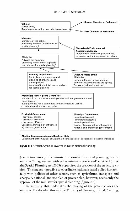
310 / BArrIE nEEdHAM
(a structure vision). The minister responsible for spatial planning, or that minister “in agreement with other ministers concerned” (article 2.3.1 of the Spatial Planning Act 2008), supervises the creation of the structure vi-sion. This makes it possi ble to coordinate national spatial policy horizon-tally with policies of other sectors, such as agriculture, transport, and energy. A national land use plan or pro ject plan, however, needs only the approval of the minister for spatial planning (figure 8.4).
The ministry that undertakes the making of the policy advises the minister. For de cades, this was the Ministry of Housing, Spatial Planning,
Second Chamber of Parliament
First Chamber of Parliament
CabinetMakes policyRequires approval for many decisions from
MinistersMembers of the cabinet(including minister responsible forspatial planning)
MinistriesAdvises the ministers(including ministry that supportsthe minister for spatial planning)
Planning InspectorateControls and monitors spatialplanning of provinces andmunicipalitiesAgency of the ministry responsiblefor spatial planning
Other Agencies of theMinistriesIncluding the very important andpowerful Rijkswaterstaat, the agencyfor roads, rail, and water, etc.
Netherlands EnvironmentalAssessment AgencyIndependent think tank: gives advice,requested and not requested, to cabinet
Provincial Government- provincial council- provincial executive- provincial officersSpatial planning policy influencedby national government
Municipal Government- municipal council- municipal executive- municipal officersSpatial planning policy influenced bynational and provincial governments
Afdeling Bestuursrechtspraak Raad van StateDepartment of the Council of State that hears appeals of decisions of government bodies
Provinciale Planologische CommissieMembers from provinces, municipalities, national government, andwater boardsEvery province has a committee for horizontal and verticalcoordination within its boundaries.
Figure 8.4 Official Agencies Involved in Dutch national Planning

nATIOnAL SPATIAL STrATEGY FOr THE nETHErLAndS / 311
and Environmental Affairs. The cabinet that came into power in 2010 abolished this ministry; the responsibilities for spatial planning and envi-ronmental policy were combined with the responsibilities for infrastruc-ture and water into a new ministry called the Ministry for Infrastructure and Environment; the responsibility for housing was transferred to an-other, existing ministry (Internal Affairs [Binnenlandse Zaken]).
Until 2002, the ministry responsible for spatial planning had a double task: to advise the minister about policy and to carry out the necessary research in an in de pen dent way. For the latter task, it employed a large number of planning researchers. Subsequently, the research task was given to a think tank financed through the ministry; since 2008, that agency has been called The netherlands Environmental Assessment Agency. It has a substantial staff of 200 full- time equivalents (Lagendijk and needham 2012).
In the 1970s, when the third national policy document was being prepared— the heyday of dutch national spatial planning (Mastop 2001)— the preparation of a national spatial plan was an im mense task that lasted years and involved consultations with both governmental and nongovern-mental organizations. detailed procedures had to be followed, draft ver-sions had to be discussed in both chambers of Parliament, and the plan had to be put on public display. Because of the length of the procedure, the cabinet that started the pro cess might have been replaced before the plan was completed. That actually happened with the fourth and the fifth national plans when the new cabinets deci ded not to accept the draft ver-sions of these plans, but to replace them with new plans, because the po-liti cal unanimity about spatial planning was waning by this time.
The 2008 act prescribes no procedures for making (as distinct from ap-proving) a structure vision, either at the national level or at the provincial or municipal levels. In contrast, a minister, province, or municipality must follow many legal procedures in making a land use or a pro ject plan. The reason for the difference is that structure visions have no binding legal force, unlike land use and pro ject plans. The planning guidelines that are determined by the minister and are legally binding are established through prescribed procedures (the general procedures for establishing a general administrative order).
If some person or or ga ni za tion (a legal person, which includes public bodies) wants to appeal a decision of the national government concerning spatial planning (or any other policy field), an in de pen dent court, the Af-deling Bestuursrechtspraak, belonging to the council of State hears that appeal. The crisis and recovery Act of 2010 removed that right of appeal for many cases concerning large projects.
312 / BArrIE nEEdHAM
Reasons for Pursuing a National Spatial Strategy
The dutch national government has pursued a spatial strategy for almost 70 years. In the first 60 years, it gradually included more aspects of spatial development, but in the past 10 years, the scope has been reduced greatly. discussion of the dutch spatial strategy can be made clearer by first ex-amining the possi ble reasons that any national government might want to pursue a national spatial strategy. It is striking that this discussion has hardly been pursued in The netherlands; it would seem that the reasons for pursuing a national spatial policy are so obvious that they can be taken for granted. “The institutionalisation of dutch planning preceded the ra-tionale” (Faludi 1991, 10). Faludi continues: “Therefore, after the war it became imperative for national planning to find a rationale” (Faludi 1991, 11). nevertheless, that search did not produce a general theory about national planning. In its absence, there are eight possi ble reasons that any national government might want to influence the distribution of people and activities within the national space:
1. To comply with international obligations, such as those under membership in the Eu ro pean Union.
2. To provide infrastructure of national importance, such as airports, waterways, railways, motorways, and international harbors.
3. To achieve important national goals that the separate regions alone cannot achieve, or that would bring national advantages greater than the advantage to an individual region (e.g., growth zones that build on the potential of certain regions; areas important for maintaining biodiversity; and security against natural calamities, such as flooding).
4. To reduce inequalities among regions (e.g., in income, unemployment, or education) that might endanger the unity of the country.
5. To ensure that citizens of the country enjoy the same basic ameni-ties, wherever they live (e.g., it might be deci ded that all children should be able to attend a primary school within a traveling distance of 30 minutes from home, that all people should be able to receive emergency medical treatment within 45 minutes, or that a fire brigade should be able to reach a fire within 30 minutes).
6. To settle conflicts if activities within one region affect another region adversely (negative external effects), and the two regions alone cannot work together to find a solution (e.g., a proposed shopping

nATIOnAL SPATIAL STrATEGY FOr THE nETHErLAndS / 313
center in one region that might drain the economy of an adjacent region, or a chemical plant in one region that might pollute an adjacent region).
7. To compensate for the disproportionate effects of activities tradi-tionally regarded as the national government’s responsibility that would affect the distribution of people and activities within the national space (e.g., large funds spent in a few locations on national defense facilities, such as military bases and military research centers, or on nationally funded universities, with disproportionate effects in their locations).
8. To improve the coordination and effectiveness of different types of mea sures taken by the national government when those mea sures have spatial consequences (e.g., policies for agriculture and for water safety, which can both affect the same area).
A national government is required to meet its international obligations, but it is not obliged to do anything about the other seven considerations. They express technical or material relationships between different locali-ties in the national space that the national government may ignore or take little account of. Those technical considerations exist irrespective of the po liti cal attention given to them. Whether and how to pay any attention to them, that is, whether to pursue some form of national spatial strategy, is a po liti cal choice. That choice will take account of the possi ble advantages and disadvantages of considering these material relationships. different national governments can make different po liti cal choices.
Key elements of the Dutch National Plans Before 2004
There has been remarkable continuity in dutch spatial policy in general, and in national spatial policy in par tic u lar. The first four national spatial plans followed what the Wrr (1998)7 identified as five “basic principles” (needham 2007, 48–49):
1. concentration of urbanization.
2. Spatial cohesion.
3. Spatial differentiation.
7 The Wrr (Wetenschappelijke raad voor het regeringsbeleid) is called in En glish the Scien-tific council for Government Policy. It gives advice, asked and unasked, to the cabinet.
314 / BArrIE nEEdHAM
4. Spatial hierarchy.
5. Spatial justice.
All levels of government shared these principles, although there was not always agreement on the precise working out of these concepts (for exam-ple, many municipalities wanted more land for housing and industry than the national government thought desirable). Faludi and Van der Valk have called the way in which the general principles were given a spatial content “principles of spatial organisation” (1994, 18). The following are some of the concepts and projects identified in the first five national strategies:
• Bundled deconcentration.
• Growth centers.
• national landscapes and national parks.
• Mainports, brainports, and greenports.
• Economic core areas.
• city regions and urban nodes.
• Urban networks and the central urban network.
• Vital town centers.
• national key projects.
• The central ring of cities.
• Quality of surroundings for daily living.
• Integral development.
• Spatial quality.
• compact cities.
• Multiple uses of land.
• Intensive use of land.
• readjustment of agricultural land.
• Ecological main structure.
As is to be expected, the content of the spatial strategies changed some-what during these 60 years. “Strategic national planning in the nether-lands is closely linked to planning for the randstad” (Mastop 2001, 225),

nATIOnAL SPATIAL STrATEGY FOr THE nETHErLAndS / 315
and that was particularly so for the first 30 years. The report on the de-velopment of the west of the country (1956) was concerned about the over-development of that region after the war. It was expected that large- scale industrialization would be necessary, with firms wanting to locate in and around the randstad. This would lead to the growth of a metropolis and the consequent disappearance of urban identities and open space. To pre-vent this, employment should be dispersed to the rest of the country. The first national spatial policy document (1960) worked this out further. The second policy document (1966) continued to advocate dispersal, but of people, not jobs, and to the central zone of The netherlands, not to the peripheral areas. The imminent danger of suburbanization and formless growth in the peri- urban regions was to be countered by bundled decon-centration. The third document (1974) continued the policy of planned dispersal (overspill) from the cities of the randstad by designating 15 growth centers, most of them around the randstad itself. That policy was discontinued in the 1980s, when the housing shortage had been reduced and the larger cities started to suffer from the outward migration. Since then, policy has been directed at strengthening towns and cities, includ-ing a policy for “the compact city” in the fourth national policy document on spatial planning. In the draft fourth plan (1988), the national policy of stimulating economic growth in the peripheral regions at the cost of the more thriving regions (the regional economic policy), which had already been weakened, was finally dropped. The new rationale was that spatial policy should stimulate economic growth in the locations most favorable for it. One way of doing this was by concentrating development in urban nodes. The supplement to the fourth plan (the Vinex) placed more em-phasis on environmental matters and contained proposals for the location of most of the new housing that would be built in the whole country be-tween 1995 and 2005. The fifth plan proposed concentrating urban growth within greenbelts and keeping it out of rural areas by imposing strong restrictions (figure 8.5). However, that plan was never formally adopted, and its replacement relaxed both sorts of planning restrictions. (For more information about the content of the first four national spatial plans, see Faludi 1991 and Mastop 2001.)
despite the changes introduced in successive national plans, there was a continuity that surprises and fascinates foreign planners. The content of spatial planning was relatively unaffected by changes in the composi-tion of the national government (and of provincial and municipal govern-ments). It was national policy to keep towns and cities strong, to steer ur-ban development away from the countryside and keep the distinction between town and country, to promote a form of development that public

316 / BArrIE nEEdHAM
transport could serve, to integrate development at the scale of the city re-gion, and to ensure that there were always enough development possibili-ties for housing and for production. The ambitions remained high and were expressed in the maps included in the national spatial plans.
Moreover, the national spatial plans were more than hopeful visions; many aspects of them have been realized (it is surprising that so little empirical research has been conducted on the concrete results of dutch national spatial planning). The best- known example of what has not been realized is keeping open the “Green Heart” of the randstad (need-ham 2007, 61). Elsewhere, the proposed locations for new housing, in par tic u lar, were fairly closely realized, as well as the protection of open
Figure 8.5 Policy for Development According to the Fifth national Policy Document, 2000Source: Needham (2007).

nATIOnAL SPATIAL STrATEGY FOr THE nETHErLAndS / 317
space (Bontje 2001; Faludi and Van der Valk 1991;8 Geurs and Van Wee 2006; Koomen, dekkers, and Van dijk 2008; Korthals Altes 2007; natu-urbalans 2006; needham and Faludi 1999; needham and Zwanikken 1997).
This won der was achieved partly through the consensus among the layers of government. The national government also took account of the wishes of the other two levels in drawing up its spatial policies. Finally, there were the financial contributions from the national government. Al-though this started to change around 2000, most of the built environment (and much of the unbuilt environment) that exists nowadays has been re-alized under the conditions of one policy for spatial planning in the nether-lands, carried out by three levels of government.
That 60 years of practice of national spatial policy can be better understood by analyzing it in terms of the eight reasons for pursuing a na-tional spatial strategy. reason 1, meeting international obligations, was not very important, partly because there were not many such obligations. reason 2, providing infrastructure of national importance, was impor-tant, but realization was often difficult because of the inadequacies in the statutory rules described in this chapter. reason 3, national goals that the separate regions alone cannot achieve, was important, but realization of those goals was sometimes hindered by the strength of municipal auton-omy. For example, national attempts to favor some regions over others in the national interest— the rationale behind national planning during its first 20 years— were strongly resisted by regions that were not favored. reasons 4, reducing inequalities among regions, and 5, ensuring that citi-zens of the country enjoy the same basic amenities, wherever they live, were given great importance nationally and also by the less favored local governments, which wanted to be brought up to the level of the more favored, using money from the national government. reason 6, avoid-ing negative external effects between regions, was given importance, but efforts were not very successful because of re sis tance from municipalities. In par tic u lar, there was enormous overzoning of land for industries, of-fices, and shopping centers. reason 7, compensating for the locational ef-fects of other national policies, was regarded as important, and the issue was tackled by policies to distribute investment in such projects, such as universities and prisons, among the regions.
reason 8, territorial policy integration, was very important from the very beginning. The sectoral ministries had (and still have) big invest-ment programs; they are spending departments. The Ministry for Spatial
8 The title of Faludi and Van der Valk (1991), “Half a Million Witnesses,” refers to the half a million people who were living in the developments proposed by the national spatial strategy.

318 / BArrIE nEEdHAM
Planning, in contrast, had no bud get for development projects. The sectoral ministries for transport, energy, agriculture, housing, and public works saw the importance of spatial coordination, while the Ministry of Spatial Plan-ning wanted to influence the location of those sectoral investments. The national government pursued this territorial policy integration, or hori-zontal coordination at the national level, partly by securing the support of all relevant ministries for the national plans, but also through a special, statutory coordinating committee, the national Spatial Planning com-mittee, which Parliament abolished around 2008 because it considered it superfluous. This is not to say that the big spending departments accepted meekly the wishes of the spatial planning ministry (some of them even went so far as to make their own national spatial plans), but the impor-tance of giving a coherent spatial dimension to sectoral policy was widely accepted (Mastop 2001). There was informal agreement that there should be a national agenda for development projects.
Key elements of the National Plan Since 2004
Significant changes began when the cabinet that came into power in 2003, more right- wing than its pre de ces sor, discarded the draft version of the fifth plan and replaced it with the “national Spatial Strategy” (figure 8.6). This strategy was based on an abstract princi ple about the role of national spatial planning formulated in that plan as: “decisions made locally when-ever that is possi ble, nationally only when that is necessary.” Although this slogan, introduced around 2004, is meaningless without further defi-nition, it did signify an important change in thinking by posing a funda-mental question: how much and what kind of national spatial planning did the dutch want? The answer was, much less than previously. The national government would stop practicing some types of active planning. Either it wanted lower levels of government to take over those planning tasks, or it left it to those lower levels to decide what to do. The national govern-ment also intended to exert less control and supervision of spatial plan-ning by local governments. The three cabinets that followed between 2006 and 2012 continued this line, and the cabinet that came into power in november 2012 has shown no signs of doing other wise.
Those who did not agree with this change in national spatial strategy, such as many national politicians in the opposition who favored continu-ing strong central involvement, as well as many professional planners, were hampered in their opposition because until then, dutch planners had hardly ever posed the fundamental question: how much national spatial planning did the dutch want, and of what sort? Thus, they had no ratio-nale at hand for defending the previous situation.

nATIOnAL SPATIAL STrATEGY FOr THE nETHErLAndS / 319
The change in policy introduced in 2003 was worked out and put into practice through an intergovernmental agreement (Bestuursakkoord) among all three levels (but initiated by the national level) in April 2011. This agreement covers much more than spatial planning, but the most im-portant provisions in regard to spatial planning are the following:
• The princi ple is established that the national government has the responsibility for determining the division of powers between the
Figure 8.6 Policy for Development According to the national Spatial Strategy, 2004Source: Needham (2007).
320 / BArrIE nEEdHAM
levels of government, which includes ensuring that the local govern-ments have the necessary powers and finance.
• The national government announces that it will stop trying to fix the boundaries of urbanisation, and will not try to enforce buffer zones or national landscapes. It hopes that the provinces will take over those tasks.9
• The national government will no longer get involved in decision making about development projects with “external effects.” Again, it hopes that the provinces will do that.
• The national government withdraws from any involvement with the redevelopment of obsolete industrial estates, with concentration and intensification of urban development, with regional economic policy, and with improving the environmental quality of natural landscapes. It is up to the local governments to take over those tasks, if they want to.
In March 2012, the national government formally adopted its “national Policy Strategy for Infrastructure and Spatial Planning.”10 The new gen-eral policy is worked out in more detail by applying it to spatial strategy. That national spatial strategy is much more selective than its pre de ces-sors and has three aims:
1. Enhance the netherlands’ competitiveness by strengthening its spatial and economic infrastructure.
2. Improve and physically guarantee accessibility, putting users first.11
3. Guarantee a safe environment in which it is pleasant to live, and in which unique natural and cultural heritage values are preserved.
Each of these three aims is translated into a number of issues of national importance (13 in all) that are to be realized by the national spatial strat-egy (figure 8.7).
9 The national government itself does not want to restrict development in certain types of lo-cations, but, by delegating that sort of decision to the provinces, it accepts the possibility that some or all provinces may want to do that. If so, then development will continue to be restricted.
10 An English- language version of the summary document is available at www . government . nl / ministries / ienm / documents - and - publications / reports / 2011 / 08 / 04 / summary - draft - national - policy - strategy - for - infrastructure - and - spatial - planning . html. As far as possi ble, the En glish terms in this chapter have been taken from this official translation.
11 The phrase “putting users first” refers to the wish to put the wishes of transport users above other (unnamed) considerations.

Figu
re 8
.7 A
mbi
tions
for
The
net
herla
nds,
204
0So
urce
: Str
uctu
urvi
sie
Infr
astr
uctu
ur e
n R
uim
te (
2012
). R
epri
nted
wit
h pe
rmis
sion
of
the
Min
istr
y of
Infr
astr
uctu
re a
nd t
he E
nvir
onm
ent.

322 / BArrIE nEEdHAM
Twelve of these issues of national importance are further worked out for each of nine regions, including parts of the north Sea.12 The strength of these regional plans is that they are connected with an instrument called the Multi- year Program for Infrastructure, Spatial Planning, and Trans-port (Meerjarenprogramma Infrastructuur, ruimte en Transport [MIrT]). Such programs lay down the spatial investment programs of the national government for each region up to 2020. The aim is to improve cohesion among investments in the separate projects, to give local governments more certainty about future investments by the national government, and to enable arrangements with local governments regarding their share of responsibility and financing. It is through the MIrT that much of the current national spatial strategy will be realized. An additional instrument is the planning guidelines: one set for the content of the policy (Spatial Planning General rules decree) and one for the procedures (Spatial Planning decree).
In contrast to previous national spatial plans, the 2012 strategy strik-ingly says nothing about desired patterns of urbanization; it offers no de-tails of where development should take place and where it should not, and whether it should follow a certain model (such as the bundled deconcen-tration or the compact city of earlier national plans).13 The cabinet has explicitly left those issues to the lower levels. nevertheless, the plan does establish as the 13th issue of national importance that there should be “careful and transparent decision- making for all decisions affecting land use and infrastructure.” To realize this, a procedure called the “ladder for sustainable urbanisation” must be followed. This requires considering the following:
• does the intended development meet a regional, inter- local demand for industrial sites, offices, residential buildings, retail development, or other urban amenities that has not been met elsewhere?
• If the intended development does meet such a need, can that be met in an urban area by restructuring or transforming existing locations?
• If restructuring or transforming offers insufficient potential, the authorities concerned will assess whether it can be achieved in such a way that it can be accessed appropriately by multiple modes of transport.
12 These regions are not the same as the current provinces. This national plan takes no ac-count of provincial boundaries.
13 Other parts of this plan, those that indicate areas that are important for international com-petitiveness and the parts that indicate infrastructure that is of national importance (figure 8.6), will have great consequences for where urbanization will take place.
nATIOnAL SPATIAL STrATEGY FOr THE nETHErLAndS / 323
Local (municipal and provincial) governments should carry out this pro-cedure. How this should be done, and how the national government will enforce this, is to be worked out in a planning guideline.
The eight reasons for pursuing a national spatial strategy can also be used to analyze the current policy and the differences with the policies up to 2004. reason 1, meeting international obligations, has been given much more importance. There are now many more EU obligations. For exam-ple, they are the reason that areas of great significance for their natural qualities (the natura 2000 areas) continue to be given strong protection, and that areas important for river- basin management are an issue of national importance.14 reason 2, providing infrastructure of national im-portance, remains very important, and the rules for ensuring this provi-sion on time have been greatly strengthened. reason 3, national goals that the separate regions alone cannot achieve, remains important, but it is now much more selective because it applies only to economic competitiveness and to water safety. reasons 4, reducing inequalities among regions, and 5, ensuring that citizens of the country enjoy the same basic amenities, wher-ever they live, no longer have a place in the national spatial strategy. na-tional government involvement in the location of production is determined only by consideration of what would bring most economic growth to the whole country. Spatial equity— that citizens should have good access to basic amenities, wherever they live—is a concern for other policy fields (health policy for the location of hospitals, educational policy for the lo-cation of schools and colleges, home affairs for the location of police sta-tions), but not for spatial policy. The national government has explicitly abandoned reason 6, avoiding negative external effects between regions; if provinces want to give it attention, they are free to do so. reason 7, com-pensating for the locational effects of other national policies, gets no more attention. In contrast, reason 8, territorial policy integration, is a cen-tral aspect of the current structure vision; the national government wants to realize its national spatial strategy by integrating its investment deci-sions within each of the nine regions.
The “national Policy Strategy for Infrastructure and Spatial Planning” states:
central government will remain responsible for the spatial planning system. It may also have to assume responsibility when:• an issue entails benefits or drawbacks for the country as a whole, and
it is beyond the powers of local and provincial authorities to override
14 The Eu ro pean Spatial Development Perspective (1999) places no obligations on the member states. Its content has had little effect on dutch spatial policy, even though the dutch were very active in preparing the ESDP.

324 / BArrIE nEEdHAM
the authority of other parties. This might include space for military activities and challenges in urban regions associated with the main-ports, brainports, greenports, and valleys;
• international obligations or agreements apply, for example on mat-ters of biodiversity, sustainable energy, water system remediation or world heritage; and
• an issue transcends provincial or national boundaries and there is either a risk of administrative deadlock or responsibility is in the hands of central government. Examples include the main road, water, rail and energy supply networks, and also the protection of public health. (section 1.2)
The first point illustrates reason 3, national goals that the separate regions alone cannot achieve; the second illustrates reason 1, meeting international obligations; and the third illustrates reason 2, providing infrastructure of national importance. Although reason 8, territorial policy integration, is not mentioned explicitly, it is clearly very important, as witnessed by the central position given to the MIrTs.
This is clearly a different type of national spatial strategy from that pur-sued before 2004. Zooneveld (2012) makes the comparison using the five basic principles of Wrr (1998). He concludes that concentration of ur-banization, spatial differentiation, and spatial justice have disappeared; that the princi ple of spatial cohesion has taken the form of coordination among spatial development, infrastructure, and water; and that spatial hierarchy has taken the form of giving dominance to spatial considerations that favor the competitiveness of the dutch economy. Faludi (2011) goes further. He in ven ted the concept of the planning doctrine in 1985 (Faludi 1985) and claimed that the dutch had a very strong planning doctrine; now, he says, it has been abandoned. It might be too soon to make such claims; the con-tinuity that lasted for 60 years has certainly been broken, but it might be restored. roodbol- Mekkes, Van der Valk, and Korthals Altes (2012) are certainly more cautious when they say that the dutch planning doctrine is undergoing evolutionary and not revolutionary change. However, they find that it is “in disarray” (roodbol- Mekkes, Van der Valk, and Korthals Altes 2012). The main changes in national spatial policy are set out in table 8.2.
Why is the current national spatial strategy so different from its pre-de ces sors? One reason is the frustrating experience with trying to realize some aspects of national spatial development, aspects to which the cur-rent national government gives great importance, such as big infrastruc-ture projects. recent cabinets have deci ded to concentrate their spatial strategy on these projects and to give themselves stronger powers to real-ize them. Other reasons have to do with different po liti cal choices. One

nATIOnAL SPATIAL STrATEGY FOr THE nETHErLAndS / 325
choice is to give more weight to economic growth and less to spatial jus-tice; this is in line with neoliberal trends in many countries of the world. Another choice is to give more decision space to local governments by withdrawing from some national government activities; the national gov-ernment has deci ded that the advantages of selective decentralization out-weigh its disadvantages.
TABle 8.2
Main Changes in Dutch National Spatial Strategy
reasons that a national government Might want to Pursue a national Spatial Strategy
Dutch national Spatial Strategy to Approximately 2003
Dutch national Spatial Strategy After Approxi-mately 2003
To meet international obligations not very important because there were few such obligations
Important because there are many more international obligations, especially from the EU
To provide infrastructure of national importance
Important, but not always supported locally
Important and promoted by greater powers of the national government
To achieve important national goals that the separate regions alone cannot achieve
Important, but not always supported locally
Selective; applied only to economic competitiveness
To reduce inequalities between regions
Important and supported locally
no longer part of national spatial policy
To ensure that citizens of the country enjoy the same basic amenities, wherever they live
Important and supported locally
no longer part of national spatial policy
To resolve conflicts when there are negative external effects between regions
Important, but often resisted locally
no longer part of national spatial policy
To compensate for disproportionate effects of national government responsibilities (e.g., defense) that would affect the distribution of people and activities within the national space
Important and supported locally
no longer part of national spatial policy
To achieve territorial integration of different national government policies (horizontal coordination at the national level)
Important Given greater importance

326 / BArrIE nEEdHAM
The “national policy strategy for infrastructure and spatial planning” offers three reasons for decentralization. First, citizens should be able to make the (planning) decisions that affect them most closely; decisions about local development should be made locally, for the people there know the situation best and should have room to find their own creative solu-tions. Moreover, the differences among the dutch regions are increasing, so it has become less appropriate for the national government to impose one policy throughout the country. The relationship between government levels should be one of trust, rather than of supervision and control. Sec-ond, decentralization will reduce the number of politicians and officials involved in planning, the time that they spend on it, and the costs of public administration. Third, decentralization, with fewer levels involved, will speed up the planning pro cess and facilitate economic development.
It should be noted that this decentralization of spatial planning was introduced around the same time at which planning legislation was being centralized (the act of 2008), and by the same cabinet. This is not a con-tradiction. The national government wanted to restrict its planning ac-tivities (decentralization of planning policy); at the same time, it wanted stronger powers to be able to realize those aspects of planning on which it wanted to concentrate (more powers to the center). nevertheless, the legislation (centralization) will last longer than the planning ambitions of a few cabinets (in this case, decentralization). A cabinet with ambitions for highly centralized spatial planning will now have more legal power to pur-sue it.
Plan Implementation Tools and Pro cesses
The formal procedures for implementing the national spatial strategy, including those for vertical coordination, are described in the section on the structure of land use governance in this chapter. In addition, there are multi- year programs for infrastructure, land use, and transport (the MIrTs that are mentioned in the section on key elements of the dutch national plan since 2004) that are also an important part of the current national spatial strategy.15 These are the mechanisms for ensuring spatial coordination of national investment projects. MIrTs have gained in im-portance now that the national government has given itself the power to push such projects through, if necessary against the wishes of provincial and municipal governments.
15 The MIrT is a continuation and extension of a previous instrument called the Multi- jaar Infrastructuur en Transport programma (MIT); the extension is that the investment plans of the MIT are now put in a spatial context.

nATIOnAL SPATIAL STrATEGY FOr THE nETHErLAndS / 327
Informal pro cesses can also be extremely effective. All levels of gov-ernment prefer to resolve differences of opinion about the spatial devel-opment of a par tic u lar location in an informal way; resort to the hierar-chical, formal procedures is regarded as an admission of administrative failure. The informal procedures begin with consultations and negotia-tions. ( Until the 2008 Spatial Planning Act, there were statutory bodies at the provincial and national levels precisely intended for such consulta-tions. Such bodies now exist only at the provincial level.) Those negotia-tions inevitably take place in the shadow of the knowledge that the national government can always, in the end, use its formal powers to impose its own will. There is also government by the purse strings. If the national gov-ernment wants a par tic u lar costly development to be built and a munici-pal government hesitates, the national government will propose coopera-tion lubricated by an attractive subsidy.16 Provincial governments play a similar game: trying to get subsidies from the national government and offering subsidies to the municipal governments. Sometimes, professional and administrative support is offered, as well as money. This is how the eight national key projects proposed in the fourth national spatial plan were implemented, and how another seven projects for modernizing rail-way stations to accommodate high- speed trains, launched in 1997, are be-ing built. This way of developing complex projects— cooperation among the different levels coupled with cooperation among the different sectors and with money from the central government— has been called “diagonal co- ordination” (Mastop 2001, 240). Sometimes, the negotiations are more indirect; for example, the national government may offer a subsidy to build a ring road in exchange for the local government dropping a plan to build on the edge of a nature reserve.
recent cabinets have preferred to reduce this sort of national involve-ment in local projects. These pro cesses are not transparent, often take a very long time, and cost the national government a lot of money. The current position is that such issues should be determined locally. At the same time, the national government wants to protect projects of national importance from local influence.
Even if only formal procedures are followed, national spatial strat-egy can be implemented through a wide range of mea sures. The cur-rent national spatial strategy makes this clear and has the following components:
16 Until 2010, such subsidies did not come from the ministry responsible for spatial planning because it was not a spending department. There were other interested departments with a lot of money, such as housing, agriculture, and transport, and the national government influenced lo-cal spatial policy by offering subsidies from these allied departments.

328 / BArrIE nEEdHAM
• decisions about what are issues of national importance and what are not.
• A map or plan showing roughly the desired location of a se lection of land uses (the current strategy is not a comprehensive plan).
• Investment plans at the regional level for realizing the desired land uses.
• rules concerning the content of and procedures for creating munici-pal and provincial land use plans.
• Statutory laws that allocate the division of planning responsibilities among the various levels of government and spell out procedures for enforcing them if necessary.
• Agreements with local governments about carry ing out those responsibilities.
Here again, there is a link between the choice within the range from cen-tralization to decentralization and the choice of implementation tools. When the national and local governments worked closely together, much national spatial strategy could be implemented by informal pro cesses. When the national government deci ded to allocate responsibilities be-tween the national and local governments explicitly and formally, it had to strengthen its formal powers to implement its own policies.
Key Outcomes and lessons
As discussed in this chapter, dutch national spatial planning has been suc-cessful in many respects; much of the content has been realized literally on the ground. However, it is much too soon to evaluate the changes in approach to national planning introduced since about 2008. How has the success of previous policies been achieved, and what lessons can be learned from this?
First, successful, effective national spatial planning requires continu-ity at the national level in the content of that planning. Also, that conti-nuity must last a long time; in par tic u lar, it must survive changes in the po liti cal composition of the governments concerned, because changing the physical environment deliberately is a slow pro cess. It is in this context that the discussion of planning doctrines is important. A planning doctrine can serve as a “durable frame for planning practice” (roodbol- Mekkes, Van der Valk, and Korthals Altes 2012, 380). A cabinet that abandons the pre-vailing doctrine runs the risk of propagating a practice that will lead its successor to abandon the new doctrine before it has had the opportunity
nATIOnAL SPATIAL STrATEGY FOr THE nETHErLAndS / 329
to affect development. If that practice is continued, national spatial strat-egies will have no impact on the ground.
Second, many good planning professionals are needed.17 The nether-lands has a strong planning profession with practicing planners who write about and discuss planning issues eloquently and widely. This is how the dutch planning doctrine arose. The doctrine has made it possi ble to con-duct debates about content and procedures quickly and effectively. A rigid planning doctrine can stifle new ideas, but there is no indication that this has been the case in The netherlands (Korthals Altes 1995; roodbol- Mekkes, Van der Valk, and Korthals Altes 2012).
Those two conditions— the presence of professionals and a doctrine— have been met in The netherlands for at least 40 years, and the momen-tum has not yet died out. Ironically, the latest national spatial strategy, through which the current government wants to break with the past, is clearly in the same line as the previous strategies. In par tic u lar, the pro-fessionalism with which the current national spatial strategy has been pre-pared would not have been possi ble without being able to build on the previous planning culture.
The third lesson is that national spatial planning is more effective if the provincial and municipal governments share the ideas and commit-ment of the national government. However, that consensus cannot be im-posed, and there is no reason to expect that all levels of government will have the same ideas about how a par tic u lar location should be developed. In that case, open and critical discussion among the various levels is easier and more productive if it is based on clear and explicit ideas (an accepted discourse) about how spatial planning could and should be divided among those levels. Moreover, many of the policy responsibilities of national gov-ernment have consequences for the distribution of people and activities throughout the national space. How the national government takes ac-count of those consequences is a po liti cal decision. At one extreme, it can ignore them. If it decides to take account of them, it is pursuing some kind of national spatial strategy. This question requires serious, open, and ex-plicit consideration, which an accepted discourse will facilitate.
Fourth, the national government must be prepared to commit substan-tial funds, first to develop the policy (consultation and research) and sub-sequently to get that policy implemented (building the infrastructure and giving subsidies to provincial and municipal governments). Money is the fuel and the lubrication that the pro cess needs. Enterprising local govern-ments will thwart national governments that try to achieve their spatial
17 Buitelaar (2007) estimated from a sample of eight dutch cities that for every 500 citizens, there was, on average, one official working on planning and related policies.

330 / BArrIE nEEdHAM
planning policies primarily by saying no (no building in certain locations, no new housing without new schools, no industrial sites without public transport). national planning should be active rather than reactive.
The experience of The netherlands shows that national spatial planning is not a hopeless cause. It can work well, but it needs to be thought through very carefully. In par tic u lar, the national government needs to decide which position it will take between the poles of centralized planning and decentralized planning, and it needs to work this position out consistently. The national government should also be aware of the variety of instru-ments available to it for implementing what ever national spatial strategy it decides to pursue. There can be much more to that strategy than mak-ing a kind of national plan.
* * *
The national Environment and Planning Act, mentioned in the text as being in preparation, was presented to Parliament in October 2014.
References
Bontje, M. 2001. “The challenge of Planned Urbanisation.” Ph.d. thesis, University of Amsterdam.
Buitelaar, E. 2007. The Cost of Land Use Decisions. Oxford: Blackwell.
Faludi, A. 1985. “A decision- centred View of Environmental Planning.” Landscape Planning 12: 239–256.
— — — , ed. 1991. “Fifty Years of dutch national Physical Planning.” Built Environ-ment 17(1).
— — —. 2011. “Geen dragers voor ruimtelijke planningsdoctrine” [no Support for Spatial Planning doctrine]. Stedenbouw en Ruimtelijke Ordening 5: 34–35.
Faludi, A., and A. van der Valk. 1991. “Half a Million Witnesses: The Success (and Failure?) of dutch Urbanization Strategy.” In “Fifty Years of dutch national Physical Planning,” ed. A. Faludi. Built Environment 17(1): 43–52.
— — —. 1994. Rule and Order: Dutch Planning Doctrine in the Twentieth Century. dor-drecht: Kluwer.
Geurs, G. K., and B. van Wee. 2006. “Ex- Post Evaluation of Thirty Years of compact Urban development in The netherlands.” Urban Studies 43: 139–160.
Koomen, E., J. dekkers, and T. van dijk. 2008. “Open- Space Preservation in The netherlands: Planning, Practice and Prospects.” Land Use Policy 25: 361–377.
Korthals Altes, W. 1995. De Nederlandse planning doctrine in het fin de siècle [The dutch planning doctrines in the end of the century]. Assen: Van Gorcum.
— — —. 2007. “The Impact of Abolishing Social- Housing Grants on the compact- city Policy of dutch Municipalities.” Environment and Planning A 39: 1497–1512.
nATIOnAL SPATIAL STrATEGY FOr THE nETHErLAndS / 331
Lagendijk, A., and B. needham. 2012. “The Short Lifespan of the netherlands Insti-tute for Spatial research.” Regional Studies 46(4): 475–491.
Mastop, J. 2001. “dutch national Planning at the Turning Point.” In National- Level Planning in Demo cratic Countries, ed. r. Alterman, 210–256. Liverpool: Liverpool University Press.
natuurbalans. 2006. Natuurbalans [Balance in nature]. Bilthoven: Agency for Envi-ronment and nature.
needham, B. 2007. Dutch Land- Use Planning. The Hague: Sdu uitgevers.
needham, B., and A. Faludi. 1999. “dutch Growth Management in a changing Mar-ket.” Planning Practice and Research 14(4): 481–491.
needham, B., and T. Zwanikken. 1997. “The current Urbanisation Policy Evaluated.” Netherlands Journal of Housing and the Built Environment 12(1): 37–55.
Pestman, P. 2001. In het spoor van de Betuweroute [In Trace of the Betuweroute]. Am-sterdam: rozenberg.
roodbol- Mekkes, P., A. van der Valk, and W. Korthals Altes. 2012. “The netherlands Spatial Planning doctrine in disarray in the 21st century.” Environment and Plan-ning A 44: 377–395.
Wrr (Scientific council for Government Policy). 1998. Town and Country Development Politics. The Hague: Sdu uitgevers.
Zonneveld, W. 2012. “Verdwenen basisprincipes van de nationale ruimtelijke orden-ing” [disappeared basic principles of the national town and country planning]. Stedenbouw en Ruimtelijke Ordening 4: 46–52.
Government publications
dutch national Government. 1956. Het Westen . . . en overig Nederland [The West . . . and the Rest of The Netherlands]. The Hague: dutch national Government.
— — —. 1960. Eerste nota ruimtelijke ordening [The First National Policy Document on Spatial Planning]. The Hague: dutch national Government.
— — —. 1966. Nota ruimtelijke ordening [The Second National Policy Document on Spatial Planning]. The Hague: dutch national Government.
— — —. 1962. Wet ruimtelijke ordening [Spatial Planning Act]. The Hague: dutch na-tional Government.
— — —. 1974. Derde nota over de ruimtelijke ordening [The Third National Policy Document on Spatial Planning].The Hague: dutch national Government.
— — —. 1988. Vierde nota over de ruimtelijke ordening [The Fourth National Policy Document on Spatial Planning]. The Hague: dutch national Government.
— — —. 1992. Vierde nota over de ruimtelijke ordening Extra: op weg naar 2015 [Supple-ment to the Fourth National Policy Document on Spatial Planning]. The Hague: dutch national Government.
— — —. 1993. Tracé wet [Trajectory Act]. The Hague: dutch national Government.
— — —. 2000. Ruimte maken, ruimte delen: Vijfde nota over de ruimtelijke ordening [The Fifth National Policy Document on Spatial Planning]. The Hague: dutch national Government.

332 / BArrIE nEEdHAM
— — —. 2004. Nota ruimte: ruimte voor ontwikkeling [National Spatial Strategy]. The Hague: dutch national Government.
— — —. 2012. Structuurvisie infrastructure en ruimte [National Policy Strategy for Infra-structure and Spatial Planning]. The Hague: dutch national Government.
Vereniging van nederlandse Gemeenten, Interprovinciaal Overleg, Unie van Water-schappen, rijk [Association of the dutch Municipal Authorities, consultative Body of Provinces, Union of regional Water Authorities, State]. 2011. Bestuursakkoord 2011–2015 [Government Agreement 2011–2015]. www . rijksoverheid . nl / bestanden / . . . / bestuursakoord - 2011 - 2015 . pdf

/ 333 /
barrie needham gives an impressive overview of the rich spatial plan-ning tradition that has shaped The netherlands. He defines the les-
sons learned and poses some critical questions about the new approach being pursued in The netherlands. The following comments focus on actual government policies in The netherlands and explain the (partial) shift from top- down national spatial planning to a more decentralized sys-tem, where national policies will be applied more selectively, and local and provincial authorities have been given more space to make locally appropriate arrangements.
National Challenges Regarding land Use
As needham points out, The netherlands has been shaped by a long spa-tial planning tradition. As a result of the country’s location in Eu rope’s main delta region, the dutch have been forced for centuries to work together on effective water management. Also, in a small and densely pop-ulated country with a strong demo cratic tradition, integrated planning proved to be a very appropriate tool to divide scarce and expensive land and to ensure an optimal mix of essential functions in the living environ-ment. The following sections discuss the main current challenges in The netherlands regarding the use of land.
Commentary
henrIëTTe berSee

334 / HEnrIëTTE BErSEE
Demographic Changes
Although the population of the world as a whole is still rising, demographic growth in Eu rope and The netherlands is stabilizing. The potential work-force is shrinking (in absolute terms), and the overall population will age considerably until about 2040. The demographic picture within The netherlands displays significant regional differences. The country’s urban population is still growing, with Amsterdam taking the lead. However, the population of a number of regions is already shrinking. This will have con-sequences for spatial decisions. Planning and building for growth, as was the common practice in The netherlands for many de cades, is no longer feasible throughout the whole country. In addition, many locations in The netherlands are built up or are dominated by one specific type of build-ing, as illustrated by the many empty office buildings along the country’s motorways. Many of these office buildings will never be used again be-cause of lack of demand. For those sites, there is no instant national solu-tion, no national master plan to be made. As for the surplus of business parks and retail areas in some places, these sites will have to be transformed through organic local- area development.
International Competitiveness
despite the current economic crisis, The netherlands has a strong eco-nomic system. Activity in the main sectors of industry— the so- called topsectors—is increasingly concentrated in the urban regions, especially around Amsterdam, rotterdam, and Eindhoven, which have an above- average international orientation. Amsterdam was the world’s financial and economic capital in the 17th century and still enjoys a strong posi-tion, thanks in part to the presence of Schiphol Airport. rotterdam, served by Eu rope’s largest port, is the logistical heart of The netherlands. The Eindhoven region boasts a highly developed international ecosystem in the knowledge- intensive manufacturing industry and was named the world’s Intelligent community of the Year 2011 by the Intelligent community Forum in new York. Because the development of these urban regions is essential if The netherlands is to continue to be internationally competi-tive, the national government will continue to invest in excellent connec-tions in these regions.
Adaptation to Climate Change
As result of climate change, the risk of flooding, heat waves, and extreme drought will increase in The netherlands. The western urban part (the
cOMMEnTArY / 335
randstad) is particularly vulnerable to flooding. Located mostly below sea level, it is the most densely populated urban area and is where two- thirds of the gross national product is earned and the main ports are located. In 2008, the national government started a study program called the delta Program to develop options to protect this area from flooding in the future and at the same time guarantee high standards of living. This program is being carried out in close cooperation with the regions that will probably be most affected. Its results, which will be presented in 2014, will guide policy decision making on water management and urban and spatial de-velopment at all government levels.
renewable energy
not only adaptation to, but also mitigation of climate change is an impor-tant goal of the national government. In order for The netherlands to con-tribute less to global climate change, the proportion of energy needs sup-plied by sustainable sources, such as wind, solar, biomass, and geothermal energy, will have to increase. This will require substantial space. Especially in a small and densely populated country like The netherlands, this issue needs the attention of all government levels.
A New Approach to National Planning
The ambitions of the national government are for The netherlands to be competitive, accessible, livable, and safe. Spatial planning is or ga nized to contribute to these goals. The Spatial Planning Act of 2008 distinguishes among municipal, provincial, and national spatial interests and pro-vides that every tier of administration is responsible for its own level of interests.
As growth in financial resources and population has slowed, responsi-bilities for planning have increasingly been decentralized. The emphasis has shifted from producing in bulk (building ever more homes, offices, and industrial estates) to customized solutions focused on quality (i.e., trans-formation and greater sustainability).
The Ministry of Infrastructure and the Environment exerts both di-rect and indirect influence on spatial planning and development through its policies, legislation, and its investments in infrastructure and water-ways. Because excessive layers of government, complex regulations, and compartmentalization have been felt to be all too common and to be hin-dering the development of The netherlands, the ministry has brought spa-tial planning decision making closer to the stakeholders (citizens and the

336 / HEnrIëTTE BErSEE
private sector) by delegating more decisions to local and provincial au-thorities. The national policy is being applied more selectively, focusing on 13 national interests for which the national government will take re-sponsibility and ensure that it achieves results. These national interests are listed in the National Policy Strategy for Infrastructure and Spatial Planning (Structuurvisie Infrastructuur en Ruimte), sent to Parliament in 2012 (Ministerie van Infrastructuur en Milieu, 2012). They include the following:
1. An outstanding, internationally accessible business climate in the urban regions.
2. Space for the main energy supply network and the energy transition toward renewable energy.
3. Space for the main pipeline network for the transport of hazardous and other substances.
4. Efficient use of the subsurface.
5. A robust main road, rail, and waterway network around and be-tween the most important urban regions.
6. Better use of the capacity of existing road, rail, and waterway networks.
7. Preservation of the existing network of roads, rails, and waterways.
8. Improvement of environmental quality.
9. Adaptation to climate change (flood protection, drinking- water supply, climate- safe urban development).
10. Preservation and strengthening of the unique cultural heritage and natural values.
11. Space for a national network of wildlife habitats.
12. Space for military sites and activities.
13. careful consideration and transparent decision making in all spatial plans.
Outside these 13 national interests, local and regional authorities are able to make their own policy decisions, but national interest number 13 indi-cates that the national government continues to be responsible for ensur-ing that the country has a good spatial planning system, based on clear national legislation.

cOMMEnTArY / 337
The environment and Planning Act
In The netherlands, legislation on housing, infrastructure, spatial plan-ning, the environment, nature, and water has generally developed over several de cades. This pro cess has resulted in dozens of laws, hundreds of regulations, and dozens of different types of plans relating to the human environment, each with its own principles, procedures, and requirements. Because these regulations were developed for specific sectors, the current system is not efficient enough to resolve problems in an integrated manner.
In 2010, the Simpler and Better Legislation Program was started with the aim of writing a new, comprehensive national Environment and Plan-ning Act. This new act will regulate all activities affecting the living en-vironment and will cover land use planning, environmental protection, nature conservation, construction of buildings, cultural heritage, water management, urban and rural redevelopment, development of major public and private works, and mining and earth removal. The new Environment and Planning Act is aimed at more transparency, predictability, and prac-ticality in applying the law. It should ensure a more integrated approach to the living environment and greater administrative discretion to allow for variation, making it easier to respond to regional and local differences. Last, but not least, it should promote quicker decision making on projects. After extensive consultations with the provinces and municipalities, the draft law has been sent to the council of State for comments and advice as a last step before being published and sent to Parliament.
Area- Focused Investment
In 2009, the central government and the regions adopted the first of the so- called regional agendas. These agendas bring together national and re-gional spatial policy strategies and challenges relating to mobility, water, urbanization, nature, and the landscape. They explore the interrelation-ships among the different challenges and how they can be tackled, as well as how solutions might be financed jointly. Based on the regional agen-das, the Multi- Year Program for Infrastructure, Spatial Planning, and Transport (Meerjarenprogramma infrastructuur, ruimte en transport, MIrT) defines when and how the various challenges are to be jointly ad-dressed in each region. This pro cess can start with a MIrT investigation or exploratory analy sis. If financial involvement of the national govern-ment is a possibility, a MIrT exploratory analy sis is performed to estab-lish the financial contributions to be made by the different parties. The MIrT program is submitted to the lower house of Parliament once a year

338 / HEnrIëTTE BErSEE
as an appendix to the bud get of the Ministry of Infrastructure and the Environment.
As Professor needham describes, The netherlands has a long spatial plan-ning tradition. Over the past several years, the national government has changed its approach in order to meet new societal challenges. The world is developing rapidly, public financial constraints are more stringent, and private initiatives need more space to keep up. national master plans are more and more being replaced by organic and adaptive planning. The na-tional government focuses on a limited set of national interests, on inte-grated regional plans that steer national and regional investments in in-frastructure, and on simplifying the law concerning the living environment. Spatial planning in The netherlands no longer means designing a national plan. Instead, it is the creation of conditions under which development is promoted and investment decisions can be made, while at the same time, national law protects the property rights of the citizens.

/ 339 /
9
The Danish national Spatial Planning Framework
Fluctuating Capacities of Planning
Policies and Institutions
DAnIel gAllAnD AnD STIg eneMArK
Geography, Population, and economy
Located in northern Eu rope, denmark is the southernmost of the nor-dic countries and consists of the Jutland peninsula and an archipelago of several hundred islands situated in the Baltic Sea (figure 9.1). Excluding the overseas, self- governing territories of Greenland and the Faroe Islands, denmark proper covers an area of approximately 42,916 square kilome-ters, roughly the same as the sum of the areas of Mary land, delaware, and rhode Island in the United States. A total of 66 percent of the land is used for farming and agriculture, while forests and heathland cover 16 percent. Urban zones and transport infrastructure make up about 10 percent of the country’s area, and the remaining 7 percent consists of bodies of water, such as lakes, marshes, and wetlands (Statistics denmark 2014a).
As of 2014, denmark’s population was about 5.63 million, with a den-sity of 130.5 inhabitants per square kilometer. The population is predom-inantly urban. Approximately one- third of the population lives in the Greater copenhagen region (1.75 million), while an additional one- fifth resides in the country’s next three largest urban areas: Århus (324,000),
The authors would like to thank niels Østergård, former director general at the Agency for Spatial and Environmental Planning in the danish Ministry of the Environment, for providing critical feedback on an earlier version of this chapter.
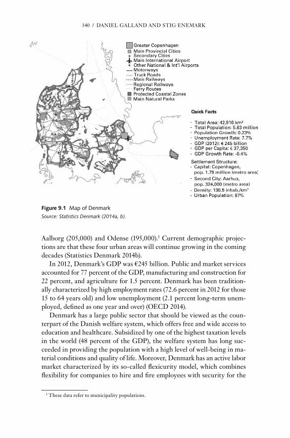
340 / dAnIEL GALLAnd And STIG EnEMArK
Aalborg (205,000) and Odense (195,000).1 current demographic projec-tions are that these four urban areas will continue growing in the coming de cades (Statistics denmark 2014b).
In 2012, denmark’s GdP was €245 billion. Public and market ser vices accounted for 77 percent of the GdP, manufacturing and construction for 22 percent, and agriculture for 1.5 percent. denmark has been tradition-ally characterized by high employment rates (72.6 percent in 2012 for those 15 to 64 years old) and low unemployment (2.1 percent long- term unem-ployed, defined as one year and over) (OEcd 2014).
denmark has a large public sector that should be viewed as the coun-terpart of the danish welfare system, which offers free and wide access to education and healthcare. Subsidized by one of the highest taxation levels in the world (48 percent of the GdP), the welfare system has long suc-ceeded in providing the population with a high level of well- being in ma-terial conditions and quality of life. Moreover, denmark has an active labor market characterized by its so- called flexicurity model, which combines flexibility for companies to hire and fire employees with security for the
1 These data refer to municipality populations.
Figure 9.1 Map of DenmarkSource: Statistics Denmark (2014a, b).

dAnISH nATIOnAL SPATIAL PLAnnInG FrAMEWOrK / 341
unemployed at relatively high levels. This model has helped the country adjust to shocks while limiting the social cost of unemployment. The dan-ish welfare system, combined with labor- market flexicurity, has ensured low poverty and in e qual ity rates over time.
System of Government and Administrative Structure
Since the enactment of its first constitution in 1849, denmark has func-tioned as a parliamentary democracy headed by a prime minister and ex-ercising executive, legislative, and judicial powers. The cabinet carries out the executive functions of the country and is composed of several minis-ters whose core responsibility is to head specific government departments (ministries) in charge of par tic u lar sectors of government administration (there are normally between 18 and 20 ministries). Among other tasks, the cabinet deals with draft legislation; proposals for parliamentary resolution; reports to Parliament; appointments to boards, councils, and committees; decisions on proposals from the opposition for legislation; and parliamen-tary resolution (Folketinget, 2014).
The Parliament exercises legislative power and is the only branch of power enabled to adopt legislation. consisting of 179 members (MPs) (175 elected in denmark, 2 in the Faroe Islands, and 2 in Greenland), the Par-liament is responsible for adopting and approving the state’s bud gets and accounts. It also exercises control of the government and takes part in in-ternational cooperation. At the practice level, the Parliament is or ga nized into 26 standing committees dealing with bills and proposals for parlia-mentary resolution. Among them, the Parliament’s Environment and Planning committee takes care of planning- related affairs.
denmark has traditionally had minority governments consisting of two or more po liti cal parties, which have established co ali tion governments oc-casionally supported by nongovernment parties. The election system is based on the concept of proportional repre sen ta tion, and elections are car-ried out every fourth year, although the prime minister may call for elec-tions more frequently. Since October 2011, a left- wing co ali tion has been in power, originally formed by the Social demo cratic Party, the danish Social- Liberal Party, and the Socialist People’s Party; the last withdrew in February 2014.
Judicial powers are exercised by the danish courts, which since 2007 have consisted of the Supreme court, the two high courts, the Maritime and commercial court, the Land registration court, 24 district courts, the courts of the Faroe Islands and Greenland, the Appeals Permission Board, the Special court of Indictment and revision, the danish Judicial Appointments council, and the danish court Administration. The nature

342 / dAnIEL GALLAnd And STIG EnEMArK
and Environmental Board of Appeals is concerned with planning- related matters.
In 2007, the liberal- conservative co ali tion government then in power implemented a reform of local- government structure that changed the ge-ographies of intergovernmental arrangements in denmark. The reform merged 275 municipalities into 98 larger units, abolished the county level, and created five administrative regions whose main task is to undertake healthcare administration ( table 9.1). This territorial and administrative restructuring generated a major re distribution of tasks and responsibili-ties among levels of government that had a profound impact on the dan-ish planning system (Galland and Enemark 2013).
denmark has a decentralized system of public administration whereby local authorities administer most of the total public expenditure. The mu-nicipalities are authorized to levy taxes and are currently responsible for numerous tasks related to employment, education, social ser vices, culture, and physical planning, among other areas. The regions have no legal au-thority to levy taxes and are dependent on central government and mu-nicipal funding. Both municipalities and regions are led by elected coun-cils, which are elected every four years.
evolution of National Spatial Planning in Denmark
In 1997, the commission of the Eu ro pean communities (cEc) contended in its EU Compendium of Spatial Planning Systems and Policies that spatial
TABle 9.1
Five New Administrative Regions in Denmark
region PopulationArea (Km2)
number of Municipalities
largest Urban Area (Population)
capital region of denmark (region Hovedstaden)
1,749,155 2,546 29 Greater copenhagen (1.75 million)
region Zealand (region Sjælland)
813,795 7,217 17 roskilde (84,000)
region South denmark (region Syddanmark)
1,200,956 12,256 22 Odense (195,000)
region central denmark (region Midtjylland)
1,278,480 13,000 19 Århus (324,000)
region north denmark (region nordjylland)
579,972 7,874 11 Aalborg (205,000)
Total 5,622,358 42,893 98
Source: Based on data from Statistics denmark (2014b).

dAnISH nATIOnAL SPATIAL PLAnnInG FrAMEWOrK / 343
planning in denmark had a comprehensive- integrated character, a label normally attributed to “mature” planning systems (cEc 1997). This as-sertion essentially derived from the statement that the planning domain in denmark consisted of a “systematic and formal hierarchy of plans from national to local level, which coordinate public sector activity across different sectors but focus more specifically on spatial co- ordination than economic development” (cEc 1997, 36–37). Accordingly, the danish plan-ning system distinguished itself from several other Eu ro pean planning systems by its harmonized and coherent institutional and policy frame-work across different levels of planning administration. Table 9.2 presents the milestones in the history of national planning in denmark.
brief history of Danish Spatial Planning
The comprehensive- integrated tradition of planning systems and policies is mainly associated with Scandinavian countries. It explicitly seeks to deliver a certain degree of horizontal and vertical integration of policies across sectors and jurisdictions (cEc 1997). In this sense, comprehensive- integrated planning aims to achieve spatial coordination through a hier-archy of plans occurring at multiple scales. In denmark, the birth of com-prehensive planning should be understood as a direct response to the significant sociospatial challenges posed by the country’s industrial devel-opment and rapid economic growth after the Second World War. The most significant of these were urban sprawl, industry requirements for extra land, and a general decline in the living conditions of a considerable part of the population. Population distribution also became a relevant is-sue, particularly at a time when a high migration rate to copenhagen left several other regions of the country lagging behind. This lack of balance and these challenges required the design of solid planning capacities and schemes aimed at rethinking the spatial arrangement of denmark’s urban centers (Gaardmand 1993).
during the 1960s, planning per se was mainly a private exercise that dealt with the preparation of land development plans for single- family housing in suburban areas, as well as cottage areas along the coasts. The establishment of the national Planning committee during that de cade, however, led to the publication of an indicative planning exercise that spec-ified areas for urban and industrial development, environmental preser-vation, summer housing, and agricultural production. In the 1970s, a ter-ritorial reconfiguration of the administrative division of counties and municipalities took place through a reform of local- government structure. The rationale behind this reform was that every new municipality em-braced a single town and its hinterland. Based on the provision of goods and ser vices, coupled with a hierarchical positioning of each center in

344 / dAnIEL GALLAnd And STIG EnEMArK
relation to others, this spatial pattern eventually replaced the former land demarcation that made a sharp distinction between urban and rural areas. Furthermore, this structural reform also led to the institutionaliza-tion of danish planning based on the social demo cratic ideology of equal development, which called for decentralization as the means by which de-velopment needs (e.g., better access to public and private ser vices that would have other wise remained in a few urban centers) could be met throughout the entire country. In this sense, the danish planning domain in the 1970s could be portrayed as “the spatial expression of the welfare state” ( Jensen and Jørgensen 2000, 31).
Spatial planning underwent a period of ambiguity during the 1980s. The 1981 national planning report signified the peak of the long- term welfarist planning exercise developed in accordance with an urban hier-archy pattern aimed at securing and enabling equal resource distribution throughout the whole territory (Ministry of the Environment 1981). Toward the end of the de cade, subsequent national planning reports were based on a neoliberal vocabulary that reinterpreted the notion of equality. Influenced by international agendas, the center- right government at the end of the 1980s thus played an important role in shaping national spatial planning policy along the lines of diversity and modernization (Ministry of the Environment 1987, 1989; nielsen and Olsen 1990).
As national planning moved away from welfarist logics, regional plan-ning remained confronted with the task of spatial coordination, as well as the implementation of the hierarchical urban pattern. The counties there-fore continued to delegate key roles to specific cities and towns as provid-ers of ser vices and infrastructure development. Additionally, the counties assumed a cross- sectoral focus stemming from the need to balance multi-ple interests and objectives by delivering a sound spatial planning frame-work for municipalities to advance their own land use regulations. Binding regional plans defined urban development zones (e.g., for infrastructure, traffic, business development), countryside regulations (e.g., for recre-ational areas, nature protection, environmental resource management), and regional facility- siting objectives (e.g., for waste or energy facilities) (Galland 2012a).
during the 1990s, the objectives and contents of danish spatial plan-ning were significantly reframed. The Planning Act that came into force in 1992 replaced equal development with the aim to achieve “appropriate development in the whole country and in the individual administrative re-gions and municipalities, based on overall planning and economic con-siderations” (Ministry of the Environment 2007b, 5). This new catch-phrase could be interpreted as an outcome of the agenda of international competitiveness promoted by Eu ro pean spatial planning policies at the

dAnISH nATIOnAL SPATIAL PLAnnInG FrAMEWOrK / 345
time (Amin and Thrift 1994; newman and Thornley 1996). Spatial struc-turing and positioning of denmark became influenced by more market- oriented and polycentric growth thinking. notions inspired by a language of competitiveness replaced spatial concepts that were based on the logic of urban hierarchy (Ministry of Environment and Energy 1997, 2000; Ministry of the Environment 1992, 2003). despite this policy discourse, planning at the national level continued to adopt regulatory mea sures in the form of planning directives on such issues as coastal protection and out- of- town retail development, as well as the EU directive on environ-mental impact assessments. These directives are still legally binding on local planning authorities.
A significant shift in danish spatial planning was linked to the enact-ment of the 2007 reform of local governments, which radically reconfig-ured the po liti cal and administrative map of denmark. In regard to plan-ning practice, the reform transferred the counties’ tasks and responsibilities to both national and municipal authorities. The new municipalities ac-quired responsibilities for town and country land use planning, while responsibilities for sectoral planning were transferred to the national level.2
After the structural reform, national planning clearly positioned itself in accordance with globalization. The 2006 national planning report stressed the need to renew spatial planning as a prerequisite for pursuing competitiveness demands (Ministry of the Environment 2006). In re-sponding to these challenges, the report focused on promoting differen-tiated settlement regions, most notably on creating two metropolitan regions— the Greater copenhagen and the Øresund region—as one co-hesive urban region, and to the Eastern Jutland region, consisting of mul-tiple cities along a single urban corridor. In princi ple, then, danish spatial planning continued the strategic turn of the previous de cade. At the same time, the reform brought an unpre ce dented planning directive for Greater copenhagen, which could be understood as a case of recentralization that enabled the Ministry of the Environment to assume planning powers in that metropolitan region (Ministry of the Environment 2007a).
The 2010 danish national planning report did not explicitly exhibit any par tic u lar spatial development tendency. The diverse settlement patterns and strategic spatial approaches adopted by former national planning reports during the previous two de cades were abandoned (Ministry of the Environment 2010). Thus, the planning approach at the national level
2 national and municipal planning were “strengthened” by one- third and two- thirds, respec-tively, in relation to the tasks formerly run by the counties, as calculated by the total number of civil servants who were transferred to these entities (Galland 2012b, 1390).
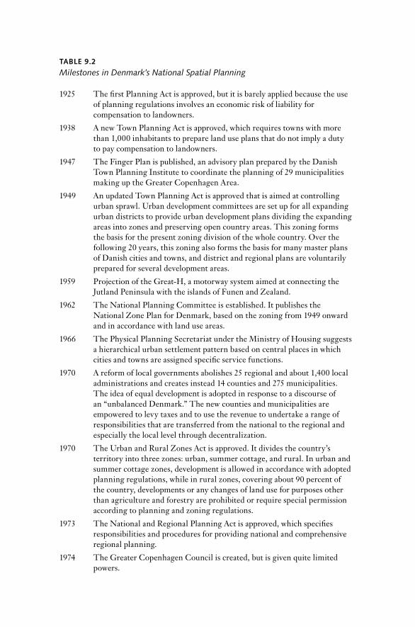
TABle 9.2
Milestones in Denmark’s National Spatial Planning
1925 The first Planning Act is approved, but it is barely applied because the use of planning regulations involves an economic risk of liability for compensation to landowners.
1938 A new Town Planning Act is approved, which requires towns with more than 1,000 inhabitants to prepare land use plans that do not imply a duty to pay compensation to landowners.
1947 The Fin ger Plan is published, an advisory plan prepared by the danish Town Planning Institute to coordinate the planning of 29 municipalities making up the Greater copenhagen Area.
1949 An updated Town Planning Act is approved that is aimed at controlling urban sprawl. Urban development committees are set up for all expanding urban districts to provide urban development plans dividing the expanding areas into zones and preserving open country areas. This zoning forms the basis for the pre sent zoning division of the whole country. Over the following 20 years, this zoning also forms the basis for many master plans of danish cities and towns, and district and regional plans are voluntarily prepared for several development areas.
1959 Projection of the Great- H, a motorway system aimed at connecting the Jutland Peninsula with the islands of Funen and Zealand.
1962 The national Planning committee is established. It publishes the national Zone Plan for denmark, based on the zoning from 1949 onward and in accordance with land use areas.
1966 The Physical Planning Secretariat under the Ministry of Housing suggests a hierarchical urban settlement pattern based on central places in which cities and towns are assigned specific ser vice functions.
1970 A reform of local governments abolishes 25 regional and about 1,400 local administrations and creates instead 14 counties and 275 municipalities. The idea of equal development is adopted in response to a discourse of an “unbalanced denmark.” The new counties and municipalities are empowered to levy taxes and to use the revenue to undertake a range of responsibilities that are transferred from the national to the regional and especially the local level through decentralization.
1970 The Urban and rural Zones Act is approved. It divides the country’s territory into three zones: urban, summer cottage, and rural. In urban and summer cottage zones, development is allowed in accordance with adopted planning regulations, while in rural zones, covering about 90 percent of the country, developments or any changes of land use for purposes other than agriculture and forestry are prohibited or require special permission according to planning and zoning regulations.
1973 The national and regional Planning Act is approved, which specifies responsibilities and procedures for providing national and comprehensive regional planning.
1974 The Greater copenhagen council is created, but is given quite limited powers.
(continued )
TABle 9.2 (continued )
1975 The national Agency for Physical Planning is created under the Ministry of the Environment, and the first (annual) national planning report is published.
1977 The Municipal Planning Act is approved, with duties and procedures providing for comprehensive municipal planning and also local plans before implementation of any major development proposal. The planning procedures at the regional and local levels are based on the principles of decentralization, comprehensive planning, and public participation.
1979 On the basis of the spatial logic suggested in 1966, the national Agency for Physical Planning publishes the influential Report on the Future Urban Settlement Pattern for Denmark.
1981 In accordance with the 1979 report, the national planning report officially designates a hierarchy of urban centers for the whole country.
1982 A conservative government influenced by Thatcherite neoliberalism assumes office, and national planning enters a standby period.
1989 The national planning report asserts that the notion of equal development is outdated. Instead, the regions of denmark should develop differentially to strengthen the country’s position internationally.
1992 A revised and modernized Planning Act is approved that merges the regulation of the former acts on urban and rural zones, national and regional planning, and municipal planning into one piece of legislation. The national Planning report Denmark Towards the Year 2018 promotes the Øresund region as the international gateway and leading urban region in Scandinavia. International competitiveness is promoted, and other danish provincial cities are portrayed from such framing.
1994 A national planning directive on coastal protection is adopted. The directive establishes a protection zone of three kilometers along the coastline where any development activities are subject to specific coastal planning considerations.
1997 A national planning directive on retail trade is adopted that limits large- scale, out- of- town retail development. The national planning report Denmark and Eu ro pean Spatial Planning Policy adopts the idea of polycentricity, which creates new planning concepts based on the merger of former and updated spatial logics.
2001 A liberal- conservative co ali tion government assumes office and attempts to adapt the scope of planning to fulfill growth- oriented agendas.
2006 Influenced by the preparation of a structural reform, the national planning report The New Map of Denmark— Spatial Planning Under New Conditions portrays spatial planning as a tool to meet growth and competitiveness demands. The Ministry of the Environment advances initiatives to create partnership and dialogue among municipal councils, regional councils, and the state on the future development of two metropolitan regions.

348 / dAnIEL GALLAnd And STIG EnEMArK
clearly broke away from the differentiated spatial reasoning associated with previous planning.
However, the national planning report published in 2013 does attempt to articulate a spatial approach based on the idea of concentrating growth in the Greater copenhagen region and within potential city- regions lo-cated along the national highway system, the so- called Great- H (see Min-istry of the Environment 2013b) (figure 9.2). In so doing, the report pro-vides a national spatial structure based on ad hoc spatial analyses (such as commuting patterns) and also adopts a “green growth” discourse in rela-tion to climate and the environment. It can be argued, however, that this report is mainly indicative because it does not provide any direction to meet spatial coordination challenges at intermunicipal and regional levels. The national level formerly had the capacity and competence to coordinate spatial planning across scales through regional planning, but it currently has limited resources to adopt such coordinating roles. Hence, except for the 2013 Fin ger Plan directive for Greater copenhagen, danish national spatial planning continues to have a limited say in the implementation of spatial planning policy within the national territory. The diminishing power of national planning suggests that plans, policies, and reports at this level of administration are likely to have less say in future spatial de-velopment decisions (Galland and Enemark 2013).
TABle 9.2 (continued )
2007 A structural reform is implemented in denmark that modifies intergovernmental arrangements by creating larger municipalities (98 instead of 275) and five new administrative regions. The county level is abolished, and its spatial planning tasks are redistributed to the national and especially the municipal levels. The former comprehensive regional plans are replaced by visionary regional development plans, while the land use content of the former regional plans is transferred to municipal plans. As part of the structural reform, the Fin ger Plan is adopted as a national planning directive to regulate and control land use in the Greater copenhagen region.
2010 Planning at the national level is chiefly aligned with environmental sustainability and sectoral agendas. The first national planning report published since the structural reform exhibits no spatial development tendency.
2013 In response to a number of criticisms, mostly from municipalities, national planning takes a more spatial approach based on the concentration of growth in city- regions, although the national planning report largely remains an indicative document with limited capacity for implementation.
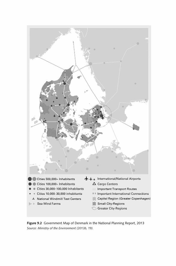
Figure 9.2 government Map of Denmark in the national Planning report, 2013Source: Ministry of the Environment (2013b, 19).

350 / dAnIEL GALLAnd And STIG EnEMArK
Factors Shaping Danish Spatial Planning
Planning systems originally appeared in several Western Eu ro pean post-war welfare states during the 1960s and 1970s. Behind their emergence was the rise of “Keynesian welfarism,” under which capitalist states inter-vene to secure full employment and economic growth by linking the na-tional economy, the national state, and national society ( Jessop 1990, 2000). Planning systems and policies emerged in this context as spatial frame-works to tackle mounting socioeconomic disparities among regions. In regard to spatial concepts, these objectives were materialized within specific national territories (such as denmark and Germany) on the basis of hierarchies of central places (christaller 1966).
As the danish case indicates, spatial planning agendas at the time were translated into plans, regulations, guidelines, and schemes dealing with land use allocation, urban expansion, infrastructure development, settle-ment improvements, and sectoral policy coordination, among other mat-ters. The traditional conception of spatial planning in this and related Eu-ro pean contexts could be understood as “the methods used largely by the public sector to influence the future distribution of activities in space . . . undertaken with the aims of creating a more rational territorial or ga ni za-tion of land uses and the linkages between them, to balance demands for development and to achieve social and economic objectives” (cEc 1997, 24).
The downfall of welfarist regimes led to the establishment of neoliber-alism, which sought to promote international competitiveness and socio-technical innovation in open economies. A result of this paradigm shift was that social policies became significantly subordinated to economic policies in allowing for greater labor- market flexibility. By the 1980s, spa-tial planning shifted to supporting new economic initiatives by replacing welfarist policy objectives with the promotion and regulation of distinct development projects, such as efforts aimed at revitalizing rundown areas of cities and city- regions (Healey et al. 1997).
In denmark, however, this neoliberal turn took place more slowly than it did elsewhere in Eu rope (e.g., in the United Kingdom or The nether-lands). In contrast, the danish social demo cratic state kept key policy sec-tors out of the market and introduced neoliberal policy adjustments in the mid-1980s to improve the per for mance of its accumulation regime (Harvey 2005; Jessop 2000). This fact helps explain why the under lying conception of danish spatial planning at the national and regional levels remained essentially unchanged until the 1990s.
during the late 1990s and first years of the 21st century, in what was known as “the revival of strategic spatial planning” (Salet and Faludi 2000; see also Albrechts 2004, 743), spatial planning in diverse Eu ro pean settings
dAnISH nATIOnAL SPATIAL PLAnnInG FrAMEWOrK / 351
supplemented its focus on projects and land use regulation (Albrechts, 2001) with a new strategic emphasis on innovative place- making activities based on relational pro cesses for decision making (Healey 2007). This new focus on place qualities meant that spatial planning policies were reframed as economic positioning to promote competitive cities and city- regions in Eu ro pean and global contexts. In denmark, this shift was particularly obvious in the contents and orientation of national planning reports (Ministry of Environment and Energy 1997, 2000; Ministry of the Environment 1992, 2003, 2006), which were inspired by spatial plan-ning concepts derived from The Eu ro pean Spatial Development Perspec-tive (ESDP) (cEc 1999; Faludi 2004) that to a considerable extent re-placed the former welfarist logic that was based on urban hierarchies (Galland 2012b).3
Table 9.3 shows a series of economic, sociocultural, and po liti cal factors that help explain how the planning domain in denmark and elsewhere in Eu rope has been shaped since the 1990s (Albrechts, Healey, and Kunzmann 2003). It is worth noting that most of these factors are connected to the changing conception of national and regional spatial planning in denmark. danish land use planning has largely been delegated to the local level (except for Greater copenhagen), but its contents have remained largely unchanged. Moreover, po liti cal factors are intrinsically related to changing institutional arrangements, which have influenced all levels of government in denmark, particularly since the structural reform.
The institutional arrangements of the danish planning system have changed considerably compared to its original structure even though, in princi ple, the framework under which the national level steers local levels remains in place. The former steering role of the state should be under-stood in light of the welfarist conception of spatial planning and of the emergence of “classical- modernist” institutions, which sought to attain “territorial synchrony” during the postwar de cades (Hajer 2003, 176, 182). In the transition from welfarist to neoliberal regimes, the state’s planning tasks and responsibilities have been transferred to an array of various ac-tors operating at different administrative levels.
The abolition of the danish counties and of land use planning func-tions at the regional level illustrates how the progressive loss of territorial synchrony and the “hollowing out” of nation- states ( Jessop 2000, 352) have been “filled in” ( Jones et al. 2005, 337) by “soft spaces” of governance (All-mendinger and Haughton 2009, 619; see also Haughton et al. 2010) oc-curring at regional and local scales. Examples of soft spaces are formal and
3 denmark was the main nordic contributor to the ESDP (Böhme 2002). Several concepts derived from this initiative were incorporated into danish national planning policies.
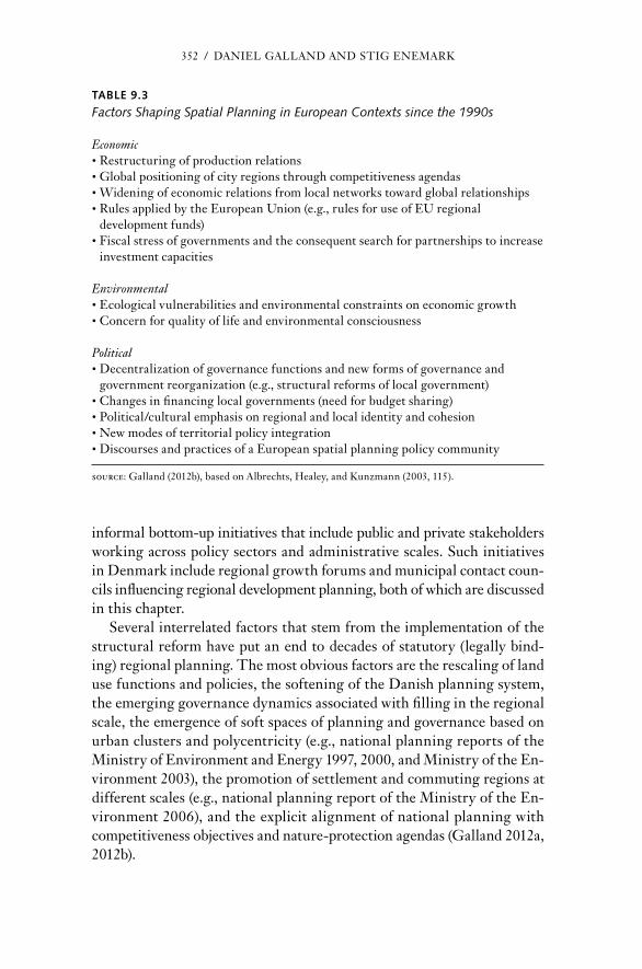
352 / dAnIEL GALLAnd And STIG EnEMArK
informal bottom-up initiatives that include public and private stakeholders working across policy sectors and administrative scales. Such initiatives in denmark include regional growth forums and municipal contact coun-cils influencing regional development planning, both of which are discussed in this chapter.
Several interrelated factors that stem from the implementation of the structural reform have put an end to de cades of statutory (legally bind-ing) regional planning. The most obvious factors are the rescaling of land use functions and policies, the softening of the danish planning system, the emerging governance dynamics associated with filling in the regional scale, the emergence of soft spaces of planning and governance based on urban clusters and polycentricity (e.g., national planning reports of the Ministry of Environment and Energy 1997, 2000, and Ministry of the En-vironment 2003), the promotion of settlement and commuting regions at different scales (e.g., national planning report of the Ministry of the En-vironment 2006), and the explicit alignment of national planning with competitiveness objectives and nature- protection agendas (Galland 2012a, 2012b).
TABle 9.3
Factors Shaping Spatial Planning in Eu ro pean Contexts since the 1990s
Economic• restructuring of production relations• Global positioning of city regions through competitiveness agendas• Widening of economic relations from local networks toward global relationships• rules applied by the Eu ro pean Union (e.g., rules for use of EU regional
development funds)• Fiscal stress of governments and the consequent search for partnerships to increase
investment capacities
Environmental• Ecological vulnerabilities and environmental constraints on economic growth• concern for quality of life and environmental consciousness
Po liti cal• decentralization of governance functions and new forms of governance and
government reor ga ni za tion (e.g., structural reforms of local government)• changes in financing local governments (need for bud get sharing)• Po liti cal/cultural emphasis on regional and local identity and cohesion• new modes of territorial policy integration• discourses and practices of a Eu ro pean spatial planning policy community
Source: Galland (2012b), based on Albrechts, Healey, and Kunzmann (2003, 115).

dAnISH nATIOnAL SPATIAL PLAnnInG FrAMEWOrK / 353
The Danish Planning System
The danish planning system is characterized by a decentralized division of tasks and responsibilities. Since the structural reform in 2007, the Plan-ning Act has delegated responsibility for comprehensive land use plan-ning and regulation to municipal councils. The regional councils are in charge of preparing regional development plans to support spatial devel-opment strategies at the municipal level. The Ministry of the Environ-ment is responsible for safeguarding national interests through national planning (figure 9.3).
The Planning Act is intended to ensure that planning meets the inter-ests of society with res pect to land use and helps protect nature and the environment. It specifies the following aims (Ministry of the Environment 2007b, 5):
• To ensure appropriate development in the whole country and in the individual administrative regions and municipalities, based on overall planning and economic considerations.
• To create and conserve valuable buildings, settlements, urban environments, and landscapes.
• To ensure that the open coasts continue to be an important natural and landscape resource.
• To prevent pollution of air, water, and soil and noise nuisance.
• To involve the public in the planning pro cess as much as possi ble.
Planning System Principles
Since its inception in the 1970s, the danish planning system has been characterized by three core principles: decentralization, framework con-trol, and public participation. The princi ple of decentralization has long been established as a cultural institution that strives for broad po liti cal and social consensus. As such, this princi ple is meant to ensure a fine- tuned relationship between national authorities and municipal councils. In this light, denmark has a long tradition of delegating responsibility and decision- making authority to local governments. The decentralization of planning tasks is based on trust in the municipal councils, which must pro-vide, adopt, monitor, and revise comprehensive spatial planning. The mu-nicipal councils are also responsible for delivering legally binding local plans before the execution of development projects, and for the control of land use, which is implemented through the granting of building permits.

354 / dAnIEL GALLAnd And STIG EnEMArK
The princi ple of framework control is that planning decisions made at lower levels must not conflict with planning decisions established at higher levels. This princi ple is in line with the idea of coordinating inter-ests across different institutional scales through dialogue and partner-ship. In doing so, framework control is operationalized through dialogue and veto. On behalf of the national government, the minister for the en-vironment is required to veto municipal plan proposals that do not abide by the stipulations and interests put forward at the national level. At the same time, any municipality may object to plan proposals of neigh-boring municipalities if such proposals conflict with its development objectives.
Public participation is an important part of the planning pro cess and is a significant demo cratic means through which objectives for economic de-velopment and environmental improvement are met. Together with local plans, planning proposals at the local level must be submitted for public debate, inspection, and potential objection for at least eight weeks before they are finally adopted. Particularly in the case of binding local plans,
Co
un
try
Mu
nic
ipal
ity
Building Permits
Water Resource Plans
Climate Plans
Transport Plans
Natura 2000 Plans
Raw Materials Plans
Local Plans
National Planning
Government Policy:
· National Planning Report
· Overview of National Interests
· National Planning Directives
· Finger Plan 2013
Municipal Planning
· Municipal Planning Strategies
· Municipal Land-Use Plans and Regulations for Urban and Rural Areas
· Frameworks for Local Planning
Figure 9.3 Danish Planning System, 2015
Note: The county level of planning administration, together with regional land use plans, was repealed in 2007. The so- called regional spatial development plans of 2007 were repealed in February 2015.
dAnISH nATIOnAL SPATIAL PLAnnInG FrAMEWOrK / 355
public participation provides opportunities for public scrutiny before local changes of the spatial environment are made. Once a plan is adopted, it cannot be appealed, because the procedures of public participation are re-garded as adequate to ensure the legitimacy of the po liti cal decision.
Zoning System
The zoning system, established in the 1970s, divides the country into three types of zones: urban, rural, and summer cottage areas. development is al-lowed in accordance with planning regulations in both urban and summer cottage zones. developments or any land use changes for other purposes than agriculture and forestry either are banned in rural areas or are subject to special permission according to planning and zoning regulations. changing a rural area into an urban zone requires the provision of a binding local plan.
The Planning Act defines urban zones as (1) areas allocated to urban development as part of an urban development plan; (2) areas allocated as construction zones for urban development by a building bylaw (according to pre-1970 building legislation); (3) areas allocated to urban development or public use by a town planning bylaw (according to pre-1970 building legislation); and (4) areas transferred to an urban zone by a local plan. The act defines summer cottage areas as special zones allocated for develop-ment for such purposes by a building bylaw or a town planning bylaw, and areas transferred to a summer cottage area by a local plan. Finally, rural zones are defined as any areas other than urban and summer cottage zones (Ministry of the Environment 2007b).
Structure of land Use Governance
The danish planning system divides governance into national, regional, and local levels with a decentralized delegation of planning responsibili-ties that places most decision- making authority and its associated admin-istrative powers mainly at the local level. Since the implementation of the latest structural reform in 2007, the Planning Act has transferred most spa-tial planning tasks and responsibilities to the 98 municipalities by giving them a high degree of planning control of urban and rural areas. At the same time, specific planning responsibilities have been reassigned to the national level. Table 9.4 presents the different policy institutions and pol-icy instruments that constitute the danish planning system.
national level
The nature Agency at the Ministry of the Environment has been the na-tional administrative authority for spatial planning functions since 2011.

TAB
le 9
.4
Ove
rvie
w o
f th
e D
anis
h N
atio
nal S
pati
al P
lann
ing
Polic
y Fr
amew
ork
afte
r th
e R
efor
m o
f Lo
cal G
over
nmen
t St
ruct
ure,
200
7
Polic
y In
stitu
tions
Polic
y In
stru
men
ts
leve
lPl
anni
ng a
utho
rity
num
ber
of
inha
bita
nts
Type
of
plan
or
inst
rum
ent
Des
crip
tion
lega
l eff
ect
nat
iona
lM
inis
try
of t
he
Env
iron
men
t5.
63 m
illio
nn
atio
nal p
lann
ing
repo
rtn
atio
nal v
isio
ns r
egar
ding
func
tion
al
phys
ical
dev
elop
men
tA
dvis
ory
guid
elin
es a
nd
reco
mm
enda
tion
s
Ove
rvie
w o
f nat
iona
l in
tere
sts
rega
rdin
g m
unic
ipal
pla
ns
nat
iona
l int
eres
ts a
risi
ng fr
om
legi
slat
ion,
act
ion
plan
s, s
ecto
r pl
ans,
an
d ag
reem
ents
bet
wee
n na
tion
al
auth
orit
ies
Bin
ding
for
loca
l aut
hori
ties
. r
ight
to v
eto
mun
icip
al p
lan
prop
osal
s w
hen
cont
radi
ctin
g na
tion
al in
tere
sts
Gre
ater
cop
enha
gen
Fin g
er
Plan
dir
ecti
veE
stab
lishe
s a fr
amew
ork
for
the
spat
ial
deve
lopm
ent o
f the
met
ropo
litan
re
gion
acc
ordi
ng to
spa
tial
pri
ncip
les
and
land
- use
con
cept
s
Bin
ding
for
loca
l aut
hori
ties
Oth
er n
atio
nal p
lann
ing
dire
ctiv
esM
aps
and
lega
l pro
visi
ons
(i.e.
, co
asta
l zon
e pl
anni
ng; s
itin
g fo
r w
ind
turb
ines
; loc
atio
n of
nat
ural
gas
pi
pelin
es a
nd t
rans
mis
sion
line
s)
Bin
ding
for
loca
l aut
hori
ties
Sect
oria
l pla
ns W
ater
and
nat
ura
2000
pla
ns,
clim
ate
plan
s, a
nd t
raffi
c pl
ans,
etc
.B
indi
ng fo
r lo
cal a
utho
riti
es
reg
iona
l5
adm
inis
trat
ive
regi
ons
~ 1,
000,
000
(w
ide
devi
atio
ns)
reg
iona
l spa
tial
dev
elop
men
t pl
ans
(rep
eale
d in
201
4)A
dvis
ory
and
visi
onar
y pl
ans
Bin
ding
for
loca
l aut
hori
ties
( u
ntil
Febr
uary
201
4)
Loc
al98
mun
icip
al
coun
cils
~ 30
,000
(w
ide
devi
atio
ns)
Mun
icip
al p
lans
Polic
ies,
map
s, a
nd la
nd- u
se
regu
lati
ons
Bin
ding
for
loca
l aut
hori
ties
Loc
al p
lans
Map
s an
d de
taile
d le
gal l
and-
use
regu
lati
ons
Bin
ding
for
land
owne
rs

dAnISH nATIOnAL SPATIAL PLAnnInG FrAMEWOrK / 357
It is responsible for facilitating the planning system and for monitoring land use planning tasks carried out at the local level. It advises the minis-ter for the environment on planning issues and is in charge of preparing planning legislation. The institutional setup associated with national plan-ning has been reconfigured several times since the Ministry of the Envi-ronment assumed spatial planning responsibilities in 1975 ( table 9.5). Like its pre de ces sors, the nature Agency aims at using spatial planning to strengthen the implementation of the country’s environmental policies while fostering spatial development through planning.
The nature Agency represents denmark in international cooperation on spatial planning and on the environmental impact assessment of proj-ects, policies, plans, and programs. This cooperation takes place within the Eu ro pean Union, the United nations, the council of Eu rope, and the Or ga ni za tion for Economic cooperation and development, as well as with planning authorities in the nordic and Baltic countries.
The Spatial Planning department is also consulted on planning projects outside denmark. Besides the nature Agency, two other entities within the Ministry of the Environment deal with planning matters, namely the Environmental Protection Agency and the nature Protection and Environmental Board of Appeal. The former is responsible for im-plementing national policies regarding pollution and environmental con-trol of air, water and soil, waste management, and environmental technol-ogy by administering the Environmental Protection Act, the Water Supply Act, and the contaminated Soils Act. The latter is in charge of pro cessing appeals of decisions made by municipalities under these acts.
Other ministries involved directly or indirectly in spatial planning de-cisions through policy intervention are the Ministry of Transport; the Ministry of climate, Energy, and Building; the Ministry of Food, Agri-culture, and Fisheries; the Ministry of Housing, Urban, and rural Affairs; and the Ministry of Business and Growth. Since the implementation of the
TABle 9.5
Timeline of the Reconfiguration of National- Level Planning Authorities within the Ministry of the Environment
national- level Planning Institution Period
national Agency for Physical Planning 1975–1992Spatial Planning department 1993–2002Forest and nature Agency (Spatial Planning Office) 2003–2007Agency for Spatial and Environmental Planning (Planning Office) 2008–2010nature Agency (Planning Office) 2011– pre sent
358 / dAnIEL GALLAnd And STIG EnEMArK
latest structural reform, the capacities of national planning to intervene in local planning and projects of international, national, or regional rele-vance have been reinforced.
regional level
The regional level lost most of its clout after the abolition of the counties in the structural reform in 2007. regional councils were deprived of their power in spatial planning and were mainly left with tasks and responsi-bilities associated with healthcare administration. In the area of planning, the administrative regions were tasked with facilitating the preparation of regional spatial development plans (rSdPs), which were meant to emerge from bottom-up, multi- stakeholder pro cesses in collaboration with mu-nicipalities and other regional actors. The regions also handle responsi-bilities regarding soil pollution and raw- materials planning.
Appointed by the regional councils since 2007, regional growth forums (rGFs) are partnership- based bodies that have emerged as important are-nas to influence the spatial development of the regions by fostering eco-nomic growth. consisting of representatives from the business commu-nity, educational institutions, and labor- market entities and politicians from the regional and municipal levels, growth forums are intended to make recommendations to regional councils and the state on questions re-garding the allocation of Eu ro pean Union structural funds. rGFs prepare business development strategies based on local conditions for economic growth, including the development of peripheral areas. These strategies are meant to be part of the foundation of rSdPs.
Since the implementation of the structural reform, an interest or ga ni-za tion known as Local Government denmark (LGdK) has acquired in-fluence in planning matters at the regional level. As the member author-ity of danish municipalities, LGdK instituted municipal contact councils at the regional level, which to some extent have functioned as competing planning arenas by developing po liti cal initiatives that foster intermunici-pal collaboration. Municipal contact councils can be conceived as soft spaces of governance that serve to promote economic growth initiatives to influence spatial development at the regional level (Galland 2012a).
local level
Since the implementation of the structural reform, the municipal coun-cils have assumed spatial planning and land use tasks and responsibilities, although the 34 municipalities within Greater copenhagen must comply with the Fin ger Plan directive discussed in this chapter. The newly as-sembled and larger local authorities have been further empowered to pro-
dAnISH nATIOnAL SPATIAL PLAnnInG FrAMEWOrK / 359
vide local solutions to local needs and to combine responsibility for deci-sion making with accountability for financial, social, and environmental consequences of their decisions. Each municipality is obligated to prepare a comprehensive municipal plan covering its whole territory. In addition, municipal authorities have the right to prepare detailed and binding local plans for specific (neighborhood) areas in order to impose planning regu-lations. Moreover, municipalities must also provide local plans before im-plementation of major development projects. Altogether, the municipal plan comprises a framework for detailed local plans and for pro cessing in-dividual cases pursuant to the Planning Act, as well as other sectoral acts.
Key Planning and land Use Policy Instruments
The danish spatial planning framework consists of an array of planning and land use policy instruments that are developed by planning policy institutions at different levels. Table 9.6 provides a synthesis of these instruments.
national level
The rules on national planning were originally introduced in 1974 and were significantly reinforced after the structural reform in 2007. As a whole, the national planning policy framework for comprehensive spatial planning and land use decision making is made up of planning reports, binding directives, rules, guidelines, and intervention in municipal plan-ning for themes and projects of international, national, regional, and lo-cal interest.
nATIOnAl PlAnnIng rePOrTS
national planning reports set out overall spatial policies and objectives after each government election. The nature Agency prepares these reports in cooperation with other relevant ministries and submits them as pro-posals with several thematic alternatives. Before the minister for the en-vironment submits a report to Parliament on behalf of the government, a period of public debate is held during which municipalities and other stake-holders react to the proposal. The objectives of these reports are to pro-vide guidance to the regions and municipalities and to set forth national planning policies on specific issues.
The contents of national planning reports and the discourses associ-ated with them indicate that national spatial planning adopts distinctive roles and development orientations in pursuit of growth and development. Galland (2012b) shows how national planning reports, in liaison with other

TAB
le 9
.6
Plan
ning
and
Lan
d U
se P
olic
y In
stru
men
ts
Plan
Stat
us a
nd D
urat
ion
Obj
ectiv
es, F
orm
, and
Use
Prod
uctio
n
nat
iona
l pla
nnin
g re
port
sSt
atut
ory
repo
rts
prov
idin
g ge
nera
l gu
idan
ce a
nd p
olic
ies;
com
puls
ory
prep
arat
ion
afte
r ev
ery
nati
onal
el
ecti
on
Sets
out
the
cur
rent
nat
iona
l pla
nnin
g po
licie
s an
d pr
ovid
es g
uida
nce
for
regi
onal
and
loca
l pla
nnin
g au
thor
itie
s.
The
ir r
atio
nale
, sco
pe, a
nd d
evel
opm
ent
orie
ntat
ion
have
var
ied
wid
ely
over
the
pa
st fo
ur d
e cad
es.
Pre
pare
d by
the
Min
istr
y of
the
E
nvir
onm
ent a
nd a
dopt
ed b
y th
e go
vern
men
t
nat
iona
l pla
nnin
g di
rect
ives
Stat
utor
y di
rect
ives
pro
vidi
ng
bind
ing
regu
lati
ons
on s
peci
fic
issu
es o
f nat
iona
l int
eres
t
Sets
out
lega
l pro
visio
ns o
n sp
ecifi
c is
sues
of
nat
iona
l int
eres
t, e.
g., d
eter
min
ing
the
path
of n
atur
al g
as p
ipel
ines
and
the
si
ting
of w
ind
turb
ines
and
ele
ctri
cal
tran
smis
sion
line
s.
Pre
pare
d an
d ad
opte
d by
the
min
iste
r fo
r th
e en
viro
nmen
t; bi
ndin
g on
reg
iona
l and
lo
cal a
utho
riti
es
Fin g
er P
lan
dir
ecti
veSt
atut
ory
dire
ctiv
e pr
ovid
ing
bind
ing
plan
ning
reg
ulat
ions
; pr
epar
ed in
200
7 an
d up
date
d in
20
13
Est
ablis
hes
a sp
atia
l fra
mew
ork
for
the
who
le r
egio
n by
del
imit
ing
area
s fo
r ur
ban
deve
lopm
ent,
gree
n ar
eas,
tr
ansp
ort c
orri
dors
, noi
se- i
mpa
ct a
reas
, te
chni
cal i
nsta
llati
ons,
and
oth
er u
ses.
Pre
pare
d by
the
Min
istr
y of
the
E
nvir
onm
ent;
bind
ing
on 3
4 lo
cal
auth
orit
ies
in G
reat
er c
open
hage
n
Ove
rvie
w o
f N
atio
nal I
nter
ests
on
Mun
icip
al P
lans
an
d th
e R
ight
to
Vet
o
Stat
utor
y re
port
pre
pare
d ev
ery
four
yea
rs b
efor
e th
e pr
o ces
s of
re
visi
ng t
he m
unic
ipal
pla
ns b
egin
s
det
erm
ines
the
inte
rest
s an
d co
nsid
erat
ions
ari
sing
from
po l
iti c
ally
ad
opte
d de
cisi
ons
in t
he fo
rm o
f le
gisl
atio
n, a
ctio
n pl
ans,
sec
tor
plan
s,
nati
onal
pla
nnin
g de
cisi
ons,
and
ag
reem
ents
am
ong
publ
ic a
utho
riti
es.
Pre
pare
d by
the
Min
istr
y of
the
E
nvir
onm
ent i
n co
oper
atio
n w
ith
othe
r re
leva
nt m
inis
trie
s; b
indi
ng o
n lo
cal
auth
orit
ies.
The
min
iste
r fo
r th
e en
viro
nmen
t has
the
rig
ht to
vet
o a
mun
icip
al p
lan
prop
osal
if it
con
flict
s w
ith
nati
onal
inte
rest
s

reg
iona
l spa
tial
de
velo
pmen
t pla
ns
(rSd
Ps)
Adv
isor
y, v
isio
nary
dev
elop
men
t pl
ans
that
des
crib
e th
e de
sire
d fu
ture
spa
tial
dev
elop
men
t for
eac
h ad
min
istr
ativ
e re
gion
; rep
eale
d fr
om t
he P
lann
ing
Act
in e
arly
20
14
Port
raye
d as
um
brel
la to
ols
to in
spir
e gr
owth
and
dev
elop
men
t ini
tiat
ives
at
the
mun
icip
al le
vel.
In p
ract
ice,
rSd
Ps
reje
ct t
he a
spir
atio
n to
man
age
and
cont
rol s
pati
al d
evel
opm
ent a
t low
er
scal
es.
Fram
ed to
em
erge
from
bot
tom
-up,
m
ulti
- sta
keho
lder
pro
cess
es fa
cilit
ated
by
the
adm
inis
trat
ive
regi
ons
in
colla
bora
tion
wit
h m
unic
ipal
itie
s an
d ot
her
regi
onal
act
ors
Mun
icip
al p
lans
Stat
utor
y pl
ans
prov
idin
g la
nd u
se
regu
lati
on; c
ompu
lsor
y re
visi
on
ever
y fo
ur y
ears
, cov
erin
g th
e w
hole
are
a of
the
mun
icip
alit
y w
ith
a tw
elve
- yea
r ho
rizo
n
Sets
out
gen
eral
and
spe
cific
pol
icie
s an
d re
gula
tion
s fo
r la
nd u
se in
urb
an a
nd
rura
l are
as a
nd is
the
mai
n po
liti c
al
inst
rum
ent f
or d
evel
opm
ent c
ontr
ol a
t th
e m
unic
ipal
leve
l.
Pre
pare
d an
d ad
opte
d by
mun
icip
al
coun
cils
; sub
ject
to p
ublic
con
sult
atio
n at
tw
o fo
rmal
sta
ges:
bef
ore
prep
arat
ion
of
the
plan
pro
posa
l and
bef
ore
adop
tion
; bi
ndin
g on
loca
l aut
hori
ties
Loc
al p
lans
Stat
utor
y pl
ans
prov
idin
g
bind
ing
regu
lati
ons
for
loca
l or
neig
hbor
hood
are
as; c
ompu
lsor
y pr
epar
atio
n be
fore
impl
emen
tati
on
of d
evel
opm
ent p
ropo
sals
Sets
out
det
aile
d re
gula
tion
s fo
r fu
ture
la
nd u
se, i
nclu
ding
wri
tten
sta
tem
ents
an
d m
aps
wit
h sc
ale
betw
een
1:50
0 an
d 1:
5,00
0.
Pre
pare
d an
d ad
opte
d by
mun
icip
al
coun
cils
; sub
ject
to p
ublic
con
sult
atio
n an
d ob
ject
ions
for
at le
ast e
ight
wee
ks
befo
re a
dopt
ion;
no
poss
ibili
ty fo
r ap
peal
s ex
cept
in r
egar
d to
lega
l iss
ues;
mus
t co
mpl
y w
ith
mun
icip
al p
lans
; bin
ding
on
land
owne
rs

362 / dAnIEL GALLAnd And STIG EnEMArK
national policies, have assumed steering, balancing, and strategic roles over various time frames since the inception of national planning in denmark. For instance, by aligning with welfarist logics, national planning played a steering role from the 1970s until the late 1980s. However, steering was largely supplemented or even replaced by balancing and strategic roles dur-ing the 1990s and the first years of the 21st century. The balancing role can be interpreted as the reinvention of spatial planning as a policy do-main characterized by the introduction of ad hoc economic and environ-mental agendas. In parallel, the strategic role arose after the adoption of Eu ro pean spatial planning concepts, which advocated competitiveness mea sures based on visionary strategies for spatial development.4
nATIOnAl PlAnnIng DIreCTIveS AnD rUleS
The minister for the environment prepares and adopts national planning directives, which are binding on regional and local authorities. These in-struments set out legal provisions on specific issues of national interest, for example, determining the path of natural- gas pipelines and the siting of wind turbines and electrical transmission lines. Planning directives can be used in different ways, such as planning for specific infrastructure proj-ects and stating siting regulations for energy facilities.
In addition, national planning directives may also be used to regulate more thematic issues. For instance, after the introduction of planning di-rectives for coastal- area protection and retail trade in 1994 and 1997, re-spectively, the Planning Act adopted straightforward and simplified rules for both domains. The overall rule for retail planning is that land desig-nated for retail trade must be located in town and city centers in such a way that shops are accessible by all means of transport, particularly walk-ing, cycling, and public transportation. regarding coastal protection, con-struction within 300 meters of the shoreline is banned, and no new sum-mer cottage areas may be designated. Within a protected coastal zone extending 3 kilometers from the shoreline, the transfer of land to an ur-ban zone and planning for development in a rural zone are prohibited unless there is a specific planning- related or functional justification for location near the coast.5
4 Galland (2012b) provides a descriptive analy sis of the history and evolution of national plan-ning policy in denmark.
5 An amendment to the Planning Act, effective in September 2011, has loosened planning rules and directives in 29 so- called peripheral municipalities to allow for more developments in rural areas and coastal zones. To a certain extent, this mea sure reflects the former (liberal- conservative) government’s intention to minimize planning constraints.

dAnISH nATIOnAL SPATIAL PLAnnInG FrAMEWOrK / 363
greATer COPenhAgen FIn ger PlAn DIreCTIve
A special directive aimed at guiding the development of Greater copen-hagen was issued in 2007. It establishes a spatial framework for the whole region by promoting urban development in accordance with the princi ple of station proximity (figure 9.4). Greater copenhagen can be conceived as one integrated region, including one cohesive labor market and common green areas. However, its governance has historically been complex be-cause the region contains numerous municipalities (currently 34) respon-sible for their own spatial planning (Galland and Ferdinandsen 2013). The directive is based on the spatial conception of the first Fin ger Plan pub-lished in 1947 (Egnsplankontoret 1947), which vividly portrayed Greater copenhagen in the shape of a hand that outwardly projected an ordered urban expansion along five corridors (the fingers) into rural areas to the west and north of the inner city (the palm) and in the direction of rela-tively nearby towns. This expansion was based on the idea of moderate population increase and housing stock positioned in function of suburban railway lines. The spaces between the corridors were to be preserved for agricultural and recreational purposes.6
In line with its pre de ces sor, the 2007 Fin ger Plan directive regulates land use in all 34 municipalities in Greater copenhagen by delimiting areas for urban development, green areas, transport corridors, noise- impact areas, technical installations, and other uses. The directive and the Plan-ning Act state that Greater copenhagen is subdivided into four geographic zones: (1) the core urban region (the palm of the hand); (2) the peripheral urban region (the fingers); (3) the green wedges (located between and across the urban fingers); and (4) the rest of the urban region (where urban de-velopment is allowed only in connection with municipal centers) (Minis-try of the Environment 2007b, 9–10).
Although the directive itself is not strategic, it does make explicit the overall objective of ensuring a well- functioning metropolitan area to en-hance international competitiveness. The binding nature of the 2007 Fin-ger Plan directive and the handover of its direction and execution to the nature Agency after the structural reform illustrate how spatial planning tasks and responsibilities have been recentralized. In 2013, an amendment to the directive expressed the overall po liti cal aim to convert Greater copenhagen into a greener urban region.
6 The 1947 Fin ger Plan for Greater copenhagen was the first comprehensive planning at-tempt in denmark to address matters such as mass transport, industry development, housing, and nature preservation coherently above the urban level.
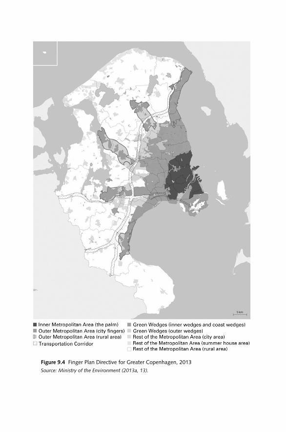
Figure 9.4 Fin ger Plan Directive for greater Copenhagen, 2013Source: Ministry of the Environment (2013a, 13).

dAnISH nATIOnAL SPATIAL PLAnnInG FrAMEWOrK / 365
OvervIew OF nATIOnAl InTereSTS On MUnICIPAl PlAnnIng AnD The rIghT TO veTO
Prepared by the Ministry of the Environment in cooperation with other relevant public authorities, the Overview of National Interests on Municipal Planning outlines the aims and requirements of the government with res-pect to municipal planning (Ministry of the Environment 2011). Arising from po liti cal decisions based on legislation, sector plans, and agreements with other ministries, the report addresses urban development (including special considerations for Greater copenhagen), energy supply, green transport, green growth, tourism and recreation, use of rural areas, and aspects of nature protection. These issues are discussed and dealt with every four years before the municipal plans are revised.
Published every fourth year since 2007, this overview should be under-stood as a core national planning instrument that municipalities should abide by in order to avoid a veto. As stated earlier, the minister for the en-vironment has the right to veto a proposed municipal plan on behalf of all the government ministers if such proposal conflicts with national inter-ests. Vetoes are made during the public hearing period, and the munici-pal council cannot adopt the proposal until the minister agrees to its con-tent. A committee of state civil servants assesses each proposed municipal plan during the period of public comment to coordinate the state’s view-points. A national veto can also be imposed on a local plan when national interests are at stake. Thus, monitoring, dialogue, and veto work to achieve a sustainable balance between the two levels of administration.
regional level
Introduced in 2007, but repealed from the Planning Act in early 2014, regional spatial development plans aimed to foster spatial development in close connection with business development. The rSdPs differed nota-bly from the former physical, land use regional plans because they were only visionary, which constrained them to offer a simple overview of growth possibilities at the regional level. Thus, rSdPs focused on poten-tial regional strengths within diverse sectoral areas, namely, business and the labor market, education, tourism and recreation, culture, nature, and the environment. As stated in the section on the structure of land use gov-ernance, rSdPs emerged from bottom-up, multistakeholder pro cesses in dialogue with municipalities. The role of the administrative region was thus to facilitate the pro cess of generating such plans. Moreover, rSdPs were meant to ensure the cohesion of a series of sectoral plans and strate-gies, including those for business development, employment, Local Agenda 21, education, and culture.

366 / dAnIEL GALLAnd And STIG EnEMArK
Business development strategies are prepared by partnership- oriented rGFs and aim at improving local conditions for economic growth. rSdPs were intended to ensure the cohesion of these strategic documents, which continue to be based on the strengths of local businesses within each ad-ministrative region. Prepared every four years, these strategies center on drivers of economic growth: innovation, entrepreneurship, education, and new technology. On the basis of these strategies, rGFs are intended to make recommendations to the state and the regional councils on sup-port of Eu ro pean Union funds and regional development projects.
local level
The municipal plan is the main po liti cal instrument of the council for de-velopment control and serves as a strategy for both social and economic development and environmental improvement. The plan combines po liti-cal objectives, land use policies, and the more detailed land use regula-tions within a municipal jurisdiction. Altogether, the municipal plan pro-vides the linkage between national planning interests and detailed local plans. Municipal plans must be revised every four years.
Procedures for public participation are ensured both before and after the issuance of the plan proposal. Appeals can be made only in regard to legal and procedural issues; the content of the plans cannot be appealed. This also applies to local plans.
The municipal plan is not binding on landowners, but the municipal council must strive to implement the adopted plan. Proposals for local plans, as well as land use decisions in general, must be consistent with the adopted planning regulations. The Planning Act determines the proce-dures, the structure of the plan, and the minimum content of regulations, but municipal authorities still have wide latitude in their planning ap-proach. Traditional land use regulation is the basic ele ment in order to provide the framework for control of development and implementation, but the plan can also serve as a strategic means to link sectors and coordi-nate municipal activities, for example, in relation to urban regeneration, environmental resilience, and policies on attracting commercial develop-ment or improving the living conditions of specific population groups. The municipal plan thus summarizes the overall po liti cal objectives and de-velopment priorities of the municipality.
Beyond land use planning functions and regulations, ad hoc municipal policies address aspects of urban master planning (such as urban regen-eration, waterfront redevelopment, and strategic planning for suburban areas). More recently, municipal councils have also begun to adopt climate plans.
dAnISH nATIOnAL SPATIAL PLAnnInG FrAMEWOrK / 367
The local plan is the main instrument through which the municipal authority issues detailed planning regulations while also the basic means for planning control through the issuing of building permits. The plans are legally binding on landowners and hence determine development possi-bilities and influence property values. However, local plans regulate only future transactions and thus do not require property owners to act. reg-ulations through local plans are hence not subject to claims for compen-sation, as they may adversely affect property value.
Local plans must be provided before implementation of any major de-velopment and construction works. This power and duty of the municipal authority is a crucial ele ment of the planning system because it ensures that larger developments are subjected to the regulation of the planning system and the provisions for public participation before implementation. The legal provisions of local plans can include a wide range of detailed regulations as determined in the Planning Act, such as zoning status; use of land and buildings; size and extent of properties; roads, tracks, and transmission lines; building density and design; and landscape features.
Before a municipal authority adopts a local plan, it must provide at least eight weeks for public inspection and comments. during this period, state authorities may veto a local plan if the proposal conflicts with national interests. The municipal council then pro cesses the comments and objec-tions and may make any relevant changes before adopting the plan. Mu-nicipal councils publish the adopted plans in their websites and make them available on the national planning information system, PlansystemdK.7
Plan Implementation Tools and Pro cesses
The danish planning system is mainly plan led (rather than market led). development possibilities are determined in the general planning regula-tions at the municipal level and are further detailed in the legally binding local plans. However, planning regulations established by the planning system are mainly restrictive. Although the system is designed to prevent undesirable development from occurring at any time, it cannot guarantee that po liti cally desirable development will actually occur at the right place and time.
7 The e- planning portal (http:// plansystemdk . dk) provides public access to all municipal plans and local plans ( either adopted or proposed) across denmark. The map- based interface provides a range of navigation tools, including address, cadastral parcel number, municipality, and area polygons. The system provides direct access to an electronic copy of the local plans. The e- planning portal also enables citizens to provide direct feedback on proposed development plans during the statutory eight- week consultation period.

368 / dAnIEL GALLAnd And STIG EnEMArK
When a municipality adopts a local plan, the development possibilities are legally determined, and development proposals that conform to the planning regulation are easily implemented without any delay. When no local plan is adopted, the basic condition for approval and implementation of development proposals is the extent to which the proposal conforms to the adopted planning regulations in the municipal plan. The legal means of planning control are sufficient in the sense that the system is able to ensure that undesirable development does not occur, but it also makes it possi ble for desirable development to take place even if it does not comply with adopted planning regulations.
Even if the means of planning control are in place, implementation may not automatically take place as intended by the municipal plan, because most development is implemented through private developers and invest-ments. However, the municipal authority may, in some cases and under certain conditions, use compulsory purchase (expropriation with full com-pensation) as a means to implement a local plan. Expropriation can also be used to implement planning for public institutions and infrastructure facilities. The municipal authority may also adopt a more active role by purchasing land and property in the free market to achieve planning ob-jectives in a longer perspective. In this way, the municipal council becomes the developer and can take full control of the implementation pro cess (see, e.g., Galland and Hansen 2012).
The Building Act determines the final control of implementation through the granting of building permits, which must be consistent with adopted planning regulations (Ministry of Housing and Urban Affairs 1998). The building permit thus functions as the final stage in the plan-ning control system. The Building Act also provides a range of detailed regulations of construction works. Larger development proposals are sub-ject to adoption of a local plan that will set the planning regulations. When a municipal authority is pro cessing a building permit to implement the construction works, it checks whether the pro ject conforms to the ad-opted planning regulations and other relevant legislation, as well as the detailed demands for construction works listed in the Building Act.
If there is no local plan and there are no precise regulations in the mu-nicipal plan concerning the specific area for development, the development proposal must comply with the general building provisions stated in the Building Act. These regulations imply a minimum plot size, a maximum building density and building height, and a minimum distance from a building to a neighbor’s boundary. These general building provisions serve as basic safeguards for appropriate development; they do not apply when a local plan states other wise. It should be noted that the Building Act in denmark belongs to the Ministry of Housing, Urban and rural Affairs (formerly the Ministry of Housing and Urban Affairs) and therefore is not

dAnISH nATIOnAL SPATIAL PLAnnInG FrAMEWOrK / 369
fully coordinated with the Planning Act, in contrast to many other coun-tries where planning and building control are integrated under the same Ministry.
Zoning and sectoral land use control provides additional means of de-velopment control. development is allowed in urban and summer cottage zones in accordance with the current planning regulations. In rural zones, which cover about 90 percent of the country, developments and any change of land use for purposes other than agriculture and forestry are prohibited or are subject to special permission from the municipal authority accord-ing to planning and zoning regulations. These provisions are intended to prevent urban sprawl and uncontrolled development and installations in the countryside. In addition to the regulations already mentioned, there are a range of other rules that may affect the possi ble use of land, for example, the Agricultural Holdings Act, the nature Protection Act, and the Envi-ronmental Protection Act.
In summary, the planning system in denmark is a mix of vertical and horizontal connections through which national and sectoral policies are implemented from the top down and are integrated at the local level through comprehensive spatial planning. Monitoring, dialogue, and the national power of vetoing a proposal for a municipal or a local plan con-stitute the core means that make the planning system function.
Key Outcomes and lessons
The discussion in this chapter suggests that the danish national spatial planning framework has diverged from the comprehensive- integrated tra-dition that originally characterized it. In princi ple, a comprehensive- integrated planning system is meant to exhibit coherent conceptual ori-entations, as well as stable and coordinated institutional structures within and across the various levels of planning administration. However, the danish case has shown that planning policies and practices embedded within the system are prone to constant shifts, as illustrated by the diver-gence of policy agendas across levels of planning administration. Since the latest structural reform, national- level planning has been mainly con-cerned with promoting specific sectoral issues; regional- level planning has focused on fostering growth- oriented strategies to facilitate regional development; and municipal planning has undertaken physical land use tasks and responsibilities in both urban and rural areas, including plan-ning for climate change. The divergence in policy themes suggests a de-creasing degree of spatial coordination and policy coherence.
On the institutional side, danish spatial planning also seems to have shifted from its comprehensive- integrated character. The institutional setup of the danish spatial planning system originally displayed institutional

370 / dAnIEL GALLAnd And STIG EnEMArK
comprehensiveness and territorial synchrony. In princi ple, these quali-ties seem to have remained constant in the graphic repre sen ta tion and the structural configuration of the planning system (figure 9.3). However, it is evident that the welfarist scope of this former state spatial pro ject has been significantly altered since the abolition of the county level and the re distribution of planning tasks and responsibilities to the national and lo-cal levels. In this sense, the formal institutional structures of planning within and across administrative levels have become less consistent.
At the national level, spatial planning has gradually lost an important share of its former institutional clout, particularly under the rule of the liberal- conservative co ali tion government during the previous de cade. This is illustrated by the changing institutional arrangements within the Ministry of the Environment whereby spatial planning tasks were abridged and transferred from the now- extinct Spatial Planning Agency to an of-fice within the nature Agency whose agendas certainly diverge from those that former planning authorities promoted. At the regional level, a fuzzy governance landscape characterized by the emergence of soft spaces of planning lessened the narrow reach of rSdPs, which were finally elimi-nated from the planning system in 2014. Last, the local level continues to be the core land use actor with strong legal means of planning control, although it is still subordinate to national- level interests and planning directives. A new hierarchical relationship has been generated between national and local planning authorities, one that relies on regulatory in-tervention rather than spatial coordination.
These policy and institutional shifts, as well as the softening of the princi ple of framework control, suggest that the comprehensive- integrated approach of danish spatial planning is worn out. Whereas the scope of the former comprehensive- integrated version of danish spatial planning was self- evident by definition, the current version entails ambiguous con-ceptual orientations and unrelated institutional capacities across levels of planning administration. To an important degree, the somewhat incoher-ent policy framework and the partial institutional fragmentation associ-ated with the danish planning system— demonstrated by its less related plans and less connected administrative levels— imply that danish spatial planning can be exercised only through a local land use regulatory framework.
To understand danish spatial planning as a whole, it is necessary to examine the changing planning rationale and governance arrangements through which shifting policies and competing institutional capacities seem to diverge from the inherited synchronized logic of the former plan-ning system. Although the Planning Act continues to adhere to its former systematic logic based on the princi ple of framework control, there is a

dAnISH nATIOnAL SPATIAL PLAnnInG FrAMEWOrK / 371
need to redefine or at least readjust the institutional and policy framework of danish spatial planning.
* * *
The governance structures and policy instruments of the danish national spatial planning framework have been considerably transformed during the past two de cades. Although it can be argued that spatial planning in denmark is currently in crisis at the national and regional levels (espe-cially in comparison with the domain’s former clout and capacities), the legacy of planning is still embedded at the local level, albeit under quite challenging conditions.
From a broader po liti cal economy perspective, this chapter has ad-dressed a series of factors that seem to shape the per for mance of the dan-ish planning system in light of its more recent structural re orientations. It has stressed that the comprehensive- integrated character of danish spa-tial planning has gradually dissolved. This argument is supported by the impression that there is less spatial coordination and coherence across different levels of planning administration, and less spatial consciousness in most policy instruments (except for municipal plans and the Greater copenhagen directive). In contrast to its pre de ces sor, the current plan-ning system pays less attention to the integration and coordination of pol-icy strategies put forward by other sectors (i.e., the tasks and responsibili-ties associated with the now- extinct regional plans). This absence of spatial reasoning has evidently reduced the possibility for the planning domain to have a say in pre sent and future spatial development pro cesses. Hence, in contrast with the configuration of its forerunner, the current danish planning system has less power to make plans matter.
Furthermore, danish spatial planning has proved to have the capacity to align itself with prevailing government agendas. In this res pect, spatial planning ends up reflecting the ideologies and interests of the government in power. Influenced by a wave of globalization and competitiveness agen-das, neoliberal- minded governments have evidently favored the relative strength of specific economic sectors within the country since the late 1980s. In contrast with the social welfarist objectives of the 1970s, these governmental preferences in support of new sectors have indirectly caused spatial planning to be regarded more as a cost than as an asset. There-fore, it is evident that the danish planning domain has progressively lost politi cal clout.
The 2007–2008 credit crunch and the subsequent recession seem to have diminished further the significance and weight of spatial planning in denmark. In view of the ongoing global economic restructuring, there is evidently a common perception among governmental actors that there

372 / dAnIEL GALLAnd And STIG EnEMArK
is less need for comprehensive spatial planning at higher levels of planning administration. Globalization and the accompanying liberalization of world markets have led to radical changes in denmark’s role in the inter-national division of labor. As has happened elsewhere in Eu rope, the dan-ish manufacturing industry (which traditionally played a fundamental role in the country’s economy) has become more equally distributed, and a considerable part of it has been outsourced to Asia. At the same time, other sectors, such as finance, tourism, and transport, have grown signifi-cantly. These economic shifts imply that the overall profits associated with the danish economy relate much more to international monetary flows than they do to local production. consequently, the need for spatial plan-ning seems to have radically diminished (except for transport and infra-structure planning). It is also in this context that the recent structural reform can be understood as a state initiative to mobilize national institu-tions toward different forms of economic growth promotion.
The center- left co ali tion government that came to power in late 2011 continues to face the challenge of dealing with the economic recession. Therefore, a continued focus on economic growth agendas is very likely to remain in place. Based on these assertions, danish spatial planning as conceived before the structural reform is unlikely to persist under its tem-porary setback status during the 2010s. At the national level, planning will probably remain less spatial and be deprived of its former societal and distributive capabilities. Instead, it will be understood as an all- purpose tool designed to promote specific sectoral agendas, such as the pursuit of environmental sustainability and economic growth at different scales.
References
Albrechts, L. 2001. “From Traditional Land Use Planning to Strategic Spatial Plan-ning: The case of Flanders.” In The Changing Institutional Landscape of Planning, ed. L. Albrechts, J. Alden, and A. da rosa Pires. Aldershot: Ashgate.
Albrechts, L. 2004. “Strategic (Spatial) Planning reexamined.” Environment and Plan-ning B, 31: 743–758.
Albrechts, L., P. Healey, and K. Kunzmann. 2003. “Strategic Spatial Planning and re-gional Governance in Eu rope.” Journal of the American Planning Association 69(2): 113–129.
Allmendinger, P., and G. Haughton. 2009. “Soft Spaces, Fuzzy Boundaries, and Meta-governance: the new Spatial Planning in the Thames Gateway.” Environment and Planning A 41: 617–633.
Amin, A., and n. Thrift. 1994. Globalisation, Institutions and Regional Development in Eu rope. Oxford: Oxford University Press.
Böhme, K. 2002. Nordic Echoes of Eu ro pean Spatial Planning: Discursive Integration in Practice. Stockholm: nordregio.
dAnISH nATIOnAL SPATIAL PLAnnInG FrAMEWOrK / 373
cEc (commission of the Eu ro pean communities). 1997. The EU Compendium of Spa-tial Planning Systems and Policies. Luxembourg: Office for Official Publications of the Eu ro pean communities.
cEc (commission of the Eu ro pean communities). 1999. The Eu ro pean Spatial Devel-opment Perspective: Towards Balanced and Sustainable Development of the Territory of the EU. Luxembourg: Office for Official Publications of the Eu ro pean communities.
christaller, W. 1966 (1933). Central Places in Southern Germany. Englewood cliffs, nJ: Prentice- Hall.
Egnsplankontoret [regional Planning Office]. 1947. Skitseforslag til Egnsplan for Storkøbenhavn (Regional Plan Design Proposal for Greater Copenhagen). copenhagen: Egnsplankontoret.
Faludi, A. 2004. “Spatial Planning Traditions in Eu rope: Their role in the ESdP Pro-cess.” International Planning Studies 9(2): 155–172.
Folketinget [The Parliament]. 2014. The Parliamentary System of Denmark. copenhagen: Folketinget.
Gaardmand, A. 1993. Dansk Byplanlægning, 1938–1992 [Danish Urban Planning, 1938–1992]. copenhagen: Arkitektens Forlag.
Galland, d. 2012a. “Is regional Planning dead or Just coping? The Transformation of a State Sociospatial Pro ject into Growth- Oriented Strategies.” Environment and Planning C: Government and Policy 30(3): 536–552.
— — —. 2012b. “Understanding the re orientations and roles of Spatial Planning: The case of national Planning Policy in denmark.” Eu ro pean Planning Studies 20(8): 1359–1392.
Galland, d., and S. Enemark. 2013. “Impact of Structural reforms on Planning Sys-tems and Policies: Loss of Spatial consciousness?” Eu ro pean Journal of Spatial De-velopment 52: 1–23.
Galland, d., and I. Ferdinandsen. 2013. “The Historical Evolution of Planning and Metropolitan Governance in the Greater copenhagen region.” Paper presented at the 15th national conference on Planning History of the Society for American city and regional Planning History, Toronto, canada (October 2013).
Galland, d., and c. Hansen. 2012. “The roles of Planning in Waterfront redevelop-ment: From Plan- Led and Market- driven Styles to Hybrid Planning?” Planning Practice and Research 27(2): 203–225.
Hajer, M. 2003. “Policy Without Polity? Policy Analy sis and the Institutional Void.” Policy Sciences 36: 175–195.
Harvey, d. 2005. A Brief History of Neoliberalism. Oxford: Oxford University Press.
Haughton, G., P. Allmendinger, d. counsell, and G. Vigar. 2010. The New Spatial Planning: Territorial Management with Soft Spaces and Fuzzy Boundaries. London: routledge.
Healey, P. 2007. Urban Complexity and Spatial Strategies: Towards a Relational Planning for Our Times. new York: routledge.
Healey, P., A. Khakee, A. Motte, and B. needham. 1997. Making Strategic Spatial Plans: Innovation in Eu rope. London: UcL Press.
Jensen, O., and I. Jørgensen. 2000. “danish Planning: The Long Shadow of Eu rope.” Built Environment 26(1): 31–40.

374 / dAnIEL GALLAnd And STIG EnEMArK
Jessop, B. 1990. State Theory: Putting the Capitalist State in Its Place. cambridge: Polity Press.
— — —. 2000. “The crisis of the national Spatio- temporal Fix and the Ecological dominance of Globalizing capitalism.” International Journal of Urban and Regional Studies 24(2): 273–310.
Jones, r., M. Goodwin, M. Jones, and K. Pett. 2005. “ ‘Filling in’ the State: Economic Governance and the Evolution of devolution in Wales.” Environment and Planning C: Government and Policy 23: 337–360.
Ministry of Environment and Energy. 1997. Denmark and Eu ro pean Spatial Planning Policy: National Planning Report for Denmark from the Minister for Environment and Energy. copenhagen: Ministry of the Environment and Energy.
— — —. 2000. Local Identity and New Challenges: National Planning Report for Denmark from the Minister for Environment and Energy. copenhagen: Ministry of the Envi-ronment and Energy.
Ministry of Housing and Urban Affairs. 1998. Byggeloven nr. 452 af 24 juni 1998 [Build-ing Act, Consolidating Act no. 452 of 24 June 1998]. copenhagen: Bolig-og Byminis-teriet [Ministry of Housing and Urban Affairs].
Ministry of the Environment. 1981. 1981 Redegørelsen fra Miljøministeren om Landsplan-lægning [1981 Report on National Planning from the Ministry of the Environment]. copenhagen: Ministry of the Environment.
— — —. 1987. 1987 Redegørelsen fra Miljøministeren om Landsplanlægning [1987 Report on National Planning from the Ministry of the Environment]. copenhagen: Ministry of the Environment.
— — —. 1989. Det Regionale Danmarksbillede— Nu og i Fremtiden [The Regional Map of Denmark— Now and in the Future]. copenhagen: Ministry of the Environment.
— — —. 1992. Denmark Towards the Year 2018: National Planning Report for Denmark from the Minister for the Environment. copenhagen: Ministry of the Environment.
— — —. 2003. Balanced Development in Denmark— What Needs to Be Done? Draft Na-tional Planning Report— In Brief. copenhagen: Ministry of the Environment.
— — —. 2006. The New Map of Denmark— Spatial Planning Under New Conditions. co-penhagen: Ministry of the Environment.
— — —. 2007a. Fingerplan 2007— Landsplandirektiv for Hovedstadsområdets Planlægning [Fin ger Plan 2007— National Planning Directive for Planning in the Greater Copenha-gen Area]. copenhagen: Ministry of the Environment.
— — —. 2007b. The Planning Act in Denmark: Consolidated Act No. 813 of 21 June 2007. copenhagen: Ministry of the Environment.
— — —. 2010. Landsplanredegørelse 2010. [National Planning Report 2010]. copenha-gen: Ministry of the Environment.
— — —. 2011. Oversigt over Statslige Interesser i Kommuneplanlægningen— 2013 [Over-view of National Interests on Municipal Planning— 2013]. copenhagen: Ministry of the Environment.
— — —. 2013a. Fingerplan 2013— Landsplandirektiv for Hovedstadsområdets Planlægning [Fin ger Plan 2013— National Planning Directive for Planning in the Greater Copenha-gen Area]. copenhagen: Ministry of the Environment.
— — —. 2013b. Landsplanredegørelse 2013— Grøn Omstilling - Nye Muligheder for Hele Danmark [National Planning Report 2013— Green Recon-

dAnISH nATIOnAL SPATIAL PLAnnInG FrAMEWOrK / 375
version - New Possibilities for the Whole Denmark]. copenhagen: Ministry of the Environment.
newman, P., and A. Thornley. 1996. Urban Planning in Eu rope: International Competi-tion, National Systems and Planning Projects. London: routledge.
nielsen, B., and K. Olsen. 1990. “Fra Ligelighed til Mangfoldighed” [From Equality to diversity]. Samfundsøkonomen 2(90): 23–28.
OEcd (Or ga ni za tion for Economic cooperation and development). 2014. OECD Eco-nomic Surveys: Denmark. Paris: OEcd Publications.
Salet, W., and A. Faludi, eds. 2000. The Revival of Strategic Spatial Planning. Amster-dam: Koninklijke nederlandse Akademie van Wetenschappen.
Statistics denmark. 2014a. Denmark in Figures 2014. copenhagen: danmarks Statistik.
— — —. 2014b. Statistikbanken [The Bank of Statistics]. www . statistikbanken . dk / statbank 5a / default . asp ? w=1920

/ 376 /
Denmark is well planned and has high- quality surroundings in nature, the environment, landscapes, and cities and towns. At the same time,
the government in denmark wishes to focus on a green transformation of the economy and the creation of jobs and cities that are attractive, green, and well functioning.
Today, denmark has a simple and clear spatial planning system that is well described by daniel Galland and Stig Enemark. The Planning Act ensures that the overall planning synthesizes the interests of society with res pect to land use and contributes to protecting nature and environment so that sustainable development is secured to improve people’s living con-ditions and to conserve of wildlife and vegetation.
denmark has thoroughly reformed its public sector in recent years. The latest reform in 2007 of the danish Planning Act changed den-mark’s spatial planning system. Municipalities are now responsible for planning both town and country, and municipal plans thus have a new role as the key plans for development and land use. The recent modern-ization of the Planning Act has focused on promoting strategic planning and reinforcing public participation in planning, improving the opportu-nities for converting disused industrial sites into mixed- used urban dis-tricts, promoting environmentally sound location policies, protecting attractive and vibrant town centers, and protecting the open stretches of the coast.
Commentary
JAne KrAgh AnDerSen

cOMMEnTArY / 377
A municipal plan summarizes the overall po liti cal objectives for the de-velopment of a municipality, both in towns and cities and in the country-side. It contains guidelines for land use and a framework for the content of local plans. The municipal council publishes a strategy for municipal planning within the first two years of the municipal election period, as well as information on the planning that has occurred since the last time the municipal plan was revised. The municipal councils are responsible for comprehensive land use regulation at the municipal and local levels through legally binding guidelines for property owners. Local plans are the foundation of denmark’s spatial planning system. They concretize the po liti cal strategy and objectives of the municipal plan.
The regional councils prepare plans that pre sent strategic visions for the spatial development of each region. The regional spatial development plan comprehensively describes desired future spatial development for each administrative region’s cities and towns, rural districts, and small- town re-gions. A map is to illustrate the general content of the plan.
The minister for the environment is responsible for upholding the na-tional interest through national planning. national planning is formu-lated in government policy, the national Planning report, the Overview of national Interests, the Fin ger Plan, and national planning directives. After each election to the Parliament, the minister for the environment submits a national planning report to be used in regional spatial plan-ning and municipal planning. In June 2013, the Minister for the Envi-ronment submitted a national plan proposal that focused on seven topics regarding spatial planning. The plan proposal was debated in public for 13 weeks.
The Planning Act contains overall principles for urban development and recreational considerations, as well as special rules on planning in Greater copenhagen. The Minister for the Environment has prepared a national planning directive that will be continually updated to implement these principles. At the national, regional, and municipal levels, the Plan-ning Act has strengthened the strategic aspect of spatial planning and has raised the po liti cal interest in planning. Visions, strategies for action, and interaction between the planning authority and the public and the enter-prises ensure that the current spatial planning system is able to deal with many different interests. The visions and strategies are transformed to regulation for areas in the municipal planning.
One priority of the 2007 planning reform was to coordinate local, re-gional, and national interests through dialogue, cooperation, and partner-ship. Municipalities benefit by cooperating in numerous spatial planning tasks, as shown in two examples: First, on the island of Fyn, nine munici-palities, the region of Southern denmark, and the danish Ministry of

378 / JAnE KrAGH AndErSEn
the Environment are cooperating to develop and design a common spa-tial planning structure for the island of Fyn in order to support and pro-mote sustainable development and regional economic growth. The struc-ture will focus primarily on business development, housing, and accessibility. Second, seventeen municipalities, region Zealand, Trafiksel-skabet Movia (the transportation agency), the Ministry of Transport, and the Ministry of the Environment have been involved in a dialogue regard-ing the future development of the towns and cities in the region. In this pro ject, the partners have drawn a common picture of the structure of the region until the year of 2030. The structure shows a concentration of growth in the larger and most efficient towns and cities regarding trans-portation, placement of new urban growth as close as possi ble to stations, and use of existing buildings in the rural zone and in villages, but limits on new buildings in the rural zone.
These examples of cooperation among municipalities, regions, relevant partners, and ministries show the interest in dialogue and cooperation and underline the wish for a common regional perspective on development. cooperation and dialogue do not necessarily result in a strategic spatial planning perspective, but they may be seen as a first step toward spatial planning that is capable of dealing with conflicting interests and ensuring such spatial planning in each of the municipalities on the basis of po liti cal decisions.
At the same time, the Planning Act promotes the national interest in decentralized planning. The state is responsible for upholding the national interest and for dealing with complex cases related to the environment, nature, and spatial planning. The municipalities are responsible for mu-nicipal planning, but they cannot adopt municipal plans that conflict with national interests. The regional councils may oppose a proposed munici-pal plan that conflicts with the regional spatial development plan. A mu-nicipality may object to the proposed plan of a neighboring municipality if the proposal would adversely affect the objecting municipality’s devel-opment. negotiation will be used in order to find a solution.
The danish Planning Act involves the public in the planning pro cess at municipal, regional, and national levels. Before a municipal plan, a re-gional spatial development plan, a national planning directive, or a national planning report may be adopted, a proposal and a report on the premises of the proposal must be published. Property owners, neighbors, nongov-ernmental organizations, public authorities, and others have at least eight weeks to submit their objections, comments, proposals, and protests. The planning authority decides whether it should distribute more material for discussion, arrange citizens’ meetings, establish working groups, or create

cOMMEnTArY / 379
electronic citizens’ panels. The municipalities experiment with various ways of involving the public and others in the planning pro cess.
It is surprising that daniel Galland and Stig Enemark remark that spa-tial planning in denmark is currently in crisis at the national and regional levels. The new challenges are being met by dialogue, cooperation, discus-sions of po liti cal visions, involvement of the public, and spatial planning based on strategic and po liti cal decisions. In other words, the planning sys-tem in denmark still has po liti cal clout.


/ 381 /
10
Planning Without a Spatial Development Perspective?
The French Case
AnnA GePPert
to an international readership, France is known as the birthplace of aménagement du territoire, usually translated into En glish as spatial
planning. It is considered the ideal “regional economic” approach to planning (Eu ro pean Commission 1997). To a certain extent, French plan-ning may be seen as the model for the Eu ro pean Union’s cohesion policy (Faludi 2004). Paradoxically, today, France has no national spatial devel-opment perspective or any document that would serve as a guideline for its spatial policies. Is French spatial planning still alive?
In the past de cades, the evolution of the French nation- state has led to a redefinition of the roles of different participants in the planning pro-cess, as well as the modes and the meaning of spatial planning. In the 1960s, aménagement du territoire was a set of policies implemented by the national government in order to counterbalance regional disparities. In the 1980s, planning powers were transferred to local governments. For the regions, planning addressed the issues of territorial competitiveness. Currently, the state is no longer a strong player in the field; rather, it is more a critical friend of local endeavors.
This chapter explains the evolution of the French planning system within its institutional and cultural context over the past five de cades. In par tic u lar, it focuses on the changes in the conception of spatial plan-ning and the role of the national government in the planning pro cess. The

382 / AnnA GEPPErT
chapter is based on a review of planning policies and discourses from the 1960s until the pre sent. It also incorporates the author’s experience of French planning over the past two de cades.
Emergence of Aménagement du Territoire
Historical Context
The area of France is 550,000 square kilometers, halfway between the sizes of Texas and California. Its population of 65 million is about the same as that of these two largest states in the United States. As a consequence, at the national level, planning has to cope with a large variety of regional situations and issues. Also, France has territories outside the Eu ro pean continent. For example, French Guyana has 2 inhabitants per square kilo-meter in a territory the size of Austria. On the mainland, the distribution of population and wealth is uneven. Some regions are highly urbanized: Paris lies at the heart of a city- region of 11 million inhabitants with a den-sity of almost 1,000 inhabitants per square kilometer. Other regions remain rural, remote, and scarcely populated. The Limousin region has a density of 42 inhabitants per square kilometer, and its largest city, Limoges, is home to some 140,000 people. France exhibits a variety of landscapes, regional cultures, and identities.
Building the nation- state has been an endeavor of more than a thou-sand years. remembering the lost empire of Charlemagne in the 800s, French kings relentlessly expanded their domain. By weddings, alliances, and wars, they integrated many provinces into the kingdom. To keep the kingdom unified, se nior road surveyors developed an efficient transpor-tation network.1 Also, this period witnessed an unremitting strug gle be-tween the kings and the local lords. To deal with the local striving for in-de pen dence, the monarchy developed a strong, centralized administration. In each province, the representative of the Crown collected taxes and supervised justice and the police.2 He had to contend with the power of local lords, parliaments, and assemblies. By the time the French revolution erupted, kings had strongly centralized the country, but had not succeeded in eradicating local powers.
1 In 1599, King Henri IV (1589–1610) elevated this office to a ministerial level for Maximilien de Béthune, duc de Sully (1559–1641). His responsibilities concerned royal roads, public places, and the aesthetics of the cities. These surveyors existed until the French revolution, foreshadowing the role of the future ministry of infrastructure, also in charge of planning. Today, it has come under the umbrella of ecol ogy and sustainable development.
2 The title of these state officials appeared around 1620. They foreshadowed the function of the prefect.

THE FrEnCH CASE / 383
In 1789, the revolutionary regime completed this centralization. Dur-ing the night of August 4, 1789, the national Assembly repealed all privi-leges, including all local regulations. The revolutionary regime suppressed all former provinces, counties, and earldoms. Instead, it established a new administrative division, the department, headed by a nominated represen-tative of the state, the prefect, who took over the responsibilities, and of-ten physically the office space, of the representative of the Crown. In the first years of the French revolution, there was a strug gle in the national Assembly between two parties. The Jacobins, more radical, favored of a strong central power, which they considered the best way to achieve equal treatment of all citizens. The Girondinists, more moderate, advocated local freedoms and what one might today call territorial diversity or multicul-turalism. In 1793, the Jacobins won and instituted a new state or ga ni za tion that was unitary, strongly centralized, and hierarchical. The representative of the state, the prefect, was directly under the authority of the minister of the interior. He implemented policies defined at the national level, and exercised legal guardianship over locally elected representatives. This dominance lasted until 1982. Aménagement du territoire was designed by and for a unitary, centralized nation- state. Its goals, its decision making, and its implementation were typically Jacobin. A chronology of French planning can be found in table 10.1.
TAblE 10.1
Milestones in French Planning
YearLegislative and Institutional Changes
Significant Positions in Books, reports, or Plans national Policies
1607 Edit de Sully, the first planning regulation, is promulgated.
1747 The École royale des Ponts et Chaussées is created.
1789 During the French revolution, the nation- state is centralized. Local regulations are suppressed, and departments are created.
1793 The Girondists are defeated and beheaded. The Jacobin model of a centralized, egalitarian republic is instituted.
(continued )

TAblE 10.1 (continued )
YearLegislative and Institutional Changes
Significant Positions in Books, reports, or Plans national Policies
1794 The École Polytechnique is created.
1852– 1870
Georges- Eugène Haussmann works in Paris.
1947 Paris et le désert français, by Jean- Francois Gravier, denounces the hegemony of Paris, the leading princi ple for French spatial planning.
1955– 1985
The industrial decentralization policy supports the relocation of firms outside Paris.
1963 The Délégation à l’Aménagement du Territoire et à l’Action régionale (DATAr), an interministerial think tank that elaborates, promotes, and coordinates planning policies, is created.
Le niveau supérieur de l’armature urbaine française, by Hautreux and rochefort, designates metropolises to counterbalance Paris.
Policy of counterweight metropolises promotes the largest French cities as a counterbalance to Paris through infrastructure and equipment (1963 to mid- 1970s).
1965 Schéma Directeur d’Aménagement et d’Urbanisme de la Région Parisienne (the Plan Delouvrier) opts for a polycentric development of the region Île- de- France.
Construction of the new Towns starts.
1967 Loi d’orientation foncière (LOF). This planning Act institutes local planning documents and their hierarchy.
1971 DATAr publishes Schéma général d’aménagement de la France, which confirms the necessity to counteract regional disparities.

TAblE 10.1 (continued )
YearLegislative and Institutional Changes
Significant Positions in Books, reports, or Plans national Policies
1973 The policy of regional centers promotes regional capitals in the regions next to the Île- de- France. The policy for middle- sized cities promotes them as centers for rural areas.
1982 In the first round of decentralization reform, the national government transfers planning powers to local governments and creates regions, a new, additional tier of local government.
1991 Eu rope 2000, by the Eu ro pean Commission, advocates integrated Eu ro pean spatial planning.
Policy of networks of cities supports groups of neighboring cities willing to collaborate.
1992 L’urbanisme, pour un droit plus efficace, by the Conseil d’État, analyzes the dysfunction of statutory planning documents.
1993 Débat National pour l’aménagement du territoire: Document Introductif, by DATAr, provides support to the public debate on spatial planning. It is the last national spatial vision promoted by the state.
1994 Eu rope 2000+, by the Eu ro pean Commission, pleads for an integrated planning system and territorial collaboration.
(continued )

TAblE 10.1 (continued )
YearLegislative and Institutional Changes
Significant Positions in Books, reports, or Plans national Policies
1995 Loi d’orientation pour l’aménagement et le développement du territoire (LOADT), also known as the Pasqua Act, reforms the planning system and institutes counties.
Counties are established as a soft spatial planning tool to foster urban- rural partnerships in urban areas.
1996 DATAr publishes a draft national scheme for spatial planning and development.
1999 Loi d’orientation pour l’aménagement et le développement durable du territoire (LOADDT), also known as the Voynet Act, updates the Pasqua Act. Loi relative au renforcement et à la simplification de la coopération intercommunale, also known as the Chevènement Act, reforms municipal groupings.
Eu ro pean Spatial Development Perspective, by the Informal Council of Ministers responsible for Spatial Planning of the Eu ro pean Union, disseminates key concepts, such as polycentricism.
2000 Loi solidarité et renouvellement urbains, also known as the SrU Act, reforms local planning documents.
Aménager la France de 2020, by DATAr, presents a polycentric scenario.
2002 State Funding for the counties is added to the funds of the programmatic period 2000–2006. The policy takes off.
2003 Loi urbanisme et habitat, also known as the UH Act, softens the requirements of the SrU Act.
Métropoles et structuration du territoire, also known as the Bury report, but the Conseil Économique et Social argues that France needs cities of Eu ro pean dimension.
The French Government establishes a national Strategy for Sustainable Development (2003–2008), disconnected from planning.

TAblE 10.1 (continued )
YearLegislative and Institutional Changes
Significant Positions in Books, reports, or Plans national Policies
2004 The cluster policy is launched. DATAr issues a call for metropolitan collaborations to stimulate large city- regions.
2005 L’intercommunalité en France, by the Cour des comptes, analyzes the failure of the reform of municipal groupings.
2007 Territorial Agenda of the Eu ro pean Union, by the Informal Council of Ministers responsible for Spatial Planning of the Eu ro pean Union.
Grenelle de l’environnement. Permanent consultation on the ways to enter the environmental era.
2008 The President of the French republic organizes an international competition envisioning future developments for the greater Paris.
2010 Loi portant engagement national pour l’environnement, also known as the Grenelle II Act, mandates the greening of local planning documents. Loi de réforme des collectivités territoriales, also known as the rCT Act, launches a pro cess re- shaping municipal collaborative groupings.
Eu rope 2020, by the Eu ro pean Commission, promotes smart, sustainable, and inclusive growth.
Towards a Green and Fair Economy. The 2010–2013 national strategy for sustainable development is established.
2011 Grand Paris express, a 175- kilometer metro line circling Paris, with 57 new stations and 17 future clusters, is launched.
(continued )

388 / AnnA GEPPErT
early De cades of Aménagement du Territoire (1960s and 1970s)
The trend of centralization has developed over the course of 1,000 years. It had strong effects on the geography of France. Paris is a true capital within the French urban hierarchy and dominates the system of cities. At pre sent, the Île- de- France region contains 20 percent of the inhabitants of the country and accounts for 40 percent of its gross domestic product. Transportation networks are strongly centralized. Today, going from one major French city to another is still often faster via Paris, even if the dis-tance is twice as great. Jean- François Gravier’s famous essay Paris and the French Desert (Gravier 1947) vigorously protested the dominance of Paris, which he believed hampered the development of the rest of the territory. The discourse was prorural and was framed by a certain “hatred of the city” (Marchand 2001). Gravier recommended a re distribution of economic activities in order to counteract the excessive concentration of capital in the Île- de- France. His views were persuasive for the minister for recon-struction and urbanism, Eugène Claudius- Petit. Since 1955, the state has fostered the relocation of industries outside Paris. Investments in the capital region are submitted to a preliminary authorization pro cess as a way to control their number. Companies that locate in provincial cities benefit from a state financial grant, the spatial planning grant.3
3 Later, Jacques Delors used the spatial planning grant as a model for Eu ro pean structural funds regulations.
TAblE 10.1 (continued )
YearLegislative and Institutional Changes
Significant Positions in Books, reports, or Plans national Policies
2012
2014 The loi de modernisation de l’action publique territoriale et d’affirmation des métropoles, also known as the Law Modernizing Territorial Public Action and Strengthening Metropolises, creates a new status for agglomerations of more than 400,000 inhabitants.
Proposal to aggregate the Alsace region and the departments of Haut- rhin and Bas- rhin is defeated in a referendum.
2015 A bill proposes to reduce the number of regions.

THE FrEnCH CASE / 389
During the next de cades, the discourse about the spatial imbalance of the country remained a key ele ment of spatial planning. In 1971, the Dé-légation à l’Aménagement du Territoire et à l’Action régionale (DATAr) published Schéma général d’aménagement de la France, which, despite its title, was a forecast, not a planning document (Monod 1971). Subtitled Scénario de l’inacceptable, it claimed that by the year 2000, spontaneous development would lead to an unacceptable concentration of population and growth in Paris. The capital region would be congested, while other parts of the country would be overlooked. The threat justified state intervention.
At this time, the state was the main, if not the only, player. DATAr was established in 1963 under the direct authority of the prime minister. With a small staff, DATAr was a think tank that developed spatial poli-cies. It worked closely with academics from the social sciences (e.g., geog-raphers and economists). Conceptually, DATAr officials were influenced by Walter Christaller’s theory of central places (Christaller 1933) and Fran-çois Perroux’s theory of polarization (Boudev ille 1968). Studies prepared for DATAr collected empirical evidence and looked for cities likely to counterbalance Paris (Hautreux and rochefort 1963, 1964).
In the 1960s and 1970s, national policies in regard to cities aimed to reduce French regional disparities by addressing the hierarchy of its urban centers. At the national level, the policy of counterweight metropolises promoted the largest French cities as a counterbalance to Paris.4 In the Île- de- France and its seven neighbor regions, a number of regional centers (zones d’appui) were supported in order for them to play a similar role.5 As a second step, new policies addressed middle- sized cities and small rural centers. Although these policies were adapted to different scale levels, they shared a common conceptual framework. They aimed to influence regional spatial structures in urban areas and, whenever possi ble, in city systems rather than isolated cities. Policy strategies were similar as well: developing public infrastructure, such as transportation infrastructures; providing public ser vices, such as higher education or healthcare; and encouraging economic specialization of spaces in certain sectors (for example, the aircraft industry in Toulouse).
At the local scale, the key feature of the discourse was the control of urbanization. In the “thirty glorious years” of industrialization and urban-ization (Fourastié 1979), uncontrolled urban growth appeared to be a threat. rumor has it that in 1961, General de Gaulle, flying above Paris,
4 These cities and conurbations were: Lille- roubaix- Tourcoing; nancy- Metz; Strasbourg; Lyon– Saint- Etienne; Marseille- Aix; Toulouse; Bordeaux; and nantes– Saint- nazaire.
5 These zones were Zone d’appui nord Champenoise (reims, Epernay, Châlons), Zone d’appui de la Basse Vallée de la Seine, Zone d’appui de la vallée de l’Oise, and Zone d’appui ligériane.

390 / AnnA GEPPErT
was upset about the chaotic development of the suburbs, so he commanded Paul Delouvrier, at the time the general delegate for the district of Paris (a quasi- ministerial position), to “put some order in this mess.” Details of the story vary, and some authors claim that it is an urban legend that shows the atmosphere of the time (Vadelorge 2005). In any case, the Urban Development Plan for the region Ile- de- France, known as the Plan Delouvrier (1965), launched the construction of five new towns.6 Created ex nihilo, they were expected to become new poles and were given par tic-u lar functions, for instance, the role of administrative centers.
Local land use planning was also under the control of the representative of the state. In 1967, the regulatory planning system was established, with two sorts of planning documents in a hierarchical relation. At the upper level, the urban development plan set the overall guidelines for the future development of urban regions, that is, groups of municipalities. For each municipality, a detailed regulatory land use plan provided the legal basis for the issuance of building permits. Local governments may express their opinion about these plans, but the final decision belonged to the prefect.
The structure was very hierarchical. Decisions were made at the na-tional level and implemented top- down. The central government defined the legislative framework, key objectives, and policies. Locally, the state administration prepared statutory plans for the municipalities. For large projects, the central government created specific public entities under state control. Public planning companies planned and built the new towns. Inter-ministerial planning companies executed major regional projects, such as the transformation of the Languedoc- roussillon region. They were granted large bud gets and broad prerogatives, such as expropriation. Metropolitan- area planning offices made plans for the development of the counterweight metropolises (Cohen 2002). The role of civil servants, in par tic u lar, graduates of the École nationale des Ponts et Chaussées7 and the École Polytech-nique8 (prestigious engineering schools), was dominant. The assumption was that the state apparatus would lead the nation into modernity.
The economic crisis of the mid-1970s generated strong criticism of planning. When the foreseen development did not happen, plans and
6 These towns were Cergy- Pontoise, Marne- la- Vallée, Saint- Quentin- en- Yvelines, Evry, and Melun- Sénart.
7 The École royale des Ponts et Chaussées was founded in 1747 under King Louis XV. Its mission was to educate the body of civil engineers in charge of the kingdom’s bridges and roads. Today called the École des Ponts ParisTech, it is under the Ministry of Ecology, Sustainable Development and Energy. Students are selected by competition and, by being selected, become civil servants during their period of study.
8 The École Polytechnique was created in 1794 for military engineers. napoléon I (1769–1821) gave it its prestige. nicknamed “the X,” it is under the Ministry of Defense. Students are selected by competition and thus become civil servants during their scholarship.

THE FrEnCH CASE / 391
schemes were considered dubious. Planners were criticized as stubborn technocrats, unable to foresee the future or to make it happen. The top- down approach and the dominant role of the state were considered dis-connected from local reality. A devolution of powers appeared necessary. In 1982, newly elected French president François Mitterrand instituted a major decentralization reform. The devolution of powers to local and re-gional governments concerned town and regional planning, among other issues. This reform created a new framework for planning.
The Contemporary French Planning System
The 1982 reform devolved many powers to territorial governments of three levels. Municipalities (36,571 communes) are in charge of land use plan-ning and urban development. Twenty- six regions, newly established for this purpose, are responsible for regional planning and economic devel-opment. There are also 96 departments, which, strictly speaking, have no spatial planning power, but exercise some planning- related powers, for ex-ample, over key infrastructure, such as roads.
The distribution of roles among the numerous tiers of local and regional governments is complex. First, there is no real specialization of the different tiers of territorial government. For example, all tiers have authority in economic development, housing, and culture. Second, in addition to its obligatory missions, any local government is free to contribute to any pro ject. In short, most public investments involve the participation of many levels of government, from national to local, and eventually all of them. At each territorial level, the state administration acts alongside the elected representatives of the local governments. Therefore, the gover-nance structure of public authorities concerned with planning is dual ( table 10.2).
The state administration acts in two ways. First, it checks the legality of planning documents, a legal control that does not involve any power of qualitative appreciation. Second, it coordinates national policies and in-vestments in the region with the investments and policies of the local governments.
In this multiactor governance system, coherence in spatial planning re-quires a high level of coordination and collaboration in matters ranging from the elaboration of planning documents and territorial strategies to the implementation of joint investments. Coherence in statutory land use planning among the different territorial levels is sought through the hier-archy of planning documents, which works well at the local level, but less well at the regional and national and levels. In policy making, the auton-omy of the different local governments leads to a multiplication of strate-
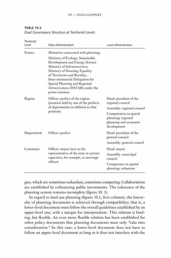
392 / AnnA GEPPErT
gies, which are sometimes redundant, sometimes competing. Collaborations are established by cofinancing public investments. The coherence of the planning system remains incomplete (figure 10. 1).
In regard to land use planning (figure 10.1, first column), the hierar-chy of planning documents is achieved through compatibility; that is, a lower- level document must follow the overall guidelines established by an upper- level one, with a margin for interpretation. This relation is bind-ing, but flexible. An even more flexible relation has been established for other policy documents that planning documents must only “take into consideration.” In this case, a lower- level document does not have to follow an upper- level document as long as it does not interfere with the
TAblE 10.2
Dual Governance Structure at Territorial Levels
territorial Level State Administration Local Administration
France Ministries concerned with planning:
Ministry of Ecol ogy, Sustainable Development and Energy (former Ministry of Infrastructure);Ministry of Housing, Equality of Territories and rurality;Inter-ministerial Delegation for Spatial Planning and regional Attractiveness (DATAr) under the prime minister
region Officer: prefect of the region (position held by one of the prefects of departments in addition to that position)
Head: president of the regional council
Assembly: regional council
Competences in spatial planning: regional planning and economic development
Department Officer: prefect Head: president of the general council
Assembly: general council
Commune Officer: mayor (acts as the representative of the state in certain capacities, for example, as marriage officer)
Head: mayor
Assembly: municipal council
Competence in spatial planning: urbanism

THE FrEnCH CASE / 393
upper- level document’s realization. In this case, the relation is more one of broad coordination than of hierarchy.
At the national level, France has no comprehensive national spatial development perspective, only a series of sectoral schemes for collective ser vices. Seven separate planning documents have been produced, summa-rizing national priorities in the following fields: higher education and research, information and communication, energy, natural and rural spaces, culture, health, and sport. Implementation is done through more detailed schemes, so the usefulness of the schemes is doubtful. For in-stance, in 2005, two schemes concerning transportation were abolished without further consequences. Still, the schemes remain binding on re-gional and local documents.
In specific situations, when the national interest is at stake, the national government may intervene directly. A pro ject of general interest could be, for instance, a major piece of infrastructure. An operation of national in-terest is larger; it could be a new town or a port. In this case, local plan-ning documents must be revised in order to comply with the pro ject or operation. If local authorities do not do so, the state representative steps in. The national government makes little use of these procedures, not least because they require important investments and public money is scarce.
Two levels have been assigned the authority to elaborate planning doc-uments: the regions, a tier of government established in 1982 explicitly to
Institutions
EuropeanUnion
PLANNING DOCUMENTS(implications on land-use)
POLICY DOCUMENTS(strategies, sectoral policies)
PUBLICINVESTMENT
ESDP, Territorial AgendaLeipzig charter EU funds
Nationalfunds
Regionalfunds
EPCI funds
Municipalfunds
Relation:
PLU Municipal land-use planor
CC Rural land-use plan
PDULocal mobility plan
SCOTUrban development plan
SRADDTRegional spatial development perspective
DTADDTerritorial directive for
planning and sustainabledevelopment
PCETLocal climate and energy
program
Territorial CharterPays, Agglomération
PLHLocal housing program C
om
mo
n in
vest
men
t p
rog
ram
: CP
ER
Co
ntr
act
bet
wee
n s
tate
an
d r
egio
n f
or
com
mo
n in
vest
men
ts
SRCE Regional plan forecological coherency
SAGEWater management
plan
SSCSchemes for collective services
PIG, OINProject of general interest
Operation of national interest
Compatibility Consideration
State
MunicipalityGroupings
Region
Municipality
PCETLocal climate and energy program
PCETLocal climate and energy program
Figure 10.1 Incomplete Coherence of the Planning System, 2013

394 / AnnA GEPPErT
perform regional planning; and the municipalities. Between these two government levels, there is a disruption of the hierarchy; local documents do not have to follow the guidelines provided by regional documents except in the capital region, where local documents must be compatible with the regional plan, the Urban Development Plan for the region Île- de- France.9
Each region prepares a regional sustainable development perspective. The regions have little geographic, historical, and economic consistency. Their perimeters were defined hastily by aggregating departments,10 which had become too small in a society of increased mobility. However, they did not replace the departments; instead, they constitute an additional layer. The regions’ bud gets remain modest. Because of the electoral sys-tem, regional representatives often act as lobbyists for their departments. regional staffs have more experience in public administration than in spa-tial planning. As a consequence, although regions manage their modest bud gets well, they tend to elaborate the regional sustainable development perspectives without a spatial vision. In the late 1980s, the first regional documents were merely lists of foreseen investments. Their quality has progressively improved, but they still seldom include, for instance, a com-prehensive map.
At the local level, the communes prepare planning documents at two levels. Their perimeters, inherited from medieval parishes, remain nar-row: the size of a village in the countryside and a small district in most cities. At the level of the urban area, voluntary groupings of communes elaborate the scheme for territorial consistency (schéma de cohérence terri-toriale [SCoT], the new name of the comprehensive urban development plan);11 this document provides the general guidelines and the common development perspective of the area. But, because groupings are volun-tary, the actual size of the area varies from a built agglomeration to a func-
9 In the Île- de- France, the urban development plan for the region (SDrIF) is binding on local documents. This is consistent with the highly urbanized profile of the region. The plan is much more precise and detailed than any other regional plan and, in addition to the vote of the re-gional assembly, needs the approval of the state government. Its 2008 version did not get this approval, so the 1994 version is still valid. On October 25, 2012, the region adopted a new ver-sion of the plan, which has finally been approved by the national government on December 27, 2013.
10 The departments were established in 1789 to replace and erase provinces and counties of the monarchy. The tabula rasa policy is pre sent in their perimeters and in their names, often taken from rivers. They were designed with the rule that every citizen should be able to go to and from the capital of the department in one day’s horse ride. In 1982, with car mobility, the de-partments were quite small, but in the meantime, they had gained some administrative and po liti cal consistency.
11 The SCoT is the successor of the former urban development plan (SD) Schéma directeur, earlier called Schéma directeur d’Aménagement et d’Urbanisme.

THE FrEnCH CASE / 395
tional urban area. Each commune elaborates its local urban plan,12 the land use plan that contains the zoning and all the regulations that have to be taken into account for the issuance of building permits.
In addition to statutory planning, sectoral policies have implications for land use (figure 10.1, second column). The urban mobility plan is manda-tory for agglomerations of 80,000 inhabitants or more. It is elaborated by a specific grouping of municipalities responsible for public transportation, the Or ga niz ing Authority for Urban Transport, which aims to reduce car traffic and promote low- carbon mobility. The local program for housing is a more programmatic document that outlines the municipal strategy for housing and, in par tic u lar, the support provided to public housing. Since 2010, each level of local government has been required to elaborate a ter-ritorial plan for climate change and energy saving to show how it will ad-dress the issue of climate change. Finally, larger groups of municipalities may prepare common spatial visions. These are expressed in territorial charters that are not binding in regard to land use but give birth to com-mon strategies. Different stakeholders prepare these strategies and docu-ments with different priorities and in different time frames.
The planning system was reformed in 2000 by a new planning law. Today at the local level, the core document is the SCoT. It coordinates plans and policies. Sectoral documents, such as the urban mobility plan and the local program for housing, must be compatible with the SCoT, which must take environmental objectives into consideration. Broader strategies expressed by a territorial charter must be consistent with plan-ning. The SCoT has become an instrument of horizontal coordina-tion of public policies across sectors and jurisdictions (Geppert 2008b; Motte 2006).
In regard to public investment (figure 10.1, third column), autonomy prevails. Many projects receive contributions from several institutions, which often means complex partnerships, long negotiations, and imple-mentation delays. On top of these ad hoc agreements, a common invest-ment framework is prepared for longer programmatic periods, the frame-work agreement for joint projects between state and region (contrat de projets état- régions, CPEr). Foreseen investments are shared not only by the state and the regions, but also by all levels of public institutions, from the mu-nicipalities to the use of Eu ro pean structural funds. Therefore, preparation of a CPEr involves intensive negotiation among public stakeholders, where development strategies are consulted and discussed. Once deci ded, a CPEr
12 The local urban plan (PLU) is the successor of the former land- use plan (POS) Plan d’Occupation des Sols (POS).

396 / AnnA GEPPErT
has a strong impact on the policies of local governments because it ear-marks an important part of the public resources available for investment.
In this structure of land use governance, the roles of the different institutional actors may appear overlapping and redundant. Although spa-tial planning at the local level seems to have gained consistency, the frame-work is not optimal for national policies, the French aménagement du territoire. It is unclear whether national policy should result from the aggre-gation of regional visions, or whether the central government still has an active role. In the last years, the visions expressed by the national admin-istration have been fragile and changing.
Disappearance of the National Spatial Strategy
Since the 1990s, attempts to define a comprehensive spatial strategy for the country have fallen short. Paradoxically, despite playing a “pioneer-ing role” in the Eu ro pean arena (Faludi and Peyrony 2001), France seems to have lost the ability to define a strong national vision. At the same time, new sectoral strategies and objectives have interfered with planning and have led to a redefinition, if not a dilution, of aménagement du territoire. The historical role of DATAr as an incubator of national policies has weakened. Even in the 1960s and 1970s, visions produced by DATAr were not legally binding, but, because the state was the key player and DATAr was the national body, policies defined and coordinated by DATAr were implemented. After the decentralization reform of 1982, the devolution of planning powers to local governments made the overall picture somewhat fuzzy. A national spatial development perspective would have been useful for domestic planning by defining common objectives and guidelines. It would also have been helpful in international relations, in par tic u lar with regard to cross- border planning issues. However, the attempt to create such a document was unsuccessful.
In the early 1990s, the significance of spatial planning was contested. Globalization increased international competition. From an instrument to influence the spatial structure of the country, planning became a way of fostering territorial competitiveness. Cities and regions engaged in terri-torial marketing and gave priority to investments that seemed to increase their attractiveness. regional Planning Perspectives (SrADT) looked for economic profiles and niches for regional promotion. Local regulatory plans tried hard to provide land for possi ble investors. In this context, the rigidity of the planning system triggered an outburst of contests (Conseil d’État, 1992). Territorial rivalries arose and hampered the development of territorial strategies and visions at the scale of city- regions. The defense

THE FrEnCH CASE / 397
of a classical approach to spatial planning came from the Eu ro pean Com-mission, which advocated “the need for a coherent Community approach” for the development of the Eu ro pean Community’s territory (Eu ro pean Commission 1991, 5). It spoke in favor of reducing territorial disparities: “It is the Commission’s firm opinion that the Union’s ultimate objective of sustained and balanced economic development can be achieved only through cooperation and joint action between all the interested parties at all levels, supported by a common framework for territorial planning” (Eu ro pean Commission 1994, 4).
In 1993–1994, the French government launched a national debate on spatial planning. The government sought input from a wide variety of organizations and persons. The consultation was even promoted through mass media, for the first time in French planning history. It addressed all issues linked with planning, from its purpose to its modalities. Aménage-ment du territoire was presented as the corollary of the French vision of society, “grounded in the very values of the republic,” an implicit refer-ence to the Jacobin discourse (Geppert 1995b). DATAr presented the state’s vision of a desirable future (figure 10.2). It pleaded that balanced spatial development must be supported by urban systems at different lev-els (metropolitan, intermediate, and rural). It advocated that the scale rel-evant for regional planning consisted of entities that were larger than both the departments and the regions (DATAr 1993). The debate was considered a first step in the reform of the planning system while a new planning act was being prepared.
In 1995, the French planning system was deeply reformed with a new planning Act (LOADT). This moment can be seen as the last attempt of the national government to keep control of regional planning. It created a hierarchy of planning documents at the upper level. The Act mandated that a national scheme for spatial planning and development would be submit-ted to the Parliament in the following year. This document was meant to stand over planning documents of all levels, as well as to improve the co-ordination of national sectoral policies. In 1996, a draft was made public. It included a number of principles; for instance, no place in France should be farther than 50 kilometers or more than 45 minutes from a rapid trans-portation system. However, it did not include a map showing the spatial dynamics. The national scheme never reached the parliamentary agenda.
At the next level, this Act created a possibility for the national gov-ernment to plan locally when the national interest was at stake. The pro-cedure, called the territorial planning directive, could be used where large physical entities were involved, such as mountains or rivers, or in cities confronted with a high level of social segregation. The state implemented

398 / AnnA GEPPErT
them slowly and reluctantly; by 2010, only six of these directives had re-ceived the force of law.
In 1999, a new government reformed the planning system again. The new planning Act (LOADDT) abandoned the would-be national schemes and replaced them with a series of sectoral guidelines for national policies, the Schémas de Ser vices Collectifs (Geppert 2001). It also abandoned the hierarchy between regional and local plans. In par tic u lar cases the national government may express a spatial strategy at the local level (DTADD). However, it has no regulatory effect on planning documents.
At the turn of the millennium, the impulse for discussing the French spatial development perspective came again from the Eu ro pean Union.
Figure 10.2 DAtAr’s Vision of a Desirable national Development Perspective Source: DATAR (1993).

THE FrEnCH CASE / 399
After 10 years of gestation (Faludi and Waterhout 2002), the Informal Council of Ministers responsible for Spatial Planning of Potsdam adopted the Eu ro pean Spatial Development Perspective (ESDP) (Eu ro pean Commis-sion 1999). In the domestic arena, DATAr echoed its concept of poly-centric development in a forecasting exercise, France for 2020 (DATAr 2002). The report presented a series of forecasts that might be used as an inspiration, both for national policies and for regional authorities. Follow-ing its tradition, DATAr presented four scenarios of possi ble, but unsuit-able futures. The fifth scenario was a “plea for polycentricity,” considered the only way likely to spread development across the whole national terri-tory. There has been no direct implementation of this idea, although the concept has entered the French planning discourse. However, few French planners know that it comes from the ESDP (Geppert 2009).
At the same time, new objectives arose that influenced French planning policies. The Eu ro pean slogan of switching to a sustainable and knowledge- based economy was translated into planning through the cohesion policy (Geppert 2007, 2008a). Since 2004, France has developed a cluster policy. Brought to maturity under the umbrella of DATAr, it claims a specific approach where territory is the breeding ground of the interaction among research, industry, and local decision makers (Darmon and Jacquet 2005; DATAr 2005). An economic dimension in planning is not new for France, which, according to the EU Compendium of Spatial Planning Systems and Policies, belongs to the “regional- economic ideal- type” (Eu ro pean Com-mission 1997). However, at pre sent, the relation is inverted. In the tradi-tion of aménagement du territoire, economic incentives were an instrument to modify spatial structures. In the cluster policy, territorial assets are the means for industrial development, which appears sectoral. Indeed, once the location of the 71 clusters is settled, the core of the policy will be to support research projects and platforms. Today, DATAr remains a part-ner in the policy, but other ministries with economic and industrial port-folios play more important roles.
The relation between sustainability and planning is even more one sided. French planning has claimed a relation with sustainability since the Voynet Act (1999). However, since 2003, the development of the national Strategy for Sustainable Development had been under the umbrella of the Ministry of the Environment. In 2007, President nicolas Sarkozy launched the Grenelle de l’environnement,13 a permanent consultation group to de-fine how the French society could implement its “sustainable revolution.”
13 The name refers to the agreements that settled the social conflict in May 1968, which took place in the rue de Grenelle.
400 / AnnA GEPPErT
Planning issues and planning stakeholders played a rather minor role. So far, the pro cess has established new environmental requirements for the planning documents. Spatial considerations, however, come at the end and on the margin of the core pro cess.
Today, the definition of aménagement du territoire hesitates between two poles: cohesion and competitiveness. This is well illustrated by the two core missions assigned to DATAr. It still prepares, initiates, and coordi-nates national spatial policies, but the objectives are twofold. On one hand, these policies pursue territorial cohesion, which one can consider equiva-lent to aménagement du territoire. Without an explicit strategy, local gov-ernments set and implement planning goals, with some support from the state. On the other hand, planning policies have to promote “territorial attractiveness,” helping French cities and regions face global competition. In 2006, to show this evolution, DATAr was renamed the Délégation à l’Aménagement et à la Compétitivité des Territoires and was merged with the French international investment agency. In 2009, DATAr recovered its former acronym, but it now stands for Délégation Interministérielle à l’Aménagement du Territoire et à l’Attractivité régionale.
In the long run, cohesion and competitiveness are complementary. However, in the short term, they often conflict and lead to overlaps among sectoral ministerial departments. Also, their implementation requires a strong commitment from local authorities.
Policy Implementation: Top- Down and bottom- Up Pro cesses
Going from Jacobin to Girondist culture is a major change. The state must adjust to its role of “modern state, modest state” (Crozier 1986). no longer the first actor, it has to define why and how it should intervene in spatial planning. The national level keeps the possibility to act top- down through legislative reforms. However, it also expects lower- level governments to build local and regional strategies and to enhance bottom-up approaches, which do not always arise.
top- Down Approach
In a top- down approach, the state promotes its objectives through legisla-tive changes. Shifting from a very mild approach that left planning deci-sions to the local level, the state has become slightly more normative. The control of urbanization is one example.
In France, as in other Eu ro pean countries, urban sprawl has become evident and has led to substantial increases in land consumption and green house gas emissions. This phenomenon is related to the dynamics
THE FrEnCH CASE / 401
in peripheral rural areas, in which lower- middle- class people settle in modest individual housing, and which appear socially and eco nom ically fragile. These small rural municipalities would like to attract new in-habitants. Therefore, they produce permissive local planning documents. The local plans allow for an accumulation of local decisions that foster urban sprawl. In 2000, to tackle this issue, the reform instituted a new territorial strategy (Goze 2002).
Local statutory plans were reformed and renamed. The larger urban development plans (SD) are now called Scheme for Territorial Coherence (SCoT). The key objective of the reform was to ensure that this overarch-ing document would produce a cohesive spatial strategy, as is illustrated by its new name. The SCoT must include a sustainable development per-spective and an environmental impact assessment. Urban agglomerations are obliged to have a SCoT, but small municipalities remain free to decide whether to join the common planning document. To avoid free- rider strategies, the reform established a 15- kilometer rule: if they are not covered by a SCoT, municipalities located within 15 kilometers of the outer limit of an urban agglomeration may no longer urbanize (they lose the right to prepare local planning documents and to issue building permits).
The first de cade of implementation of the Loi Solidarité et renouvel-lement Urbains, also known as the SrU Act, proved disappointing. Al-though SCoTs of the de cade were less permissive with regard to urban sprawl, unexpected consequences appeared. First, rural municipalities af-fected by the 15- kilometer rule developed alternative strategies, for ex-ample, setting up alliances of peripheries; a number of them adopted quite permissive rural SCoTs. Second, urban sprawl spilled out to the second ring around municipalities, at a distance of 20 to 50 kilometers from ur-ban agglomerations. The economic context fueled the spatial sprawl as land values skyrocketed early in the 21st century. Worse than sprawl in the immediate periphery, which the government tried to prevent, this second belt was located even farther from city centers and was even less connected by public transportation networks (Geppert 2008b).
In 2010, the Grenelle II Act increased the pressure on localities to block urban sprawl. By 2016, any municipality not covered by a SCoT will have to freeze urbanization. Every SCoT must define objectives for reduction of land consumption and must express them in mea sur able indicators. It may also establish preconditions for urbanization. For instance, it may de-cide that new areas will open to urbanization only if and when the poten-tial of existing developable areas is fully used. It is too early to assess the results of this legislation and to see how local governments will imple-ment it.

402 / AnnA GEPPErT
Bottom- Up Approach
Since the 1990s, when the idea of structuring the territory through the urban system reemerged, the state has tried to catalyze bottom-up pro-cesses and to promote its goals to cities and regions. In 1991, DATAr invited French cities to establish collaborative networks of cities. The policy framework is open: networks are established voluntarily and remain informal. DATAr provides financial support for networking activities (Geppert 1995a). The results have been modest. Some 20 networks have been established, geo graph i cally quite heterogeneous. Territorial lobby-ing is usually the first and sometimes the only activity. A few networks have engaged in further collaboration in various areas, for example, tourism, culture, and economic development. But when public support ends, most networks become dormant. Mayors find little interest in issues reaching further than their own city. In a culture shaped by centralization, they leave the larger scale to the state (Geppert 1996).
However, the state has not given up and has tried to find new mecha-nisms for encouraging aggregation of local interests and initiatives. The national debate of 1993 stressed the fragmentation of French municipali-ties and called for a development of urban- rural partnerships (DATAr 1994). The 1995 reform instituted a new collaborative framework for “geo-graph i cally relevant” spaces with the size of functional urban areas: the county.14 To soothe the reluctance of mayors to pool decisions or bud gets, the approach is very soft, and counties are not legal entities. Their gover-nance has two levels. A development council gathers representatives of the “civic society”: people, nGOs, and private firms. It participates in the preparation of a territorial charter, which is a vision of the future devel-opment of the county. All final decisions and policy implementation re-main in the hands of the mayors. The hope of the government is that after experiencing soft collaboration, mayors will be willing to share more and, in par tic u lar, to extend the perimeters of SCoTs to these larger areas.
At first, the counties were met with skepticism. Local representatives feared that they were a cover for some authoritative reform. Some coun-ties were established in regions with a tradition of local collaborations, like the Bretagne region (Bazin and Geppert 2002). In 2002, the state re-launched the county policy, earmarking important state subsidies for in-vestment projects supported by counties. Given this incentive, collabora-tions flourished, and, in a few years, counties covered almost all the French territory. The evolutions of counties have followed different trajectories.
14 The county must be understood as a geographic region with a cultural and historical con-notation. It is not an administrative unit.

THE FrEnCH CASE / 403
Some counties have become dormant or have vanished; others have a mod-est level of activity, tackling consensual issues such as touristic or cultural collaborations, but avoiding hard questions such as important investments or land use. Finally, a few have given birth to institutionalized municipal groupings, mostly in rural areas, embodying defensive alliances of small municipalities against core cities.
The French government has continued to focus on cities in the 21st century, but it is now working at the other end of the scale and respond-ing to international pressures. In 2003, the state renewed its attempt to stimulate larger cities, which were considered too small to face Eu ro pean competition. DATAr issued a call for metropolitan cooperation that addressed networks of cities with a population of at least 500,000 and at least one city of more than 200,000 people. Elected metropolitan networks would formulate a strategy to foster their international dimen-sion, and the state would support their investment programs (DATAr 2004).
In response, 23 proposals were submitted. The call mobilized all major French cities and led to aggregations of a number of middle- sized and smaller cities. Fifteen proposals were selected, with little concern for their territorial shape. They might cover large urban areas or metropolitan regions, or they might aggregate cities far apart from one another. The se lection committee gave priority to governance issues. Candidates were asked to prove the support of various partners, public as well as private. They also had to announce how they intended to manage future decisions. Adopted solutions were inspired by the soft scheme of the county. Existing staffs constituted technical teams at minimal cost. All groupings featured development councils, with various actors, going from nGOs to universities or hospitals that could be partners for possi ble planning endeavors. Deci-sion making rested with the mayors (Geppert 2005).
From 2005 to 2006, successful candidates prepared their strategic projects. The government suggested that they focus on five drivers of metropolitanization: economic development, strategic employment, international accessibility, research and higher education, and arts and culture. Instead, most projects focused on local issues and added other topics, such as public health or the environment (Geppert 2006; Motte 2007). Some metropolitan collaborations deci ded to prepare an SCoT covering the whole metropolitan area. Strasbourg and Toulon have ad-opted their SCoTs. Larger city- regions, such as Aix- Marseille, Lyon, and Toulouse have engaged in coordination and common monitoring of their documents.
A major obstacle to the implementation of this metropolitan coordina-tion strategy has been the withdrawal of the state. Within the first two
404 / AnnA GEPPErT
years, it became clear that the support promised for public investments would not be provided. As a result, some networks become dormant, and one, the Métropole normande, shut down. In contrast, some collabora-tions proved dynamic, for example, the Sillon lorrain, which in 2011 institutionalized as a collaborative grouping with a specific bud get. How-ever, when they remain active, metropolitan collaborations tend to focus on core cities. Links with the broader territory remain weak, as do collabo-rations with regional authorities, who feel endangered by the growing power of cities.
Therefore, a combination of authoritative and collaborative policies seems necessary. However, until now, both types of policies have been weak. First, in implementing legislative changes, the central government has often hesitated. For instance, in the implementation of the 15- kilometer rule, the state representatives issued many waivers for building permits. In 2003, these requirements were softened. Initially, the rule affected mu-nicipalities around agglomerations of 15,000 inhabitants; this threshold was changed to 50,000 inhabitants, exempting the surroundings of some 200 small cities. Second, in responding to local governments with col-laborative proposals, the state has lacked continuity and has not kept its commitments. This has generated distrust, which in return will hamper the effectiveness of future policies. Last, but not least, coordination ap-pears too weak, both between sectoral policies and between territorial levels. Is French spatial planning still efficient? What can be learned from past experiences?
Defining a National Spatial Planning Perspective
Adjusting to multiactor governance, France has progressively abandoned the national spatial planning strategy that was its hallmark under the name aménagement du territoire. As a result, spatial planning oscillates among objectives of spatial cohesion, territorial competitiveness, and var-ious conceptions of sustainability. There are three main reasons for this. First, local governments pursue diverse strategies without developing common spatial strategies. Second, the state has given up its role of pro-viding an overarching vision and strong policy impulses. Third, the eco-nomic crisis has resulted in a focus on sectoral policies rather than spatial planning.
The hope that local governments would spontaneously coproduce coherent spatial planning has failed. In addition, the French institutional design lacks an efficient system of checks and balances among the different actors. Too many tiers of local government exist. In spite of numerous
THE FrEnCH CASE / 405
reforms, they remain fragmented and their responsibilities redundant. Several reforms failed to improve the institutional design. In 1999, a reform tried to foster a more efficient or ga ni za tion of the municipal groupings,15 but the outcomes did not meet expectations (Cour des comptes 2005). In 2010, a new reform followed, still with limited outcomes. A reform announced for 2015 would create a new status for the biggest city- regions.
At the next level, the existence of two levels, regions and departments, generates redundancies. However, attempts to suppress one of these levels remained unsuccessful. In 2012, the possibility was given to departments and regions to merge, on a voluntary base. The only attempt, made by the region Alsace, failed. In 2015, a new reform was announced. rather than suppressing one of the levels, it would give each level a role of leader with res pect to certain responsibilities. The number of regions would be di-minished from 22 to 13. The pro ject has generated much controversy. In the view of the author, it does not match the key issues at stake: the larger regions are not geo graph i cally consistent, while the duality of tiers will remain.
In such circumstances, very efficient coordination is necessary. How-ever, coordination procedures remain in effec tive and time- consuming. The accumulation of local strategies does not create an overall picture. The objectives of regional strategies do not converge. In regard to policy making, the multiactor CPErs juxtapose actions without defining a co-herent investment program. In each negotiation, quite legitimately, regions have an important weight. As a result, the state administration tends to follow the local level. Little room is left for the promotion of national goals and for coordination among neighboring regions. Likewise, a real clarification of the roles of the different institutional actors involved is still missing. Many Eu ro pean countries have reor ga nized their institutions, but the French system seems mired in its complexity.
Meanwhile, the national government has abandoned its overarching vi-sion, which has been diluted in a series of sectoral policies. This is partly due to a Girondist posture that is more respectful of local governments. State administrations avoid authoritative interventions even when laws grant that power. In implementing the institutional reforms of 1999 and 2010, prefects could reject municipal groupings with obviously irrel-evant perimeters, for instance, ones that cut a city into two parts, but they
15 It reduced the categories of groupings to three possi ble types: communauté urbaine for cit-ies above 500,000 inhabitants, communauté d’agglomération for cities above 50,000 inhabitants, and communauté de communes for smaller groupings. The larger the grouping, the stronger is its financial and po liti cal integration. Groupings may choose a status below their demographic threshold. Some have done so, because municipalities did not want to lose their powers.
406 / AnnA GEPPErT
made little use of this prerogative. Because the planning culture remains deeply influenced by the tradition of centralization, local governments often keep waiting for a stronger signal from the state and, in the mean-time, continue to implement short- term strategies.
The low profile of the state also reflects the re orientation of its priori-ties in a context of a shortage of public funding. Calls for proposals co-managed by DATAr have addressed various issues. Some target specific kinds of spaces, like the metropolitan collaborations described in this chapter. Others address sectoral issues, such as information and com-munication technologies, public health, and scientific clusters. In the policy mix, spatial policies have received far less funding than sectoral interventions. At the same time, a specific law, outside the usual plan-ning procedures, has instituted the circling metro for the Grand Paris pro ject. A new state- owned com pany has been created for this purpose, the Société du Grand Paris, which will administer a flow of 25 billion euros in the next 20 years. State investments will support 17 clusters along the future metro line through so- called territorial development contracts.
The evolution of the role of DATAr illustrates the change in the approach to spatial planning. From a think tank for national policies, it has become a network administration supporting local development. DATAr performs a growing number of networking activities. It cofinances a number of specialized agencies that advise local stakeholders on specific issues. Entreprises territoires et développement deals with territorial devel-opment; Mission opérationnelle transfrontalière supports cross- border cooperation. These agencies provide methodological support and dissem-inate information.
Along the way, DATAr has lost its historical role of spokesperson, which used to be embodied in its forecasting. In 1971, Schéma général d’aménagement de la France was a legitimation of national policies (Monod 1971). In 2000, the polycentric scenario was a spatial vision proposed to the other stakeholders, without any national means of implementation. Since then, forecasting has continued in two consecutive research programs led by the DATAr, Territoires 2030 (2004–2008) and Territoires 2040 (2009–2012). However, it no longer delivers a national vision, even with-out implementation. Instead, it aims to stimulate debates on key planning issues (DATAr 2012).
In Territoires 2040, DATAr asked experts, often academics, and local representatives to reflect on trends affecting seven “spatial systems,” a nickname for different pro cesses having a spatial impact (e.g., communi-cation society, industrial transformations, metropolitanization). For each of them, DATAr produced several scenarios, 28 in all. They forecast
THE FrEnCH CASE / 407
specific trends and pro cesses, but none of them is a spatial development perspective.
However, territorial actors themselves question the lack of a national vision. For instance, the Association of Municipal Groupings states: “The rich French tradition of aménagement du territoire has been a laboratory for many innovations. Today, many local representatives feel that the state has no national strategy, or at least that the momentum is lost. The na-tional strategy has become blurred because of the multiplication of calls for proposals, the proliferation of sectoral contracts, [and] the lack of stra-tegic content of the generation of CPErs currently under execution” (ADCF 2012, 17; translated by Anna Geppert). The report further sug-gests that a national spatial development strategy for 2014 to 2020 should be defined jointly by the national and local levels.
In the contemporary context of economic crisis, defining a spatial de-velopment perspective is more difficult than it was when DATAr was es-tablished. In the short run, the state is the firefighter facing emergencies that arise suddenly and generate conflicting priorities. However, it is even more necessary that the state ensure that investments supporting strate-gic economic sectors and mitigating social difficulties prove efficient in the long run.
References
ADCF (Association des Communautés de France). 2012. “Propositions pour une nou-velle gouvernance des territoires et des politiques publiques” [Proposals for a new governance of territories and public policies]. La Gazette des communes, Cahier dé-taché no. 2, 37/2143 (October 1): 48.
Bazin, M., and A. Geppert. 2002. “Les pays, de Pasqua à Voynet: Espaces de mémoire collective et espaces d’avenir” [ The pays, from Pasqua to Voynet: Places of collective memory and future]. In Les dynamiques du développement régional, ed. G. rasselet, 127–146. reims: reims University Press.
Boudev ille, J. 1968. L’espace et les pôles de croissance. [Space and growth poles]. Paris: PUF.
Christaller, W. 1933. Die zentralen Orte in Süddeutschland [Central place in southern Germany]. Jena: Gustav Fischer.
Cohen, J. 2002. “Métropoles d’équilibres” [Balance metropolises]. In Strates, special issue: Parcours dans la recherche urbaine: Michel Rochefort, un géographe engagé. Strates. http:// strates . revues . org / document556 . html
Conseil d’État. 1992. L’urbanisme, pour un droit plus efficace, aka Rapport Labetoulle [For a more effective planning law (also referred to as the Labetoulle report)]. Paris: La Documentation Française.
Cour des comptes. 2005. L’intercommunalité en France: Rapport au Président de la Ré-publique [Inter- municipal collaborative groupings in France: report to the presi-dent of the French republic]. Public report of the Court of Audit of France.

408 / AnnA GEPPErT
Crozier, M. 1986. État moderne, état modeste: Stratégies pour un autre changement [Mod-ern state, modest state: Strategies for another change]. Paris: Fayard.
Darmon, D., and n. Jacquet. 2005. Les pôles de compétitivité: Le modèle français [Clus-ters: The French model]. Paris: La Documentation Française.
DATAr (Délégation à l’Aménagement du Territoire et à l’Action régionale). 1993. Débat national pour l’aménagement du territoire: Document introductif [national debate on special planning: Introductory document]. Paris: La Documentation Française.
— — —. 1994. Débat national pour l’aménagement du territoire— Document d’étape [na-tional debate on special planning— Intermediate report]. Paris: La Documentation Française.
— — —. 2002. Aménager la France de 2020— Mettre les territoires en mouvement [Plan-ning for France in 2020— Impulsing dynamics in the territories]. 2nd ed. Paris: La Documentation Française.
— — —. 2004. Pour un rayonnement européen des métropoles françaises— Appel à coopera-tion [For a Eu ro pean development of French metropolises— Call for collaboration]. Paris: DATAr.
— — —. 2005. La France, puissance industrielle— Une nouvelle politique industrielle par les territoires [France, industrial superpower— A new industrial policy led by the ter-ritories]. Paris: La Documentation Française.
— — —. 2012. “Les démarches de prospective: Du Scénario de l’inacceptable à Territoires 2040” [Forecast exercises: From the unacceptable scenario to Territories 2040]. In “DATAr, 50 ans, 1963–2013.” Special issue, Territoires en mouvement, no. 11 (Win-ter): 14–16.
Eu ro pean Commission. 1991. EUROPE 2000: Outlook for the Development of the Com-munity’s Territory, a Preliminary Overview. Communication from the Commission to the Council and the Eu ro pean Parliament. Luxembourg: Office for Official Pub-lications of the Eu ro pean Communities.
— — —. 1994. EUROPE 2000+: Cooperation for Eu ro pean Territorial Development. Lux-embourg: Office for Official Publications of the Eu ro pean Communities.
— — —. 1997. The EU Compendium of Spatial Planning Systems and Policies. Luxem-bourg: Office for Official Publications of the Eu ro pean Communities.
— — —. 1999. Eu ro pean Spatial Development Perspective: Towards Balanced and Sus-tainable Development of the Territory of the Eu ro pean Union. [Also referred to as ESDP]. Luxembourg: Office for Official Publications of the Eu ro pean Communities.
Faludi, A. 2004. “Territorial Cohesion: Old (French) Wine in new Bottles?” Urban Studies 41 ( June): 1349–1365.
Faludi, A., and J. Peyrony. 2001. “The French Pioneering role. In “regulatory Com-petition and Co- operation in Eu ro pean Spatial Planning,” ed. A. Faludi. Built Environment 27(4): 253–262.
Faludi, A., and B. Waterhout. 2002. The Making of the Eu ro pean Spatial Development Perspective: No Masterplan. London: routledge.
Fourastié, J. 1979. Les Trente Glorieuses, ou la révolution invisible de 1946 à 1975 [The thirty glorious years, or the invisible revolution from 1946 to 1975]. Paris: Fayard.
THE FrEnCH CASE / 409
Geppert, A. 1995a. “Inter- Cities networking in Champagne- Ardenne (France).” In Planning and Socio- economic Development, ed. T. Marszał, 124–135. Łód ź : Łód ź Uni-versity Press.
— — —. 1995b. “Spatial Planning in France— A new Deal?” In Proceedings of Plan-ning for a Broader Eu rope VIII AESOP Congress, Istanbul, 24–27 August 1994, 2:298–311. Istanbul: Yildiz Technical University Press.
— — —. 1996. “réseaux urbains et aménagement du territoire en Champagne- Ardenne” [Urban collaborative networks and spatial planning in the region Champagne- Ardenne, France]. reims: Université de reims- Champagne- Ardenne.
— — —. 2001. “Schémas de ser vice collectifs: Objectif cohérence” [Schemes for col-lective ser vices: Toward more coherence]. Pouvoirs locaux 50(3): 22–24.
— — —. 2005. “En quête de métropoles” [Chasing metropolises]. Pouvoirs locaux 65(2): 3–8.
— — —. 2006. “Les coopérations métropolitaines: Un décryptage” [Decrypting met-ropolitan collaborations]. Urbanisme 18: 44–46.
— — —. 2007. “Economie de la connaissance et territoire(s) en Eu rope” [Knowledge economy and place(s) in Eu rope]. Pouvoirs locaux 72(1): 52–57.
— — —. 2008a. “La politique de cohésion 2007–2013, instrument de la spatialisation de la stratégie de Lisbonne” [The 2007–2013 cohesion policy as a spatialization of the Lisbon strategy]. In La Champagne- Ardenne et la Picardie face aux enjeux de l’attractivité et de la compétitivité des territoires. reims.
— — —. 2008b. “Vers l’émergence d’une planification stratégique spatialisée” [ Toward the emergence of strategic spatial planning]. Habilitation thesis.reims: Université de reims- Champagne- Ardenne. www . aesop - planning . eu / books / en _ GB / 2011 / 03 / 04 / readabout / geppert - anna - towards - a - strategic - spatial - planning - universite - de - reims - champagne - ardenne - reims - 2008 - vol - 1 - 230p - vol - 2 - 256p - in - french
— — —. 2009. “Polycentricity: Can We Make It Happen? From a Concept to Its Implementation.” Urban Practice and Research 2(3): 251–268.
Goze, M. 2002. “La stratégie territoriale de la loi SrU” [Territorial strategy of the SrU act]. Revue d’Économie Régionale et Urbaine, no. 5: 761–777.
Gravier, J. 1947. Paris et le désert français [Paris and the French desert]. Paris: Le Portulan.
Hautreux, J., and M. rochefort. 1963. Le niveau supérieur de l’armature urbaine fran-çaise [The upper level of the French urban armature]. Ministère de la construction. Paris: CGPEP.
— — —. 1964. La fonction régionale dans l’armature urbaine française [The regional functions of French cities]. Ministère de la construction. Paris: CGPEP.
Marchand, B. 2001. “La haine de la ville: Paris et le désert français de Jean- François Gravier” [The hatred of the city: Paris and the French Desert by Jean- Francois Gravier]. L’Information Géographique 65: 234–253.
Monod, J. 1971. Schéma général d’aménagement de la France. Une image de la France en l’an 2000: Scénario de l’inacceptable [French spatial development perspective. An im-age of France in the year 2000: The unacceptable scenario]. Paris: La Documenta-tion Française.
Motte, A. 2006. La notion de planification stratégique spatialisée en Eu rope (1995–2005) [The concept of strategic spatial planning in Eu rope (1995–2005)]. Paris– La Défense: MEEDDAT– PUCA.

410 / AnnA GEPPErT
— — —. 2007, Les Agglomérations françaises face aux défis métropolitains [French agglom-erations facing metropolitan challenges]. Paris: Economica.
Vadelorge, L. 2005. “Mémoire et histoire— Les villes nouvelles françaises” [Memory and history— French new towns]. In “Les visages de la ville nouvelle.” Special is-sue, Les Annales de la Recherche Urbaine 98: 7–12.

/ 411 /
Anna Geppert’s chapter is well documented and gives a clear picture of the evolution of the French planning system, which proves to be
very complex. Her critical approach is logical for an academic; my com-ments will stand up for policy makers.
I have a general difficulty about the concept of planning itself. In French, my professional field can be defined as aménagement du territoire, which Délégation à l’aménagement du territoire et à l’action régionale (DATAr) itself translates as “spatial planning,” but I doubt that “planning” is real ly a good translation.
The issue of territorial level is crucial for understanding the phenom-enon of French planning. There is no doubt that urban planning is part of the picture, and that in France since 1982 (when the devolution laws have been passed) even within the national legal framework, local authorities have had the leading role in urban planning, as in most countries. At the local level, one needs to decide what areas will be developed or protected, and one must make the rules public. A binding plan in the narrow sense remains the best tool for local guidance and control.
At the national level, aménagement du territoire means something different. DATAr’s role has always been one mainly of coordination, both horizontal (between different ministries) and vertical (between state and local authorities). Its first mission when it was created in 1963 was to or-ga nize the reallocation of activities from Paris to other French regions.
Commentary
JeAn PeYronY

412 / JEAn PEYrOnY
The state had tools, such as the power to fund major infrastructure (motorways and, later, high- speed trains), and the procedure of “agreement” led by the Decentralization Committee, making decisions on the location of plants. This was possi ble because of the very centralized character of the French economy at that time (with a leading role of civil servants, as Geppert explains), but also because of economic trends (what Philippe Aydalot has called “peripheral exploitation”).1 Public policies comple-mented economic trends, rather than created them.
Geppert may be unfair to DATAr in presenting the cluster policy, which consists of calls for projects for economic clustering and was launched in 2003 with the active participation of DATAr. She suggests that it is an industrial policy under a territorial disguise. In fact, this pol-icy has played a significant role in promoting new cooperation among busi-nesses, research centers, and universities on a territorial basis.
These two examples— involvement in allocation of new plants and the coordination of economic clustering projects— show that DATAr is more an agency for regional policy than for planning, if planning is understood as the making of plans. Plans are tools, not ends in themselves. Even dur-ing the “thirty glorious years” of industrialization and urbanization men-tioned by Geppert, there were national plans for infrastructure, such as motorways, but there was no national binding master plan.
It is clear that the planning activities of DATAr in the narrow sense of production of master plans cannot be considered a success. Geppert tells the story of the national scheme for planning and development; but it was abandoned for po liti cal reasons that had little to do with substantive plan-ning considerations. In the socialist government of Lionel Jospin from 1997 onward, the Green minister Dominique Voynet replaced the national scheme by schemes for collective ser vices. The latter approach was more modest, acknowledging that spatial planning is primarily for local and re-gional authorities. But schemes for collective ser vices were not pure sec-toral guidelines. DATAr produced them through interaction with sectoral ministries. This is, after all, the daily work of DATAr, which is a ser vice of the prime minister, even if it is also supervised by another minister.
Once again, terminology is an issue. Depending on the period, at na-tional or Eu ro pean level, the stress has been put on “schemes” (in the 1990s) or on softer tools such as “perspectives” (since 2002). This is likely why Geppert uses the term “spatial development perspective,” which was employed for the Eu ro pean Spatial Development Perspective (CEC, 1999), but
1 Philippe Aydalot, a pioneer of economic geography, has built a theory of spatial division of labor; he has shown that in industrialized countries, the delocalization of firms into peripheral regions in the 1960s has been the result of lower labor costs.
COMMEnTArY / 413
was nevertheless translated into French as schéma de développement de l’espace communautaire. Such documents may be no more than paper tigers, but they are part of the overall dynamics as tools to influence a decision pro-cess. In regard to DATAr’s role, there has always been in DATAr a vi-sion of what a more competitive, balanced, and sustainable development of the national territory would mean.
At the national level, planning in France is both procedural and sub-stantive. One example is rail infrastructure, which is generally considered a structuring ele ment for territorial development patterns. Cities that were left out of initial railway development in the 19th century, such as Albi, have developed less, and this story may repeat. In contrast, high- speed trains (HSTs) have a station in the center of Lille, not in the middle of fields, and, consequently, make Lille a central node in the emerging Eu-ro pean HST network connecting London, Paris, and Amsterdam. This has been an important part of the revival of Lille and its region. In the French system, such decisions are the result of different factors, including negotiations among diverse national sectoral ministries and agencies (in the HST case, the Ministry of Transport, the rail operator SnCF, and the Ministry of Finance were the key players), as well as the actions of local politicians. In Lille, the commitment of Pierre Mauroy, a politician strongly devoted to his city and region as mayor of Lille and also a leader in national politics,2 was the key.
In such pro cesses, DATAr generally has a significant role, based on substantial input (whether in schemes or in perspectives) and on proce-dures, such as Interministerial committees for planning and spatial devel-opment, or, at a more day- to- day level, meetings among ministerial cabi-nets that prepare governmental decisions. More recently, projects such as the HST infrastructure for the Turin- Lyon connection (with a long tun-nel under the Alps crossing the border between France and Italy) owe their survival so far, despite scarce public money and strong environmentalist re sis tance, more to bargaining, supported by the influence of DATAr at the national level and politicians at the local level, than to any binding master plan.3
2 As French prime minister in 1981, Mauroy had to persuade Margaret Thatcher to accept the digging of the tunnel under the En glish Channel. He was one of the fathers of devolution in 1982, and of the socialist conversion toward the Eu ro pean construction, together with Jacques Delors and Michel rocard. Later, Mauroy was also one of the most influential promoters of cross- border local integration, launching in 2008 the first Eu ro pean Grouping of Territorial Cooperation to support the Eurométropole Lille Kortrijk- Tournai, and serving as the president of Mission opérationnelle transfrontalière (Transfrontier operational mission). Mauroy passed away in June 2013.
3 This can be analyzed as an ongoing dialogue between politicians and engineers, this duet having been created by, among others, Louis XIV and Vauban themselves; see Boltanski and Thévenot (2006) and Peyrony (2007).

414 / JEAn PEYrOnY
Geppert’s chapter gives a clear and true depiction of the progress and limits of French planning legislation, but it sometimes misses things that are going on outside planning laws and documents. Over the past 30 years, major cities such as Lille, Bordeaux, Marseille, Lyon, Strasbourg, nantes, and Toulouse have changed substantially, for example, with the introduc-tion of new tramways and HST lines. These changes are fostered by a combination of factors similar to the example of Lille: the commitment of major politicians developing a career at both local and national levels, a new local consensus on urban renewal, and national financial support for their projects. Planning tools such as local schemes for territorial consis-tency (schémas de cohérence territorale, SCoTs) certainly play a large role, but only as a complement to other resources, including urban planning pub-lic agencies producing soft planning (see, e.g., Faludi 2013); new institu-tions such as urban communities and now “metropolises,” with their power ful technical staffs; the po liti cal influence of leaders sharing their time between Paris and their cities; and, not least, DATAr staging the de-cision in Paris. DATAr certainly does not always win in fights with sec-toral ministries, but this does not mean that national policies have lost the spatial dimension.
As Geppert says, to understand French spatial policies, one has to relate them to a vision where the unity of territory appears an integral part of the nation- state. The debate between Girondists and Jacobins is still on-going, with Alain rousset, socialist president of the Aquitaine region and of the Association of French regions, as the leader of the Girondists,4 lob-bying hard to persuade President François Hollande to give a leading role to regions in aménagement du territoire. One of the issues is the status of regional schemes for spatial planning and sustainable development (sché-mas régionaux d’aménagement et de développement durable du territoire, SrADDT): SCoTs legally do not have to conform to, or even be consis-tent with, the SrADDT. Such a link exists only for the very specific case of the regional scheme for the region Île- de- France (the Paris region), with which SCoTs have to be consistent.
Even though the pre sent French government has launched a third round of devolution and a reform of state territorial action, it is not obvious that the Girondist view will fully prevail. Because this discussion is still ongo-ing, it would be premature to draw any conclusions, but the early history
4 rousset is a Girondist in the strict sense, because the department of Gironde is part of the Aquitaine region.
COMMEnTArY / 415
of this polarity suggests that it is necessary to provide a bit more nuance to Geppert’s view.
In regard to round one of decentralization in 1982, sociologists gener-ally stress that the game between French prefects (representing the state at the level of departments and regions) and local politicians has not changed as much as one might think at first glance (see, e.g., Crozier and Thoenig 1975). Even before 1982, the main concern of prefects was not to frustrate local politicians, because they might complain to Paris, and pre-fects could be sacked every Wednesday during the meetings of the Coun-cil of Ministers. Under devolution, although the prefects have their say, final decisions belong to local representatives; but this might have been true even before devolution.
In any case, DATAr has actively supported the devolution to regions and the development of a local aménagement du territoire with framework agreements for joint projects between state and regions since the 1980s, and the policy of agglomerations and “pays” in the 1990s. “Pays” are a good example of DATAr’s role. It launched this policy because it questioned, from functional and community- led- development points of view, the relevance of administrative patterns dating from the beginning of the 19th century. “Pays” have been experiments in softer planning and governance.
But France is, and will most probably remain, a unitary state, not only because of ideology (the French discourse about diversity and unity), but also because of economic, social, and geographic realities. The Paris re-gion keeps its central role as the main pump of various flows: po liti cal de-cisions, interregional migrations, and financial flows of the welfare state, among many others. Aménagement du territoire has always been a dialectic between equity and efficiency; also, the rhe toric of equality has always been there. With regard to spatial policies, de Gaulle had two hands: DATAr, to develop regions outside Paris (e.g., through counterweight metro-polises), but also a specific planning policy for the Paris region. In the same vein, Datar now depends on the minister of housing, territorial equality and rurality, also in charge of Greater Paris. Of course, the state had much more room to maneuver in de Gaulle’s time than it has now, but this is true for public action in general because of the issue of public debt.
Change is possi ble; in fact, it is continuously happening. Perhaps one of the real challenges, beyond decentralization, is to move from “implicit negotiation” to “explicit negotiation,” as Crozier and Friedberg (1980) ex-plain in their theory of change within the government administration. A major po liti cal discussion is taking place at the moment in France: should the accumulation of po liti cal mandates be more limited than it is now? The government has committed itself to forbid a politician to be at the same

416 / JEAn PEYrOnY
time a member of Parliament and mayor of a city, as Mauroy was for Lille. Some say that this would cut the local roots of politicians and eliminate a necessary counterweight to the power of the French president and the French national administration (e.g., civil servants of the École des Ponts et Chaussées or the École Polytechnique, mentioned by Geppert). The ex-ample of Mauroy has shown this for Lille. But many say that such a re-form would lead to more democracy and would make necessary reforms easier. One example of such a reform is giving a clearer role to each level of local authority, for instance, giving regions’ SrADDT a prescriptive effect. The ongoing discussions in the French Parliament show how difficult it is to pass such reforms, because a majority of members of Par-liament are caught in entangled and contradictory local and national interests.
In any case, evidence basis, explicitness of facts, and alternative techni-cal solutions certainly contribute to economic efficiency, responsibility of citizens, and po liti cal accountability. This requires technical objects such as perspectives and plans— soft or hard, depending on the territorial scale. Therefore, planning is certainly still worth discussing.
* * *
In 2014 new developments occurred that deserve to be mentioned. The law forbidding a politician to be at the same time a member of Parliament and mayor of a city was passed in January 2014. In April 2014, DATAr has been merged with the administration in charge of urban deprived areas; the name of the new structure is General Commission for Territorial Equality, Commissariat général à l’égalité des territoires. The Parliament is in the pro cess of adopting a law replacing the 22 regions by 13 regions, and in early 2015 a new bill will be discussed that, if it is voted, will give more power to these new regions, including prescriptive schemes for spa-tial planning. These two laws are governmental initiatives, being at the core of the reform pack President Hollande announced mid-2014 after bad electoral results in local and Eu ro pean elections during the first semester. This shows that “territories,” if not planning, are still a major concern for the national level in France.
References
Boltanski, L., and L. Thévenot. 2006. On Justification: Economies of Worth. Prince ton, nJ: Prince ton University Press.
CEC- Commission of the Eu ro pean Communities. 1999. Eu ro pean Spatial Development Perspective. Luxembourg: Office for Official Publications of the Eu ro pean Commission.

COMMEnTArY / 417
Crozier, M., and E. Friedberg. 1980. Actors and Systems: The Politics of Collective Action. Chicago: University of Chicago Press.
Crozier, M., and J. C. Thoenig. 1975. “La régulation des systèmes organisés complexes: Le cas du système de décision politico- administratif local en France.” Revue Fran-çaise de Sociologie 16(1): 3–32.
Faludi, A. 2013. “Territorial Cohesion, Territorialism, Territoriality and Soft Plan-ning: A Critical review.” Environment and Planning A 45(6): 1302–1317.
Peyrony, J. 2007. “Territorial Cohesion and the Eu ro pean Model of Society: French Perspectives.” In Territorial Cohesion and the Eu ro pean Model of Society, ed. A. Faludi, 61–79. Cambridge. MA: Lincoln Institute of Land Policy.

/ 419 /
11
national Planning in the United Kingdom
MArK teWDWr- JoneS
the United Kingdom is a constitutional monarchy with a parliamen-tary system; it is also a member of the Eu ro pean Union and has legis-
lative commitments to Eu ro pean integration. Its capital is London. Al-though the United Kingdom is no longer the empire it was in the 18th and 19th centuries, it is the sixth- largest economy in the world in nomi-nal gross domestic product. Its population of 62.3 million is crowded into urban areas: 90 per cent of the population is located on just 10 percent of the land area. After London, the 10 largest urban areas are Manchester, Birmingham, Leeds, Glasgow, newcastle, Liverpool, nottingham, Shef-field, Bristol, and Belfast, which house approximately 40 percent of the population. The predominant ethnicity is white British (86 percent), but there are also significant numbers of Indian, Pakistani, Ca rib bean, Afri-can, and Bangladeshi citizens (over 7 percent), some of whom are located in distinct urban areas.
There is no such thing as a national planning pro cess or even a national plan in the United Kingdom, and no such pro cess or plan has ever existed. The origins of what some see as this planning vacuum can be traced to the establishment of the United Kingdom itself. The United Kingdom is actually not one country but four: England, Scotland, Wales, and north-ern Ireland (figure 11.1). Together, England, Scotland, and Wales consti-tute Great Britain, a po liti cal creation of Queen Anne’s reign dating from 1707, when Scotland and England came together in the Act of Union;

420 / MArK TEWDWr- JOnES
Wales had become allied to England under Henry VIII in the Act of Union of 1536. In 1801, England, Scotland, and Wales joined with the island of Ireland to create the United Kingdom of Great Britain and Ireland. After the Irish War of In de pen dence of 1919–1921, most of Ireland seceded from the United Kingdom. The remainder then became known, and is still known to this day, as the United Kingdom of Great Britain and northern Ireland.
This political- geographic history is a necessary preface to the main dis-cussion in this chapter because it mirrors the ongoing tensions within the land use and spatial planning pro cesses in the United Kingdom. Those tensions surround uncertainty about the appropriate scale of planning, the rights and responsibilities of the national government, the planning rela-tionship between the national and subnational governments, and the de-gree of fluidity and discretion in the institutional apparatus within plan-
Figure 11.1 United Kingdom, 2014Source: National Center for Smart Growth Research and Education (2014).

nATIOnAL PLAnnInG In THE UnITED KInGDOM / 421
ning that, in turn, results in continuous reform of planning structures and implementation tools (Allmendinger and Haughton 2007). Planning tra-ditionally has been a state activity split between central government and local governments, but the relationship has been fragile because both po-liti cal tiers are elected in de pen dently, but have strong agency relationships in regard to formulation and implementation of policies. This dynamic relationship has been described as “a dual polity” (Bullpit 1983, 17). Since 1979, with the onset of the private sector and more public participation, the existing relationship of central and local governments in planning has been put under even greater strain (rhodes 1988).
Lacking a written constitution, the United Kingdom negotiates the al-location of roles and responsibilities among different arms of government and among planning layers de rigueur. Discretion, a hallmark of U.K. planning, is somewhat nebulous; it can be inserted, removed, or reordered po liti cally over short periods by the strong hand of the central state. That has significant implications for the form of the land use planning system (Booth 1996; Tewdwr- Jones 1999). The absence of rigid structures and set forms of planning has some benefits (ease and speed of adapting to chang-ing needs and requirements), but there are also disadvantages (suscepti-bility to po liti cal ideological changes and constant arguments among different parts of the state about legitimacy to act). The pace of change and uncertainty about clear purposes and directions can also bewilder the planning profession (Clifford and Tewdwr- Jones 2013; Gunn and Vigar 2012).
Since 1999, po liti cal and institutional devolution to Wales, Scotland, and northern Ireland has further fragmented the meaning of the term “national” in policy and planning terms (Tewdwr- Jones and Allmendinger 2006). During the first de cade of the 21st century, the push toward re-gional spatial planning in England rebalanced national planning matters in favor of subnational interests, dubbed “regionalism” (Haughton et al. 2010, 24). Since 2010, devolution has occurred at the local level through a transfer of powers from national- and local- government levels to commu-nities and neighborhoods, dubbed localism. Because of the strong push to make planning nonuniform throughout the United Kingdom over the past 30 years through devolution, decentralization, regionalism, localism, and privatization, it is increasingly questionable whether the United Kingdom now possesses anything that could be regarded singularly as a planning system, since so much has changed spatially and within policy- making institutions and pro cesses across different parts of the country. The plan-ning polity now comprises at least four different systems within the con-stituent parts of the United Kingdom. Planning in the United Kingdom is now plural and increasingly divergent as devolution from England to Scotland, Wales, and northern Ireland enters a period of maturity and

422 / MArK TEWDWr- JOnES
even more differentiated planning arrangements, not just between the four countries, but also within them.
The United Kingdom still possesses a national government, of course, and policies are formulated within that government on certain topics for application across the whole of Great Britain and northern Ireland; plan-ning’s relevance within government and politics should not be underesti-mated. But to what extent can the U.K. government now claim authority to secure national consistency and coordination within spatial planning policy and on land use matters, authority it previously possessed for over 75 years? Does central government real ly take its sticky fingers off mat-ters relating to spatial development in the spirit of regionalism or local-ism? This is the theme of this chapter.
Historical Context
Planning and land use, both in the United Kingdom and elsewhere, have historically been stretched in all directions to accommodate disparate agendas, changing needs, and po liti cal preferences (Beauregard 1989; Bruton 1974; Healey 1997; Wildavsky 1973). Planning has long been associ-ated with different drivers of change as they affect land and land demand, and future trends in economic growth, transport, infrastructure, energy, and water supply. Governments have consistently employed land use and spatial planning to intervene in the management of land and to give shape and direction to change. Indeed, as in other parts of the industrialized world, such as the United States and Germany, the planning system in the United Kingdom was first created statutorily by central government; in the U.K. this occurred through the Housing, Town Planning Act 1909 to address key problems related to housing in inner- city locations and the welfare and health of citizens and to avoid overcrowding and high densi-ties (Hall 1975). But, interestingly, in the United Kingdom in the early 1900s, Parliament did not award itself direct powers to plan. The power of intervention to instigate new state housing development and to regu-late private housing development was handed over to local government, even though Parliament recognized the need for the state to become in-volved. In the following de cades, central government did acquire its own planning powers, but only as a consequence of World War II and the need to rebuild cities, infrastructure, and the economy in the national interest. Since 1945, central government has retained these powers, allowing a min-ister of the Crown to set out legislation, make policy, and issue decisions on key development projects, while also permitting the monitoring of local authorities in their operation of the planning system. As table 11.1 il-lustrates, the purposes of U.K. planning have changed dramatically over

nATIOnAL PLAnnInG In THE UnITED KInGDOM / 423
the past 100 years, and planning’s fortunes have ebbed and flowed accord-ing to po liti cal ideology, the condition of the state and the public sector more generally, and the changing role of government and the relationships among different arms and layers of the state (Tewdwr- Jones 2002, 2012).
Since 1980, the planning system has been subject to intense bouts of po liti cal intervention from successive national governments and to insti-tutional and demo cratic changes ( table 11.2). In the 1980s, as part of a po-liti cal ideological conviction to roll back the state and the public sector,
TAblE 11.1
Changing Purposes of Planning, 1900–1980
The Original Purposes of Planning, 1900–1920s• Improve living conditions• Create higher environmental standards and improved public health• Improve housing standards and create new housing development• Balance high- density development with open space, “green lungs”• respond to the socialist objective of creating mixed communities• Influence and control new development in the wider interest• End po liti cal differences over housing provision and provide subsidies for those in
most need
The Protectionist Agenda, 1920s–1930s• Protect the best landscapes, such as national parks• Protect the coast against unsightly development• Protect the most historic buildings or those of architectural merit• Control advertisements• Control suburban housing development• Develop regional policy to address north- South differentials
The Postwar Phase, 1940s–1970s• Create a major infrastructure and rebuilding program• rebuild houses and flats, industry, and transportation links rapidly• Protect the Green Belt from “the octopus”• Decentralize plans from inner cities to the edge of cities through the new Towns
program• Meet new spatial demands from increasing population and car own ership• Develop the motorway network and urban motorways• Clear slums through programs and comprehensive development• Increase council housing and high- rise flats• Consider and plan for the loss of heritage and historically significant buildings• Early identification of environmentalism• Introduce formal public consultation in the planning system• Attempt to introduce national planning, regional planning and city- region
authorities falter

TAblE 11.2
Changes in Planning Since 1980
• Urban planning was achieved through private sector property development.• Local- authority development plans and decision making were bypassed.• Public sector planning- free areas were introduced through enterprise zones,
simplified planning zones, and UDCs.• The principal policy agenda was job creation and economic development.• Development of out- of- town retailing and edge- of- center business parks and
housing was encouraged.• Building of council housing was replaced by reliance on private residential
development.• Planning agendas were shaped by stronger central- government policies.
The Sustainable Development Phase, 1990s• The focus shifted to balancing public sector and private sector interests in
planning.• Planning tackled economic growth, environmental protection, and social
inclusion.• Planning emphasized town centers and urban regeneration.• Environmental protection and environmental considerations were brought into
planning.• The influence of the Eu ro pean Union on some planning issues grew.• There was heightened interest in community involvement in planning and
alternative approaches to participation.
Planning’s Re nais sance, 2000–2009• Commitments were made to spatial planning and sustainable development.• Stronger national decision making for infrastructure projects was implemented.• A new regional tier of planning was introduced in England.• Devolution to Scotland, Wales, northern Ireland and London allowed start of
distinct planning arrangements.• Subnational planning models were devised in the South and north in England,
and ecotowns.• Attempts to integrate planning, environmental, and transport issues faltered.• Stronger local development planning was introduced, and there were attempts to
resolve planning and local- government ser vice and delivery arrangements.• An urban re nais sance agenda was introduced, and commitments to brownfield
development were made.• Planning’s role in enabling economic growth was questioned.
Planning’s Fragmentation, 2010– Pre sent• Sustainable development has been defined po liti cally as job creation.• Agendas for major national development projects have changed.• The regional tier of planning in England has been abandoned.• Planning systems and differentiation in Scotland and Wales are increasing.• Subnational planning models have been abandoned, local enterprise partnerships
have been introduced.

nATIOnAL PLAnnInG In THE UnITED KInGDOM / 425
the government withdrew some of the provisions of the planning system to allow the market, rather than the state, to lead in development and land use matters, usually through property development and urban regener-ation. Local authority powers were curtailed, while at the same time, central government actually centralized the pa ram e ters of planning by setting out the issues local planning had to address (Thornley 1991). Al-though this has been labeled a withdrawal of central government from be-ing seen to lead the planning system, as previous governments had done in the spirit of late 1940s welfare- state legislation, central government actu-ally awarded itself additional powers during the 1980s, albeit in a different style from the one that had existed before 1979. The irony here is that, in order to implement a 1980s program of permitting economic growth, giving a more prominent role to the market in land use and development interests, and bypassing local authority planning powers, central gov-ernment had to adopt greater centralist tendencies in order to impose its market agenda against local public opposition.
The Labour government’s (1997–2010) review of the planning system (DETr 1998) initially emphasized that the basic principles of the plan-ning system at that time did not need to be fundamentally altered, but that certain dimensions were missing. These missing dimensions included the Eu ro pean context for planning at national and regional levels; a clearer statement of intent on nationally significant development projects; the strengthening of regional policy making; and the use of fiscal instru-ments, such as incentives and taxation, and their integration into the plan-ning framework. In the years since this statement, a great deal has hap-pened. The green paper on the future of the planning system released in December 2001 advocated the replacement of local development plans pre-pared by local governments and the formulation of enhanced regional spatial strategies (rSSs) in England. national planning policy in England would then increasingly focus on nationally and regionally significant proj-ects and problems (DTLr 2001). In the ensuing legislation, the Planning
TAblE 11.2 (continued )
• Enterprise zones have been reintroduced; brownfield development targets have been abandoned.
• Local authorities retain development plan and integration powers.• There has been an ideological commitment to localism, the Big Society, and
collaborative planning.• neighborhood planning and neighborhood forums to determine local planning
matters have been introduced.• Businesses are allowed to prepare local neighborhood plans.

426 / MArK TEWDWr- JOnES
and Compulsory Purchase Act 2004, these new regional and local spa-tial frameworks were devised at the subnational level and were intended to be as much integrative strategies across various policy sectors as they were planning documents.
In the early to mid-2000s, the pro cess of national planning policy be-came a matter unique to each of the three British countries, and this is the system currently retained. Since then, the Scottish government and the Welsh government have begun developing their own national policy perspectives, which diverge from that laid down in England. Wales had already strengthened its national spatial policy by preparing a revised version of the Wales Spatial Plan (WAG 2005). In Scotland, a similar ex-ercise created the national Planning Framework (Scottish Government 2009) and, separately, the national Land Use Strategy (Scottish Govern-ment 2011). In northern Ireland, a new regional Development Strategy has addressed spatial unevenness, environmental resources, and infrastruc-ture (DrDnI 2012). England, on the other hand, did not embark on an En glish spatial planning exercise; rather, it retained its narrow national planning policies, focused on land use (the Planning Policy Statements), but had no plans to develop anything stronger at the all- England level, preferring to rely on new broader post-2001 rSSs covering the standard regions of England and London (Swain, Marshall, and Baden 2012).
Since 2010, the Co ali tion Government’s planning reform program has involved stripping away aspects of state- led strategic spatial planning co-ordination and decentralizing planning powers to neighborhood groups under the guise of localism and the Big Society (Lowndes and Pratchett 2012). The Localism Act 2011 in England abolished rSSs in England and introduced a new tier of neighborhood planning that transfers planning decision making from local government directly to communities (Gallent and robinson 2012). This has been described as a fundamental shift in de-mocracy away from top- down mechanisms and the state, but it is also, again somewhat ironically, an example of a centralized agenda imposed on all of England, irrespective of whether parts of England want the change.
It would be foolish to think that in the spirit of regionalism or local-ism, or because of a po liti cal commitment to enhance citizen involvement in land use decisions, central government is con ve niently withdrawing from the picture. It is true that the national government has relinquished some powers and functions, but in other respects, it has merely adopted a different role. During these moments of po liti cal posturing, the key ques-tion is whether central government has relinquished the right sort of du-ties and has retained those issues of national interest on which it should act. More pertinently, in any shift by central government in favor of de-

nATIOnAL PLAnnInG In THE UnITED KInGDOM / 427
centralization or localism, what serves as the national interest, and what conforms to the notion of planning as a matter of national significance?
Structure of land Use Planning and Governance
As outlined in the introduction of this chapter, the main actors in the structure of land use planning in the United Kingdom are governments, both in the United Kingdom and in the devolved bodies, but the market predominantly carries out implementation. Governments initiate legisla-tion and policies and formulate strategies (the rules of the game), but it is the private sector or individual that applies for permission to develop or change land and instigate the strategies, often with state financial support for some infrastructure developments. The legislative framework for plan-ning across the United Kingdom is fragmented and complex ( table 11.3). Consolidating legislation was introduced in 1990 through the Town and Country Planning Act 1990, which remains the principal guiding legisla-tion for planning in both England and Wales, although it has been amended several times since. Scotland possesses its own legislation; also, at the time of writing, Scotland, Wales, and northern Ireland are creating their own planning acts for the first time under devolution. A considerable body of legislation on housing, economic development, and environmental protec-tion has planning implications, but is not legally regarded as planning. Planning law is tightly defined predominantly in a procedural way and, crucially, differs from planning policy. Policy statements produced by ministers in the separate countries supplement the law and, in many ways, interpret it. These policy statements are po liti cal and planning inter-pretations of the legislation, reflect the policy preferences of individual ministers and administrations, and are prepared and revised relatively more frequently than pieces of legislation. Aside from the national Plan-ning Framework in Scotland, the Wales Spatial Plan, the regional De-velopment Framework in northern Ireland, and the rSSs in England (prepared from 2000 to 2010), policy was enshrined in Planning Policy Statements (PPSs); all four countries of the United Kingdom now have consolidated single documents that outline policies on issues ranging from housing, conservation, and nature to retailing, leisure, economic develop-ment, pollution, and waste, among others. England abolished its PPSs in 2012 and replaced them with one brief document, the national Planning Policy Framework. The devolved strategies for Scotland and Wales con-tained a variety of spatial maps (figures 11.2 and 11.3), but the policy documents for England have never contained any geographic reference or spatial explications.
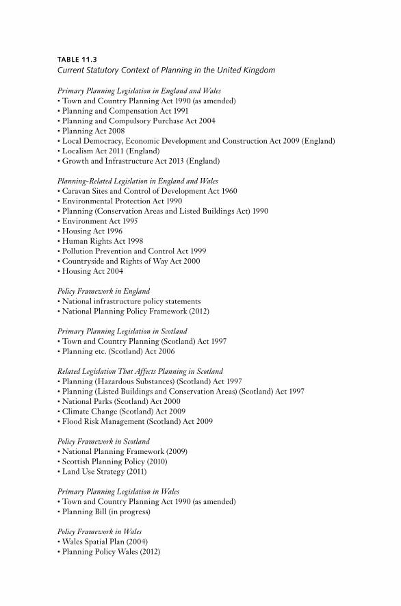
TAblE 11.3
Current Statutory Context of Planning in the United Kingdom
Primary Planning Legislation in England and Wales• Town and Country Planning Act 1990 (as amended)• Planning and Compensation Act 1991• Planning and Compulsory Purchase Act 2004• Planning Act 2008• Local Democracy, Economic Development and Construction Act 2009 ( England)• Localism Act 2011 ( England)• Growth and Infrastructure Act 2013 ( England)
Planning- Related Legislation in England and Wales• Caravan Sites and Control of Development Act 1960• Environmental Protection Act 1990• Planning (Conservation Areas and Listed Buildings Act) 1990• Environment Act 1995• Housing Act 1996• Human rights Act 1998• Pollution Prevention and Control Act 1999• Countryside and rights of Way Act 2000• Housing Act 2004
Policy Framework in England• national infrastructure policy statements• national Planning Policy Framework (2012)
Primary Planning Legislation in Scotland• Town and Country Planning (Scotland) Act 1997• Planning etc. (Scotland) Act 2006
Related Legislation That Affects Planning in Scotland• Planning (Hazardous Substances) (Scotland) Act 1997• Planning (Listed Buildings and Conservation Areas) (Scotland) Act 1997• national Parks (Scotland) Act 2000• Climate Change (Scotland) Act 2009• Flood risk Management (Scotland) Act 2009
Policy Framework in Scotland• national Planning Framework (2009)• Scottish Planning Policy (2010)• Land Use Strategy (2011)
Primary Planning Legislation in Wales• Town and Country Planning Act 1990 (as amended)• Planning Bill (in progress)
Policy Framework in Wales• Wales Spatial Plan (2004)• Planning Policy Wales (2012)

TAblE 11.3 (continued )
Primary Planning Legislation in Northern Ireland• Planning Act (northern Ireland) 2011• Planning Bill (in progress)
Policy Framework in Northern Ireland• Planning Strategy for rural northern Ireland (1993)• regional Development Strategy 2035 (2012)• Planning policy statements
Figure 11.2 national Vision for Wales, 2004Source: Welsh Government (2005). http://www.wales.gov.uk/walesspatialplan

Figure 11.3 national Vision for Scotland, 2009Source: Government of Scotland, national Planning Framework (2009).
nATIOnAL PLAnnInG In THE UnITED KInGDOM / 431
It is the policy statements rather than the legislation that have fleshed out the detailed sectoral interventions required and have acted as a frame or guide to planners operating and implementing the planning system on the ground in distinct parts of the United Kingdom. Legislation legiti-mizes the right to act; policy sets out the action required and justifies it. It is easy to identify differences in policy approaches to certain issues in the four countries; for example, policies on renewable energy, telecommu-nications, and housing are subtly different in various parts of the United Kingdom, resulting in planning either facilitating or impeding develop-ment opportunities. The benefit of this dual pro cess is the ability to amend policy quickly, without a protracted parliamentary debate and primary leg-islation, and to retain the principal pieces of legislation as overarching legitimation vehicles allocating or denying rights, but devoid of discussion of broader needs and planning purposes. The disadvantage is that the direction and implementation of planning are prone to constant po liti-cal intervention and policy changes preferred by different ministers, which make long- term planning strategizing increasingly difficult, if not impossible.
At the pre sent time, further legislative changes are being enacted. England has seen the implementation of four significant legislative plan-ning reforms since 2004, and a fifth piece of legislation, the Growth and Infrastructure Act, received royal assent in 2013. The 2013 act intends to prioritize economic growth as the overarching purpose of planning and to remove administrative burdens on businesses and house holders in the belief that it is the planning system that is the barrier to economic recov-ery (Cameron 2011). These legislative changes have amended the regula-tion of planning and the institutions of governance and responsibilities within planning, and they have removed discretion or allocated rights; they do not directly relate to the national interest or long- term England- wide socioeconomic and environmental needs. rather, they reflect the po liti-cal preferences of successive governments about the scale of planning.
Interrelated Factors That Shape U.K. Planning and National Policy
As discussed here, the role of central government in addressing spatial planning and land use change has under gone considerable amendments over the past 75 years and has affected the shape and form of planning at a frenetic pace in the past 30 years. This has been the consequence of the changing role of the state, an ideological preference of successive govern-ments to roll back the central state in favor of subnational and local levels of governance. Also, central government has rarely provided national direction on spatial matters, but has relied on other means to influence

432 / MArK TEWDWr- JOnES
policies and decisions on land use change implemented by other tiers of government or even by the market. These other means have included specifically named legislative instruments to deliver infrastructure proj-ects (e.g., high- speed rail lines, facilities for the 2012 Olympic Games, and nuclear power stations). Enacted during an era when top- down control and authoritarianism were not questioned as inappropriate and unnecessary, the postwar planning system in Britain was created in a deliberative way to bolster local democracy and accountability by awarding most planning powers to the level of government closest to the people. At a time when direct citizen involvement in planning remained de cades away (public con-sultation on planning matters in the United Kingdom was introduced only after 1969), the issue of democracy and transparency would be re-vealed in planning through a reliance on planning committees of local gov-ernment and the work of elected po liti cal representatives. Issues of more than local interest, such as major infrastructure issues, would be resolved through exceptional means where central government ministers could re-trieve development proposals for their determination after public inquiry (the so- called call-in rule).
Although this system may seem like the ideal means by which issues could be dealt with locally, it did raise the question whether some matters were of national interest and required national policy, and how these mat-ters would then be prescribed or actioned by a separate and in de pen dently elected tier of government. Step forward, then, central government’s na-tional planning policy: not only statements of national interest, but also national planning policies covering a wealth of planning and land use is-sues and projects that were actually the preserve of local government pol-icy and decision making.
The provision of national planning policy from central government to local authorities and property developers to shape land use policy and prac-tice has been a feature of the planning system in Britain since the 1940s (Tewdwr- Jones 2002). This policy, however, was never released in any consistent form and has occasionally been criticized by commentators (Bruton and nicholson 1985). Although the original postwar role of na-tional planning policy was to provide strategic direction, central govern-ment has modified its planning authority and for the most of the past 75 years has used its land use obligation to set pa ram e ters for detailed plan-ning control and policy matters at the local level. The nature of central government intervention in local land use matters has therefore changed over time. Table 11.4 displays the most recent forms of national advice in England, Scotland, Wales, and northern Ireland: the national Policy Planning Framework in England, which replaced PPSs (formerly planning policy guidance) in 2012; Scottish Planning Policy, which replaced national

nATIOnAL PLAnnInG In THE UnITED KInGDOM / 433
planning policy guidelines in Scotland in 2010; Planning Policy Wales in Wales; and planning policy statements in northern Ireland.
Between the 1940s and the 1980s, the architecture of the land use plan-ning pro cess in the United Kingdom changed very little. Different types of land use and development plans were introduced, while others were abolished; new scales of policy were initiated, and some were removed. But planning was primarily restricted to considering land use issues through the management and coordination of policy at various levels of adminis-tration by a variety of agencies and actors. Implicit in the operation of the land use planning system was a national coordinating level under a U.K. government minister, where the social, economic, and environmental needs of areas could be addressed in an integrated way. Although this sug-gested that planning could be operated effectively only when land use is-sues were considered strategically, the provision of a national ele ment of strategic coordination by the central state was seen as an essential ingre-dient in physical development. Strategic planning sets out a frame of ref-erence for the or ga ni za tion of planning at the lower tiers of administra-tion. The planning pro cess was managed and implemented by national and local tiers of government and was hierarchical as a policy framework (Tewdwr- Jones 1996). Although there was never a meaningful national plan covering England, Scotland, Wales, and northern Ireland, central government always provided a clear approach in determining and promot-ing planning policy to be operated across the various government levels. rather than developing a statutory national physical plan, the government preferred to rely on a system of discretion rather than prescription, a pro-cess where central government set up the legal framework and broad policy for local government to interpret.
When the United Kingdom was in the throes of World War II and the country was concerned about how it should commence rebuilding itself physically, eco nom ically, and socially, central government was charged with taking the lead in providing strong national direction and coordina-tion. Indeed, it was during this period that planning was formally given a role in bringing about physical change, a response to the recognition that there was a need to start anew, and that those changes could be coordi-nated only by the state. One of the first pieces of planning- related legisla-tion that emerged in the United Kingdom to secure this national plan-ning lead was the Minister of Town and Country Planning Act 1943. Under the provisions of this act, a central government minister was charged with overall responsibility for development and physical rebuilding, and these essentially became the core building blocks on which statutory land use planning was based. The minister was charged with the duty of “securing consistency and continuity in the framing and execution of a

434 / MArK TEWDWr- JOnES
national policy with res pect to the use and development of land through-out England and Wales” (HM Government 1943, Section 1). The role of central government in overseeing a national policy approach to physical planning and in ensuring that government planning agencies (the minis-ter and central government departments) implemented national policy was therefore placed at the heart of the emerging statutory planning leg-islation. Whether the framers of this statute intended to extend this duty to encompass detailed local planning matters at this time, in addition to strategic direction, is difficult to determine.
Central government’s duty for land use planning has been fulfilled by successive planning ministers since the 1940s. Different ministers and gov-ernments of different po liti cal persuasions have used this obligation to define the role of the planning system by a variety of methods, including direct intervention in local planning issues, providing national policy ad-vice, and passing planning- related legislation. Although Section 1 of the 1943 act was repealed in 1970 (when the office of Secretary of State for the Environment was created, later rechristened as Secretary of State for Communities), the duty of central government in planning did not change drastically. However, the interpretation of the duty has shifted ac-cording to how interventionist planning ministers have been when in office.
The exact role of central government in planning has therefore been modified. After the rebuilding of the British economy in the 1950s, there was no need for a minister of the Crown to frame national policy on plan-ning, because local government agencies (charged with implementing land use planning at the local scale) could coordinate and develop future phys-ical land use change by negotiating with developers and later the public without the necessity of heavy central- state intervention. However, as the British economy has ebbed and flowed in the period since then, central government has retained its overriding duty to intervene in the land use planning system both to achieve economic recovery and to reflect party po liti cal mandates, but not consistently. This explains why there has never been a consistent form of policy documentation to reflect central govern-ment’s planning agenda. This also applies in the current era, in which suc-cessive ministers have attempted both to devolve planning to lower gov-ernment or community tiers and to deregulate development management to placate the market. Despite 30 years of planning reforms, planning has remained stubbornly resistant to abolition or weakening, but it remains an ideological target for economists, neoliberals, and the development sector. The reason that planning survives onslaughts, picks itself up, dusts itself off, and then continues as before is that it is remarkably resilient to changing needs over time. Even relatively antiplanning ministers some-times recognize that the planning system can help achieve national agen-das, and that it is a con ve nient and flexible mechanism to bring together
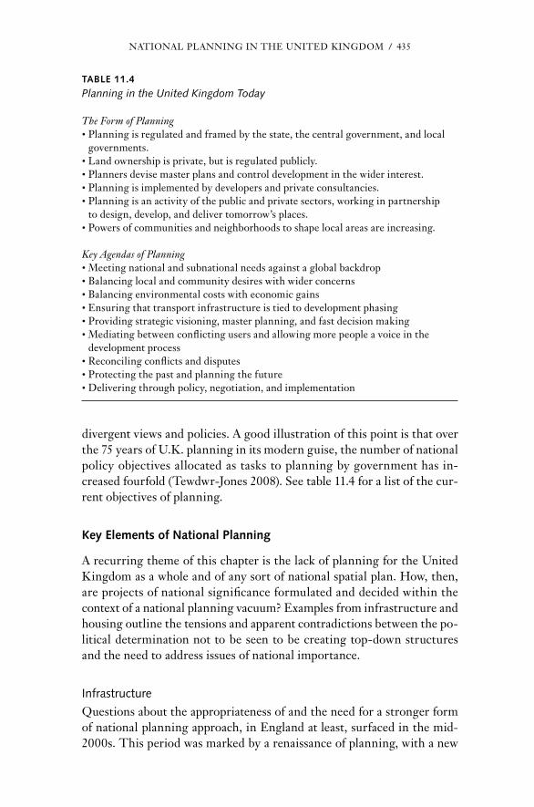
nATIOnAL PLAnnInG In THE UnITED KInGDOM / 435
divergent views and policies. A good illustration of this point is that over the 75 years of U.K. planning in its modern guise, the number of national policy objectives allocated as tasks to planning by government has in-creased fourfold (Tewdwr- Jones 2008). See table 11.4 for a list of the cur-rent objectives of planning.
Key Elements of National Planning
A recurring theme of this chapter is the lack of planning for the United Kingdom as a whole and of any sort of national spatial plan. How, then, are projects of national significance formulated and deci ded within the context of a national planning vacuum? Examples from infrastructure and housing outline the tensions and apparent contradictions between the po-liti cal determination not to be seen to be creating top- down structures and the need to address issues of national importance.
Infrastructure
Questions about the appropriateness of and the need for a stronger form of national planning approach, in England at least, surfaced in the mid-2000s. This period was marked by a re nais sance of planning, with a new
TAblE 11.4
Planning in the United Kingdom Today
The Form of Planning• Planning is regulated and framed by the state, the central government, and local
governments.• Land own ership is private, but is regulated publicly.• Planners devise master plans and control development in the wider interest.• Planning is implemented by developers and private consultancies.• Planning is an activity of the public and private sectors, working in partnership
to design, develop, and deliver tomorrow’s places.• Powers of communities and neighborhoods to shape local areas are increasing.
Key Agendas of Planning• Meeting national and subnational needs against a global backdrop• Balancing local and community desires with wider concerns• Balancing environmental costs with economic gains• Ensuring that transport infrastructure is tied to development phasing• Providing strategic visioning, master planning, and fast decision making• Mediating between conflicting users and allowing more people a voice in the
development pro cess• reconciling conflicts and disputes• Protecting the past and planning the future• Delivering through policy, negotiation, and implementation

436 / MArK TEWDWr- JOnES
type of planning, spatial planning, being enacted in Scotland, Wales, northern Ireland, and London, and a new system of rSSs in each region of England (Tewdwr- Jones, Gallent, and Morphet 2010). The national agenda in England was considered initially in the white paper Planning for a Sustainable Future (HM Government 2007) and enacted through legis-lation the following year in the Planning Act 2008. This act created a new way of determining development and infrastructure projects of national significance, including new railways, motorways, airports, power stations, reservoirs, and power lines. The government proposed to establish an Infrastructure Planning Commission (IPC) to take charge of major plan-ning projects that previously had been the subject of long, expensive, and adversarial planning inquiries on a pro ject- by- pro ject basis, such as deter-mining the necessity of a new terminal building, Terminal 5, at London’s Heathrow Airport. The second relevant provision was for an enhanced na-tional strategic planning policy that set out medium- to long- term plan-ning requirements over a 25- year period, cut back on detailed policy guid-ance, and focused more on nationally relevant issues. The intention at the time was to streamline the planning system. The proposals illustrated the degree to which central government still called the shots on the form of planning existing in the regions and locales of England, but they also set out a national case for government on spatial planning matters. Commu-nities Secretary ruth Kelly referred to the proposals as delivering “a planning system fit for the 21st century” (HM Government 2007, 1). But the reform proposals generated criticism from environmentalists and community representatives, who were concerned about the prospect of a free- for- all on development issues and about the state imposing its will on local areas while removing local discretion to determine planning proj-ects. Business leaders, in contrast, welcomed the proposals that were in-tended to assist economic growth and build on a series of major govern-ment reports devoted to major sectoral changes under way, including those on planning and the economy (the Barker report, HM Government 2006b), transport and infrastructure (the Eddington report, HM Gov-ernment 2006c), climate change (the Stern report, HM Government 2006a), and local government management and finance (the Lyons report, HM Government 2006d).
The 2007 white paper attempted to strike a balance between future environmental protection, economic growth, and sustainable development. Critics remarked that the proposed IPC would ride roughshod over local demo cratic pro cesses because it would be an in de pen dent agency at arm’s length from government and ministerial accountability and a structure separate from local government, which determine the majority of plan-ning applications for change and development. But individual local author-

nATIOnAL PLAnnInG In THE UnITED KInGDOM / 437
ities have rarely determined major infrastructure proposals; instead, the secretary of state has frequently called them in because the potential im-pacts of such development may be felt beyond the boundaries of one local authority area. In the context of stronger national policy guidance, the IPC would still be required to make recommendations to the minister who would ultimately be responsible to Parliament for the decisions taken. One can argue that developments in the national interest require national pol-iticians to act; this is not necessarily a dent in the demo cratic pro cess; rather, it is merely a different type of demo cratic pro cess from that used to determine small house hold planning applications.
The IPC, approved under the Planning Act 2008, was formally estab-lished in 2009, but the Conservative Party in opposition had already an-nounced its intention to abolish the body if it was elected to government (Conservative Party 2010). Thus, in June 2010, the IPC’s abolition was announced, and the IPC’s functions were transferred to the Planning Inspectorate Agency (responsible for planning appeals). The secretary of state was to make decisions on large development projects directly. The promised strategic national policy statements have been released, but they have been formulated by different government departments. The Depart-ment for Energy and Climate Change released policy statements on en-ergy, fossil fuels, oil and gas supply and electricity, and nuclear power; the Department for Transport released statements on ports, transport net-works, and aviation; and the Department for Environment, Food, and rural Affairs released national policies on water supply, hazardous waste, and wastewater treatment. To date, all the statements except that on nu-clear power lack a spatial dimension; they do not even contain a map iden-tifying locations or the siting of new projects. Geography is completely absent. One can understand why central government may be reluctant to stipulate the se lection of par tic u lar local sites, but this lack of spatial de-tail undermines the idea of a new central government lead on matters of national importance. Furthermore, under the provisions of the later Lo-calism Act 2011, the national policy statements are now also subject to par-liamentary approval. Thus, the determination to open up the pro cess in the interests of democracy could well delay the implementation of major infrastructure projects, which is exactly what the proposals of the 2008 act and the Localism Act were attempting to avoid.
It is likely that ministers will come under the same pressure to make quick decisions on major development projects after public inquiries as their pre de ces sors did in the 1980s and 1990s. A desire for both faster de-cision making and enhanced demo cratic opportunities may yet conspire to slow down the pro cess even further. Without a geographic dimension either in the national policy statements or the national Planning Policy

438 / MArK TEWDWr- JOnES
Framework of 2012, decision making for major projects will remain ad-versarial and will combine issues of princi ple with issues of detail. This revised planning regime relates to projects of national significance. But an equally problematic situation can occur when the government or an indi-vidual minister wants to be seen to be doing something about a problem but is constrained from doing so by the governmental framework or by the princi ple of subsidiarity that successive governments have advocated. In 2013, the Labour Party opposition established a review to consider future planning for infrastructure. The resultant report, the Armitt re-view (2013), called for the establishment of a new national infrastructure agency. If Labour gains office in 2015, there may be a return to an IPC- style arrangement and the promise of another planning act.
Housing
On the vexed subject of affordable housing, Prime Minister Gordon Brown in 2007 publicly committed the government to providing over 300,000 new houses per year to meet demand and to deal with the unaffordability issue. On the surface, this is a fine objective. The problem is that it is not the government that builds houses or gives planning permission locally for new development schemes. The state’s role in house building ended in the 1980s, so a planned provision of housing locally is always a matter for negotiation between house builders and local planning authorities. Although there were planning mechanisms in place until 2010 to ensure that the 300,000 figure would be cascaded down to regions, counties, and districts, once the local scale is reached, the issue becomes argumentation about a specific site, involving local people with diverse views about the merits or problems of building on greenfield and brownfield sites. new government incentives were offered to local authorities to allocate more land than has been earmarked for new housing both under Labour and under the Co ali tion, but such allocation may conflict with locally agreed-on plans that, by demo cratic virtue, attempt to restrict growth. The South East of England, already a development hot spot, has long been the focus of argumentation in this res pect as local battles emerge over the fate of individual plots of land.
These contentions relate to England- wide matters. The position of any U.K. perspective also remains uncertain in light of the greater devo-lution of powers to the four countries. The royal Town Planning Insti-tute progressed a feasibility study into the provision of both a U.K. na-tional Spatial Planning Framework (Wong, ravetz, and Turner 2000) and a map for England (Wong et al. 2012), and although giving commitments to devolution this has always been thought of as potentially running counter
nATIOnAL PLAnnInG In THE UnITED KInGDOM / 439
to po liti cal thought and developments. At the moment, however, the United Kingdom possesses a kaleidoscopic framework of planning policy pro-cesses in which the word “national” means different things in different contexts, both geo graph i cally and po liti cally. This is compounded by a si-multaneous emphasis on transnational and supranational spatial planning developments between the nations and regions of the United Kingdom and other parts of Eu rope (Alden 2001; Tewdwr- Jones 2001).
Key Outcomes and lessons for U.K. land Use Planning
The role of central government in spatial planning and land use in the United Kingdom has changed as new parliamentary bills have progressed in each of the four countries simultaneously to reform the pro cesses. These reforms have significant implications not only for national policy, but also for the role of the central state in relation to local government, the proc-lamation of central government preferences for land use, and, indeed, the opportunities for public involvement. In England, the Localism Act’s pro-vision commenced in the spring of 2012, heralding what the minister promised to be a radical reform of the planning system. If those words seem familiar, it is because previous incumbents have described recent planning bills in much the same way (Stephen Byers in 2001 and ruth Kelly in 2007). The bill was controversial and went through a tortuous pro cess in both Houses of Parliament. The government agreed to over 240 amendments, more than was in the bill to begin with. The bill was sup-plemented by the Chancellor’s Bud get Financial Statement of March 2011, with its focus on deregulation of the planning system and its economic interpretation of sustainable development that, in turn, heralded another bout of reform with the issuing of a new national Planning Policy Frame-work in 2012 and a new Growth and Infrastructure Act in 2013.
Despite the experiences of the 1980s, when central government success-fully deregulated large parts of the planning pro cess, allowing the market a more prominent role in land use decisions and an increasing reliance on alternative policy and decision mechanisms to local authorities and local development plans, it has been reluctant to let go of some responsibility for land use matters even if successive ministers have lamented publicly how much they detest planning (e.g., Pickles 2012). Previous attempts by central government to reform the planning pro cess occurred under the Planning and Compulsory Purchase Act 2004, the Planning Act 2008, and the Local Democracy, Economic Development, and Construction Act of 2009. The Localism Act promised to revise planning decision- making pro-cesses once again, introducing some bold ideas that have as much impact on forms of local democracy as they do on land use planning per se. Some

440 / MArK TEWDWr- JOnES
of these new revisions dismantle aspects of the pro cesses put in place under the Labour administration from 2004 to 2010. These include the aboli-tion of rSSs, national and regional housing targets of central govern-ment, and the Infrastructure Planning Commission, which had only recently been charged with assessing major development projects of na-tional significance.
The bill, perhaps controversially, was not preceded by a white paper on planning issues per se; rather, it mirrored the Open Source Green Paper on Planning published by the Conservatives just before the general election (Conservative Party 2010). The Green Paper reflected the ideological be-lief in localism and the much- lauded Big Society and its application to planning: “We need a planning system that enables local people to shape their surroundings in a way that . . . is also sensitive to the history and character of a given location. . . . Our conception of local planning is rooted in civic engagement and collaborative democracy as the means of reconciling economic development with quality of life. . . . The planning system can play a major role in decentralising power and strengthening society” (Conservative Party 2010, 1).
At face value, then, these principles suggest potential reforms that support place- based distinctiveness, a deeper understanding of land locally, and an opening up of policy and decision making to wider sections of society. The government is in the pro cess of dismantling high tiers of strategic spatial policy at the national level in England and in the En glish regions in favor of a rescaling of policy and decision making to the local authority or neighborhood levels. This fits ideologically with the notion that there has been too much top- down policy in the past, especially in addressing housing needs in the South East of England and in London, where many residents remain opposed to new development. But, of course, it also means that commitments of high policy tiers, such as renewable en-ergy targets, will be much more difficult to achieve if decisions on wind turbine farms are to be left to incremental neighborhood decision making.
The other striking issue is two ideologically different approaches to planning occurring in central government simultaneously. This is not a feature of all recent administrations and possibly reflects an apparent on-going frustration with planning or uncertainty on what to do about it. The Localism Act 2011, supported by community, voluntary, and environmen-tal groups around England eager to take up the new promised decision- making powers that ministers trumpeted, is a fundamental shift away from not only the planners, but also local government representatives. That is one agenda. The Trea sury’s perspective is, however, a little different and underlies the Growth and Infrastructure Act 2013. This agenda, naturally enough, reflects a market perspective and talks about the need for eco-
nATIOnAL PLAnnInG In THE UnITED KInGDOM / 441
nomic growth after the recession; deregulating more of the planning sys-tem; allowing more housing development, especially on greenfield, edge- of- town land; and reintroducing a 30- year- old policy, enterprise zones, where planning permission and regulation are not required.
Clearly, there is a potential for contestation in a community, with neighborhoods and developers having two very different viewpoints about what should be done and by whom. Since the introduction of neighbor-hood planning, communities have become frustrated because the long- promised powers are set within tight pa ram e ters. The most noticeable constraint is that although communities are able to make decisions about future land release for new developments, they are not permitted to re-fuse development; they can only add to development proposals above and beyond that already proposed by the local authority plan. Battles are al-ready raging over urban periphery land on greenfields in the South East of England; local people fiercely oppose new development, while the house builders say that their projects support economic growth. Both sides claim legitimacy in acting by referring to different pieces of planning legisla-tion. Local planning authorities were not abolished under the Localism Act; in fact, they are still obligated to prepare local development plans and deliver public ser vices in partnership with health bodies, transport pro-viders, and other social infrastructure groups. A further limit on the abil-ity of neighborhood groups to make decisions is a requirement that neigh-borhood plans be in conformity with local authority development plans, which, in turn, are to be in conformity with the national Planning Policy Framework. nesting the planning scales is a con ve nient governance mech-anism, but it does not meet the high expectations of individual scales or allow discretion within the system to make an appropriate decision given circumstances and location. There is even more frustration in communi-ties over the ac know ledg ment that central government prioritizes eco-nomic growth and housing development, but little else. It is possi ble that, as a result of the policy pro cess and tiered governmental relations, some of the local and neighborhood agenda will have already been determined by the time neighborhoods are asked to make judgments on schemes (Lord and Tewdwr- Jones 2014).
A National Remit in an Age of Decentralization and Antiplanning Sentiment
The importance of the U.K. national policy context is recognized in fa-cilitating government policy objectives relating to the economy, society, and the environment, and in complying with Eu ro pean Union directives and meeting global treaty commitments. The drivers of land use change

442 / MArK TEWDWr- JOnES
related to changing demographics, climate change, economic recovery, in-frastructure provision, and energy needs are all of national importance and significance and warrant some form of central government involve-ment in addressing the issues both now and in the future. As the United Kingdom has become more concerned about global economic triggers, im-pacts of climate change, and population increases (both from within and possibly from migration overseas), the U.K. governmental and planning structures have fragmented practically and ideologically. This is only to be expected in devolution pro cesses, but the fragmentation has been ex-acerbated by the hollowing out of subnational po liti cal and governance ar-rangements that make it more difficult to address the spatial and land use impacts of these changes over time. reliance on the locality and the neigh-borhood in the revised En glish planning pro cess may resolve site- specific issues and give local people a greater voice in determining the extent and pace of change in their own backyards, but it is hardly an effective ar-rangement to address regional differences in energy provision, water shortages, failing infrastructure provision, or the uneven spatial differ-ences in unemployment.
Scotland, Wales, and northern Ireland are in the pro cess of creating country- specific planning and governance arrangements, comprising new national planning legislation alongside new spatial planning frameworks, land use change maps, and subnational plans to provide the evidence base and trends and potentially address these threats in an integrative and ro-bust way. The same is not true of England, nor has it ever been the case with regard to the United Kingdom as a whole. The enhanced Eu ro pean context of spatial planning and territorial cohesion likely will strengthen the spatial policy pro cesses within the new structures of governance cur-rently being put in place as part of the implementation of devolved gov-ernments in Wales, Scotland, and northern Ireland; it may also give these parts of the United Kingdom an institutional advantage over England. The dual push toward Eu ro pean spatial planning and devolution makes it nec-essary to assess whether a U.K.- wide approach to spatial planning and land use change will be required in the future, and how U.K. national policies and decisions could potentially affect devolved forms of spatial planning pro cesses. This is not a question of devising some sort of grand national plan; rather, it is a matter of ensuring that the U.K.- wide effects of land use change and the territorial and spatial differences within the United Kingdom are recognized sufficiently and serve as a basis for possi ble future action. Today, these U.K.- wide assessments are largely off the radar.
Local uniqueness and diversity may start to underlie decisions. All places are different, so place assets may be considered in the future. The market will probably adjust to any new system, as the market always does,

nATIOnAL PLAnnInG In THE UnITED KInGDOM / 443
and perhaps innovative arrangements will emerge that start to align in-centives with regulations, linking land decisions, spatial change, and financial tools. Furthermore, this strengthens the need for local and stra-tegic intelligence to underpin community decisions for two reasons. The first is to ensure a more robust decision pro cess resilient to appeal and chal-lenge from aggrieved individuals. The second reason centers on localism itself, by generating more information about places and how they change, analyzing the options available, and assessing the implications of those different options. This seems to be an essential prerequisite for local sus-tainability. Evidence and data generation become more important here to avoid incremental decision making and to assess the wider strategic im-plications of this. The difficulty remains how to discuss and address stra-tegic intelligence issues relating to land use planning without being seen to be top- down or authoritarian, especially if the spatial strategy and national policy mechanisms previously available have been, to all intents and purposes, removed.
In recent years, local authorities and other bodies have collected and commissioned a significant amount of place- based information on such topics as social infrastructure, land use changes, biodiversity, and eco-system ser vices that could usefully support the transition to community de-cision making. Many local authorities have exhibited an entrepreneurial spirit, but more work is required, including the greater use of modeling that links science on environmental capacity to decision making. There could be a new and significant role here for planners and others to inform the decision pro cess and also to ensure that all the hard work and resources accumulated over the past 15 years are not lost in the transition to the new system. Changing the pro cess to allow different people to make decisions does not lessen the necessity for robust and resilient strategic and local in-telligence. But, more worryingly, if these issues are left to local neigh-borhood groups, there is great uncertainty whether they could afford to commission studies or monitor the effects. What happens in the absence of policy evaluation and monitoring? And would the private sector step in?
The U.K. planning reforms could lead to a greater understanding and recognition of the diversity of places and their assets from both biodiver-sity and economic perspectives. Many organizations outside central gov-ernment departments are undertaking deeper assessments of land and are using scenario and modeling work to inform choices and possibly, in some cases, to attempt to influence arguments. This could then lead to the pro-motion of place- based governance and growth, based on the realization of opportunities and assets and not led by government, but rather by a range of alternative organizations. This is an important point because of international interest. The Or ga ni za tion for Economic Cooperation and

444 / MArK TEWDWr- JOnES
Development is promoting place- based growth as a paradigm globally, while the Eu ro pean Union’s 2020 agenda (Commission for Eu ro pean Communities, 2010) will soon require member states to address territo-rial impact assessments (TIAs). TIAs could link in well to place- based as-sets and ecosystem ser vices. Above all, it is likely that a strategic overview of the implications for land use changes will still occur even if there are no formal strategic plans in place in England; academics, policy organiza-tions, and environmental bodies will still consider the synoptic and wider matters of land use change even if doing so is unfashionable in government. If other groups are still performing that strategic and synoptic role at pre sent, it may be useful for a future government.
References
Alden, J. 2001. “Devolution Since Kilbrandon and Scenarios for the Future of Spatial Planning in the United Kingdom and Eu ro pean Union.” International Planning Studies 6(2): 117–132.
Allmendinger, P., and G. Haughton. 2007. “The Fluid Scales and Scope of UK Spa-tial Planning.” Environment and Planning A 39: 1478–1496.
Armitt, Sir J. 2013. An In de pen dent Review of Long Term Infrastructure Planning. Com-missioned by the Labour Policy. London: Labour Party.
Beauregard, r. 1989. “Between Modernity and Postmodernity: The Ambiguous Po-sition of US Planning.” Environment and Planning D 7: 381–395.
Booth, P. 1996. Controlling Development. London: UCL Press.
Bruton, M. 1974. The Spirit and Purpose of Planning. 2nd ed. London: Hutchinson.
Bruton, M., and D. nicholson. 1985. “Strategic Land Use Planning and the British Development Plan System.” Town Planning Review 56: 21–41.
Bulpitt, J. 1983. Territory and Power in the United Kingdom. Manchester: Manchester University Press.
Cameron, D. 2011. Speech at the Conservative Party Conference, Manchester (Octo-ber 5).
Clifford, B., and M. Tewdwr- Jones. 2013. The Collaborating Planner? Prac ti tion ers in the Neo- liberal Age. Bristol: Policy Press.
Commission for Eu ro pean Communities (CEC). 2010. Eu rope 2020: A Strategy for Eu ro pean Growth. Luxembourg: CEC.
Conservative Party. 2010. Open Source Green Paper on Planning. London: Conservative Party.
DETr (Department for Environment Transport and the regions). 1998. Modernising Planning: A Statement by the Minister for Planning, Regeneration and the Regions. Lon-don: DETr.
DrDnI (Department for regional Development northern Ireland). 2012. Regional Development Strategy for Northern Ireland 2035. Belfast: DrDnI.

nATIOnAL PLAnnInG In THE UnITED KInGDOM / 445
DTLr (Department for Transport Local Government and the regions). 2001. Plan-ning: Delivery a Fundamental Change. London: HMSO.
Gallent, n., and S. robinson. 2012. Neighbourhood Planning. Bristol: Policy Press.
Gunn, S., and G. Vigar. 2012. “reform Pro cesses and Discretionary Acting Spaces in En glish Planning Practice, 1997–2010.” Town Planning Review 83(5): 533–552.
Hall, P. 1975. Urban and Regional Planning. newton Abbot: David and Charles.
Haughton, G., P. Allmendinger, D. Counsell, and G. Vigar. 2010. The New Spatial Plan-ning. London: routledge.
Healey, P. 1997. Collaborative Planning. Basingstoke: Macmillan.
HM Government. 1943. Minister of Town and Country Planning Act 1943. London: HMSO.
— — —. 1990. Town and Country Planning Act 1990. London: HMSO.
— — —. 2004. Planning and Compulsory Purchase Act 2004. London: Stationery Office.
— — —. 2006a. The Economics of Climate Change (the Stern report). London: Statio-nery Office.
— — —. 2006b. The Review of Land- Use Planning (the Barker report). London: Statio-nery Office.
— — —. 2006c. Transport’s Role in Sustaining the UK’s Productivity and Competitiveness (the Eddington report). London: Stationery Office.
— — —. 2006d. Well Placed to Deliver? Shaping the Pattern of Government Ser vice (the Lyons report). London: HM Trea sury.
— — —. 2007. Planning for a Sustainable Future. White Paper. Cm 7120. London: Sta-tionery Office.
— — —. 2008. Planning Act 2008. London: Stationery Office.
— — —. 2011. Localism Act 2011. London: Stationery Office.
— — —. 2013. Growth and Infrastructure Act 2013. London: Stationery Office.
Lord, A., and M. Tewdwr- Jones. 2014. “Is Planning ‘ Under Attack’? Chronicling the Deregulation of Urban and Environmental Planning in England.” Eu ro pean Plan-ning Studies 22(2): 345–361.
Lowndes, V., and L. Pratchett. 2012. “Local Governance Under the Co ali tion Gov-ernment: Austerity, Localism, and the ‘Big Society.’ ” Local Government Studies 38(1): 21–40.
The national Vision for Wales. 2004. Welsh Government. Wales Spatial Plan. Car-diff: Welsh Government.
Pickles, E. 2012. “Statement by the Secretary of State for Communities.” Hansard, Sep-tember 6.
rhodes, r. 1988. Beyond Westminster and Whitehall: The Sub- central Government of Brit-ain. London: Unwin Hyman.
Scottish Government. 2009. National Planning Framework for Scotland. Edinburgh: Scottish Government.
— — —. 2011. Land Use Strategy. Edinburgh: Scottish Government.
446 / MArK TEWDWr- JOnES
Swain, C., T. Marshall, and T. Baden, eds. 2012. En glish Regional Planning, 2000–2012. London: routledge.
Switzer, J. 1984. “The Significance of Circulars in the Planning Pro cess.” Journal of Planning and Environment Law 36: 72–76.
Tewdwr- Jones, M. ed. 1996. British Planning Policy in Transition. London: UCL Press.
— — —. 1999. “Discretion, Flexibility, and Certainty in British Spatial Planning: Emerging Ideological Conflicts and Inherent Po liti cal Tensions.” Journal of Plan-ning Education and Research 18(2): 244–256.
— — —. 2001. “Complexity and Interde pen dency in a Kaleidoscopic Spatial Planning Landscape in Eu rope.” In The Changing Institutional Framework of Eu ro pean Spatial Planning, ed. L. Albrechts, J. Alden, and A. de Pires. Aldershot: Ashgate.
— — —. 2002. The Planning Polity: Planning, Government and the Policy Pro cess. London: routledge.
— — —. 2008. “The Complexity of Planning reform: A Search for the Spirit and Purpose of Planning.” Town Planning Review 79(6): 673–688.
— — —. 2012. Spatial Planning and Governance: Understanding UK Planning. Basing-stoke: Palgrave Macmillan.
Tewdwr- Jones, M., and P. Allmendinger. 2006. Territory, Identity and Spatial Planning: Spatial Governance in a Fragmented Nation. London: routledge.
Tewdwr- Jones, M., n. Gallent, and J. Morphet. 2010. “An Anatomy of Spatial Plan-ning: Coming to Terms with the Spatial Ele ment in UK Planning.” Eu ro pean Plan-ning Studies 18(2): 239–257.
Thornley, A. 1991. Urban Planning Under Thatcherism. London: routledge.
WAG (Welsh Assembly Government). 2005. People, Places, Futures: The Wales Spatial Plan. Cardiff: Welsh Government.
Wildavsky, A. 1973. “If Planning Is Everything, Maybe It’s nothing.” Policy Sciences 4: 127–153.
Wong, C., M. Baker, S. Hincks, A. Schulze Bäing, and B. Webb. 2012. A Map for England: Spatial Expression of Government Policies and Programme. London: rTPI.
Wong, C., J. ravetz, and J. Turner. 2000. The United Kingdom Spatial Planning Frame-work: A Discussion. London: rTPI.
/ 447 /
Mark Tewdwr- Jones outlines the history of planning in the United Kingdom over many de cades. He argues that since po liti cal and
institutional devolution to Wales, Scotland, and northern Ireland in 1999, and because of increasing emphasis on what is termed “localism” in England, planning in the various parts of the United Kingdom has diverged to such an extent that there is no longer a recognizable national planning pro cess in the United Kingdom.
Tewdwr- Jones shows the extent to which it has become an increasingly power ful po liti cal tool used by successive governments to intervene and influence the way in which the planning system operates at the local level (see tables 11.1 and 11.2). He highlights the inherent contradiction be-tween the ideological conviction of the governments of the past 30 years to reduce the role of the state and the actual effect of their interventions. These interventions have increasingly centralized planning, and commu-nities have become ever more hostile to development that they see as im-posed on them.
This tension between localism and centralism is being played out in the current government’s localism agenda, introduced with much fanfare in 2011 under the Localism Act (for England). However, because planning is seen as a continuing brake on economic growth, localism is increasingly sidelined by government decisions that leave local communities confused about their role in the planning system. The latest legislation to go through
Commentary
LeonorA rozee

448 / LEOnOrA rOZEE
Parliament— the Growth and Infrastructure Act, which received royal assent on April 26, 2013— along with other mea sures to reduce red tape by deregulating significant parts of the planning system, has the potential to markedly reduce the influence that local people can have over what hap-pens in their areas. A good example of this is a proposal by ministers to allow house holders to extend their houses by up to eight meters (substan-tially more than currently allowed as permitted development) without any consultation with neighbors or any involvement by the local planning au-thority. The House of Lords heavily criticized this proposal and threatened to throw it out, forcing the secretary of state to propose a new pro cess of notification whereby neighbors must be consulted; if they object, the local authority will decide the acceptability of the scheme.
Tewdwr- Jones sets out the complex statutory and policy framework of planning systems in the UK (see table 11.3). These are especially complex in England, where there are six pieces of primary legislation and a further nine pieces of related legislation governing the planning pro cess. All but one of these statutes date from 1990 or later; six have gained royal assent in the past nine years, and the array of statutes has become bewildering. Until March 2012, when they were largely replaced by the national Plan-ning Policy Framework, a single document 49 pages in length, there were some 25 wordy and overlapping planning policy statements or guidance notes covering a range of land use topics. A further 200 documents total-ing some 7,000 pages provided additional guidance on the operation of the planning system. The Taylor review1 was set up in 2012 with the aim of reducing this vast amount of material by identifying what the govern-ment must do to ensure the proper operation of the planning system and what can be removed entirely or left to others.
What seems evident is that in England, in par tic u lar, there has been a continuing and largely unhelpful focus at government level for several de-cades on the pro cess of planning rather than the desired outcomes and how best to achieve them. Much of the rhe toric has concerned central control versus local empowerment, with politicians of all the main parties seeking to promote themselves as being firmly in the camp of letting the people decide how their areas should be planned. At the same time, they are putting in place mechanisms to control that pro cess (such as the na-tional Planning Policy Framework), the requirement that neighborhood plans (statutory plans generated by local communities) conform to the
1 External review of Government Planning Practice Guidance report submitted by Lord Matthew Taylor of Goss Moor, published by Department of Communities and Local Govern-ment, December 2012.

COMMEnTArY / 449
strategy of the local plan (the local- authority statutory plan), and the 2008 Planning Act relating to national infrastructure.
nevertheless, Tewdwr- Jones notes that despite 30 years of planning re-forms, U.K. planning remains central to any government as a mechanism to deliver policy across a range of national agendas. He states that plan-ning is “remarkably resilient to changing needs over time.” The risk, however, is that as the planning system gets ever more complex, and it is charged with achieving an increasing range of national policy objectives (see table 11.4), the population at large will become more suspicious and less trusting of the ability of the planning system to operate in a socially just and environmentally acceptable way. This has led to an endemic con-flict between the ability of the nation to meet its development needs (e.g., to build housing, create economic growth, and replace and update the frag-ile national infrastructure) and people’s ac cep tance of both the need for and the location of such development.
Politicians are sensitive to the accusations that planning delays devel-opment and that people have no influence over what is happening in their areas, but they have dealt with infrastructure projects of national impor-tance in different ways. The Labour government delegated the decision on nationally significant infrastructure proposals to an in de pen dent body (the In de pen dent Planning Commission) under the 2008 Planning Act with the idea that politicians would determine national policy and need (in the form of national Policy Statements) and would thus separate them-selves from individual decisions; the new body was hardly in existence before the co ali tion government abolished it under the 2011 Localism Act and took back the decision- making power because of concerns about demo-cratic accountability. However, as Tewdwr- Jones points out, the lack of any spatial dimension in national policy (other than for the development of nuclear power stations) leaves a large question mark about the effective-ness of a pro cess designed to make decision- making quicker and clearer and to base it on effective early engagement with communities.
Tewdwr- Jones recounts the continuing search by successive govern-ments for a faster, simpler planning system during 20 years of reform fol-lowed by reform. Similarly, there has been an ongoing search for a way to engage the public in a constructive dialogue about the way in which their places will change. The latest attempt devolves power to the lowest possi-ble level with neighborhood planning, but what can be done at this level is constrained. For example, the plan must propose more development, not less, than the local authority proposes in its local plan. nevertheless, this more localized pro cess has the potential to produce a deeper understand-ing of local issues and create more locally distinctive places. But the gap

450 / LEOnOrA rOZEE
that Tewdwr- Jones exposes between high- tier policy commitments (e.g., those associated with responding to climate change) and the more locally focused planning pro cess is likely to be a serious obstacle in planning the future of England. This contrasts strongly with devolution in nations in which a national or regional spatial plan of some kind provides a more coherent framework for addressing the myriad policy objectives modern governments face.
Tewdwr- Jones further identifies the potential for greater conflict, es-pecially at the local level, where house builders who believe that the gov-ernment’s economic rhe toric supports them are pitted against local resi-dents who may feel that they have been misled by the rhe toric of localism when the secretary of state, on appeal, allows decisions they bitterly op-pose. There are regular reports in Planning (the planning profession’s newspaper) of challenges and complaints about housing decisions being taken out of the hands of local people. Indeed, the 2013 Growth and In-frastructure Act allows developers in certain cases to bypass the local au-thority altogether and apply directly to the secretary of state for planning permission for major development.
Tewdwr- Jones reports that the current planning agenda of the co ali-tion government has its origins in a Conservative discussion document published before the 2010 election (titled Open Source Planning2). Found-ing a set of major reforms of the planning system on such a document begs the question of the legitimacy of the pro cess, especially when the po liti cal party associated with that ideology failed to gain a majority sufficient to form a government in its own right. The reforms could lead to a greater understanding and recognition of the diversity of places. However, in the absence of a national vision and strategy to provide a context for local development planning, there is a risk that the nation will not be able to achieve a much- needed rebalancing or to adequately address the global challenges it faces.
Tewdwr- Jones refers to the fragmentation of the governmental and planning structures in the United Kingdom. This is occurring at a time when all nations face major challenges, such as dealing with the economic chaos since 2008, planning for climate change, housing their populations, and protecting the ecological diversity of the planet. Meeting all these challenges requires strong leadership and strategic national planning. The chapter also refers to the potential impact on England of the Eu ro pean context of spatial planning and territorial cohesion because, unlike the rest
2 www . conservatives . com / ~ / media / Files / Green%20Papers / planning - green - paper . ashx
COMMEnTArY / 451
of the United Kingdom, England has no national spatial framework. Tewdwr- Jones points out the risk that the evidence and intelligence needed to inform the planning and decision pro cesses will be lost because of the dismantling of the structures that previously collected such data (such as the regional assemblies) and the loss of strategic planning expertise. How-ever, he suggests that what ever happens at the government level, other drivers exist, such as the Or ga ni za tion for Economic Cooperation and De-velopment’s promotion of place- based growth and the Eu ro pean Union’s 2020 Agenda, to ensure that there will continue to be a strategic overview of the implications for land use changes.
Tewdwr- Jones’s optimism is understandable, but there are a number of tensions within the system that continue to inhibit the effectiveness of U.K. planning (notably in England). These can be summarized as follows:
• Hierarchical: Who is responsible for what? The co ali tion govern-ment’s hasty announcement of the abolition of regional spatial strategies in May 2010 led to lengthy and costly court battles and ultimately required a change in the law. It also created a lacuna in policy that at least in part has led to the lowest number of houses being built at any time in spite of ever- increasing demand.
• Interdepartmental: There is a tendency for national and local government departments to work in silos. At the local level, this was partly addressed in the 2000 Local Government Act, which required local authorities to produce a cross- authority policy document called a sustainable communities strategy.
• Functional: Planning issues do not res pect administrative boundar-ies, and many local- authority areas are too small to plan strategically. Having abolished the regional strategy that helped manage this tension, the government introduced a duty to cooperate in the Localism Act that requires local authorities to work together on planning for their areas. It remains to be seen how effective this will be because the only sanction is that the promoting authority will lose its plan if a neighbor refuses to cooperate. For example, an in de pen-dent examination found Stevenage Borough Council’s plan unsound because a neighboring authority, north Hertfordshire, would not agree to accommodate housing that could not be provided within the constrained boundaries of Stevenage.3 This led to legal challenges and a great deal of po liti cal fallout.
3 www . planningportal . gov . uk / general / news / stories / 2011 / jun11 / 2jun11 / 020611 _ 3
452 / LEOnOrA rOZEE
• Po liti cal: As noted in this commentary, there is a continuing and consistent tension between centralism and localism, with mutual distrust between national and local politicians.
• Local: Citizens lack trust in the planning system, which is increas-ingly seen as controlled by the development industry. In this context, the role of the planner becomes critical to building trust by adapting to the changing world and adopting new methods to avoid or manage disputes, such as mediation.
In conclusion, Tewdwr- Jones’s chapter is a useful exposition of the con-fused state of the U.K. planning system as it adapts to devolved govern-ment and the different ideological makeup of the various nations. England appears to be somewhat out of step with the rest of the United Kingdom and, indeed, with many parts of Eu rope in its current mix of centralist and localist planning within a market- dominated po liti cal agenda, devoid of any national spatial plan. It will be interest ing to see whether planning will become a more effective tool for creating places where people want to live, work, and play, providing the infrastructure the nation needs, and help-ing the United Kingdom meet its international obligations.

/ 453 /
Ireland is an island, 32,524 square miles (84,421 square kilometers) in area, located on the northwestern extremity of the Eu ro pean continent
between latitude 51.5º and 55.5º north and longitude 5º and 10º west. Fig-ure 12.1 shows the island of Ireland and the existing county structure. Po-liti cally, the island is divided into:
1. the republic of Ireland, consisting of 26 counties, with a land area of 26,959 square miles (69,825 square kilometers) and a population of 4.58 million at the time of the last census in April 2011; and
2. northern Ireland, consisting of 6 counties in the province of Ulster, with a land area of 5,460 square miles (14,139 square kilometers) and a population of 1.81 million at the time of the last census in March 2011.
The term “Irish” is generally used in the context of matters relating to the nation- state, the republic of Ireland (Éire in the Irish language or Gaelic). Ireland became a member of the Eu ro pean Union (EU) in 1973. northern Ireland has been part of the United Kingdom since 1801. The Regional Development Strategy for Northern Ireland 2001–2025 (Department for regional Development 2001) was “the first of its kind in the British Isles” in that it took a high- level, strategic perspective and cast its gaze
12
the Irish national Spatial Strategy
BernA GrISt

Figure 12.1 Island of Ireland, 2013Sources: Republic of lreland counties: Ordinance Survey Ireland, permit no. MP009006; Northern Ireland counties digitized by Dr. Harutyun Shahumyan.
IrISH nATIOnAL SPATIAL STrATEGY / 455
beyond traditional physical or land use planning; it also broke new ground in acknowledging the need to consider Cross- Border planning issues (Warnock 2011, 103). This chapter provides background information on the institutional structures within which the comparable planning frame-work for the republic of Ireland, The National Spatial Strategy 2002–2020 (Government of Ireland 2002), is to be understood and evaluated. It then discusses the po liti cal and financial circumstances surrounding the gesta-tion of the Strategy and the vicissitudes it has faced.
It is important to understand the historical development of the Irish legal and po liti cal systems in order to analyze cultural attitudes. Two na-tional policies in par tic u lar have undermined the implementation of the Irish National Spatial Strategy; both can be linked to this historical con-text. The third factor working against the strategy is more easily addressed because it has its roots in the Planning Acts, which provided for almost complete local autonomy in the matter of zoning land.
Po liti cal, Cultural, and Institutional Framework
The republic of Ireland is a parliamentary democracy based on the West-minster model. The bicameral legislature, the Oireachtas (Parliament), is composed of a lower house, called the Dáil (House of representatives), which is directly elected by universal suffrage; and an upper house, called the Seanad (Senate), members of which, in general terms, are elected by serving local- and national- level politicians.1 The principal differences from the British model are, first, the absence of a theory of parliamentary supremacy because Ireland has a written Constitution, titled Bunreacht na hÉireann (Constitution of Ireland); and, second, the electoral system of proportional repre sen ta tion.
General Structure of Government
The Irish Constitution contains echoes of the Constitution of the United States of America.2 However, as in Westminster, the executive or govern-ment is drawn from the members of the legislature, and the Taoiseach (prime minister) holds office subject to the approval of the Dáil. Unlike in the United States, the legislature is not elected for a fixed term, and the
1 These terms are used in both the Irish- and the English- language versions of the Constitu-tion and are never translated in speech or written materials. Likewise, the word Taoiseach and the abbreviation TD are used orally and in writing to refer, respectively, to the prime minister and members of the lower house.
2 Examples are found in the Preamble, which declares the ultimate lawmaker to be “We, the people of Eire”; and in Articles 40 to 44, which are headed “Fundamental rights” and are often compared to the Bill of rights in the U.S. Constitution.

456 / BErnA GrIST
Taoiseach has the right to call an election at any time. Constitutional and electoral laws provide that the term of government is of uncertain dura-tion, but cannot be longer than five years.
The Constitution also sets out the system of election to the Dáil. The geographic boundaries of constituencies must be revised at least every 12 years to ensure equality of repre sen ta tion as far as practicable. Strong population growth in recent years has resulted in a five- year revision cycle after the publication of the census of population. A significant factor in the way politics influences decision- making in practical terms is the Irish system of proportional repre sen ta tion. Each Dáil constituency must elect between three and five deputies, called Teachtai Dála (TDs) (mem-bers of Parliament). Every elector has a single transferable vote. This elec-toral system, in contrast to the British straight vote or “first past the post” system, ensures that candidates from minority parties are elected as leg-islators in proportion to their parties’ overall vote, which is the system’s demo cratic strength. However, the system also encourages parties to strategically run candidates from different parts of the constituency to tap parochial support. Where more than one TD of a par tic u lar party is elected for the same constituency, there is intense competition between them to serve the voters’ interests and thereby secure their own re- election even if their party’s overall vote declines. Proportional repre sen ta tion by means of the single transferable vote (Pr- STV) thrusts TDs into the role of bro-kers of po liti cal patronage (Lee 1989) and provides a strong incentive for ministers of the government, who also must keep an eye on their re- election prospects, to allocate projects and national lottery funding to their own po liti cal heartlands.
Since 1987, Pr- STV has given Ireland co ali tion governments of vari-ous compositions, many of which have changed the allocation of functions among ministers and thus the titles of government departments. respon-sibility for spatial planning and the supervision of local government has remained consistently with the Department of the Environment and Lo-cal Government, although the department has been allocated and subse-quently relieved of related responsibilities, such as roads and heritage pro-tection, during this period. With the transfer of community functions in May 2011, the title changed to Department of the Environment, Com-munity, and Local Government.
Pr- STV is also the electoral system used for local elections, where con-stituencies can have as many as seven councillors. Although the Constitu-tion recognizes the role of local government “in providing a forum for the demo cratic repre sen ta tion of local communities” (Article 28A, inserted by the 20th Amendment to the Constitution, 1999), its structure and func-tions can be changed by legislation.
IrISH nATIOnAL SPATIAL STrATEGY / 457
Legal and Cultural Context
The normans invaded Ireland from the southeast in 1169, just a century after Duke William of normandy led them to victory at the Battle of Hastings (1066). The Irish system of Brehon law was displaced in the years after 1169, and Ireland eventually became part of the common- law tradition,3 like many countries of the former British Empire, such as Aus-tralia, Canada, and the United States of America.
The norman feudal system addressed more than land tenure; it was also an arrangement designed to centralize the administration of the country under the power of the king. This centralization was completely alien to the pre- existing Irish society, which was essentially decentralized, and there was constant tension between the two systems. Sub- infeudation and the writ of the king were confined largely to the area around Dublin and the East Coast, which became known as the Pale. Here, a fledgling centralized administration was established in the century after the inva-sion, which led to the summoning of an Irish Parliament in 1297. This can be considered the first step on the Irish road to democracy (Moody and Martin 1978). Figure 12.2 shows the Pale and later colonial spatial settle-ment patterns.
Disturbances were almost continuous from the 12th to the 17th centu-ries. After the Flight of the Earls in 1607, the plantation of Ulster began to grant lands to En glish and Scottish settlers, usually by creation of feu-dal tenure that made the Irish the tenants of these new landlords. The rest of Ireland continued to oppose attempts at resettlement until 1652, when Oliver Cromwell completed a campaign that led to large- scale confisca-tions and resettlement of lands. Some Irish cultural attitudes today can be traced back to this period in the history of the country. It is suggested that these attitudes form a strand in the shaping of the planning system and of what has been po liti cally acceptable in terms of strategic planning. During
3 The norman conquest of England was effected swiftly through the feudal system of land-holding whereby the new king saw himself as the absolute owner of the land he had conquered. To reward his closest allies and supporters, he devised the doctrine of tenure, granting large tracts of land to them as tenants- in- chief, in return for feudal ser vices, thus centralizing po liti-cal and military control. As the new class of norman landlords established themselves, a variety of issues concerning rights and responsibilities at each level in the feudal hierarchy had to be settled. High- ranking members of the norman nobility traveled from London on circuits throughout the shires to decide disputes and settle administrative matters. Eventually, the ad-ministrative functions fell away, and these representatives of the Crown became itinerant judges who attempted to apply an amalgam of the norman law they had brought from France and the local customs already in existence. On return to Westminster, they compared notes and deci ded to adopt the most reasonable principles that emerged from this fusion of French, Saxon, and Wessex law for future application throughout the conquered territory, declaring it to be the law common to England and Wales. In contrast to England, the legal and po liti cal transition in Ireland took some six centuries.

458 / BErnA GrIST
the 17th and 18th centuries, the British relegated the Irish to the western counties, where the poorest land is; completed the conquest of Ireland; and imposed En glish common law throughout the island (Wylie 1975).
Pockets of re sis tance continued. After the 1798 rebellion, which, with French assistance, had almost succeeded, the Irish Parliament was dis-
Figure 12.2 Settlement Patterns in Ireland, 15th–17th CenturiesSource: Florida Center for Instructional Technology. http:// etc . usf . edu / maps / pages / 3600 / 3692 / 3692 . htm .
IrISH nATIOnAL SPATIAL STrATEGY / 459
solved. Ireland became part of the United Kingdom of Great Britain and Ireland under the 1800 Act of Union. From January 1, 1801, members were elected to the Houses of Parliament in Westminster, which legislated for the island of Ireland until 1922.4 The standard procedure was for an act to be passed for Great Britain. Some five to ten years later, a corresponding piece of legislation would be passed for Ireland, with amendments to take account of the very different social and po liti cal situations. This is how in 1898, ten years after the adoption of a similar act for Britain, the Local Government (Ireland) Act established the two- tier structure of local gov-ernment that was still largely in place5 until the coming into operation of the 2014 Local Government reform Act between January and July 2014.
Local Government
Under the 1898 Act, the upper tier of local government consisted of 32 newly created county councils, members of which were elected under a franchise extended to the minor landowners. This brought a considerable ele ment of democracy to the Irish countryside with dramatic suddenness, and the county councils became “centres of nationalism” (Chubb 1992, 269). The six largest boroughs, which already had a historic range of func-tions and royal charters, were created county borough corporations and given the same suite of powers as the councils. Because they were ad-ministrative counties in themselves, they were made in de pen dent of the counties in which they were geo graph i cally located. The lower tier of local government consisted of the remaining five smaller borough corporations, urban district councils, rural district councils (whose functions were later taken over by the county councils), and town commissioners. Counties and cities were granted the authority to manage their financial and admin-istrative affairs, but bodies in the lower tier of local government had a
4 The nationalist Party, founded in 1882, aspired to home rule. The descendants of the Ulster plantation holders did not share this wish and formed the Unionist Party shortly after-ward to represent their cultural tradition. The 1920 Government of Ireland Act provided for parallel institutional arrangements for the twenty- six Southern counties and for six of the nine counties in Ulster. In January 1922, the twenty- six counties became an in de pen dent state within the British Commonwealth, while the six counties and two cities, Belfast and Londonderry (Derry), formed the separate northern Ireland administration and remained part of the United Kingdom.
5 The local government system given to Ireland by this act was modelled as closely as possi ble on that given to England, Scotland, and Wales by the 1888 Local Government Act, but it took into account the concerns of Irish landowners, most of whom were unionist supporters and Protestants. It provided for the government to subvent that portion of rates previously paid by them on behalf of their tenants, who in general were anti- unionist Catholics, and the new coun-cils were not given control of education or the police, as they had been in Britain (Crossman 1994).

460 / BErnA GrIST
reduced range of functions and formed part of the county in which they were located for administrative purposes.
A pattern of opposition to the central control of the Local Government Board in Dublin developed over the next two de cades because it was seen as the agent of a colonial administration. Po liti cal activity was far more important to county councillors than the provision of local ser vices, so they discharged their functions inefficiently. This situation was exacer-bated by their tendency to engage in nepotism to the point of corruption in their appointments (Lee 1989). In de pen dence in 1922 did not change this culture, and the new ministers, together with their civil servants, took a very strict line with the local authorities, a number of which were dis-solved during the 1920s for failing to discharge their duties. They were replaced by salaried commissioners who had administrative expertise and displayed complete impartiality in the solution of many urgent local prob-lems. This experience was so successful that a group of business and professional men in the city of Cork, drawing on the example of city man-agement systems in the United States, proposed having a permanent official, not to replace the elected members, but to share power with them. The 1929 Cork City Management Act created the post of city manager in Cork, and similar management systems were introduced to the other three cities (Dublin, Waterford, and Limerick), replacing committee adminis-tration. Finally, the 1940 County Management Act brought the manage-ment system to the county councils (that is, to the rest of the country) in 1942.
The duties and powers of local government were divided between the elected members and this newly created, permanent officeholder, who was centrally appointed by the impartial Local Appointments Commission in Dublin. Functions were designated “reserved” if they were seen as concerning policy, po liti cal, or financial matters. Such functions were to be discharged by a vote of the councillors on the proposal of a resolution by one or more of them. The manager was given responsibility for the ad-ministration of deci ded policy and, in par tic u lar, for decisions that might be open to personal or po liti cal influence. These were designated “execu-tive” functions. The default position in Irish local government legislation is that if a function is not specified as “reserved,” it is to be discharged by the manager. The manager, therefore, is not only the chief executive, but also a statutory part of the local authority.
As can be imagined, the councillors did not easily accept this replace-ment of committee administration by a manager. Subsequent legislation went some way toward addressing their grievances at their loss of power and influence. In par tic u lar, the 1955 City and County Management (Amendment) Act gave the elected members the right to pass a resolution

IrISH nATIOnAL SPATIAL STrATEGY / 461
directing the manager how to perform any of the executive functions. The relationship between the manager and the councillors can be strained to the point of fractiousness on occasion because they have different time horizons and imperatives, but, to a greater or lesser degree, depending on the personalities involved, they coexist through a pro cess of compromise and cooperation.
The former Chief Justice, ronan Keane, has described the introduc-tion of the management system as the most important single development in the history of Irish local government in the twentieth century (Keane 1982). A number of significant innovations were contained in the 2001 and 2003 Local Government Acts. One of the aims of the 2001 Act was the modernization of local government legislation, and it replaced some of the arcane nomenclature used in the 1898 Act. County borough corpo-rations became cities, borough corporations became boroughs, and urban district councils and town commissioners became towns. However, the 2001 Act did not fundamentally alter the 19th- century structures because this was considered po liti cally unacceptable to entrenched positions and procedures at the local level.
Introduction of Land Use Planning
not only do the overall po liti cal, administrative, and legislative landscapes of the republic of Ireland bear strong resemblances to those of England, but also the Irish planning pro cess has its origins in British planning. The 1947 Town and Country Planning Act provided the model for the 1963 Local Government (Planning and Development) Act, which introduced a system broadly similar to that in existence today (tables 12.1 and 12.2).
As with the 1898 Act, the British prototype was adapted to reflect local circumstances, in this case, the local government structure. The making of development plans was allocated to the elected members, and decisions on individual planning applications, which were recognized as susceptible to po liti cal patronage, were allocated to the manager. All local authorities except town commissioners were entrusted with the full range of planning responsibilities in 1963, which meant that there were 87 planning author-ities for a population of 2.8 million. It is worth noting that the 1947 Act reduced from 1,441 to 145 the number of planning authorities in England and Wales (Hall and Tewdwr- Jones 2011), an area that had a population of 43.7 million according to the 1951 census. The number of planning authorities in Ireland was increased to 88 under local government reor ga-ni za tion in the 1990s.
The management system was intended to provide coordination and consistency within a county’s boundaries, the county manager being also
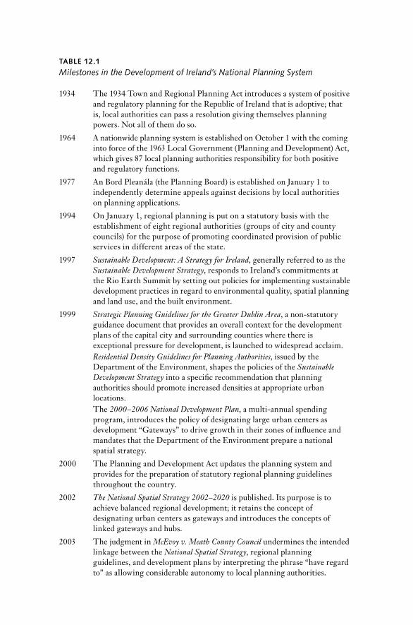
TAblE 12.1
Milestones in the Development of Ireland’s National Planning System
1934 The 1934 Town and regional Planning Act introduces a system of positive and regulatory planning for the republic of Ireland that is adoptive; that is, local authorities can pass a resolution giving themselves planning powers. not all of them do so.
1964 A nationwide planning system is established on October 1 with the coming into force of the 1963 Local Government (Planning and Development) Act, which gives 87 local planning authorities responsibility for both positive and regulatory functions.
1977 An Bord Pleanála (the Planning Board) is established on January 1 to in de pen dently determine appeals against decisions by local authorities on planning applications.
1994 On January 1, regional planning is put on a statutory basis with the establishment of eight regional authorities (groups of city and county councils) for the purpose of promoting coordinated provision of public ser vices in different areas of the state.
1997 Sustainable Development: A Strategy for Ireland, generally referred to as the Sustainable Development Strategy, responds to Ireland’s commitments at the rio Earth Summit by setting out policies for implementing sustainable development practices in regard to environmental quality, spatial planning and land use, and the built environment.
1999 Strategic Planning Guidelines for the Greater Dublin Area, a non- statutory guidance document that provides an overall context for the development plans of the capital city and surrounding counties where there is exceptional pressure for development, is launched to widespread acclaim. Residential Density Guidelines for Planning Authorities, issued by the Department of the Environment, shapes the policies of the Sustainable Development Strategy into a specific recommendation that planning authorities should promote increased densities at appropriate urban locations.The 2000–2006 National Development Plan, a multi- annual spending program, introduces the policy of designating large urban centers as development “Gateways” to drive growth in their zones of influence and mandates that the Department of the Environment prepare a national spatial strategy.
2000 The Planning and Development Act updates the planning system and provides for the preparation of statutory regional planning guidelines throughout the country.
2002 The National Spatial Strategy 2002–2020 is published. Its purpose is to achieve balanced regional development; it retains the concept of designating urban centers as gateways and introduces the concepts of linked gateways and hubs.
2003 The judgment in McEvoy v. Meath County Council undermines the intended linkage between the National Spatial Strategy, regional planning guidelines, and development plans by interpreting the phrase “have regard to” as allowing considerable autonomy to local planning authorities.

IrISH nATIOnAL SPATIAL STrATEGY / 463
ex- officio the manager of each of the sub- county urban authorities. none-theless, this multiplicity of small planning units, each with the sole role of securing the proper development of its own functional area, has given rise to an undesirable level of fragmentation and has consistently militated against adoption of strategic spatial policies.
Unlike Britain, where the administrative boundaries of the counties have been altered on more than one occasion since the 19th century, Ire-land hesitated to make significant geographic revisions to the or ga ni za-tion of local government because of the recognized emotional attachment among the public to the county structure. This can be traced to the influ-ence of the Gaelic Athletic Association (GAA), which was established in 1884 “for the preservation and cultivation of the national pastimes of the people,” in par tic u lar, the traditional Irish sport of hurling (Corry 2005, 9).
TAblE 12.1 (continued )
As part of the national annual bud get, the Minister for Finance announces the Decentralisation Programme, under which more than 50% of government departments and a number of state agencies are to be moved to regional centers, only some of which have been designated as gateways or hubs in the National Spatial Strategy.
2005 Sustainable Rural Housing Guidelines, issued by the Department of the Environment, advises planning authorities to facilitate applications for one- off houses in the open countryside in a wide range of circumstances.
2008 The Irish economy, which has relied excessively on the construction industry and development, collapses.
2010 The intended linkage between national policies, regional guidelines, and development plans is restored by the provision in the 2010 Planning and Development (Amendment) Act that development plans must contain a core strategy that provides evidence that the plan is consistent with the National Spatial Strategy and the relevant regional planning guidelines.The Department of the Environment’s publication Implementing the National Spatial Strategy: 2010 Update and Outlook finds that the bulk of population growth has not taken place in the gateways and hubs, but in the smaller settlements and rural areas within commuting distance of these designated urban centers.
2012 Final Report of the Tribunal of Inquiry into Certain Planning Matters and Payments (the Mahon report) concludes over 14 years of investigation into alleged corruption in the planning pro cess and makes a number of key recommendations for changes to the planning system.The government’s action program titled Putting People First proposes reform of local government and a reduction in the number of planning authorities; these proposals are incorporated into the Local Government Bill, which is presented to the Oireachtas in October 2013, and are brought into effect in the 2014 Local Government reform Act.

TAblE 12.2
Institutions, Agencies, and Organizations Active in Land Use Planning in Ireland
An Bord Pleanála (the Planning Board): An Bord Pleanála is a statutory body corporate that was established on January 1, 1977, to decide appeals against decisions by local planning authorities on planning applications. Board members are appointed by the Minister for the Environment for terms of from five to seven years in a whole- time capacity. They are completely in de pen dent in the discharge of their functions; the Minister is precluded by law from exercising control in any par tic u lar case (i.e., there is no power of call-in).
Economic and Social Research Institute: The Economic and Social research Institute is a limited liability com pany that is funded by an annual grant- in- aid from the Irish government and support for agreed programs from government departments and agencies, as well as competitive research grants (both Irish and international), payments for commissioned research projects, and sales of publications.
City and County Councils: City and county councils are the primary units of local government. The members (councillors) are elected every five years and share power with the city or county manager, a full- time, appointed administrator who holds office for a term of ten years. Within each county, there are a number of town councils (the second- tier units), all of which have elected members and the full range of planning powers. Planning is primarily discharged by local government and, with the steady transfer of other local government responsibilities to national organizations in recent de cades, is recognized to be its most important function. Under the reform program proposed in Putting People First, the intention is to streamline local government in 2014, in par tic u lar by amalgamating the town councils into the county councils as municipal districts.
Industrial Development Authority: The Industrial Development Authority is a state- sponsored body that was established in 1949 to support and develop export- led business and enterprise, both Irish and foreign. Since 1994, it has focused exclusively on promotion of foreign direct investment in the manufacturing and international ser vices sectors, while Enterprise Ireland has assumed responsibility for the development of indigenous commercial activity.
Minister for the Environment, Community, and Local Government: The Minister for the Environment, Community, and Local Government is the member of the government who has overall responsibility for policy on planning and environmental matters. Under current co ali tion arrangements, there are also two ju nior (non- cabinet) ministers in this minister’s department, one of whom has been designated Minister of State for Housing and Planning by order of the Taoiseach (prime minister).
Minister for Transport, Tourism, and Sport: The Minister for Transport, Tourism, and Sport is responsible for the provision of the public transport system and oversees policy and funding for national roads, aviation, and ports. There are a number of state- sponsored bodies under the aegis of this minister’s department, including Iarnród Eireann (Irish rail) and the national Transport Authority.

IrISH nATIOnAL SPATIAL STrATEGY / 465
Almost from its foundation, the GAA or ga nized itself on a county ba-sis. After the publication of the Barrington report (Government of Ireland 1991), consideration was given to the need to retain all 80 smaller urban authorities (borough corporations, urban district councils, and town commissioners), the range of whose functions had dwindled over the years. In January 1994, the Minister for the Environment, in announcing details of the government’s decision on local government reor ga ni za tion at the sub- county level, confirmed the retention of the existing town- based system because of the strong sense of civic tradition, local identity, and loyalty in many urban areas, which the government perceived as a strength on which to build. This remained the position until the implementation of the reform program published in 2012, which is discussed in the final section of this chapter.
A further significant difference between the British and the Irish sys-tems is the entitlement given to persons other than the applicant to ap-peal the decision of the planning authority on any planning application. Provided they have made a written submission during the currency of the application at the local level, third parties have the same status as disap-pointed applicants and can generate an appeal against a grant of permis-sion or conditions attached thereto (Grist 2012). An Bord Pleanála (the Planning Board) is the in de pen dent national authority established under the 1976 Planning Act to determine appeals against decisions of local au-thorities on planning applications. The Board consists of a chairperson and
TAblE 12.2 (continued )
Oireachtas (Parliament): The Oireachtas passes legislation, almost always on the initiative of the government (cabinet), which has a majority in both houses because of the electoral system set out in the Constitution.
Regional Authorities: regional Authorities consist of elected politicians nominated by the city and county councils located in the region. They have coordinating and advisory (rather than executive) functions, which have been enlarged and strengthened in recent years. Like the city, county, and town councils, their number is to be reduced under the Putting People First program.
Tribunal of Inquiry into Certain Planning Matters and Payments: The Tribunal of Inquiry into Certain Planning Matters and Payments was established in 1997 to investigate allegations of bribery and corruption in the pro cess of land zoning in the Dublin area. It carried out its work over a period of some 15 years, during which it was chaired in succession by two High Court judges (Mr. Justice Feargus Flood and Mr. Justice Alan Mahon) and produced three substantive reports containing findings of fact. Its final report, known generally as the Mahon report after its chairman, contains a number of significant recommendations, almost all of which have been accepted by the government.

466 / BErnA GrIST
nine other members appointed by the state in a whole- time or executive capacity for terms of between five and seven years. Decisions are taken col-legially by board members, who are prohibited from holding any other employment or position in res pect of which emoluments are payable dur-ing their period of office to ensure that no conflicts of interest arise. The Board is probably the only or ga ni za tion with a remit in the development and construction sector to have emerged from the 2008 collapse of the Irish economy with its reputation enhanced rather than diminished.
Horizontal and Vertical Relationships
The 1963 Planning Act did not require plans to be approved by the Min-ister for Local Government or any higher authority. The legislature and the sponsoring civil servants appear to have envisaged that local officials would prepare a plan in draft form that the manager would then pre sent to the councillors (the manager’s plan), who could make changes if they chose, but were unlikely to do so until after public display and receipt of submissions. Even at that stage, it was anticipated that a material altera-tion of a draft plan would be the exception. This local autonomy for a func-tion considered to be of limited po liti cal potential was an innocuous ele-ment of the planning system for its first two de cades, but has since proved to be its Achilles’s heel (Grist 2011). The adoption of the development plan is the most significant local government function that councillors still exercise, and their focus of interest has been and continues to be two aspects: zoning and rural housing policy.
establishment of regional Planning
neither regionalization nor regional planning was mentioned in the 1963 Planning Act, and early attempts to combine areas for the coordination of physical planning were largely ineffectual. Within a couple of years, con-sul tants were commissioned to undertake regional studies for the country based on the grouping of counties. Having examined the country’s eco-nomic position and resource possibilities, Colin Buchanan and Partners (1968) concluded that the greater the degree of concentration, the larger would be the likely scale of employment growth, which, in turn, would stem the tide of emigration. However, the greater the concentration, the more widespread the pattern of loss would be elsewhere in the country. In an attempt to balance economic and social considerations, the report rec-ommended a regional strategy based on an urban hierarchy with a limited number of growth centers (Bannon 1989).
Although the national Industrial and Economic Council, which saw a diffusion effect spreading out to the rest of the country, welcomed the pro-

IrISH nATIOnAL SPATIAL STrATEGY / 467
posals, they met with general hostility because the se lection of a limited number of growth centers imparted a strong urban bias to the form of future spatial development (Boylan 2005) in a country with a very large rural population (Walsh 2013). After a period of contentious and divisive debate, the government recognized the po liti cal realities of the situation and stated that it had difficulties accepting the Buchanan recommenda-tions in full. The Industrial Development Authority was given the task of finding a compromise that would be po liti cally acceptable. The failure to adopt the Buchanan strategy as government policy left a long shadow over future attempts to promote a new spatial development strategy.
regional planning was finally given a statutory basis in 1994, when eight regional authorities were established by grouping cities and counties together (regional Authorities Establishment Order 1993). Membership consists of city and county councillors selected by the constituent author-ities, and a small administrative unit supports each regional authority. The culture of local autonomy was so strong that the Minister for the En-vironment had to reassure the councillors that these new bodies would not diminish or restrict their powers. The regional authorities were given two functions: (1) promoting the coordination of the provision of public ser vices on a regional basis; and (2) advising on the implementation of pro-grams for the delivery of Eu ro pean funding.
From these inauspicious beginnings, the regional authorities developed into a major component of the planning system. The economy began to grow rapidly in the mid-1990s, and the Dublin and Mid- East regional Au-thorities responded to development pressures in the Greater Dublin Area (GDA) by preparing non- statutory strategic planning guidelines to pro-vide an overall context for the development plans of the capital city and the six surrounding counties, which included eight urban district coun-cils (as town councils were then styled). The Strategic Planning Guidelines for the Greater Dublin Area (Brady Shipman Martin et al. 1999) were of im-mense planning significance and were launched in 1999 to widespread acclaim as an exemplar of the best way to secure comprehensive and coor-dinated planning across local- authority boundaries. Subsequently, the princi ple of regional authorities having the power to prepare strategic guidelines was incorporated into the 2000 Planning and Development Act, while the GDA guidelines were given statutory recognition.
toward a Hierarchy of Spatial Plans
One of the three core principles underpinning the Minister’s vision of a planning system appropriate for the 21st century was that it should be “strategic in approach and integrate the various layers of spatial planning which affect modern Ireland” (Dempsey 1997, 6). The 2000 Planning Act

468 / BErnA GrIST
secured this by introducing a hierarchy of land use plans, which replaced reliance on cooperation between adjoining local authorities and the co-ordinating role of the manager within the county boundary. The hierarchy consisted of regional planning guidelines, development plans, and local area plans, all of which were set within the context of the national Spatial Strategy.
regional planning guidelines were to provide a long- term framework for the individual development plans of their constituent planning author-ities. Having a time horizon of 12 to 20 years, they would address strate-gic matters, such as population projections, infrastructure provision (e.g., water ser vices, waste disposal, and public transportation), and sustainable settlement strategies. Within the hierarchy, the development plan con-tinued to be the basic policy document of each planning authority, setting out the development objectives for the area. Adoption of a development plan remained a function reserved to the elected members of the council, and the 2000 Act required planning authorities to “have regard to” re-gional planning guidelines when they were making and adopting their development plans.6 This may simply have been loose wording, or it may have been a manifestation of reluctance on the part of both the Depart-ment and the Minister to grasp the nettle of local supervision.
In any event, the phraseology was revealed to have significant adverse consequences when Tony McEvoy, an elected member of Kildare County Council, mounted a legal challenge to the Meath County Development Plan, which had grossly over- provided zoned lands for the proportion of the projected regional population growth appropriate to County Meath’s primary urban development centers. During the pro cess that had led to the adoption of the plan, the councillors had accepted extensive proposals for zoning in addition to that contained in the draft, which had resulted in the council providing for over 60 percent of the population projected for the hinterland of the Dublin metropolitan area (Counties Meath, Kildare, and Wicklow). The High Court held that the phrase did not re-quire the planning authority to comply with the relevant guidelines but merely to give them “reasonable consideration” (McEvoy v. Meath County Council [2003] 1 I.r. 208). The effect of this decision was to sideline re-gional planning guidelines as an ele ment in the strategic hierarchy of land use plans. Thereafter, planning authorities throughout the country over-zoned with impunity, which, of course, laid the foundations for unfinished housing estates, inappropriately located developments on the periphery of towns, and other related land use problems.
6 Section 27(1) of the 2000 Planning and Development Act.

IrISH nATIOnAL SPATIAL STrATEGY / 469
restoration of Hierarchical Alignment
The 2010 Planning and Development (Amendment) Act re- established the intended linkage between national policies, regional guidelines, develop-ment plans, and local area plans by introducing a requirement that devel-opment plans include a core strategy, which is a statement containing spe-cific information demonstrating that the development objectives in the plan are consistent with the national objectives set out in the National Spa-tial Strategy and the regional objectives contained in the relevant regional planning guidelines. A core strategy must contain details of the quantity of land already zoned for residential use and the number of housing units to be provided thereon, together with similar information about lands pro-posed to be zoned for residential purposes. It must also explain how ac-count has been taken of the Minister’s policies in regard to national and regional population targets. Put simply, the core strategy is designed to provide a warranty that zoning will be the logical outcome of an evidence- based pro cess rather than a discrete and arbitrarily discharged reserved function, as it has been in the past. The 2010 Act also stated that, in pro-viding the long- term strategic planning framework for the development of a region, the objective of regional planning guidelines is to support the implementation of the National Spatial Strategy, and that the guidelines must be consistent with it.7
Evolution of the National Spatial Strategy
Walsh (2013) well describes the context in which the National Spatial Strat-egy was formulated as a time of unpre ce dented economic transformation in the republic of Ireland. Yet, this growth was accompanied by tenden-cies toward regional divergence in both economic and physical develop-ment within the State itself. The Strategic Planning Guidelines for the Greater Dublin Area (Brady Shipman Martin et al. 1999) had been well received and encouraged the incorporation of a more strategic level into the hith-erto locally focused planning system. There was consensus among key development agencies, such as the Industrial Development Authority and the Economic and Social research Institute, that Ireland needed a longer- term spatial plan to or ga nize strategic investment in infrastructure (Cussen 2011).
The Eu ro pean Spatial Development Perspective (ESDP) (Commission of the Eu ro pean Communities 1999), also published in 1999, re oriented
7 Section 14 of the 2010 Planning and Development (Amendment) Act.
470 / BErnA GrIST
thinking on regional policy away from the concept of distributional equity and toward sustainable development based on maximizing local poten-tial. The Department of the Environment was involved in the develop-ment of the ESDP and considered that many of the policies contained in it were relevant to Ireland, in par tic u lar, the development of polycentric urban systems, which strengthened partnerships between urban and rural areas.
After the Good Friday Agreement was signed in Belfast in April 1998, attention on both sides of the Border was given to capturing the opportu-nities for growth that would arise from the peace dividend and normal-ization of the po liti cal climate on the island of Ireland. Cross- Border poli-cies could now be more closely aligned, and it was desirable to complement the 2001 Regional Development Strategy for Northern Ireland with a similar strategy for the republic of Ireland (Morgenroth 2013).
national Sustainable Development Strategy
In April 1997, the government published Sustainable Development: A Strat-egy for Ireland (Government of Ireland 1997) in response to the EU Fifth Action Programme for the Environment and Ireland’s commitment to the principles and agenda agreed at the 1992 Earth Summit in rio de Janeiro. It provided a comprehensive analy sis and framework to enable sustainable development to be taken forward more systematically in the context of the strong growth the Irish economy was then experiencing. recognizing that threats to the environment accompany growth, the overall aim of the strat-egy was “to ensure that economy and society in Ireland can develop to their full potential within a well protected environment, without compromising the quality of that environment, and with responsibility towards pre sent and future generations and the wider international community”(25).
Generally referred to as the Sustainable Development Strategy (SDS), this broad- based program set out a wide range of objectives and mea sures for eight key sectors of economic activity: agriculture, forestry, marine resources, energy, industry, transport, tourism, and trade. To support this framework, the SDS contained policies implementing sustainable devel-opment practices in res pect of environmental quality, spatial planning and land use, and the built environment. It provided for the development of monitoring indicators and periodic review under new structural arrange-ments, including the establishment of a national Sustainable Development Council in de pen dently chaired, with broad repre sen ta tion from relevant government departments and agencies, the social partners, and environ-mental non- governmental organizations. The SDS had been prepared by the Department of the Environment, which also had responsibility for many of the key infrastructural investment areas, including water ser vices,

IrISH nATIOnAL SPATIAL STrATEGY / 471
housing, and roads. These programs were delivered at the local govern-ment level, and department officials were aware of the increasing impor-tance of coordination to support efficient delivery (Cussen 2011).
national Development Plans
Since 1989, development policy at the national level has been underpinned by the multi- annual spending program called the national development plan (NDP). Unlike its pre de ces sors, the third National Development Plan, which covered the years 2000–2006, was not designed principally to at-tract Eu ro pean Union structural funds. These moneys had already done their job of lifting the Irish economy, and strong economic growth had started in the mid-1990s. By the end of the de cade, macro- economic indi-cators were moving rapidly toward those of the most developed parts of the EU. The term “Celtic Tiger era” is commonly used to describe the period of burgeoning growth that preceded the 2008 collapse of the Irish economy, which grossly over- relied on the construction industry and development. Famously, financial analyst Kevin Gardiner first used this term two de cades ago to compare the economy of Ireland to those of Southeast Asia in a report for the multinational investment corporation Morgan Stanley (Gardiner 1994).
Unlike the two previous national development plans, which were weak on regional development and spatial planning, the 2000–2006 NDP rec-ognized that Ireland had a significant infrastructural deficit, compounded by unevenly distributed regional development. Of €22.4 billion allocated to economic and social infrastructure in the NDP, approximately 27 percent (€5,967.7 million) was to be invested in the national roads net-work. The very high de pen dency on roads as a transport mode (96 percent of passenger traffic, 90 percent of freight) meant that road development was seen as the key to sustaining levels of economic activity and promot-ing balanced regional growth. Chapter 3 of the NDP was titled “regional Development.” It acknowledged that, while all areas had benefited from recent growth, there were significant variations between the east and the west of the country, with the greatest concentration around Dublin and its surrounding towns, although the western city of Galway had also per-formed strongly. Balanced regional development was to be a key objective over the six- year life of the NDP. The government’s policy to reduce dis-parities between and within the regions was to focus on the large urban centers that could serve as “development Gateways” because they were strategically placed to drive growth in their zones of influence (Govern-ment of Ireland 1999, 43). These gateways would be of pivotal importance in the economic per for mance of their surrounding smaller towns and rural hinterlands and would therefore be the locations where public and

472 / BErnA GrIST
private investment would be prioritized (Walsh 2013). The NDP identi-fied the five main cities, each with its critical mass, as gateways, and the roads between Dublin and the four regional cities of Galway, Limerick, Cork, and Waterford were designated as the main inter- urban routes that would be upgraded to motorway or high quality dual carriageway stan-dard during the period of the plan.
In order to bring balanced regional development and other elements of regional policy contained in the NDP to fruition, the government man-dated that the Department of the Environment prepare a national spatial strategy that would translate policies into “a more detailed blueprint for spatial development over the longer term” (Government of Ireland 1999, 45). In addition to providing the promised blueprint, the strategy was also to provide a basis for long- term coordination and cooperation in decision making on major investment in infrastructure, which, together with both roads and public modes of transport, would include water and wastewater ser vices, energy, and communications. With the commitment to prepare a national spatial strategy in the NDP, the word “where” was added to the lexicon of Irish government policy (Cussen 2011, 149).
Preparation of the national Spatial Strategy
The National Development Plan 2000–2006 (Government of Ireland 1999) was published in november 1999. By the following February, a spatial planning unit had been established in the Department of the Environ-ment, and a pro cess of consultation with relevant local, regional, and sec-toral interests had commenced in order to develop a high degree of con-sensus on the strategy that would eventually emerge.
Progress was rapid. The first round of consultations indicated that there should be a strong social dimension to the strategy, and that there were differing interpretations of the concept of balanced regional development. A technical working paper on this topic, circulated in June 2000, consid-ered two alternatives: balance as equality (the traditional approach of Irish policy makers) and balance as full utilization of potential (Department of the Environment 2000). The spatial policy unit recommended ac cep tance of the latter interpretation, in which the concept of potential would en-compass the interaction between socio- economic and locational factors to create the conditions and possibilities for economic development. Walsh points out that this approach had its roots in the “balanced competitive-ness” concept used in the ESDP (Walsh 2013, 24). It was not without its difficulties, however, as evidenced by the cautious response of representa-tives of areas that would anticipate gaining more from the spatial equity model.
IrISH nATIOnAL SPATIAL STrATEGY / 473
The final consultation paper proposed a targeted approach to balanced regional development, based on the focused strengthening of a small num-ber of urban centers. To this end, the concept of functional areas was in-troduced. Twelve such areas were identified, covering the State; each con-tained one or more cities and towns central to the economic functioning of the area in question. This represented a radical step away from the use of city and county administrative units. Meredith, Walsh, and Foley as-sert that the boundaries of the functional areas were left imprecise and overlapping to draw attention to the “relational nature of economic space” (2013, 67). That may be so. More important, the approach was also in-tended to keep the focus on the high- level framework and avoid offending local sensitivities. However, reservations to the point of re sis tance emerged toward the concept, mainly because the boundaries of the functional areas were not aligned with county boundaries. Furthermore, rural interests saw the pro cess as urban led and voiced concerns about issues relating to rural housing, which they claimed were not adequately addressed.
Contributors to the development of the strategy had different perspec-tives of places and spaces, reflecting the opposition to growth centers that had greeted the Buchanan report in 1968. The “cultural antipathy to Dublin” (Meredith, Walsh, and Foley 2013, 67), which formed a significant undercurrent in the consultation pro cess, can be traced back to the days of the Local Government Board (discussed above in this chapter) and re-flects an anti- urban attitude described in one of the preparatory reports as “Dublin versus the rest” (Department of the Environment 2001, 12).
Content
The National Spatial Strategy 2002–2020 (NSS) was published in november 2002 and was “designed to deliver more balanced social, economic and physical development between the regions” (Government of Ireland 2002, 10). It provides a national development framework to guide policies, programs, and investment and covers the period to 2020. The definition given to balanced regional development is “developing the full potential of each area to contribute to the optimal per for mance of the State as a whole— economically, socially and environmentally” (Government of Ireland 2002, 11).
Key elements
To accommodate the negative reaction to the concept of functional areas, the NSS adopted an approach that took account of place- specific sensitivi-ties and divided the country into five zones, each with a strategic role.

474 / BErnA GrIST
The Dublin city region would be consolidated, and an alternative devel-opment axis to the Dublin- Belfast corridor would be provided by strength-ening the urban structure from Waterford through Cork, Limerick, and Galway to Letterkenny and then to Derry in northern Ireland to com-plement Dublin. Western areas would be revitalized through urban- led economic diversification based on land and marine resources. The Mid-lands area, lying between the Greater Dublin Area (GDA) and the Atlan-tic corridor, would be reinforced, while the strategic spatial role of the Border area would be co- operation in improved north- south interaction. Figure 12.3, which is derived from the NSS, shows these zones together with the urban centers designated in the Strategy.
The NSS further developed the gateways policy, identifying two stra-tegically located regional towns, Dundalk and Sligo, as additional gate-ways and introducing the new concept of a “linked” gateway, described as “one in which two or more strong towns work in partnership to promote economic and social development in their region” (Government of Ireland 2002, 38). Crossing the border with northern Ireland, the Letter-kenny/(Derry) linked gateway reflected the government’s commitment to enhance relationships on the island of Ireland, while the centrally located Athlone/Mullingar/Tullamore linked gateway was intended to ensure that regional growth was not confined to the coastal areas. Below this tier, nine strategically located medium- sized towns were identified as hubs, which in turn would support and be supported by the gateways and would pro-vide links to the wider rural areas. These were Cavan, Ennis, Kilkenny, Mallow, Monaghan, Tuam, Wexford, Ballina/Castlebar, and Tralee/Killarney; the last two again illustrated the linked concept. As figure 12.3 shows, this gave eigh teen urban places, four of which were multi- centered (polycentric).
For towns below the level of hubs in the settlement hierarchy, the NSS envisaged a complementary role. Various medium- sized towns in each re-gion would act as local capitals that would provide a range of ser vices and opportunities for employment. In some contexts, the NSS distinguished county towns (administrative centers) and larger towns (defined as those with a population in excess of 5,000) from towns with a population of 1,500 to 5,000. For the most part, these urban places were simply addressed col-lectively as “other towns,” and no details were given of how each level of towns would participate in the strategic approach to balanced growth.
With regard to those parts of the country outside these urban centers, the NSS saw rural potential being developed through tourism, agriculture, local ser vices, and enterprises focused on land- and marine- based natural resources. In alignment with some of the policies contained in the 1997 National Sustainable Development Strategy (Government of Ireland 1997),

Figure 12.3 Strategic Spatial roles and Urban Places in the national Spatial Strategy, 2002Sources: Government of Ireland (2002). Map by Dr. Harutyun Shahumyan based on the nSS Gateways and Hubs map.

476 / BErnA GrIST
rural towns and villages were to assume increased importance as a focus of local investment, and their established structures were to be strength-ened to assist local economies and to support local infrastructure and ser-vices, such as schools and public transport. The NSS noted that, in some areas, towns and villages were declining in population, with resulting underutilization of ser viced land, while, at the same time, it recognized that there was a tradition of people living in rural areas, and that sustain-able rural development should be supported.
The five- yearly census of population should have been taken in April 2001, but because of the foot- and- mouth disease outbreak, it was post-poned until April 2002. The detailed results of this census were not avail-able soon enough to inform the development of the strategy (Meredith, Walsh, and Foley 2013). In 2002, the Preliminary Census report indicated that the population of the country was approximately 3.9 million, of which about 1.5 million lived in the Greater Dublin Area. The NSS recognized that there was strong evidence that Dublin was becoming a “Dispersed City,” in which high- tech industries located on the periphery were draw-ing their workforces from “up to and beyond 80 km away” (Government of Ireland 2002, 22). It presented two types of population projections for the period to 2020. The first, considered more likely, forecast a popula-tion of 4.4 million by 2020 on the basis of current demographic trends. This figure has already been exceeded. The second, based on expansion in employment levels, which seemed a possibility in those Celtic Tiger times, considered that the population could be as high as 5 million by 2020.
Analy sis
The concept of linked places gave rise to considerable uncertainty about how the land between urban centers would be addressed in practice. Were these centers to be allowed (or even encouraged) to coalesce physically? Was there now a presumption in favor of development everywhere on the intervening open countryside? The fact that the Athlone/Mullingar/Tullamore (AMT) Gateway in the Midlands straddled two counties with in de pen dent plan- making administrations further complicated the con-cept. Jurisdictional issues were anticipated with regard to the Cross- Border Letterkenny/Derry Gateway, despite all the goodwill surrounding the peace pro cess.
The NSS explained the polycentric concept, which was modeled on the Danish experience, but prac ti tion ers in the public sector, who were attempting to put some restraints on the apparently insatiable demands of the building industry, had concerns that this aspect of the strategy would be used to support unsustainable development proposals. The explanation
IrISH nATIOnAL SPATIAL STrATEGY / 477
given in response to the question of how the new units would function was that they were not designated as agglomerations but were “more a state of mind.” It was envisaged that an “integrated development frame-work” would evolve over a period of up to seven years (Matthews and Martin 2003).
The NSS defined polycentric development as “linking and integrating the development of a number of urban centers in a way that combines their strengths in terms of infrastructure co- ordination, business promotion, innovation and cultural ties” (Government of Ireland 2002, 146). In 1993, the Triangle region had been established as a collaboration among eight municipalities on Jutland, the mainland part of Denmark, to promote and develop their area jointly as a polycentric national center. This region had a total population of some 225,000 within 60 kilometers of a strate-gic location on Denmark’s national transport structure. In contrast, the 2002 Preliminary Census report put the population of the AMT Gateway at 43,000. Although all three towns in this gateway are served by rail, Mullingar is on the line linking Dublin to Sligo, whereas Tullamore and Athlone are on the radial route from the capital to Galway. The national railway com pany, Iarnród Éireann (Irish rail), closed the line between Mullingar and Athlone in 1987.
reference was made to the complementary capabilities of the separate towns in the AMT Gateway, which are shown in detail in figure 12.4. The NSS merely suggested what specialized role each town might contribute, and then only in terms of the existing ser vice functions they performed (third- level education; healthcare; retail) with some overlapping descrip-tion. Similarly, the existing functions of Castlebar/Ballina and of Tralee/Killarney were stated (the first in each is the county town with a county hospital, while the second has a strong tourism profile). There was no over-lap of existing specialized functions, which could be taken as a stronger indicator of future complementary roles, and in both cases, the two towns are linked by rail, although the link between Castlebar and Ballina is some-what circuitous. However, for coordinated strategic planning, it would have been necessary to provide direction on the future designation of land uses between the separate urban centers in order to allow the critical mass for the various specializations to develop and to give the towns specific roles as places in partnership rather than in competition for desirable proj-ects, such as the retail, leisure, and commercial developments that con-tribute strongly to the local funding system.
A number of academic commentators have drawn attention to the weak-ness of the formal knowledge base available to the draf ters of the NSS. In fairness to its authors, as early as May 2000 (Matthews 2000), they ac-knowledged the difficulty of producing a report of this nature within the

478 / BErnA GrIST
relatively short two- year period allocated. However, they had been as-signed a task by the government and had no option but to complete the research in the allocated timeframe. A par tic u lar weakness was that data to allow analy sis of commuting patterns were not available from the Cen-tral Statistics Office when the NSS was being drawn up. Morgenroth (2013) argues that a key deficiency in the NSS was the lack of economic analy sis and is of the opinion that if it had contained a quantification of its bene-
Figure 12.4 Midlands Gateway, 2013Source: County boundaries: Ordinance Survey Ireland, permit no. MP009006. Redrawn by Dr. Harutyun Shahumyan.
IrISH nATIOnAL SPATIAL STrATEGY / 479
fits, this would have provided a power ful rationale and would have helped public ac cep tance.
Meredith, Walsh, and Foley point out that the incorporation of “other towns” into the NSS was a departure from the spatial concepts contained in the ESDP, and that the NSS did not provide any justification for their se lection (2013, 65). They argue that a justification could have been made on functional grounds for the identification of some lower- order towns, based on the absence of a well- defined urban system in parts of the coun-try, as set out in some of the preparatory reports. Put simply, the NSS gave recognition to too many urban places and thereby dissipated the focus of development decisions in a system that, at the time, was not plan led, but very much developer led.
Implementation
The National Spatial Strategy was integrated into a number of plans and programs over the years after its publication and was supported by the establishment of the Gateway Innovation Fund. Of course, the various regional planning guidelines incorporated its provisions, although their translation down the hierarchy has been impeded until recently by the judgment in the McEvoy case. However, a number of subsequent policies actually worked against the achievement of the goals set out in the NSS. The most significant of these were the Decentralisation Programme, which formed part of the 2004 bud get, and national housing policy, in-cluding the approach taken in the NSS itself to new rural housing.
national Development Plan, 2007–2013
The fourth National Development Plan (Government of Ireland 2007), in-dicated that it was using the NSS as its blueprint for investment, which would be particularly focused on the nine gateways. recognizing that the key to regional development would be the efficient use of planned invest-ment in infrastructure, the NDP established the Gateway Innovation Fund to assist the pro cess and bring about better coordination in gateway de-velopment. The NDP allocated an initial €300 million designed to attract significant matching funding, both public and private. In June 2007, local authorities in the gateways were invited to submit proposals for targeted capital projects that would trigger accelerated development of a type that did not form part of mainstream NDP investment. All NSS gateways sub-mitted proposals by the closing date of november 2007. These proposals were being evaluated when the economy collapsed in September 2008. As a result, funding was deferred and no allocations were made. Despite some

480 / BErnA GrIST
hopeful indications in 2010, this postponement has become indefinite, and allocations of funding are unlikely in the current economic situation.
transport Policy
The Strategic Rail Review was undertaken by con sul tants for the De-partment of Transport and was published in February 2003 (Booz Allen Hamilton 2003). Its purpose was to evaluate long- term rail requirements from a national perspective in the light of emerging spatial planning and regional development trends and policies. The Review set out an invest-ment strategy for the period to 2022. It acknowledged that the NSS had identified that Ireland’s best prospects for establishing a critical mass of the type and scale capable of competing with the GDA lay in developing the interconnected network of gateways from Waterford through Cork and Limerick to Galway. Having examined and evaluated a number of additional new schemes that would support this policy approach, it found that they performed poorly when projected patronage was factored in because of levels of development and population density along the lines in question. Accordingly, it did not recommend inclusion of the Sligo- to- Cork scheme, the Athlone- to- Mullingar scheme, or the Derry- to- Letterkenny scheme in the investment strategy. It considered that these schemes required fur-ther detailed evaluation in the context of securing complementary land use policies at regional and local levels in the areas concerned. The report rec-ognized that infrastructure development could support regional develop-ment as outlined in the NSS, but it stated that this would be contingent on building up compact and sustainable settlement forms along the rail corridors with population densities that would support effective and efficient rail ser vice.
This report had been commissioned before the publication of the NSS, and its priorities, based on a cost- benefit analy sis, focused on the GDA, where the suburban network offered opportunities for “beneficial invest-ment” (Booz Allen Hamilton 2003, 248). This made economic sense, but was po liti cally unacceptable. In June 2004, the Minister for Transport es-tablished an expert working group to examine the proposal to reopen the Western rail Corridor (WrC) in the context of the findings of the NSS, the Strategic Rail Review, relevant regional planning guidelines, and local development plans. The WrC runs from the hub town of Ennis (which is linked by rail to Limerick) through Athenry (linked by rail to Galway), the hub town of Tuam, and Claremorris to Collooney on the Dublin- Sligo line. On the basis of the recommendations in this report (McCann 2005), it was deci ded to reopen the first section, the 58- kilometer (36- mile) stretch from Ennis to Athenry, because it created a rail link between the four larg-

IrISH nATIOnAL SPATIAL STrATEGY / 481
est cities outside Dublin— Galway, Limerick, Cork, and Waterford— and therefore implemented a major objective of the NSS, that of creating greater linkages between these four gateways. This involved relaying 36 miles of track and the construction of four new stations.
Transport 21 (T21) was launched in november 2005. It was the govern-ment’s capital investment framework for the development of the national transport system over the period 2006 to 2015. This was the first time a 10- year financial plan had been approved for any sector of the economy. The total funding involved was €34 billion, divided among national roads, public transport, and regional airports. One of the key policy ob-jectives of T21 was to support the implementation of the NSS, and it re-flected the policies contained in that document, particularly in regard to improving interaction among the gateways, ensuring that rail offered a re-alistic alternative to road travel on key inter- urban routes, and providing better connectivity along the Atlantic corridor between Cork and Galway via Limerick.
A significant aspect of T21 was its robust monitoring arrangements, through which the framework’s inbuilt flexibility enabled rebalancing of funding in any year to absorb moneys allocated to, but not used by, one of the three sub- programs, with revised rebalancing over the following year(s) to ensure that each sub- program’s funding remained unchanged over the full plan period. Unfortunately, this meant that the bulk of the funding disbursed before the economic downturn went to the road- building program, which was already well advanced, whereas the lead-in for the big rail projects resulted in a number being mothballed. Phase 1 of the WrC, the intercity connection between Limerick and Galway, opened in March 2010, but parallel road improvements have resulted in a shorter journey time by road (one and one- half hours) than by train (two hours).
Like all other areas of national expenditure, the T21 program had to be reviewed, and the position regarding Phase 2 of the WrC, from Athenry to Tuam, is dependent on the per for mance of Phase 1 and a full economic assessment. The national Transport Authority commissioned con sul tants to conduct a review of the ser vice on the line in 2012. The re-sults indicate that the two commuting legs (from Ennis to Limerick City and from Athenry to Galway City) showed a growth in patronage for 2011 and 2012, but this was offset by loss of patronage on the intercity trip, pos-sibly caused by the inability to reduce journey times in comparison with cars. It must be acknowledged that the population in the catchment areas of stations other than these four is low. Experience with Phase 1 of the WrC, where patronage is well below the levels forecast, would seem to justify the approach taken in the 2003 Strategic Rail Review toward the re-opening of the full rail corridor linking the Sligo Gateway through to the
482 / BErnA GrIST
Waterford Gateway. The Strategic Rail Review recognized the Atlantic Corridor as important to delivery of the NSS, but financially problematic because of the lack of the settlement densities necessary to support it.
Decentralisation Programme
In December 2003, barely a year after publication of the NSS, the Minis-ter for Finance announced in the Dáil that eight of the fifteen departments of state would be moving their headquarters (including ministers and se-nior management) from Dublin to provincial locations. The program in-cluded an unspecified number of state bodies and agencies. Admitting that the plan to relocate 10,300 public ser vice jobs to 53 centers in 25 coun-ties was radical, the Minister justified it in the context of achieving re-gionally balanced growth. This was clearly a return to the po liti cally ac-ceptable definition of the term based on geographic equity, and a move away from the concept of developing the potential of places that under-pinned the NSS. When asked about the implications for the nSS, the Minister claimed:
The locations which have been selected take full account of the na-tional spatial strategy, the existence of good transport links—by road, rail and air— and the location of existing decentralised offices. The aim has been to establish viable clusters of work units within a region, either in the form of self- contained locations or clusters of sites located geo graph i cally close to each other or to existing decentralised locations. This will help to avoid the pitfalls of fragmentation and protect ser vice delivery. (McCreevy 2003, 413)
This perspective on the Decentralisation Programme was clearly at variance with the facts. The announcement was completely unexpected, and the program was not supported by any study or spatial analy sis. Some departments and agencies were moved to gateways and hubs, but others were relocated to lower- tier urban centers; a rural site at Knock Air-port was designated for the Department of Community, rural, and Gael-tacht Affairs. A closer look at the towns chosen for departmental head-quarters reveals that, for the most part, they were in constituencies of various ministers that had not been allocated a gateway or a hub. For example, the administrative headquarters of the Department of Defence was moved to newbridge in the constituency of the then Minister for Finance, while the Office of Public Works was relocated to Trim, County Meath, in the constituency of the then Minister for Transport.
Barry (2010) argues that the Decentralisation Programme had all the characteristics of a po liti cal “stroke” designed to garner electoral support

IrISH nATIOnAL SPATIAL STrATEGY / 483
in the regions. Local elections were to be held in June 2004. By De-cember 2003, ministers had been subjected to a year- long campaign by both current and aspiring councillors from the co ali tion government’s par-ties, who themselves were receiving adverse reaction from their constitu-ents. rural representatives rejected the NSS as urban- centric and inimi-cal to the development of rural areas. It was also proving unacceptable to representatives of those urban areas that, despite being county towns, were ranked only in the middle of the spatial hierarchy; that is, they were part of neither a gateway nor a hub. The Irish electoral system would have been a major contributor to the sense of competition among all local politicians. Under Pr- STV, there is no such thing as a safe seat; a party may be safe in calculating that it will win one, two, or even more seats in a constitu-ency, but no individual TD or councillor can be sure of being elected. Even ministers cannot take electoral success for granted, as the Minister for Public Enterprise had discovered in the 2002 general election, in which she lost her seat despite an 11 percent increase in her party’s share of the vote nationally.
At the national level, the 2002 election had added 12 TDs to the ranks of the two government parties. Both new and established TDs were con-scious that any reduction in overall support by a disenchanted electorate would endanger their personal chance of re- election. Disenchantment would certainly be heightened if electors felt that they were not enjoying an equal share of the growth in the economy. However, despite the best efforts of the Minister for Finance, the government parties lost 86 seats in the June 2004 local elections, and their share of the vote dropped by 9.7 percent.
The proposal to relocate the Department of Community, rural, and Gaeltacht Affairs to a greenfield site of 2.5 hectares (6 acres) at Knock Air-port in rural County Mayo was one of the most astonishing examples of unsustainable development in the Decentralisation Programme. The site was five miles from the nearest village. Fortunately, this proposal required planning permission. After a third- party appeal, the in de pen dent national appeals authority, An Bord Pleanála, in 2007 refused it as being “contrary to the national Spatial Strategy which seeks to maximize access to and encourage the use of public transport, cycling and walking in facilitating future development and which also seeks to reinforce the key roles of larger and smaller towns and villages in achieving balanced regional develop-ment” (An Bord Pleanála 2007, 2 of the Decision).
The Inspector’s report (An Bord Pleanála 2007) acknowledged the potential of the Decentralisation Programme, under which government offices could play a crucial role in achieving the objective of critical mass within existing urban centers, in par tic u lar those served by mainline rail.

484 / BErnA GrIST
However, no details had been given regarding the se lection of sites, inves-tigation of alternative sites, or the assessment criteria used in the pro cess. The Ballina/Castlebar linked hub, where both towns were served by rail, would have had capacity in zoned lands, ser vices, infrastructure, housing, and community facilities to accommodate offices of the scale proposed (4,550 square meters), which were intended to house some 140 staff mem-bers. As the Inspector commented, there might be inherent advantages to locating commercial and industrial enterprises that were dependent on air transport beside an airport, but the only inherent advantage in locating the proposed departmental offices so close to the rural airport related to “commuting by air which is well established as an unsustainable form of transport” (An Bord Pleanala 2007, 13 of the Inspector’s Report).
After the Board refused permission, the location for this department was designated as the nearby town of Charlestown, which the 2006 cen-sus recorded as having a population of 744, and which the professional advisers acting for the proposed Knock Airport office development had disparaged as an unsuitably small urban settlement. After the crash of the economy, the Public Ser vice Decentralisation Programme was reviewed, paused, and finally canceled in november 2011. However, between 2003 and 2011, many agencies and sections of departments were dispersed under the terms of the program, which has left a legacy of governance issues, as well as lost opportunities.
national Housing Guidelines
The second policy that worked against the achievement of the objectives of the NSS can be traced back to the cultural attitudes discussed in the early part of this chapter. Particularly where the land was of poor quality, a tradition grew up of each family attempting to survive at subsistence level on its own smallholding, where its tenancy was anything but secure. This meant that single houses became an inherent part of the Irish landscape in the 19th and early 20th centuries. A folk memory of evictions gave rise to a passionate desire to own a plot of ground and build a house on it.
The 1997 Sustainable Development Strategy was the first national docu-ment to provide a policy on rural housing. It found that demand for hous-ing in the countryside from people working in cities and towns is gener-ally unsustainable because of the increased energy usage associated with being separated from all other activities, such as work, shops, schools, and entertainment; the danger to groundwater arising from the multiplicity of individual septic tanks; increased road and transport costs; and the neg-ative impact on the urban fabric of towns. It stated that there must be a presumption against urban- generated one- off rural housing, although per-

IrISH nATIOnAL SPATIAL STrATEGY / 485
mission might be granted for dwellings for certain categories of persons whose occupations required them to be rurally based, thereby catering to “genuine needs.” In such cases, certain principles were to be applied, including protection of the carry ing capacity of the national road net-work, preservation of outstanding landscapes, and assessment of site suit-ability for wastewater absorption (Government of Ireland 1997, 151–152).
The 1999 Residential Density Guidelines for Planning Authorities (Depart-ment of the Environment 1999), issued by the Minister for the Environ-ment, translated the policy of sustainable urban development contained in the SDS into a specific recommendation that planning authorities should promote increased densities at appropriate locations. This advice was pop-u lar both with planning officials, because it accorded with sound sustain-able development principles, and with developers, for reasons related to financial returns per hectare. However, as incomes grew during the Celtic Tiger era and generous mortgages became freely available, there was a dichotomy between the aspirations of purchasers who wanted spacious houses with gardens and the densely developed semidetached or terraced housing on minimal- sized plots being offered to them in the gateway cit-ies and hub towns. Many couples at the family- formation stage, who were willing to trade off journey time for quality of life, voted with their feet and bought larger houses in low- density developments in the smaller towns and villages within commuting distance of the gateways. Because of the ongoing improvements to the national roads network— one of the priori-ties of the 2000 nDP was the completion of the five inter- urban routes to motorway standard by 2006— journeys of 40 and even 50 miles (60 to 80 kilometers) to work were becoming feasible.
A further factor ignored by policy makers and commentators both dur-ing the preparation of the NSS and over the years since, even after the collapse of the economy, was the absence of the self- build option anywhere within urban areas. Irish housing estates have always been designed and fully built out by their developers, who have offered a choice to purchas-ers within a fairly standardized range of house types. With one or two exceptions at the top end of the market, most notably a development of some 40 plots ranging in size from half an acre to over one acre at Mala-hide in northern County Dublin, where pop singers, footballers, and now- disgraced investment bankers built trophy homes, this position continued during the Celtic Tiger years. The only possibility for anyone attempting to have a house built to his own design was to buy a one- off unser viced site in a rural area from a farmer. In some cases, families with one parent of rural background, who were living in cities and towns and wanted to trade up, went to extraordinary lengths to secure a site and persuade the planning authority of their need to live in that area, often on the most
486 / BErnA GrIST
spurious grounds. If permission was not forthcoming, they lobbied coun-cillors and TDs vigorously. Again, because of the insecurity and competi-tion between sitting politicians engendered by the electoral system of multi- seat constituencies, at all levels they felt it necessary to be seen to support demands for extensive exceptions to the policy of preventing urban sprawl in the open countryside.
The NSS set rural housing in a far more flexible context than the SDS had done. It identified a new category of “rural generated housing need,” which it described as housing “for people who are an intrinsic part of the rural community by way of background or the fact that they work full- time or part- time in rural areas” (Government of Ireland 2002, 106). This enlargement of the meaning of “need” to encompass “want” was a response at the national level by members of the government, supported by opposi-tion members of the Oireachtas, to grassroots lobbying by councillors, as well as direct repre sen ta tions by their own constituents. In this sense, the NSS contained an inherent contradiction between its other settlement pol-icies and objectives and its stance on rural housing that contributed to its own difficulties.
The policy contained in the NSS was further liberalized in Sustainable Rural Housing Guidelines for Planning Authorities (Department of the En-vironment 2005). Like the Residential Density Guidelines, this document was issued by the Minister for the Environment under Section 28 of the 2000 Planning Act. The policy context made reference to the long tradition of people living in rural areas and the existence of a dispersed pattern of settlement in Ireland. The guidelines stated that the provisions of the 1997 Sustainable Development Strategy had sometimes been “operated over- rigidly,” and that this had led to the flexibility introduced in the NSS, which was now being expanded (Department of the Environment 2005, 1). The concept of “rural- generated housing need” was enlarged to include not only those living in an area, but also people with roots in or links to it. According to the Sustainable Rural Housing Guidelines, even in areas under strong urban pressures for development, the desires of persons who could thus be defined as part of the rural community to get planning permission for one- off housing should be facilitated. Lip ser vice was paid to road safety, wastewater disposal, design criteria, and heritage protection. Generous exceptions were given to the presumption against granting permission for dispersed housing. These exceptions could be based on residency, former residency, bloodline, local employment, or agricultural activities and even went as far as “health circumstances” (Department of the Environment 2005, 32). It was not unknown for people who had a perfectly good house in a nearby town or village, closer to their place of

IrISH nATIOnAL SPATIAL STrATEGY / 487
employment, to move children into a rural primary school or to join a ru-ral GAA club in order to establish links to an area in which they wanted to build a self- designed home. The implications for the exponential growth of a dispersed settlement pattern in such a policy were clear, but, again, clientelism in politics prevailed.
Outcomes
By October 2010, there had been official ac know ledg ment that achieve-ment of the objectives of the NSS could at best be described as sporadic. A review of the implementation of the NSS published by the Department of the Environment found that, although there had been significant in-vestment in public infrastructure, population growth had not taken place in the cities and hub towns, but in the smaller settlements and rural areas within a 50- to 80- kilometer commuting distance from these major ur-ban centers. It stated that excessive and inappropriately located zonings and developments had worked against the implementation of the NSS prin-ciples and priorities and had undermined efficient Exchequer investment in infrastructure and ser vices. The review recognized that a significant proportion of undeveloped residentially zoned land was in outlying loca-tions and resulted from “developer- led” planning (Department of the Environment 2010, 8).
zoning: Autonomy and Corruption
The curtailment of local autonomy contained in the 2010 Planning Act would appear to have gone some way toward addressing the problem of overzoning. By October 2010, all eight regional authorities had published revised regional planning guidelines covering the period 2010 to 2022. The 2010 Act required planning authorities to prepare a core strategy not later than one year after the making of these guidelines and to amend their development plans to include the core strategies. Of course, all future de-velopment plans will have core strategies as an integral component. A sur-vey of housing land availability carried out in 2012 by the Department of the Environment contains details about the impact of core strategies on overzoning at a national level (Department of the Environment 2012). By June 30, 2012, the amount of undeveloped zoned land stood at 29,329 hect-ares, a reduction of some 30 percent from the 42,058 hectares available two years earlier (regional Authorities 2012). not all zoned lands were actually served by the infrastructure necessary to enable development to take place. In June 2012, the 13,707 hectares of ser viced residentially zoned

488 / BErnA GrIST
land were estimated to have a yield of 394,357 housing units. On the basis of average housing completions over the previous three years, this was cal-culated to be sufficient to meet demand for the next thirty- five years.
It might be expected that the consequence of identified overzoning would be to unzone or dezone considerable tracts of land. The amount of legacy overzoning raises the question why this approach has not been fol-lowed to a greater extent. The clue may lie in the findings of a tribunal of inquiry that investigated corruption in the plan- making pro cess in the Dublin area during the late 1980s and early 1990s.
In 1989, a Garda (police) investigation of allegations of bribery and cor-ruption in the planning pro cess led to one unsuccessful prosecution. Be-cause of insufficient evidence, the director of public prosecutions was unable to initiate any action after a further Garda investigation in 1993. Finally, in 1995, a firm of solicitors based in northern Ireland, acting on behalf of two unnamed clients, offered a reward of Ir£10,000 for infor-mation relating to corrupt rezoning practices in the republic of Ireland. no Irish solicitor wanted to handle the matter.8 One of the persons who responded was a former managing director of a building com pany, James Gogarty, and the information he supplied was the key factor in the estab-lishment of the Tribunal of Inquiry into Certain Planning Matters and Payments in 1997.
The Final Report of the Tribunal of Inquiry, generally referred to as the Mahon report after the tribunal’s chairman, Judge Alan Mahon, states un-compromisingly that corruption became a regular aspect of the public role of some councillors on the Dublin County Council. It continues:
Those councillors exercised their public powers in their own inter-ests rather than in the interests of the public and bartered that power in exchange for cash and/or other benefits. There was apparently no shortage of persons prepared to pay for the corrupt exercise of pub-lic power and large tracts of land were ultimately rezoned because of the making and receipt of corrupt payments rather than in the interests of proper land use and development. (Government of Ireland 2012, 4)
There are no grounds for believing that corruption was confined to the Greater Dublin Area, or that it ended when the tribunal began its work.
8 Donnelly neary Donnelly, Solicitors, of newry in northern Ireland, placed an advertise-ment in the Irish Times on July 3, 1995. The two unnamed clients of this firm were revealed in the final report of the Tribunal of Inquiry to be Colm MacEochaidh (then a barrister) and Michael Smith (then the chairman of An Taisce, an environmental non- governmental or ga ni za tion).

IrISH nATIOnAL SPATIAL STrATEGY / 489
Indeed, the Mahon report states that throughout the period investigated, “corruption in Irish po liti cal life was both endemic and systemic” (Gov-ernment of Ireland 2012, 1). The publicity given to disclosures of wrong-doing made to the tribunal during the 15 years of its investigations may well have increased awareness of the possibilities for personal enrichment inherent in the adoption of development plans and the ease with which payments could be explained away as election contributions. Councillors, who less than a de cade ago accepted money from landowners in return for votes for rezoning, are likely to feel certain constraints on now voting to dezone the same lands in the open forum of the council chamber.
The tribunal made a number of recommendations regarding planning at the local and national levels. It declined to accept proposals that the power to rezone land be taken away from the councillors altogether, partly because the legislative changes discussed in this chapter have restricted their autonomy in the adoption of development plans, but also because there is no reason to suppose that elected members are more prone to cor-ruption than other individuals. Local level recommendations were largely aimed at ensuring transparency in the way councillors exercise their powers. At the national level, recommendations included placing the NSS on a statutory footing and establishing a planning regulator, whose role would be to supervise the plan- making function and to investigate possi ble sys-temic problems in the planning system, including those raising corrup-tion risks. The government responded to the Mahon Tribunal in July 2012 and accepted these recommendations, among others. To date, neither of these recommendations has been implemented.
Structural reor ga ni za tion
On the second day of the symposium in October 2012, a program with the title Putting People First was launched to reform local government in four main areas, one of which relates to new institutional arrangements for planning.9 As noted in this chapter, the basic structure of local govern-ment was established at the end of the 19th century and, in general terms, has remained unchanged since that time. Consequently, there are 80 town and borough councils, 26 of which do not have planning powers because they were formerly town commissioners. There are also 34 city and county councils. In all, there are 114 local authorities for a population of 4.58 mil-lion. The program proposes to reduce the number of local authorities to 31, all of which will have the full range of planning powers. This reduction
9 This section was drafted in October 2013. See end of chapter for the current position on reor ga ni za tion.
490 / BErnA GrIST
is to be achieved by two elements of streamlining, neither of which affects the identity of the counties or their geographic boundaries.
The 80 town and borough councils are to be abolished as separate units of local government and are to be integrated into their counties as mu-nicipal districts. Councillors are to be elected simultaneously to both the municipal district council and the county council. Municipal districts are to be built around the main towns and their natural hinterlands as much as possi ble, and the municipal districts of a county are to cover the entire county. The city and county councils in Limerick and Waterford are to be unified, as are the existing administrative counties of north Tipperary and South Tipperary.
The 2012 program proposes a significant realignment at the regional level by amalgamation of the eight regional authorities into three regions (figure 12.5). The regional configuration is set out in more tentative lan-guage than the county structures because it is subject to finalization in the light of considerations relating to EU funding arrangements. It is envisaged that there will be
• a Southern region consisting of Munster and Counties Carlow, Kilkenny, and Wexford;
• an Eastern and Midlands region consisting of Leinster other than the three counties in the Southern region; and
• a Connaught- Ulster region consisting of Connaught and Counties Monaghan, Cavan, and Donegal.
The new regional bodies are to be styled “assemblies” and will continue to be responsible for the preparation of regional planning guidelines, de-scribed as one of their key functions by the Minister of State for Housing and Planning (O’ Sullivan 2013a). They will also be given the new respon-sibility of drawing up regional spatial and economic strategies and will act as a bridge between the NSS and local authority plans and programs, par-ticularly with regard to development of NSS gateway locations. In addi-tion to providing a framework for local authority action in the economic area, these strategies will address the coordination of activities of other relevant government departments and agencies. To ensure adequate com-mitment and input to inter- agency arrangements, which has been a glar-ing weakness in Irish public administration, these strategies will be put on a legal basis.
The Future of the National Spatial Strategy
In her address to the symposium “Planning for States and nation- States,” the Minister for Housing and Planning indicated that, although many of

Figure 12.5 Proposed regional Configuration of Ireland, 2013Sources: Republic of lreland counties: Ordinance Survey Ireland, permit no. MP009006; Northern Ireland counties digitized by Dr. Harutyun Shahumyan.

492 / BErnA GrIST
the concepts and ideas in the 10- year- old NSS remained valid because they were derived from international and EU thinking, there was “a need to address new and altered realities” in relation to Ireland’s spatial develop-ment (O’ Sullivan 2012, 12). She suggested that a national spatial strategy produced in 2012 would look very different from that produced in 2002. She acknowledged that it would be difficult to think 20 years ahead in the midst of dealing with the collapse of the economy, but she said that it was her intention to start an updating pro cess early in 2013 by evaluating the principles on which a significantly revised national spatial strategy could be built (O’ Sullivan 2012).
In February 2013, the Minister for the Environment (the se nior min-ister and a member of the government) told a Joint Oireachtas Committee that the successes of the NSS had been limited. Describing it as “no lon-ger fit for purpose,” he stated that he intended to develop a successor that would look quite different in focus and content, and that he would soon be bringing proposals to the government in that regard (Hogan 2013). Until such time as a successor has been developed and adopted by the gov-ernment (as was the current NSS) and the Oireachtas (in accordance with the accepted recommendation of the Mahon report), the National Spatial Strategy 2002–2020 will continue to serve as Ireland’s national- level spa-tial planning framework.
In October 2013, the Minister for Housing and Planning established a three- person expert group to prepare a report setting out guidance on the preparation of a successor to the NSS (O’ Sullivan 2013b). There are strong indications that the preparation of the nSS Mark 2 will be undertaken within a tight time frame in order to provide the strategic framework for the six- yearly review of the 2010 regional planning guidelines, which is due to commence in mid-2015. The successor to the NSS will also need to be adopted before the new regional assemblies prepare their regional spatial and economic strategies.
The Future Shape of local Government
Exactly a year after the symposium, a Bill (Government of Ireland 2013) was published that, if enacted, will give effect to the proposals contained in Putting People First (Department of the Environment 2012) regarding the streamlining of local- government structures described in this chap-ter. The number of planning authorities will be reduced from 88 to 31 by incorporating the existing lower- tier urban authorities into the counties in which they are geo graph i cally located; amalgamating the cities of Wa-terford and Limerick with their respective counties; and amalgamating the administrative counties of north and South Tipperary. The statutory

IrISH nATIOnAL SPATIAL STrATEGY / 493
role of the regional bodies, to be restyled “regional assemblies,” will be strengthened from a spatial planning perspective. As set out in the Bill, their functions will include coordinating, promoting, and supporting stra-tegic planning and sustainable development; promoting effectiveness in local government and public ser vices; and preparing spatial and economic strategies. However, the Bill postponed the real ly difficult po liti cal deci-sions on the number and spatial arrangement of the regional assemblies and the boundaries of the municipal district electoral areas, which will be left to future ministerial orders. Because local government elections must take place in June 2014 under the Constitution, this restructuring of local government will have to be concluded early in 2014. To date, no legisla-tion has been published implementing the recommendation of the Mahon report regarding the establishment of a planning regulator.
* * *
The 2014 Local Government reform Act came into operation between January and July of 2014. The Act implemented the streamlining of local government described in this chapter. Elections to the 31 realigned local authorities (3 city councils, 26 county councils, and 2 city and county councils) took place in May 2014. Municipal districts have been established in all local government areas with the exception of the three suburban counties immediately proximate to Dublin city, where there are no urban centers appropriate to this pattern of reor ga ni za tion.
The eight regional authorities were dissolved in June 2014. However, the regional configuration best suited to a future national spatial strategy and associated government policy in relation to regional economic develop-ment were considered to require further reflection. Accordingly, the func-tions of the regional authorities were temporarily transferred to one or other of the two existing regional assemblies— bodies established in 1999 for the purpose of managing Eu ro pean Union structural funds. regional reor ga ni za tion oversight groups have been established in each of the three regions shown in Figure 12.5 to support the transition to the new regional structures, which are due to be determined by the end of 2014.
References
An Bord Pleanála. 2007. “Inspector’s report and Board Decision on the Proposal to Erect Offices at Kilgarriff West, Knock Airport, County Mayo, ref. PL16.221249.” www . pleanala . ie
Bannon, M. 1989. “Development Planning and the neglect of the Critical regional Dimension.” In Planning: The Irish Experience, 1920–1988, ed. M. Bannon, 122– 157. Dublin: Wolfhound Press.
494 / BErnA GrIST
Barry, F. 2010. “Politics and Economic Policymaking in Ireland.” In Irish Business and Society: Governing, Participating and Transforming in the 21st Century, ed. J. Hogan, P. Donnelly, and B. O’rourke, 28– 43. Dublin: Gill and Macmillan.
Booz Allen Hamilton et al. 2003. Strategic Rail Review. Dublin: Department of Transport.
Boylan, T. 2005. “From Undeveloped Areas to Spatial Strategies: reflections on Irish regional Policy.” In Planning in Ireland and Beyond: Multidisciplinary Essays in Hon-our of John V. Greer, ed. M. McEldowney, M. Murray, B. Murtagh, and K. Sterrett, 91– 106. Belfast: School of Environmental Planning, Queen’s University Belfast.
Brady Shipman Martin et al. 1999. Strategic Planning Guidelines for the Greater Dublin Area: Directions for Land Use and Transportation in the Dublin and Mid- East Regions for the New Millennium. Dublin: Brady Shipman Martin.
Chubb, B. 1992. The Government and Politics of Ireland. London: Longman.
Colin Buchanan and Partners. 1968. Regional Studies in Ireland. Dublin: An Foras Forbatha.
Commission of the Eu ro pean Communities. 1999. Eu ro pean Spatial Development Per-spective: Towards Balanced and Sustainable Development of the Territory of the Eu ro-pean Union. Luxembourg: Commission of the Eu ro pean Communities.
Corry, E. 2005. An Illustrated History of the GAA. Dublin: Gill and Macmillan.
Crossman, V. 1994. Local Government in Nineteenth- Century Ireland. Belfast: Institute of Irish Studies, Queen’s University Belfast.
Cussen, n. 2011. “Spatial Planning in the republic of Ireland: Progress and Poten-tial.” Journal of Irish and Scottish Studies 4(2): 149–158.
Dempsey, n. Minister for the Environment and Local Government. 1997. “Opening Address to the Convention on the review of Planning Legislation.” Dublin. (november 27).
Department of the Environment. 1999. Residential Density Guidelines for Planning Authorities. Dublin: Stationery Office.
— — —. 2000. The National Spatial Strategy: Balanced Regional Development. Dublin: Department of the Environment and Local Government.
— — —. 2001. The National Spatial Strategy: Indications for the Way Ahead. Dublin: De-partment of the Environment and Local Government.
— — —. 2005. Sustainable Rural Housing Guidelines for Planning Authorities. Dublin: Stationery Office.
— — —. 2010. Implementing the National Spatial Strategy: 2010 Update and Outlook. Dublin: Department of the Environment and Local Government.
— — —. 2012. Putting People First— Action Programme for Effective Local Government. Dublin: Department of the Environment and Local Government.
— — —. 2012. Survey of Housing Land Availability. http:// www . environ . ie / en / Publications / StatisticsandRegularPublications / HousingStatistics
Department for regional Development. 2001. Shaping our Future: Regional Develop-ment Strategy for Northern Ireland 2025. Belfast: Corporate Document Ser vice.
Gardiner, K. 1994. “The Irish Economy: a Celtic Tiger” in Ireland: Challenging for Pro-motion. Morgan Stanley Euroletter 31 August 1994, 9–21.

IrISH nATIOnAL SPATIAL STrATEGY / 495
Government of Ireland. 1991. Local Government Reorganisation and Reform (Barrington Report). Dublin: Stationery Office.
— — —. 1997. Sustainable Development: A Strategy for Ireland. Dublin: Stationery Office.
— — —. 1999. Ireland: National Development Plan 2000– 2006. Dublin: Stationery Office.
— — —. 2002. The National Spatial Strategy 2002–2020: People, Places and Potential. Dublin: Stationery Office.
— — —. 2007. Ireland: National Development Plan 2007– 2013. Dublin: Stationery Office.
— — —. 2012. Final Report of the Tribunal of Inquiry into Certain Planning Matters and Payments (Mahon Report). Dublin: Stationery Office.
— — —. 2013. Local Government Bill 2013 [no. 98]. Dublin: Stationery Office.
Grist, B. 2011. “Politicians and the Irish Planning Pro cess: Po liti cal Culture and Impediments to a Strategic Approach.” Journal of Irish and Scottish Studies 4(2): 159–172.
— — —. 2012. An Introduction to Irish Planning Law. Dublin: Institute of Public Administration.
Hall, P., and M. Tewdwr- Jones. 2011. Urban and Regional Planning. Abingdon: routledge.
Hogan, P. (Minister for the Environment, Community, and Local Government). 2013. “Opening Statement for the Joint Oireachtas Committee on Jobs, Enterprise and Innovation.” February 12.
Ireland. Bunreacht na hÉireann (Constitution of Ireland). Enacted by the People, July 1937. Dublin, Government Publications.
Keane, r. 1982. The Law of Local Government in the Republic of Ireland. Dublin: Incor-porated Law Society.
Lee, J. 1989. Ireland, 1912–1985: Politics and Society. Cambridge: Cambridge Univer-sity Press.
Local Government Act. 1991 (regional Authorities) (Establishment) Order, 1993. S. I. 394 of 1993.
Matthews, F. 2000. “The national Spatial Strategy— A View to the Future.” Paper delivered at the Irish Planning Institute national Planning Conference, Westport (May 4–5).
Matthews, F., and J. Martin. 2003. “The national Spatial Strategy.” Pre sen ta tion to public sector planners in Dublin ( January).
McCann, P. 2005. Report to the Minister for Transport from the Chairman of the Expert Working Group on the Western Rail Corridor (May).
McCreevy, C. (Minister for Finance). 2003. Dáil Debates 576:2 (December 3).
McEvoy v. Meath County Council [2003] 1 I.r. 208.
Meredith, D., J. Walsh, and r. Foley. 2013. “Perspectives on Ireland’s Economic Geography: An Evaluation of Spatial Structures.” Administration 60(3): 61–90.
Moody, T., and F. Martin. 1978. The Course of Irish History. Cork: Mercier Press.

496 / BErnA GrIST
Morgenroth, E. 2013. “Economics— The Missing Link in the national Spatial Strat-egy.” Administration 60(3): 41–59.
O’ Sullivan, J. (Minister of State for Housing and Planning). 2012. “Opening Address to the Symposium ‘Planning for States and nation- States: A Trans- Atlantic Ex-ploration.’ ” Dublin (October 15).
— — —. 2013a. “Local Government reform— A new Direction for Planners.” Ad-dress at the Irish Planning Institute national Planning Conference, Belfast (April 25–26).
— — —. 2013b. “Address to the Irish Planning Institute Autumn Conference.” Dublin (October 11).
Planning and Development Act 2000. Irish Statute Book number 30 of 2000. Dublin: Office of the Attorney General. http:// www . irishstatutebook . ie / pdf / 2000 / en . act . 2000 . 0030 . pdf
Planning and Development (Amendment) Act 2010. Irish Statute Book number 30 of 2010. Dublin: Office of the Attorney General. http:// www . irishstatutebook . ie / pdf / 2010 / en . act . 2010 . 0030 . pdf
regional Authorities. 1993. S. I. no. 394/1993—Local Government Act, 1991 (re-gional Authorities) (Establishment) Order, 1993. http:www.irishstatutebook.ie/1993 / en/si/0394.html
— — —. 2012. “regional Planning Guidelines Implementation Annual report 2011.” (April 4). www . myplan . ie / content / Final%20RPGs%20Implementation %20Annual %20 Report %202nd%20April%202012 . pdf
United Kingdom of Great Britain and Ireland. Local Government (Ireland) Act 1898 (61 & 62 Vic. c. 37).
Walsh, J. 2013. “The national Spatial Strategy: rationale, Pro cess, Per for mance and Prospects.” Administration 60(3): 13–40.
Warnock, M. 2011. “Current Directions in the Creation of Space: The regional De-velopment Strategy for northern Ireland.” Journal of Irish and Scottish Studies 4(2): 103–113.
Wylie, J. 1975. Irish Land Law. London: Professional Books.
/ 497 /
Berna Grist’s chapter presents a historical and institutional context for public administration and more specifically spatial planning in Ireland,
and a good overview of the emergence and implementation of Ireland’s na-tional spatial strategy. Her short history of Ireland, setting out its po liti-cal and institutional roots, as well as its colonial past, illustrates why as a society, the Irish have had a somewhat tempestuous relationship with plan-ning, accepting the princi ple of, if not always the requirements for, an effective planning system.
Irish history has perhaps fostered a deep social ambivalence about urbanization, for example, the relationships between, and the optimal roles of, urban and rural areas. This issue continues to be very divisive at na-tional and local levels despite efforts to outline a national policy in 2005. nevertheless, the aftermath of an economic crash driven by a property bubble gives cause for hope that lessons have been learned, and that there is now recognition at the requisite po liti cal, institutional, and societal levels that an effective planning pro cess is an integral requirement for sustained progress of the country in economic, social, and environmental terms.
Preparation of the National Spatial Strategy
Again, Grist provides a good overview of the background and prepara-tion of Ireland’s first national spatial plan, The National Spatial Strategy
Commentary
nIALL CUSSen

498 / nIALL CUSSEn
2002–2020 (NSS) (Government of Ireland 2002), whose publication marked the culmination of a very significant resurgence in institutional and po liti cal interest in spatial planning and regional development during the late 1990s and the early years of the 21st century. Of course, interest in planning often waxes in an economic upturn, only to wane in more reces-sionary times. This has been Ireland’s historical experience. The planning system was introduced in the 1960s at a time of economic revival before being undermined in the 1980s and 1990s by decisions like the disband-ment of An Foras Forbatha (the national Institute for Physical Planning and Construction research), a national physical planning research agency established with the support of the United nations in the early 1960s. The folklore is that one of the reasons that the minister at that time disbanded the or ga ni za tion was its opposition to being relocated from the capital, Dublin, to one of the regional cities as part of a decentralization process— planning and decentralization a recurring theme.
Grist fairly describes the challenge faced by the team that prepared the NSS between January 2000 and late 2002, which had to grapple with high expectations, a tight time frame, and a dearth of information caused in part by the disbandment of the Foras. The point she makes about a more robust economic rationale underpinning the strategy is also fair; however, clear methodologies for identifying regional economic potential and op-tions for its most effective arrangement in relation to key inputs and drivers were in somewhat short supply. Today, the situation is little different, al-though efforts by experts from Ireland’s Economic and Social research Institute are under way to plug that gap.
Sensibly, in 2002, the NSS team focused on ensuring that the NSS would lead to the establishment of a proper hierarchical plan structure, thereby giving a shape to an Irish planning pro cess that was essentially entirely locally driven and lacked effective coordination arrangements. Such localism subsequently gave rise to issues of overzoning, suboptimal infrastructure investment, and unfinished developments.
Grist’s analy sis of the content of the NSS, specifically in relation to polycentric development, however, highlights a continuing challenge in the planning mind- set. Planning prac ti tion ers seem to desire more and more details, and even instruction, from higher- level plans about how land should be managed rather than considering such high- level plans a broader call for planning to extend its role from regulation to place making. By the time strategic plans contain all the details planners at more regional and local levels sometimes say they need, they cease being strategic.
Grist highlights the barriers to implementation of the NSS that bound-aries presented. Administrative and po liti cal boundaries do complicate matters, but perhaps what is more important today is how representatives

COMMEnTArY / 499
or officials can work across boundaries and with communities and eco-nomic interests in new governance models to reinterpret and reanimate places in new ways. Such new governance models were what the NSS called for. Some interest ing efforts have emerged locally, but more are needed. Perhaps that is where a localism agenda fits in, responding to the higher- level frameworks but adapting to and even harnessing local strengths.
Implementation of the National Spatial Strategy
As Implementing the National Spatial Strategy (Department of the Envi-ronment 2010) acknowledged, implementation of the NSS had both high points, such as much of the infrastructural investment under the national development plans for 2000–2006 and 2007–2013 in the transport, hous-ing, and water ser vices sectors, and downsides, notably the problematic De-centralisation Programme. However, a more enduring benefit of the im-plementation pro cess has been the building of a more coordinated and evidence- based system of planning at national, regional, and local levels through the 2010 Planning and Development (Amendment) Act and the core strategy pro cess. The existence of the NSS, which presented a touch-stone, so to speak, for assessment of the plans of local authorities, led the Department of the Environment to act through a succession of ministe-rial directives to local authorities on their development plans under Sec-tion 31 of the Planning and Development Act 2000 from 2005 on. Such directives generally aimed to remove or adjust inappropriate land use zon-ing objectives that could not be justified by reference to the NSS or re-gional planning guidelines, which, coupled with the judgment in McEvoy v. Meath County Council ([2003] 1 I.r. 208), pointed clearly to the need for a more precise linkage between the high- level objectives of national and re-gional plans and the strategies and objectives, including zoning objec-tives, of city and county development plans.
The resultant 2010 Planning and Development (Amendment) Act was a visible demonstration that a national spatial planning perspective was now having a profound effect on national legislation. Some might say that the 2010 legislation was too little too late, closing the proverbial stable door after the horse had bolted. However, if one considers the time scales that spatial strategies deal with, typically 20 to 40 years, it can be argued that experience in implementing the NSS had to unfold in order to inform the evolution of the implementation of the strategy. With legislation amended and operating effectively, the planning pro cess is now much better suited to meeting the needs of the country as its economic prospects continue to stabilize and recover.
500 / nIALL CUSSEn
The Road Ahead
Despite the challenges facing Ireland, comfort can be taken from the fact that there seems to be a high degree of institutional consensus on the need for more effective spatial planning that is community- centered rather than developer- led. Indeed, as Grist points out, the work of the in de pen dent Mahon Tribunal, established by the national parliament to examine alle-gations of abuses of planning, primarily in Dublin in the early 1990s and therefore before the 2000 Act, the NSS, and regional plans, finally led to a report in 2012. The report made many recommendations, 10 of which related to the planning arena. For example, it called for the NSS to be put on a statutory footing and for a planning regulator to be appointed with power to oversee the planning pro cess, primarily by making an in de pen-dent assessment of plans. The regulator would also have certain investi-gative roles, as well as important research and training functions.
The government has committed itself to the implementation of virtu-ally all of the Tribunal’s recommendations, including the establishment of an in de pen dent Office for Planning regulation. It will be in the context of those emerging actions that people can make a definitive judgment about the degree to which the concept of “proper planning and sustainable de-velopment” stated in the Preamble to the Planning and Development Act will now fully permeate the institutions of the state.
Furthermore, while national planning legislation was comprehensively amended in 2010 and will likely see further amendment to take account of the Mahon Tribunal’s recommendations, the current Programme for Government (2011–2016) is leading to a substantial reform of the structures through which the planning functions at regional and local levels are carried out. new local government structures emerging under the Government’s Action Programme for Local Government reform outlined in the document Putting People First (Department of the Environment 2012) include the establishment of a more stable supporting funding frame-work (which has led to a local property tax and establishment of a national water utility and preparations for water metering and user charges for the domestic sector). This new funding framework will reduce the historical reliance of local government on planning and development charges and commercial rates, which, in the Celtic Tiger era, tended to act as a distor-tion of the planning pro cess, particularly in relation to decisions affect-ing city- and town- center development.
Local government structures are being radically reshaped. The current 88 planning authorities at city, county, and municipal levels are to be reduced to a core structure of 31 city and county councils, and the ten regional bodies are to be reduced to three new regional assemblies, which

COMMEnTArY / 501
will prepare new regional spatial and economic strategies beginning 2014/2015. The city and county development plans are also to be radically repositioned; they will be more clearly linked to the new regional spatial and economic strategies and will also provide a context for local commu-nity development plans, which in turn are a result of alignment of previ-ously distinct local rural and community development and local authority structures.
These actions will shift the very nature of local government from be-ing a provider of a fairly narrow (by international standards) range of in-frastructure to being the key force at the local level for enablement and integration of economic and social development, working closely with the central government and the investment and community sectors. It is no coincidence that the overarching framework guiding the pro cess in Put-ting People First has had a strong planning input. Again, experience in im-plementing the NSS has been put to good use; the strategy was very much in the minds of the team that put together the action program for local government reform.
now that maintenance and overhaul of the institutional context for planning in Ireland are receiving much- needed attention, work is advanc-ing on the development of a successor to the National Spatial Strategy. Al-though it is far too early to suggest what the next national spatial strategy might contain, recent events suggest some of its likely characteristics:
1. There will be a need to establish a legislative framework to define the purpose of the new nSS and to oversee its preparation and implementation, involving po liti cal oversight, public consultation, and integration of the requirements, primarily environmental, of various Eu ro pean Union (EU) directives.
2. Proper account will have to be taken of both new economic realities and environmental challenges with which Ireland and the wider EU and global economy will be grappling for some years to come, primarily affecting the scope for public investment and demanding smart growth policies that fully harness existing assets and capital.
3. The next nSS must address Ireland’s wider territorial context, not just in a terrestrial sense and in regard to its maturing relationship with northern Ireland and EU/global linkages, but also in regard to its marine setting through the developing area of marine spatial planning.
4. Preparation and implementation of the next nSS will benefit from advances in spatial data assembly and analy sis through initiatives like
502 / nIALL CUSSEn
the national Institute for regional and Spatial Analy sis, the Depart-ment’s www . myplan . ie initiative, which is modeled on U.S. prowess in assembling key spatial data to influence policy makers, as well as the ESPOn research program at the EU level.
5. Maturing regional coordination since 2004 means that the next NSS is likely to be a more strategic and concise document that is clearly set in the context of medium- to long- term fiscal and bud getary outlooks to be prepared jointly by the Departments of Finance and Public Expenditure.
The economic crash of 2008 and its aftermath have taught the hard lesson that good planning is central to long- term competitiveness and socioeconomic and environmental progress. Poor planning outcomes cost the community, the environment, the economy, and, above all, the taxpayer as we have found in the State’s investment in the national Asset Man-agement Agency.
In all this hard and expensive learning, there is a newfound sense of the contribution that spatial planning can and does make to enabling the achievement of economic, social, and environmental conditions that are both sustainable and optimal. The journey will continue.
References
Department of the Environment. 2010. Implementing the National Spatial Strategy: 2010 Update and Outlook. Dublin: Department of the Environment and Local Government.
— — —. 2012. Putting People First— Action Programme for Effective Local Government. Dublin: Department of the Environment and Local Government.
Government of Ireland. 2002. The National Spatial Strategy 2002–2020: People, Places and Potential. Dublin: Stationery Office.
McEvoy v. Meath County Council [2003] 1 I.r. 208.
Planning and Development Act 2000. Irish Statute Book number 30 of 2000. Dublin: Office of the Attorney General. http:// www . irishstatutebook . ie / pdf / 2000 / en . act . 2000 . 0030 . pdf
Planning and Development (Amendment) Act 2010. Irish Statute Book number 30 of 2010. Dublin: Office of the Attorney General. http:// www . irishstatutebook . ie / pdf / 2010 / en . act . 2010 . 0030 . pdf
Programme for Government 2011–2016. Dublin: Department of the Taoisigh (Prime Minister). http:// www . taoiseach . gov . ie / eng / Work _ Of _ The _ Department / Programme _ for _ Government / Programme _ for _ Government _ 2011 - 2016 . pdf

/ 503 /
the case studies of plans and planning frameworks from the United States and Eu rope presented in this volume offer substantial new
information about the current state and recent evolution of planning frameworks in these states and countries. If there is an obvious conclu-sion to be drawn, it is that planning frameworks in Western nations and states are undergoing continuous change along with the social, eco-nomic, po liti cal, and environmental contexts in which they operate. In fact, the responsiveness of planning to these socioeconomic trends at all levels, and at the state and national levels in par tic u lar, has been pro-found, at least in these case- study locations. Although it is necessary to recognize the hazards of drawing inferences and conclusions from only a few case studies and to acknowledge that no formal comparative analyses were conducted, it is possi ble to observe trends on both sides of the At-lantic, trends that cross the Atlantic, and policy implications that can be drawn from these trends.
Trends in the Eu ro pean Case Studies
The case studies from Western Eu rope paint a picture of a continent still struggling to find a balanced approach to planning and managing land use and addressing spatial development challenges. At least in part, the
Conclusion

504 / COnCLUSIOn
Eu ro pean Union (EU) was established to address these challenges. Toward those ends, it developed the Eu ro pean Spatial Development Per-spective (ESDP) (Eu ro pean Commission 1999), the Territorial Agenda (Eu ro pean Commission 2007) to support a more competitive and sus-tainable Eu rope of diverse regions, and the Territorial Agenda of the Eu ro pean Union 2020 (Eu ro pean Commission 2011), a growth strategy for the 21st century. The EU also launched the Eu ro pean Spatial Planning Observa-tion network (ESPOn), an or ga ni za tion charged with providing infor-mation and technical support on a continental basis, and it created a set of informal networks and funding programs designed to foster collaboration across the Eu ro pean continent (InTErrEG and UrBACT). All have certainly left their marks. But many informed observers have come to believe that the formal institutions and programs of the EU are less influ-ential than the informal networks, directives, and other efforts at col-laboration and information exchange. Or, as Andreas Faludi puts it in chapter 7, the Eu ro pe anization of planning is progressing more rapidly than the EUropeanization of planning. Whether such Eu ro pe anization is leading to a convergence of planning approaches, however, remains a topic of considerable debate, and there is no compelling evidence in the five case studies presented here to end that debate (Stead 2013).
The Eu ro pean case studies offer clear and unambiguous evidence of de-volution in the formulation and exercise of planning, especially land use planning. France, of course, was the forerunner, devolving responsibili-ties formerly held by the national government to regional governments in 1982. The netherlands offers perhaps the most striking case. not only was The netherlands’ fifth national spatial plan never formally adopted, but also the new national policy directives expressly favor greater reliance on market forces and more regional and local discretion. The Danish exam-ple is also remarkable. Although the Danish national government contin-ues to provide policy guidance and plays a major role in planning for Greater Copenhagen, local governments in Denmark have more respon-sibility for and discretion over land use and spatial policy than at any time in Danish history. The United Kingdom, though muddled and perpetu-ally in flux, offers another example of devolution. It has devolved planning responsibilities to the constituent nations (countries) of Wales, Scotland, and northern Ireland, and the succession from national policy to regional policies to localism in England could not offer a more striking example of policy devolution, at least on paper. Ireland is perhaps an exception. It ad-opted a national spatial strategy in 2002, but even there, the role of the national government is currently being reconsidered as that strategy is be-ing revised.

COnCLUSIOn / 505
It is important to note, however, that the devolution of planning in the Eu ro pean case studies is not absolute.1 In every case, the nature of na-tional planning has changed significantly; it has moved increasingly away from spatial, comprehensive, and distributive roles toward sectoral goals, strategic national interests, economic competitiveness, and, more recently, dealing with climate change. And although the national role in spatial planning has substantially diminished, the powers to control development are expressly retained, even if they are selectively used. This creates what Barrie needham in chapter 8 calls “central- decentral” pull and is consis-tent with Alterman’s (2001) conclusion that national planning has strength-ened, not weakened.
The second common trend in the Eu ro pean case studies is the rise of regionalism. Again led by France, growth in the role of regions and re-gional cooperation is promoted by the ESDP and is generally illustrated in four of the five case studies. Only in Denmark has the role of regions diminished, particularly after the government structural reforms abolished counties, which once had a major role in ensuring coherent and coordi-nated regional development. The regionalization of planning in the United Kingdom is perhaps the most complicated example. There has been de-volution to the constituent countries (regions in a broad sense) of Wales, Scotland, and northern Ireland, but subnational regional authorities have been eliminated in England. regions and provinces have also risen to prominence in The netherlands. Coordination of spatial and transport planning was first formalized as a role of regions in 2006 and then with-drawn and given to the provincial level, but the regions remain the me-dium for the implementation of the national long- term program for infra-structure, land use, and transport investments. In general across the Eu ro pean cases, however, the role of regions has risen primarily in the area of sectoral planning, not land use planning or development control. More specifically, regional governments, perhaps because of their better under-standing of regional issues, or perhaps because of greater po liti cal homo-geneity, have gained a stronger voice on social, economic, and environ-mental policy, but not on land development policy. Perhaps the most striking exception, again, is Ireland. There, regional authorities not only are tasked with developing regional development guidelines, but also have become critical players in Ireland’s attempt to prevent another round
1 Dictionary . com defines devolution as “the transfer or delegation of power to another.” The Merriam- Webster online dictionary defines devolution as “transference (as of rights, powers, property, or responsibility) to another; especially: the surrender of powers to local authorities by a central government.” “Transfer” or “delegation” better describes the situation in land use policy than “surrender.”
506 / COnCLUSIOn
of overbuilding through better development monitoring and building control.
The third clear trend in the Eu ro pean case studies is the movement away from hierarchy and toward territorial governance. Territorial gov-ernance embodies a range of concepts born out of the desire for territo-rial cohesion, an equally complex and somewhat ambiguous concept. As discussed by Faludi, there is currently much debate among Eu ro pean plan-ning scholars about what territorial cohesion and territorial governance mean. According to the Green Paper on Territorial cohesion (Eu ro pean Commission 2008, 3), territorial cohesion is defined as: “. . . ensuring the harmonious development of all these places and about making sure that their citizens are able to make the most of inherent features of these ter-ritories. As such, it is a means of transforming diversity into an asset that contributes to sustainable development of the entire EU.” The ESPOn- TAnGO pro ject (Territorial Approaches to new Governance; ESPOn and nordregio 2012) identifies five dimensions of territorial governance: (1) coordinating actions of actors and institutions; (2) integrating policy sectors; (3) mobilizing stakeholder participation; (4) being adaptive to changing contexts; and (5) realizing place- based/territorial specificities and impacts. The movement away from hierarchy and toward more informal governance pro cesses is perhaps most evident in The netherlands. As needham states, “All levels of government prefer to resolve differences of opinion about the spatial development of a par tic u lar location in an infor-mal way; resort to the hierarchical, formal procedures is regarded as an admission of administrative failure.” In France, Anna Geppert describes a multi-actor governance system and a dependence on local voluntarism in metropolitan planning. In Denmark, Daniel Galland and Stig Enemark describe a multistakeholder pro cess in plan development and implementa-tion, at least at the regional level. Again, perhaps only Ireland has but-tressed the formal hierarchy among the national spatial strategy, re-gional planning guidelines, and local plans.
To a significant degree, of course, territorial cohesion is about spatial equity and raising the welfare of the new members of the EU closer to the welfare levels of the existing members. Territorial governance has to do with how to make that happen, given the po liti cal difficulties of overt in-ternational re distribution. More nuance is therefore needed. Territorial cohesion is one such form of nuance. Stead (2013) distinguishes between type I and type II territorial governance. According to Stead, type I ter-ritorial governance is the most prevalent form: nations tend to plan for the territories within their boundaries, often in some hierarchical, feder-alist fashion. But with this kind of “Euclidean” planning it is difficult to promote territorial cohesion, at least across national boundaries. Fur-
COnCLUSIOn / 507
thermore, type I territorial governance, in which national planning is embedded in an hierarchical EU planning system is also po liti cally diffi-cult, if not impossible (as explored by Faludi in chapter 7). This dilemma gives rise to type II territorial governance, which is more functionally specific, less place bound, and more flexible. An example of type II territo-rial governance is planning for a watershed, conducted or funded by the EU, that is less bound by po liti cal boundaries and more flexible to the boundaries of water- related issues. Such functionally based planning is increasingly common in Eu rope not only at the supranational scale, but within the po liti cal boundaries of Eu ro pean nations as well.
In short, the Eu ro pean case studies reveal fundamental challenges to the historic structure of planning institutions. The new forms of func-tional plans are increasingly decentralized, are more regionally than nationally focused, and tend to rely on informal forms of territorial gov-ernance. Land use planning and development control in many case- study nations, meanwhile, continue to devolve to regional and local levels of governance, and national governments have become more strategic and deferential to local governments.
Trends in the U.S. Case Studies
In the United States, the narrative is even less clear. not only are the five case- study states not representative of national trends (no informed ob-server would suggest that Oregon, Mary land, California, Delaware, and new Jersey exemplify national trends in state land use policy), but also, the stories in each of these states are highly divergent. They illustrate, however, the varieties of approaches that are possi ble, as well as the com-plex pro cesses that accompany efforts to institute state- level activities and coordination with regional and local levels. Oregon is still viewed as the national leader in state land use policy, but change is clearly happening more rapidly in California, Mary land, and new Jersey. Further, although France is 15 times the size of The netherlands, California is 66 times the size of Delaware. Given the dramatic differences in size and complexity, there is little reason to expect that trends observed in Delaware will also be observed in California.
At the federal level, there is clearly no movement to reintroduce any form of national land use policy. Still, there seems to be growing recogni-tion within federal agencies that federal policies have implications that pro-foundly affect development patterns. At the U.S. Department of Trans-portation, for example, the interdependence of transportation and land use is now well understood and undergirds federal policies that support transit- oriented development, multimodal transportation options, and

508 / COnCLUSIOn
green house gas reductions. The U.S. Department of Housing and Urban Development also clearly recognizes the influence of spatial development patterns on housing affordability, community development, and social equity. The Environmental Protection Agency (EPA) has a small but active office of sustainable development that provides technical assistance on ways to promote smart growth. Moreover, the signature urban policy initiative of the Obama administration, the Sustainable Communities Initiative, was launched by a memorandum of understanding by the secretaries of the two departments and the administrator of the EPA. It would be difficult to argue that the Obama administration has taken a bold and aggressive new approach to urban policy, but it would be equally hard to argue that it has not been more active in land use and urban affairs than the two administrations of George W. Bush.
Many of the planning and spatial development principles espoused by the Sustainable Communities Initiative differ little from the principles of smart growth established in the early 1990s. These include compact de-velopment, mixed land uses, pedestrian- friendly urban designs, and pro-tection of natural resources. But, at least partly as a response to the cur-rent economic crisis, economic development and social justice are now included in the U.S. sustainability platform. The case for economic de-velopment, however, is largely based on the purported cost savings of smart growth development, and social equity generally focuses on affordable housing and disparities in access to opportunity within metropolitan areas. At the federal level, there remains little po liti cal will to address spatial issues within specific sectors or regional imbalances in economic growth and prosperity. Instead, the sustainability agenda at the national level is largely designed to help local governments make more sustainable choices at the micro scale, not to address spatial issues that manifest themselves at the national level.
At the state level, compelling evidence of policy devolution cannot be found in all five case studies, but none offer evidence that the quiet revolution—in the growth of state- level planning— has gained momentum or is still under way. new Jersey, long the national leader in statewide plan-ning, seems to have abandoned that role. In Mary land, the state develop-ment plan was severely crippled before it was fully established and faces a highly uncertain future. Oregon abandoned its efforts at state agency coordination in the 1980s, and California delegated responsibility for meeting green house gas targets to metropolitan planning organizations (MPOs). Only Delaware, it seems, dares to launch and sustain statewide initiatives without fear of the po liti cal backlash that thwarts such efforts in other states. As David Callies stated in a retrospective on the quiet rev-olution over three de cades ago:

COnCLUSIOn / 509
With the hindsight of ten years, it is probably more accurate to char-acterize the “ancient regime” of local land use controls as having metamorphosed rather than having been overthrown. The trends toward home rule municipalities, local growth control, and strength-ened local comprehensive planning, together with a host of new and more flexible local land use control techniques portend continuing increased local control. (Callies 1980, 148)
Another trend in the United States, although perhaps more aspirational than fully achieved, is the increasing role and prominence of MPOs, or what is sometimes called metropolitan regionalism (Fishman 2000; Knaap and Lewis 2012). The strongest example of this is found in California, which has assigned primary responsibility for addressing climate change to MPOs, albeit without giving them any degree of land use control. The California experience, along with examples from places like Portland, Or-egon, and central Utah, also undergirds the federal government’s sustain-able communities strategy (Knaap and Lewis 2012). By giving planning grants to consortia of organizations led by MPOs, the federal government is wagering that metropolitan areas around the nation will follow the example set by MPOs in California and establish new metropolitan plan-ning regimes. That, perhaps, is the greatest U.S. planning experiment of the new millennium.
Another pervasive trend in the United States is the use of incentives, or targeted spending, by state and regional governments to influence the planning decisions of local governments. This is the policy strategy that underlies both California’s and the federal government’s focus on MPOs. If local governments in California do not follow their MPO’s sustainable communities plan, they will not receive state or federal funding for their desired transportation investments. The Mary land and Delaware planning systems are also highly dependent on the success of this strategy. Both states rely on locally chosen and state- approved place designations as tar-gets of state spending: spending on conservation in designated conserva-tion areas and on urban infrastructure in designated growth areas. Much is riding in the United States on the efficacy of this approach. Unfortunately, there is scant evidence that the approach will work. Indeed, considerable evidence suggests that it does not (Knaap 2008; Lewis and Knaap 2012; Lewis, Knaap, and Sohn 2009).
The final trend in U.S. planning and spatial policy is the substitution of metropolitan governance for metropolitan government.2 This is a
2 Governance is a way to manage power and policy; government is an instrument to do so (Milcu 2011).

510 / COnCLUSIOn
long- term trend that vividly illustrates the difficulty of institutional reform. Metropolitan areas in the United States are characterized by fragmented local governments, nearly all of which exercise land use authority granted by their states. States clearly have the authority to create metropolitan- wide governments, but the po liti cal obstacles are too great. As a result, most metropolitan areas have councils or other voluntary associations of governments. Most metropolitan areas have also established MPOs to re-ceive federal funds for transportation planning and capital projects. This set the foundation for both the California climate strategy and the sus-tainable communities strategy of the federal government: provide fund-ing and technical assistance to consortia or voluntary associations of gov-ernments as incentives for mutual cooperation. Again, the efficacy of this approach remains largely untested, but it is clear that planning and land use management in metropolitan areas of the United States will occur in-creasingly through voluntary governance pro cesses.
Similarities and Differences
The beginning of the 21st century brought a new set of challenges for planners in both Eu rope and the United States. On both sides of the Atlantic, partly as a result of the global economic and environmental crisis, much of the attention has turned to economic development and climate change. As a consequence, national governments in Eu rope and state agen-cies in the United States are focusing their activities on areas where their action is most needed, where achievements are more tangible and mea-surable, and where po liti cal barriers are least formidable. Despite declin-ing engagement in land use and spatial planning, the U.S. federal govern-ment and the Eu ro pean Union remain quite influential. In Eu rope, EU directives are major channels of influence, all of which have legal standing and sanctions for noncompliance; in the United States, the influence comes via environmental laws (e.g., the Clean Air and Water Acts) and funding programs for transportation, community development, and hous-ing. On both continents, national and state governments are affirming their influence, not by engaging directly in land use planning or regula-tion, but rather by discretionary use of their preemptive and enabling au-thority, and by providing incentives.
Incentives in the form of funding and spending requirements continue to be the most prevalent method of policy influence. This happens at two levels: from the superstructures (federal programs in the United States and EU structural funds, InTErrEG, and ESPOn programs in Eu rope) and from Eu ro pean nations and U.S. states through the funding (or cost shar-ing) of infrastructure and community development programs. Finally,

COnCLUSIOn / 511
both the U.S. federal government and the EU realize that the intermedi-ate (regional, provincial, and metropolitan) institutions can help provide a crucial link to local action. So, trends toward regionalization and less for-mal means of territorial (regional) governance appear to be occurring on both sides of the Atlantic. But there are important differences in these trends as well.
In the Eu ro pean nations, the movement toward regionalization is strengthening the role of provinces (The netherlands), multicounty re-gions (Ireland), and large subnational entities (France). Further, planning in these regions tends to focus on large- scale sectoral plans, as in Denmark. In the United States, the movement toward regional planning is occurring primarily at the metropolitan level, and these plans largely focus on land use, transportation, and metropolitan growth management or sustainability. With the exception of transportation planning, very little sectoral planning takes place at the metropolitan level in the United States. In both the United States and Eu rope, however, regional planning must rely on in-formal associations, voluntary agreements, or territorial governance, not on the exercise of formal legal authority. Finally, in Eu rope, the regional focus is often ambiguously defined; in the United States, the regional focus is more clearly on metropolitan areas. On both sides of the Atlantic, however, governance is in; government is out.
Perhaps the major difference between plans and planning frameworks in the United States and Eu rope is the issue of scale. The primary chal-lenge of the EU is to build a cohesive association of nations that make up the Eu ro pean continent. The Eu ro pean Spatial Development Perspective was developed primarily with that task in mind, hence the focus on ter-ritorial cohesion and territorial governance. Many nations that constitute the Eu ro pean Union developed ambitious national development plans in the reconstruction period following WWII. As those plans became less critical and as planning capacity grew at the local level, those planning tasks devolved to the regional and local levels. But because the fundamen-tal fabric of urban form, the microscale issues of urban design (the focus of smart growth in the United States), were established before the automo-bile, these issues in Eu rope are far less pressing. As a result, much plan-ning in Eu rope is focused on cross- border interrelationships and regional economic growth with strong development controls at the very local level.
Implications for Policy
The policy implications of the contextual and structural changes in plan-ning systems and practices at the national and subnational levels are very difficult to discern. If one takes as given that the quiet revolution in the

512 / COnCLUSIOn
United States is over and that states and nation- states are instead devolv-ing more responsibilities to local or regional governments, relying more heavily on economic incentives in place of regulations, and moving toward more informal forms of governance, what does that mean about the efficacy of planning in addressing climate change, economic competitiveness, social equity, and other challenges of the day? Unfortunately, the case studies offer very little evidence on which to base an answer to this ques-tion. In some cases, the changes in planning frameworks are too new to identify their impacts. In other cases, there is little information about the extent of progress on specific planning outcomes. In still others, the effects of planning structure on planning outcomes are too difficult to isolate.
The most comprehensive assessment of state planning systems in the United States (Ingram et al. 2009) finds that states tend to make progress only on those issues on which they expressly focus their efforts— urban containment in Oregon, affordable housing in new Jersey, concurrency in Florida— but it does not attempt to address the impacts of specific state policy frameworks. Across the Atlantic, newman and Thornley (2002) suggest that in the 1990s, increased international competition and global-ization and the Single Eu ro pean Act led to more cooperation among Eu-ro pean nations and more involvement of the private sector, but they also required a “reappraisal of the traditional roles of nation- state” (3). Alter-man (2001) suggests that the change in the role of national governments has been one of increased involvement in planning, regardless of the po-liti cal ideology exercised by their respective administrative and power elites. While this finding seems contrary to our general conclusion about the apparent devolution of planning to subnational levels in the Eu ro pean nation- states included in this volume, her finding resonates with our ob-servation that at the national levels, planning powers are retained or even strengthened in certain functional areas of strategic or immediate impor-tance. Using a very different sample of nation- states, Cotella and Stead (2011) affirm the influence of the ESDP and Eu ro pean policies and direc-tives on the Eu ro pe anization of planning, including the contents of na-tional spatial plans and strategies. Like the case studies in this volume, however, none of these analyses of changing institutional planning struc-tures offer much information about how changing institutional structures have changed planning outcomes, or whether these planning outcomes are better or worse in a normative sense.
In the absence of definitive research, only speculation is possi ble, but some concerns can be raised. In the United States, the Sustainable Com-munities initiative, based on the California model, has stimulated new con-versations and has engaged new constituencies in discussions of metro-politan issues, especially climate change and social equity (Urban Institute

COnCLUSIOn / 513
2012). As a result, new metropolitan- wide plans are being prepared to re-place former plans that addressed little more than transportation invest-ment priorities. In California, the state’s Air Quality resources Board may provide sufficient oversight and financial incentives to assure the imple-mentation of those plans. In the metropolitan areas of other states, there is great uncertainty regarding what will happen when the federal planning grants are gone. The hope is that the conversations and voluntary agree-ments among local governments, regional agencies, and advocacy organi-zations will continue, but such hope has little basis in recent experience.
At the state level, the retrenchment of the new Jersey state plan and the difficulties in launching the Mary land state plan (as well as the demise of growth management in Florida, not addressed in this volume) should give pause to any governor who is considering launching a comprehensive planning effort at the state level— not that many are about to do so. The state plans in Delaware and Mary land are much less strategies for growth and development than they are spatial expressions of where targeted state spending will take place. Only Oregon, it seems, has established a frame-work in which the state works with local governments to coordinate both regulatory and incentive approaches, and the available evidence, though limited, suggests that this seems to work best (Ingram et al. 2009).
In Eu rope, the only constant is change as the Eu ro pean, EU, and na-tional contexts continue to evolve, both institutionally and substantively. There is no doubt that Eu ro pean planning goals have influenced national and, in some cases, subnational planning. Despite its lack of explicit com-petence in spatial planning, the impact of the EU has been quite substan-tial and is clearly articulated in all the chapters on Eu ro pean nations. The ESDP and the Territorial Agendas are only two of several sources of influ-ence. Others, such as the EU directives, policies (environmental, regional development, and cohesion policies, in par tic u lar), and programs (includ-ing InTErrEG and structural funds), are perhaps even more potent. As most authors, including Faludi, conclude, the Eu ro pean pro cess has had long- lasting effects: it has brought spatial issues to the table, stimulated debate, and fostered shared learning. But the diversity and complexity of contexts in which Eu ro pean planning takes place result in equally diverse local responses and solutions. The focus of the Eu ro pean level is on pro-moting common criteria (goals) to be reached and leaving the approaches to achieve these goals to individual nations rather than developing a blue-print to be followed.
At the nation- state level, the continued devolution of spatial planning to subnational levels and the abandonment of comprehensive, spatially explicit national visions and plans, has been coupled with a focus on issues that are considered to be national interests: economic competitiveness at

514 / COnCLUSIOn
international scale, infrastructure, and climate change (or environmental issues). Spatial plans and visions are replaced by more pragmatic strategies and frameworks. The regional approach, based on legal mandates or co-operation, has gained a more prominent role for spatial and sectoral planning, implementation of national strategies, and bottom-up strate-gies alike. The outliers seen in England’s localism and Ireland’s reconsid-eration of the national and regional roles are only further indications of the general state of flux.
Perhaps the best way to examine the effectiveness of planning at all levels is monitoring and mea sure ment, a growing practice on both sides of the Atlantic. In Eu rope at the EU level, ESPOn, Eurostat, and the Eu ro-pean Environmental Agency collect and disseminate data, but mostly at the regional scale;3 at the national level, the practice is probably most prevalent in Denmark and The netherlands. In the United States, Ore-gon and California both have set mea sur able goals for localities to use in their planning. Mary land also has extensive monitoring and reporting systems at the state and local levels. recently, the U.S. EPA released the “Smart Locations Database,” which contains over 90 variables at the census- block scale.4 In part, this difference in data orientation between ESPOn and the U.S. EPA illustrates the difference in scalar orientations between the U.S. federal government and the EU. At the EU, the focus tends to be regional and multinational; within the U.S. federal govern-ment, the focus tends to be metropolitan and submetropolitan.
In sum, the evidence from the selected states and nation- states sug-gests that institutional change continues to occur in the frameworks for planning across the Western world. In Eu rope, both the EU and many national governments are disengaging from land use planning and focus-ing instead on larger strategic and sectoral plans. In the United States, the quiet revolution is over, the revolutionaries have lost, and new plan-ning systems feature more local control, more regionalism, and greater reliance on governance in place of government. In some ways, these trends could make planning more effective. regional governments would seem better suited for implementing functional plans in Eu rope and for pro-moting metropolitan sustainability in the United States. Local governments are perhaps best suited for addressing local development issues. Perhaps for this reason, the commentaries from prac ti tion ers in this volume are
3 The EU provides extensive data on a variety of variables at the regional scale in geographic units called “nomenclature of Territorial Units for Statistics,” a geocode standard for referenc-ing the subdivisions of countries for statistical purposes. See http:// epp . eurostat . ec . europa . eu / portal / page / portal / eurostat / home . See also EAA’s Urban Atlas at: http://www.eea.europa.eu/data-and - maps/data/urban-atlas
4 See www . epa . gov / smartgrowth / smartlocationdatabase . htm

COnCLUSIOn / 515
consistent with this point of view. In other ways, however, devolution, economic incentives, and informal governance may make the complexi-ties of plan implementation all the more challenging, which appears to be the general consensus of the planning academicians who wrote the chapters in this book. If so, it remains to be seen whether this newly evolv-ing paradigm is up to the challenge.
References
Alterman, r. 2001. National- Level Planning in Demo cratic Countries: An International Comparison of City and Regional Policy- Making. Liverpool: Liverpool University Press.
Callies, D. L. 1980. “The Quiet revolution revisited.” Journal of the American Plan-ning Association 46(2): 135–144.
Cotella, G., and D. Stead. 2011. “Spatial Planning and the Influence of Domestic Ac-tors: Some Conclusions.” disP— The Planning Review 186(3): 77–83.
ESPOn (Eu ro pean Spatial Planning Observation network) and nordregio. 2012. “ESPOn- TAnGO Pro ject Interim report.” www . espon . eu / export / sites / default / Documents / Projects / AppliedResearch / TANGO / ESPON _ TANGO _ Interim _ Report _ final . pdf
Eu ro pean Commission. 1999. Eu ro pean Spatial Development Perspective (ESDP): To-wards Balanced and Sustainable Development of the Territory of the Eu ro pean Union. Luxembourg: Eu ro pean Communities.
— — —. 2007. Territorial Agenda of the Eu ro pean Union: Towards a More Competitive and Sustainable Eu rope of Diverse Regions. Luxembourg: Eu ro pean Communities.
— — —. 2011. Territorial Agenda of the Eu ro pean Union 2020: Towards an Inclusive, Smart and Sustainable Eu rope of Diverse Regions. Luxembourg: Eu ro pean Communities.
Fishman, r. 2000. “The Death and Life of American regional Planning.” In Reflec-tions on Regionalism, ed. B. Katz, 107–123. Washington, DC: Brookings Institution Press.
Ingram, G., A. Carbonell, Y.- H. Hong, and A. Flint, eds. 2009. Smart Growth Policies: An Evaluation of Programs and Outcomes. Cambridge, MA: Lincoln Institute of Land Policy.
Knaap, G.- J. 2008. “The Sprawl of Economics: A reply to Jan Brueckner.” In Toward a Vision of Land in 2015, ed. G. C. Cornia and J. riddell, 67–88. Cambridge, MA: Lincoln Institute of Land Policy.
Knaap, G.- J., and r. Lewis. 2012. “Metropolitan Planning for Sustainability and the Hegemony of Metropolitan regionalism.” In American Regional Planning: Practice and Prospect, ed. E. Seltzer and A. Carbonell, 176–221. Cambridge, MA: Lincoln Institute of Land Policy.
Lewis, r., and G.- J. Knaap. 2012. “Targeting Spending for Land Conservation: An Evaluation of Mary land’s rural Legacy Program.” Journal of the American Planning Association 78(1): 34– 52.
Lewis, r., G.- J. Knaap, and J. Sohn. 2009. “Managing Growth with Priority Funding Areas: A Good Idea Whose Time Has Yet to Come.” Journal of the American Plan-ning Association 75(4): 457–478.

516 / COnCLUSIOn
Milcu, A. 2011. “From Government to Governance and Onward to Adaptive Gover-nance.” http:// ideas4sustainability . wordpress . com / 2011 / 12 / 12 / from - government - to - gover nance - and - onward - to - adaptive - governance /
newman, P., and A. Thornley. 2002. Urban Planning in Eu rope: International Competi-tion, National Systems and Planning Projects. 2nd ed. London: routledge.
Stead, D. 2013. “Convergence, Divergence, or Constancy of Spatial Planning? Con-necting Theoretical Concepts and Empirical Evidence from Eu rope.” Journal of Planning Lit erature 28(1): 19–31.
Urban Institute. 2012. “Can Federal Efforts Advance Federal and Local De- siloing? Lessons from the HUD- EPA- DOT Partnership for Sustainable Communities.” Washington, DC: Urban Institute. www . livingcities . org / knowledge / media / ? action=view & id=109

/ 517 /
Contributors
Editors
ArMAnDo CArBoneLLSe nior Fellow and ChairmanDepartment of Planning and Urban FormLincoln Institute of Land Policy, United States
GerrIt- JAn KnAAPProfessor of Urban Studies and PlanningDirector, national Center for Smart Growth research and educationAssociate Dean for research and Creative Activity, School of Architecture, Planning, and PreservationUniversity of Mary land, United States
zorICA neDoVIĆ- BUDIĆProfessor of Spatial PlanningSchool of Geography, Planning and environmental PolicyUniversity College Dublin, Ireland
Authors
MArtIn A. BIerBAUMFormer Deputy Director for Smart Growth, new Jersey Governor’s Policy officeSe nior Scholarnational Center for Smart Growth research and educationUniversity of Mary land, United States
StIG eneMArKProfessor of Land ManagementAalborg University, DenmarkHonorary PresidentInternational Federation of Surveyors, Denmark

518 / COnTrIBUTOrS
AnDreAS FALUDIemeritus Professor of Spatial Policy Systems in eu rope and Guest researcherDelft University of technology, the netherlands
WILLIAM FULtonDirector of the Kinder Institute for Urban researchrice University, United States
DAnIeL GALLAnDAssociate Professor of Urban and regional PlanningDepartment of Development and PlanningAalborg University, Denmark
AnnA GePPertProfessor of Urban and regional PlanningUniversity of Paris– Sorbonne, France
BernA GrIStSe nior LecturerSchool of Geography, Planning and environmental PolicyUniversity College Dublin, Ireland
reBeCCA LeWISAssistant Professor of Planning, Public Policy, and ManagementUniversity of oregon, United States
BArrIe neeDHAMemeritus Professor of Spatial Planningnijmegen School of Managementradboud University, the netherlands
PAtrICIA e. SALKInDean and Professor of Lawtouro Law Center, United States
etHAn SeLtzerProfessornohad A. toulan School of Urban Studies and PlanningPortland State University, United States

COnTrIBUTOrS / 519
MArK teWDWr- JoneSProfessor of town Planningnewcastle University, United Kingdom
Commentators
JAne KrAGH AnDerSenGeographerMinistry of the environment, Denmark
HenrIËtte BerSeeHead of Policy StudiesDirectorate for Spatial DevelopmentMinistry of Infrastructure and the environment, the netherlands
nIALL CUSSenSe nior Planning AdviserDepartment of the environment, Community and Local GovernmentIreland
rICHArD HALLSecretaryMary land Department of Planning, United States
ConStAnCe C. HoLLAnDDirectorDelaware office of State Planning Coordination, United States
MIKe MCKeeVerexecutive DirectorSacramento Association of Governments, United States
JeAn PeYronYDirector GeneralMission opérationnelle transfrontalière, France
FrAnK J. PoPPerProfessor of Planning and Public Policyrutgers UniversityProfessor, environmental Studies ProgramPrince ton University, United States

520 / COnTrIBUTOrS
LeonorA rozee, oBe, MrtPIVisiting ProfessorBartlett School of PlanningUniversity College London, United Kingdom
rICHArD WHItMAnnatural resources Policy Directororegon office of the Governor, United States
BrenDAn WILLIAMSLecturerSchool of Geography, Planning and environmental PolicyUniversity College Dublin, Ireland

/ 521 /
Index
Note: page numbers followed by f, t, and n refer to figures, tables, and footnotes, respectively.
Adirondack Park Agency (New York), 45Affordable Communities Initiative
(U.S.), 36–37AgPrint program (Maryland), 209, 210alternative planning scenarios (APSs),
109, 126, 176aménagement du territoire. See France
and aménagement du territoireAmerican Planning Association,
Oregon Chapter, 84–85Americans with Disabilities Act of 1990
(ADA) (U.S.), 33Anglo-Saxon model, 264archetypes of European planning
systems, 264–266Argyris, C., 165nAshmun, Candace, 146Association of Bay Area Governments
(California), 103Atiyeh, Victor, 73Aydalot, Philippe, 412
Babbitt, Bruce, 50Babcock, Richard, 186Baker v. City of Milwaukee (1975,
Oregon), 65Barca, Fabrizio, 285Barca Report, 285Barry, F., 482–483Bassett, Ellen, 74–75, 80, 81Bass-Levin, Susan, 166, 167Bennett, Edward, 57blueprint strategies (California), 105–107An Bord Pleanála (the Planning Board)
(Ireland), 464t, 465–466, 483–484
Bosselman, Fred, 40, 41–42, 218Boyer, W., 234, 249–250Bringing Homes Within Reach
Through Regulatory Reform Program (U.S.), 37
Brown, Anthony, 220Brown, Edmund G. Jr. (Jerry), 117, 120Brown, Gordon, 438Buchanan Report (Ireland, 1968),
466–467Building Act (Denmark), 368–369Burchell, Robert, 153nBurnham, Daniel, 57, 226Bush, George H. W., 105Bush, George W., 508
California, 97–130; AB 32 (Global Warming Solutions Act of 2006), 107–108; AB 857 (2002), 105; active institutions, agencies, and organizations, 102t; habitat conservation plans in San Diego, 50; implementation challenges, 116–119; lessons from implementation, 124–128; milestones time line, 100t; MPOs, rise of, 105–107, 106t; planning history, 99–105; population growth and urban development pattern, 98–99; SB 375 (Sustainable Communities and Climate Protection Act of 2008), 108–113, 116–119, 123, 124–130; SB 628 (Enhanced Infrastructure Financing District Bill of 2014), 120; SB 743 (2013), 120; size, population, and

522 / INDEx
California (cont.) per-capita income, 7t; Strategic
Growth Council (SGC), 116–117, 119, 120; Sustainable Communities Strategies (SCSs), 109–110, 113–120; unique history of, 97–98
California Air Resources Board (CARB), 102t, 129–130
California Coastal Commission, 101, 102t
California Department of Housing and Community Development (HCD), 103
California Environmental Quality Act of 1970 (CEQA), 100–101, 104, 116, 117, 120, 129
California: The Great Exception (McWilliams), 98
Callies, David, 41–42, 218, 508–509Campbell, Bradley, 166, 167Cape Cod Commission, 44–45CARB (California Air Resources Board),
108–113, 115, 116–117, 124, 127Carper, Thomas R., 230, 234, 238, 250Casseres, Joël de, 268Chesapeake Bay, 199, 203–205Christaller, Walter, 389Christie, Chris, 170Cities in the Wilderness (Babbitt), 50City and County Management
(Amendment) Act (Ireland), 460–461Clark, J., 266, 267–268Claudius-Petit, Eugène, 388Cleveland National Forest v. SANDAG,
115–116, 120climate change: California, 97, 107, 118,
119, 509; Delaware, 249, 256; France, 395; Maryland, 205, 210; The Netherlands, 334–335; New Jersey, 169; Oregon, 53, 54, 55, 85; United Kingdom, 442, 450; United States, 43, 52. See also greenhouse gas (GHG) emissions reductions
Clinton, Bill, 188Coastal Area Facilities Review Act
(CAFRA) (New Jersey), 163Coastal Zone Management Act of 1972
(CZMA) (U.S.), 32cohesion policy (EU), 263–264, 265,
266, 275–276, 282–287Commissariat Général à l’égalité des
territoires (France), 416Commissariat Général au Plan
(France), 269
Committee on Spatial Development (EU), 277
Committee to Study Housing Affordability (Oregon), 74
Community Challenge Grants (CCG), 39
Community Initiative (EU), 281–282Community Investment Tax Credits
(Maryland), 201nCommunity Legacy Program
(Maryland), 201n, 207comprehensive-integrated planning: as
archetype, 264, 265; Denmark and, 265, 343, 369, 371
Conference of Regions of North West Europe, 273
Conference on Regional Economies (EU), 274
Conservation Reserve Enhancement Program (Maryland), 201n
contrat de projects états-régions (CPER) (France), 395–396, 405
Copenhagen Finger Plan Directive (Greater Copenhagen), 348, 358–359, 360t, 363, 364f
Cordova Hills Project (Sacramento County, CA), 118
Cork City Management Act (1929) (Ireland), 460
corporatist model, 264corruption: Ireland and, 487–489; New
Jersey and, 141Corzine, Jon, 168–170Cotella, G., 512Council of Europe, 261, 274, 275, 281Council of the European Union
(Council of Ministers), 260, 270, 287t
Council on Affordable Housing (COAH) (New Jersey), 138–140, 139t, 142, 169–170, 173
councils of governments (COGs): California, 101–104, 102t, 105–107; Oregon, 68t
Crisis and Recovery Act of 2010 (The Netherlands), 302, 305, 311
Cromwell, Oliver, 457cross-acceptance process (New Jersey),
142, 144, 156, 161Crozier, M., 415Cullingworth, J. Barry, 186
Danish Planning Act (1992), 344, 353–355, 362, 365, 366, 367, 370–371,
INDEx / 523
376–379. See also Denmark, national spatial planning framework in
DATAR (Délégation à l’Aménagement du Territoire et à l’Action Régionale) (France), 388–389, 396, 398f, 399, 400, 402–403, 406–407, 411–413
Davis, Gray, 104–105Davoudi, S., 283decentralization: Denmark, 342, 344,
353, 378; France, 275, 391, 396, 415; Ireland, 457, 482–484, 498, 499; The Netherlands, 299–300, 325–326, 335; Oregon, 90; trend of, 507; United Kingdom, 421–422, 426. See also localism
de Gaulle, Charles, 274, 389, 415DeGrove, John, 54–55, 227nDelaware and the Delaware Plan,
227–256; active institutions, agencies, and organizations, 235t; Cabinet Committee on State Planning Issues, 227, 234–236, 235t, 237, 240, 243, 245, 247, 250, 258; the Delaware model, 248–251, 255; evolving framework under governors Carper, Minner, and Markell, 237–240; executive orders, 239, 242, 256; Governor’s Advisory Council on Planning Coordination, 235t, 236; House Bill 255 (2001), 238–239; implementation tools and processes, 241–245; investment area map, 243–245, 244f; Land Use Planning Act (LUPA), 237, 238; Living Delaware Agenda, 238–239, 242; milestones time line, 232–233t; municipal comprehensive plans, 233–234; Office of State Planning Coordination (OSPC), 234, 235t, 236, 237, 239, 240, 242–243, 245–248, 250, 254–258; outcomes and lessons, 245–248; policy matrix by agency and by investment area, 241t; Preliminary Land Use Service (PLUS) process, 231, 237, 241, 243, 245, 246–247, 251; profile, 7t, 228–231; Quality of Life Act (1988) and county comprehensive plans, 227, 231, 233, 238; Shaping Delaware’s Future, 227, 238; stakeholders, 247–248, 258; state review of local comprehensive plans and projects, 237; statutory context of state plan, 236–237
Delaware Strategies for State Policies and Spending. See Delaware and the Delaware Plan
Delors, Jacques, 260, 275, 276, 413nDelouvrier, Paul, 389–390Denmark: comprehensive-integrated
planning and, 265, 343, 369, 371; EU and, 277; government system and administrative structure, 341–342, 342t; Local Government Denmark (LGDK), 358; map, 340f, 349f; Nordic model and, 264; polycentric development and, 476–477; profile, 7t, 339–341, 340f
Denmark, national spatial planning framework in, 339–379; Building Act, 368–369; Danish planning system, 353–355, 354f; factors shaping, 350–352, 352t; Finger Plan Directive for Greater Copenhagen, 348, 358–359, 360t, 363, 364f; globalization and, 371–372; history of Danish spatial planning, 343–348; implementation tools and processes, 367–369; land use governance structure, 355–359, 356t, 357t; milestones time line, 346–348t; Ministry of the Environment, 355, 356t, 357, 357t, 370; Nature Agency, 355, 357, 359, 363, 370; outcomes and lessons, 369–371; Overview of National Interests on Municipal Planning, 360t, 365; Planning Act (1992), 344, 353–355, 362, 365, 366, 367, 370–371, 376–379; PlansystemDK, 367; policy instruments, 359–367, 360–361t; regional growth forums (RGFs), 358, 366; regional spatial development plans (RSDPs), 358, 361t, 365–366, 370; Spatial Planning Department, 357
diagonal coordination, 327Dittmar, Hank, 105Doria, Joseph, 169Dover/Kent County MPO (Delaware),
230Dublin and Greater Dublin Area
(GDA), Ireland, 460, 467, 469, 473, 474, 476, 488
Eber, R., 77, 79, 83École nationale de ponts et chaussées,
390, 416
524 / INDEx
École polytechnique, 390, 416Economic and Social Research Institute
(Ireland), 464tEconomic Growth, Resource
Protection, and Planning Act (1992) (Maryland), 192
Edwards, Cary, 142eminent domain, 34endangered or threatened species,
93–94Endangered Species Act (ESA) (U.S.),
31, 50Energy Policy Act of 2005 (EnPA)
(U.S.), 34England: Growth and Infrastructure
Act (2013), 431, 440–441, 448, 450; housing, 438; infrastructure planning, 436–438; Localism Act (2011), 426, 437, 439–440, 441, 447, 449; National Planning Policy Framework (2012), 427, 439, 441, 448; Norman conquest of, 457n; Planning and Compulsory Purchase Act (2004), 425–426; Planning for a Sustainable Future white paper, 436–437; Planning Inspectorate Agency, 436; Planning Policy Statements (PSSs), 427; regional spatial strategies (RSSs), 422, 426; spatial planning context and, 442; statutory context of planning, 428t; Town and Country Planning Act (1947), 461. See also United Kingdom
Enhanced Infrastructure Financing District Bill of 2014 (Calif. SB 628), 120
environmental advocates (New Jersey), 140, 175, 187
Esping-Andersen, G., 264EU Compendium of Planning Systems and
Policies, The (CEC), 264–266, 277, 342–343, 399
Europe: 2020 (CEC), 285, 444European case studies, trends in,
503–507European Coal and Steel Community
(ECSC), 287tEuropean Commission: 2014 elections
and, 287; Conference on Regional Economics (1963), 274; ESDP and, 278, 279–280; France and, 397; role of, 260, 270, 287t; on territorial cohesion, 282
European Community (EC), 275, 287t
European Council of Heads of State and Government, 260, 287t
European Economic Community (EEC), 270, 271–274, 287t
Europeanization, 267–268, 291, 293, 504
European Observation Network for Territorial Development and Cohesion (ESPON), 283–284, 502
European Parliament, 260, 270, 275, 287t
European Spatial Development Perspective (ESDP), 262–263, 275–283, 351, 399, 469–470, 472
European Territorial Cooperation, 282European Union and national planning,
257–295; active institutions, agencies, and organizations, 287t; cohesion policy, 263–264, 265, 266, 275–276, 282–287; Denmark and, 277; ESPON, 283–284, 502; EU, defined, 287t; European Spatial Development Perspective (ESDP) and, 262–263, 275–283; federal Europe idea and uncertainty in EU, 259–260; financial crisis (2008+) and, 292, 293–294; France and, 266, 274, 275–276, 277, 279, 282, 381; future prospects, 286–287, 292–294; Germany and, 278, 281; globalization trends and, 292; history of European integration and planning, 269–275; integration of European and shared learning, 266–268; Ireland and, 281, 471, 493, 501; map, 262f; milestones time line, 271–272t; The Netherlands and, 275–277, 281, 323; planners, traveling, and shared learning, 268–269; planning systems and archetypes, 264–266; qualified majority voting and the empty-chair crisis (1965), 274; structure of EU, 260–262; territorial cohesion issue, 282–287; United Kingdom and, 277, 281, 282–283, 292; United States, comparison to, 5, 260–262
Evilsizer, Tyler, 75–76
Faludi, A., 277, 312, 314, 324Fasano v. Board of County Commissioners
of Washington County (1973, Oregon), 64–65
Federal Energy Regulatory Commission (FERC) (U.S.), 34, 44t

INDEx / 525
Federal Highway Administration (FHA) (U.S.), 37
federalism (U.S.), 31–32, 46Finger Plan Directive for Greater
Copenhagen, 348, 358–359, 360t, 363, 364f
Fire Island National Seashore (FINS) Act of 1964 (U.S.), 31–32
Florio, James, 157–160Foley, R., 473, 479An Foras Forbatha (National Institute
for Physical Planning and Construction Research, Ireland), 498
Forester, John, 171nframework control principle, 353–354France and aménagement du territoire,
381–417; in 1960s and 1970s, 388–391; Commissariat Général à l’égalité des territoires, 416; Commissariat Général au Plan, 269; contemporary planning system and governance structure, 391–396, 392t, 393f; contrat de projects états-régions (CPER), 395–396, 405; corporatist model and, 264; DATAR (Délégation à l’Aménagement du Territoire et à l’Action Régionale), 388–389, 396, 398f, 399, 400, 402–403, 406–407, 411–413; disappearance of national spatial strategy, 396–400; EU and, 266, 274, 275–276, 277, 279, 282, 381; Girondinists vs. Jacobins, 383, 414; historical context, 382–383; milestones time line, 383–388t; multi-level government and, 275; Pasqua Act, 397–398; pays policy, 415; profile of France, 7t, 382; rail infrastructure, 413; regional-economic planning, 266; Regional Planning Perspectives (SRADT), 396, 414, 416; schéma de cohérence territoriale (SCOT), 394–395, 401; spatial planning perspective, defining, 404–407, 412–413; top-down and bottom-up implementation processes, 400–404
France for 2020 (DATAR), 399Friedberg, E., 415Friedmann, J., 4functional (sectoral) plans, defined, 4
Gaelic Athletic Association (GAA) (Ireland), 463, 465
Galland, D., 359, 362n
Gardiner, Kevin, 471Gateway Cities SCS (California), 114gateways policy (Ireland), 474–476Geddes, Patrick, 268geographic information systems (GIS),
209, 257–258Germany: comprehensive-integrated
planning and, 265; corporatist model and, 264; EU and, 278, 281; Länder (federal states), 265, 278
Girondinists vs. Jacobins, 383, 397, 414Giscard d’Estaing, Valéry, 259Glendening, Parris, 189, 199globalization: Denmark and, 345,
371–372; EU and, 17–18, 292; France and, 396
Global Warming Solutions Act of 2006 (California), 107–108
Good Friday Agreement (Belfast, 1998), 470
Gosnell, H., 76–77Governor’s Advisory Council on
Planning Coordination (Delaware), 235t, 236
Governor’s Task Force on Land Use in Oregon, 73
grants: Maryland, 190; New Jersey, 163–164; Oregon, 64; United States, 32
Gravier, Jean-François, 388Greenhouse Gas Emissions Reduction
Act of 2009 (Maryland), 205greenhouse gas (GHG) emissions
reductions: California, 107–113, 113t, 120, 123–126; France, 400–401; Maryland, 205; Oregon, 93
Green Paper on Territorial Cohesion (CEC), 284
GreenPrint program (Maryland), 209, 210
Grenelle de l’environment (France), 399–400
Growing Smart Legislative Guidebook (Meck), 42
Growth and Infrastructure Act 2013 (England), 431, 440–441, 448, 450
growth management. See specific placesGrowthPrint program (Maryland), 209,
210
Hall, Richard, 209Hallstein, Walter, 274Halprin, Lawrence, 60Hanlon, B., 206

526 / INDEx
Hatfield, Mark, 58Hayek, Friedrich, 269Henri IV of France, 382nHighlands Watershed Protection
and Planning Council (New Jersey), 168
Hise, G., 86Hogan, Larry, 220Hollande, François, 414, 416Hoover, Herbert, 188Hopkins, L. D., 212nHoran, Thomas, 105horizontal integration and coordination:
Denmark, 369; France, 411–412; Maryland, 213–214; The Netherlands, 300
housing: California, 103, 107, 109; Denmark, 368–369; Ireland, 484–487; Maryland, 201n; New Jersey, 140, 169–170, 173; Oregon, 74; United Kingdom, 438–439; United States, 36
Housing, Town Planning Act 1909 (U.K.), 422
Housing Act of 1949 (U.S.), 36Howard, Ebeneezer, 268Howland, M., 206, 218Hudson County, New Jersey, 154Hurley, P., 80–81
incentives and targeted spending: California, 117, 118; Delaware, 228, 249–250; European Union, 294; France, 399; Maryland, 189, 201, 208, 211–219; New Jersey, 135, 155, 164; Oregon, 77; trend of, 509; United Kingdom, 438, 443; United States, 40, 41, 45, 46
Industrial Development Authority (Ireland), 464t
Infrastructure Planning Commission (IPC) (England), 436–437
Ingram, G. K., 54, 70, 75Intelligent Community Forum, 334Intermodal Surface Transportation
Efficiency Act of 1991 (ISTEA), 105investment areas: Delaware, 240, 241t,
242, 243–245, 244f; The Netherlands, 337–338
Ireland and the National Spatial Strategy (NSS), 453–502; active institutions, agencies, and organizations, 464–465t; Anglo-Saxon model and, 264; An Bord Pleanála (the Planning
Board), 464t, 465–466, 483–484; Celtic Tiger era, 471, 476, 485, 500; City and County Management (Amendment) Act, 460–461; content of NSS, 473–479; context for formulation of NSS, 469–470; Decentralisation Programme, 482–484, 499; EU and, 281, 471, 493, 501; future of, 490–492, 500–502; Good Friday Agreement (1998), 470; governmental structure, 455–456; horizontal and vertical relationships, 466–469; housing guidelines, 484–487; Industrial Development Authority, 464t; introduction of land use planning, 461–466; legal and cultural context, history of, 457–459, 458f; local government, history of, 459–461; Local Government (Ireland) Act (1898), 459; Local Government (Planning and Development) Act (1963), 461; Local Government Reform Act (2014), 493; Mahon Tribunal, 465t, 488–489, 500; milestones time line, 462–463t; national development plans, 471–472, 479–480; National Industrial and Economic Council, 466–467; outcomes, 487–490; “physical planning” in, 265–266; Planning and Development (Amendment) Act (2010), 469, 499; preparation of NSS, 472–473, 497–499; profile, 7t, 453–455, 454f; Putting People First program and structural reorganization, 489–490, 491f, 492–493, 500, 501; Strategic Rail Review and Transport 21 (T21), 480–482; strategic spatial roles and urban places (map), 475f; Sustainable Development Strategy (SDS), 470–471, 474–476, 484–485, 487; zoning, autonomy, and corruption, 487–489
Jacobins vs. Girondinists, 383, 397, 414Jacobs, Jane, 186–187Jaeger, W. K., 75Jefferson, Thomas, 188Johnson, Jim, 77–78joint land use studies (JLUSs) (U.S.), 35Jones, A., 266, 267–268Jordan, Daniel, 105Jospin, Lionel, 412Juncker, Jean-Claude, 287

INDEx / 527
Kean, Ronan, 461Kean, Tom, 142, 143, 146, 156Kelly, Ruth, 436Kemp, Jack, 36Kemp Commission, 36Kenny, Jane, 162–163Keynesian welfarism, 350Kitzhaber, John, 92Knaap, G.-J., 206, 207Korthals Altes, W., 324Kuperus, Charles, 168n
“ladder for sustainable urbanisation” procedure (The Netherlands), 322–323
Landis, John, 104Land Use and Development Act (Act
250) (Vermont), 43Land Use Board of Appeals (LUBA)
(Oregon), 65, 68tland use management archetype
(Europe), 264Land Use Planning Act (LUPA)
(Delaware), 237, 238Lewis, R., 206, 207Lincoln Institute for Land Policy,
185–186, 188Lisbon Strategy, 282Living Delaware Agenda, 238–239, 242Local Government Act (1898) (U.K.),
459nLocal Government (Ireland) Act (1898)
(Ireland), 459Local Government (Planning and
Development) Act (1963) (Ireland), 461
Local Government Denmark (LGDK), 358
Local Government Reform Act (2014) (Ireland), 493
localism: EU and, 283; Ireland and, 498, 499; United Kingdom and, 421–422, 426–427, 440, 443, 447–448; United States and, 52, 188. See also decentralization
Localism Act 2011 (England), 426, 437, 439–440, 441, 447, 449
Low Carbon Fuel Standard (California), 108
Luce, T., 76
Mahon Tribunal (Ireland), 465t, 488–489, 500
Maraziti, Joseph, 163
Marjolein, Robert, 269, 274Markell, Jack, 239, 242, 256Maryland, 189–226; active institutions,
agencies, and organizations, 196–199, 197–198t; Chesapeake Bay, 199, 203–205; Community Legacy Program, 207; Economic Growth, Resource Protection, and Planning Act (1992), 192; effectiveness studies, 205–208; Greenhouse Gas Emissions Reduction Act of 2009, 205; history of land use planning and zoning, 192–196; Job Creation Tax Credit Program, 207; milestones time line, 193–195t; Office of Smart Growth (OSG), 196, 197t, 215; place-specific programs, 201–203; PlanMaryland, 208–220, 224–225; priority funding areas (PFAs) program, 199–200, 204f, 205–206, 207, 214n, 225; profile, 7t, 190–192; Rural Legacy Program, 200–201, 204f, 207; Septics Bill (Sustainable Growth and Agricultural Preservation Act of 2012), 204–205, 216, 219; Smart Growth Areas Act (1997), 199–200; Smart Growth Coordinating Committee, 197t, 198, 212, 214, 215; as smart-growth leader, 118, 119, 165; Smart Growth Subcabinet, 196, 197t, 212–215; Sustainable Growth Commission, 197t, 198–199, 210, 211, 215
Maryland Affordable Housing Trust, 201n
Maryland Agricultural Land Preservation Program, 201n
Maryland Association of Counties (MACo), 191–192, 199, 213
Maryland Capital Access Program, 201n
Maryland Department of Planning (MDP), 189–190, 192, 196, 197t, 200, 206–210, 212–213, 216–217, 224
Maryland Environmental Trust, 200nMaryland Mortgage Program, 201nMaryland Municipal League (MML),
199Maryland–National Capital Park and
Planning Commission (M-NCPPC), 196, 197t
Massachusetts, 44–45Masser, I., 5Mauroy, Pierre, 413, 416

528 / INDEx
Mazmanian, Daniel A., 177nMcAneny, George, 28McCall, Tom, 59, 60, 65McEvoy v. Meath County Council (2003,
Ireland), 468, 479, 499McGreevey, James E., 165–168McGuire, M., 206McLaughlin, R., 54McWilliams, Carey, 98Meck, Stewart, 42Meredith, D., 473, 479metropolitan planning organizations
(MPOs): California, 102t, 105–107, 106f, 109–120, 124–130; defined, 11n; Delaware, 230; Maryland, 198t; Oregon, 68t; prominence of, 508–509; purpose of, 45
Metropolitan Transportation Commission (MTC) (California), 103, 105, 113t, 119–120, 125
Minister of Town and Country Planning Act 1943 (U.K.), 433–434
Minner, Ruth Ann, 236, 238MIRT (Multi-year Program for
Infrastructure, Spatial Planning, and Transport) (Netherlands), 322, 326, 337–338
Mitterand, François, 391Model Cities Program (U.S.), 36Monnet, Jean, 269, 270Moses, Robert, 186–187Mt. Laurel II case (New Jersey, 1983),
131, 142n, 148multi-level government, 275Mumford, Lewis, 186–187Municipal Land Use Law (New Jersey),
143
Nadin, V., 264, 266National Center for Smart Growth
Research and Education, 198tNational Environment and Planning
Act (Netherlands), 302, 330, 337National Industrial and Economic
Council (Ireland), 466–467national interstate electronic
transmission corridors (U.S.), 34National Land Use Policy Act of 1970
(NLUPA) (U.S.; proposed), 30–31, 51, 52, 276
National Oceanic and Atmospheric Administration (NOAA) (U.S.), 32
National Planning Policy Framework (2012) (England), 427, 439, 441, 448
National Policy for Infrastructure and Spatial Planning (Structuurvisie infrastructuur en ruimte), 307, 321f, 336
National Policy Strategy for Infrastructure and Spatial Planning (2008) (Netherlands), 320–326
national spatial strategy, Dutch. See The Netherlands, national spatial strategy for
National Spatial Strategy 2002–2020, The (Ireland). See Ireland and the National Spatial Strategy (NSS)
Nature Agency (Denmark), 355, 357, 359, 363, 370
Neighborhood Business Development Program (Maryland), 201n
neoliberalism: Denmark and, 344, 350, 351; The Netherlands and, 325
The Netherlands: Conference of Regions of North West Europe and, 273; EU and, 275–277, 281, 323; in EU Compendium, 265; flood-prone areas, 299, 300f; planning models and, 264; profile, 7t, 298–301, 301f; Randstad, 273, 299, 314–315, 316, 335; Rotterdam port extension, 278–279
The Netherlands, national spatial strategy for, 297–338; active institutions, agencies, and organizations, 306t; area-focused investment, 337–338; climate change adaptation and, 334–335; Crisis and Recovery Act (2010), 302, 305, 311; defined, 297–298; demographic challenges, 334; elements of plans before 2004, 313–318, 316f; elements of plans since 2004, 318–326, 319f, 321f, 325t; geographical and governmental context, 298–301, 300f, 301f; implementation tools and processes, 326–328; international competitiveness and, 334; land use governance structure, 301–305, 304f; milestones time line, 306t; Ministry of Infrastructure and Environment, 335; MIRT (Multi-year Program for Infrastructure, Spatial Planning, and Transport), 322, 326, 337–338; National Environment and Planning Act, 302, 330, 337; national interests (list), 336; National Planning Agency, 305; National Policy for Infrastructure
INDEx / 529
and Spatial Planning (Structuurvisie infrastructuur en ruimte), 307, 321f, 336; National Policy Strategy for Infrastructure and Spatial Planning (2008), 320–326; National Spatial Strategy (2004), 318, 319f; outcomes and lessons, 328–330; planning participants, information sources, and process at national level, 309–311, 310f; reasons for pursuing, 312–313, 317–318, 323–324, 325t; renewable energy and, 335; Spatial Planning Act (1962), 301, 307–308, 309; Spatial Planning Act (2008), 301, 309, 311, 335; statutory framework, evolution of, 305–309; Trajectory Act (1993), 309; WRR (Wetenschappelijke raad voor het regeringsbeleid; Scientific Council for Government Policy) (Netherlands), 313–314, 324
The Netherlands Environmental Assessment Agency, 311
Neurath, Otto, 269Newcomb, Charles, 158New Jersey Department of Community
Affairs (DCA), 148, 163, 167New Jersey Fair Housing Act (1985),
138, 142, 143, 170New Jersey Redevelopment Authority,
163New Jersey State and Local
Expenditure and Revenue Policy Commission (SLERP Commission), 146n
New Jersey State Plan, 131–188; active institutions, agencies, and organizations, 139–140t; BIG Map, 166–167; centers designation, 157–158; Christie administration and, 156; Corzine administration and, 168–170; cross-acceptance process, 142, 144, 156, 161; Department State Plan Implementation Teams, 173; development of, 132–135; Draft Preliminary State Development and Redevelopment Plan, 152; economy and, 188; Florio administration and, 157–160; framing the issue, 144–148, 174–175; impetus for, 131; Kean administration and, 142–143, 156; lessons learned, 171–178; McGreevey administration and, 165–168;
milestones time line, 149–152t; Office for Planning Advocacy (OPA), 139t, 156, 157–160, 165n; Office of Smart Growth (OSG), 165n, 166, 169, 170; Plan Implementation Committee (PIC), 157; Planning Act of 1986, passage of, 142–144; Policy Map, 134, 148, 152, 156, 161, 162f, 166; politics of, 155–156, 175–176; profile of New Jersey and cultural context for, 7t, 135–141, 174; vision, goals, and policies, 148, 152–155; Whitman administration and, 160–165
New Jersey State Plan Ad Hoc Committee, 142
New Jersey State Planning Commission. See New Jersey State Plan
Newman, P., 512New York, 45New York City Zoning Resolution
(1916), 28–29Nolon, John R., 40Northern Ireland: Good Friday
Agreement (1998), 470; map, 454f; profile, 453; Regional Development Strategy, 426; spatial planning context and, 442; statutory context of planning, 429t. See also United Kingdom
Not in My Backyard (Kemp Commission), 36
Obama, Barack, 128, 508O’Malley, Martin, 189–190, 196, 209,
210, 216–217, 224–2251000 Friends of Oregon, 65–66Open Source Green Paper on Planning
(U.K.), 440, 450Orange County SCS (California), 114Oregon, 53–95; active institutions,
agencies, and organizations, 68–69t; advocates, elections, and challenges, 65–67; after World War II, 57–58; agricultural land preservation, 76–78; emergence of planning in Portland, 57; future large-scale societal changes, 92–94; greenhouse gas emissions reductions, 93; horizontal integration, 92; lessons learned, 82–85; map, 55f; milestones time line, 71–72t; profile, 7t, 55–57; property rights and ballot measures,
530 / INDEx
Oregon (cont.) 79–82; reclaiming scale and
reassertion of state interests, 67–70; as regulatory approach example, 124; Senate Bill 10 (1969), 58–59, 66; Senate Bill 100 (1973), 60–61, 69–70, 81; species conservation and the sage grouse, 93–94; Statewide Planning Goals, process, rules, and appeals, 61–65, 62–63t; Transportation Planning Rule, 92, 93; urban growth boundaries (UGBs), 72–76, 78; vertical coordination vs. unified state-level plan, 90–92
Oregon Department of Land Conservation Development (DLCD), 60, 61, 63–64, 66, 68t, 70, 84
Oregon Housing Study Cost, 74Oregon Land Conservation and
Development Commission (LCDC), 60, 61, 63–64, 66, 68t, 70
Orfield, M., 76Organization for European Economic
Cooperation, 269, 443–444, 451Overview of National Interests on Municipal
Planning (Denmark), 360t, 365
Paris and the French Desert (Gravier), 388Parliamentary Assembly (EU), 287tPartnership for Sustainable
Communities (PSC) (U.S.), 37–40, 44t, 190
Pasqua Act (France), 397–398Péguy, Charles, 188Perroux, François, 389Plan Bay Area (California), 113,
119–120planification, 269PlanMaryland, 208–220, 224–225planning, defined, 4Planning and Compulsory Purchase
Act 2004 (England), 425–426Planning for a Sustainable Future white
paper (England), 436–437“Planning for States and Nation-States:
A Transatlantic Exploration” conference, 2–3, 92
planning frameworks, defined, 4Planning Inspectorate Agency
(England), 437Planning Paradise (Walker and Hurley),
80–81Planning Policy Statements (PSSs)
(England), 427
PlansystemDK, 367polycentric development in Ireland,
476–477Popper, Karl, 269Preliminary Land Use Service (PLUS)
process (Delaware), 231, 237, 241, 243, 245, 246–247, 251
priority funding areas (PFAs) program (Maryland), 199–200, 204f, 205–206, 207, 214n, 225
Program Open Space (Maryland), 200n
property rights: The Netherlands, 338; New Jersey, 134; Oregon, 79–82, 84; SZEA (U.S.) and, 30; U.S. federal lands and, 50
public participation: Delaware, 249, 255–256; Denmark, 353–355, 366; Maryland, 210; Oregon, 81; United Kingdom, 421; United States, 36
Putting People First program (Ireland), 489–490, 491f, 492–493, 500, 501
Quality of Life Act (1988) (Delaware), 227, 231, 233, 238
quiet revolution, 42–43, 101, 508, 511Quiet Revolution in Land Use Control,
The (Bosselman and Callies), 41–42
regional blueprints (California), 105–107
Regional Development Strategy (Northern Ireland), 426
regional-economic planning, 264, 266, 399
regional growth forums (RGFs) (Denmark), 358, 366
Regional Housing Needs Assessment (RHNA) process (California), 103, 109
regionalism: Oregon, 84–85; rise of, 505–507; United Kingdom, 421, 426; United States, 43–45. See also decentralization; localism
Regional Planning Perspectives (SRADT) (France), 396, 414, 416
regional spatial development plans (RSDPs) (Denmark), 358, 361t, 365–366, 370
regional spatial strategies (RSSs) (England), 422, 426
Regional Targets Advisory Committee (RTAC) (California), 102t, 110–112, 124, 127

INDEx / 531
regional transportation plans (RTPs) (California), 105, 109, 118–119
Religious Land Use and Institutionalized Persons Act of 2000 (RLUIPA) (U.S.), 33
Republic of Ireland. See Ireland and the National Spatial Strategy (NSS)
Residential Density Guidelines for Planning Authorities (Ireland), 485
Reynolds, Daniel, 134Richmond, Henry, 65Rocard, Michel, 413nRoodbol-Mekkes, P., 324Rousset, Alain, 414Royal Town Planning Institute (U.K.),
438
Sabatier, Paul A., 177nSacramento Area Council of
Governments (SACOG), 105–107, 113, 113t
San Diego Association of Governments (SANDAG), 112–113, 113t, 115–116, 120
San Francisco Bay Conservation and Development Commission, 101, 102t
San Joaquin–Sacramento Delta Protection Commission, 101
Sarkozy, Nicolas, 399scale, 53–54, 66schéma de cohérence territoriale (SCOT)
(France), 394–395, 401Schéma général d’aménagement de la
France (DATAR), 389, 406Schon, D., 165nSchuman, Robert, 269Schwarzenegger, Arnold, 107–108, 115Scientific Council for Government
Policy (Wetenschappelijke raad voor het regeringsbeleid; WRR) (Netherlands), 313–314, 324
Scotland: National Planning Framework, 426; spatial map, 430f; spatial planning context and, 442; statutory context of planning, 428t. See also United Kingdom
sectoral (functional) plans, defined, 4Septics Bill (Sustainable Growth
and Agricultural Preservation Act of 2012) (Maryland), 204–205, 216, 219
Shaping Delaware’s Future, 227, 238Shen, Q., 206Simmens, Herbert, 159
Smart Growth Areas Act of 1997 (Maryland), 199–200
Smart Growth Coordinating Committee (Maryland), 197t, 198, 212, 214, 215
smart growth movement (U.S.): Maryland as model in, 118, 119, 165; New Jersey, 165–166; Oregon, 70, 75; United States, 42–43. See also Maryland
Smart Growth Subcabinet (Maryland), 196, 197t, 212–215
social-democratic model, 264soft spaces of governance, 351–352Sohn, J., 206, 207, 218Somerset County, New Jersey, 172nSouthern California Association of
Governments (SCAG), 111, 112–113, 113t, 114–115, 124, 125, 127–128
Soviet-style planning, 269Spaak, Paul-Henri, 273spatial planning, EU definition of, 5.
See also European Spatial Development Perspective (ESDP); European Union and national planning; specific countries
Spatial Planning Act of 1962 (Netherlands), 301, 307–308, 309
Spatial Planning Act of 2008 (Netherlands), 301, 309, 311, 335
Spinelli, Ben, 168n, 169–170, 174sprawl: California, 113, 118; France,
400–401; New Jersey, 140–141, 145–146, 153, 161–162, 165–166; Oregon, 57, 58–59, 72, 78, 84
Standard City Planning Enabling Act of 1928 (SCPEA) (U.S.), 29
Standard State Zoning Enabling Act of 1924 (SZEA) (U.S.), 29
Stead, D., 264, 266, 512Steinberg, Darrell, 124Stockman, Gerald R., 142–143Strategic Growth Council (SGC)
(California), 116–117, 119, 120Strategic Rail Review (Ireland), 480–482Sullivan, E., 77, 79, 83Sully, Maximilien de Béthune, duc de,
382nSustainability Communities Initiative
(SCI) (U.S.), 128, 201, 508Sustainable Communities and
Climate Protection Act of 2008 (Calif. SB 375), 108–113, 116–119, 123, 124–130

532 / INDEx
Sustainable Communities Regional Planning Grant (SCRPG) program (U.S.), 39–40, 51
Sustainable Communities Strategies (SCSs) (California), 109–110, 113–120
Sustainable Development Strategy (SDS) (Ireland), 470–471, 474–476, 484–485, 487
Sustainable Growth and Agricultural Preservation Act of 2012 (Septics Bill) (Maryland), 204–205, 216, 219
Sustainable Growth Commission (Maryland), 197t, 198–199, 210, 211, 215
Sustainable Rural Housing Guidelines for Planning Authorities (Ireland), 486–487
Swan, Eileen, 168n
Tahoe Regional Planning Agency (California), 101, 102t
Taylor, Timothy, 115–116Taylor Review (U.K.), 448Telecommunications Act of 1996
(TCA) (U.S.), 33–34Territorial Agenda of the European Union
(2007), 283, 284, 285Territorial Agenda of the European Union
2020, 285–286territorial cohesion, 282–287, 506territorial impact assessments (TIAs)
(U.K.), 444Thatcher, Margaret, 413nThornley, A., 512threatened or endangered species, 31,
50, 93–94Torremolinos Charter, 274–275town and country planning, 265Town and Country Planning Act 1947
(England), 461Town and Country Planning Act 1990
(U.K.), 427Trajectory Act of 1993 (Netherlands),
309transit-oriented development (TOD)
(Maryland), 203Transport 12 (T21) (Ireland), 481Transportation and Growth
Management (TGM) program (Oregon), 92
transportation and traffic: California, 120; French rail infrastructure, 413; Maryland, 203, 205; Metropolitan
Transportation Commission (MTC) (California), 103, 105, 113t, 119–120, 125; New Jersey, 145–146; Oregon, 92–93; regional transportation plans (RTPs) (California), 105, 109, 118–119; Transportation Investment Generating Economic Recovery (TIGER) (U.S.), 38–39; vehicle miles traveled (VMT), 93, 108, 109, 110
Transportation Investment Generating Economic Recovery (TIGER) (U.S.), 38–39
Treaty of Lisbon (2009), 270, 282, 287Treaty of Maastricht (1992), 277Treaty of Rome (1957), 270, 273
United Kingdom, 419–452; Anglo-Saxon model and, 264; devolution, 421–422; EU and, 277, 281, 282–283, 292; factors shaping policy, 431–435, 435t; history of planning and land use, 422–427, 423t, 424–425t; Housing, Town Planning Act (1909), 422; housing planning, 438–439; infrastructure planning, 435–438; Local Government Act (1898), 459n; map, 420f; Minister of Town and Country Planning Act (1943), 433–434; national remit in age of decentralization and antiplanning sentiment, 441–444; Open Source Green Paper on Planning, 440, 450; outcomes and lessons, 439–441; profile, 7t, 419–420; Royal Town Planning Institute, 438; structure of planning and governance, 427–431, 428–429t, 429f, 430f; Taylor Review, 448; tensions within planning system, 420–421, 451–452; Town and Country Planning Act (1990), 427; town and country planning in, 265. See also England; Northern Ireland; Scotland; Wales
United States, 27–52; active institutions, agencies, and organizations, 44t; early system of land use control, 28–29; EU, comparison with, 5, 260–262; federal agencies, influence of, 34–37; federalism and local land use regulation, 31–32; federal lands, 27, 50; federal laws influencing local control since 1990s, 32–34; future of land use control in, 45–46; interagency collaboration and the

INDEx / 533
Partnership for Sustainable Communities (PSC), 37–40; model zoning and planning acts, 29–30; National Land Use Policy Act of 1970 (NLUPA) (proposed), 30–31, 51, 52, 276; regionalism and regional entities, 43–45; roles of different levels of government, 27, 40–41; smart growth movement, 42–43; state development plans, rarity of, 190; state roles, 41–43; Sustainability Communities Initiative (SCI), 128. See also Delaware and the Delaware Plan; Maryland; New Jersey State Plan; Oregon
Urban Coordinating Council (UCC) (New Jersey), 139t, 163
Urban Development Plan for the Region Île-de-France, 390
urban growth boundaries (UGBs) (Oregon), 72–76, 78
U.S. case studies, trends in, 507–510U.S. Constitution, 28U.S. Department of Commerce, 29, 44tU.S. Department of Defense (DOD),
35, 44tU.S. Department of Housing and
Urban Development (HUD), 36, 44t, 51, 190
U.S. Department of Justice, 44tU.S. Department of Transportation
(DOT), 37, 44tU.S. Environmental Protection Agency
(EPA), 35–36, 44t, 203, 508
Van der Valk, A., 314, 324vehicle miles traveled (VMT):
California, 108, 109, 110; Oregon, 93Ventura County Transportation
Commission, 114nVerma, N., 4Vermont, 43vertical integration and coordination:
Denmark, 369; France, 391–393, 393f,
411–412; Maryland, 214; The Netherlands, 300, 303–305, 304f
Voynet, Dominique, 412
Wakeford, Richard, 186Wales: spatial map, 429f; spatial
planning context and, 442; statutory context of planning, 428t; Wales Spatial Plan, 426. See also United Kingdom
Walker, P., 80–81Walsh, J., 469, 472, 473, 479Washington Township, New Jersey,
164, 172Waterhout, B., 277watershed implementation plans
(WIPs), 203–204, 219welfarism, Keynesian, 350Whitman, Christine Todd, 157,
160–165, 175Whitman, Richard, 75–76Wildavsky, A., 156nWILMAPCO (Wilmington, DE), 230,
242, 247Wilson, Woodrow, 187Witsen, Jenno, 308WRR (Wetenschappelijke raad voor
het regeringsbeleid; Scientific Council for Government Policy) (Netherlands), 313–314, 324
Zaninovich, George, 74–75Zellner, Adam, 166, 168, 175Zhang, F., 206zoning: California, 100–101; Delaware,
231, 233, 238; Denmark, 355, 369; EU and, 263; Ireland, 455, 469, 487–489, 499; Maryland, 192, 195, 205–207, 210–211; The Netherlands, 268, 317; New Jersey, 131, 135, 140, 142, 152, 156, 157, 158; New York, 27; Oregon, 59, 60, 65, 76, 84; United States, 27–35, 38–43
Zooneveld, W., 324


About the Lincoln Institute of Land Policy
The Lincoln Institute of Land Policy is a private operating foundation whose mission is to improve the quality of public debate and decisions in the areas of land policy and land- related taxation in the United States and around the world. The Institute’s goals are to integrate theory and prac-tice to better shape land policy and to provide a nonpartisan forum for discussion of the multidisciplinary forces that influence public policy. This focus on land derives from the Institute’s founding objective—to address the links between land policy and social and economic progress— which was identified and analyzed by po liti cal economist and author Henry George.
The work of the Institute is or ga nized in three departments: Valuation and Taxation, Planning and Urban Form, and International Studies, which includes programs on Latin America and China. We seek to inform deci-sion making through education, research, policy evaluation, demonstration projects, and the dissemination of information through our publications, website, and other media. Our programs bring together scholars, prac ti-tion ers, public officials, policy makers, journalists, and citizens in a colle-gial learning environment. The Institute does not take a par tic u lar point of view, but rather serves as a catalyst to facilitate analy sis and discussion of land use and taxation issues—to make a difference today and to help policy makers plan for tomorrow. The Lincoln Institute of Land Policy is an equal opportunity institution.
113 Brattle StreetCambridge, MA 02138-3400 USA
Phone: 1-617-661-3016 or 1-800-526-3873Fax: 1-617-661-7235 or 1-800-526-3944Email: help@lincolninst . eduWeb: www . lincolninst . edu


PL
AN
NIN
G F
OR
ST
AT
ES
AN
D N
AT
ION
-ST
AT
ES
IN T
HE
U.S
. AN
D E
UR
OP
E
P L A N N I N G F O R S TAT E S
A N D N AT I O N - S TAT E S
I N T H E U . S . A N D E U R O P E
Edited by Gerrit-Jan Knaap, Zorica Nedović-Budić, and Armando Carbonell
Knaap, N
edović-Budić,
and Carbonell“This timely transatlantic dialogue between planning researchers and policy makers provides
a wealth of information and insights into the planning frameworks and institutions in changing economic, environmental, social, and political contexts. There are no silver bullets, but the international lessons learned provide a formidable foundation for innovative and implementable responses to the governance challenges and opportunities in spatial planning.”
ROBERT FREESTONEProfessor of Planning
University of New South Wales
“The case studies in this volume document the rise of regionalism in the United States and Europe, yet they reveal that successful regional planning remains elusive. This book is a must-read for land use planners, proponents of regionalism, and advocates of sustainable development, to learn about many of the exciting spatial planning initiatives being pursued in the United States and Europe.”
TIM CHAPINAssociate Dean for Development, College of Social Sciences and Public Policy
Professor, Department of Urban and Regional PlanningFlorida State University
“Planning for States and Nation-States is an authoritative resource on the evolution of contemporary planning policies, processes, and institutions in the United States and Europe.”
DOMINIC STEADAssociate Professor in Urban and Regional Development
Delft University of Technology
“The book is essential reading to understand the complex processes of land use planning and regulation at the state and nation-state levels in the United States and Europe. It explores how the processes fit–or fail to fit–in a regional context in the United States and Europe.”
DAVID L. CALLIES, FAICPBenjamin Kudo Professor of Law, William S. Richardson School of Law
The University of Hawaii at Manoa
“Top planning scholars from the United States and several European countries provide a long-awaited exchange of knowledge across the Atlantic. Although many of the countries in this volume share similar traditions and challenges, each country has a unique planning story.”
RACHELLE ALTERMANProfessor of Architecture
Technion-Israel Institute of Technology
PLANNING FOR STATES AND NATION-STATES IN THE U.S. AND EUROPE
Edited by Gerrit-Jan Knaap, Zorica Nedović-Budić, and Armando Carbonell