Planning Design and Access Statement for land off...
22
Planning Design and Access Statement for land off Cartway Lane, Somerton Planning application submitted by Intelligent Land July 2015
Transcript of Planning Design and Access Statement for land off...

Planning Design and Access Statement for land off Cartway Lane, Somerton
Planning application submitted by Intelligent Land
July 2015
Planning Design & Access Statement Land off Cartway Lane Somerton
Mike Hirsh MRICS MRTPI
Page 2
This Design and Access Statement has been prepared solely to accompany an outline planning application for the development of land off Cartway Lane Somerton. The information contained in it is provided as a result of a collaborative process using a number of sources and, in particular, information has come from the following companies and practices:
The Pegasus Planning Group
Mike Hirsh MRICS MRTPI Planning Consultant
Office: +44 (0)1202 570 471
Mobile: +44 (0)7802418652
Email: [email protected]
22 Ringwood Road Ferndown Dorset BH22 9AN
www.intel-land.com
Planning Design & Access Statement Land off Cartway Lane Somerton
Mike Hirsh MRICS MRTPI
Page 3
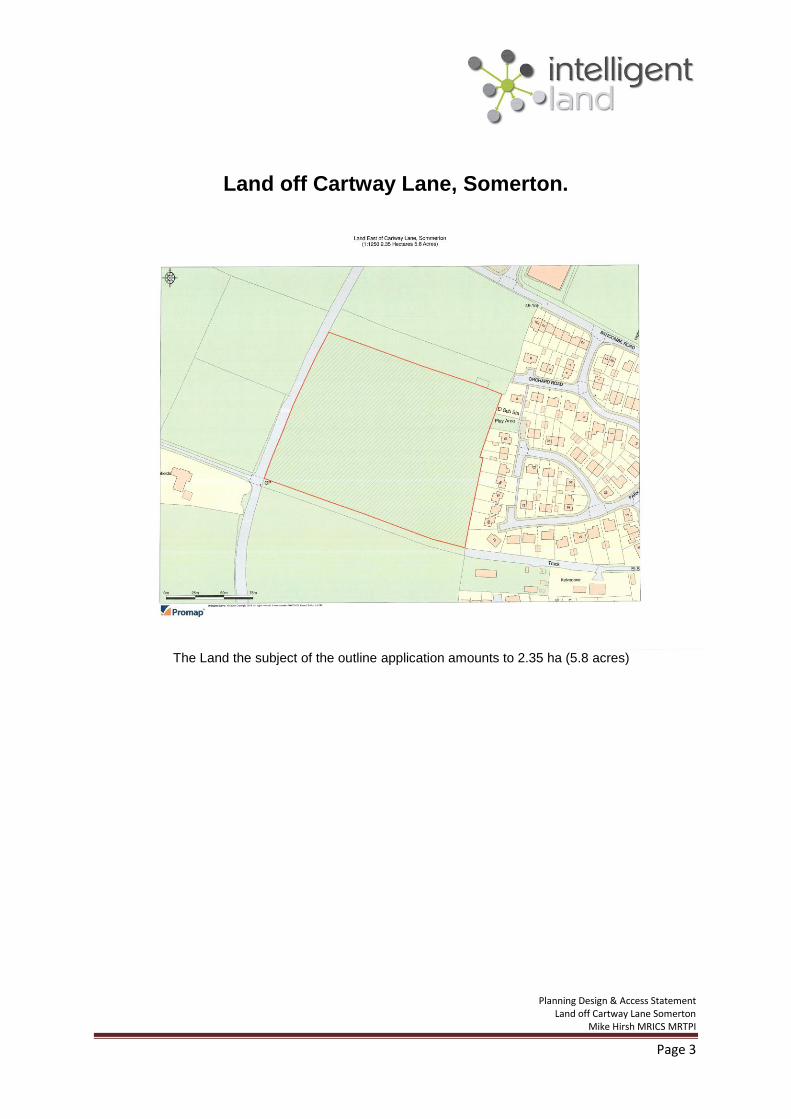
Land off Cartway Lane, Somerton.
The Land the subject of the outline application amounts to 2.35 ha (5.8 acres)
N

Planning Design & Access Statement Land off Cartway Lane Somerton
Mike Hirsh MRICS MRTPI
Page 4
Index
Key Page Number 1.0 Foreword 5
2.0 Executive summary 6
3.0 Introduction 6
4.0 The further evolution of the design process 7
5.0 Access 9
6.0 Planning Policy 10
Index of appendix documents
Appendix 1 : 13-16
Somerton an extract from the South Somerset Local Plan (2006-2028)
Appendix 2: 17 -22
The Evolution of the layout plan
COPYRIGHT All material on these pages, including without limitation text, logos, icons, photographs and all other artwork, is copyright material of Intelligent Land, unless otherwise stated. Use may be made of these pages for non-commercial purposes without permission from the copyright holder. Commercial use of this material may only be made with the express, prior, written permission of Intelligent Land.

Planning Design & Access Statement Land off Cartway Lane Somerton
Mike Hirsh MRICS MRTPI
Page 5
1.0 Foreword
1.1 Design and Access Statements [DAS] first appeared as a regulatory part of the planning submission process in 2006 with the publication of the Circular ‘Guidance on the changes to the development control system.’ This statement includes the mandatory elements required by regulation and responds to the best practice advice provided by the Commission for Architecture and the Built Environment [CABE] in the guide ‘Design and Access Statements How to write, read and use them.’ 1.2 The practical point about a DAS is it should help explain the design thinking behind a proposal and how the development will provide an appropriate legacy and a safe and convenient environment that future occupants and visitors will want to live in and enjoy. DAS ought to demonstrate a consideration of the wider implications, too, in the context of planning policy, particularly where the policy strongly influences the proposed development. 1.3 Planning policy both nationally and locally, through the District Council, provides a framework which makes it clear that developments, which are inappropriate in their context, should be refused. It is therefore fundamental that any proposal, can demonstrate it has emerged from an assessment of the site’s characteristics and has had regard to the landscape and buildings beyond the site in the neighbourhood, together with an appreciation of planning policy. The National Planning Policy Framework (NPPF) provides, at Section 7, guidance on good design and emphasises that developments need to:
Add to the quality of the area
Establish a strong sense of place to create attractive and comfortable places to live,
work and visit
Optimise the potential to accommodate development
Respond to local character and history whilst not preventing innovation
Create safe and accessible environments
Are visually attractive as a result of good architecture and appropriate landscaping.

Planning Design & Access Statement Land off Cartway Lane Somerton
Mike Hirsh MRICS MRTPI
Page 6
2.0 Executive Summary
2.1 This outline application for the development of land off Cartway Lane by up to 60 dwellings demonstrates a design that has evolved as a result of the pre-application process. The principle of development for a residential scheme is supported by the South Somerset Local Plan 2006-28 that was adopted earlier this year. The section on Somerton is set out in full as Appendix 1 together with the inset map (Map 11) showing areas of search. It will be noted that the application site lies within the areas of search. 2.2 The application proposal aspires to meet the extant Council policies and to provide new buildings of excellence in relation to the quality of the accommodation that is to be provided. This will not only be in relation to the layout of the dwellings on the land, but also the sustainable characteristics of the scheme. It will provide a sustainable legacy and meet the Council’s policy of providing 35% affordable housing. 2.3 The key trees, which are all on the perimeter, are able to be retained and there is opportunity to be creative in relation to the new landscape setting to the proposed buildings. 2.4 A series of reports, each focusing on various fundamental matters have been prepared to accompany the application and no reason to resist the development has been identified in this context. 3.0 Introduction 3.1 This Design and Access Statement is concerned with the development of land on the east side of Cartway Lane Somerton. The planning application, which is in outline, is for: The construction of up to 60 dwellings with a new vehicular access from Cartway Lane, associated car parking and open space including the provision of a play area and laying out of an access road. [The maximum height of buildings to be two storeys above existing ground level]. 3.2 The intention is that a pre-requisite of any grant of planning permission will require the applicant and land owner to enter into a Section 106 Agreement under the 1990 Act, as amended, to deal with the contractual matters related to the provision of:
affordable housing
open space and an equipped play area including a capitalised contribution for
equipment in this respect.
improvements to the existing bridleway.
3.3 The site of 2.35 hectares lies in an ‘area of search’ to the west of an established residential area and has a common boundary with dwellings served off Orchard Road and Parklands Way. This ‘area of search’ relates to the policy for Somerton set out in the South Somerset Local Plan 2006-28 which was adopted by the Council earlier this year (please see Appendix 1). This and other policies are further considered at section 6.0 below. 3.4 The site is currently a field down to grass and has a bridleway adjacent on its south side, which has an existing restricted access on to Cartway Lane. This bridleway’s surface will be

Planning Design & Access Statement Land off Cartway Lane Somerton
Mike Hirsh MRICS MRTPI
Page 7
improved and will also be capable of providing an emergency access and preliminary agreement has been reached in this respect with the Highway Authority as well as the reinstatement of a field boundary hedge detail. This bridleway east of the site is already utilised by local residents seeking access to and from the urban area and this sustainable and well-orientated right of way can also be improved at the development’s expense to provide access from the application site as well. 3.5 Since Intelligent Land first became involved with the site and met local residents and Town Councillors the Country has suffered one of the wettest winters on record. Part of the reason for the delay in this submission was to engage with Wessex Water so that a study could be instigated about the local flooding near the site that took place, largely through surface water entering the foul water system. The proposals for the development take this potential for surface water infiltration into the foul system into account and off-site works are proposed to up-size existing pipework. This has been incorporated into the flood risk assessment report. This detail together with the supporting information concerning bio-diversity, landscape, highways and travel are set out in the following sister documents:
Flood Risk Assessment by Eric Woodgate Associates
Appraisal of Landscape and visual effects by Pegasus Planning Group
Framework Travel Plan by Eric Woodgate Associates
Transport Statement by Eric Woodgate Associates
Ecological Assessment by Ecosupport Ltd
Tree Constraints Plan by KJF Consultancy Ltd
The land is classified as Grade 3 Agricultural Land so there is no justification for its retention in its current use. There is also no indication on the ground, from aerial photographs or other background information that there is a need to investigate archeology and there is no scheduled heritage asset in the immediate vicinity. 3.6 It is not the intention to review each of these documents here. What can be learned by reading through these reports, in addition to the technical matters concerning flood risk and their resolution, is that there is traffic capacity on the local road network, there is no bar due to the existence or protected species or habitats and that any significant trees are on the site perimeter; further the scheme will not impose significantly on the wider landscape. The unequivocal conclusion arrived at, having regard to these reports, is that there is no constraint that would warrant the refusal of permission. The site is a sensible location to build more housing. 4.0 The further evolution of the design process 4.1 The public and the Town Council were first consulted about the principle of development here against a layout showing two access points on to Cartway Lane in April 2013.The layout (Drwng Ref: 800 -105) showed some 79 units and the plan is at Appendix 2. It showed some housing backing on to the dwellings to the east in Orchard Road and Parklands Way, a smaller area of open space and acess to the existing bridleway was more circuitous than is now suggested. 4.2 The feedback from the propsals fell into two. There were those concerned about the principle of the development and its prematurity ahead of the Local Plan and then others more concerned about the spatial relationship of the scheme both in itself and in relation to the existing development and the finer details such as the external finishes.

Planning Design & Access Statement Land off Cartway Lane Somerton
Mike Hirsh MRICS MRTPI
Page 8
4.3 Physically the scheme has gone through a number of iterations and these plans together with that now submitted are in Appendix 2. The informal Council officer advice, arising from the earlier scheme, had been the need to increase and alter the position and provision of open space and allow for an equipped play space. In turn the equipped play space needs to be overlooked by dwellings to provide enhanced security for children at play. The badger sett to the north east requires a no build area and easy access for foraging to be maintained. 4.4 The land drainage advice is that part of the site can utilise soakaways, but there will need to be some on site attenuation where soakaway tests have failed. In turn discussion with Council officers has identifed the need that such attentuation in the form of balancing ponds should successfully meld into the new landscape as ponds shallow enough to avoid being a hazard, or being unsightly. 4.5 The principle of reinforcing the scheme with good new landscape has been carefully considered too. 4.6 Overall there has been a reduction in the numbers for the scheme from 79 to 60 dwelling units during the pre-application process. This amount of housing is considered acceptable. 4.7 Whilst the design of individual buildings is not provided at this stage, it was made clear
from the outset that the prevailing external materials, based on the local stone would be
preferable, matched to traditional roofing. A vision of the housing showing a likely street
scene has been prepared in support of the application.
Proposed vision perspective prepared by Scott Worsfold Architects Dwg No 13-840-107-sk
4.8 The signifcant separation distances between the existing and new housing is such that problems of over-looking, loss of light or other substantial impact matters will not occur. The rear boundaries of the dwellings that back on to the east of the site have a variety of physical

Planning Design & Access Statement Land off Cartway Lane Somerton
Mike Hirsh MRICS MRTPI
Page 9
forms but hedges predominate. In the envisaged scheme these boundaries will be placed in a landscape setting and will have open space adjacent. 5.0 Access 5.1 The site is in a sustainable location within walking distance of the Town Centre and local bus routes on the adjacent road network. It is also within walking distance of the local industrial estate. It has the advantage of the bridleway access along the south boundary running east/west giving access to the Town, largely segregated from vehicles. 5.2 The main access to Cartway Lane has been designed to reflect the current accepted safe design for such an access. The enhancement of the bridleway along the south boundary of the site will be utilising a surface both appropriate for horses and pedestrians.
Houses backing on to the site showing boundary detail
5.3 It is the intention that the internal access road will be constructed to adoptable highway requirements and the private drives and pedestrian ways leading to groups or individual dwellings will be at a gradient and in materials that will facilitate the widest possiblities for access in accordance with best practice guidance. 5.4 Car parking is shown to be provided in accordance with the Council’s current standards and in most instances within curtilages. 5.5 The design of access within dwellings is not part of the current consideration, but will reflect the building regulations at the time, in relation to meeting the requirements for disabled persons access.

Planning Design & Access Statement Land off Cartway Lane Somerton
Mike Hirsh MRICS MRTPI
Page 10
6.0 Planning Policy 6.1 Planning law by virtue of Section 38(6) of the Planning and Compulsory Purchase Act 2004 and Section 70(2) of the Town and Country Planning Act 1990 requires that applications for planning permission must be determined in accordance with the development plan, unless material considerations indicate otherwise. 6.2 The adoption by South Somerset District Council of the core strategy document South Somerset Local Plan (2006-2028) [SSLP] simplifes the Council’s position. Any application for development will need to be considered against Policy EQ2 which is a criteria based policy and which advises: Development will be designed to achieve a high quality, which promotes South Somerset’s local distinctiveness and preserves or enhances the character and appearance of the district. Development proposals, extensions and alterations to existing buildings, structures and places will be considered against:
;
advice and guidance; and
Innovative designs delivering low energy usage and/or wastage will be encouraged. Development must not risk the integrity of internationally, nationally or locally designated wildlife and landscape sites. Development proposals should protect the residential amenity of neighbouring properties and new dwellings should provide acceptable residential amenity space in accordance with Policy HW1 This application, it is suggested, complies with these criteria. 6.3 In relation to the extension of the existing residential area of Somerton, the SSLP simplifies the previous position in that which Policy LMT3 advises:
The direction of growth at Somerton will be to the west of the town.

Planning Design & Access Statement Land off Cartway Lane Somerton
Mike Hirsh MRICS MRTPI
Page 11
In the text of the chapter on Somerton reproduced at Appendix 1 it advises that at least around 374 dwellings should be built in the town over the local plan period. Given the nature of this wording it is clear that the proposal complies with this up-to-date plan in this respect. 6.4 The provision of affordable housing is considered in the SSPL between paragraphs 10.16 and 10.34. Policy HG3 advises that: Planning permission for the erection of new dwellings will be permitted provided that, where it is viable to do so, the scheme provides affordable housing and then sets criteria, which for Primary Market Towns (such as Somerton) is a target of 35% on a site such as this. The application is intended to comply with this policy and the offer to incorporate requirements into a S106 Agreement is part of this application submission. 6.5 In addition to these key policies the SSLP considers a range of practical impact and policy matters. Some of these are further considered in the sister reports accompanying this application. For example Policy TA5 requires that all new development shall be required to address its own transport implications and this is reflected in the Travel Plan and Highway assessment submissions. The submission also seeks to comply with Policy TA6 which advises that: Parking provision in new development should be design-led and based upon site characteristics, location and accessibility. The parking standards within the Somerset County Council Parking Strategy will be applied in South Somerset. 6.6 Policy HW1 provides the framework for the provision of open space and outdoor equipped play provision which has led to the proposed layout with significant open space as part of the scheme. 6.7 Policy EQ4 on biodiversity reflects National policy and has led to the Biodiversity Appraisal submitted with the application and the arising advice. 6.8 Nationally the guidance is provided by the National Planning Policy Framework 2012. This document recognises and makes it plain that its policy base is secondary to up to date local plans. It is not, therfore intended to dwell on this document in the context of the current submission. However, it has to be noted that Section 6 of the NPPF is concerned with the need to boost significantly the supply of housing and indeed this is now being pursued by the new Government in reflecting a manifesto pledge to provide a ‘clear focus on housing.’ At paragrapgh 49 it is advised that : ‘Housing applications should be considered in the context of the presumptin of sustainable development.’ It is plain that this site is sustainable and there is therefore a presumption that it should be considered positively.

Planning Design & Access Statement Land off Cartway Lane Somerton
Mike Hirsh MRICS MRTPI
Page 12
Appendices

Planning Design & Access Statement Land off Cartway Lane Somerton
Mike Hirsh MRICS MRTPI
Page 13
Appendix 1
Local Market Towns – Somerton Spatial Portrait 7.137 Somerton is a market town dating back over 1,000 years, with an important history including being the centre of a major royal estate in the 10th century and briefly serving as the county town of Somerset. The town has held a weekly market since the Middle Ages and long prospered as an agricultural centre and an attachment to local estates, reflected by the many fine 17th and 18th century houses in the town centre.
Somerton Buttercross 7.138 Today, Somerton is one of the larger settlements in South Somerset with a population of 4,274 people. It is a relatively compact settlement, set above the Cary valley with the core of the town concentrated upon the market place and church. The town centre and an area to the east of the town is designated as a Conservation Area. Recent residential growth has spread to the west of the town centre, and the main employment area is the Bancombe Road Trading Estate to the north west of the town. 7.139 Somerton is located in a rural setting and, alongside nearby Langport/Huish Episcopi and Street in Mendip District, is important in serving the needs of residents in the rural north of South Somerset. In terms of retail, Somerton has a reasonably healthy, well-kept and attractive town centre with a range of independent stores including a small supermarket and specialist food stores that meet the day to day needs of local residents. Some of the other key services in Somerton are a library, doctor's surgery, banks, and primary and junior schools. 7.140 Public transport to the larger settlements of Yeovil, Taunton and Street is relatively good with a regular bus service, although links to other parts of the district are poor. A national cycle route passes through the town. However, based upon 2001 Census data, it would indicate that self-containment is relatively low with over 60% of Somerton residents travelling to work elsewhere, mainly to locations in Mendip District and Yeovil. 7.141 Some of the key environmental issues at Somerton include areas of high flood risk to the north, east and south of the town; a high quality historic environment; and the presence of protected species near the town.
Local Aspirations 7.142 Somerton Town Council updated its Community Plan in 2011, which describes how local people would like to see the town evolve in the next 5-10 years. The key areas for improving the town are set out in a series of 'project plans' that include broadening the range of cultural amenities, open space, sports and leisure facilities; attracting new businesses to the town; and producing a shared vision of how the people of Somerton would like their town to develop in the future.

Planning Design & Access Statement Land off Cartway Lane Somerton
Mike Hirsh MRICS MRTPI
Page 14
What Will The Local Plan Deliver? Settlement Status 7.143 As set out in Policy SS1, Somerton is classified as a 'Market Town' due to the settlement having a strong employment, retail and community role. Given its relatively smaller scale and nature compared to some of the larger Market Towns, Somerton is identified as a Local Market Town (alongside Langport/Huish Episcopi and Ansford/Castle Cary) with a reduced scale of growth to match. 7.144 It is important to sustain and enhance Somerton's role as a Market Town in the rural north of the district, with a level of development that is relative to the size, accessibility, character and environmental constraints of the town. Therefore, at least round 374 dwellings should be built in the town over the local plan period. As shown in Table 1, the 286 dwellings have already been committed, albeit with only a small number of completions (2 dwellings) in the first years of the local plan period. Based upon the commitments there is a residual housing requirement of 88 dwellings. A 'direction of growth' to identify a broad location to accommodate new development on the edge of the town is required, as explained below.
Employment 7.145 As set out in Policy SS3, a total of 6.63ha of employment land should be delivered in Somerton over the local plan period. 1.56ha of this has already been provided, leaving 5.07ha still to be found, primarily within the direction of growth. This should provide a total of 307 jobs in Somerton to provide the opportunity for residents to both live and work in the town.
Retail 7.146 Regarding new retail development, the ability to increase the amount of comparison goods floorspace at Somerton will be constrained by its size, natural catchment area, and level of commercial market interest.141 Somerton is orientated towards a top-up food shopping function and, in principle, it would be beneficial to increase the level of retention of main/bulk-food shopping trips. However, like the comparison retail sector, the natural catchment and expenditure capacity of the town will limit the potential for large scale additional convenience goods provision; such proposals would also cause concerns over the impact on existing retail provision in the town. Therefore, for both convenience and comparison retailing, a general strategic approach is recommended for Somerton that acknowledges the need to retain shopping trips within the town and supports proposals that increase this retention.
7.147 The town centre has a delicate balance of shops, including a small supermarket, and is therefore considered vulnerable to potential out of centre retail development. It is considered appropriate to require a local retail impact assessment for retail proposals greater than a threshold of 250 sq m for Somerton given the scale and nature of the town.
Infrastructure 7.148 The Infrastructure Delivery Plan identifies several infrastructure issues that are considered 'necessary' to provide as a result of new development at Somerton, which generally relate to open space and sports facilities. A replacement for the surgery is specifically identified, and this is being pursued with other development.

Planning Design & Access Statement Land off Cartway Lane Somerton
Mike Hirsh MRICS MRTPI
Page 15
Direction of Growth 7.149 To accommodate the proposed level of housing and employment development at Somerton, a 'direction of growth' has been identified to the west of the town. This direction of growth has been identified from evidence in the Sustainability Appraisal and the potential deliverability of sites for development. 7.150 Development to the north-west section of the Direction of Growth would potentially lead to flooding problems, which will need to be addressed through the use of Sustainable Drainage Systems (SuDS). The costs of this infrastructure are not considered to be 'showstoppers' to new development in the town.
POLICY LMT3: SOMERTON DIRECTION OF GROWTH
The direction of growth at Somerton will be to the west of the town.
Delivery 7.151 The following delivery bodies will be key in implementing the proposed development at Somerton:
South Somerset District Council;
Town and Parish Councils;
Developers and Landowners; and
NHS South West / Clinical Commissioning Group.
Monitoring Indicators
Target
Net additional dwellings in Somerton
374 dwellings built at Somerton between 2006 and 2028
Additional employment ('B' uses) floor space in Somerton
4.9 ha of 'B' use employment land made available in Somerton between 2006 and 2028

Planning Design & Access Statement Land off Cartway Lane Somerton
Mike Hirsh MRICS MRTPI
Page 16
____�_______ 4_ Somerton Inset Map 11 (Adopted 2015) Somerset Local Plan 2006 – 28 The direction of travel is indicated by the brown dashed lines to the west of the settlement. It will be noted that the application site lies within this area of search.

Planning Design & Access Statement Land off Cartway Lane Somerton
Mike Hirsh MRICS MRTPI
Page 17
Appendix 2
The evolution of the layout plan

Planning Design & Access Statement Land off Cartway Lane Somerton
Mike Hirsh MRICS MRTPI
Page 18
April 2013
Public Consultation draft plan

Planning Design & Access Statement Land off Cartway Lane Somerton
Mike Hirsh MRICS MRTPI
Page 19
Plan absorbing bridleway into the scheme December 2013

Planning Design & Access Statement Land off Cartway Lane Somerton
Mike Hirsh MRICS MRTPI
Page 20
Informal discussion plan showing a single point of access September 2014
Planning Design & Access Statement Land off Cartway Lane Somerton
Mike Hirsh MRICS MRTPI
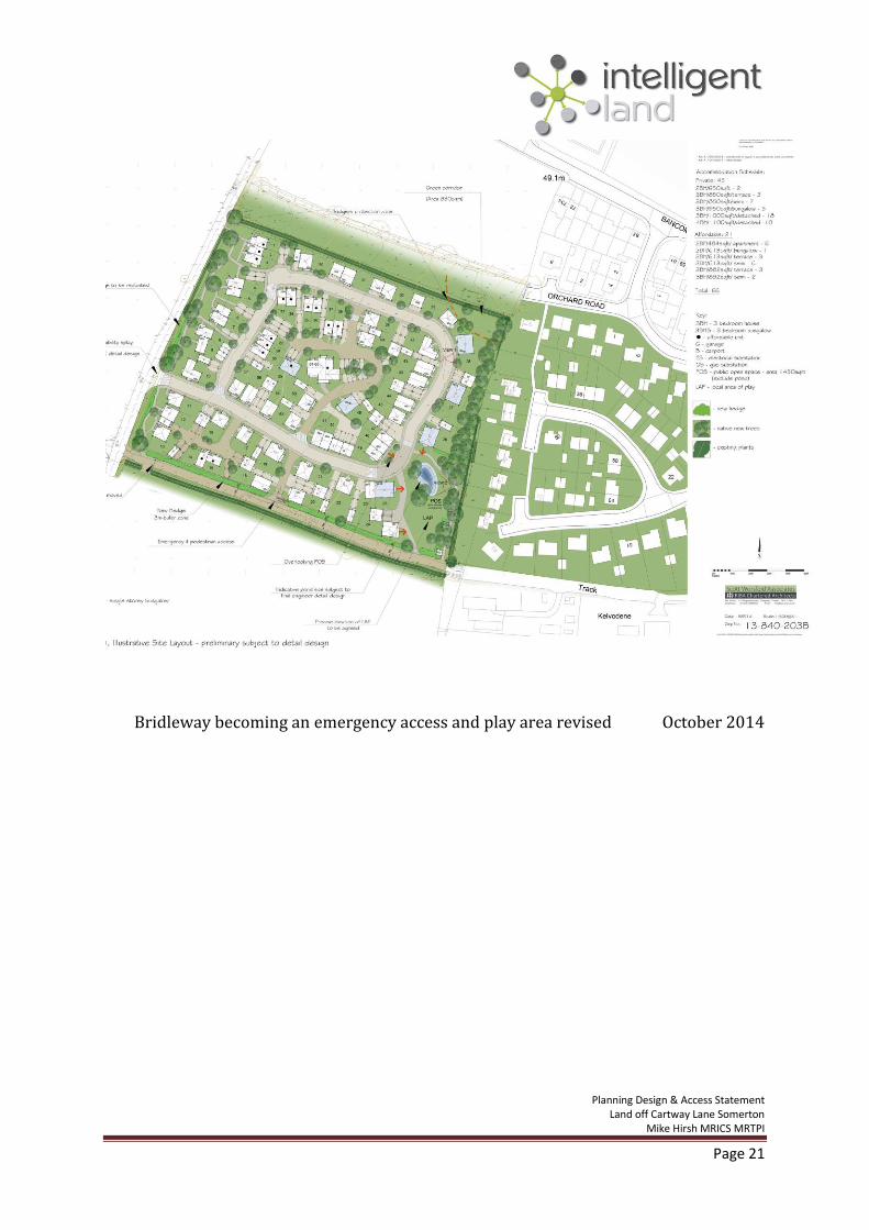
Page 21
Bridleway becoming an emergency access and play area revised October 2014

Planning Design & Access Statement Land off Cartway Lane Somerton
Mike Hirsh MRICS MRTPI
Page 22
July 2015 Planning Application submission
![General arrangement drawing - South Somersetcip.southsomerset.gov.uk/Planning/StreamDocPage/obj.pdf?DocNo=... · Waind Gohil Architects’ [WGA] General Arrangement drawings [GA],](https://static.fdocuments.in/doc/165x107/5ada8c9f7f8b9a6d318cea32/general-arrangement-drawing-south-gohil-architects-wga-general-arrangement.jpg)