Location Planning Capacity Planning and Layout Planning Module IV.

12
th Esri India User Conference 2011
PLANNING AND DESIGN OF RESIDENTIAL LAYOUT USING GIS
Venugopal T V, Prakash P S
Harkirat Singh, Shivanad P N.
(under the guidance of V ANANTHARAMA
Abstract:
Many residential townships are being developed
across the country for providing housing facilities to ever
growing population. This project is an attempt to plan and
design the layout according to bylaws and regulations of
the governing authority (BDA/BMRDA) using Geographic
information system (GIS), Global positioning system (GPS)
for which ARC GIS 9.3 and ERDAS Imagine9.1 have been
made use of. The main objective is to apply GIS in various
stages of the project including
1. Feasibility studies
2. Governmental approvals – environmental impact
assessment
3. Scientific planning and design of various
infrastructures of the layout like the
� Residential units
� Commercial units
� Water supply lines
� Sewerage lines
� Roads networks
� Rain water harvesting units
4. Marketing of the project.
The other objective is to create Triangular Irregular
Network (TIN) using Total Station data and Google earth
data, compare the result and investigate the possibility of
reducing and/or eliminating ground survey. Using TIN,
Digital Elevation Data (DEM) is created to develop the
ground surface profile to calculate the formation levels of
roads, sewerage lines, and plinth levels of the individual
houses so as to provide the proper slope for draining out
the used water as per IS1172:1993. Additionally we render
the entire layout in 3D and create a data base management
system which will be useful to engineer, customer and the
government.
Thus our project shows that GIS can greatly enhance
the process of planning and design of an efficient and a
sustainable residential settlement.
Page 1 of 8
PLANNING AND DESIGN OF RESIDENTIAL LAYOUT USING GIS
Venugopal T V, Prakash P S,
Harkirat Singh, Shivanad P N.
RVCE, Bangalore
ANANTHARAMA,
Asst.professor, Department of Civil Engineering, RVCE)
Many residential townships are being developed
across the country for providing housing facilities to ever
growing population. This project is an attempt to plan and
nd regulations of
the governing authority (BDA/BMRDA) using Geographic
information system (GIS), Global positioning system (GPS)
for which ARC GIS 9.3 and ERDAS Imagine9.1 have been
The main objective is to apply GIS in various
environmental impact
planning and design of various
infrastructures of the layout like the
The other objective is to create Triangular Irregular
Network (TIN) using Total Station data and Google earth
data, compare the result and investigate the possibility of
cing and/or eliminating ground survey. Using TIN,
Digital Elevation Data (DEM) is created to develop the
ground surface profile to calculate the formation levels of
roads, sewerage lines, and plinth levels of the individual
er slope for draining out
Additionally we render
the entire layout in 3D and create a data base management
system which will be useful to engineer, customer and the
greatly enhance
the process of planning and design of an efficient and a
About the Authors:
MR Venugopal T.V (B.E. civil),
Email:[email protected]
Mobile:+91-9740294275
Prakash P S (B.E. Civil)
Email:[email protected]
Mobile:+91-9632251095
We are presently doing our masters in
Geo informatics from KSRSAC, Bangalore.
We have completed our under graduation in Civil
engineering from RVCE, Bangalore.
Our GIS projects include,
Planning And Design Of Residential
Using GIS. This project was selected as
Technological University‘s (VTU
engineering project. This project also won “most
innovative project award “ conducted by
Entrepreneurship cell of RV college
Earlier Worked on a project aimed at
providing Optimized feeder bus routes to the
Banglore Metro Rail corporation limited (BMRCL)
using GIS .Our project was highly appreciated by
BMTC and was also published in the newspaper.
Finalist in the national level competition
designing a metro rail system,
Kharagpur. We were among the final 10 teams out
of the 300 odd teams that participated. We
the only team in the country to make use of GIS for
PLANNING AND DESIGN OF RESIDENTIAL LAYOUT USING GIS
masters in
Bangalore.
under graduation in Civil
from RVCE, Bangalore.
Planning And Design Of Residential Layout
. This project was selected as Visvesvaraya
(VTU) best civil
engineering project. This project also won “most
innovative project award “ conducted by
Entrepreneurship cell of RV college
ked on a project aimed at
providing Optimized feeder bus routes to the
Banglore Metro Rail corporation limited (BMRCL)
using GIS .Our project was highly appreciated by
BMTC and was also published in the newspaper.
el competition for
conducted by IIT
We were among the final 10 teams out
of the 300 odd teams that participated. We were
only team in the country to make use of GIS for

12
th Esri India User Conference 2011
Introduction: We come across a number of private property developers,
community. Many a times the main criteria
maximum amount of area under commercial utilization. This being the case
communities” to be well planned, self sustainable
consumers. Thus we wanted to bring a sc
Page 2 of 8
number of private property developers, who are selling sites based on the concept of
criteria on which the site planning is done is on the sole intension of
maximum amount of area under commercial utilization. This being the case one cannot
self sustainable and good enough to provide all the adequate
Thus we wanted to bring a scientific, methodical approach to planning, designing and marketing of these
this event.
who are selling sites based on the concept of gated
on which the site planning is done is on the sole intension of getting
one cannot expect these “gated
adequate facilities to the
and marketing of these
12
th Esri India User Conference 2011
living spaces (‘gated communities’) by using
engineer, government and the customer are benefitted and
sustainable residential spaces.
Objectives:
1. To study the necessary approvals and to design
2. Creation of a database associated with the
the stakeholders of the project (investor,government,
3. Create Triangular Irregular Network (TIN) of the area using Total Station an
4. To design
o Water supply system.
o Sewerage system.
To map the above two systems along with
5. To render the entire layout in 3D using GIS tool
Methodology:
1. The land for the proposed layout was surveyed using t
2. Image procurement and Rectification -
downloader software by specifying the extent
process by which and image or grid is converted form
o Projected Coordinate System
o UTM, WGS 1984
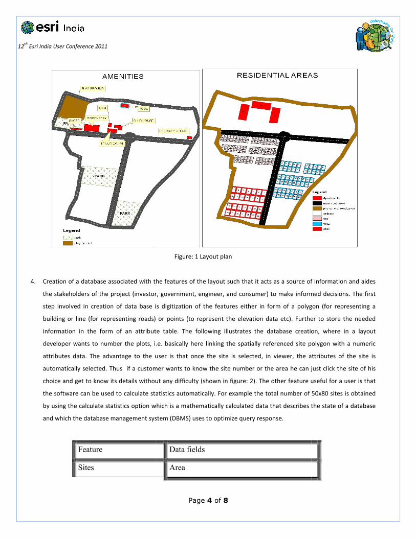
3. Planning of the layout amenities and digitizing
provision of other amenities of the layout such as main roads, arterial roads, parks and public facilities using
Arc GIS (Fig 1). The planning of the layout is carried o
which the planning of these amenities were carried out are listed
o There must be adequate space for
� Residential area
� Commercial area
� Recreational area
o Must be according to by- laws
o Planning must takes care of environmental considerations
o All necessary engineering aspect (including slope, aspect etc)
o Planning should be such that Resources are optimally used.
o The public space must be located away from the
o Easy access for all people to all amenities provided.
Page 3 of 8
by using GIS such that all stake holders of a such a project
government and the customer are benefitted and act as partners in the creation of a well
essary approvals and to design the residential layout according to the government
Creation of a database associated with the features of the layout such that it acts as a source of information and aide
,government,engineer,consumer,) to make informed decisions
Create Triangular Irregular Network (TIN) of the area using Total Station and Google earth data and compare the results
with creation of attribute database.
To render the entire layout in 3D using GIS tools.
surveyed using total station and this data was imported into the
The satellite imagery of the required area was procured
extents of the area in terms of latitude and longitude. Rectification
is converted form image coordinated to real-world coordinate
digitizing- The whole area was divided into plots of various sizes along with
other amenities of the layout such as main roads, arterial roads, parks and public facilities using
The planning of the layout is carried out as per the guidelines of local authorities.
which the planning of these amenities were carried out are listed as follows
There must be adequate space for
Planning must takes care of environmental considerations.
All necessary engineering aspect (including slope, aspect etc) must be considered.
Planning should be such that Resources are optimally used.
The public space must be located away from the residential area.
Easy access for all people to all amenities provided.
namely the developer,
act as partners in the creation of a well planned and
government bylaws.
rce of information and aides
to make informed decisions.
and compare the results
imported into the Arc GIS.
was procured using google earth
Rectification, (i.e. is the
coordinates) was done by using
The whole area was divided into plots of various sizes along with
other amenities of the layout such as main roads, arterial roads, parks and public facilities using CADD and
ut as per the guidelines of local authorities. The guiding criteria on
12
th Esri India User Conference 2011
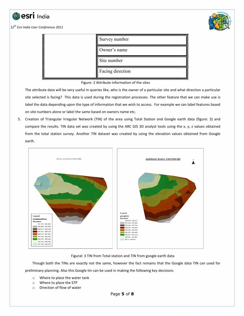
4. Creation of a database associated with the features of the layout such that it acts as a source of information and aides
the stakeholders of the project (investor
step involved in creation of data base is digitization of the features either in form of a polygon (for representing a
building or line (for representing roads) or points (to
information in the form of an attribute table. The following illustrates the database creation, where in a layout
developer wants to number the plots, i.e.
attributes data. The advantage to the user is that once the site is selected
automatically selected. Thus if a customer wants to know the
choice and get to know its details without any difficulty
the software can be used to calculate statistics automatically. For examp
by using the calculate statistics option which is a
and which the database management system (DBMS) uses to optimize query response.
Feature
Sites
Page 4 of 8
Figure: 1 Layout plan
Creation of a database associated with the features of the layout such that it acts as a source of information and aides
vestor, government, engineer, and consumer) to make informed decisions.
step involved in creation of data base is digitization of the features either in form of a polygon (for representing a
building or line (for representing roads) or points (to represent the elevation data etc). Further
information in the form of an attribute table. The following illustrates the database creation, where in a layout
er wants to number the plots, i.e. basically here linking the spatially referenced site polygon with a numeric
The advantage to the user is that once the site is selected, in viewer, the attributes of the site is
automatically selected. Thus if a customer wants to know the site number or the area he can just click the site of his
get to know its details without any difficulty (shown in figure: 2). The other feature useful for a user is that
the software can be used to calculate statistics automatically. For example the total number of 50x80 sites is obtained
by using the calculate statistics option which is a mathematically calculated data that describes the state of a database
and which the database management system (DBMS) uses to optimize query response.
Data fields
Area
Creation of a database associated with the features of the layout such that it acts as a source of information and aides
make informed decisions. The first
step involved in creation of data base is digitization of the features either in form of a polygon (for representing a
Further to store the needed
information in the form of an attribute table. The following illustrates the database creation, where in a layout
basically here linking the spatially referenced site polygon with a numeric
the attributes of the site is
site number or the area he can just click the site of his
. The other feature useful for a user is that
le the total number of 50x80 sites is obtained
mathematically calculated data that describes the state of a database
12
th Esri India User Conference 2011
Figure: 2
The attribute data will be very useful in queries
site selected is facing? This data is used during the registration processes. The other feature that we can make use is
label the data depending upon the type of information that we wish to access
on site numbers alone or label the same base
5. Creation of Triangular Irregular Network (TIN) of the area using Total Station and Google earth data
compare the results. TIN data set was created by using the ARC
from the total station survey. Another TIN dataset was created by using the elevation values obtained from
earth.
Figural: 3 TIN from Total station and TIN
Though both the TINs are exactly not the same, however the fact remains that the Google
preliminary planning. Also this Google tin can be used in making the following key decisions
o Where to place the water tank
o Where to place the STP
o Direction of flow of water
Page 5 of 8
Survey number
Owner’s name
Site number
Facing direction
igure: 2 Attribute information of the sites
queries like, who is the owner of a particular site and what direction a
This data is used during the registration processes. The other feature that we can make use is
label the data depending upon the type of information that we wish to access. For example we can label features based
ite numbers alone or label the same based on owners name etc.
Triangular Irregular Network (TIN) of the area using Total Station and Google earth data
TIN data set was created by using the ARC GIS 3D analyst tools using the x
TIN dataset was created by using the elevation values obtained from
Figural: 3 TIN from Total station and TIN from google earth data
s are exactly not the same, however the fact remains that the Google
preliminary planning. Also this Google tin can be used in making the following key decisions
hat direction a particular
This data is used during the registration processes. The other feature that we can make use is
For example we can label features based
Triangular Irregular Network (TIN) of the area using Total Station and Google earth data (figure: 3) and
the x, y, z values obtained
TIN dataset was created by using the elevation values obtained from Google
s are exactly not the same, however the fact remains that the Google data TIN can used for

12
th Esri India User Conference 2011
Finally a land developer may take the help of Google TIN
i.e. without even doing any survey the developer can first get an idea of the terrain and then depending upon the
feasibly aspects he can decide to buy or not. It can also helps in saving the huge amount of money to spend in conduct
the survey before planning.
6. Referring to the codal provisions the various necessities like water supply, sewerage system of the residential lay
was designed according to civil engineering practices.
the land ,distance, position of the various amenities of the layout .These inputs were used in the form of different layers
of data such as DEM data (using ERDAS 9.1)
layer containing the details of the position of Sewerage treatment
and by using various civil engineering methodologies
equation) the position of the water lines and their diameter were fixed and then mapped along with their attribute
values. The water supply and sewer lines for layout is shown in figure: 4.
Figure: 4 Water supply and sewer lines for proposed residential layout
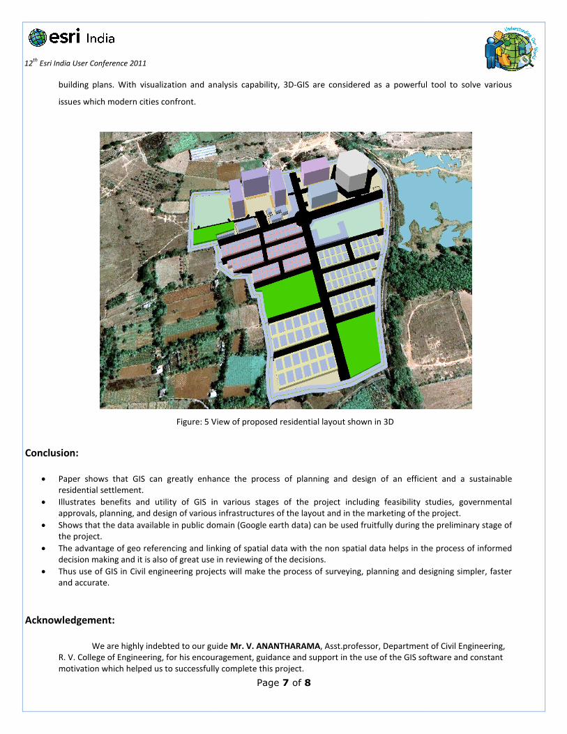
7. The entire layout was rendered into 3D along with other a
figure: 5) Arc Scene is a map display program customized for displaying 3D data. This application enables users to
visualize complicated urban planning information in 3D way, to evaluate allowable capacity of block and to simulate
Page 6 of 8
may take the help of Google TIN in deciding whether to buy a particular property or not.
without even doing any survey the developer can first get an idea of the terrain and then depending upon the
r not. It can also helps in saving the huge amount of money to spend in conduct
Referring to the codal provisions the various necessities like water supply, sewerage system of the residential lay
according to civil engineering practices. Designing of these features required inputs such as the slope of
of the various amenities of the layout .These inputs were used in the form of different layers
(using ERDAS 9.1) for slope input, shape files containing the location of the sites, another
layer containing the details of the position of Sewerage treatment plant, water tank etc were overlapped on each other
methodologies (i.e. calculation and use of fixture units, use
water lines and their diameter were fixed and then mapped along with their attribute
lines for layout is shown in figure: 4.
: 4 Water supply and sewer lines for proposed residential layout
into 3D along with other amenities like parks, roads etc using ARC Scene
is a map display program customized for displaying 3D data. This application enables users to
visualize complicated urban planning information in 3D way, to evaluate allowable capacity of block and to simulate
in deciding whether to buy a particular property or not.
without even doing any survey the developer can first get an idea of the terrain and then depending upon the
r not. It can also helps in saving the huge amount of money to spend in conduct
Referring to the codal provisions the various necessities like water supply, sewerage system of the residential layout
Designing of these features required inputs such as the slope of
of the various amenities of the layout .These inputs were used in the form of different layers
containing the location of the sites, another
tank etc were overlapped on each other
units, use of hazen willam
water lines and their diameter were fixed and then mapped along with their attribute
menities like parks, roads etc using ARC Scene (as shown in
is a map display program customized for displaying 3D data. This application enables users to
visualize complicated urban planning information in 3D way, to evaluate allowable capacity of block and to simulate
12
th Esri India User Conference 2011
building plans. With visualization and analys
issues which modern cities confront.
Figure: 5 V
Conclusion:
• Paper shows that GIS can greatly enhance the process of planning and design of an efficient and a sustainable
residential settlement.
• Illustrates benefits and utility of GIS in various stages of the project including feasibility studies, governmental
approvals, planning, and design of various infrastructures of the layout and in the marketing of the project.
• Shows that the data available in public domain (Google earth data) can be used fruitfully during the preliminary stage of
the project.
• The advantage of geo referencing and linking of spatial data with the non spatial data helps in the process of informed
decision making and it is also of great use in reviewing of the decisions.
• Thus use of GIS in Civil engineering projects will make the process of surveying,
and accurate.
Acknowledgement:
We are highly indebted to our guide
R. V. College of Engineering, for his encouragement, guidance
motivation which helped us to successfully complete this project.
Page 7 of 8
building plans. With visualization and analysis capability, 3D-GIS are considered as a powerful tool to solve various
Figure: 5 View of proposed residential layout shown in 3D
shows that GIS can greatly enhance the process of planning and design of an efficient and a sustainable
utility of GIS in various stages of the project including feasibility studies, governmental
of various infrastructures of the layout and in the marketing of the project.
available in public domain (Google earth data) can be used fruitfully during the preliminary stage of
referencing and linking of spatial data with the non spatial data helps in the process of informed
decision making and it is also of great use in reviewing of the decisions.
ivil engineering projects will make the process of surveying, planning and designing simpler, faster
We are highly indebted to our guide Mr. V. ANANTHARAMA, Asst.professor, Department of Civil Engineering,
R. V. College of Engineering, for his encouragement, guidance and support in the use of the GIS software and constant
motivation which helped us to successfully complete this project.
GIS are considered as a powerful tool to solve various
shows that GIS can greatly enhance the process of planning and design of an efficient and a sustainable
utility of GIS in various stages of the project including feasibility studies, governmental
of various infrastructures of the layout and in the marketing of the project.
available in public domain (Google earth data) can be used fruitfully during the preliminary stage of
referencing and linking of spatial data with the non spatial data helps in the process of informed
planning and designing simpler, faster
, Asst.professor, Department of Civil Engineering,
in the use of the GIS software and constant
12
th Esri India User Conference 2011
We would also like to express our gratefulness towards all the faculty
Department and management of R. V. College of
References:
1. Matt Freeman ‘Singapore Masters Land-Use Planning Using GIS
2. ESRI, white papers and product documentation.
3. Dr B C Punmia, Ashok Kr Jain and Arum Kr Jain
edition,[2007].
4. Lilles, Thomas m Kiefer, Ralph W, Remote Sensing and Image Interpretation, John Wiley and Sons, Inc. New York, 4
Edition, [2002].
5. Burrough, P A, Principles of Geographic Information System, Oxford Publication, [1986].
6. Satheesh Gopi, R. Sathikumar and N. Madhu, “Advanced Surveying” Total Station, GIS and Remote Sensing, Pearson
Education,[2008]
7. Dr B C Punmia, Ashok Kr Jain and Arum Kr Jain
edition,[2007].
8. 1172:1993 Indian Standard code of basic requirements for water supply, drainage and sanitation [Fourth Revision]
9. Anekal planning authority –By laws.
Page 8 of 8
We would also like to express our gratefulness towards all the faculty members, head of
College of Engineering, Bangalore.
Use Planning Using GIS’, Arc Watch, December [2009]
papers and product documentation.
Kr Jain ‘Water Supply Engineering ’, Laxmi Publications Pvt Ltd , 2
Lilles, Thomas m Kiefer, Ralph W, Remote Sensing and Image Interpretation, John Wiley and Sons, Inc. New York, 4
Burrough, P A, Principles of Geographic Information System, Oxford Publication, [1986].
. Madhu, “Advanced Surveying” Total Station, GIS and Remote Sensing, Pearson
Kr Jain ‘Waste Water Engineering ’, Laxmi Publications Pvt Ltd , 2
1172:1993 Indian Standard code of basic requirements for water supply, drainage and sanitation [Fourth Revision]
of the civil engineering
‘Water Supply Engineering ’, Laxmi Publications Pvt Ltd , 2nd
Lilles, Thomas m Kiefer, Ralph W, Remote Sensing and Image Interpretation, John Wiley and Sons, Inc. New York, 4th
. Madhu, “Advanced Surveying” Total Station, GIS and Remote Sensing, Pearson
‘Waste Water Engineering ’, Laxmi Publications Pvt Ltd , 2nd
1172:1993 Indian Standard code of basic requirements for water supply, drainage and sanitation [Fourth Revision]