
Using dendrochronology methodologies to reconstruct glacial activities

Place Names and HistoryThe 1st Regional Training Program in Toponymy
including Marine ToponymyManila, 19—24 March 2018
United Nations Group of Experts on Geographical Names (UNGEGN)
Multamia RMT Lauder & Allan F. Lauder
Department of Linguistics Universitas Indonesia

What is History

What is History?• According to Edward H. Carr (1961), an influential British
historian, history was an attempt to understand and interpret the past, to explain the causes and origins of things in intelligible terms.
• Carr focused on wider forces in society that caused outcomes in society and politics, economic change, industrialization, class formation and class conflict.
• The purpose of history was to understand the present and mould the future. Carr believed that historical causes were only interesting if they could help society deal with present day problems.
• Carr’s work has been influential, but many of its assumptions have been called into question. History today addresses a much wider range of issues. It now includes subjects such as religion, culture, gender (Bentley, 2012; Tosh, 2015).
Carr, Edward Hallett. 1987. [1961]. What is History? Second Edition. London & New York: Penguin.Bentley, Jerry H.. Ed. 2012. The Oxford Handbook of World History. Oxford University PressTosh, John. 2015. The Pursuit of History: Aims, Methods and New Directions in the Study of History. Sixth edition. London: Routledge.
History and Southeast Asia
Early History of Southeast Asia
• Southeast Asia is a world region where each country has its own history. However, some shared events are:• Early migrations into the area of ancestral peoples with
a capability for agriculture and seafaring (Glover & Bellwood, 2004) ;
• The rise and fall of different old kingdoms and the influence of powerful neighbours;
• Contacts between different areas of SEA with China, South Asia, and Africa for trade, and diplomacy from at least 2,000 years ago;
• The spread of Hinduism, Buddhism, Islam and Christianity; …
Glover, Ian, and Bellwood, Peter S. eds. 2004. Southeast Asia: From Prehistory to History. London & New York: RoutledgeCurzon.
History of Southeast Asia
• and also …• The importance of old port cities where peoples from
different regions were in contact (Blussé, 2013) ;
• Flows of language, culture, technology and ideas;
• The period of European colonial expansion, domination, exploitation and retreat;
• World War II, Independence and development (Clark, 2013; Reid, 2015).
Blussé. Leonard. 2013. Port Cities of South East Asia: 1400–1800. In Clark, Peter. Ed. 2013. The Oxford Handbook of Cities in World History. Oxford: Oxford University Press. Clark, Peter ed. 2013. The Oxford Handbook of Cities in World History. Oxford: Oxford University Press.
Reid, Anthony. 2015. A History of Southeast Asia: Critical Crossroads. Malden MA & Oxford: Wiley Blackwell.

Word Histories

Historical Linguistics• Language is in a constant state of change
• Words change over time – their sounds, spellings and meanings
• The study of how and why languages change is called historical linguistics (Campbell and Mixco, 2007).
• The study of sound correspondences in historical linguistics help us to reconstruct proto-languages from which we can derive daughter languages and the study of innovations shared by different languages allows us to make subgroupings. These are often expressed as 'trees'.
• It is also possible to produce maps that show the geographic disribution of languages and dialects.
• Place names also are subject to change. Place names may also be changed to other names.
Campbell, Lyle and Mixco, Mauricio J. 2007. A Glossary of Historical Linguistics. Edinburgh University Press.
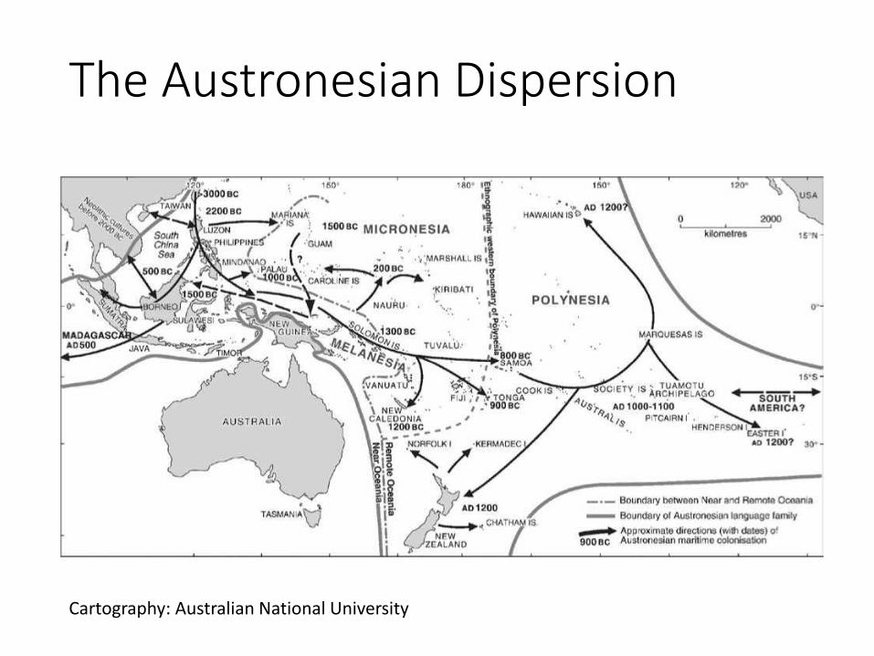
The Austronesian Dispersion
Cartography: Australian National University
Etymology
• Etymology is the study of word histories. It is part of the field of historical linguistics.
• Present day words all have some sort of origin, whether it is from an older version of the present language, or if it has originated from some other language, and possibly intermediate forms from yet other languages.
• There are possible relationships between linguistic meaning and cultural, extralinguistic history (Durkin, 2009)
Durkin, Philip P. 2009. The Oxford Guide to Etymology. Oxford: Oxford University Press.
Studying place name histories
• There are a number of things to look for when studying place name histories:• The language the place name belongs to and the
language of any original source forms of the word• The value of the name as evidence for vocabulary and
word meaning• How the name can throw light on non-linguistic history
(Durkin, 2009)
• Place names can be seen within the study of historical linguistics (Coates, 2016), or as evidence for non-linguistic history (Fellows-Jensen, 2016)
Durkin, Philip P. 2009. The Oxford Guide to Etymology. Oxford: Oxford University Press.Coates, Richard. 2016. Names and Historical Linguistics. In The Oxford Handbook of Names and Naming. ed. Carole Hough, 525-539. OxfordFellows-Jensen, Gillian. 2016. Names and History. In The Oxford Handbook of Names and Naming. ed. Carole Hough, 513-524. Oxford University Press.

Geographical Names and History:Selected ExamplesEtymology of some place names from Indonesia

Natural FeaturesIsland
Onrust Island 1
• Onrust Island is one of a chain of 110 islands called the Thousand Islands (Kepulauan Seribu) which stretch 45 km north from the West Jakarta Bay into the Java Sea. Onrust Island is 3,5 km2 in size and is located 14 km from the Jakarta coast.
• It is important historically and culturally because it played an important role for the Dutch as part of their defenses of the city of Batavia (now Jakarta). The Dutch East India Company got permission in 1610 from the Prince of Jayakarta to build a naval base there.
• Its later Malay name Pulau Kapal (Ship Island) was given because of this function; it appeared for the first time alongside the name Onrust (“unrest”), given by the Dutch, on a 1761 chart of Batavia Bay by Gerrit de Haan.
Lauder, Multamia R.M.T., and Lauder, Allan F. Place Names as Cultural Heritage in an Archipelagic Country. In press.

Onrust Island 2
Old Fort on Onrust Island

Onrust Island 3
• After being destroyed by the British in the Napoleonic wars, the Dutch rebuilt Onrust Island as a place where ships owned by the Dutch East Indies Government and private sector could be repaired.
• Because of the eruption of Krakatoa in 1883 and the construction of a new port in Tanjung Priok in Batavia, larger and better equipped for ship repair and ship building, Onrust Island went into decline.
• After this, it was used as a quarantine station and as a hospital for sufferers of tuberculosis (TB). Between 1911 and 1933, it was also used to quarantine people who planned to go to Mecca to perform their Hajj. In 1972, when Ali Sadikin was Governor of Jakarta, the island was identified as a protected historical site. Indonesians continue to name the island Onrust to remind us of its cultural and historical value.
Lauder, Multamia R.M.T., and Lauder, Allan F. Place Names as Cultural Heritage in an Archipelagic Country. In press.

Constructed Features

Manggarai Station 1• Information about Manggarai station was found in a series of
maps dating back to the late 19th century. The first of these maps was a map by Meester Corneis of the Mengrai Kampung (village/settlement). The railway had not been constructed at this time.
• The name Manggarai as applied to a train station appears in 1908 and 1909, N.I.S. Station (Nederlandsch-Indische SpoorwegMaatschappij).
• The map from 1927 uses the name Manggarai for the station and it is found also on the maps in 1930, 1937, 1942, and 1959.
• The railway line came under the management of the national rail company Staatsspoor en Tramwegen (SS) in 1913. The company controlled the entire railway network in the Batavia and MeesterCornelis regions. SS also constructed a new Manggarai station which was designed by the Dutch architect Ir. J. Van Gendt. (Wardny, 2015)
Wardany, Inayah. 2015. Toponimi Nama Stasiun Kereta Api Komuter Jabodetabek: Sebuah Kajian Linguistik, Tesis belum diterbitkan. Fakultas Ilmu Pengetahuan Budaya, Universitas Indonesia.
Manggarai Station 2• Jan Pieterszoon Coen took control of Jayakarta in 1619.
One of the problems faced was the lack of human resources to develop the place into a colonial city.
• The Dutch brought in forced laborers from many places in the archipelago, from Kalimantan, Sulawesi, Buton, Bali, Sumbawa, Flores, Timor, and Papua.
• These laborers, some of whom were slaves, played an important part in the city’s development (Ward, 2009).
• There are a number of toponyms in Jakarta that originate with such ethnolinguistic groups from Ambon, Bugis, Makasar, Bandan, Bali, Tambora, Pakojan and Manggarai (Wardany, 2015).
Ward, Kerry. 2009. Networks of Empire: Forced Migration in the Dutch East India Company. Cambridge: Cambridge University Press.
Wardany, Inayah. 2015. Toponimi Nama Stasiun Kereta Api Komuter Jabodetabek: Sebuah Kajian Linguistik, Tesis belum diterbitkan. Fakultas Ilmu Pengetahuan Budaya, Universitas Indonesia.
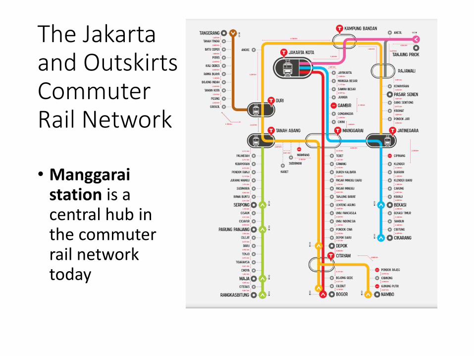
The Jakarta and Outskirts Commuter Rail Network
• Manggaraistation is a central hub in the commuter rail network today
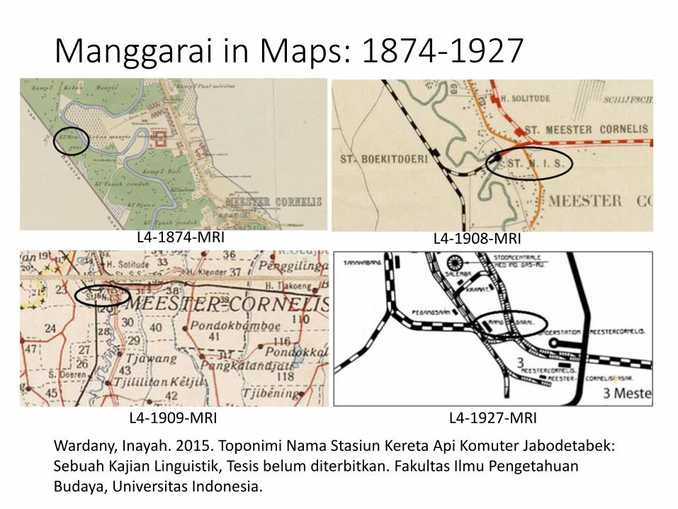
Manggarai in Maps: 1874-1927
L4-1874-MRI L4-1908-MRI
L4-1909-MRI L4-1927-MRI
Wardany, Inayah. 2015. Toponimi Nama Stasiun Kereta Api Komuter Jabodetabek: Sebuah Kajian Linguistik, Tesis belum diterbitkan. Fakultas Ilmu Pengetahuan Budaya, Universitas Indonesia.
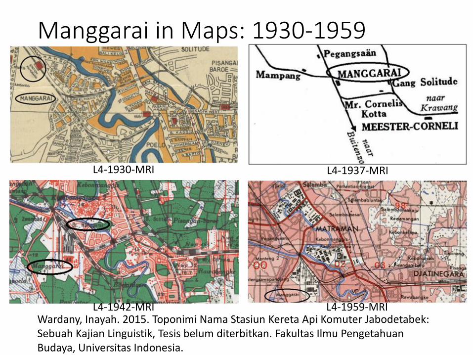
Manggarai in Maps: 1930-1959
L4-1930-MRI L4-1937-MRI
L4-1959-MRIL4-1942-MRIWardany, Inayah. 2015. Toponimi Nama Stasiun Kereta Api Komuter Jabodetabek: Sebuah Kajian Linguistik, Tesis belum diterbitkan. Fakultas Ilmu Pengetahuan Budaya, Universitas Indonesia.
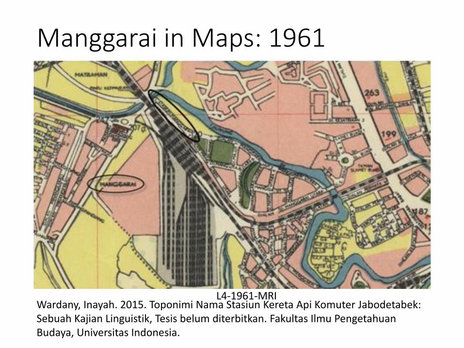
Manggarai in Maps: 1961
L4-1961-MRIWardany, Inayah. 2015. Toponimi Nama Stasiun Kereta Api Komuter Jabodetabek: Sebuah Kajian Linguistik, Tesis belum diterbitkan. Fakultas Ilmu Pengetahuan Budaya, Universitas Indonesia.

History and Cartography
• Cartography helps us look at the world in a particularly useful way.
• Maps can represent the relation between important events with their spatial context (Garfield, 2012; Kraak & Ormeling, 2010; Thrower, 2008).
• Maps also provide a rich source of examples of place names.
Garfield, Simon. 2012. On the Map- A Mind-Expanding Exploration of the Way the World Looks. Gotham.Kraak, Menno-Jan & Ormeling, Ferjan. 2010. Cartography- Visualization of Geospatial Data, 3rd Edition. Pearson Education.Thrower, Norman J. W. 2008. Maps and Civilization- Cartography in Culture and Society, 3rd Edition. University of Chicago Press
Early Maps
• Early maps of SEA show place names that give clues to what kinds of contacts were taking place. Early exonyms can reveal what countries were arriving at different locations (Ormeling , 2003).
• Comparing maps from the colonial period with those of those from the later independence give clues to the history of decolonizing (Akerman, 2017).
Ormeling, Ferjan J. 2003. Exonyms in Cartography. pp 119-127 in Ferjan Ormeling, JörnSievers and Hans Stabe Eds. Training Course on Toponymy, Enschede 2002.
Akerman, James R. ed. 2017. Decolonizing the Map: Cartography from Colony to Nation. The Kenneth Nebenzahl Jr. Lectures in the History of Cartography. Chicago: University of Chicago Press.

Populated Places

The City of Jakarta 1• The city of Jakarta is the country’s Special Capital Region and is
the country’s political, economic and cultural center. It is located on the northwest coast of Java Island. It has, over the years, had a number of names, namely Sunda Kelapa, Jayakarta and Batavia.
• Its original name was Sunda Kalapa. The etymology of this name comes from the Malay word for coconut ‘kelapa’. The area was a major port in the kingdom of Sunda Pajajaran where the area’s name took after the coconut trees that lined the shore. Tomé Pires called it Cunda Calapa or Sunda Kalapa and wrote in 1515 that ‘the Port of Kalapa belongs to the Sunda kingdom’. In 1527, Sunda Kalapa was captured by troops of the Demak Sultanate and the port fell under the control of its ruler.
• Sunda Kelapa was renamed Jayakarta meaning ‘victory’ or ‘absolute wellbeing’. The city name is recorded in numerous documents with variation in spelling: Jayakarta, Jaketra, Jakerta, and Jakarta.
Lauder, Multamia R.M.T., and Lauder, Allan F. Place Names as Cultural Heritage in an Archipelagic Country. In press. Pires, Tome, Cortesao, Armando, and Rodrigues, Francisco. 1967. The Suma oriental of Tome Pires. Vol. I/II. Works issued by the Hakluyt Society, 2d ser , no 89-90. Nendeln, Liechtenstein: Kraus Reprint.
The City of Jakarta 2• The Netherlands recognized the economic potential of
trade through Jayakarta, in particular its trade in pepper and other spices which they wanted to gain a monopoly on. In 1602, the ruler of Jayakarta, Prince Wijayakrama encouraged international trading activities.
• He gave the British and the Dutch permission to establish a trading station on the west bank of the Ciliwung River estuary. Many Chinese merchants built houses around the fort. Jayakarta developed into a busy port city.
• The Dutch were determined to dominate the trade and eventually, Jayakarta fell into the hands of the Dutch East India company (VOC).
Lauder, Multamia R.M.T., and Lauder, Allan F. Place Names as Cultural Heritage in an Archipelagic Country. In press.
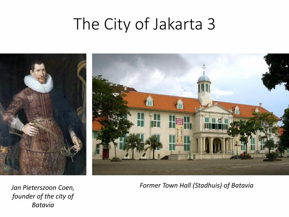
The City of Jakarta 3
Jan Pieterszoon Coen, founder of the city of
Batavia
Former Town Hall (Stadhuis) of Batavia
The City of Jakarta 4• When the Dutch Governor General Jan Pieterzoon Coen was in
charge of the city, on 30th May 1619, he ordered the construction of a fort and a new urban area which he first wanted to name Hoorn, after his home town in the Netherlands. The board of the VOC, called the Council of Seventeen ‘De Heeren Zeventien’ which sat in Amsterdam, however renamed Jayakarta Batavia, after the ancestors of all the Dutch, the ancient Germanic tribe of the Batavi. In the 18th century the city was described as beautiful and became known as ‘The Queen of the East’ or, because of its many canals dug by the Dutch, ‘The Venice of the East’ Venetië in het Oosten’.
• During the Japanese occupation in WWII, the name Batavia was changed back to Jayakarta or Jakarta through a Government News Announcement of the Japanese Military Government Kang Po No. 9 December 8, 1942 (Ruchiat, 2011). Up till the present, Jakarta has been the name of Indonesia’s capital.
Lauder, Multamia R.M.T., and Lauder, Allan F. Place Names as Cultural Heritage in an Archipelagic Country. In press. Ruchiat, Rachmat. 2011. Asal-Usul Nama Tempat di Jakarta [Origins of PlaceNames in Jakarta]. Jakarta: Masup.
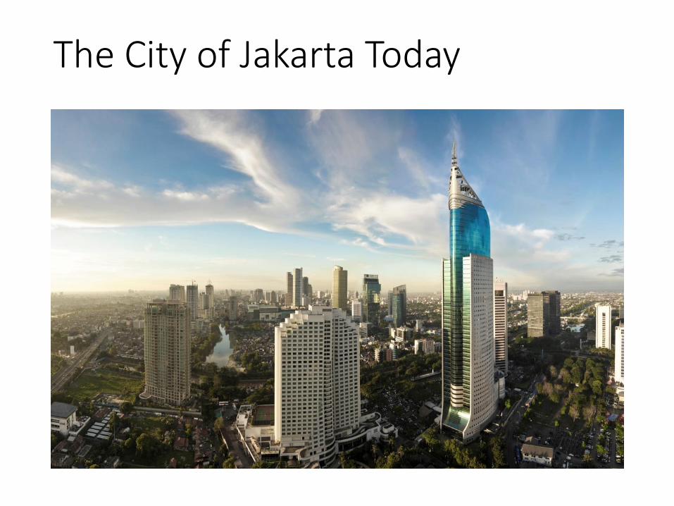
The City of Jakarta Today
Archeology and PhilologyData for studying early history:Artefacts, Stone inscriptions, and Manuscripts

Ancient manuscripts
• An example of an ancient manuscript is Nagarakertagama written by Prapanca in 1287 Saka era (1365 AD).
• This text mostly tells of the journey of King HayamWuruk and his entourage who visited 210 places on a journey around the Majapahit Empire between 1353 and 1361 AD. The area beyond the borders of the Majapahit kingdom was referred to as Nusantara, which literally means ‘other islands’. (Lauder & Lauder, 2014)
Lauder, Multamia R.M.T., and Lauder, Allan F. 2014. A historical perspective on the study ofgeographical names in Indonesia. Paper read at The International Symposium on Toponymy: Geographical Names as Cultural Heritage. November 5 to 7, 2014, Seoul, Korea. KoreanNational Geographic Information Institute (NGII).

The Negarakertagama: the journey of King Hayam Wuruk
The Negarakertagama, manuscript documenting the history of the Majapahitkingdom, recognized by UNESCO.Source: http://wilwatiktamadani.blogspot.com/2011/05/kitab-negarakertagama-jadi-memori-dunia.html
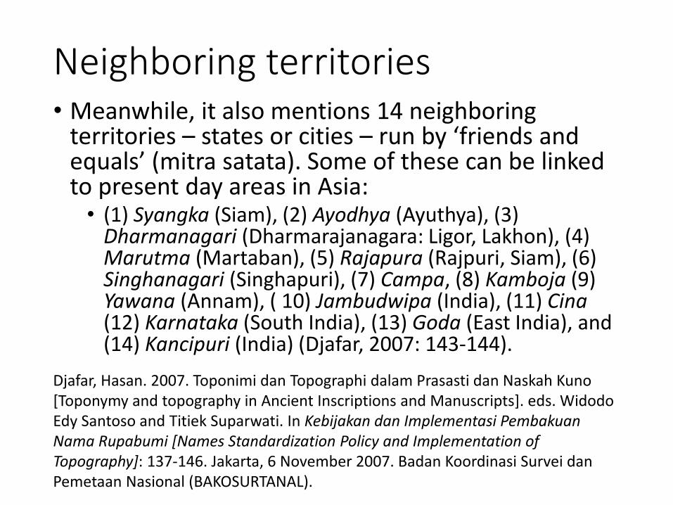
Neighboring territories• Meanwhile, it also mentions 14 neighboring
territories – states or cities – run by ‘friends and equals’ (mitra satata). Some of these can be linked to present day areas in Asia: • (1) Syangka (Siam), (2) Ayodhya (Ayuthya), (3)
Dharmanagari (Dharmarajanagara: Ligor, Lakhon), (4) Marutma (Martaban), (5) Rajapura (Rajpuri, Siam), (6) Singhanagari (Singhapuri), (7) Campa, (8) Kamboja (9) Yawana (Annam), ( 10) Jambudwipa (India), (11) Cina(12) Karnataka (South India), (13) Goda (East India), and (14) Kancipuri (India) (Djafar, 2007: 143-144).
Djafar, Hasan. 2007. Toponimi dan Topographi dalam Prasasti dan Naskah Kuno [Toponymy and topography in Ancient Inscriptions and Manuscripts]. eds. Widodo Edy Santoso and Titiek Suparwati. In Kebijakan dan Implementasi Pembakuan Nama Rupabumi [Names Standardization Policy and Implementation ofTopography]: 137-146. Jakarta, 6 November 2007. Badan Koordinasi Survei dan Pemetaan Nasional (BAKOSURTANAL).

International Relations in the Majapahit: Exonyms• The old place names which refer to present day places
exhibit different kinds of sound or spelling changes:• For example, Syangka (Siam) refers to Thailand, Kamboja to
Cambodia, Cina to China and Yawana (Annam) to Vietnam.
• These EXONYMS demonstrate the resistance of some place names to change and also give evidence on the transitions between one society or people and another at different times.
• It can also tell us about the relations between the Majapahit and people in these places and the level of awareness of one another.
• They provide a map of the Majapahit world, its international relations, diplomacy, trade and cultural contacts.
Lauder, Multamia R.M.T., and Lauder, Allan F. 2014. A historical perspective on the study ofgeographical names in Indonesia. Paper read at The International Symposium on Toponymy: Geographical Names as Cultural Heritage. November 5 to 7, 2014, Seoul, Korea. KoreanNational Geographic Information Institute (NGII).
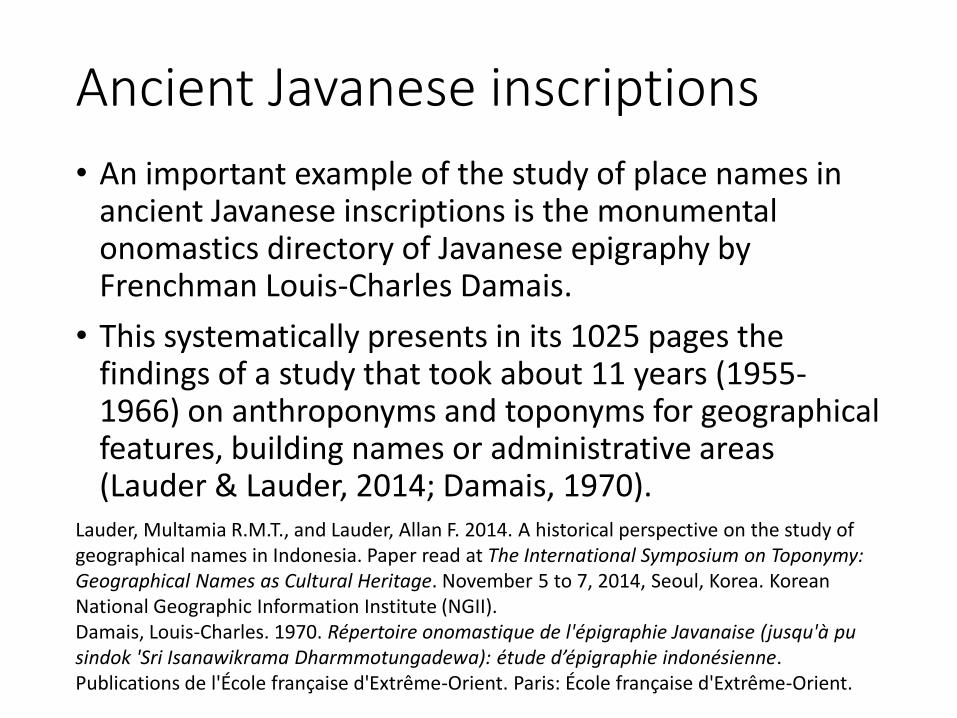
Ancient Javanese inscriptions
• An important example of the study of place names in ancient Javanese inscriptions is the monumental onomastics directory of Javanese epigraphy by Frenchman Louis-Charles Damais.
• This systematically presents in its 1025 pages the findings of a study that took about 11 years (1955-1966) on anthroponyms and toponyms for geographical features, building names or administrative areas (Lauder & Lauder, 2014; Damais, 1970).
Lauder, Multamia R.M.T., and Lauder, Allan F. 2014. A historical perspective on the study ofgeographical names in Indonesia. Paper read at The International Symposium on Toponymy: Geographical Names as Cultural Heritage. November 5 to 7, 2014, Seoul, Korea. KoreanNational Geographic Information Institute (NGII).Damais, Louis-Charles. 1970. Répertoire onomastique de l'épigraphie Javanaise (jusqu'à pu sindok 'Sri Isanawikrama Dharmmotungadewa): etude d’epigraphie indonesienne. Publications de l'École française d'Extrême-Orient. Paris: École française d'Extrême-Orient.

Conclusion

Conclusion
• The function and role of history in the naming of topographic features is very important if we want to understand local culture
• The history of the past helps us to know whether geographical names are relatively new or if they have existed for hundreds of years
• Tracking the name of historical topographic features requires the involvement of a team of people with different expertise. Linguists, who are specialists in geographical linguistics, should work with archeologists, who are specialists in spatial archeology


![Reconstruct Market Boundaries[1][1]](https://static.fdocuments.in/doc/165x107/577d36401a28ab3a6b929b6a/reconstruct-market-boundaries11.jpg)
