PINELLAS COUNTY COMPREHENSIVE PLAN · FLUM Categories, Descriptions & Rules PINELLAS COUNTY...
62
PINELLAS COUNTY COMPREHENSIVE PLAN Future Land Use Map (FLUM) Category Descriptions and Rules Amended March 17, 2009 (Ordinance 09-17) Amended March 16, 2010 (Ordinance 10-18) Amended October 26, 2010 (Ordinance 10-56) Amended April 26, 2011 (Ordinance 11-13 & Ordinance 11-14) Amended April 15, 2014 (Ordinance 14-20)
Transcript of PINELLAS COUNTY COMPREHENSIVE PLAN · FLUM Categories, Descriptions & Rules PINELLAS COUNTY...

____________________________________________________________________________________________________________ FLUM Categories, Descriptions & Rules
PINELLAS COUNTY COMPREHENSIVE PLAN
Future Land Use Map (FLUM) Category Descriptions and Rules
Amended March 17, 2009 (Ordinance 09-17) Amended March 16, 2010 (Ordinance 10-18)
Amended October 26, 2010 (Ordinance 10-56) Amended April 26, 2011 (Ordinance 11-13 & Ordinance 11-14)
Amended April 15, 2014 (Ordinance 14-20)

____________________________________________________________________________________________________________ FLUM Categories, Descriptions & Rules
PINELLAS COUNTY COMPREHENSIVE PLAN FUTURE LAND USE (FLUM) CATEGORY DESCRIPTIONS & RULES
he Future Land Use Map (FLUM) categories establish the maximum densities and intensities, the locational and use characteristics of each category, and additional standards and criteria a necessary to assist in managing the development of land in the unincorporated areas of Pinellas County. The purpose of the attached category
descriptions and rules is to aid decision makers and the general public in understanding what the appropriate uses are in each category, where they should be located, and how intensively a parcel of land can be developed. For each FLUM category, the compatible zoning districts in the Pinellas County Land Development Code are identified. For a specific parcel of land, however, an additional zoning district may be determined by the Pinellas County Local Planning Agency (LPA) to be compatible with a particular FLUM category based on findings of the LPA for that particular situation. Such findings would not have general applications throughout the unincorporated areas of Pinellas County and would be determined on a case–by-case basis. The Future Land Use Map was adopted as part of the Pinellas County Comprehensive Plan. Planning Department staff has automated the production of the FLUM using the Pinellas County Geographic Information System (GIS). This project was completed in November of 1995. The GIS now contains the digital spatial and attribute information for the FLUM, and includes all amendments that have been made to the FLUM since August 1989. As new amendments occur, they will be added to the GIS database and new Future Land Use Maps will be printed as needed. Copies of the unincorporated FLUM are available at the Pinellas County Planning Department, 600 Cleveland St., Suite 750, Clearwater, Florida 33755 (727-464-8200). Information and Future Land Use Maps may also be obtained at the Pinellas County Department of Building & Development Review Services. 310 Court Street, Clearwater, Florida 33756 (727-464-3888).
T
i

____________________________________________________________________________________________________________ FLUM Categories, Descriptions & Rules
FUTURE LAND USE MAP (FLUM) CATEGORY DESCRIPTIONS & RULES
PART I - FUTURE LAND USE MAP (FLUM) CATEGORY DESCRIPTIONS RESIDENTIAL CLASSIFICATION
Residential Rural (RR) ........................................................................................................... 1 Residential Estate (RE) ........................................................................................................... 2 Residential Suburban (RS) ..................................................................................................... 3 Residential Low (RL) ............................................................................................................... 4 Residential Urban (RU) ........................................................................................................... 5 Residential Low Medium (RLM) .............................................................................................. 6 Residential Medium (RM) ....................................................................................................... 7 Residential High (RH) ............................................................................................................. 8
MIXED USE CLASSIFICATION
Community Redevelopment District – Activity Center (CRD-AC) ........................................... 9 Residential/Office Limited (R/OL) ......................................................................................... 11 Residential/Office General (R/OG) ....................................................................................... 13 Residential/Office/Retail (R/O/R) .......................................................................................... 14 Resort Facilities Overlay-Permanent (RFO-P) ..................................................................... 16 Resort Facilities Overlay-Temporary (RFO-T) ...................................................................... 17 Transit Oriented Development – Neighborhood Center (TOD-NC) ...................................... 18 Transit Oriented Development – Community Center (TOD-CC) ......................................... 18 Transit Oriented Development – Regional Center (TOD-RC-E) & (TOD-RC-MU) .............. 18 Transit Oriented Development – Park and Ride (TOD-PR) ................................................. 18 Pinellas County Rail/Fixed Guideway Transit Station Area Typologies (Table 1) .............. 20 Transit Oriented Development Overlay (TODO) .................................................................. 21
COMMERCIAL CLASSIFICATION Commercial Neighborhood (CN) ........................................................................................... 23 Commercial Recreation (CR) ................................................................................................ 24 Commercial General (CG) .................................................................................................... 25
INDUSTRIAL CLASSIFICATION
Industrial Limited (IL) ............................................................................................................ 26 Industrial General (IG) .......................................................................................................... 28
PUBLIC/SEMI PUBLIC CLASSIFICATION Preservation (P) .................................................................................................................... 29 Preservation-Resource Management (P-RM) ...................................................................... 30 Resource Management Overlay (RMO-1 and RMO-2)………. . ....................................... …31 Recreation/Open Space (R/OS) ........................................................................................... 33 Institutional (I) ....................................................................................................................... 34 Institutional Overlay (IO) ....................................................................................................... 35 Transportation/Utility (T/U) .................................................................................................... 37
ADDITIONAL STANDARDS ............................................................................................................ 38 PART II - MANDATORY RULE/TRANSFERABLE DEVELOPMENT RIGHTS ............................. 40 PART III- SITE-SPECIFIC LAND USE RESTRICTIONS ON SPECIFIC PROPERTIES ................ 44 GLOSSARY ..................................................................................................................................... 45
ii
______________________________________________________________________________________________________ FLUM Categories, Descriptions & Rules
1
PART I - FUTURE LAND USE MAP (FLUM) CATEGORY DESCRIPTIONS
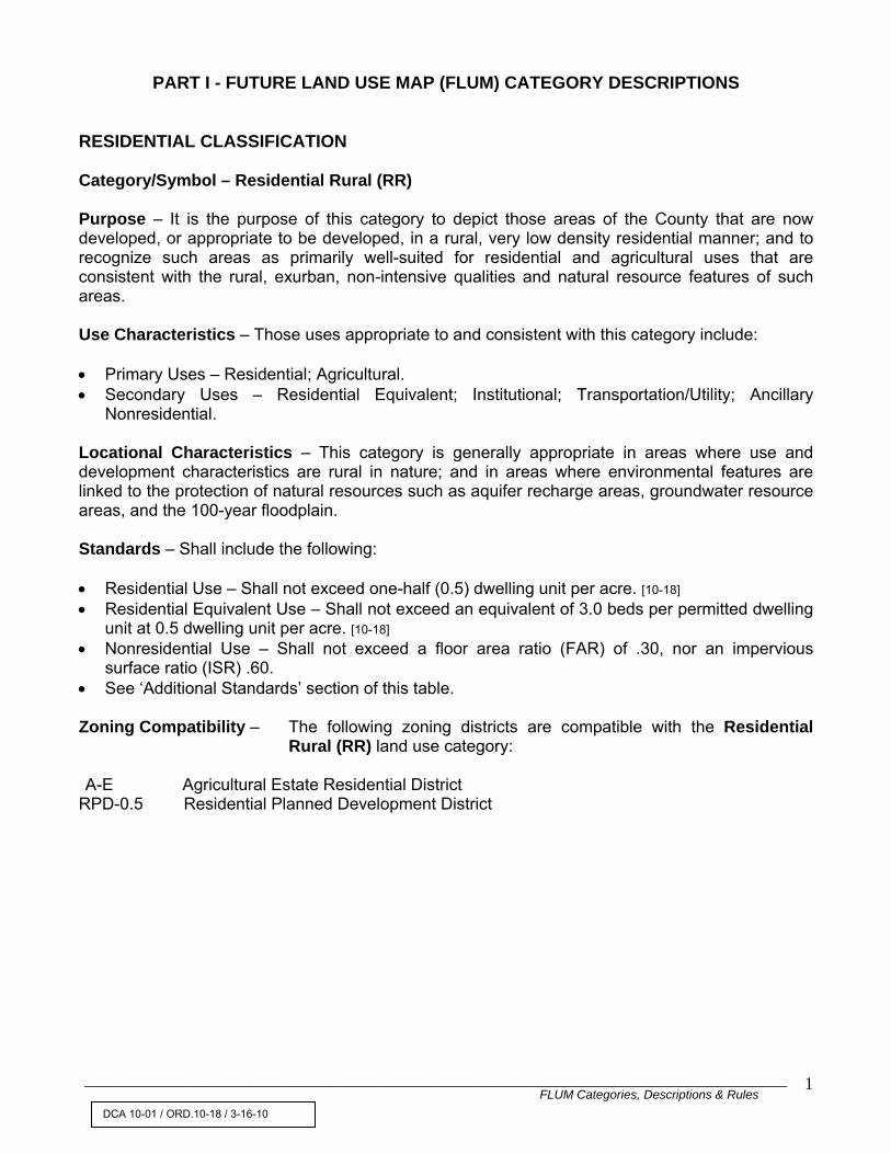
RESIDENTIAL CLASSIFICATION Category/Symbol – Residential Rural (RR) Purpose – It is the purpose of this category to depict those areas of the County that are now developed, or appropriate to be developed, in a rural, very low density residential manner; and to recognize such areas as primarily well-suited for residential and agricultural uses that are consistent with the rural, exurban, non-intensive qualities and natural resource features of such areas. Use Characteristics – Those uses appropriate to and consistent with this category include: • Primary Uses – Residential; Agricultural. • Secondary Uses – Residential Equivalent; Institutional; Transportation/Utility; Ancillary
Nonresidential. Locational Characteristics – This category is generally appropriate in areas where use and development characteristics are rural in nature; and in areas where environmental features are linked to the protection of natural resources such as aquifer recharge areas, groundwater resource areas, and the 100-year floodplain. Standards – Shall include the following: • Residential Use – Shall not exceed one-half (0.5) dwelling unit per acre. [10-18] • Residential Equivalent Use – Shall not exceed an equivalent of 3.0 beds per permitted dwelling
unit at 0.5 dwelling unit per acre. [10-18] • Nonresidential Use – Shall not exceed a floor area ratio (FAR) of .30, nor an impervious
surface ratio (ISR) .60. • See ‘Additional Standards’ section of this table. Zoning Compatibility – The following zoning districts are compatible with the Residential
Rural (RR) land use category: A-E Agricultural Estate Residential District
RPD-0.5 Residential Planned Development District
DCA 10-01 / ORD.10-18 / 3-16-10

______________________________________________________________________________________________________ FLUM Categories, Descriptions & Rules
2
RESIDENTIAL CLASSIFICATION– (cont’d) Category/Symbol – Residential Estate (RE) Purpose – It is the purpose of this category to depict those areas of the County that are now developed, or appropriate to be developed, in a large lot, very low density residential manner; and to recognize such areas as primarily well-suited for estate residential uses that are consistent with the suburban, non-intensive qualities and natural resource characteristics of such areas. Use Characteristics – Those uses appropriate to and consistent with this category include: • Primary Uses – Residential; Agricultural. • Secondary Uses – Residential Equivalent; Institutional; Transportation/Utility; Ancillary
Nonresidential. Locational Characteristics – This category is generally appropriate in areas where use and development characteristics are estate residential in nature; in areas serving as a transition between more rural and more urban residential areas; in environmentally-sensitive areas where the prohibition of development is not required to protect the natural resource; and in the 100 year floodplain (where preservation, open space/restricted, or recreation/open space are not feasible). Standards – Shall include the following: • Residential Use – Shall not exceed one (1.0) dwelling unit per acre. [10-18] • Residential Equivalent Use – Shall not exceed an equivalent of 3.0 beds per permitted dwelling
unit at 1.0 dwelling unit per acre. • Nonresidential Use – Shall not exceed a floor area ratio (FAR) of .30, nor an impervious
surface ratio (ISR) of .60. • See ‘Additional Standards’ Section of this table. Zoning Compatibility – The following zoning districts are compatible with the Residential
Estate (RE) land use category: A-E Agricultural Estate Residential District E-1 Estate Residential District RM-1 Residential Multiple Family District RPD-1 Residential Planned Development District All RPD and RM zoning districts that allow less than 1 unit per acre. [10-18]
DCA 10-01 / ORD.10-18 / 3-16-10

______________________________________________________________________________________________________ FLUM Categories, Descriptions & Rules
3
RESIDENTIAL CLASSIFICATION – (cont’d) Category/Symbol – Residential Suburban (RS) Purpose – It is the purpose of this category to depict those areas of the County that are now developed, or appropriate to be developed, in a suburban, low density residential manner, and to recognize such areas as primarily well-suited for residential uses that are consistent with the suburban, non-intensive qualities and natural resource characteristics of such areas. Use Characteristics – Those uses appropriate to and consistent with this category include: • Primary Uses – Residential; Agricultural. [10-18] • Secondary Uses - Residential Equivalent; Institutional; Transportation/Utility; Ancillary
Nonresidential. Locational Characteristics – This category is generally appropriate in areas where use and development characteristics are suburban residential in nature; in areas serving as a transition between more rural and more urban residential areas; and in areas within the 100 year floodplain (where preservation, open space/restricted, or recreation/open space are feasible). Standards – Shall include the following: • Residential Use – Shall not exceed two and one-half (2.5) dwelling units per acre. [10-18] • Residential Equivalent Use – Shall not exceed an equivalent of 3.0 beds per permitted dwelling
unit at 2.5 dwelling units per acre. [10-18] • Non-residential Use – Shall not exceed a floor area ratio (FAR) of .30, nor an impervious
surface ratio (ISR) of .60. • See ‘Additional Standards’ section of this table. Zoning Compatibility - The following zoning districts are compatible with the Residential
Suburban (RS) land use category: A-E Agricultural Estate Residential District E-1 Estate Residential District R-R Rural Residential District R-1 Single Family Residential District RM -2.5 Residential, Multiple Family District RPD-2.5 Residential Planned Development District All RPD and RM zoning districts that allow less than 2.5 units per acre. [10-18]
DCA 10-01 / ORD.10-18 / 3-16-10

______________________________________________________________________________________________________ FLUM Categories, Descriptions & Rules
4
RESIDENTIAL CLASSIFICATION – (cont’d) Category/Symbol – Residential Low (RL) Purpose – It is the purpose of this category to depict those areas of the County that are now developed, or appropriate to be developed, in a low density residential manner; and to recognize such areas as primarily well suited for residential uses that are consistent with the low density, non-intensive qualities and natural resource characteristics of such areas. Use Characteristics – those uses appropriate to and consistent with this category include: • Primary Uses – Residential. • Secondary Uses – Residential Equivalent, Institutional; Transportation/Utility, Ancillary
Nonresidential. Locational Characteristics – This category is generally appropriate to locations between major employment centers and community and regional shopping centers; in areas where use and development characteristics are low density residential in nature, in areas serving as a transition between more suburban and more urban residential areas; and in areas within the 100-year floodplain (where preservation, open space/restricted, or recreation/open space are not feasible). • Residential Use – Shall not exceed five (5) dwelling units per acre. [10-18] • Residential Equivalent Use – Shall not exceed an equivalent of 3.0 beds per permitted
dwelling unit at 5 dwelling units per acre. [10-18] • Nonresidential Use – Shall not exceed a floor area ratio (FAR) of .40, nor an impervious
surface ratio (ISR) of .65. • See ‘Additional Standards’ section of this table.
Zoning Compatibility - The following zoning districts are compatible with the Residential Low
(RL) land use category: AE Agricultural Estate Residential District E-1 Estate Residential District R-R Rural Residential District R-1 Single Family Residential District R-2 Single Family Residential District R-3 Single Family Residential District R-4 One, Two, or Three Family Residential District RM-5 Residential, Multiple Family District RPD-5 Residential Planned Development District All RPD and RM zoning districts that allows less than 5.0 units per acre. [10-18]
DCA 10-01 / ORD.10-18 / 3-16-10

______________________________________________________________________________________________________ FLUM Categories, Descriptions & Rules
5
RESIDENTIAL CLASSIFICATION – (cont’d) Category/Symbol – Residential Urban – (RU) Purpose – It is the purpose of this category to depict those areas of the County that are now developed, or appropriate to be developed, in an urban low density residential manner, and to recognize such areas as primarily well-suited for residential uses that are consistent with the urban qualities and natural resource characteristics of such areas. Use Characteristics – Those uses appropriate to and consistent with this category include: • Primary Uses – Residential. • Secondary Uses – Residential Equivalent; Institutional; Transportation/Utility; Ancillary
Nonresidential. Locational Characteristics – This category is generally appropriate to locations between major employment centers and community and regional shopping centers; in areas where use and development characteristics are urban residential in nature; and in areas serving as a transition between more suburban and more urban residential areas. Standards – Shall include the following: • Residential Use – Shall not exceed seven and one-half (7.5) acre dwelling units per acre. [10-18] • Residential Equivalent Use – Shall not exceed an equivalent of 3.0 beds per permitted dwelling
unit at 7.5 dwelling units per acre. [10-18] • Nonresidential Use – Shall not exceed a floor area ratio (FAR) of .40, nor an impervious
surface ratio (ISR) of .65. • See ‘Additional Standards’ section of this table. Zoning Compatibility – The following zoning districts are compatible with the Residential
Urban (RU) land use category: AE Agricultural Estate Residential District E-1 Estate Residential District R-R Rural Residential District R-1 Single Family Residential District R-2 Single Family Residential District R-3 Single Family Residential District R-4 One, Two, or Three Family Residential District R-6 Mobile Home Parks and Subdivision Districts RM-7.5 Residential, Multiple Family District RPD-7.5 Residential Planned Development District All RPD and RM zoning districts that allow less than 7.5 units per acre. [10-18]
DCA 10-01 / ORD.10-18 / 3-16-10

______________________________________________________________________________________________________ FLUM Categories, Descriptions & Rules
6
RESIDENTIAL CLASSIFICATION– (cont’d) Category/Symbol – Residential Low Medium (RLM) Purpose – It is the purpose of this category to depict those areas of the county that are now developed, or appropriate to be developed, in a low to moderately intensive residential manner, and to recognize such areas as primarily well-suited for residential uses that are consistent with the urban qualities, transportation facilities and natural resource characteristics of such areas. Use Characteristics - Those uses appropriate to and consistent with this category include: • Primary Uses – Residential. • Secondary Uses – Residential Equivalent; Institutional; Transportation/Utility; Ancillary
Nonresidential. Locational Characteristics – This category is generally appropriate in areas served by a complete range of urban services with particular emphasis on the availability of transit service and recreation/open space facilities; in areas where use and development characteristics are low medium residential in nature; in areas serving as a transition between low density and high density residential areas; and in areas in close proximity to major employment centers, community and regional shopping centers, and arterial and collector highway facilities. Standards – Shall include the following: • Residential Use – Shall not exceed ten (10) dwelling units per acre. [10-18] • Residential Equivalent Use – Shall not exceed an equivalent of 3.0 beds per permitted dwelling
unit at 10 dwelling units per acre. [10-18] • Nonresidential Use – Shall not exceed a floor area ratio (FAR) of .50 nor an impervious surface
ratio (ISR) of .75. • See ‘Additional Standards’ section of this table. Zoning Compatibility - The following zoning districts are compatible with the Residential Low
Medium (RLM) land use category: AE Agricultural Estate Residential District E-1 Estate Residential District R-R Rural Residential District R-1 Single Family Residential District R-2 Single Family Residential District R-3 Single Family Residential District R-4 One, Two, or Three Family Residential District R-6 Mobile Home Parks and Subdivisions District RM-10 Residential, Multiple Family District RPD-10 Residential Planned Development District All RPD and RM zoning districts that allows less than 10.0 units per acre. [10-18]
DCA 10-01 / ORD.10-18 / 3-16-10

______________________________________________________________________________________________________ FLUM Categories, Descriptions & Rules
7
RESIDENTIAL CLASSIFICATION – (cont’d) Category/Symbol – Residential Medium (RM) Purpose – It is the purpose of this category to depict those areas of the County that are now developed, or appropriate to be developed, in a moderately intensive residential manner; and to recognize such areas as primarily well-suited for residential uses that are consistent with the urban qualities, transportation facilities and natural resource characteristics of such areas. Use Characteristics – This category is generally appropriate to locations in close proximity to major employment centers and community and regional shopping centers; in areas where use and development characteristics are medium density residential in nature; in areas serving as a transition between less urban and more urban residential and mixed use areas; and in areas served by a complete range of urban services with particular emphasis on transit service and recreation/open space facilities. These areas are typically in close proximity to and may have direct access from the arterial and thoroughfare highway network. • Primary Uses – Residential. • Secondary Uses – Residential Equivalent; Institutional; Transportation/Utility; Ancillary
Nonresidential. • Standards – Shall include the following: • Residential Use – Shall not exceed fifteen (15) dwelling units per acre. [10-18] • Residential Equivalent Use – shall not exceed an equivalent of 3.0 beds per permitted dwelling
unit at 15 dwelling units per acre. [10-18] • Nonresidential Use – Shall not exceed a floor area ratio (FAR) of .50, nor an impervious
surface ratio (ISR) of .75. • See ‘Additional Standards’ section of this table. Zoning Compatibility - The following zoning districts are compatible with the Residential
Medium (RM) land use category: A-E Agricultural Estate Residential District E-1 Estate Residential District R-R Rural Residential District R-1 Single Family Residential District R-2 Single Family Residential District R-3 Single Family Residential District R-4 One, Two, or Three Family Residential District RM- 12.5 Residential, Multiple Family District RPD-12.5 Residential Planned Development District All RPD and RM zoning districts that allows less than 12.5 units per acre. [10-18]
DCA 10-01 / ORD.10-18 / 3-16-10

______________________________________________________________________________________________________ FLUM Categories, Descriptions & Rules
8
RESIDENTIAL CLASSIFICATION – (cont’d) Category/Symbol – Residential High (RH)
Purpose – It is the purpose of this category to depict those areas of the County that are now developed in a highly intensive residential manner; and to recognize such areas as primarily well-suited for residential uses that are consistent with the urban and intensive qualities, transportation facilities and natural resource characteristics of such areas.
Use Characteristics – Those uses appropriate to and consistent with this category include:
• Primary Uses – Residential. • Secondary Uses – Residential Equivalent; Institutional; Transportation/Utility; Ancillary
Nonresidential. Locational Characteristics – This category is generally appropriate to locations in close proximity to major employment centers and community and regional shopping centers; in areas where use and development characteristics are high density residential in nature; and in areas served by a complete range of urban services with particular emphasis on the availability of mass transit and recreation/open space facilities. These areas are typically in close proximity to, and may have direct access from, the arterial and thoroughfare highway network, and are served by mass transit in a manner that provides an alternative to individual automobile use. Standards – Shall include the following: • Residential Use – Shall not exceed thirty (30) dwelling units per acre. [10-18] • Residential Equivalent Use – Shall not exceed an equivalent of 3.0 beds per permitted dwelling
unit at 30 dwelling units per acre. [10-18] • Nonresidential Use – Shall not exceed a floor area ratio (FAR) of .60 nor an impervious surface
ratio (ISR) of 0.85. • See ‘Additional Standards’ section of this table. Zoning Compatibility - The following zoning districts are compatible with the Residential
High (RH) land use category: None applicable.
DCA 10-01 / ORD.10-18 / 3-16-10

______________________________________________________________________________________________________ FLUM Categories, Descriptions & Rules
9
MIXED-USE CLASSIFICATION Category/Symbol – Community Redevelopment District – Activity Center (CRD – AC) Purpose – It is the purpose of this category to depict those areas of the County that are now developed, or appropriate to be developed, as dynamic areas of mixed use that serve as community focal points of commerce, employment, and housing; and to recognize such areas so that they retain and enhance a community’s distinctive characteristics, are compatible with natural resource features, and do not adversely affect public services and facilities. Use Characteristics – Those uses appropriate to and consistent with this category shall include:
• Residential; Commercial; Office; and Institutional uses as enumerated in the adopted Pinellas County Land Development Code. The Pinellas County Land Development Code may place restrictions on specific uses normally included within this generalized list of appropriate uses in order to ensure that the Community Redevelopment District-Activity Center designation as applied to a specific area provides for mixed use development that is compatible with the surrounding community, and supports the community vision or plan for its future that has been developed through a local public participation process.
Locational Characteristics – this category is generally appropriate to those locations that have historically served, or are appropriate to serve, as town, suburban commercial, or neighborhood centers where a more concentrated and integrated mixed use development pattern is compatible with the surrounding community, the availability of public services and facilities, and, where applicable, the area’s historic resources. This category may be utilized to promote development that will create a strong sense of community identity for a specific area as expressed in a community vision or local plan developed through a local public participation process. Standards – The applicable standards for this category shall be specified in the applicable special area plan and the Pinellas County Land Development Code. These standards shall not exceed the following:
• Residential Use – Shall not exceed twelve and one-half (12.5) dwelling units per acre. [10-18] • Residential Equivalent Use – Shall not exceed an equivalent of 3.0 beds per permitted
dwelling unit at 12.5 dwelling units per acre. [10-18] • Transient Accommodation Use – Shall not exceed twelve and one-half (12.5) transient
accommodation units per acre. [10-18] • Nonresidential Use – Shall not exceed a floor area ratio (FAR) of 0.60, nor an impervious
surface ratio of 0.90. • Residential Use and Residential Equivalent Use combined shall not exceed more than thirty
(30) percent of the total development floor area within a mixed-use project or mixed-use area designated with this category.
DCA 10-01 / ORD.10-18 / 3-16-10

______________________________________________________________________________________________________ FLUM Categories, Descriptions & Rules
10
MIXED USE CLASSIFICATION - (cont’d) Category/Symbol – Community Redevelopment District-Activity Center (CRD-AC) (cont’d) Special Note – The above standards represent the maximum development density and intensity that may be permitted within the Community Redevelopment District-Activity Center category. The Pinellas County Land Development Code and the applicable special area plan may further restrict the density and intensity of development within an area having this designation in order to ensure that development is compatible with the surrounding community and its distinctive characteristics, with the availability of public services and facilities, and with the area’s natural and cultural resources. As provided for in policies 1.3.5 and 1.3.6 of the Future Land Use and Quality Communities Element, the Pinellas County Land Development Code and the applicable special area plan may require that a project meet certain requirements in order to exceed a base residential density or intensity established in the special area plan or the Land Development Code. Special Area Plan – Use of this category shall require a special area plan as set forth in Objective 1.3 of the Future Land Use and Quality Communities Element. Zoning Compatibility – Generally, utilization of the Community Redevelopment District-Activity
Center designation will require development of a specific Zoning District for each location where it is designated on the Future Land Use Map.

______________________________________________________________________________________________________ FLUM Categories, Descriptions & Rules
11
MIXED USE CLASSIFICATION - (cont’d) Category/Symbol – Residential/Office Limited (R/OL) Purpose – It is the purpose of this category to depict those areas of the County that are now developed, or appropriate to be developed, in a residential and/or limited office use; and to recognize such areas as well-suited for residential and limited office use consistent with the surrounding uses, transportation facilities and natural resource characteristics of such areas. Use Characteristics – Those uses appropriate to and consistent with this category include: • Primary Uses – Residential; Residential Equivalent; Office. • Secondary Uses – Institutional; Transportation/Utility; Ancillary Nonresidential; Personal
Service/Office Support Use. Locational Characteristics – This category is generally appropriate to locations where it would serve as a transition from more intensive nonresidential use to low density residential or less intensive public/semi-public use; in areas where office and residential use is established or is determined appropriate as a means of encouraging reuse and neighborhood scale conversion; and along major transportation facilities where maintaining the traffic-carrying capacity is of paramount importance (e.g., scenic/noncommercial corridors). These areas are typically in close proximity to and served by the collector and arterial highway network. Standards – Shall include the following: • Residential Use-Shall not exceed seven and one-half (7.5) dwelling units per acre, except on
scenic/non-commercial corridors designated by the Board of County Commissioners, where residential use shall not exceed five (5.0) dwelling units per acre. [10-18]
• Residential Equivalent Use – Shall not exceed an equivalent of 3.0 beds per permitted dwelling unit at 7.5 dwelling units per acre, except on scenic/non-commercial corridors designated by the Board of County Commissioners, where residential equivalent use shall not exceed an equivalent of 3.0 beds per permitted dwelling unit at 5.0 dwelling units per acre. [10-18]
• Nonresidential Use – Shall not exceed a floor area ratio (FAR) of .20, nor an impervious surface ratio (ISR) of .75.
• Mixed Use-Shall not exceed, in combination, the respective number of units per acre and floor area ratio permitted, when allocated in their respective proportion to the total lot area.
• Personal Service/Office Support Use - Such use shall not exceed a maximum floor area of three thousand six hundred (3,600) square feet, or any combination of such uses in any single multi-tenant building, or in the alternative, in any group of buildings that are integral to and function as part of a unified project, shall not exceed ten (10) percent of the total floor area of said buildings, whichever is greater.
• See ‘Additional Standards’ section of this table.
DCA 10-01 / ORD.10-18 / 3-16-10

______________________________________________________________________________________________________ FLUM Categories, Descriptions & Rules
12
MIXED USE CLASSIFICATION - (cont’d) Category/Symbol – Residential/Office Limited (R/OL) (cont’d) Zoning Compatibility – The following zoning district is compatible with the
Residential/Office Limited (R/OL) land use category: P-1A Limited Office District Residential zoning districts allowing up to 7.5 units per acre, except on scenic/non-commercial corridors designated by the Board of County Commissioners where residential zoning districts permitting up to 5.0 units per acre are compatible. [10-18]
DCA 10-01 / ORD.10-18 / 3-16-10

______________________________________________________________________________________________________ FLUM Categories, Descriptions & Rules
13
MIXED USE CLASSIFICATION – (cont’d) Category/Symbol – Residential/Office General – (R/OG) Purpose – It is the purpose of this category to depict those areas of the County that are now developed, or appropriate to be developed, in residential and/or office use; and to recognize such areas as primarily well-suited for a mixed-use of a residential/office character consistent with the surrounding uses, transportation facilities and natural resource characteristics of such areas. Use Characteristics – Those uses appropriate to and consistent with this category include: • Primary Uses – Residential; Residential Equivalent; Office. • Secondary Uses – Institutional; Transportation/Utility; Ancillary Nonresidential;
Personal Service/Office Support. Research/Development. [10-18]
Locational Characteristics – This category is generally appropriate to locations where it would serve as a transition from a high intensity activity center (such as a major traffic corridor) or more intensive nonresidential use to low density residential or public/semi-public use; and in areas where the size and scale of office use in appropriate to free standing office. These areas are typically in close proximity to and served by the arterial and major thoroughfare highway network, as well as by mass transit. Standards – Shall include the following:
• Residential Use – Shall not exceed ten (10.0) dwelling units per acre. The actual dwelling unit density allowed within this density range will be determined, in part, by the characteristics and density of neighboring residential areas. [10-18]
• Residential Equivalent Use - Shall not exceed an equivalent 3.0 beds per permitted dwelling unit at 10.0 dwelling units per acre. [10-18]
• Nonresidential Use – Shall not exceed a floor area ratio (FAR) of 0.40, nor an impervious surface ratio (ISR) of .75.
• Mixed Use - Shall not exceed, in combination, the respective number of units per acre and floor area ratio permitted, when allocated in their respective proportion to the total lot area.
• Personal Service/Office Support Use - Such use shall not exceed a maximum floor area of five thousand (5,000) square feet, or any combination of such uses in any single multi-tenant building or, in the alternative, in any group of buildings that are integral to and function as part of a unified project, shall not exceed ten (10) percent of the total floor area of said buildings, whichever is greater.
• See ‘Additional Standards’ section of this table. Zoning Compatibility – The following zoning districts are compatible with the Residential/Office General (R/OG) land use category: P-1 General Professional Office District P-1A Limited Office District Residential zoning districts permitting up to 10.0 units per acre. [10-18]
DCA 10-01 / ORD.10-18 / 3-16-10
______________________________________________________________________________________________________ FLUM Categories, Descriptions & Rules
14
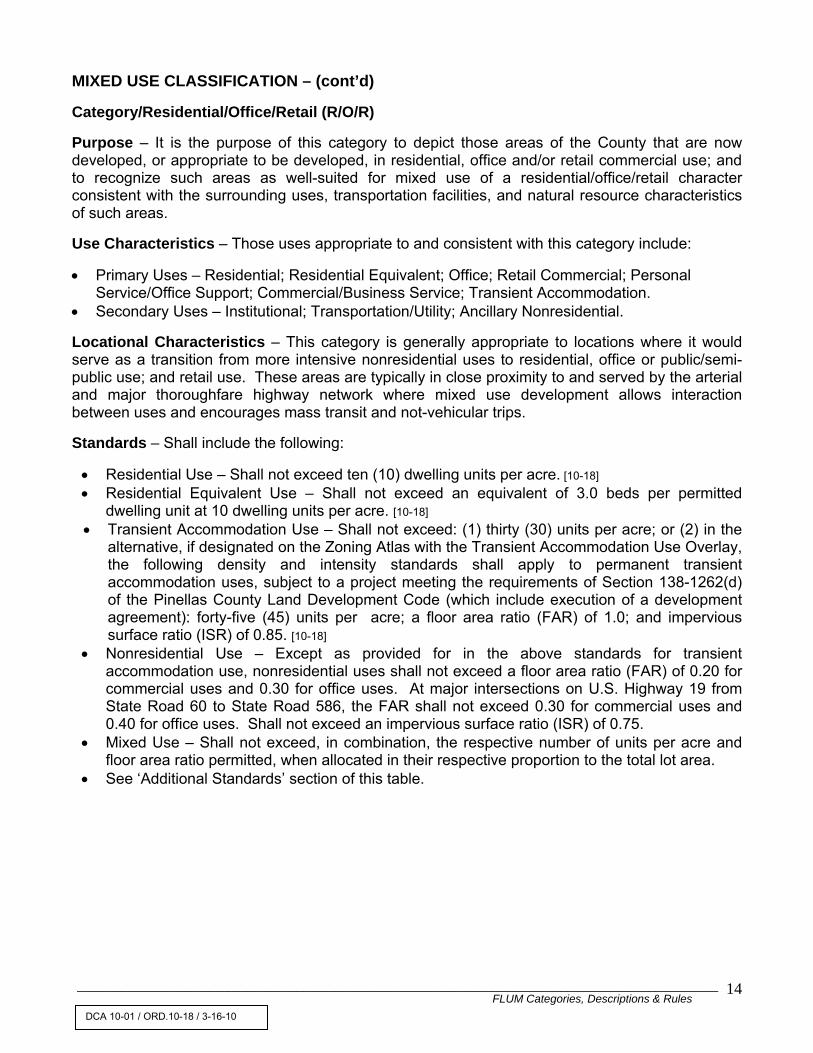
MIXED USE CLASSIFICATION – (cont’d) Category/Residential/Office/Retail (R/O/R) Purpose – It is the purpose of this category to depict those areas of the County that are now developed, or appropriate to be developed, in residential, office and/or retail commercial use; and to recognize such areas as well-suited for mixed use of a residential/office/retail character consistent with the surrounding uses, transportation facilities, and natural resource characteristics of such areas. Use Characteristics – Those uses appropriate to and consistent with this category include: • Primary Uses – Residential; Residential Equivalent; Office; Retail Commercial; Personal
Service/Office Support; Commercial/Business Service; Transient Accommodation. • Secondary Uses – Institutional; Transportation/Utility; Ancillary Nonresidential. Locational Characteristics – This category is generally appropriate to locations where it would serve as a transition from more intensive nonresidential uses to residential, office or public/semi-public use; and retail use. These areas are typically in close proximity to and served by the arterial and major thoroughfare highway network where mixed use development allows interaction between uses and encourages mass transit and not-vehicular trips. Standards – Shall include the following: • Residential Use – Shall not exceed ten (10) dwelling units per acre. [10-18] • Residential Equivalent Use – Shall not exceed an equivalent of 3.0 beds per permitted
dwelling unit at 10 dwelling units per acre. [10-18] • Transient Accommodation Use – Shall not exceed: (1) thirty (30) units per acre; or (2) in the
alternative, if designated on the Zoning Atlas with the Transient Accommodation Use Overlay, the following density and intensity standards shall apply to permanent transient accommodation uses, subject to a project meeting the requirements of Section 138-1262(d) of the Pinellas County Land Development Code (which include execution of a development agreement): forty-five (45) units per acre; a floor area ratio (FAR) of 1.0; and impervious surface ratio (ISR) of 0.85. [10-18]
• Nonresidential Use – Except as provided for in the above standards for transient accommodation use, nonresidential uses shall not exceed a floor area ratio (FAR) of 0.20 for commercial uses and 0.30 for office uses. At major intersections on U.S. Highway 19 from State Road 60 to State Road 586, the FAR shall not exceed 0.30 for commercial uses and 0.40 for office uses. Shall not exceed an impervious surface ratio (ISR) of 0.75.
• Mixed Use – Shall not exceed, in combination, the respective number of units per acre and floor area ratio permitted, when allocated in their respective proportion to the total lot area.
• See ‘Additional Standards’ section of this table.
DCA 10-01 / ORD.10-18 / 3-16-10

______________________________________________________________________________________________________ FLUM Categories, Descriptions & Rules
15
MIXED USE CLASSIFICATION – (cont’d) Category/Symbol – Residential/Office/Retail (R/O/R) (cont’d) Zoning Compatibility - The following zoning districts are compatible with the
Residential/Office/Retail (R/O/R) land use category: CP-1 Commercial Parkway District CP-2 Limited Office District P-1 General Professional Office District C-2 General Retail Commercial and Limited Services District (with limited FAR and no
residential). C-T Overlay Transient Accommodation Use Overlay Residential zoning districts permitting up to 10.0 dwelling units per acre. [10-18]
DCA 10-01 / ORD.10-18 / 3-16-10

______________________________________________________________________________________________________ FLUM Categories, Descriptions & Rules
16
MIXED-USE CLASSIFICATION – (cont’d) Category/Symbol – Resort Facilities Overlay-Permanent (RFO-P) Purpose – It is the purpose of this category to depict those areas of the County that are now developed, or appropriate to be developed, in residential and permanent transient accommodation use; and to recognize such areas as well-suited for the combination of residential and permanent transient accommodation use consistent with the location, density, surrounding uses, transportation facilities and natural resource characteristics of such areas.
Use Characteristics – Those uses appropriate to and consistent with this category include: • Primary Uses – Residential; Permanent Transient Accommodations. • Secondary Uses – Residential Equivalent; Institutional; Transportation/Utility; Ancillary
Nonresidential. Locational Characteristics - This category is generally appropriate to locations where it would identify existing low to moderately intensive mixed residential and small scale permanent transient accommodation use in and adjacent to the resort areas of the county; in locations where unique recreational assets warrant the combination of permanent accommodations in close proximity to and served by the arterial and major thoroughfare network. Standards – Shall include the following: • Residential Use – Shall not exceed the maximum number of dwelling units per acre dwelling
unit at the underlying residential density. [10-18] • Residential Equivalent Use – Shall not exceed an equivalent of 3.0 beds per permitted dwelling
unit at the underlying residential density. [10-18] • Permanent Transient Accommodation Use – Shall not exceed a ratio of 1.0 permanent
transient accommodation unit to the permitted number of underlying residential units. • Non-residential Use – Shall not exceed the maximum floor area ratio (FAR) nor the maximum
impervious surface ratio (ISR) of the underlying residential category. • Mixed Use – Shall not exceed, in combination, the respective number of units per acre and
floor area ratio permitted, when allocated in their respective proportion to the total lot area. • See ‘Additional Standards’ section of this table. Zoning Compatibility – The following zoning districts are compatible with the Resort
Facilities Overlay – Permanent (RFO-P) land use category: All PRR Zoning.
DCA 10-01 / ORD. 10-18 / 3-16-10

______________________________________________________________________________________________________ FLUM Categories, Descriptions & Rules
17
MIXED USE CLASSIFICATION – (cont’d) Category/Symbol – Resort Facilities Overlay-Temporary (RFO-T) Purpose – It is the purpose of this category to depict those areas of the County that are now developed, or appropriate to be developed, in residential and temporary transient accommodation use; and to recognize such areas as well suited for the combination of residential and temporary transient accommodation use consistent with the location, density, surrounding uses, transportation facilities and natural resource characteristics of such areas. Use Characteristics – Those uses appropriate to and consistent with this category include: • Primary Uses – Residential; Temporary Transient Accommodations. • Secondary Uses – Residential Equivalent; Institutional; Transportation/Utility; Ancillary
Nonresidential. Locational Characteristics – This category is generally appropriate to locations where it would identify existing low to moderately intensive mixed residential and small scale temporary transient recreational assets warrant the combination of temporary accommodations in close proximity to and served by the arterial and major thoroughfare network. Standards – Shall include the following: • Residential Use – Shall not exceed the maximum number of dwelling units per acre determined
by the underlying residential plan category. [10-18] • Residential Equivalent Use – Shall not exceed an equivalent of 3.0 beds per permitted dwelling
unit at the underlying residential density. • Temporary Transient Accommodation Use – Shall not exceed a ratio of 1.0 temporary transient
accommodation unit to the permitted number of underlying residential units. • Nonresidential Use – Shall not exceed the maximum floor area ratio (FAR) nor the maximum
impervious surface ratio (ISR) of the underlying residential category. • Mixed Use – Shall not exceed, in combination, the respective number of units per acre and
floor area ratio permitted, when allocated in their respective proportion to the total lot area. • See ‘Additional Standards’ section of this table. Zoning Compatibility - The following zoning districts are compatible with the Resort
Facilities Overlay Temporary (RFO-T) land use category: CR Commercial Recreation District
DCA 10-01 / ORD. 10-18 / 3-16-10

______________________________________________________________________________________________________ FLUM Categories, Descriptions & Rules
18
MIXED-USE CLASSIFICATION – (cont’d) Category/Symbol – Transit Oriented Development – Neighborhood Center (TOD-NC) Transit Oriented Development – Community Center (TOD-CC) Transit Oriented Development – Regional Center (TOD-RC-E) & (TOD-RC-MU) Transit Oriented Development – Park and Ride (TOD-PR) [10-56] Purpose – It is the purpose of this category to depict those areas, by station type, that are located within an easy walking distance of rail or fixed-guideway transit stations in order to establish transit oriented development that supports, and is served by, significant public investment in public transit, resulting in community focal points of commerce, employment, housing, and culture. Use Characteristics – Those uses that may be allowed in the TOD-NC category are limited to Residential and those uses found in the Mixed Use, Commercial, and Public/Semi-Public Classifications. Those uses that may be allowed in the TOD-CC category are limited to Residential; those uses found in the Mixed Use, Commercial and Public/Semi-Public Classifications; and Research/Development. Light manufacturing/assembly (Class A) uses may be allowed as a conditional use as long as specific criteria within the Pinellas County Land Development Code or applicable Station Area Plan are met. Those uses that may be allowed in the TOD-RC category are limited to the following: TOD-RC-E (Employment Emphasis) – Residential, those uses found in the Mixed Use, Commercial and Public/Semi-Public Classifications, and those uses found in the Industrial Limited category. TOD-RC-MU (Mixed-Use Emphasis) – Residential and those uses found in the Mixed Use, Commercial and Public/Semi-Public Classifications; Light manufacturing/assembly (Class A) uses may be allowed as a conditional use as long as specific criteria within the Pinellas County Land Development Code or applicable Station Area Plan are met. Those uses that may be allowed in the TOD-PR category are limited to Residential and those uses found in the Commercial Classification. A specific Station Area Plan and the Pinellas County Land Development Code may place restrictions on specific uses normally included within this list of appropriate uses in order to ensure that the Transit Oriented Development designation as applied to a specific transit station area provides for development that reflects the results of the station area market analysis, is compatible with the station area’s typology and the surrounding community, and that supports the community vision or plan for its future that has been developed through a local public participation process.
DCA 10-02 / ORD. 10-56 / 10-26-10

______________________________________________________________________________________________________ FLUM Categories, Descriptions & Rules
19
MIXED-USE CLASSIFICATION – (cont’d)
(cont’d) [10-56]
Category/Symbol – Transit Oriented Development – Neighborhood Center (TOD-NC) Transit Oriented Development – Community Center (TOD-CC) Transit Oriented Development – Regional Center (TOD-RC-E) & (TOD-RC-MU) Transit Oriented Development – Park and Ride (TOD-PR) Locational Characteristics – This category shall be restricted to those locations within an easy walking distance of a rail or fixed-guideway transit station, and the category’s extent at any particular transit station shall generally conform to the station area boundaries approved by the Board of County Commissioners through the process established in the Future Land Use and Quality Communities Element. Standards – The applicable density and intensity standards for this category are specified in Table 1 (Pinellas County Rail/Fixed Guideway Transit Station Area Typologies) of these Rules. Special Notes 1The above standards represent the maximum development density and intensity that may be permitted within the Transit Oriented Development category. The Pinellas County Land Development Code and the applicable Station Area Plan may further restrict the density and intensity of development within an area having this designation in order to ensure that development reflects the results of the station area market analysis, is compatible with the surrounding community and its distinctive characteristics, with the availability of public services and facilities, and with the area’s natural and cultural resources. As provided for in policies 1.5.12 and 1.5.13 of the Future Land Use and Quality Communities Element, the Pinellas County Land Development Code and the applicable Station Area Plan may require that a project meet certain requirements in order to exceed a base residential density or intensity established in the Station Area Plan or the Land Development Code. 2The maximum density and intensity standards for this category may be exceeded through the use of density bonus or other incentive provisions provided in the adopted Pinellas County Comprehensive Plan to further implementation of other Plan objectives, such as the provision of affordable housing. 3Residential equivalent use shall not exceed an equivalent of 3.0 beds per permitted dwelling unit. Station Area Plan – Use of this category shall require approval of a Station Area Plan as set forth in Objective 1.5 of the Future Land Use and Quality Communities Element. Zoning Compatibility Generally, utilization of the Transit Oriented Development (TOD) land
use category will require development of zoning districts specifically addressing transit oriented development.
DCA 10-02 / ORD. 10-56 / 10-26-10

______________________________________________________________________________________________________ FLUM Categories, Descriptions & Rules
20
Table 1 Pinellas County Rail/Fixed Guideway Transit Station Area Typologies
Station Type
Maximum Density1
and Minimum Density1 (Dwelling
Units/Acre)
Maximum FAR1 and Minimum FAR1
Project Target Building Height2
(stories) Transit System Function Land Use Function
Downtown Urban Core 40 - 200
Max FAR = 8.0 Min FAR within 1/4 mile
walk of station = 2.0
5 and above; governed by FAA height limits,
County Airport Zoning Code, and
FAR
Intermodal facility/transit hub. Major regional
destination with high quality local transit feeder
connections.
Major regional location for employment, retail, residential,
entertainment, civic, and cultural activities. Mid-to-high-rise office and
condominium buildings
Regional Center 40 to 603
Max FAR = 5.0 Min FAR within 1/4 mile
walk of station = 1.5
4 to 20 or as determined by Airport
Zoning Code
Regional destination. Linked with high quality local transit
feeder connections
Moderate to high density/intensity mix of residential and commercial uses;
regional employment center
Community Center 15 to 40
Max FAR = 3.0 Min FAR within 1/4 mile
walk of station = 1.0 2 to 8
Walk-up station with limited park-n-ride with local transit
feeder connections
Subregional or local center of activity of historic or more recent origin; Main Street; low-rise to mid-rise residential
Neighborhood Center 10 to 20
Max FAR = 1.5 Min FAR within 1/4 mile
walk of station = 0.5 1 to 3
Local transit feeder system with walk-up station or stop
with limited park-n-ride
Residential and neighborhood retail/services; low-rise residential
Park and Ride 5 to 15 Max FAR = 1.0
Min FAR within 1/4 mile walk of station = 0.5
1 to 3
Capture station for in-bound commuters. Large park-n-ride with local and express
connections
Residential; mix of office and retail uses to serve daily needs
1The requirements for maximum and minimum density and intensity are incorporated as standards in the Transit Oriented Development Future Land Use Map (FLUM) categories. The minimum density/intensity standards in this table may be reduced within a station area as part of the FLUM amendment action to assign a Transit Oriented Development category to that station area in order to ensure that new development is compatible with existing stable neighborhoods and historic structures and resources. The distance from stations associated with minimum FARs is for guidance purposes. FAR = Floor Area Ratio
2The Project Target Building Heights described in this table are for guidance purposes. 3Residential uses may not be appropriate in all employment centers. For example, employment centers in the vicinity of the St. Petersburg-Clearwater International Airport may not be appropriate for a residential use component.
DCA 10-02 / ORD. 10-56 / 10-26-10

____________________________________________________________________________________________________________________ FLUM Categories, Descriptions & Rules 21
MIXED-USE CLASSIFICATION – (cont’d) Category/Symbol – Transit Oriented Development Overlay (TODO) [10-56] Purpose – It is the purpose of this category to depict, using an overlay, those areas that are located within an easy walking distance of rail or fixed-guideway transit stations in order to establish transit oriented development that supports, and is served by, significant public investment in public transit, resulting in community focal points of commerce, employment, housing, and culture. Use Characteristics – those uses listed in the underlying principal Plan categories. A specific Station Area Plan and the Pinellas County Land Development Code may place restrictions on specific uses listed in the underlying principal Plan categories in order to ensure that the Transit Oriented Development Overlay designation as applied to a specific transit station area provides for development that reflects the results of the station area market analysis, is compatible with the station area’s typology and the surrounding community, and that supports the community vision or plan for its future that has been developed through a local public participation process. Locational Characteristics – This category shall be restricted to those locations within an easy walking distance of a rail or fixed-guideway transit station, and the category’s extent at any particular transit station shall generally conform to the station area boundaries approved by the Board of County Commissioners through the process established in the Future Land Use and Quality Communities Element. This category may be most appropriate when used in conjunction with underlying mixed-use principal Plan categories such as Community Redevelopment District-Activity Center or Residential/Office/Retail. Standards –The applicable density and intensity standards are specified in Table 1 (Pinellas County Rail/Fixed Guideway Transit Station Area Typologies) of these Rules for the Transit Station Area Typology that has been assigned through implementation of Objective 1.4 of the Future Land Use and Quality Communities Element to the station area surrounding an existing or future transit station. Special Notes 1These standards represent the maximum development density and intensity that may be permitted within the Transit Oriented Development Overlay category. The Pinellas County Land Development Code and the applicable Station Area Plan may further restrict the density and intensity of development within an area having this designation in order to ensure that development reflects the results of the station area market analysis, is compatible with the surrounding community and its distinctive characteristics, with the availability of public services and facilities, and with the area’s natural and cultural resources. As provided for in policies 1.5.12 and 1.5.13 of the Future Land Use and Quality Communities Element, the Pinellas County Land Development Code and the applicable Station Area Plan may require that a project meet certain requirements in order to exceed a base residential density or intensity established in the Station Area Plan or the Land Development Code.
DCA 10-02 / ORD. 10-56 / 10-26-10

____________________________________________________________________________________________________________________ FLUM Categories, Descriptions & Rules 22
MIXED-USE CLASSIFICATION – (cont’d) Category/Symbol – Transit Oriented Development Overlay (TODO) (cont’d) 2The maximum density and intensity standards for this category may be exceeded through the use of density bonus or other incentive provisions provided in the adopted Pinellas County Comprehensive Plan to further implementation of other Plan objectives, such as the provision of affordable housing. Station Area Plan – Use of this category shall require approval of a Station Area Plan as set forth in Objective 1.5 of the Future Land Use and Quality Communities Element. In areas where a Station Area Plan is in conflict with the Standards for the underlying principal Plan categories (except for the Preservation, Preservation-Resource Management, Resource Management Overlay, and Recreation/Open Space categories), the Station Area Plan shall supersede. Zoning Compatibility Generally, utilization of the Transit Oriented Development Overlay
(TODO) land use category will require development of zoning districts specifically addressing transit oriented development.
DCA 10-02 / ORD. 10-56 / 10-26-10

____________________________________________________________________________________________________________________ FLUM Categories, Descriptions & Rules 23
COMMERCIAL CLASSIFICATION Category/Symbol – Commercial Neighborhood (CN) Purpose – It is the purpose of this category to depict those areas of the County that are now developed, or appropriate to be developed, in a manner to provide local, neighborhood scale convenience commercial goods and services; and to recognize such areas as primarily well-suited for neighborhood commercial use consistent with the need, scale, and character of adjoining residential areas which they serve. Use Characteristics – Those uses appropriate to and consistent with this category include: • Primary Uses – Office, Personal Service/Office Support; Retail Commercial;
Commercial/Business Service as appropriate for neighborhood-scale activity. • Secondary Uses – Institutional; Transportation/Utility. Locational Characteristics – This category is generally appropriate to locations adjacent to and on the periphery of large, definable residential neighborhoods; in areas distant from other commercially-designated properties and situated so as to preclude strip-like commercial development. These areas are generally located on a collector roadway and oriented to a specific and limited geographic neighborhood as distinct from through traffic on an arterial or major thoroughfare. Standards – Shall include the following: • Nonresidential Use – Shall not exceed a floor area ratio (FAR) of .30, nor an impervious
surface ratio (ISR) of .80. • See ‘Additional Standards’ section of this table.
Zoning Compatibility - The following zoning districts are compatible with the Commercial
Neighborhood (CN) land use category: C-1 Neighborhood Commercial District P-1 General Professional Office District P-1A Limited Office District
DCA 10-01 / ORD. 10-18 / 3-16-10

____________________________________________________________________________________________________________________ FLUM Categories, Descriptions & Rules 24
COMMERCIAL CLASSIFICATION – (cont’d) Category/Symbol – Commercial Recreation (CR) Purpose – It is the purpose of this category to depict those areas of the County that are now developed, or appropriate to be developed, in a manner designed to provide commercial recreation activities; and to recognize such areas as primarily well-suited for commercial recreation consistent with the need, scale, and character of adjoining areas which they serve. Use Characteristics – Those uses appropriate to and consistent with this category include: • Primary Uses – Commercial Recreation including Waterfront/Marina Facilities, Sports Stadium;
Race Track/Para-mutual Facility; other similar recreation facilities. • Secondary Uses – Transient Accommodation; Institutional; Transportation/Utility; Accessory
Residential Dwellings. Locational Characteristics – This category is generally appropriate to locations adjacent to major employment centers, community and regional shopping centers, and other areas designated for commercial use; in water-dependent locations for marina and boat service use; and with good access to major transportation facilities so as to serve the commercial recreation and major sports facility needs of the resident and tourist population of the County. Standards – Shall include the following: • Transient Accommodation Use – Shall not (1) exceed ten (10) units per acre; or (2) in the
alternative, if designated on the Zoning Atlas with the Transient Accommodation Use Overlay, the following maximum density and intensity standards shall apply to permanent transient accommodation uses, subject to a project meeting the requirements of Section 138-1262(d) of the Pinellas County Land Development Code (which include execution of a development agreement): sixty (60) units per acre; a floor area ratio (FAR) of 1.2; and an impervious surface ratio (ISR) of 0.90 [10-18]
• Nonresidential Use – Except as provided for in the above standards for transient accommodation use, shall not exceed a floor area ratio (FAR) of 0.35, nor an impervious surface ratio (ISR) or 0.90.
• Mixed Use – Shall not exceed, in combination, the respective number of units per acre and floor area ratio permitted, when allocated in their respective proportion to the total lot area.
• See ‘Additional Standards’ section of this table. Zoning Compatibility - The following zoning district is compatible with the Commercial
Recreation (CR) land use category: CR Commercial Recreation District C-T Overlay Transient Accommodation Use Overlay
DCA 10-01 / ORD. 10-18 / 3-16-10

____________________________________________________________________________________________________________________ FLUM Categories, Descriptions & Rules 25
COMMERCIAL CLASSIFICATION – (cont’d) Category/Symbol – Commercial General (CG) Purpose – It is the purposes of this category to depict those areas of the County that are now developed, or appropriate to be developed, in a manner designed to provide community and countywide commercial goods and services; and to recognize such areas as primarily consistent with the need, relationship to adjoining uses and with the objective of encouraging a consolidated, concentrated commercial center providing for the full spectrum of commercial uses. Use Characteristics – Those uses appropriate to and consistent with this category include: • Primary Uses – Office; Personal Service/Office Support; Retail Commercial;
Commercial/Business Service; Transient Accommodation; Wholesale/Distribution; Storage/Warehouse.
• Secondary Uses – Commercial Recreation; Residential Equivalent; Institutional; Transportation/Utility; Accessory Residential Dwellings.
Locational Characteristics – This category is generally appropriate to locations in and adjacent to major employment centers where surrounding land uses support and are compatible with intensive commercial use; and in areas in proximity to and with good access to major transportation facilities, including mass transit. General commercial uses should not be located on road segments between two sequential intersections of traffic facilities, shown on the MPO Long Range Highway Plan, unless more than 50 percent of the total road frontage is developed as existing permanent commercial development. Standards – Shall include the following: • Residential Equivalent Use – Shall not exceed a density of 50 beds per acre. [10-18] • Transient Accommodation Use – Shall not exceed: (1) forty (40) units per acre; or (2) in the
alternative, if designated on the Zoning Atlas with the Transient Accommodation Use Overlay, the following density and intensity standards shall apply to permanent transient accommodation uses, subject to a project meeting the requirements of Section 138-1262(d) of the Pinellas County Land Development Code (which include execution of a development agreement): sixty (60) units per acre; a floor area ratio (FAR) of 1.2; and an impervious surface ratio (ISR) of 0.90. [08-68], [10-18]
• Nonresidential Use – Except as provided for in the above standards for transient accommodation use, shall not exceed a floor area ratio (FAR) of.35; for appropriate storage/warehouse uses as defined by the Zoning Regulations, the FAR shall not exceed 0.50; shall not exceed a maximum impervious surface ratio (ISR) of 0.90. [08-68]
• See ‘Additional Standards’ section of this table. Zoning Compatibility - The following zoning districts are compatible with the Commercial General (CG) land use category: C-1 Neighborhood Commercial District C-2 General Retail Commercial and Limited Services District C-3 Commercial, Wholesale and Warehousing District P-1 General Professional Office District P-1A Limited Office District CP-1 Commercial Parkway District CP-2 Commercial Parkway District C-T Overlay Transient Accommodation Use Overlay
DCA 10-01 / ORD. 10-18 / 3-16-10

____________________________________________________________________________________________________________________ FLUM Categories, Descriptions & Rules 26
INDUSTRIAL CLASSIFICATION Category/Symbol – Industrial Limited (IL) Purpose – It is the purpose of this category to depict those areas of the County that are now developed, or appropriate to be developed, in a limited industrial manner; and so to encourage the reservation and use of consolidated areas for industrial use in a manner and location consistent with surrounding use, transportation facilities, and natural resource characteristics Use Characteristics – Those uses appropriate to and consistent with this category include: • Primary Uses – Research/Development; Light Manufacturing/Assembly; Light
Manufacturing/Assembly (Class A); Wholesale/Distribution; Storage/Warehouse. • Secondary Uses – Office; Retail Commercial; Personal Service/Office Support;
Commercial/Business Service; Transient Accommodations within Permanent Structures; Institutional; Transportation/Utility.
Locational Characteristics – This category is generally appropriate to locations with sufficient size to encourage an industrial park type arrangement with provision for internal service access in locations suitable for light industrial use with minimal adverse impact on adjoining uses, and with good access to transportation and utility facilities such as the major collector, arterial and thoroughfare highway network, rail facilities, water transport facilities, airports, and mass transit. Standards – Shall include the following: • Transient Accommodation Use – Shall not exceed: (1) forty (40) units per acre; or (2) in the
alternative, if designated on the Zoning Atlas with the Transient Accommodation Use Overlay, the following density and intensity standards shall apply to permanent transient accommodation uses, subject to a project meeting the requirements of Section 138-1262(d) of the Pinellas County Land Development Code (which include execution of a development agreement): seventy-five (75) units per acre, a floor area ratio (FAR) of 1.5 and an impervious surface ratio (ISR) of 0.85. [10-18]
• All Other Uses – Shall not exceed a floor area (FAR) of 0.50, nor an impervious surface ratio (ISR) of .85. When a project is located in an area where more intensive development is appropriate, the maximum FAR may be increased to 0.60 and have a maximum building coverage of fifty (50) percent.
• Industrial: Residential Use – An appropriate buffer as determined by the Pinellas County Land Development Regulations shall be provided in and between the Industrial Limited category and an adjoining Residential classification.
• Industrial/Mixed Use projects shall require the following: [11-13]
a. Number of Uses – Provision for two or more primary or secondary uses that are mutually supportive, and designed to be physically and functionally integrated. [11-13]
b. Public Transit – Location within reasonable proximity, and with specific provision for
access, to a designated public transit corridor and connection point. [11-13]
c. Project Components – Integration of project components, including uninterrupted pedestrian connections, an internal roadway system to reduce impacts to offsite areas, open space and recreation facilities, public/common spaces in relationship to key project
DCA 11-01 / ORD. 11-13 / 4-26-11 DCA 10-01 / ORD. 10-18 / 3-16-10

____________________________________________________________________________________________________________________ FLUM Categories, Descriptions & Rules 27
INDUSTRIAL CLASSIFICATION - (cont’d) Category/Symbol – Industrial Limited (IL) – (cont’d)
uses, bicycle facilities, and accommodation for mass transit, as appropriate. Such integration shall be designed so as to increase the interaction between uses, to reduce the need for automobile use within the project, as well as reduction of off-site automobile trips attributable to the project, and to encourage the provision of shared infrastructure. [11-13]
d. A master development plan that identifies the type and scale of uses, permitted
densities and intensities, and relationships among plan components. The overall project must result in a walkable area and there must be significant physical and functional integration of the different uses within the project. [11-13]
• Planned Industrial/Mixed Use Projects that constitute a Development of Regional Impact (DRI)
or that comprise not less than fifty (50) acres. [11-13]
a. The planned Industrial/Mixed Use project shall be developed under a unity of title, and shall be subject to master development plan for the entire project. Where the property included in the development plan is within 500 feet of an adjacent municipal jurisdiction, the master development plan shall be submitted to that adjoining jurisdiction for review and comment. [11-13]
b. Retail Commercial, Personal Service/Office Support, Commercial/Business Service
uses, and Transient Accommodations shall be integral to, oriented within and function as part of the mixed use project as distinct from free-standing, unrelated out-parcel type uses. [11-13]
c. For projects that are subject to Development of Regional Impact (DRI) review,
Institutional, Transportation/Utility, Retail Commercial, Personal Service/Office Support, and Commercial/Business Service uses and Transient Accommodations or their combination shall not exceed 25 percent of the total permitted floor area of the project.
d. For planned Industrial/Mixed Use projects not subject to DRI review and comprising
not less than 50 acres in size, Institutional, Transportation/Utility, and Retail Commercial, Personal Service/Office Support, and Commercial/Business Service uses and Transient Accommodations or their combination shall not exceed ten (10) acres. [11-13]
• See ‘Additional Standards’ section of this table. [11-13] Zoning Compatibility - The following zoning districts are compatible with the Industrial Limited (IL) land use category: M-1 Light Manufacturing and Industry District C-3 Commercial, Wholesale and Warehousing District. IPD Industrial Planned Development District. C-T Overlay Transient Accommodation Use Overlay
DCA 11-01 / ORD. 11-13 / 4-26-11

____________________________________________________________________________________________________________________ FLUM Categories, Descriptions & Rules 28
INDUSTRIAL CLASSIFICATION – (cont’d) Category/Symbol – Industrial General (IG) Purpose – It is the purpose of this category to depict those areas of the County that are now developed, or appropriate to be developed, in a general industrial manner, and so as to encourage the reservation and uses of consolidated areas for industrial use in a manner and location consistent with surrounding use, transportation facilities, and natural resource characteristics. Use Characteristics – Those uses appropriate to and consistent with this category include: • Primary Uses – Research/Development; Heavy Manufacturing/Assembly;
Wholesale/Distribution; Storage/Warehouse; Agricultural Processing; Vehicular Salvage. • Secondary Uses – Institutional; Transportation/Utility; Solid Waste/Refuse Disposal, Transfer,
Recycling Facility; Electric Power Generation Plant.
Locational Characteristics – This category is generally appropriate to locations with sufficient size to encourage an industrial park type arrangement with provision for internal service access and adequate buffering of adverse noise, odor, or emissions; with good access to transportation and utility facilities such as the arterial and thoroughfare highway network, rail facilities, mass transit, airports, and water transport facilities. Standards – Shall include the following: • No use shall exceed a floor area ratio (FAR) of 0.50, nor an impervious surface ratio (ISR) of
0.95. When a project is located in an area where more intensive development is appropriate, the maximum FAR may be increased to 0.70 and have a maximum building coverage of fifty (50) percent.
• Office; Retail Commercial; Personal/Business Service; and Commercial/Business Service – Shall be allowed only as accessory uses, located within the structure to which it is accessory, and not exceed twenty-five (25) percent of the floor area of the principal use to which it is accessory.
• Industrial; Other Use – An appropriate buffer shall be provided in and between the Industrial General category and an adjoining plan classification other than Industrial or Transportation/Utility.
• See ‘Additional Standards’ section of this table. Zoning Compatibility – the following zoning districts are compatible with the
Industrial General (IG) land use category: M-1 Light Manufacturing and Industry District M-2 Heavy Manufacturing and Industry District IPD Industrial Planned Development District

____________________________________________________________________________________________________________________ FLUM Categories, Descriptions & Rules 29
PUBLIC/SEMI-PUBLIC CLASSIFICATION Category/Symbol – Preservation (P) Purpose – It is the purpose of this category to depict those areas of the County that are now characterized, or appropriate to be characterized, as a natural resource feature worthy of preservation; and to recognize the significance of preserving such major environmental features and their ecological functions. Use Characteristics – Those uses appropriate to and consistent with this category include: • Primary Uses – Open and undeveloped consistent with the following natural resource features
and considerations: Tidal Wetlands and Non-tidal Wetlands; Undeveloped Barrier Islands and Spoil Islands: 25- year Floodplains; Natural Drainageways; Land Seaward of the Coastal Construction Control Line; Beach and Dune Systems; Habitat for endangered or threatened species; and such additional areas determined to have environmental significance and recognized in the Pinellas County Comprehensive Plan.
Locational Characteristics – This category is generally appropriate to areas of major ecological functions, as described in the Natural Resource Conservation and Management Element; and in areas where environmental features preserved in their natural state greatly lessen the need for governmental urban support facility expenditures. In recognition of the natural conditions which they are intended to preserve, these features will frequently occur in a random and irregular pattern interposed among the other plan categories. [09-17] Standards – Shall include the following: • Preservation areas shall remain in essentially their natural condition with no development being
permitted in these areas. • Transfer of development rights shall be allowed consistent with Part II of the Future Land Use
Map Category Descriptions and Rules. • Where the mapped delineation of these areas is inconclusive due to the scale of the FLUM or
the nature of the environmental feature, mapping of the actual boundary at an appropriate scale will depend upon a field determination during the specific project review.
Zoning Compatibility – The following zoning districts are compatible with the Preservation (P) land use category: AL Aquatic Lands District PC Preservation/Conservation District All RPD zoning districts
DCA09-01/ORD 09-17/3-17-09

____________________________________________________________________________________________________________________ FLUM Categories, Descriptions & Rules 30
PUBLIC/SEMI-PUBLIC CLASSIFICATION – (cont’d) Category/Symbol – Preservation – Resource Management (P-RM) [09-17] Purpose – It is the purpose of this category to depict those areas of the County where the conservation and management of important natural and potable water resources is a priority, and to recognize those functional open space areas that are essential to the health, safety, and welfare of the County’s residents. In addition, this category is compatible with the provision of resource-based recreation. Use Characteristics - Those uses appropriate to and consistent with this category include: Primary Uses – Natural resource conservation and management, watershed management, resource-based recreation, environmental education and research, wellfield protection and groundwater recharge, replacement/repair of water infrastructure, groundwater monitoring, and site alterations that further and are compatible with these predominantly undeveloped open space uses. Locational Characteristics – This category is generally appropriate to depict those environmentally important open space areas where the protection and management of the natural resources, including potable water resources is a priority. In addition, resource-based recreational uses are compatible with this category. Standards – Shall include the following: • No use shall exceed a floor area ratio (FAR) of 0.05 nor an impervious surface ratio (ISR) of
0.10, based on the area of the project site. • Low impact, pervious, development techniques are encouraged. • Transfer of development rights shall be allowed consistent with Part II of the Future Land Use
Category Descriptions and Rules. Zoning Compatibility - The following zoning district is compatible with the Preservation-Resource Management (P-RM) land use category: P-RM Preservation-Resource Management
DCA09-01/ORD 09-17/3-17-09

____________________________________________________________________________________________________________________ FLUM Categories, Descriptions & Rules 31
PUBLIC/SEMI-PUBLIC CLASSIFICATION – (cont’d) Category/Symbol - Resource Management Overlay (RMO-1 and RMO-2) [09-17] Purpose – It is the purpose of this category to depict those areas of the County where the conservation and management of important potable water resources is a priority, and to recognize those areas that are critical to the production and management of the regional potable water supply and the health, safety, and welfare of the County’s residents, consistent with the natural resources of the area. Use Characteristics - Those uses appropriate to and consistent with this category include projects that enhance or support the provision of potable water. Specifically: • The RMO–1 category allows for wellfields and non-vertical water supply
infrastructure/structures on those lands that are assets of Pinellas County Utilities or Tampa Bay Water (including necessary supporting minor appurtenances and structures) that facilitate provision of high quality potable water.
• The RMO–2 category allows for RMO-1 uses as well as vertical water supply infrastructure/structures as may be required to support the provision of high quality potable water.
Those primary uses listed in the underlying principal Plan category are also permitted. Locational Characteristics – The RMO-1 category is appropriate for properties designated as P-RM that are assets of Pinellas County Utilities or Tampa Bay Water. The RMO-2 category is appropriate for properties designated as P-RM that are assets of Pinellas County Utilities or Tampa Bay Water and are located generally north of Keystone Road, west of the eastern boundary of Section/Township/Range (STR) 02/27/16 and STR 11/27/16, or located within and immediately north of the CSX (former) railroad corridor and immediately east of the eastern boundary of STR 11/27/16. The location of vertical water supply infrastructure/structures within properties designated with the RMO-2 category is based on an assessment of the project needs and the ability to locate the planned use in a location that considers sound engineering principles, environmental compatibility and function, and economic feasibility. Location will be determined by the ability to comply with all regulatory requirements, including current environmental regulations and any approved preserve management plan(s). Final decisions regarding the location of vertical water supply infrastructure/structures within the area of the Overlay shall be the responsibility of the Pinellas County Board of County Commissioners. Prior to making a final decision, Pinellas County will provide general notice to the public, and two public informational meetings will be held to provide interested citizens with the opportunity to review the proposal for locating vertical water supply infrastructure/structures and provide comments. Following the two public informational meetings, the Board of County Commissioners will conduct a public hearing on the proposal before rendering a final decision. In addition, before a final decision is made regarding the location, the Pinellas County Planning Department will review the proposed location for compliance with the adopted Pinellas County Comprehensive Plan.
DCA 09-01 / ORD. 09-17 /3-17-09

____________________________________________________________________________________________________________________ FLUM Categories, Descriptions & Rules 32
PUBLIC/SEMI-PUBLIC CLASSIFICATION – (cont’d) Category/Symbol - Resource Management Overlay (RMO-1 and RMO-2) (cont’d) [09-17] Standards – Shall include the following: • For properties designated with the RMO-1 category, no use shall exceed a floor area ratio
(FAR) of 0.05 nor an impervious surface ratio (ISR) of 0.10, based on the area of the project site.
• Vertical water supply projects within the RMO-2 category, including site plan related alterations (e.g., impervious surfaces such as parking, paved roads, detention/retention ponds) when combined cannot exceed 260 cumulative acres.
• For properties designated with the RMO-2 category, no use shall exceed a floor area ratio (FAR) of 0.05 nor an impervious surface ratio (ISR) of 0.10, based on the area of the project site, unless the following conditions apply: (a) vertical water supply infrastructure/structures shall not exceed an FAR of 0.25 and an ISR of 0.50, calculated based on the area of the project site within the 260 acres that would permit these vertical water supply uses; and (b) if a reservoir is constructed within the 260 acres that would permit vertical water supply infrastructure/structures, the reservoir may be permitted up to a maximum ISR of 0.50, calculated based on the area of the project site, and any other vertical water supply infrastructure/structures shall not exceed an FAR of 0.25 and an ISR of 0.50 based on the area of the project site within the remaining portion of the 260 acres not used as a reservoir.
• Low impact, pervious, development techniques are encouraged. Zoning Compatibility - The following zoning district is compatible with the Resource Management Overlay land use category: P-RM Preservation-Resource Management
DCA 09-01 / ORD. 09-17 / 3-17-09
____________________________________________________________________________________________________________________ FLUM Categories, Descriptions & Rules 33
PUBLIC/SEMI-PUBLIC CLASSIFICATION – (cont’d) Category/Symbol – Recreation/Open Space (R/OS) Purpose – It is the purpose of this category to depict those areas of the County that are now used, or appropriate to be used, for open space and/or recreational purposes; and to recognize the significance of providing open space and recreational areas as part of the overall land use plan. Use Characteristics – Those uses appropriate to and consistent with this category include: • Primary Uses – Public/Private Open Space; Public/Private Park; Public Recreation Facility;
Public Beach/Water Access; Golf Course/Clubhouse. Locational Characteristics – this category is generally appropriate to those public and private open spaces and recreational facilities dispersed throughout the County; and in recognition of the natural and man made conditions which contribute to the active and passive open space character and recreation use of such locations. Standards – Shall include the following: • No use shall exceed a floor ratio (FAR) of .25 nor an impervious surface ratio (ISR) of .60. • Transfer of development rights shall be allowed consistent with Part II of Table 4. Zoning Compatibility - The following zoning districts are compatible with the
Recreation/Open Space (R/OS) land use category: P/C Preservation/Conservation District
FBR Facility-Based Recreation District [10-18] RBR Resource-Based Recreation District [10-18] All RPD zoning districts.
DCA 10-01 / ORD. 10 -18 / 3-16-10

____________________________________________________________________________________________________________________ FLUM Categories, Descriptions & Rules 34
PUBLIC/SEMI-PUBLIC CLASSIFICATION – (cont’d) Category/Symbol – Institutional (I) Purpose – It is the purpose of this category to depict those areas of the County that are now used, or appropriate to be used, for public/semipublic institutional purposes; and to recognize such areas consistent with the need, character and scale of the institutional use relative to surrounding uses, transportation facilities, and natural resource features. Use Characteristics – Those uses appropriate to and consistent with this category include: • Primary Uses – Public/private Schools, Colleges, Hospital, Medical Clinic; Church, Religious
Institution, Cemetery; Social/Public Service Agency; Child Day Care; Fraternal, Civic Organization; Municipal Office Building, Courthouse; Library; Public Safety Facility, emergency Medical Service Building; Convention Center.
• Secondary Uses – Residential; Residential Equivalent. Locational Characteristics – This category is generally appropriate to those locations where educational, health, public safety, civic, religious and like institutional uses are required to serve the community; and to recognize the special needs of these uses relative to their relationship with surrounding uses and transportation access. Standards – Shall include the following: • Residential Use – Shall not exceed twelve and one-half (12.5) dwelling units per acre. [10-18] • Residential Equivalent Use – Shall not exceed an equivalent of 3.0 beds per permitted dwelling
unit at 12.5 dwelling units per acre. • All Other Uses – Shall not exceed a floor area ratio (FAR) of .65, nor an impervious surface
ratio (ISR) of .85. Zoning Compatibility - The following zoning districts are compatible with the Institutional (I)
land use category: PSP Public/Semi-Public District IL Institutional, Limited Residential zoning districts permitting up to 12.5 dwelling units per acre. [10-18]
DCA 10-01/ ORD. 10-18 / 3-16-10 DEO 14-20 / ORD. 14-20 / 4-15-14

____________________________________________________________________________________________________________________ FLUM Categories, Descriptions & Rules 35
PUBLIC/SEMI-PUBLIC CLASSIFICATION – (cont’d) Category/Symbol – Institutional Overlay – Community Center (IO-CC) Institutional Overlay – Church (IO-CR) Institutional Overlay – Daycare Center (IO-DC) Institutional Overlay – Private School (IO-PS) Purpose – It is the purpose of this category to depict those areas of the County that are now used, or appropriate to be used, for a specific institutional purpose while retaining the otherwise applicable provisions of the underlying principal plan category; and to recognize such areas and specific institutional uses so as not to adversely affect the surrounding community, transportation facilities, and natural resource features. Application of this overlay category shall require that a proposed institutional use consistent with the use characteristics below be approved through a local public hearing and review process that may establish and require additional safeguarding to ensure proper operation of the use and compatibility with the surrounding community. Use Characteristics – those uses appropriate to and consistent with this category include: • Primary Uses - IO-CC Community Center. IO-CR Church or place of religious worship and approved related activities. (Any related
activities associated with a church or place of religious worship must be approved through a local public hearing and review process.)
IO-DC Daycare Center. IO-PS Private School. Those primary uses listed in the underlying principal Plan category are also permitted. • Secondary Uses – Those secondary uses appropriate to and consistent with the underlying
principal Plan category. Locational Characteristics – This category is generally appropriate to those locations where places of religious worship and related activities, private schools, daycare centers, and community centers are required to serve the community; and to recognize the important relationship that these institutional uses have with the surrounding community, public facilities, and the natural environment. In order to ensure that a specific institutional use is compatible with the surrounding community, additional requirements affecting the use of property with this overlay designation may be imposed through a local public hearing and review process. Standards – Shall include the following: • Residential Use – Shall not exceed the maximum density of the underlying principal Plan
category.

____________________________________________________________________________________________________________________ FLUM Categories, Descriptions & Rules 36
PUBLIC/SEMI-PUBLIC CLASSIFICATION – (cont’d) Category/Symbol – Institutional Overlay – (cont’d) • Residential Equivalent Use – Shall not exceed an equivalent of 3.0 beds per permitted dwelling
unit at the underlying residential density. • Non residential Use – Shall not exceed the floor area ratio (FAR) and impervious surface ratio
(ISR) of the underlying principal Plan category. • See ‘Additional Standards’ section of this table for the underlying principal Plan category. Zoning Compatibility – The following zoning districts are compatible with the Institutional Overlay (IO) land use category: IL Institutional, Limited
Those zoning districts that is compatible with the underlying principal Plan category.

____________________________________________________________________________________________________________________ FLUM Categories, Descriptions & Rules 37
PUBLIC/SEMI-PUBLIC CLASSIFICATION – (cont’d) Category/Symbol – Transportation/Utility (T/U) Purpose – It is the purpose of this category to depict those areas of the County that are now used, for transport and public/private utility services; and to recognize such areas consistent with the need, character and scale of the transport/utility use relative to surrounding uses, transportation facilities, and natural resource features. Use Characteristics – Those uses appropriate to and consistent with this category include: • Primary Uses – Airport, Seaport, Marina; Coast Guard, Customs Facility; Electric Power
Generation Plant; Utility Transmission Line; Municipal Water Supply; Wastewater Disposal Facility; Solid Waste/Refuse Disposal, Transfer, Recycling Facility; Public Works Garage/Storage; Electric Power Substation; Telephone Switching Station.
• Secondary Uses – Storage/Warehouse. Locational Characteristics – This category is generally appropriate to those air and sea transport terminals, utility installations, major transmission lines, refuse disposal and public works facilities serving the County; and to reflect the unique siting requirements and consideration of adjoining uses required in the placement of these facilities. Standards – Shall include the following: • No use shall exceed a floor area ratio (FAR) of .70, nor an impervious surface ratio (ISR) of .90. • An appropriate buffer shall be provided within and between the Transportation/Utility category
and any other adjoining plan classification, other than Industrial. • Where a utility transmission line otherwise included within this category is located in an
easement as distinct from a right-of-way, this category may be shown as an overlay, superimposed over, and applicable in addition to, the otherwise applicable underlying plan category.
Zoning Compatibility - The following zoning districts are compatible with the
Transportation/Utility (T/U) land use category: PSP Public/Semi-Public District M-1 Light Manufacturing and Industry District
____________________________________________________________________________________________________________________ FLUM Categories, Descriptions & Rules 38
ADDITIONAL STANDARDS [14-20] [09-17] Any of the uses listed below when considered for property designated with the future land use category to the left, shall require a plan amendment when the use by itself or when added to existing contiguous like uses exceeds the applicable acreage threshold. The plan amendment shall include such use and all contiguous like uses. ACREAGE
FUTURE LAND USE CATEGORY USES THRESHOLD Residential Rural (RR) Transportation/Utility; Ancillary Nonresidential; 3 Institutional* 5 Residential Estate (RE) Transportation/Utility; Ancillary Nonresidential 3 Institutional* 5 Residential Suburban (RS) Transportation/Utility; Ancillary Nonresidential 3
Institutional* 5 Residential Low (RL) Transportation/Utility; Ancillary Nonresidential 3 Institutional* 5 Residential Urban (RU) Transportation/Utility; Ancillary Nonresidential 3 Institutional* 5 Residential Low Medium (RLM) Transportation/Utility; Ancillary Nonresidential 3 Institutional* 5 Residential Medium (RM) Transportation/Utility; Ancillary Nonresidential 3 Institutional* 5 Residential High (RH) Transportation/Utility; Ancillary Nonresidential 3 Institutional* 5 Residential/Office Limited (R/OL) Transportation/Utility; Ancillary Nonresidential 3 Institutional* 5 Residential/Office General (R/OG) Transportation/Utility; Ancillary Nonresidential 3 Institutional* 5 Residential/Office/Retail (R/O/R) Transportation/Utility; Ancillary Nonresidential 3 Institutional 5 Resort Facilities Overlay- Transportation/Utility; Ancillary Nonresidential 3 Permanent (RFO-P) Institutional 5 Resort Facilities Overlay- Transportation/Utility; Ancillary Nonresidential 3 Temporary (RFO-T) Institutional 5 Commercial Neighborhood (CN) Transportation/Utility; Institutional 5 Commercial Recreation (CR) Transportation/Utility; Institutional 5 Commercial General Transportation/Utility; Institutional 5 Industrial Limited (IL)** Retail Commercial; 5 Personal Service/Office Support; Commercial/Business Service Support; Transportation/Utility; Institutional; Transient Accommodations Industrial General (IG) Transportation/Utility Institutional 5
DCA 09-01 / ORD. 09-17 / 3-17-09DEO 14-01 / ORD. 14-20 /4-15-14

____________________________________________________________________________________________________________________ FLUM Categories, Descriptions & Rules 39
*Public educational facilities, as defined and allowed per Policy 2.1.2. and Policy 2.1.3., respectively, of the Public School Facilities Element of the Pinellas County Comprehensive Plan, are not subject to these acreage threshold limitations for public/semi-public uses. [14-20]
**These Additional Standards do not apply to planned Industrial Mixed Use projects described in the “Standards” for this land use category. These conditions do not apply if any of the uses discussed in this table are also considered as a primary use within the future land use category.
DEO 14-01 / ORD. 14-20 /4-15-14

____________________________________________________________________________________________________________________ FLUM Categories, Descriptions & Rules 40
(PART II)
MANDATORY RULES ON TRANSFERABLE DEVELOPMENT RIGHTS
AND DENSITY/INTENSITY AVERAGING [11-13]
I. Transferable Development Rights
A. Development rights may be transferred from areas designated for Preservation (P) or Preservation-Resource Management (P-RM) on the Future Land Use Map (FLUM) to other locations under the same or different ownership, regardless of whether the parcel(s) receiving development rights is(are) contiguous to the sending parcel.
1. Areas designated on the FLUM as P or P-RM shall have a development rights transfer
of up to one residential unit per acre, or a building floor area to lot area ratio (FAR) of up to five percent per acre (nonresidential), depending on the applicable FLUM classification(s).
2. Preservation development rights noted above represent development rights that may
be transferred from P and P-RM FLUM categories to other FLUM categories; actual land uses within P and P-RM FLUM categories are restricted to uses permitted by the FLUM Rules.
B. Development rights associated with dedicated parkland or open space, dedicated drainage
areas or drainage easements in conjunction with development, future public park or open space sites, and proposed open space provided in conjunction with new development proposals (e.g., public space within mixed-use projects) may be transferred to other properties, regardless of whether these properties are contiguous to the sending parcel, in accordance with the project’s FLUM designation(s) or zoning, whichever is more restrictive. The area within which the transfer occurs must be subject to a site plan, master plan or comparable approval process.
C. If the situation in the implementation of A. or B. above meets the requirements of
density/intensity averaging, the provisions for density/intensity averaging under Section II. of these Mandatory Rules will be utilized.]
D. The aggregation of development rights between contiguous property(ies) in different FLUM
categories that exceed a combined total of five (5) acres is subject to these Mandatory Rules on Transferable Development Rights, and must be part of a site plan, master plan or comparable approval process.
E. Development rights may only be transferred to a receiving parcel that remains consistent
with the use characteristics of its given FLUM category, and post transfer of development rights in receiving areas should result in a land use density, intensity and pattern that is compatible with the natural environment, support facilities and services, and the land uses in adjacent and surrounding areas.
F. There shall be no transfer of development rights to the Recreation/Open Space (R/OS), P
or P-RM FLUM categories.
DCA 11-01 / ORD. 11-13 / 4-26-11

____________________________________________________________________________________________________________________ FLUM Categories, Descriptions & Rules 41
G. There shall be no transfer of development rights from the Community Redevelopment District-Activity Center (CRD-AC) or Transit Oriented Development (TOD) categories governed by a special area plan or transit station area plan, except as may be provided for in such special area plan or transit station area plan.
H. The nature of submerged lands is such that they do not have development potential in and
of themselves. As a result, the intensity of existing and planned development should be based upon a determination of the adjacent upland’s natural carrying capacity and suitability for development. Furthermore, the transferring of development rights from submerged lands often makes it extremely difficult to plan the adequate provision of public services and facilities, and frequently results in poor land use transitions resulting in adverse impacts upon adjacent land uses, and may over burden the natural carrying capacity of upland areas. Therefore, there shall be no transfer of any development rights from or to submerged lands.
I. The maximum permitted density/intensity of the FLUM category for any parcel of land to
which development rights are transferred shall not exceed twenty-five (25) percent of the otherwise maximum permitted density/intensity allowed for each respective FLUM category applicable to such parcel, except as may be otherwise specifically provided for as follows:
1. Within the CRD-AC and TOD categories on the FLUM, the transfer of development
rights and permitted increase in maximum density/intensity as a function of such transfer shall be governed by the provisions of the applicable special area plan or transit station area plan.
J. Where all development rights have previously been transferred from a sending parcel, no
additional development rights shall be transferrable from that sending parcel.
K. There shall be no transfer of development rights from outside the Coastal High Hazard Area (CHHA) into the CHHA, or from outside the Coastal Storm Area (CSA) into the CSA.
L. There shall be no transfer of development rights from existing developed property,
irrespective of whether or not that property has been developed to the maximum density/intensity permitted under the FLUM, except for preservation of archaeological, historical, or environmental sites or features.
M. Where development rights are transferred from a sending parcel, that property shall only be used in a manner and to the extent specified in the transfer and recording mechanism. Any parcel from which development rights are transferred will be limited to the use and density/intensity that remains after the transfer. In particular:
1. The residual development rights on the sending parcel will be limited to the remnant
use and density/intensity available under the FLUM category, and not otherwise transferred.
2. Neither the use nor density/intensity of a sending parcel shall be double-counted and
the transfer of development rights shall not result in any combination of use or density/intensity above that which was otherwise permitted under the applicable FLUM category for each the sending and receiving parcels, when taken together.
DCA 11-01 / ORD. 11-13 / 4-26-11
____________________________________________________________________________________________________________________ FLUM Categories, Descriptions & Rules 42
3. A sending parcel from which all development rights are transferred shall not thereafter be available for use except consistent with the use characteristics and density/intensity standards of the R/OS category, except for sending parcels classified as P or P-RM, or required to be classified as P or P-RM as a function of the transfer, in which case such parcels shall be limited to the use characteristics and density/intensity standards of the P or P-RM category.
N. Transfer of development rights shall require recording the transfer of density or intensity in
the public records with the Clerk of the Circuit Court of Pinellas County in a form approved by the Countywide Planning Authority, and a record copy of same shall be filed with the Pinellas Planning Council.
II. Density/Intensity Averaging
A. Density averaging may occur from any Future Land Use Map (FLUM) category to any other FLUM category, except as follows:
1. There shall be no density/intensity averaging to the Preservation (P), Preservation-
Resource Management (P-RM) or Recreation/Open Space (R/OS) categories. 2. There shall be no density/intensity averaging from the Community Redevelopment
District-Activity Center (CRD-AC) or the Transit Oriented Development (TOD) categories, except as may be provided for in the applicable special area plan or station area plan.
3. There shall be no density/intensity averaging from or to submerged land, from outside
the Coastal High Hazard Area (CHHA) into the CHHA, or from outside the Coastal Storm Area (CSA) into the CSA.
B. Density/intensity averaging may occur only in accordance with the following:
1. Aggregation within contiguous property(ies) in the same FLUM category based on the maximum density/intensity allowed in this category.
2. Aggregation within contiguous property(ies) in different FLUM categories based on the
maximum density/intensity allowed in the combination of applicable categories, provided that the subject area does not exceed a maximum area of five (5) acres.
3. When considering a project that incorporates density/intensity averaging, Pinellas
County shall ensure that development within the project is compatible with the natural environment, support facilities and services, and the land uses in adjacent and surrounding areas.
4. Such aggregation of density/intensity as provided for in either 1 or 2 above shall
require the property(ies) to be subject to a site plan, master plan or comparable approval process and a written record of the density/intensity averaging recorded in the public record with the Clerk of the Circuit Court for Pinellas County, and a record of same filed with the Pinellas Planning Council.
DCA 11-01 / ORD. 11-13 / 4-26-11

____________________________________________________________________________________________________________________ FLUM Categories, Descriptions & Rules 43
C. Density/intensity averaging shall be allowed to include any development rights available to, but previously unused by, existing developed property that is being added to or redeveloped using the density/intensity averaging provisions of these Mandatory Rules.
III. Previously Approved Transferable Development Rights & Density/Intensity Averaging
Density/intensity permitted as a function of transfer of development rights or density/intensity averaging through an approved master plan, planned development, or comparable process, prior to April 15, 2010, shall be deemed to be consistent and conforming as to the maximum permitted density/intensity requirements of the Pinellas County Comprehensive Plan.
DCA 11-01 / ORD. 11-13 / 4-26-11

____________________________________________________________________________________________________________________ FLUM Categories, Descriptions & Rules 44
PART III SITE-SPECIFIC LAND USE RESTRICTIONS ON SPECIFIC PROPERTIES
The following properties have specific development restrictions, which have been adopted by Ordinance, and are identified by a specific annotation on the Legend of the Future Land Use Map: 1. Collany Island, located in Tierra Verde, west of Pinellas Bayway, accessed by 6th
Avenue South – the following development restriction applies: The maximum density permitted on this property shall be limited to 12.5 residential dwelling units per acre in compliance with the Stipulated Settlement Agreement with the Department of Community Affairs associated with County Ordinance No. 04-92 (DOAH Case No. 05-1245GM). 2. 19.74 acres, south of Park Boulevard, approximately 106 feet west of 79th Street North, (adjacent to the western terminus of 70th Avenue North and 72 Avenue North), and north of Joe’s Creek County Preserve – the following development restriction applies: This property is located within the hurricane vulnerability zone as defined by Rule 9J-5.003 (57), F.A.C., and for this reason: Transient accommodation uses are prohibited on this site, and the maximum number of residential units is limited to either 147 residential units, or the maximum number of units permitted by Policy 1.3.13 of the Future Land Use and Quality Communities Element of the adopted Comprehensive Plan, whichever number of units is less. [Pursuant to County Ordinance 11-14, adopted April 26, 2011]. The maximum of 147 residential dwelling units is calculated as follows: 7.5 units/acre [i.e., the maximum density associated with the Residential Urban Future Land Use designation on the property before it was amended to Residential/Office/Retail] x 19.66 acres [i.e., the total acreage minus wetland/preservation acreage] = 147. [11-14]
DCA 11-01 / ORD. 11-13 & 11-14/ 4-26-11

____________________________________________________________________________________________________________________ FLUM Categories, Descriptions & Rules 45
Glossary AGRICULTURAL USES means activities within land areas that are predominantly used for the cultivation of crops and livestock, including: cropland; pastureland; orchards; vineyards; nurseries; ornamental horticulture areas; groves; specialty farms; and silviculture areas. [10-18] AIRPORT FACILITY means any area of land or water improved, maintained, or operated by a governmental agency for the landing and takeoff of aircraft or privately-owned paved runways of 4,000 or more feet in length, and any appurtenant area which is used for airport buildings or other airport facilities or rights-of-way. ANCILLARY NON-RESIDENTIAL USE means off-street parking, drainage retention areas and open space buffer areas for adjacent contiguous non-residential uses. AREAS SUBJECT TO COASTAL FLOODING see "Hurricane vulnerability zone." ARTERIAL ROAD means a roadway providing service which is relatively continuous and of relatively high traffic volume, long trip length, and high operating speed. In addition, every United States numbered highway is an arterial road. BEACH* means the zone of unconsolidated material that extends landward from the mean low water line to the place where there is marked change in material or physiographic form, or to the line of permanent vegetation, usually the effective limit of storm waves. "Beach", as used in the Coastal Management Element requirements, is limited to oceanic and estuarine shorelines. [09-17] CAPITAL IMPROVEMENT means physical assets constructed or purchased to provide, improve, or replace a public facility and which are large scale and high in cost. The cost of a capital improvement is generally nonrecurring and may require multi-year financing. For the purposes of this rule, physical assets which have been identified as existing or projected needs in the individual comprehensive plan elements shall be considered capital improvements. CHURCH OR OTHER PLACE OF RELIGIOUS WORSHIP means any site or premises such as a church, synagogue, temple, mosque, cathedral, chapel, tabernacle or similar place which is used primarily or exclusively for religious worship and approved related activities. COASTAL HIGH-HAZARD AREA (also "high-hazard coastal areas") shall be the area defined by the Sea, Lake and Overland Surges from Hurricanes (SLOSH) model to be inundated from a category one hurricane, as reflected in the most recent Regional Evacuation Study, Storm Tide Atlas. [09-17] COASTAL PLANNING AREA* means that when preparing and implementing all requirements of the Coastal Management Element except those requirements relating to hurricane evacuation, hazard mitigation, water quality, water quantity, estuarine pollution, or estuarine environmental quality, the coastal area shall be an area of the local government's choosing; however, this area must encompass all of the following where they occur within the local government's jurisdiction: water and submerged lands of oceanic water bodies or estuarine water bodies; shorelines adjacent to oceanic waters or estuarine waters; coastal barriers; living marine resources; marine wetlands; water-dependent facilities or water-related facilities on oceanic or estuarine waters; or public access facilities to oceanic beaches or estuarine shorelines; and all lands adjacent to such
DCA 09-01 / ORD. 0-9-17 / 3-17-09 DCA 10-01 / ORD.10-18 / 3-16-10

____________________________________________________________________________________________________________________ FLUM Categories, Descriptions & Rules 46
occurrences where development activities would impact the integrity or quality of the above. When preparing and implementing the hurricane evacuation or hazard mitigation requirements of the Coastal Management Element, the coastal area shall be those portions of the local government's jurisdiction which lie in the hurricane vulnerability zone. When preparing and implementing the requirements of the coastal management element concerning water quality, water quantity, estuarine pollution, or estuarine environmental quality, the coastal area shall be all occurrences within the local government's jurisdiction of oceanic waters or estuarine waters. [09-17] COASTAL STORM AREA shall be the area delineated in the Coastal Management Element, which encompasses all of the following: (1) the Coastal High Hazard Area (CHHA), (2) all land connected to the mainland of Pinellas County by bridges or causeways, (3) those isolated areas that are defined by the SLOSH model to be inundated by a category two hurricane or above and that are surrounded by the CHHA or by the CHHA and a body of water, and (4) all land located within the Velocity Zone as designated by the Federal Emergency Management Agency. If 20% or more of a parcel of land is located within the coastal storm area, then the entire parcel shall be considered within the coastal storm area. However, if either a parcel of land or a group of parcels that are part of a master development plan is equal to or greater than 5 acres and less than 50% of the parcel or group of parcels is within the coastal storm area, the property owner may elect to provide a survey of the parcel or parcels to determine the exact location of the coastal storm area. COLLECTOR ROAD means a roadway providing service which is of relatively moderate traffic volume, moderate trip length, and moderate operating speed. Collector roads collect and distribute traffic between local roads or arterial roads. COMMERCIAL/BUSINESS SERVICE USE means an occupation or service involving the sale, storage, repair, service or rental of automobiles, boats, recreational vehicles, machinery, equipment or like merchandise; the production assembly or dismantling of which shall clearly be secondary and incidental to the primary use characteristics. COMMERCIAL USES means activities within land areas which are predominantly connected with the sale, rental, and distribution of products or performance of services. COMMUNITY CENTER means a building used for recreational, social, educational and cultural activities usually owned and operated by a public or non-profit group or agency for the benefit of the local community. COMMUNITY GARDENING means an activity on property where more than one person grows produce and/or horticulture plants for their personal consumption and enjoyment, for the consumption and enjoyment of friends and relatives and/or donation to a not-for-profit organization, generally on a not-for-profit basis, except as expressly allowed herein. [10-18] COMMUNITY PARK means a park located near major roadways and designed to serve the needs of more than one neighborhood. [10-18]
DCA 09-01 / ORD.09-17/ 3-17-09 DCA 10-01 / ORD.10-18 / 3-16-10

____________________________________________________________________________________________________________________ FLUM Categories, Descriptions & Rules 47
CONCESSIONS mean restaurants, cafeterias, snack bars, and goods and services customarily offered in connection with park programs, special events or for public convenience. It also includes vending machines dispensing foods when operated independently or in conjunction with facilities in or under the control of a government agency. [10-18] CONCURRENCY means that the necessary public facilities and services to maintain the adopted level of service are available when the impacts of development occur. CONCURRENCY MANAGEMENT SYSTEM means the procedures and/or processes that the local government will utilize to assure that development orders and permits are not issued unless the necessary facilities and services are available concurrent with the impacts of development. CONE OF INFLUENCE means an area around one or more major waterwells the boundary of which is determined by the government agency having specific statutory authority to make such a determination based on groundwater travel or drawdown depth. CONSERVATION USES means activities within land areas designated for the purpose of conserving or protecting natural resources or environmental quality and includes areas designated for such purposes as flood control, protection of quality or quantity of groundwater or surface water, floodplain management, fisheries management, or protection of vegetative communities or wildlife habitats. DAY CARE CENTER means and includes any day nursery, nursery school, kindergarten, or other facility, as defined by state law, as amended, which with or without compensation cares for five or more children 17 years of age or under, not related to the operator by blood, marriage or adoption, away from the child’s own home. Such facilities shall be licensed and operated in strict accord with the provision of the above referenced laws of the state. This term includes adult day care as defined by state law but does not include a family day care center as defined by state law. DENSITY means the measure of permitted residential development expressed as a maximum number of dwelling units per net acre of land area. [10-18] DENSITY/INTENSITY AVERAGING is the aggregation of the otherwise permitted density and/or intensity of a parcel or parcels of land in a non-uniform or consolidated manner on a portion of such contiguous parcel(s) in accordance with the Pinellas County Comprehensive Plan and land development regulations. [11-13] DEPARTMENT means the Florida Department of Community Affairs. DEVELOPMENT FORMS in Pinellas County are identified and described as follows: [10-56] 1. Neighborhoods
a. Traditional – In the unincorporated area, traditional neighborhoods are the historic small towns and villages that were established in isolated locations not adjacent to a downtown. Several of them are located on the coast since travel was by water prior to the railroads. Unlike the suburban neighborhoods, they tend to contain more of a mix of housing types. Small scale commercial uses may be present within these neighborhoods on small lots, sometimes as non-conforming uses.
i. Crystal Beach ii. Old Palm Harbor (formerly known as Sutherland) iii. Ozona
DCA 11-01 / ORD. 11-13 / 4-26-11DCA 10-01 / ORD.10-18 / 3-16-10

____________________________________________________________________________________________________________________ FLUM Categories, Descriptions & Rules 48
iv. Lealman east of 49th Street v. Ridgecrest (portions) vi. Highpoint (portions) vii. Anclote viii. Various municipal neighborhoods
b. Suburban i. Most unincorporated area neighborhoods are suburban in character. ii. Typical lot sizes - ≤ 7,000 square feet. There are some areas of large lot zoning
(1/4 acre lots or larger) in the unincorporated area. iii. Some of the County’s suburban communities contain a mixture of residential
dwellings and are not solely single-family homes. These different housing types are not integrated, however, but are constructed in separate locations within the neighborhood or development. For example, Feather Sound contains single-family homes, townhomes, multi-family structures (both condominiums and apartments). The East Lake Tarpon Area also contains a mix of residential types, although they are usually segregated into different areas of the community.
c. Mobile Home and Manufactured Home Communities – The housing types found in
these communities distinguishes them from other neighborhoods. These neighborhoods often exhibit a strong social support structure and sense of community.
d. Large Multi-family Communities and Resorts (e.g. Top of the World, Five Towns, and
Innisbrook) 2. Centers
a. Urban Centers – Primary office center, urban entertainment and cultural venues, multi-family housing, retail, educational facilities, all modes of transit service available at no less than 20 minutes frequencies.
i. Downtown St. Petersburg ii. Downtown Clearwater
b. Town Centers – The historic downtowns of smaller communities. They typically offer
public uses such as town halls, libraries, public parks or pavilions, community centers, post offices, places of worship, retail, services, entertainment, dining options, and residential (multi-family and single-family)
i. Downtowns of Largo, Oldsmar, Tarpon Springs, Safety Harbor, Dunedin, Pinellas Park, Palm Harbor, Gulfport, Madeira Beach, St. Pete Beach.
c. Suburban Commercial Centers – Have a concentration of retail, restaurant,
entertainment, personal services, and occasionally, office uses. They are often clustered around an indoor or outdoor mall. They have been designed primarily for access by motor vehicles with little thought given to other modes of transportation. It is usually difficult to access different structures within these commercial centers other than by driving. Examples of suburban commercial centers include:
i. the regional malls and adjacent/nearby nonresidential development (may include standalone “big box” stores),
ii. Largo Mall iii. Proposed Largo Town Center (former Crossroads Mall)

____________________________________________________________________________________________________________________ FLUM Categories, Descriptions & Rules 49
iv. Larger shopping centers that are generally greater than 10 acres in size and serve a market greater than the immediate neighborhood. An example is the retail and office uses at Boot Ranch.
d. Neighborhood Centers – Located within or on the periphery of a neighborhood often at
the intersection of two roadways, these centers provide neighborhood-scale retail and services. Uses often include a grocery store, a pharmacy, banking services, dry cleaners, barbershop/hair salon, a variety of eating establishments, etc. They usually contain no residential uses or public uses. In Pinellas County, most groupings of retail/service uses that serve as a neighborhood center are located at a major intersection or are intermingled with strip commercial development along major roadways. Examples of neighborhood centers are LaBelle Plaza at the intersection of Highland Avenue and Belleair Road, the shopping center at the intersection of CR1 and Tampa Road, and Oakhurst Plaza Shopping Center at the intersection of Oakhurst Road and Antilles Drive.
e. Village Centers – These centers are distinguished from Neighborhood Centers by the
presence of only individually-owned small commercial lots that preclude the presence of larger retail and service establishments, such as a typical neighborhood-scale grocery store or pharmacy. These centers are typically embedded within the surrounding residential neighborhood and are served by the local street system, and are not located on an arterial facility. Typical uses within a village center include a variety of restaurants, small shops and offices, small grocery stores and specialized food stores. Examples would be the village centers located on Orange Street in Ozona and at the intersection of Walsingham Road and Ridge Road. [10-56]
3. Corridors
a. Interstate – This corridor is located along I-275 from the Howard Frankland Bridge and Causeway to the Sunshine Skyway Bridge and Causeway. This is a limited access roadway with no parallel local access roads. There is no direct access to any property from this federal roadway.
b. Commercial Corridors – These corridors are located along municipal, county, or state
arterial facilities where the primary orientation is toward the roadway, providing easy accessibility for the automobile. There is often little connectivity between the commercial uses along the arterial facility and the adjacent neighborhoods. The “strip” development within these corridors typically consists of surface parking in front of one- or two-story commercial establishments. A commercial corridor generally serves a larger trade area than the immediate neighborhood. Apartment complexes may also be found along these corridors interspersed among the nonresidential uses. The “big box” national chains are often located within these corridors.
c. Employment Corridors – These corridors are distinguished from commercial corridors in
that they also include a significant number of jobs that are typically found in employment centers. In this case, the employment center is linearly oriented along a major roadway. Development along U.S. Highway 19 in mid and north Pinellas County contains a substantial quantity of office space as well as the retail and personal services typically found within a commercial corridor.
DCA 10-02 / ORD.10-56 / 10-26-10

____________________________________________________________________________________________________________________ FLUM Categories, Descriptions & Rules 50
d. Residential Corridors – These corridors are formed when residential development (single-family and multi-family) is adjacent to an arterial roadway and have direct access onto that roadway. In some cases, the residential structures were constructed prior to the roadway being upgraded to a larger facility (e.g. from a two-lane to a four-lane facility).
e. Scenic/Non-Commercial Corridors – Roadways and the adjacent lands designated by
the Board of County Commissioners to protect their traffic-carrying capacity and scenic qualities. These corridors are usually, though not exclusively, found in conjunction with residential corridors.
f. Coastal Corridor – This is a unique roadway corridor in Pinellas County that runs the
length of the barrier island chain to Clearwater Beach, and then continues northward on the mainland along the coast from Downtown Clearwater through Dunedin, Palm Harbor, Tarpon Springs to the Pasco County line. This corridor includes the major centers of tourism along the County’s Gulf beaches, and connects the historic downtowns on the west coast of north Pinellas County.
g. Transit Corridors – This represents a nascent development form in Pinellas County
since it depends upon frequent, high-quality transit service. These corridors identify those areas that have been selected through the Pinellas Alternatives Analysis to be served by a rail or fixed-guideway system, and where funding has been approved to construct the system. It is anticipated that a transit corridor would usually be in conjunction with one of the other corridors (e.g. a commercial corridor). [10-56]
4. Districts
a. Employment Districts – Historically, these are larger areas that have been principally devoted to manufacturing, warehousing, businesses and business services, professional services, other office uses, research and development, and hotel accommodations. Recently, residential uses and supporting retail and personal services have been introduced or planned within selected employment districts. Examples include:
i. Industrial and Office DRIs (Carillon, Gateway, Gateway Areawide, Bay Vista, DRI in Oldsmar) and surrounding related and supportive land uses
ii. Industrial areas not part of a planned development (Joe’s Creek, Airport Industrial Park, Clearwater Airpark Industrial Park, Mid-county Industrial Area, Tyrone Industrial Park, Dome Industrial Park)
b. Historic Districts – These are districts containing a number of historically-significant
structures that are designated on the National Register and/or by the local government as being historically significant. Historic Districts can be residential or commercial in character.
c. Arts and Cultural Districts – These districts are typically mixed-use areas in which
concentrations of cultural facilities serve as economic and cultural anchors. There defining characteristic is the prevalence of cultural facilities, arts organizations, individual artists, and arts-based businesses.
DCA 10-02 / ORD.10-56 / 10-26-10
____________________________________________________________________________________________________________________ FLUM Categories, Descriptions & Rules 51
d. Airport District – The St. Petersburg-Clearwater International Airport, Coast Guard Air Operations, Black Hawk Training Center, and businesses and operations supporting the Airport.
e. University/College Campuses – The campuses of USF- St. Petersburg, Eckerd College,
and St. Petersburg College.
f. Medical District – These districts represent the major hospitals in the County and the concentration of medical offices and services that occur in the vicinity of the hospital campus. Examples include:
i. Morton Plant Hospital in Clearwater. ii. All Children’s Hospital in St. Petersburg
g. Mease Countryside Hospital in Safety Harbor [10-56]
DRAINAGE BASIN means the area defined by topographic boundaries which contributes stormwater to a drainage system, estuarine waters, or oceanic waters, including all areas artificially added to the basin.
DRAINAGE FACILITIES means a system of man-made structures designed to collect, convey, hold, divert, or discharge stormwater and includes stormwater sewers, canals, detention structures, and retention structures. DWELLING UNIT means one or more rooms, designed, occupied or intended for occupancy as separate living quarters, with cooking, sleeping and sanitary facilities provided within the dwelling unit for the exclusive use of a single family maintaining a household. EDUCATIONAL USES means activities and facilities of public or private primary or secondary schools, vocational and technical schools, and colleges and universities licensed by the Florida Department of Education, including the areas of buildings, campus open space, dormitories, recreational facilities, or parking. (This land use is recorded under the Public/Semi-Public land use category). ENVIRONMENTAL LANDS* Any lands or related water resources that are determined to contain major ecological, hydrological, physiographics components, and whose interdepedent biophysical or biocultural components can only be maintained through preservation or extreme limitations on development. These lands are set aside to protect significant natural or potable water resources, remnant landscapes, open space, and visual aesthetics/buffering characteristics. County preserve lands and designated management areas are included in this definition. [09-17] ESTUARY means a semi-enclosed, naturally existing coastal body of water in which saltwater is naturally diluted by freshwater and which has an open connection with oceanic waters. "Estuaries" include bays, embayments, lagoons, sounds, and tidal streams. EVACUATION ROUTES means routes designated by county civil defense authorities or the regional evacuation plan, for the movement of persons to safety, in the event of a hurricane. FACILITY-BASED RECREATION means recreational activities that usually require a built facility such as a playfield, court, horse stable, swimming pool, etc. to accommodate them. Uses may
DCA 09-01 / ORD.09-17 / 3-17-09

____________________________________________________________________________________________________________________ FLUM Categories, Descriptions & Rules 52
include softball, baseball, football, tennis, basketball, soccer, playgrounds, fitness trails, pool swimming, etc. These activities are not natural resource dependent. [09-17], [10-18] FLOODPLAINS means areas inundated during a 100-year flood event or identified by the National Flood Insurance Program as an A Zone or V Zone on Flood Insurance Rate Maps or Flood Hazard Boundary Maps. FLOODPROOFING means any combination of structural and non-structural additions, changes, or adjustments to structures which reduce or eliminate flood damage to real estate or improved real property, water and sanitary facilities, structures and their contents. FLOODWAY means the channel of a river or other watercourse and the adjacent land areas that must be reserved in order to discharge the 25 year flood without cumulatively increasing the water surface elevation more than one-tenth of a foot. FLOOR AREA, GROSS means the sum of the gross horizontal areas of the several floors of a building measured from the exterior face of exterior walls, or from the centerline of a wall separating two buildings, but not including interior parking spaces or loading space for motor vehicles. FLOOR AREA RATIO (FAR) means a measurement of the intensity of building development on a site. A floor area ratio is the relationship between the gross floor area on a site and the net land area. The FAR is calculated by adding together the gross floor areas of all buildings on the site and dividing by the net land area. [10-18] GOAL means the long-term end toward which programs or activities are ultimately directed. GRAPHIC INFORMATION SYSTEMS means a computerized system by which land information is indexed geographically from a digitized base map. GROUP HOME means a facility which provides a living environment for unrelated residents who operate as the functional equivalent of a family, including such supervision and care as may be necessary to meet the physical, emotional, and social needs of the residents. Assisted Living Facilities comparable in size to group homes are included in this definition. It shall not include rooming or boarding homes, clubs, fraternities, sororities, monasteries or convents, hotels, residential treatment facilities, nursing homes, or emergency shelters. HURRICANE VULNERABILITY ZONE (also "areas subject to coastal flooding") means the areas delineated by the regional or local hurricane evacuation plan as requiring evacuation. The hurricane vulnerability zone shall include areas requiring evacuation in the event of a 100-year storm or Category 3 storm event. IMPERVIOUS SURFACE means a surface that has been compacted or covered with a layer of material so that it is highly resistant or prevents infiltration by stormwater. It includes roofed areas and surfaces such as limerock or clay, as well as conventionally surfaced streets, sidewalks, parking lots, and other similar surfaces. IMPERVIOUS SURFACE RATIO (ISR) means a measure of the intensity of hard surfaced development on a site. An impervious surface ratio is the relationship between the total impervious
DCA 10-01 / ORD.10-18 / 3-16-10 DCA 09-01 / ORD.09-17/ 3-17-09

____________________________________________________________________________________________________________________ FLUM Categories, Descriptions & Rules 53
surface area on a site and the net land area. The ISR is calculated by dividing the square footage of the area of all impervious surfaces on the site by the square footage of the net land area. [10-18] INDUSTRIAL USES means the activities within land areas predominantly connected with manufacturing, assembly, processing, or storage of products. INFRASTRUCTURE means those man-made structures which serve the common needs of the population, such as: sewage disposal systems; potable water systems; potable water wells serving a system; solid waste disposal sites or retention areas; stormwater systems; utilities; piers; docks; wharves; breakwaters; bulkheads; seawalls; bulwarks; revetments; causeways; marinas; navigation channels; bridges; and roadways. INSTITUTIONAL USES means those primary and secondary uses listed under the Use Characteristics of the Institutional plan category. LEVEL OF SERVICE means an indicator of the extent or degree of service provided by, or proposed to be provided by, a facility based on and related to the operational characteristics of the facility. Level of service shall indicate the capacity per unit of demand for each public facility. LIGHT MANUFACTURING/ASSEMBLY (CLASS A) USE means a use engaged in the manufacturing, predominately from previously prepared materials, of finished products or parts, including processing, fabrication, assembly, treatment, packaging, storage, sales and distribution of such products consistent with standards contained in the Pinellas County Land Development Code. This use shall be limited to clean industries having onsite and offsite impacts comparable to the primary uses listed under the Commercial General, Residential/Office/Retail, and Community Redevelopment District-Activity Center categories as applicable. This use shall not include or allow for any exterior storage or processing of equipment or materials of any kind. LIMITED ACCESS FACILITY means a roadway especially designed for through traffic and over, from, or to which owners or occupants of abutting land or other persons have no greater than a limited right or easement of access. LOCAL ROAD means a roadway providing service which is of relatively low traffic volume, short average trip length or minimal through traffic movements, and high volume land access for abutting property. LOW AND MODERATE INCOME FAMILIES means "lower income families" as defined under the Section 8 Assisted Housing Program or families whose annual income does not exceed 80 percent of the median income for the area. The term "families" includes "households." MAJOR TRIP GENERATORS OR ATTRACTORS means concentrated areas of intense land use or activity that produces or attracts a significant number of local trip ends.
MARINE HABITAT means areas where living marine resources naturally occur, such as mangroves, seagrass beds, algae beds, salt marshes, transitional wetlands, marine wetlands, rocky shore communities, hard bottom communities, oyster bars or flats, mud flats, coral reefs, worm reefs, artificial reefs, offshore springs, nearshore mineral deposits, and offshore sand deposits.
DCA 10-01 / ORD.10-18 / 3-16-10

____________________________________________________________________________________________________________________ FLUM Categories, Descriptions & Rules 54
MARINE WETLANDS means areas with a water regime determined primarily by tides and the dominant vegetation is salt tolerant plant species including those species listed in Subsection 17-4.02 (17), Florida Administrative Code, "Submerged Marine Species." MINERALS means all solid minerals, including clay, gravel, phosphate rock, lime, shells (excluding living shellfish), stone, sand, heavy minerals, and any rare earths, which are contained in the soils or waters of the state. MIXED-USE DEVELOPMENT generally occurs as one of the following types: [10-56]
1. Mixed-Use Projects Mixed-use projects combine single-use buildings, typically on distinct parcels, in a range of land uses in one planned development project, although combining both vertical and horizontal mix of uses can also occur. The overall project must result in a walkable area and there must be significant physical and functional integration of the different uses. These projects may occur within a mixed-use walkable area or they may be located in a more suburban setting.
2. Mixed-Use Areas – Larger Scale Areas where there is a mixing of different land uses – e.g. residential, shopping, eating establishments, employment, lodging, civic, cultural – in one relatively discrete area. These areas usually have multiple ownerships, and combine both a vertical and horizontal mix of uses where there is significant physical and functional integration of the different uses, resulting in a walkable area. Urban centers and town centers usually exhibit these characteristics; examples in Pinellas County include Downtown St. Petersburg, Downtown Dunedin, Downtown Palm Harbor, Downtown Clearwater, and Downtown Largo. A larger-scale mixed-use area may or may not include a mixed-use project. 3. Mixed-Use Areas- Neighborhood Scale Areas where there is a mixing of land uses at a neighborhood scale in one relatively discrete area. The range of uses is generally more restricted focusing on neighborhood retail and services, eating establishments, and residential. These areas may be under one ownership or have multiple owners, and often emphasize a horizontal mix of uses, although some vertical mix may occur. There is significant physical and functional integration of the different uses that result in a walkable area. The collection of retail, service, office, and civic uses in Ozona in north Pinellas County exemplifies these characteristics. A neighborhood-scale mixed-use area may or may not include a mixed-use project. 4. Transit Oriented Development (TOD) TOD represents an approach to community building where housing, jobs, shopping, community services, and recreational opportunities are within an easy walking distance of a rail or fixed-guideway transit station, where transit service is convenient, frequent and of high quality. TOD results in compact and pedestrian-friendly neighborhoods where the walker takes precedence over other modes of transportation, and expands options for housing, mobility, shopping, and employment. TOD should achieve a functional integration of transit with development in the immediate area around the transit station and with the surrounding neighborhood. [10-56]
DCA 10-02 / ORD.10-56 / 10-26-10

____________________________________________________________________________________________________________________ FLUM Categories, Descriptions & Rules 55
MOBILE HOME means a structure, transportable in one or more sections, which, in the traveling mode, is eight feet or more in width and which is built on a metal frame and designed to be used as a dwelling with or without a permanent foundation when connected to the required utilities and includes the plumbing, heating, air conditioning, and electrical systems contained therein. If fabricated after June 15, 1976, each section bears a U.S. Department of Housing and Urban Development label certifying that it is built in compliance with the federal Manufactured Home Construction and Safety Standards. [10-56] NATURAL DRAINAGE FEATURES means the naturally occurring features of an area which accommodate the flow of stormwater, such as streams, rivers, lakes, and wetlands. NATURAL RESERVATIONS means areas designated for conservation purposes and operated by contractual agreement with or managed by a federal, state, regional, or local government or nonprofit agency, such as: national parks; state parks; lands purchased under the Save Our Coast, Conservation and Recreation Lands, or Save Our Rivers programs; sanctuaries; preserves; monuments; archaeological sites; historic sites; wildlife management areas; national seashores; and Outstanding Florida Waters. NEIGHBORHOOD PARK means a park which serves the population of a neighborhood and is generally accessible by bicycle or pedestrian ways. NET LAND AREA means the land area for the purpose of computing density/intensity shall be the total land area within the property boundaries of the subject parcel, and specifically exclusive of any submerged land or pre-existing dedicated public road right-of-way. [10-18] NONPOINT SOURCE POLLUTION means any source of water pollution that is not a point source. NON-VERTICAL WATER SUPPLY INFRASTRUCTURE/INFRASTRUCTURES* Any below ground structures such as wells, pipes, pumps, etc. (and their supporting above-ground minor appurtenances and structures), that facilitate the provision of high quality potable water. Reservoirs are not included in this definition. [09-17] OBJECTIVE means a specific, measurable, intermediate, and that is achievable and marks progress toward a goal. OFFICE USE means an occupation or service providing primarily an administrative, professional or clerical service and not involving the sale of merchandise; examples of which include medical, legal, real estate, design, and financial services, and like uses. No "Office Use" shall include any Personal Service/Office Support Use, Retail Commercial Use, or Commercial/Business Service Use, as specifically defined within Table 4. ONE HUNDRED (100) YEAR FLOODPLAIN means the land within a community subject to the base flood. OPEN SPACES* means undeveloped lands suitable for resource-based outdoor recreation or conservation purposes. This definition can include land with environmental value such as preserve/preservation lands, and can also include land required or desired to provide for visual relief, and aesthetic and scenic value. [09-17] PARK means a neighborhood, community, or regional park.
DCA 10-01 / ORD.10-18 / 3-16-10 DCA 10-02 / ORD.10-56 / 10-26-10 DCA 09-01 / ORD.09-17 /3-17-09

____________________________________________________________________________________________________________________ FLUM Categories, Descriptions & Rules 56
PERMANENT TRANSIENT ACCOMMODATION USE means a transient accommodation use such as a hotel, motel, inn, or resort. This use does not include facilities that accommodate recreational vehicles and travel trailers. [08-68] PERMANENT TRANSIENT ACCOMMODATION UNIT means an individual room, rooms, or suite within a permanent transient accommodation use designed to be occupied as a single unit for temporary occupancy. [08-68] PERSONAL SERVICE OFFICE SUPPORT USE means an occupation or service attending primarily to one's personal care or apparel; examples of which include hair and beauty care, clothing repair or alteration, dry cleaning/laundry service (collection and distribution only), and like personal service uses; and office equipment or supplies, and like office support uses. Any assembly, sale of merchandise or conveyance of a product in support of a personal service or office support use shall be clearly secondary and incidental to the primary use characteristics of the Personal Service/Office Support Use. No "Personal Service/Office Support Use" shall include any Retail Commercial Use or Commercial/Business Service Use, as specifically defined within Table 4. POINT SOURCE POLLUTION means any source of water pollution that constitutes a discernible, confined, and discrete conveyance, including but not limited to any pipe, ditch, channel, tunnel, conduit, well, discrete fissure, container, rolling stock, concentrated animal feeding operation, or vessel or other floating craft from which pollutants are or may be discharged. This term does not include return flows from irrigated agriculture. POLICY means the way in which programs and activities are conducted to achieve an identified goal. POLLUTION means the presence in the outdoor atmosphere, ground, or water of any substances, contaminants, noise, or man-made or man-induced alteration of the chemical, physical, biological, or radiological integrity of air or water, in quantities or at levels which are or may be potentially harmful or injurious to human health or welfare, animal or plant life, or property, or unreasonably interfere with the enjoyment of life or property. PORT FACILITY means harbor or shipping improvements used predominantly for commercial purposes including channels, turning basins, jetties, breakwaters, landings, wharves, docks, markets, structures, buildings, piers, storage facilities, plazas, anchorages, utilities, bridges, tunnels, roads, causeways, and all other property or facilities necessary or useful in connection with commercial shipping. POTABLE WATER FACILITIES means a system of structures designed to collect, treat, or distribute potable water and includes water wells, treatment plants, reservoirs, and distribution mains. PRIMARY USES means a principal use identified under the use characteristics of each Plan category. These categories of uses are those which the Plan category is primarily designed to accommodate. PRIVATE RECREATION SITES means sites owned by private, commercial, or nonprofit entities available to the public for purposes of recreational use.
DCA 08-02 / ORD.08-68/ 10-21-08

____________________________________________________________________________________________________________________ FLUM Categories, Descriptions & Rules 57
PRIVATE SCHOOL means a building or part thereof, or group of buildings, which is used for kindergarten, primary or secondary education, and which use is not part of the inventory of public school facilities.
PUBLIC ACCESS means the ability of the public to physically reach, enter, or use recreation sites including beaches and shores. PUBLIC FACILITIES means transportation systems or facilities, sewer systems or facilities, solid waste systems or facilities, drainage systems or facilities, potable water systems or facilities, educational systems or facilities, parks and recreation systems or facilities, and public health systems or facilities. PUBLIC RECREATION SITES means sites owned or leased on a long-term basis by a federal, state, regional, or local government agency for purposes of recreational use. PUBLIC/SEMI-PUBLIC means structures or lands that are owned, leased, or operated by a government entity, such as civic and community centers; hospitals; libraries; police stations; fire stations; and government administration buildings. RECREATION means the pursuit of leisure time activities occurring in an indoor or outdoor setting. RECREATION FACILITY means a component of a recreation site used by the public such as a trail, court, athletic field, or swimming pool. RECREATIONAL USES means activities within areas where recreation occurs. REGIONAL PARK means a park which is designed to serve two or more communities.
RESEARCH/DEVELOPMENT USE means a use devoted to investigation in the natural, physical, or social sciences, or engineering and development as an extension of investigation, with the objective of creating an end product. RESIDENT POPULATION means permanent and seasonal residents living in permanent dwelling units intended for year-round occupancy. RESIDENTIAL EQUIVALENT USE means a residential-like accommodation other than a dwelling unit, including group home, congregate care, nursing home and comparable assisted living facilities. No such use shall be required or eligible to employ the residential equivalent standards for density/intensity for any household that qualifies as a dwelling unit. RESIDENTIAL USE means a dwelling unit including, single-family, multi-family, and mobile home dwelling unit. This use shall include any type of use authorized by Chapter 419, F.S., Community Residential Homes, which is entitled to be treated as a residential dwelling unit. RESIDENTIAL USES means activities within land areas used predominantly for housing. RESOURCE-BASED RECREATION means recreational activities that are dependent on natural resources and a healthy outdoor environment. These activities have little adverse impact on a site and are compatible with natural and/or cultural resource protection. Depending on the site, uses may include picnicing, low-impact camping, educational nature studies, wildlife viewing, horseback riding on trails, fishing, hiking, saltwater beach activities, or freshwater swimming. Specific types of

____________________________________________________________________________________________________________________ FLUM Categories, Descriptions & Rules 58
resource-based recreation for each County Park and Preserve will be identified in the respective management plans. Such uses may be further defined and, if appropriate, be listed in any land development regulations developed pursuant to s. 163.3202. Florida Statutes. [09-17], [10-18] RETAIL COMMERCIAL USE means commercial activities which are predominantly connected with the sale, rental and distribution of products. RIGHT-OF-WAY means land in which the state, a county, or a municipality owns the fee simple title or has an easement dedicated or required for a transportation or utility use. SEASONAL POPULATION means temporary residents occupying units intended for short-term or seasonal occupancy (i.e. hotels, motels, timeshare or migrant units). SECONDARY USES means use which is designed to accommodate as a secondary priority. In certain instances secondary use may only be allowed through approval of a conditional use or special exception application. SERVICES means the programs and employees determined necessary by local government to provide adequate operation and maintenance of public facilities and infrastructure as well as those educational, health care, social, and other programs necessary to support the programs, public facilities, and infrastructure set out in the local plan or required by local, state, or federal law. SHORELINE or SHORE* means the interface of land and water and, as used in the Coastal Management Element requirements, is limited to oceanic and estuarine interfaces. [09-17] STORAGE/WAREHOUSE USE means a use devoted to the storage of goods and materials, motor vehicles and equipment. STORMWATER means the flow of water which results from a rainfall event. SUBMERGED LANDS are defined as the area situated below the mean high water line or the ordinary high water line of a standing body of water, including gulf, estuary, lake, pond, river or stream. For the purpose of this definition, drainage detention areas created as a function of development that are recorded on an approved final site plan or other authorized development order action of Pinellas County, and wetlands, landward of the mean and/or ordinary high water line, shall not be considered submerged land, and thus may be included in the computation of land area for the purpose of determining permitted density and intensity. [11-13] SUPPORT DOCUMENTS means any surveys, studies, inventory maps, data, inventories, listings, or analyses used as bases for or in developing the local comprehensive plan. TEMPORARY TRANSIENT ACCOMMODATION USE means a use offering facilities to accommodate recreational vehicles and travel trailers. TRANSFER OF DEVELOPMENT RIGHTS is the conveyance of development rights by deed, easement or other legal instrument from a parcel or parcels of land to another parcel or parcels, or within the same parcel, where such conveyance is from one Future Land Use Map (FLUM) category to a similar, but non-contiguous, or to a different, FLUM category, other than as is permitted by Part II of the Rules. [11-13]
DCA 11-01 / ORD.11-13 /4-26-11 DCA 09-01 / ORD.09-17 / 3-17-09 DCA 10-01 / ORD.10-18 / 3-16-10
____________________________________________________________________________________________________________________ FLUM Categories, Descriptions & Rules 59
TRANSIENT ACCOMMODATION USE means a facility offering transient lodging accommodations for tourists and visitors; such as hotels, motels, inns, resorts and recreational vehicle parks. TRANSPORTATION/UTILITY USE means those primary and secondary uses listed under the Use Characteristics of the Transportation/Utility plan category. TWENTY-FIVE (25) YEAR FLOOD means the flood having a four percent chance of being equaled or exceeded in any given year. VEGETATIVE COMMUNITIES means ecological communities, such as coastal strands, oak hammocks, and cypress swamps, which are classified based on the presence of certain soils, vegetation, and animals. VERTICAL WATER SUPPLY INFRASTRUCTURE/STRUCTURES* Any building, facility, fixture, machinery, reservoir or appurtenant structure used or useful to the provision of high quality potable water, including the development, supply, storage, distribution, treatment, conservation, acquisition or transfer of water to meet the needs of Pinellas County customers. [09-17] WATER-DEPENDENT USES means activities which can be carried out only on, in or adjacent to water areas because the use requires access to the water body for: waterborne transportation including ports or marinas; recreation; electrical generating facilities; or water supply. WATER RECHARGE AREAS means land or water areas through which groundwater is replenished. WATER-RELATED USES means activities which are not directly dependent upon access to a water body but which provide goods and services that are directly associated with water-dependent or waterway uses. WATER WELLS means wells excavated, drilled, dug, or driven for the supply of industrial, agricultural, or potable water for general public consumption. WELLFIELD* means an area of land that is developed or could be developed with one or more wells for obtaining water. [09-17] WHOLESALE/DISTRIBUTION USE means a use engaged in the storage, wholesale, and distribution of manufactured products, supplies, and equipment.
DCA 09-01 / ORD.09-17 / 3-17-09