Pine Creek volcanic assemblage at Mount St. Helens, Washington
36
PINE CREEK VOLCANIC ASSEMBLAGE AT MOUNT ST. HELENS, WASHINGTON SURVEY BULLETIN 1383-A
Transcript of Pine Creek volcanic assemblage at Mount St. Helens, Washington

PINE CREEK
VOLCANIC ASSEMBLAGE AT MOUNT ST. HELENS, WASHINGTON
SURVEY BULLETIN 1383-A


PINE CREEK VOLCANIC ASSEMBLAGE AT MOUNT ST. HELENS, WASHINGTON
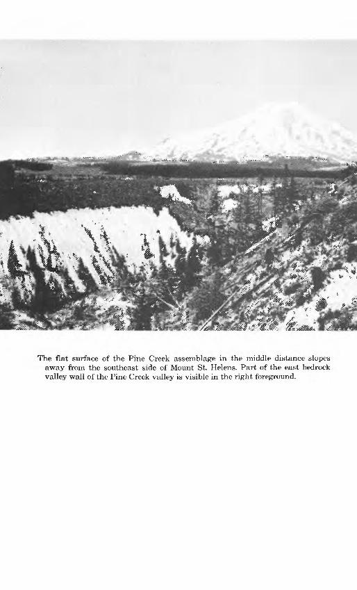
The flat surface of the Pine Creek assemblage in the middle distance slopes away from the southeast side of Mount St. Helens. Part of the east bedrock valley wall of the Pine Creek valley is visible in the right foreground.

Pine Creek Volcanic Assemblage at Mount St. Helens, WashingtonBy DWIGHT R. CRANDELL and DONAL R. MULLINEAUX
GEOLOGY OF MOUNT ST. HELENS VOLCANO, WASHINGTON
GEOLOGICAL SURVEY BULLETIN 1383-A
A study of a valley-fill assemblage of pyroclastic-flow deposits, lahars, and alluvium of postglacial age southeast of Mount St. Helens volcano
UNITED STATES GOVERNMENT PRINTING OFFICE, WASHINGTON : 1973

DEPARTMENT OF THE INTERIOR
WILLIAM P. CLARK, Secretary
U.S. GEOLOGICAL SURVEY
Dallas L. Peck, Director
First printing 1973 Second printing 1984
For sale by the Distribution Branch, U.S. Geological Survey, 604 South Pickett Street, Alexandria, VA 22304

CONTENTS
PageAbstract Al Introduction - 1
- ---- "« --" ---- '"""""""' ""' ""- -T- -- - " ~^ * -'- *~"- i- -" - »" tj
-. - __ ______ _________ ___ __________________________________ « __________ 7
Description of the Pine Creek assemblagePre-J unit of the Pine Creek assemblage 10Post-J, pre-Y unit of the Pine Creek assemblage 13Post-Y unit of the Pine Creek assemblage 13Ash-cloud deposits - 18
Volume of the Pine Creek assemblage- 20Character of old Mount St. Helens in Pine Creek time 20v oicdjiic iiflz£ircis~" - "" --" - - ----- « « . «* ».»«.»-»»» &£*References - 22
ILLUSTRATIONS
Pag.?FRONTISPIECE. The flat surface of the Pine Creek assemblage slopes away
from the southeast side of Mount St. Helens.
FIGURE 1. Index map of the Mount St. Helens region ~ A32. Map showing extent of the Pine Creek assemblage 43. Diagrammatic section showing tephra layers in set P 94. Section showing stratigraphic sequences of deposits in the
Pi TIP C~^Y*Gpk 3.sspinblfifirp~_ _ __ __ .- . --. . _....._..._.......... 11
5. Section showing stratigraphic sequences of deposits exposedin the Pine Creek valley . 14
6. Photograph of pyroclastic-flow deposits 157. Photograph of lahars interbedded with fluvial deposits- - ^
TABLES
Page TABLE 1. Age and predominant Fe-Mg phenocryst content of tephra sets- A8
2. Radiocarbon dates pertinent to the age of the Pine Creek as semblage and associated tephra deposits- - - ~,~~ 8
3. Sequence of events at Mount St. Helens and in the adjacent region, as indicated by deposits in the area southeast of the volcano -----~ ~~~~ ~~~~...._ .. ._.... 21


GEOLOGY OF MOUNT ST. HELENS VOLCANO, WASHINGTON
PINE CREEK VOLCANIC ASSEMBLAGE AT MOUNT ST. HELENS, WASHINGTON
By DWIGHT R. CRANDELL and DONAL R. MULLINEAUX
ABSTRACT
The Pine Creek volcanic assemblage consists of the deposits of hot pyroclastic flows and lahars that are interbedded with alluvium. The assemblage was formed during two or more postglacial episodes of explosive andesitic and dacitic volcanism at an old Mount St. Helens volcano which coincided with, but predated, the modern cone. The assemblage forms a sloping flat-topped to convex valley fill locally more than 100 meters thick and 1-4 km (kilometers) wide. The fill extends from the base of the modern volcano, where it emerges from under a broad apron of younger lahars, lava flows, and alluvium, 16 km southeastward to the Lewis River valley and thence 70 km downstream. In the Lewis River valley, however, it is mostly concealed by three large reservoirs. Hot pyroclastic-flow deposits in the assemblage are found as far as 16 km from the volcano, lahars reached at least 55 km downvalley, and the Lewis River transported volcanic rock debris downstream to its confluence with the Columbia River. Clouds of ash accompanying the hot pyroclastic flows formed de posits 5-100 centimeters thick and 1-3 km wide which are interbedded with tephra along both sides of the Pine Creek assemblage as far as 11 km from the volcano. Radiocarbon dates indicate that the oldest Pine Creek eruptive episode occurred be fore about 12,000 years ago and the youngest between 3,000 and about 2,500 years ago.
INTRODUCTION
Mount St. Helens is a late Quaternary stratovolcano in southern Washington 70 km (kilometers) northeast of Portland, Oreg. (fig. 1). The modern cone is made up largely of olivine basalts and pyrox ene andesites through which several dacite domes have been erupted, one of which forms the present summit (Verhoogen, 1937; Hopson, 1971). The modern cone overlaps an older eruptive center which included several dacite domes and which is characterized by pale-red hornblende dacite and gray hornblende-hypersthene andesite. Verhoogen (1937, p.268) referred to these rocks as the "old Mount St. Helens series." The main purpose of this report is to de scribe a valley-fill assemblage of pyroclastic flow deposits, lahars, and alluvium which was formed during two or possibly three erup tive episodes of the old Mount St. Helens of Verhoogen in late Pleis-
Al
A2 GEOLOGY OF MOUNT ST. HELENS VOLCANO, WASHINGTON
tocene and Holocene time. The Pine Creek assemblage, which is the informal name we will use for the deposits of this valley fill and genetically related ash-cloud deposits, provides examples of how some types of volcanism can affect valleys which head at a volcano, and illustrates some kinds of hazards which could accom pany similar volcanism in the future.
This report is the first chapter in a Geological Survey bulletin on various aspects of the geology and eruptive history of Mount St. Helens volcano. Jack H. Hyde, Tacoma Community College, Tacoma, Wash., who is currently working on the south and south west sides of Mount St. Helens, has provided us with unpublished information concerning the stratigraphic sequence in those areas. Clifford A. Hopson, University of California at Santa Barbara, has contributed unpublished data based on his current geologic map ping of Mount St. Helens and the adjacent region.
Mount St. Helens is drained on the north by the North Fork of the Toutle River, on the west by the South Fork of the Toutle and by the Kalama River, and on the east and south by tributaries of the Lewis River (fig. 1). The major tributaries that drain the east and south east sides are Smith Creek, Muddy River, and Pine Creek. Smith Creek occupies a bedrock valley that lies east of and predates Mount St. Helens (fig. 1). Relatively little volcanic rock debris has been transported into the upper part of the Smith Creek valley be cause of a bedrock interfluve between it and the volcano, and it is still deep and V shaped. Pine Creek occupies the next bedrock valley west of Smith Creek. However, the old Pine Creek valley has been partly filled with rock debris from Mount St. Helens, and Pine Creek now flows through a relatively narrow and shallow trench cut into the fill. In the past, the Muddy River also flowed down the Pine Creek valley; now, however, its upper reach is along the east margin of the fill in the Pine Creek valley, and then it passes through a low saddle in the interfluve and joins Smith Creek. Smith Creek was mainly responsible for the erosion of the valley that is now followed by the lower 14 km of the Muddy River; thus, the en tire length of the valley east of the Pine Creek-Smith Creek interfluve will be referred to as the Smith Creek valley.
The eastward diversion of the Muddy River into the Smith Creek valley evidently occurred when aggradation of the Pine Creek valley by the Pine Creek assemblage raised the valley floor to the level of a low saddle in the interfluve. Ape Canyon Creek (fig. 2) also was once a tributary of Pine Creek but was forced to cross a re latively low point on the interfluve by a lava flow that is younger than the Pine Creek assemblage.
The Pine Creek assemblage is mainly a valley fill of uncon-

PINE CREEK VOLCANIC ASSEMBLAGE A3
122°
'Spirit Lake
5 10 MILES
i i I_______I
0 5 10 KILOMETERS!,,,,! I
FIGURE 1. Index map of the Mount St. Helens region. Bedrock interfluve be tween Pine Creek and Smith Creek valleys is shown by chevron pattern.
solidated volcanic rock debris 1-4 km wide and in places more than 100 m (meters) thick; its surface slopes about 70 m/km along Pine Creek immediately southeast of Mount St. Helens. The fill extends from the base of the modern volcano, where it emerges from under a broad apron of younger lahars, lava flows, and alluvium, along Pine Creek to the Smith Creek valley, where it forms Cedar Flats (fig. 2). Remnants of the fill extend on down the Lewis River to Woodland, which is near the confluence of the Lewis and Columbia Rivers (fig. 1). In the Lewis River valley, however, the fill is now largely concealed by water in three large reservoirs.
The part of the fill that is within about 15 km of the volcano con sists largely of the deposits of hot pyroclastic flows. Lahars and coarse fluvial gravels are volumetrically less important here, but they predominate at greater distances from the volcano. The assemblage is represented only by fine-grained fluvial deposits in the part of the Lewis River valley that is downstream from Lake Merwin (fig. 1).

122"
00'
46°
10'
EX
PL
AN
AT
ION
| ]
LA
HA
RS
AN
D A
LL
UV
IUM
PIN
E C
RE
EK
A
SSE
MB
LA
GE
: M
id-P
ash
-clo
ud d
epos
itP
ost-
J, p
re-B
uni
ts
Pre
-J u
nit
(A)
LO
CA
LIT
Y
DIS
CU
SS
ED
IN T
EX
T
O
O s O
O O
C! 2! CO < O K CO ffi O
FIG
URE
2. E
xte
nt
of t
he P
ine
Cre
ek a
ssem
blag
e in
the
are
a so
uthe
ast
of M
ount
St.
Hel
ens.

PINE CREEK VOLCANIC ASSEMBLAGE A5
Lithologically similar lahars which are apparently only a few hundred years younger than the youngest part of the Pine Creek assemblage are present in some of the other valleys that head at the volcano namely, the North and South Forks of the Toutle River (Mullineaux and Crandell, 1962), the Kalama River (Hyde, 1970), and Swift Creek (J. H. Hyde, oral commun., 1972).
A volumetrically small part of the Pine Creek assemblage con sists of beds of ash which occur in areas adjacent to the valley-fill deposits. These beds are thought to be the deposits of clouds of ash that accompanied hot pyroclastic flows, or to be the deposits of such flows.
TERMINOLOGY
The term "pyroclastic-flow deposit" will be used in this report to describe the deposit of a hot dry flow of vesicular or nonvesicular volcanic rock debris that is mobilized chiefly by gravity and hot air trapped within the debris, or by hot gases emitted by the rock debris, or by both. Lithic pyroclastic-flow deposits consist almost entirely of nonvesicular rock debris and probably were mobilized chiefly by air that was trapped and heated, although hot gas may also have been emitted by the rock fragments. Pumiceous pyro clastic-flow deposits consist largely of pumice fragments of a wide size range, and these may have been mobilized mostly by hot gases emitted by the constituent pumice particles during movement.
Tephra, a term introduced by Thorarinsson (1954, p. 1-3), was defined as fragmental volcanic debris which was transported from the crater through the air. Thus, it serves as a general term which does not denote properties of composition, vesicularity, or grain size as do most other terms for volcanic clastic material. Most material described as tephra in this report was erupted high into the air over the volcano, carried laterally primarily by wind, and then fell back to the land surface at a high angle. Some of these tephra deposits consist chiefly of vesicular material, others are composed mostly of nonvesicular (lithic) fragments, and still others contain major proportions of both kinds of particles. Near the vent, the deposits may have either a wide range or a limited range in grain size. Downwind, they form elongate lobes in which the deposits become progressively thinner and the particles are finer and better sorted with increasing distance from the volcano. The deposits also thin rapidly from the central axes of the lobes to ward the margins.
Still another group of deposits seems to have had a composite origin; they could be considered tephra in part, but they seem to consist chiefly of fine-grained pyroclastic flows and dust from such

A6 GEOLOGY OF MOUNT ST. HELENS VOLCANO, WASHINGTON
flows. We have not found a term that is entirely appropriate for this group, although we wish to distinguish it from other tephra de posits. For the purpose of this report, therefore, we will use the term "ash-cloud deposit" for beds of material deposited from clouds of airborne ash whose origin was associated with hot pyroclastic flows. Some ash-cloud deposits may have been formed directly by sheetlike or tonguelike pyroclastic flows of mostly ash-sized material which flowed down the side of the volcano and across the landscape as broad overwhelming density currents, to some degree independent of topography. Others probably fell from dust clouds rising above hot pyroclastic flows that moved mostly along top ographic depressions in contact with the underlying ground sur face. The ash-cloud deposits consist chiefly of nonvesicular ash a few centimeters to a meter thick. They commonly display bedding that suggests rapid lateral transport during deposition. They may decrease in thickness away from the axis of the valley down which hot pyroclastic flows traveled, but commonly they do not decrease as noticeably as does most tephra in thickness and grain size with distance from the source vent.
Lahars are flows of rock debris, mobilized by water, which orig inated on the slopes of a volcano. They may carry either hot or cold rock debris. Lahars generally show a rude vertical size gradation from coarse to fine toward the top, which implies a mudflow origin (Mullineaux and Crandell, 1962; Crandell, 1971, p. 6-7).
Differentiation of lahars from pyroclastic-flow deposits is generally difficult, but a few criteria are helpful. A deposit in which individual rock fragments all have a preferred direction of rem- anent magnetism is inferred to have been formed by a pyroclastic flow because the ferromagnetic minerals in the fragments must have still been above their Curie temperatures when the deposit came to rest (Aramaki and Akimoto, 1957; Crandell, 1971, p. 5). Conversely, a coarse unsorted deposit of volcanic rock debris in which rock fragments have random directions of remanent mag netism is probably a lahar. A brick-red to reddish-gray color in the uppermost 1-5 m also suggests that a deposit was hot when it came to rest, and therefore is probably of pyroclastic-flow origin. Such a red zone at the top of ash flows has been mentioned by Smith (1960, p. 831). Williams (1960, p. 13) also described "glowing avalanche" deposits in Guatemala in which the gray color "changes to pink near the top, in some places, owing to sublimation of finely divided hematite from fumarolic vapors given off by the ejecta while they were still hot." One such deposit described by Williams (p. 35) has a pink zone 4.5 m thick and also contains fragments of carbonized wood. Williams (p. 67) noted that "The presence of a pink top

PINE CREEK VOLCANIC ASSEMBLAGE A7
strongly suggests an [glowing] avalanche deposit, but its absence has no diagnostic value."
A few deposits in the Pine Creek assemblage which have red dish tops were found to contain rock fragments having randomly oriented directions of remanent magnetism. These rock fragments may have cooled below the Curie temperature while being trans ported by pyroclastic flows. Other deposits, in which some rock fragments have a preferred orientation of remanent magnetism, lack reddish zones at their tops. Some of these deposits were formed by pyroclastic flows, but others may have been formed by lahars which were carrying hot rock fragments.
Units in the Pine Creek assemblage which are texturally similar to lahars or pyroclastic-flow deposits, but which lack features from which their origin can be inferred, are designated in this report as "flowage deposits."
TEPHRA
Mount St. Helens has erupted tephra repeatedly during the last few tens of thousands of years before, during, and after the for mation of the Pine Creek assemblage. Thus, the assemblage can be separated from other deposits by its stratigraphic position relative to tephra, and tephra layers interbedded with the assemblage per mit it to be subdivided, as well.
The tephra deposits are divided into several groups, or sets; each set consists of several layers that contain similar suites of Fe-Mg phenocrysts and that differ in Fe-Mg mineral content from the tephra in underlying and overlying sets. Each of the sets listed in table 1, except set T, contains more than one layer. The Pine Creek assemblage was deposited after the eruption of tephra set S and be fore the eruption of set B.
Tephra set S consists of several beds of coarse pumice in which cummingtonite and hornblende are abundant (table 1). All the layers in the set probably were erupted during a relatively short period of time, between limiting dates of about 18,000 and 12,000 years ago (table 2). Their actual age, however, may not be close to either limiting date. A soil profile was formed on the unnamed tephra deposits after 18,000 years ago but before set S was erupted, and another soil profile developed on set S before set J was de posited.
Tephra set J includes two coarse pumice layers and one distinctly finer bed. No Fe-Mg minerals other than hypersthene and hornblende have been found in this set. Set J is similar in general appearance to set S and commonly must be distinguished by mineral content. The set is bracketed by radiocarbon dates of about 12,000 and 8,000 years (table 2).
A8 GEOLOGY OF MOUNT ST. HELENS VOLCANO, WASHINGTON
TABLE 1. Age and predominant Fe-Mg phenocryst content of tephra sets[Data mostly from Mullineaux, Hyde, and Rubin (1972)]
Set
T
W
g
p
j
o ____________________ _____ _ _____
Approximate age (years)
150-200
450
< 2,500, >450
3,000-2,500(7)
4,000-3,000
< 12,000, > 8,000
< 18,000, >12,000
> 35,000-18,000
Predominant Fe-Mg phenocrysts
Hypers thene, hornblende, and augite.
Hypersthene and hornblende.
Olivine, augite, and hypersthene.
Hypersthene and hornblende.
Cummingtonite and hornblende.
Hypersthene and hornblende.
Cummingtonite and hornblende.
C ummingtonite , hornblende, and biotite.
Tephra set Y includes 10 or more coarse pumice beds, all of which contain Cummingtonite and hornblende. Set Y pumice layers generally can be identified by their coarse grain size and young age. Two layers within set Y are known to be very extensive; one forms a northeast-trending lobe which was first described in Mount Rainier National Park (Crandell and others, 1962) as "ash layer Y"; the other extends southeast from Mount St. Helens. The Y tephra that is associated with the Pine Creek assemblage is mostly that of the southeast-trending lobe.
The age of set Y as a whole ranges from about 4,000 to 3,000 years. The two most extensive layers in it are closely bracketed by radio carbon dates of 3,500 and 3,350 years at Mount St. Helens (table 2).
Tephra set P consists of several thin pumice-bearing layers which also include a high proportion of lithic and crystal frag-
TABLE 2. Radiocarbon dates pertinent to the age of the Pine Creek assemblage and associated tephra deposits
[All dates were determined by Meyer Rubin in the radiocarbon laboratory of the U.S. Geol. Survey]
Date (years before present)
1 ,740+250 -
9'fi70-l-9Sft
2 850±250
3|350±:250 -----
^ QftO J f)cif\
11,800±300 -----
18's60i550'
LaboratoryNo.
W-2527 W-1394 W-2529 W-2541 W-2542 W-2675 W-2549 W-1752 W-2677 W-2587 W-2655 W-2441 W-2413
Kind of sample and stratigraphic position
Charcoal from within tephra set B. Wood from above or within upper part of tephra set P.
Do. Do.
Charcoal from base of tephra set P. Charcoal from within tephra set Y.
Do. Charcoal from base of tephra set Y. Charcoal from above or within upper part of tephra set J. Wood from lahar beneath tephra set J. Charcoal from ash beneath tephra set J. Charcoal from pyroclastic-flow deposit beneath tephra set S.

PINE CREEK VOLCANIC ASSEMBLAGE A9
ments. The pumice and lithic fragments contain only hypersthene and hornblende as Fe-Mg phenocrysts and can thereby be distin guished from tephra of set Y. Hypersthene in set P has a lower re fractive index than that in set W; thus, the two sets can be distin guished even though they have a similar mineralogy.
Set P contains a coarse, poorly sorted bed of pumice and lithic fragments at its base and one or two finer, well-sorted beds in its lower part (fig. 3). Reddish- to brownish-gray sand and silt beds of undetermined origin generally separate the tephra layers and are thickest near the middle of the set. One to four fine, well-sorted tephra layers, similar to those in the lower part, lie above the thick sand and silt. The uppermost bed of the set consists of yellowish- gray pumiceous lapilli and ash.
The older age limit of the set is established by a radiocarbon date of about 3,000 years at its base (table 2). At Mount St. Helens, the closest limiting date above the tephra is one of about 1,700 years in the overlying set B. A date of about 2,400 years was obtained at Mount Rainier from wood above the upper fine-grained, well-sorted beds of set P. Whether or not the wood is younger than the topmost bed of the set at Mount St. Helens, however, is not known.
Set B consists mostly of layers of olivine-bearing scoria and is readily distinguished by its overall brown color and abundant dark glass. Minor variations in mineral content allow the set to be sub divided into lower and upper units. The set is dated by its strati- graphic position relative to sets P and W and by a single radio-
Topmost layer
Upperfine-grainedlayers
EXPLANATION
TEPHRA DEPOSITS: Pumice lapilli size or larger
Lithic fragments lapilli size or larger
DEPOSITS OF UNDETERMINED ORIGIN: Sand
r^-~ silt
Lowerfine-grainedlayers
Basal layer
FIGURE 3. Diagrammatic section showing tephra layers in set P.

A10 GEOLOGY OF MOUNT ST. HELENS VOLCANO, WASHINGTON
carbon date of about 1,700 years from thin sand and silt beds that lie between the lower and upper units of the set.
DESCRIPTION OF THE PINE CREEK ASSEMBLAGE
The Pine Creek volcanic assemblage originated during two or possibly three episodes of explosive dacitic and andesitic volcan- ism. The assemblage is divided into three principal units by their stratigraphic relation to the tephra sets, as shown below:
Tephra set B Post-Y unit (contemporaneous with tephra set P)
Tephra set Y Post-J, pre-Y unit
Tephra set J Pre-J unit
Tephra set S
These tephra sets extend far beyond the limits of the Pine Creek assemblage and are not regarded as a part of the assemblage where they are interbedded with it.
PRE-J UNIT OF THE PINE CREEK ASSEMBLAGE
The oldest part of the Pine Creek assemblage consists of lithic pyroclastic-flow deposits and lahars which are younger than tephra set S and older than set J. The deposits are well exposed near the confluence of the Muddy and Lewis Rivers and can be seen in scattered outcrops down the Lewis River valley in segments be tween the three reservoirs. The unit can be traced only a short dis tance up the Pine Creek valley because it is covered by younger units of the Pine Creek assemblage. The pre-J unit forms a fan at the mouth of the Pine Creek valley which spreads across the lower Smith Creek valley and forces the Muddy River against the east valley wall. The surface of the northern part of this fan is called Cedar Flats. A section through the fan deposits is exposed in cuts along an abandoned logging road 0.6 km north of the mouth of the Muddy River (loc. A, fig. 2). The sequence of deposits exposed at locality A and the sequence in an outcrop at the front of a terrace cut into the Cedar Flats fan about 2 km farther north (loc. B, fig. 2) are shown in figure 4. The pink-topped pyroclastic-flow deposit be neath tephra set J at locality A is unweathered at the top.
The deposits shown in figure 4 as of pyroclastic-flow origin are unsorted mixtures of fragments of nonvesicular andesite and dacite as large as 1 m in diameter in a compact matrix of gray silty sand. These deposits are 1-5.5 m thick. Units designated as lahars are lithologically similar to the pyroclastic-flow deposits and are 0.5-7 m thick. Both kinds of deposits are generally bounded by

PINE CREEK VOLCANIC ASSEMBLAGE All
Altitude(feet)
1350WEST EAST
1150
1000
LOCALITY B
FIGURE 4. Stratigraphic sequences of deposits in the Pine Creek assemblage exposed near the mouth of the Muddy River (loc. A, fig. 2) and about 2 km farther north (loc. B, fig. 2). Stipple pattern indicates covered intervals.
nearly horizontal contacts, along some of which can be found lenses of silt and very fine sand 1-4 cm (centimeters) thick. The only deposit of fluvial origin at locality A is a single lens of pumice- lapilli gravel 40 cm thick.
At locality A the upper surface of the pre-J part of the Pine Creek assemblage lies about 75 m above the Muddy River, and the valley fill seems to have temporarily blocked the Lewis River at least once. Remnants of a lahar backfill are found along the Lewis River valley for about 8 km upstream from the mouth of the Muddy River, and they veneer terraces of glacial outwash sand and gravel. The backfill extends about 5 km upvalley from the terminal position

A12 GEOLOGY OF MOUNT ST. HELENS VOLCANO, WASHINGTON
reached by the Lewis River glacier in late Pleistocene time (fig. 2). Comparison of profiles of weathering in till in the terminal moraine with those in till of alpine glaciers in the Mount Rainier region (Crandell, 1969, p. 18) suggests that the terminal moraine was formed during the Evans Creek Stade of the Fraser Glaciation. Several tephra layers of set S, which is less than 18,000 years old, lie between the deposits of the backfill and the outwash sand and gravel.
The lahar backfill deposits become finer in grain size up the Lewis River valley. At a point 4 km upvalley from the Muddy River, a lahar of the backfill is more than 3 m thick and consists of sub- angular rock fragments mostly 2-5 cm in diameter in a gray sand matrix. The deposit also contains scattered dacite rock fragments as large as 0.7 m across and grades to coarse sand and granule gravel at the top. Two kilometers farther upstream the lahar backfill is finer in texture and consists mostly of unstratified coarse sand and granule gravel.
The pre-J part of the Pine Creek assemblage has been recognized along the Lewis River valley between Swift Dam and Cougar and between Yale Dam and Speelyai Bay (fig. 1). In both of these areas the pre-J deposits are chiefly lahars. The top of the assemblage is about 60 m above the prereservoir valley floor at Cougar.
The presence of wood that is about 11,800 years old in the pre-J deposits at locality B limits the age of the older part of the Pine Creek assemblage. The wood-bearing lahar seems to be part of a somewhat younger fill in a canyon that was entrenched into the Cedar Flats fan after the units that make up the fan were de posited. The lahar and alluvium that form the younger fill evident ly moved down the Smith Creek valley.
The 11,800-year date suggests that the lahar occurred during the Everson Interstade of the Fraser Glaciation, which lasted from about 13,000 to 11,000 years ago in the Fraser Lowland of north west Washington and southwest Canada (Armstrong and others, 1965). It has been suggested that alpine glaciers in the Olympic Mountains of western Washington reached their maximum ex tents and began to retreat before 15,000 years ago, and alpine glaciers in the Cascade Range probably behaved in the same way (Crandell, 1965, p. 345-348). The oxidized zone at the top of the out- wash sand and gravel beneath the lahar of the Lewis River back fill records a time interval between deposition of the outwash and arrival of the lahar; this suggests that the pre-J part of the Pine Creek assemblage was formed not much more than 12,000 years ago. The near-absence of wood in that part of the assemblage may reflect a lack of dense forests at these altitudes in late-glacial time.

PINE CREEK VOLCANIC ASSEMBLAGE A13
POST-J, PRE-Y UNIT OF THE PINE CREEK ASSEMBLAGE
Deposits of the Pine Creek assemblage that are younger than tephra set J but older than set Y have been recognized only in the lower valley of Pine Creek and on the Cedar Flats fan. A borrow-pit exposure on the north side of Pine Creek at locality C (fig. 2) shows layer Y on top of about 0.5 m of yellowish-brown fluvial sand and gravel. Beneath the gravel is a lithic pyroclastic-flow deposit more than 12 m thick. This deposit consists of pebble- to boulder-sized fragments of nonvesicular dacite in a very compact matrix of gray silty sand.
The surface of the Cedar Flats fan west of locality A is veneered by a lahar as much as 1.5 m thick which lies between tephra sets J and Y. The lahar is a loose unsorted mixture of subangular rock fragments as large as 15 cm in diameter in a matrix of silty sand. At some places the lahar is underlain by as much as 1 meter of fluvial gravel, and at other places there are two lahars between tephra sets J and Y.
The topographic position of the pre-Y lahar at the surface of the Cedar Flats fan suggests that Pine Creek did not entrench the fan until after set J and the lahar were deposited, even though the Muddy River had done so before these deposits were formed. In some exposures tephra set Y can be seen to overlie an oxidized zone as much as 0.7 m thick which is developed within a post-J lahar. This oxidation, which resulted from weathering, seems to represent a substantial time interval after deposition of the lahar but before tephra set Y was formed between 4,000 and 3,000 years ago, and its presence implies that the lahar is closer in age to set J than to set Y.
POST-Y UNIT OF THE PINE CREEK ASSEMBLAGE
The most extensive and best preserved part of the Pine Creek assemblage is younger than tephra set Y and older than set B. The post-Y sequence includes valley-fill deposits of hot pyroclastic flows, lahars, and streams, and ash-cloud deposits beyond the margins of the valley fill. Within a distance of 3 km from the base of the volcano the valley fill is partly covered by younger lahars (fig. 2); elsewhere it is mantled only by tephra. The surface of the valley fill slopes southeastward along the course of Pine Creek at a gradient of about 70 m/km. At a distance of 3-7 km from the base of the volcano the surface of the fill is convex in cross profile, and farther downvalley it forms a succession of fill terraces that ex tends to the edge of Swift Reservoir. The part of the valley of Pine Creek that is below the lowest terrace (fig. 5) is thought to postdate the Pine Creek eruptive episode, but the higher terraces probably were formed during that episode and were caused by alternations of valley filling and cutting.

A14 GEOLOGY OF MOUNT ST. HELENS VOLCANO, WASHINGTON
Altitude (feet) SOUTH
1550 r-NORTH
'-O
APPROXIMATE SCALE
B Tephra set B Y Tephra set Y A Fluvial deposit C Ash-cloud deposit
EXPLANATION
LF Lithic pyroclastic-flow deposit PF Pumiceous pyroclastic-flow deposit L Lahar F Fkiwage deposit of unknown origin
Stipple pattern indicates covered intervals
FIGURE 5. Stratigraphic sequences of deposits exposed in the Pine Creek Valley near locality C (fig. 2). Horizontal scale is diagrammatic.
Pyroclastic-flow deposits form the largest part of the sequence from the base of the volcano downvalley for about 11 km (fig. 6). In dividual lithic flow deposits are as much as 15 m thick and typically have pink zones 1-3 m thick at their tops. Some pumiceous pyro clastic-flow deposits are compact mixtures of pumice fragments and nonvesicular glassy rock fragments, and others consist of breadcrusted pumice blocks and lapilli in a loose ash matrix. The pumice in each of the pyroclastic-flow deposits examined con tained hypersthene and hornblende as the predominant Fe-Mg minerals.
One of the best exposures of the post-Y part of the Pine Creek

PINE CREEK VOLCANIC ASSEMBLAGE A15
FIGURE 6. Pyroclastic-flow deposits exposed in the side of the trench of Pine Creek about 5 km southeast of the base of Mount St. Helens. The largest block in the center of the photograph is about 3 m in diameter.
assemblage is on the east side of Pine Creek at locality E, where there are at least 10 pyroclastic-flow deposits which range in thick ness from 1 to 12 m. The lowest of these, which is 1.2 m thick, con sists mostly of pumice but also contains many fragments of non-

A16 GEOLOGY OF MOUNT ST. HELENS VOLCANO, WASHINGTON
vesicular glassy rock. Charcoal in it was found to have a radio carbon age of about 2,850 years (sample W-2542, table 2). An over lying pumiceous pyroclastic-flow deposit which is 2.7 m thick con tains pumice fragments mostly less than 5 cm in diameter as well as angular fragments of nonvesicular glassy rock. Above it is a lithic pyroclastic-flow deposit 1-3 m thick which is especially con spicuous because of a reddish-gray zone, about 1 m thick, at its top. This deposit contains angular and subangular nonvesicular dacite fragments as large as 1.2 m in diameter in a loose sand matrix. Rock fragments tested with a fluxgate magnetometer showed a preferred orientation of the direction of remanent mag netism. All the wood fragments in the deposit, including large logs, have been entirely converted to charcoal.
Above the charcoal-bearing lithic pyroclastic flow is a similar de posit which is estimated to be about 12 m thick. The direction of remanent magnetism of rock fragments in it was not determined, but a reddish-gray zone at its top suggests that the deposit also orig inated as a hot pyroclastic flow. An interesting feature of the upper half of this deposit is the presence of long thin layers of pumice blocks. These do not seem to have the continuity that would sug gest that they separate a succession of pyroclastic flows.
Ross and Smith (1961, p. 21) attributed alternating layers of thin pumice zones and typical unsorted ash-flow tuff to the overlapping of eddies or surges of an ash flow near its terminus. They suggested that lobes of a flow would have concentrations of pumice at top and bottom and would override one another, thus leaving a deposit that is crudely bedded. They also noted that incorporation of rubble by an ash flow from the underlying terrain may lead to concentra tions of this material in lenses or linear zones within the ash flow. Although such lenses are most common near the base, they may also occur within the flow and give an impression of bedding.
Charcoal from another pyroclastic-flow deposit within the assemblage, which was obtained from an outcrop along a logging road at locality F (fig. 2), had a radiocarbon age of about 2,670 years. Charcoal from a pyroclastic-flow deposit that is overlain only by set B and other tephra west of Pine Creek at locality G had a radiocarbon age of about 2,580 years (table 2).
Lahars form a subordinate part of the post-Y unit within a dis tance of about 11 km from the base of the volcano, but they pre dominate farther downvalley and extend beyond Swift Dam. Lahars were observed at several places along Pine Creek. At the confluence of two branches of the creek near locality E (fig. 2), at least 8 lahars are exposed. A roadcut 1 km farther south shows a very coarse lahar that contains blocks of nonvesicular dacite and
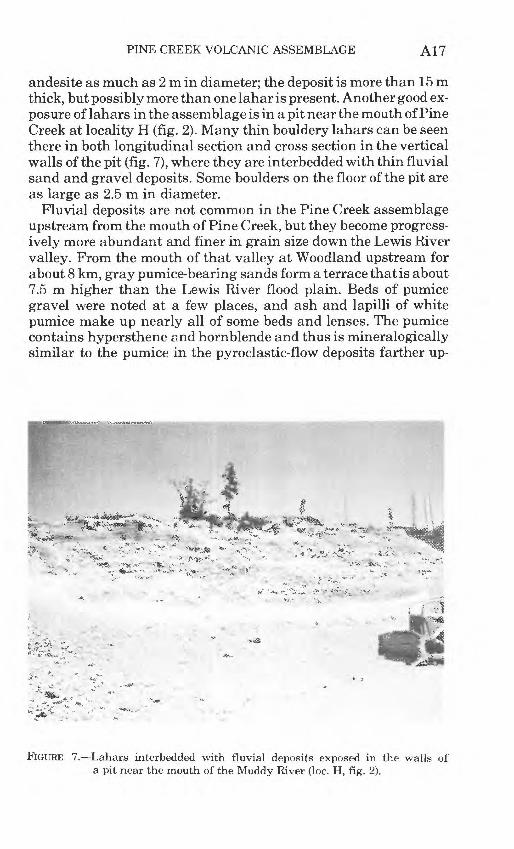
PINE CREEK VOLCANIC ASSEMBLAGE A17
andesite as much as 2 m in diameter; the deposit is more than 15m thick, but possibly more than one lahar is present. Another good ex posure of lahars in the assemblage is in a pit near the mouth of Pine Creek at locality H (fig. 2). Many thin bouldery lahars can be seen there in both longitudinal section and cross section in the vertical walls of the pit (fig. 7), where they are interbedded with thin fluvial sand and gravel deposits. Some boulders on the floor of the pit are as large as 2.5 m in diameter.
Fluvial deposits are not common in the Pine Creek assemblage upstream from the mouth of Pine Creek, but they become progress ively more abundant and finer in grain size down the Lewis River valley. From the mouth of that valley at Woodland upstream for about 8 km, gray pumice-bearing sands form a terrace that is about 7.5 m higher than the Lewis River flood plain. Beds of pumice gravel were noted at a few places, and ash and lapilli of white pumice make up nearly all of some beds and lenses. The pumice contains hypersthene and hornblende and thus is mineralogically similar to the pumice in the pyroclastic-flow deposits farther up-
FlGURE 7. Lahars interbedded with fluvial deposits exposed in the walls of a pit near the mouth of the Muddy River (loc. H, fig. 2).

A18 GEOLOGY OF MOUNT ST. HELENS VOLCANO, WASHINGTON
stream as well as to pumice in tephra set P. The lithology of the sand deposit indicates that it is not a normal fluvial deposit of the Lewis River, and we infer that the sand is the downstream cor relative of the post-Y part of the Pine Creek assemblage.
ASH-CLOUD DEPOSITS
Ash clouds which were formed during the accumulation of the post-Y part of the Pine Creek assemblage created several deposits 5-100 cm thick over an area 1-3 km wide adjacent to the Pine Creek valley. The ash-cloud deposits are interbedded with pumice and lithic tephra of set P along both sides of the valley as far as 12 km southeast of the base of the volcano.
Ash-cloud deposits have been recognized in the tephra sequence associated with sets J and Y, and at two stratigraphic positions within set P, but only the deposit at one horizon within set P will be described because it is the thickest and most widespread ash-cloud deposit recognized in the area southeast of Mount St. Helens. It will be referred to as the mid-P ash-cloud deposit. Stratigraphic posi tions of all post-S ash-cloud deposits recognized within the tephra sequence are as follows:
Tephra set B Ash-cloud deposit
Topmost pumice layer of tephra set P Ash-cloud deposit
Upper fine beds of tephra set P Ash-cloud deposit (mid-P)
Middle silt and sand layers of tephra set PLower fine beds of tephra set PBasal layer of tephra set PUpper layers of tephra set Y
Ash-cloud depositLower layers of tephra set Y
Ash-cloud deposit Ash-cloud deposit
Tephra set J Ash-cloud deposit(?) Ash-cloud deposit(?)
Tephra set S
The distribution of the mid-P ash-cloud deposit is shown in figure 2. The deposit is thickest along the northeast base of Marble Moun tain and on the interfluve between the Pine Creek and Smith Creek valleys just above the east margin of the valley-fill part of the Pine Creek assemblage. It decreases in thickness away from the valley fill and also toward the southeast, away from the volcano. The deposit veneers the north slope and crest of Marble Mountain as

PINE CREEK VOLCANIC ASSEMBLAGE A19
much as 2.5 km south of, and 360 m higher than, the top of the valley fill at the north base of Marble Mountain.
Texturally, the mid-P ash-cloud deposit is fine to coarse lithic ash that contains scattered pumice ash and lapilli. Angular fragments of nonvesicular rock as large as 2 cm in diameter are not uncom mon in the deposit near the margins of the valley-fill part of the Pine Creek assemblage. The mid-P deposit becomes finer upslope from the valley fill and also away from the volcano.
The mid-P ash-cloud deposit seems to be massive in many places, but planar bedding is not uncommon. Foreset bedding in which the beds dip away from the volcano was noted at a few places.
At places where the cloud deposit is thin, it resembles tephra layers of set P, but the following characteristics aid in its identifi cation:1. Areal distribution of the ash-cloud deposit is closely related to
the margins of the valley-fill part of the Pine Creek assem blage; its thickness decreases outward from these margins to the east and to the west, as well as with increasing height above the top of the valley fill. In contrast, the thickness and grain size of set P tephra sheets decrease predictably away from the volcano according to distance and wind directions at the time of the eruption. Those tephra thicknesses are gov erned primarily by distance from the volcano rather than by local topographic features or by altitude.
2. The ash-cloud deposit consists largely of sand-sized ash where it is as much as 1 m thick. In contrast, most tephra layers derived from Mount St. Helens which are more than about 20 cm thick typically consist mainly of fragments of lapilli size or larger.
3. The ash-cloud deposit consists mostly of nonvesicular material, whereas most tephra deposits contain a significant or pre dominant component of vesicular fragments.
The mid-P ash-cloud deposit probably was formed in at least two ways. Part of it may have resulted from fallout of fine material fi-om clouds of dust rising above hot pyroclastic flows moving down valley floors. Clouds of this kind are illustrated in accounts of the 1902 and 1929 eruptions of MontPele'e(Lacroix, 1904; Ferret, 1937). Other parts probably were formed by hot dense clouds of pre dominantly fine grained rock debris moving across the ground sur face at high velocity. Such clouds may originate from the eruption of finely comminuted gas-rich debris which descends one or more flanks of a volcano with increasing speed because of gravitational acceleration. Incandescent clouds of this kind, which resulted from the climactic eruption of Mount Lamington, Papua, on January 21,

A20 GEOLOGY OF MOUNT ST. HELENS VOLCANO, WASHINGTON
1951, were referred to as "ash hurricanes" by Taylor (1958, p. 45). Features characteristic of base-surge deposits, such as dune sur face form and dune-type bedding (Moore, 1967; Fisher and Waters, 1970), have not been recognized in the Pine Creek area.
Although some features of bedding, texture, and distribution sug gest ways in which different kinds of ash-cloud deposits can be dis tinguished, the mid-P deposit has not yet been studied in enough de tail to be differentiated.
VOLUME OF THE PINE CREEK ASSEMBLAGE
Although we cannot yet calculate the relative volumes of the pre- J and post-J parts of the Pine Creek assemblage, we estimate that the original volume of the entire assemblage was between 3 and 4 km3 . This amount can be compared with the volume of the present cone of Mount St. Helens, which is about 27 km3 if the cone is as sumed to be symmetrical and smooth-sided and to have a basal dia meter of 8 km and a height of 1.6 km. The volume of the assemblage is also less than that of tephra set Y, whose volume may be as much as 10 km3 . Set P may have only one-tenth or one-fifth the volume of tephra set Y.
CHARACTER OF OLD MOUNT ST. HELENS IN PINE CREEK TIME
We have as yet no direct evidence concerning the size or shape of the old Mount St. Helens volcano from which the Pine Creek assem blage was derived. However, something of its general character can be inferred from the nature and distribution of the assemblage itself. The large volume of rock debris in the Pine Creek deposits suggests a derivation from dacite domes which were repeatedly ex truded and then destroyed by explosions. These domes probably were not part of a high symmetrical volcano similar to modern St. Helens; rather, they may have risen through low cones of fragmen- tal debris. Mass-flowage deposits dating from the interval 3,000 to 2,500 years ago (table 3) have been found thus far only in the area southeast of the volcano. This suggests that some kind of a top ographic feature prevented volcanic debris from moving into valleys to the north and west at that time. If St. Helens was then a single cone with a central dome, rather than a group of domes and cones, it probably had a crater open to the southeast which dis charged into an "avalanche valley" at the head of Pine Creek.
The interbedding of lithic and pumiceous pyroclastic-flow deposits in the post-Y part of the Pine Creek assemblage shows that the volcano erupted these materials alternately, perhaps during a single short eruptive episode. The lithic deposits could have orig-

PINE CREEK VOLCANIC ASSEMBLAGE A21
TABLE 3. Sequence of events at Mount St. Helens and in the adjacent region, as indicated by deposits in the area southeast of the volcano
Approximate age, orlimiting dates
Event (years ago)
Eruption of tephra set W - - 450Eruption of tephra set B < 2,500, > 450Eruption of tephra set P and formation of
hot pyroclastic flows and lahars -- 3,000-2,500(7) Eruption of tephra set Y ----- -- ----- 4,000-3,000 Formation of hot pyroclastic flows
and lahars----------------------- < 8,000, 4,000Eruption of tephra set J --- - - -- - < 12,000, > 8,000 Formation of hot pyroclastic flows
and lahars < 18,000, > 8,000Eruption of tephra set S - ---- --- < 18,000, > 12,000Retreat of alpine glaciers
inated from the explosive disruption of dacite domes and spines as they were being elevated, and the pumiceous flow deposits prob ably originated when explosive venting of gas-charged magma oc curred.
The old Mount St. Helens of pre-J time probably also consisted of one or several domes and cones of fragmental debris. We do not yet know how widely flowage deposits of this age are distributed around the volcano.
The volume of the valley fills of pyroclastic flows and lahars in the Pine Creek assemblage may have an inverse relation to the volume and vesicularity of tephra erupted at about the same time. Thus, most of the post-Y valley-fill deposits of the assemblage were formed during the same eruption period that produced tephra set P, which is of relatively small volume and mostly of nonvesicular material. Likewise, pumice is virtually absent from the pre-J part of the assemblage, the deposition of which evidently was not accom panied by eruptions that produced recognizable tephra deposits. In contrast, few pyroclastic flows or lahars were formed at times when the volcano was erupting large volumes of highly vesicular mate rial, like that represented by tephra set Y and perhaps also by set J.
The eruption of domes and pumiceous tephra seems to have characterized Mount St. Helens for a long time. Some tephra and pyroclastic-flow deposits, probably derived from domes, date back to the period between 18,000 and 36,000 years ago (Mullineaux and others, 1972; J. H. Hyde, written commun., 1972). In addition, domes (Hopson, 1971) as well as tephra and pyroclastic flows (Mullineaux, 1964; Hyde, 1970) have been erupted within the last 500 years or so.

A22 GEOLOGY OF MOUNT ST. HELENS VOLCANO, WASHINGTON
VOLCANIC HAZARDS
The events represented by the deposits of the Pine Creek assem blage and associated tephra are not the only kinds of volcanic ac tivity that have occurred during the last 15,000 years or so, but they are potentially among the most dangerous. Pyroclastic flows, ash clouds, and tephra falls could be a direct and immediate threat to human life in areas adjacent to an active vent. Pyroclastic flows and lahars could, in addition, move large masses of rock debris down valley floors within a short period of time and endanger persons and property at greater distances from the volcano. Move ment of large volumes of fragmental rock material into valleys on the south side of the volcano might also displace a large volume of water from Swift Reservoir and perhaps endanger the dam itself.
If volcanism of this kind were to occur in the future, areas affected by tephra fall would be downwind from the active vent or vents; the extent of the endangered area would depend on the ex- plosiveness and volume of the eruption and the strength and direc tion of winds. Areas affected most by lahars and pyroclastic flows with their associated ash clouds would be the floors and sides of valleys that head at or near the active vent. The greatest danger would exist in the area actually reached by the flows, but if floods were caused by reservoir displacement, the danger could be ex tended far downstream.
REFERENCESAramaki, Shigeo, and Akimoto, Syun-iti, 1957, Temperature estimation of pyro
clastic deposits by natural remanent magnetism: Am. Jour. Sci., v. 255, no. 9, p. 619-627.
Armstrong, J. E., Crandell, D. R., Easterbrook, D. J., and Noble, J. B., 1965, Late Pleistocene stratigraphy and chronology in southwestern British Co lumbia and northwestern Washington: Geol. Soc. America Bull., v. 76, no. 3, p. 321-330.
Crandell, D. R., 1965, The glacial history of western Washington and Oregon, in The Quaternary of the United States: Princeton, N. J., Princeton Univ. Press, p. 341-353.
____1969, Surficial geology of Mount Rainier National Park, Washington: U. S. Geol. Survey Bull. 1288, 41 p.
___1971, Postglacial lahars from Mount Rainier volcano, Washington: U.S. Geol. Survey Prof. Paper 677, 75 p.
Crandell, D. R., Mullineaux, D. R., Miller, R. D., and Rubin, Meyer, 1962, Pyroclastic deposits of Recent age at Mount Rainier, Washington, in Short papers in geology, hydrology, and topography: U.S. Geol. Survey Prof. Paper 450-D, p. D64-D68.
Fisher, R. V., and Waters, A. C., 1970, Base surge bed forms in maar volcanoes: Am. Jour. Sci., v. 268, no. 2, p. 157-180.
Hopson, C. A., 1971, Eruptive sequence at Mount St. Helens, Washington: Geol. Soc. America, Cordilleran Sec., Abs. with Programs, v. 3, no. 2, p. 138.

PINE CREEK VOLCANIC ASSEMBLAGE A23
Hyde, J. H., 1970, Geologic setting of Merrill Lake and evaluation of volcanic hazards in the Kalama River valley near Mount St. Helens, Washington: U.S. Geol. Survey open-file report, 17 p.
Lacroix, Alfred, 1904, La Montagne Pele'e et ses eruptions: Paris, Masson et Cie., 662 p.
Moore, J. G., 1967, Base surge in recent volcanic eruptions: Bull. Volcanol., v. 30, p. 337-363.
Mullineaux, D. R., 1964, Extensive Recent pumice lapilli and ash layers from Mount St. Helens volcano, southern Washington, in Abstracts for 1963: Geol. Soc. America Spec. Paper 76, p. 285.
Mullineaux, D. R., and Crandell, D. R., 1962, Recent lahars from Mount St. Helens, Washington: Geol. Soc. America Bull., v. 73, no. 7, p. 855-870.
Mullineaux, D. R., Hyde, J. H., and Rubin, Meyer, 1972, Preliminary assessment of upper Pleistocene and Holocene pumiceous tephra from Mount St. Helens, southern Washington: Geol. Soc. America, Cordilleran Sec., Abs. with Pro grams, v. 4, no. 3, p. 204-205.
Perret, F. A., 1937, The eruption of Mt. Pelee, 1929-1932: Carnegie Inst. Wash ington Pub. 458, 126 p.
Ross, C. S., and Smith, R. L., 1961, Ash-flow tuffs Their origin, geologic relations, and identification: U.S. Geol. Survey Prof. Paper 366, 81 p.
Smith, R. L., 1960, Ash flows: Geol. Soc. America Bull., v. 71, no. 6, p. 795- 842.
Taylor, G. A., 1958, The 1951 eruption of Mount Lamington, Papua: Australia Bur. Mineral Resources, Geology and Geophysics Bull. 38, 100 p.
Thorarinsson, Sigurdur, 1954, The tephra-fall from Hekla on March 29th, 1947, in Einarsson, T., Kjartansson, G., and Thorarinsson, S., eds., The eruption of Hekla 1947-1948: Visindafelag Islendinga, pt. 2, no. 3, 68 p.
Verhoogen, Jean, 1937, Mount St. Helens a recent Cascade volcano: California Univ. Pubs. Geol. Sci., v. 24, no. 9, p. 263-302.
Williams, Howel, 1960, Volcanic history of the Guatemalan Highlands: California Univ. Pubs. Geol. Sci., v. 38, no. 1, p. 1-87.
U.S. GOVERNMENT PRINTING OFFICE: 1973 516-336/56