Pilot Sound ASP - Edmonton · Pilot Sound Area Structure Plan Office Consolidation January 2016...
58
Pilot Sound Area Structure Plan Office Consolidation January 2016 Pilot Sound Area Structure Plan Office Consolidation January 2016 Prepared by: City Planning Branch Sustainable Development City of Edmonton Bylaw 6288 (as amended) was adopted by Council in June 1981. In January 2016, this document was consolidated by virtue of the incorporation of the following bylaws which were amendments to the original Bylaw 6288. Bylaw 6288 Approved June 24, 1981(to adopt the Pilot Sound Area Structure Plan) Bylaw 12493 Approved March 6, 2001 (to replace map and Tables I through VII) Bylaw 13492 Approved October 23, 2003 (to reduce the number of neighbourhoods in the Pilot Sound area from six to five; to realign 167 Avenue, 50 Street and various collector roads; to decrease the number of schools in the area from eleven to six; to relocate and enlarge the District Park site; to increase the number of commercial sites from three to four; to add two stormwater management facilities and relocate another; to replace map and statistics) Bylaw 14047 Approved July 13, 2005 (to introduce an additional community commercial site; replace map and statistics) Bylaw 14154 Approved December 5, 2005 (to delete the saline wetland from the Development Concept) Bylaw 14172 Approved January 24, 2006 (to add commercial uses in the northwest part of the plan; to adjust the location of the northwest Storm Retention Pond; to include the possibility of a future storm retention pond) Bylaw 14920 Approved July 9, 2008 (to add commercial uses in the southeastern portion of the plan; to revise the amount of land designated for Light Industrial uses) Bylaw 15333 Approved February 17, 2010 (to introduce a Fire Station in the southeastern portion of the Hollick Kenyon neighbourhood, and amend the Development Concept map and Land use and population statistics) Bylaw 15938 Approved November 21, 2011 (to redesignate a 1.4 ha residential site to Community Commercial Site in the McConachie Neighbourhood) Bylaw 16054 Approved July 4, 2012 (to reconfigure the stormwater management facility and to introduce an additional facility; to reconfigure the neighbourhood park site and introduce two pocket parks and a greenway; to retain a natural area; to reconfigure the alignment of the collector roadway network) Bylaw 16372 Approved June 5, 2013 (to recognise the proposed LRT alignment through the Gorman neighbourhood. The proposed amendment establishes a framework for residential, mixed use, park, natural area, light industrial and stormwater management uses.) Bylaw 16585 Approved September 16, 2013 (to amend a 1.7 hectare site from Commercial uses to Residential uses in the Brintnell Neighbourhood). Bylaw 17345 Approved September 8, 2015 (to amend a Convenience Commercial site to “Community Commercial” on McConachie Way and 167 Avenue). Bylaw 17491 Approved January 25, 2016 (to amend the Pilot Sound Area Structure Plan Population Statistics and Land Use Map) Editor’s Note: This is an office consolidation edition of the Pilot Sound Area Structure Plan, Bylaw, as approved by City Council on June 24, 1981. This edition contains all amendments and additions to Bylaw 6288. For the sake of clarity, new maps and a standardized format were utilized in this Plan. Where it provides clarity, names of City departments have been standardized to reflect their present titles. Private owne rs’ names have been removed in accordance with the Freedom of Information and Protection of Privacy Act. Furthermore, all reasonable
-
Upload
truongnhan -
Category
Documents
-
view
227 -
download
0
Transcript of Pilot Sound ASP - Edmonton · Pilot Sound Area Structure Plan Office Consolidation January 2016...

Pilot Sound Area Structure Plan Office Consolidation January 2016
Pilot Sound Area Structure Plan
Office Consolidation January 2016
Prepared by:
City Planning Branch
Sustainable Development
City of Edmonton
Bylaw 6288 (as amended) was adopted by Council in June 1981. In January 2016, this document was consolidated
by virtue of the incorporation of the following bylaws which were amendments to the original Bylaw 6288.
Bylaw 6288 Approved June 24, 1981(to adopt the Pilot Sound Area Structure Plan)
Bylaw 12493 Approved March 6, 2001 (to replace map and Tables I through VII)
Bylaw 13492 Approved October 23, 2003 (to reduce the number of neighbourhoods in the Pilot Sound area
from six to five; to realign 167 Avenue, 50 Street and various collector roads; to decrease the
number of schools in the area from eleven to six; to relocate and enlarge the District Park site; to
increase the number of commercial sites from three to four; to add two stormwater management
facilities and relocate another; to replace map and statistics)
Bylaw 14047 Approved July 13, 2005 (to introduce an additional community commercial site; replace map and
statistics)
Bylaw 14154 Approved December 5, 2005 (to delete the saline wetland from the Development Concept)
Bylaw 14172 Approved January 24, 2006 (to add commercial uses in the northwest part of the plan; to adjust the
location of the northwest Storm Retention Pond; to include the possibility of a future storm
retention pond)
Bylaw 14920 Approved July 9, 2008 (to add commercial uses in the southeastern portion of the plan; to revise
the amount of land designated for Light Industrial uses)
Bylaw 15333 Approved February 17, 2010 (to introduce a Fire Station in the southeastern portion of the Hollick
Kenyon neighbourhood, and amend the Development Concept map and Land use and population
statistics)
Bylaw 15938 Approved November 21, 2011 (to redesignate a 1.4 ha residential site to Community Commercial
Site in the McConachie Neighbourhood)
Bylaw 16054 Approved July 4, 2012 (to reconfigure the stormwater management facility and to introduce an
additional facility; to reconfigure the neighbourhood park site and introduce two pocket parks and
a greenway; to retain a natural area; to reconfigure the alignment of the collector roadway
network)
Bylaw 16372 Approved June 5, 2013 (to recognise the proposed LRT alignment through the Gorman
neighbourhood. The proposed amendment establishes a framework for residential, mixed use,
park, natural area, light industrial and stormwater management uses.)
Bylaw 16585 Approved September 16, 2013 (to amend a 1.7 hectare site from Commercial uses to Residential
uses in the Brintnell Neighbourhood).
Bylaw 17345 Approved September 8, 2015 (to amend a Convenience Commercial site to “Community
Commercial” on McConachie Way and 167 Avenue).
Bylaw 17491 Approved January 25, 2016 (to amend the Pilot Sound Area Structure Plan Population Statistics
and Land Use Map)
Editor’s Note: This is an office consolidation edition of the Pilot Sound Area Structure Plan, Bylaw, as approved by City Council
on June 24, 1981. This edition contains all amendments and additions to Bylaw 6288.
For the sake of clarity, new maps and a standardized format were utilized in this Plan. Where it provides clarity,
names of City departments have been standardized to reflect their present titles. Private owners’ names have been
removed in accordance with the Freedom of Information and Protection of Privacy Act. Furthermore, all reasonable

Pilot Sound ASP Office Consolidation January 2016
attempts were made to accurately reflect the original Bylaws. All text changes are noted in the right margin and are
italicized where applicable.
This office consolidation is intended for convenience only. In case of uncertainty, the reader is advised to consult
the original Bylaws, available at the office of the City Clerk.
City of Edmonton
Sustainable Development

Pilot Sound Area Structure Plan Office Consolidation January 2016
Bylaw 17491
Approved on January 25, 2016
Pilot Sound ASP Office Consolidation January 2016 i
Table of Contents (Amended by Editor)
(Amended by Editor)
Page
CHAPTER ONE: INTRODUCTION 1
CHAPTER TWO: DEVELOPMENT INFLUENCES 3
I. INTRODUCTION 3
II. EXISTING LAND USE 3
III. NATURAL FEATURES 4
IV. PIPELINES AND UTILITY CORRIDORS 7
V. THE RESTRICTED DEVELOPMENT AREA 8
VI. THE NAMAO AIRPORT VICINITY PROTECTION AREA 8
A. Noise Annoyance 11
B. Safety Hazard 11
VII. THE CLAREVIEW AND CASSELMAN-STEELE HEIGHTS DISTRICT OUTLINE
PLANS AND THE LAKE DISTRICT AREA STRUCTURE PLAN 11
A. The Lake District 12
B. Casselman-Steele Heights District Outline Plan 12
C. The Clareview District Outline Plan 12
VIII. LIGHT RAIL TRANSIT 12
IX. THE LAND OWNERSHIP PATTERN 14
IX. SUMMARY 14
CHAPTER THREE: DEVELOPMENT OBJECTIVES 19
I. GENERAL OBJECTIVES 19
II. RESIDENTIAL DEVELOPMENT OBJECTIVE 19
III. INDUSTRIAL DEVELOPMENT OBJECTIVE 19
IV. COMMERCIAL DEVELOPMENT OBJECTIVE 20
V. RECREATION DEVELOPMENT OBJECTIVE 20
VI. PUBLIC AND SEMI-PUBLIC DEVELOPMENT OBJECTIVE 20
VII. TRANSPORTATION DEVELOPMENT OBJECTIVE 20
VIII. PUBLIC UTILITY DEVELOPMENT OBJECTIVE 20

Pilot Sound ASP Office Consolidation January 2016
ii
CHAPTER FOUR: DEVELOPMENT CONCEPT 21
I. INTRODUCTION 21
II. RESIDENTIAL LAND USE 24
III. STATION TOWN CENTRE 25
III. GENERAL INDUSTRIAL LAND USE 25
A. Business Industrial Area 25
B. Light Industrial Area 25
IV. INSTITUTIONAL LAND USE 26
V. OPEN SPACE / RECREATION LAND USE 28
VI. COMMERCIAL LAND USE 29
VII. THE CIRCULATION SYSTEM 32
VIII. THE SERVICING CONCEPT 33
A. Water Supply and Distribution 33
B. Sanitary Sewage Collection and Disposal 33
C. Storm Water Drainage 34
CHAPTER FIVE: AN IMPLEMENTATION STRATEGY 37
CHAPTER SIX: STATISTICS
Appendix A: Municipal Planning Commission
Conditions of Support - 27 November, 1980
Pilot Sound ASP Office Consolidation January 2016
1
PILOT SOUND
Area Structure Plan
Prepared for:
THE NORTHEAST OWNERS GROUP
Five Private Corporations*
by
Mackenzie Spencer Associates
in association with
DeLCan (DeLeuw Catherer Canada) Ltd.
Hilldale Developments Ltd.
Walker, Newby & Associates Ltd.
December, 1980
(*Amended by Editor)

Pilot Sound ASP Office Consolidation January 2016
1
Chapter One
INTRODUCTION
The purpose of this report is to examine the major factors which will affect the future
development of an area of approximately 1872.4 acres (757.7 ha) situated within the
northeast sector of the City of Edmonton, and, to recommend a land use pattern which
may be appropriate for guiding the eventual development of this area. This report,
therefore, proposes an Area Structure Plan as contemplated by the Planning Act (1977)
for this sector of the City subsequently referred to as "Pilot Sound".
The Pilot Sound area, annexed to the City of Edmonton as of January 1, 1980, is
generally located east of 66 Street and north of the new alignment of 153 Avenue to the
southern limit of the Edmonton Transportation and Utility Corridor. As such, the Pilot
Sound area encompasses lands currently outside of the jurisdictional limits of the City of
Edmonton and within the present boundaries of the Restricted Development Area. The
Development Concept proposed for Pilot Sound incorporates this- area given that the
Edmonton Transportation and Utility Corridor forms a logical planning boundary as
opposed to the artificial limits imposed by the Restricted Development Area. It has been
assumed, therefore, in the formulation of the Development Concept proposed for Pilot
Sound that this "additional" area will ultimately be annexed to the City of Edmonton and
form an integral component of the development within Pilot Sound.
The Development Concept proposed for Pilot Sound provides for the orderly extension of
major roadway and utility facilities to the area, the orderly evolution of the land use
pattern within Pilot Sound, and the integration of that land use pattern into the urban
fabric of the City of Edmonton.
This report has been prepared by Mackenzie Spencer Associates for the Edmonton
Northeast Owners Group. That Group encompasses five private corporations.
Engineering information utilized in the preparation of this document was provided by
Walker Newby and Associates Limited. Transportation considerations were the
responsibility of DeLCan (DeLeuw Cather Canada) Limited. Advice concerning
industrial development within this sector of the City of Edmonton was provided by
Hilldale Developments Limited.
This report consists of five chapters in addition to the Introduction. Chapter Two
examines a number of land use related factors that will influence the development of Pilot
Bylaw 14172
January 24, 2006
Amended by Editor
Amended by Editor

Pilot Sound ASP Office Consolidation January 2016
2
Sound including the existing land use pattern, natural features, pipeline and utility
corridors and land ownership pattern. Each of these factors is described in summary and
then analyzed for the implications each has on planning and development. Chapter Three
defines a number of development objectives of the Edmonton Northeast Owners Group
which, together with the physical and policy factors identified in Chapter Two, will
establish the basis of the land use and development concept. Chapter Four outlines the
development concept proposed for Pilot Sound. Chapter Five outlines a proposed strategy
for the development of the land encompassed by Pilot Sound and provides in summary a
proposed development sequence. Chapter Six statistically summaries the development
concept which is proposed to be adopted as the Pilot Sound Area Structure Plan.

Pilot Sound ASP Office Consolidation January 2016
3
Chapter Two
DEVELOPMENT INFLUENCES
I. INTRODUCTION
Pilot Sound is generally located within the northeast sector of the City of
Edmonton approximately four miles from the Central Business District (C.B.D.).
The area, in total, encompasses approximately 1872.4 acres (757.7 ha) of
predominantly agricultural land north of 167 Avenue and suburban development
south of 167 Street. Various urban and semi-urban uses are scattered throughout
the area. The dominant land use, however, is agriculture.
II. EXISTING LAND USE
For the purposes of analysis, Pilot Sound may be divided into four basic
sectors. A power transmission line bisects the area into north and south sectors.
Manning Drive forms a boundary between east and west sectors. The affect of
these lineal features is to divide the area into four sectors which are used as a
geographic basis for describing existing land use. (Figure 1: Existing Land Use
Pattern) (Figure 2: Aerial Photograph).
The predominant use in the northwest sector is agriculture with associated
farmhouses. The exception is the existence of the Slovenian Canadian
Association's cultural and social complex located adjacent to 66 Street north of
170 Avenue.
Agricultural uses were in the majority in the southwest sector. Central to this
sector, however, were a number of residential dwellings within an area of
fragmented ownership. These dwellings border the extension of 50 Street into
the area. Adjacent to 50 Street is the site of The Little Mountain Cemetery. A
private corporation occupies a 5 acre site in this sector adjacent 66 Street.
Agricultural uses and semi-urban uses encompassed the majority of the
southeast sector of Pilot Sound. Specifically, the semi-urban uses consisted of
sod-farms, recreation vehicle storage sites, a nursery, and a small sand and
gravel operation. Interspersed throughout this sector were a limited number of
residential dwellings. Bisecting this sector is the Private Rail Corporation
Bylaw 14172
January 24, 2006
Amended by Editor
Amended by Editor
Amended by Editor
Amended by Editor

Pilot Sound ASP Office Consolidation January 2016
4
Mainline which splits in this sector to form the Coronado and the Vegreville
lines.
The predominant land use in .the northeast sector is the Evergreen Memorial
Gardens Cemetery that occupies an approximately 100 acre (40.47 ha) site. The
balance of the northeast sector is devoted to agricultural uses.
The Matt Berry, Hollick-Kenyon and Brintnell neighbourhoods located south of
167 Avenue as well as the McConachie neighbourhood located north of 167
Avenue, are in various stages of suburban development. The neighbourhoods of
Matt Berry, Hollick Kenyon and Brintnell are approaching completion. The
McConachie Neighbourhood Structure Plan was approved on January 24,
2006 and is currently being development. The Cy Becker Neighbourhood
Structure Plan was approved in 2012.
With the adoption of “The Way We Grow”, the City of Edmonton’s Municipal
Development Plan, Bylaw 15100, no longer identifies lands within the eastern
portion of the Pilot Sound Area Structure Plan boundaries as being a
“Business & Employment Area” as previously identified in “Plan Edmonton”,
the City of Edmonton’s former Municipal Development Plan; instead lands
within the eastern half of the boundaries of the Pilot
Sound Area Structure Plan are now identified as “Developing, Planned and
Future Neighbourhoods”. This change has created an opportunity to create a
complete community east of Manning Drive in the Gorman Area, with both
employment and residential areas.
III. NATURAL FEATURES
The Pilot Sound area is generally level and is devoid of any significant
topographic feature that may present a constraint to urban development. The
exception is the existence of a minor ridge which runs from north to south
through the western extremity of the area.
Pilot Sound is interspersed with a number of smaller concentrations of trees with
a somewhat larger mass located central to the area. (Figure 3 - Natural Features:
Topography and Vegetation).
Bylaw 14172
Bylaw 13492
Bylaw 16054,
July 4, 2012
Amended by Editor
Amended by Editor
Bylaw 16372,
June 2013

Pilot Sound ASP Office Consolidation January 2016
5
Soils in the area as defined by the Canada Land Inventory are predominantly
Class 2 and 3 with a fringe of Class 1 bordering the north limit of the area. Class
1 soils have been defined as having no significant limitations in use for crops.
Class 2 soils are those that have moderate limitations for agricultural use. Soils in
the Class 3 category have severe limitations that restrict the range of crops or
require special conservation practices, or both.
Vriend Lake (NE 8096) located in the eastern half of the plan area, is
considered a “local environmentally sensitive” area and is subject to a
bed and shore claim by the Province. It is approximately 9.25 ha in area
and provides habitat for waterfowl. Disturbances to the landscape around
Vriend Lake should be done in such a manner as to limit potential
negative impacts on its hydrology. Future development surrounding
Vriend Lake should incorporate the recommendations of the Natural Area
Management Plan.
Two Significant Natural Areas (NE8091 and NE9097) and one Environmentally
Sensitive Area (NE8096) have been identified in the Area Structure Plan in
accordance with City-Policy C467 – Conservation of Natural
Bylaw 13492
October 23, 2003
Bylaw 16372
June 2013

Pilot Sound ASP Office Consolidation January 2016
5
Figure 1 – Existing Land Use Pattern*
(Bylaw 6288, June 24, 1981)
*Amended by Editor
Railway Power Line

Pilot Sound ASP Office Consolidation January 2016
6
Figure 2 – Aerial Photograph
(Bylaw 6288, June 24, 1981)

Pilot Sound ASP Office Consolidation January 2016
7
Sites in Edmonton’s Table Lands. The future of these sites will be determined at
the time a more detailed Neighbourhood Structure Plan (NSP) is prepared for
the areas where these sites are located.
At the NSP stage, each development area must be the subject of a Natural Area
Assessment as defined by City policy at the time. This assessment should deal
not only with the identified natural areas included in the “Inventory of
Environmentally Sensitive and Significant Natural Areas”, but also with natural
features and conditions throughout the NSP area.
A Phase 1 Environmental Assessment will also be required prior to the approval
of any new NSPs.
IV. PIPELINES AND UTILITY CORRIDORS
A number of pipelines and utility corridors traverse Pilot Sound, the most
significant of which is the private utility corporation 120 foot right-of-way which
bisects the area on an east-west alignment. Supplementing the high voltage
transmission line located within this right-of-way is a substation adjacent to the
area on the extreme east.
In addition to a number of smaller intermediate pressure service lines, there is a
12 inch high pressure gas transmission line located in a 50 foot right-of-way on a
northwest to southeast alignment within the Restricted Development Area. At
34th Street, this right-of-way turns south and branches off in two lines at the
south limit of the area. One line continues on into the Clareview District while
the second line returns west following the south boundary of the area. In addition
to the private utility corporation rights-of-way, a 50 foot right-of-way containing
an high pressure gas transmission line cuts the southwest corner of Pilot Sound
prior to running parallel to the south limit of the area to The Manning Drive. At
this point the line turns south into the Casselman-Steele Heights District. A water
line serving the Alberta Hospital complex at Oliver bisects the area between The
Manning Drive and the railway mainline. This facility will be replaced in the
future with a main that is to be connected to a proposed looping of the Northeast
Water Board line to Fort Saskatchewan.
Amended by Editor
Amended by Editor
Bylaw 13492
October 23, 2003

Pilot Sound ASP Office Consolidation January 2016
8
V. THE RESTRICTED DEVELOPMENT AREA
The Edmonton (North) Restricted Development Area was imposed by the
Province of Alberta in November, 1974. Its defined purpose was to provide for a
corridor for major pipeline and utility trunks around the City of Edmonton and to
reserve the required right-of-way for the proposed Transportation and Utility
Corridor. The R.D.A., as originally imposed, was defined utilizing the
boundaries of existing legal subdivisions and incorporated, in whole, those titled
areas anticipated to be required, in whole or in part, by the transportation and
utility corridor. Incorporation of complete titled areas into the R.D.A. was
required given that the ultimate right-of-way of this corridor had not been
finalized at the time the R.D.A. was originally imposed. This right-of-way,
therefore, could not be legally defined.
A policy paper approved by the Province of Alberta in December, 1979,
however, has provided the criteria which Alberta Environment has recently
utilized in defining this ultimate right-of-way for the "Edmonton Transportation
and Utility Corridor". This corridor adjacent to Pilot Sound has been set at a
width of 2,030 feet and will accommodate the Transportation and Utility
Corridor, buffer zones, and major corridors for oil and gas pipelines and power
transmission lines. This "rationalized" R.D.A. together with that originally
imposed in 1974 is indicated on Figure 4 - Restricted Development Area.
There exists the potential that lands currently identified as being within
the Transportation Utility Corridor (TUC) may no longer be required by
the Province and could be removed from the TUC; more specifically
approximately 13.4 ha of land north of, and adjacent to, 167th
Avenue and
east of Manning Drive may become available for general development
purposes as identified in Figure 7.0 Development Concept.
VI. THE NAMAO AIRPORT VICINITY PROTECTION AREA
To the north and west of the Pilot Sound area is the airport at C.F.B. Edmonton
(Namao). This facility accommodates, on average, 70,000 aircraft movements
annually.
Amended by Editor
Amended by Editor
Bylaw 16372
June 2013

Pilot Sound ASP Office Consolidation January 2016
9
The significance to Pilot Sound of the existence of this airport relates to two
primary factors: noise annoyance and safety hazard. Each of these factors form
the basis of an "Airport Vicinity Protection Area" proposed by the Edmonton
Regional Planning Commission for C.F.B. Edmonton (Namao). The area defined
by the Edmonton Regional Planning Commission represents a policy statement
pending its formalization through the Regional Plan and/or an Order-in-Council
under the provisions of Section 142.1 The Planning Act (R.S.A. 1977, C. 89).

Pilot Sound ASP Office Consolidation January 2016
9
Figure 3 – Natural Topography and Vegetation
(Bylaw 6288, June 24, 1981)

Pilot Sound ASP Office Consolidation January 2016
10
Figure 4 - Restricted Development Area
(Bylaw 6288, June 24, 1981)

Pilot Sound ASP Office Consolidation January 2016
11
A. Noise Annoyance
Noise annoyance is defined through the use of Noise Exposure Forecast
(N.E.F.) contours developed by the Ministry of Transport. The policy of
the Edmonton Regional Planning Commission concerning development
within the noise annoyance areas is to preclude residential subdivision or
development in the areas identified as being within the 30 N.E.F. contour
or higher intensity. (Figure 5: N.E.F. Contours)
B. Safety Hazard
A safety hazard, or "airport hazard", area forms part of the proposed
Namao Airport Vicinity Protection Area in which development is
proposed to be controlled. Specifically, the policy of the Edmonton
Regional Planning Commission states:
"Land use within this area shall be controlled so that
concentrations of people associated with the following
land uses-in particular are not located within this area:
residential land use in urban or rural areas; institutional
land uses such as schools, hospitals or other similar land
uses; and public assembly land uses such as churches,
theatres, stadia or other similar uses. Industrial, public
utility, commercial, recreational, transportation and
agricultural land uses which do not constitute a safety
hazard may be permitted subject to conformity with local
and regional land use planning policy."
VII. THE CLAREVIEW AND CASSELMAN-STEELE HEIGHTS DISTRICT
OUTLINE PLANS AND THE LAKE DISTRICT AREA STRUCTURE PLAN
Three developing residential districts border Pilot Sound on the west and south.
The Lake District borders the area on the west. The Casselman-Steele Heights
District lies immediately to the southwest of the area. Adjacent to Edmonton
Northeast on the southeast and extending to the North Saskatchewan River is the
Clareview District.
A. The Lake District

Pilot Sound ASP Office Consolidation January 2016
12
The Lake District Area Structure Plan incorporates various provisions
which will have a direct bearing on the land use pattern proposed within
Pilot Sound. First, the Plan makes the provision for the extension of a re-
aligned 153 Avenue through the Lake District to Pilot Sound. Second,
the Plan provides for the extension of Castle Downs Road through the
Lake District to Pilot Sound on an alignment approximating the
Government Road Allowance at 170 Avenue. Third, the sanitary sewage
collection and disposal system for the Lake District has been designed
such that a majority of the sewerage will flow through Pilot Sound to the
Main Disposal Plan located in the Gold Bar District. Fourth, the storm
water management system within the Lake District has been designed
such that a certain portion of Pilot Sound will drain west through the
Lake District to existing facilities in the City-of Edmonton.
B. The Casselman-Steele Heights District Outline Plan
The Outline Plan which governs development within the Casselman--
Steele Heights District was approved by the City of Edmonton in 1971.
Of the six neighbourhoods which comprise this District, three extend
north to the new alignment of 153 Avenue which forms the south boun-
dary of Pilot Sound.
C. The Clareview District Outline Plan
The Outline Plan which governs development within the Clareview
District was approved by the City of Edmonton in 1972. As with the
Casselman-Steele Heights District, two neighbourhoods encompassed by
the Clareview District extend north to the south limit of Pilot Sound, the
new alignment of 153 Avenue.
VIII. LIGHT RAIL TRANSIT
The extension of the Light Rail Transit (LRT) network in the
northeast of the City, from Clareview to Gorman, has provided for
additional transportation opportunities in the northeast and will
act as a transit hub for Pilot Sound. The LRT extension will occur
largely within the existing CN right-of-way, and will be
approximately 2.9 km in length. With the establishment of an LRT
Bylaw 16372, June
2013

Pilot Sound ASP Office Consolidation January 2016
13
station in Gorman the opportunity will exist to develop a mixed-use
transit oriented community surrounding the LRT Station. The LRT
extension underwent preliminary engineering in 2010, with design
and construction to occur at a later date, once funding becomes
available.

Pilot Sound ASP Office Consolidation January 2016
13
Figure 5 – Airport Vicinity Protection Area CFB Edmonton (Namao)
(Bylaw 6288, June 24, 1981)
Pilot Sound ASP Office Consolidation January 2016
14
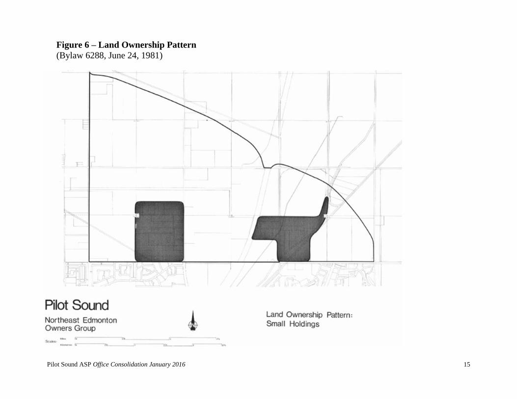
IX. THE LAND OWNERSHIP PATTERN
The developability of land is significantly influenced by the degree of
fragmentation or consolidation which exists within the land ownership pattern of
a given area. With two notable exceptions, the majority of land in Pilot Sound is
held in parcels twenty acres in size or greater. (Figure 6 - Land Ownership
Pattern). The exceptions are the following:
1. The division of control among a number of owners within the S.W. ¼
Section 31-53-23-W4M.
2. The fragmentation of ownership of the twenty seven parcels which
constitute the majority of the E.½ Section 35-53-24-W4M.
X. SUMMARY
This Chapter has examined a number of land use related factors which will
influence the planning and development within Pilot Sound. The following
summarizes the implications of those factors in formulating a proposed land use
pattern:
1. Both the Little Mountain Cemetery and the Evergreen Memorial Gardens
Cemetery must be viewed as permanent uses.
2. The effect of the size and location of the Evergreen Memorial Gardens
Cemetery, together with such lineal land use features as the Manning
Drive, 153 Avenue, the private rail corporation Coronado and
Vegreville rail lines, and the private utility corporation right-of-way, is
to render the northeast and southeast sectors of Pilot Sound unsuitable
for residential development. Alternative land uses which could be
accommodated in these sectors include industrial, public utility,
institutional, commercial, and/or recreation land uses.
3. The Slovenian Canadian Association's cultural and social building and
the private corporation maintenance/storage complex are considered
permanent and, therefore, must be integrated into future uses which
develop in Pilot Sound.
Amended by Editor
Amended by Editor
Pilot Sound ASP Office Consolidation January 2016
15
Figure 6 – Land Ownership Pattern
(Bylaw 6288, June 24, 1981)
Pilot Sound ASP Office Consolidation January 2016
16
The general absence of tree cover within Pilot Sound, where practical, warrants the
preservation of the limited stock which does exist.
4. The presence of Class 1, 2, and 3 soils throughout Pilot Sound implies
that urban development will consume prime agricultural land. Prime
agricultural land is deemed by the Edmonton Regional Planning
Commission to be the Canada Land Inventory - Soil Capability for
Agriculture, Classes 1, 2, and 3 (alone or in combination) where these
cover at least 50 percent of a given area. It is concluded, however, that
the City of Edmonton will undoubtedly grow if land for expansion is
available. Further, the existing City represents a substantial investment of
physical infrastructure and, social capital which is a nucleus for future
growth. Also, given that the number of-viable alternative residential
expansion areas of the City are limited and these potential expansion
areas will consume predominantly Class 1 soils, it is concluded the use
of productive soils to accommodate the expansion of the City of
Edmonton cannot be avoided. Prime agricultural land, therefore, is not
regarded as a constraint to intensive urban use of Pilot Sound. This
conclusion conforms to the policy of the Edmonton Regional Planning
Commission with respect to the expansion of urban areas onto prime
agricultural land.
5. Major utility lines require to be situated in unobstructed rights-of-way. In
order to prevent the unnecessary sterilization of land, however, the rights-
of-way should be incorporated into the circulation/open space system
proposed within Pilot Sound. Where incorporation of a utility right-of-
way into the circulation/open space system is not practical, relocation, in
whole or in part, should be considered. Such a consideration should be
primarily based on technical feasibility and economic viability.
6. The private utility corporation 120 foot right-of-way and high voltage
transmission line presents a unique constraint, and opportunity, to Pilot
Sound. Given the amount of land the right-of-way consumes and given
its strategic location, the right-of-way offers significant potential to the
open space system by providing the opportunity to link the pedestrian
circulation system within the Casselman-Steele Heights, Clareview and
Amended by Editor

Pilot Sound ASP Office Consolidation January 2016
17
Lake Districts to that proposed for Pilot Sound through the incorporation
of a defined pedestrian corridor within the right-of-way.
7. The north limit of Pilot Sound cannot be assumed to be the south limit of
the 1974 Edmonton (North) Restricted Development Area. Rather, Pilot
Sound must assume its northern' boundary to be the south limit of the
Edmonton Transportation and Utility Corridor as recently defined by
Alberta Environment. However, it must be recognized that as
Anthony Henday Drive develops and nears completion, the
northern limit of Pilot Sound may be adjusted in order to include
lands within the TUC which may no longer be required by the
Province, and may be suitable for general development purposes.
8. That land area isolated between the respective south limits of the 1974
Edmonton (North) Restricted Development Area and the Edmonton
Transportation and Utility Corridor should be incorporated into the land
use pattern within Pilot Sound. Annexation of these lands to the City of
Edmonton, however, is a prerequisite to development.
9. Given the existence of a defined "Airport Hazard Area", land uses within
this portion of Pilot Sound should be confined to industrial, public utility,
commercial, recreational, transportation, and/or agricultural land uses.
10. Given that residential development is generally precluded beyond the 30
N.E.F. contour by the Edmonton Regional Planning Commission, and
given that the 30 N.E.F. contour extends into the previously defined
limits of Pilot Sound, the land use pattern proposed for the area should
recognize this restriction. Encroachment by residential development
beyond the 30 N.E.F. contour should only be considered where the land
area is required in order to ensure a sufficient population base to support
essential neighbourhood services and/or facilities as anticipated by the
general airport vicinity protection area regulations defined by the
Province of Alberta.
11. The proposed development concept for Pilot Sound must recognize the
approved Lake District Area Structure Plan and incorporate, where
Bylaw 16372
June 2013

Pilot Sound ASP Office Consolidation January 2016
18
required, those specific provisions of that Plan that have a direct bearing
on the land use pattern in Pilot Sound.
12. In those areas where fragmentation of ownership exists, development
may be delayed pending either consolidation or consensus among a
number of owners controlling a significantly large tract of land. Where
fragmentation of ownership coincides with existing development
proposed to be replaced by the Pilot Sound Area Structure Plan,
development may be further retarded resulting in a number of non-
conforming uses existing in the area on an interim basis.
13. Given that the five major vehicular routes which comprise the major road
network in this sector of the City of Edmonton are defined (ie. Manning
Drive, the Transportation and Utility Corridor, 66 Street, 153 Avenue,
and Victoria Trail), the flexibility of adapting this network to a particular
land use pattern does not exist. The flexibility which does not exist is the
manner in which the extension of 50 Street and 167 Avenue is
accommodated within Pilot Sound.
14. The approval of the 2.9 km LRT extension from Clareview to Gorman,
facilitates the further growth and development of this area of the City
and in particular provides for the opportunity to develop a Transit
Oriented Development within Pilot Sound, which will be focused upon
the future Gorman LRT station.
Each of the factors reviewed in this Chapter, the conclusions reached by the analysis
of those factors, and a number of general development objectives form-the basis of
the land use pattern proposed for Pilot Sound. The following Chapter details those
general objectives.
Amended by Editor
Bylaw 16372
June 2013

Pilot Sound ASP Office Consolidation January 2016
19
Chapter Three
DEVELOPMENT OBJECTIVES
The general development objectives proposed to guide the ultimate development of
Pilot Sound are the following:
I. GENERAL OBJECTIVES
To define a land use framework for Pilot Sound that is energy efficient through
the integration of living and working environments in a geographically distinct
area of the City of Edmonton;
To provide a framework for the development of approximately 2155 acres
(872.2 ha) of land within the City of Edmonton which could ultimately house
approximately 40,000 persons.
To create, by the physical development of land, a socially integrated community
within which may be enjoyed the highest standard of safety, health,
convenience, and privacy;
To create within Pilot Sound an attractive and functional, integrated community
which will reinforce the existing physical structure and social viability of the
City of Edmonton; and,
To ensure that development takes place in the most orderly and economic
manner.
II. RESIDENTIAL DEVELOPMENT OBJECTIVE
To create a residential district within which will be provided a broad range of
housing types and forms through the utilization of innovative techniques
anticipated by the Edmonton Land Use Bylaw.
III. INDUSTRIAL DEVELOPMENT OBJECTIVE
To create a diversified and balanced industrial mix, compatible with adjacent
land uses, within the area to the north and northwest of the existing power line
right-of-ways; thereby providing for a variety of employment opportunities for
current and future residents within the northeast of the City of Edmonton.
Bylaw 14920
Bylaw 14172
Bylaw 12493
Bylaw 16054
Bylaw 16372,
June 2013
Amended by Editor
Bylaw 16372,
June 2013

Pilot Sound ASP Office Consolidation January 2016
20
IV. COMMERCIAL DEVELOPMENT OBJECTIVE
To provide a systematic and orderly pattern of commercial development that
will adequately serve the projected residential and industrial population within
Pilot Sound.
V. RECREATION DEVELOPMENT OBJECTIVE
To ensure the adequate provision and development of land for active and
passive recreation and associated facilities and to maximize the amenity value
of those features of Pilot Sound which have the potential to contribute to the
aesthetic quality of future residential, commercial and industrial development.
VI. PUBLIC AND SEMI-PUBLIC DEVELOPMENT OBJECTIVE
To provide suitable sites of adequate size for all forms of public and semi-
public uses so that they may render the most economical and efficient service
to the projected residential and industrial population within Pilot Sound.
VII. TRANSPORTATION DEVELOPMENT OBJECTIVES
To develop a system of transportation facilities within Pilot Sound to meet the
requirements of all sectors of the community related to the movement of
people, goods, and services and to ensure that this system is developed in a
safe, efficient, economic and equitable manner and in a manner offering
convenient connection to regional, provincial, and inter-provincial
transportation systems.
VIII. PUBLIC UTILITY DEVELOPMENT OBJECTIVE
To provide safe, adequate, economic, and reliable utility systems to serve the
needs of the projected residential and industrial population within Pilot Sound.
Bylaw 16372,
June 2013

Pilot Sound ASP Office Consolidation January 2016
21
Chapter Four
DEVELOPMENT CONCEPT
I. INTRODUCTION
The Development Concept proposed for Pilot Sound is outlined on Figure 7 -
"The Development Concept". This Concept, in large part, derives from the
constraints imposed and opportunities afforded by a number of land and policy
based factors which were analyzed in Chapter Two and the general development
objectives defined in Chapter Three. These objectives, in summary, outline a
framework within which it is-proposed to guide the ultimate development of
Pilot Sound.
The Development Concept proposed for Pilot Sound envisions the creation of a
mixed use area within the City of Edmonton which will provide the opportunity
for future residents to live and work in a geographically distinct community.
Unlike other suburban developments in the City, Pilot Sound will provide the
opportunity to live in a predominantly single family environment with immediate
access to potential employment areas.
The concept envisions the creation of a residential area that will ultimately
house approximately 40,000 persons at a density of approximately 45.4 persons
per gross developable hectare. With concurrent development of the residential,
commercial and light industrial areas (ie., the concurrent establishment of living
and working environments) the opportunity will be provided to develop a
positive interaction between these environments that has not been possible in
other suburban developments. Traditionally, within the City of Edmonton,
suburban developments have been comprised exclusively of residential and
ancillary land uses and have been geographically removed from employment
areas. It has not been possible, therefore, to develop a positive interaction
between the two major urban environments without the major expenditure of
funds, specifically, those associated with the development of an efficient
transportation system.
The concept proposed for Pilot Sound, however, attempts to integrate living and
working environments in a geographically distinct area of the City and to
encourage a positive interaction between these two environments. The benefits
Bylaw 14920
Bylaw 14172
Bylaw 12493
Bylaw 16054
Bylaw 16372,
June 2013
Amended by Editor
Bylaw 16372, June 2013
Bylaw 16372,
June 2013

Pilot Sound ASP Office Consolidation January 2016
22
of this proposal, if successful would be a reduction in the reliance of future
residents on sources of employment external to the community. It is assumed
with this positive interaction between living and working environments, and the
physical proximity of one environment with the other, coupled with the
development of the new Gorman LRT station and the surrounding Transit
Oriented Development, that public transit will take on a significant role within
Pilot Sound, becoming a major mode of transportation for work and recreation
related trips both to and from the area. Energy conservation, through reducing
the reliance on the private automobile for work and recreation related trips,
therefore, is a major objective of the land use pattern proposed for Pilot Sound.
In summary, the Concept for the development of Pilot Sound envisions the
creation of a community providing living and working environments in a
geographically distinct area within the City of Edmonton, a concept that provides
for the maximum possible interaction between these two major environments
encompassed by an urban area. The following defines in detail the major land use
components of the Pilot Sound Area Structure Plan, the circulation system and
servicing concept.

Pilot Sound ASP Office Consolidation January 2016
23
Figure 7 – Development Concept Bylaw 17491
Approved January 25, 2016

Pilot Sound ASP Office Consolidation January 2016
24
II. RESIDENTIAL LAND USE
The residential land use component of Pilot Sound is proposed to be comprised
of six neighbourhoods ranging in size from approximately 74 hectares to 256
hectares. In total, it is projected that approximately 40,000 persons will be
accommodated with eventual development of this land use at a density
approximating 45.4 persons per gross developable hectare.The neighbourhoods,
as defined, encompass a sufficient population base to ensure the efficient and
economic provision of basic, local services (ie. educational facilities,
transportation systems, convenience commercial outlets, and recreational
facilities).
Where practicable, residential development has been confined to the 30
N.E.F. contour. Minor encroachments beyond the 35 N.E.F. contour occur
in Neighbourhoods 1, 4, and 5. The rationale for these encroachments is,
in general, that these "additional" lands are required to establish a
population base in each of the respective neighbourhoods sufficient to
sustain basic, local services, to preclude the isolation of these lands, and to
ensure the inclusion of the lands within a logical land use pattern.
(Development beyond the 30 N.E.F. contour up to N.E.F. 35 is anticipated
by Canada Mortgage and Housing Corporation and the general airport
vicinity protection area regulations defined by the Province of Alberta
(Alberta Regulation 291/75).
Table I provides the population and land use statistics for Pilot Sound. The land
use categories reflect those specified in the Edmonton Zoning Bylaw. The
number of persons per dwelling unit are those defined by the City of Edmonton
Planning Department. Table II provides a summary of the municipal/school
reserve sites dedicated in Pilot Sound. Table III summarizes the municipal
reserve dedications to-date.
Tables II and III assume municipal reserve dedication of 10%. Provincial
legislation allows municipalities to require higher percentages of municipal
reserve dedication in areas where higher dwelling unit densities are planned.
This may result in a requirement that additional municipal reserve land be
dedicated in portions of the plan area..
Bylaw 14172
Amended by Editor
Bylaw 15938
Bylaw 16054
Bylaw 16372,
June 2013
Bylaw 16372, June
2013
Amended by Editor
Pilot Sound ASP Office Consolidation January 2016
25
III. STATION TOWN CENTRE
The Gorman Station Town Centre shown in Figure 7: Development Concept is
situated around the planned LRT station, at a radius of approximately 400
metres. The design and concept of the Station Town Centre will incorporate
higher density mixed uses and a public park to create a community focal point.
This area will be Gorman’s economic and social heart, providing a range of
residential, employment, commercial, transportation, and institutional land
uses and amenities.
A small public park (Urban Plaza) will be provided within 200 metres of the
planned LRT station to reinforce the Station Town Centre as the community
focal point. It will be between the 0.25 and 0.50 ha in area. The specific
location of this park will be determined at a more detailed planning stage. The
Station Town Centre is to be developed consistent with the City of Edmonton’s
Transit Oriented Development Guidelines for Enhanced Neighbourhood
Stations.
IV. GENERAL INDUSTRIAL USE
Integral to the development of Pilot Sound is the designation and
subsequent development of areas of concentrated employment. The
employment area defined within Pilot Sound is a Light Industrial Park
encompassing the east development sector.
A. The Business Industrial Park
The original Pilot Sound ASP included a Business Industrial Park
of approximately 270 acres (109 ha) located in the west
development sector, north of the 167 Avenue extension. This area
was re-designated to “residential” in 1998 by the Municipal
Development Plan. All text referring to the Business Industrial
Park was thus removed.
B. Light Industrial Area
The employment area defined within Pilot Sound incorporates a Light
Industrial Area comprising of approximately 111 acres (45.1 ha). At
an average density of 22.2 employees (as historically identified within
the Pilot Sound ASP) per gross developable hectare, the Light
Bylaw 12493
March 6, 2001
Amended by Editor
Bylaw 14920
Bylaw 12493
Bylaw 16372,
June 2013
Bylaw 12493
March 6, 2001
Amended by Editor
Bylaw 16372, June
2013

Pilot Sound ASP Office Consolidation January 2016
26
Industrial area has the potential to create in excess of 1,000
employment opportunities.
The Light Industrial Area, due to its limited size, should attract light
industrial users desirous of being in the northeast sector of the City of
Edmonton. The success of this area, therefore, will be its availability to
accommodate the typical industrial user whose primary locational
criteria is a site in the northeast sector of the City. There is a defined,
latent demand in this sector of the City which this Light Industrial Area
would accommodate. The Area is projected to be opened gradually in
units of approximately 30 to 50 acres (12-20 hectares) per year.
V. INSTITUTIONAL LAND USE
The Development Concept proposed for Pilot Sound provides for the
establishment or continuation of a number of institutional land uses. Those
existing institutional uses which have been retained and which form integral
components of the proposed Development Concept include the Evergreen
Memorial Gardens and Little Mountain cemeteries and the facility adjacent 66
Street/167 Avenue developed by the Slovenian Canadian Association.
Institutional uses proposed to supplement those that exist are religious institu-
tions and educational facilities.
The Fire Rescue Services Branch (FRS) identified the need for a fire station in
the Hollick Kenyon Neighbourhood, and one has been located north of 153
Avenue and west of 50 Street.
Five church sites were originally proposed by the Development Concept, each
of which was situated adjacent a potential commercial facility. However,
Religious Assembly sites are no longer designated in the Area Structure Plan
(ASP) stage. The sites will be determined and shown on the development
concept map at the Neighbourhood Structure Plan stage.
In total, seven schools are proposed within the residential sectors of Pilot
Sound.The basis of the determination of this requirement was detailed in Tables
VI, VII, and VIII of the original ASP. Table VI of the original ASP defined by
selected land use categories, the number of elementary, junior high, and senior
high students anticipated to be generated for each of the Public and Separate
School Systems. These generation factors were developed in consultation with
Amended by Editor
,
Bylaw 13492
Bylaw 12493
Bylaw 16372,
June 2013
Amended by Editor
Amended by Editor
Bylaw 15333
February 17, 2010
Amended by Editor
Bylaw 16372,
June 2013

Pilot Sound ASP Office Consolidation January 2016
27
the two school boards and were applicable solely to the northeast sector of the
City. On average, within the City of Edmonton, 70 percent of students generated
were projected to attend the Public School System. In the northeast sector,
however, this percentage was determined to be approximately 55 percent. The
students that would attend the Separate School System, therefore, were projected
at 45 percent of the City average as opposed to 30 percent which was applicable
in other residential development sectors in Edmonton. Table VII of the original
ASP defined the number of students by school type projected to be generated per
gross acre for each of the specified development options. Table VIII of the
original ASP on the basis of the generation factors developed in Tables VI and
VII in the original ASP, projected the number of students for each of the Public
and Separate School Systems by school type anticipated to the generated within
each neighbourhood.
Tables I through VIII from the original ASP have been replaced through
Bylaws 12493 and 13492 – see the original Bylaw 6288 for the original tables
and statistics.
Changes in the anticipated student generation that resulted from amendments
to the original ASP have not been calculated. It is assumed that student
generation will be addressed at the neighbourhood structure plan stage.
Edmonton Public Schools completed a study that concluded the densities and
student generation numbers projected in the original Area Structure Plan are
not being achieved. Based on this finding they have reduced the proposed
number of public schools in the Pilot Sound Area from eleven to seven.
On the basis of this determination, the growth and evolution of Pilot Sound and
the surrounding communities, as well as a recent communication (2010) with the
Separate School Board, the following educational facilities appear to be required
to serve the projected residential population in Pilot Sound and the surrounding
area:
Separate Elementary/Junior High – two
Public Elementary – one
Public Junior High – one
Public Elementary/Junior High – two
Separate High school – one
Senior high school students within Pilot Sound as well as surrounding areas
will have the option of attending either a proposed separate high school to be
located in Gorman or the public senior high school campus planned for the
Clareview Town Centre.
Amended by Editor
Bylaw 12493
March 6, 2001
Bylaw 13492
Bylaw 16372,
June 2013
Bylaw 16372,
June 2013

Pilot Sound ASP Office Consolidation January 2016
28
VI. OPEN SPACE/RECREATION LAND USE
Two major components comprise the open space/recreation land use within Pilot
Sound – the District Parks/Athletic Grounds and Neighbourhood Parks.
Two District Parks have been identified in Pilot Sound. The first 21.7 hectare
District Park has been centrally located in Pilot Sound, providing for good
accessibility and frontage. This District Park lies west of Manning Drive, and
incorporates part of a Significant Natural Area (NE8091), which will be used
for passive recreation. The second District Park, lies east of Manning Drive,
and will be approximately 10 hectares in size. It is centrally located and easily
accessible from the arterial road system and will be adjacent to the proposed
High School Site acting as a valuable resource to students and the community
for both passive and active recreation.
Neighbourhood parks will be provided in all six neighbourhoods. Dispersed
park sites may be deemed appropriate in addition to the central neighbourhood
park. They may vary in size from 0.5 ha to 3.0 ha, and their precise locations
will be determined at the neighbourhood planning stage.
Table 3 in the Appendix, shows the anticipated municipal reserve dedication
from the residential portion of Pilot Sound according to neighbourhood. The
amount of reserve required may increase when more detailed planning occurs
at the time of neighbourhood structure plan preparation and further
requirements are determined for the dispersed park sites and the natural area.
An Urban Plaza has been designated within the Station Town Centre and is
intended to reinforce the Station Town Centre as a community focal point. The
Urban Plaza (a small public park) is to be provided within 200 metres of the
planned LRT station and will be between 0.25 and 0.5 ha in area. The specific
location of the Urban Plaza will be determined at a more detailed planning
stage.
Bylaw 13492
Bylaw 16372
June 2013

Pilot Sound ASP Office Consolidation January 2016
29
VII. COMMERCIAL LAND USE
The Development Concept proposed for Pilot Sound defines two types of
commercial land use – community and convenience. It also allows for mixed-
use commercial development within the Station Town Centre within the
Gorman Neighbourhood.
A proposed community commercial site of approximately 4.07 ha has been
designated in the northeast corner of 167 Avenue and a collector road.
Prominent frontage along 167 Avenue and the collector roadway are
significant components influencing the location of this commercial site. The
community commercial sire is intended to serve the commercial needs of the Cy
Becker neighbourhood and surrounding Pilot Sound area.
A proposed community commercial site has been designated in northwest,
southeast and southwest corners of 50 Street and 167 Avenue. The size and
proximity of these three sites may assist in establishing a central commercial
activity node for the Pilot Sound Community. A proposed community
commercial site has been designated in the northeast corner of McConachie
Way and 167 Avenue. The site is intended to serve the commercial needs of the
McConachie neighbourhood, as well as the surrounding Pilot Sound area.
The employment area defined within the Pilot Sound incorporates a Community
Commercial area of 31.38 ha in the east development sector. At an average
density of 92.3 employees per gross hectare, the Community Commercial area
has the potential to create 2,896 employment opportunities.
This Community Commercial site is strategically located at the northeast
corner of Manning Drive (Highway 15) and 153rd Avenue. The Community
Commercial area furthers the viability of continuous and strategic industrial,
commercial and service corridor as planned in northeast Edmonton. This is
accomplished by encouraging development of an economic activity centre in a
similar manner as the development to the south and extending the trend for
commercial development at key locations (i.e. major intersections). The
Community Commercial area reinforces the city’s economic potential and aids
in building up the non-residential tax base.
Bylaw 13492
Bylaw16372,
Juen 2013
Bylaw 14047
Bylaw 12493
Amended by Editor
Bylaw 15938
Bylaw 17345,
September 8, 2015
Bylaw 14920
July 9, 2008
Bylaw 14920
Bylaw 16372,
June 2013
Bylaw 16054
July 4, 2012

Pilot Sound ASP Office Consolidation January 2016
30
The community commercial site located at the southwest corner of 50 Street
and 167 Avenue shall pay specific attention to land use transitioning, interface
and setbacks between the commercial area and adjacent residential uses. This
community commercial use shall be compatible with the future commercial site
situated east of 50 Street. A 1 meter landscaped berm with a 1.8 metre screen
fence shall be constructed on the western and southern boundary of the
commercial site. This berm and fence will provide adequate physical
separation and assist in reducing potential visual nuisances between the
commercial and residential developments. Setback distances, fencing and
landscaped yards shall be developed as required by the City of Edmonton
Zoning Bylaw. The Community Commercial Site shall provide access for
future private pedestrian connections from the adjoining Residential
Neighbourhood.
An industrial service centre was previously contemplated in order to service
once identified large scale light industrial park in Gorman; however as a result
of the extension of the LRT, the establishment of the Station Town Centre, and
the reduction in scale of the light industrial park, an industrial service centre is
no longer necessary.
Finally, four neighbourhood convenience commercial centres are proposed,
each of which is located west of Manning Drive. These centres are intended to
be developed as convenience commercial outlets serving the basic, day-to-day
needs of the resident population.
A. Community Commercial
A Community Commercial area is planned for the southeast portion of
the ASP and is located prominently at the intersection of Manning
Drive (Highway 15) and 153 Avenue and adjacent to the western
boundary of 34 Street. The area will be developed to offer a wide
variety of retail and commercial opportunities, services and goods at
the local and area level. The following development guidelines are
intended to provide a conceptual framework in the development of the
Community Commercial site located within the Pilot Sound ASP.
Successful commercial areas have inherent flexibility incorporated
Bylaw 14172
Bylaw 13492
Amended by Editor
Bylaw 17345
September 8, 2015
Bylaw 14920
July 9, 2008
Bylaw 16372
June 2013

Pilot Sound ASP Office Consolidation January 2016
31
within to accommodate for the ever changing commercial / retail
innovation, trends, and consumer preference.
The Community Commercial site will provide a vibrant and
desirable community destination that promotes attractive, and
walkable streets.
The site will be provided with focal points at the intersection of
major circulation routes.
Private roads will be constructed through the commercial area
providing opportunities for orientation to the street level.
Pedestrian routes (either dedicated or along private / public
boulevards) will be provided through the site providing
linkages to the adjacent neighbourhoods and amenities.
Site layout and building façade treatment will provide for
interesting streetscapes avoiding exposed “dead” frontages
along major circulation corridors. In instances where
buildings abut a major corridor appropriate architectural
articulation will be incorporated.
Community Commercial development will share a consistent
architectural theme having regard to for building design,
façade treatments, setbacks, signage, lighting, and
landscaping.
Attention, both from the perspective of site layout and building
design, will be paid to the perimeter of the site ensuring
appropriate setbacks, landscaping and façade treatment as it
relates to perimeter roadways and other abutting and adjacent
uses.
Sidewalks and generous landscaping will be provided
throughout the site.
Opportunities for mixed use (commercial, office, retail) will be
provided for under the City of Edmonton Zoning Bylaw.

Pilot Sound ASP Office Consolidation January 2016
32
More detailed Community Commercial guidelines will be provided at
the Rezoning stage through the creation of site specific Direct
Development Control Provision Zoning (DC1) in consultation with the
City of Edmonton Planning and Development Department.
THE CIRCULATION SYSTEM
The circulation system proposed to serve Pilot Sound has four major elements.
First, the primary road network defined for the area will link Pilot Sound to the
regional transportation network and provide an efficient collector and
distributor function within the development sectors of Pilot Sound. The major
roads which comprise this network include the Transportation and Utility
Corridor, Manning Drive, 153 Avenue, 66 Street, 167 Avenue and 50 Street. In
combination with a series of local collector roadways, these routes comprise a
defined hierarchy of purpose-designed roadways which will result in an orderly
flow of traffic within Pilot Sound.
Second, the public mass transit concept proposed for Pilot Sound is to focus on
the Gorman Light Rail Transit Station with "feeder" bus service from the major
residential districts in the northeast sector of the City of Edmonton.
Third, pedestrian circulation within Pilot Sound is proposed to consist of a
series of defined linkages which will connect the major institutional,
recreational, and commercial land uses with the residential component and
employment sectors defined by the Development Concept. This system is
proposed to extend beyond the limits of the community to link with the
pedestrian circulation system proposed within the Clareview and Lake Districts
through the utilization of the private utility corporation right-of-way within
which an exclusive pedestrian corridor could be defined.
Fourth, rail access to the light industrial sector east of the Manning Drive is
proposed to be provided through connections to either the private rail
corporation Coronado or Vegreville Lines. Due to the type of industrial
development being proposed (ie., predominantly light industrial) the demand
for rail service and connections to the light industrial sector is anticipated to be
minimal.
Amended by Editor
Amended by Editor
Amended by Editor
Bylaw 16372
June 2013

Pilot Sound ASP Office Consolidation January 2016
33
The City of Edmonton may construct the potential pedestrian crossing of the
railway shown in “Figure 7 – Development Concept”. The need for this facility
will be determined at the neighbourhood planning stage. If this facility is not
provided, the shared use path alignments can be adjusted as required without
amendment to the area structure plan.
A possible collector road, as generally shown in “Figure 7 – Development
Concept” may be developed to serve the neighbourhood and specifically the light
industrial use, if the land between the rail lines is removed from the TUC and the
railway company agrees to the construction of railway crossings.
VIII. THE SERVICING CONCEPT
Water supply and distribution, sanitary sewage collection and disposal, and
storm water drainage form the three major components of the servicing system
which must be provided to allow for the eventual development of Pilot Sound
to intensive urban use.
A. Water Supply and Distribution
Pilot Sound will have two major sources of water. First, a supply main
will be installed within the Victoria Trail alignment north to 153
Avenue by the end of the first quarter of 1980. This main will be
capable of supplying water to develop the Light Industrial Area. This
main can be extended as development proceeds. The existing reservoir
at 137 Avenue and Victoria Trail will provide the necessary storage.
Second, a supply main is proposed to be installed along the
approximate alignment of the private utility corporation right of-way
from the west as development of the Lake District progresses east
toward 66 Street. It is anticipated that the supply main will reach 66
Street by 1985 at the projected rate of development within this area.
This schedule could be accelerated if funds were available from the
Revolving Trunk Services Program. The major source of water to
supply this main will be the E. L. Smith Water Treatment Plant.
B. Sanitary Sewage Collection and Disposal
The original sanitary sewage system within Pilot Sound was proposed
to drain to the southeast into the Clareview Sanitary Interceptor. A
force main from the Lake District was to enter Pilot Sound at approxi-
Amended by Editor
Amended by Editor
Bylaw 16372
June 2013

Pilot Sound ASP Office Consolidation January 2016
34
mately 66 Street and the private utility corporation right-of-way. On
the east side of the "66 Street ridge" the system was to flow by gravity
through to the Clareview District. The Clareview Sanitary Interceptor,
which was under construction at the time original Bylaw 6288 was
being prepared, was sized to accommodate Pilot Sound and the Lake
District. At that time, existing sanitary sewage collection and disposal
systems tied into the North East Interceptor which flowed by gravity to
the Bremner Lagoons. However, by 1985 it was anticipated that a
diversion tunnel would be in operation which would bring the sanitary
sewage to the Gold Bar Treatment Facility. The Bremner Lagoons
subsequent to this date will be used for the treatment of industrial
waste.
The sanitary sewage system within Pilot Sound drains to the southeast
to the Clairview Sanitary Interceptor, which connects to the North East
Interceptor. A portion of Pilot Sound, east of 66 Street, will drain to
the North Edmonton Sanitary Trunk, by means of a trunk sewer
proposed to go north on 66 Street from 153 Avenue. Presently, existing
sanitary sewage collection and disposal systems tie into the North East
Interceptor which discharges to the Capital Regional Sewage
Commission treatment plant. The Bremner Lagoons no longer receive
flows, including industrial wastes, from the City.
The area east of Manning Drive will be serviced by two independent
sanitary sewage collection systems. The Gorman West sanitary
sewage collection system will tie into the existing Pilot Sound Sanitary
Trunk in the vicinity of 151 Avenue NW and 34 Street NW, while
Gorman East will tie into the existing Clareview Sanitary Trunk along
153 Avenue, approximately 800m from 18 Street NW.
C. Storm Water Drainage
A report entitled "Northeast Edmonton: An Engineering Report on
Major Municipal Servicing Requirements" prepared by Walker, Newby
& Associates Limited suggests the application of the principles of
storm water management as a means of controlling storm water runoff
within Pilot Sound.
Bylaw 12493
March 6, 2001
Amended by Editor
Bylaw 16372
June 2013

Pilot Sound ASP Office Consolidation January 2016
35
In general, the system envisions all of the storm drainage east of the 66
Street ridge being gathered into 12 stormwater management
facilities.The ponds vary in size from approximately 5.6 acres to 7.9
acres (2.3 to 3.2 hectares), for an average of 6.2 acres (2.5 hectares),
at the 100 year storm level. The drainage is to the southeast entering
the Clareview District at approximately 151 Avenue and 34 Street.
From that point, a storm interceptor drains the water to the existing
outfall at 144 Avenue and 20 Street. The Clareview portion of this
storm water interceptor was under construction at the time this Area
Structure Plan was prepared.
The area west of the 66 Street ridge is part of the Lake District drainage
basin. A storm water management scheme for this area has been
prepared by Stanley Associates Engineering Limited. This scheme
proposes the location of one retention pond east of 66 Street within the
limits of Pilot Sound. This pond will drain west across 66 Street into
the Lake District storm sewage system. Development within Matt
Berry will be served by a proposed storm water management lake
immediately west of 66 Street located within the Lake District.
Revised Neighbourhood Design Reports were prepared by Scheffer
Andrew Ltd. as part of the October 2003 amendment. Separate
Neighbourhood Design Reports will be prepared for individual
neighbourhoods within Pilot Sound to provide more details for
servicing within the areas.
The amendments to the Pilot Sound Area Structure Plan will not result
in any significant alteration of the servicing concepts identified in the
original plan. However, the Area Master Plan for stormwater drainage
is being amended with respect to the size and location of some of the
stormwater management facilities. The area structure plan is being
changed to maintain consistency between the two documents.
The lake in the northwest corner of the plan area is to be
approximately 4.0 ha at the high water level. To the southeast of this
lake, a site for a possible future storm retention pond in the northeast
portion of the McConachie neighbourhood has been provided.
Bylaw 13492
October 23, 2003
Amended by Editor
Amended by Editor
Amended by Editor
Bylaw 12493
Bylaw 16054
Bylaw 16372
June 2013
Bylaw 13492
October 23, 2003
Amended by Editor
Bylaw 14172
Bylaw 13492
October 23, 2003
Amended by Editor
Amended by Editor
Pilot Sound ASP Office Consolidation January 2016
36
The lake proposed in the area west of existing 50 Street and north of
the private utility corporation right-of-way has been split into three
facilities of approximately 2.0 – 2.5 ha at high water level: one is
proposed north of 167 Avenue in Neighbourhood 4, one south of 167
Avenue in Hollick-Kenyon, and one south of 167 Avenue and east of 50
Street in Brintnell.
The stormwater management facility in Neighbourhood 1 (Brintnell)
will be a “constructed wetland.” A “saline wetland” exists
immediately north of the private utility corporation right-of-way in the
same approximate location as the proposed stormwater management
facility. In 2004, Scheffer Andrews Ltd., experts in the fields of earth
sciences, hydrogeology, solit sciences, botany and the City
Administration investigated, based on available information, the
practicality of retaining the saline wetland as an integrated part of the
stormwater management facility.
The intent of the investigation was to study technical approaches to
integrating the stormwater management facility with the “saline
wetland” in a manner that left the wetland as nearly as possible to its
natural state, while the area required for the integrated facility should
remain approximately the size required for the storwater management
facility alone. The goal was to find a solution that would allow the
integrated components to function as a stormwater management
facility, but allow the “saline wetland” the opportunity to continue to
operate as it does naturally. While alternative designs were
investigated, the utimate findings of the investigation concluded that
the “saline wetland’ could only be retained as part of the integrated
facility if the land area consumed by the integrated facility were to be
increased significantly. The provision of the excess land required to
retain the “saline wetland” was determined unfeasible by the owner
due to financial constraints. Ultimately, it was accepted by all parties
that the retention of the “saline wetland” would be impractical.
Therefore, a stormwater management facility without the rentention of
the “saline wetland” is proposed.
Bylaw 13492
October 23, 2003
Amended by Editor
Bylaw 14154
December 5, 2005
Bylaw 13492
October 23, 2003
Amended by Editor
Pilot Sound ASP Office Consolidation January 2016
37
The lake in the northeast is to remain the same location, and will be
approximately 10.2 ha at the high water level.
The lakes in the approved neighbourhoods will not change.
The area east of Manning Drive will contain four stormwater
management facilities in order to control and manage post-
development storm runoff. Three of the facilities are to be located in
close proximity to 153 Avenue, while the fourth is to be situated
southwest of 34 Street and 167 Avenue. Two to three outlets for these
facilities will be required and will be located along 153 Avenue. The
facilities have been sized in order to accommodate major rainfall
events (i.e. 1 in 100 year return period), and can be constructed as wet
ponds, constructed wetlands, or a combination of both. For minor
rainfall events (i.e. 1 in 5 year return period) , the runoff will be
collected via a proposed minor storm sewer system that discharges to
the storm water facility; while for major rain fall events the runoff will
be routed to the stormwater facilities via local roadways and PUL’s.
Chapter Five
AN IMPLEMENTATION STRATEGY
I. An Implementation Strategy
The formulation of an Area Structure Plan encompassing a land area as large as
that of Pilot Sound is but the first stage in the development of this approximately
1856 acres (751 ha). Full development of this area will allow for the
accommodation of approximately 40,032 persons in six neighbourhood
units.With development of this magnitude, it is important to define an
implementation strategy that is capable of managing this planned growth of the
City of Edmonton. This process should adequately translate the policies and
proposals of the Plan into a physical form that reflects the needs and desires of
future residents and provides an efficient mechanism whereby undeveloped land
can be subdivided, serviced, and developed in an expeditious and economic
manner. This Chapter summarizes a potential implementation strategy. Of
necessity, this strategy must be of a general nature given that the City of
Bylaw 14920
Bylaw 14172
Bylaw 13492
Bylaw 16054,
Bylaw 16372
June 2013
Amended by Editor
Bylaw 13492
October 23, 2003
Bylaw 16372
June 2013
Pilot Sound ASP Office Consolidation January 2016
38
Edmonton has an explicitly defined implementation process which involves the
formulation of Neighbourhood Structure Plans, Plans of Subdivision, and
development/servicing agreements.
Six major events are viewed as being prerequisites to development within Pilot
Sound. First, a master drainage plan should be formulated for the area that will
define specifically the size and location of each of the proposed storm retention
ponds and the drainage basin each of those facilities is intended to serve. This
master drainage plan would also define ultimate grading within Pilot Sound in
order to ensure that the storm water management system will function at an
optimum level of efficiency. Second, the extension of the sanitary sewer
interceptor from the Clareview District through to the Lake District must be
effected prior to development of the majority of the lands within Pilot Sound.
Third, the extension of the water trunk main from the Lake District to Pilot
Sound must be effected in order to ensure an adequate water supply for the
development of the area. Fourth, the method by which land consumed by the
storm water management system is rationalized among the various private
interests with Pilot Sound must be defined. The method of rationalization is
required to ensure that landowners share equally in the provision of the required
storm water management lakes within a defined drainage basin. Fifth, the
alignment and rights-of-way for each of the major roads within Pilot Sound
should be defined prior to any significant development occurring in the area.
With definition of these major rights-of-way, neighbourhood boundaries would
be defined and the corridors established for the extension of both the sanitary
sewer interceptor and water trunk main. Finally, the entire area of Pilot Sound
should be rezoned from an agricultural to an urban category. Incremental
rezoning of this area with each plan of subdivision retards the development
process and provides no assurance that the Development Concept will be effected
as proposed and approved by the City of Edmonton. It is important, therefore,
that the City of Edmonton secure the rezoning of these lands as a whole at the
earliest possible opportunity following approval of the Development Concept.
With accomplishment of these various factors, the implementation of the
Development Concept within Pilot Sound would be dictated by the process
defined by the City of Edmonton.
Pilot Sound ASP Office Consolidation January 2016
39
Given the interdependence of Pilot Sound and the Lake District with respect to
the provision of major municipal services, specifically, sanitary sewage
collection and disposal and water supply and distribution, and, the capacity
within existing municipal servicing systems in the Casselman-Steele Heights and
Clareview Districts to develop the defined extension areas of these communities,
staging of development within Pilot Sound could commence within three general
areas simultaneously. This general staging sequence is defined by Figure 8.
Where it is proposed to utilize existing systems in the initial stages of
development utilization of the capacity of these systems will be on a temporary
basis pending the installation of alternative, permanent facilities.
Development to-date in the plan area has not followed the general staging
sequence described in the original plan. It was expected that development would
occur first in Neighbourhood 1 (Brintnell) and in the northwest corner of the
plan area. Instead, development has started in the southwest corner and moved
east from there. The northwest portion of the area is expected to develop last.
Neighbourhood Structure Plans (NSP) have been approved for five
neighbourhoods within Pilot Sound – Matt Berry, Neighbourhood 3, Hollick-
Kenyon, Neighbourhood 2; Brintnell, Neighbourhood 1; McConachie,
Neighbourhood 4; and Cy Becker, Neighbourhood 5.
The Matt Berry, Hollick-Kenyon, Brintnell and McConachie neighbourhoods
are in various stages of suburban development and are approaching
completion. The McConachie neighbourhood is currently being developed. The
Cy Becker neighbourhood was adopted by Council in 2012 and is starting to
develop.
The amendment area will require the preparation of a neighbourhood structure
plan consistent with the amended Pilot Sound Area Structure Plan.
The neighbourhood structure plan for Gorman will provide detailed planning
for the area in Gorman on the east side of the rail line, consistent with all
relevant City of Edmonton policies and, particularly, the City's guidelines for
Transit Oriented Development. West of the rail line, Gorman contains only a
limited amount of area to be developed since large portions of the area will
Bylaw 12493
March 6, 2001
Bylaw 14172
Bylaw 12493
March 6, 2001
Amended by Editor
Bylaw 14172
Bylaw 13492
Bylaw 16054,
July 4, 2012
Bylaw 16372
June 2013

Pilot Sound ASP Office Consolidation January 2016
40
maintain their existing uses (i.e., cemetery and commercial DC1 – Manning
Crossing).
As a result of the above and consistent with the technical reports completed in
support of the amended Area Structure Plan, various background reports may
be deferred to the rezoning stage for the area west of the rail line in order to
accommodate development in the remaining portion of Gorman.
The Department of National Defence must be contacted during the preparation
of any amendment to the Pilot Sound Area Structure Plan or Neighbourhood
Structure Plan within the Pilot Sound Area Structure Plan area to determine
whether or not proposed land uses and associated infrastructure may impact
the operations of CFB Edmonton.

Pilot Sound ASP Office Consolidation January 2016
41
Figure 8 – General Staging Sequence*
(Bylaw 6288, June 24, 1981)
Power Line
*Amended by Editor

9/14
Pilot Sound ASP Office Consolidation January 2016
1
STATISTICS

Pilot Sound ASP Office Consolidation January 2016
2
Table I – Pilot Sound Area Structure Plan
Land Use and Population Statistics
(Bylaw 17491, January 25, 2016)
TABLE I
PILOT SOUND AREA STRUCTURE PLAN
LAND USE AND POPULATION STATISTICS
1 2 3 4 5 6
Brintnell
Hollick-
Kenyon
Matt
Berry McConachie
Cy
Becker Gorman Totals
Gross Area 125.3 157.4 113.3 255.9 99.5 246.1 872.2
Powerline 6.0 5.8 0.0 0.0 0.0 10.7 22.25
Major Arterials 0.0 0.0 0.0 7.6 3.7 3.4 14.7
Pipeline Corridor 0.0 0.0 4.2 1.7 0.0 0 5.9
Cemetery (Memorial
Gardens) 36.2 36.2
Natural Areas (NE 8096 &
NE 8097) 27.8 27.8
Rail Line 9.3 9.3
Transportation Utility
Corridor (TUC) 0.0 0.0 0.0 0.0 0.0 0 0.0
Gross Developable Area 119.3 151.6 109.4 246.6 95.9 158.7 881.1
Mixed Use Town Centre 16.6 16.6
Commercial 6.7 7.4 1.4 3.48 4.1 0 23.08
Industrial 41.0 41.0
Residential 70.6 87.5 72.2 139.6 58.2 39.0 467.1
School/Park 5.2 10.2 9.6 5.7 7.6 11.0 49.3
District Park 0.0 0.0 0.0 22.6 0.0 10.0 32.6
Institutional 0.0 0.0 0.0 1.3 0.0 10.0 1.3
Cemetery 0.0 2.8 0.0 0.0 0.0 0.0 2.8
Natural Area NE 8091&
Buffer 0.0 0.0 0.0 15.5 0.0 0.0 15.5
Storm Water Management 8.1 10.4 0.0 6.1 6.8 10.2 41.6
Circulation 28.7 33.3 25.6 51.8 19.2 27.0 185.6
LRT R.O.W. 3.9 3.9
Population Generation
Population 5,534 6,266 5,014 10,354 4,924 8,048 40,140
Density (ppgdha) 46.4 39.8 46.0 41.99 51.0 50.7 45.56

Pilot Sound ASP Office Consolidation January 2016
3
Table II – Summary of Municipal/School Reserve
Pilot Sound Area Structure Plan
(Bylaw 16585, September 16, 2013)
RESIDENTIAL DEVLEOPMENT SECTOR
Hectares Hectares
Gross Developable Area 881.1
Municipal/School Reserve Dedication 88.0
Brintnell (Neighbourhood 1): 119.3 gross developable hectares
Public Elementary School 3.6
Community Park/League 2.6
Subtotal 6.2
Municipal/School Reserve 11.9
Balance +5.7
Hollick Kenyon (Neighbourhood 2): 151.6 gross developable hectares
Public Elementary/Junior High School/Park 9.3
Neighbourhood Parks 0.9
Subtotal 10.2
Municipal/School Reserve 15.2
Balance +4.9
Matt Berry (Neighbourhood 3): 109.3 gross developable hectares
Public Elementary School/ Separate Elementary/Junior High School 9.2
Neighbourhood Parks 0.4
Subtotal 9.6
Municipal/School Reserve 10.9
Balance +1.3
McConachie (Neighbourhood 4): 246.6 gross developable hectares
Public & Separate Junior High School/Separate Elementary District
Park
22.6
Public Elementary School/Neighbourhood Park 5.7
Subtotal 28.2
Municipal/School Reserve 24.7
Balance -3.58
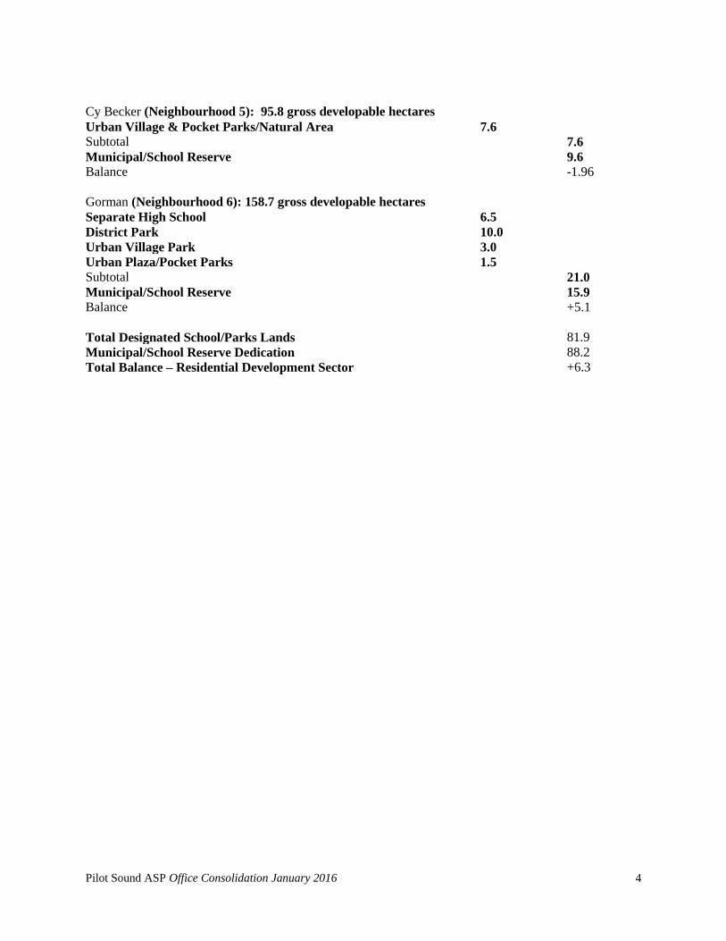
Pilot Sound ASP Office Consolidation January 2016
4
Cy Becker (Neighbourhood 5): 95.8 gross developable hectares
Urban Village & Pocket Parks/Natural Area 7.6
Subtotal 7.6
Municipal/School Reserve 9.6
Balance -1.96
Gorman (Neighbourhood 6): 158.7 gross developable hectares
Separate High School 6.5
District Park 10.0
Urban Village Park 3.0
Urban Plaza/Pocket Parks 1.5
Subtotal 21.0
Municipal/School Reserve 15.9
Balance +5.1
Total Designated School/Parks Lands 81.9
Municipal/School Reserve Dedication 88.2
Total Balance – Residential Development Sector +6.3

Pilot Sound ASP Office Consolidation January 2016
5
Table III – Municipal Reserve Balance
(Bylaw 16372, June 5, 2013)
1 2 3 4 5 6
Brintnell
Hollick-
Kenyon
Matt
Berry McConachie Cy Becker
Gorman Totals
Gross Area 125.3 157.4 113.3 255.9 99.5 246.1 872.2
Less:
Powerline 6.0 5.8 0.0 0.0 0.0 10.7 22.5
Land not Subject to
Reserve Dedication 0.0 0.0 3.2 7.6 3.7
45.5 60.0
Retained Government
Road Allowance 0.0 1.0 1.0 1.7 0.0
3.4 7.1
Environment Reserve 0.0 0.0 0.0 0.0 0.0 27.8 27.8
Land Subject to Reserve
Dedication 119.3 150.6 109.1 246.6 95.8
158.7 880.1
10% equals
Municipal Reserve
Generation 11.9 15.1 10.9 24.7 9.6
15.9 88.0
Municipal Reserve
Requirements 5.2 10.2 9.6 5.7 7.6
11.0 49.3
District Park Site 0.0 0.0 0.0 22.6 0.0 10.0 32.6
Total Municipal
Reserve Requirement
81.8
Note:
Neighbourhood Statistics for Neighbourhoods 1-4 have been updated based on approved/consolidated NSP’s
Natural Area and Natural Area Buffers are not included, excluding Cy Becker
Major Arterials / Road ROW area is included within “Land not Subject to Reserve Dedication”
Pipeline / Utility Corridor (TUC) area is included within “Retained Government Road Allowance”

Pilot Sound ASP Office Consolidation January 2016
6
APPENDIX A

Pilot Sound ASP Office Consolidation January 2016
7
Appendix A (Amended by Editor)
(Bylaw 6288, June 24, 1981)
The Municipal Planning Commission "conditions of support" of the Pilot Sound
Area Structure Plan are listed below. This report has been amended to reflect
Conditions 12 (the location of the District Park), 13 (the alignment of 153 Avenue), and
15 (the extension of LRT into Pilot Sound).
I. That the Municipal Planning Commission SUPPORT the Area Structure Plan
and recommend to City Council its adoption as the Pilot Sound Area Structure Plan
Bylaw. The support of the Plan is subject to the following conditions:
1. All neighbourhood plans be substantially in accordance with the Area
Structure Plan.
2. Subsequent Neighbourhood Structure and Subdivision Plans conform to
the Guidelines for the Distribution of Residential Density approved by
Council.
3. Church sites be provided in the locations indicated on the plan.
4. Detailed plans for the area include appropriate setbacks from high
pressure gas pipelines running through the plan area.
5. Noise attenuation measures shall be provided, upon detailed subdivision,
in those residential areas abutting truck routes, namely 66 Street, the 167
Avenue/50 Street loop, Manning Freeway, and 153 Avenue between the
Freeway and 50 Street, to the satisfaction of Transportation Systems
Design.
6. Prior to submission of any neighbourhood structure plans, that an
agreement (or agreements) be executed between the owners for
sharing the costs of storm water management facilities in Pilot
Sound.
7. That a Master Drainage Plan for the Area be completed to the
satisfaction of Water and Sanitation prior to the Municipal Planning
Commission's consideration of the first neighbourhood plan for the
area.

Pilot Sound ASP Office Consolidation January 2016
8
8. That with respect to the storm water management system for this area,
the design capacity for the inlet from the northeast sector to the
Clareview storm trunk system shall be restricted to 2.265 c.m.s. (80
c.f.s.).
9. Prior to any surface disturbance resulting from any subdivision
approvals in this area, a Historical Resources Impact Assessment be
provided, pursuant to Section 22(2) of the Alberta Historical
Resources Act.
10. That prior to Third Reading of this Area Structure Plan Bylaw, the
Financial Impact Analysis be presented to Council for information.
11. That the District Park for Pilot Sound be 16.194 ha (40 acres) in size and
that it be located totally within the residential portion of the plan and
west of 167 Avenue/50 Street, as approximated on the Exhibit Plan.
Acquisition of the land is to be accomplished by use of the area due to
the City from redundant government road allowances and by transfer of
the municipal reserve due from the industrial areas. The location of the
park shall be determined to the satisfaction of Community Services
Department and Planning.
12. That the alignment of 153 Avenue between the rail line and the
City boundary be straightened.
13. That the final design of the collector roadways, with respect to the off-
setting of major intersections, be reviewed at the Neighbourhood
stage, to the satisfaction of Transportation Systems Design and the
Municipal Planning Commission.
14. That the Plan be revised to include LRT right-of-way in the location
identified by Transportation Systems Design, and it is to be provided by
the developers through the statutory dedication provisions of The
Planning Act.
II. That the Law Department be directed to prepare the Area Structure Plan Bylaw for
Pilot Sound.
Amended by Editor