Pickwick Reservoir Land Management Plan Error Tract … Content...500 0 500250 December 17, 2009...
10
05/2012 Pickwick Reservoir Land Management Plan Error − Tract No. XPR-14PT2 Reservoir Land Planning Errors After approval of a reservoir land management plan (RLMP) by the Tennessee Valley Authority (TVA), all future uses of TVA managed lands on that reservoir must then be consistent with the allocations within that RLMP. Recent research of deeds shows that on certain TVA reservoir land tracts and the current land management zone allocations have the potential to conflict with egress and ingress rights of the adjacent property owners if the current backlying land use were to change. The resolution of these potential conflicts has resulted in the reallocation of the TVA-managed land to align with the egress and ingress rights of the adjacent property owners. This document addresses the reallocation of a portion of 2002 Pickwick RLMP (2002 RLMP) Tract No. XPR-14PT2 and is considered a supplement to the 2002 RLMP. Definitions of TVA’s land planning allocations are located on TVA’s Web site, http://www.tva.com/environment/reports/nrp/index.htm . General Information about Pickwick Reservoir Pickwick Reservoir is an impoundment of the Tennessee River formed by Pickwick Landing Dam, which is located at Tennessee River mile (TRM) 206.7 in Hardin County, Tennessee. Pickwick Reservoir is located in parts of three states—Alabama, Mississippi, and Tennessee. TVA originally acquired 63,625 acres of land for construction of the reservoir, which was completed in February 1938. TVA has retained 19,238 acres of land lying above full pool elevation. At full pool, the reservoir is 52.7 miles long; shoreline length is 490.6 miles; and surface area is 43,100 acres. Pickwick RLMP Tract No. XPR-14PT2 Tract No. XPR-14PT2 is located in Lauderdale County, Alabama, along the right descending bank of Bumpas Creek mile 0.3. In the 2002 RLMP, Tract No. XPR-14PT2 was allocated for “Natural Resource Conservation.” However, Tract No. XPR-14PT2 fronts two parcels of land, Tract Nos. XPR-212 and -356, which TVA sold subject to Section 31 of the TVA Act. Upon the sale of these lands, TVA granted “the right of ingress to and egress from waters of Pickwick Lake over and upon the adjoining land between the 423-foot contour elevation and the waters of the lake.” In order to resolve the potential conflict from the 2002 RLMP allocation, Tract No. XPR-14PT2 is modified to consist of Tract Nos. XPR-14aPT2 and -14PT2 (Figure 1). Tract No. XPR-14aPT2 fronts Tract Nos. XPR-212 and -356 and occupies approximately 1,263 feet of shoreline. Tract No. XPR-14aPT2 is designated as “Shoreline Access” and requests for private water use facilities will be considered. Tract No. XPR-14PT2 consists of the remainder of the original reservoir land tract and remains designated as “Natural Resource Conservation.”
Transcript of Pickwick Reservoir Land Management Plan Error Tract … Content...500 0 500250 December 17, 2009...

05/2012
Pickwick Reservoir Land Management Plan Error − Tract No. XPR-14PT2
Reservoir Land Planning Errors After approval of a reservoir land management plan (RLMP) by the Tennessee Valley Authority (TVA), all future uses of TVA managed lands on that reservoir must then be consistent with the allocations within that RLMP. Recent research of deeds shows that on certain TVA reservoir land tracts and the current land management zone allocations have the potential to conflict with egress and ingress rights of the adjacent property owners if the current backlying land use were to change. The resolution of these potential conflicts has resulted in the reallocation of the TVA-managed land to align with the egress and ingress rights of the adjacent property owners. This document addresses the reallocation of a portion of 2002 Pickwick RLMP (2002 RLMP) Tract No. XPR-14PT2 and is considered a supplement to the 2002 RLMP. Definitions of TVA’s land planning allocations are located on TVA’s Web site, http://www.tva.com/environment/reports/nrp/index.htm. General Information about Pickwick Reservoir Pickwick Reservoir is an impoundment of the Tennessee River formed by Pickwick Landing Dam, which is located at Tennessee River mile (TRM) 206.7 in Hardin County, Tennessee. Pickwick Reservoir is located in parts of three states—Alabama, Mississippi, and Tennessee. TVA originally acquired 63,625 acres of land for construction of the reservoir, which was completed in February 1938. TVA has retained 19,238 acres of land lying above full pool elevation. At full pool, the reservoir is 52.7 miles long; shoreline length is 490.6 miles; and surface area is 43,100 acres. Pickwick RLMP Tract No. XPR-14PT2 Tract No. XPR-14PT2 is located in Lauderdale County, Alabama, along the right descending bank of Bumpas Creek mile 0.3. In the 2002 RLMP, Tract No. XPR-14PT2 was allocated for “Natural Resource Conservation.” However, Tract No. XPR-14PT2 fronts two parcels of land, Tract Nos. XPR-212 and -356, which TVA sold subject to Section 31 of the TVA Act. Upon the sale of these lands, TVA granted “the right of ingress to and egress from waters of Pickwick Lake over and upon the adjoining land between the 423-foot contour elevation and the waters of the lake.” In order to resolve the potential conflict from the 2002 RLMP allocation, Tract No. XPR-14PT2 is modified to consist of Tract Nos. XPR-14aPT2 and -14PT2 (Figure 1). Tract No. XPR-14aPT2 fronts Tract Nos. XPR-212 and -356 and occupies approximately 1,263 feet of shoreline. Tract No. XPR-14aPT2 is designated as “Shoreline Access” and requests for private water use facilities will be considered. Tract No. XPR-14PT2 consists of the remainder of the original reservoir land tract and remains designated as “Natural Resource Conservation.”

Exhibit MapPickwick Reservoir
Proposed Allocation ChangeParcel 14PT2
Map Reference: C/D Stage: 23 & 59 Quad: 25NE
Property and NaturalResources
¹XPR-14aPT2 - Area To Be Reallocatedto Zone 7 - (Approx. 3.2 Acres)
XPR-14PT2 - Area To RemainZone 4 - (Approx. 67 Acres)
May 3, 2012
600 0 600 1,200Feet
hlmcgee
Typewritten Text
Figure 1. XPR-14PT2 Exhibit Map

06/2013
Pickwick Reservoir Land Management Plan Error − Tract No. XPR-104PT2
Reservoir Land Planning Errors After approval of a reservoir land management plan (RLMP) by the Tennessee Valley Authority (TVA), all future uses of TVA managed lands on that reservoir must then be consistent with the allocations within that RLMP. Recent research of deeds shows that on certain TVA reservoir land tracts and the current land management zone allocations have the potential to conflict with egress and ingress rights of the adjacent property owners if the current backlying land use were to change. The resolution of these potential conflicts has resulted in the reallocation of the TVA-managed land to align with the egress and ingress rights of the adjacent property owners. This document addresses the reallocation of a portion of 2002 Pickwick RLMP (2002 RLMP) tract XPR-104PT2 (XPR-104PT2) and is considered a supplement to the 2002 RLMP. Definitions of TVA’s land planning allocations are located on TVA’s Web site, http://www.tva.com/environment/reports/nrp/index.htm. General Information about Pickwick Reservoir Pickwick Reservoir is an impoundment of the Tennessee River formed by Pickwick Landing Dam, which is located at Tennessee River mile 206.7 in Hardin County, Tennessee. Pickwick Reservoir is located in parts of three states—Alabama, Mississippi, and Tennessee. TVA originally acquired 63,625 acres of land for construction of the reservoir, which was completed in February 1938. TVA has retained 19,238 acres of land lying above full pool elevation. At full pool, the reservoir is 52.7 miles long; shoreline length is 490.6 miles; and surface area is 43,100 acres. Pickwick RLMP Tract No. XPR-104PT2 XPR-104PT2 is located in Colbert County, Alabama, along the left descending bank of Bear Creek Mile 15.3. In the 2002 RLMP, XPR-104PT2 was allocated for “Natural Resource Conservation.” However, XPR-104PT2 fronts a parcel of land, XPR-240, which TVA sold subject to Section 31 of the TVA Act. Upon the sale of this land, TVA granted the right to construct water use facilities in accordance with plans approved by TVA. In order to resolve the potential conflict from the 2002 RLMP allocation, approximately 12.9 acres of XPR-104PT2 with 5,145 feet of shoreline is designated as “Shoreline Access” and requests for private water use facilities will be considered. The remainder of the original XPR-104PT2 reservoir land tract remains designated as “Natural Resource Conservation.”

December 17, 2009500 0 500250Feet
Exhibit MapPickwick Reservoir
Land Management PlanAllocation Change
Tract No. XPR-104PT2Bear Creek Mile 15.3L
Map Reference:D-Stage 29
Quad - 25SE
Land and Water Stewardship
Portion of XPR-104PT2 allocatedas Zone 4 to be re-allocatedas Zone 7
Legend
\\Alisnorris\home\norlm\projects\Norris_LP_Revisited\Board_Package_Folder\Final_Docs\final_maps
±

06/2013
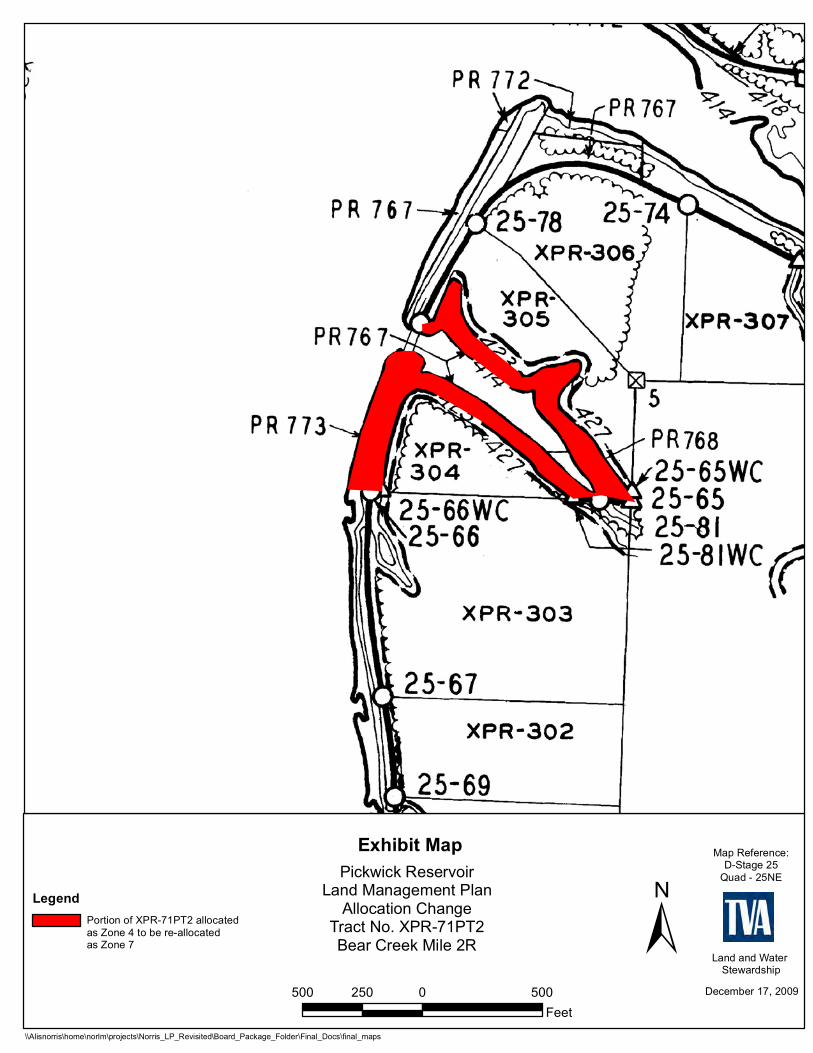
Pickwick Reservoir Land Management Plan Error − Tract No. XPR-71PT2
Reservoir Land Planning Errors After approval of a reservoir land management plan (RLMP) by the Tennessee Valley Authority (TVA), all future uses of TVA managed lands on that reservoir must then be consistent with the allocations within that RLMP. Recent research of deeds shows that on certain TVA reservoir land tracts and the current land management zone allocations have the potential to conflict with egress and ingress rights of the adjacent property owners if the current backlying land use were to change. The resolution of these potential conflicts has resulted in the reallocation of the TVA-managed land to align with the egress and ingress rights of the adjacent property owners. This document addresses the reallocation of a portion of 2002 Pickwick RLMP (2002 RLMP) tract XPR-71PT2 (XPR-71PT2) and is considered a supplement to the 2002 RLMP. Definitions of TVA’s land planning allocations are located on TVA’s Web site, http://www.tva.com/environment/reports/nrp/index.htm. General Information about Pickwick Reservoir Pickwick Reservoir is an impoundment of the Tennessee River formed by Pickwick Landing Dam, which is located at Tennessee River mile 206.7 in Hardin County, Tennessee. Pickwick Reservoir is located in parts of three states—Alabama, Mississippi, and Tennessee. TVA originally acquired 63,625 acres of land for construction of the reservoir, which was completed in February 1938. TVA has retained 19,238 acres of land lying above full pool elevation. At full pool, the reservoir is 52.7 miles long; shoreline length is 490.6 miles; and surface area is 43,100 acres. Pickwick RLMP Tract No. XPR-71PT2 XPR-71PT2 is located in Colbert County, Alabama, along the right descending bank of Bear Creek Mile 2. In the 2002 RLMP, XPR-71PT2 was allocated for “Natural Resource Conservation.” However, XPR-71PT2 fronts two parcels of land, XPR-304 and XPR-305, which TVA sold subject to Section 31 of the TVA Act. Upon the sale of these lands, TVA granted “the right of ingress to and egress from waters of Pickwick Lake over and upon the adjoining land between the 423-foot contour elevation and the waters of the lake.” In order to resolve the potential conflict from the 2002 RLMP allocation, approximately 5.8 acres of XPR-71PT2 with 2,887 feet of shoreline is designated as “Shoreline Access” and requests for private water use facilities will be considered. The remainder of the original XPR-71PT2 reservoir land tract remains designated as “Natural Resource Conservation.”
December 17, 2009500 0 500250Feet
Exhibit MapPickwick Reservoir
Land Management PlanAllocation Change
Tract No. XPR-71PT2Bear Creek Mile 2R
Map Reference:D-Stage 25
Quad - 25NE
Land and Water Stewardship
Portion of XPR-71PT2 allocatedas Zone 4 to be re-allocatedas Zone 7
Legend
\\Alisnorris\home\norlm\projects\Norris_LP_Revisited\Board_Package_Folder\Final_Docs\final_maps
±

05/2012
Pickwick Reservoir Land Management Plan Error − Tract No. XPR-25PT2
Reservoir Land Planning Errors After approval of a reservoir land management plan (RLMP) by the Tennessee Valley Authority (TVA), all future uses of TVA managed lands on that reservoir must then be consistent with the allocations within that RLMP. Recent research of deeds shows that on certain TVA reservoir land tracts and the current land management zone allocations have the potential to conflict with egress and ingress rights of the adjacent property owners if the current backlying land use were to change. The resolution of these potential conflicts has resulted in the reallocation of the TVA-managed land to align with the egress and ingress rights of the adjacent property owners. This document addresses the reallocation of a portion of 2002 Pickwick RLMP (2002 RLMP) Tract No. XPR-25PT2 and is considered a supplement to the 2002 RLMP. Definitions of TVA’s land planning allocations are located on TVA’s Web site, http://www.tva.com/environment/reports/nrp/index.htm. General Information about Pickwick Reservoir Pickwick Reservoir is an impoundment of the Tennessee River formed by Pickwick Landing Dam, which is located at Tennessee River mile (TRM) 206.7 in Hardin County, Tennessee. Pickwick Reservoir is located in parts of three states—Alabama, Mississippi, and Tennessee. TVA originally acquired 63,625 acres of land for construction of the reservoir, which was completed in February 1938. TVA has retained 19,238 acres of land lying above full pool elevation. At full pool, the reservoir is 52.7 miles long; shoreline length is 490.6 miles; and surface area is 43,100 acres. Pickwick RLMP Tract No. XPR-25PT2 Tract No. XPR-25PT2 is located in Lauderdale County, Alabama, along the right descending bank of TRM 235. In the 2002 RLMP, Tract No. XPR-25PT2 was allocated for “Natural Resource Conservation.” However, Tract No. XPR-25PT2 fronts a parcel of land, Tract No. XPR-265, which TVA sold subject to Section 31 of the TVA Act. Upon the sale of these lands, TVA granted “the right of ingress to and egress from waters of Pickwick Lake over and upon the adjoining land between the 423-foot contour elevation and the waters of the lake.” In order to resolve the potential conflict from the 2002 RLMP allocation, Tract No. XPR-25PT2 is modified to consist of Tract Nos. XPR-25aPT2 and -25PT2 (Figure 1). Tract No. XPR-25aPT2 fronts Tract No. XPR-265 and occupies approximately 4,327 feet of shoreline. Tract No. XPR-25aPT2 is designated as “Shoreline Access” and requests for private water use facilities will be considered. Tract No. XPR-25PT2 consists of the remainder of original reservoir land tract and remains designated as “Natural Resource Conservation.”

Exhibit MapPickwick Reservoir
Proposed Allocation ChangeParcel 25PT2
Map Reference: C/D Stage: 36 Quad: 35SW
Property and NaturalResources
¹XPR-25aPT2 - Area To Be Reallocatedto Zone 7 - (Approx. 18.9 Acres)
XPR-25PT2 - Area To RemainZone 4 - (Approx. 68.5 Acres)
May 3, 2012700 0 700 1,400
Feet
hlmcgee
Typewritten Text
Figure 1. XPR-25PT2 Exhibit Map

12/2015
Pickwick Reservoir Land Management Plan Error – Tract No. XPR-160PT2 Reservoir Land Planning Errors After approval of a reservoir land management plan (RLMP) by the Tennessee Valley Authority (TVA), future uses of TVA-managed lands on that reservoir must be consistent with the land use allocations within that RLMP. In 2002, the TVA Board of Directors approved the Pickwick RLMP, which assigned land use categories that identified the most suitable uses for approximately 19,238 acres of TVA public land. A 1.0-acre portion of XPR-160PT2, with 860 feet of shoreline, and a 4.1-acre portion of “Unplanned” backlying TVA property should have been designated as Project Operations (Zone 2) in the 2002 Pickwick RLMP. This document addresses the reallocation of this 5.1-acre area and is considered a supplement to the 2002 Pickwick RLMP. Definitions of TVA’s land planning allocation zones are available at https://www.tva.gov/Environment/Environmental-Stewardship/Land-Management/Reservoir-Land-Management-Plans.
General Information about Pickwick Reservoir
Pickwick Reservoir is an impoundment of the Tennessee River formed by Pickwick Landing Dam, which is located at Tennessee River mile (TRM) 206.7 in Hardin County, Tennessee. Pickwick Reservoir is located in parts of Alabama, Mississippi, and Tennessee. TVA originally acquired 63,625 acres of land for construction of the reservoir, which was completed in February 1938. TVA has retained 19,238 acres of land lying above full pool elevation. At full pool, the reservoir is 52.7 miles long; shoreline length is 490.6 miles; and surface area is 43,100 acres.
Pickwick Parcel 160PT2 (XPR-160PT2)
XPR-160PT2 (84.9 acres) is located in Colbert County, Alabama along the right descending bank of Spring Creek mile 0.4 on Pickwick Reservoir. When the Pickwick RLMP was developed, TVA overlooked a license agreement with the City of Sheffield for use by Colbert County, Alabama for maintenance facilities. An approximately 1.0-acre portion of XPR-160PT2, with 860 feet of shoreline, should have been designated as “Project Operations” instead of Residential Access (Zone 7) to reflect the license agreement. An additional 4.1 acres of backlying TVA property adjoining the 1.0-acre area was inadvertently omitted during the development of the RLMP and should also have been designated as “Project Operations.” Correction of the land use allocation to “Project Operations” would reflect legal instruments in existence but overlooked when Pickwick Reservoir was planned. The 5.1-acre area will be renamed XPR-160aPT2 (Parcel 160a). Requests for private water use facilities would not be considered on XPR-160aPT2. XPR-160PT2 consists of the remainder of the original reservoir land tract (approximately 83.9 acres) and would remain allocated as “Residential Access.”

±
Exhibit MapLand Use Allocation Correction
XPR-160PT2; XPR-160aPT2 Colbert County, Alabama Spring Creek Mile 0.4R
October 23, 2015
Natural Resources
Map Reference:C/D Stage: 52-D
Quad: 45NEEasement Location
Pickwick Reservoir500 0 500250
Feet
(Approx. 1.9 acres)Zone 7 to be Allocated Zone 2 (Approx. 1.0 acre)
Unplanned to be Allocated Zone 2 (Approx. 4.1 acres)