Welcome Supply Chain Management Software Jonathan D. Wareham [email protected].
Philliols Farm, Bere Regis, Wareham, Dorset
An Archaeological Fieldwalking Survey
for Aggregate Industries
by Steve Ford
Thames Valley Archaeological Services Ltd
Site Code PFW04-16fw
June 2004
i
Summary Site name: Philliols Farm, Bere Regis, Dorset Grid reference: SY 864 914 Site activity: Fieldwalking Date and duration of project: 7th–9th June 2004 Project manager: Steve Ford Site supervisor: Steve Ford Site code: PFW04/16 Area of site: c. 55ha (overall) (c. 20ha this project) Summary of results: A dense cluster of struck flint of Mesolithic or possibly early Neolithic date was located on the terrace edge overlooking the floodplain of Bere Stream and the River Piddle. A more extensive scatter of later Neolithic and/or Bronze Age date was also found. A few sherds of medieval and post-medieval pottery were also recovered. Monuments identified: Flint scatters Location and reference of archive: The archive is held at Thames Valley Archaeological Services, 47-49 De Beauvoir Road, Reading, RG1 5NR and will be deposited with Dorset County Museum Service in due course. This report may be copied for bona fide research or planning purposes without the explicit permission of the copyright holder Report edited/checked by: Steve Preston 24.06.04 Sian Anthony 24.06.04
1
Philliols Farm, Bere Regis, Wareham, Dorset Fieldwalking Survey
by Steve Ford
Report 04/16b
Introduction
This fieldwalking study, commissioned by Mr. Ian Lanyon of Aggregate Industries, Callow Rock Quarry, Shipham
Gorge, Cheddar, Somerset, BS27 3DQ is part of an assessment of the archaeological potential of the land at Philliols
Farm, Bere Regis, near Wareham, Dorset (SY 864 914) (Fig. 1). The report constitutes the second, non-invasive
stage of a process to determine the presence/absence, extent, character, quality and date of any archaeological
remains that may be affected by development within the area.
The site
The whole proposal site comprises an irregular parcel of land (c. 50 hectares) on the north side of the River Piddle
close to its confluence with Bere Stream and to the south east of Bere Regis. The site is in agricultural use and under
rotation of grass and sweetcorn. Approximately 20ha was cultivated at the time of the survey and it is this area,
subdivided into three fields which was subjected to fieldwalking. The site is located on relatively level ground with a
gentle slope down towards the river to the south with a well defined terrace edge (Fig. 2). The site lies at an average
height of c. 24m above Ordnance Datum. The underlying geology is mapped as second and third terrace gravel for
these three fields (BGS 2000).
Planning background and development proposals
The site is to be promoted for mineral extraction and a draft desktop contribution to an Environmental Assessment
has suggested that there is a possibility of the presence of archaeological deposits in the proposal area (Ford 2004).
Objectives and methodology
The fieldwalking took place along north–south lines spaced at 10m intervals and based on the National Grid.
Material was collected from units of 10m intervals along these lines with an average search width of 1m. This

2
approximates to a 10% sample of the surface area of the site. The methodology is comparable with that practised in
other regions of central southern England (Richards 1990; Ford 1987a, appendix 1) though the sample fraction here
is higher. All pre-19th century artefacts (primarily struck flint and pottery) were to be collected and retained. Dense
scatters of brick/tile or burnt flint were to be recorded in the field but only a sample of material collected for dating
purposes.
A record was made of conditions which may have influenced recovery rates, such as stoniness of ground,
vegetation cover, bright sunlight and which individual walked which line. The topography was also recorded to
assist in interpretation of the finds.
Results
A total area of c. 20ha was fieldwalked by 2 individuals.
Collection conditions
All of the fieldwalked area had been planted with sweetcorn which was of low or no growth. In effect the whole
ground surface was observable. The site was sunny for the vast majority of the time of the survey and the ground
dry. Stone, comprising gravel fragments was moderately dense in the south-western portions of fields 2 and 3 but
with largely stone free sandy areas in field 1 and the north-eastern portions of fields 2 and 3.
Finds
Struck flint and chert
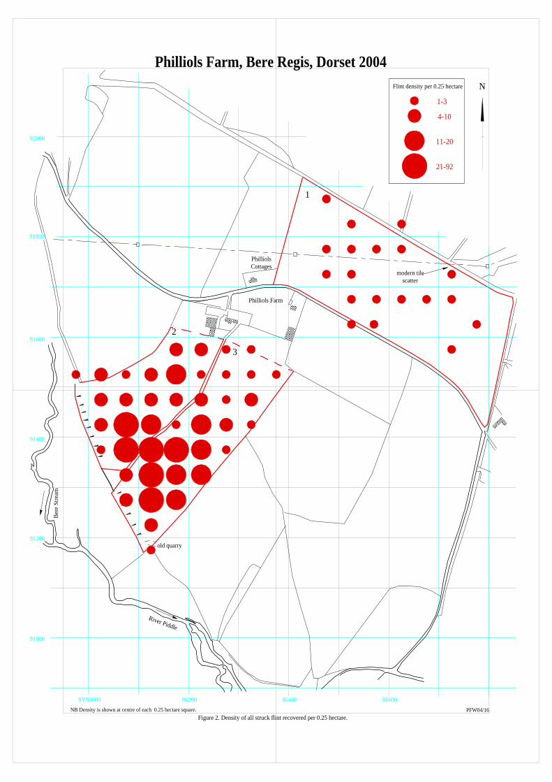
In all, 511 struck pieces were recovered, the vast majority of which were of flint, as detailed in Table 1. The
distribution is shown in Figures 2 and 3. A further 7 pieces are thought to be of modern (plough-struck) origin. As
on any flint rich subsoil where plough-struck flints are being produced with each cultivation episode, a small
proportion (1%?) of the collection recovered may be misidentified and not be of prehistoric date. Approximately
20% of the material was patinated a blueish white colour to a greater or lesser extent and one or two pieces iron
stained. A small number are relatively fresh, but are thought to be of bona fide prehistoric origin. Most pieces were
edge damaged (plough retouched) to a greater or lesser extent, and it is likely that some of these pieces were

3
originally deliberately retouched in prehistoric times. Conditions which affect the rate of patination of struck flints
are complex and locally variable and sometimes can be used as a chronological indicator. It is noteworthy that 51%
of the blade/narrow flake component is patinated as are 47% of the blade cores, which may indicate that patination is
representative of the early component to the collections. However, this is somewhat contradicted by 75% of the
ordinary flake cores also being patinated.
Table 1: Struck flint and chert
Blades/narrow flake 55 Flake 332 Chert flake 4 Core 24 Blade core 17 Bashed lumps/core fragment 13 Spall 36 Scraper 15 Awl 2 Fabricator 2 Notched flake 2 Knife 2 Hammerstone 1 Transverse arrowhead 1 Invasively retouched piece 1 Retouched flake 4
The sub-division of blades/narrow flakes from broad flakes was not done metrically but assigned by eye. Relatively
low proportions of the material can be regarded as related to procurement activity.
Chronology
As a whole, the flint collection contains a significant proportion of Mesolithic and possibly earlier Neolithic material
alongisde later material (Ford 1987). Overall, blades/narrow flakes account for only 7% of the flake component
which is a statistic not atypical for later (Neolithic) period assemblages. However, blade cores account for 41% of all
cores. As many of the blades/narrow flakes are unambiguously of (early) blade technology rather than fortuitous by-
products of non-blade knapping, it is suggested that the collection as a whole contains material of both Mesolithic
and later date. The retouched component of the collection contains very few items of close date. The retouched
component was, as always, dominated by scrapers, a ubiquitous tool of very limited chronological significance. No
4
distinctive Mesolithic items such as microliths, microburins, burins or tranchet axes were identified, but items such
as fabricators (rods or strike-a-lights) and some of the scrapers would not be atypical for Mesolithic assemblages.
Other items, such as the transverse arrowhead, the knives and invasively retouched piece are characteristic of
Neolithic flintworking. The differentiation of Middle Bronze Age or Late Bronze Age/Early Iron Age assemblages
from those of later Neolithic/Early Bronze Age date is, unfortunately, based on negative characteristics (Ford et al.
1984) and it is not possible to identify these periods separately here.
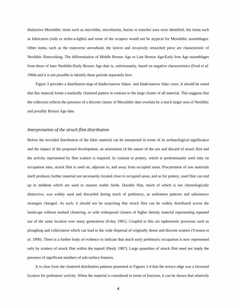
Figure 3 provides a distribution map of blades/narrow flakes and blade/narrow flake cores. It should be noted
that this material forms a markedly clustered pattern in contrast to the large cluster of all material. This suggests that
the collection reflects the presence of a discrete cluster of Mesolithic date overlain by a much larger area of Neolithic
and possibly Bronze Age date.
Interpretation of the struck flint distribution
Before the recorded distribution of the lithic material can be interpreted in terms of its archaeological significance
and the impact of the proposed development, an assessment of the nature of the use and discard of struck flint and
the activity represented by flint scatters is required. In contrast to pottery, which is predominantly used only on
occupation sites, struck flint is used on, adjacent to, and away from occupied areas. Procurement of raw materials
itself produces further material not necessarily located close to occupied areas, and as for pottery, used flint can end
up in middens which are used to manure arable fields. Durable flint, much of which is not chronologically
distinctive, was widely used and discarded during much of prehistory, as settlement patterns and subsistence
strategies changed. As such, it should not be surprising that struck flint can be widely distributed across the
landscape without marked clustering, or with widespread clusters of higher density material representing repeated
use of the same location over many generations (Foley 1981). Coupled to this are taphonomic processes such as
ploughing and colluviation which can lead to the wide dispersal of originally dense and discrete scatters (Yorston et
al. 1990). There is a further body of evidence to indicate that much early prehistoric occupation is now represented
only by scatters of struck flint within the topsoil (Healy 1987). Large quantities of struck flint need not imply the
presence of significant numbers of sub-surface features.
It is clear from the clustered distribution patterns presented in Figures 2-4 that the terrace edge was a favoured
location for prehistoric activity. When the material is considered in terms of function, it can be shown that relatively
5
low proportions can be regarded as related to procurement activity (i.e., few waste, cortical, unusable flakes) with a
relatively high proportion and range of retouched tool types. The scatters are therefore best interpreted as
representing occupation activity.
Pottery
The fieldwalking resulted in the recovery of just 8 sherds of pottery as shown on Figure 3. Five of the sherds are of
later post-medieval currency, with one item of stoneware and four items of yellow glazed post-medieval redware.
Three other sherds, in fine sandy fabrics, one of which retains faint traces of glaze, may be of late medieval date.
Interpretation of the pottery distribution
The distribution of the pottery is shown on Figure 3 and can only be interpreted as representing material
incorporated into manure which is subsequently spread onto farmland.
Conclusion
The fieldwalking has resulted in the recovery of a quantity of lithic material from parts of the site area and clearly
indicates widespread use of the landscape at various times in the past though for some areas this use is light. The
density and clustering of lithic material on the terrace edge suggest evidence for occupation in both Mesolithic and
Neolithic/Bronze Age times. In contrast pottery finds are few in number and only represent the manuring of
farmland in medieval and post-medieval times.
English Heritage have recently published guidelines on assessing the significance of lithic scatters in
management terms (EH 2000). Six criteria were presented to identify the most important scatters, which might be
worthy of preservation as Scheduled Monuments in their own right. In summary, it is concluded that scheduling
would be ‘unlikely in most cases’, but a lithic scatter will have particular importance if it meets three of the
following criteria:
1> it has clearly defined boundaries making it recognizable as a discrete site 2> the high quality of the artefacts suggests they derive from subsurface features whose disturbance has been
recent 3> additional evidence points to associated buried structural remains or other artefacts 4> there is evidence for part of the site’s being undisturbed 5> it can be dated or interpreted with confidence
6
6> there is evidence of diversity (of dates or activities)
The scatter located here does not meet these criteria. Whilst the scatter does include a clustered early component at a
‘field extent’ of analysis, the boundaries of this within the field are actually diffuse. The later (Neolithic/Bronze
Age), larger scatter is superimposed on top of the earlier (Mesolithic) scatter and its limits are even more diffuse.
The flintwork recovered is invariably edge-damaged to a greater or lesser extent and a proportion is patinated. The
material would have little potential for use-wear studies. There is no evidence for these flints having been recently
derived from buried deposits or for any realistic prospect of parts of the scatter not having been disturbed by
ploughing. The composition of the scatter does reflect a diversity of dates and a range of activities but the
chronology is derived only from the lithic characteristics alone. This dating is therefore of limited precision, in
contrast to stratified assemblages associated with pottery or radiocarbon dated material.
For lithic scatters not meeting the criteria for national importance, i.e., the majority of cases, recording is
regarded as the most appropriate response (EH 2000, 7).
References BGS, 2000, British Geological Survey, 1:50,000, Solid and Drift Edition, sheet 328, Keyworth EH, 2000, Managing lithic scatters, archaeological guidance for planning authorities and developers, English
Heritage, London Foley, R, 1981, Off-site Archaeology and Human Adaption in East Africa, Brit Archaeol Rep (Int Ser) 97, Oxford Ford, S, 1987a, The East Berkshire Archaeological Survey, Berkshire County Council Dept Highways Planning,
Occas Pap 1, Reading Ford, S, 1987b, ‘Chronological and functional aspects of flint assemblages’, in A G Brown and M R Edmonds,
(eds), Lithic Analysis and Later British Prehistory: Some Problems and Approaches, Brit Archaeol Rep 162, Oxford, 67–85
Ford S, 2004, Philliols Farm, Bere Regis, Wareham, Dorset, Archaeological contribution to Environmental Impact Assessment, Thames Valley Archaeological Services report 04/16, Reading [DRAFT]
Ford, S, Bradley, R J, Hawkes, J and Fisher, P, 1984, ‘Flint working in the metal age’ Oxford J Archaeol 3, 157–173 Healy, F, 1987, ‘Prediction or prejudice? The relationship between field survey and excavation’, in A G Brown and
M R Edmonds (eds), Lithic Analysis and Later British Prehistory, Brit Archaeol Rep 162, Oxford, 9–18 Richards, J C, 1990, The Stonehenge Environs Project, Hist Buildings Monuments Comm (Engl) Rep 16, London Yorston, R, M, Gaffney, V L, and Reynolds, P J, 1990, ‘Simulation of artefact movement due to cultivation’, J
Archaeol Sci, 17, 67–83

Philliols Farm, Bere Regis, Wareham, Dorset, 2004Fieldwalking Survey
Figure 1. Location of site within Bere Regis andDorset.
Reproduced from Ordnance Survey Outdoor Leisure 15 at 1:25000Ordnance Survey Licence 100025880
90000
91000
92000
SY84000 85000 86000 87000
SITE
PFW04/16b
SITE
BournemouthWareham
DorchesterBridport
SwanageWeymouth
BlandfordForum
Shaftsbury
1
23
N
Philliols Farm, Bere Regis, Dorset 2004
River Piddle
PhilliolsCottages
Philliols Farm
SY86000 86200 86400 86600
92000
91800
91600
91400
Bere
Stre
am
Figure 2. Density of all struck flint recovered per 0.25 hectare.PFW04/16
91200
91000
1
2
3
old quarry
1-3
4-10
11-20
21-92
Flint density per 0.25 hectare
NB Density is shown at centre of each 0.25 hectare square.
modern tilescatter

Philliols Farm, Bere Regis, Dorset 2004
River Piddle
PhilliolsCottages
Philliols Farm
92000
91800
91600
91400
Bere
Stre
am
Figure 3. Blades (narrow flakes), blade cores and post-medieval pottery.
PFW04/16
91200
91000
Blades and narrow flakesBlade and narrow flake cores
1
23
old quarry
N
SY86000 86200 86400 86600
Post-medieval potteryP
Key
M
M
P P
P
P
P
Medieval potteryM
M

Philliols Farm, Bere Regis, Dorset 2004
River Piddle
PhilliolsCottages
Philliols Farm
92000
91800
91600
91400
Bere
Stre
am
Figure 4. Other lithic material.
PFW04/16
91200
91000
1
23
old quarry
N
SY86000 86200 86400 86600
SSS S
S
S
S
S
S
S
S
S
S
S
S
R
R R
RH
R
K
K
F
F
NN
A
A
Spall
Core
S Scraper
R Retouched flakeH HammerstoneF Fabricator
Transverse arrowhead
Core fragment/bashed lump
K KnifeN Notched flake
A Awl
Key