Valuation Methods Applied To Lookback Capped Multi Bonus ...

Page 1 of 10
Philip Habib & Associates Engineers and Planners • 102 Madison Avenue • New York, NY 10016 • 212 929 5656 • 212 929 5605 (fax)
220 CENTRAL PARK SO.: ZR 13-451, SPECIAL PERMIT FINDINGS NARRATIVE
RESIDENTIAL GROWTH PARKING STUDY ANALYSIS 22 June 2017
Background and Summary of Findings: This report summarizes the analysis of residential growth and off-street parking changes within and in the vicinity of Midtown Manhattan pursuant to Section 13-451 of the NYC Zoning Resolution (Special permit for additional spaces for residential growth, or “Special Permit”). The analysis is in support of an application (“Application”) by 228 West 58th LLC, an affiliate of Vornado Realty Trust to the City Planning Commission (“CPC”) for a 64-space below-grade parking garage (“Proposed Project”) within a mixed-use building being developed at 220 Central Park South, Block 1030, Lots 15, 16, 17, and 19 (“Site”). The site is located midblock on Central Park South (W. 59th Street) between Seventh Avenue and Broadway, although its zoning lot also includes properties with frontage on Broadway and W. 58th Street. The required analyses found that the 64 spaces proposed by the applicant are reasonable and not excessive in relation to recent trends within close proximity to the proposed development site. In addition to the applicant’s planned 118 DUs on the development site, there has been a net increase of over 2,400 housing units (in new construction, expansions, and conversions) within the prescribed one-third mile study area (“Study Area”) surrounding the development site during the 10-year lookback period and extending until 2018 (the proposed project’s build year), during which there has been a net increase of 384 off-street residential parking spaces (including an increase due to new spaces in residential developments which was partly offset by the elimination of spaces from existing facilities), plus an additional 42 residential spaces on the development site that have been eliminated. Using the Department of City Planning’s methodology, the analysis found that with the study area’s net change in the supply of residential parking spaces, the study area’s net increase in the number of residential units, and the proposed 64-space special permit, the ratio of change in residential parking spaces to change in residential units would be 15.53 percent (+16.50%) and thus does not exceed the 20 percent (+20%) target growth parking ratio for the development site and most of the study area developments. The applicant has also identified associated sites for the proposed 64 spaces. Methodology In order to quantify the residential growth parking ratio for the Study Area surrounding the site, residential parking change and residential unit change analyses were prepared in accordance with the methodology set forth by the Department of City Planning (“DCP”) “Section 13-451 (Additional parking spaces for residential growth) Special Permit Application Guidelines Version 3.0, dated 30 October 2014 (hereafter “the Guidelines”).

Page 2 of 10
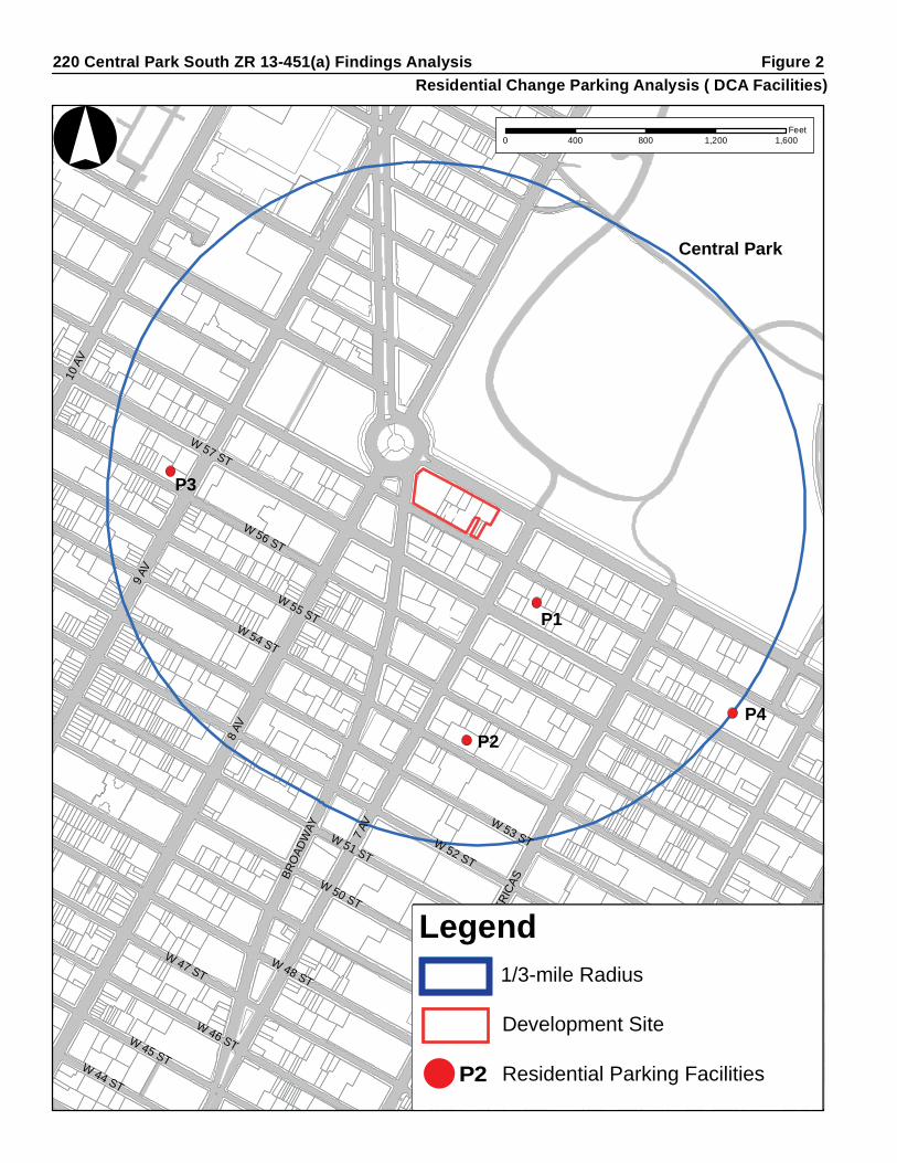
Study Area The Study Area is defined as a one-third mile radius from the edge of the proposed development’s zoning lot. For this project, the study area encompasses an area that extends as far north as W. 65th Street at Central Park West, as far east as the midblock area between Fifth and Sixth Avenues, as far south as the south side of W. 52nd Street and as far west as the midblock area between Ninth and Tenth Avenues. The study area is spread across portions of Community Districts 4, 5, and 7. Refer to Figure 1. Study Period Per the Guidelines, the study period was defined as starting at a 10-year “look-back” prior to the application filing; as this application is being filed in 2015, the look-back period begins in 2005. The study period continues until the anticipated completion year for the proposed development, which is 2018. Data Collection DCP provided data from the NYC Department of Consumer Affairs (DCA) on capacity changes in licensed public parking facilities and data from the NYC Department of Buildings (DOB) on new residential development (new construction and conversions) since the start of the study period. These data sets were used as a starting point for identifying all changes in residential off-street parking capacity and residential units within the Study Area during the study period. Additional data collection conducted as part of this analysis included field visits, reviews of certificates of occupancy (C of Os), building permit filings, CPC parking special permit reports, and previous environmental reviews. Residential Parking Change Analysis Pursuant to the Guidelines, the gross number of eliminated off-street parking spaces must be adjusted by the community district percentages of residential parking usage, as presented in DCP’s Manhattan Core Public Parking Study, issued in 2009. The percentages for community districts included in the study area are 30 percent for Community District 4, 24 percent in Community District 5, and 69 percent in Community District 7. However, new parking facilities in residential or primarily residential buildings are to be considered entirely utilized by area residents, unless there are circumstances that warrant special treatment. Thus, the Residential Parking Change Analysis found that during the study period, the Study Area has experienced a loss of approximately 235 DCA licensed off-street parking spaces. This involved the elimination of two public parking facilities with a combined total of 222 spaces, of which it is estimated that 54 were residential parking spaces. In addition, one facility experienced a decrease of 18 DCA licensed parking spaces, of which it is estimated 4 were residential parking spaces. In addition there is one facility in the Study Area where the licensed capacity increased. It is a garage in a mixed residential-commercial building that according to DCA records increased its licensed capacity from 20 to 25 spaces. There are no records of a parking special permit being issued to allow increased parking and the increased capacity is not indicated on the most recent certificate of

8 AV
7 AV
W 52 ST
9 AV
W 51 ST
W 53 ST
W 50 ST
W 49 ST
W 54 ST
W 55 ST
W 48 ST
W 56 ST
W 47 ST
BRO
ADW
AY
W 57 ST
W 46 ST 5 AVW 45 ST
AV O
F TH
E AM
ERIC
AS
10 A
V
W 44 STE 50 ST
E 51 ST
ROCK
EFEL
LER
PZ
° 0 400 800 1,200 1,600Feet
220 Central Park South ZR 13-451(a) Findings Analysis Figure 1Study Area
CD4
CD7
CD5
Central Park
Legend1/3-mile Radius
Development Site
Community District (CD) Boundaries
High Line
CD4
Legend1/3-mile Radius
Development Site
Community District (CD) BoundariesCD4

Page 3 of 10
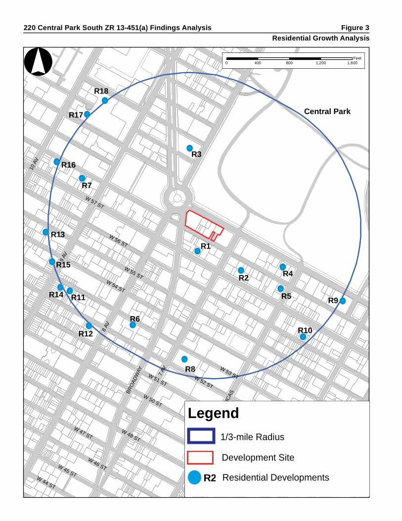
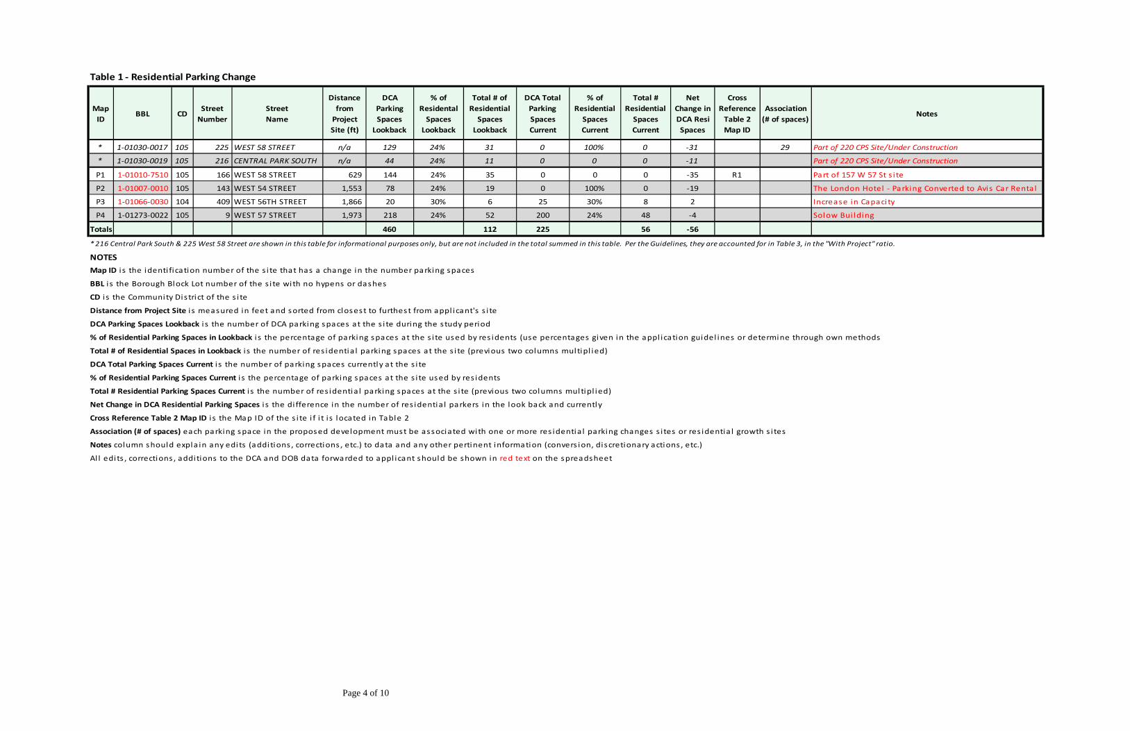
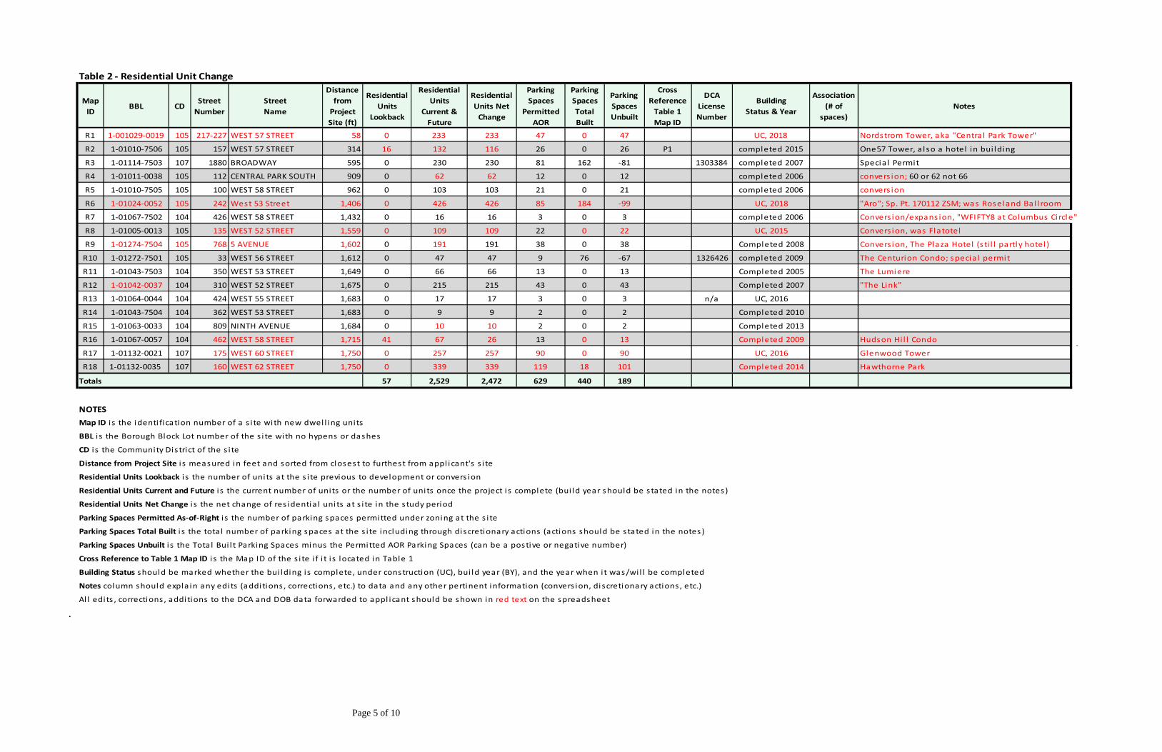
occupancy. In light of these circumstances, the applicable community district percentage of spaces used by residents has been applied to the reported incremental increase in parking spaces. As such, for analysis purposes this facility is projected to have increased it residential parking by 2 spaces. Refer to Table 1 and Figure 2. With the loss of 54 residential spaces at two locations, the reduction of 4 residential spaces from one location, and the increase of 2 residential spaces at one location, the study area experienced a net change of -56 residential parking spaces (excluding spaces in new residential and mixed use buildings accounted for in Table 2 and changes on the development site accounted for in Table 3). There are no known new off-street parking facilities created during the study period, apart from those located in new residential developments which are discussed separately in the description of the “Residential Unit Change Analysis.” Additionally, there are no known instances of non-DCA residential accessory parking spaces being eliminated in the Study Area during the study period. It should be noted that, per the Guidelines, off-street parking facilities that were already in existence as of the start of the look-back period (2005) which are still operating without a change in licensed capacity, are not considered in this analysis. Residential Unit Change Analysis New Residential Units The Residential Unit Change Analysis indicates that as a result of new residential and mixed residential-commercial developments in the Study Area during the study period there has been a net increase of approximately 2,472 residential units. This reflects the development of 18 sites with residential units, ranging in size from 9 to 426 units. These include 12 developments from 2005 to 2014 and 6 completed in 2015, under construction in 2015 or expected to be completed by 2018. In terms of the type of development, 4 of the 18 are conversions of existing buildings, 1 of the 18 is a conversion/expansion of an existing building, and 13 of the 18 are new construction. On 16 of the 18 sites there were no residential units at the beginning of the study period, while two sites had residential units at the beginning of the study period replaced as part of new buildings. In total, by the end of the study period in 2018 there will be 2,529 DUs on the 18 residential unit change sites, compared to 57 DUs at the start of the study period. As a result, as shown in the table, the study area has experienced a net increase of 2,472 DUs. Refer to Table 2 and Figure 3. New Residential Parking in New Residential or Mixed Residential-Commercial Developments According to the Guidelines, the target percentage (ratio) of parking spaces to residential units for the Study Area is the same as the as-of-right parking maximums for new developments in the Manhattan Core: 20 percent of units for Community Districts 1 to 6; and 35 percent for Community Districts 7 and 8. Applying the 20 percent target rate to the study area’s Community District 4 and 5 developments and applying the 35 percent target rate to the study area’s Community District 7 developments, the target number of residential parking spaces for the 2,529 total DUs is approximately 629; but the target number of residential parking spaces for the net increase of 2,472 DUs is approximately 618.
!(
!(
!(!(
!(
!(
!(!(
!( !(!(
!(!(
!(
!(
!(!(!(
!(
8 AV
7 AV
W 52 ST
9 AV
W 51 ST
W 53 ST
W 50 ST
W 49 ST
W 54 ST
W 55 ST
W 48 ST
W 56 ST
W 47 ST
BRO
ADW
AY
W 57 ST
W 46 ST 5 AVW 45 ST
AV O
F TH
E AM
ERIC
AS
10 A
V
W 44 STE 50 ST
E 51 ST
ROCK
EFEL
LER
PZ
° 0 400 800 1,200 1,600Feet
220 Central Park South ZR 13-451(a) Findings Analysis Figure 2Residential Change Parking Analysis ( DCA Facilities)
Central Park
Legend1/3-mile Radius
Development Site
Community District (CD) Boundaries
High Line
CD4
P4P2
P3
P1
Legend1/3-mile Radius
Development Site
Residential Parking Facilities P2
8 AV
7 AV
W 52 ST
9 AV
W 51 ST
W 53 ST
W 50 ST
W 49 ST
W 54 ST
W 55 ST
W 48 ST
W 56 ST
W 47 ST
BRO
ADW
AY
W 57 ST
W 46 ST 5 AVW 45 ST
AV O
F TH
E AM
ERIC
AS
10 A
V
W 44 STE 50 ST
E 51 ST
ROCK
EFEL
LER
PZ
° 0 400 800 1,200 1,600Feet
220 Central Park South ZR 13-451(a) Findings Analysis Figure 3Residential Growth Analysis
Central Park
Legend1/3-mile Radius
Development Site
Community District (CD) Boundaries
High Line
CD4
R12 R10
R3
R5
R4R2
R16
R15
R14
R13
R11
R7
Legend1/3-mile Radius
Development Site
Residential DevelopmentsR2
R9
R8
R17
R18
R1
R6
Page 4 of 10
Table 1 ‐ Residential Parking Change
Map ID
BBL CDStreetNumber
StreetName
Distance from Project Site (ft)
DCA Parking Spaces Lookback
% of Residental Spaces Lookback
Total # of ResidentialSpaces Lookback
DCA Total ParkingSpaces Current
% of ResidentialSpaces Current
Total # ResidentialSpaces Current
Net Change in DCA Resi Spaces
Cross Reference Table 2 Map ID
Association(# of spaces)
Notes
* 1‐01030‐0017 105 225 WEST 58 STREET n/a 129 24% 31 0 100% 0 ‐31 29 Part of 220 CPS Site/Under Construction
* 1‐01030‐0019 105 216 CENTRAL PARK SOUTH n/a 44 24% 11 0 0 0 ‐11 Part of 220 CPS Site/Under Construction
P1 1‐01010‐7510 105 166 WEST 58 STREET 629 144 24% 35 0 0 0 ‐35 R1 Part of 157 W 57 St s i te
P2 1‐01007‐0010 105 143 WEST 54 STREET 1,553 78 24% 19 0 100% 0 ‐19 The London Hotel ‐ Parking Converted to Avis Car Renta l
P3 1‐01066‐0030 104 409 WEST 56TH STREET 1,866 20 30% 6 25 30% 8 2 Increase in Capaci ty
P4 1‐01273‐0022 105 9 WEST 57 STREET 1,973 218 24% 52 200 24% 48 ‐4 Solow Bui lding
Totals 460 112 225 56 ‐56
* 216 Central Park South & 225 West 58 Street are shown in this table for informational purposes only, but are not included in the total summed in this table. Per the Guidelines, they are accounted for in Table 3, in the "With Project" ratio.
NOTES
Al l edits , corrections , additions to the DCA and DOB data forwarded to appl icant should be shown in red text on the spreadsheet
Notes column should expla in any edits (addi tions , corrections , etc.) to data and any other pertinent information (convers ion, discretionary actions , etc.)
Cross Reference Table 2 Map ID i s the Map ID of the s i te i f i t i s located in Table 2
Association (# of spaces) each parking space in the proposed development must be associated with one or more res identia l parking changes s i tes or res identia l growth s i tes
Map ID i s the identi fication number of the s i te that has a change in the number parking spaces
CD i s the Community District of the s i te
Distance from Project Site i s measured in feet and sorted from closest to furthest from appl icant's s i te
DCA Parking Spaces Lookback i s the number of DCA parking spaces at the s i te during the study period
% of Residential Parking Spaces in Lookback i s the percentage of parking spaces at the s i te used by res idents (use percentages given in the appl ication guidel ines or determine through own methods
BBL i s the Borough Block Lot number of the s i te with no hypens or dashes
Net Change in DCA Residential Parking Spaces i s the di fference in the number of res identia l parkers in the look back and currently
Total # of Residential Spaces in Lookback i s the number of res identia l parking spaces at the s i te (previous two columns multipl ied)
DCA Total Parking Spaces Current i s the number of parking spaces currently at the s i te
% of Residential Parking Spaces Current i s the percentage of parking spaces at the s i te used by res idents
Total # Residential Parking Spaces Current i s the number of res identia l parking spaces at the s i te (previous two columns multipl ied)
Page 5 of 10
Table 2 ‐ Residential Unit Change
Map ID
BBL CDStreetNumber
StreetName
Distance from Project Site (ft)
Residential Units
Lookback
Residential Units
Current & Future
Residential Units Net Change
Parking Spaces
Permitted AOR
Parking SpacesTotal Built
Parking SpacesUnbuilt
Cross Reference Table 1 Map ID
DCA LicenseNumber
BuildingStatus & Year
Association (# of
spaces)Notes
R1 1‐001029‐0019 105 217‐227 WEST 57 STREET 58 0 233 233 47 0 47 UC, 2018 Nordstrom Tower, aka "Centra l Park Tower"
R2 1‐01010‐7506 105 157 WEST 57 STREET 314 16 132 116 26 0 26 P1 completed 2015 One57 Tower, also a hotel in bui lding
R3 1‐01114‐7503 107 1880 BROADWAY 595 0 230 230 81 162 ‐81 1303384 completed 2007 Specia l Permit
R4 1‐01011‐0038 105 112 CENTRAL PARK SOUTH 909 0 62 62 12 0 12 completed 2006 convers ion; 60 or 62 not 66
R5 1‐01010‐7505 105 100 WEST 58 STREET 962 0 103 103 21 0 21 completed 2006 convers ion
R6 1‐01024‐0052 105 242 West 53 Street 1,406 0 426 426 85 184 ‐99 UC, 2018 "Aro"; Sp. Pt. 170112 ZSM; was Roseland Bal l room
R7 1‐01067‐7502 104 426 WEST 58 STREET 1,432 0 16 16 3 0 3 completed 2006 Convers ion/expans ion, "WFIFTY8 at Columbus Circle"
R8 1‐01005‐0013 105 135 WEST 52 STREET 1,559 0 109 109 22 0 22 UC, 2015 Convers ion, was Flatotel
R9 1‐01274‐7504 105 768 5 AVENUE 1,602 0 191 191 38 0 38 Completed 2008 Convers ion, The Plaza Hotel (s ti l l partly hotel )
R10 1‐01272‐7501 105 33 WEST 56 STREET 1,612 0 47 47 9 76 ‐67 1326426 completed 2009 The Centurion Condo; specia l permit
R11 1‐01043‐7503 104 350 WEST 53 STREET 1,649 0 66 66 13 0 13 Completed 2005 The Lumiere
R12 1‐01042‐0037 104 310 WEST 52 STREET 1,675 0 215 215 43 0 43 Completed 2007 "The Link"
R13 1‐01064‐0044 104 424 WEST 55 STREET 1,683 0 17 17 3 0 3 n/a UC, 2016
R14 1‐01043‐7504 104 362 WEST 53 STREET 1,683 0 9 9 2 0 2 Completed 2010
R15 1‐01063‐0033 104 809 NINTH AVENUE 1,684 0 10 10 2 0 2 Completed 2013
R16 1‐01067‐0057 104 462 WEST 58 STREET 1,715 41 67 26 13 0 13 Completed 2009 Hudson Hi l l Condo
R17 1‐01132‐0021 107 175 WEST 60 STREET 1,750 0 257 257 90 0 90 UC, 2016 Glenwood Tower
R18 1‐01132‐0035 107 160 WEST 62 STREET 1,750 0 339 339 119 18 101 Completed 2014 Hawthorne Park
Totals 57 2,529 2,472 629 440 189
NOTES
Residential Units Current and Future i s the current number of units or the number of units once the project i s complete (bui ld year should be s tated in the notes )
Map ID i s the identi fication number of a s i te with new dwel l ing units
BBL i s the Borough Block Lot number of the s i te with no hypens or dashes
CD i s the Community District of the s i te
Distance from Project Site i s measured in feet and sorted from closest to furthest from appl i cant's s i te
Residential Units Lookback i s the number of units at the s i te previous to development or convers ion
Notes column should expla in any edi ts (additions , corrections , etc.) to data and any other pertinent information (convers ion, discretionary actions , etc.)
Al l edi ts , corrections , additions to the DCA and DOB data forwarded to appl icant should be shown in red text on the spreadsheet
Residential Units Net Change i s the net change of res identia l units at s i te in the study period
Parking Spaces Permitted As‐of‐Right i s the number of parking spaces permitted under zoning at the s i te
Parking Spaces Total Built i s the tota l number of parking spaces at the s i te including through discretionary actions (actions should be s tated in the notes )
Parking Spaces Unbuilt i s the Tota l Bui l t Parking Spaces minus the Permitted AOR Parking Spaces (can be a postive or negative number)
Cross Reference to Table 1 Map ID i s the Map ID of the s i te i f i t i s located in Table 1
Building Status should be marked whether the bui lding i s complete, under construction (UC), bui ld year (BY), and the year when i t was/wi l l be completed
.
Page 6 of 10
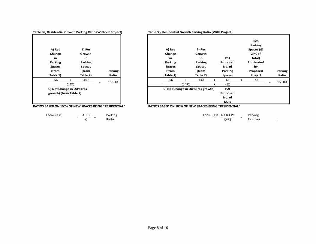
Table 2 also indicates that in the Study Area during the study period, four of the 18 residential development sites have included off-street parking spaces. These include a 184-space garage slated to open in 2018 in a new 426-DU building at 242 W. 53rd Street; the parking spacs will be provided pursuant to a recently approved garage special permit. Collectively, these new developments have a licensed capacity of 440 off-street residential parking spaces. With the 440 new residential parking spaces created in four of the 18 “residential growth” sites and the net reduction of 56 residential parking spaces identified in Table 1, the DCP Guidelines methodology finds that the net adjusted change in residential off-street parking capacity is a net increase of 384 spaces. Change in Residential Parking and Residential Units due to the Proposed Project The Proposed Project would change both the number of residential parking spaces and the number of residential units in the Study Area. Proposed Project: Residential Parking Change With the Proposed Project, there would be 42 residential parking spaces eliminated from two previous parking facilities on the site and 64 residential parking spaces added pursuant to the proposed special permit, resulting in a net increase of 22 residential spaces added to the development site and to the study area’s overall inventory of residential parking spaces. Per the Guidelines, it is assumed that 100 percent of the added spaces would be residential parking spaces. It should be noted that the Proposed Project, with a development program of 118 residential units, would be permitted approximately 24 residential accessory parking spaces as-of-right. Proposed Project: Residential Unit Change Previously, there was a building complex on the development site with 130 residential units that was present at the beginning of the lookback study period. With the proposed development site’s 118 additional residential units, resulting in a net decrease of 12 residential units on the development site, and the net increase of 2,472 study area DUs added during the study period without the project, the study area will experience a net increase of 2,460 study area DUs. With these 2,460 DUs, the study area would have a target number of 616 new residential parking spaces, which represents the total number of residential parking spaces that could be added before the Study Area target ratio is achieved, i.e., 20 percent for Community District 4 and 5 sites and 35 percent for Community District 7 sites (aggregated). Residential Growth Parking Ratio The Residential Growth Parking Ratio is calculated by dividing the net change in off-street residential parking spaces by the net change in the number of residential units in the Study Area during the study period. This ratio is calculated for “Without Project” and “With Project” conditions. As indicated in Table 3, under “Without Project” conditions, the Study Area Residential Growth Parking Ratio will be 15.53 percent. This reflects a net increase of 384 residential parking spaces and a net increase of 2,472 residential units. As also shown in Table 3, under “With Project” conditions, the Study Area Residential Growth Parking Ratio also will be

Page 7 of 10
16.50 percent. This reflects an overall net increase (inclusive of changes on the development site) of 406 residential parking spaces and a net increase of 2,460 residential units. In order for the Study Area to reach the target 616 spaces of parking under “With Project” conditions, the Study Area would need to add an additional 210 residential parking spaces to the 406 residential spaces provided under “With Project” conditions.
Page 8 of 10
.
Table 3a, Residential Growth Parking Ratio (Without Project) Table 3b, Residential Growth Parking Ratio (With Project)
A) Res Change
in Parking Spaces (from Table 1)
B) Res Growth
in Parking Spaces (from Table 2)
Parking Ratio
A) Res Change
in Parking Spaces (from Table 1)
B) Res Growth
in Parking Spaces (from Table 2)
P1) Proposed No. of Parking Spaces
Res Parking
Spaces (@ 24% of total)
Eliminated by
Proposed Project
Parking Ratio
‐56 + 440 ‐56 + 440 + 64 + ‐422,472 2,472 + ‐12
P2) Proposed No. of DU's
RATIOS BASED ON 100% OF NEW SPACES BEING "RESIDENTIAL" RATIOS BASED ON 100% OF NEW SPACES BEING "RESIDENTIAL"
Formula is: A + B Formula is: A + B + P1C C+P2 6/22/2017
C) Net Change in DU's (res growth) (from Table 2)
C) Net Change in DU's (res growth)
=Parking Ratio
=
16.50%
Parking Ratio w/
= 15.53% =
Page 9 of 10
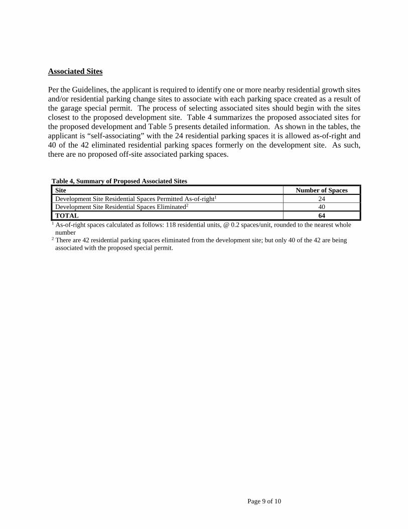
Associated Sites Per the Guidelines, the applicant is required to identify one or more nearby residential growth sites and/or residential parking change sites to associate with each parking space created as a result of the garage special permit. The process of selecting associated sites should begin with the sites closest to the proposed development site. Table 4 summarizes the proposed associated sites for the proposed development and Table 5 presents detailed information. As shown in the tables, the applicant is “self-associating” with the 24 residential parking spaces it is allowed as-of-right and 40 of the 42 eliminated residential parking spaces formerly on the development site. As such, there are no proposed off-site associated parking spaces.
Table 4, Summary of Proposed Associated Sites Site Number of Spaces Development Site Residential Spaces Permitted As-of-right1 24 Development Site Residential Spaces Eliminated2 40 TOTAL 64
1 As-of-right spaces calculated as follows: 118 residential units, @ 0.2 spaces/unit, rounded to the nearest whole number
2 There are 42 residential parking spaces eliminated from the development site; but only 40 of the 42 are being associated with the proposed special permit.

Page 10 of 10
Table 5 ‐ Associations
Applicant Project Name
BBLCommunity District
StreetNumber
Street Name
CommunityDistrict
StudyPeriod
ULURP # CPC Review Session Date
ResidentialUnits
Proposed
ParkingSpaces
Proposed
PermittedAOR Parking
Spaces
Number ofParking Spacesto Associate
Number ofSites
Associated
220 Central Park South
1‐01030‐0015, 1‐01030‐0016, 1‐01030‐0017, 1‐01030‐0019
105 220Central
Park South105 2005‐2016 ‐ N/A 118 64 24 40 1
StreetNumber
Street NameCommunityDistrict
BBL PlutoX PlutoYDistance from
Project Development Site
Number of Spaces Applicant isAssociating
10 Year AssociationEnd Date
Map ID Numberfrom Table 1 and/or Table 2
Year BuiltNumber of Residential
Units
Number AOR Accessory
Parking Spaces
Number of Accessory
Parking Spaces
Number of Unbuilt Accessory Parking
Spaces
Difference in DCA Capacity
For Lookback Period
Difference in DCA Residential Parking Capacity
for
DCA Capacity
DCA ResidentialParking
Expected Loss In Residential Capacity
225 WEST 58 STREET 105 1‐01030‐0017 989583 218699 n/a 40 2026 n/a 2016 118 24 0 24 N/A N/A 173 42 42
Type C. Applicant Self‐Association Lost Residential Parking Spaces, for example, if there was a 100 space parking lot on the development site, applicant would take the appropriate percentage of residential parking spaces and self‐associate those spaces
Applicant can associated with multiple sites and multiple types.
Map ID i s the identifi cation number of the s i te that has a change in the number parking spaces
BBL i s the Borough Block Lot number of the s i te with no hyphens or dashes
Pluto X and Y coordinates for mapping and s i te identi fication
Distance from Project Site i s measured in feet and sorted from closes t to furthest from appl icant's s i te
Number of Spaces Applicant is Associating i s the tota l number of spaces associated; appl icant cannot leave unassociated spaces at multiple s i tes
10 Year Association End Date i s 10 years from the date when the associated s i te created new res identia l development or los t res identia l parking spaces
Map ID i s the ID number from Table 1 and / or Table 2 maps and spreadsheets
Notes column should conta in any pertinent data and information
Type B Association Only:DCA Lost Residential Parking Spaces
Type C Association Only:Applicant Self‐Association Lost Residential Parking Spaces Notes
Type A Association Only:New Residential Development with Unbuilt Parking
Association Site
2015-10-30.