PHASE 1: RESOURCE DOCUMENT STATEWIDE LANE ELIMINATION GUIDANCE · PHASE 1: RESOURCE DOCUMENT ....
110
PHASE 1: RESOURCE DOCUMENT STATEWIDE LANE ELIMINATION GUIDANCE FLORIDA DEPARTMENT OF TRANSPORTATION Transportation Statistics Office FEBRUARY 2014
Transcript of PHASE 1: RESOURCE DOCUMENT STATEWIDE LANE ELIMINATION GUIDANCE · PHASE 1: RESOURCE DOCUMENT ....

PHASE 1: RESOURCE DOCUMENT
STATEWIDE LANE ELIMINATION GUIDANCE
FLORIDA DEPARTMENT OF TRANSPORTATION Transportation Statistics Office
FEBRUARY 2014


PHASE 1: RESOURCE DOCUMENT
STATEWIDE LANE ELIMINATION GUIDANCE
February 2014 Prepared for: Florida Department of Transportation Transportation Statistics Office FDOT Project Manager: John Taylor 605 Suwannee Street, MS-27 Tallahassee, FL 32399-0450 (850) 414-4930 [email protected] Prepared by: Kittelson & Associates, Inc.

Statewide Lane Elimination Guidance Phase 1: Resource Document
February 2014 | i
TABLE OF CONTENTS 1.0 Introduction .................................................................................................................................................................................................................................. 1 2.0 Lane Elimination Projects in Florida ............................................................................................................................................................................................. 1 3.0 Impacts of Lane Elimination Projects.......................................................................................................................................................................................... 13 4.0 Lane Elimination Issues ............................................................................................................................................................................................................... 22 5.0 Existing Processes for Reviewing Lane Elimination Requests ..................................................................................................................................................... 45 6.0 References .................................................................................................................................................................................................................................. 61 Appendix A: FDOT District Four Draft Process Appendix B: FDOT District Seven Draft Process Appendix C: Michigan DOT Process Appendix D: City of Sunnyvale (CA) Process Appendix E: FDOT District Five Conceptual Process
ii | Kittelson & Associates, Inc.
LIST OF FIGURES Figure 1. Bradenton Lane Elimination Project ............................................................................................................................................................................................. 2 Figure 2. Lakeland Lane Elimination Projects .............................................................................................................................................................................................. 2 Figure 3. Martin Luther King, Jr. Ave (Lakeland) .......................................................................................................................................................................................... 9 Figure 4. Ingraham Ave (Lakeland) .............................................................................................................................................................................................................. 9 Figure 5. Lake Wire Dr (Lakeland) ................................................................................................................................................................................................................ 9 Figure 6. E Parker St (Lakeland) ................................................................................................................................................................................................................... 9 Figure 7. Gainesville Lane Elimination Projects ......................................................................................................................................................................................... 10 Figure 8. Tallahassee Lane Elimination Projects ........................................................................................................................................................................................ 10 Figure 9. Franklin Blvd (Tallahassee) ......................................................................................................................................................................................................... 10 Figure 10. Boynton Beach Lane Elimination Project .................................................................................................................................................................................... 10 Figure 11. Delray Beach Lane Elimination Project ....................................................................................................................................................................................... 10 Figure 12. Atlantic Avenue (Delray Beach) .................................................................................................................................................................................................. 11 Figure 13. Vero Beach Lane Elimination Project .......................................................................................................................................................................................... 11 Figure 14. Orlando Lane Elimination Project ............................................................................................................................................................................................... 11 Figure 15. Edgewater Drive (Orlando) ......................................................................................................................................................................................................... 11 Figure 16. Tampa Lane Elimination Project ................................................................................................................................................................................................. 12 Figure 17. Nebraska Ave in Tampa .............................................................................................................................................................................................................. 12 Figure 18. Clearwater Lane Elimination Project .......................................................................................................................................................................................... 12 Figure 19. St. Petersburg Lane Elimination Project ..................................................................................................................................................................................... 12 Figure 20. 1st Ave South and Pinellas Trail (St. Petersburg) ........................................................................................................................................................................ 12 Figure 21. Indian Rocks Beach Lane Elimination Project ............................................................................................................................................................................. 12 Figure 22. St. Petersburg Beach Lane Elimination Project........................................................................................................................................................................... 13
LIST OF TABLES Table 1. Lane Elimination Projects on State Highways in Florida ............................................................................................................................................................... 3 Table 2. Before-and-After Crash and Operations Data ............................................................................................................................................................................ 24 Table 3. Functional Classification and Federal System ............................................................................................................................................................................. 34 Table 4. Example Lane Elimination Project Costs ..................................................................................................................................................................................... 43 Table 5. Summary of FDOT District Four Lane Elimination Review Process ............................................................................................................................................. 47 Table 6. Summary of FDOT District Seven Lane Elimination Review Process .......................................................................................................................................... 50 Table 7. Summary of Michigan DOT Lane Elimination Review Process ................................................................................................................................................... 53 Table 8. Summary of City of Sunnyvale Lane Elimination Review Process .............................................................................................................................................. 56 Table 9. Summary of FDOT District Five Conceptual Lane Elimination Review Process .......................................................................................................................... 58
Statewide Lane Elimination Guidance Phase 1: Resource Document
February 2014 | 1
1.0 INTRODUCTION 1.1 PURPOSE OF THIS DOCUMENT The purpose of this document is relating in-formation that Florida Department of Trans-portation (FDOT) Districts can use to develop processes for reviewing requests for elimi-nating lanes on State roadways. Local gov-ernments (including cities and counties) and agencies such as metropolitan planning or-ganizations (MPOs) and transportation plan-ning organizations (TPOs) typically request the elimination of through lanes on State roads so that the recovered right-of-way can be converted to bicycle lanes, wider side-walks, landscaping, on-street parking, or other purposes in order to promote use of non-automobile modes, contribute to more livable environments (e.g., by reducing pe-destrian crossing distances and traffic speeds), and/or contribute to economic de-velopment and vitality.
This document is intended to assist District staff who are developing processes for re-viewing lane elimination requests. It is in-tended to comprehensively identify issues that may be of concern to District staff; however, there may arise site-specific con-cerns associated with a specific lane elimina-
tion request that are not covered in this document.
1.2 SCOPE OF THIS DOCUMENT This document supports lane elimination projects proposed for the following purpos-es:
Creation of space for dedicated bicycle facilities (e.g., bicycle lanes)
Creation of space for new sidewalks or wider sidewalks
Addition of landscaping buffers or land-scaped medians
Creation of space for on-street parking Traffic calming
Lane elimination projects intended to create space for dedicated transit facilities (e.g., bus lanes) are not explicitly addressed in this document, but many of the considerations discussed in this document are applicable to the creation of dedicated on-street transit facilities.
Lane elimination projects go by several other names, including "road diets." For simplicity, this document classifies all such projects as "lane elimination" projects.
1.3 USE OF THIS DOCUMENT This document applies to requests to elimi-nate through lanes on State roadway facili-ties in Florida. It is organized into the follow-ing sections:
Lane elimination projects in Florida Impacts of lane elimination projects Issues for evaluation
Existing processes for reviewing lane elimination requests
The first section provides a snapshot of Flor-ida experience with lane elimination pro-jects. The second section documents select-ed studies of the impacts of lane elimination projects; it is intended to serve as reference information for District staff. The third sec-tion presents "profiles" of issues and con-cerns associated with lane elimination pro-jects, explaining the importance of each is-sue and offering potential solutions to ad-dress concerns. The fourth section provides descriptions of existing lane elimination re-view processes as a means of illustrating what such a process might include and how it might be organized.
1.4 ACKNOWLEDGMENTS This document relies on significant input from Central Office and District staff. Addi-tionally, Mr. Paul Hamilton of the Tri-County Regional Planning Commission in Lansing, MI, provided helpful information regarding Michigan DOT lane elimination policy and the air quality impacts of lane elimination projects. 2.0 LANE ELIMINATION PROJECTS IN FLORIDA 2.1 PROJECT INFORMATION This section identifies and describes existing and proposed lane elimination projects in Florida for the purpose of providing a snap-shot of statewide experience. The following
This document is intended to assist FDOT District staff in developing processes for re-viewing State highway lane elimination re-quests.
2 | Kittelson & Associates, Inc.
characteristics of each identified project are summarized in Table 1:
Status of the project Location of the project Purpose of the project Project features and extent Reported project successes and/or
shortcomings Level of District involvement in the pro-
ject
Table 1 is not intended to be a complete in-ventory of lane elimination projects in Flori-da.
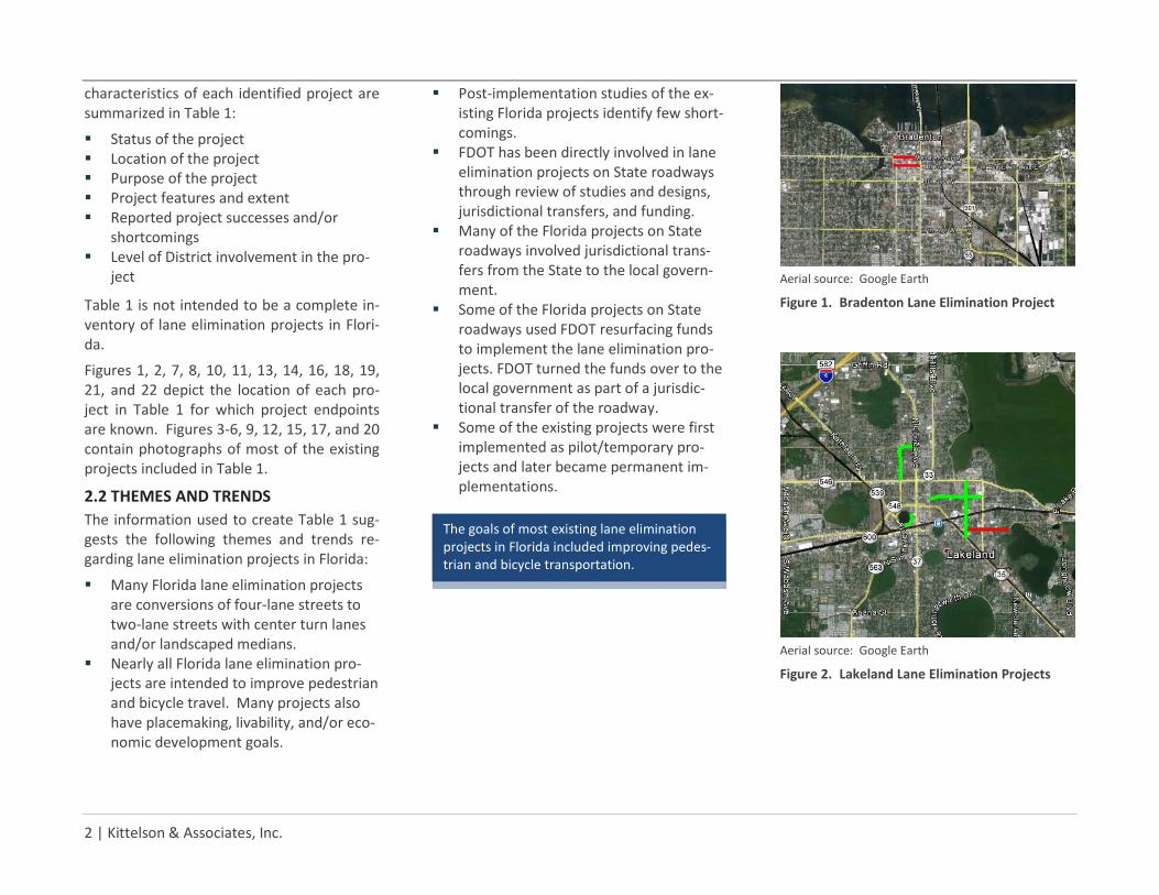
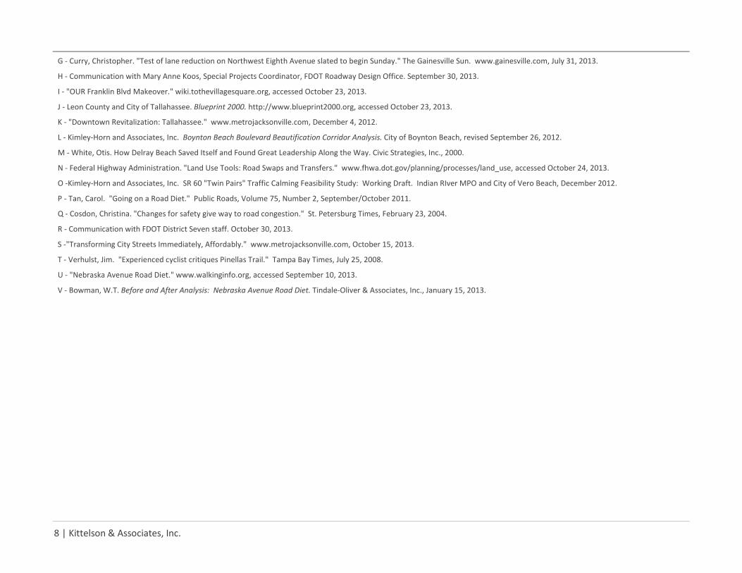
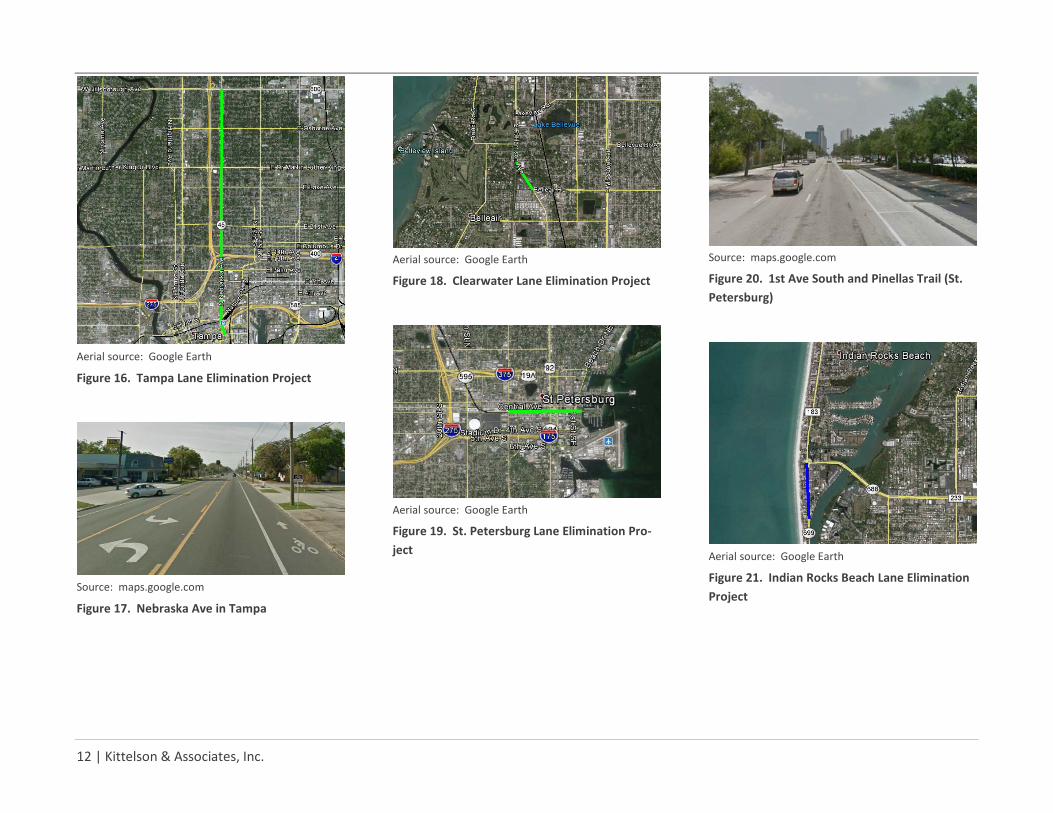
Figures 1, 2, 7, 8, 10, 11, 13, 14, 16, 18, 19, 21, and 22 depict the location of each pro-ject in Table 1 for which project endpoints are known. Figures 3-6, 9, 12, 15, 17, and 20 contain photographs of most of the existing projects included in Table 1.
2.2 THEMES AND TRENDS The information used to create Table 1 sug-gests the following themes and trends re-garding lane elimination projects in Florida:
Many Florida lane elimination projects are conversions of four-lane streets to two-lane streets with center turn lanes and/or landscaped medians.
Nearly all Florida lane elimination pro-jects are intended to improve pedestrian and bicycle travel. Many projects also have placemaking, livability, and/or eco-nomic development goals.
Post-implementation studies of the ex-isting Florida projects identify few short-comings.
FDOT has been directly involved in lane elimination projects on State roadways through review of studies and designs, jurisdictional transfers, and funding.
Many of the Florida projects on State roadways involved jurisdictional trans-fers from the State to the local govern-ment.
Some of the Florida projects on State roadways used FDOT resurfacing funds to implement the lane elimination pro-jects. FDOT turned the funds over to the local government as part of a jurisdic-tional transfer of the roadway.
Some of the existing projects were first implemented as pilot/temporary pro-jects and later became permanent im-plementations.
Aerial source: Google Earth
Figure 1. Bradenton Lane Elimination Project
Aerial source: Google Earth
Figure 2. Lakeland Lane Elimination Projects
The goals of most existing lane elimination projects in Florida included improving pedes-trian and bicycle transportation.
Statewide Lane Elimination Guidance Phase 1: Resource Document
February 2014 | 3
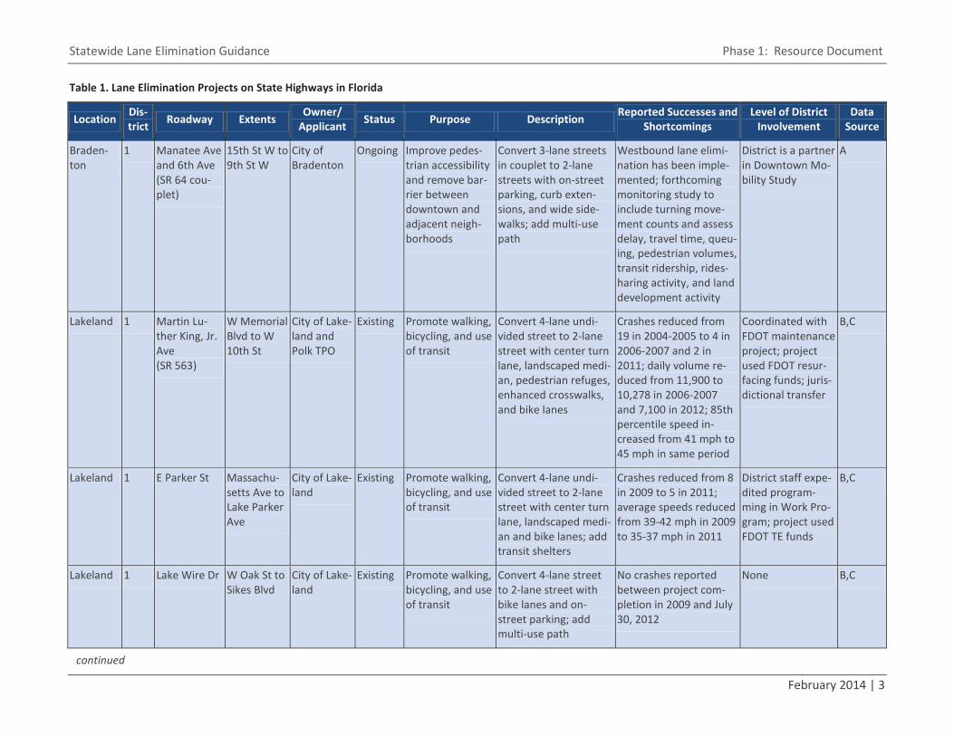
Table 1. Lane Elimination Projects on State Highways in Florida
Location Dis-trict Roadway Extents Owner/
Applicant Status Purpose Description Reported Successes and Shortcomings
Level of District Involvement
Data Source
Braden-ton
1 Manatee Ave and 6th Ave (SR 64 cou-plet)
15th St W to 9th St W
City of Bradenton
Ongoing Improve pedes-trian accessibility and remove bar-rier between downtown and adjacent neigh-borhoods
Convert 3-lane streets in couplet to 2-lane streets with on-street parking, curb exten-sions, and wide side-walks; add multi-use path
Westbound lane elimi-nation has been imple-mented; forthcoming monitoring study to include turning move-ment counts and assess delay, travel time, queu-ing, pedestrian volumes, transit ridership, rides-haring activity, and land development activity
District is a partner in Downtown Mo-bility Study
A
Lakeland 1 Martin Lu-ther King, Jr. Ave (SR 563)
W Memorial Blvd to W 10th St
City of Lake-land and Polk TPO
Existing Promote walking, bicycling, and use of transit
Convert 4-lane undi-vided street to 2-lane street with center turn lane, landscaped medi-an, pedestrian refuges, enhanced crosswalks, and bike lanes
Crashes reduced from 19 in 2004-2005 to 4 in 2006-2007 and 2 in 2011; daily volume re-duced from 11,900 to 10,278 in 2006-2007 and 7,100 in 2012; 85th percentile speed in-creased from 41 mph to 45 mph in same period
Coordinated with FDOT maintenance project; project used FDOT resur-facing funds; juris-dictional transfer
B,C
Lakeland 1 E Parker St Massachu-setts Ave to Lake Parker Ave
City of Lake-land
Existing Promote walking, bicycling, and use of transit
Convert 4-lane undi-vided street to 2-lane street with center turn lane, landscaped medi-an and bike lanes; add transit shelters
Crashes reduced from 8 in 2009 to 5 in 2011; average speeds reduced from 39-42 mph in 2009 to 35-37 mph in 2011
District staff expe-dited program-ming in Work Pro-gram; project used FDOT TE funds
B,C
Lakeland 1 Lake Wire Dr W Oak St to Sikes Blvd
City of Lake-land
Existing Promote walking, bicycling, and use of transit
Convert 4-lane street to 2-lane street with bike lanes and on-street parking; add multi-use path
No crashes reported between project com-pletion in 2009 and July 30, 2012
None B,C
continued
4 | Kittelson & Associates, Inc.
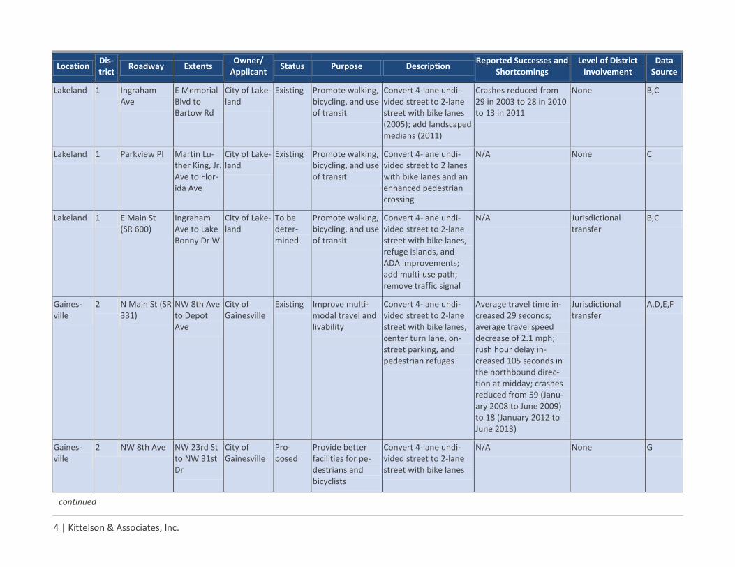
Location Dis-trict Roadway Extents Owner/
Applicant Status Purpose Description Reported Successes and Shortcomings
Level of District Involvement
Data Source
Lakeland 1 Ingraham Ave
E Memorial Blvd to Bartow Rd
City of Lake-land
Existing Promote walking, bicycling, and use of transit
Convert 4-lane undi-vided street to 2-lane street with bike lanes (2005); add landscaped medians (2011)
Crashes reduced from 29 in 2003 to 28 in 2010 to 13 in 2011
None B,C
Lakeland 1 Parkview Pl Martin Lu-ther King, Jr. Ave to Flor-ida Ave
City of Lake-land
Existing Promote walking, bicycling, and use of transit
Convert 4-lane undi-vided street to 2 lanes with bike lanes and an enhanced pedestrian crossing
N/A None C
Lakeland 1 E Main St (SR 600)
Ingraham Ave to Lake Bonny Dr W
City of Lake-land
To be deter-mined
Promote walking, bicycling, and use of transit
Convert 4-lane undi-vided street to 2-lane street with bike lanes, refuge islands, and ADA improvements; add multi-use path; remove traffic signal
N/A Jurisdictional transfer
B,C
Gaines-ville
2 N Main St (SR 331)
NW 8th Ave to Depot Ave
City of Gainesville
Existing Improve multi-modal travel and livability
Convert 4-lane undi-vided street to 2-lane street with bike lanes, center turn lane, on-street parking, and pedestrian refuges
Average travel time in-creased 29 seconds; average travel speed decrease of 2.1 mph; rush hour delay in-creased 105 seconds in the northbound direc-tion at midday; crashes reduced from 59 (Janu-ary 2008 to June 2009) to 18 (January 2012 to June 2013)
Jurisdictional transfer
A,D,E,F
Gaines-ville
2 NW 8th Ave NW 23rd St to NW 31st Dr
City of Gainesville
Pro-posed
Provide better facilities for pe-destrians and bicyclists
Convert 4-lane undi-vided street to 2-lane street with bike lanes
N/A None G
continued
Statewide Lane Elimination Guidance Phase 1: Resource Document
February 2014 | 5
Location Dis-trict Roadway Extents Owner/
Applicant Status Purpose Description Reported Successes and Shortcomings
Level of District Involvement
Data Source
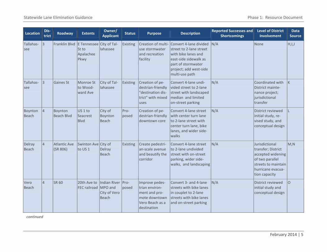
Tallahas-see
3 Franklin Blvd E Tennessee St to Apalachee Pkwy
City of Tal-lahassee
Existing Creation of multi-use stormwater and recreation facility
Convert 4-lane divided street to 2-lane street with bike lanes and east-side sidewalk as part of stormwater project; add west-side multi-use path
N/A None H,I,J
Tallahas-see
3 Gaines St Monroe St to Wood-ward Ave
City of Tal-lahassee
Existing Creation of pe-destrian-friendly "destination dis-trict" with mixed uses
Convert 4-lane undi-vided street to 2-lane street with landscaped median and limited on-street parking
N/A Coordinated with District mainte-nance project; jurisdictional transfer
K
Boynton Beach
4 Boynton Beach Blvd
US 1 to Seacrest Blvd
City of Boynton Beach
Pro-posed
Creation of pe-destrian-friendly downtown core
Convert 4-lane street with center turn lane to 2-lane street with center turn lane, bike lanes, and wider side-walks
N/A District reviewed initial study, re-vised study, and conceptual design
L
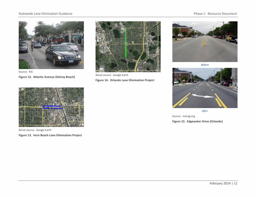
Delray Beach
4 Atlantic Ave (SR 806)
Swinton Ave to US 1
City of Delray Beach
Existing Create pedestri-an-scale avenue and beautify the corridor
Convert 4-lane street to 2-lane undivided street with on-street parking, wider side-walks, and landscaping
N/A Jurisdictional transfer; District accepted widening of two parallel streets to maintain hurricane evacua-tion capacity
M,N
Vero Beach
4 SR 60 20th Ave to FEC railroad
Indian River MPO and City of Vero Beach
Pro-posed
Improve pedes-trian environ-ment and pro-mote downtown Vero Beach as a destination
Convert 3- and 4-lane streets with bike lanes in couplet to 2-lane streets with bike lanes and on-street parking
N/A District reviewed initial study and conceptual design
O
continued
6 | Kittelson & Associates, Inc.
Location Dis-trict Roadway Extents Owner/
Applicant Status Purpose Description Reported Successes and Shortcomings
Level of District Involvement
Data Source
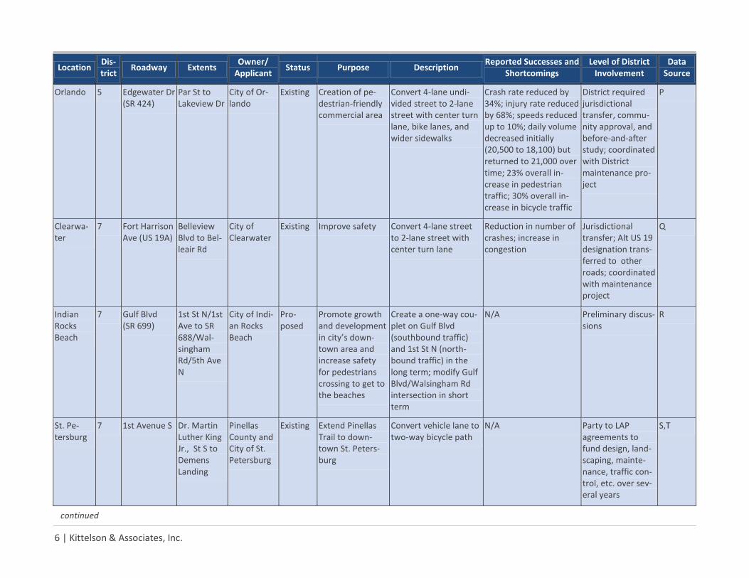
Orlando 5 Edgewater Dr (SR 424)
Par St to Lakeview Dr
City of Or-lando
Existing Creation of pe-destrian-friendly commercial area
Convert 4-lane undi-vided street to 2-lane street with center turn lane, bike lanes, and wider sidewalks
Crash rate reduced by 34%; injury rate reduced by 68%; speeds reduced up to 10%; daily volume decreased initially (20,500 to 18,100) but returned to 21,000 over time; 23% overall in-crease in pedestrian traffic; 30% overall in-crease in bicycle traffic
District required jurisdictional transfer, commu-nity approval, and before-and-after study; coordinated with District maintenance pro-ject
P
Clearwa-ter
7 Fort Harrison Ave (US 19A)
Belleview Blvd to Bel-leair Rd
City of Clearwater
Existing Improve safety Convert 4-lane street to 2-lane street with center turn lane
Reduction in number of crashes; increase in congestion
Jurisdictional transfer; Alt US 19 designation trans-ferred to other roads; coordinated with maintenance project
Q
Indian Rocks Beach
7 Gulf Blvd (SR 699)
1st St N/1st Ave to SR 688/Wal-singham Rd/5th Ave N
City of Indi-an Rocks Beach
Pro-posed
Promote growth and development in city’s down-town area and increase safety for pedestrians crossing to get to the beaches
Create a one-way cou-plet on Gulf Blvd (southbound traffic) and 1st St N (north-bound traffic) in the long term; modify Gulf Blvd/Walsingham Rd intersection in short term
N/A Preliminary discus-sions
R
St. Pe-tersburg
7 1st Avenue S Dr. Martin Luther King Jr., St S to Demens Landing
Pinellas County and City of St. Petersburg
Existing Extend Pinellas Trail to down-town St. Peters-burg
Convert vehicle lane to two-way bicycle path
N/A Party to LAP agreements to fund design, land-scaping, mainte-nance, traffic con-trol, etc. over sev-eral years
S,T
continued
Statewide Lane Elimination Guidance Phase 1: Resource Document
February 2014 | 7
Location Dis-trict Roadway Extents Owner/
Applicant Status Purpose Description Reported Successes and Shortcomings
Level of District Involvement
Data Source
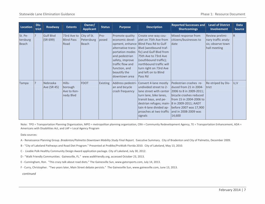
St. Pe-tersburg Beach
7 Gulf Blvd (SR 699)
73rd Ave to Blind Pass Road
City of St. Petersburg Beach
Pro-posed
Promote quality economic devel-opment, enhance alternative trans-portation modes and pedestrian safety, improve traffic flow and function, and beautify the downtown area
Create one-way cou-plet on 75th Ave from Blind Pass Rd to Gulf Blvd (westbound traf-fic) and Gulf Blvd from 75th Ave to 73rd Ave (southbound traffic); northbound traffic will turn right on 73rd Ave and left on to Blind Pass Rd
Mixed response from citizens/businesses to date
Review prelimi-nary traffic analy-sis; observe town hall meeting
R
Tampa 7 Nebraska Ave (SR 45)
Hills-borough Ave to Ken-nedy Blvd
FDOT Existing Address pedestri-an and bicycle crash frequency
Convert 4-lane mostly undivided street to 2-lane street with center turn lane, bike lanes, transit bays, and pe-destrian refuges; main-tain 4-lane divided ap-proaches at two traffic signals
Pedestrian crashes re-duced from 21 in 2004-2006 to 8 in 2009-2011; bicycle crashes reduced from 15 in 2004-2006 to 8 in 2009-2011; AADT before 2007 was 17,900 and in 2008-2009 was 14,600
Re-striped by Dis-trict
U,V
Note: TPO = Transportation Planning Organization, MPO = metropolitan planning organization, CRA = Community Redevelopment Agency, TE = Transportation Enhancement, ADA = Americans with Disabilities Act, and LAP = Local Agency Program
Data sources:
A - Renaissance Planning Group. Bradenton/Palmetto Downtown Mobility Study Final Report. Executive Summary. City of Bradenton and City of Palmetto, December 2009.
B - "City of Lakeland Pathways and Road Diet Program." Presented at ProBike/ProWalk Florida 2010. City of Lakeland, May 13, 2010.
C - Livable Polk Healthy Community Design Award application package. City of Lakeland, July 30, 2012.
D - "Walk Friendly Communities: Gainesville, FL." www.walkfriendly.org, accessed October 23, 2013.
E - Cunningham, Ron. "This crazy talk about road diets." The Gainesville Sun, www.gatorsports.com, July 14, 2013.
F - Curry, Christopher. "Two years later, Main Street debate persists." The Gainesville Sun, www.gainesville.com, June 13, 2013.
continued
8 | Kittelson & Associates, Inc.
G - Curry, Christopher. "Test of lane reduction on Northwest Eighth Avenue slated to begin Sunday." The Gainesville Sun. www.gainesville.com, July 31, 2013.
H - Communication with Mary Anne Koos, Special Projects Coordinator, FDOT Roadway Design Office. September 30, 2013.
I - "OUR Franklin Blvd Makeover." wiki.tothevillagesquare.org, accessed October 23, 2013.
J - Leon County and City of Tallahassee. Blueprint 2000. http://www.blueprint2000.org, accessed October 23, 2013.
K - "Downtown Revitalization: Tallahassee." www.metrojacksonville.com, December 4, 2012.
L - Kimley-Horn and Associates, Inc. Boynton Beach Boulevard Beautification Corridor Analysis. City of Boynton Beach, revised September 26, 2012.
M - White, Otis. How Delray Beach Saved Itself and Found Great Leadership Along the Way. Civic Strategies, Inc., 2000.
N - Federal Highway Administration. "Land Use Tools: Road Swaps and Transfers." www.fhwa.dot.gov/planning/processes/land_use, accessed October 24, 2013.
O -Kimley-Horn and Associates, Inc. SR 60 "Twin Pairs" Traffic Calming Feasibility Study: Working Draft. Indian RIver MPO and City of Vero Beach, December 2012.
P - Tan, Carol. "Going on a Road Diet." Public Roads, Volume 75, Number 2, September/October 2011.
Q - Cosdon, Christina. "Changes for safety give way to road congestion." St. Petersburg Times, February 23, 2004.
R - Communication with FDOT District Seven staff. October 30, 2013.
S -"Transforming City Streets Immediately, Affordably." www.metrojacksonville.com, October 15, 2013.
T - Verhulst, Jim. "Experienced cyclist critiques Pinellas Trail." Tampa Bay Times, July 25, 2008.
U - "Nebraska Avenue Road Diet." www.walkinginfo.org, accessed September 10, 2013.
V - Bowman, W.T. Before and After Analysis: Nebraska Avenue Road Diet. Tindale-Oliver & Associates, Inc., January 15, 2013.
Statewide Lane Elimination Guidance Phase 1: Resource Document
February 2014 | 9
2003
2006
Source: City of Lakeland
Figure 3. Martin Luther King, Jr. Ave (Lakeland)
Before
After
Source: maps.google.com
Figure 4. Ingraham Ave (Lakeland)
Source: maps.google.com
Figure 5. Lake Wire Dr (Lakeland)
Source: maps.google.com
Figure 6. E Parker St (Lakeland)

10 | Kittelson & Associates, Inc.
Aerial source: Google Earth
Figure 7. Gainesville Lane Elimination Projects
Aerial source: Google Earth
Figure 8. Tallahassee Lane Elimination Projects
Before
After
Source: maps.google.com
Figure 9. Franklin Blvd (Tallahassee)
Aerial source: Google Earth
Figure 10. Boynton Beach Lane Elimination Pro-ject
Aerial source: Google Earth
Figure 11. Delray Beach Lane Elimination Pro-ject
Statewide Lane Elimination Guidance Phase 1: Resource Document
February 2014 | 11
Source: KAI
Figure 12. Atlantic Avenue (Delray Beach)
Aerial source: Google Earth
Figure 13. Vero Beach Lane Elimination Project
Aerial source: Google Earth
Figure 14. Orlando Lane Elimination Project
Before
After
Source: nctcog.org
Figure 15. Edgewater Drive (Orlando)
12 | Kittelson & Associates, Inc.
Aerial source: Google Earth
Figure 16. Tampa Lane Elimination Project
Source: maps.google.com
Figure 17. Nebraska Ave in Tampa
Aerial source: Google Earth
Figure 18. Clearwater Lane Elimination Project
Aerial source: Google Earth
Figure 19. St. Petersburg Lane Elimination Pro-ject
Source: maps.google.com
Figure 20. 1st Ave South and Pinellas Trail (St. Petersburg)
Aerial source: Google Earth
Figure 21. Indian Rocks Beach Lane Elimination Project

Statewide Lane Elimination Guidance Phase 1: Resource Document
February 2014 | 13
Aerial source: Google Earth
Figure 22. St. Petersburg Beach Lane Elimina-tion Project
3.0 IMPACTS OF LANE ELIMINATION PROJECTS This section summarizes studies of lane elim-ination project impacts and provides brief critiques of the studies where warranted.
3.1 SAFETY AND OPERATIONAL ANALYSIS OF 4-LANE TO 3-LANE CONVERSIONS (MICHIGAN DOT)
Reference Lyles, R.W., M.A. Siddiqui, W.C. Taylor, B.Z. Malik, G. Siviy, and T. Haan. Safety and Op-erational Analysis of 4-lane to 3-lane Conver-sions (Road Diets) in Michigan: Final Report. Michigan DOT Report RC-1555. Department of Civil and Environmental Engineering, Michigan State University, East Lansing, MI, January 2012.
Synopsis This study was commissioned by the Michi-gan DOT to quantify the safety and delay impacts of reducing a cross section from four lanes to three lanes and develop guidelines for identifying candidate sites for road diets. The study looked at 24 existing road diet sites in different environments throughout Michigan, some of which were visited by the authors to qualitatively assess pedestrian and bicyclist operations. Key findings of the authors are the following:
Based on Synchro analyses of nine sig-nalized intersections, four-to-three con-versions tend to create "significant [in-tersection approach] delay" when aver-age daily traffic (ADT) is greater than 10,000 and peak hour volumes are greater than 1,000. The authors con-clude that the 20,000 ADT threshold that has been used by others is too high.
The authors calculated an average crash modification factor (CMF) of 0.91 for four-to-three conversions but deter-mined that it is not statistically different from 1.0. The authors conclude that simply comparing before and after crash statistics may overestimate the benefits of a four-to-three conversion.
The authors did not find changes in crash severity resulting from four-to-three conversions to be significant.
Qualitative assessment led to the con-clusion that "well-functioning" road diets from the perspective of pedestrians and
bicyclists require supportive land uses, successful traffic calming, and clearly marked pedestrian and bicycle infra-structure.
Findings varied considerably across the 24 study sites. The authors recommend conducting detailed corridor operational analyses (after initial screening) to sup-port proposed road diets.
Comments This study is not a before-and-after study but an operational modeling study. The de-lay assessment determines the threshold at which signalized intersection approaches along the three-lane segment do not meet a Level of Service (LOS) D standard. It does not appear that the authors accounted for potential diversion of traffic to other corri-dors after the four-to-three conversion in their delay assessment or in forming their recommendation for a 10,000 ADT thresh-old. The study does not appear to have in-cluded any travel demand modeling.
The authors disregarded crashes that oc-curred on side streets. Crash frequency on side streets is arguably sensitive to the rout-ing and magnitude of diverted traffic vol-umes as well as changes made to signal tim-ing as a result of a lane elimination project. Disregarding side-street crashes may not be appropriate.
The appendices of the study were not avail-able for review. The authors' crash data are not broken out by crash type in the body of
14 | Kittelson & Associates, Inc.
the report but may be more detailed in an appendix.
3.2 US 1 CORRIDOR MODIFICATION EVALUATION (FDOT)
Reference Kimley-Horn and Associates, Inc. US 1 Corri-dor Modification Evaluation. Executive Summary. FDOT, Delray Beach, FL, May 2009.
Synopsis This study was commissioned by FDOT to evaluate potential changes to lane configu-ration (i.e., a reduction from three through lanes to two through lanes) along one-way couplet segments of US 1 in Delray Beach, Florida. The study looked at speed, volume, and crash data collected in the peak season prior to implementation of the corridor modification (April 2007) and in the peak season after implementation of the lane re-duction (February 2009). Key findings of the authors are the following:
Evaluation of the link LOS for the study corridor after the implementation of the lane reduction revealed that overall time-of-day patterns did not significantly change and the corridor continued to operate at an acceptable LOS. Traffic volumes were noted to be lower in 2009 than 2007 but this was not attributed to the lane reduction .
Based on SYNCHRO analysis of the study area intersections during the a.m. and p.m. peak hours, the most significant in-
crease in delay for an intersection was 5.3 seconds and for a US 1 approach was 5.7 seconds. Some intersections and ap-proaches saw a decrease in delay in the 2009 scenario due to the decrease in volumes. Signal timings were not modi-fied between 2007 and 2009; therefore, the changes in delay are most likely at-tributable to the decrease in volumes (which, as noted above, was not the re-sult of the lane reduction).
Speeds along the corridor were ob-served to be on average 6 miles per hour (mph) slower after the corridor modifi-cation. Prior to the corridor modifica-tion, the observed operating speeds were 5 to 10 mph over the posted speed limit; however, with the lane reduction, the 85th percentile speed was observed to be generally equivalent to the posted speed limit of 35 mph. The lane reduc-tion resulted in lower operating speeds throughout the corridor.
Crashes decreased along the corridor after the lane reduction. There was a re-duction in rear-end collisions, the most common crash type in the study area, and the intersections that experienced the highest number of crashes before the lane reduction had a dramatic 75% reduction in the number of crashes.
Comments The above summary is based on an execu-tive summary of the full report and, thus, appendices were not available for review.
3.3 GOING ON A ROAD DIET (FHWA)
Reference Tan, C.H. Going on a Road Diet. FHWA-HRT-11-006. FHWA, Washington, D.C., Septem-ber-October 2011.
Synopsis This report discussed what road diets are, their benefits, the public's view of road di-ets, other considerations, and example road diet projects including Edgewater Drive in Orlando, FL, and Stone Way North in Seattle, WA. Key findings are listed by topic or pro-ject as follows.
Edgewater Drive – Orlando, FL The FHWA report documents a before-and-after analysis for a 1.5-mile section of Edge-water Drive that was reduced from 4 lanes to 3 lanes, one lane in each direction plus a center turn lane. The study used an average of three years of “before” data and four months of “after” data (annualized to one year). Crash rates, vehicle speeds, and traffic volumes were examined. Findings of the evaluation include the following:
The road diet reduced crash rates by 34 percent and injury rates by 68 percent, where crash rate and injury rate are de-fined as crashes or injuries per million vehicle miles driven on the study seg-ment. Before the road diet, the study section experienced a crash every 2.5 days (146 crashes per year). After the road diet was implemented, the study
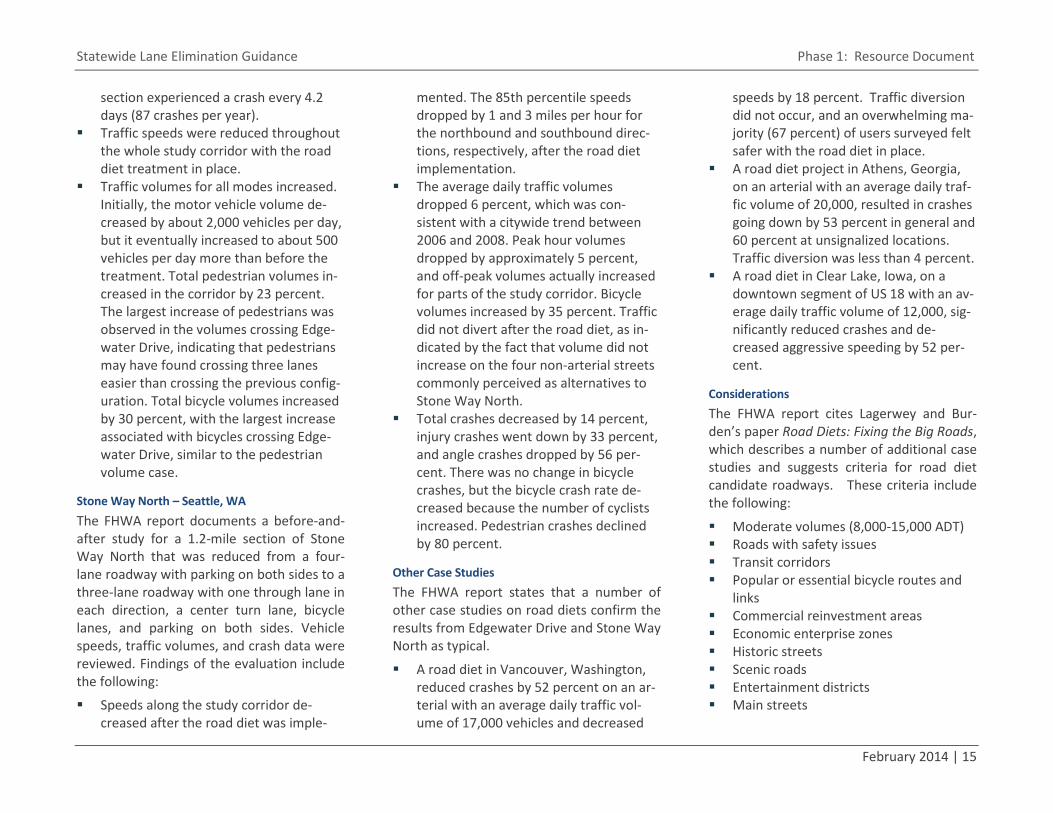
Statewide Lane Elimination Guidance Phase 1: Resource Document
February 2014 | 15
section experienced a crash every 4.2 days (87 crashes per year).
Traffic speeds were reduced throughout the whole study corridor with the road diet treatment in place.
Traffic volumes for all modes increased. Initially, the motor vehicle volume de-creased by about 2,000 vehicles per day, but it eventually increased to about 500 vehicles per day more than before the treatment. Total pedestrian volumes in-creased in the corridor by 23 percent. The largest increase of pedestrians was observed in the volumes crossing Edge-water Drive, indicating that pedestrians may have found crossing three lanes easier than crossing the previous config-uration. Total bicycle volumes increased by 30 percent, with the largest increase associated with bicycles crossing Edge-water Drive, similar to the pedestrian volume case.
Stone Way North – Seattle, WA The FHWA report documents a before-and-after study for a 1.2-mile section of Stone Way North that was reduced from a four-lane roadway with parking on both sides to a three-lane roadway with one through lane in each direction, a center turn lane, bicycle lanes, and parking on both sides. Vehicle speeds, traffic volumes, and crash data were reviewed. Findings of the evaluation include the following:
Speeds along the study corridor de-creased after the road diet was imple-
mented. The 85th percentile speeds dropped by 1 and 3 miles per hour for the northbound and southbound direc-tions, respectively, after the road diet implementation.
The average daily traffic volumes dropped 6 percent, which was con-sistent with a citywide trend between 2006 and 2008. Peak hour volumes dropped by approximately 5 percent, and off-peak volumes actually increased for parts of the study corridor. Bicycle volumes increased by 35 percent. Traffic did not divert after the road diet, as in-dicated by the fact that volume did not increase on the four non-arterial streets commonly perceived as alternatives to Stone Way North.
Total crashes decreased by 14 percent, injury crashes went down by 33 percent, and angle crashes dropped by 56 per-cent. There was no change in bicycle crashes, but the bicycle crash rate de-creased because the number of cyclists increased. Pedestrian crashes declined by 80 percent.
Other Case Studies The FHWA report states that a number of other case studies on road diets confirm the results from Edgewater Drive and Stone Way North as typical.
A road diet in Vancouver, Washington, reduced crashes by 52 percent on an ar-terial with an average daily traffic vol-ume of 17,000 vehicles and decreased
speeds by 18 percent. Traffic diversion did not occur, and an overwhelming ma-jority (67 percent) of users surveyed felt safer with the road diet in place.
A road diet project in Athens, Georgia, on an arterial with an average daily traf-fic volume of 20,000, resulted in crashes going down by 53 percent in general and 60 percent at unsignalized locations. Traffic diversion was less than 4 percent.
A road diet in Clear Lake, Iowa, on a downtown segment of US 18 with an av-erage daily traffic volume of 12,000, sig-nificantly reduced crashes and de-creased aggressive speeding by 52 per-cent.
Considerations The FHWA report cites Lagerwey and Bur-den’s paper Road Diets: Fixing the Big Roads, which describes a number of additional case studies and suggests criteria for road diet candidate roadways. These criteria include the following:
Moderate volumes (8,000-15,000 ADT) Roads with safety issues Transit corridors Popular or essential bicycle routes and
links Commercial reinvestment areas Economic enterprise zones Historic streets Scenic roads Entertainment districts Main streets
16 | Kittelson & Associates, Inc.
Lagerwey offered a rule of thumb: If the prospective road is in an urbanized situation with a number of left turns, short blocks, and a signal at every corner, then a road diet could be appropriate in some situations with a daily traffic volume as high as 25,000. On the other hand, if a road has virtually no left turns and few signals, a road diet might be inappropriate if the average daily traffic is over 18,000.
3.4 4-LANE TO 3-LANE CONVERSIONS (IOWA DOT)
Reference Welch, Tom. "4-Lane to 3-Lane Conver-sions." Powerpoint. Office of Traffic and Safety, Highway Division, Iowa Department of Transportation, Ames, Iowa, 2005.
Synopsis The Iowa DOT conducted a study of eight four-lane to three-lane conversion projects and highlighted the US 75 Sioux Center pro-ject specifically. Key findings are listed by topic or project as follows.
US 75 Sioux Center A before-and-after study of a four-lane roadway with on-street parking was reduced to a three-lane roadway with bike lanes and a center two-way left-turn lane. Findings of this study include the following:
The corridor saw an average travel speed decrease of 7 mph (25%).
The corridor saw an average free flow speed decrease of 3 mph (10%).
The corridor saw total crashes decrease 57% and personal injury crashes de-crease 100%.
Other Iowa Cases Eight other four-lane to three-lane lane re-duction studies were evaluated. Related findings include the following:
Annual average crashes went down for all studies in a range of 27-67%.
Crash rates went down for all studies in a range of 39-68%.
Comments The information was presented in a Power-Point presentation, so appendices and addi-tional information are not available.
3.5 MICHIGAN’S OPERATIONS MANUAL: 4-TO-3 LANE CONVERSIONS (MICHIGAN DOT)
Reference "4-to-3 Lane Conversions." Michigan's Oper-ations Manual. Policy Guide. Michigan DOT, Lansing, MI, November 13, 2009.
Synopsis This document is a policy guide for four-lane to three-lane conversions to be used to pro-vide policy and guidance for projects of this type in Michigan. The policy focuses on pro-ject design life, safety and capacity, pedes-trian and bicyclist accommodation, and community support. Key points of infor-mation in the document are the following:
FHWA generally requires improvement projects using Federal-Aid funds to be
designed to accommodate the traffic demands that will be experienced throughout the design life of the im-provement. Design life can vary with each application of a four-to-three lane conversion. If signing and markings are the major items of work, a project de-sign life of 3-5 years would justify the costs. If the safety benefits are great enough for the project to be considered a safety project, project design life is as calculated according to MDOT time-of-return safety analysis procedures. If the project requires significant pavement construction or reconstruction, project design life will have to increase as the project costs increase and may range from 10 to 20 years.
Four-to-three lane conversions across the country have been successfully im-plemented on corridors with an ADT of 15,000 or less, where "success" means improvements in safety (e.g., crash rate reductions of 10-50%) and little adverse impact to traffic flow. In Michigan, a study of lane conversions reported an average 26% reduction in injury crashes, an average 37% injury crash reduction for older drivers, and an average 37% pedestrian crash reduction.
Michigan DOT and Iowa DOT set guid-ance limits of about 15,000 to 17,500 ADT as being realistic volumes for four-to-three lane conversions. Depending on conditions, a three-lane cross section
Statewide Lane Elimination Guidance Phase 1: Resource Document
February 2014 | 17
can be investigated at higher levels of ADT.
Four-to-three lane conversions create space for bicycle lanes. The document states that bicycle lanes improve the vis-ibility of bicyclists to motorists and re-duce turning conflicts between bicyclists and motorists.
Business owners worry about loss of cus-tomer access following a lane conver-sion, while motorists worry about a re-duction in capacity and an increase in congestion. As a result, the community may be reluctant to support a four-to-three lane conversion. Trial periods of 1-3 years can be used to build community support, if a promise is made to revert back to four lanes if the community does not want to keep the three-lane lane section after the trial period ends. This can be a particularly good approach if the conversion only involves signing and marking.
Comments The document states that three-lane sec-tions are safer than four-lane sections at in-tersections and driveways because it is easi-er for drivers to find gaps in traffic flow. While this is reasonable as a general state-ment, it is desirable to have supporting data.
The document states that three-lane sec-tions are better equipped than four-lane sections to handle left-turning traffic with-out causing a large reduction in capacity and safety. This statement assumes that no ex-
clusive left turn lanes are provided through-out the four-lane section (i.e., the section is a four-lane undivided section). While this is reasonable as a general statement, it would be desirable to have supporting data, as well as data for four-lane sections with exclusive left turn lanes (i.e., for four-lane divided sec-tions). Data relating the percentage of left turns in the traffic stream to the capacity of the section would be particularly informa-tive.
3.6 TRAFFIC PRACTICES: A GUIDEBOOK FOR CITY & COUNTY AGENCIES (MISSOURI COALITION FOR ROADWAY SAFETY)
Reference Missouri DOT, Missouri LTAP, and Missouri Coalition for Roadway Safety. Traffic Practic-es: A Guidebook for City & County Agencies. Missouri Coalition for Roadway Safety, pub-lished after 2009.
Synopsis The Missouri Coalition for Roadway Safety (MCRS) is a partnership that includes Mis-souri DOT. MCRS created a guidebook to provide local transportation agencies with a reference guide for finding information re-lated to traffic control devices. Within this guidebook, there is a section on road diets. Key information provided in the guidebook includes the following:
Road diets provide multiple safety and operational benefits for all modes of transportation, including:
▫ Reducing crossing distances for pe-destrians
▫ Providing space for pedestrian ref-uges
▫ Improving bicyclist safety when bicy-cle lanes are added
▫ Providing space for on-street parking ▫ Reducing rear-end and side-swipe
crashes ▫ Improving speed limit compliance
(i.e., reducing vehicle speeds) ▫ Decreasing the number of crashes
and crash severity (e.g., a 29% re-duction in number of crashes for converting a four-lane roadway to three-lane roadway)
Roadways with an ADT of 20,000 or less may be good candidates for road diets. Roads with an ADT of 15,000 or less have been shown to positively affect safety, operations, and livability.
Factors to be considered in evaluating potential road diets include driveway density, transit routes, number of inter-sections in the corridor, design of inter-sections in the corridor, and operational characteristics of the corridor.
Road diets may impact intersection turn lanes, signing, pavement markings, traf-fic control devices, transit stops, pedes-trian facilities, and bicycle facilities.
The four-lane to three-lane road diet is compatible with single-lane rounda-bouts.

18 | Kittelson & Associates, Inc.
Community input should be obtained when proposing a road diet.
Comments The road diet material in this guidebook is a small section of a larger report but it sup-plies a list of key resources used to develop the material.
The statement in the guidebook about the compatibility of four-lane to three-lane road diets with single-lane roundabouts would benefit from more discussion.
3.7 "MOVING BEYOND THE AUTOMOBILE: ROAD DIET" TRANSCRIPT (STREETFILMS)
Reference C. Dickerson, Jr. "Moving Beyond the Auto-mobile: Road Diet." Transcript. Streetfilms, April 12, 2011.
Synopsis This article is a transcript of the video “Road Diets” from the Streetfilms video series “Moving Beyond the Automobile” (MBA). Dan Burden, Mike Sallaberry, and Charles Gandy discuss the benefits of a road diet. Key benefits they describe are:
Efficient reallocation of space – In a road diet, space is reallocated so the street functions more efficiently. Space can be reallocated to bicycle/pedestrian infra-structure and/or parking. The reallocat-ed space benefits those who live, work, and shop in the corridor instead of the drivers who just drive through the area.
Positive impact on property values and sales – Generally, property values go up after a road diet, and businesses typical-ly do better after a road diet. After a road diet, motorists drive more prudent-ly, people can shop for parking spaces, and the retail life of the street improves.
Increased livability – A road diet can re-sult in a quieter street and a street with more social interactions.
Cost-effectiveness – A road diet is one of the most cost-effective ways to improve a roadway. One of the participants in the video states that a roadway can be con-verted for about $50,000 per mile.
Multimodal accommodation ▫ Pedestrians – Road diets reduce
speeding, make vehicle movements more predictable, and shorten cross-ing distances.
▫ Bicyclists – Many road diets shift space from car lanes to create bike lanes.
▫ Drivers – Road diets reduce speed-ing, which improves safety. Road diets can provide left-turn pockets, which allows through traffic to pro-ceed without shifting lanes or wait-ing behind turning vehicles.
One of the participants in the video notes that a road diet on Valencia Street in San Francisco in the 1990s resulted in a 140% increase in bicyclist volume. The road diet converted a four-lane street into a three-lane street with bicycle lanes.
Comments Although the speakers are recognized as having a large base of knowledge on this topic, no references were cited.
3.8 REVITALIZING THE URBAN CORE: ROAD DIETS (METRO JACKSONVILLE)
Reference Davis, Ennis. "Revitalizing the Urban Core: Road Diets." Metro Jacksonville. August 2, 2010.
Synopsis This article discusses what a road diet is, its popularity, and example road diet projects. Key points of the article are as follows:
Road diets are typically successful where the road carries less than 19,000 vehi-cles per day. They can be successful at up to 23,000 vehicles per day but more extensive changes to the roadway might be required (e.g., traffic calming treat-ments on parallel roads)
Popularity is gaining. San Francisco leads the country in number of road diets, with 30 as of 2010, and Hartford, CT, has the greatest number of road diets per capita, with 12 road diets (as of 2010).
Retail merchants in Seattle are reported to be strong proponents of road diets. This is because reduced vehicle speeds allow for easier and safer parking, im-proved store access, and increased qual-ity of overall walking conditions and liv-ability—conditions that support im-proved economic activity.
Statewide Lane Elimination Guidance Phase 1: Resource Document
February 2014 | 19
3.9 ROAD DIETS: FIXING THE BIG ROADS (WALKABLE COMMUNITIES, INC.)
Reference D. Burden and P. Lagerway. Road Diets: Fix-ing the Big Roads. Walkable Communities, Inc., March 1999.
Synopsis The authors explore the history and benefits of road diets. They also discuss processes for implementation, considerations, and typical roadways selected. Key points of the paper are the following:
Best Model Project – To build communi-ty support, the first projects in an area should include roadways with some of the following characteristics: ▫ Moderate volumes (ADT of 8,000-
15,000) ▫ Roads with safety concerns ▫ Transit corridors ▫ Popular or essential bicycle routes
and links ▫ Commercial reinvestment areas ▫ Economic enterprise zones ▫ Historic streets ▫ Scenic roads ▫ Entertainment districts ▫ Main streets
Communities proposing a road diet have conducted a three- to six-day charrettes to gain input and support from a variety of people. Involving the public is essen-
tial because road diets can be controver-sial.
The "ideal" roadway for a road diet is a four-lane road carrying 12,000-18,000 auto trips per day. Road diets may also be feasible where the roadway carries 19,000-25,000 cars per day.
The City of Santa Monica is reportedly "most comfortable" with road diets where auto trips do not exceed 20,000 per day.
Road diets can create more space be-tween automobiles and fixed objects on the roadside.
The paper contains summaries of several road diet before-and-after studies.
Comments The paper states, "Often [road diets] set the stage for millions or megamillions of dollars in new commercial and residential develop-ment. The change can increase the value of existing properties." No supporting data for these statements are provided. Supporting data are not provided for several of the stud-ies described in the paper.
The paper states, "Four-lane roadways sig-nificantly discourage mobility and access of transit users (cannot cross these streets), pedestrians, and bicyclists." This statement seems to be an exaggeration, as there are many examples of four-lane roadways that support non-auto uses. It is not uncommon, for example, to find four-lane roads with signalized crossings and/or pedestrian ref-
uge islands. A more informative statement might have focused on fundamental factors (e.g., auto speeds and volumes) and reiter-ated that site-specific assessment is essen-tial.
The paper describes the ADT of 30,000 car-ried by Lake Washington Boulevard in Kirk-land, WA, as an ADT that "may be beyond the comfort range of many." The paper states that an ADT of 20,000-23,000 is more likely to be acceptable to the community.
3.10 COAST HIGHWAY LANE REDUCTION TO GO FORWARD (SAN DIEGO UNION TRIBUNE)
Reference B. Henry. "Coast Highway Lane Reduction to Go Forward." The San Diego Union-Tribune, February 1, 2013.
Synopsis This article is about the plan to eliminate one northbound lane of Coast Highway 101 in Encinitas, CA, which was approved by the City despite concerns expressed by the state Coastal Commission. A public hearing was held, with much voiced support from bicy-clists encouraging the project, which is antic-ipated to create a safer environment for bi-cyclists.
The Coastal Commission's concern related to the need for the City of obtain a coastal de-velopment permit because the lane reduc-tion project "changes the intensity of use of the road." A City civil engineer countered

20 | Kittelson & Associates, Inc.
that (1) state officials typically exempt cities from coastal permit requirements for small-scale projects like repaving and (2) this lane reduction project does not change the amount of traffic on the road or add lanes to the road. The City intends to move forward with the project.
Comments This article provides an example of how mul-tiple agencies and local governments may get involved in a lane elimination project.
3.11 COSTS OF COMPLETE STREETS (NATIONAL COMPLETE STREETS COALITION)
Reference "Costs of Complete Streets: What We Are Learning from State and Local Govern-ments." National Complete Streets Coalition, Washington, D.C., 2011.
Synopsis Taken from the National Complete Streets Coalition website, the fact sheet entitled “Costs of Complete Streets” discusses the cost-effectiveness of converting streets into Complete Streets. This is relevant to lane elimination projects because reallocating street space to non-auto modes is a com-mon goal of lane elimination projects. Key findings from the fact sheet that pertain to lane elimination projects are:
Complete Streets can be achieved within existing budgets. ▫ Projects can be achieved within ex-
isting transportation budgets and
can sometimes save money that might otherwise have been expend-ed on widening projects.
▫ Complete Street policies do not nec-essarily trigger any additional spend-ing but they do require more careful planning of existing transportation projects. Safety improvements can be incorporated into existing pro-jects instead of seeking separate funding sources.
▫ Many projects are modest in size and low cost.
Citizens support Complete Streets. Complete Streets are safer streets.
▫ Complete Street policies are a cost-effective way to address pedestrian safety hazards.
▫ Examples
• Orlando, FL: A four-to-three lane elimination project on Edge-water Drive reduced the fre-quency of injury crashes from one every nine days to one eve-ry 30 days, and the number of people walking and bicycling rose 23% and 30%, respectively.
• Vancouver, WA: A four-to-three lane elimination project on Fourth Plain Boulevard reduced vehicle crashes by 52%, and the number of pedestrian crashes dropped from two per year to zero.
• Lee County, FL: County staff de-cided that five roads shown to be four-laned in the Long-Range Transportation Plan (LRTP) should instead be improved as two-lane roads with medians and turn lanes. The total cost for all five projects was reduced by $58.5 million.
• Colorado Springs, CO: The City has created miles of bikeways through lane elimination pro-jects. Speeding has been re-duced by the projects, and community satisfaction has in-creased.
3.12 PROVEN SAFETY COUNTERMEASURES: ROAD DIET (FHWA)
Reference “Proven Safety Countermeasures: Road Diet (Roadway Reconfiguration)." FHWA, Wash-ington, D.C., 2012.
Synopsis This fact sheet discusses the benefits of a road diet and provides background infor-mation and guidance on when to implement a road diet. Key facts in the document are:
Four-to-three lane elimination projects have resulted in a 29% reduction in all roadway crashes. Reductions in rear-end and side-swipe crashes are most com-mon.
Statewide Lane Elimination Guidance Phase 1: Resource Document
February 2014 | 21
Reduced crossing distances benefit pe-destrians.
Reallocated space can provide room for pedestrian crossing islands as well as bike lanes ( which increase safety for bi-cyclists) and on-street parking. The latter two options create buffer space be-tween pedestrians and vehicles, increas-ing the safety and quality of travel of pedestrians.
If there is only one through lane in each direction, multiple-threat crashes (i.e., when the driver in one lane stops for a pedestrian but the driver in the adjacent lane does not) are reduced.
Reduced vehicle speeds are associated with improved speed limit compliance and decreased crash severity.
Roadways with ADTs of 20,000 or less may be good candidates for a road diet. Roads with ADTs of 15,000 or less have been reported to have very good results in the areas of safety, operations, and livability. Other considerations are driveway density, transit routes, and the number and design of intersections along the corridor.
Comments The article has many key resources cited at the end.
3.13 ROAD DIETS – WHITE PAPER (CITY OF ASHLAND, OR)
Reference
Kittelson & Associates, Inc., “Road Diets – White Paper.” Portland, OR, January 11, 2011.
Synopsis This white paper is one in a set of five devel-oped for the City of Ashland’s Transportation System Plan update to present information on tools, opportunities, and potential strate-gies to help develop a green transportation community. It presents general information on road diets including example projects and their effects. A table in the report summa-rizes before-and-after data for three road diet projects. An additional project is pre-sented in more detail as a case study.
According to the white paper, road diets provide the following benefits:
Improved traffic flow – The reduced number of vehicle travel lanes in the same direction reduces lane changes and weaving, which improves vehicle flow along the corridor.
Vehicle speeds reduced closer to desired operating speed – The narrowed road-way and features such as on-street park-ing and bike lanes create a “tunnel ef-fect” that naturally slows motorists.
Reduced conflicts and reduced number of crashes – The reduced number of au-tomobile travel lanes reduces the num-
ber of conflict points along the roadway segment. The number of crashes de-crease due to the reduced number of conflict points, the slower operating speeds, and the increase in motorists’ attentiveness resulting from higher lev-els of street activity. National research indicates that converting a four-lane un-divided road to a three-lane road with two through lanes and a center turn lane reduces crashes by approximately 29%.
A more attractive environment for pe-destrians and bicyclists – Reallocating existing right-of-way to designate space exclusively for pedestrian and/or bicycle travel provides a more inviting and com-fortable setting for pedestrians and bicy-clists. Reduced vehicle speeds and the streetscape improvements that often accompany road diets also improve the quality of travel for pedestrian and bicy-clists.
The white paper identifies the following sit-uations where extra care needs to be taken to make a road diet successful:
Relatively high access density – Accesses and driveways should be consolidated to help reduce conflict points in the corri-dor.
Offset minor streets at intersections – Offset minor street approaches at inter-sections should be realigned and/or con-sideration should be given to restricting access to/from those minor streets to right-in/right-out only.
22 | Kittelson & Associates, Inc.
Heavy existing traffic congestion – Ef-forts should be made to mitigate existing traffic congestion along a corridor with intersections currently operating at or near capacity before attempting to im-plement a road diet on the corridor.
3.14 NICKERSON STREET RECHANNELIZATION BEFORE-AND-AFTER REPORT (SEATTLE DOT)
Reference "Nickerson Street Rechannelization: Before and After Report." City of Seattle, WA, March 1, 2012.
Synopsis This study by the Seattle DOT describes the effects of reconfiguring the travel lanes on Nickerson Street from 13th Avenue West to Florentia Street. The goal of the project was to improve pedestrian safety by reducing pedestrians' exposure to traffic and reducing vehicle speeds. Prior to rechannelization, there were two travel lanes in each direc-tion. The street was reconfigured to one lane in each direction with a two-way left turn lane in the center and bicycle lanes in each direction. Two new marked crosswalks were installed. Key findings of the study were as follows:
Speed – The percent of drivers traveling over the speed limit was reduced by more than 60% in both directions. The percent of "top-end" speeders (those traveling more than 10 mph over the posted speed) was reduced by more
than 90% in each direction. The 85th percentile speed was reduced by 18% in the westbound direction and 24% in the eastbound direction.
Safety – The rechannelization and instal-lation of marked crosswalks reduced col-lisions by 23% one year after project completion.
Volume – Daily and p.m. peak traffic volumes changed very little with the im-plementation of the project. A.M. peak volumes decreased 10% after the im-plementation of the project.
Diverted traffic – The project does not appear to have diverted traffic to other corridors. In fact, according to the study, traffic volumes on potential diver-sion routes decreased after implementa-tion of the Nickerson Street project.
Freight use – The number of freight ve-hicles on Nickerson street rose "slightly" after project implementation; freight vehicles are approximately 5% of the ve-hicles using the corridor. Large trucks (such as semi-trailers) make up approx-imately 2% of total traffic, and such trucks continue to use the corridor as a through route and as a means of access-ing the surrounding neighborhood.
4.0 LANE ELIMINATION ISSUES This section contains profiles of issues that may be associated with lane elimination pro-jects. This section could serve as the foun-dation for a lane elimination review check-list. Three cautions should be kept in mind when considering these issues:
There are trade-offs in addressing all of these issues.
Some issues are interrelated. Successfully addressing some of these
issues will require a lot of lead time, so early coordination with the applicant and relevant stakeholders is critical.
4.1 SAFETY IMPACTS
Profile Generally, lane elimination results in a net improvement to safety. However, as with many aspects of lane elimination, the safety impacts of these actions can be both positive and negative. In part, the negative impacts can be mitigated through design and opera-tional decisions; however, they are also like-ly to be impacted by changes in adjoining land use and peoples’ travel decisions, in-cluding modal choice.
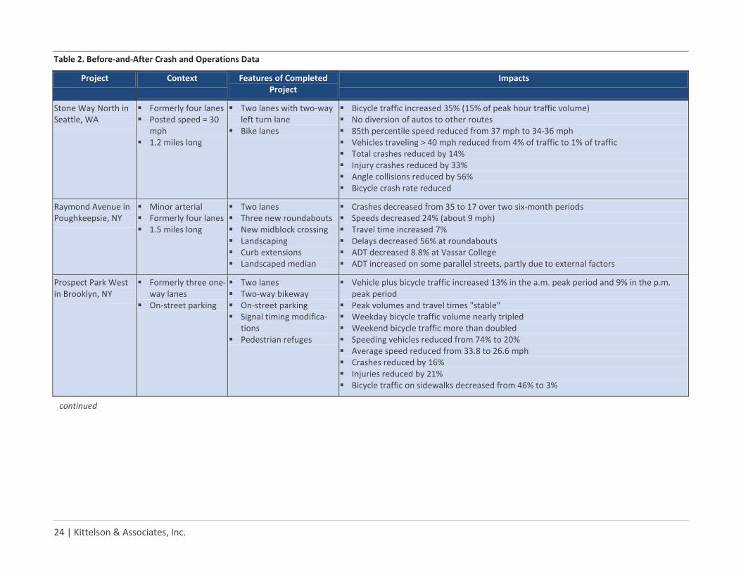
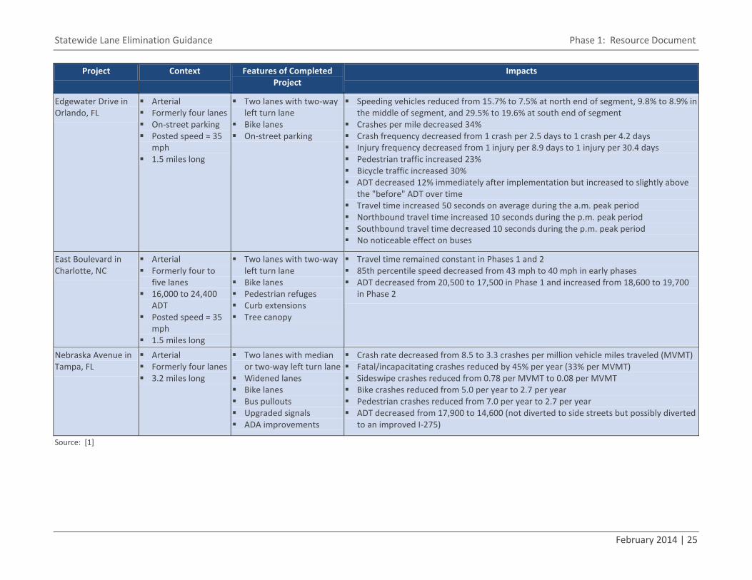
The Project for Public Spaces [1] cites the before-and-after study results summarized in Table 2. Other studies show that the speed of vehicles are reduced on the through lane or lanes after a lane elimina-tion. The studies point to a speed reduction of 1 to 7 mph, depending on conditions.
There are trade-offs in addressing the myriad issues associated with lane elimination pro-jects. Some of the issues are interrelated, so addressing one issue will require additional actions to address related issues. Addressing some issues will require a significant amount of lead time.
Statewide Lane Elimination Guidance Phase 1: Resource Document
February 2014 | 23
One study cited an 18% decrease in speeds (i.e., an 8 mph reduction from 45 mph).
One of the most obvious advantages of a lane elimination project is that pedestrian exposure to oncoming traffic is reduced, of-ten by half (e.g., a two-lane road versus a four-lane road). As such, decreases in pe-destrian crashes as high as 80% have been observed after lane elimination projects have been implemented.
Impacts:
Lane elimination projects generally re-duce crash rates. It has been observed in some cases that the total number of pedestrian and bicycle crashes increases after a lane elimination project is im-plemented, but this generally reflects an increase in volumes rather than an in-crease in crash rates.
Lane elimination projects generally re-duce the severity of crashes.
Many studies indicate that the number of crashes as well as the crash rates decrease significantly after a lane elimination project. Studies show reductions in the number of crashes ranging from 14% to 60% and de-creases in crash rates ranging from 34% to 68%. The number of injury crashes is re-duced similarly (e.g., 33% to 68%).
With slower speeds and fewer conflicting movements, studies of such lane elimination projects have shown reductions in rear-end crashes, as well as a 56% reduction in angle crashes.
Factors to consider:
Pedestrian and bicycle riders – It should be kept in mind that, when implemented in conjunction with a Complete Streets strategy, it is likely that the total number of pedestrians and bicyclists may in-crease after lane elimination project im-plementation. Providing safe accommo-dations for non-motorized modes of travel is important in lane elimination projects.
Travel patterns – Crash experience on cross streets and alternative routes might be issues for investigation.
Minimum design standards – Lane elimi-nation projects should meet or exceed minimum design standards for all modes.
User expectancy – Modifying the cross section of an existing roadway will re-quire actions to ensure that users of the facility are prepared for the change.
4.2 TRAFFIC OPERATIONS IMPACTS
Profile According to studies by FHWA, under most ADT conditions, lane elimination (of one through lane per direction) seems to have minimal effects on vehicle capacity because left-turning vehicles were moved into a
common two-way left-turn lane (TWLTL). Four-lane roadways with ADT of up to 20,000 (or up to 1,750 vehicles per peak hour) have been shown to be good candi-dates for a road diet. Four-lane roads with ADTs higher than 20,000 should be evaluat-ed for feasibility on a case-by-case basis. [2] Similarly, of the before-and-after studies conducted, little to no changes in vehicle LOS were seen for roadway segments and intersections, while achieving the desired effects of slower vehicle speed and fewer accidents. When a street is converted to two lanes, this helps to calm traffic, in part by eliminating the opportunity for passing and in part because the slower drivers set the speed.
The Project for Public Spaces [1] cites the before-and-after study results summarized in Table 2.
Issue: Safety
Lane elimination projects generally reduce crash rates and crash severity.
Issue: Traffic Operations
Lane elimination projects are reported to work best when ADT is less than 20,000 (on a four-lane roadway) and left-turning vehicles are removed from the through traffic flow, and traffic diversion resulting from a lane elimination project can be significantly lower than project opponents anticipate. However, projects should be evaluated on a case-by-case basis.
24 | Kittelson & Associates, Inc.
Table 2. Before-and-After Crash and Operations Data
Project Context Features of Completed Project
Impacts
Stone Way North in Seattle, WA
Formerly four lanes Posted speed = 30
mph 1.2 miles long
Two lanes with two-way left turn lane
Bike lanes
Bicycle traffic increased 35% (15% of peak hour traffic volume) No diversion of autos to other routes 85th percentile speed reduced from 37 mph to 34-36 mph Vehicles traveling > 40 mph reduced from 4% of traffic to 1% of traffic Total crashes reduced by 14% Injury crashes reduced by 33% Angle collisions reduced by 56% Bicycle crash rate reduced
Raymond Avenue in Poughkeepsie, NY
Minor arterial Formerly four lanes 1.5 miles long
Two lanes Three new roundabouts New midblock crossing Landscaping Curb extensions Landscaped median
Crashes decreased from 35 to 17 over two six-month periods Speeds decreased 24% (about 9 mph) Travel time increased 7% Delays decreased 56% at roundabouts ADT decreased 8.8% at Vassar College ADT increased on some parallel streets, partly due to external factors
Prospect Park West in Brooklyn, NY
Formerly three one-way lanes
On-street parking
Two lanes Two-way bikeway On-street parking Signal timing modifica-
tions Pedestrian refuges
Vehicle plus bicycle traffic increased 13% in the a.m. peak period and 9% in the p.m. peak period
Peak volumes and travel times "stable" Weekday bicycle traffic volume nearly tripled Weekend bicycle traffic more than doubled Speeding vehicles reduced from 74% to 20% Average speed reduced from 33.8 to 26.6 mph Crashes reduced by 16% Injuries reduced by 21% Bicycle traffic on sidewalks decreased from 46% to 3%
continued
Statewide Lane Elimination Guidance Phase 1: Resource Document
February 2014 | 25
Project Context Features of Completed Project
Impacts
Edgewater Drive in Orlando, FL
Arterial Formerly four lanes On-street parking Posted speed = 35
mph 1.5 miles long
Two lanes with two-way left turn lane
Bike lanes On-street parking
Speeding vehicles reduced from 15.7% to 7.5% at north end of segment, 9.8% to 8.9% in the middle of segment, and 29.5% to 19.6% at south end of segment
Crashes per mile decreased 34% Crash frequency decreased from 1 crash per 2.5 days to 1 crash per 4.2 days Injury frequency decreased from 1 injury per 8.9 days to 1 injury per 30.4 days Pedestrian traffic increased 23% Bicycle traffic increased 30% ADT decreased 12% immediately after implementation but increased to slightly above
the "before" ADT over time Travel time increased 50 seconds on average during the a.m. peak period Northbound travel time increased 10 seconds during the p.m. peak period Southbound travel time decreased 10 seconds during the p.m. peak period No noticeable effect on buses
East Boulevard in Charlotte, NC
Arterial Formerly four to
five lanes 16,000 to 24,400
ADT Posted speed = 35
mph 1.5 miles long
Two lanes with two-way left turn lane
Bike lanes Pedestrian refuges Curb extensions Tree canopy
Travel time remained constant in Phases 1 and 2 85th percentile speed decreased from 43 mph to 40 mph in early phases ADT decreased from 20,500 to 17,500 in Phase 1 and increased from 18,600 to 19,700
in Phase 2
Nebraska Avenue in Tampa, FL
Arterial Formerly four lanes 3.2 miles long
Two lanes with median or two-way left turn lane
Widened lanes Bike lanes Bus pullouts Upgraded signals ADA improvements
Crash rate decreased from 8.5 to 3.3 crashes per million vehicle miles traveled (MVMT) Fatal/incapacitating crashes reduced by 45% per year (33% per MVMT) Sideswipe crashes reduced from 0.78 per MVMT to 0.08 per MVMT Bike crashes reduced from 5.0 per year to 2.7 per year Pedestrian crashes reduced from 7.0 per year to 2.7 per year ADT decreased from 17,900 to 14,600 (not diverted to side streets but possibly diverted
to an improved I-275)
Source: [1]

26 | Kittelson & Associates, Inc.
Impacts:
Capacity – According to FHWA, it is only for road diets on four-lane roadways with ADTs above approximately 20,000 that there is an increased chance that traffic congestion will increase to the point of diverting traffic to alternative routes. In the cases of lane elimination projects that FHWA examined through-out North America, lane eliminations have not resulted in reductions in ADT, meaning such projects have not caused inconveniences to motorists to the point of them diverting to alternative routes.
Speed – According to FHWA, before-and-after studies suggest a traffic calm-ing effect that results in a 4-5 mph re-duction in the 85th percentile free-flow speed, a 25% reduction in travel speed, and a 30 percent reduction in the per-centage of vehicles traveling more than 5 mph over the speed limit. This calming effect seems to be more evident when lane elimination occurs on US or State routes with moderate ADTs in small ur-ban areas. This calming effect would be less likely in the central areas of larger cities, where the speed limits (and traf-fic speeds) may have been lower to begin with.
Travel time – According to a before-and-after study of US 75 in Iowa, a conver-sion of four to three lanes (with a two-way-left-turn lane included) resulted in a 18-second (or 36%) increase in peak hour travel time.
Delay – For roadways without many sig-nalized intersections, lane elimination may result in a slight increase in delay. For roadways with many signalized in-tersections, a reduction in delay should be expected if dedicated left turn lanes are added and the traffic signals are modified to improve progression and reduce cycle lengths (while providing appropriate pedestrian phases). In an-other study of going from five travel lanes to three in Kentucky, simulation shows a minimum increase in delay of up to 7 seconds/trip under the existing level of traffic.
Queuing – Of the cases examined, queu-ing has not been an issue. If a two-way-left-turn lane or left turn pockets are in-stalled as part of lane elimination pro-jects, queuing that would otherwise oc-cur from left-turning vehicles’ delays may be eliminated or reduced.
Cross streets – Bike lanes, if they were to be installed curbside or between parking lanes and travel lanes as part of a lane elimination project, could increase sight distance and turning radii at intersec-tions and driveways.
Factors to consider:
Larger operational impacts (such as sig-nificantly more queuing and delay) that may occur with lane elimination in a busy downtown setting due to heavy side street volumes and the three-lane scenario’s loss of left-turn capacity caused by the short block lengths
Reduction in the number of receiving lanes for dual turn lanes from side streets
Signal timing and coordination on the segment from which through lanes are being eliminated and the cross streets
Achieving preferred design standards vs. minimum design standards (e.g., for cen-ter turn lane width), which may have an impact on the operations of the segment from which through lanes are being eliminated
Signal spacing Peaking and directional characteristics of
traffic (i.e., distribution of daily traffic by hour and direction)
Posted speed Long-term (forecast) volumes Truck and bus volumes Turning volumes (left and right turns) Driveway density/access management Pedestrian crossing volumes
4.3 PEDESTRIAN AND BICYCLIST ACTIVITY
Profile In general, lane elimination projects create a more attractive and safer environment for pedestrians and bicyclists in many ways. Re-allocated space can be used to expand or create sidewalks and/or bicycle lanes. Space reallocated to on-street parking or landscap-ing creates a buffer between vehicle traffic and pedestrians, generating an environment that feels more pedestrian-friendly and saf-er.
Statewide Lane Elimination Guidance Phase 1: Resource Document
February 2014 | 27
The Project for Public Spaces [1] cites the before-and-after study results summarized previously in Table 2. Other studies show increases in pedestrian and bicycle activity of 23 and 30 percent, respectively.
Impacts:
Facilities – The reallocation of existing right-of-way to designated space for pe-destrian and/or bicycle travel provides a more inviting and comfortable setting for pedestrians and bicyclists. Streetscape improvements that may ac-company lane elimination projects also improve the quality of travel for pedes-trian and bicyclists.
Safety – Reduced vehicle speeds and reduced exposure to oncoming traffic at crossings are added safety effects of lane elimination projects. Studies point to a speed reduction of 1 to 7 mph, and lower speeds reduce the severity of crashes. Shorter crossing distances limit pedestrian and bicyclist exposure to on-coming traffic and eliminate the multi-ple-threat crashes. Decreases in pedes-trian crashes as high as 80% have been observed after lane elimination projects have been implemented. [2] Bicycle
crash rates have been shown to de-crease as well, even if the total number of crashes did not decrease; the increase in bicycling volumes combined with the same number of crashes resulted in a lower crash rate. The number of crashes may also decrease because of increased motorists’ attentiveness to higher levels of street activity.
Factors to consider:
Depending on the scope of the project, upgrades to meet ADA standards may be required for pedestrian facilities.
Trade-offs exist between providing dedi-cated pedestrian and bicycle facilities and using the available right-of-way for other purposes (e.g., medians, landscap-ing, and transit facilities).
Alternative means of improving pedes-trian and bicyclist safety may exist. For example, an alternative means of reduc-ing pedestrian crossing distances is con-struction of curb extensions or bulb-outs.
Additional improvements may be need-ed if the corridor has a relatively high number of access points, offset minor streets, and heavy congestion. For ex-ample, a lane elimination project in a corridor with a relatively high number of access points might be more successful if access points are consolidated as part of the lane elimination project and traffic is able to flow more smoothly as a result. [3]
4.4 IMPACTS TO TRANSIT ROUTING/STOPS AND RIDERSHIP
Profile Lane elimination projects could affect the routing of transit services and the location and design of transit stops. Existing and pro-posed lane elimination projects identified to date are not located in existing rail corridors, so impacts to bus services are the most likely type of transit impact. However, implemen-tation of rail transit and/or dedicated transit running ways may be planned for the corri-dor, and the lane elimination project must take such plans into consideration.
Lane elimination projects should ensure that at least one resulting through lane in each direction is wide enough to accommodate buses (i.e., at least 11 feet wide according to [5]).
Information relevant to the design of transit facilities in Florida can be found in FDOT's Accessing Transit: Design Handbook for Flor-ida Bus Passenger Facilities [6] and FDOT's
Issue: Pedestrian and Bicyclist Activity
Lane elimination projects are reported to create safer, more comfortable environ-ments for pedestrians and bicyclists.
Issue: Impacts to Transit
A lane elimination project may or may not have a significant impact on transit service. Access to transit, delays to buses caused by increased congestion, delays caused by buses stopping in through lanes, and stop reloca-tion are topics for consideration, as is the potential for a corridor to support a dedicat-ed transit facility in the future.
28 | Kittelson & Associates, Inc.
Typical Sections for Exclusive Transit Running Ways. [7]
Only a limited number of studies to date have documented the impacts that lane elimination projects have on transit services. Specific impacts described in these studies include the following: [1]
The East Boulevard road diet in Char-lotte, NC, was a corridor project that "improved pedestrian and bicycle infra-structure connections to bus routes and light rail."
The Edgewater Drive road diet in Orlan-do, FL, "had no measured impact on bus loading times or operations."
Impacts:
Lane elimination may negatively affect the speed and reliability of bus services, especially if just one travel lane per di-rection remains. Constructing bus bulbs can mitigate these effects, although use of bus bulbs may result in delays for other vehicles when there is just one through lane in each direction and the bus stops in that through lane to serve passengers.
Factors to consider:
Marking of transit zones and stop loca-tions
Provision of adequate, accessible pedes-trian access to transit
Compatibility of with transit use Bus volumes and headways
Number and type of bus routes operat-ing in the corridor (which is significant because express buses in the corridor will require a passing lane or other means of passing stopped local buses)
Number of bus stops and/or need to relocate bus stops
Need to re-route transit services Need for bus pull-outs due to automo-
bile speeds vs. re-entry delay experi-enced by buses attempting to leave bus pull-outs
Use of transit preferential treatments in the corridor (e.g., transit signal priority and signals timed for bus progression)
Coordination with the LRTP and TDP re-garding future transit services planned in the corridor
4.5 IMPACTS ON PARKING SUPPLY AND ACTIVITY
Profile The effect of lane elimination on parking supply and parking activity is highly depend-ent on the roadway cross sections before and after the lane elimination project. In most instances, the lane elimination project does not reduce the supply of parking on the roadway. In fact, underutilized travel lanes are often eliminated in favor of additional on-street parking, effectively increasing the parking supply.
It is well known that the public does not like removal of parking spaces. An example of the public’s resistance occurred in the City of Santa Barbara (CA), which proposed a road
diet that would remove on-street parking. Residents pressured the City to keep on-street parking and remove a traffic lane in-stead. [8]
Impacts:
The HCM 2010 multimodal level of ser-vice methodology uses on-street parking percentage as an analysis parameter. For pedestrians, higher on-street parking uti-lization results in improved level of ser-vice, as these parked cars act as buffers. For bicyclists, level of service is adversely impacted by on-street parking, as "door-ing" becomes a greater concern. [9] Generally, a five- or six-foot wide bicycle lane next to an eight-foot wide parking lane does not have dooring issues.
In Ashland, OR, a before-and-after study of a lane elimination project found that parking utilization increased from 29 percent to 41 percent after the lane elimination project was implemented. [10]
On-street parking acts as a traffic calm-ing device, creating a “tunnel effect” that naturally slows motorists’ speeds. [3]
Issue: Parking
Removal of on-street parking can be a con-troversial issue, but lane elimination projects do not typically reduce the supply of on-street parking.
Statewide Lane Elimination Guidance Phase 1: Resource Document
February 2014 | 29
The provision of on-street parking allows for the construction of curb extensions at crosswalks, which reduce crossing dis-tance for pedestrians.
Factors to consider:
Parallel vs. angled parking ▫ According to the MUTCD, parallel
parking stalls may be eight feet wide by 22 to 26 feet long. [11] Angled parking uses less linear curb length per parking space than traditional parallel parking, so more spaces can be provided on the same block. However, angled parking takes up more distance perpendicular to the curb (20 feet next to a 13 feet travel lane). [12]
▫ Angled parking may be considered on low-speed and low-volume commercial collectors and main streets. [13]
▫ Back-in angled parking—as opposed to head-in angled parking—is con-sidered beneficial to bicyclists, as it is easier to make eye contact with drivers as they pull out of their park-ing spots. On the other hand, drivers may be confused by this configura-tion.
Induced effects ▫ The increased non-motorized level
of service typically provided by lane elimination projects may turn driv-ers into pedestrians or bicyclists, po-
tentially reducing parking demand in the study roadway.
▫ However, if free on-street parking is provided, it will reduce the market price of parking of all types (includ-ing off-street parking). Because providing this parking has an associ-ated cost, it is in essence a subsidy that incentivizes automobile travel and inflates parking demand. [14]
Roadway design characteristics ▫ High-speed street types are not suit-
able for on-street parking. [12] ▫ On-street parking should not impede
visibility for pedestrians, bicyclists and other vehicles. This means that on-street parking spaces should be located carefully relative to intersec-tions and crosswalks. [12]
Twenty-four-hour vs. peak period park-ing ▫ On-street parking can be allowed at
some times of the day and disal-lowed at peak traffic times. This can allow more efficient use of lane ca-pacity when it is needed. [12]
Metering of on-street parking ▫ If on-street parking is created by a
lane elimination project, the distri-bution of meter revenue might be-come a topic of discussion between the jurisdiction that maintains the roadway and the jurisdiction in which the roadway is located. This
issue is considered in Section 10.6.11 of the FDOT Right of Way Procedures Manual [15] with respect to State roadways.
4.6 SALES TAX REVENUE AND PROPERTY VALUE IMPACTS
Profile The impacts of lane elimination projects on sales tax revenues and property values are mixed, although most studies point to either no overall economic impacts or some posi-tive impact. Typical concerns related to sales tax revenue include the belief that eliminat-ing lanes will reduce the volume of business for establishments along the roadway where the lane will be removed. Additionally, there are concerns that lane elimination projects will increase congestion on the roadway, which will result in lower property values along the route. [16]
Example projects:
East Main Street in El Cajon, CA: On East Main Street, two through lanes were removed from a four-lane roadway, re-sulting in a two-lane roadway with angle parking. Since the lane elimination pro-ject was implemented, property values have increased 181% (more than double than the citywide average), and taxable sales have increased by 66% compared to 45% for the entire city. Lease rates have increased by 56 percent. [17]
Fourth Plain Boulevard in Vancouver, WA: Fourth Plain Boulevard was re-
30 | Kittelson & Associates, Inc.
striped from a four-lane facility to a three-lane facility with a two-way left turn lane. ADA ramps, bicycle lanes, and underground utility work were under-taken as part of this effort. Gross sales receipts in the corridor increased by 3.1% after implementation of the road diet. Two comparable commercial zones elsewhere in the city saw declines of 9.8% and 25%. [13]
York Boulevard in Los Angeles, CA: Prior to the road diet, York Boulevard was a four-lane roadway with on-street park-ing. The reconfigured roadway consist-ed of one through lane in each direction, a center turn lane, and on-street park-ing, with bicycle lanes added later. A study of this project found no significant change in property values as a result of the road diet. While sales tax revenues are higher in the affected portion of York Boulevard, the study was not able to conclude that the road diet caused in the increase in sales tax revenues. [16]
Despite the findings of the above studies, anecdotal reports indicate that lane elimina-tion projects in Florida have resulted in sub-stantial positive economic development im-pacts. Cited examples of such projects in-clude Atlantic Avenue in Delray Beach and Las Olas Boulevard in Fort Lauderdale.
Impacts:
Business activity – Studies have shown that lane elimination projects can (but do not always) increase economic activi-
ty. Studies have shown a wide variation in lane elimination project impacts on business activity, from little to no in-crease in economic activity relative to neighborhood growth to a 174% in-crease in business activity (implying the possibility of positive impacts).
Property values – No significant impacts on property values have been estab-lished in quantitative studies of lane elimination projects. Property values may be positively impacted by potential streetscape improvements implemented in conjunction with lane elimination pro-jects.
Factors to consider:
Merchants’ perceptions – Research into surveys of merchants' perceptions on both the possible business impacts re-sulting from a lane elimination and their perceptions of customer travel patterns are often inaccurate. Efforts to educate local merchants on these issues may be beneficial in gaining support for a lane elimination project.
On-street parking – On-street parking is an important and potentially conten-tious asset to local merchants and cus-tomers. Removal of a parking lane as
part of a lane elimination project may make the lane elimination project con-troversial.
4.7 ENVIRONMENTAL ISSUES
Profile Lane elimination projects generally have a net positive impact on the environment. If there is a reduction in traffic volumes through a shift to non-auto modes resulting from the lane elimination project, air quality will improve and noise will be reduced. Addi-tionally, lane elimination projects provide an opportunity to add landscaping and green projects to streets. There are several bene-fits associated with "greening" a corridor related to runoff reduction, detention, re-tention, conveyance, water quality mitiga-tion, and carbon absorption by plants. How-ever, the pollution generated by increased congestion and the reconstruction of the existing road should be taken into account.
Impacts:
Traffic volume reductions (through mode shift) can positively impact air quality.
Increases in delay can adversely impact air quality.
Lane elimination projects create space for low-emission travel. If trees and
Issue: Sales Tax Revenue and Property Value
Lane elimination projects generally have no impact or a positive impact on sales tax reve-nues and property values.
Issue: Environmental Impacts
Lane elimination projects generally have a net positive impact on the environment.

Statewide Lane Elimination Guidance Phase 1: Resource Document
February 2014 | 31
landscaping are added to the corridor, air quality can improve still further due to carbon absorption by the plants.
If the road surface is replaced by more permeable materials, stormwater man-agement is improved. Landscaping ele-ments like bioswales, planters, rain gar-dens, and street trees help curb storm-water runoff and are beneficial for ecol-ogy. Optimal stormwater management is more than simply removing rainfall as quickly as possible, as simply removing rainfall quickly risks negative environ-mental impacts associated with both stormwater quality and quantity (e.g., polluted runoff, sedimentation, and bank erosion). Instead, optimal storm-water management focuses on efforts to retain and treat—or even eliminate—runoff at the source through cost-effective green infrastructure. [18]
Reductions in auto traffic caused by travelers shifting to non-auto modes can lead to reduced traffic noise in the corri-dor.
Factors to consider:
The city or county may require specific environmental permits.
If the project uses federal funding, the National Environmental Policy Act (NEPA) process has to be followed. However, a lane elimination project typ-ically occurs within existing pavement, so it is possible that the project can ob-tain a Categorical Exclusion. [19]
Green landscaping is a means of enhanc-ing environmental sustainability.
Reconstructing an existing roadway can have an environmental cost. Additional-ly, traffic studies must consider future capacity needs to avoid the situation in which it is necessary to reconstruct the road again in a short span.
If the road needs a new surface, paving materials should be chosen to minimize noise and to maximize reflectivity in or-der to reduce the urban heat island ef-fect, improve air quality, and increase pavement durability.
If the lane reduction project diverts traf-fic to other corridors, environmental im-pacts (e.g., emissions and noise) may in-crease in those corridors.
4.8 DESIGN VARIANCES AND EXCEPTIONS
Profile FDOT's design standards are available through the Roadway Design Office. [20]
According to FDOT’s Plans Preparation Man-ual [21], design exceptions are required when proposed design elements are below both the FDOT's governing criteria and AASHTO’s new construction criteria for the 13 Controlling Design Elements. The 13 Con-trolling Design Elements are:
1. Design Speed 2. Lane Widths 3. Shoulder Widths 4. Bridge Widths
5. Structural Capacity 6. Vertical Clearance 7. Grades 8. Cross Slope 9. Superelevation 10. Horizontal Alignment 11. Vertical Alignment 12. Stopping Sight Distance 13. Horizontal Clearance
Design variations are required when pro-posed design elements do not require a de-sign exception but are below FDOT's govern-ing criteria.
Lane elimination projects generally will not affect many of the 13 Controlling Design El-ements. The Controlling Design Elements most likely to need a variance or exception for these types of projects include but are not limited to design speed, lane widths, and shoulder widths.
Approval from multiple individuals may be required for certain issues. The guidelines for approval authorities are outlined in Vol-ume 1, Section 23.3, of the Plans Prepara-tion Manual. [21]
Impacts:
Issue: Design Variances and Exceptions
Lane elimination projects can be feasible without design variances and exceptions. Where a variance or exception is needed, it is most likely to be related to median and lane widths.
32 | Kittelson & Associates, Inc.
May delay project schedule if exceptions and variances are not submitted and ap-proved in advance
Factors to consider:
Lane elimination project components such as landscaping may require a sight distance evaluation.
If automobile and/or bicycle lane widths are narrowed as part of a lane elimina-tion project, a design exception or vari-ance may be required.
Lane elimination projects may be funded with safety funds if the lane elimination project is intended to address a safety issue. When projects using safety funds are developed to improve specific safety problems, only the elements identified under the scope of work for the safety improvement project are subject to the variance/exception approval processes. Existing features within the safety im-provement project limits not meeting design criteria do not require approval to remain as long as the project does not create a nonconforming condition. The safety study should identify all the appli-cable variations and/or exceptions (de-sign or utility) required based on the proposed scope.
Lane elimination projects can go hand-in-hand with maintenance, resurfacing, ride rehabilitation, and skid hazard pro-jects or may even be considered as one. These projects do not require design ex-ceptions or design variations other than for addressing ADA curb ramp require-
ments. If compliance with ADA curb ramp requirements is determined to be technically infeasible, documentation as a design variation is required. Mainte-nance resurfacing projects can only be programmed on routes that meet the requirements identified in Chapter 28 of the Work Program Instructions. [22]
4.9 CONSISTENCY WITH PLANS AND PROGRAMS
Profile Proposed lane elimination projects should be consistent with adopted plans and pro-grams. These plans and programs include the following:
FDOT Work Program MPO/TPO Long-Range Transportation
Plan (LRTP) MPO/TPO Transportation Improvement
Program (TIP) State Transportation Improvement Pro-
gram (STIP) Transit agency Transit Development Plan
(TDP) Local comprehensive plan Local vision documents and master plans
Specifically, the proposed new cross section for a given roadway should be consistent with (a) the cross section upon which the analyses that informed the above-listed plans and programs are based and (b) any planned and programmed projects affecting that roadway. If the travel demand model-ing underlying the LRTP assumed that a
roadway for which lane elimination is pro-posed would have a six-lane cross section in the long term, reducing the cross section to four lanes is not consistent with the LRTP. If the Work Program shows that funding has been obtained to widen a given roadway from four lanes to six lanes, lane elimination is not consistent with the Work Program. If the TDP shows that a given roadway is planned to have dedicated bus lanes in the future, eliminating through lanes may make it infeasible to implement the dedicated bus lanes, so lane elimination is not consistent with the TDP.
If a proposed lane elimination project is not consistent with an adopted plan or program, the lane elimination (a) may be infeasible or (b) the adopted plan or program must be amended or modified. The amendment pro-cesses for the above-listed plans and pro-grams involve the following:
Work Program – Amendments must oc-cur in accordance with Section 339.135 of the Florida Statutes (F.S.) [23]. See Part III, Chapter 3, of the Work Program Instructions [22] for detailed information
Issue: Consistency with Plans and Programs
It is essential to ensure that a proposed lane elimination project is consistent with adopt-ed plans and programs. If there is an incon-sistency, the project must be modified and/or one or more adopted plans and pro-grams must be amended.
Statewide Lane Elimination Guidance Phase 1: Resource Document
February 2014 | 33
about the process, the types of amend-ments that are possible, and the condi-tions under which amendments are al-lowed.
LRTP – Amendments must occur in ac-cordance with the Code of Federal Regu-lations (CFR) Title 23 Part 450 [24] and 339.175, F.S. [25] FDOT's Office of Policy Planning has also prepared a document [26] that specifies thresholds at which proposed changes to LRTP projects re-quire an amendment to the LRTP; amendments may be required based on changes in project cost, changes in pro-ject schedule, changes in project scope, and deletion of a cost-feasible project from the LRTP. Also available from the Office of Policy Planning is Chapter 4 of FDOT's Metropolitan Planning Organiza-tion Program Management Handbook, which includes a section on LRTP admin-istrative modifications and amendments. [27] An "administrative modification" is a change that is less significant than an "amendment."
TIP – Amendments must occur in ac-cordance with 23 CFR 450 [24] and 339.175, F.S. [25] Chapter 5 of FDOT's Metropolitan Planning Organization Pro-gram Management Handbook includes a section on TIP amendments. [8] Chapter 5 describes conditions under which a TIP amendment is required and the amendment process. Administrative TIP amendments do not require the approv-al of the full MPO/TPO board.
STIP – Amendments must occur in ac-cordance with 23 CFR 450. [24] Chapter 5 of FDOT's Metropolitan Planning Or-ganization Program Management Hand-book notes that each MPO/TPO's TIP is incorporated into the STIP and includes a section on TIP and STIP amendments. [28] Chapter 5 describes conditions un-der which a STIP amendment is required and the amendment process. Additional information about STIP amendments and administrative modifications is available from the FDOT Office of Work Program and Budget. [29]
TDP – TDPs undergo major updates eve-ry five years and minor updates annual-ly. Both types of update provide an op-portunity to maintain consistency be-tween TDP projects and proposed lane elimination projects. TDP updates occur according to Florida Administrative Code (F.A.C.) Rule 14-73.001 [30]. TDPs are required to be consistent with the LRTP and the local comprehensive plan.
Comprehensive plan – Local government comprehensive plans may be amended at any time. The timing of amendment submittals will vary by jurisdiction. The Florida Department of Economic Oppor-tunity (DEO) provides information about amendment review processes and time frames. [31] 163.3177, F.S., states the requirements that comprehensive plans are to meet. [32] 163.3184, F.S., pro-vides information about FDOT's role in
reviewing comprehensive plan amend-ments. [33]
Visions and master plans – Amendment processes will vary by jurisdiction.
Impacts:
A proposed lane elimination project may be determined to be infeasible if it is not consistent with one or more plans and programs.
Factors to consider:
The amendment processes may require public involvement, the participation and approval of multiple agencies, re-vised fiscal analyses, and revised envi-ronmental analyses (in non-attainment and maintenance areas).
Amending one of the above-listed plans and programs may require amending others (e.g., local comprehensive plans should be consistent with the applicable LRTP).
A project that utilizes federal funding must be included in the TIP and STIP. Amendments to the TIP and STIP associ-ated with such projects must be trans-mitted to FHWA. [28]
Environmental document approvals re-quire consistency with the LRTP, TIP, and STIP. [28] The forthcoming FHWA/FDOT document Final Guidance for Meeting Planning Requirements for NEPA Ap-proval [34] may be helpful.
The amendment process can take sever-al months. [28]
34 | Kittelson & Associates, Inc.
4.10 FUNCTIONAL CLASSIFICATION
Profile Elimination of a lane on a roadway can im-pact the functional classification of that road. A change in functional classification can be very significant because it could re-sult, effectively, in a gap in the continuity and connectivity of the system and it could affect planning, funding, traffic analyses, project prioritization, and state and federal reporting requirements. As such, potential changes to functional classification are key considerations in reviewing lane elimination projects.
The primary guide for managing functional classifications for federal reporting purposes is FHWA's Highway Functional Classification: Concepts, Criteria and Procedures [35] doc-ument, which was updated in 2013. There are key differences between the 2013 doc-ument, the original 1989 document, and the 2008 interim guidance document [36] that may continue to impact functional classifica-tions in Florida (e.g., ongoing designation of Urban Minor Collectors). The 2013 docu-ment notes that federal functional classifica-tions should reflect existing conditions, not future conditions. That is, a federal func-tional classification change should occur af-ter the associated roadway project con-cludes. The federal functional classification system is the only functional classification recognized by FDOT. [37] Other agencies in Florida as well as local governments may
have their own functional classification sys-tems.
The FHWA document is supplemented by a document prepared by FDOT's Transporta-tion Statistics Office (TranStat): FDOT's FHWA Urban Boundary and Federal Func-tional Classification Handbook. [37] The FDOT Handbook was completed in 2003, so it does not reflect the 2013 version of the FHWA document in some respects, but it describes the process for assigning and revis-ing functional classifications (a process wherein ADT, access, and system continuity are criteria) and provides sample forms. It notes that reclassification of US highways requires coordination with AASHTO, and it states that functional classification changes should occur before system designation changes occur. The FDOT Handbook links federal functional classification to federal system classification as shown in Table 3.
Table 3. Functional Classification and Federal System
Functional Classification(s)
Federal System/ Funding Eligibility
Local, Rural Minor Col-lector
Eligible for Federal-Aid only with special con-siderations
Rural Major Collector, Urban Collector, Minor Arterial, Principal Arte-rial
Eligible for Surface Transportation Pro-gram (STP)
Local, Rural Minor Col-lector, Rural Major Col-lector, Urban Collector, Minor Arterial, Principal Arterial
Eligible for National Highway System (NHS) as determined by Con-gress and revised by FHWA, based on FDOT or FHWA Division Of-fice request
Source: [37]
Under MAP-21, STP funds can be used on any “Federal-aid highway, bridge, and tunnel projects on any public road" as well as "pe-destrian and bicycle infrastructure and trans-it capital projects, including intercity bus terminals.” [38] Table 3 indicates that, in general, the only roads upon which STP funds cannot be used are Local streets and Rural Minor Collectors. In all likelihood, lane elimination projects in Florida will be pro-posed only on non-Local streets in urban areas. As such, downgrading the functional classification of the affected roadway as part of the lane elimination project will likely not impact the potential to receive future STP funding for the roadway. The FHWA Division
Issue: Functional Classification
A lane elimination project can affect the de-gree to which a roadway serves a mobility or access function. A change in federal func-tional classification might also affect federal funding eligibility.
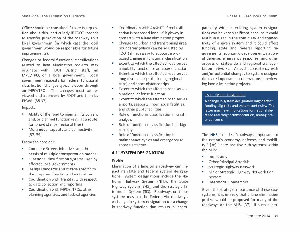
Statewide Lane Elimination Guidance Phase 1: Resource Document
February 2014 | 35
Office should be consulted if there is a ques-tion about this, particularly if FDOT intends to transfer jurisdiction of the roadway to a local government (in which case the local government would be responsible for future improvements).
Changes to federal functional classifications related to lane elimination projects may originate with FDOT District staff, an MPO/TPO, or a local government. Local government requests for federal functional classification changes typically occur through an MPO/TPO. The changes must be re-viewed and approved by FDOT and then by FHWA. [35,37]
Impacts:
Ability of the road to maintain its current and/or planned function (e.g., as a route for long-distance, regional trips)
Multimodal capacity and connectivity [37, 39]
Factors to consider:
Complete Streets initiatives and the needs of multiple transportation modes
Functional classification systems used by affected local governments
Design standards and criteria specific to the proposed functional classification
Coordination with TranStat with respect to data collection and reporting
Coordination with MPOs, TPOs, other planning agencies, and federal agencies
Coordination with AASHTO if reclassifi-cation is proposed for a US highway in concert with a lane elimination project
Changes to urban and transitioning area boundaries (which can be adjusted by FDOT) if necessary to support a pro-posed change in functional classification
Extent to which the affected road serves a mobility function or an access function
Extent to which the affected road serves long-distance trips (including regional trips) and short-distance trips
Extent to which the affected road serves a national defense function
Extent to which the affected road serves airports, seaports, intermodal facilities, and other public facilities
Role of functional classification in crash analysis
Role of functional classification in bridge capacity
Role of functional classification in maintenance cycles and emergency re-sponse activities
4.11 SYSTEM DESIGNATION
Profile Elimination of a lane on a roadway can im-pact its state and federal system designa-tions. System designations include the Na-tional Highway System (NHS), the State Highway System (SHS), and the Strategic In-termodal System (SIS). Roadways on these systems may also be Federal-Aid roadways. A change in system designation (or a change in roadway function that results in incom-
patibility with an existing system designa-tion) can be very significant because it could result in a gap in the continuity and connec-tivity of a given system and it could affect funding, state and federal reporting re-quirements, economic development, nation-al defense, emergency response, and other aspects of statewide and regional transpor-tation networks. As such, consistency with and/or potential changes to system designa-tions are important considerations in review-ing lane elimination projects.
The NHS includes "roadways important to the nation's economy, defense, and mobili-ty." [38] There are five sub-systems within the NHS:
Interstates Other Principal Arterials Strategic Highway Network Major Strategic Highway Network Con-
nectors Intermodal Connectors
Given the strategic importance of these sub-systems, it is unlikely that a lane elimination project would be proposed for many of the roadways on the NHS. [37] If such a pro-
Issue: System Designation
A change in system designation might affect funding eligibility and system continuity. The latter may have implications for national de-fense and freight transportation, among oth-er concerns.
36 | Kittelson & Associates, Inc.
posal occurs, CFR Title 23 Part 470 [24] con-tains information about modifications to the NHS. Such modifications require coordina-tion between FDOT, local officials, and FHWA. [37] A project on the NHS must also be included in the local MPO/TPO's Trans-portation Improvement Program (TIP) and the State Transportation Improvement Pro-gram (STIP) [22]. Additionally, FDOT's FHWA Urban Boundary and Federal Functional Classification Handbook [37] indicates that a re-designation of a US highway would re-quire coordination with AASHTO. The Hand-book recommends that functional classifica-tion changes should occur before system designation changes occur.
The SHS consists of roadways under the ju-risdiction of and maintained by FDOT, quali-fying expressway authorities, and other state agencies. [37,40] FDOT's authority to desig-nate facilities as part of the SHS and to con-struct, regulate, and maintain them comes from Sections 334.044 and 335.02 of the Florida Statutes (F.S.) [41,42]. FDOT is al-lowed to establish standards for access management and the number of lanes in SHS roadway segments, with the goal of achieving "the highest degree of efficient mobility for corridor users," and may also regulate vehicles allowed to use the SHS. FDOT has authority to number and re-number SHS facilities. [42] FDOT has estab-lished design standards for SHS facilities [20], and policy and procedure documents have been prepared on topics such as Con-text Sensitive Solutions [43] and major urban
corridor studies [44]. Constructing and main-taining the SHS is funded by the State Trans-portation Trust Fund [22].
Multiple lane elimination projects exist on SHS (or former SHS) facilities in Florida, and it is anticipated that requests to eliminate through lanes on SHS facilities will continue to arise. Several of the existing lane elimina-tion projects were accompanied by jurisdic-tional transfers. If a lane elimination pro-posal includes transferring a road off the SHS, the road's eligibility for continuing Trust Fund dollars must be assessed. (FDOT's Work Program Instructions describes a varie-ty of purposes for which Trust Fund dollars can be used. [22]) Transferring a road off the SHS requires a formal deletion of SHS mile-age. Forms are available to request and au-thorize such mileage deletions; examples can be found in FDOT's Road Jurisdiction and Numbering Handbook. [45]
The SIS is a network of transportation facili-ties (including roads, railroads, ports, and multimodal facilities) that "meet a strategic and essential state interest." [22] FDOT's authority to develop and manage the SIS is established in Section 339.63, F.S. [46] There are two primary SIS designations: SIS and Emerging SIS, and criteria for identifying the roadways that are eligible for these des-ignations include the following: [47]
Interstate, NHS, or SHS facility Provides connection between Economic
Regions as defined by Enterprise Florida Provides connection to Rural Area of
Critical Economic Concern
Provides connection to other states Limited-access facility Percent trucks Annual average daily truck traffic Provides connection to other SIS or
Emerging SIS facilities
The above criteria (and others) are available through FDOT's Enterprise Strategic Inter-modal System (eSIS) tool. [47] The eSIS tool also provides a map of SIS facilities, infor-mation about and documentation for cur-rent SIS designation change requests, and the 2007 SIS Data and Designation Review. The eSIS tool is also a means to track re-quests to change SIS designations. A docu-ment about the formal SIS designation change process is available through eSIS; this document includes example forms. FDOT's Office of Policy Planning undertakes periodic systemwide reviews to determine if SIS crite-ria and/or designations need to be updated. Districtwide Coordinators review SIS desig-nations as needed. [47]
Requests to change a SIS designation may be submitted to Districts by the owner of the transportation facility, an MPO/TPO, a local government, other stakeholders, or District staff. All criteria associated with the pro-posed SIS designation must be met before the District will process the request. The Dis-trict can use the SIS Environmental Screen-ing Tool to evaluate the community and en-vironmental impacts of a proposed SIS des-ignation change request. After Districts submit SIS designation change requests to Central Office, Central Office conducts an
Statewide Lane Elimination Guidance Phase 1: Resource Document
February 2014 | 37
analysis of statewide implications of the change in designation. [47]
If a lane elimination proposal includes changing a SIS designation, the road's eligi-bility for SIS funding (which is a statewide set-aside from the Trust Fund) must be as-sessed. SIS funds can be used for capacity, ITS, preservation, safety, and interchange projects. [22]
Federal-Aid funds are distributed to states for construction, reconstruction, and im-provement of highways and bridges on eligi-ble routes and for special projects. [24] Giv-en the flexibility provided under MAP-21, states have a great deal of discretion regard-ing where Federal-Aid funds can be used. That is, Federal-Aid funds are not used only on the official Federal-Aid systems (i.e., the Interstate system and the NHS). However, Federal-Aid funds are generally not used on Rural Minor Collectors and Local streets. [22] Funding programs under the Federal-Aid umbrella include the Surface Transportation Program (STP), the Bicycle Transportation and Pedestrian Walkways program, the Con-gestion Mitigation and Air Quality Improve-ment Program, the Safe Routes to School program, and the Transportation Alterna-tives Program. [48]
The STP is the most flexible of all the funds provided under MAP-21, and it can be used for Federal-Aid highway, bridge, and tunnel projects on any public road as well as pedes-trian/bicycle infrastructure and transit capi-tal projects. [38,48] According to FDOT's
FHWA Urban Boundary and Federal Func-tional Classification Handbook [37], the only roads upon which STP funds generally can-not be used are Local streets and Rural Mi-nor Collectors. In all likelihood, lane elimina-tion projects in Florida will not occur on Lo-cal roads or Rural Minor Collectors or result in the affected road being reclassified as a Local road or Rural Minor Collector. Thus, roadways from which lanes are proposed to be eliminated should continue to be eligible for STP funding. The FHWA Division Office should be contacted if there are questions about this.
Federal-Aid funds might be available for the landscaping components of a lane elimina-tion project if the lane elimination project is a Federal-Aid construction project, but this is generally not the case if the lane elimination project consists only of resurfacing. [22]
Impacts:
Future funding of transportation im-provements in the corridor
Factors to consider:
Consistency with adopted plans and programs (e.g., the TIP and the SIS Cost-Feasible Plan)
Coordination with TranStat regarding data collection and reporting
Coordination with the FDOT Office of Policy Planning regarding management of the SIS
Coordination with MPO/TPOs, other planning agencies, and federal agencies
regarding system designation changes (which might affect the prioritization of planned projects)
Jurisdictional transfer Route numbering changes SHS and SIS designation criteria Design standards and criteria Support from affected agencies and oth-
er affected local governments (e.g., let-ters and resolutions)
4.12 ACCESS MANAGEMENT
Profile Lane elimination projects may include access management plans that eliminate, consoli-date, and/or relocate driveways to reduce conflict points. Reducing conflict points tends to improve traffic operations by help-ing vehicle traffic flow more smoothly; it also tends to improve safety for all modes. [3,4] Shared/joint accesses minimize the number of driveways and curb cuts, particularly in a downtown setting, which is important in maintaining a pedestrian-oriented environ-ment and managing vehicular traffic and safety. Another benefit to reducing the number of accesses is that landscaped me-dians could replace a center turn lane; this might visually narrow the road, add green elements to the corridor, and enhance the aesthetics of the roadway.
F.A.C. Chapter 14-97 [49] describes the ac-cess management classification system for the SHS, associated standards, and the pro-cess for modifying a roadway's access man-
38 | Kittelson & Associates, Inc.
agement classification. Where access spac-ing is increased due to driveway consolida-tion, however, there might not be a need to modify access management classification. FDOT's Systems Planning Office has devel-oped several resources related to access management.
Impacts:
If turn lanes do not exist and a lane elim-ination project results in a facility with only one through lane in each direction, the impacts of turning movements on through traffic might increase
If turning movements are to occur at a reduced number of driveways, traffic control at the higher-volume driveways may need to be reviewed.
Factors to consider:
Access management classification Functional classification Need for exclusive left and right turn
lanes Accommodation of U-turns in a nar-
rowed cross section (especially U-turns that might be made by large trucks)
Maintaining property access
Enforcement of access restrictions (e.g., through use of medians and islands)
Need for public hearings
4.13 EMERGENCY EVACUATION
Profile Careful consideration must be given to the decision to eliminate a travel lane in poten-tial evacuation areas. Evacuation is an unu-sual transportation circumstance that can be planned for in areas that are especially prone to disaster, such as coastal areas (dur-ing hurricanes) and locations with specific security threats (institutional areas, heavily-visited tourist attractions, and other build-ings/areas designed to hold large crowds during special events). The MUTCD [11] calls for a state- or locally-developed contingency plan that considers “the use of all applicable roadways” in the event of an emergency evacuation. It also calls for “a controlled operation of certain designated highways” and “the establishment of traffic operations for the expediting of essential traffic.”
Negative consequences resulting from lane elimination with regard to evacuation can be mitigated by leaving the full required paved roadway width anticipated by the emergen-cy evacuation plan. Lane width changes, striping of bicycle lanes, and striping of painted buffer areas are types of improve-ments that do generally not physically re-duce the paved width of the roadway and, thus, are the optimal type of lane elimina-tion strategy if the study area is located within an evacuation area.
While evacuation events are so rare that the effects of lane reduction on their success have not been comprehensively examined, the consequences for evacuating and emer-gency vehicles have been raised during sev-eral studies of actual lane reduction projects. Some types of lane reduction (specifically four-to-three conversions and bicycle lane addition/conversion from parking) are actu-ally preferred by emergency responders be-cause they enable emergency vehicles to use an intuitive path (i.e., the center left turn lane) and mitigate confusion by other driv-ers. [50]
Impacts:
Evacuation time requirements may pre-clude reducing the vehicular capacity of a designated evacuation route.
To accommodate evacuating traffic, evacuation routes may be required to maintain a minimum width of obstruc-tion-free paved roadway. That is, the evacuation plan might require parking lanes to be used as a travel lane during an evacuation and/or the direction of flow in existing through lanes might be reversed.
Issue: Access Management
Consolidation of access points in conjunction with a lane elimination project could pro-mote smoother traffic flow, reduce conflict points, and provide opportunities to install landscaped medians in place of center turn lanes.
Issue: Emergency Evacuation
Lane elimination projects can impact evacua-tion capacity.
Statewide Lane Elimination Guidance Phase 1: Resource Document
February 2014 | 39
Factors to consider:
Curb extensions and widened medians are types of geometric changes that have been associated with lane elimina-tion projects and which might obstruct for evacuating vehicles as well as emer-gency responders.
Evacuating vehicles may create their own lanes or be instructed to do so by officials during an evacuation.
Different areas (e.g., different coastal zones) may have different evacuation requirements.
4.14 JURISDICTIONAL TRANSFERS
Profile Jurisdictional transfers of roadways involve conveying the ownership of and opera-tions/maintenance responsibility for a given roadway (including sidewalks, bridges, bicy-cle lanes, railroad crossings, and drainage elements) from one level of government or agency to another. Table 1 indicates that jurisdictional transfers have frequently ac-companied lane elimination projects in Flor-ida. Where these lane elimination‒related jurisdictional transfers have occurred, FDOT has transferred jurisdiction of the affected roadway to a local government. The trans-fers reflect the interest of local governments in being fully engaged in the planning, de-sign, and implementation of the lane elimi-nation project and the willingness of local governments to take responsibility for the
impacts of the lane elimination project (in-cluding tort liability).
TranStat has prepared a document that de-scribes the jurisdictional transfer process in detail [45] and supplements a relevant FDOT procedural document [51] and relevant Statutory language [42]. This document, the Road Jurisdiction and Numbering Handbook, was written for FDOT staff representing mul-tiple disciplines and covers the following types of jurisdictional transfers:
1. Jurisdictional changes involving only FDOT (i.e., new State road construction, realigned State roads, and vacated State roadway right-of-way)
2. Jurisdictional changes involving FDOT and a local government
3. Jurisdictional changes involving FDOT and another state agency (e.g., an ex-pressway authority)
The Handbook includes sample transfer forms and agreements. It states that the Districts are responsible for determining which office within each District is responsi-ble for handling jurisdictional transfers; the Handbook assumes that this responsibility defaults to the office that tracks SHS mile-age. The transfer process may involve mul-tiple rounds of negotiations, and a local gov-ernment resolution is required for the sec-ond type of above-listed transfer. The ap-provals of the District Secretary and the De-partment Secretary are also required. Juris-dictional transfer requests may be initiated
by FDOT, by a local government, or by an-other state agency.
If the affected roadway previously received Federal-Aid funds, the local government to which the roadway is being transferred is required to enter into a Project Maintenance Agreement with FDOT. More information about this is available in the FDOT procedur-al document entitled Inspection of Federal-Aid Projects Under Local Jurisdiction. [52]
Impacts:
N/A
Factors to consider:
Coordination with the local government Liability (including liability for contami-
nated soils and hazardous pavement conditions)
National defense Travel to and through urban areas Disaster preparedness and emergency
evacuation Access to intermodal facilities and re-
gional public facilities Existing agreements and obligations Location of the affected roadway in trib-
al lands
Issue: Jurisdictional Transfers
Transferring jurisdiction of a roadway to a local government as part of a lane elimina-tion project is not uncommon. Future maintenance of the roadway is a concern.
40 | Kittelson & Associates, Inc.
Continued operation of existing traffic monitoring sites in the affected roadway section
Impact on and maintenance of cultural, historical, architectural, and archaeolog-ical resources
Coordination with TranStat Coordination with AASHTO regarding
requests for US route number changes (which may take several months and must occur prior to the jurisdictional transfer)
Previous use of Federal-Aid funds to construct/improve/maintain the affect-ed roadway
Need for public hearings
4.15 FREIGHT ROUTES/ACCESS
Profile The Florida Statutes task FDOT with the fol-lowing duties: [41]
Conducting studies and providing coor-dination to assess needs associated with landside ingress and egress to port facili-ties
Coordinating with local governmental entities to ensure that port facility ac-cess routes are properly integrated with other transportation facilities
Emphasizing freight issues and needs in all appropriate transportation plans, in-cluding the Florida Transportation Plan and the Strategic Intermodal System Plan
Thus, FDOT has an interest in accommodat-ing freight activity on the SHS. Freight activi-
ty is a critical consideration with regards to lane elimination projects because lane elim-ination projects impact roadway geometry and access to intermodal centers and busi-nesses.
It is common for freight organizations to dis-courage lane elimination projects along truck routes, mainly due to concerns about increased congestion leading to increased truck delay and decreased truck reliability. [53,54] While the effect of lane elimination on delay should be closely considered before lanes are eliminated, additional coordination should be undertaken with the freight com-munity even if the lane elimination project is not be expected to increase delay.
Impacts:
Any increases in congestion may result in increases in delay and decreases in travel time reliability.
Decreased curb radii may limit truck movements and/or cause trailer off-tracking that can put pedestrians at risk.
Removal of delivery zones may impact truck access to businesses.
Where there is only one through lane per direction after a lane elimination project, trucks that stop for deliveries are likely to block auto traffic.
Factors to consider:
Lane elimination elements that can posi-tively affect freight ▫ Lane widening ‒ Lane elimination
might result in the widening of exist-ing through lanes. Wider lanes bet-ter accommodate trucks (and buses) and provide a buffer between trucks, autos, and bicyclists in bicy-cle lanes.
▫ Increased commercial development ‒ The livability benefits associated with lane elimination projects (in-cluding the addition of multimodal facilities and a general improvement of roadway aesthetics) can lead to increased economic activity along the roadway corridor. New commer-cial development could lead to in-creased opportunities for freight carriers and other freight-supported activity.
Lane elimination elements that can neg-atively affect freight ▫ Increased delay ‒ The most common
concern voiced by freight organiza-tions related to lane elimination is the perception that the removal of through lanes will decrease roadway capacity and, consequently, increase delay to trucks. While lane elimina-tion projects are usually performed on roadways that operate under ca-pacity, a change in travel time relia-bility could significantly affect the
Issue: Freight Routes and Access
Lane elimination projects may impact the viability of truck routes as well as business access and local deliveries.
Statewide Lane Elimination Guidance Phase 1: Resource Document
February 2014 | 41
on-time performance of freight movements.
▫ Decreased turning radii ‒ Careful consideration must be undertaken regarding the design vehicle and its geometric requirements when lane elimination projects are implement-ed. Curb extensions or other per-manent, non-traversable areas that are added as part of a lane elimina-tion project can be problematic for large vehicles if these treatments are not designed according to the prop-er design vehicle.
▫ Lane narrowing ‒ If lane widths are decreased during a lane elimination project as a means of adding bicycle lanes or other features, large trucks may be at increased risk of involve-ment in sideswipe and mirror crash-es, depending on the resulting width of the lane and the curvature of the road. Additionally, narrower lanes mean that there is less space be-tween trucks and other road users, which can create a sense of discom-fort in all users.
In Florida and other states, truck routes can be officially designated by local au-thorities, with routes being identified us-ing a combination of engineering and community input. [54] Most authorities tend to sign truck restrictions and pro-hibited routes rather than defined routes. The simplest way to avoid a con-
flict between truck routes and a lane elimination project is to design the lane elimination project around the design vehicle, but this may not always be pos-sible given the goals of the lane elimina-tion project. If trucks can no longer be accommodated safely or efficiently on a truck route after a lane elimination pro-ject is implemented, then any truck route designation may need to be moved to an alternative route and the section where lanes have been eliminat-ed should be signed with truck prohibi-tions or restrictions.
Improvements may be needed to ac-commodate trucks on alternate routes.
Delivery zones and loading areas may need to be modified or relocated.
Future land use plans may include pro-jects that will generate a high level of truck traffic.
4.16 EXTRA-JURISDICTIONAL IMPACTS
Profile The impacts of a lane elimination project can manifest outside of the corridor in which the lane elimination project is located. These impacts may extend into adjacent communi-ties and jurisdictions.
Impacts:
Impact on traffic operations in adjacent jurisdictions (e.g., increased congestion due to diverted traffic)
Impact on transportation safety in adja-cent jurisdictions
Factors to consider:
Determination of impact area Methodology for predicting changes in
traffic patterns (e.g., extents of the local travel demand model)
Effect of lane elimination on planned and programmed transportation pro-jects in adjacent jurisdictions
Effects of adjacent jurisdictions' planned and programmed transportation pro-jects on the segment where through lanes are to be eliminated
Near- and long-term assessments Adjacent jurisdictions' LOS standards Incorporation of adjacent communities
into public outreach efforts Degree of support from adjacent juris-
dictions Associated comprehensive plan amend-
ments, which require extra-jurisdictional coordination [33]
4.17 STRUCTURE/UTILITY IMPACTS
Profile Lane elimination projects occur within exist-ing right-of-way, so impacts to structures and utilities are generally limited. Structural and utilities impacts are most likely to occur when the lane elimination project is more
Issue: Extra-Jurisdictional Impacts
The impacts of a lane elimination project may extend into adjacent jurisdictions.
42 | Kittelson & Associates, Inc.
complex than simply restriping existing pavement (e.g., if the lane elimination pro-ject involves widening sidewalks or adding landscaping).
Impacts:
Relocation of traffic signal hardware (e.g., traffic signal poles, controller cabi-nets, pedestrian push-buttons, and pe-destrian signals)
Relocation of signs and sign structures Relocation of street lighting Relocation of guardrails and separators
on bridges Relocation/reconstruction of drainage
system elements (e.g., gutters and storm drains)
Access to utilities (e.g., access to fire hy-drants and access to underground utili-ties if a raised median is added to the cross section in place of existing through lanes)
Installation/modification of irrigation systems (e.g., if landscaping is added to the corridor)
Factors to consider:
Relocation of traffic signal hardware, signs, sign structures, and street lighting
may be needed to maintain obstruction-free sidewalks.
Relocation of structures may be needed to meet design standards and local ordi-nances (e.g., for street lighting uniformi-ty and for sign placement).
Structure and utility relocations may im-pact a lane elimination project's mainte-nance of traffic (MOT) plan.
Lane elimination projects can be coordi-nated with utility projects as well as pavement maintenance projects.
Local governments might propose relo-cating overhead utilities underground as part of a lane elimination project.
Conventional traffic signal and street lighting infrastructure might be replaced with ornamental infrastructure if a pro-posed lane elimination project includes corridor beautification elements.
4.18 COSTS AND FUNDING SOURCES
Profile While a lane elimination project can result in significant changes to roadway design, lane elimination projects are typically relatively low-cost projects. [55] If a repaving or re-construction project is ongoing or pro-grammed, elements of the lane elimination project (e.g., restriping) can be implemented as part of that repaving or reconstruction project so as to save costs. [56]
Although lane elimination projects may be perceived as adding "expensive" multimodal features to an existing corridor, the incre-mental cost of features such as bicycle lanes
and sidewalks is relatively low in comparison to other project cost elements (e.g., variable costs of labor and materials). [55] In addi-tion, if the lane elimination project leads to implementation of a Complete Street, the needs of multiple users can be integrated into the project early, minimizing calls for future retrofits in the corridor. [55]
Example lane elimination project costs are provided in Table 4. Minnesota DOT's pub-lication entitled Minnesota's Best Practices for Pedestrian/Bicyclist Safety [57] provides the following illustrative costs for lane elimi-nation projects on four-lane undivided roadways:
$16,000 per mile for restriping $500,000 per mile for overlay $5 million per mile for reconstruction
Although lane reduction projects have real construction/implementation costs, they can be viewed as long-term investments in the community rather that short-term projects. [59] A cost-benefit ratio calculated in 2004 for a lane elimination project in Evansville, IN, indicated that that project's benefits would exceed its costs by a factor of 5.24 after 20 years. [60]
Issue: Structure/Utility Impacts
Lane elimination projects may impact struc-tures and utilities, even though lane elimina-tion projects typically occur within existing right-of-way. Issue: Costs and Funding
Lane elimination projects are often relatively low in cost, particularly when coordinated with other improvement projects.
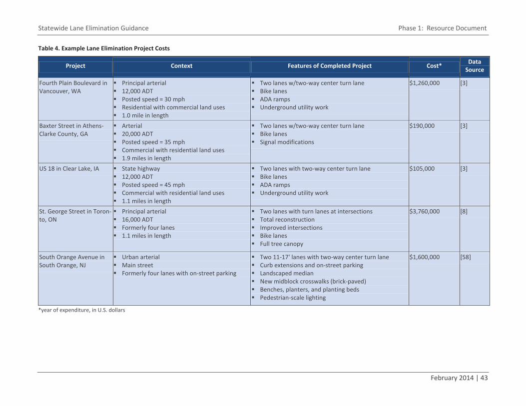
Statewide Lane Elimination Guidance Phase 1: Resource Document
February 2014 | 43
Table 4. Example Lane Elimination Project Costs
Project Context Features of Completed Project Cost* Data Source
Fourth Plain Boulevard in Vancouver, WA
Principal arterial 12,000 ADT Posted speed = 30 mph Residential with commercial land uses 1.0 mile in length
Two lanes w/two-way center turn lane Bike lanes ADA ramps Underground utility work
$1,260,000 [3]
Baxter Street in Athens-Clarke County, GA
Arterial 20,000 ADT Posted speed = 35 mph Commercial with residential land uses 1.9 miles in length
Two lanes w/two-way center turn lane Bike lanes Signal modifications
$190,000 [3]
US 18 in Clear Lake, IA State highway 12,000 ADT Posted speed = 45 mph Commercial with residential land uses 1.1 miles in length
Two lanes with two-way center turn lane Bike lanes ADA ramps Underground utility work
$105,000 [3]
St. George Street in Toron-to, ON
Principal arterial 16,000 ADT Formerly four lanes 1.1 miles in length
Two lanes with turn lanes at intersections Total reconstruction Improved intersections Bike lanes Full tree canopy
$3,760,000 [8]
South Orange Avenue in South Orange, NJ
Urban arterial Main street Formerly four lanes with on-street parking
Two 11-17' lanes with two-way center turn lane Curb extensions and on-street parking Landscaped median New midblock crosswalks (brick-paved) Benches, planters, and planting beds Pedestrian-scale lighting
$1,600,000 [58]
*year of expenditure, in U.S. dollars

44 | Kittelson & Associates, Inc.
Including facilities for multimodal users in a corridor can create opportunities to access new funding sources. [59] Potential funding sources for lane elimination projects include the federal Transportation Alternatives Pro-gram (into which the Safe Routes to School Program was absorbed), the Transportation Investment Generating Economic Recovery (TIGER) program, the Sustainable Communi-ties Challenge grants program, Main Street programs, Community Development Block Grants, and various local sources. [55]
Impacts:
The desire to coordinate a lane elimina-tion project with a programmed project might impact the schedule of one or both of the projects.
Factors to consider:
If the lane elimination project leads to implementation of a Complete Street, the needs of multiple users can be inte-grated into the project early, minimizing calls for future retrofits.
The potential outcomes of lane elimina-tion projects are beneficial to the health of communities and the environment. The short-term cost of a lane elimination project could be perceived as a long-term investment in sustainability and ac-tive transportation.
Lane elimination projects that reduce crashes can save funding later. [59]
Costs will vary by location and year. [55]
There may be opportunities to share the costs of studies, design, and implemen-tation among multiple stakeholders.
4.19 COMMUNITY SUPPORT
Profile Gaining public acceptance for lane elimina-tion projects is important but can be chal-lenging. A study by Vergis and Niemeier [61] reports that public support for a lane elimi-nation project is linked to perceived safety, perceived comfort, volume of bicyclists, and expected cross-street congestion. Public participation is often coordinated with out-reach to elected officials.
There are multiple tools available to assess and/or build community support for a lane elimination project. These include the fol-lowing:
Trial period – Trial periods help gauge the level of support for a lane elimina-tion project through a simulation of the project. Pilot implementations are a powerful tool because they provide an opportunity to validate an approach for deployment and show the community how the project will operate. Executing a pilot implementation can also uncover operability issues and provide an oppor-tunity to address these issues before roll-out. To effectively prepare for a pilot implementation, a detailed approach and an effective means of monitoring should be developed.
Poll – A citizens’ poll or vote is another tool for assessing public support. Com-
bined with a trial period (e.g., conduct-ing the poll or vote before and after the trial), it is even more effective. In gen-eral, poll and votes should be conducted in a manner that results in a statistically sound representation of all community members.
Media – Creating a web page for the project is a way to reach the public. In-teractive blogs enable public participa-tion. Social media can be used to keep the community up-to-date on the pro-ject. Webinars are a means of providing access to information. Educating the public about the potential impacts of the lane elimination project is essential.
Workshop – Workshops are a more en-gaged form of public participation and educational outreach.
Impacts:
It is not uncommon for a lane elimina-tion proposal to generate controversy. The strongest objections from the com-munity typically come from the stake-holders who are afraid of a reduction in the motorized capacity of the road. Commuters, businesses, transit opera-tors, and freight operators usually be-long to this group.
Issue: Community Support
Community support for a lane elimination project is essential but can be challenging to obtain.
Statewide Lane Elimination Guidance Phase 1: Resource Document
February 2014 | 45
Bicyclists and walkers tend to be sup-portive of lane elimination projects, par-ticularly when the projects create or en-hance bicycle and pedestrian facilities. Environmental groups and health advo-cates tend to favor lane elimination pro-jects as well.
Factors to consider:
Timing the public outreach effort with project development
Ease with which the community can ob-tain information about the project and provide input
Obtaining feedback from an adequately representative sample of the community
Funding community outreach activities
4.20 OTHER ISSUES Other issues that might be considered in de-veloping a procedure for reviewing lane elimination requests include the following:
Assessment of person capacity in the corridor instead of vehicle capacity
Analysis of alternatives to lane elimina-tion
Assessment of railroad crossing impacts Feasibility of the project schedule FDOT Central Office coordination re-
quirements
5.0 EXISTING PROCESSES FOR REVIEWING LANE ELIMINATION REQUESTS 5.1 INTRODUCTION The purpose of this chapter is to identify and describe existing processes for reviewing lane elimination requests. This information will provide Florida Department of Transpor-tation (FDOT) District staff with examples of guidelines and processes for reviewing lane elimination requests.
The processes described in this chapter in-clude the existing FDOT District Four and FDOT District Seven processes. Also included are Michigan DOT's process and the process used in the City of Sunnyvale, California. The remaining process described in this guide is a conceptual process outlined by FDOT Dis-trict Five; the District Five process is transit-focused but contains elements applicable to other types of lane elimination projects.
Overall, efforts to identify existing processes for reviewing lane elimination requests re-vealed that few such processes have been
formalized. While many agencies and gov-ernments make use of information about the impacts of lane elimination when pro-posing or reviewing lane elimination pro-jects, most do not have formal processes or guidelines to assist them in their efforts.
5.2 FDOT DISTRICT FOUR DRAFT PROCESS
Overview FDOT District Four's process was developed to create consistency in the District's han-dling of an increasing number of lane elimi-nation requests from local governments and other agencies. The process is currently in draft form. The process is intended to give applicants as much information as early as possible to help them decide whether or not the lane elimination request is feasible.
Description Table 5 summarizes the characteristics of the draft District Four review process. Ap-pendix A contains District Four's description of its draft review process.
The draft District Four process has been cir-culated among other FDOT Districts and FDOT Central Office. Comments on the pro-cess received to date suggest the following improvements:
Other Issues
Person capacity vs. vehicle capacity
Alternatives to lane elimination
Railroad crossings
Project schedule
Central Office coordination
Few formal processes for reviewing lane elimination requests exist.

46 | Kittelson & Associates, Inc.
Add a definition of lane elimination to the process document.
Note that towns, TPOs, counties, and developers may also be applicants.
Consider that local governments without the technical resources and/or funding might ask FDOT to conduct lane elimina-tion studies on their behalf. This may occur through the identification of MPO/TPO priorities and Work Program development.
Note that State roads might also be part of the National Highway System (NHS) or Strategic Highway Network (STRAHNET).
Include access management classifica-tion as an issue of concern and a data need.
Another issue to address is whether or not federal funding was used to widen a given roadway to its current cross sec-tion.
Consider separating the process from the required technical documentation. There may not be a need to include rep-resentatives of each office in all stages.
The District Coordinator could conduct a preliminary review of submitted docu-mentation and analyses to ensure that the documentation and analyses are complete before they are transmitted to all of the offices.
Clarify the text by replacing "challenges" with "fatal flaws." The process should only be stopped for fatal flaws.
Add the following to the list of topics to be addressed at the initial meeting:
▫ Consistency with previous Project Development and Environment (PD&E) commitments
▫ Potential impacts to active construc-tion projects in the area
▫ Alternatives to the proposed lane elimination
▫ Potential design variances or excep-tions
▫ Benefits to non-automobile modes, including Americans with Disabilities Act (ADA) and transit access im-provements
▫ Utility impact assessment and utility coordination plan
▫ Proposed modifications to bridges ▫ Proposed modifications to traffic
signal and sign structures
Consider including a discussion of poten-tial commitments in the initial meeting. This would provide the applicant with more guidance for developing the con-ceptual implementation plan in the con-cept report.
Consider eliminating the Central Office notice requirement in Stage 1, as the applicant may choose to withdraw the lane elimination request after the initial meeting.
Add the following to the concept report requirements: ▫ Volumes and analyses for existing
and future no-build and build sce-narios (not just near- and long-term volumes and analyses)
▫ Possible relocation of delivery zones and truck staging areas
▫ Coordination with the county emer-gency management department and the regional planning council regard-ing hurricane evacuation routes
▫ Public involvement documentation (in Stage 2 instead of Stage 3)
▫ Conceptual access management plan ▫ Assessment of modifications to me-
dians and median openings ▫ Impact on drainage, wetlands, sur-
face waters, and habitats, including how impacts will be mitigated and what level of permitting is required (if any)
▫ Impacts to existing utilities and utili-ty easements and discussion of utili-ty relocations
▫ Impacts to existing bridges and traf-fic signal and sign structures
▫ Before-and-after evaluation of mul-timodal level of service (MMLOS) consistent with the latest edition of the FDOT Quality/Level of Service Handbook
▫ Consider clarifying that the concept report should present conceptual designs that do not degrade existing substandard roadway elements.
▫ Consider including an application document.
▫ Consider requiring the District Secre-tary to sign off on the District staff recommendation.

Statewide Lane Elimination Guidance Phase 1: Resource Document
February 2014 | 47
Table 5. Summary of FDOT District Four Lane Elimination Review Process
Under what circumstances is the process used?
The process is used when an applicant approaches the District to discuss a potential or proposed lane elimination project on a State road.
To whom does the process apply?
The applicant is typically a city, county, or MPO.
What project components are reviewed?
The reviewed project components are:
Project location Project limits Project length Proposed change in lane configuration Project schedule Transportation analysis Design plans (conceptual and detailed)
The District also review's the applicant's impact assessment (referred to as a concept report). This assessment must include:
Conceptual design plans (including proposed typical sections) that meet FDOT design standards for all transportation modes Need for any design variations or exceptions Near- and long-term traffic forecasts with and without the proposed project (with changes in travel patterns clearly shown) Near- and long-term level of service (LOS) and queuing analyses for intersections and segments in the impact area Mitigation to address any significant and adverse LOS impacts on State roads and the regional transportation system resulting from
the lane elimination Impact on pedestrian and bicycle infrastructure (e.g., sidewalks, bicycle lanes, and multi-use paths) and connectivity Impact on transit routes and/or transit stop locations (including appropriateness of turn radii and lane widths) Impact on trucks and truck routes (including appropriateness of turn radii and lane widths and possible relocation of designated
truck routes) Crash analysis (including five years of crash data for pedestrian/bicycle crashes, three years of crash data for all other types of
crashes, identification of high-crash locations, and a Crash Modification Factor assessment) Conceptual funding plan (including cost estimates and funding sources) Conceptual implementation plan (including an implementation schedule and a list of the commitments that the applicant will
make in support of the lane elimination proposal)
At the application stage, the District requires a resolution by the appropriate local government governing body, documentation of public involvement activities and public comment, a final concept report (as applicable), a final funding plan (as applicable), and a final implementation plan (as applicable).
continued
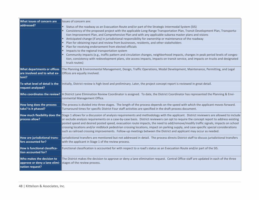
48 | Kittelson & Associates, Inc.
What issues of concern are addressed?
Issues of concern are:
Status of the roadway as an Evacuation Route and/or part of the Strategic Intermodal System (SIS) Consistency of the proposed project with the applicable Long-Range Transportation Plan, Transit Development Plan, Transporta-
tion Improvement Plan, and Comprehensive Plan and with any applicable subarea master plans and visions Anticipated change (if any) in jurisdictional responsibility for ownership or maintenance of the roadway Plan for obtaining input and review from businesses, residents, and other stakeholders Plan for receiving endorsement from elected officials Impacts to the regional transportation system Community impacts (e.g., traffic pattern and circulation changes, neighborhood impacts, changes in peak period levels of conges-
tion, consistency with redevelopment plans, site access impacts, impacts on transit service, and impacts on trucks and designated truck routes)
What departments or offices are involved and to what ex-tent?
The Planning & Environmental Management, Design, Traffic Operations, Modal Development, Maintenance, Permitting, and Legal Offices are equally involved.
To what level of detail is the request analyzed?
Initially, District review is high-level and preliminary. Later, the project concept report is reviewed in great detail.
Who coordinates the review? A District Lane Elimination Review Coordinator is assigned. To date, the District Coordinator has represented the Planning & Envi-ronmental Management Office.
How long does the process take? Is it phased?
The process is divided into three stages. The length of the process depends on the speed with which the applicant moves forward. Turnaround times for specific District Four staff activities are specified in the draft process document.
How much flexibility does the process allow?
Stage 1 allows for a discussion of analysis requirements and methodology with the applicant. District reviewers are allowed to include or exclude analysis requirements on a case-by-case basis. District reviewers can opt to require the concept report to address existing posted speed and desired posted speed, evacuation route impacts, the need to add/remove/modify traffic signals, impacts on school crossing locations and/or midblock pedestrian crossing locations, impact on parking supply, and case-specific special considerations such as railroad crossing improvements. Follow-up meetings between the District and applicant may occur as needed.
How are jurisdictional trans-fers accounted for?
Jurisdictional transfers are mentioned but not addressed in detail. The process directs District staff to discuss jurisdictional transfers with the applicant in Stage 1 of the review process.
How is functional classifica-tion accounted for?
Functional classification is accounted for with respect to a road's status as an Evacuation Route and/or part of the SIS.
Who makes the decision to approve or deny a lane elimi-nation request?
The District makes the decision to approve or deny a lane elimination request. Central Office staff are updated in each of the three stages of the review process.
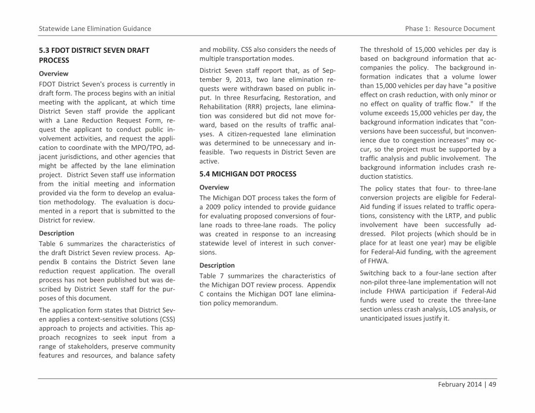
Statewide Lane Elimination Guidance Phase 1: Resource Document
February 2014 | 49
5.3 FDOT DISTRICT SEVEN DRAFT PROCESS
Overview FDOT District Seven's process is currently in draft form. The process begins with an initial meeting with the applicant, at which time District Seven staff provide the applicant with a Lane Reduction Request Form, re-quest the applicant to conduct public in-volvement activities, and request the appli-cation to coordinate with the MPO/TPO, ad-jacent jurisdictions, and other agencies that might be affected by the lane elimination project. District Seven staff use information from the initial meeting and information provided via the form to develop an evalua-tion methodology. The evaluation is docu-mented in a report that is submitted to the District for review.
Description Table 6 summarizes the characteristics of the draft District Seven review process. Ap-pendix B contains the District Seven lane reduction request application. The overall process has not been published but was de-scribed by District Seven staff for the pur-poses of this document.
The application form states that District Sev-en applies a context-sensitive solutions (CSS) approach to projects and activities. This ap-proach recognizes to seek input from a range of stakeholders, preserve community features and resources, and balance safety
and mobility. CSS also considers the needs of multiple transportation modes.
District Seven staff report that, as of Sep-tember 9, 2013, two lane elimination re-quests were withdrawn based on public in-put. In three Resurfacing, Restoration, and Rehabilitation (RRR) projects, lane elimina-tion was considered but did not move for-ward, based on the results of traffic anal-yses. A citizen-requested lane elimination was determined to be unnecessary and in-feasible. Two requests in District Seven are active.
5.4 MICHIGAN DOT PROCESS
Overview The Michigan DOT process takes the form of a 2009 policy intended to provide guidance for evaluating proposed conversions of four-lane roads to three-lane roads. The policy was created in response to an increasing statewide level of interest in such conver-sions.
Description Table 7 summarizes the characteristics of the Michigan DOT review process. Appendix C contains the Michigan DOT lane elimina-tion policy memorandum.
The threshold of 15,000 vehicles per day is based on background information that ac-companies the policy. The background in-formation indicates that a volume lower than 15,000 vehicles per day have "a positive effect on crash reduction, with only minor or no effect on quality of traffic flow." If the volume exceeds 15,000 vehicles per day, the background information indicates that "con-versions have been successful, but inconven-ience due to congestion increases" may oc-cur, so the project must be supported by a traffic analysis and public involvement. The background information includes crash re-duction statistics.
The policy states that four- to three-lane conversion projects are eligible for Federal-Aid funding if issues related to traffic opera-tions, consistency with the LRTP, and public involvement have been successfully ad-dressed. Pilot projects (which should be in place for at least one year) may be eligible for Federal-Aid funding, with the agreement of FHWA.
Switching back to a four-lane section after non-pilot three-lane implementation will not include FHWA participation if Federal-Aid funds were used to create the three-lane section unless crash analysis, LOS analysis, or unanticipated issues justify it.

50 | Kittelson & Associates, Inc.
Table 6. Summary of FDOT District Seven Lane Elimination Review Process
Under what circumstances is the process used?
The process is used when an applicant submits an application for a proposed lane elimination project on a State road.
To whom does the process apply?
Applicants include local governments and citizens.
What project components are reviewed?
The application form requires the following:
US route number and/or State road number SIS and FIHS status NHS designation Evacuation route status Roadway identification number Location of roadway in a protected area Location of roadway in Multimodal Transportation District, Transportation Concurrency Exception Area, Community Redevelop-
ment Area, Dense Urban Land Area, etc. Project endpoints (including milepoints) Functional classification Access classification Corridor width Corridor preservation width Posted speed limit Roadway design Unique design features Pedestrian features Roadway ownership and whether or not a jurisdictional transfer is being requested Characteristics of parallel roadways (location, width, speed limit, pedestrian features, on-street parking, and roadway design) Existing annual average daily traffic (AADT) and LOS Future AADT and LOS LOS standard A.M. peak hour P.M. peak hour Traffic signal characteristics (type and location) Type and frequency of existing transit service
continued
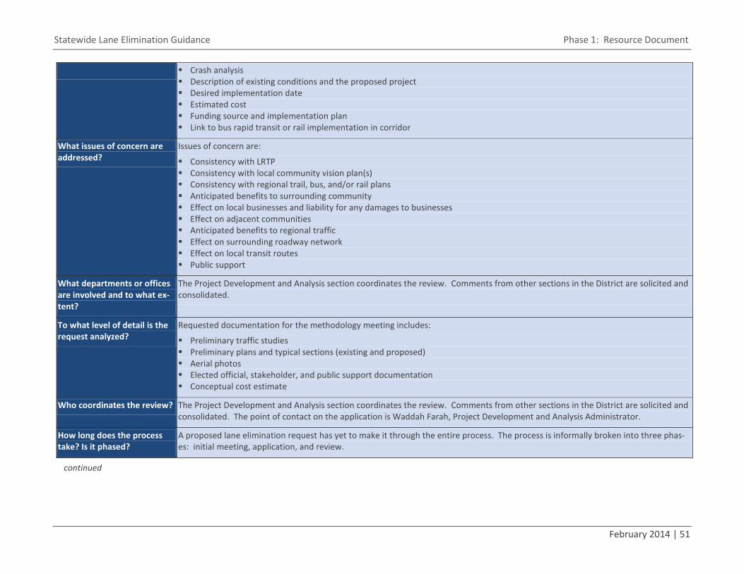
Statewide Lane Elimination Guidance Phase 1: Resource Document
February 2014 | 51
Crash analysis Description of existing conditions and the proposed project Desired implementation date Estimated cost Funding source and implementation plan Link to bus rapid transit or rail implementation in corridor
What issues of concern are addressed?
Issues of concern are:
Consistency with LRTP Consistency with local community vision plan(s) Consistency with regional trail, bus, and/or rail plans Anticipated benefits to surrounding community Effect on local businesses and liability for any damages to businesses Effect on adjacent communities Anticipated benefits to regional traffic Effect on surrounding roadway network Effect on local transit routes Public support
What departments or offices are involved and to what ex-tent?
The Project Development and Analysis section coordinates the review. Comments from other sections in the District are solicited and consolidated.
To what level of detail is the request analyzed?
Requested documentation for the methodology meeting includes:
Preliminary traffic studies Preliminary plans and typical sections (existing and proposed) Aerial photos Elected official, stakeholder, and public support documentation Conceptual cost estimate
Who coordinates the review? The Project Development and Analysis section coordinates the review. Comments from other sections in the District are solicited and consolidated. The point of contact on the application is Waddah Farah, Project Development and Analysis Administrator.
How long does the process take? Is it phased?
A proposed lane elimination request has yet to make it through the entire process. The process is informally broken into three phas-es: initial meeting, application, and review.
continued
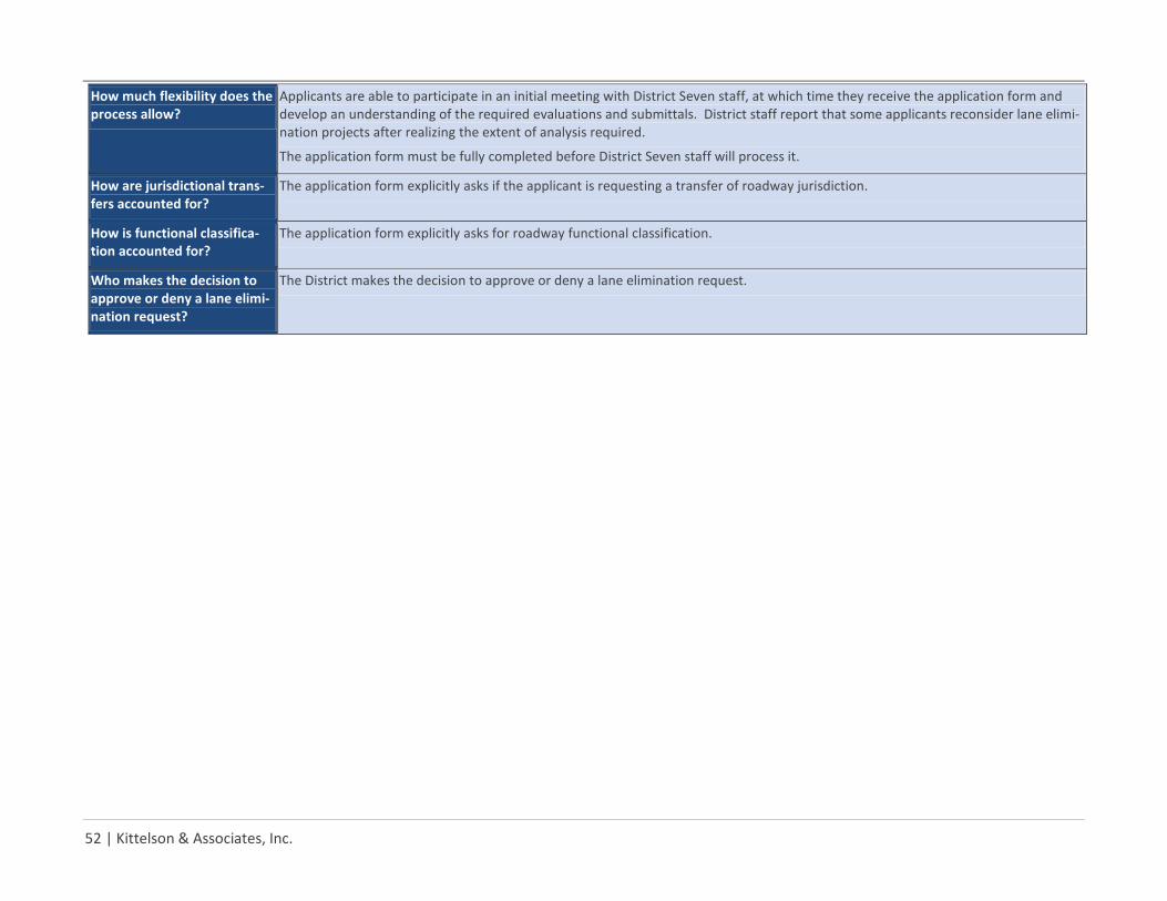
52 | Kittelson & Associates, Inc.
How much flexibility does the process allow?
Applicants are able to participate in an initial meeting with District Seven staff, at which time they receive the application form and develop an understanding of the required evaluations and submittals. District staff report that some applicants reconsider lane elimi-nation projects after realizing the extent of analysis required.
The application form must be fully completed before District Seven staff will process it.
How are jurisdictional trans-fers accounted for?
The application form explicitly asks if the applicant is requesting a transfer of roadway jurisdiction.
How is functional classifica-tion accounted for?
The application form explicitly asks for roadway functional classification.
Who makes the decision to approve or deny a lane elimi-nation request?
The District makes the decision to approve or deny a lane elimination request.
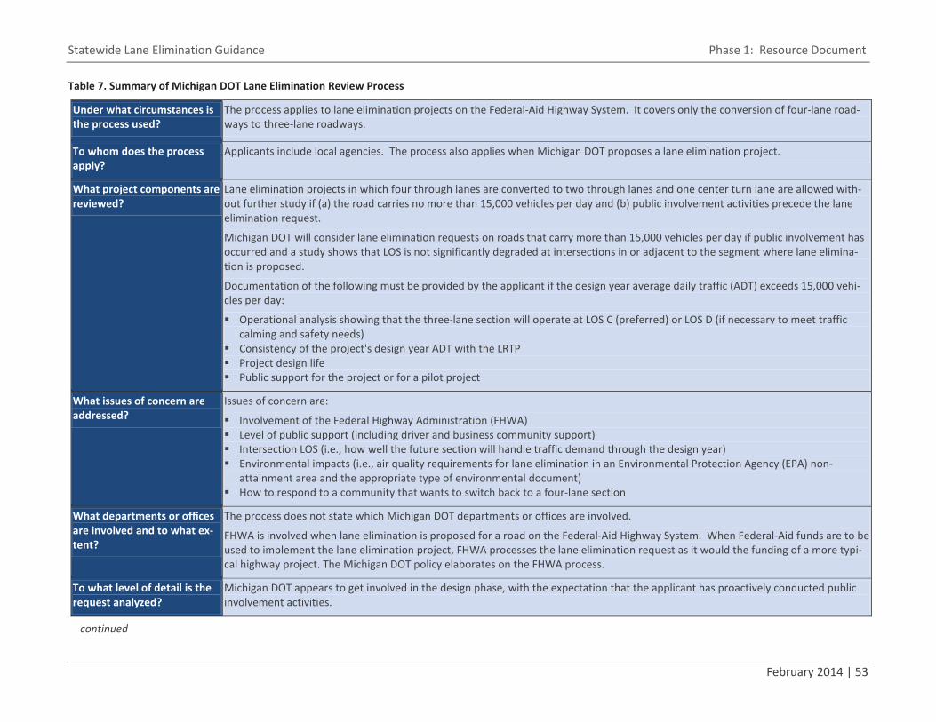
Statewide Lane Elimination Guidance Phase 1: Resource Document
February 2014 | 53
Table 7. Summary of Michigan DOT Lane Elimination Review Process
Under what circumstances is the process used?
The process applies to lane elimination projects on the Federal-Aid Highway System. It covers only the conversion of four-lane road-ways to three-lane roadways.
To whom does the process apply?
Applicants include local agencies. The process also applies when Michigan DOT proposes a lane elimination project.
What project components are reviewed?
Lane elimination projects in which four through lanes are converted to two through lanes and one center turn lane are allowed with-out further study if (a) the road carries no more than 15,000 vehicles per day and (b) public involvement activities precede the lane elimination request.
Michigan DOT will consider lane elimination requests on roads that carry more than 15,000 vehicles per day if public involvement has occurred and a study shows that LOS is not significantly degraded at intersections in or adjacent to the segment where lane elimina-tion is proposed.
Documentation of the following must be provided by the applicant if the design year average daily traffic (ADT) exceeds 15,000 vehi-cles per day:
Operational analysis showing that the three-lane section will operate at LOS C (preferred) or LOS D (if necessary to meet traffic calming and safety needs)
Consistency of the project's design year ADT with the LRTP Project design life Public support for the project or for a pilot project
What issues of concern are addressed?
Issues of concern are:
Involvement of the Federal Highway Administration (FHWA) Level of public support (including driver and business community support) Intersection LOS (i.e., how well the future section will handle traffic demand through the design year) Environmental impacts (i.e., air quality requirements for lane elimination in an Environmental Protection Agency (EPA) non-
attainment area and the appropriate type of environmental document) How to respond to a community that wants to switch back to a four-lane section
What departments or offices are involved and to what ex-tent?
The process does not state which Michigan DOT departments or offices are involved.
FHWA is involved when lane elimination is proposed for a road on the Federal-Aid Highway System. When Federal-Aid funds are to be used to implement the lane elimination project, FHWA processes the lane elimination request as it would the funding of a more typi-cal highway project. The Michigan DOT policy elaborates on the FHWA process.
To what level of detail is the request analyzed?
Michigan DOT appears to get involved in the design phase, with the expectation that the applicant has proactively conducted public involvement activities.
continued
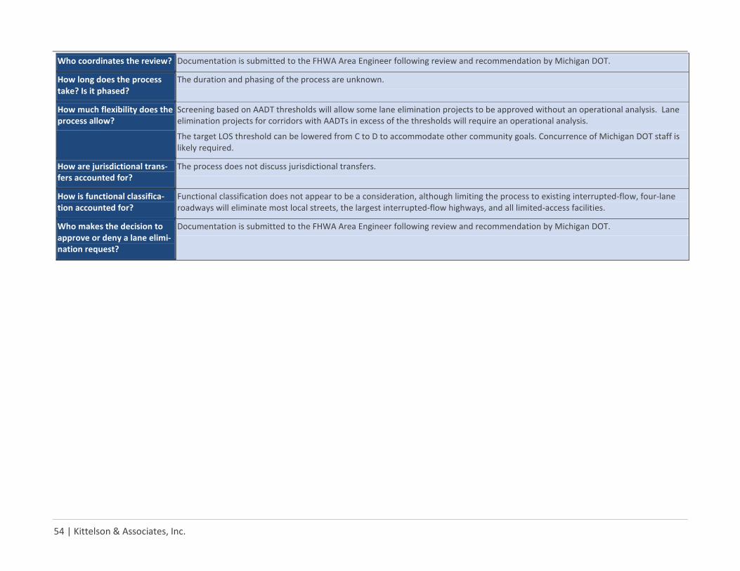
54 | Kittelson & Associates, Inc.
Who coordinates the review? Documentation is submitted to the FHWA Area Engineer following review and recommendation by Michigan DOT.
How long does the process take? Is it phased?
The duration and phasing of the process are unknown.
How much flexibility does the process allow?
Screening based on AADT thresholds will allow some lane elimination projects to be approved without an operational analysis. Lane elimination projects for corridors with AADTs in excess of the thresholds will require an operational analysis.
The target LOS threshold can be lowered from C to D to accommodate other community goals. Concurrence of Michigan DOT staff is likely required.
How are jurisdictional trans-fers accounted for?
The process does not discuss jurisdictional transfers.
How is functional classifica-tion accounted for?
Functional classification does not appear to be a consideration, although limiting the process to existing interrupted-flow, four-lane roadways will eliminate most local streets, the largest interrupted-flow highways, and all limited-access facilities.
Who makes the decision to approve or deny a lane elimi-nation request?
Documentation is submitted to the FHWA Area Engineer following review and recommendation by Michigan DOT.
Statewide Lane Elimination Guidance Phase 1: Resource Document
February 2014 | 55
5.5 CITY OF SUNNYVALE (CALIFORNIA) PROCESS
Overview The City of Sunnyvale process is rooted in policy language in the City's General Plan. A "Policy on the Allocation of Street Space" was proposed by the City's Bicycle and Pe-destrian Advisory Commission and adopted by the City Council in 2009. The Council amended the General Plan in 2011 to incor-porate the policy. The purpose of the policy is "to provide direction on how to consider all modes of transportation when allocating roadway space, particularly in situations that could require the removal of travel lanes [or] on-street parking...." Application of this pol-icy generally includes conducting a standard-ized set of evaluations and completing a standardized evaluation table.
Description Table 8 summarizes the characteristics of the City of Sunnyvale analysis and review process. Appendix D contains the City's "Policy on the Allocation of Street Space" and examples of how it has been used.
City staff note that it is not always possible to meet all objectives within the available right-of-way. In such cases, safety takes precedence over capacity and providing for multimodal travel takes precedence over providing on-street parking.
5.6 FDOT DISTRICT FIVE CONCEPTUAL PROCESS
Overview District Five has prepared a conceptual framework for evaluating lane elimination requests when such requests are intended to create a dedicated transit lane. This framework has not been finalized or applied. The purposes of the conceptual framework are the following:
Assist the District in ascertaining wheth-er or not a proposed dedicated transit lane is consistent with the goals of the community and region
Assist the District in ascertaining wheth-er or not a proposed dedicated transit lane is consistent with FDOT's mission
Assist communities in implementing pro-jects that are consistent with FDOT's mission
FDOT's mission is providing a safe transpor-tation system "that ensures the mobility of people and goods, enhances economic pros-perity, and preserves the quality of our envi-ronment and communities."
Description Table 9 summarizes the characteristics of the District Five conceptual review process. Appendix E contains District Five's conceptu-al framework.
5.7 SUMMARY OF EXISTING LANE ELIMINATION REVIEW PROCESSES As noted in the introduction section of this document, few lane elimination review pro-cesses have been formally documented. Given the complexity of lane elimination projects, formal documentation of a review process is likely to be beneficial to reviewers in that it provides a checklist of issues to as-sess. Formal documentation of a process is also likely to be beneficial to applicants be-cause it clarifies the level of analysis that is needed for District reviewers to comprehen-sively review a lane elimination request.
Existing formal processes for reviewing lane elimination requests are all concerned with project funding, community support, and impacts on traffic operations.
Most existing formal processes for reviewing lane elimination requests are concerned with environmental impacts, safety impacts, con-sistency with planned and programmed pro-jects, and the needs of pedestrians and bicy-clists.
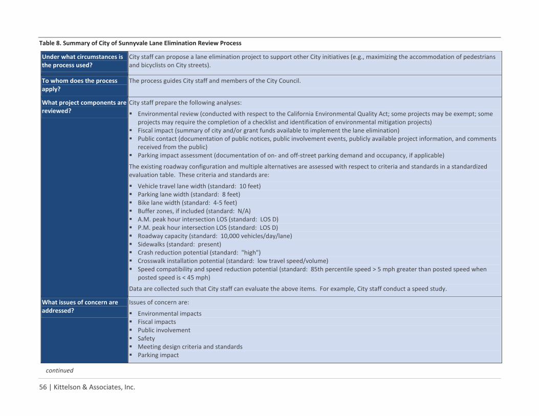
56 | Kittelson & Associates, Inc.
Table 8. Summary of City of Sunnyvale Lane Elimination Review Process
Under what circumstances is the process used?
City staff can propose a lane elimination project to support other City initiatives (e.g., maximizing the accommodation of pedestrians and bicyclists on City streets).
To whom does the process apply?
The process guides City staff and members of the City Council.
What project components are reviewed?
City staff prepare the following analyses:
Environmental review (conducted with respect to the California Environmental Quality Act; some projects may be exempt; some projects may require the completion of a checklist and identification of environmental mitigation projects)
Fiscal impact (summary of city and/or grant funds available to implement the lane elimination) Public contact (documentation of public notices, public involvement events, publicly available project information, and comments
received from the public) Parking impact assessment (documentation of on- and off-street parking demand and occupancy, if applicable)
The existing roadway configuration and multiple alternatives are assessed with respect to criteria and standards in a standardized evaluation table. These criteria and standards are:
Vehicle travel lane width (standard: 10 feet) Parking lane width (standard: 8 feet) Bike lane width (standard: 4-5 feet) Buffer zones, if included (standard: N/A) A.M. peak hour intersection LOS (standard: LOS D) P.M. peak hour intersection LOS (standard: LOS D) Roadway capacity (standard: 10,000 vehicles/day/lane) Sidewalks (standard: present) Crash reduction potential (standard: "high") Crosswalk installation potential (standard: low travel speed/volume) Speed compatibility and speed reduction potential (standard: 85th percentile speed > 5 mph greater than posted speed when
posted speed is < 45 mph)
Data are collected such that City staff can evaluate the above items. For example, City staff conduct a speed study.
What issues of concern are addressed?
Issues of concern are:
Environmental impacts Fiscal impacts Public involvement Safety Meeting design criteria and standards Parking impact
continued
Statewide Lane Elimination Guidance Phase 1: Resource Document
February 2014 | 57
What departments or offices are involved and to what ex-tent?
City Public Works staff conduct the required analyses.
To what level of detail is the request analyzed?
City staff review proposed lane elimination projects with respect to environmental impacts, fiscal impacts, and public involvement, based on recent examples of how the policy has been applied.
Who coordinates the review? City Public Works staff coordinate the required analyses and the presentation of results to the City Council.
How long does the process take? Is it phased?
The duration of the process is unknown. It is not phased.
How much flexibility does the process allow?
The process appears to require multiple analysis alternatives. City staff appear to have discretion in developing the alternatives and designing the analyses.
How are jurisdictional trans-fers accounted for?
The policy appears to apply only to City streets.
How is functional classifica-tion accounted for?
Functional classification does not appear to be a consideration, although it might influence roadway design criteria and standards.
Who makes the decision to approve or deny a lane elimi-nation request?
The City Council makes the final decision based on a staff report.

58 | Kittelson & Associates, Inc.
Table 9. Summary of FDOT District Five Conceptual Lane Elimination Review Process
Under what circumstances is the process used?
The process applies when a local government or other agency proposes converting general-purpose through lanes on a State roadway to dedicated transit lanes.
To whom does the process apply?
The process applies to communities, municipalities, and regions.
What project components are reviewed?
The framework considers three general project elements:
Community commitment (consistency with the goals, commitments, and actions of the community and region) Technical analyses (traffic operations and impacts) Implementation feasibility (funding and approvals)
Implementation feasibility is assessed only if the District determines that there is adequate community commitment behind the pro-posed lane elimination project and the project is technically feasible.
Technical analyses should address the following:
Existing and future roadway capacity Existing and future delay Short- and long-term person throughput Short- and long-term LOS Short- and long-term traffic impacts on adjacent roadways
What issues of concern are addressed?
Issues of concern are:
Support of community and regional leadership bodies Existing transit ridership and ridership trends Potential for existing and/or proposed land uses to increase transit ridership Adoption of transit-supportive land uses in the comprehensive plan Inclusion of the transit service that will use the dedicated lane in the LRTP, transit agency’s vision, or TDP Satisfying the community and region's adopted LOS standards General feasibility of roadway configuration scenarios and concepts of operations (using adopted land uses) Extra-jurisdictional impacts and willingness of adjacent jurisdictions to support inclusion of the dedicated lane project in the LRTP Identification and securement of funding for detailed planning and engineering
What departments or offices are involved and to what ex-tent?
The review team should consist of traffic, roadway design, transit, and community planning experts who are experienced in urban transportation and community development issues.
To what level of detail is the request analyzed?
The conceptual process focuses on traffic operations and person throughput. The conceptual process does not discuss pedestrian and bicycle issues or access to transit.
continued
Statewide Lane Elimination Guidance Phase 1: Resource Document
February 2014 | 59
Who coordinates the review? The process is conceptual, but it is possible that the District's Intermodal Systems Development office would coordinate a lane elimi-nation request review.
How long does the process take? Is it phased?
The duration of the process is unknown.
How much flexibility does the process allow?
If the technical analyses do not justify the lane elimination project or show technical feasibility, District staff may provide guidance and suggest milestones to the applicant to strengthen the lane elimination request.
How are jurisdictional trans-fers accounted for?
The process does not discuss jurisdictional transfers.
How is functional classifica-tion accounted for?
The process does not discuss functional classification.
Who makes the decision to approve or deny a lane elimi-nation request?
It is likely that the District makes the decision to approve or deny a lane elimination request.
60 | Kittelson & Associates, Inc.
Other observations about the review pro-cesses contained in this document are the following:
All of the processes are explicitly or im-plicitly limited to review of lane elimina-tion requests on specific types of road-ways (e.g., state roadways, city road-ways, and four-lane roadways). Howev-er, the review process principles are generally applicable to a wider range of roadway types.
Most of the processes described in this document do not include specific criteria against which proposed lane elimination projects are to be reviewed. (The specif-ic criteria that are provided take the form of LOS standards, ADT thresholds, and geometric design criteria.) Districts may wish to include detailed evaluation criteria (e.g., MMLOS standards) in their lane elimination review processes.
Most of the processes do not specify the extent to which analysis requirements and review standards may be sensitive to the purpose of the lane elimination project and/or the specific features of the lane elimination project. A process may ask the applicant to provide the functional classification of the affected roadway, for example, but it does not necessarily indicate the use to which re-viewers will put that information. Dis-tricts may wish to clarify how they will use the information provided in a lane elimination application (i.e., the condi-
tions under which specific analysis re-quirements are applicable).
Two of the processes acknowledge the possibility of pilot (temporary) imple-mentations of lane elimination projects, but only one provides details about how a pilot implementation is to be accom-plished and evaluated. Associated issues for the Districts to consider include the following: ▫ Under what conditions should a pilot
implementation be required? ▫ How long should a pilot implementa-
tion remain in place before it is evaluated?
▫ How should a pilot implementation be evaluated, who conducts the evaluation, and who pays for the evaluation?
▫ If the community does not like the pilot roadway section, who is re-sponsible for restoring the roadway to its original cross section? Who pays for restoring the roadway to its original cross section?
Only one process addresses the issue of precedence when right-of-way is con-strained. If right-of-way in a corridor is constrained to the point where through lane elimination is a potential means of creating space for other roadway ele-ments, which of those other roadway el-ements are the most important? For ex-ample, is on-street parking more im-portant than bicycle lanes? Do District staff have a vision that defines prece-
dence and how state roadway right-of-way is to be used?
Only one process requires applicants to analyze multiple build alternatives.
All of the processes are concerned with the following issues: ▫ Funding proposed lane elimination
projects ▫ Obtaining community support for
proposed lane elimination projects ▫ Analyzing traffic operations impacts
in the affected corridor and in a larger area of impact
Districts may wish to include these is-sues in their processes.
Most of the processes mention the fol-lowing issues: ▫ Analyzing environmental impacts ▫ Analyzing safety impacts ▫ Consistency of the lane elimination
project with adopted plans and vi-sions
▫ Pedestrian and bicyclist needs
Districts may wish to include these is-sues in their processes.
Most of the processes specifically re-quire short- and long-term analyses.
The three FDOT Districts' processes acknowledge a degree of phasing or staging in the lane elimination review process. The District Four and District Seven draft procedures include three stages, while the District Five conceptual procedure includes two stages.

Statewide Lane Elimination Guidance Phase 1: Resource Document
February 2014 | 61
The District Four procedure includes FDOT Central Office notice require-ments. The Michigan DOT procedure in-cludes FHWA notice requirements.
The Michigan DOT procedure allows for the approval of lane elimination projects on lower-volume roadways without preparation of an operational analysis. Districts may wish to consider establish-ing thresholds under which analysis re-quirements are simplified.
6.0 REFERENCES 1. "Rightsizing Streets." Project for Public
Spaces, accessed December 13, 2013. Available at http://www.pps.org /reference/rightsizing/.
2. Tan, C.H. Going on a Road Diet. FHWA-HRT-11-006. FHWA, Washington, D.C., September-October 2011.
3. Kittelson & Associates, Inc., “Road Diets – White Paper.” Portland, OR, January 11, 2011.
4. Missouri DOT, Missouri LTAP, and Mis-souri Coalition for Roadway Safety. Traf-fic Practices: A Guidebook for City & County Agencies. Missouri Coalition for Roadway Safety, published after 2009.
5. University of North Florida and FAMU-FSU College of Engineering. Integrating Transit into Traditional Neighborhood Design Policies - The Influence of Lane Width on Bus Safety. Final Report. FDOT, Tallahassee, FL, June 2010. Avail-able at http://www.dot.state.fl.us/
transit/Pages/LaneWidthonBus Safe-ty.pdf.
6. Accessing Transit: Design Handbook for Florida Bus Passenger Facilities. Version III. FDOT, Tallahassee, FL, 2013. Available at http://www.dot.state.fl.us/transit/ Pages/2013AccessingTransitFinal.pdf.
7. Typical Sections for Exclusive Transit Running Ways. Final Report. FDOT, Tal-lahassee, FL, June 2013. Available at http://www.dot.state.fl.us/transit/Pages/TypicalSectionsExclusiveTransitRunningways.pdf.
8. D. Burden and P. Lagerway. Road Diets: Fixing the Big Roads. Walkable Commu-nities, Inc., March 1999.
9. Highway Capacity Manual. Transporta-tion Research Board, Washington, D.C., 2010.
10. D. Burden. "Livability and the Role of Transportation." Presentation. Walkable and Livable Communities Institute, Feb-ruary 2013.
11. Manual on Uniform Traffic Control De-vices. 2009 Edition with revisions. FHWA, Washington, D.C., May 2012.
12. Urban Street Design Guidelines. City of Charlotte, Charlotte, NC, 2007.
13. J. A. Rosales, Road Diet Handbook: Set-ting Trends for Livable Streets. Second Edition. Parsons Brinckerhoff, New York City, NY, July 2007.
14. D. Shoup. The High Cost of Free Parking. University of California-Berkeley, Berke-ley, CA, 1997.
15. Right of Way Procedures Manual. Sec-tion 10.6. FDOT, Tallahassee, FL, October 2012. Available at http://www.dot.state. fl.us/rightofway/documents/ROWmanual/ch10s06.pdf.
16. C. McCormick. York Boulevard: The Eco-nomics of a Road Diet. UCLA Luskin School of Public Affairs, Los Angeles, CA, 2012. Available at http://la.streetsblog. org/wp-content/pdf/york_blvd_final_ report_compress.pdf.
17. "El Cajon's Road Diet." Pedestrian and Bicycle Information Center, accessed December 16, 2013. Available at http://katana.hsrc.unc.edu/cms/downloads/ENG.ElCajon'sRoadDiet.pdf.
18. Smart Growth America and National Complete Streets Coalition. "Implement-ing Complete Streets: Sustainable Com-plete Streets." National Complete Streets Coalition, Washington, D.C., 2010.
19. "National Environmental Policy Act (NEPA)." Web page. EPA, Washington, D.C., updated June 25, 2012.
20. "Design Standards for Design, Construc-tion, Maintenance, and Utility Opera-tions on the State Highway System." Year 2014. FDOT, Tallahassee, FL, 2013. Available at http://www.dot.state.fl.us/rddesign/DesignStandards/Standards.shtm.
21. Plans Preparation Manual. FDOT, Talla-hassee, FL, July 1 2013. Available at http://www.dot.state.fl.us/rddesign/PPMManual/PPM.shtm.
62 | Kittelson & Associates, Inc.
22. Work Program Instructions. Tentative Work Program – FY 14/15-18/19. FDOT, Tallahassee, FL, September 30, 2013. Available at http://www.dot.state.fl.us/programdevelopmentoffice/Development/PDF In-structions/WorkProgramInstructions.pdf
23. Florida Statutes, Chapter 339.135. Available at http://www.flsenate.gov/ Laws/Statutes/2013/339.135.
24. Title 23 CFR. Revised April 1, 2011. Available at http://www.gpo.gov/fdsys/ pkg/CFR-2011-title23-vol1/pdf/CFR-2011-title23-vol1.pdf.
25. Florida Statutes, Chapter 339.175. Available at http://www.flsenate.gov/Laws/Statutes/2013/339.175.
26. FDOT. "Florida LRTP Amendment Thresholds." August 7, 2013. Available at http://www.dot.state.fl.us/planning /Policy/metrosupport/lrtpamdmtthresh.pdf.
27. FDOT. Metropolitan Planning Organiza-tion Program Management Handbook. "Long-Range Transportation Plan" chap-ter. May 7, 2012. Available at http://www.dot.state.fl.us/planning/ Policy/metrosupport/mpohandbook/ ch4.pdf.
28. FDOT. Metropolitan Planning Organiza-tion Program Management Handbook. "Transportation Improvement Program" chapter. July 3, 2012. Available at http://www.dot.state.fl.us/planning/Poli
cy/metrosupport/mpohandbook/ ch5.pdf.
29. FDOT. "STIP Information." Available at http://www.dot.state.fl.us/programdevelopmentoffice/federal/stip.shtm.
30. Florida Administrative Code, Rule 14-73.001. Available at https://www.flrules.org/gateway/RuleNo.asp?id=14-73.001.
31. DEO. "Amendment Submittal and Pro-cessing Guidelines." Available at http://www.floridajobs.org/community-planning-and-development/programs/ comprehensive-planning/amendment-submittal-and-processing-guidelines.
32. Florida Statutes, Chapter 163.3177. Available at http://www.flsenate. gov/Laws/Statutes/2013/163.3177.
33. Florida Statutes, Chapter 163.3184. Available at http://www.flsenate.gov/ Laws/Statutes/2013/163.3184.
34. FDOT and FHWA. Final Guidance for Meeting Planning Requirements for NEPA Approval. Forthcoming.
35. Highway Functional Classification: Con-cepts, Criteria and Procedures. FHWA, Washington, D.C., 2013. Available at http://www.fhwa.dot.gov/planning/ processes/statewide/related/highway_ functional_classifications/fcauab.pdf.
36. "Guidance for the Functional Classifica-tion of Highways (Updated)." FHWA, Washington, D.C., October 14, 2008. Available at http://www.fhwa.dot.gov/ policy/ohpi/hpms/fchguidance.cfm.
37. FHWA Urban Boundary and Federal Functional Classification Handbook. FDOT, Tallahassee, FL, April 4, 2003. Available at http://www.dot.state.fl.us/ planning/statistics/hwysys/fchand book.pdf.
38. "Surface Transportation Program (STP)." FHWA. Accessed November 25, 2013. Available at http://www.fhwa.dot.gov/ map21/stp.cfm.
39. Multimodal Transportation Districts and Areawide Quality of Service Handbook. FDOT, Tallahassee, FL, 2003. Available at http://www.reconnectingamerica.org/assets/Uploads/bestpractice098.pdf.
40. "Florida Highway Systems, Numbering and Jurisdiction." FDOT, Tallahassee, FL, accessed November 26, 2013. Available at http://www.dot.state.fl.us/planning/ statistics/hwysys/.
41. Florida Statutes, Chapter 334. Available at http://www.flsenate.gov/Laws/ Stat-utes/2013/Chapter334.
42. Florida Statutes, Chapter 335. Available at http://www.flsenate.gov/Laws/ Stat-utes/2013/Chapter335.
43. "Policy: Context Sensitive Solutions." FDOT, Tallahassee, FL, November 20, 2008. Available at http://www2.dot. state.fl.us/proceduraldocuments/procedures/bin/000650002.pdf.
44. "Policy: Major Urban Corridor Studies." FDOT, Tallahassee, FL, September 20, 2007. Available at http://www2.dot. state.fl.us/proceduraldocuments/procedures/bin/000725010.pdf.7
Statewide Lane Elimination Guidance Phase 1: Resource Document
February 2014 | 63
45. Road Jurisdiction and Numbering Hand-book. FDOT, Tallahassee, FL, July 20, 2006. Available at http://www.dot. state.fl.us/planning/statistics/hwysys/jurisdictionhandbook.pdf.
46. Florida Statutes, Chapter 339.63. Avail-able at http://www.flsenate.gov/Laws/ Statutes/2013/339.63.
47. "Enterprise Strategic Intermodal Sys-tem." FDOT, Tallahassee, FL, accessed November 27, 2013. Available at http://www.dot.state.fl.us/planning/sis/esis.shtm.
48. "A Guide to Federal-Aid Programs and Projects: Introduction." FHWA, Wash-ington, D.C., accessed November 26, 2013. Available at http://www.fhwa. dot.gov/federalaid/projects.pdf#intro.
49. Florida Administrative Code, Rule 14-97. Available at https://www.flrules.org/ gateway/ChapterHome.asp?Chapter=14-97.
50. Nozzi, D. “Economic Merits of Road Diets and Traffic Calming.” Walkable Streets blog. August 17, 2003. Available at http://walkablestreets.wordpress.com/2003/08/17/economic-merits-of-road-diets-and-traffic-calming/
51. FDOT. Road Jurisdiction and Number Procedure. Topic No. 525-020-010. FDOT, Tallahassee, FL, July 2006. Availa-ble at http://www2.dot.state.fl.us/ pro-ceduraldocu-ments/procedures/bin/525020010.pdf.
52. Inspection of Federal-Aid Projects Under Local Jurisdiction. Topic No. 850-065-
001. FDOT, Tallahassee, FL, January 2008. Available at http://www2.dot. state.fl.us/proceduraldocuments/procedures/bin/850065001.pdf.
53. E. Barnett. “Freight Interests’ Dire Pre-dictions About Road Diets Not Borne Out By Data.” Publicola at SeattleMet. March 31, 2011. Available at http://www. seat-tlemet.com/news-and-profiles/public ola/articles/freight-interests-dire-predictions-about-road-diets-not-borne-out-by-data.
54. J. Maus. “Freight Committee: ‘Postpone any advancement’ of Barbur road diet.” BikePortland.org. October 10, 2013. Available at http://bikeportland.org/ 2013/10/10/freight-committee-postpone-any-advancement-of-barbur-road-diet-95306.
55. Complete Streets: Guide to Answering the Costs Question. National Complete Streets Coalition, Washington, D.C., 2013. Available at http://www.smart growthamerica.org/documents/cs/ re-sources/cs-answering-the-costs-question.pdf.
56. "Costs Concerns." Fact sheet. National Complete Streets Coalition, Washington, D.C., 2010. Available at http://www. smartgrowthamerica.org/complete-streets/implementation/cost-concerns.
57. Minnesota's Best Practices for Pedestri-an/Bicycle Safety. Minnesota DOT, Ro-seville, MN, September 2013. Available at http://www.dot.state.mn.us/ re-search/TS/2013/201322.pdf.
58. R. Ewing and M. King. Flexible Design of New Jersey's Main Streets. New Jersey DOT, Trenton, NJ, 2002. Available at http://www.state.nj.us/transportation/publicat/flexibledesign.pdf.
59. "Costs." Fact sheet. National Complete Streets Coalition, Washington, D.C., 2010. Available at http://www.smart growthamerica.org/complete-streets/implementation/factsheets/ costs.
60. D. Stensaas. "Lincoln Avenue Road Diet: A Prescription for Health." Presentation. Evansville MPO, Evansville, IN, 2008. Available at http://www.indianampo. com/PDF/Presentations/P10Stensas.pdf.
61. S. Vergis and D. Neimeier. Understand-ing How Public Perceptions of Road Diets are Formed. Institute of Transportation Studies, University of California, Davis, CA, September 2012.

64 | Kittelson & Associates, Inc.
This page is intentionally blank.

APPENDIX A: FDOT DISTRICT FOUR DRAFT PROCESS

FDOT DISTRICT FOUR DRAFT LANE ELIMINATION REVIEW AND APPROVAL PROCESS FEBRUARY 13, 2013 With a growing interest from local municipalities requesting the elimination of lanes on State roadways, the following review and approval process was developed to assure consistency in FDOT’s handling of these requests. This process is a refinement of a process that was developed and implemented in October 2008 in District Four. The FDOT Lane Elimination Review and Approval Process is a three-stage process:
1. Initial Meeting 2. Interim Meeting and Concept Report 3. Formal Application
The stages of the process are outlined below. Coordination of the Lane Elimination Review and Approval Process is the responsibility of the District Lane Elimination Review Coordinator. The process engages a multi-disciplined review team with representatives from the Planning & Environmental Management, Design, Traffic Operations, Modal Development, Maintenance, Permitting, and Legal offices.
STAGE 1: INITIAL MEETING
Goal District Deliverable(s) Notice Requirement
Obtain preliminary information about the proposed lane elimination project from the applicant and provide preliminary feedback on the process requirements and feasibility of the concept.
Identification of any issues that prevent the application from moving forward
List of items to be discussed at the Initial Meeting List of items to be evaluated in more detail by the
applicant in Stage 2 Initial Meeting summary
Send notice to Central Office (Public Involvement Office) that the District has been contacted about a lane elimination proposal.
The Lane Elimination Review and Approval Process is initiated when the applicant (typically a city, county, or MPO) meets with the District for the first time to discuss a potential or proposed lane elimination project. The Initial Meeting will be arranged by the District Coordinator, who will be responsible for inviting the District's multi-disciplined reviewers to the Initial Meeting and providing them with any materials transmitted by the applicant in advance of the meeting. The purpose of the Initial Meeting is the sharing of preliminary information about the proposed project, discussion of key issues, and a discussion of FDOT concerns.
Typically, this meeting is an opportunity for the applicant to gain an understanding of the Lane Elimination Review and Approval Process. District reviewers are not required to prepare consolidated comments in advance of the Initial Meeting. A copy of this process document will be provided to the applicant when the date, time, and location for the Initial Meeting have been established. The applicant should be prepared to discuss the following items at a preliminary, conceptual level at the Initial Meeting:
Basic information about the proposed project Project location Project limits Project length Proposed change in lane configuration Project schedule Conceptual plan (if available)
Status of the roadway as an Evacuation Route and/or part of the Strategic Intermodal System Consistency of the proposed project with the applicable Long-Range Transportation Plan, Transit Development Plan,
Transportation Improvement Plan, and Comprehensive Plan and with any applicable subarea master plans and visions Existing and historical traffic counts Proposed use(s) for the right-of-way after the lane is eliminated (e.g., widened sidewalks, bicycle lanes, landscaping, on-
street parking, and transit lanes) Existing right-of-way width and any proposed changes to the right-of-way width Anticipated change (if any) in jurisdictional responsibility for ownership or maintenance of the roadway Plan for obtaining input and review from businesses, residents, and other stakeholders Plan for receiving endorsement from elected officials Initial (qualitative) assessment of impacts to the regional transportation system and community impacts:
Traffic pattern and circulation changes Neighborhood impacts Changes in peak period levels of congestion Consistency with redevelopment plans Site access impacts Impacts on transit service (e.g., re-routing and relocation of bus stops) Impacts on trucks and designated truck routes
Ideas for funding sources Potential implementation strategy
At the Initial Meeting, District reviewers will identify any challenges that may make it infeasible for the applicant to proceed with the proposed lane elimination project. If no such challenges are identified, District reviewers at the Initial Meeting will prepare a list of elements for the applicant to analyze in detail and provide to the District in the form of a concept report. The concept report will be discussed at the Interim Meeting in Stage 2. The District Coordinator will also send notice to Central Office (Public Involvement Office) that the District has been contacted about a lane elimination proposal. The District Coordinator will provide a summary of the Initial Meeting as well as the list of elements to be addressed in Stage 2 to the applicant and to the District reviewers. If the affected roadway segment is part of a corridor for which premium transit service is planned or if the eliminated lane is intended to be dedicated to transit, additional requirements may apply. If a jurisdictional transfer of the roadway is part of the project, additional requirements will apply. These additional requirements will be discussed at the Initial Meeting.
STAGE 2: INTERIM MEETING AND CONCEPT REPORT
Goal District Deliverable(s) Notice Requirement
Obtain a detailed evaluation of the proposed lane elimination project from the applicant and provide review comments.
Consolidated review comments Interim Meeting summary List of conditions to be met for approval of lane elimination
application Correspondence stating if FDOT is receptive to the concept and
advancing to the formal application in Stage 3
Send notice to Central Office (Public Involvement Office) that the District has received and reviewed a concept report supporting a proposed lane elimination project.
The purpose of the Interim Meeting is to discuss the results of the detailed analysis conducted by the applicant following the Initial Meeting. The applicant will provide a complete concept report that summarizes this analysis to the District Coordinator no less than two weeks in advance of the Interim Meeting so that District reviewers have adequate opportunity to review the report. District reviewers' comments on the concept report will be consolidated by the District Coordinator in advance of the Interim Meeting and shared at the meeting for the purposes of discussion. The concept report requirements and the items to be discussed at the Interim Meeting will be identified at the Initial Meeting. The following elements, along with the supporting documents for the items discussed at the initial meeting, will be required for all concept reports:
Conceptual design plans (including proposed typical sections) that meet FDOT design standards for all transportation modes Need for any design variations or exceptions Near- and long-term traffic forecasts with and without the proposed project (with changes in travel patterns clearly shown) Near- and long-term level of service (LOS) and queuing analyses for intersections and segments in the impact area
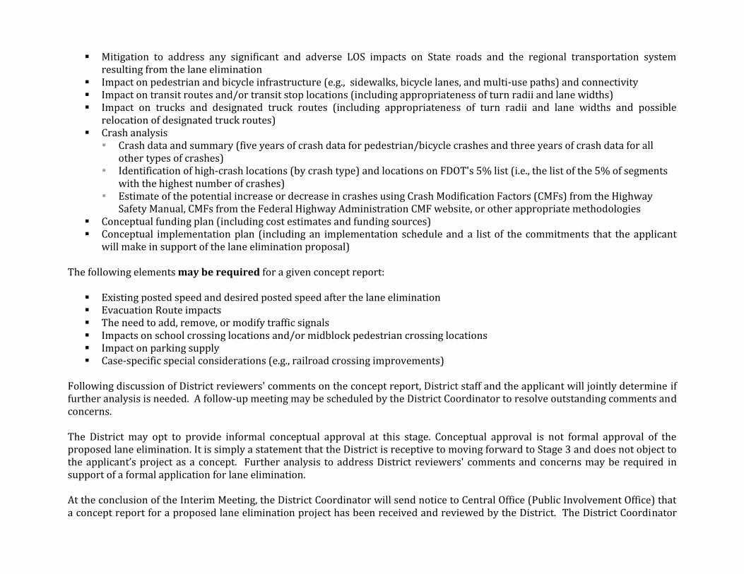
Mitigation to address any significant and adverse LOS impacts on State roads and the regional transportation system resulting from the lane elimination
Impact on pedestrian and bicycle infrastructure (e.g., sidewalks, bicycle lanes, and multi-use paths) and connectivity Impact on transit routes and/or transit stop locations (including appropriateness of turn radii and lane widths) Impact on trucks and designated truck routes (including appropriateness of turn radii and lane widths and possible
relocation of designated truck routes) Crash analysis
Crash data and summary (five years of crash data for pedestrian/bicycle crashes and three years of crash data for all other types of crashes)
Identification of high-crash locations (by crash type) and locations on FDOT's 5% list (i.e., the list of the 5% of segments with the highest number of crashes)
Estimate of the potential increase or decrease in crashes using Crash Modification Factors (CMFs) from the Highway Safety Manual, CMFs from the Federal Highway Administration CMF website, or other appropriate methodologies
Conceptual funding plan (including cost estimates and funding sources) Conceptual implementation plan (including an implementation schedule and a list of the commitments that the applicant
will make in support of the lane elimination proposal) The following elements may be required for a given concept report:
Existing posted speed and desired posted speed after the lane elimination Evacuation Route impacts The need to add, remove, or modify traffic signals Impacts on school crossing locations and/or midblock pedestrian crossing locations Impact on parking supply Case-specific special considerations (e.g., railroad crossing improvements)
Following discussion of District reviewers' comments on the concept report, District staff and the applicant will jointly determine if further analysis is needed. A follow-up meeting may be scheduled by the District Coordinator to resolve outstanding comments and concerns. The District may opt to provide informal conceptual approval at this stage. Conceptual approval is not formal approval of the proposed lane elimination. It is simply a statement that the District is receptive to moving forward to Stage 3 and does not object to the applicant’s project as a concept. Further analysis to address District reviewers' comments and concerns may be required in support of a formal application for lane elimination. At the conclusion of the Interim Meeting, the District Coordinator will send notice to Central Office (Public Involvement Office) that a concept report for a proposed lane elimination project has been received and reviewed by the District. The District Coordinator

will also provide a summary of the Interim Meeting to the applicant and to the District reviewers. The summary will include a list of items to be addressed before the District will approve a formal application for lane elimination in Stage 3.
STAGE 3: FORMAL APPLICATION
Goal District Deliverable(s) Notice Requirement
Approve (or deny) the application for lane elimination.
Approval (or denial) letter
Send notice to Central Office (Secretary) that the District has reviewed a formal application for lane elimination and is recommending approval (or denial) of the application.
In Stage 3, the applicant submits the following documents to the District Coordinator:
Formal application requesting the lane elimination Resolution documenting project approval by the appropriate city or county body (e.g., commission resolution or formal
letter) Documentation that public involvement activities were noticed and occurred Summary of concerns and supportive comments that were voiced at the public meeting(s) or provided through written
communication to the applicant, along with discussion of how any concerns were addressed Final concept report (as applicable) Final funding plan (as applicable) Final implementation plan (as applicable)
The District Coordinator will review the formal application and supporting documents, with input from District staff as needed. The District will send notice to Central Office (Secretary) that the applicant has submitted an application for lane elimination, it has been reviewed by the District, and the District has made a recommendation for approval (or denial). After receiving approval from the Secretary, the District Coordinator will inform the applicant that the application for lane elimination has been approved (or denied). A before-and-after study or a pilot implementation of the concept may be a condition of approval of the application.
PROCESS SUMMARY The flowchart below summarizes the three-stage Lane Elimination Review and Approval Process.
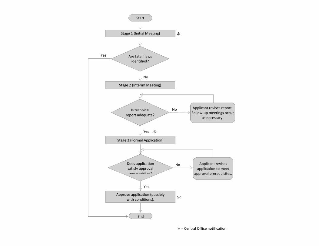
Start
Stage 1 (Initial Meeting)
End
Is technical report adequate?
Applicant revises report. Follow-up meetings occur
as necessary.
Are fatal flaws identified?
Stage 2 (Interim Meeting)
Stage 3 (Formal Application)
Does application satisfy approval prerequisites?
Applicant revises application to meet
approval prerequisites.
Yes
Yes
No
No
No
Yes
Approve application (possibly with conditions).
= Central Office notification

APPENDIX B: FDOT DISTRICT SEVEN DRAFT PROCESS

FDOT DISTRICT SEVEN DRAFT LANE REDUCTION PROCESS AND REQUEST FORM The District Seven Lane Reduction Process includes an initial meeting with the applicant wherein the applicant receives the Lane Reduction Request Form. Based on the initial meeting and the form, a methodology is developed for a report to be submitted to District Seven for review. The initial meeting also requests that the applicant undertake public involvement activities and coordinate with the MPO, neighboring jurisdictions, and other relevant agencies.
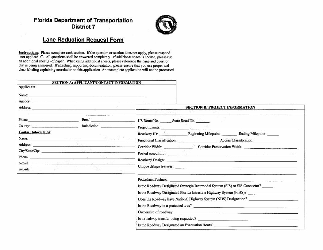


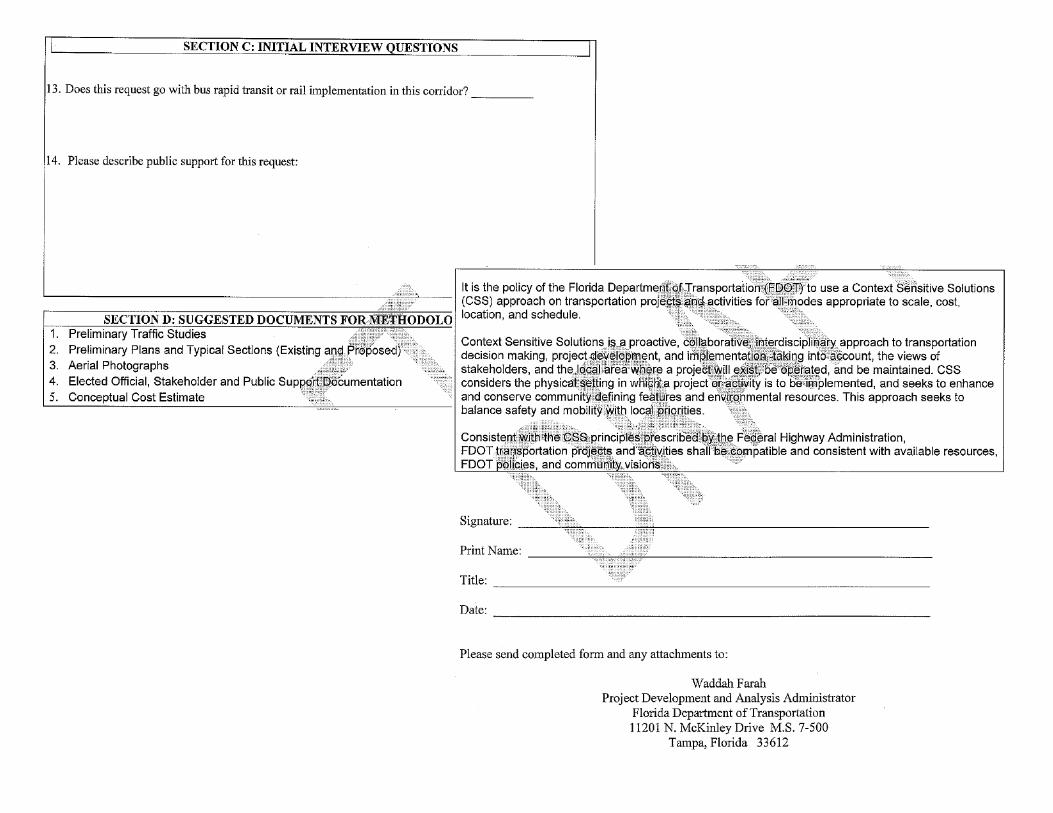


APPENDIX C: MICHIGAN DOT PROCESS

MICHIGAN DOT LANE REDUCTION POLICY AND PROCESS The Michigan FHWA Division Office issued a 2009 memo on the Michigan Operation Manual providing policy guidance on conversion of 4 to 3 lane facilities signed by the Division administrator. In sum, it indicates willingness to approve road diets on the federal aid system for roadways up to 15,000 vpd without further study, provided that proactive public involvement activities preceded the request, and it also indicated a willingness to consider road diets on higher use facilities up to and beyond 20,000 vpd provided that proactive public involvement also occurred and that study determined there was no significant deterioration in service flow quality of intersections in, or adjacent to, the road diet. The memo also clearly recognizes that it does not exempt these projects from review by the interagency work group in non-attainment and maintenance areas or from environmental clearances or other project reviews.
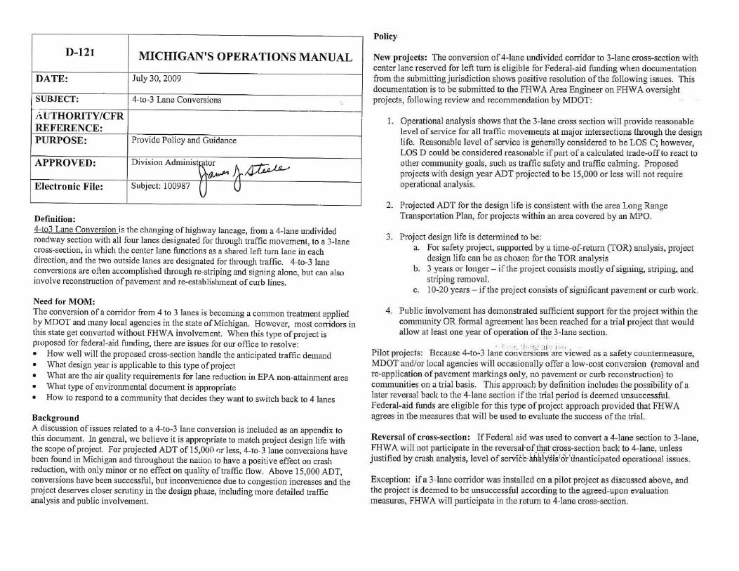
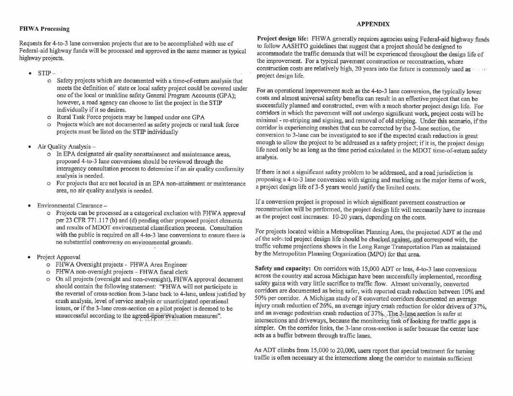

APPENDIX D: CITY OF SUNNYVALE (CA) PROCESS


CITY OF SUNNYVALE (CALIFORNIA) LANE REDUCTION PROCESS AND EVALUATION SUMMARY
—"Report to Mayor and Council," City of Sunnyvale, Bicycle and Pedestrian Advisory Commission (BPAC), August 20, 2012 [Other assessments included in a typical BPAC report are environmental review, fiscal impact, and public contact. An evaluation summary table may be prepared for lane elimination requests as well.] [The following language is from the City's General Plan.] Policy LT-5.5 Support a variety of transportation modes.
LT-5.5a Promote alternate modes of travel to the automobile. LT-5.5b Require sidewalk installation in subdivisions of land and in new, reconstructed, or expanded development. LT-5.5c Support land uses that increase the likelihood of travel mode split. LT-5.5d Maximize the provision of bicycle and pedestrian facilities. LT-5.5e Implement the City of Sunnyvale Bicycle Plan. LT-5.5f Support an efficient and effective paratransit service and transportation facilities for people with special transportation needs. LT-5.5g Ensure safe and efficient pedestrian and bicycle connections to neighborhood transit stops.
LT-5.5h Work to improve bus service within the City, including linkages to rail.
Policy LT-5.6 Minimize expansion of the current roadway system, which maximizing opportunities for alternative transportation systems and related programs.
LT-5.6a Develop clear, safe and convenient linkages between all modes of travel; including access to transit stations and stops and connections between work, home and commercial sites. LT-5.6b Promote public and private transportation demand management.
Policy LT-5.7 Pursue local, state and federal transportation funding sources to finance City transportation capital improvement projects consistent with City priorities.
LT-5.7a Develop alternatives and recommendations for funding mechanisms to finance the planned transportation system. LT-5.7b Develop a funding mechanism where new and existing land uses equitably participate in transportation system improvements.
Policy LT-5.8 Provide a safe and comfortable system of pedestrian and bicycle pathways. Policy LT-5.9 Appropriate accommodations for motor vehicles, bicycles, and pedestrians shall be determined for City streets to increase the use of bicycles for transportation and to enhance the safety and efficiency of the overall street network for bicyclists, pedestrians, and motor vehicles. Policy LT-5.10 All modes of transportation shall have safe access to City streets. Policy LT-5.11 The City should consider enhancing standards for pedestrian facilities. Policy LT-5.12 City streets are public space dedicated to the movement of vehicles, bicycles and pedestrians. Providing safe accommodation for all transportation modes takes priority over non-transport uses. Facilities that meet minimum appropriate safety standards for transport uses shall be considered before non-transport uses are considered. Policy LT-5.13 Parking is the storage of transportation vehicles and shall not be considered a transport use. Policy LT-5.14 Historical precedence for street space dedicated for parking shall be a lesser consideration than providing street space for transportation uses when determining the appropriate future use of street space.
Policy LT-5.15 Parking requirements for private development shall apply to off-street parking only.
LT-5.15a Incentives to offset impacts of roadway changes to non-transportation users shall be considered when retrofitting roadways.
Policy LT-5.16 When decisions on the configuration of roadway space are made, staff shall present options, including at a minimum an option that meets minimum safety-related design standards for motor vehicles, bicycles and pedestrians. Policy LT-5.17 Bike retrofit projects shall be evaluated based on the merits of each project in the context of engineering and planning criteria.
LT-5.17a The City shall maintain engineering and planning criteria with respect to roadway geometry, collisions, travel speed, motor vehicle traffic volume, and parking supply and demand (on and off street) to guide decisions on the provision of bike lanes.
Policy LT-5.18 The City Council shall make the final decisions on roadway space reconfiguration when roadway reconfiguration will result in changes to existing accommodations. Policy LT-5.19 Public input on roadway space reconfiguration shall be encouraged and presented independently of technical engineering and planning analyses. Policy LT-5.20 If street configurations do not meet minimum design and safety standards for all users , than standardization for all users shall be priority. Policy LT-5.21 Safety considerations of all modes shall take priority over capacity considerations of any one mode.
LT-5.21a For each roadway space retrofit project, a bike and pedestrian safety study shall be included in the staff report to evaluate the route in question.
[Evaluation Example 1: Duane Avenue]
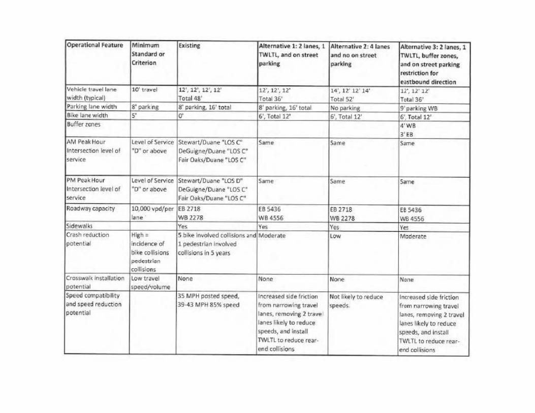

[Evaluation Example 2: Remington Drive]
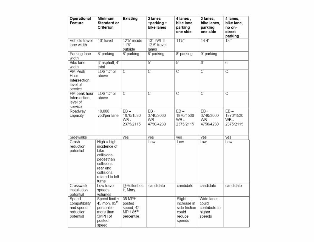
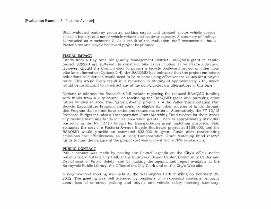
[Evaluation Example 3: Pastoria Avenue]
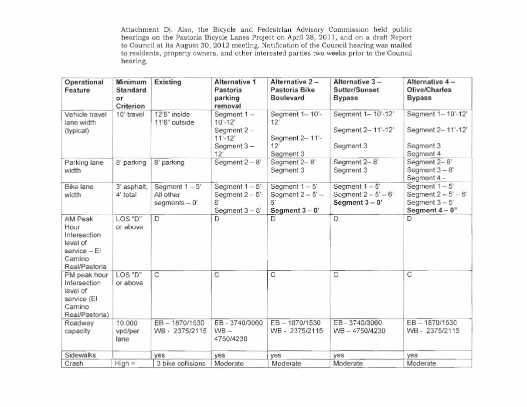
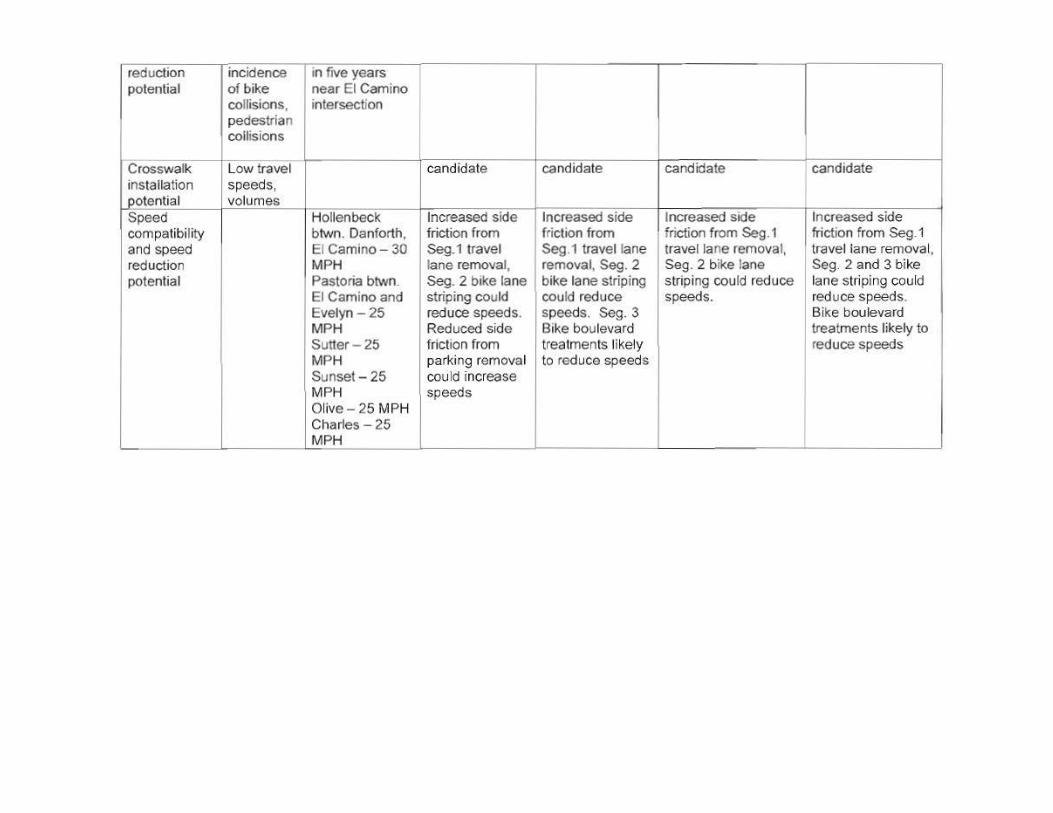
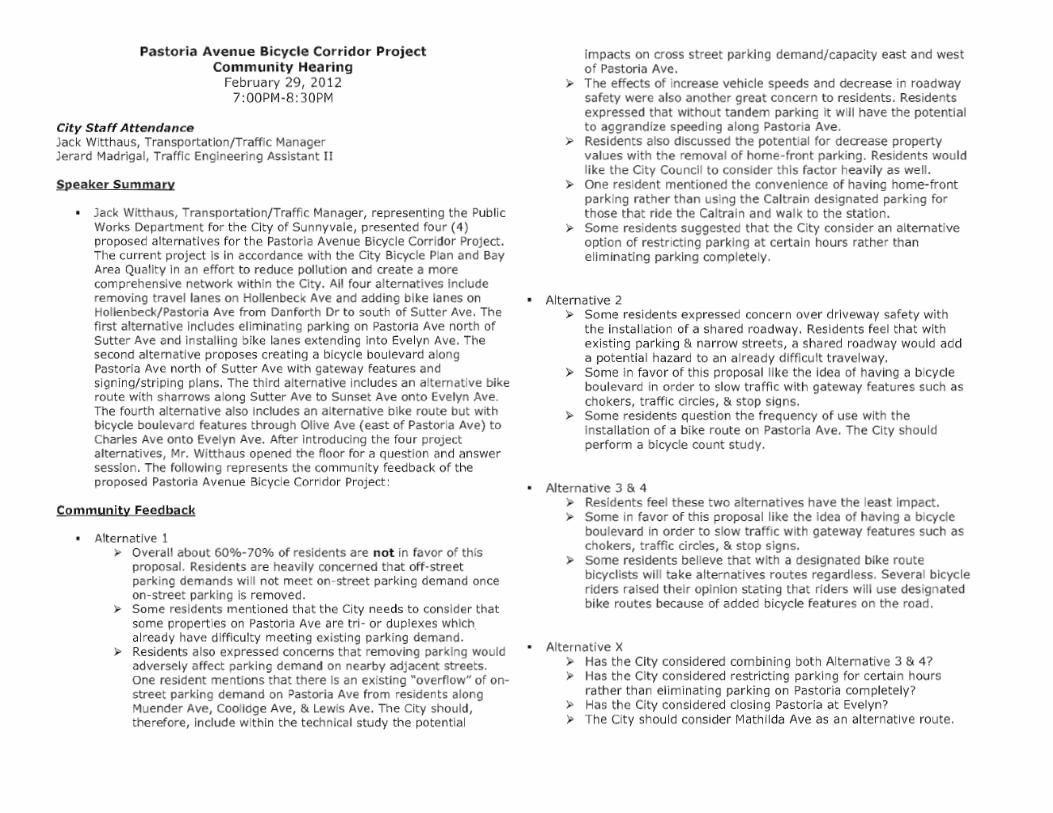

APPENDIX E: FDOT DISTRICT FIVE CONCEPTUAL PROCESS


FDOT DISTRICT FIVE CONCEPTUAL LANE REDUCTION PROCESS FDOT Mission The Department will provide a safe transportation system that:
Ensures the mobility of people and goods Enhances economic prosperity Preserves the quality of our environment and communities
It is assumed that the goals of consideration of dedicating a FDOT lane (existing or proposed) to transit use are the following:
Ascertain whether a dedicated transit lane project is accomplishing the stated and demonstrated goals of a local community/municipality/region (C/M/R).
Ascertain whether it is accomplishing those goals in a manner that is consistent with the Department’s mission. Work with communities to refine their projects to accomplish community goals in a manner that is consistent with the
Department’s mission. Conceptual Framework With the above goals in mind, then the following might be a framework to consider:
1. Community Commitment ‒ Determine if the request is truly consistent with the goals, commitments, and actions of the C/M/R.
2. Technical Analyses ‒ Perform technical analyses in order to determine the mobility feasibility of the request, regardless of existing/proposed roadway configuration and operational plans.
3. Implementation Feasibility ‒ If 1 and 2 result in positive answers, then evaluate the implementation feasibility of the request.
In reviewing any proposals, a multi-disciplined team of traffic, roadway design, transit, and community planning experts should be assembled. Team members should be experienced in urban transportation and community development issues. Step 1: Community Commitment The following questions will illuminate the C/M/R’s seriousness and commitment to the request:
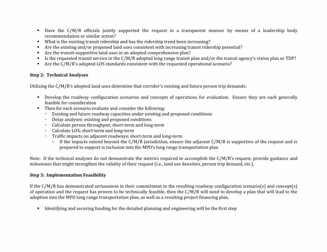
Have the C/M/R officials jointly supported the request in a transparent manner by means of a leadership body
recommendation or similar action? What is the existing transit ridership and has the ridership trend been increasing? Are the existing and/or proposed land uses consistent with increasing transit ridership potential? Are the transit-supportive land uses in an adopted comprehensive plan? Is the requested transit service in the C/M/R adopted long range transit plan and/or the transit agency’s vision plan or TDP? Are the C/M/R’s adopted LOS standards consistent with the requested operational scenario?
Step 2: Technical Analyses Utilizing the C/M/R’s adopted land uses determine that corridor’s existing and future person trip demands:
Develop the roadway configuration scenarios and concepts of operations for evaluation. Ensure they are each generally feasible for consideration
Then for each scenario evaluate and consider the following: Existing and future roadway capacities under existing and proposed conditions Delay analyses: existing and proposed conditions Calculate person throughput; short-term and long-term Calculate LOS; short-term and long-term Traffic impacts on adjacent roadways; short-term and long-term
‒ If the impacts extend beyond the C/M/R jurisdiction, ensure the adjacent C/M/R is supportive of the request and is prepared to support is inclusion into the MPO’s long range transportation plan
Note: If the technical analyses do not demonstrate the metrics required to accomplish the C/M/R’s request, provide guidance and milestones that might strengthen the validity of their request (i.e., land use densities, person trip demand, etc.). Step 3: Implementation Feasibility If the C/M/R has demonstrated seriousness in their commitment to the resulting roadway configuration scenario(s) and concept(s) of operation and the request has proven to be technically feasible, then the C/M/R will need to develop a plan that will lead to the adoption into the MPO long range transportation plan, as well as a resulting project financing plan.
Identifying and securing funding for the detailed planning and engineering will be the first step