PG&E OCEAN BOTTOM SEISMOMETER RECOVERY PROJECT BIOLOGICAL ... · OCEAN BOTTOM SEISMOMETER. RECOVERY...
18
FUGRO PELAGOS, INC. PG&E OCEAN BOTTOM SEISMOMETER RECOVERY PROJECT BIOLOGICAL ROV SURVEY FIELD OPERATIONS AND COMPLIANCE REPORT PADRE ASSOCIATES, INC. OFFSHORE POINT BUCHON, CALIFORNIA Survey Period: May 27-29, 2015 Report Number: 23.00007130_CSLC R0 Prepared for: California State Lands Commission Mineral Resources Management Division Attn: Geophysical Coordinator 200 Oceangate, 12 th Floor Long Beach, CA 90802 Client Reference: 23.00007130 0 Draft BV CP CP 6/26/2015 Rev Description Prepared Checked Approved Date
Transcript of PG&E OCEAN BOTTOM SEISMOMETER RECOVERY PROJECT BIOLOGICAL ... · OCEAN BOTTOM SEISMOMETER. RECOVERY...

FUGRO PELAGOS, INC.
PG&E
OCEAN BOTTOM SEISMOMETER RECOVERY PROJECT
BIOLOGICAL ROV SURVEY
FIELD OPERATIONS AND COMPLIANCE REPORT
PADRE ASSOCIATES, INC. OFFSHORE POINT BUCHON, CALIFORNIA
Survey Period: May 27-29, 2015 Report Number: 23.00007130_CSLC R0
Prepared for: California State Lands Commission
Mineral Resources Management Division
Attn: Geophysical Coordinator
200 Oceangate, 12th Floor
Long Beach, CA 90802
Client Reference: 23.00007130
0 Draft BV CP CP 6/26/2015
Rev Description Prepared Checked Approved Date
CALIFORNIA STATE LANDS COMMISSION FIELD OPERATIONS AND COMPLIANCE REPORT
Report No. 23.00007131_CSLC R0 Page i
CONTENTS
Page
1. SURVEY INFORMATION 1 1.1 DESCRIPTION OR WORK PERFORMED 1 1.2 DATA COLLECTION DATES, TIMES, WEATHER AND SEA STATE DURING OPERATIONS 1 1.3 CHART OF SURVEY AREA 1 1.4 SPATIAL INFORMATION RELATED TO SURVEY TRACKLINES 1 1.5 NATURE AND LOCATION OF ENVIRONMENTAL HAZARDS ENCOUNTERED 1 1.6 ACCIDENT, INJURY, DAMAGE TO OR LOSS OF PROPERTY 2 1.7 OTHER INFORMATION RELATIVE TO THE PERMITTED ACTIVITIES 2
2. BIOLOGICAL INFORMATION 2 2.1 ENCOUNTERS WITH WITH MARINE WILDLIFE 2 2.2 SHUT-DOWNS AND SLOW DOWNS 2 2.3 OBSERVATIONS OF PINNIPED BEHAVIOR 2 2.4 COLLISION EVENTS 2 2.5 EXHIBIT H – MITIGATION MONITORING PROGRAM 2 2.6 MWM MONITORING REPORT 3
CALIFORNIA STATE LANDS COMMISSION FIELD OPERATIONS AND COMPLIANCE REPORT
Report No. 23.00007130_CSLC R0 Page 1
1. SURVEY INFORMATION
1.1 DESCRIPTION OR WORK PERFORMED
As part of Pacific Gas & Electric Company’s (PG&E) seismic safety assessment at the Diablo Canyon
Power Plant (DCPP), an ocean bottom seismometer (OBS) system was installed in the nearshore
waters off Pt. Buchon, San Luis Obispo County in July 2013 and recovered in May 2015.
Between May 27 and 29, 2015, Fugro Pelagos, Inc. (Fugro) provided surface and subsurface
positioning services in support of ROV operations in deeper water segments. Wide area DPGS
integrated with Hypack navigational software was used to position the survey vessel in real time.
Subsurface positioning was achieved using the TrackPoint II USBL positioning system integrated with
the surface navigation system. During survey operations, ROV position fixes were logged along the
seismometer cable recovery route.
1.2 DATA COLLECTION DATES, TIMES, WEATHER AND SEA STATE DURING OPERATIONS
Survey operations were conducted during daylight hours. Daily progress reports (DPRs) were
generated for each survey day which included daily events, Quality, Health, Safety, & Environmental
(QHSE) summary, weather conditions, hours worked, and any Health, Safety & Environmental (HSE)
incidents if incurred. Below is a table describing survey dates and weather conditions, as recorded
in the DPRs.
Date Start Time End Time Weather
5/27/15 6:00am 3:30pm Winds 0-05KT
Seas 2-4FT
5/28/15 6:05am 4:15pm Winds 5-25KT
Seas 4-6FT
5/29/15 6:16am 4:18pm Winds 5-20KT
Seas 4-5FT
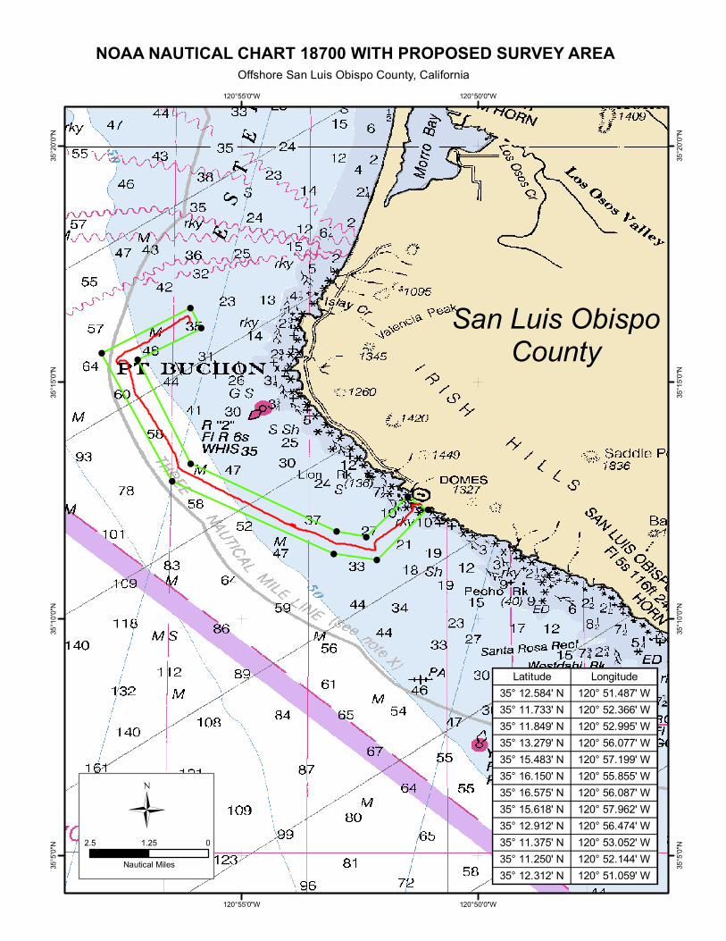
1.3 CHART OF SURVEY AREA
A map of the biological ROV survey route is included at the end of this report.
1.4 SPATIAL INFORMATION RELATED TO SURVEY TRACKLINES
Accompanying and made a part of this report is the digital ArcGIS shapefile depicting the biological
ROV Survey route.
1.5 NATURE AND LOCATION OF ENVIRONMENTAL HAZARDS ENCOUNTERED
No environmental hazards were encountered during survey operations.
CALIFORNIA STATE LANDS COMMISSION FIELD OPERATIONS AND COMPLIANCE REPORT
Report No. 23.00007130_CSLC R0 Page 2
1.6 ACCIDENT, INJURY, DAMAGE TO OR LOSS OF PROPERTY
No accidents or injuries occurred during the operations of the project, and no damages or loss of
property was reported.
1.7 OTHER INFORMATION RELATIVE TO THE PERMITTED ACTIVITIES
No other information related to the permitted activities are reported.
2. BIOLOGICAL INFORMATION
California State Lands Commission “Survey Permit PRC 8391 General Permit to Conduct
Geophysical Surveys” states in Section 7, Paragraph h, item iii “MWMs will not be required aboard
vessels conducting survey activites that ultilize, as the only form of geophysical equipment, non-pulse
or non-acoustic generating passive survey equipment (e.g. ROV, magnetometers, gravity meters).”
Therefore no MWMs were present onboard the vessel and information provided in this section are
from observations by the vessel and ROV survey crews.
2.1 ENCOUNTERS WITH WITH MARINE WILDLIFE
The captain of the vessel and all personnel aboard were instructed to visually monitor the area around
the vessel for approaches by marine wildlife. No encounters with marine wildlife were reported duing
the ROV visual inspections.
2.2 SHUT-DOWNS AND SLOW DOWNS
During ROV video operations, no shut-downs or slow downs were required related to proximity of
marine wildlife.
2.3 OBSERVATIONS OF PINNIPED BEHAVIOR
The ship and ROV survey crews were instructed to report any visual observations of Pinnipeds
exhibiting unusual behavor. During the ROV video surveys no unusual Pinniped behavior was
observed or reported.
2.4 COLLISION EVENTS
There were no collision events during the ROV video survey operations.
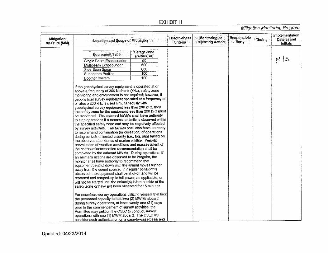
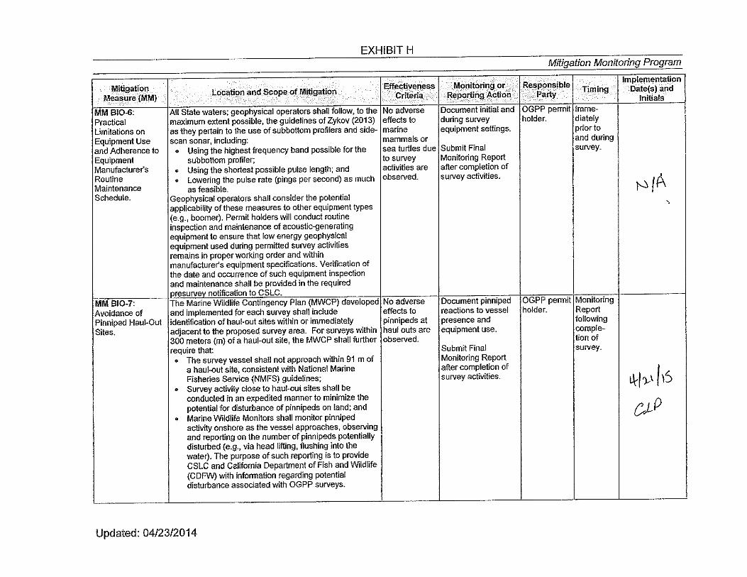
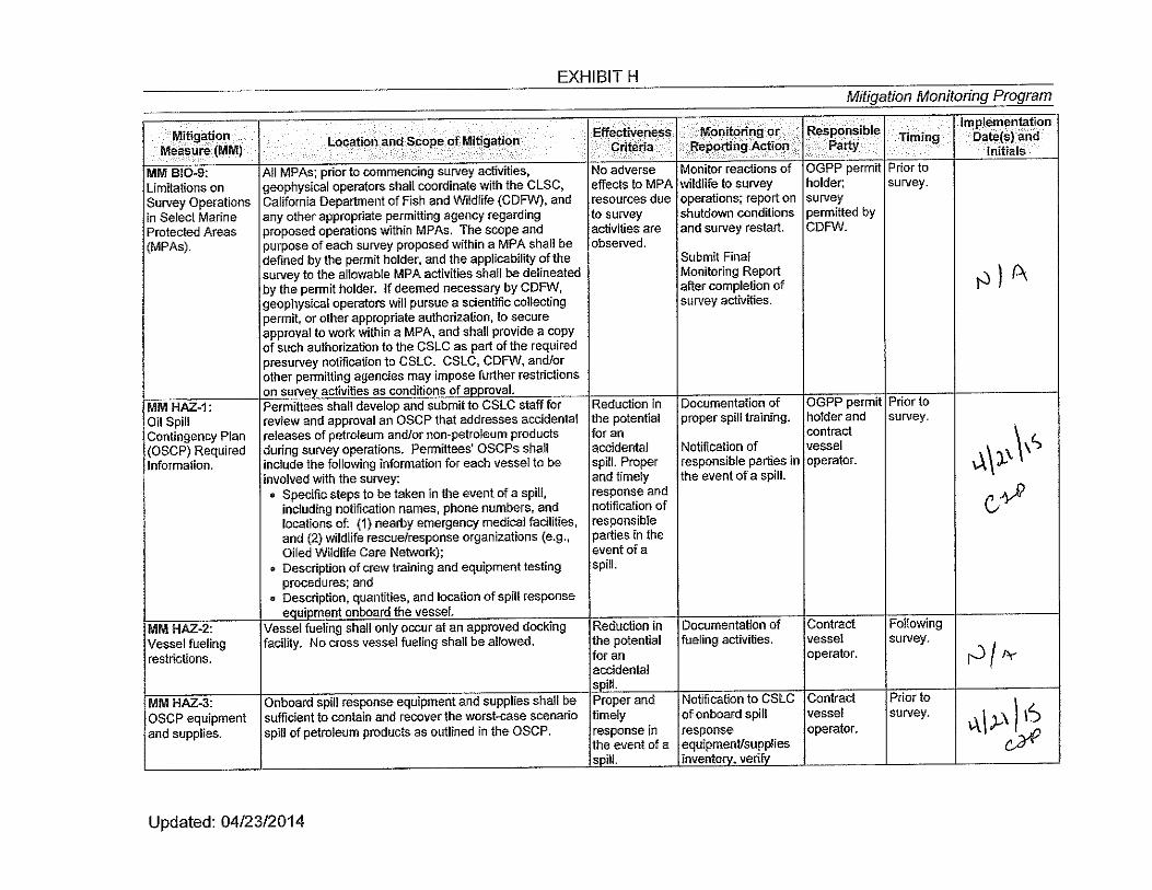
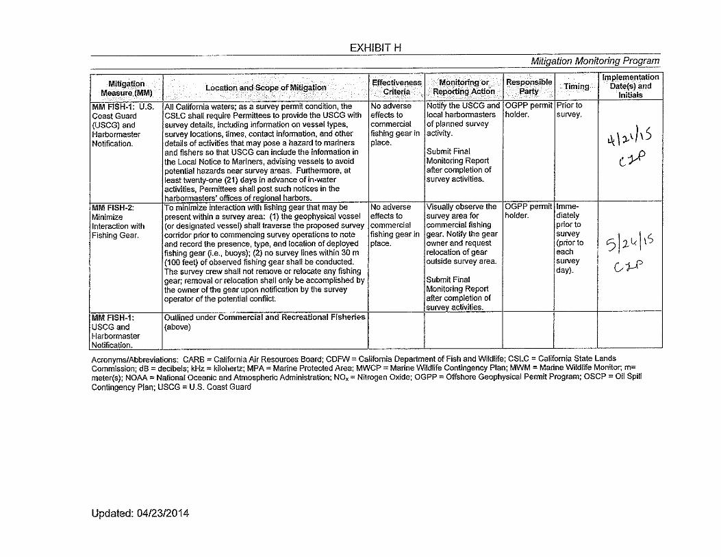
2.5 EXHIBIT H – MITIGATION MONITORING PROGRAM
In accordance with CSLC regulations, a completed copy of Exhibit H taken from Fugro Geophysical
Permit PRC 8391.9 has been completed with acknowledgements and included in Appendix A.

CALIFORNIA STATE LANDS COMMISSION FIELD OPERATIONS AND COMPLIANCE REPORT
Report No. 23.00007130_CSLC R0 Appendix A
2.6 MWM MONITORING REPORT
Based on the cooperative efforts of the Project team and vessel crew, no negative Project activity or
transit-related effects to the marine environment were observed during Project activities. The project
activities were in compliance with the mitigation measures outlined in Exhibit H of CSLC issued
geophysical permit and all mitigation measures were implemented. The mitigation measures were
effective in preventing or minimizing the environmental impacts from the PG&E OBS Project ROV
Survey.

CALIFORNIA STATE LANDS COMMISSION FIELD OPERATIONS AND COMPLIANCE REPORT
Report No. 23.00007130_CSLC R0 Appendix A
APPENDICES
A CSLC MITIGATION MONITORING PROGRAM EXHIBIT H
B ROV SURVEY ROUTE
CALIFORNIA STATE LANDS COMMISSION FIELD OPERATIONS AND COMPLIANCE REPORT
Report No. 23.00007130_CSLC R0 Appendix A
A CSLC MITIGATION MONITORING PROGRAM EXHIBIT H


CALIFORNIA STATE LANDS COMMISSION FIELD OPERATIONS AND COMPLIANCE REPORT
Report No. 23.00007130_CSLC R0 Appendix B
B ROV SURVEY ROUTE
!
!!
!
!
!
!
!
!
!!
!
San Luis ObispoCounty
120°50'0"W
120°50'0"W
120°55'0"W
120°55'0"W
35°20
'0"N
35°20
'0"N
35°15
'0"N
35°15
'0"N
35°10
'0"N
35°10
'0"N
35°5'
0"N
35°5'
0"N
NOAA NAUTICAL CHART 18700 WITH PROPOSED SURVEY AREAOffshore San Luis Obispo County, California
Ü2.5 01.25
Nautical Miles
Latitude Longitude35° 12.584' N 120° 51.487' W35° 11.733' N 120° 52.366' W35° 11.849' N 120° 52.995' W35° 13.279' N 120° 56.077' W35° 15.483' N 120° 57.199' W35° 16.150' N 120° 55.855' W35° 16.575' N 120° 56.087' W35° 15.618' N 120° 57.962' W35° 12.912' N 120° 56.474' W35° 11.375' N 120° 53.052' W35° 11.250' N 120° 52.144' W35° 12.312' N 120° 51.059' W


![Seismic Broadband Ocean-Bottom Data and Noise …bullard.esc.cam.ac.uk/~tilmann/BSSA_06.pdf · [ob24], PMD seismometer and hydrophone [ob29], Lamont-Doherty Earth Observatory [LDEO]](https://static.fdocuments.in/doc/165x107/5a78b7d37f8b9a07028d2d5b/seismic-broadband-ocean-bottom-data-and-noise-tilmannbssa06pdfob24-pmd.jpg)