Petroleum Exploration and Development Opportunities in Sri ...
13
Petroleum Exploration and Development Opportunities in Sri Lanka Petroleum Resources Development Secretariat (PRDS) www.prds-srilanka.com
Transcript of Petroleum Exploration and Development Opportunities in Sri ...

Petroleum Exploration and Development
Opportunities
in Sri Lanka
Petroleum Resources Development Secretariat (PRDS)
www.prds-srilanka.com

Growing Island nation
• Sri Lanka, formerly
called "Ceylon", is an
island nation in the
Indian Ocean
• The documented history spans
3,000 years, with evidence of pre-
historic human settlements dating
back to at least 125,000 years
• The island's strategic location in the
Indian Ocean, intersecting with the
major air and sea routes between
Europe and the Far East, gives it an
• The three major ports -
Colombo, Hambantota
and Trincomalee, and
investments creating an ideal
environment for global
upstream business ventures
and partnershipsstrategic advantage as a global
logistics hub
the two international airports -
Colombo and Mattala offers
investors with attractive and
efficient logistics support in the
shipping and aviation related.
• Rapidly growing
Energy Market
• Colombo is one fastest growing
cities in Asia
• A brand new City
development; Port City
Colombo will be the most
livable city in South Asia
• A new energy policy for
more cleaner energy
sources
• Long-Term Generation Expansion
Plan to add 4,800 MW of Natural
Gas / LNG power plants to the
National Grid within 20 years.
• New favorable Government
policies to address Sri Lankan
upstream industry
4/10/2019

E&P Opportunities
Shallow to deep water E& P opportunities
Three offshore sedimentary basins
Mannar Basin – 9 exploration blocks (M1 – M9)
Cauvery Basin – 5 exploration blocks (C1 – C9)
Lanka Basin - 6 ultra deep water blocks (JS1 – JS6)
Two natural gas discoveries
New oil and gas plays
Total data coverage of
2D Seismic data – 22375 line kms
3D Seismic data – 2350 sqkm
Well Data – 11 wells
Rapidly growing domestic energy market
Attractive PSC terms
Multi- Client data acquisition opportunities
Open data room policy at PRDS
Joint Study opportunities4/10/2019

Petroleum Data coverage
• Data acquired from the exploration activities carried out from late 1960s
to 1984 have categorized under vintage data. Most of the seismic and
well logs are vectorized data.
• In-addition, well reports, interpretation reports and other reports are
available.
• Total of approximately 9030 line kms of seismic data were acquired and
total of 8199 line kms of seismic data were vectorized.
• Total of seven wells were drilled and there was a gas show in the Pasalai
– 1 well. Other wells were dry.
• For data prices & purchase contact Data Manager at PRDS
Vintage Data
New Data
• Data acquired from the exploration activities carried out since 2001 to date
have been categorized under new data.
• Total of approximately 14,174 line kms of 2D seismic data were acquired,
consecutively 1100 line kms in 2001, 4500 line kms in 2005, 742 line kms in
2009 and 7832 line kms in 2018.
• Total of approximately 2353 sq kms of 3D seismic data were acquired in the
block M2 consecutively, 1753 sq kms in 2009 and 600 sq kms in 2012.
• Four wells have been drilled and well data pertaining to these wells are
available.
• In-addition several re-processed seismic data packs and reports are
available
• For data prices & purchase contact Data Manager at PRDS 4/10/2019

Mannar Basin
Deep water Mannar basin is located between the coasts of South-eastern India and western Sri Lanka, and lies to the south of the
Cauvery basin. In terms of the areal extent, Mannar basin approaches an area of approximately 50,000 square kilometres within the
maritime jurisdiction of Sri Lanka.
The basin is a failed-rift basin and its formation was initiated with the East-West Gondawana separation in Upper Jurassic age. The basin
has experienced two syn-rift events is followed by a thermal sag phase and an inversion in Eocene. Deep-marine sedimentary
environment has been persisted since Barremian.
Three potential source rock levels belonging to the Campanian – Maastrichtian, Albian - Aptian, and the Upper Jurassic age have been
identified. Scenario based source rock modeling work have shown that large volumes of hydrocarbons (both oil and gas) have been
generated from these source rocks. Particularly, the source rocks existing in and below the late syn-rift phase.
Rifted weathered basement highs, early syn-rift abrupt margin pinch outs, Late Albian plays, Cretaceous plays related to volcanic intrusive
and extrusives, and Tertiary fan and channel plays are prominent plays in the Mannar basin. Despite the two discoveries in the basin, a
major portion of the Mannar basin still remains under explored.
Divided into 9 exploration block ( M1 to M9).
Seismic line SL 05- 57 showing play types.
Data availability
• Approximately 5572 line km of new 2D
seismic data
• 3001 line km of Vintage 2D seismic data
• Well data from 4 exploration wells – Dorado,
Dorado North, Barracuda & Wallago.
• Approximately 1924 line kms Multi Client 2D
seismic data acquired in 2018.
4/10/2019

Cauvery Basin
Cauvery basin is consisted with sub-basins; Ramnad – Palk bay depression, Pamban Depression and
Palk – Pesalai depression. These sub – basins are separated by ridges; Mandapan – Delft and Palk.
Cauvery basin is proven for it’s hydrocarbon generation.
The PH9-1 well, drilled in the Ramnad – Palk bay sub basin, tested 1488BOPD of 56 API crude with 570
Mcf/d gas from 6m pay. This flow came from a sand layer in the Cretaceous.
On the Indian side oil shows- in Cretaceous and weathered basement rocks have been recorded.
Pesalai – 1 well has confirmed a Gas show in the in basal Cretaceous sands.
Source Potential - Mature Cretaceous marine shale.
Reservoir Potential -The Cretaceous sands/ Weathered basement/ tertiary sands & limestones.
Cap Rock - Claystones and shales below the lower Miocene sections
Plays -Basement fault blocks / Simple anticlinal traps formed by drape and differential compaction/ Onlapping
sediments to the basement highs
The Basin (approximately 20,000 sqkm) has been divided into 5 exploration blocks (C1 – C5).
Data availability
Approximately 4400 line kms of 2D vintage seismic data
Well data from Drilled 6 exploration wells – Pedro-1, Palk Bay-1,Delft-1, Pesalai-1, Pesalai-2, Pesalai-3
approximately 295 line kms Multi Client 2D seismic data acquired in 2018 covering C4 ad C5 blocks
A cross section through wells (not to scale)
Basement structure time map of the Cauvery basin
4/10/2019
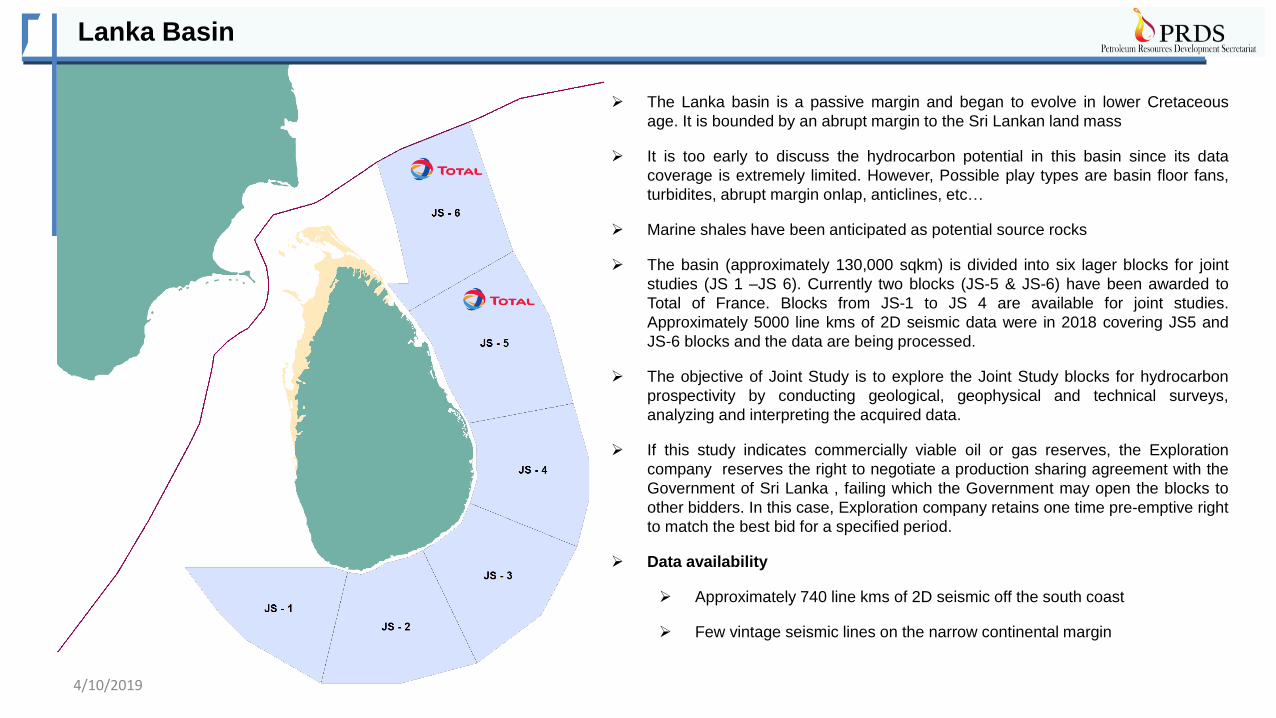
Lanka Basin
The Lanka basin is a passive margin and began to evolve in lower Cretaceous
age. It is bounded by an abrupt margin to the Sri Lankan land mass
It is too early to discuss the hydrocarbon potential in this basin since its data
coverage is extremely limited. However, Possible play types are basin floor fans,
turbidites, abrupt margin onlap, anticlines, etc…
Marine shales have been anticipated as potential source rocks
The basin (approximately 130,000 sqkm) is divided into six lager blocks for joint
studies (JS 1 –JS 6). Currently two blocks (JS-5 & JS-6) have been awarded to
Total of France. Blocks from JS-1 to JS 4 are available for joint studies.
Approximately 5000 line kms of 2D seismic data were in 2018 covering JS5 and
JS-6 blocks and the data are being processed.
The objective of Joint Study is to explore the Joint Study blocks for hydrocarbon
prospectivity by conducting geological, geophysical and technical surveys,
analyzing and interpreting the acquired data.
If this study indicates commercially viable oil or gas reserves, the Exploration
company reserves the right to negotiate a production sharing agreement with the
Government of Sri Lanka , failing which the Government may open the blocks to
other bidders. In this case, Exploration company retains one time pre-emptive right
to match the best bid for a specified period.
Data availability
Approximately 740 line kms of 2D seismic off the south coast
Few vintage seismic lines on the narrow continental margin
4/10/2019

Block M2 - Status and Dorado Gas discovery
Block Area : 3000 sq. km, Water depths varying from
approximately 300m to 2000 m
Seismic Coverage :
3D : 2353 Sq.Km. (within block)
2D : 5700 LKM (Regional data)
Number of Wells drilled within the block – 4
(2 Gas Discoveries, 2 Dry Holes)
Dorado , Barracuda – Gas discoveries
Dorado North. – Dry
Wallago – Prematurely Abandoned
More leads & prospects
Proximity to Emerging Energy Markets:
Sri Lanka, Southern India
Dorado well is located approximately 30 km
away from the western shore line.
The pool is dominant with dry gas (>95%
methane) and they may have been charged
from Albian or syn-rift sources in the basin
since the Paleocene.
The Dorado discovery was made in a forced
fold structure formed above an igneous
intrusion during the Maastrichtian period.
The reservoir is feldspathic-arenite with
average porosity and moderate permeability.
The presence of gas in the trap is apparent
on seismic data as a bright amplitude
anomaly and also, the prospect is having
Class III type Amplitude Versus Offset (AVO)
response.
Modular Formation Dynamic Tester (MTD) -
pressure data confirms the Gas-Water
Contact (GWC) and thus, the pool limits
have been determined with high confidence.
Estimated mid case recoverable volume is
350bcf.
Soft bright seismic
amplitude anomaly / DHI
Igneous intrusives
HZ-1
Gamma ray logResistivity log
4/10/2019

Block M2 – Barracuda Gas discovery
Intra-volcanic sand
layers
• The Barracuda discovery was made in the well; Barracuda and gas was encountered in three intra flood-volcanic sand layers. • These sand layers are feldspathic to subfeldspathic-arenites rich with mafic minerals and porosities of layers are consistent with variable
permeabilities. • Mapping of sand layers is a major technical challenge and thus, estimation of the pool limits is a major challenge. The mid case GIIP volume
estimation is 1.5 Tcf and High case is 5 Tcf . • However, it is apparent on seismic data that the flood volcanic layer together with intra-volcanic sand layers is pinching out towards the basin
margin. • Therefore, higher lateral extension of these sand layers could be anticipated.
GR Res LithTGas S.GR Den/Neu
Sand-B
Water Sand
Gas Sand-1
Gas Sand-2
Gas Sand-3
4/10/2019
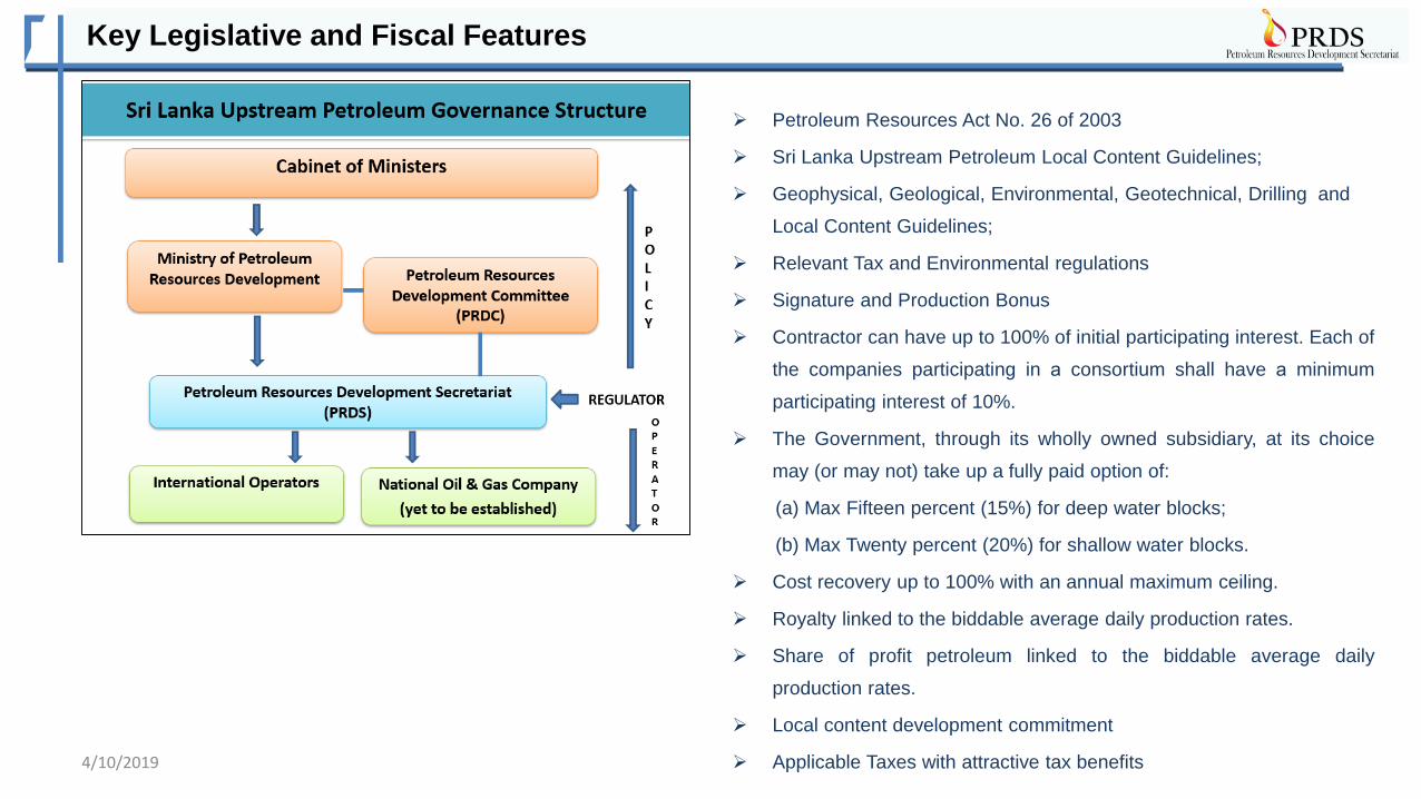
Key Legislative and Fiscal Features
Petroleum Resources Act No. 26 of 2003
Sri Lanka Upstream Petroleum Local Content Guidelines;
Geophysical, Geological, Environmental, Geotechnical, Drilling and
Local Content Guidelines;
Relevant Tax and Environmental regulations
Signature and Production Bonus
Contractor can have up to 100% of initial participating interest. Each of
the companies participating in а consortium shall have а minimum
participating interest of 10%.
The Government, through its wholly owned subsidiary, at its choice
may (or may not) take up a fully paid option of:
(a) Max Fifteen percent (15%) for deep water blocks;
(b) Max Twenty percent (20%) for shallow water blocks.
Cost recovery up to 100% with an annual maximum ceiling.
Royalty linked to the biddable average daily production rates.
Share of profit petroleum linked to the biddable average daily
production rates.
Local content development commitment
Applicable Taxes with attractive tax benefits4/10/2019
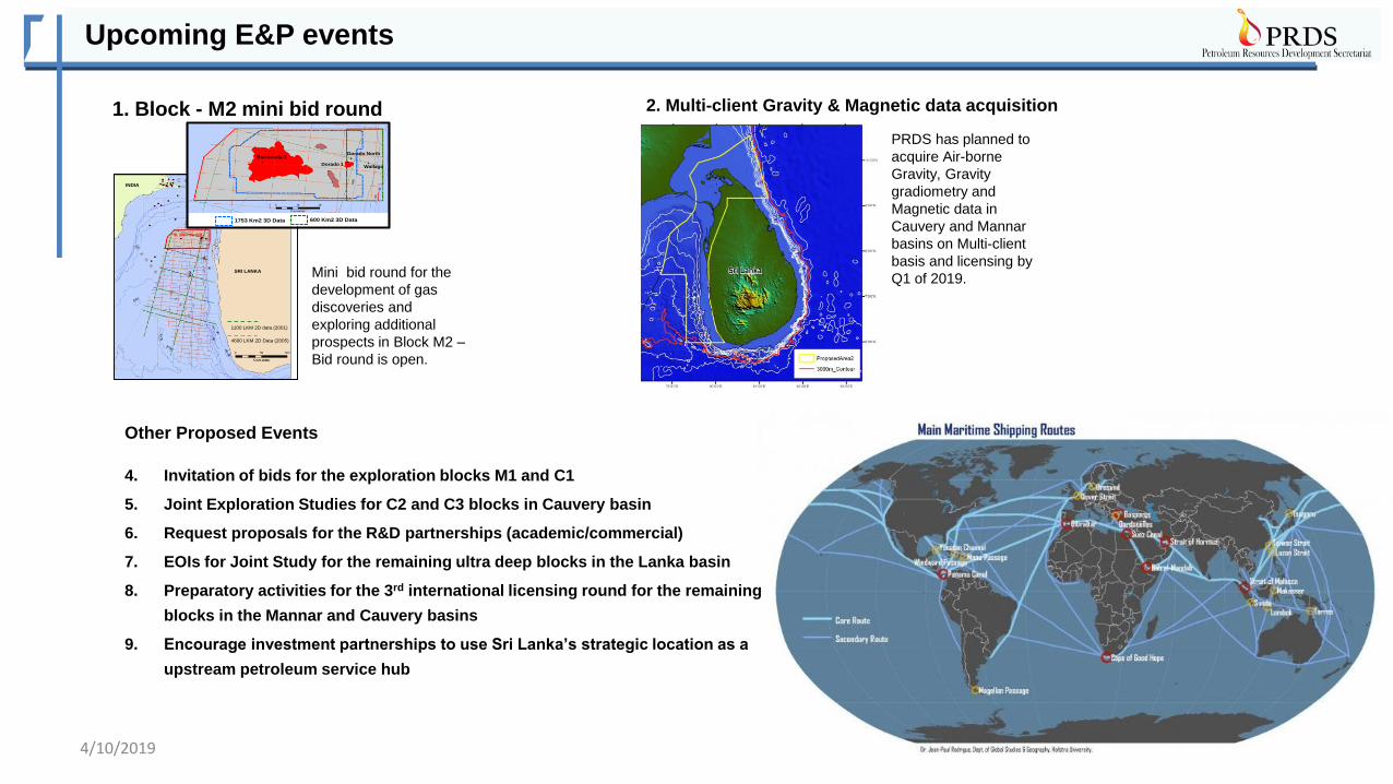
Upcoming E&P events
SRI LANKA
INDIA
1100 LKM 2D data (2001)
4600 LKM 2D Data (2005)
SL 2007-01-001
C a u v e ry B a s i n
Barracuda 1
Dorado 1
Dorado North
Wallago
1753 Km2 3D Data 600 Km2 3D Data
Mini bid round for the
development of gas
discoveries and
exploring additional
prospects in Block M2 –
Bid round is open.
1. Block - M2 mini bid round
PRDS has planned to
acquire Air-borne
Gravity, Gravity
gradiometry and
Magnetic data in
Cauvery and Mannar
basins on Multi-client
basis and licensing by
Q1 of 2019.
2. Multi-client Gravity & Magnetic data acquisition
Other Proposed Events
4. Invitation of bids for the exploration blocks M1 and C1
5. Joint Exploration Studies for C2 and C3 blocks in Cauvery basin
6. Request proposals for the R&D partnerships (academic/commercial)
7. EOIs for Joint Study for the remaining ultra deep blocks in the Lanka basin
8. Preparatory activities for the 3rd international licensing round for the remaining
blocks in the Mannar and Cauvery basins
9. Encourage investment partnerships to use Sri Lanka’s strategic location as a
upstream petroleum service hub
4/10/2019

Useful Links
http://www.pucsl.gov.lk/english/industries/electricity/electricity-tariffscharges/
Useful Information Link
Petroleum Resources Act No. 26 of 2003 http://www.prds-srilanka.com/aboutus/legislation.faces
Upstream Geophysical, Geological, Environmental and
Geotechnical Program Guidelines
http://www.prds-srilanka.com/aboutus/legislation.faces
Initial Natural Gas Utilization Road Map of Sri Lanka http://www.prds-srilanka.com/aboutus/publications.faces
Sri Lanka Upstream Petroleum Local Content Guidelines http://www.prds-srilanka.com/pdfs/Guidelines2014.pdf
Marine Environmental Protection Authority http://www.mepa.gov.lk
Sri Lanka Energy Policy http://powermin.gov.lk/english/?page_id=1394
Petroleum products – Marketing and Sales http://ceypetco.gov.lk/marketing-sales/
Sri Lanka Electricity Tariffs and Charges http://www.pucsl.gov.lk/english/industries/electricity/electricity
-tariffscharges/
Sri Lanka Energy Balance http://energybalance.axioon.com/
4/10/2019

Vision & Mission
Design and monitor fiscal regimes that meet the country's evolving economic needs, matching them with a
stable, efficient regulatory framework that attracts investment and encourages knowledge transfer, until the last
economic reserves are produced.
Contact Details
Address:
Petroleum Resources Development Secretariat
Level 06, Ceylinco House
69, Janadhipathi Mawatha
Colombo 01
Tel: 94 11 2332002, 94 11 2332004, 94 11
2332005, 94 11 2332008, 94 11 2332013, 94 11
2332014, 94 11 2332015, 94 11 2332017
Fax: 94 2332003
Email : [email protected], [email protected]
Web : www. prds-srilanka.com
To ensure that all Sri Lankans benefit from the petroleum resources of the country by managing the industry in
an equitable, safe and environmentally sustainable manner.
Vision
Mission
4/10/2019
![Petroleum Exploration Production Act regulations 1984 · · 2016-06-16LAWS OF MALAWI Petroleum (Exploration and Production) Cap. 61 Petroleum (Applications) Regulations 41 [Subsidiary]](https://static.fdocuments.in/doc/165x107/5ac9a3347f8b9a5d718da164/petroleum-exploration-production-act-regulations-1984-of-malawi-petroleum-exploration.jpg)