PETIT - pan European mapping 5 th EC-GIS 99 Stresa 28 th -30 th June 1999 PETIT using existing...
19
PETIT - pan European mapping 5 th EC-GIS 99 Stresa 28 th -30 th June 1999 PETIT using existing databases for Pan-European mapping? Olav Eggers PETIT Project Manager
-
Upload
imogene-holland -
Category
Documents
-
view
216 -
download
0
Transcript of PETIT - pan European mapping 5 th EC-GIS 99 Stresa 28 th -30 th June 1999 PETIT using existing...

PE
TIT
- p
an E
urop
ean
map
ping
5th EC-GIS 99 Stresa 28th-30th June 1999
PETIT
using existing databases for Pan-European mapping?
Olav EggersPETIT Project Manager

PE
TIT
- p
an E
urop
ean
map
ping
5th EC-GIS 99 Stresa 28th-30th June 1999
OverviewOverview
• Introduction
• Technical issues
• Legal issues
• The way forward

PE
TIT
- p
an E
urop
ean
map
ping
5th EC-GIS 99 Stresa 28th-30th June 1999
What is PETITWhat is PETIT
• Assessing the feasibility of creating a pan-European topographic dataset in the scale 1:250.000, using VMap level 1 data.
• INFO2000 supported
• 8 Partners; 2 private, 5 NMAs & MEGRIN
PE
TIT
- p
an E
urop
ean
map
ping
5th EC-GIS 99 Stresa 28th-30th June 1999
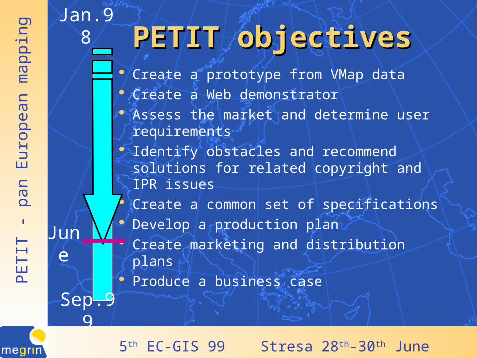
PETIT objectivesPETIT objectives Create a prototype from VMap data Create a Web demonstrator Assess the market and determine user
requirements Identify obstacles and recommend
solutions for related copyright and IPR issues
Create a common set of specifications Develop a production plan Create marketing and distribution plans Produce a business case
June
Sep.99
Jan.98
PE
TIT
- p
an E
urop
ean
map
ping
5th EC-GIS 99 Stresa 28th-30th June 1999
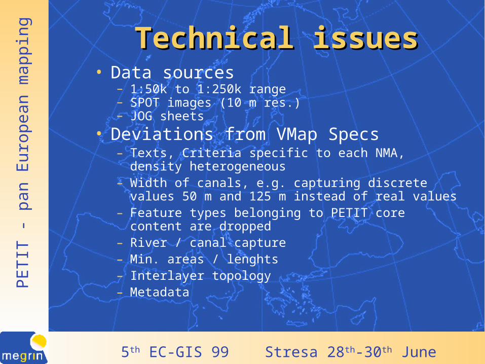
Technical issuesTechnical issues• Data sources
– 1:50k to 1:250k range– SPOT images (10 m res.) – JOG sheets
• Deviations from VMap Specs– Texts, Criteria specific to each NMA, density
heterogeneous– Width of canals, e.g. capturing discrete values 50 m and
125 m instead of real values– Feature types belonging to PETIT core content are
dropped– River / canal capture– Min. areas / lenghts– Interlayer topology– Metadata

PE
TIT
- p
an E
urop
ean
map
ping
5th EC-GIS 99 Stresa 28th-30th June 1999
86
4
24
67
83
5
25
84
50
85
49
Only linesLine or node
68
26
69
Unknown by MEGRIN
Bridges and TunnelsBridges and Tunnels

PE
TIT
- p
an E
urop
ean
map
ping
5th EC-GIS 99 Stresa 28th-30th June 1999
86
4
24
67
83
5
25
84
50
85
49
20 m25 m
68
26
69
60 m
100 mVarious
Unknown by MEGRIN
Contour intervalContour interval

PE
TIT
- p
an E
urop
ean
map
ping
5th EC-GIS 99 Stresa 28th-30th June 1999
VMap updatingVMap updating
• No general VMap concept for updating exists– procedures– frequency
• Only a few NMAs have update agreements with the military

PE
TIT
- p
an E
urop
ean
map
ping
5th EC-GIS 99 Stresa 28th-30th June 1999
86
26
4
24
67
83
5
25
84
50
85
49
1995 or later1990 to 19941980 to 19891979 or before
6968
Unk. by MEGRIN
Best Currency of VMapBest Currency of VMap

PE
TIT
- p
an E
urop
ean
map
ping
5th EC-GIS 99 Stresa 28th-30th June 1999
86
26
4
24
67
83
5
25
84
50
85
49
1995 or later1990 to 19941980 to 19891979 or before
69
Unk. by MEGRIN
68
Worst Currency of VMapWorst Currency of VMap

PE
TIT
- p
an E
urop
ean
map
ping
5th EC-GIS 99 Stresa 28th-30th June 1999
86
26
4
24
6769
83
5
25
84
50
68
85
49
End 199920002001
< Sep 1999
Completion of VMap CDsCompletion of VMap CDs

PE
TIT
- p
an E
urop
ean
map
ping
5th EC-GIS 99 Stresa 28th-30th June 1999
Legal issuesLegal issues
• Complex production history
• Unclear who owns the rights
• Only few NMAs are certain
• Copyright legislation and neighbouring law in the European countries differ

PE
TIT
- p
an E
urop
ean
map
ping
5th EC-GIS 99 Stresa 28th-30th June 1999
Rights to use VMap dataRights to use VMap data

PE
TIT
- p
an E
urop
ean
map
ping
5th EC-GIS 99 Stresa 28th-30th June 1999
ProductionProduction
PRODUCTION:PETIT
NDB's
VMapVMap
CD ROMROMVMap
PanEuropeanProduct
Other
Sources
PETITUPDATING

PE
TIT
- p
an E
urop
ean
map
ping
5th EC-GIS 99 Stresa 28th-30th June 1999
Stairway to…..Stairway to…..
Pan European base data
Clarify legal issues
Technical availability of VMap
Production plan
Who is paying?
PE
TIT
- p
an E
urop
ean
map
ping
5th EC-GIS 99 Stresa 28th-30th June 1999
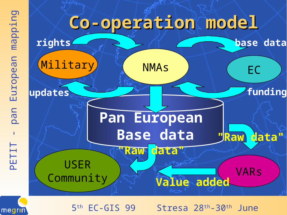
Co-operation modelCo-operation model
NMAsMilitary EC
Pan European Base data
VARsUSER
Community
"Raw data"
"Raw data"
Value added
fundingupdates
rights base data

PE
TIT
- p
an E
urop
ean
map
ping
5th EC-GIS 99 Stresa 28th-30th June 1999
Base data is for all to useBase data is for all to use
• Reduce cost (no duplication)• improve cross-sector communication and
exchange (common reference)• better governance
And for all And for all to create to create togethertogether

PE
TIT
- p
an E
urop
ean
map
ping
5th EC-GIS 99 Stresa 28th-30th June 1999
More informationMore information
Contact:
http://www.megrin.org

PE
TIT
- p
an E
urop
ean
map
ping
5th EC-GIS 99 Stresa 28th-30th June 1999
http://www.megrin.org