PERPUSTAKAAN UMP - core.ac.uk fileSize of drainage can affected the water flow 10 Figure 2.3 Waste...
24
PERPUSTAKAAN UMP 1 1111 Ill IH Ill Ill I II 1111111 IllH II 0000073570 INVESTIGATION - ANTS OF MAIN DRAIN FOR TAMAN DESA DARUL NAIM, PASIR TUMBOH MOHD RIDZUAN BIN HUSIN A thesis submitted in partial fulfillment of the requirements for the award of the degree of Bachelor of Civil Engineering with Environment Faculty of Civil Engineering & Earth Resources University Malaysia Pahang JUNE 2012
-
Upload
nguyenlien -
Category
Documents
-
view
212 -
download
0
Transcript of PERPUSTAKAAN UMP - core.ac.uk fileSize of drainage can affected the water flow 10 Figure 2.3 Waste...

PERPUSTAKAAN UMP
1 1111 Ill IH Ill Ill I II 1111111 IllH II 0000073570
INVESTIGATION - ANTS OF MAIN DRAIN
FOR TAMAN DESA DARUL NAIM, PASIR TUMBOH
MOHD RIDZUAN BIN HUSIN
A thesis submitted in partial fulfillment of the
requirements for the award of the degree of
Bachelor of Civil Engineering with Environment
Faculty of Civil Engineering & Earth Resources
University Malaysia Pahang
JUNE 2012

TABLE OF CONTENT
PAGE CHAPTER TITLE
AUTHENTICATION
TITLE
DECLARATION
ACKNOWLEDGMENT
ABSTRACT
ABSTRAK
TABLE OF CONTENT
LIST OF TABLE
LIST OF FIGURE
LIST OF ABBREVIATION & SYMBOLS
LIST OF APPENDICES
CHAPTER 1 INTRODUCTION
1.1 Research Background
1.2 Problem Statement
1.3 Research Objective
1.4 Scope of Research
II
ifi
Iv
V
VI
VII
VIII
Ix
x
1
2
4
5

CHAPTER 2 LITERATURE REVIEW
2.1 Introduction of Flood 6
2.2 Flash Flood 8
2.3 Type of Drainage 9
2.3.1. Drainage Basin Divides 9
2.3.2 Stream Order 9
2.3.3 Drainage Patterns 9
2.3.4 Continental Divide 10
2.3.5 Increased Of Drainage Capacity 10
2.3.6 Soil Water Storage ii
2.3.7 Size and Duration Rainfall 11
2.4 Development Area 11
2.5 Waste Management 11
CHAPTER 3 METHODOLOGY
3.1 Introduction 14
3.2 Flow Chart Of Study 14
3.1 Site Visit 16
3.4 Data Collection 17
3.5 Proposed Design of ARTs for Pasir Tumboh Drainage System 17

CHAPTER 4 RESULT AND ANALYSIS
4.1 Introduction 20
4.2 Rational Method Calculation at Study Area 23
4.2.1 Analysis peak flows at both area 26
4.3 Drainage Design 27
4.4 Proposed new drainage calculatin design 28
4.5 Analysis the Capacity of Drainage 29
CHAPTER 5 CONCLUSION AND RECOMMENDATION
5.1 Conclusion 30
5.2 Recommendations 31
REFFERENCES
APPENDICES

LIST OF TABLE
TABLE NO. TITLE PAGES Table 4.1 Rainfall data for 5 years (2007-2011) (mm) 21 Table 4.2 Shows the information about the study location for area one 24 Table 4.3 Shows the information about the study location for area two 25 Table 4.4 Shows the rainfall depth at 30 and 60 minute for area one 25 Table 4.5 Shows the rainfall depth at 30 and 60 minute for area two 26 Table 4.6 Shows the different value of peak flow at the area one and two 26 Table 4.7 Shows the specification of drain 27 Table 4.8 Shows the specification of new proposed drain 28

LIST OF FIGURE
FIGURE NO. TITLE PAGES
Figure 1.1
The residential area before the project develops. 3
Figure 1.2
Site proposed for project development 3
Figure 2.1
Flood causes by development area. 7
Figure 2.2
Size of drainage can affected the water flow 10
Figure 2.3
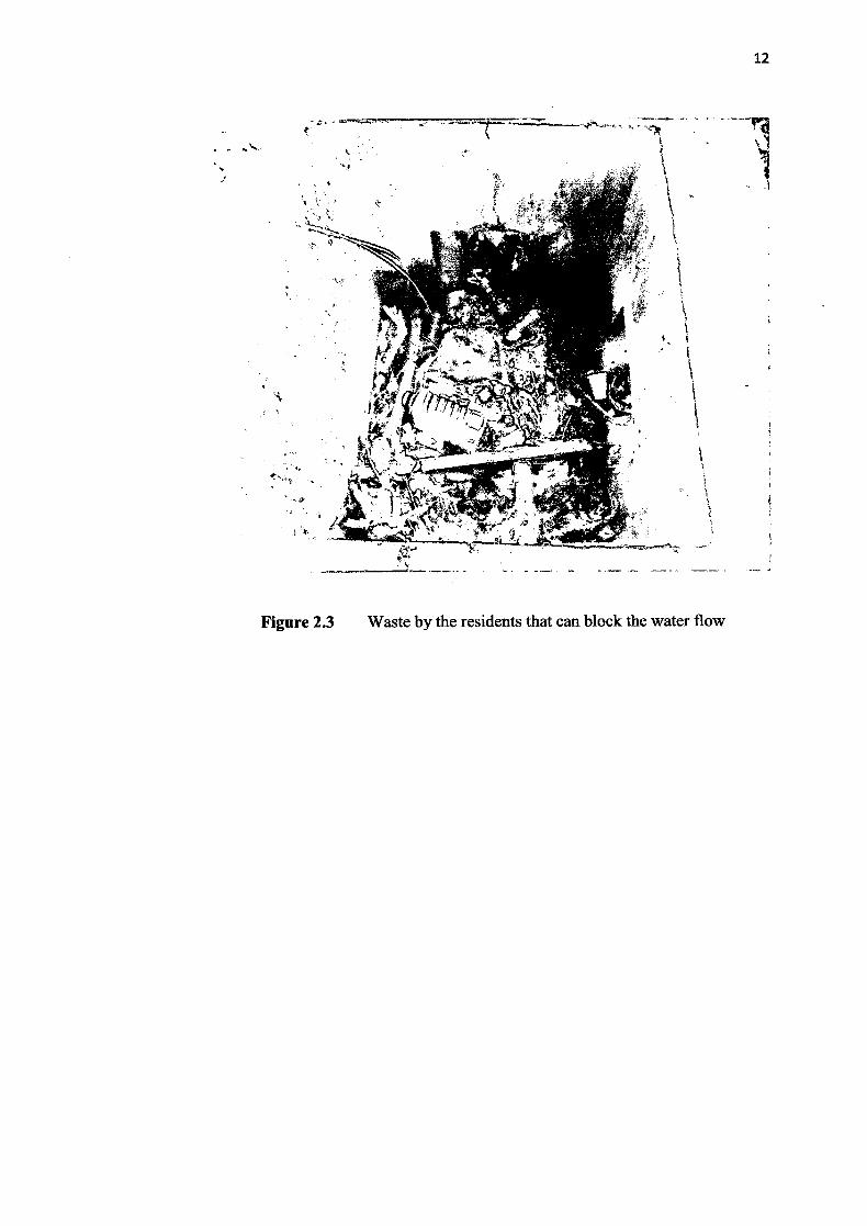
Waste by the residents that can block the water flow 12
Figure 2.4
The condition of main drain with the waste. 14
Figure 3.1
Flow chart study drainage system 16
Figure 3.2
Flow chart of comparative literature 16
Figure 3.3
The main drain at Taman Desa Darul Naim condition 17
Figure 3.4
Step used to propose a new design of drainage system based onARis 18
Figure 4.1
Shows that the different amount of rainfall in january —disember for five years 22
Figure 4.2
The study location 23
Figure 4.3
The site specification 24
Figure 4.4
Shows the drain design 27
Figure 4.5
New drain proposed
28

LIST OF ABBREVIATION & SYMBOL
JPS : Jabatan Pengairan Dan Saliran
MPKB: Majlis Perbandaran Kota Bharu
I : Rainfall Intensity
AR! Average Recurrence Interval
Pd Rainfall Depth
FD Adjustment Factor For Storm Duration
R Average Return Interval (Years)
Duration

ABSTRACT
Flood disaster is the most problems that always happen in Kelantan, and the situation is
commonly happened with monsoon seasons and with occurrence of flash flood. The
same situation occured at Taman Desa Dami Naim , where the area that are impact by
adjacent development and this caused shortage of land surface area that naturally use to
absorb the rain water. Drains were built to collect and channel the surface run off to the
main drain which eventually will discharge volume of water to nearby stream. This
study will investigate the potential flash flood problem for the study area by using the
rainfall data of Kelantan, and the capacity of drain to accommodate the volume of rain
water using MASMA. If the main drain are not having enough adequate capacity to
accommodate the volume of water, new drain need to be designed using rational method
ABSTRAK
Bencana banjir adalah masalah yang sentiasa berlaku di Kelantan, dan keadaan yang
biasanya berlaku dengan musim tengkujuh dan dengan beriakunya banjir kilat. Keadaan
yang sama berlaku di Taman Desa Darul Naim, di mana kawasan yang kesan oleh
pembanguflan bersebelahan dan mi menyebabkan kawasan permukaan tanah yang
digunakan untuk menyerap air hujan berkurangan. Longkang telah dibina untuk
mengumpul dan menyalurkan larian permukaan ke saliran utama yang akhirnya akan
melepaskan isipadu air ke sungai berdekatan. Kajian mi akan menyiasat masalah banjir
kilat yang berpotensi untuk kawasan kajian dengan menggunakan data hujan di
Kelantan, dan kapasiti pant untuk menampung jumlah air hujan menggunakan
MASMA. Jika pant utama tidak rnempunyai kapasiti yang mencukupi untuk
menampung jumlah air, pant baru perlu direka bentuk dengan menggunakan kaedah
rational.

CHAPTER 1
INTRODUCTION
1.1 Research Background
Flood is a condition where the wide area is filled with waters. This condition
occurs when an area is facing with non-stop heavy rain. Malaysia is a one of the
countries that always facing with this flood problem. It maybe happens because of its
position in the equatorial region. As usual, at the monsoon season, Malaysia is always
faced with flood problems; there are several countries in Malaysia that always facing
with this problem is Terengganu, Kelantan, Pahang, Johor, Sabah and Sarawak And for
the flash flood, it's always happened at urban area and developing urban. Perils, Kedah,
Pulau Pinang, Perak, Selangor, Negeri Sembilan, Melaka and also Wiiayah Persekutuan
Kuala Lumpur are those examples. Frequency of flood that always happened and factor
of erosion of the river because of human action that can make the rivers became shallow,
this the main factor why the river not to accommodate the rainwater and then can cause
the water will spill out from the river.
Sungai Pengkalan Data is located near the Pasir Tumbuh. The residential areas
around the Taman Desa Darul Naim, Pasir Turnbuh Kelantan, are facing the flood
disaster just because of its location. It's located in the valley. Bull 2004, say that, the
main factor for the flood occurs is because of the location of the village that located in
the valley, the flow of water from the high area will flow to the lower area. And then
Will submerge the land area. These phenomena are becoming worse with the increasing
of developing around the flood location.
1

2
Every year, the floods will bring a lot of adverse effect, a lot of damage, and the
danger of the flooding is that can cause death. Many cost is needed to accommodate the
flood victims needed and for repairing all the damage that caused by flood. To find the
safe place to evacuate the flood victims. This also can destroy all the plants and animals.
Discharge - The discharge of a stream is the amount of water passing any point in a
given time.
QAxV
Discharge (m3/Sec) Cross-sectional Area [width x average depth] (rn2) x
Average Velocity (mlSec).
As the amount of water in drains increases, the drain must adjust its velocity and
cross sectional area in order to form a balance. Discharge increases as more water is
added through rainfall, tributary drains, or from groundwater seeping into the drain. As
discharge increases, generally width, depth, and velocity of the drains also increase.
1.2 Problem Statement
In Malaysia, flooding is always occurring, there are two categories of flood that
happened in Malaysia, which is flash flood and monsoon flood. According to Jabatan
Meteorology, 2011, the cold air as a result of high pressure that forms over Siberia and
Northern China have reached at Peninsula's Eastern Coast has resulted in conviction and
it caused heavy rainfall in the East Cost of Peninsula and because of the east winds the
sea level rose and the wave ups to 3.5 meters along the east coast such as Kelantan,
Terengganu and Pahang. The figure 1.1 and figure 1.2 Show the residential area before
and after the project.

Figure 1.1 Residential area before the project developed
Figure 1.2 Site proposed for project development

4
The Pengkalan Datu River at Pasir Tumbuh is not going to accommodate the
water when the heavy ram occurs. The river location is situated in a vantage position in
the low lying areas and can cause water from the high lying area prefer to run into the
river and will cause flooding. In addition, that area is developing, more building are built
in that area, then a lot of soil around the development area was in plasters. This situation
would worsen the situation in that area. In addition, the drainage systems are not
properly maintenance and to be upgraded parallel with the increase in development. The
drainage system is very important in order to avoid the water from flooding in that area.
The drain should be designed to be provide enough capacity to keep large volume of
water as stated by Norrudin and Borrudin, 2009, as the land which are previously used to
absorb the rainwater has been in plaster, this situation can cause the rain water flow to
the river and thus will cause the river rose more than usual and it difficult to
accommodate the water and this can cause water to overflow and flooded areas. This
situation would be a danger to the resident.
In other of the increasing of the population in the study are will bring effect of
increased solid waste. As we know, waste is one of the factors that the flash flood
occurs. In addition, this study area is in transition to be developed as new residential
growth area. However it is located in a flat terrain zone with a low velocity drainage
system which may be blocked by domestic wastes that eventually may cause flash flood
such as recently happened in Kajang.
1.3 Research Objective
The objectives of this study are:
1.1.1 To investigate the potential flash flood problem by using rainfall data. 1. 1.2 To analyze the factor that can caused of overflow in Pasir Tumbuh,
Kelantan.

5
1.4 Scope Of Research
The scopes of this research are focusing on:
1.3.1 To study the main drain in Taman Desa Danil Naim.
1.3.2 To investigate the effect of the rainfall that can contribute to the
overflow.
1.3.3 To analyze the maximum drain capacity and the effect of the
development.
1.3.4 To analyze the effect of problem drainage to the water flow.

CHAPTER 2
LITERATURE REVIEW
2.1 Introduction of flood
The flood is the situation when the water overflows and submerged the land.
That always happens after the heavy rain. In Malaysia there are two types of floods are
always happening. There are flash flood and monsoon flood. Flood are among the most
frequent and costly natural disasters in terms of human hardship and economic loss
(American Red Cross). In geological perspective, the flood was the disaster that
occurred as a result of environmental trends changing and flood are expected to occur as
long as the water cycle continues to run (Nelson, 2011). Bangladesh is one of the
country that always facing with flood disaster, is about one half of that country's land, is
at an elevation less than 8 meters above the sea level and is about 200,000 of deaths are
recorded in 1991 because of that disaster and associated tropical cyclones (Nelson,
2011).
From a geological perspective, floods are natural consequences of stream flow in
a continually changing environment streams receive most of their water input from
Precipitation, and the amount of precipitation falling in any given drainage basin varies
from day to day, year to year, and century to century. (Nelson, 2011).

ig
2.2 Flash Flood
Flash flood is happened by excessive rainstorm in short period of time (less than
6 hours) and could lead to river water rising rapidly (Noorazuan et al., 2011). There are
several factors that can contribute the flash flood, such as the intensity the rate of
rainfall, duration of the rainfall rate, topography, soil conditions and ground cover that
as an important role duration of the rainfall (National Oceanic and Atmospheric
Administration., 1992). As reported by Berita Harian, 2011, Kuala Lumpur, after
rainstorm about one hour, a few places in around capital city Kuala Lumpur flooded
because of water rise to 0.5 meters high and lead to road congestion.
Figure 2.1 Flood causes by developed area
Figure 2.1 shows that the flood caused by the uncontrolled development area.
Flash flood is also occurring because of human action changed environment with
development that cause soil surface condition change from water permeable became
impermeable (Haliza Abdul Rahman, 2007).

8
2.3 Type of Drainage
Water flowing from the roof and from the streets as a result of rainfall will carry
the water to flow into drains, streams and then dram it into the sea From here we can
see that how drainage is very important especially during the rainy season. Most
significantly in the developing city to avoid flash floods, as most of the lands in the
pavement and cause stagnant rain water because it can't be absorbed by the soil. The
drainage system is important to carry water from the street to the rivers and from the
river to the ocean This system is designed to avoid the water.
There four types of drainage systems:
2.3.1 Drainage Basin and Divides
Drainage systems developed in such a way to efficiently remove water from the
soil. Each flow in the drainage ditches certain areas, known as drainage basins. In a
drainage basin, all water that falls in the basin drains into the same stream. Drainage
basins can range in size from a few km2, a small river, a very large area. The gap
separates each drainage basin from other drainage basins (Nelson, 2011).
2.3.2 Stream order
The smallest flow in the drainage network has no tributary flow. This is known
as first-order flow. Two first order flow together to form a second-order flow. Second-
order flow has only first-order flow as a stream. Third order flow has only the second
and first order flow as a stream, and so on. As orders increased current, the increase in
emissions, the slope decreases, the velocity increases, and the channel dimensions
(width and depth) increase to accommodate the increased discharge (Nelson, 2011).

9
2.3.3 Drainage Patterns
Drainages tend to develop along zones where rock type and structure of the most
prone to erosion. Therefore, various types of drainage patterns in the region and these
drainage patterns reflect the structure of the rock (Nelson, 2011).
2.3.4 Continental divide
Continent can be divided into large drainage basins that empty into different
ocean basins. The lines that separate the major drainage basins called the Continental
Divide. Any split is usually carried out along the high mountain peaks formed recently
enough that they are not eroded. Thus major continental divides and drainage patterns in
the major basins reflect the recent history of geological continents (Nelson, 2011).
2.3.5 Increased Of Drainage Capacity
Size drainage will affect the water flow, when the capacity of drainage was increased, the water will flow smoothly. The figure below shows the size of drainage that can affect the water flow
t. I .1; . ;. •.!.
I i.••
.,
• - • -
- - -.
• ...• . -: -. --
I- r-1 -
. -•, . .. J
Figure 2.2 Size of drainage can affect the water how

10
2.3.6 Soil Water Storage.
Soil water storage is important to accommodate the water. The peak flows were
influenced by the types of soils. Surface water soils, such as clays. Which have only a
small volume of easily drained pore spaces may increase peak flows (M. Robinson,
1990). In permeable soil, lowering the water table increases the temporary storage
capacity of horizon above the water table, also means the lateral water movement tales
place through deeper horizons and probably at a slower rate on balances the overall
should be to reduce peak flows (M. Robinson, 1990). Impermeable soil as ones where
research was necessary particularly where secondary treatment was used (M. Robinson,
1990).
2.3.7 Size And Duration Rainfall
The size and duration of rainfall can influence the capacity of the drainage.
When the non-stop raining was occurring, the capacity of water in the drainage is
increased immediately. Increasing amount of water will increase the water flow, but if
the capacity of drainage is not sufficient to accommodate the water from rain, it will
cause the overflows. The effect of soil storage is great at taking care of the runoff from
summer or early autumn storms after the soil has been thoroughly dried out, but it may
be much less with respect to late winter and early spring flood flows (M. Robinson,
1990).
2.4 Development Area
The drainage system is related to the development. When the area was
developed, it will cause the several problems such as, it can decrease the land surface
that contributes to the reduction of water absorption of the land surface. This situation
can effect to the:
• Drainage capacity will decrease.
• Availability soil water storage capacity will decrease
• To the storm characteristics and antecedent condition will
effected.

11
2.4 Waste Management
The increasing of the population in Kelantan will bring the effect of increased
solid waste. We need to find a method to solving this problem, to avoid it becoming
worse. As we known here, waste management is not properly managed will give a big
impact because it will cause effects on soil pollution. A management measure is
essential to avoid this problem led to the contamination. The removal garbage in
everywhere and the river will cause water pollution and will lead to more serious
problems that blocked drainage and can cause flash flooding. As we known, this
situation is always happening in the village, where no rubbish bins, provided in the
village, so they are using the approach by gathering the garbage in one place in their
home areas for the purpose of burning the garbage. They used to burn all the rubbish to
avoid it becomes a lot. And sometimes they find an easy ways by throwing it in the
river. The solid waste like a plastics, tires, polystyrene, words are incitided in the type of
an organic waste. These types of waste are not easy to degradable. It will cause problems
to the river if the waste is placed in the river. The wastes will block the water flow in the
drain. In another way to solve this problem to avoid it become Worst is by making a
campaign to recycle the waste in the village. Figure 2.3 and 2.4 shows the examples of
clogged drain in the study area.
12
-
a.
S. . S ___
Figure 2.3 Waste by the residents that can block the water flow

13
V "'
S S
.5
SS•.
-5 - .-- l•-_ - S • sI• 51
_-_. .,•.S-'
S
5, 5 S n. -"S - It55 •-
'• .•55 555 •. 5
Figure 2.4 The condition of main drain with the waste
CHAPTER 3
METHODOLOGY
3.1 Introduction
This study is about to propose the solution to flood disaster by using waste
recycling as a costless approach to prevent flash flood in Pasir Tumboh Kelantan. This
is considered the number of residential and the estimating the water flow velocity the
river in the study area.
3.2 Flow Chart of Study
Based on the Figure 3.1 below; this study starts with literature review and
research about the title. The tasks have been done through research on the interview,
internet, books, journals and other sources. After all relevant information is found, the
project undergoes by collecting data to determine thud the developing areas that involve
the flooding in the study area. Next, is studying about drainage systems for estimating
water flow velocity and do the research in the problem area. Figure 3.1 and 3.2 outlines
the flow chart of the methodology.
14

Study for study
area
'I, Site visit
Study drainage system and Data collection by JPS estimate water flow ____ _
velocity
USE MASMA to find the capacity of drainage and to design a new drainage
Propose new design drainage
system with new capacity
Figure 3.1 Flow chart study drainage system.
Comparative literature
Collect data • Articles • journal • Books
Analyze the factor that can cause of
the flood.
Figure 3.2 Flowchart of comparative literature
15