PerNav: A Route Summarization Framework for … A Route Summarization Framework for Personalized...
4
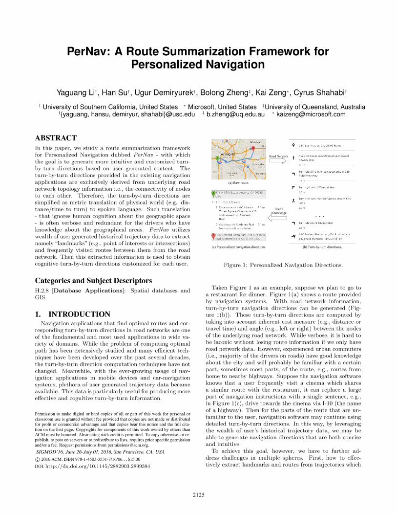
PerNav: A Route Summarization Framework for Personalized Navigation Yaguang Li † , Han Su † , Ugur Demiryurek † , Bolong Zheng ‡ , Kai Zeng * , Cyrus Shahabi † † University of Southern California, United States * Microsoft, United States ‡ University of Queensland, Australia † {yaguang, hansu, demiryur, shahabi}@usc.edu ‡ [email protected] * [email protected] ABSTRACT In this paper, we study a route summarization framework for Personalized Navigation dubbed PerNav - with which the goal is to generate more intuitive and customized turn- by-turn directions based on user generated content. The turn-by-turn directions provided in the existing navigation applications are exclusively derived from underlying road network topology information i.e., the connectivity of nodes to each other. Therefore, the turn-by-turn directions are simplified as metric translation of physical world (e.g. dis- tance/time to turn) to spoken language. Such translation - that ignores human cognition about the geographic space - is often verbose and redundant for the drivers who have knowledge about the geographical areas. PerNav utilizes wealth of user generated historical trajectory data to extract namely “landmarks” (e.g., point of interests or intersections) and frequently visited routes between them from the road network. Then this extracted information is used to obtain cognitive turn-by-turn directions customized for each user. Categories and Subject Descriptors H.2.8 [Database Applications]: Spatial databases and GIS 1. INTRODUCTION Navigation applications that find optimal routes and cor- responding turn-by-turn directions in road networks are one of the fundamental and most used applications in wide va- riety of domains. While the problem of computing optimal path has been extensively studied and many efficient tech- niques have been developed over the past several decades, the turn-by-turn direction computation techniques have not changed. Meanwhile, with the ever-growing usage of nav- igation applications in mobile devices and car-navigation systems, plethora of user generated trajectory data became available. This data is particularly useful for producing more effective and cognitive turn-by-turn information. Permission to make digital or hard copies of all or part of this work for personal or classroom use is granted without fee provided that copies are not made or distributed for profit or commercial advantage and that copies bear this notice and the full cita- tion on the first page. Copyrights for components of this work owned by others than ACM must be honored. Abstracting with credit is permitted. To copy otherwise, or re- publish, to post on servers or to redistribute to lists, requires prior specific permission and/or a fee. Request permissions from [email protected]. SIGMOD’16, June 26-July 01, 2016, San Francisco, CA, USA c 2016 ACM. ISBN 978-1-4503-3531-7/16/06. . . $15.00 DOI: http://dx.doi.org/10.1145/2882903.2899384 (b) Turn-by-turn directions. (a) Raw route. Road Network Users Knowledge (c) Personalized navigation directions Figure 1: Personalized Navigation Directions. Taken Figure 1 as an example, suppose we plan to go to a restaurant for dinner. Figure 1(a) shows a route provided by navigation systems. With road network information, turn-by-turn navigation directions can be generated (Fig- ure 1(b)). These turn-by-turn directions are computed by taking into account inherent cost measure (e.g., distance or travel time) and angle (e.g., left or right) between the nodes of the underlying road network. While verbose, it is hard to be laconic without losing route information if we only have road network data. However, experienced urban commuters (i.e., majority of the drivers on roads) have good knowledge about the city and will probably be familiar with a certain part, sometimes most parts, of the route, e.g., routes from home to nearby highways. Suppose the navigation software knows that a user frequently visit a cinema which shares a similar route with the restaurant, it can replace a large part of navigation instructions with a single sentence, e.g., in Figure 1(c), drive towards the cinema via I-10 (the name of a highway). Then for the parts of the route that are un- familiar to the user, navigation software may continue using detailed turn-by-turn directions. In this way, by leveraging the wealth of user’s historical trajectory data, we may be able to generate navigation directions that are both concise and intuitive. To achieve this goal, however, we have to further ad- dress challenges in multiple spheres. First, how to effec- tively extract landmarks and routes from trajectories which 2125
Transcript of PerNav: A Route Summarization Framework for … A Route Summarization Framework for Personalized...
PerNav: A Route Summarization Framework forPersonalized Navigation
Yaguang Li†, Han Su†, Ugur Demiryurek†, Bolong Zheng‡, Kai Zeng∗, Cyrus Shahabi†
† University of Southern California, United States ∗ Microsoft, United States ‡University of Queensland, Australia†{yaguang, hansu, demiryur, shahabi}@usc.edu ‡ [email protected] ∗ [email protected]
ABSTRACTIn this paper, we study a route summarization frameworkfor Personalized Navigation dubbed PerNav - with whichthe goal is to generate more intuitive and customized turn-by-turn directions based on user generated content. Theturn-by-turn directions provided in the existing navigationapplications are exclusively derived from underlying roadnetwork topology information i.e., the connectivity of nodesto each other. Therefore, the turn-by-turn directions aresimplified as metric translation of physical world (e.g. dis-tance/time to turn) to spoken language. Such translation- that ignores human cognition about the geographic space- is often verbose and redundant for the drivers who haveknowledge about the geographical areas. PerNav utilizeswealth of user generated historical trajectory data to extractnamely “landmarks” (e.g., point of interests or intersections)and frequently visited routes between them from the roadnetwork. Then this extracted information is used to obtaincognitive turn-by-turn directions customized for each user.
Categories and Subject DescriptorsH.2.8 [Database Applications]: Spatial databases andGIS
1. INTRODUCTIONNavigation applications that find optimal routes and cor-
responding turn-by-turn directions in road networks are oneof the fundamental and most used applications in wide va-riety of domains. While the problem of computing optimalpath has been extensively studied and many efficient tech-niques have been developed over the past several decades,the turn-by-turn direction computation techniques have notchanged. Meanwhile, with the ever-growing usage of nav-igation applications in mobile devices and car-navigationsystems, plethora of user generated trajectory data becameavailable. This data is particularly useful for producing moreeffective and cognitive turn-by-turn information.
Permission to make digital or hard copies of all or part of this work for personal orclassroom use is granted without fee provided that copies are not made or distributedfor profit or commercial advantage and that copies bear this notice and the full cita-tion on the first page. Copyrights for components of this work owned by others thanACM must be honored. Abstracting with credit is permitted. To copy otherwise, or re-publish, to post on servers or to redistribute to lists, requires prior specific permissionand/or a fee. Request permissions from [email protected].
SIGMOD’16, June 26-July 01, 2016, San Francisco, CA, USAc© 2016 ACM. ISBN 978-1-4503-3531-7/16/06. . . $15.00
DOI: http://dx.doi.org/10.1145/2882903.2899384
(b) Turn-by-turn directions.
(a) Raw route.
Road Network
User s
Knowledge
(c) Personalized navigation directions
Figure 1: Personalized Navigation Directions.
Taken Figure 1 as an example, suppose we plan to go toa restaurant for dinner. Figure 1(a) shows a route providedby navigation systems. With road network information,turn-by-turn navigation directions can be generated (Fig-ure 1(b)). These turn-by-turn directions are computed bytaking into account inherent cost measure (e.g., distance ortravel time) and angle (e.g., left or right) between the nodesof the underlying road network. While verbose, it is hard tobe laconic without losing route information if we only haveroad network data. However, experienced urban commuters(i.e., majority of the drivers on roads) have good knowledgeabout the city and will probably be familiar with a certainpart, sometimes most parts, of the route, e.g., routes fromhome to nearby highways. Suppose the navigation softwareknows that a user frequently visit a cinema which sharesa similar route with the restaurant, it can replace a largepart of navigation instructions with a single sentence, e.g.,in Figure 1(c), drive towards the cinema via I-10 (the nameof a highway). Then for the parts of the route that are un-familiar to the user, navigation software may continue usingdetailed turn-by-turn directions. In this way, by leveragingthe wealth of user’s historical trajectory data, we may beable to generate navigation directions that are both conciseand intuitive.
To achieve this goal, however, we have to further ad-dress challenges in multiple spheres. First, how to effec-tively extract landmarks and routes from trajectories which
2125

usually come with noise and uncertainty? Second, how toutilize knowledge routes to generate personal navigation di-rections that are concise but convey enough informationfor user to interpret the route? - To address these chal-lenges, we designed a prototype system called PerNav thatproduces turn-by-turn directions by leveraging the wealthof user’s historical trajectory data. In particular, PerNavfirst extracts user’s knowledge about the road network byleveraging trajectory calibration and trajectory clustering.Then for a given route, PerNav partitions it based on ex-tracted knowledge using dynamic programming and branch-and-bound based approaches. The final step is to constructa personalized navigation directions based on the route par-tition. In summary, PerNav improves navigation applica-tions in three ways. First, PerNav incorporates histori-cal trajectory data to navigation applications to producehigher-quality personalized turn-by-turn directions for ur-ban commuters. To our knowledge, this paper is the first todescribe the use of trajectory data for generating personal-ized turn-by-turn directions. Second, PerNav offers networkbandwidth reduction by significantly reducing the informa-tion transferred between the server and navigation clients.Third, PerNav allows user to customize the summary con-struction process with different detailed granularities.
The remainder of this paper is organized as follows. InSection 2, we formalize the problem and describe key tech-niques. In Section 3, we present our prototype system withreal-world use cases. In Section 4, we review related work.
2. OVERVIEWBy referring to places and routes that are familiar to peo-
ple, we can provide them an intuitive view about a newroute. PerNav follows the same intuition to construct ahigher level summary for a route generated by navigationsoftware.
Figure 2: Framework overview of PerNav .
Figure 2 shows the overview of PerNav . The input of Per-Nav is a route and the output is a personalized navigationdirection. This procedure mainly contains three steps, i.e.,data preprocessing, route partition and summary genera-tion. The first step for data preprocessing is offline while thelast two steps are online. In the data preprocessing, PerNavwill extract frequent visiting 〈starting point, destination〉pairs and routes between them for every user, which arecalled the knowledge of users, from users’ historical trajec-tories. Then given a route, PerNav partitions it based onextracted knowledge and the detail will be discussed in Sec-tion 2.3. The final step is to construct personalized naviga-tion directions based on the route partition. In what follows,we will formalize the problem and describe the key technicalsbehind each step.
2.1 Preliminaries ConceptsWe adopt the standard road network representation in
which intersections are represented by nodes and roads arerepresented by links with attached features. Link is alsoknown as road segment and we will use link and road seg-ment interchangeably whenever the context is clear.
Definition 1 (Landmark). A landmark l is a geograph-ical point in the space, which is stable and independent ofuser trajectories.
A landmark can be either a Point of Interest (POI) or anintersection in the road network, and a route in the roadnetwork can be represented using landmarks.
Definition 2 (Route). Formally, a route R in the roadnetwork is defined as a sequence of landmarks. R = [l1, l2, · · · ln].R(i) denotes the ith landmark, i.e., li. Every two adjacentlandmarks are directly connected by a link in the road net-work. Thus R can also be considered as a sequence of links.
In the road network, adjacent links usually share some fea-tures, e.g., street name, direction. Based on these features,we can divide the road network into disjointed routes, i.e.,all the adjacent links with same features will be in the sameroute. As this type of route is independent of specific per-son, we call it natural route (NR). For example, in Figure 1,S Atlantic Blvd is called a natural route. For a given routeR = [l1, l2, · · · ln], we can use a sequence of natural routes[NR1,NR2, · · · ,NRm] (m ≤ n), to represent it, which isknown as the turn-by-turn manner, e.g., Figure 1(b), andthis manner is widely used by existing navigation systems.
Moreover, there exists another type of route which is spe-cific to individuals. In real life, urban commuters will getquite familiar with certain landmarks and routes betweensome of them, e.g., the route from home to work or the routefrom work to a shopping center. We call such a route knowl-edge route (KR) for the urban commuter. In Figure 1(a), theroute from home to the cinema is an example of knowledgeroute for the user.
Note that, a knowledge route usually contains multiplenatural routes, i.e., KR = [NRi,NRi+1, · · · ,NRj ]. Thus, ifthis sequence of natural routes is a sub-sequence of R, wecan represent the route as:
R = [NR1, · · · ,NRi−1,KR,NRj+1, · · · ,NRk] k ≤ m ≤ n
which is called the personalized manner. Obviously, by usingknowledge routes, the personalized manner becomes moreconcise, i.e., less number of the route-segments, and morefamiliar to the urban commuter than the turn-by-turn man-ner. In the following subsection, we will show how to extractand measure knowledge routes by analyzing user’s historicaltrajectories.
2.2 User Knowledge MeasurementWith historical trajectories, PerNav first employs trajec-
tory calibration proposed in our previous research to mapthem into routes in the road network [8, 10]. Then staypoints detection [15] is used to identify places that are famil-iar to user. These places are used to generate the descriptionof knowledge routes. After that, PerNav groups trajectoriesinto clusters [13]. In each cluster, the most representativeroute is extracted as a knowledge route connecting a sourceand a destination. Besides, for each knowledge route, we
2126

calculate a familiarity score f(R) ∈ [0, 1], which indicatesthe user’s familiarity of this knowledge route. f(R) is af-fected by the following aspects: 1) The frequency this routeis traversed. 2) The significance of start and end landmarksof this route. The significance of landmarks are calculatedby leveraging a HITS-like algorithm [15] which models thetravellers as authorities, landmarks as hubs, and check-insas hyperlinks. In PerNav , normalized weighted sum of thesetwo factors is used as the familiarity score. Note that, for anatural route, its familiarity to a user is 0 by default.
Given the familiarity of a route R, we can derive the fa-miliarity of its segments, i.e., route segment.
Definition 3 (Route Segment). A route segment RS= R(j, k) = [lj , lj+1, · · · , lk], is defined as a sub-sequence ofroute R. It can also be seen as a sequence of links connectinglj and lk.
Based on the type of R, a route segment can be either anatural route segment or a knowledge route segment. Thefamiliarity of a route segment is calculated using Equation 1
f(RS) = f(R(RS)) · g( len(RS)
len(R(RS))
)(1)
where R(RS) is the corresponding knowledge route of RS,len(RS)
len(R(RS))is the length ratio of RS. g(·) is a monotonic
convex function with g(0) = 0 and g(1) = 1. With thedecrease of length ratio, the familiarity score decreases fasterthan a linear function which is more consistent with humanbeing’s cognition.
2.3 Knowledge-based Route PartitionUsually, if we want to describe a route, we will partition
it into route segments and then give description for each ofthem.
Definition 4 (Route Partition). For a route R, apartition of it P(R) = {RS1, RS2, · · · , RSn} is such that:
•⋃n
i=1RSi = R
• ∀i, j RSi ∩RSj = ∅
Each route segment RSi can be either a knowledge route seg-ment or a natural route segment.
For a route R in the road network, we can partition it inmany ways resulting in possibly different navigation direc-tions. Generally, we want the generated directions 1) be in-tuitive and easy for user to understand, i.e., utilizing knowl-edge routes with high familiarity in generated directions;and then 2) be concise, so it will be easy for human beingsto read and share, i.e., minimize the number of route seg-ments. With these objectives, we can evaluate the qualityof a partition P by equation 2:
QP(R) =∑
RSi∈P(R)
f(RSi)− λ|P(R)| (2)
Popt(R) = argmaxP(R)
QP(R) (3)
where f(·) is the function to calculate the familiarity scorein Equation 1, |P(R)| is the number of route segments in thispartition, λ ≥ 0 is used to constrain the number of segmentsin the generated route partition. We want to find the routepartition P(R)opt that maximize QP(R).
The naıve approach is to enumerate all the possible com-bination of route segments and choose the one with maxi-mum score. However, the time complexity is exponential interms of the number of links in the route. In the followingparagraphs, we will show that dynamic programming can beused to find the optimal route partition efficiently.
Definition 5 (Conditional Route Partition). Gi-ven a route R = [l1, l2, · · · , ln], its conditional route parti-tion P(R(1, i)|R′(·, ·)) is defined as route partitions with thelast route segment, i.e., RS, coming from route R′.
Specially, P(R(1, i)|R′(j, k)
)represents the conditional route
partition with the last route segment equals to R′(j, k).
Lemma 1. The optimal partition of a route is the bestconditional optimal partition among all candidate routes forthe last link.
Popt(R(1, i)) = argmaxP
Q(Popt(R(1, i)|R′(·, ·)
)(4)
R′ ∈ R(R(i− 1, i))
where R(R(i − 1, i)) is the set of all the routes that con-tains link R(i − 1, i). The proof is straightforward, as weenumerate all possible conditions and choose the best one.
Lemma 2. The conditional optimal route partition of asub-route R(1, i + 1), i.e., Popt(R(1, i + 1)|R′(·, ·)), can bederived from conditional optimal route partitions of R(1, i),i.e., Popt
(R(1, i)|R′′(·, ·)
).
Popt(R(1,i+ 1)|R′) = argmaxR′′∈R(R(i−1,i))
(5)
Q(Popt
(R(1, i)|R′′(·, ·)
)∪(R(i, i+ 1) 7→ R′
))where R
(R(i−1, i)
)is the set of all the routes that contain
link R(i − 1, i), and Popt
(R(1, i)|R′′
)∪(R(i, i + 1) 7→ R′
)means mapping the link R(i, i + 1) to R′ and merge itto the conditional optimal partition Popt(R(1, i)|R′′). Let∆Q
(R(i, i+ 1) 7→ R′
)denotes the score change after map-
ping the link R(i, i + 1) to R′. According to Equation 2,∆Q
(R(i, i + 1) 7→ R′
)will be the same as long as the last
segment of P is mapped to a route other than R′. Thus,we can iteratively find the optimal partition using dynamicprogramming.
2.4 Summary ConstructionAfter the partitioning step, a route R will become a se-
quence of route segments. Then PerNav will generate nav-igation directions by describing knowledge route segmentsand natural route segments respectively. As knowledge routeR is familiar to user, we can describe it using some keyfeatures, e.g., the start/end landmark, the main highway,rather than describing all the natural routes in it. In orderto construct more fluent summary sentences, we also definesentence templates, e.g., drive towards POI name via mostrepresentative feature of the knowledge route. The most sig-nificant POI within a certain distance is selected to generatethe summary.
For natural routes, traditional turn-by-turn directions gen-erations techniques can be used. Moreover, in PerNav usercan specify the description granularity of directions. Underthe configuration of the most detailed granularity, PerNavwill generate descriptions for every single route segments.
2127
The result will be similar to turn-by-turn directions providedby current navigation systems. With the decrease of detaillevel, less important route segments, i.e., low-level roads andshort roads, will be omitted.
3. DEMONSTRATIONIn this section, we will present a detailed demonstration
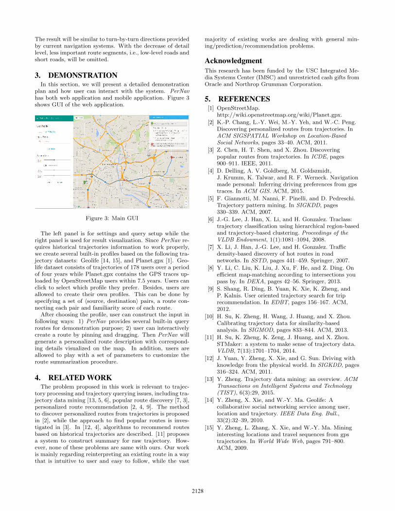
plan and how user can interact with the system. PerNavhas both web application and mobile application. Figure 3shows GUI of the web application.
Figure 3: Main GUI
The left panel is for settings and query setup while theright panel is used for result visualization. Since PerNav re-quires historical trajectories information to work properly,we create several built-in profiles based on the following tra-jectory datasets: Geolife [14, 15], and Planet.gpx [1]. Geo-life dataset consists of trajectories of 178 users over a periodof four years while Planet.gpx contains the GPS traces up-loaded by OpenStreetMap users within 7.5 years. Users canclick to select which profile they prefer. Besides, users areallowed to create their own profiles. This can be done byspecifying a set of 〈source, destination〉 pairs, a route con-necting each pair and familiarity score of each route.
After choosing the profile, user can construct the input infollowing ways: 1) PerNav provides several built-in queryroutes for demonstration purpose; 2) user can interactivelycreate a route by pinning and dragging. Then PerNav willgenerate a personalized route description with correspond-ing details visualized on the map. In addition, users areallowed to play with a set of parameters to customize theroute summarization procedure.
4. RELATED WORKThe problem proposed in this work is relevant to trajec-
tory processing and trajectory querying issues, including tra-jectory data mining [13, 5, 6], popular route discovery [7, 3],personalized route recommendation [2, 4, 9]. The methodto discover personalized routes from trajectories is proposedin [2], while the approach to find popular routes is inves-tigated in [3]. In [12, 4], algorithms to recommend routesbased on historical trajectories are described. [11] proposesa system to construct summary for raw trajectory. How-ever, none of these problems are same with ours. Our workis mainly regarding reinterpreting an existing route in a waythat is intuitive to user and easy to follow, while the vast
majority of existing works are dealing with general min-ing/prediction/recommendation problems.
AcknowledgmentThis research has been funded by the USC Integrated Me-dia Systems Center (IMSC) and unrestricted cash gifts fromOracle and Northrop Grumman Corporation.
5. REFERENCES[1] OpenStreetMap.
http://wiki.openstreetmap.org/wiki/Planet.gpx.
[2] K.-P. Chang, L.-Y. Wei, M.-Y. Yeh, and W.-C. Peng.Discovering personalized routes from trajectories. InACM SIGSPATIAL Workshop on Location-BasedSocial Networks, pages 33–40. ACM, 2011.
[3] Z. Chen, H. T. Shen, and X. Zhou. Discoveringpopular routes from trajectories. In ICDE, pages900–911. IEEE, 2011.
[4] D. Delling, A. V. Goldberg, M. Goldszmidt,J. Krumm, K. Talwar, and R. F. Werneck. Navigationmade personal: Inferring driving preferences from gpstraces. In ACM GIS. ACM, 2015.
[5] F. Giannotti, M. Nanni, F. Pinelli, and D. Pedreschi.Trajectory pattern mining. In SIGKDD, pages330–339. ACM, 2007.
[6] J.-G. Lee, J. Han, X. Li, and H. Gonzalez. Traclass:trajectory classification using hierarchical region-basedand trajectory-based clustering. Proceedings of theVLDB Endowment, 1(1):1081–1094, 2008.
[7] X. Li, J. Han, J.-G. Lee, and H. Gonzalez. Trafficdensity-based discovery of hot routes in roadnetworks. In SSTD, pages 441–459. Springer, 2007.
[8] Y. Li, C. Liu, K. Liu, J. Xu, F. He, and Z. Ding. Onefficient map-matching according to intersections youpass by. In DEXA, pages 42–56. Springer, 2013.
[9] S. Shang, R. Ding, B. Yuan, K. Xie, K. Zheng, andP. Kalnis. User oriented trajectory search for triprecommendation. In EDBT, pages 156–167. ACM,2012.
[10] H. Su, K. Zheng, H. Wang, J. Huang, and X. Zhou.Calibrating trajectory data for similarity-basedanalysis. In SIGMOD, pages 833–844. ACM, 2013.
[11] H. Su, K. Zheng, K. Zeng, J. Huang, and X. Zhou.STMaker: a system to make sense of trajectory data.VLDB, 7(13):1701–1704, 2014.
[12] J. Yuan, Y. Zheng, X. Xie, and G. Sun. Driving withknowledge from the physical world. In SIGKDD, pages316–324. ACM, 2011.
[13] Y. Zheng. Trajectory data mining: an overview. ACMTransactions on Intelligent Systems and Technology(TIST), 6(3):29, 2015.
[14] Y. Zheng, X. Xie, and W.-Y. Ma. Geolife: Acollaborative social networking service among user,location and trajectory. IEEE Data Eng. Bull.,33(2):32–39, 2010.
[15] Y. Zheng, L. Zhang, X. Xie, and W.-Y. Ma. Mininginteresting locations and travel sequences from gpstrajectories. In World Wide Web, pages 791–800.ACM, 2009.
2128