Permafrost environment in the Yari-Hotaka Mountains ... · ASL (Ono 1984). Although a number of...
6
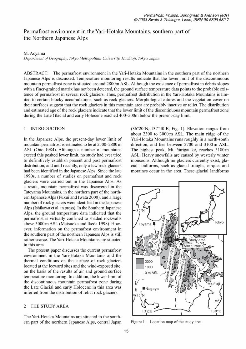
1 INTRODUCTION In the Japanese Alps, the present-day lower limit of mountain permafrost is estimated to lie at 2500–2800 m ASL (Ono 1984). Although a number of mountains exceed this posited lower limit, no study had ever tried to definitively establish present and past permafrost distribution, and until recently, only a few rock glaciers had been identified in the Japanese Alps. Since the late 1990s, a number of studies on permafrost and rock glaciers were carried out in the Japanese Alps. As a result, mountain permafrost was discovered in the Tateyama Mountains, in the northern part of the north- ern Japanese Alps (Fukui and Iwata 2000), and a large number of rock glaciers were identified in the Japanese Alps (Ishikawa et al. in press). In the Southern Japanese Alps, the ground temperature data indicated that the permafrost is virtually confined to shaded rockwalls above 3000 m ASL (Matsuoka and Ikeda 1998). How- ever, information on the permafrost environment in the southern part of the northern Japanese Alps is still rather scarce. The Yari-Hotaka Mountains are situated in this area. The present paper discusses the current permafrost environment in the Yari-Hotaka Mountains and the thermal conditions on the surface of rock glaciers located at the leeward sites and the wind-exposed site, on the basis of the results of air and ground surface temperature monitoring. In addition, the lower limit of the discontinuous mountain permafrost zone during the Late Glacial and early Holocene in this area was inferred from the distribution of relict rock glaciers. 2 THE STUDY AREA The Yari-Hotaka Mountains are situated in the south- ern part of the northern Japanese Alps, central Japan (36°20N, 137°40E; Fig. 1). Elevation ranges from about 2300 to 3000 m ASL. The main ridge of the Yari-Hotaka Mountains runs roughly in a north-south direction, and lies between 2700 and 3100 m ASL. The highest peak, Mt. Yarigatake, reaches 3180m ASL. Heavy snowfalls are caused by westerly winter monsoons. Although no glaciers currently exist, gla- cial landforms, such as glacial troughs, cirques and moraines occur in the area. These glacial landforms 15 Permafrost environment in the Yari-Hotaka Mountains, southern part of the Northern Japanese Alps M. Aoyama Department of Geography, Tokyo Metropolitan University, Hachioji, Tokyo, Japan ABSTRACT: The permafrost environment in the Yari-Hotaka Mountains in the southern part of the northern Japanese Alps is discussed. Temperature monitoring results indicate that the lower limit of the discontinuous mountain permafrost zone is situated around 2800m ASL. Although the existence of permafrost in debris slopes with a finer-grained matrix has not been detected, the ground surface temperature data points to the probable exis- tence of permafrost in several rock glaciers. Thus, permafrost distribution in the Yari-Hotaka Mountains is lim- ited to certain blocky accumulations, such as rock glaciers. Morphologic features and the vegetation cover on their surfaces suggest that the rock glaciers in this mountain area are probably inactive or relict. The distribution and estimated age of the rock glaciers indicate that the lower limit of the discontinuous mountain permafrost zone during the Late Glacial and early Holocene reached 400–500m below the present-day limit. Permafrost, Phillips, Springman & Arenson (eds) © 2003 Swets & Zeitlinger, Lisse, ISBN 90 5809 582 7 139 o E 137 o E 37 o N 35 o N 0 m ASL 1000 2000 Toyama Nagoya Matsumoto Mt.Fuji £ Study area Tokyo ¡ Northern Japanese Alps Central Japanese Alps Southern Japanese Alps Figure 1. Location map of the study area.
Transcript of Permafrost environment in the Yari-Hotaka Mountains ... · ASL (Ono 1984). Although a number of...
1 INTRODUCTION
In the Japanese Alps, the present-day lower limit ofmountain permafrost is estimated to lie at 2500–2800 mASL (Ono 1984). Although a number of mountainsexceed this posited lower limit, no study had ever triedto definitively establish present and past permafrostdistribution, and until recently, only a few rock glaciershad been identified in the Japanese Alps. Since the late1990s, a number of studies on permafrost and rockglaciers were carried out in the Japanese Alps. As a result, mountain permafrost was discovered in theTateyama Mountains, in the northern part of the north-ern Japanese Alps (Fukui and Iwata 2000), and a largenumber of rock glaciers were identified in the JapaneseAlps (Ishikawa et al. in press). In the Southern JapaneseAlps, the ground temperature data indicated that thepermafrost is virtually confined to shaded rockwallsabove 3000 m ASL (Matsuoka and Ikeda 1998). How-ever, information on the permafrost environment inthe southern part of the northern Japanese Alps is stillrather scarce. The Yari-Hotaka Mountains are situatedin this area.
The present paper discusses the current permafrostenvironment in the Yari-Hotaka Mountains and thethermal conditions on the surface of rock glacierslocated at the leeward sites and the wind-exposed site,on the basis of the results of air and ground surfacetemperature monitoring. In addition, the lower limit ofthe discontinuous mountain permafrost zone duringthe Late Glacial and early Holocene in this area wasinferred from the distribution of relict rock glaciers.
2 THE STUDY AREA
The Yari-Hotaka Mountains are situated in the south-ern part of the northern Japanese Alps, central Japan
(36°20�N, 137°40�E; Fig. 1). Elevation ranges fromabout 2300 to 3000 m ASL. The main ridge of theYari-Hotaka Mountains runs roughly in a north-southdirection, and lies between 2700 and 3100 m ASL.The highest peak, Mt. Yarigatake, reaches 3180 mASL. Heavy snowfalls are caused by westerly wintermonsoons. Although no glaciers currently exist, gla-cial landforms, such as glacial troughs, cirques andmoraines occur in the area. These glacial landforms
15
Permafrost environment in the Yari-Hotaka Mountains, southern part of the Northern Japanese Alps
M. AoyamaDepartment of Geography, Tokyo Metropolitan University, Hachioji, Tokyo, Japan
ABSTRACT: The permafrost environment in the Yari-Hotaka Mountains in the southern part of the northernJapanese Alps is discussed. Temperature monitoring results indicate that the lower limit of the discontinuousmountain permafrost zone is situated around 2800m ASL. Although the existence of permafrost in debris slopeswith a finer-grained matrix has not been detected, the ground surface temperature data points to the probable exis-tence of permafrost in several rock glaciers. Thus, permafrost distribution in the Yari-Hotaka Mountains is lim-ited to certain blocky accumulations, such as rock glaciers. Morphologic features and the vegetation cover ontheir surfaces suggest that the rock glaciers in this mountain area are probably inactive or relict. The distributionand estimated age of the rock glaciers indicate that the lower limit of the discontinuous mountain permafrost zoneduring the Late Glacial and early Holocene reached 400–500m below the present-day limit.
Permafrost, Phillips, Springman & Arenson (eds)© 2003 Swets & Zeitlinger, Lisse, ISBN 90 5809 582 7
139 oE137oE
37oN
35oN
0 m ASL
1000
2000
Toyama
Nagoya
Matsumoto
Mt.Fuj i£
Study area
Tokyo¡
Nor
ther
n Ja
pane
se A
lps
Cen
tral
Jap
anes
e A
lps
Sou
ther
n Ja
pane
se A
lps
Figure 1. Location map of the study area.

were presumed to have been formed during the LatePleistocene (Ito and Vorndran 1983). The inherited gla-cial landforms and the present-day snow patches con-centrate on east-facing slopes because of snow driftsupplied by predominant westerly wind. Eight rockglaciers were identified in this area (Ishikawa et al., inpress). The distribution of these rock glaciers (RG1-8)is presented in Figure 2. The rock glacier fronts occurbetween 2360 and 2890 m ASL. RG1-7 is located onthe east-facing side of the main ridge. In contrast, RG8is located on the west-facing side. The surfaces of theserock glaciers consist of large angular blocks withoutfine-grained soil. The bedrock geology of the area con-sists of the Hotaka Andesite (Harayama 1990).
3 METHODS
Air and ground surface temperature monitoring wereconducted from 1 October 2000 until 30 September2002, by means of miniature data loggers (ThermoRecorder TR-52, manufactured by T & D corporation,Japan). The loggers recorded temperatures at 1 h
intervals with a resolution of 0.1°C. The monitoringsites are shown in Figure 2. Air temperature was moni-tored at the Minamidake Mountain Hut (2975 m ASL),which is located on the main ridge of the Yari-HotakaMountains. Ground surface temperature monitoringwas conducted at a single location on each of four rockglaciers. Site 1 (2810 m ASL) is located on RG1. Site 2(2620 m ASL) is located on the small mound of RG6.Site 3 (2625 m ASL) is located at the upper part of RG7.Site 4 (2960 m ASL) is located at the upper part of RG8.
Morphometric parameters of each rock glacier (e.g.the frontal angle and relative height of the rock glacier) were measured by means of an analyticalplotter SD 3000 (manufactured by Leica corporation,Switzerland). Furthermore, morphologic features ofthe rock glacier and vegetation cover on the rock gla-cier surface were observed by field survey and air-photo interpretation. In this paper, rock glaciers RG1,RG6, RG7 and RG8, where ground surface tempera-ture was monitored, are described in detail.
4 RESULTS
4.1 Air temperature
Results of air temperature monitoring are summarizedin Table 1. The mean annual air temperature (MAAT)was �2.5°C for each measurement year. Freezingindices for 2000–2001 and 2001–2002 were 2013.4degree days and 1944.9 degree days, respectively.Thawing indices reached 1101.3 degree days in2000–2001 and 1033.1 degree days in 2001–2002. Thewarmest months were July and August in 2001 (9.9°C)and July in 2002 (10.5°C). January was the coldestmonth, with mean air temperatures of �15.9°C in2001 and �14.1°C in 2002. Autum/n and early winter(October to December) temperatures in 2001 werecolder than the precedent year. However, winter tem-peratures (January to March) in 2002 were warmerthan in 2001. Air temperatures stayed below 0°Cthroughout the entire winter (Fig. 3).
4.2 Ground surface temperature
At sites 1, 2 and 3, located at the leeward site, the tem-perature remained nearly constant during the winter
16
0 500m
Site 3
Mt. Yarigatake
Yarisawa
RG1
Mt. Minamidake
Tongue-shapedrock glacierLobaterock glacierMoraine
Cirque wall
Mt. Kitahotakadake
RG5
RG3
measurement siteof air temperature
measurement siteof ground surfacetemperature
RG8
3000
RG6RG7
Site 2
Site 1Site 4 RG2
2500Mt. Nakadake
2500
2500
RG4
Figure 2. Topographic map showing the location of themonitoring sites of air and ground surface temperature, anddistribution of rock glaciers.
Table 1. Summary of air temperature monitoring fromOctober 2000 to September 2002 at the MinamidakeMountain Hut.
Freezing Index Thawing IndexYear Mean (°C) (°C � days) (°C � days)
2000–2001 �2.5°C 2013.4 1101.32001–2002 �2.5°C 1944.9 1033.1

(February and March; Fig. 3). This thermal conditionsuggests that a thick insulating snow cover developedat these monitoring sites during that period.
In 2000–2001, the temperatures at site 1 were below0°C during the period from mid-November to the endof May 2001. Thereafter, the temperatures remainedat about 0°C until early July. In 2001–2002, the tem-peratures were below 0°C during the period from theend of October to early May. Thereafter, it stayed atabout 0°C until the end of July. In contrast to the airtemperature, winter ground surface temperatures in2002 were colder than in 2001. The mean bottom tem-peratures of winter snow cover (BTS) for February andMarch were �1.2°C in 2001, and �1.9°C in 2002.Mean annual surface temperatures (MAST) for 2001and 2002 were 1.8°C and 0.2°C, respectively.
At site 2, the temperature profile in 2000–2001showed similar general behavior to that of 2001–2002.During the period from mid-December to mid-April,temperatures remained nearly constant at around�4.5°C. By mid-April, the temperature rose towards0°C, and stayed at about 0°C until mid-August in 2001,and early August in 2002. The mean BTS measurementsfor February and March were �4.2°C in 2001 and�4.6°C in 2002. MAST values in 2000–2001 and2001–2002 were �0.1°C and �0.2°C, respectively.
At site 3, temperature fluctuation in 2000–2001 and2001–2002 also showed similar general behavior.Between February and April, temperature stayedbetween about �4°C and �5°C. By end of April, itrose towards 0°C, and stayed at about 0°C until earlyJuly in 2001, and the end of July in 2002. The meanBTS values for February and March were �4.5°C foreach measurement year. MAST values in 2000–2001and 2001–2002 were �1.2°C and 0°C, respectively.
Site 4 is located at the wind-exposed site. In con-trast to sites 1, 2 and 3, which are located at the leewardsite, the temperatures were constantly fluctuating dur-ing winter. Hence, the snow cover at this site musthave been shallow. However, the diurnal range of tem-perature in winter was smaller than in the other sea-sons. The diurnal range of temperature was about0.5–2.0°C during the February through March period.MAST values were 0.8°C for each measurement year.
4.3 Morphology of the rock glaciers and vegetation cover on the rock glacier surface
RG1 is located at the foot of the east-facing talus belowa cirque wall. The front and head altitudes of RG1 are2750 m ASL and 2820 m ASL, respectively. Anenclosed hollow exists in the central portion of therock glacier, while the outer part of the rock glacierconsists of a continuous ridge. The ridge crest tends tobe rounded. The frontal slope of RG1 is 33 m high,with an angle of 33°. The majority of the rock glaciersurface is not covered with vegetation.
RG6 is located at the foot of the southeast facingtalus below a cirque wall. The front and head altitudesof RG6 are 2500 m ASL and 2630 m ASL, respec-tively. The lowest part of the rock glacier consists of acontinuous ridge with dense vegetation. There is asmall, subdued mound in the central part of the rockglacier. The height of the frontal slope of RG6 is 20 m,with an angle of 36°.
RG7 is located at the foot of the north-facing talusbelow a cirque wall. The front and head altitudes ofRG7 are 2540 m ASL and 2640 m ASL, respectively.The upper part of the rock glacier consists of distinctmultiple-lobes and transverse ridges with patchy veg-etation, while the lower part consists of a subdued lon-gitudinal ridge, with many boulders are covered withlichen. The height of the frontal slope is 17 m, and theangle is 25°.
RG8 is adjacent to the cirque wall on the west side.The front and head altitudes of RG8 are 2890 m ASLand 2960 m ASL, respectively. RG8 is tongue-shaped,and characterized by a distinct hummocky topography(Fig. 4). At the central part of the rock glacier, theheight of RG8 is ca. 20 m. A furrow and transverseridge topography of 1–2 m relief is developed on the
17
Air temperature
Site 1
Site 2
Site 3
Site 4
a
b
c
d
e
1-O
ct
1-Ja
n
1-A
pr
1-Ju
l
1-O
ct
1-Ja
n
1-A
pr
1-Ju
l
_30
0
30
0
30
0
30
0
30
0
30
Tem
pera
ture
(ºC
)
2000 2001 2002
_20
_20
_20
_20
Figure 3. Two-years variation in air temperature at theMountain Hut Minamidake (a) and ground surface temper-atures on the rock glaciers (b–e).
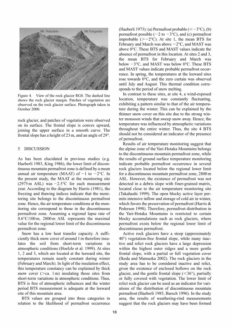
rock glacier, and patches of vegetation were observedon its surface. The frontal slope is convex upward,joining the upper surface in a smooth curve. Thefrontal slope has a height of 23 m, and an angle of 29°.
5 DISCUSSION
As has been elucidated in previous studies (e.g.Haeberli 1983, King 1986), the lower limit of discon-tinuous mountain permafrost zone is defined by a meanannual air temperature (MAAT) of �1 to �2°C. Inthe present study, the MAAT at the monitoring site(2975 m ASL) was �2.5°C for each measurementyear. According to the diagram by Harris (1981), thefreezing and thawing indices indicate that the moni-toring site belongs to the discontinuous permafrostzone. Hence, the air temperature conditions at the mon-itoring site correspond to those in the discontinuouspermafrost zone. Assuming a regional lapse rate of0.6°C/100 m, 2800 m ASL represents the maximalvalue for the regional lower limit of the discontinuouspermafrost zone.
Snow has a low heat transfer capacity. A suffi-ciently thick snow cover of around 1 m therefore insu-lates the soil from short-term variations inatmospheric conditions (Hoelzle et al. 1999). At sites1, 2 and 3, which are located at the leeward site, thetemperatures remain nearly constant during winter(February and March). In light of the insulation effect,this temperature constancy can be explained by thicksnow cover (�ca. 1 m) insulating those sites fromshort-term variations in atmospheric conditions. Thus,BTS is free of atmospheric influences and the winterperiod BTS measurement is adequate at the leewardsite of this mountain area.
BTS values are grouped into three categories in relation to the likelihood of permafrost occurrence
(Haeberli 1973): (a) Permafrost probable (��3°C), (b)permafrost possible (�2 to �3°C), and (c) permafrostimprobable (��2°C). At site 1, the mean BTS forFebruary and March was above �2°C, and MAST wasabove 0°C. These BTS and MAST values indicate theabsence of permafrost in this location. At sites 2 and 3,the mean BTS for February and March wasbelow �3°C, and MAST was below 0°C. These BTSand MAST values indicate probable permafrost occur-rence. In spring, the temperatures at the leeward sitesrose towards 0°C, and the zero curtain was observeduntil July and August. This thermal condition corre-sponds to the period of snow melting.
In contrast to these sites, at site 4, a wind-exposedlocation, temperature was constantly fluctuating,exhibiting a pattern similar to that of the air tempera-ture during the winter. This can be explained by thethinner snow cover on this site due to the strong win-ter monsoon winds that sweep snow away. Hence, thetemperature was influenced by atmospheric variationsthroughout the entire winter. Thus, the site 4 BTSshould not be considered an indicator of the presenceof permafrost.
Results of air temperature monitoring suggest thatthe alpine zone of the Yari-Hotaka Mountains belongsto the discontinuous mountain permafrost zone, whilethe results of ground surface temperature monitoringindicate probable permafrost occurrence in severalrock glaciers located below the regional lower limitfor a discontinuous mountain permafrost zone, 2800 mASL. However, the existence of permafrost was notdetected in a debris slope with finer-grained matrix,located close to the air temperature monitoring site(Takahashi 1999). The open blocky active layer per-mits intensive inflow and storage of cold air in winter,which favors the preservation of permafrost (Harris &Pedersen 1998). Therefore, permafrost distribution inthe Yari-Hotaka Mountains is restricted to certainblocky accumulations such as rock glaciers, wherepermafrost exists below the regional lower limit ofdiscontinuous permafrost.
Active rock glaciers have a steep (approximately40°) vegetation-free frontal slope, while many inac-tive and relict rock glaciers have a large depressionwithin the highest outer ridges and a more gentlefrontal slope, with a partial or full vegetation cover(Ikeda and Matsuoka 2002). The rock glaciers in thestudy area has to be considered inactive and relict,given the existence of enclosed hollows on the rockglacier, and the gentle frontal slope (�36°), partiallyor fully covered with vegetation. The lower limit ofrelict rock glacier can be used as an indicator for vari-ations of the distribution of discontinuous mountainpermafrost (Haeberli 1985, Barsch 1996). In the studyarea, the results of weathering-rind measurementssuggest that the rock glaciers may have been formed
18
Mt. Nakadake Mt.Yarigatake
Figure 4. View of the rock glacier RG8. The dashed lineshows the rock glacier margin. Patches of vegetation areobserved on the rock glacier surface. Photograph taken inOctober 2000.

during the Late Glacial and early Holocene (Aoyama2001). The relict rock glaciers occur above 2360 mASL (RG5 in Fig. 2). As can be deduced from theoccurrence of these relict rock glaciers, the lower limitof the discontinuous mountain permafrost zone dur-ing these periods was 400–500 m lower than the pres-ent-day limit in the study area.
6 CONCLUSIONS
In the Yari-Hotaka Mountains, in the southern part ofthe northern Japanese Alps, air temperature condi-tions at the monitoring site (2975 m ASL) suggest thatthe regional lower limit of discontinuous mountainpermafrost lies at about 2800 m ASL. Although theexistence of permafrost was not detected in debrisslopes with a finer-grained matrix, ground surfacetemperature data point to probable permafrost occur-rence within several rock glaciers. Hence, permafrostdistribution in the Yari-Hotaka Mountains is restrictedto certain block accumulations such as rock glaciers.The morphologic features of the rock glaciers and thevegetation cover on their surfaces suggest that therock glaciers in the Yari-Hotaka Mountains are proba-bly inactive or relict. Relict rock glaciers occur above2360 m ASL. These rock glaciers may have developedduring the Late Glacial and early Holocene. Thus, adepression of 400 –500 m below the lower limit of thepresent-day discontinuous mountain permafrost zoneis likely to have occurred during those periods.
ACKNOWLEDGEMENTS
I would like to thank Professor S. Iwata of Tokyo Metro-politan University for continuous support and helpfulcomments during the course of this work. Thanks aredue to Professor H. Fukusawa and Dr. S. Tsukamoto ofTokyo Metropolitan University for helpful advice.
REFERENCES
Aoyama, M. 2001. Estimating the age of rock glaciers fromweathering rind thickness in the Yari-Hotaka MountainRange, northern Japanese Alps. Geographical reportsof Tokyo Metropolitan University 36: 49–58.
Barsch, D. 1996. Rockglaciers. Indicators for the presentand former geoecology in high mountain environ-ments. Berlin: Springer.
Fukui, K. & Iwata, S. 2000. Result of permafrost investiga-tion in Kuranosuke cirque, Tateyama, the Japanese
Alps (in Japanese). Seppyo (Japanese Journal of Snowand Ice) 62: 23–28.
Haeberli, W. 1973. Die Basis-Temperatur der winterlichenSchneedecke als möglicher Indikator für die Verbrei-tung von Permafrost in den Alpen. Zeitschrift fürGletscherkunde und Glazialgeologie 9: 221–227.
Haeberli, W. 1983. Permafrost-glacier relationships in the Swiss Alps-today and in the past. In Proceedings,4th International Conference on permafrost. NationalAcademy Press, Washington, 415–420.
Haeberli, W. 1985. Creep of mountain permafrost: internalstructure and flow of Alpine rock glaciers. Mitteilungender Versuchsanstalt für Wasserbau Hydrologie undGlaziologie an der ETH Zürich No. 77: 1–142.
Harayama, S. 1990. Geology of the Kamikouchi district.With Geological sheet map at 1:50,000. Tsukuba:Geological Survey of Japan.
Harris, S. A. 1981. Climatic relationships of permafrost zonesin areas of low winter snow-cover. Arctic 34: 64–70.
Harris, S. A. & Pedersen, E. 1998. Thermal regimes beneathcoarse blocky materials. Permafrost and PeriglacialProcesses 9: 107–120.
Hoelzle, M., Wegmann, M. & Krummenacher, B. 1999.Miniature temperature dataloggers for mapping andmonitoring of permafrost in high mountain areas: firstexperience from the Swiss Alps. Permafrost andPeriglacial Processes 10: 113–124.
Ikeda, A. & Matsuoka, N. 2002. Degradation of talus-derivedrock glaciers in the Upper Engadin, Swiss Alps.Permafrost and Periglacial Processes 13: 145–161.
Ishikawa, M., Fukui, K., Aoyama, M., Ikeda, A., Sawada, Y. &Matsuoka, N. in press. Mountain permafrost in Japan:distribution, landforms and thermal regimes. Zeitschriftfür Geomorphologie, Supplementband.
Ito, M. & Vorndran, G. 1983. Glacial geomorphology andsnow-lines of Younger Quaternary around the Yari-Hotaka Mountain Range, Northern Alps, CentralJapan. Polarforschung 53: 75–89.
King, L. 1986. Zonation and ecology of high mountain per-mafrost in Scandinavia. Geografiska Annaler 68A:131–139.
Matsuoka, N. & Ikeda, A. 1998. Some observations regard-ing mountain permafrost in the Japanese Alps. AnnualReport of the Institute of Geoscience, the University ofTsukuba 24: 19–25.
Ono, Y. 1984. Last glacial paleoclimate reconstructed fromglacial and periglacial landforms in Japan. Geographi-cal Review of Japan 57B: 87–100.
Takahashi, N. 1999. Air and ground temperature conditionsin the alpine zone of the Mt. Minamidake, HidaMountain Range (in Japanese). In Report of grant-in-aid for the scientific research, The study ofperiglacial phenomena and its environment in thealpine zone of Japan. 96–107.
19