Perambulation Heritage
3
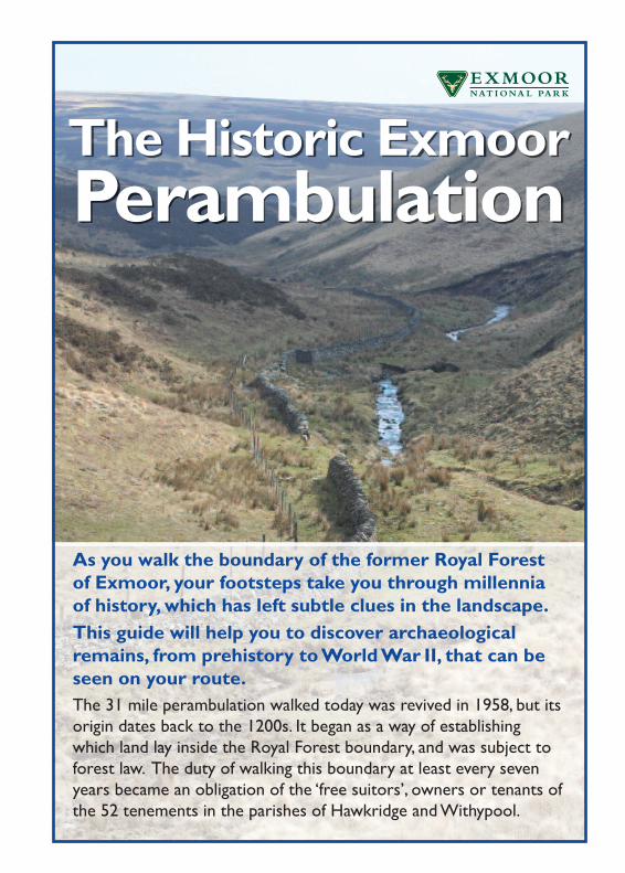
The Historic Exmoor Perambulation As you walk the boundary of the former Royal Forest of Exmoor,your footsteps take you through millennia of history, which has left subtle clues in the landscape. This guide will help you to discover archaeological remains, from prehistory toWorld War II, that can be seen on your route. The 31 mile perambulation walked today was revived in 1958, but its origin dates back to the 1200s. It began as a way of establishing which land lay inside the Royal Forest boundary,and was subject to forest law. The duty of walking this boundary at least every seven years became an obligation of the ‘free suitors’, owners or tenants of the 52 tenements in the parishes of Hawkridge and Withypool.
-
Upload
mike-bishop -
Category
Documents
-
view
218 -
download
0
description
A look into the heritage of Perambulating the Old Royal Forest of Exmoor
Transcript of Perambulation Heritage
The Historic ExmoorPerambulation
As you walk the boundary of the former Royal Forestof Exmoor, your footsteps take you through millenniaof history, which has left subtle clues in the landscape.This guide will help you to discover archaeologicalremains, from prehistory toWorldWar II, that can beseen on your route.The 31 mile perambulation walked today was revived in 1958, but itsorigin dates back to the 1200s. It began as a way of establishingwhich land lay inside the Royal Forest boundary, and was subject toforest law. The duty of walking this boundary at least every sevenyears became an obligation of the ‘free suitors’, owners or tenants ofthe 52 tenements in the parishes of Hawkridge andWithypool.
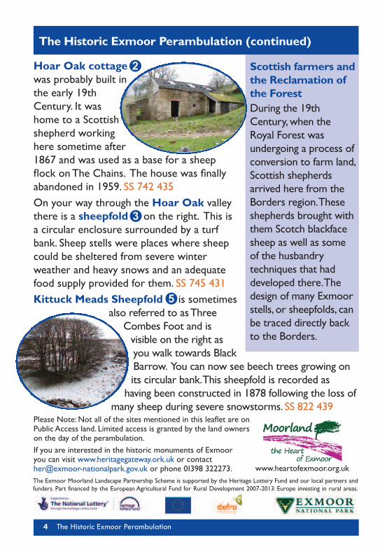
Hoar Oak cottagewas probably built inthe early 19thCentury. It washome to a Scottishshepherd workinghere sometime after1867 and was used as a base for a sheepflock onThe Chains. The house was finallyabandoned in 1959. SS 742 435On your way through the Hoar Oak valleythere is a sheepfold on the right. This isa circular enclosure surrounded by a turfbank. Sheep stells were places where sheepcould be sheltered from severe winterweather and heavy snows and an adequatefood supply provided for them. SS 745 431Kittuck Meads Sheepfold is sometimes
also referred to asThreeCombes Foot and isvisible on the right asyou walk towards BlackBarrow. You can now see beech trees growing onits circular bank.This sheepfold is recorded ashaving been constructed in 1878 following the loss of
many sheep during severe snowstorms. SS 822 439Please Note: Not all of the sites mentioned in this leaflet are onPublic Access land. Limited access is granted by the land ownerson the day of the perambulation.If you are interested in the historic monuments of Exmooryou can visit www.heritagegateway.ork.uk or [email protected] or phone 01398 322273.
The Historic Exmoor Perambulation (continued)
Scottish farmers andthe Reclamation ofthe ForestDuring the 19thCentury,when theRoyal Forest wasundergoing a process ofconversion to farm land,Scottish shepherdsarrived here from theBorders region.Theseshepherds brought withthem Scotch blackfacesheep as well as someof the husbandrytechniques that haddeveloped there.Thedesign of many Exmoorstells, or sheepfolds, canbe traced directly backto the Borders.
The Exmoor Moorland Landscape Partnership Scheme is supported by the Heritage Lottery Fund and our local partners andfunders. Part financed by the European Agricultural Fund for Rural Development 2007-2013: Europe investing in rural areas.
4 The Historic Exmoor Perambulation
3
5
2
www.heartofexmoor.org.uk
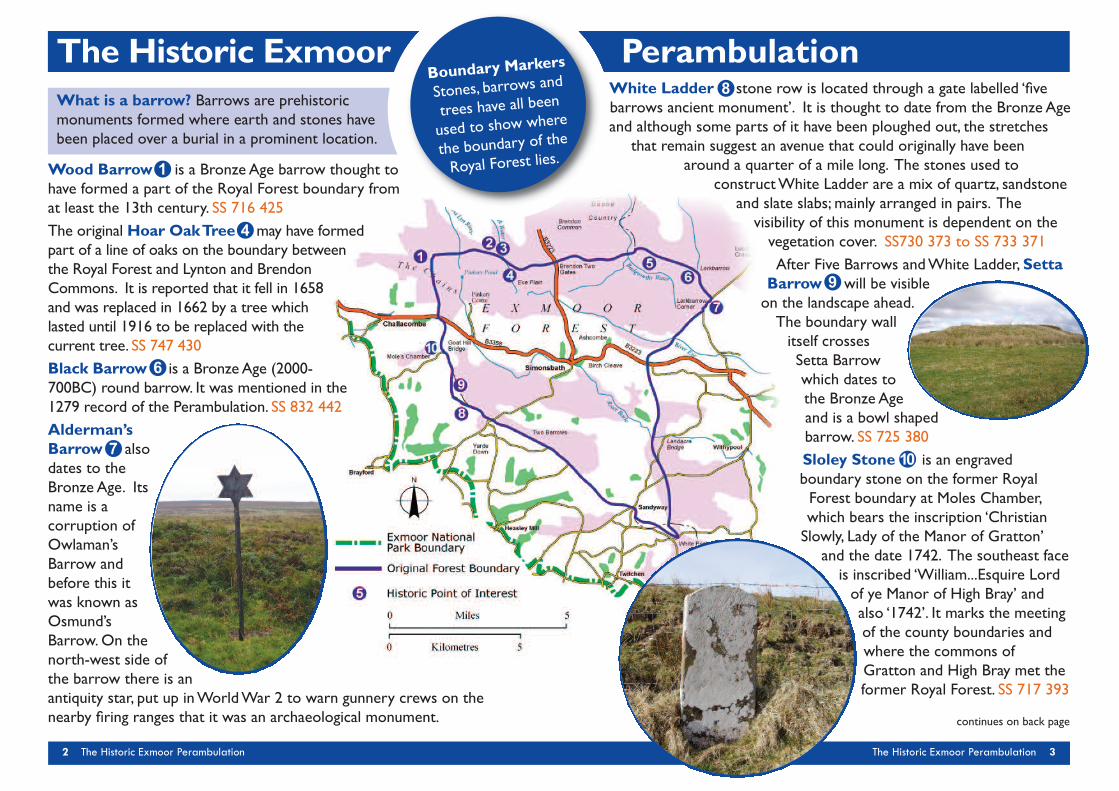
Wood Barrow is a Bronze Age barrow thought tohave formed a part of the Royal Forest boundary fromat least the 13th century. SS 716 425The original Hoar OakTree may have formedpart of a line of oaks on the boundary betweenthe Royal Forest and Lynton and BrendonCommons. It is reported that it fell in 1658and was replaced in 1662 by a tree whichlasted until 1916 to be replaced with thecurrent tree. SS 747 430Black Barrow is a BronzeAge (2000-700BC) round barrow. It was mentioned in the1279 record of the Perambulation. SS 832 442Alderman’sBarrow alsodates to theBronze Age. Itsname is acorruption ofOwlaman’sBarrow andbefore this itwas known asOsmund’sBarrow.On thenorth-west side ofthe barrow there is anantiquity star, put up inWorldWar 2 to warn gunnery crews on thenearby firing ranges that it was an archaeological monument.
White Ladder stone row is located through a gate labelled ‘fivebarrows ancient monument’. It is thought to date from the Bronze Ageand although some parts of it have been ploughed out, the stretches
that remain suggest an avenue that could originally have beenaround a quarter of a mile long. The stones used to
constructWhite Ladder are a mix of quartz, sandstoneand slate slabs; mainly arranged in pairs. Thevisibility of this monument is dependent on thevegetation cover. SS730 373 to SS 733 371After Five Barrows andWhite Ladder,Setta
Barrow will be visibleon the landscape ahead.The boundary wallitself crossesSetta Barrowwhich dates tothe Bronze Ageand is a bowl shapedbarrow. SS 725 380Sloley Stone is an engravedboundary stone on the former RoyalForest boundary at Moles Chamber,which bears the inscription ‘ChristianSlowly, Lady of the Manor of Gratton’
and the date 1742. The southeast faceis inscribed ‘William...Esquire Lordof ye Manor of High Bray’ andalso ‘1742’. It marks the meetingof the county boundaries andwhere the commons ofGratton and High Bray met theformer Royal Forest. SS 717 393
1
4
6
2 The Historic Exmoor Perambulation The Historic Exmoor Perambulation 3
7
8
continues on back page
Boundary Markers
Stones, barrows and
trees have all been
used to show where
the boundary of the
Royal Forest lies.
The Historic Exmoor PerambulationWhat is a barrow? Barrows are prehistoricmonuments formed where earth and stones havebeen placed over a burial in a prominent location.
9
10
The Historic ExmoorPerambulation
As you walk the boundary of the former Royal Forestof Exmoor, your footsteps take you through millenniaof history, which has left subtle clues in the landscape.This guide will help you to discover archaeologicalremains, from prehistory toWorldWar II, that can beseen on your route.The 31 mile perambulation walked today was revived in 1958, but itsorigin dates back to the 1200s. It began as a way of establishingwhich land lay inside the Royal Forest boundary, and was subject toforest law. The duty of walking this boundary at least every sevenyears became an obligation of the ‘free suitors’, owners or tenants ofthe 52 tenements in the parishes of Hawkridge andWithypool.
Hoar Oak cottagewas probably built inthe early 19thCentury. It washome to a Scottishshepherd workinghere sometime after1867 and was used as a base for a sheepflock onThe Chains. The house was finallyabandoned in 1959. SS 742 435On your way through the Hoar Oak valleythere is a sheepfold on the right. This isa circular enclosure surrounded by a turfbank. Sheep stells were places where sheepcould be sheltered from severe winterweather and heavy snows and an adequatefood supply provided for them. SS 745 431Kittuck Meads Sheepfold is sometimes
also referred to asThreeCombes Foot and isvisible on the right asyou walk towards BlackBarrow. You can now see beech trees growing onits circular bank.This sheepfold is recorded ashaving been constructed in 1878 following the loss of
many sheep during severe snowstorms. SS 822 439Please Note: Not all of the sites mentioned in this leaflet are onPublic Access land. Limited access is granted by the land ownerson the day of the perambulation.If you are interested in the historic monuments of Exmooryou can visit www.heritagegateway.ork.uk or [email protected] or phone 01398 322273.
The Historic Exmoor Perambulation (continued)
Scottish farmers andthe Reclamation ofthe ForestDuring the 19thCentury,when theRoyal Forest wasundergoing a process ofconversion to farm land,Scottish shepherdsarrived here from theBorders region.Theseshepherds brought withthem Scotch blackfacesheep as well as someof the husbandrytechniques that haddeveloped there.Thedesign of many Exmoorstells, or sheepfolds, canbe traced directly backto the Borders.
The Exmoor Moorland Landscape Partnership Scheme is supported by the Heritage Lottery Fund and our local partners andfunders. Part financed by the European Agricultural Fund for Rural Development 2007-2013: Europe investing in rural areas.
4 The Historic Exmoor Perambulation
3
5
2
www.heartofexmoor.org.uk