People living under threat of volcanic hazard in southern ... · PDF filetheir risk...
14
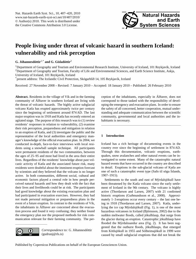
Nat. Hazards Earth Syst. Sci., 10, 407–420, 2010 www.nat-hazards-earth-syst-sci.net/10/407/2010/ © Author(s) 2010. This work is distributed under the Creative Commons Attribution 3.0 License. Natural Hazards and Earth System Sciences People living under threat of volcanic hazard in southern Iceland: vulnerability and risk perception G. Jóhannesdóttir 1,* and G. Gísladóttir 2 1 Department of Geography and Tourism and Environmental Research Institute, University of Iceland, 101 Reykjavík, Iceland 2 Department of Geography and Tourism, Faculty of Life and Environmental Sciences, and Earth Science Institute, Askja, University of Iceland, 101 Reykjavík, Iceland * present address: The Icelandic Civil Protection, Skógarhlíð 14, 105 Reykjavík, Iceland Received: 27 November 2008 – Revised: 7 January 2010 – Accepted: 18 January 2010 – Published: 26 February 2010 Abstract. Residents in the village of Vík and in the farming community of Álftaver in southern Iceland are living with the threat of volcanic hazards. The highly active subglacial volcano Katla has erupted approximately twice per century since the beginning of settlement around 874 AD. The last major eruption was in 1918 and Katla has recently entered an agitated stage. The purpose of this research was to (1) review residents’ responses in relation to vulnerability, (2) examine their risk perception, preparedness and mitigation in relation to an eruption of Katla, and (3) investigate the public and the representative of the local authorities and emergency man- ager’s knowledge of the official evacuation plan. In 2004, we conducted in-depth, face-to-face interviews with local resi- dents using a snowball sample technique. All participants were permanent residents of the two communities, between the ages of 25–95 and most had lived in the area their entire lives. Regardless of the residents’ knowledge about past vol- canic activity of Katla and the associated future risk, many residents were doubtful about the imminent eruption forecast by scientists and they believed that the volcano is no longer active. In both communities, different social, cultural and economic factors played a central role in how people per- ceived natural hazards and how they dealt with the fact that their lives and livelihoods could be at risk. The participants had good knowledge about the existing evacuation plan and had participated in evacuation exercises. However, they had not made personal mitigation or preparedness plans in the event of a future eruption. In contrast to the residents of Vík, the inhabitants in Álftaver are concerned about the evacua- tion process and found it very confusing; they neither found the emergency plan nor the proposed methods for risk com- munication relevant for their farming community. The per- Correspondence to: G. Jóhannesdóttir ([email protected]) ception of the inhabitants, especially in Álftaver, does not correspond to those tasked with the responsibility of devel- oping the emergency and evacuation plans. In order to ensure the safety of all concerned, better cooperation, mutual under- standing and adequate communication between the scientific community, governmental and local authorities and the in- habitants is necessary. 1 Introduction Iceland has a rich heritage of documenting events in the country ever since the beginning of settlement in 874 AD. Through this documentation, volcanic eruptions, earth- quakes, snow avalanches and other natural events can be in- vestigated to some extent. Many of the catastrophic natural hazard events that have occurred in the country are described in detail. Eruptions in the sub-glacial volcano of Katla are one of such a catastrophic event type (Safn til sögu Íslands, 1907–1915). Settlements to the south and east of Mýrdalsjökull have been threatened by the Katla volcano since the early settle- ment of Iceland in the 9th century. The volcano is highly active (Thordarson and Larsen, 2007) with 21 confirmed historic eruptions (Guðmundsson et al., 2008). Approxi- mately 1–3 eruptions occur every century – the last one be- ing in 1918 (Thordarson and Larsen, 2007). Katla, under- lying the ice cap Mýrdalsjökull (Fig. 1), is one of the most hazardous volcanoes in Iceland (Björnsson, 2002) due to the sudden meltwater floods, called jökulhlaup, that surge from the glacier during an eruption. Catastrophic jökulhlaup have flooded the Mýrdalssandur area (Fig. 2). It has been sug- gested that the outburst floods, jökulhlaups, that emerged from Kötlujökull in 1955 and Sólheimajökull in 1999 were caused by small subglacial eruptions that did not break the Published by Copernicus Publications on behalf of the European Geosciences Union.
Transcript of People living under threat of volcanic hazard in southern ... · PDF filetheir risk...
Nat. Hazards Earth Syst. Sci., 10, 407–420, 2010www.nat-hazards-earth-syst-sci.net/10/407/2010/© Author(s) 2010. This work is distributed underthe Creative Commons Attribution 3.0 License.
Natural Hazardsand Earth
System Sciences
People living under threat of volcanic hazard in southern Iceland:vulnerability and risk perception
G. Jóhannesdóttir1,* and G. Gísladóttir2
1Department of Geography and Tourism and Environmental Research Institute, University of Iceland, 101 Reykjavík, Iceland2Department of Geography and Tourism, Faculty of Life and Environmental Sciences, and Earth Science Institute, Askja,University of Iceland, 101 Reykjavík, Iceland* present address: The Icelandic Civil Protection, Skógarhlíð 14, 105 Reykjavík, Iceland
Received: 27 November 2008 – Revised: 7 January 2010 – Accepted: 18 January 2010 – Published: 26 February 2010
Abstract. Residents in the village of Vík and in the farmingcommunity of Álftaver in southern Iceland are living withthe threat of volcanic hazards. The highly active subglacialvolcano Katla has erupted approximately twice per centurysince the beginning of settlement around 874 AD. The lastmajor eruption was in 1918 and Katla has recently entered anagitated stage. The purpose of this research was to (1) reviewresidents’ responses in relation to vulnerability, (2) examinetheir risk perception, preparedness and mitigation in relationto an eruption of Katla, and (3) investigate the public and therepresentative of the local authorities and emergency man-ager’s knowledge of the official evacuation plan. In 2004, weconducted in-depth, face-to-face interviews with local resi-dents using a snowball sample technique. All participantswere permanent residents of the two communities, betweenthe ages of 25–95 and most had lived in the area their entirelives. Regardless of the residents’ knowledge about past vol-canic activity of Katla and the associated future risk, manyresidents were doubtful about the imminent eruption forecastby scientists and they believed that the volcano is no longeractive. In both communities, different social, cultural andeconomic factors played a central role in how people per-ceived natural hazards and how they dealt with the fact thattheir lives and livelihoods could be at risk. The participantshad good knowledge about the existing evacuation plan andhad participated in evacuation exercises. However, they hadnot made personal mitigation or preparedness plans in theevent of a future eruption. In contrast to the residents of Vík,the inhabitants in Álftaver are concerned about the evacua-tion process and found it very confusing; they neither foundthe emergency plan nor the proposed methods for risk com-munication relevant for their farming community. The per-
Correspondence to:G. Jóhannesdóttir([email protected])
ception of the inhabitants, especially in Álftaver, does notcorrespond to those tasked with the responsibility of devel-oping the emergency and evacuation plans. In order to ensurethe safety of all concerned, better cooperation, mutual under-standing and adequate communication between the scientificcommunity, governmental and local authorities and the in-habitants is necessary.
1 Introduction
Iceland has a rich heritage of documenting events in thecountry ever since the beginning of settlement in 874 AD.Through this documentation, volcanic eruptions, earth-quakes, snow avalanches and other natural events can be in-vestigated to some extent. Many of the catastrophic naturalhazard events that have occurred in the country are describedin detail. Eruptions in the sub-glacial volcano of Katla areone of such a catastrophic event type (Safn til sögu Íslands,1907–1915).
Settlements to the south and east of Mýrdalsjökull havebeen threatened by the Katla volcano since the early settle-ment of Iceland in the 9th century. The volcano is highlyactive (Thordarson and Larsen, 2007) with 21 confirmedhistoric eruptions (Guðmundsson et al., 2008). Approxi-mately 1–3 eruptions occur every century – the last one be-ing in 1918 (Thordarson and Larsen, 2007). Katla, under-lying the ice cap Mýrdalsjökull (Fig. 1), is one of the mosthazardous volcanoes in Iceland (Björnsson, 2002) due to thesudden meltwater floods, called jökulhlaup, that surge fromthe glacier during an eruption. Catastrophic jökulhlaup haveflooded the Mýrdalssandur area (Fig. 2). It has been sug-gested that the outburst floods, jökulhlaups, that emergedfrom Kötlujökull in 1955 and Sólheimajökull in 1999 werecaused by small subglacial eruptions that did not break the
Published by Copernicus Publications on behalf of the European Geosciences Union.

408 G. Jóhannesdóttir and G. Gísladóttir: Vulnerability and risk perception of volcanic hazard
Fig. 1. The Volcano Katla and its surroundings. Historical jökulhlaups have emerged at Kötlujökull and Sólheimajökull and have formedthe outwash plains in front of the glacier. Pre-historic jökulhlaup emerged at Entujökull. The historic Eldgjá lava and the rootless coneswere formed during an eruption event (subaerial and subglacial) in the Katla volcanic system∼934 AD. Tephra covered the whole areashown on the figure, although being thickest east of Mýrdasljökull and the jökulhlaup emanated from the outlet glacier in the northeast,Öldufellsjökull. Repeated catastrophic jökulhlaups since 934 AD have formed the Mýrdalsandur outwash plain. Outlines of Eldgjá lavas arefrom Larsen (2000), the Katla caldera by Björnsson et al. (2000) and other geological phenomena by Jóhannesson et al. (1990).
ice surface (Guðmundsson et al., 2007). The volcano is stillhighly active and has entered an agitated stage (Sturkell etal., 2006).
The natural hazards following the interaction of the Katlavolcano and Mýrdalsjökull glacier are catastrophic jökulh-laup, tephra fallout, minor earthquakes, toxic gas and light-ning. Eighteen of the documented Katla eruptions havebeen associated with jökulhlaup that have emerged fromthe eastern side of Mýrdalsjökull down to the Mýrdalssan-dur outwash plain (Fig. 2) and two from the southern sideof Sólheimasandur. Katla eruptions are capable of break-ing through the 400 m thick ice cover in 1–2 h (Björnsson,2002) and floodwater emerges from the glacier 1–2 h afterthe onset of an eruption and flooding can reach settled areassoon after (Guðmundsson et al., 2005) (Fig. 3). Jökulhlaupare a mixture of water, ice blocks, volcanic products and aheavy load of sediment. In 1918, a jökulhlaup reached a peakdischarge rate of 300 000 m3 s−1 (Tómasson, 1996; Larsen,2000; Björnsson 2002) (Fig. 2).
The flat agricultural and farming community of Álftaver(Fig. 2) is in the floodpath of jökulhlaup and is the commu-nity at greatest risk during a Katla eruption. The 1918 floodtook the inhabitants by surprise as they had not felt any earlywarning signs (Bjarnason, 1986; Jóhannsson, 1919; Sveins-son, 1930), even though Katla jökulhlaups have been pre-ceded by earthquakes 2–10 h before the floodwater emergedfrom the glacier (Safn til sögu Íslands, 1907–1915). Farm-ers who were gathering sheep on the Mýrdalssandur area in1918 just escaped the flood and the inhabitants in Álftavereither stayed at farms located on hills or escaped to highergrounds (Bjarnason, 1986). According to the local popula-tion, (Jóhannesdóttir, 2005) the rootless cones (Figs. 1 and4) to the west of the community have protected the farmingsociety during eruptions.
Due to jökulhlaup and tephra, farms in Álftaver weredesolated and regional agricultural land destroyed (Safn tilsögu Íslands, 1907–1915, Gísladóttir, 1980; Gísladóttir andMargrétardóttir, 2004) (Fig. 2). The 0.5–1 km3 of tephra
Nat. Hazards Earth Syst. Sci., 10, 407–420, 2010 www.nat-hazards-earth-syst-sci.net/10/407/2010/

G. Jóhannesdóttir and G. Gísladóttir: Vulnerability and risk perception of volcanic hazard 409
Fig. 2. The main paths of the three last major jökulhlaups across Mýrdalssandur. The repeated floods have destroyed vegetation in largeareas on the sandur plain and have severely degraded vegetation and the farming area in Álftaver. Vegetation show present situation. Floodpaths are from Larsen (2000), the Katla caldera by Björnsson et al. (2000) and the vegetation by Guðjónsson and Gíslason (1998).
www.nat-hazards-earth-syst-sci.net/10/407/2010/ Nat. Hazards Earth Syst. Sci., 10, 407–420, 2010

410 G. Jóhannesdóttir and G. Gísladóttir: Vulnerability and risk perception of volcanic hazard
Fig. 3. The potential jökulhlaup hazard zone on Mýrdalssandur, estimated in 2005. Historically the flood emanated from Kötlujökull soonafter the eruption broke through the ice cap. The time lines show the position of the flood after the eruption. It is estimated that within threehours the flood (of similar size as the jökulhlaup in 1918) will inundate the main highway, bridges and electric power lines and reach thesettlement in Álftaver. As soon as the eruption is confirmed, residents in Álftaver and Vík need to evacuate, according to present evacuationplans. Vegetation classes are seen on Fig. 2. Time lines are after Ríkislögreglustjóri, Almannavarnadeild (2008) and the vegetation byGuðjónsson and Gíslason (1998).
and other debris carried by the jökulhlaup in 1918 elevatedthe surface of the outwash plain by 1 m (Thordarson andHoskuldsson, 2002). Furthermore, the jökulhlaup in 1955and the glacial rivers have raised the outwash plain (variousresidents, personal communication, 2003, 2004). Therefore,the rootless cones may not be as effective in protecting the lo-cal community. As a result of this combined effect, Álftavermay be more vulnerable to jökulhlaup hazard.
Katla eruptions have caused small tsunamis in Vík and inthe Westman Islands about 60 km southwest of Vík (Safn tilsögu Íslands, 1907–1915; Jóhannsson, 1918). In 1918 thejökulhlaup extended the coastline at Kötlutangi by 14 km2
(Figs. 1 and 3) (Thordarson and Hoskuldsson, 2002). Priorto 1918, coastal erosion was severe in Vík, but after this,the unconsolidated flood deposits forming Kötlutangi werecarried by coastal currents to Vík causing continuous accre-tion until 1971. Since then, erosion has been prominent. Atpresent, about 80% of the houses in Vík and the main high-way are located on the beach close to the coastline (Ísakssonet al., 2005), making them more vulnerable to storm surgesand tsunamis.
Given the descriptions of former eruptions of Katla (Safntil sögu Íslands, 1907–1915), the risk is substantial and itis likely to affect all aspects of residents’ lives during andfollowing an eruption. Furthermore, since the last eruptionin 1918, the society has become a technologically advanced
community and, therefore, the local community is more vul-nerable since critical lifelines, transport and communicationinfrastructure, etc. are likely to be affected (Fig. 3).
The objective of the Icelandic Civil Protection (ICP) inIceland since 1967 is to focus their attention on knownnatural hazards (Act No 94/1962) and the first emergencyplans in Iceland were developed in 1972 for communities atrisk. Snow avalanches, volcanic eruptions and earthquakesposed immediate threats to various districts, which neededemergency preparedness plans (Jónsson, 2003; Friðfinnsson,2005). The local Civil Protection Committee and the districtcommissioner in Vík are in charge of local emergency pre-paredness and response and they work with the local munici-pal authorities in preparing the emergency plans in collabora-tion with the ICP (Act 94/1962). Emergency plans in Icelandare of two kind’s, generic emergency plans that are used torespond to any major emergency and specific plans that dealwith particular hazards, on specific locations or sites. Sincethe communities south and east of Katla are at great risk, aspecific evacuation and response plan was prepared and ex-ercised for a Katla eruption as early as 1973 (Fiðfinnsson,2003). In 1999, the plans were revised and, since then, gra-dual changes were made in the plan that have not been ex-ercised. Children in the town of Vík usually take part in anevacuation exercise every year at school, they are given de-tailed information where to go and what to do in an eruption,
Nat. Hazards Earth Syst. Sci., 10, 407–420, 2010 www.nat-hazards-earth-syst-sci.net/10/407/2010/

G. Jóhannesdóttir and G. Gísladóttir: Vulnerability and risk perception of volcanic hazard 411
Fig. 4. Mýrdalsjökull seen from Álftaver with the row of rootless cones in the foreground. Photograph by Gísladóttir.
but other residents have to rely on exercises that have beenfew and far between. The plans were made by emergencymanagers in Vík and local and national administrators with-out involvement of the general public (Jóhannesdóttir, 2005).Recent findings (Kjartansson, 2008; Jóhannesdóttir, 2005;Bird et al., 2009) show that the approach of the IcelandicCivil Protection has generally been reactive to emergencieswith less emphasis on prevention and preparedness. Accord-ing to these findings, more effort has been expended in re-sponding to various hazardous events than on prevention andeducation. Recently, however, public awareness on risk hasbeen promoted by local and national civil protection authori-ties in various hazardous areas; for example by celebratinga Katla information day in the community of Vík in Oc-tober, the day Katla started to erupt in 1918 and informa-tion brochures have been distributed to the inhabitants andtourists about the hazards following an eruption of Katla.
2 Risk perception and vulnerability
Risk is a product of the likelihood of an incident occurringand its possible consequences. It could be the suffering ofharm or loss from a hazard that can cause injury, disease,economic loss or environmental damage. It is expressed interms of probability – a mathematical statement about theprobability of an occurrence (Miller, 1995).
When assessing probabilities, however, two main princi-ples can be used (SEMA, 2008). Quantitative assessments,empirical estimates that constitute a recognized basis for as-sessment of probability, based on, for example, statisticalmaterial and qualitative assessments that are used to esti-mate probability, either to complement empirical data or asthe sole relevant source. Probability is assessed based on thesubjective estimates of persons with good knowledge of thepertinent conditions. Assessing consequences concerns an-ticipating the direct and indirect (negative) effects that canarise based on certain given condition (SEMA, 2008).
When looking at risk, three elements have to be consid-ered: the hazard, the exposure and vulnerability. Chric-ton (1999) refers to these three elements as the risk trian-gle and if any one element increases or decreases then therelated side of the triangle, area of the triangle and, hence,the amount of risk will increase or decrease accordingly. In-volved in the concept of natural hazard, risk is an event,where actual or potential interaction between extreme natu-ral events and human activities takes place which may impacton various elements that then become at risk and can makepeople vulnerable (Crichton, 1999; Alexander, 2000).
Vulnerability is the susceptibility to disturbances andlosses, determined by exposure and sensitivity to distur-bance, and the capacity to adapt (Smit and Wandel, 2006).The nature of perturbations (slow onset or sudden andepisodic) and the location of the system in the risk cycle arecrucial in shaping vulnerability.
More specifically natural hazard vulnerability generallyrefers to the characteristics of the element exposed to a ha-zard that contributes to its capacity to resist, cope with andrecover from the impact of a natural hazard (Crichton, 1999).Elements at risk may be a population, their social structureand the built and natural environment that are likely to beaffected by the hazard.
These elements can have both intrinsic and functionalvalue and are often hard to calculate. With respect to com-munities, assessments relying only on numbers, statistics andobjective calculation, may not necessarily give the same in-formation as those based on the assessment of emotionaland subjective information (e.g. Otway, 1992; Slovic, 2000,2004). These qualitative assessments can provide an under-standing of intangible social elements that influence dailylives. They can reveal factors that make people feel safein their neighbourhood, indicate their tolerance, social cohe-sion and network, trust and expectations which indicate theirvulnerability. Moreover, vulnerability measured by qual-itative methods may explain how critically a society andits inhabitants will be affected by an event. How people
www.nat-hazards-earth-syst-sci.net/10/407/2010/ Nat. Hazards Earth Syst. Sci., 10, 407–420, 2010

412 G. Jóhannesdóttir and G. Gísladóttir: Vulnerability and risk perception of volcanic hazard
perceive and look at risk depends on various factors: so-cial (Fischoff et al., 1978; Slovic et al., 1978; Blaikie et al.,1994), psychological (Fischoff et al., 1978; Pidgeon et al.,1992; Blaikie et al., 1994), economic (Deyle et al., 1998),cultural (Sjöberg, 2000; Boholm, 1998) and environmental(Mileti, 1994; Haynes et al., 2008) or a combination of allfactors (Alexander, 2000; Jóhannesdóttir, 2005). Further-more, people are susceptible to damage and loss due to thesefactors. In this respect, risk perception can increase vulnera-bility and determine people’s losses to a greater degree thanthe hazard itself. The meaning of risk may vary between peo-ple since actions and understanding about risks are learnedby socially and culturally structured conceptions and evalua-tions (Alexander, 2000).
In cultural theory, risk perception is looked at as a re-flection of the social context an individual finds oneself inand is not necessarily the sole determinant of risk percep-tion (Sjöberg, 2000). In natural hazards, decisions on miti-gation depend rather on how dangerous the risk is perceivedrather than on absolute or objective conditions (Alexander,2000). Normalization bias (Mileti, 1994; Gregg et al., 2004)and cognitive dissonance are terms that are sometimes usedand refer to unrealistic behaviour, risk perception and de-nial of the existence of the hazard when people are livingunder threat. Others believe that disasters will happen tosomeone else (Alexander, 2000). Studies on risk perceptionhave shown that most people have a much more comprehen-sive perception of risk than just probability and consequences(Kasperson et al., 1994). Consequently, risk perception is afunction of beliefs and values and even specific fear (Sjöberg,2000). The importance of events that are close in time andspace tend to be magnified in the minds of people and thosedistant in time tend to diminish (Lindell, 1994). Both thescale and the accuracy of perception may depend on the ex-tent to which lives and resources are at risk and on the contextof social problems in the community (Alexander, 2000). It ismore likely that policies are established with an emphasison prevention and preparedness in an aftermath of disasterwhen risk perception is high and people are willing to adoptnew measures. Analysing and evaluating social, cultural andpsychological relations between vulnerability and risk per-ception helps to provide a better understanding of people’sattitude towards risk and helps predict public response to ha-zard and risk (Mileti, 2000). This can be used to improve riskcommunication and risk reduction and associated conflictsduring emergency situations (Gregg et al., 2004; Jóhannes-dóttir, 2005; Bird and Dominey-Howes, 2006; Haynes et al.,2008; Bird et al., 2009, 2010).
Systematic identification and evaluation of threats, riskperception and vulnerabilities in communities can help pri-oritise suggestions for mitigation and increase resilience. Aneffective evacuation process is dependent upon the under-standing of the official emergency planners and managementofficials of the potential public response to a disaster. If therisk perception of officials does not correspond to the pub-
lic perception, a conflict is likely and vulnerability will notbe reduced. To facilitate efficient risk communication, it isessential that earth scientists provide residents at risk witheasily understood and accessible data (Alexander, 2007). Inrisk management, socio-economic, political and behaviouralelements have to be taken into account along with the physi-cal processes (Blaikie et al., 1994).
Therefore, the purpose of this paper is to investigate peo-ple’s perception of natural hazards in two communities thathave been exposed to volcanic hazard and to: (1) review resi-dents’ responses in relation to vulnerability, (2) examine theirrisk perception, preparedness and mitigation in relation to aneruption in Katla, and (3) investigate the public, local repre-sentative authorities and emergency managers’ knowledge ofthe official evacuation plans.
3 Methods
The methodology used was in-depth, face-to-face interviewsand a snowball sample technique (Balso et al., 1997). Snow-ball sampling involves, first, selecting persons who havecharacteristics that meet the requirement of the study andthen asking them for further contacts. This method is of-ten used to study a certain area or social groups. In this case,the topic is volcanic eruption and the geographical area is de-fined as a known hazard zone. The participants work and liveclose to the volcano and are familiar with the area. Therefore,their knowledge, beliefs and risk perception may give an in-dication to their vulnerability during an eruption and providea basic understanding of the condition of people living underthreat. Since disasters usually strike without much warning,most of the participants were visited in their home or work-place without prior warning. The reason was to determinethe participants’ knowledge, preparedness and response ca-pabilities at a time when an eruption had been forecast byscientists. Furthermore, contact prior to interviewing was notmade as we did not want the participants to prepare for theinterview by reading the response and evacuations plans.
Additionally, it was essential to investigate the emergencymanagement in the local community to evaluate the emer-gency procedure through the interpretation of the local emer-gency managers. Therefore, we interviewed the mayor andthe district commissioner in Vík who are responsible for theprevention, preparedness and response to an emergency inthe area, at the time of the research.
By using structured questionnaires and a quantitative in-terview technique, a much larger sample could have beenobtained but it would not have given the knowledge of riskperception and vulnerability which met the purpose of thestudy. The size of the sample is not the major issue, sincethe results are not to be generalized for the whole popula-tion, but rather to get a basic understanding of risk perceptionand vulnerability in the two case study areas. In-depth inter-views can facilitate the conversation about the respondents’
Nat. Hazards Earth Syst. Sci., 10, 407–420, 2010 www.nat-hazards-earth-syst-sci.net/10/407/2010/

G. Jóhannesdóttir and G. Gísladóttir: Vulnerability and risk perception of volcanic hazard 413
experiences; they allow flexibility and they can produce richinvaluable information that only personal interviews provide(Balso et al., 1997). The results obtained by using this qual-itative method, may provide emergency managers with use-ful information when preparing for emergencies. The par-ticipants’ risk perception and vulnerability is investigated byusing different socio-psychological, economic, environmen-tal and cultural-historical factors in order to understand whatmakes the inhabitants vulnerable to natural hazard and, at thesame time, to examine their knowledge of preparedness andevacuation plans.
All the interviews were conducted in October 2004. Theywere digitally recorded, then written down, organized, dis-sected and categorized for further analysis.
A semi-structured checklist was used in all the interviewsin order to determine people’s perception of risk and theirvulnerability during Katla eruption. The discussions wereopen and the semi-structured checklist covered the followingtopics:
– The home, the family and friends. The participants wereasked about their background; family, children, theirextended family and friends and why they had chosento live in this particular community. By delving intothese relations and understanding the social structure,we hoped that we would understand their resilience orvulnerability.
– Work and economic status. In former eruptions thefarmers lost livestock and land, therefore, it was impor-tant to understand how the participants saw their liveli-hood and sustenance in the future, with or without aneruption.
– Hazard and risk knowledge. Natural disasters are com-mon in Iceland and recent events like snow avalanches,volcanic eruptions and earthquakes were consideredcompared to an eruption. This indicated their percep-tion of risk from Katla.
– Katla emergencies. Oral tradition and historical knowl-edge about Katla from past generations may contributeto community resilience if they use this knowledge totheir benefit. Therefore, information on these factorswas considered valuable to study. If not mentioned, weasked residents if they believe an eruption was immi-nent. If so, had they made preparedness plans them-selves to avoid risk including insurance?
– The environment. In relation to inherited knowledgeabout former eruptions, residents discussed what theimpacts of an eruption could be on the environment.This included discussions about environmental degra-dation and their livelihood as well as the effect on theeconomy in the region.
– Response plans and evacuation exercises.Similarly,discussions about emergency response plans, theirknowledge of the plans and the evacuation process. In-volvement in evacuation exercises and training werealso discussed.
– Scientists and research. We thought it important to gainan understanding about their perception and knowledgeon scientific research on volcanoes in general and Katlaspecifically. We, therefore, asked if they had receivedresearch information on Katla, if the results were pre-sented clearly and if they had trust in this information.
– The Civil Protection and emergency planning.Sincetrust can determine if residents will follow emergencyadvice during an eruption, we wanted to understandthe residents’ level of trust in the local Civil ProtectionCommittee and the Icelandic Civil Protection, if theywere satisfied with their work and had confidence in theauthority’s emergency planning.
4 Results and discussion
The sample size was 28 participants, male and females, alladults. In Álftaver there are 9 farms and 8 of them were vis-ited and 11 participants were interviewed (Table 1). The par-ticipants in Álftaver lived in a closely connected community;all were farmers while one also worked in Vík. The area isisolated and their families had lived there for generations andthe population is aging. In Vík, 17 out of the total populationof 296 inhabitants were interviewed. The participants in Víkwere in the service sector and some skilled workers. Eachinterview lasted for more that 2 h.
The results are presented in a descriptive way accordingto the participants’ response during the interview in Octo-ber 2004 and are analysed and evaluated during the process(Balso et al., 1997). The focus is on the hazardous eruption ofKatla and the consequent risk perception, vulnerability andemergency prevention and preparedness.
4.1 Risk perception of Katla
All participants knew about the volcano in the Mýrdalsjökullglacier and knew it had erupted regularly in the past. Theirgeneral knowledge was good and they knew about outburstfloods in Álftaver and a potential tsunami in Vík. Neverthe-less, they expressed their perception about the risk and con-sequences of an eruption in different ways. Most residents inÁlftaver had first-hand knowledge from former residents inthe area that had survived the outburst flood in 1918. Theyacquired their knowledge from their ancestors about the out-burst flood in 1860, 1823 and so on.
In the beginning of the interviews, there seemed to be alack of interest, apathy and silence about Katla and how theresidents would cope with an eruption. Participants in the
www.nat-hazards-earth-syst-sci.net/10/407/2010/ Nat. Hazards Earth Syst. Sci., 10, 407–420, 2010

414 G. Jóhannesdóttir and G. Gísladóttir: Vulnerability and risk perception of volcanic hazard
Table 1. The participants age distribution in Álftaver and Vík.
Age of 25–35 36–45 46–55 56–65 66–75 76 years Totalthe participants years years years years years and older
Álftaver 3 1 2 2 3 11Vík 2 3 2 5 2 3 17
Total 2 6 3 7 4 6 28
farming area found it difficult to delve into the matter anddid not answer directly. They rather referred to stories fromformer eruptions and what had saved the farmers. These ac-counts were of farmers riding on horses and heroic escapesfrom the outburst flood or the incredible rescue of livestockand people. Legends and mythology from the Middle Ageswere frequently mentioned. In Vík, older participants, whoseheritage originated in the local agricultural area, gave similaraccounts.
Repeatedly mentioned were the legend of Krukkur and thelegend of Katla. These stories and legends seemed to be theircommon cultural ties to the place.
The participants referred to a prophet from the MiddleAges called Krukkur. He had predicted that if the outburstflood from Katla would reach a certain place in Meðalland(Fig. 2), the eruption from Katla would cease and change itsstarting place and erupt at sea. The flood reached this placein 1918. In 1963 and 1973 two huge eruptions were out atsea not far from Katla close to and on the Westman Islands.Some residents who referred to Krukkur indicated that hispredictions were valid and some even said they wanted tobelieve his predictions so Katla would not erupt again andharm them. These beliefs may have an impact on residents’level of preparedness and, therefore, it is important that emer-gency managers provide correct and up-to-date hazard infor-mation to the public in order to promote higher level of dis-aster awareness to reduce vulnerability.
When people in Álftaver and Vík refer to the volcano, theypersonify the image of Katla and always referred to it as afemale Katla. This has its roots in a legend and old saga fromthe Middle Ages about a notorious female named Katla. Shelived in the farming community of Álftaver and threw herselfinto a chasm in the Mýrdalsjökull glacier after a conflict withresidents in the community. Soon after, there was an eruptionin the glacier and it was seen as a revenge of Katla. In theaffected communities, an eruption of Katla is always referredto as “The return of Katla”, A woman referred to this legendwhen she said, “She (Katla) is up there, I am down here,she might return.” Like an unwelcome guest, Katla is seenas someone who might return after an unpleasant visit in thepast but the residents hope that she will stay away. By talkingabout the volcano in awe, their risk perception may increasetheir vulnerability, since they seem reluctant to deal with thesituation.
When we asked about Katla, in the beginning of the inter-view, many of the participants said, “. . . we never talk aboutKatla! “She” (Katla) is not important, I don’t think aboutan eruption; it’s typically something people outside the com-munity, outsiders worry about.” “ The media attention dur-ing minor earthquakes is tiresome and my relatives in thecity become anxious and keep calling me and tell me to getout of there”, a woman in Álftaver said. Nevertheless, laterduring the in-depth interviews many of the same participantsrevealed their concern about the hazard and risk which indi-cates the importance of this interview technique in such del-icate matters. A woman in Álftaver described her thoughtsas, “There is this feeling within when you think about the riskfrom an eruption, it is something you don’t talk about as youmake the kids scared and if you are scared all the time youjust can’t live here, so you just put these thoughts aside, moreor less let the thought sleep while you try to live a normallife.”
In Álftaver it was common that participants did not allowthis imminent threat to take over their lives; they wanted tolive a normal life so the threat was put aside, by normal-izing the threatening situation as demonstrated by Mileti etal. (1992, 1994) and Gregg et al. (2004).
Older participants showed fear when talking about Katlaand an older man told us he was shocked when he heard thathis relatives had given their daughter the name Katla and hesaid, “to give a child this name is ridiculous!”
The consequences of an eruption are kept alive, especiallywithin the farming community and detailed heroic storiesabout narrow escapes and bravery during an eruption havebeen passed on to the younger generation.
Scientific research and historical documentation show thateruptions from Katla have occurred during different monthsof the year (Larsen, 2000). Furthermore, scientific findingsreveal that seismicity in the glacier around Katla has a dis-tinct seasonal pattern with the majority of earthquakes oc-curring in the latter half of the year (Einarsson and Brands-dóttir, 2000). Even though earthquakes are a pre-warning toan eruption, the autumn seismicity is more likely to be re-lated to (pore) pressure in the crust below the glacier and, toa minor degree, the reduced load of the glacier ice (Einars-son and Brandsdóttir, 2000). Many of the residents believedthat, because of this seasonal pattern, an eruption was morelikely to happen during autumn. One farmer even said, “If
Nat. Hazards Earth Syst. Sci., 10, 407–420, 2010 www.nat-hazards-earth-syst-sci.net/10/407/2010/

G. Jóhannesdóttir and G. Gísladóttir: Vulnerability and risk perception of volcanic hazard 415
Katla would erupt again he hoped that it would be duringautumn because it would be the most convenient time as thelivestock is kept indoors during late autumn and winter andtourists are not hiking in the mountains at that time. Peopleare not working in the fields and are, therefore, more likely tobe at home.” In this case, this scientific information has notreached all the participants.
Some residents have used their own cultural and histori-cal explanations to minimize their fears (e.g. Sjöberg, 2000;Slovic, 2004; Mileti, 2000). For example, one woman in Álf-taver stated, “There is always some activity in Katla duringthe autumn. She is like us women, we have our period everymonth but Katla has her motions every autumn but it does notnecessarily mean an eruption.A woman in the village madethe following comment about this seasonal seismicity, “Katlausually erupts during the autumn. There is always some un-rest in the glacier at that time. It usually starts in Augustand the unrest is continuous throughout the autumn. Somemelting will increase at that time and then at some point theglacier makes paths for the glacier’s outburst flood.”
Consequently this can make the residents more resilientduring the autumn and more vulnerable at other times of theyear, caused by the incoherence in objective research by sci-entists and subjective perceptions of the residents.
People in Álftaver perceived that other hazards in Icelandare riskier than an eruption from Katla, especially the re-cent disasters in the country like snow avalanches (1995) andearthquakes (2000). The risk was perceived in the number ofdeaths and destruction. In the snow avalanche disaster, manypeople died and in the earthquake the destruction of housesand properties was considerable. A common assumption was“ I don’t think people will die during an eruption.” Fadingmemory of hazards and disaster distant in time is common(Lindell, 1994). Their risk perception is rooted in their value,fear, hazard and risk that they feel exposed to and it is as-sessed by reference to that experience (Slovic, 2004; Mileti,2000)
The villagers in Vík perceived the hazard to be more ofa threat to people in Álftaver than to themselves. One of theparticipants in Vík said, “I think of Álftaver as an awful placeto live in when I think of the eruption, I believe the flood willhave a severe impact on the farming community and destroytheir livelihood. Later the tsunami will hit Vík but I don’tthink it will be more than a minor flood in some basementsnear the sea.”
Similar comments were:“The greatest hazard is in Álftaver, the area is so flat and
the flood will force its way down there, I think here in Vík wewill get the tsunami and we know what to do.”
However, some perceived that the residents in Vík wouldbe at risk. A woman in Vík whose parents experienced thelast eruption in Katla was frightened when she talked aboutKatla eruption and believed that an eruption would be a catas-trophic disaster, “. . . I fear the tephra fall, it will be horrific,and ash will keep you from getting away.” The secondary
effects from an eruption like ash and tephra fall were gener-ally more strongly perceived in Álftaver than in Vík. Thismay be due to the fact that storytelling has a long traditionin the farming community and information about an erup-tion has been kept alive. Participants in Vík believed thatthe beach and the village would benefit from an eruption ofKatla, since the unconsolidated sediment transported by theflood after the eruption in 1918 extended the beach. The res-idents in Vík saw this as a positive aspect of an eruption ofKatla.
Another positive aspect was how people in both communi-ties seemed to have strong cultural and historical attachmentto their environment; they valued the landscape and natureand had strong social bonds. These things meant more tothem than future hazards and risk (Hargreaves, 2004; Pid-geon et al., 1992). The locals especially valued raising chil-dren in rural communities because of perceived social secu-rity and safety. A woman in the village said, “indeed we areisolated here but if something happens to you or your fam-ily, there are always people here that care and will help you.I don’t think that will happen in the city because often youdon’t even know your next door neighbour.”
Again participants highlight and value the quality of thesocial relationship and community bonds. This perceptionmay increase their resilience during an eruption.
A woman who had recently moved to the village was al-ways thinking of an eruption reflected on her fear when shesaid, “But after a while you learn there is nothing to beafraid of and if something would happen there are peoplehere that will take care of you.” This shows that she learnedto overlook the risk by trusting the locals and their experi-ence since people living in a community with strong socialrelationship may support each other in crisis. She did nottake action herself since she relied on others more experi-enced even though she lived so close to the hazard and knewabout the consequences. By transferring the risk, she maybe more vulnerable during an eruption (Gregg et al., 2004).Emergency managers must raise the residents’ awareness inknown hazardous areas by improving their capability to dealwith hazardous events through education, training and exer-cise (Mileti, 2000).
4.2 Vulnerability in the two communities
First hand experience and perception of the risk is deeplyembedded in the mind of an old lady. Even after 86 yearsfrom the Katla eruption, an indication about her vulnerabil-ity during an eruption is clear, “It was when I was a teenager,tephra and ash covered everything, there was lightning andthunder. . . I don’t think anyone can believe the horror I ex-perienced! This is something that I will never forget as longas I live. We were trying to work in the field the followingsummer but it was of no use, the ash covered everything.”
Her worries represent the view Alexander (2000) ex-pressed about society’s tolerance levels, which tend to
www.nat-hazards-earth-syst-sci.net/10/407/2010/ Nat. Hazards Earth Syst. Sci., 10, 407–420, 2010

416 G. Jóhannesdóttir and G. Gísladóttir: Vulnerability and risk perception of volcanic hazard
synchronize with the occurrence of the hazard. After a longinactive period, people tend to forget the horrendous conse-quences of a disaster and consequently hazard prevention andpreparedness decreases.
For example, a woman in the village said, “I worry aboutthe school that was built in 1976 so close to the coast . . . Ithought it was not safe, they never should have allowed de-velopment so close to the sea; it is too risky.” Local planningauthorities decided to build a school in an area by the sea.The local government planned land use in an area that couldbe exposed to risk. In emergency plans in Iceland schools areused as emergency aid centres during disasters and the localschool was not considered safe enough during an eruption,therefore, another location was designated for this purposeup in the hills above the village.
In Álftaver people were concerned about their livelihoodduring and after an eruption and raised some economic andsocial questions related to vulnerability.
A farmer said, “We will be forced to evacuate and leavethe livestock behind. We are not even allowed to milk ourcows. It is obvious that the livestock will suffer and so willwe. The government has to find a way to allow us to takecare of our livestock during an eruption.” In this respect,the farmer has both social and economic ties to his liveli-hood, making him even more vulnerable. Similar views wereexpressed by another farmer who said, “Our life is basedon our land and I sometimes wonder what I will do if aneruption takes place and everything is taken away from me!Will it all be over?” Another farmer said, “what if the roadsare blocked, no electricity, no phone connections, petrol andso on.” His thoughts highlighted the social and economicchanges in the communities since the last eruption in 1918and the way modern societies depend on various critical in-frastructures like communication, transport, electricity, andother vital utilities. “We have electric fencing for our live-stock. How will we cope with all this; how will we survive.”This combination of economic, social and psychological tiesto their livelihood makes the farmers severely susceptible todamage and losses and increase their vulnerability, similar tothat shown by Alexander (2000). Losses from catastrophicevents are likely to have both economic and emotional con-sequences and may add to the vulnerability of the residents.
“ If wet tephra accumulates on my roof my house will beruined,” said a gentleman in the village. The man was wor-ried about damage of his house if the roof collapsed from theweight of the wet tephra.
In the town of Vík, both a young woman and a middle-aged man saw opportunities after an eruption; they saw awindow of opportunity as expressed by Alexander (2000).The opportunity was in the tourist industry, “Tourists will ar-rive in the village during an eruption and we do appreciatemore tourism. We really need more tourists here so I wouldwelcome an eruption.”
Nevertheless, the residents perceived that visitors to theregion were more vulnerable to volcanic hazards than them-
selves. One of the villagers said, “If Katla erupts during thepeak of the tourist season. I don’t know if we can rescue thetourists and keep them safe.”
It is obvious that the residents believe that people withoutlocal knowledge are more exposed to the natural hazard inthis area (Morin et al., 2008; Bird et al., 2010). Tourists willbe vulnerable in the area during an eruption and it is impor-tant to make information available to them about the hazardfrom Katla, especially on busy hiking trails in the highlandduring the summer.
Some villagers were concerned about severe coastal ero-sion in Vík. One woman expressed her worries when shesaid, “The sand on the coast is almost gone and it makes iteasier for the tsunami to reach the houses down by the sea.”Another woman was more optimistic, “Katla will improvethe coastline and give shelter to the village.” A middle-agedman in Vík did not think the hazard from Katla would domuch damage in the village, but he stated, “We are worriedabout the coastal erosion since the coast is getting closer tothe village. If we have an eruption, sediment from the jökulh-laup will increase down by the coast and we will have sandaccumulating on the beach and the erosion will stop.”
From this point-of-view, an eruption may increase theirresilience in the long run as the coastal erosion and stormsurges will decrease. However, if the tsunami comes in thewake of an eruption, the inhabitants may suffer since thevillage is so close to the sea and the tsunami may damagecoastal structures.
The landscape in Álftaver is flat but some of the inhabi-tants were convinced that the rootless cones on the outskirtof the area (Figs. 1 and 4) will protect the community fromthe outburst flood.
One of the women in Álftaver believed thatthe water willsurge down the outwash plain fast and furiously but on theoutskirt of the community the sand has piled up against therootless cones. The vegetation, the Leymus arenarius, andthe rootless cones will protect the community by diverting theflood away from the community. Other areas will be more atrisk. Another woman in Álftaver was not convinced aboutthe protection by the rootless cones, “There is nothing thatstops this flood; we cannot rely on some mounds of sands orrootless cones to protect our environment even though theyhave been of some protection in the past.”
The protection by the rootless cones (Figs. 1 and 4) is em-bedded in the consciousness of people in Álftaver, an experi-ence passed on through generations living in the area (Jóhan-nesdóttir, 2005). Nevertheless, because the outwash plain ishigher at present than prior to the last eruption (Thordarsonand Höskuldsson, 2002) the residents in Álftaver are morevulnerable to flood risk.
A farmer in Álftaver knew from the past that areas outsideÁlftaver were at great risk to tephra fall. He was convincedthat they would not have much tephra fall in Álftaver sincethey hardly ever had northwesterly wind on the area. An-other farmer said, “During the summer we have southerly
Nat. Hazards Earth Syst. Sci., 10, 407–420, 2010 www.nat-hazards-earth-syst-sci.net/10/407/2010/

G. Jóhannesdóttir and G. Gísladóttir: Vulnerability and risk perception of volcanic hazard 417
and easterly wind, at least it feels like it when you are work-ing in the fields.” This indication about the weather conditionin the area may increase their resilience during an eruption.
Much time and effort has gone into restoring vegetation onMýrdalssandur plain (Fig. 2). Residents in both communitiesgave detailed information on the sandstorms that increasedseverely after the 1918 jökulhlaup because of the sedimentthat was deposited on Mýrdalssandur plain. The sandstormsdamaged their houses, cars and other equipments. Onewoman in Álftaver said, “Previously Mýrdalssandur was acomplete desert but gradually it has become green and plantsare thriving. An eruption will ruin the vegetation and wewould have to start all over again.” Environmental degrada-tion following an eruption will make the residents more vul-nerable and even lead to economic collapse (Smith, 2004).
Clearly, the residents are aware of the risk as one of thefarmers said, “You know “she”(Katla) is there and I monitor“her” (the volcano)every day when I am working in the field,Katla is there and I am here and I just can’t worry all thetime.” One farmer said that he had learnt from those who ex-perienced the 1918 eruption, that when the glacier’s surfaceis level with two certain peaks seen from her farm it wouldbe time to prepare an evacuation. This inherited knowledgetaught her how to recognise physical indicators that in turnmay increase her resilience (Morin et al., 2008).
4.3 Emergency, preparedness plans and evacuation
To increase the resilience of the residents, a mutual under-standing, a dialogue and collaboration is essential betweenall stakeholders related to the disaster’s prevention, prepared-ness, response and recovery. The local district commissioneris in charge of operations in the event of an eruption in thetwo communities. His perception to such a collaborationwas the following, “The scientists monitor all the equipmentaround the volcano and they will let me know if there are in-dications of an activity in Katla. During an eruption, I willbe in charge and manage the response, the evacuation plansand the rescue team will assist me. I am confident that wecan start to evacuate before the eruption starts. We hope wewill get a minimum of twelve hours to evacuate at least if thescientific calculation and monitoring is accurate.” His as-sumptions are early warning signs and a long warning time.
The local district commissioner further stated that the gov-ernment was always concerned about an eruption. “On theother hand, funding was always a problem, but once aneruption has started, funding is easier; this was the case inan eruption in Vatnajökull glacier in 1996.” This indicatesthe fact that the governmental approach to disaster manage-ment has put more effort in responding to various hazardousevents than on prevention and preparedness (e.g. Kjartans-son, 2008). By increasing funding and education of hazardpreparedness and prevention, the local population may be-come more resilient during disasters.
The mayor of Vík had a different perspective to the evacu-ation procedure than the local district commissioner. He wassatisfied with the evacuation plans and had confidence in theresidents, “They know what to do and some residents in thevillage are involved in evacuation procedures. We will makesure that all residents will be contacted. Once we know thatthe eruption has started, we can swiftly evacuate the village.”
Some discussions were about new residents in Vík andhow they were informed about the emergency and evacua-tion plans and if they knew what to do. The mayor said,“New residents in Vík are often obsessed with Katla but theysoon realize that everything is under control.”
Decision making and risk is a complex process and riskperception and trust plays a crucial role in that procedure.If people perceive the risk as real, they will act accordingly(Slovic, 2000), which is not necessarily the correct action.Thus, risk communication and education is vital.
The discrepancies in the perception of the local districtcommissioner and the residents about the evacuation pro-cess indicate a lack of collaboration between the emergencymanagers and the public. In Álftaver, the residents did notagree with the local district commissioner about the evacua-tion procedure and some even said they would not evacuate.They referred to the fact that past generations had survivedthe eruption and they were convinced that it would apply tothem as well. In contrast, many villagers believed that aneruption would bring about enormous difficulties in Álftaver.Nevertheless, participants had not made any special survivalkits or preparedness plans of their own. In some cases, theparticipants had put a disaster information poster, distributedby the authorities as a checklist during eruptions, somewhereaway in storage.
The collaboration between scientists, officials in chargeof risk and emergency management, and the local popula-tion seems limited, and it is likely to create conflict duringthe efficiency of the evacuation process1. In Álftaver peoplewere concerned about risk communication during an erup-tion. One resident stated, “We are supposed to get informa-tion once the eruption starts but the nature of farming is suchthat we work outdoors in the fields and I somehow wonder ifwe can be reached. That was our experience in an evacua-tion exercise 10 years ago.” They also found the evacuationprocess complex and confusing. An older farmer was scepti-cal of the evacuation plans, “The plans will collapse if thereis a power failure and what if our cars will not start. I don’tthink helicopters will rescue us if the tephra and ash fall hasbegun.”
In Vík, the participants knew they had to evacuate to thehills north of the village if a tsunami followed an eruption.
1In August 2008 scientists investigating the hazard from Katlacame together to exchange ideas with stakeholders, emergencymanagers, officials and the general public in Vík in order to share in-formation and give an update on scientific research on Katla, emer-gency plans and public participation.
www.nat-hazards-earth-syst-sci.net/10/407/2010/ Nat. Hazards Earth Syst. Sci., 10, 407–420, 2010

418 G. Jóhannesdóttir and G. Gísladóttir: Vulnerability and risk perception of volcanic hazard
However, some of the women were concerned about theirchildren, “If the children are in school or playing by the coastI will not evacuate unless I know the children are safe.”
An evacuation exercise is practised every year in the vil-lage school and a young woman described her trauma thatshe experienced after an exercise when she was a child, “Ihad nightmares and I dreamt of the tsunami and there waswater everywhere and it covered the whole village. I knowmy brother and some kids in my class also had similar ex-perience, but as an adult I never worry.” It is importantto know the perception of children when presenting hazardknowledge (e.g. Ronan et al., 2001; Johnston et al., 2005).
As mentioned in this study, evacuation exercises have beenfew and only for the communities east and south of Katla. In2006, a large-scale live evacuation exercise was conductedfor the whole Katla area including a recently identified vol-canic zone to the west of the glacier. This study on risk per-ception, vulnerability and evacuation provided the plannersof the exercise with valuable information about residents’ po-tential response during the exercise (V. Reynisson, personalcommunications, 2007). In 2006, changes were made in thedisaster management in Vík (Act 46/2006) and the evacua-tion plans were improved in order to meet the residents’ re-quirements and needs.
5 Conclusions and recommendations
The participants’ risk perception of social, cultural and eco-nomic elements clearly indicates that the communities arevulnerable to Katla eruption. This is especially true for peo-ple in Álftaver, as they live in the direct path of the jökulh-laup and, therefore, are exposed to the threat. An eruptionmay lead to a great loss for the local community. However,their strong cultural and social cohesion and local knowledgemay increase resilience during an eruption. Their isolationfrom the rest of the district may force them to join forces andstand together. Strong oral tradition and storytelling servesas a regular reminder of the hazardous environment they livein. Their cultural framework reflects the social structure theylive in and gives rise to their feelings that they will be safelike their forefathers before them. They use a normalizing de-fensive mechanism to make this possible. They have strongawareness and their risk perception is high. Their lack ofmitigation, prevention and preparedness may be due to thefact that the hazardous event has not happened during theirlifetime. They feel that other recent natural hazards outsidetheir region are more hazardous. In Vík, the residents are lessvulnerable, they have a longer warning period and feel theyare not directly exposed to the threat. Nevertheless, if thevillage is hit by a tsunami, they will be at risk. From an eco-nomic perspective, the participants in the two communitieslook differently at the aftermath of an eruption. While res-idents in Álftaver perceive an eruption as a destructive and
negative force to their community, the benefit of an eruptionaccording to some residents in Vík is increased tourism andimproved coastal development. Trust in the official evacua-tion plans was limited in the farming community and the res-idents found the evacuation process confusing and some hadforgotten the basic evacuation procedure. The residents haveto rely on a fast flow of information and proper transportationaway from the hazardous area and they felt insecure aboutthe evacuation process. To increase their resilience, it is rec-ommended that the residents’ role in the evacuation plan isincreased in order to increase their responsibility, rather thanrelying on rescue from outside the area. In Vík the partici-pants were quite confident about the evacuation and did notthink they were at risk. The district commissioner was notcollaborating with all concerned and did not have a holisticview on the disaster management. The scientists and the ad-ministrators have not communicated the risk and warning tothe general public in a way that the residents could relate to.Increased hazard information has to be disseminated withinthe communities by the local civil protection authorities.
It is apparent that risk perception studies will add impor-tant knowledge to emergency management. They can givethe emergency managers a better understanding of people’sattitude towards the risk and predict public response. Fur-thermore, they can be used to make available informationon how to increase awareness and facilitate educational pro-grams. Understanding risk perception and vulnerability mayalso be useful to prevent conflicts during emergency situa-tions. Additionally, they can be used in the risk communica-tion process.
Findings from vulnerability research can be used to sup-port residents in accepting their vulnerability as it can in-crease warning effectiveness and improve their mitigationand preparedness. It is important to apply cross disciplinaryapproaches when assessing hazards and risks. Scientists,emergency managers, the people at risk and the media shouldcollaborate in order to create a better understanding andwhen an eruption is forecast, the risk communication mustbe presented in terms that people understand and are morelikely to react according to the plans.
Acknowledgements.We thank all the participants in Álftaverand Vík for their willingness to participate in the investigation.Especially we thank Marin I. Kardjilov for the map productionand the University of Iceland Assistance Fund for economicsupport. This article benefited from valuable comments fromDale Dominey-Howes and an anonymous reviewer.
Edited by: J. BirkmannReviewed by: D. Dominey-Howes and another anonymous referee
Nat. Hazards Earth Syst. Sci., 10, 407–420, 2010 www.nat-hazards-earth-syst-sci.net/10/407/2010/

G. Jóhannesdóttir and G. Gísladóttir: Vulnerability and risk perception of volcanic hazard 419
References
Alexander, D.: Confronting Catastrophe: New perspectives onNatural Disasters, Terra Publishing, Herfordshire, England,2000.
Alexander, D.: Making research on geological hazards relevant tostakeholders needs, Quatern. Int., 171–172, 186–192, 2007.
Balso, M. and Lewis, A.: A Guide to Social Research, InternationalThompson Publishing. Scarborough, Ontario, Canada, 1997.
Bird, D. and Dominey-Howes, D.: Tsunami risk mitigation andthe issue of public awareness, Australian Journal of EmergencyManagement, 21, 29–35, 2006.
Bird, D., Gisladottir, G., and Dominey-Howes, D.: Volcanic riskand tourism in southern Iceland: Implication for hazard, risk andemergency response education and training, J. Volcanol. Geoth.Res., 189, 33–48, 2010.
Bird, D. K., Gisladottir, G., and Dominey-Howes, D.: Resident per-ception of volcanic hazards and evacuation procedures, Nat. Haz-ards Earth Syst. Sci., 9, 251–266, 2009,http://www.nat-hazards-earth-syst-sci.net/9/251/2009/.
Bjarnason, V.: Á flótta undan Kötluhlaupi, Dynskógar, 3, 149–173,1986.
Björnsson, H.: Subglacial lakes and jökulhlaups in Iceland, GlobalPlanet. Change, 35, 255–271, 2002.
Björnsson, H., Pálsson, F., and Guðmundsson, M. T.: Surface andbedrock topography of the Mýrdalsjökull ice cap, Iceland: TheKatla caldera, eruption sites and routes of Jökulhlaups, Jökull,the Icelandic Journal of Earth Sciences, 49, 29–46, 2000.
Blaikie, P., Cannon, T., Davis, I., and Wisner, B.: At risk: Naturalhazard, people’s vulnerability and disasters, Routledge, London,UK, 1994.
Boholm, Å.: Comparative studies of risk perception: a review oftwenty years of research, J. Risk Res., 1(2), 135–163, 1998.
Crichton, D.: The risk triangle, in: Natural Disaster Management,Tudor Ross, London, 102–103, 1999.
Deyle, R., French, S., Olshansky, R., and Paterson, R.: Hazard As-sessment: The Factual Basis for Planning and Mitigation, in: Co-operating with Nature edited by: Burby, R., National AcademyPress, Joseph Henry Press, Washington, DC, 1998.
Einarsson, P. and Brandsdóttir, B.: Earthquakes in the Mýrdal-sjökull area, Iceland, 1978–1985: seasonal correlation and con-nection with volcanoes, Jökull, the Icelandic Journal of EarthSciences, 49, 49–73, 2000.
Fischoff, B., Slovic, P., Lichtenstein, S., Read, S., and Combs, B.:How safe is safe enough; a psychometric study of attitudes to-ward technological risks and beliefs, Policy Study, 9, 127–152,1978.
Friðfinnsson, B.: Almannavarnir og áfallaþol íslensk samfélags,Dóms- og kirkjumálaráðuneytið, Málþing um framtíðarskipulagalmannavarna- og björgunarmála, 8 March 2005.
Gísladóttir, G.: Örnefni í Álftaveri, Verkfræði- og raunvísindadeild,Háskóli Íslands, B.Sc. thesis in Geography, unpublished, 1980.
Gísladóttir, G. and Margrétardóttir, E.: Áhrif uppgræðslu á sandfokog lokun þjóðvegar 1 um Mýrdalssand, (RH-01-2004): Reyk-javík, Raunvísindastofnun Háskólans, 2004.
Gregg, C. E., Houghton, B., Johnston, D. M., Paton, D., and Swan-son, D. A.: The perception of volcanic risk in Kona communitiesfrom Mauna Loa and Hualalai volcanoes Hawaii, J. Volcanol.Geoth. Res., 130(3–4), 179–196, 2004.
Guðjónsson, G. and Gíslason, E.: Vegetation map of Iceland,1:500 000, General Overview, 1st. edn., Icelandic Institute ofNatural History, Reykjavík, 1998.
Guðmundsson, M. T. and Högnadóttir, Th.: Yfirlit yfir hættu vegnaeldgos og hlaupa frá vesturhluta Mýrdalsjökuls og Eyjafjalla-jökli, in: Hættumat vegna eldgosa og hlaupa frá vestanverðumMýrdalsjökli and Eyjafjallajökli edited by: Guðmundsson, M. T.and Gylfason, A., Ríkislögreglustjóri, Háskólaútgáfa, UniversityPress, Reykjavík, 2005.
Guðmundsson, M. T., Högnadóttir, Th., Kristinsson, A. B., andGuðbjörnsson, S.: Geothermal activity in the subglacial Katlacaldera, Iceland, 1999–2005, studied with radar altimetry, Ann.Glaciol., 45, 66–72, 2007.
Guðmundsson, M. T., Larsen, G., Höskuldsson, A., and GylfasonA.: Volcanic hazards in Iceland, Jökull, The Icelandic Journal ofEarth Sciences, 58, 251–267, 2008.
Hargreaves, A.: Building Communities of Place; Habitual move-ment around significant places, Journal of Housing and the BuiltEnvironment, 9, 49–65, 2004.
Haynes, K., Barclay, J., Pidgeon, N.: Whose reality counts?; Fac-tors affecting the perception of volcanic risk, J. Volcanol. Geoth.Res., 172, 259–272, 2008.
Ísaksson, G., Viggósson, G., Jóhannesson, H., and Pálsson, S.: Thebeach in front of Vík, Second International Coastal Symposium,Höfn, Iceland, 2005.
Johnston, D., Paton, D., Crawford, G. L., Ronan, K., Houghton,B., and Bürgelt, P.: Measuring Tsunami Preparedness in CoastalWashington, United States, Nat. Hazards, 35, 173–184, 2005.
Jóhannesdóttir, G.: “Við tölum aldrei um Kötlu hér”. Mat íbúa áhættu vegna Kötlugoss, M.Sc. thesis in Environmental Sciences,Department of Geology and Geography, University of Iceland,unpublished, 2005.
Jóhannsson, G.: Kötlugosið 1918. Frásagnir úr Vík og Heiðardal íMýrdal, Hjörleifshöfða, Skaftártungu, Álftaveri, Meðallandi ogSíðu. Reykjavík, Bókaverslun Ársæls Árnasonar, 1919.
Jóhannesson, H., Jakobsson, S.P., Saemundsson, K.: Geologicalmap of Iceland, sheet 6, South-Iceland, 3rd edn., Icelandic Mu-seum of Natural History and Iceland Geodetic Survey, Reyk-javík, 1990.
Jónsson, H.: The history of the Civil Protection of Iceland, Reyk-javík, Iceland, unpublished manuscript, 2003.
Kasperson, R., Renn, O., Slovic, P., Brown, H., Emel, J., Goble, R.,Kasperson, J., and Ratick, S.: The Social Ampification of Risk,in: A Conceptual Model, edited by: Cutter, S., EnvironmentalRisks and Hazard, Upper Saddle River Prentice Hall, 1994.
Kjartansson, Ó. H.: Stjórnsýsla almannavarna. The Civil ProtectionAdministration, MPA thesis, University of Iceland, unpublished,2008.
Larsen, G.: Holocene eruption within the Katla volcanic systemsouth Iceland; Characteristics and environmental impact, TheIcelandic Journal of Earth Sciences, 49, 1–27, 2000.
Lindell, M. K.: Perceived characteristics of environmental hazards,International Journal of Mass Emergencies and Disasters, 12(3),303–326, 1994.
Lög um almannavarnir: Act on Civil Protection 94, Althingi, 1962.Lög um almannavarnir: Act on Civil Protection 82, Althingi, 2008.Lögreglulög: Act 90/1996. Act on Police 90, 1996 and 46/2006,
Althingi, 2008.Mileti, D. and O’Brien, P.: Warning during disasters; normalising
www.nat-hazards-earth-syst-sci.net/10/407/2010/ Nat. Hazards Earth Syst. Sci., 10, 407–420, 2010

420 G. Jóhannesdóttir and G. Gísladóttir: Vulnerability and risk perception of volcanic hazard
communicational risk, Soc. Probl., 39(1), 40–57, 1992.Mileti, D.: Human Adjustment to the Risk of Environmental Ex-
tremes, in: Environmental Risks and Hazard, edited by: Cutter,S., Upper Saddle River Prentice Hall, 1994.
Mileti, D. and Peek, L.: The social psychology of public responseto warning of a nuclear power plant accident, J. Hazard. Mater.,75(2–3), 181–194, 2000.
Miller, T. G.: Environmental Science. Working with theEarth.Wadsworth Publishing Company, A Division ofWadsworth Inc., Belmont California, 1995.
Morin, J., De Coster, B., Paris, R., Flohic, F., Le Floch, D., andLavigne, F.: Tsunami-resilient communities’ development in In-donesia through educative actions: Lessons from the 26 Decem-ber 2004 tsunami. Disaster Prevention and Management: An In-ternational Journal, 17(3), 430–446, 2008.
Otway, H.: Public Wisdom, Expert Fallibility: Toward a ConceptualTheory of Risk, in: Social Theories of Risk, edited by: Krimsky,S. and Golding, D., Praeger, London, UK, 1992.
Pidgeon, N., Hood, C., Turner, B., and Gibson, R.: Risk Percep-tion: Risk: Analysis, Perception and Management, London: TheRoyal Society, 1992.
Reynisson, V.: The department manager for the Icelandic Civil Pro-tection, a personal communication, 5 April 2007.
Ríkislögreglustjóri, Almannavarnadeild: Katla – Austur hluti,available at: http://www.almannavarnir.is/default.asp?cat_id=193(last access: 5 July 2008), 2008.
Ronan, K. R., Johnston, D. M., Daly, M., and Fairley, R.: Schoolchildren’s risk perception and preparedness: A hazard educa-tion survey, Australian Journal of Disaster and Trauma Stud-ies, 1, ISSN:1174-4707, available at:http://www.massey.ac.nz/~trauma/issues/2001-1/ronan.htm(last access: 19 April 2008,2001.
Safn til sögu Íslands IV: Copenhagen and Reykjavík, Hiðíslenskabókmenntafélag, 186–294, 1907–1915.
SEMA (Swedish Emergency Management Agency): Risk and vul-nerability analyses, A guide of governmental agencies, 2008.
Sjöberg, L.: Factors in Risk Perception, Risk Anal., 20(1), 1–11,2000.
Slovic, P., Fischoff, B., Lichtenstein, S.: Accident probabilities andseat belt usage: A psychological perspective, Accident Anal.Prev., 10(4), 281–285, 1978.
Slovic, P.: The Perception of Risk, London, Earth Scan Publication,2000.
Slovic, P., Finucane, M. L., Peters, E., and MacGregor, D. G.: RiskAnalysis and Risk as a Feeling: Some thought about Affect, Rea-son, Risk and Rationality, Risk Anal., 24(2), 311–3221, 2004.
Smit, B. and Wandel, J.: Adaptation, adaptive capacity and vulner-ability. Global Environ. Chang., 16(3), 282–292, 2006.
Smith, K: Environmental Hazards. Assessing Risk and ReducingDisaster, Routledge, New York, 2004.
Sturkell, E., Einarsson, P., Sigmundsson, F., Geirsson, H., Ólafsson,H., Pedersen, R., de Zeeuw-van Dalfsen, E., Linde, A. T., Sacks,S. I., and Stefánsson, R.: Volcanic geodesy and magma dynamicsin Iceland, J. Volcanol. Geoth. Res., 150, 14–34, 2006.
Sveinsson, G.: Skýrsla um Kötlugosið 1918 og afleiðingar þess, in:Rit um jarðelda á Íslandi, edited by: Loftsson, M., Reykjavík,Skúli Magnússon, 140–194, 1930.
Thordarson, T. and Höskuldsson, A.: The central south, in: Ice-land Classic Geology in Europe 3, edited by: Thordarson, T. andHöskuldsson, A., Harpenden, England: Terra Publishing, 97–121, 2002.
Thordarson, T. and Larsen, G.: Volcanism in Iceland in historictime: Volcano types, eruption, styles and eruptive history, J. Geo-dyn., 43, 118–152, 2007.
Tómasson, H.: The jökulhlaup from Katla in 1918, Ann. Glaciol.,22, 249–254, 1996.
Nat. Hazards Earth Syst. Sci., 10, 407–420, 2010 www.nat-hazards-earth-syst-sci.net/10/407/2010/