Penrith Lakes Schemeadmin.penrithlakes.com.au/content/2015/03/Smith... · previous human activity...
32
Penrith Lakes Scheme Smith Road Residence Archaeology Handbook (Part of Appendix A—Archaeological Management Plan) Draft Report Report prepared for Penrith Lakes Development Corporation September 2008
Transcript of Penrith Lakes Schemeadmin.penrithlakes.com.au/content/2015/03/Smith... · previous human activity...

Penrith Lakes Scheme
Smith Road Residence Archaeology Handbook (Part of Appendix A—Archaeological Management Plan)
Draft Report
Report prepared for Penrith Lakes Development Corporation September 2008

Report Register
The following report register documents the development and issue of the report entitled Penrith Lakes Scheme—Archaeological Management Plan (Smith Road Residence Archaeology Handbook), undertaken by Godden Mackay Logan Pty Ltd in accordance with its quality management system. Godden Mackay Logan operates under a quality management system which has been certified as complying with the Australian/New Zealand Standard for quality management systems AS/NZS ISO 9001:2000.
Job No. Issue No. Notes/Description Issue Date
07-0365 1 Draft Report September 2008
Copyright Historical sources and reference material used in the preparation of this report are acknowledged and referenced at the end of each section and/or in figure captions. Reasonable effort has been made to identify, contact, acknowledge and obtain permission to use material from the relevant copyright owners.
Unless otherwise specified or agreed, copyright in this report vests in Godden Mackay Logan Pty Ltd (‘GML’) and in the owners of any pre-existing historic source or reference material.
Moral Rights GML asserts its Moral Rights in this work, unless otherwise acknowledged, in accordance with the (Commonwealth) Copyright (Moral Rights) Amendment Act 2000. GML’s moral rights include the attribution of authorship, the right not to have the work falsely attributed and the right to integrity of authorship.
Right to Use GML grants to the client for this project (and the client’s successors in title) an irrevocable royalty-free right to reproduce or use the material from this report, except where such use infringes the copyright and/or Moral Rights of GML or third parties.

Penrith Lakes Archaeological Management Plan—Appendix A—Smith Road Residence Archaeology Handbook—Draft Report, September 2008 1
Smith Road Residence—Archaeology Handbook
1.0 Introduction The property at 43 Smith Road is situated on the northern boundary of the Penrith Lakes Scheme area, between the Nepean River to the west and Castlereagh Road to the east. It sits on an allotment that formed part of one of the original land grants in the Penrith area. The property currently contains an early twentieth century mass concrete house with outbuildings and features of a later construction date. The house is located on high ground with expansive views across the Penrith Lakes Scheme area to the south.
The land at 43 Smith Road has been used for residential purposes, farming, grazing, market gardening and dairying. The site is presently vacant.
2.0 Description and Setting The residential area of the site is positioned on a gentle elevation amidst grassed land with sparse plantings on the western side, towards the Nepean River. The main standing structure is the single-storey, east-facing house erected at the beginning of the twentieth century. The house was built using the unusual mass concrete technique, which appears to be characteristic for the Castlereagh area only.1 It is set back from Smith Road and accessed by means of a dirt driveway on its eastern side. Buildings associated with the mass concrete house comprise: (i) a fibro cement garage northwest of the house; (ii) two corrugated-iron sheds further northwest of the house, dating to the twentieth century; and (iii) a dairy of besser blocks with a large shelter and silage pots to the northeast of the house.
The mass concrete house itself consists of two distinctive portions constructed at about same time: a four bedroom main house with an L-shaped verandah; and two rear wings added onto the western wall. These wings contain rooms and form an almost enclosed courtyard. The parapet of the north wing (damaged) bears the incised date 1902. The house underwent major refurbishment in the period between 1957 and 1972 when several modern alterations were made, including roofing of the originally open courtyard. The western wall, once enclosing the courtyard, is no longer present.
Figure 1 Smith Road Residence, front elevation.
Location
43 Smith Road (93 Castlereagh Road), Castlereagh.
c11km north of Penrith.
Historic Uses
Part of original 160 acre grant to Donald Kennedy in 1803—cleared and farmed.
Prosperous early nineteenth century farm.
Late nineteenth century orchard cultivation and sandstone mining.
Mass concrete house built 1900–1902.
Twentieth century residence, orchard, dairy and sandstone supplier.
Present Use
Vacant.
Associated People
Donald Kennedy (the original land grantee in 1803) who arrived in Australia as a convict on the Royal Admiral in 1792.
Robert and Ann (nee Kennedy) Ritchie who purchased the property by 1843 and later passed it to their nephews.
George Howell III—owner of part of the property from 1884.
Athol Colless Howell, the youngest son of George Howell III, who inherited his father’s property with the mass concrete house in 1902.
From 1965 subsequent owners were Alan and Evelyn Petherbridge, Leslie George Schaefer and Mary Halleen.
Quarries Pty Ltd, owners from June 1975.

Penrith Lakes Archaeological Management Plan—Appendix A—Smith Road Residence Archaeology Handbook—Draft Report, September 2008 2
3.0 Phases of Development Date Event
Mulgoa country, the traditional land of the Mulgoa people.
1803 Donald Kennedy, an ex convict, granted 160 acres by Governor King (Portion 42, District of Evan, the Nepean River).
1810 Governor Macquarie and his wife visit Kennedy’s farm.
1829 Following Donald Kennedy’s death in the same year, the property was passed onto Kennedy’s three sons. The prosperous period of the farm, however, saw decline resulting in several mortgages and transfers of mortgages.
1843 Robert and Ann Ritchie bought the whole 160 acres and brought them back to the Kennedy family.
1884 George Howell III officially received his 40 acres of land from Ann Ritchie’s will.
1891 George Howell III purchased another 40 acres of the original Kennedy grant for his son, William Peter, who built a house for his own family a few years later.
1899–1900 William Peter Howell built a mass concrete house.
c1900 On his own son’s example George Howell III began construction of an identical mass concrete house.
1902 George Howell III and his wife died and the unfinished mass concrete house was inherited by their youngest son, Athol Colless Howell, who completed its construction the same year.
1902–1952 A flourishing period marked by a successful citrus orchard, garden market, dairying and carrier business established by Athol Howell.
1956 The property passed on to the son Athol Robert Howell.
1965 Athol Robert Howell sold the property to the Petherbridge family. The following successors were Leslie George Schaefer and Mary Hallen respectively.
1975 The property sold to Quarries Pty Ltd.
Figure 2 Smith Road interior.
Key References
Bently F and J Birmingham 1981, Penrith Lakes Scheme Regional Environmental Study: History of European Settlement, report prepared for PLDC.
Britton G and C Morris 1999, Castlereagh Cultural Landscape Study, report prepared for PLDC.
Nepean District Historical Archaeology Group 2003, In Search of the Early Nepean Pioneers, unpublished report.
Stedinger Associates 2006, European Heritage Within the Penrith Lakes Scheme, a Conservation Management Plan (Masterplan), report prepared for PLDC.
Nepean River Historical Archaeology Group, Aug 2002, A Report on the Mass Concrete House at Castlereagh—43 Smith St, Castlereagh, prepared by Ros Wright & George Gyford.
Lavelle S, Anne Bickford and Associates and The Nepean District Historical Archaeology Group, 1997, DA4 Management Study Heritage Assessment—Penrith Lakes Scheme Area, Castlereagh, NSW, prepared for PLDC.
Fox and Associates, Heritage Study of the City of Penrith, prepared on behalf of Penrith City Council, March 1987.
Stedinger Associates Pty Ltd in conjunction with W McPhee & Associates Pty Ltd and G Britton Environmental Design & Heritage Consultant, March 2007, Mass Concrete House at 43 Smith Road, Castlereagh, a Conservation Management Plan & Schedule of Works, for PLDC.

Penrith Lakes Archaeological Management Plan—Appendix A—Smith Road Residence Archaeology Handbook—Draft Report, September 2008 3
4.0 Archaeological Potential
4.1 Introduction
‘Archaeological potential’ refers to the likelihood of archaeological remains to survive at a site. It should be distinguished from ‘archaeological significance’ which refers to the heritage values of any remains that may prove to have survived. Thus, there may be ‘low potential’ for certain remains to survive, but if they do survive, they might be assessed as being of ‘high significance’ (for example, if they are rare examples from the convict period).
The potential for relics to survive at a site depends on the ‘site formation processes’ that have operated there. These processes include the physical development of the site (for example, the phases of building construction) and the activities that occurred there.
Ask: Have parts of the site been subject to actions that may have deposited relics (on the one hand) or which might have destroyed relics (on the other hand)?
For example, a site that has been graded by earthmoving machinery may have low archaeological potential because grading works often disturb or remove archaeological evidence. Some archaeological remains are more vulnerable to disturbance (for example, botanical remains), while others are more robust (for example, wall footings).
4.2 Site Formation Processes
An earlier slab cottage with stables and outhouses (possibly Donald Kennedy’s original home) is documented in the property valuation of 1902.2 There is no visible evidence of this structure on the site. However, it is likely to have been located to the immediate west or south of the extant structure, in order to capture the best views from the elevated property. In 1902 it was described as being ‘very old’ and it appears to have been demolished soon after 1902. Controlled demolition typically causes considerable damage to the archaeological record as elements are removed to (or often below) the foundations. It is likely that the remains of the cottage and stables were not extensive or robust anyway (post holes, compacted surfaces etc).
The Smith Road Residence was relatively well constructed and the immediately surrounding area kept clean. There is relatively low potential for under-floor deposits or artefacts to exist immediately adjacent to the house.
Figure 3 Smith Road, rear.
Gradings of Archaeological Potential
High Historical research indicates that there was previous human activity or development in the area and that physical evidence of this activity would have been created. There has been little or no evidence of subsequent ground disturbance. There is a very good chance that physical evidence of this previous activity or development (archaeological remains) will survive in situ.
Moderate Historical research indicates that there was previous human activity or development in the area and that physical evidence of this activity may have been created. There has been some ground disturbance in the area. There is some chance that physical evidence (archaeological remains) will survive in situ.
Low Historical research indicates that there has been no human activity or development in the area, or that there would be little or no physical evidence of any former activity or development. The area has been subject to significant ground disturbance. It is unlikely that any physical evidence of previous activity or development (archaeological remains) would be present.
Figure 4 Smith Road, interior.

Penrith Lakes Archaeological Management Plan—Appendix A—Smith Road Residence Archaeology Handbook—Draft Report, September 2008 4
A well is located a short distance north of the house’s northwest corner.
The land at 43 Smith Road has been used for farming and market gardening. Ploughing and other ground disturbance associated with crop production can significantly disturb archaeological features. However, at 43 Smith Road, the farming is likely to have taken place some distance from the residential area. The cultivation of orchards and spray irrigation of market gardens carried out in the twentieth century may have caused some surface disturbance.
Sandstone mining is also likely to have occurred away from the residential area, destroying any archaeological remains in those areas.
4.3 Potential Archaeological Remains at the Smith Road Residence—Summary
Activity Potential Remains Integrity of Remains Archaeological Potential
Archaeological Significance at Local Level
Early land clearing
Tree roots, charcoal deposits, artefact scatters, soil deposits, evidence of camp sites etc.
Likely to have been removed/disturbed by subsequent activities.
Low High
Original timber slab cottage and stables
Compacted floor footprint, post holes, base plates, paving, isolated artefacts.
Likely to have been disturbed by subsequent activities, especially the demolition process.
Low-to-Moderate High (possibly State significant)
Domestic life in the later residence
Deposits and artefacts within and near the footprint of the house.
The house was relatively well made and artefacts are not likely to have made their way under the floors, although some accumulation of rubbish is possible. The area around the house appears to have been kept clean.
Low-to-Moderate Moderate
Well Visible to the north of the northwest corner of the house (Zone 3).
Still extant and visible. High Moderate-to-High depending on date
Evidence of farm activities carried out in the existing structures, and modifications to those structures over time
Discard and structural remains of extant and recently demolished farm buildings.
A number of farm structures exist on the site, including work and dairy sheds. Archaeological evidence of the activities undertaken in these areas may survive as isolated artefacts (discarded or lost), soil deposits, compacted surfaces, brick piers etc.
High Low, unless early settler relics are exposed
Service infrastructure and water supply
Ceramic and metal pipes. Deeper subsurface features are likely to survive relatively intact. Some confirmed by geophysical survey.
High Low
Waste disposal Garbage pits, refuse dumps and privies.
Unlikely to have been located near the extant house but may exist elsewhere on the site.
Low Moderate-to-High, depending on date (original settler relics may be state significant)
Former landscaping around the residence
Paths, steps, edging, driveways (including unsealed surfaces), flower beds, soil deposits etc.
May have been obscured or disturbed/removed by subsequent landscaping or activities or structures.
Moderate Moderate

Penrith Lakes Archaeological Management Plan—Appendix A—Smith Road Residence Archaeology Handbook—Draft Report, September 2008 5
5.0 Archaeological Significance
5.1 Introduction
‘Archaeological significance’ refers to the heritage significance of archaeological relics (known or potential).
Assessments of heritage significance endeavour to establish why a place or item is considered important and why it is valued by a community. Significance assessments are carried out applying a range of criteria expressed in a variety of documents including The Burra Charter: the Australia ICOMOS Charter for Places of Cultural Significance 1999 (for general application), the NSW Heritage Manual (for assessing State and local significance) and the Environment Protection and Biodiversity Conservation Act 1999 (Cwth) (for places of National significance).
While all of the assessment criteria may be applied to archaeological remains, the most relevant criteria relate to the research potential of the remains (that is, their ability to provide information), as well as associations with significant historical places, events or people. Remains that have higher research potential would generally have greater heritage significance.
Archaeological remains should be managed according to their significance, which can influence the degree of impact that may be acceptable, or the level of investigation and recording that may be required. In some cases, the most appropriate management strategy may be to protect the remains from any impact or to retain any exposed archaeological remains in situ.
5.2 Summary Statement of Significance
The Smith Road Residence is of local heritage significance because it:
• Demonstrates phases of use from earliest non-Aboriginal settlement through to late twentieth century (historical significance).
• Has associations with early settlers Donald Kennedy and the Howell family (associative significance).
• Is located in a picturesque rural setting with expansive views (aesthetic significance).
• May contain archaeological relics dating to the first land grant (scientific significance).
Figure 5 Smith Road, south elevation.
Gradings of Archaeological Significance
Archaeological remains are generally graded as being of Local, State or National significance.
These grades are sometimes further subdivided so that a place can be of low, moderate or high Local, State or National significance.
Burra Charter
Article 1.2—Cultural significance means aesthetic, historic, scientific, social or spiritual value for past, present or future generations.
Cultural significance is embodied in the place itself, its fabric, setting, use, associations, meanings, records, related places and related objects.
Figure 6 General view from site.

Penrith Lakes Archaeological Management Plan—Appendix A—Smith Road Residence Archaeology Handbook—Draft Report, September 2008 6
• Uses the mass concrete building technique, characteristic of the area, and is typical of the development of small land holdings in the area from the early twentieth century (representativeness).
6.0 Archaeological Research Design The following research framework should be applied to any archaeological investigation undertaken at the site of the Smith Road Residence.
6.1 Research Questions—General
• What physical evidence of former activities survives at the site?
• What is the extent of the surviving archaeological evidence?
• What is the nature of extant archaeological features?
• What is the date of the identified features?
• What can the cultural evidence contribute to our knowledge about this site or other sites?
6.2 Research Questions—Penrith Lakes District
• What evidence is there of the pre-European landscape?
• Is there physical evidence of Aboriginal and non-Aboriginal contact?
• What does the archaeological evidence tell us about the types of people that lived and worked in the area (in terms of socio-economic groups, race, religion, nationalities etc)?
• What does the archaeology tell us about farming and domestic activities in the area from the time of the first land grants?
6.3 Research Questions—Specific to the Smith Road Residence?
The archaeological evidence at the Smith Road Residence might be used to address the following questions. Additional questions for specific parts of the site are also presented below, by archaeological zone.
• Is there any archaeological evidence of the slab cottage recorded in the 1902 property valuation? Where was it located? What does the archaeology tell us about its construction? How large was it and
Figure 7 Smith Road surrounds.
NSW Heritage Manual Criteria
Criterion (a)—Important in the course, or pattern, of our cultural history.
Criterion (b)—Strong or special association with the life or works of a person, or group of persons.
Criterion (c)—Demonstrating aesthetic characteristics and/or a high degree of creative or technical achievement.
Criterion (d)—Strong or special association with a particular community or cultural group for social, cultural or spiritual reasons.
Criterion (e)—Potential to yield information that will contribute to an understanding of cultural history.
Criterion (f)—Possesses uncommon, rare or endangered aspects of cultural history.
Criterion (g)—Important in demonstrating the principal characteristics of a class of cultural places.
Other Assessment Criteria
1. Can the site contribute knowledge that no other resource can?
2. Can the site contribute knowledge that no other site can?
3. Is this knowledge relevant to general questions about human history or other substantive questions relating to Australian history, or does it contribute to other major research questions?
(Bickford A and S Sullivan 19843)

Penrith Lakes Archaeological Management Plan—Appendix A—Smith Road Residence Archaeology Handbook—Draft Report, September 2008 7
how was it configured? Is there any evidence to link it to the original land grantee?
• What archaeological evidence is there for the varying phases of site use, (for example, dairy farming, animal husbandry, etc)?
• Is there any archaeological evidence of former landscaping within the site?
• What evidence is there of sanitation and waste disposal around the site?
• What does the archaeological resource tell us about the phases and kinds of construction within the house and ancillary buildings?
7.0 Archaeological Management
7.1 Roles and Responsibilities
• Penrith Lakes Development Corporation (PLDC) has ultimate responsibility for the appropriate management of archaeological resources within the Penrith Lakes Scheme.
• PLDC should appoint a Heritage Officer as the primary point of contact and communication for the management of heritage issues within the Penrith Lakes Scheme.
• The PLDC Heritage Officer should be consulted before ground disturbance is undertaken in areas identified as being of archaeological sensitivity. If in doubt—ask.
• The PLDC Heritage Officer must be responsible for applying the principles and policies in this document. The PLDC Heritage Officer should consult with relevant heritage professionals and, where appropriate, the Heritage Branch, NSW Department of Planning if in doubt.
• Contractors involved in ground disturbance in archaeologically sensitive areas must be informed of their obligations in relation to archaeological issues by the PLDC Heritage Officer. A copy of this Archaeology Handbook must be provided to site contractors. Contractors are also responsible for the appropriate management and treatment of the archaeological remains, in consultation with the PLDC Heritage Officer.
Figure 8 Smith Road, surrounds.
Need for a Research Framework
The archaeological remains at a site are a finite resource. Where subsurface disturbance or excavation is required and remains cannot be retained in situ (not disturbed or destroyed), it is essential that the research potential of the archaeological resource be fully realised.
An Archaeological Research Design (ARD) helps to ensure that this occurs. It provides a research framework for the archaeologist, including a range of ‘research questions’ that help the archaeologist formulate excavation methodologies prior to work commencing. A number of research ‘historic themes’ have been developed to provide a framework for developing these research questions.
An ARD sets out the appropriate excavation methodologies for a proposed excavation. Excavation methodologies should be designed to best answer the research questions posed by the ARD, and to contribute to interpretation and other mitigative strategies.
Figure 9 Smith Road, interior.

Penrith Lakes Archaeological Management Plan—Appendix A—Smith Road Residence Archaeology Handbook—Draft Report, September 2008 8
• Where the development of the site is determined to be a ‘major project’ under Part 3A of the Environmental Planning and Assessment Act 1979 (NSW), the Minister for Planning would be the consent authority for the project. The AMP should be submitted with the Concept Application and related Project Applications. Consents should be conditioned such that works carried out in accordance with the provisions of this document require no further consents.
7.2 General Policies—Archaeological Management
The following policies form the basis of archaeological management at the site.
Prioritise Management of Historical Archaeological Relics—Appropriate management of historical archaeological relics (known and potential) should be given high priority in the management of the site’s heritage values.
Minimise Archaeological Impacts—Ground disturbance should be minimised or avoided in areas of archaeological potential, where possible.
In Situ Retention—Archaeological relics of State significance should be retained in situ, where possible.
Site Protection—Strategies should be put in place to minimise or avoid uncontrolled disturbance of areas of archaeological potential (for example, restricted movement of heavy machinery across these areas).
Archaeological Investigation—Where disturbance of areas of archaeological potential is proposed, this disturbance should be preceded by, or undertaken in conjunction with, archaeological investigation and recording.
Underground Utility Services—Excavation or ground disturbance for the purpose of exposing or accessing underground utility services infrastructure is generally appropriate where the excavation or disturbance would occur within an existing trench and the excavation or disturbance would not affect known or potential archaeological remains (other than the service infrastructure itself).
Suitably Qualified Personnel—Any archaeological investigation or recording should be undertaken by suitably qualified personnel. The archaeologist on site (Excavation
Figure 10 Sheds north of residence.
Historic Themes Relevant to the Smith Road Property
Peopling Australia, which incorporates the sub-themes of: Peopling Australia—Migrating and Promoting settlement.
Developing Local, Regional and National Economies, which includes the sub-themes of: Developing Primary Production and Farming for Commercial Profit.
Building Settlements, Towns and Cities, which incorporates the sub-themes of: Land Tenure—Making Settlements to Serve Rural Australia, and Remembering Significant Phases in the Development of Settlements, Towns and Cities.
Working, which includes the sub-theme of: Working on the Land.
Developing Australia’s Cultural Life, which includes the sub-themes of: Living in the Country and Rural Settlements.
Figure 11 Brick paving at rear of residence.
Penrith Lakes Archaeological Management Plan—Appendix A—Smith Road Residence Archaeology Handbook—Draft Report, September 2008 9
Director) must have the authority to stop or redirect works, as required, to allow archaeological relics to be appropriately investigated or recorded.
Contractors and Subcontractors—Suitable clauses should be included in all contractor and subcontractor contracts to ensure that on-site personnel are aware of their obligations in relation to the site’s archaeological significance. Site inductions should include a heritage component. Relevant contracts should include provision for potential delays related to the discovery of unexpected archaeological remains.
Notification—The Heritage Branch, NSW Department of Planning, should be notified of the commencement and completion of any archaeological investigations.
Reporting—The results of any archaeological investigation should be presented in an Archaeological Excavation Report within 12 months of completion of the investigation and a copy of the report should be submitted to the Heritage Branch, NSW Department of Planning and Mitchell Library.
Conservation and Storage of Artefacts—PLDC (or its successors) is responsible for the safekeeping of relics recovered from the site unless alternative arrangements are negotiated with the Heritage Branch, NSW Department of Planning. ‘Safekeeping’ may include cleaning, stabilising, labelling, cataloguing and storing in an appropriate repository.
Interpretation—Interpretation of archaeological remains should occur within the Penrith Lakes Scheme where appropriate and should be undertaken in accordance with the policies and recommendations identified in the Penrith Lakes Scheme Interpretation Strategy (2008) and relevant Special Element Interpretation Plans.
Unexpected Aboriginal Archaeological Objects—If any unexpected Aboriginal archaeological objects are exposed during site works, work should cease and consultation with relevant Aboriginal community representatives and the Department of the Environment and Climate Change should be initiated.
Unexpected Relics of National Significance—If any unexpected remains of potentially National heritage significance are encountered during site works, works should cease until a proper assessment has been made by a heritage professional. It may be necessary to make a ‘referral’ to the Australian Government Minister for the
Statutory Framework
If relics of National significance would be significantly impacted by works, it may be necessary to refer the matter to the Australian Government Minister for Environment, Water, Heritage and the Arts (applying the Environment Protection and Biodiversity Conservation Act 1999).
The Penrith Lakes Scheme has been declared a ‘major project’ governed by Part 3A of the Environmental Planning and Assessment Act 1979 (NSW). In most cases, the Minister for Planning will be the consent authority.
The Penrith Lakes Scheme is implemented under the provisions of Sydney Regional Environmental Plan 11 (SREP 11). The Minister for Planning is also the consent authority under the SREP.
The Minister for Planning can approve works and can condition that approval such that the works are undertaken in accordance with this AMP.
For all other circumstances, the provisions of the Heritage Act 1977 (NSW) would apply.
The Heritage Act provides automatic statutory protection to ‘relics’. The Heritage Act defines a ‘relic’ as:
Any deposit, object or material evidence relating to the settlement of the area that comprises New South Wales, not being Aboriginal settlement, and which is 50 or more years old.
Sections 139–145 of the Heritage Act prevent the excavation of a relic, except in accordance with a gazetted exception or an excavation permit issued by the Heritage Council of NSW (except where specified by other prevailing legislation).
The site has the potential to contain historical archaeological relics as defined by the Heritage Act.
The management of the Penrith Lakes Scheme heritage resource is also governed by the provisions of a confidential Deed entered into between PLDC and State government in 1987, and the conditions of consent attaching to a number of DAs. Always consult these before commencing works that may impact on the archaeological resource.

Penrith Lakes Archaeological Management Plan—Appendix A—Smith Road Residence Archaeology Handbook—Draft Report, September 2008 10
Environment, Water, Heritage and the Arts.
Disputes and Uncertainty—Should disagreement or uncertainty arise concerning the application of this AMP, the matter should be referred to the Heritage Branch, NSW Department of Planning for determination.
8.0 Specific Management—Management Zones Figures 14 and 15 illustrate the location and layout of the site.
The site has been divided into a number of management zones in Figure 16. For each management zone the following is provided:
• A summary of potential archaeological relics and their significance.
• Research questions that the potential archaeology in the zones might be used to address, and which should guide future excavation methodologies.
• Management recommendations for the various zones, based on likely and anticipated actions, and the identified potential relics.
Remember: if a specific circumstance is not covered in this Archaeology Handbook use the policy framework in the Archaeological Management Plan for guidance.
Figure 12 Brick wall footings at rear of residence (facing north).
Consultation and Liaison
If Aboriginal objects are exposed by ground disturbance, consult with those parties identified in the Aboriginal Cultural Heritage Management Plan (this may include the Department of the Environment and Climate Change, Aboriginal community representatives and others). Consult the guidelines for consultation published by the DECC.
The PLDC Heritage Officer should consult with heritage professionals and/or the Heritage Branch, NSW Department of Planning, as appropriate.
The PLDC Heritage Officer may wish to involve community groups in the management of the archaeological resource.
Figure 13 Brick wall footings at rear of residence (facing west).

Penrith Lakes Archaeological Management Plan—Appendix A—Smith Road Residence Archaeology Handbook—Draft Report, September 2008 11
Figure 14 Site survey taken from Stedinger CMP 2007.
Figure 16 Site plan with management zones overlaid. (Base photo: Google Earth)
Figure 15 Location within the Scheme Area.

Penrith Lakes Archaeological Management Plan—Appendix A—Smith Road Residence Archaeology Handbook—Draft Report, September 2008 12

Penrith Lakes Archaeological Management Plan—Appendix A—Smith Road Residence Archaeology Handbook—Draft Report, September 2008 13
Zone 1
Zone 1—Footprint of the Main Residence
Potential Relics
Potential Relics Possible Archaeological Evidence Archaeological Potential
Archaeological Significance
Under-floor deposits and isolated artefacts
Artefacts located in discrete areas under the floors. These are commonly small artefacts (buttons, pins, coins, etc).
Low-to-Moderate Low (Relics from original cottage would be of High significance)
Structural elements Piers, post holes, impressions of floor joists and bearers, wall footings from previous structures or earlier parts of the building. Defunct services.
Low-to-Moderate Low (Relics from original cottage would be of High significance)
Research Questions Specific to the Main Residence
• How did the structure develop over time (alterations, additions etc)?
• What evidence is there of the activities that took place in the house?
• Is there any evidence of the original settler’s cottage that is likely to have been somewhere near the extant house?
Archaeological Management Regime—Footprint of the Main Residence
In Situ Retention and Conservation Works at the Main Residence
• In situ retention and conservation would be the most desirable heritage outcome for the residence. If undertaking in situ retention and conservation, seek an option for the floor that will involve minimal ground disturbance. The most desirable archaeological outcome would be for any archaeological relics in this area to be retained undisturbed and in situ as part of the conserved residence.
• Do not disturb the deposits under the floors of the residence except for overwhelming conservation reasons (for example, to ascertain and rectify structural and physical conservation problems) or for overwhelming health and safety reasons (for example, to prevent structural failure). Where ground disturbance would result in the physical conservation of the house the disturbance would be appropriate.
• Where ground disturbance is required:
− If this AMP has been endorsed by the Heritage Council, proceed with the works by observing the methodology below.
− If the works do not form part of a Part 3A Major Project, and the AMP has not been endorsed by the Heritage Council, proceed by way of an Exception application to the Heritage Branch, NSW Department of Planning (the application should provide for the excavation methodology presented below).
− If the works form part of a Part 3A Major Project, and if the provisions of the Heritage Act do not apply, proceed by way of the methodology below.
Penrith Lakes Archaeological Management Plan—Appendix A—Smith Road Residence Archaeology Handbook—Draft Report, September 2008 14
Zone 1
• Prior to the works commencing, a site induction of all relevant personnel should be undertaken to explain the obligations of all personnel and the appropriate excavation methodology for the management of the archaeological resource.
• Where ground disturbance must occur, this should be undertaken by an archaeologist or be monitored by an archaeologist, at least in the first instance. If initial ground disturbance indicates that the potential for relics to survive under the floors is, in fact, very low then it would be appropriate for the works to continue without an archaeologist monitoring the works. However, if unexpected relics were then exposed, the archaeologist should return to monitor and record the works. The decision to terminate the monitoring process should be made by the archaeologist and only after sufficient ground disturbance has occurred to demonstrate that the potential for relics is in fact very low.
• Where ground disturbance occurs, the archaeologist should record the deposits, applying the principles of stratigraphic excavation.
• It is not necessary to sieve the under-floor deposits unless excavation indicates that the original slab cottage was on this location.
• Any artefacts that are recovered should be washed, labelled and stored. Arrangements should be made for appropriate conservation to occur where artefacts with particular conservation requirements are found (for example, leather and metal artefacts).
• Wherever subsurface disturbance can be restricted, this should be done in order to reduce the impact on any potential archaeological relics at the site.
• Where historic structural remains are exposed (for example, wall footings etc), those remains should be left in situ where possible; however, early twentieth century relics are likely to be of local significance and may be removed if necessary.
• Be aware that there is a possibility that the house is located on the site of the original settler’s slab cottage. If relics belonging to the original cottage survive they should be left in situ unless this is impossible for overwhelming conservation or health and safety reasons. If in situ retention of State-significant relics is impossible for overwhelming conservation, health or safety reasons, they may be removed only after this has been demonstrated, by a qualified archaeologist observing the principles of stratigraphic excavation (including sieving), and ensuring appropriate recording (in words, photography, survey and measured drawings, as appropriate) and conservation and storage of relics. (Note: if the works do not form part of a Part 3A Major Project, for significant damage to State-significant relics it may be necessary to apply to the Heritage Branch, NSW Department of Planning, for an Excavation Permit.)
• If archaeological evidence relating to Aboriginal use of the site is discovered, the Director of the NSW National Parks and Wildlife Service must be notified, in accordance with Section 91 of the National Parks and Wildlife Act 1974 (NSW). Appropriate Aboriginal consultation must be undertaken consistent with Department of Environment and Climate Change guidelines.
• On completion of the works, a succinct report should be prepared and submitted to the Heritage Branch, NSW Department of Planning, that presents the results of the excavation, illustrated by photographs, survey plans and other drawings as appropriate.

Penrith Lakes Archaeological Management Plan—Appendix A—Smith Road Residence Archaeology Handbook—Draft Report, September 2008 15
Zone 2
Zone 2—2m Buffer Zone Around Residence
Potential Relics
Potential Relics Possible Archaeological Evidence Archaeological Potential
Archaeological Significance
Isolated artefacts Artefacts lost or discarded. These are commonly small artefacts (buttons, pins, coins, etc).
Low-to-Moderate Low (Relics from original cottage would be of High significance)
Structural elements Piers, post holes, impressions of floor joists and bearers, wall footings from previous structures or earlier parts of the building. Defunct services.
Moderate Low (Relics from original cottage would be of High significance)
Research Questions Specific to the 2m Buffer Zone Around Residence
• How did the structure develop over time (alterations, additions etc)?
• What evidence is there of the activities that took place in the house?
• Is there any evidence of the original settler’s cottage that is likely to have been somewhere near the extant house?
There is a generally low potential for archaeological relics here. Works involving ground disturbance in the buffer zone can be carried out without the need for further consultation or consents (so far as archaeology is concerned). However, if unexpected archaeological relics are encountered works must cease and an archaeologist should be engaged to assess the likely extent and significance of the relics.
• Where unexpected relics of local significance or in disturbed contexts are exposed, and the proposed ground disturbance would disturb or destroy them:
− If this AMP has been endorsed by the Heritage Council, proceed with the works by observing the methodology below.
− If the AMP has not been endorsed by the Heritage Council, and the works do not form part of a Part 3A Major Project, notify the Heritage Branch, NSW Department of Planning of the discovery and proceed by way of an Exception application to the Heritage Branch. The application should recommend the following methodology.
− If the works form part of a Part 3A Major Project, and if the provisions of the Heritage Act do not apply, the works should be undertaken observing the following methodology.
• The recommended ground disturbance methodology is as follows.
− If relics of local significance or relics in highly disturbed contexts are encountered, they can be removed after being appropriately recorded (in words, photography, survey and measured drawings, as appropriate), then conserved and stored.

Penrith Lakes Archaeological Management Plan—Appendix A—Smith Road Residence Archaeology Handbook—Draft Report, September 2008 16
Zone 2
− Seek to retain relics of State or National significance in situ. If in situ retention of State-significant relics is impossible for overwhelming conservation, health or safety reasons, they may be removed only after this has been demonstrated, by a qualified archaeologist observing the principles of stratigraphic excavation, and ensuring appropriate recording (in words, photography, survey and measured drawings, as appropriate) and conservation and storage of relics. (Note: if the works do not form part of a Part 3A Major Project, for significant damage to State-significant relics it may be necessary to apply to the Heritage Branch, NSW Department of Planning, for an Excavation Permit.)
• On completion of the works, a succinct report should be prepared and submitted to the Heritage Branch, NSW Department of Planning that presents the results of the excavation, illustrated by photographs, survey plans and other drawings as appropriate.
• Any artefacts that are recovered should be washed, labelled and stored. Arrangements should be made for appropriate conservation to occur where artefacts with particular conservation requirements are found (for example, leather and metal artefacts).
• Wherever subsurface disturbance can be restricted, this should be done in order to reduce the impact on any potential archaeological relics at the site.
• If archaeological evidence relating to Aboriginal use of the site is discovered, the Director of the NSW National Parks and Wildlife Service must be notified immediately, in accordance with Section 91 of the National Parks and Wildlife Act 1974 (NSW). Appropriate Aboriginal consultation must be undertaken consistent with Department of Environment and Climate Change guidelines.

Penrith Lakes Archaeological Management Plan—Appendix A—Smith Road Residence Archaeology Handbook—Draft Report, September 2008 17
Zone 3
Zone 3—Site of Historic Well
Potential Relics
Potential Relics Possible Archaeological Evidence Archaeological Potential
Archaeological Significance
Well and objects discarded in the well
Cut, fill and masonry. High (extant) Depends on the date: Twentieth century—Low-to-Moderate. Late nineteenth century—Moderate. Early to mid nineteenth century—High.
Research Questions Specific to the Site of Historic Well • Can the archaeology clarify the date of construction?
• How was the well constructed?
• What evidence is there of the activities that took place in the house?
• Is there any evidence that well was related to earlier residences? Seek to retain the well in situ unless this is impossible for overwhelming conservation, or occupational health and safety issues. Where possible, leave the well and its contents in situ and undisturbed. If the well must be disturbed or destroyed for overwhelming conservation or health and safety reasons, use this as an opportunity to archaeologically investigate the structure.
• If the well must be disturbed for overwhelming conservation of health and safety reasons:
− If this AMP has been endorsed by the Heritage Council, proceed with the works by observing the methodology below.
− If the AMP has not been endorsed by the Heritage Council, and the works do not form part of a Part 3A Major Project, proceed by way of an Exception application to the Heritage Branch, NSW Department of Planning. The application should recommend the following methodology.
− If the works form part of a Part 3A Major Project, and if the provisions of the Heritage Act do not apply, the works should be undertaken observing the following methodology.
• Prior to the works commencing, a site induction of all relevant personnel should be undertaken by a qualified archaeologist, who will explain the obligations of all personnel and the appropriate excavation methodology for the management of the archaeological resource.
• Minimise ground disturbance. Remove only so much of the well as is necessary.
• Where ground disturbance must occur, this may be undertaken by machine excavation monitored by an archaeologist and augmented by manual excavation, as determined by the archaeologist. A flexible approach to the excavation of the well may be required, depending

Penrith Lakes Archaeological Management Plan—Appendix A—Smith Road Residence Archaeology Handbook—Draft Report, September 2008 18
Zone 3
on health and safety requirements. Record the deposits in the well, observing the principles of stratigraphic excavation.
• Any artefacts that are recovered from within the well should be washed, labelled and stored. Arrangements should be made for appropriate conservation to occur where artefacts with particular conservation requirements are found (for example, leather and metal artefacts). Artefacts should be logged in a database that reflects current best-practice archaeological data recording.
• Retain a representative sample of the bricks used in the construction of the well, should they prove to be archaeologically significant. It is not necessary to retain all of the brickwork.
• The location, nature, function, dimensions etc of archaeological relics should be archaeologically recorded (in words, photography, survey and measured drawing).
• If archaeological evidence relating to Aboriginal use of the site is discovered, the Director of the NSW National Parks and Wildlife Service must be notified, in accordance with Section 91 of the National Parks and Wildlife Act 1974 (NSW). Appropriate Aboriginal consultation must be undertaken consistent with Department of Environment and Climate Change guidelines.
• On completion of the works, a succinct report should be prepared and submitted to the Heritage Branch, NSW Department of Planning, that presents the results of the excavation, illustrated by photographs, survey plans and other drawings as appropriate.

Penrith Lakes Archaeological Management Plan—Appendix A—Smith Road Residence Archaeology Handbook—Draft Report, September 2008 19
Zone 4
Zone 4—Sheds, Dairy etc North of the Residence
Potential Relics
Potential Relics Possible Archaeological Evidence Archaeological Potential
Archaeological Significance
Evidence of farm activities carried out in the existing structures, and modifications to those structures over time
A number of farm structures exist in this zone, including work and storage sheds. Archaeological evidence of the activities undertaken in these areas may survive as isolated artefacts (discarded or lost), soil deposits, compacted surfaces, brick piers etc.
High Low, depending on date and levels of disturbance
Research Questions Specific to the Sheds, Dairy etc North of the Residence
• What evidence is there of the farm activities that took place on the property? What agricultural products were produced?
• What evidence of early agricultural technologies is there in the area?
• What evidence is there of the site’s physical development and change over time?
Archaeological Management Regime—Sheds, Dairy etc North of Residence
• Works involving ground disturbance in this area can be carried out without the need for further consultation or consents (so far as archaeology is concerned). However, if unexpected archaeological relics are encountered works must cease and an archaeologist should be engaged to assess the likely extent and significance of the relics.
• Where unexpected relics of local significance or in disturbed contexts are exposed, and the proposed ground disturbance would disturb or destroy them:
− If this AMP has been endorsed by the Heritage Council, proceed with the works by observing the methodology below.
− If the AMP has not been endorsed by the Heritage Council, and the works do not form part of a Part 3A Major Project, notify the Heritage Branch, NSW Department of Planning of the discovery and proceed by way of an Exception application to the Heritage Branch. The application should recommend the following methodology.
− If the works form part of a Part 3A Major Project, and if the provisions of the Heritage Act do not apply, the works should be undertaken observing the following methodology.
• The recommended ground disturbance methodology is as follows.
− If relics of local significance or relics in highly disturbed contexts are encountered, they can be removed after being appropriately recorded (in words, photography, survey and measured drawings, as appropriate), then conserved and stored. This decision should be made only after a full significance assessment has been prepared by an archaeologist. Seek to retain relics of State or National significance in situ.
Penrith Lakes Archaeological Management Plan—Appendix A—Smith Road Residence Archaeology Handbook—Draft Report, September 2008 20
Zone 4
− If in situ retention of State-significant relics is impossible for overwhelming conservation, health or safety reasons, they may be removed only after this has been demonstrated, by a qualified archaeologist observing the principles of stratigraphic excavation, and ensuring appropriate recording (in words, photography, survey and measured drawings, as appropriate) and conservation and storage of relics. (Note: if the works do not form part of a Part 3A Major Project, for significant damage to State-significant relics it may be necessary to apply to the Heritage Branch, NSW Department of Planning, for an Excavation Permit.)
• On completion of any archaeological works, a succinct report should be prepared and submitted to the Heritage Branch, NSW Department of Planning that presents the results of the excavation, illustrated by photographs, survey plans and other drawings as appropriate.
• Any artefacts that are recovered should be washed, labelled and stored. Arrangements should be made for appropriate conservation to occur where artefacts with particular conservation requirements are found (for example, leather and metal artefacts).
• Wherever subsurface disturbance can be restricted, this should be done in order to reduce the impact on any potential archaeological relics at the site.
• If archaeological evidence relating to Aboriginal use of the site is discovered, the Director of the NSW National Parks and Wildlife Service must be notified immediately, in accordance with Section 91 of the National Parks and Wildlife Act 1974 (NSW). Appropriate Aboriginal consultation must be undertaken consistent with Department of Environment and Climate Change guidelines.
Penrith Lakes Archaeological Management Plan—Appendix A—Smith Road Residence Archaeology Handbook—Draft Report, September 2008 21
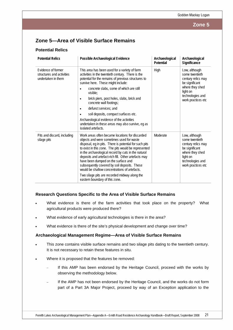
Zone 5
Zone 5—Area of Visible Surface Remains
Potential Relics
Potential Relics Possible Archaeological Evidence Archaeological Potential
Archaeological Significance
Evidence of former structures and activities undertaken in them
This area has been used for a variety of farm activities in the twentieth century. There is the potential for the remains of previous structures to survive here. These might include: • concrete slabs, some of which are still
visible; • brick piers, post holes, slabs, brick and
concrete wall footings; • defunct services; and • soil deposits, compact surfaces etc. Archaeological evidence of the activities undertaken in these areas may also survive, eg as isolated artefacts.
High Low, although some twentieth century relics may be significant where they shed light on technologies and work practices etc
Pits and discard, including silage pits
Work areas often became locations for discarded objects and were sometimes used for waste disposal, eg in pits. There is potential for such pits to exist in this zone. The pits would be represented in the archaeological record by cuts in the natural deposits and artefact-rich fill. Other artefacts may have been dumped on the surface and subsequently covered by soil deposits. These would be shallow concentrations of artefacts. Two silage pits are recorded midway along the eastern boundary of this zone.
Moderate Low, although some twentieth century relics may be significant where they shed light on technologies and work practices etc
Research Questions Specific to the Area of Visible Surface Remains
• What evidence is there of the farm activities that took place on the property? What agricultural products were produced there?
• What evidence of early agricultural technologies is there in the area?
• What evidence is there of the site’s physical development and change over time?
Archaeological Management Regime—Area of Visible Surface Remains
• This zone contains visible surface remains and two silage pits dating to the twentieth century. It is not necessary to retain these features in situ.
• Where it is proposed that the features be removed:
− If this AMP has been endorsed by the Heritage Council, proceed with the works by observing the methodology below.
− If the AMP has not been endorsed by the Heritage Council, and the works do not form part of a Part 3A Major Project, proceed by way of an Exception application to the

Penrith Lakes Archaeological Management Plan—Appendix A—Smith Road Residence Archaeology Handbook—Draft Report, September 2008 22
Zone 5
Heritage Branch, NSW Department of Planning. The application should recommend the following methodology.
− If the works form part of a Part 3A Major Project, and if the provisions of the Heritage Act do not apply, the works should be undertaken observing the following methodology.
• Prior to the removal of the features they should be recorded photographically and by survey and the results presented in a succinct report.
• The initial phase of ground disturbance should be monitored by an archaeologist to confirm that the area does not contain unexpected nineteenth century relics.
• If unexpected nineteenth century relics are exposed:
− If relics of local significance or relics in highly disturbed contexts are encountered, they can be removed after being appropriately recorded by an archaeologist (in words, photography, survey and measured drawings, as appropriate), then conserved and stored. Seek to retain relics of State or National significance in situ.
− If in situ retention of State-significant relics is impossible for overwhelming conservation, health or safety reasons, they may be removed only after this has been demonstrated, by a qualified archaeologist observing the principles of stratigraphic excavation, and ensuring appropriate recording (in words, photography, survey and measured drawings, as appropriate) and conservation and storage of relics. (Note: if the works do not form part of a Part 3A Major Project, for significant damage to State-significant relics it may be necessary to apply to the Heritage Branch, NSW Department of Planning, for an Excavation Permit.)
• On completion of any archaeological works, a succinct report should be prepared and submitted to the Heritage Branch, NSW Department of Planning that presents the results of the excavation, illustrated by photographs, survey plans and other drawings as appropriate.
• Any artefacts that are recovered should be washed, labelled and stored. Arrangements should be made for appropriate conservation to occur where artefacts with particular conservation requirements are found (for example, leather and metal artefacts).
• Wherever subsurface disturbance can be restricted, this should be done in order to reduce the impact on any potential archaeological relics at the site.
• If archaeological evidence relating to Aboriginal use of the site is discovered, the Director of the NSW National Parks and Wildlife Service must be notified immediately, in accordance with Section 91 of the National Parks and Wildlife Act 1974 (NSW). Appropriate Aboriginal consultation must be undertaken consistent with Department of Environment and Climate Change guidelines.

Penrith Lakes Archaeological Management Plan—Appendix A—Smith Road Residence Archaeology Handbook—Draft Report, September 2008 23
Zone 6
Zone 6—Area South and West of Residence/Possible Location of Historic Cottage
Potential Relics
Early twentieth century documents record a ‘very old’ timber slab cottage somewhere on the property. This may refer to the original dwelling of the first land grantee. It is unclear where this cottage stood but it is possible that it was located in this zone, where it would capture the expansive views onto the floodplain to the south.
Potential Relics Possible Archaeological Evidence Archaeological Potential
Archaeological Significance
Floor surfaces and isolated artefacts
Compacted surface on the footprint of the cottage. Artefacts located in discrete areas in and around the footprint (these are commonly small artefacts such as buttons, pins, coins, etc). Such relics are vulnerable to disturbance.
Low High
Structural elements Piers, post holes, impressions of floor joists and bearers, wall footings. Defunct services.
Low-to-Moderate High
Refuse pits and cesspits Cuts and fill often rich in artefacts, generally located a short walking distance from habitations.
Low-to-Moderate High
Remnants of concrete wall, slabs and trough
These visible features appear to date to the occupation of the twentieth century residence but may indicate ongoing use of the area from the nineteenth century.
High (visible) Low, although they may be associated with earlier structures of higher significance
Research Questions Specific to the Area South and West of Residence/Possible Location of Historic Cottage
• Is there any archaeological evidence of the cottage that was recorded in the 1902 property valuation? If so, can the archaeology assist in dating the cottage? Does it relate to the original land grant?
• Do the remnants of concrete slab, wall and trough have any association with earlier features? Do they indicate continuity of this area’s use since the nineteenth century (for example, the early cottage)?
• Does the windbreak of sheoaks reflect the location of a nineteenth century residence in this zone?
• What evidence is there of the activities that took place on the property in the nineteenth and twentieth centuries?

Penrith Lakes Archaeological Management Plan—Appendix A—Smith Road Residence Archaeology Handbook—Draft Report, September 2008 24
Zone 6
Archaeological Management Regime—Area South and West of Residence/Possible Location of Historic Cottage
Given the uncertainty surrounding the location of the nineteenth century cottage on the property, a flexible approach should be taken to the potential archaeological resource in this zone. In the first instance, a cautious approach to ground disturbance should be taken. However, if ground disturbance in the area in fact indicates a low potential for significant archaeology, a less cautious approach would be appropriate from that time.
It is not necessary to retain the twentieth century remnant walls, slab or trough in this zone. Be aware that they may indicate continuity of this area’s use since the nineteenth century and they may be in close proximity to earlier structural relics.
In the First Instance—A Cautious Approach
Generally, avoid ground disturbance in this area. For example, always seek alternative locations for ground disturbance for the purposes of drainage and other service infrastructure.
As a general principle, archaeological relics should be left undisturbed where possible. However, the enhancement of the area through improved landscaping would be a positive heritage outcome for the existing house. Ground disturbance for this purpose would generally be appropriate. If such ground disturbance is proposed, it should be used as an opportunity to investigate the area’s archaeological potential. Landscape designs should be flexible so that if relics belonging to an early nineteenth century cottage are exposed, the archaeology can inform modified landscape designs that respond to the relics.
• Where ground disturbance is proposed:
− If this AMP has been endorsed by the Heritage Council, proceed with the works by observing the methodology below.
− If the works do not form part of a Part 3A Major Project, and the AMP has not been endorsed by the Heritage Council, proceed by way of an Exception application to the Heritage Branch, NSW Department of Planning (the application should provide for the excavation methodology presented below).
− If the works form part of a Part 3A Major Project, and if the provisions of the Heritage Act do not apply, proceed by way of the methodology below.
• Prior to any ground disturbance works commencing, a site induction of all relevant personnel should be undertaken by a qualified archaeologist, who will explain the obligations of all personnel and the appropriate excavation methodology for the management of the archaeological resource.
• Where ground disturbance must occur, this should be monitored by an archaeologist. Machine excavation (small excavator or bobcat) may be appropriate but it should be monitored by the archaeologist with particular care.
• The archaeologist should excavate all deposits, applying the principles of stratigraphic excavation.

Penrith Lakes Archaeological Management Plan—Appendix A—Smith Road Residence Archaeology Handbook—Draft Report, September 2008 25
Zone 6
If Relics are Exposed
• If relics are exposed that indicate the location of the original or early nineteenth century cottage, the archaeologist should investigate them only so far as is necessary to demonstrate their nature and extent. Where possible such relics should be left in situ. This may require the redesign of landscape plans. If they cannot be retained for overwhelming conservation or health and safety reasons they may be removed only after this has been demonstrated, by a qualified archaeologist observing the principles of stratigraphic excavation, and ensuring appropriate recording (in words, photography, survey and measured drawings, as appropriate) and conservation and storage of relics. (Note: if the works do not form part of a Part 3A Major Project, for significant damage to State-significant relics it may be necessary to apply to the Heritage Branch, NSW Department of Planning, for an Excavation Permit.)
• If relics of local significance or relics in highly disturbed contexts are exposed (for example, later nineteenth century or twentieth century relics would likely be of local significance), they can be removed after being appropriately recorded (in words, photography, survey and measured drawings, as appropriate), then conserved and stored. This decision should be made only after a full significance assessment has been prepared by an archaeologist.
• Any artefacts that are recovered should be washed, labelled and stored. Arrangements should be made for appropriate conservation to occur where artefacts with particular conservation requirements are found (for example, leather and metal artefacts).
• Wherever subsurface disturbance can be restricted, this should be done in order to reduce the impact on any potential archaeological relics at the site.
• Where historic structural remains are exposed, those remains should be left in situ unless this is impossible for overwhelming conservation or health and safety reasons. In any case, the location, nature, function, dimensions etc of these remains should be archaeologically recorded (in words, photography, survey and measured drawing).
• If archaeological evidence relating to Aboriginal use of the site is discovered, the Director of the NSW National Parks and Wildlife Service must be notified, in accordance with Section 91 of the National Parks and Wildlife Act 1974 (NSW). Appropriate Aboriginal consultation must be undertaken consistent with Department of Environment and Climate Change guidelines.
• On completion of the works, a succinct report should be prepared and submitted to the Heritage Branch, NSW Department of Planning, that presents the results of the excavation, illustrated by photographs, survey plans and other drawings as appropriate.
If Ground Disturbance Indicates Very Low Potential for Significant Relics
Initial ground disturbance in parts of this zone may clearly demonstrate that this area was not in fact occupied by the original timber slab cottage. If that has been clearly demonstrated to the satisfaction of an archaeologist then further works involving ground disturbance can be carried out without the need for further consultation or consents (so far as archaeology is concerned).
However, if unexpected archaeological relics are encountered works must cease and an archaeologist should be engaged to assess the likely extent and significance of the relics. Observe the methodology above under the heading ‘If Relics are Exposed’.

Penrith Lakes Archaeological Management Plan—Appendix A—Smith Road Residence Archaeology Handbook—Draft Report, September 2008 26
Zone 6
In relation to consents:
• If this AMP has been endorsed by the Heritage Council, proceed with the works by observing the methodology under the heading ‘If Relics are Exposed’ above.
• If the AMP has not been endorsed by the Heritage Council, and the works do not form part of a Part 3A Major Project, notify the Heritage Branch, NSW Department of Planning of the discovery and proceed by way of an Exception application to the Heritage Branch. (Note: if the works do not form part of a Part 3A Major Project, for significant damage to State-significant relics it may be necessary to apply to the Heritage Branch, NSW Department of Planning, for an Excavation Permit.) The application should recommend the methodology under the heading ‘If Relics are Exposed’ above.
• If the works form part of a Part 3A Major Project, and if the provisions of the Heritage Act do not apply, the works should be undertaken following the methodology under the heading ‘If Relics are Exposed’ above.
Penrith Lakes Archaeological Management Plan—Appendix A—Smith Road Residence Archaeology Handbook—Draft Report, September 2008 27
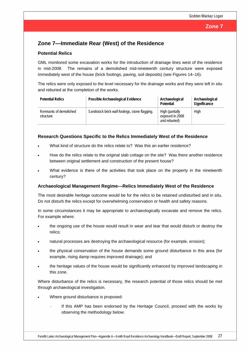
Zone 7
Zone 7—Immediate Rear (West) of the Residence
Potential Relics
GML monitored some excavation works for the introduction of drainage lines west of the residence in mid-2008. The remains of a demolished mid-nineteenth century structure were exposed immediately west of the house (brick footings, paving, soil deposits) (see Figures 14–16).
The relics were only exposed to the level necessary for the drainage works and they were left in situ and reburied at the completion of the works.
Potential Relics Possible Archaeological Evidence Archaeological Potential
Archaeological Significance
Remnants of demolished structure
Sandstock brick wall footings, stone flagging. High (partially exposed in 2008 and reburied)
High
Research Questions Specific to the Relics Immediately West of the Residence
• What kind of structure do the relics relate to? Was this an earlier residence?
• How do the relics relate to the original slab cottage on the site? Was there another residence between original settlement and construction of the present house?
• What evidence is there of the activities that took place on the property in the nineteenth century?
Archaeological Management Regime—Relics Immediately West of the Residence
The most desirable heritage outcome would be for the relics to be retained undisturbed and in situ. Do not disturb the relics except for overwhelming conservation or health and safety reasons.
In some circumstances it may be appropriate to archaeologically excavate and remove the relics. For example where:
• the ongoing use of the house would result in wear and tear that would disturb or destroy the relics;
• natural processes are destroying the archaeological resource (for example, erosion);
• the physical conservation of the house demands some ground disturbance in this area (for example, rising damp requires improved drainage); and
• the heritage values of the house would be significantly enhanced by improved landscaping in this zone.
Where disturbance of the relics is necessary, the research potential of those relics should be met through archaeological investigation.
• Where ground disturbance is proposed:
− If this AMP has been endorsed by the Heritage Council, proceed with the works by observing the methodology below.
Penrith Lakes Archaeological Management Plan—Appendix A—Smith Road Residence Archaeology Handbook—Draft Report, September 2008 28
Zone 7
− If the works do not form part of a Part 3A Major Project, and the AMP has not been endorsed by the Heritage Council, proceed by way of an Exception application to the Heritage Branch, NSW Department of Planning (the application should provide for the excavation methodology presented below).
− If the works form part of a Part 3A Major Project, and if the provisions of the Heritage Act do not apply, proceed by way of the methodology below.
• Prior to any ground disturbance works commencing, a site induction of all relevant personnel should be undertaken by a qualified archaeologist, who will explain the obligations of all personnel and the appropriate excavation methodology for the management of the archaeological resource.
• If relics are exposed that indicate the location of the original or early nineteenth century cottage, the archaeologist should investigate them only so far as is necessary to demonstrate their nature and extent. Where possible such relics should be left in situ. This may require the redesign of landscape or drainage etc plans. If they cannot be retained for overwhelming conservation or health and safety reasons they may be removed only after this has been demonstrated, by a qualified archaeologist observing the principles of stratigraphic excavation, and ensuring appropriate recording (in words, photography, survey and measured drawings, as appropriate) and conservation and storage of relics. (Note: if the works do not form part of a Part 3A Major Project, for significant damage to State-significant relics it may be necessary to apply to the Heritage Branch, NSW Department of Planning, for an Excavation Permit.)
• If relics of local significance or relics in highly disturbed contexts are exposed (for example, the visible later nineteenth century relics would be of local significance), they can be removed after being appropriately recorded (in words, photography, survey and measured drawings, as appropriate), then conserved and stored.
• Any artefacts that are recovered should be washed, labelled and stored. Arrangements should be made for appropriate conservation to occur where artefacts with particular conservation requirements are found (for example, leather and metal artefacts).
• Wherever subsurface disturbance can be restricted, this should be done in order to reduce the impact on any potential archaeological relics at the site.
• If archaeological evidence relating to Aboriginal use of the site is discovered, the Director of the NSW National Parks and Wildlife Service must be notified, in accordance with Section 91 of the National Parks and Wildlife Act 1974 (NSW). Appropriate Aboriginal consultation must be undertaken consistent with Department of Environment and Climate Change guidelines.
• On completion of the works, a succinct report should be prepared and submitted to the Heritage Branch, NSW Department of Planning, that presents the results of the excavation, illustrated by photographs, survey plans and other drawings as appropriate.

Penrith Lakes Archaeological Management Plan—Appendix A—Smith Road Residence Archaeology Handbook—Draft Report, September 2008 29
9.0 Endnotes
1 Stedinger 2007, Mass Concrete House, 43 Smith Road, Conservation Management Plan, pp 31–34. 2 Wright, R & G Gyford, NDHAG 2002, A Report on the Mass Concrete House at Castlereagh, 43 Smith St Castlereagh, p 6. 3 Bickford, A and S Sullivan 1984, ‘Assessing the Research Significance of Historic Sites’, in Sullivan S and S Bowdler (eds) Site
Surveys and Significance Assessment in Australian Archaeology (proceedings of the 1981 Springwood Conference on Australian Prehistory), Department of Prehistory, Research School of Pacific Studies, The Australian National University, Canberra.

Penrith Lakes Archaeological Management Plan—Appendix A—Smith Road Residence Archaeology Handbook—Draft Report, September 2008 30
Site plan with management zones overlaid. (Base photo: Google Earth)