Pennsylvania Riverine Condition Level 2 Rapid Assessment ...
33
Pennsylvania Riverine Condition Level 2 Rapid Assessment Protocol Version 1.0 Bureau of Waterways Engineering and Wetlands Division of Wetlands, Encroachments and Training
Transcript of Pennsylvania Riverine Condition Level 2 Rapid Assessment ...

Pennsylvania Riverine Condition Level 2 Rapid Assessment Protocol
Version 1.0
Bureau of Waterways Engineering and Wetlands Division of Wetlands, Encroachments and Training

310-2137-003 / September 9, 2016 / Page i
DEPARTMENT OF ENVIRONMENTAL PROTECTION Bureau of Waterways Engineering and Wetlands
DOCUMENT NUMBER: 310-2137-003 TITLE: Pennsylvania Riverine Condition Level 2 Rapid Assessment EFFECTIVE DATE: Upon publication of notice as final in the Pennsylvania Bulletin AUTHORITY: The Dam Safety and Encroachments Act, Act of November 26, 1978, P.L. 1375, No. 355, as amended, 32 P.S. §§ 693.1 et seq. POLICY: This document provides guidance for assessing the condition of riverine
aquatic resources for use in applicable requirements under 25 Pa. Code Chapter 105 regulations.
PURPOSE: To provide standard guidelines for evaluating the condition of riverine
aquatic resources for the purposes of meeting regulatory requirements contained in 25 Pa. Code Chapter 105. The guidance outlines how to conduct assessments, the factors to consider when doing so and establishes a scoring system based upon condition categories.
APPLICABILITY: The guidance document applies to persons performing riverine condition
assessments for planning, permitting, compliance, compensation, and other applicable requirements under 25 Pa. Code Chapter 105 regulations.
DISCLAIMER: The policies and procedures outlined in this guidance document are
intended to supplement existing requirements. Nothing in the policies or procedures will affect regulatory requirements.
The policies and procedures herein are not an adjudication or a regulation. There is no intent on the part of the Department to give these rules that weight or deference. This document establishes the framework, within which DEP will exercise its administrative discretion in the future. DEP reserves the discretion to deviate from this policy statement if circumstances warrant.
PAGE LENGTH: 33 Pages

310-2137-003 / September 9, 2016 / Page ii
Table of Contents
Introduction ............................................................................................................................................... 1
Background ............................................................................................................................................... 2
1.0 Assessment Area.............................................................................................................................4
2.0 Channel/Floodplain Condition Index ...........................................................................................7 2.1 Channel/Floodplain Condition Categories ...........................................................................9
3.0 Riparian Vegetation Condition Index ........................................................................................13 3.1 Riparian Vegetation Condition Categories ........................................................................14
4.0 Riparian Zone of Influence (ZOI) Condition Index .................................................................16 4.1 Riparian ZOI Condition Categories ...................................................................................17
5.0 In-Stream Habitat Condition Index ...........................................................................................19 5.1 In-Stream Habitat Condition Categories ............................................................................21
6.0 Channel Alteration Condition Index ..........................................................................................22 6.1 Channel Alteration Condition Categories ..........................................................................23
7.0 Riverine Condition Index (RCI) .................................................................................................24
Bibliography ............................................................................................................................................ 25
Forms ....................................................................................................................................................... 27 Form 1 Riverine Assessment Form ................................................................................................28 Form 2 Stream Assessment Summary Form .................................................................................30

310-2137-003 / September 9, 2016 / Page 1
Introduction The Dam Safety and Encroachments Act requires a person to obtain a permit from the Department of Environmental Protection (DEP or Department) to construct, operate, maintain, modify, enlarge or abandon a dam, water obstruction or encroachment. 32 P.S. § 693.6(a). Regulations related to the dam safety and waterway management permitting process have been promulgated in Chapter 105 of Title 25 of the Pennsylvania Code. When impacts are proposed to a resource in connection with a proposed dam, water obstruction or encroachment, an applicant is required to, among other things, submit a mitigation plan with the application for an individual permit or the registration for a general permit in accordance with the definition of mitigation in Chapter 105. 25 Pa. Code § 105.13. The Department has developed this technical guidance to provide a methodology acceptable to the Department for the assessment of existing riverine resource conditions proposed to be impacted as part of a permit application. This assessment protocol is neither a regulation, nor is intended to alter existing regulatory requirements. To the extent that restrictive language is used in this technical guidance, the restrictive language is intended to make sure that the assessment protocol is performed to assess the resource’s condition in a manner that the Department has determined is acceptable to attain the regulatory standard. The Department recommends the use of this technical guidance to perform resource condition assessments. The Department may approve an alternative resource condition assessment (separate from and not contained in this technical guidance) if that methodology is determined by the Department to adequately identify and assess resource conditions for the purposes of meeting regulatory requirements under Chapter 105. Complete and legally defensible supporting documentation (justifications, calculations, etc.) must be included with the application to allow the Department to make an informed decision regarding the use of an alternative assessment protocol methodology. Additional application processing time may be necessary when using an alternative methodology because the methodology will require review and approval by the Director of the Bureau of Waterways Engineering and Wetlands prior to use in a final permit action. The Department may require additional information necessary to adequately review a resource condition assessment or may require other information deemed necessary to review a proposed alternative resource condition assessment.

310-2137-003 / September 9, 2016 / Page 2
Background This protocol is part of a comprehensive effort to ensure consistency in conducting aquatic resource condition assessments, impact assessments and compensation determinations. It was developed to provide information regarding the condition of intermittent and perennial watercourses with drainage areas equal to or less than 2,000 square miles (herein, collectively addressed as riverine resources) for permit impact evaluation and compensatory mitigation purposes. This protocol is not intended to be used for water quality designation purposes. This protocol was developed by adapting the approach and scoring of previously developed and tested rapid assessment protocols (Barbour et al. 1999, USM, 2007; PA DEP ICE) and integration of the riparian ecotone concept. Little to no equipment is needed to use this protocol and a professional generally should be able to employ the protocol in less than one day, not including preparation time, to ascertain the condition of a riverine resource after proficiency is developed. This assessment protocol intends to provide a standard method for establishing the relative structural condition of a riverine resource’s condition incorporating components of the riparian ecotone concept for the purpose of a Water Obstruction and Encroachment (WO&E) permit application pursuant to Title 25, Chapter 105. Riparian ecotones are a three dimensional space of interaction that include terrestrial and aquatic ecosystems that extend down into the groundwater, up above the vegetative canopy, outward across the floodplain, up the near-slopes that drain water, laterally into the terrestrial ecosystem, and along the water course at a variable width. The riparian ecotone includes the 100 year floodplain and 100 feet landward along the valley, where as obvious slumps or landslides are added with a 45 foot band around their edge adapted from Verry et al. (2004). This rapid condition assessment through the use of condition indices considers the condition of the channel/floodplain; riparian zone of influence; riparian vegetation; instream habitat and channel alterations. These condition indices do not consider the abundance or types of fauna present, nor do they consider the water quality of the riverine resources. Therefore, this protocol seeks to assess riverine resources through evaluating the assessment area and surrounding lands based upon the departure from reference standard conditions. This protocol can be used to satisfy certain Chapter 105 application requirements as described in the Department’s permit application and environmental assessment forms and instructions available in its Online Library found at www.dep.pa.gov. This qualitative rapid assessment is designed to limit subjectivity and provide a representation of the resource condition associated with an established assessment area. The resulting riverine condition index may be used by applicants seeking Chapter 105 authorizations from the Department or by the Department when evaluating proposed project impacts and determining compensatory mitigation requirements. Assessors should follow general professional standards and collect or utilize supporting information such as photographic documentation as appropriate or reference such materials contained in the application that support observations, professional judgments or other circumstances as deemed necessary to provide an accurate and true representation of the resource conditions.

310-2137-003 / September 9, 2016 / Page 3
Resource Conditions for General Use This protocol is for use to assess resource conditions in all natural or artificial intermittent and perennial watercourses with drainage areas equal to or less than 2,000 square miles. The application of this technical guidance should be adjusted as instructed when the following circumstances are present:
Intermittent Watercourses Intermittent watercourses for the purposes of this protocol include watercourses which during periods of the year, experience flow from one or both of the following: surface runoff and groundwater discharges. Watercourses identified as ephemeral are considered a subtype of an intermittent stream channel. The RCI is determined by evaluating the Channel/Floodplain Condition Index, Riparian Vegetation Condition Index, Riparian Zone of Influence (ZOI) Condition Index and the Channel Alteration Index. Instream Habitat is not included as a condition index in determining the RCI score and the assessor should place “Not Applicable” in the Instream Habitat comment section on the form. The indices are weighted equally and the sum of the individual calculated indices is divided by 4, the number of condition categories assessed, to establish the RCI index.
Perennial Watercourses The RCI is determined for perennial watercourses with drainage areas less than or equal to 100 square miles by evaluating all of the condition indices: Channel/Floodplain Condition Index, Riparian Vegetation Condition Index, Riparian Zone of Influence (ZOI) Condition Index, Instream Habitat and the Channel Alteration Index. The indices are weighted equally and the sum of the individual calculated indices is divided by 5, the number of condition categories assessed, to establish the RCI index. The RCI is determined for perennial watercourses with drainage areas greater than 100 square miles but less than or equal to 2,000 square miles by evaluating all of the following condition indices: Channel/Floodplain Condition Index, Riparian Vegetation Condition Index, Instream Habitat and the Channel Alteration Index. Riparian ZOI is not included as a condition index in determining the RCI score and the assessor should place “Not Applicable” in the Riparian ZOI comment section on the form. The indices are weighted equally and the sum of the individual calculated indices is divided by 4, the number of condition categories assessed, to establish the RCI index. The Department should be consulted during pre-application meetings for determination of the necessity and use of this technical guidance to conduct an assessment when the following circumstances are present:
Perennial Watercourses Perennial watercourses with drainage areas greater than 2,000 square miles will be handled on case-by-case basis and the applicant may be instructed to utilize this technical guidance or the Pennsylvania Lacustrine Condition Level 2 Rapid Assessment (Doc No.: 310-2137-004) technical guidance.

310-2137-003 / September 9, 2016 / Page 4
Concrete-lined, Gabion-lined or Riprap-lined Channels Watercourses that are concrete, gabion or riprap-lined channels and do not exhibit natural or naturalized stream features (depositional, vegetation, etc.) generally will not require the performance of a resource condition assessment. However, there are instances that exist in which an assessment of condition is necessary. The necessity to conduct this assessment is on a case-by-case basis and should be discussed with DEP staff during the pre-application phase of your permit application development.
1.0 Assessment Area
Projects are proposed in streams of varying size and quality. Therefore, it is important to assess and use the quality of the stream reach proposed to be affected as a factor to determine the level of impact occurring and to ensure adequate compensation for any unavoidable impacts. There are numerous methodologies that arrive at a numerical index to use as an indicator of stream quality. An applicant may use this assessment to cover the majority of situations encountered in the permit application review process. However, this assessment is not intended to be a substitute for more detailed stream studies that may be undertaken to determine stream quality, water chemistry or biological conditions when necessary in accordance under applicable regulatory requirements. The information this assessment provides is complimentary to any detailed studies that may be required pursuant to other regulatory requirements. The assessor needs to establish the upper and lower boundaries of the Assessment Area (AA). A project may have multiple AAs due to changing stream conditions, depending upon the number of structures or activities proposed in the Chapter 105 WO&E permit application or environmental assessment, or how close in proximity the structures or activities are to each other. An assessor should not establish AAs with the intent to lower the resulting RCI scores, but instead to represent the overall condition of the resource area where the structures or activities will occur. Factors to consider in establishing the upper and lower boundaries of the AA include, but are not limited to, the following: ● The upstream influence of backwater projected as part of the hydrologic & hydraulic
analysis (H&H) and application of the same distance downstream; or ● 20 times the channel width at bankfull stage upstream and downstream; or ● 100 feet upstream and downstream of the proposed location of the structure or activity;
whichever is greater. When using this assessment protocol, the assessor should document the criteria or rationale used to establish the upper and lower limits of the AA. The Stream Assessment Form (Form 1), included in Appendix B, is used to record this information for each AA. After an assessor establishes the AA’s upper and lower limits, the boundaries of the Riparian Vegetation and the Riparian ZOI are established. The assessor will establish the boundaries of the Riparian Vegetation in the following manner in order of preference: ● Hydrologic modeling analysis to determine 100 year storm event elevations; or ● 100 year Federal Emergency Management Agency (FEMA) floodplain mapping; or

310-2137-003 / September 9, 2016 / Page 5
● In FEMA unmapped areas, estimate the flood prone area width by determining the elevation that corresponds to twice the maximum depth of the bankfull channel as taken from the established bankfull stage; or
● In FEMA unmapped areas where hydrologic modeling analysis and stream cross-section data is not available, estimate the flood prone area width by extending 100 feet from the stream bank towards the valley margins. Assessor needs to apply Best Professional Judgment (BPJ) if one or more valley margins are less than 100 feet from the bank and adjust the boundaries accordingly.
The image above is an example of mapping typically found in a FEMA floodplain map. When mapped floodplains are available they are to be used to establish the boundaries for the Riparian Vegetation and the Riparian ZOI. The 100 year floodplain boundaries are available as a Geographic Information Systems (GIS) layer from the Pennsylvania Spatial Data Access (PASDA) website at www.pasda.psu.edu; however, there can be significant projection errors and care should be taken to verify elevations and distances with older versions of the mapping. The Department highly recommends that this layer is used in conjunction with the Light Detection and Ranging (LIDAR) GIS coverages, which are also available at PASDA to improve establishing the Riparian Vegetation assessment boundaries based on topography and not fixed distances.

310-2137-003 / September 9, 2016 / Page 6
The second image above depicts a completed layout of an AA using FEMA mapped floodplain boundaries, aerial photography and LIDAR contours (LIDAR contours were used to check boundaries). The red outlined area is the Riparian Vegetation boundaries (100 year floodplain) based upon FEMA mapping and the yellow shaded area is the Riparian ZOI which extends 100 feet beyond that boundary (Riparian Vegetation).
When the AA extends into another larger floodplain (e.g., due to a confluence) or inundation zone from a dam, the extent of the Riparian Vegetation is estimated using the hierarchy of the methods previously listed. The boundaries of the other floodplain or inundation zone should be ignored because they are not related to the specific AA being assessed and the features that determine its resource condition value. The third image above uses upstream floodplain mapping to estimate distance from the bank to the 100 year floodplain boundary and then measures the same distance along the AA to establish the red shaded area as the Riparian Vegetation area (100 year floodplain) and the green shaded area extends 100 feet outward and establishes the Riparian ZOI. LIDAR contours were not used to establish the floodplain boundary in this instance. Once the Riparian Vegetation boundaries are established, the Riparian ZOI boundaries are set by extending 100 feet landward from the Riparian vegetation boundaries on each side of the stream

310-2137-003 / September 9, 2016 / Page 7
along the entire length of the Riparian Vegetation area. In most instances, the Riparian ZOI does not close or extend around the upstream and downstream terminus of the AA, however when assessing the upper most headwaters of a watercourse, the assessor may include the area 100 feet above the watercourse within the Riparian Zone boundary.
2.0 Channel/Floodplain Condition Index
Under most circumstances, channels respond to disturbances or changes in flow regime in a sequential, predictable manner. The way a stream responds to changes is by degrading to a lower elevation and eventually re-stabilizing at that lower elevation (Figure 1). This is the basic premise behind the stream channel evolutionary process. The differing stages of this process can be directly correlated with the current state of stream stability. The purpose of evaluating Channel Condition is to determine the current condition of the channel cross-section, as it relates to this evolutionary process, and to make a correlation to the current state of stream stability. These evolutionary processes apply to the majority of stream systems and assessment reaches due to the fact that the majority of stream systems are degrading, aggrading, healing, or stable. A channel’s condition can be determined by visually assessing certain geomorphological indicators related to the channel geometry, stability and active floodplain connection: Channel Geometry: The evaluator should visually assess the channel profile by assessing the degree of incision and/or widening. Channel incision is a common response of alluvial channels that have excess amounts of flow energy or stream power relative to the sediment load. This change in flow regime results in the stream eroding the stream bed, causing steep, easily eroded banks. If the cohesiveness of the bank material is very low, such as loose sand, the channel will erode the banks and have a wide cross-section compare to its depth. This instability presents itself as an over-widened channel. Channel Stability: The channel stability is assessed by looking for visual indicators of stability or instability. In a stable stream, the pattern of erosion and deposition occurs in an orderly and predictable fashion. One of the most common depositional features of stable streams in this region is the creation of point bars. A point bar is a crescent-shaped depositional feature located on the inside of a stream bend or meander. Point bars are composed of well sorted sediment with a very gentle slope at an elevation below bankfull and very close to the base flow water level. Since point bars are low-lying, they are often overtaken by stream flow and can accumulate driftwood and other debris during times of high water levels. Another common feature of a stable stream is a bankfull bench. A bankfull bench is a flat or shallow sloped area above bankfull that slows high velocity flows during flows above bankfull. The bank of a stable stream will also be well vegetated with either herbaceous or woody species or may have a natural rock surface. These banks are stabilized by these surfaces, thereby reducing or preventing erosion. Finally, an indication of a stable stream may simply be an absence of indicators of an unstable stream channel. Indicators of an unstable stream channel include depositional features such as mid-channel bars, transverse bars and transient sediments, as well as erosion features such as erosion scars, denuded banks and threaded channels. Mid-channel bars and transverse bars are landforms in a stream channel that begin to form when the discharge is low and the stream is forced to take the route of less resistance by flowing in locations of the lowest elevation. Over time, the stream begins to erode the outer edges of the bar, causing it to remain at a higher elevation than the surrounding areas. The water level decreases even more as the river laterally erodes the less cohesive bank material, resulting in a widening of the river and a further exposure

310-2137-003 / September 9, 2016 / Page 8
of the bar. As the discharge increases, material may deposit about the bar since it is an area in the stream of low velocity due to its higher elevation than the surrounding areas. Active Floodplain Connection: Active floodplain is the land between the active channel at the bankfull elevation and the terraces that are flooded by stream water on a periodic basis. Natural channels at or immediately below surrounding floodplain elevations will be connected to the active floodplain. Channels that are deeply incised or channelized will be below the elevation of the floodplain and will no longer be able to flood the floodplain during normal high-water events. Each of the condition categories below describes a particular combination of the state of these geomorphological indicators which generally correspond to a stream channel stability condition at some stage in the evolution process. The Channel Condition Index is calculated as follows:
Channel CI = Condition Score/20

310-2137-003 / September 9, 2016 / Page 9
2.1 Channel/Floodplain Condition Categories
Channel Condition is an assessment of the cross-section of the stream along the stream reach. The channel condition of each AA is assigned to one of the following five condition categories. Assessors will refer to the Channel Condition descriptions for Channel Geometry, Channel Stability and Active Floodplain Connection when conducting this assessment protocol. A condition score is given to represent the prevailing channel/floodplain condition over the entire AA. The assessor will identify (erosion, deposition, or disconnection to the floodplain) and record specific problem areas in the Notes block for the channel/floodplain condition parameter. The Channel Condition observations are recorded in Section 1 of Form 1.

310-2137-003 / September 9, 2016 / Page 10
Optimal 20 - 17
Channel Geometry: These channels show very little incision or widening and little or no evidence of active erosion or unprotected banks; anastomosed or stable multiple channels are considered optimal and scored accordingly; Channel Stability: Visual indicators of this stability include: 1) vegetative surface protection or natural rock stability present along greater than 80% of the banks; 2) stable point bars and bankfull benches may be present; 3) mid-channel bars and transverse bars are rare and if transient sediment deposition is present, it covers less than or equal to 10% of the stream bottom; Active Floodplain Connection: The channel has access to the active floodplain or has fully developed wide bankfull benches. High flow channels may be present in the floodplain at varying elevations.
Suboptimal 17 - 14
Channel Geometry: These channels are slightly incised and contain a few areas of active erosion or unprotected banks. Channel Stability: Visual indicators of this slight instability include: 1) vegetative surface protection or natural rock stability present along greater than 60% and less than 80% of both banks; 2) depositional features such as point bars and bankfull benches are likely present; 3) if transient sediment is present, it affects or buries greater than 10% and less or equal to 40% of the stream bottom. Active Floodplain Connection: The stream has access to bankfull benches, or newly developed floodplains along portions of the reach.
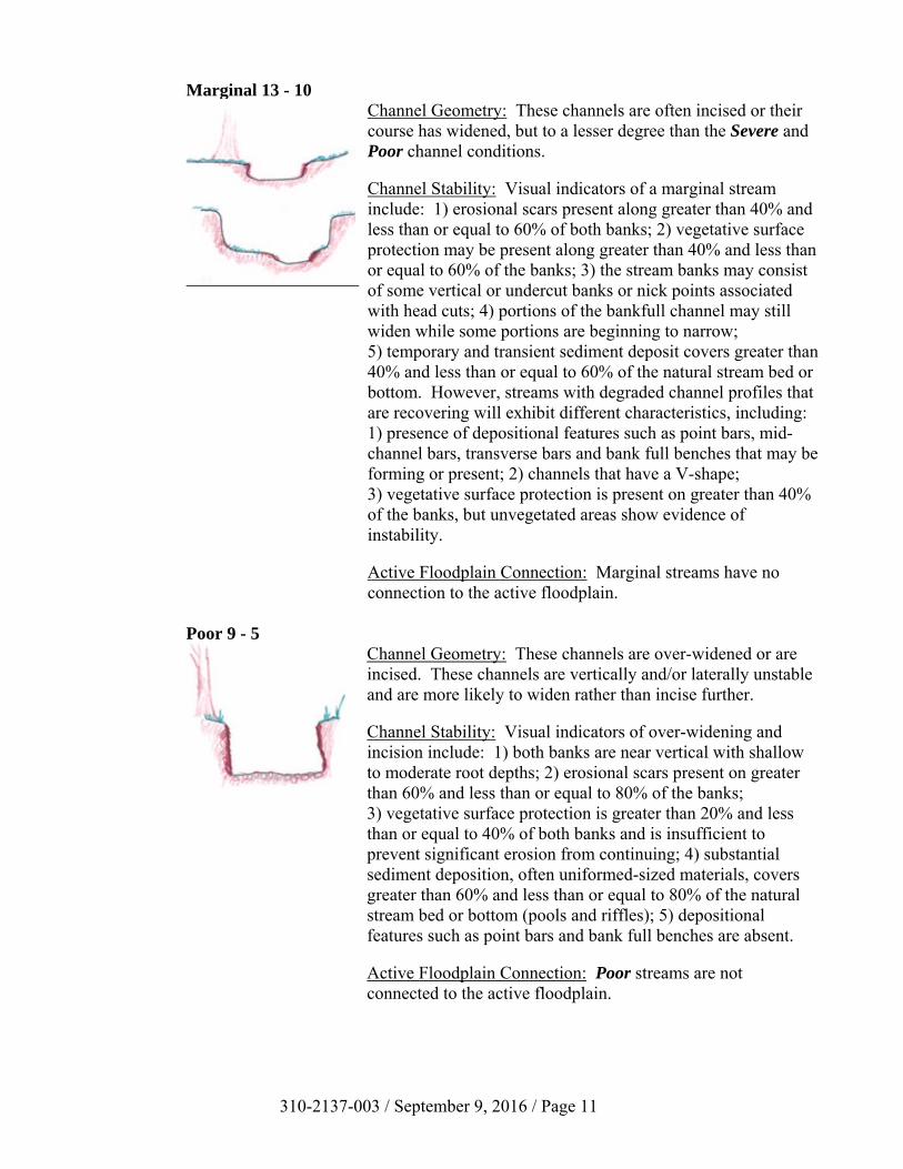
310-2137-003 / September 9, 2016 / Page 11
Marginal 13 - 10 Channel Geometry: These channels are often incised or their course has widened, but to a lesser degree than the Severe and Poor channel conditions. Channel Stability: Visual indicators of a marginal stream include: 1) erosional scars present along greater than 40% and less than or equal to 60% of both banks; 2) vegetative surface protection may be present along greater than 40% and less than or equal to 60% of the banks; 3) the stream banks may consist of some vertical or undercut banks or nick points associated with head cuts; 4) portions of the bankfull channel may still widen while some portions are beginning to narrow; 5) temporary and transient sediment deposit covers greater than 40% and less than or equal to 60% of the natural stream bed or bottom. However, streams with degraded channel profiles that are recovering will exhibit different characteristics, including: 1) presence of depositional features such as point bars, mid-channel bars, transverse bars and bank full benches that may be forming or present; 2) channels that have a V-shape; 3) vegetative surface protection is present on greater than 40% of the banks, but unvegetated areas show evidence of instability. Active Floodplain Connection: Marginal streams have no connection to the active floodplain.
Poor 9 - 5
Channel Geometry: These channels are over-widened or are incised. These channels are vertically and/or laterally unstable and are more likely to widen rather than incise further. Channel Stability: Visual indicators of over-widening and incision include: 1) both banks are near vertical with shallow to moderate root depths; 2) erosional scars present on greater than 60% and less than or equal to 80% of the banks; 3) vegetative surface protection is greater than 20% and less than or equal to 40% of both banks and is insufficient to prevent significant erosion from continuing; 4) substantial sediment deposition, often uniformed-sized materials, covers greater than 60% and less than or equal to 80% of the natural stream bed or bottom (pools and riffles); 5) depositional features such as point bars and bank full benches are absent. Active Floodplain Connection: Poor streams are not connected to the active floodplain.

310-2137-003 / September 9, 2016 / Page 12
Severe 4 - 1
Channel Geometry: Severe channels are deeply incised (or excavated) with vertical and/or lateral instability and will likely continue to incise or widen. Channel Stability: visual indications of a deeply incised stream include: 1) a streambed elevation below the average rooting depth; 2) both banks are vertical or undercut; 3) a presence of vegetative surface protection on less than 20% of the banks that does not prevent erosion from continuing; 4) bank sloughing is present; 5) erosional scars or raw banks present on greater than 80% of the banks; 6) substantial sediment deposition covers greater than 80% of the natural streambed or bottom (pools and riffles); 7) unstable multiple thread channels and/or subterranean flow may be present in certain aggrading channels. Active Floodplain Connection: Severe streams are not connected to the active floodplain.
Note: Anastomosed or stable multiple channel watercourses naturally occurring in some low-gradient streams should not be given a Severe Parameter Condition; they are rated as Optimal.

310-2137-003 / September 9, 2016 / Page 13
3.0 Riparian Vegetation Condition Index
This condition index is not intended to be a detailed vegetative cover survey, but instead, is a qualitative evaluation of the cover types that make up the riparian vegetation within the 100 year floodplain limits. An assessor should determine this condition index by evaluating what cover type occupies what percent of the total riparian vegetation area for each side of 100 year floodplain within the AA. The left side (LS) and right side (RS) are determined by facing downstream. Visual observation of the area determines the scoring of the riparian vegetation area condition. The use of aerial photography is highly recommended for initial condition category mapping prior to performing the assessment in the field. The initial condition category mapping combined with a visual observation of the riparian area is sufficient to provide adequate information to determine this condition index. See Section 1.0 for how to establish the boundaries for the Riparian Vegetation assessment area. The optimal riparian vegetation would include land cover areas comprised of hardwood/conifer trees, wetlands, waterways and/or lacustrine resources (≥ 10 acres). All areas comprised of stream channels, wetlands (regardless of classification or condition) and lacustrine resources ≥ 10 acres are categorized as optimal. It is highly likely that the area will contain land covers that meet multiple condition categories. If the land cover composite is heterogeneous (example: 33% forested, 33% cropland, and 34% pavement), each condition category present within the riparian vegetation is scored and weighted based on the percentage of the total area it occupies. A percentage estimate of the total area that each cover type occupies is determined by using visual estimates of each different area to obtain its percentage of cover. The assessor will categorize and score the observed cover types accordingly, based upon the condition category descriptions. The assessor records the percentages on the form in decimal format (0.00). Calculating the Riparian Vegetation Condition Index: The following equations are used when right and left sides of the Riparian Vegetation were established:
Left Side Sub-Index = SUM (%Areas*Scores)/20 Right Side Sub-Index = SUM (%Areas*Scores)/20
Riparian Vegetation CI = (Left Side CI + Right Side CI)/2
There may be instances where the stream is primarily up against one side of the valley wall forcing the floodplain to the other side of the stream. The assessor may use their BPJ and rate the entire area as one unit versus using left and right side data and score averaging. The following equation should be used if the Riparian Vegetation area is evaluated as one continuous area:
Riparian Vegetation CI = SUM (%Areas*Scores)/20

310-2137-003 / September 9, 2016 / Page 14
3.1 Riparian Vegetation Condition Categories
The AA is assessed for the condition of the Riparian vegetation using the following four condition categories. Non-maintained refers to an area that is not subject to regular human impacts (e.g., mowing, clearing, herbicide applications). The observations are recorded in Section 2 of Form 1.
Optimal 20 - 16 Riparian vegetation consists of a tree stratum (diameter at breast height (dbh) > 3 inches) present, with greater than or equal to 60% tree canopy cover and containing both herbaceous and shrub layers or a non-maintained understory. Areas comprised of stream channels, wetlands (regardless of classification or condition) and lacustrine resources ≥ 10 acres are scored as optimal.
Suboptimal 15 - 11
High Suboptimal (15 - 13): Riparian vegetation consists of a tree stratum (dbh > 3 inches) present, with greater than or equal to 30% and less than 60% tree canopy cover and containing both herbaceous and shrub layers or a non-maintained understory. Low Suboptimal (13 - 11): Riparian vegetation consists of a tree stratum (dbh > 3 inches) present, with greater than or equal to 30% and less than 60% tree canopy cover with maintained understory.
Marginal 10 - 6
High Marginal (10 - 8): Riparian vegetation consists of non-maintained, dense herbaceous vegetation with either a shrub layer or a tree stratum (dbh > 3 inches) present, with less than 30% tree canopy cover. Low Marginal (8 - 6): Riparian vegetation consists of non-maintained, dense herbaceous vegetation, riparian areas lacking shrub and tree stratum, areas of hay
High Suboptimal: Riparianarea
vegetation consists of a tree stratum (dbh > 3 inches)
present, with greater than or
equal to 30% and less than 60% tree canopy cover and
containing both herbaceous and shrub layers or a non-maintained
understory.
Low Suboptimal: Riparian area
vegetation consists of a tree stratum (dbh > 3 inches)
present, with greater than or
equal to 30% and less than 60% tree canopy cover with a
maintained understory.
High Marginal: Riparian area
vegetation consists of non-maintained, dense herbaceous
vegetation with either a shrub layer
or a tree stratum (dbh > 3 inches) present, with less
than 30% tree canopy cover.
Low Marginal: Riparian area
vegetation consists of non-maintained, dense herbaceous vegetation, riparian areas lacking shrub
and tree stratum, areas of hay
production, and ponds or open
water areas (< 10 acres). If trees are
present, tree stratum (dbh > 3 inches) present,
with less than 30% tree canopy cover
with maintained understory.
High Poor: Riparian area
vegetation consists of lawns, mowed, and maintained
areas, nurseries; no-till cropland; actively
grazed pasture, sparsely vegetated
non-maintained area, pervious trails,
recently seeded and stabilized, or other comparable
condition.
Low Poor: Riparian area consists of impervious
surfaces; mine spoil lands, denuded surfaces, row
crops, active feed lots, impervious trails, or other comparable conditions.
High Low High Low High LowScore
Side Sub-Index
% Riparian Area:
Score:
Total Sub-score:
% Riparian Area: CIScore:
Total Sub-score:
Right Side
20 19 18 17 16 15 14 13 12 11 10 9 8 7 6 5 4 3 2 1
Condition Category
Left Side
3. Enter the % Riparian Area in in decimal form (0.00) and Score for each category in the blocks below. Ensure the sum of the % Riparian Area Blocks equal 100
Condition Category
CI = (Left Side CI + Right Side CI)/2
Comments:
Riparian Vegetation
(Floodplain)
Optimal Suboptimal Marginal Poor
Riparian area vegetation consists of a tree stratum present (diameter at breast height (dbh) > 3 inches) with greater than or equal to 60% tree
canopy cover. Areas comprised of stream channels, wetlands
(regardless of classification or condition) and lacustrine resources ≥ 10 acres are scored as optimal.
Side Sub-Index = SUM(%Areas*Scores)/20
1. Identify Condition Category areas along the floodplain using the descriptors above.
2. Estimate the % area within each condition category.
2. RIPARIAN VEGETATION: Assess the floodplain along the entire SAR (Visual estimates of areal coverage from aerial photos with field verification acceptable).
Condition Category
310-2137-003 / September 9, 2016 / Page 15
production, and ponds or open water areas (< 10 acres). If trees are present, tree stratum (dbh > 3 inches) present, with less than 30% tree canopy cover with maintained understory.
Poor 5 - 1
High Poor (5 - 3): Riparian vegetation consists of lawns, mowed, and maintained areas, nurseries; no-till cropland; actively grazed pasture, sparsely vegetated non-maintained area, pervious trails, recently seeded and stabilized, or other comparable condition. Low Poor (3 - 1): Riparian vegetation consists of impervious surfaces, mine spoil lands, denuded surfaces, row crops, active feed lots, impervious trails, or other comparable conditions.
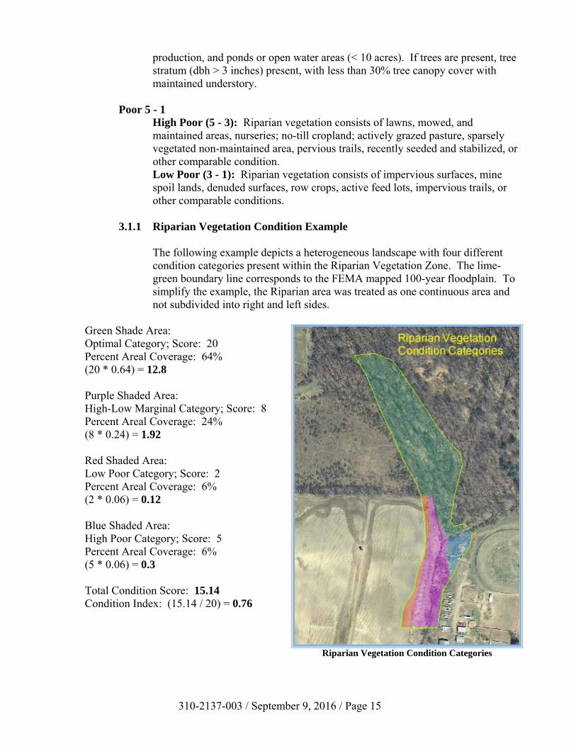
3.1.1 Riparian Vegetation Condition Example
The following example depicts a heterogeneous landscape with four different condition categories present within the Riparian Vegetation Zone. The lime-green boundary line corresponds to the FEMA mapped 100-year floodplain. To simplify the example, the Riparian area was treated as one continuous area and not subdivided into right and left sides.
Green Shade Area: Optimal Category; Score: 20 Percent Areal Coverage: 64% (20 * 0.64) = 12.8 Purple Shaded Area: High-Low Marginal Category; Score: 8 Percent Areal Coverage: 24% (8 * 0.24) = 1.92 Red Shaded Area: Low Poor Category; Score: 2 Percent Areal Coverage: 6% (2 * 0.06) = 0.12 Blue Shaded Area: High Poor Category; Score: 5 Percent Areal Coverage: 6% (5 * 0.06) = 0.3
Total Condition Score: 15.14 Condition Index: (15.14 / 20) = 0.76
Riparian Vegetation Condition Categories
310-2137-003 / September 9, 2016 / Page 16
4.0 Riparian Zone of Influence (ZOI) Condition Index
NOTE: When utilizing this conditional assessment on perennial watercourses with greater than 100 square mile drainage areas (see Page 3); this condition index should not be utilized as part of the assessment.
This condition index is not intended to be a detailed vegetative cover survey, but instead, a qualitative evaluation of the cover types that make up the Riparian ZOI. The Riparian ZOI is comprised of the land extending 100 feet into the adjacent uplands from the 100 year floodplain limits on both sides of the valley floor. The score for this index is determined by evaluating what cover type occupies what percent of the total Riparian ZOI area for each side of the floodplain within the AA. The total Riparian ZOI assessment area (on each side of the 100 year floodplain limits) is calculated by multiplying the length of the AA by 100 feet. The left side (LS) and right side (RS) are determined by facing downstream. The recommended procedure for determining the percent aerial coverage of the condition categories is to identify the 100 feet on each side of the floodplain along the AA on aerial photography and estimate the coverage for each applicable condition category. The estimate should then be verified in the field through visual observations. See Section 1.0 for how to establish the boundaries for the Riparian ZOI assessment area. The optimal riparian ZOI vegetation would include land cover areas comprised of hardwood/conifer trees, wetlands, waterways and/or lacustrine resources (≥ 10 acres). All areas comprised of stream channels, wetlands (regardless of classification or condition) and lacustrine resources ≥ 10 acres are categorized as optimal. It is highly likely that the ZOI area will contain land covers that meet multiple condition categories. If the land cover composite is heterogeneous (example: 33% forested, 33% cropland, and 34% pavement), each condition category present within the riparian ZOI is scored and weighted based on the percentage of the total area it occupies within the riparian ZOI. A percentage estimate of the total area that each cover type occupies is determined by using visual estimates of each different area to obtain its percentage of cover. The assessor will categorize and score the observed cover types accordingly, based upon the condition category descriptions. The assessor records the percentages on the form in decimal format (0.00). Calculating the Riparian ZOI Condition Index: The following equations should be used if establishing right and left sides of the Riparian ZOI:
Left Side Sub-Index = SUM (%Areas*Scores)/20 Right Side Sub-Index = SUM (%Areas*Scores)/20
Riparian ZOI CI = (Left Side CI + Right Side CI)/2

310-2137-003 / September 9, 2016 / Page 17
There may be instances where it is more advantageous to treat the area as a single continuous assessment, such as in headwaters. The example provided in 4.1.1 depicts assessing an area as a single area. The assessor can rate the entire area as one unit versus using left and right side data and score averaging. The following equation should be used if the Riparian ZOI area is evaluated as one continuous area:
Riparian ZOI CI = SUM (%Areas*Scores)/20
4.1 Riparian ZOI Condition Categories
The AA is assessed for the condition of the Riparian ZOI using the following four condition categories. The Riparian ZOI is the land extending 100 feet from the 100 year floodplain limits into the adjacent uplands on both sides of the floodplain. Non-maintained refers to an area that is not subject to regular anthropogenic alterations (e.g., mowing, clearing, herbicide applications). The observations are recorded in Section 3 of Form 1.
Optimal 20 - 16 Riparian ZOI area vegetation consists of a tree stratum (diameter at breast height (dbh) > 3 inches) present, with greater than or equal to 60% tree canopy cover. Areas comprised of stream channels, wetlands (regardless of classification or condition) and lacustrine resources ≥ 10 acres are scored as optimal.
Suboptimal 15 - 11
High Suboptimal (15 - 13): Riparian ZOI area vegetation consists of a tree stratum (dbh > 3 inches) present, with greater than or equal to 30% and less than 60% tree canopy cover and containing both herbaceous and shrub layers or a non-maintained understory.
High Suboptimal: Riparian ZOI area
vegetation consists of a tree stratum (dbh > 3 inches)
present, with greater than or
equal to 30% and less than 60% tree canopy cover and
containing both herbaceous and shrub layers or a non-maintained
understory.
Low Suboptimal: Riparian ZOI area
vegetation consists of a tree stratum (dbh > 3 inches)
present, with greater than or
equal to 30% and less than 60% tree canopy cover with a
maintained understory.
High Marginal: Riparian ZOI area
vegetation consists of non-maintained, dense herbaceous
vegetation with either a shrub layer
or a tree stratum (dbh > 3 inches) present, with less
than 30% tree canopy cover.
Low Marginal: Riparian ZOI area
vegetation consists of non-maintained, dense herbaceous vegetation, riparian areas lacking shrub
and tree stratum, areas of hay
production, and ponds or open
water areas (< 10 acres). If trees are
present, tree stratum (dbh > 3 inches) present,
with less than 30% tree canopy cover
with maintained understory.
High Poor: Riparian ZOI area
vegetation consists of lawns, mowed, and maintained
areas, nurseries; no-till cropland; actively
grazed pasture, sparsely vegetated
non-maintained area, pervious trails,
recently seeded and stabilized, or other comparable
condition.
Low Poor: Riparian ZOI area
consists of impervious
surfaces; mine spoil lands, denuded surfaces, row
crops, active feed lots, impervious trails, or other comparable conditions.
High Low High Low High LowScore
Side Sub-Index
% Riparian Area:
Score:
Total Sub-score:
% Riparian Area: CIScore:
Total Sub-score:
1. Identify Condition Category areas along the floodplain using the descriptors above.
2. Estimate the % area within each condition category.
Left SideCI = (Left Side CI +
Right Side CI)/2
Condition Category
Condition Category
3. Enter the % Riparian Area in decimal form (0.00) and Score for each category in the blocks below. Ensure the sums of % Riparian ZOI Blocks equal 100
Side Sub-Index = SUM(%Areas*Scores)/20Right Side
Marginal Poor
20 19 18 17 16 15 14 13 12 11 10 9 8 7 6 5 4 3 2 1
Riparian ZOI area vegetation consists of a tree stratum present
(diameter at breast height (dbh) > 3 inches) with greater than or equal to
60% tree canopy cover. Areas comprised of stream channels,
wetlands (regardless of classification or condition) and
lacustrine resources ≥ 10 acres are scored as optimal.
3. RIPARIAN ZONE OF INFLUENCE: Assess land cover along both sides, 100 feet from edge of floodplain into the upland along the entire AA. (rough measurements of length & width may be acceptable)
Condition Category Comments:
Riparian ZOI
Optimal Suboptimal

310-2137-003 / September 9, 2016 / Page 18
Low Suboptimal (13 - 11): Riparian ZOI area vegetation consists of a tree stratum (dbh > 3 inches) present, with greater than or equal to 30% and less than 60% tree canopy cover with a maintained understory.
Marginal 10 - 6
High Marginal (10 - 8): Riparian ZOI area vegetation consists of non-maintained, dense herbaceous vegetation with either a shrub layer or a tree stratum (dbh > 3 inches) present, with less than 30% tree canopy cover. Low Marginal (8 - 6): Non-maintained, dense herbaceous vegetation, riparian areas lacking shrub and tree stratum, areas of hay production, and ponds or open water areas (< 10 acres). If trees are present, tree stratum (dbh > 3 inches) present, with less than 30% tree canopy cover with maintained understory.
Poor 5 - 1
High Poor (5 - 3): Riparian ZOI area vegetation consists of lawns, mowed, and maintained areas, nurseries; no-till cropland; actively grazed pasture, sparsely vegetated non-maintained area, pervious trails, recently seeded and stabilized, or other comparable condition. Low Poor (3 - 1): Riparian ZOI area vegetation consists of impervious surfaces, mine spoil lands, denuded surfaces, row crops, active feed lots, impervious trails, or other comparable conditions.
4.1.1 Riparian ZOI Condition Example
The following example depicts a heterogeneous landscape with three different condition categories present within the Riparian ZOI. The lime-green boundary corresponds to the FEMA mapped 100 year floodplain and the red boundary corresponds to the outer limit of the Riparian ZOI. To simplify the example, the area was treated as one continuous area and not subdivided into right and left sides.
Green Shade Area: Optimal Category; Score: 20 Percent Areal Coverage: 45% (20 * 0.45) = 9.0 Purple Shaded Area: High Marginal Category; Score: 10 Percent Areal Coverage: 18% (10 * 0.18) = 1.80 Red Shaded Area: Low Poor Category; Score: 2 Percent Areal Coverage: 37% (2 * 0.37) = 0.74 Total Condition Score: 11.54 Condition Index: (11.54 / 20) = 0.58
Riparian ZOI Condition Categories

310-2137-003 / September 9, 2016 / Page 19
5.0 In-Stream Habitat Condition Index
NOTE: When utilizing this conditional assessment on intermittent watercourses (see Page 3); this condition index should not be utilized as part of the assessment. The In-Stream Habitat assessment considers the habitat suitability of the watercourse’s channel within the AA for effective colonization or use by fish, amphibians and/or macroinvertebrates. This condition does not intend to consider the abundance or types of organisms present, nor the quality of the water. Other factors beyond those measured in this assessment (i.e., watershed conditions) may affect the presence and diversity of aquatic organisms. Conditions such as those are taken into consideration separately by the Department when reviewing an application under Chapter 105. Therefore, evaluation of this condition index intends to assess the suitability of the physical elements within the AA to support aquatic organisms. This condition index includes the relative quantity and variety of natural structure within the channel, such as cobble and gravel (riffles), large rocks, fallen trees, logs and branches, persistent leaf packs and undercut banks; available as refugia, feeding, or sites for spawning and nursery functions of aquatic macro fauna. A wide variety and/or abundance of instream habitat features provide macroinvertebrates and fish with a large number of niches, thus increasing species diversity. As variety and abundance of cover decreases, habitat structure becomes homogenous, diversity decreases and the potential for recovery following disturbance decreases. In most stream types, riffles and runs are critical for maintaining a variety and abundance of benthic organisms and serve as spawning and feeding refugia for certain fish. The extent and quality of the riffle are both important factors in the support of a healthy biological condition. Riffles and runs offer habitat diversity through a variety of particle sizes. Snags and submerged logs are also productive habitat structures for macroinvertebrate colonization and fish refugia. This condition index does not establish a percent slope for distinguishing between high and low gradient streams. The evaluator is responsible for using their best professional judgment and knowledge to know whether a high or low gradient stream is being assessed. Low gradient streams generally do not contain significant riffle sections and dominated by sand or silt with gravel present in the riffle areas. High gradient streams generally have alternating riffles and pools, with larger gravel or cobble present in the riffles. Typically, most streams in Pennsylvania are high gradient, with the exception of streams in the Coastal Plain, low gradient streams flowing through wetlands or wet meadows and tributary streams flowing through larger floodplains (e.g., tributaries flowing to the Delaware and Susquehanna rivers) throughout the state. Headwater stream channels that have intermittent hydrologic regimes may not have the diversity of habitat features found in higher order stream channels. Hyporheic flow may comprise all of the flow in intermittent streams during dry times of the year. A high gradient stream should not be scored lower because of the lack of submerged aquatic vegetation. Likewise, a low gradient stream should not be scored lower because it is dominated by sand substrate and does not contain riffles.

310-2137-003 / September 9, 2016 / Page 20
High Gradient Streams Physical elements of high gradient stream systems that enhance a stream’s ability to support aquatic organisms are indicative of habitat diversity and include the following:
1. A varied mixture of substrate sizes (i.e., sand, gravel, cobbles and boulders). 2. Low amount of highly mobile substrate material - While most streambed substrate
mobilizes under a particular discharge, substrate that remains immobile during the more consistent and frequent discharges provides stable habitat that fish and macroinvertebrates can utilize throughout differing stages of their lifecycles.
3. Low embeddedness of substrate material - Embeddedness is the extent to which rocks
(gravel, cobble and boulders) and snags are covered by silt, sand, or mud on the stream bottom. As rocks and snags become embedded, there is less area available for fish habitat and colonization for macroinvertebrates. Generally, the less embedded each particle is, the more surface area is available to fish and macroinvertebrates. Additionally, less embedded particles indicate less large-scale sediment movement and deposition. (Observations of particle embeddedness are taken in the upstream and central portions of riffles and cobble substrate areas.)
4. A varied combination of water velocities and depths (riffles and pools) - More
combinations of velocity and depth patterns provide increased habitat diversity. 5. The presence of woody and leafy debris (fallen trees, logs, branches, leaf packs, etc.),
root mats, large rocks and undercut banks (below bankfull). 6. The provision of shade protection by overhanging vegetation. 7. The Hyporheic zone is wet within 12” of ground surface.
Low Gradient Streams Physical elements of low gradient stream systems that enhance a stream’s ability to support aquatic organisms are indicative of habitat diversity and include the following:
1. A varied mixture of substrate materials (i.e., sand and gravel) in pools - Varied substrate
materials supports a higher diversity of organisms than mud or bedrock. 2. Submerged aquatic vegetation in pools - Will also support a higher diversity of
organisms. 3. The presence of woody and leafy debris (fallen trees, logs, branches, leaf packs, etc.),
root mats and undercut banks (below bankfull). 4. The provision of shade protection by overhanging vegetation.

310-2137-003 / September 9, 2016 / Page 21
5. The Hyporheic zone is wet within 12” of ground surface. A diverse and abundant assemblage of these features promotes the potential for colonization by diverse and abundant epifaunal and fish communities.
The In-Stream Habitat Condition Index is calculated as follows:
In-Stream Habitat CI = Condition Score/20
5.1 In-Stream Habitat Condition Categories
The AA should be assessed for the condition of In-Stream Habitat using the following four categories. The Evaluator selects the condition category most representative of the overall AA. This score represents the Condition Index and is recorded in Section 4 of Form 1.
Optimal - 20 - 16 Physical Elements that enhance a stream’s ability to support aquatic organisms are present in greater than or equal to 50% of the reach. Substrate is favorable for colonization by a diverse and abundant epifaunal community, and there are many suitable areas for epifaunal colonization and/or fish cover.
Suboptimal - 15 - 11
Physical Elements that enhance a stream’s ability to support aquatic organisms are present in greater than or equal to 30% and less than 50% of the reach. Conditions are mostly desirable and are generally suitable for full colonization by a moderately diverse and abundant epifaunal community.
Marginal - 10 - 6
Physical Elements that enhance a stream’s ability to support aquatic organisms are present in greater than or equal to 10% and less than 30% of the reach. Conditions are generally suitable for partial colonization by epifaunal and/or fish communities.
Poor - 5 - 1
Physical Elements that enhance a stream’s ability to support aquatic organisms are present in less than 10% of the reach. Conditions are generally unsuitable for colonization by epifaunal and/or fish communities.
CI
Score
PoorPhysical Elements that enhance a stream’s ability to support aquatic organisms are present in greater than or equal to 50% of the reach.
Substrate is favorable for colonization by a diverse and
abundant epifaunal community, and there are many suitable areas for epifaunal colonization and/or fish
cover.
Physical Elements that enhance a stream’s ability to support aquatic organisms are present in greater
than or equal to 30% and less than 50% of the reach. Conditions are mostly desirable and are generally
suitable for full colonization by a moderately diverse and abundant
epifaunal community.
Physical Elements that enhance a stream’s ability to support aquatic organisms are present in greater
than or equal to 10% and less than 30% of the reach. Conditions are
generally suitable for partial colonization by epifaunal and/or fish
communities.
Physical Elements that enhance a stream’s ability to support aquatic organisms are present in less than 10% of the reach. Conditions are
generally unsuitable for colonization by epifaunal and/or fish communities.the reach.
CI = (Score)/2020 19 18 17 16 15 14 13 12 11 10 9 8 7 6 5 4 3 2 1
4. INSTREAM HABITAT: Varied substrate sizes, water velocity and depths, woody and leafy debris, stable substrate, low embededness, shade, undercut banks, root mats, SAV, macrophytes, emergent vegetation, riffle-pool complexes, stable features.
Instream Habitat/
Available Cover
Condition Category Comments:Optimal Suboptimal Marginal

310-2137-003 / September 9, 2016 / Page 22
6.0 Channel Alteration Condition Index
This condition index considers direct physical alteration to the watercourse from anthropogenic sources. The AA may or may not have been altered throughout its entire length. The following examples of alterations evaluated in this condition index that may disrupt the natural conditions of the watercourse include, but are not limited to: 1. Straightening of channel or other channelization 2. Stream crossings (bridges and culverts) 3. Riprap along stream banks or in streambed 4. Concrete, gabions or concrete blocks along stream banks 5. Manmade embankments on stream banks, including spoil piles 6. Constrictions to stream channel or immediate flood prone area It is important to note that this condition index evaluates the physical alteration, separate from any impact the alteration is having on the assessment reach. Any impact to the assessment reach resulting from the alteration (i.e., incision, scouring, head cuts, vertical banks, etc.) is accounted for in the Channel/Floodplain Condition Index. Any revegetation or natural re-stabilization of the channel is also accounted for in that condition index. For example, consider two assessment reaches, each with similar bridges: the first reach shows no adverse effects to the stream channel or banks; the second shows significant scouring. The alteration is the bridge, not the effects of the bridge. Therefore, the assessor should evaluate the length of bridge relative to the length of the assessment reach. The scour effect of the bridge would be considered under the Channel/Floodplain condition and in the scoring of that condition index. The assessor should evaluate The presence of a structure does not necessarily result in a reduced score. For instance, a bridge that spans the entire floodplain would not be considered an alteration. Also, the Evaluator should be cautious not to make assumptions about past alterations.
The Channel Alteration Condition Index is calculated as follows:
Channel Alteration CI = Condition Score/20

310-2137-003 / September 9, 2016 / Page 23
6.1 Channel Alteration Condition Categories
The AA is assessed for the extent of channel alterations using the following four condition categories. The Evaluator selects the category most representative of the AA. This is recorded in Section 5 of Form 1.
Negligible - 20 - 16 Channel alterations listed above are absent in the AA. The stream has an unaltered pattern or has normalized.
Minor 16 - 11
High Minor (16 - 13): Less than or equal to 20% of the stream reach is disrupted by any of the channel alterations listed above. Alteration or channelization present, usually adjacent to structures, (such as bridge abutments or culverts); evidence of past alteration, (i.e., channelization) may be present, but stream pattern and stability have recovered; recent alteration is not present. Low Minor (13 - 11): Greater than 20% and less than or equal to 40% of the stream reach is disrupted by any of the channel alterations listed above. Alteration or channelization present, usually adjacent to structures, (such as bridge abutments or culverts); evidence of past alteration, (i.e., channelization) may be present, but stream pattern and stability have recovered; recent alteration is not present.
Moderate 10 - 6
High Moderate (10 - 8): Greater than 40% and less than or equal to 60% of reach is disrupted by any of the channel alterations listed above. If the stream has been channelized, normal stable stream meander pattern has not recovered. Low Moderate (8 - 6): Greater than 60% and less than or equal to 80% of reach is disrupted by any of the channel alterations listed in the parameter guidelines. If the stream has been channelized, normal stable stream meander pattern has not recovered.
High Low High Low CI
Score
Minor Low: Greater than 20% and less than or
equal to 40% of the stream reach is
disrupted by any of the channel
alterations listed above. Alteration or
channelization present, usually
adjacent to structures, (such as bridge abutments or culverts); evidence of past alteration,
(i.e., channelization) may be present, but stream pattern and
stability have recovered; recent
alteration is not present.
Moderate High: Greater than 40% and less than or equal to 60% of
reach is disrupted by any of the
channel alterations listed above. If the stream has been
channelized, normal stable stream
meander pattern has not recovered.
Moderate Low: Greater than 60% and less than or equal to 80% of
reach is disrupted by any of the
channel alterations listed in the parameter
guidelines. If the stream has been
channelized, normal stable stream
meander pattern has not recovered.
Greater than 80% of reach is disrupted by any of the channel alterations listed
above. Greater than 80% of banks shored with gabion, riprap, or concrete.
CI = (Score)/2020 19 18 17 16 15 14 13 12 11 10 9 8 7 6 5 4 3 2 1
5. CHANNEL ALTERATION: Stream crossings, riprap, concrete, gabions, or concrete blocks, straightening of channel/channelization, embankments, spoil piles, constrictions, etc.
Channel Alteration
Condition Category Comments:Negligible Minor Moderate Severe
Channel alterations listed above are absent in the SAR. The stream has unaltered pattern or has normalized.
Minor High: Less than or equal to
20% of the stream reach is disrupted
by any of the channel alterations
listed above. Alteration or
channelization present, usually
adjacent to structures, (such as bridge abutments or culverts); evidence of past alteration,
(i.e., channelization) may be present, but stream pattern and
stability have recovered; recent
alteration is not present.

310-2137-003 / September 9, 2016 / Page 24
Severe 5 - 1 Greater than 80% of reach is disrupted by any of the channel alterations listed above. Greater than 80% of banks shored with gabion, riprap, or concrete.
7.0 Riverine Condition Index (RCI)
The Riverine Condition Index (RCI) is a numerical value placed on the AA using the scores determined from each condition index during the stream assessment. Each condition index score is calculated individually before determining the RCI (see index calculations in each index section). Each individual condition index score should result in a value from 0.05 - 1.0. The RCI score should also result in a score from 0.05 - 1.0. If values greater than 1.0 result, then it is likely that the individual scores are being used and not the calculated indexes. The individual condition indexes are equally weighted and the RECI is calculated by summing all of the individual condition index scores and then dividing by 5, the number of condition indices. The following equation is used to determine the RCI:
indices)condition of(number 5
scores)index condition ( RCI
Or As described in the Resource Conditions for General Use, when assessing intermittent or large riverine resources (> 100 sq. mile drainage areas), the following equation is used to determine the RCI:
indices)condition of(number 4
scores)index condition ( RCI
NOTE: The Department may revise the RCI scores reported as part of an application for determining applicable compensatory requirements if the assessment submitted by the applicant does not adequately represent the resource condition.
RCIRIVERINE CONDITION INDEX (RCI)
NOTE: The CIs and RCI should be rounded to 2 decimal places. RCI = (Sum of all CI's)/5
General Comments:

310-2137-003 / September 9, 2016 / Page 25
Bibliography Applied River Morphology, Second Edition; 1996. Dave Rosgen, Wildland Hydrology, 1481 Pagosa
Springs, CO. Barbour, M.T., J. Gerritsen, B.D. Snyder, and J.B. Stribling. 1999. Rapid bioassessment protocols for
use in streams and wadeable rivers: periphyton, benthic macroinvertebrates and fish, second edition. EPA 841-B-99-002. United States Environmental Protection Agency; Office of Water. Washington, D.C.
Harrelson, Cheryl C.; Rawlins, C. L.; Potyondy, John P. 1994. Stream channel reference sites: an
illustrated guide to field technique. Gen. Tech. Rep. RM-245. Fort Collins, CO: U.S. Department of Agriculture, Forest Service, Rocky Mountain Forest and Range Experiment Station. 61 p.
Interim SWG Stream Condition Assessment Standard Operating Procedures; 2011. USACE Galveston
District, P.O. Box 1229, Galveston, TX 77553-1229. Natural and Beneficial Floodplain Functions: Floodplain Management- More than Flood Loss
Reduction; Association of State Floodplain Managers; 2008. ASFPM, 2809 Fish Hatchery Road, Madison, WI 53713.
Ohio EPA. 2012. Field Evaluation Manual for Ohio’s Primary Headwater Habitat Streams.
Version 3.0. Ohio EPA Division of Surface Water, Columbus, Ohio. 117 pp. PA DEP. In Stream Comprehensive Evaluation (ICE) Surveys Manual; link 2013 version:
http://files.dep.state.pa.us/Water/Drinking%20Water%20and%20Facility%20Regulation/WaterQualityPortalFiles/Methodology/2015%20Methodology/ICE.pdf.
Plafkin, J.L., M.T. Barbour, K.D. Porter, S.K. Gross, and R.M. Hughes. 1989. Rapid Bioassessment
Protocols for Use in Streams and Rivers: Benthic macroinvertebrates and fish. EPA/440/4-89-001. U.S. Environmental Protection Agency, Office of Water, Washington, D.C.
Richard Rheinhardt, Mark Brinson, Robert Brooks, Mary McKenney-Easterling, Jennifer Masina
Rubbo, Jeremy Hite, Brian Armstrong, 2007. Development of a reference-based method for identifying and scoring indicators of condition for coastal plain riparian reaches, Ecological Indicators, Volume 7, Issue 2, April 2007, Pages 339-361, ISSN 1470-160X, http://dx.doi.org/10.1016/j.ecolind.2006.02.007.
Sullivan, S. Mazeik P.; Watzin, Mary C.; Hession, W. Cully; 2004. Understanding Stream Geomorphic
State in Relation to Ecological Integrity: Evidence Using Habitat Assessments and Macroinvertebrates. Environmental Management Vol. 34, No. 5, pp. 669-683.
Unified Stream Methodology (USM); January 2007. U.S. Army Corps of Engineers, Norfolk District
and Virginia Department of Environmental Quality. Verry, E.S., Dolloff, C.A., and Manning, M.E.: 2004, Riparian Ecotone: A functional definition and
delineation for resource assessment. Water, Air and Soil Pollution: Focus 4:67-94.

310-2137-003 / September 9, 2016 / Page 26
VTANR, 2007. Vermont Stream Geomorphic Assessment Protocol Handbooks: Remote Sensing and Field Surveys Techniques for Conducting Watershed and Reach Level Assessments (www.Anr.State.Vt.Us/Dec/Waterq/Rivers/Htm/Rv_Geoassesspro.Htm). Acquired via the internet May 17, 2007. Vermont Agency of Natural Resources, Department of Environmental Conservation, Division of Water Quality, River Management Program, Waterbury, VT.
Walsh, M.C., J. Deeds, and B. Nightingale. 2007. User’s Manual and Data Guide to the
Pennsylvania Aquatic Community Classification. Pennsylvania Natural Heritage Program, Western Pennsylvania Conservancy, Middletown, PA, and Pittsburgh, PA.

310-2137-003 / September 9, 2016 / Page 27
Forms

310-2137-003 / September 9, 2016 / Page 28
Form 1 Riverine Assessment Form

310-2137-003 / September 9, 2016 / Page 29
High Suboptimal: Riparian ZOI area
vegetation consists of a tree stratum (dbh > 3 inches)
present, with greater than or
equal to 30% and less than 60% tree canopy cover and
containing both herbaceous and shrub layers or a non-maintained
understory.
Low Suboptimal: Riparian ZOI area
vegetation consists of a tree stratum (dbh > 3 inches)
present, with greater than or
equal to 30% and less than 60% tree canopy cover with a
maintained understory.
High Marginal: Riparian ZOI area
vegetation consists of non-maintained, dense herbaceous
vegetation with either a shrub layer
or a tree stratum (dbh > 3 inches) present, with less
than 30% tree canopy cover.
Low Marginal: Riparian ZOI area
vegetation consists of non-maintained, dense herbaceous vegetation, riparian areas lacking shrub
and tree stratum, areas of hay
production, and ponds or open
water areas (< 10 acres). If trees are
present, tree stratum (dbh > 3 inches) present,
with less than 30% tree canopy cover
with maintained understory.
High Poor: Riparian ZOI area
vegetation consists of lawns, mowed, and maintained
areas, nurseries; no-till cropland; actively
grazed pasture, sparsely vegetated
non-maintained area, pervious trails,
recently seeded and stabilized, or other comparable
condition.
Low Poor: Riparian ZOI area
consists of impervious
surfaces; mine spoil lands, denuded surfaces, row
crops, active feed lots, impervious trails, or other comparable conditions.
High Low High Low High LowScore
Side Sub-Index
% Riparian Area:
Score:
Total Sub-score:
% Riparian Area: CIScore:
Total Sub-score:
CI
Score
High Low High Low CI
Score
RCI
1. Identify Condition Category areas along the floodplain using the descriptors above.
2. Estimate the % area within each condition category.
Left SideCI = (Left Side CI +
Right Side CI)/2
Condition Category
Condition Category
RIVERINE CONDITION INDEX (RCI)
NOTE: The CIs and RCI should be rounded to 2 decimal places. RCI = (Sum of all CI's)/5
General Comments:
Minor Low: Greater than 20% and less than or
equal to 40% of the stream reach is
disrupted by any of the channel
alterations listed above. Alteration or
channelization present, usually
adjacent to structures, (such as bridge abutments or culverts); evidence of past alteration,
(i.e., channelization) may be present, but stream pattern and
stability have recovered; recent
alteration is not present.
Moderate High: Greater than 40% and less than or equal to 60% of
reach is disrupted by any of the
channel alterations listed above. If the stream has been
channelized, normal stable stream
meander pattern has not recovered.
Moderate Low: Greater than 60% and less than or equal to 80% of
reach is disrupted by any of the
channel alterations listed in the parameter
guidelines. If the stream has been
channelized, normal stable stream
meander pattern has not recovered.
Greater than 80% of reach is disrupted by any of the channel alterations listed
above. Greater than 80% of banks shored with gabion, riprap, or concrete.
CI = (Score)/2020 19 18 17 16 15 14 13 12 11 10 9 8 7 6 5 4 3 2 1
5. CHANNEL ALTERATION: Stream crossings, riprap, concrete, gabions, or concrete blocks, straightening of channel/channelization, embankments, spoil piles, constrictions, etc.
Channel Alteration
Condition Category Comments:Negligible Minor Moderate Severe
Channel alterations listed above are absent in the SAR. The stream has unaltered pattern or has normalized.
Minor High: Less than or equal to
20% of the stream reach is disrupted
by any of the channel alterations
listed above. Alteration or
channelization present, usually
adjacent to structures, (such as bridge abutments or culverts); evidence of past alteration,
(i.e., channelization) may be present, but stream pattern and
stability have recovered; recent
alteration is not present.
Physical Elements that enhance a stream’s ability to support aquatic
organisms are present in greater than or equal to 10% and less than 30% of the
reach. Conditions are generally suitable for partial colonization by epifaunal
and/or fish communities.
Physical Elements that enhance a stream’s ability to support aquatic
organisms are present in less than 10% of the reach. Conditions are generally unsuitable for colonization by epifaunal
and/or fish communities.the reach.
CI = (Score)/2020 19 18 17 16 15 14 13 12 11 10 9 8 7 6 5 4 3 2 1
4. INSTREAM HABITAT: Varied substrate sizes, water velocity and depths, woody and leafy debris, stable substrate, low embededness, shade, undercut banks, root mats, SAV, macrophytes, emergent vegetation, riffle-pool complexes, stable features.
Instream Habitat/
Available Cover
Condition Category Comments:Optimal Suboptimal Marginal Poor
Physical Elements that enhance a stream’s ability to support aquatic organisms are present in greater than or equal to 50% of the reach.
Substrate is favorable for colonization by a diverse and
abundant epifaunal community, and there are many suitable areas for epifaunal colonization and/or fish
cover.
Physical Elements that enhance a stream’s ability to support aquatic
organisms are present in greater than or equal to 30% and less than 50% of the reach. Conditions are mostly desirable
and are generally suitable for full colonization by a moderately diverse and
abundant epifaunal community.
3. Enter the % Riparian Area in decimal form (0.00) and Score for each category in the blocks below. Ensure the sums of % Riparian ZOI Blocks equal 100
Side Sub-Index = SUM(%Areas*Scores)/20Right Side
Marginal Poor
20 19 18 17 16 15 14 13 12 11 10 9 8 7 6 5 4 3 2 1
Riparian ZOI area vegetation consists of a tree stratum present
(diameter at breast height (dbh) > 3 inches) with greater than or equal to
60% tree canopy cover. Areas comprised of stream channels,
wetlands (regardless of classification or condition) and
lacustrine resources ≥ 10 acres are scored as optimal.
Riverine Assessment Form 1 Page 2
3. RIPARIAN ZONE OF INFLUENCE: Assess land cover along both sides, 100 feet from edge of floodplain into the upland along the entire AA. (rough measurements of length & width may be acceptable)
Condition Category Comments:
Riparian ZOI
Optimal Suboptimal

310-2137-003 / September 9, 2016 / Page 30
Form 2 Stream Assessment Summary Form
Stream Name SAR IdRECI Condition Index
(#.##)
State Water Plan Subbasin and Watershed
Level 2 Rapid Assessment Version 1.0
Evaluators
Stream Assessment Summary Form (Form 2)Pennsylvania
Riverine Condition
Project # Notes: