Pennsylvania Natural Heritage Program Q2 PNHP newsletter.pdf · WILD HERITAGE NEWS Summer 2016 Much...
14
Pennsylvania Natural Heritage Program Pennsylvania Natural Heritage Program information for the conservation of biodiversity information for the conservation of biodiversity WILD HERITAGE NEWS Summer 2016 Much is made of the world-class recreational opportunities within Pennsylvania’s state parks, and rightly-so! They serve millions of visitors each year – providing numerous ways to enjoy the outdoors. Pennsylvania’s state parks also play a critical role in conserving the natural diversity of the commonwealth, including unique and globally significant ecosystems and rare plant and animal species. A key part of the Pennsylvania Bureau of State Parks’ (BOSP) mission is management and protection of the natural resources found within the public properties under the agency’s stewardship. Many parks are recognized for their unique natural features and plant communities. The Slippery Rock Creek Gorge at McConnells Mill, the ancient dune and bluffs at Erie Bluffs, and the boulder field at Hickory Run are just some of the many important natural features protected because of state park designation. Presque Isle State Park is notable for the large number of state-listed plant and animal species and natural communities; the concentration of rare plants is found nowhere else in the state. Parks also provide important habitat connections and corridors for wildlife movement within a greater network of protected lands. The Pennsylvania State Park system includes some of the most ecologically important areas in the state. Park lands support approximately 1400 occurrences of rare plants, animals, and natural communities that are tracked by the Pennsylvania Natural Heritage Program and used in the Pennsylvania Conservation Explorer (6% of the tracked occurrences in the state). An additional 95 elements (species or natural communities) found in parks, which includes other important species and significant natural features that Our Work in State Parks by Ephraim Zimmerman Inside This Issue Our Work in State Parks Pg 1 Ohiopyle and Youghiogheny River Gorge Pg 5 Notes from the Field Pg 9 Measures of Progress Pg 14 Photo Banner: Carolina Tassel-Rue (Trautvetteria caroliniensis) is common in the Youghiogheny River Gorge at the northern limit of its range, but is found nowhere else in Pennsylvania. Greg Funka Bluffs along Lake Erie shoreline Pete Woods
Transcript of Pennsylvania Natural Heritage Program Q2 PNHP newsletter.pdf · WILD HERITAGE NEWS Summer 2016 Much...

Pennsylvania Natural Heritage ProgramPennsylvania Natural Heritage Program
information for the conservation of biodiversityinformation for the conservation of biodiversity
WILD HERITAGE NEWS Summer 2016
Much is made of the world-class
recreational opportunities within
Pennsylvania’s state parks, and rightly-so!
They serve millions of visitors each year –
providing numerous ways to enjoy the
outdoors. Pennsylvania’s state parks also
play a critical role in conserving the natural
diversity of the commonwealth, including
unique and globally significant ecosystems
and rare plant and animal species. A key
part of the Pennsylvania Bureau of State
Parks’ (BOSP) mission is management and
protection of the natural resources found
within the public properties under the
agency’s stewardship.
Many parks are recognized for their
unique natural features and plant
communities. The Slippery Rock Creek
Gorge at McConnells Mill, the ancient dune
and bluffs at Erie Bluffs, and the boulder
field at Hickory Run are just some of the
many important natural features protected
because of state park designation. Presque
Isle State Park is notable for the large
number of state-listed plant and animal
species and natural communities; the
concentration of rare plants is found
nowhere else in the state. Parks also
provide important habitat connections and
corridors for wildlife movement within a
greater network of protected lands.
The Pennsylvania State Park system
includes some of the most ecologically
important areas in the state. Park lands
support approximately 1400 occurrences
of rare plants, animals, and natural
communities that are tracked by the
Pennsylvania Natural Heritage Program
and used in the Pennsylvania Conservation
Explorer (6% of the tracked occurrences
in the state). An additional 95 elements
(species or natural communities) found in
parks, which includes other important
species and significant natural features that
Our Work in State Parks by
Ephraim Zimmerman
Inside This Issue
Our Work in State
Parks
Pg 1
Ohiopyle and
Youghiogheny River
Gorge
Pg 5
Notes from the Field Pg 9
Measures of
Progress
Pg 14
Photo Banner:
Carolina Tassel-Rue
(Trautvetteria caroliniensis)
is common in the
Youghiogheny River Gorge
at the northern limit of its
range, but is found nowhere
else in Pennsylvania.
Greg Funka
Bluffs along Lake Erie shoreline
Pe
te W
oo
ds

Two occurrences of Price’s cave isopod were updated this quarter.
Wild Heritage News 2
are not included in environmental review, are in the
PNHP Biotics database. The density of rare elements in
state parks is particularly notable when compared to
other protected lands in the commonwealth, which
contain far fewer rare elements with respect to the
total number of acres under protection. State parks
contain 0.46 rare elements/acre, compared to the 0.13
rare elements/acre on state game lands, 0.076 rare
elements/acre on state forest land, and 0.054 rare
elements/acre within the Allegheny National Forest.
Even though it makes up only one percent of the total
land area of the state, the state park system in
comparison to other protected lands is critical for the
protection and maintenance of rare species in
Pennsylvania. While it is far too simplistic just to
compare numbers of rare species and natural
communities on a per-acre basis, since rare species are
not evenly distributed across the landscape, all acres
are not equal, and management focus differs from one
agency to the other, it does underscore the importance
of park lands in the conservation of rare flora and fauna
in the state.
Since its inception, PNHP has worked closely with the
Bureau and partners to provide ecological data and
management suggestions to guide stewardship of state
park lands. State parks have been included in PNHP
inventory efforts since the early 1980s as part of our
mission to gather information about animal and plant
species of special concern and the biodiversity of the
commonwealth. Additionally, state parks have provided
research sites for classification and assessment studies
to define vegetation types and aquatic communities.
PNHP data has been used by conservation organizations
such as Western Pennsylvania Conservancy (WPC) and
The Nature Conservancy to identify high quality,
biologically rich properties for protection, often
through
conveyance to
public
agencies. Erie
Bluffs State
Park, on the
shores of Lake
Erie, for
example, was
targeted for
protection by
WPC and
DCNR
because of the
many rare
plants and
natural
features found
on the
property by
PNHP’s County Inventory efforts and partners like Jim
Bissell of the Cleveland Museum of Natural History.
Beginning in 1999, the Bureau of State Parks began
providing specific funding to the Natural Heritage
Program to conduct ecological inventories focused on
state parks, particularly the parks where resource
management plans were being updated and/or had
designated natural areas. From 1999 to 2007, PNHP
completed inventory and assessment reports for state
natural areas within Colton Point, Leonard Harrison,
Ricketts Glen, Swatara, Caledonia, Codorus, Frances
Slocum, Gifford Pinchot, Hills Creek, Kings Gap, Pine
Grove Furnace, R.B. Winter, Salt Spring,
Susquehannock, Worlds End, Pymatuning, Cook Forest,
Canoe Creek, Black Moshannon, and Ohiopyle state
Be
tsy
Le
pp
o
Northern metalmark butterfly (Calephelis borealis) at Canoe Creek
State Park.
Floodplain Scour Community along the Clarion River at Cook Forest
State Park
Pe
te W
oo
ds
Ep
hra
im Z
imm
erm
an
Variegated horsetail (Equisetum variegatum), a
rare plant species at Erie Bluffs State Park

Wild Heritage News 3
parks. The primary tasks of this work were to
inventory rare plant and animal species and to map
plant communities. PNHP provided the parks with data
and ecological interpretation for helping to guide
management activities.
From 2007 - 2014, the Bureau and PNHP further
refined the focus of the inventory and assessment
reports to address specific management concerns held
by park managers, so that management
recommendations could be included in park
management plan updates. No longer limited to just
natural areas, PNHP staff surveyed sites throughout the
parks and made suggestions for management of
recreational trails, campgrounds, and control of invasive
plant and animal species. Erie Bluffs, Sinnamahoning,
Kettle Creek, Gifford Pinchot, Canoe Creek, Bald Eagle,
Blue Knob, Raccoon Creek, Ohiopyle, Ricketts Glen,
Caledonia, Pine Grove Furnace, and Mont Alto state
parks and Kings Gap Environmental Education Center
were among those parks covered during this period.
Botanists from Morris Arboretum also contributed to
this effort and completed inventory and management
recommendations reports for a number of parks,
including French Creek, Hickory Run, Lehigh Gorge,
Ridley Creek, and Nockamixon state parks. PNHP and
Morris Arboretum botanists also completed
comprehensive surveys for native and invasive plants in
lakes at Raccoon Creek, Canoe Creek, Promised Land,
and Shawnee state parks and developed
recommendations for treatment of aquatic invasive
plant species.
In addition to our work with Cleveland Museum and
Morris Arboretum, PNHP has collaborated with other
researchers in inventory and assessment studies in the
parks. Because of their accessibility to high quality
natural features, state parks are outstanding outdoor
labs for ecological investigations. The BOSP has a strong
environmental education program and PNHP has
actively pursued opportunities to connect staff
expertise to the educational efforts of park staff. PNHP
has worked with BOSP to coordinate bioblitzes at two
state parks. A bioblitz is a term used for an intensive
biological survey of a given area over a short period of
time, usually involving many different taxonomic experts
and volunteers. The objective of each of the two
bioblitzes was to document as many species in the park
as possible within a 24-hour period. The Erie Bluffs
Bioblitz was held shortly after the park was established
in 2004 and the Kings Gap Blitz was held following the
addition of the Ritter tract, which nearly doubled the
area of the park in 2012. Bioblitzes serve to connect
the public with professional field biologists and also to
provide information on common species in the parks
and data on many under-sampled taxonomic groups
that otherwise may be ignored in ecological
assessments. Bioblitzes provide opportunities to
showcase the park’s ecology and introduce the public
to conservation and careers in conservation. In both
cases, the results of the bioblitzes provided biological
baselines for the new properties and a snapshot in time
of a wide-spectrum of the parks’ biological diversity.
PNHP work continued into this year with a focus on
plant community mapping and descriptions. Community
maps and descriptions of the community types were
developed for Swatara, Yellow Creek, Cook Forest,
Clear Creek, Laurel Hill, and Promised Land state
parks, Boyd Big Tree Preserve and Ibberson
conservation areas, and Jennings Environmental
Education Center. The work included general
descriptions of the composition and ecological quality
of plant communities and development of GIS maps at
Sampling aquatic vegetation at Raccoon Creek State Park
Sa
rah
Pa
rke
r
Participants at the Kings Gap bioblitz preparing to survey the park.
Ch
risto
ph
er
Tra
ce
y
Wild Heritage News 4
the Pennsylvania plant community classification
standard, which is the system used by the Bureau of
Forestry and Pennsylvania Game Commission to map
state forest and state game lands. While the work did
not include the detailed species inventory or
management recommendations of previous projects,
the mapped and described plant communities will
provide a foundation to support ecologically-based
conservation and management, and ecologically sound
development. Heritage ecologists did make note of
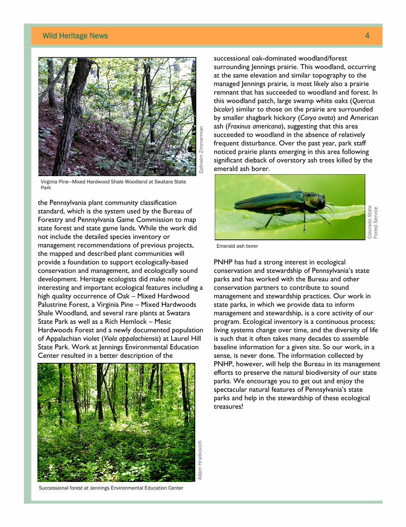
interesting and important ecological features including a
high quality occurrence of Oak – Mixed Hardwood
Palustrine Forest, a Virginia Pine – Mixed Hardwoods
Shale Woodland, and several rare plants at Swatara
State Park as well as a Rich Hemlock – Mesic
Hardwoods Forest and a newly documented population
of Appalachian violet (Viola appalachiensis) at Laurel Hill
State Park. Work at Jennings Environmental Education
Center resulted in a better description of the
successional oak-dominated woodland/forest
surrounding Jennings prairie. This woodland, occurring
at the same elevation and similar topography to the
managed Jennings prairie, is most likely also a prairie
remnant that has succeeded to woodland and forest. In
this woodland patch, large swamp white oaks (Quercus
bicolor) similar to those on the prairie are surrounded
by smaller shagbark hickory (Carya ovata) and American
ash (Fraxinus americana), suggesting that this area
succeeded to woodland in the absence of relatively
frequent disturbance. Over the past year, park staff
noticed prairie plants emerging in this area following
significant dieback of overstory ash trees killed by the
emerald ash borer.
PNHP has had a strong interest in ecological
conservation and stewardship of Pennsylvania’s state
parks and has worked with the Bureau and other
conservation partners to contribute to sound
management and stewardship practices. Our work in
state parks, in which we provide data to inform
management and stewardship, is a core activity of our
program. Ecological inventory is a continuous process;
living systems change over time, and the diversity of life
is such that it often takes many decades to assemble
baseline information for a given site. So our work, in a
sense, is never done. The information collected by
PNHP, however, will help the Bureau in its management
efforts to preserve the natural biodiversity of our state
parks. We encourage you to get out and enjoy the
spectacular natural features of Pennsylvania’s state
parks and help in the stewardship of these ecological
treasures!
Emerald ash borer
Ad
am
Hn
atk
ovic
h
Successional forest at Jennings Environmental Education Center
Ep
hra
im Z
imm
erm
an
Virginia Pine—Mixed Hardwood Shale Woodland at Swatara State
Park
Co
lora
do
Sta
te
Fo
rest
Se
rvic
e

Wild Heritage News 5
Ohiopyle State
Park is truly a gem
in western
Pennsylvania. It is
the most popular
destination for
whitewater
recreation in
North America, it
is a highlight of the
Allegheny Passage
bicycle trail, and it
is one of the most
scenic places in
Pennsylvania. It
also hosts the
most globally rare
plant species of
any site in
Pennsylvania. Six plant species of global conservation
concern (Table 1) and an additional 25 plants of
regional conservation concern have been documented
in the park. Because of the high biodiversity significance,
PNHP has conducted well over one hundred field
surveys at Ohiopyle and in adjacent portions of the
Youghiogheny River Gorge. Whether or not conducted
as part of projects funded by the Bureau of State Parks
(BOSP), these surveys have produced the core data
used to ensure that management at the park is effective
at protecting biodiversity.
Why are there so many rare plants at Ohiopyle? The
distribution of plant species is driven largely by
geography and geology. Chemically, the geology of the
Youghiogheny River Gorge contains nothing unusual for
Pennsylvania, but there is enough variation to provide a
variety of soil types, including some with elevated
alkalinity. This variability is in part responsible for the
presence of habitats suitable for different plant species.
As the river cuts through two mountains it scours the
adjacent boulders and bedrock, creating unusual
habitats that are at the core of what makes the gorge
so interesting. In this part of the Youghiogheny River,
we have two factors driving high plant diversity: a
variety of soil types and unique habitats created by a
high-energy river. But another factor also adds to the
diversity of this area.
Ohiopyle and the Youghiogheny River Gorge—A Botanical Paradise
by
Steve Grund
The falls at Ohiopyle is the most well-known of
the many scenic features at Ohiopyle
PN
HP
These rocks at Railroad Rapids are scraped of soil and
vegetation by raging flood waters which often carry sheets of
ice.
PN
HP
Table 1. Plant Species of Global Conservation Concern at Ohiopyle State Park
Latin Name Common Name Global
Conservation Status Pennsylvania Legal Status
Marshallia grandiflora Barbara's buttons G2 (Imperiled) Endangered
Vitis rupestris Sand grape G3 (Vulnerable) Endangered
Gymnocarpium appalachianum Appalachian oak fern G3 (Vulnerable) Proposed Endangered
Scutellaria saxatilis Rock skullcap G3 (Vulnerable) Proposed Endangered
Carex roanensis Roan mountain sedge G2G3 (Imperiled) Proposed Endangered
Spiraea virginiana Virginia spiraea G2 (Imperiled) Extirpated
Wild Heritage News 6
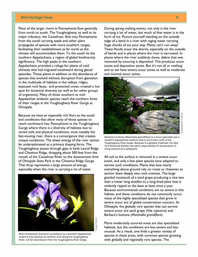
Most of the larger rivers in Pennsylvania flow generally
from north to south. The Youghiogheny, as well as its
major tributary, the Casselman, flow into Pennsylvania
from the south carrying seeds and other plant
propagules of species with more southern ranges,
facilitating their establishment as far north as the
climate will accommodate them. To the south lie the
southern Appalachians, a region of global biodiversity
significance. The high peaks in the southern
Appalachians provided a refuge for plants of cold
climates that had migrated southward during glacial
episodes. Those plants in addition to the abundance of
species that evolved without disruption from glaciation
in the multitude of habitats in the valleys, ridges,
exposed rock faces, and protected coves, created a hot
spot for botanical diversity (as well as for other groups
of organisms). Many of those southern to mid-
Appalachian endemic species reach the northern limits
of their ranges in the Youghiogheny River Gorge at
Ohiopyle.
Because we have an especially rich flora to the south
and conditions that allow many of those species to
reach northward into Pennsylvania in the Youghiogheny
Gorge where there is a diversity of habitats due to
varied soils and physical conditions, most notably the
fast-moving river, there is a convergence that creates
unique conditions. The sheer energy of the river cannot
be underestimated as a primary shaping force. The
Youghiogheny passes through gaps in both Laurel Ridge
and Chestnut Ridge, dropping about 300 feet from the
mouth of the Casselman River to the downstream limit
of Ohiopyle State Park in the Chestnut Ridge Gorge.
That drop represents a large amount of energy,
especially when the river is carrying a lot of water.
During spring melting events, not only is the river
carrying a lot of water, but much of that water is in the
form of ice. Picture yourself standing on the outside
edge of a bend in a river with raging water carrying
huge chunks of ice your way. Plants can’t run away!
These floods scour the shores, especially on the outside
of bends and in places where the river is narrowed. In
places where the river suddenly slows, debris that was
removed by scouring is deposited. This produces scour
zones and deposition zones. But it’s not all or nothing
and so we have severe scour zones as well as moderate
and minimal scour zones.
All soil at the surface is removed in a severe scour
event, and only a few plant species have adapted to
survive such conditions. Plants that lose nearly
everything above ground rely on roots or rhizomes to
anchor them deeply into rock crevices. The large
gnarled rootstock of a sand grape producing a vine less
than a meter long testifies to a long-lived plant that is
violently ripped to the base at least once a year.
Because environmental conditions are so severe in this
habitat, and these conditions do not commonly occur,
many of the highly specialized species that grow in
severe scour are of global conservation concern. At
Ohiopyle, the globally rare species that can survive
severe scour are sand grape (Vitis rupestris) and
Barbara’s buttons (Marshallia grandiflora).
More moderately scoured areas are also specialized
habitats, but the conditions are less severe and less
unusual. As a result, one finds a greater variety of
species in these areas, with common species growing
with globally and regionally rare species. The
Gre
g F
un
ka
Blue monkshood (Aconitum uncinatum) is a southern Appalachian
endemic that reaches its northern limit along the Youghiogheny
River, not far downstream from the Youghiogheny River Gorge.
Ch
risto
ph
er
Tra
ce
y
Barbara’s buttons (Marshallia grandiflora) is a scour specialist and a
southern Appalachian endemic that is not known north of the
Youghiogheny River Gorge. Because it is globally imperiled, the New
York Botanical Garden has taken responsibility for preservation of
living material as a safeguard.

Wild Heritage News 7
History of Conservation at Ohiopyle
Ohiopyle experienced its first wave of tourism in the early
twentieth century. Around the turn of the century, ten or
twelve thousand people filled five hotels during the summer
months. Botanists recognized the area for its botanical
splendor, and it became a favorite destination for botanists
from the Carnegie Museum and the Botanical Society of
Western Pennsylvania. The Torrey Botanical Society of
New York City held its second Botanical Symposium at
Ohiopyle in 1905.
By 1951, all but one of the hotels were gone, and many of
the houses were in a state of decay. Sewage flowed directly
into the river, which was devoid of fish due to acid mine
drainage originating mostly in the Casselman watershed.
The area might have succumbed its natural character to
extractive industries were it not for Lillian McCahan.
Lillian McCahan had grown up near Blackwater Falls in West Virginia, and had witnessed the clear-cutting and
subsequent burning of the virgin timber in that area. She landed a job in Ohiopyle in 1932, and later, reflecting on
that time wrote, “After I had seen Cucumber Falls and walked through Ferncliff I thought, well, someday those far
hills will be cut, but I hope they always keep Ferncliff a park.” McCahan wrote many times to the Western
Pennsylvania Conservancy (WPC), starting in 1948, hoping to get some protection for Ferncliff Peninsula.
WPC approached the state, which deemed Ferncliff too small for a state park. WPC had little resources at the
time, and was mostly working in Pittsburgh. McCahan persisted, and when the situation became critical, WPC
decided to act. Ferncliff Peninsula was up for sale, and there was an offer by a developer who planned on building a
commercial park. Other ideas for the conversion of the peninsula included an amusement park, factories, and
shunting the river at the base of the peninsula and using the drop to generate electricity.
Edgar J. Kaufmann was a businessman from Pittsburgh who owned a
house near Ohiopyle. It was a very nice house called Fallingwater
(perhaps you have heard of it). WPC approached Kaufmann who
quickly agreed to fund the purchase of the 750-acre Ferncliff
Peninsula.
Once Ferncliff was secured, WPC stepped back and looked at the
potential for a much larger project encompassing much of the
Youghiogheny Gorge. Much planning and negotiating culminated in
1971 with the dedication of Ohiopyle State Park, which encompassed
18,719 acres. Additions over the years have expanded the park to
just over 20,000 acres.
Note that while today, Ohiopyle is famous primarily for white-water
recreation opportunities; such activities were essentially unknown
when Ferncliff Peninsula was purchased for conservation in 1951. The
first commercial white-water rafting in eastern North America was at
Ohiopyle, but not until 1963. When Ohiopyle State Park was
envisioned in 1951 it was to protect the unique natural elements of
the Youghiogheny River Gorge, including its remarkable flora.
Youghiogheny River Falls in the mid 1880s, seen from scour habitat
at the mouth of Meadow Run.
The trail to Ohiopyle Falls at Ferncliff
PN
HP

Wild Heritage News 8
combinations of species are sometimes surprising and
include more typical riparian species as well as those
found in more prairie-like habitats given that woody
plants are prevented from gaining dominance. Prairie
grasses and wildflowers, like big bluestem (Andropogon
gerardii), Indian grass (Sorghastrum nutans), and tall
tickseed (Coreopsis tripteris) are common examples. Not
surprisingly, some of the typical species are those
generally encountered along rivers, such as nine-bark
(Physocarpus opulifolius) and cardinal flower (Lobelia
cardinalis). Because soil does not accumulate from year
to year in these habitats, they do not look like wetlands,
but much of the scoured habitat is wet much of the
year, and many of the characteristic plants are species
commonly encountered in mucky wetlands, such as
royal fern (Osmunda regalis), yellow star-grass (Hypoxis
hirsuta), and boneset (Eupatorium perfoliatum). Flooding
during scour events brings water levels far above
normal, submerging rocks that are as dry as any desert
most of the year. Here we find plants of dry rocky or
sandy habitats like stiff-leaved aster (Ionactis linariifolius)
and dwarf dandelion (Krigia biflora).
As noted earlier, Ohiopyle boasts six globally rare
plants and another 25 plants of regional conservation
significance. There are other biological rarities in the
park as well: one mammal of global concern (Allegheny
woodrat), and one of regional concern. Also of regional
concern are two herptiles, four insects, and one plant
community. Ohiopyle is clearly very important for
biodiversity conservation. When partnering with
organizations that work nationally and globally, PNHP
has made the case for recognition of the Youghiogheny
River Gorge in large-scale conservation planning and
has partnered extensively with Ohiopyle State Park staff
to protect the biological resources of the park. In
addition to the many field surveys to document and
monitor rare plant and animal populations, PNHP has
engaged in a number of important projects at Ohiopyle,
including participating in the development of resource
management plans, mapping the natural communities,
and providing advice on minimizing impacts when
updating park infrastructure. We work directly with
park personnel to utilize the data we collect to help
ensure the continued health of the plants, animals, and
natural communities that make Ohiopyle such a special
place.
Ste
ve
Gru
nd
Royal fern (Osmunda regalis var. spectabilis) just after a flood.
Although the fronds are broken at the base, new leaves will restore
the plant within a few weeks. The dense mass of fibrous roots and
stems is very effective at anchoring the plants to the rocks during
scour events.
Stiff-leaved aster (Ionactis linariifolius)
Gre
g F
un
ka

Wild Heritage News 9
New Confirmation of Allegheny Woodrat
With its large ears, white undersides, and robust
appearance, the Allegheny woodrat (Neotoma magister)
is more reminiscent of a woodland creature found in a
Disney movie than the images that one conjures when
the word ‘rat’ is muttered. It is an inhabitant of rocky
features and unlike the introduced Norway rat (Rattus
norvegicus) which thrives in developed areas, the
Allegheny woodrat is an obligate of forested habitats
rich in native food sources. They are nocturnal and
spend their nights gathering food which is transported
to caches where it can be dried and stored for a later
meal. These caches can contain vegetation from a
plethora of different plant species as well as soft and
hard mast, fungus, mosses, and lichens. They also tend
to defecate repeatedly in the same place which is
referred to as a latrine. Fresh scat in a latrine or fresh
vegetation in a food cache is a telltale sign of recent
woodrat activity. Unfortunately, the Allegheny woodrat
has either been extirpated or is in decline throughout
its range in the eastern United States due to several
factors which include parasites, habitat fragmentation,
and loss of food sources. It is considered a threatened
species within Pennsylvania.
In 2015 a cooperative agreement was formed between
the Pennsylvania Game Commission (PGC) and
Heritage staff at the Western Pennsylvania Conservancy
(WPC) to conduct mammal surveys as a pilot effort
within the Central Mountains Region of Pennsylvania in
support of the PGC’s Pennsylvania Mammal Atlas. As
part of this effort, Heritage zoologists conducted 45
visual surveys
at potential
and historic
woodrat
sites, and
maintained
baited trail
cameras at
four historic
sites. These
surveys
spanned
three of
PGC’s
Woodrat
Conservation
Management
Areas
(CMA): 1)
Allegheny
Front West
CMA (two
surveys), 2) Blacklog Mountain CMA (seven surveys),
and 3) Central Mountains CMA (36 surveys). Despite
our intense survey effort, we were only able to detect
the active presence of woodrats at a single site that was
within the Allegheny Front West CMA.
While we were only able to confirm the presence of
woodrats at a single location, the find was significant as
it was a previously unknown site and was located over
two miles away from the nearest known active site.
This was also a fortunate find for the zoologists present
during the survey because while most sites are
confirmed active by the fresh sign found in latrines or
food caches, we were able to observe a wood rat
function within its natural surroundings. Surprisingly,
this individual was receptive to our presence allowing
us to get close enough to photograph and observe it
going about its daily routine. For approximately 30
minutes, we watched the woodrat move about,
consume food within its food cache, and groom. As we
continue our work in this region, we are also
conducting surveys in the Southcentral Region of the
state as part of the Bedford County Natural Heritage
Inventory.
Notes from the Field
Allegheny woodrat within one of its food caches. Notice the freshly
placed vegetation.
Ch
arl
ie E
ich
elb
erg
er
Rocky outcrops with many shelves and deep
crevices provide excellent habitat for the Allegheny
woodrat
Joe
Wis
go

Wild Heritage News 10
Bedford County Zoology Fieldwork
Heritage zoologists discovered a new population of
upland chorus frog (Pseudacris feriarum) in the Town
Creek watershed in southern Bedford County. Although
fairly common in the southern Mid-Atlantic States, the
southern Pennsylvania border is the northern fringe of
the range for this species in North America. The frogs
prefer a wet meadow habitat that has not been
impacted by agriculture. These frogs are small (3 cm)
and difficult to observe, but are easily identified by their
call which has been likened to the sound of a finger
running down the teeth of a comb. This is the second
record for this species in Bedford County and the
fourth record for all of Pennsylvania. Survey effort for
this species in the spring covered much of the Bedford
County/Maryland Border.
We also surveyed for vernal pools in April and May,
visiting over 60 potential pools that were delineated
from aerial imagery and LIDAR topographical GIS
data. Many of the pools were noted to have lower than
average water levels for this time of year. The early
warm and dry weather this past spring likely had an
effect on the viability of the pools’ obligate species
(spotted, marbled, and Jefferson salamanders, wood
frogs, and fairy shrimp). Some of the pools visited had
dried significantly and we observed dead wood frog
tadpoles. On a normal year, the pools remain wet until
the frog and salamander larvae (tadpoles) can
metamorphose. Vernal pools typically dry up by late
spring (June), and it usually takes around 50 days for
wood frogs to hatch and grow into adults that can leave
the pool. Some of the pools that were visited contained
multiple obligate species and were of fairly high quality.
East Meets West: 10 Years Later
For more than 20 years, the Pennsylvania Natural
Heritage Program (PNHP) had a bit of an identity
problem. First of all, we were often known as the
Pennsylvania Natural Diversity Inventory (PNDI) which
is and has always been the database and database
information function of the program. However, we did
not adopt and rebrand the program as PNHP until later.
Also, at that time, PNHP was a three partner program
between The Nature Conservancy (TNC), Western
Pennsylvania Conservancy, and Department of
Conservation and Natural Resources and staff identified
as being PNDI-E, PNDI-W, or PNDI-Central. Other
states and even agencies and constituents within the
state were justifiably confused.
Even though we made some progress in describing and
promoting ourselves as the Pennsylvania Natural
Heritage Program, it wasn’t until late 2005 that we
undertook a full scale strategic planning effort. At that
point, TNC decided to leave the program and the
partnership as they had done in nearly all states where
they had begun Natural Heritage Programs. Our then
close cooperators, the Pennsylvania Game Commission
(PGC) and the Pennsylvania Fish and Boat Commission
(PFBC), were positioned to become full partners and
WPC agreed to employ all the TNC staff. On July 1,
2006, all TNC staff became WPC staff, the program had
four partners, and a plan was in place for the next five
years.
Ten years later, we continue with the same partnership
and strive to do all the things that we set out to do in
our strategic plan. We’ve accomplished much including
the completion of all initial County Natural Heritage
Inventories and updates for numerous counties, the
Natural Heritage Program Partnership staff circa 2005
Kin
gs G
ap
En
vir
on
me
nta
l E
du
ca
tio
n C
en
ter
Upland chorus frog (Pseudacris feriarum)
Jack
Ra
y
Wild Heritage News 11
publication of the Aquatic Community Classification and
User Guide, the development of a classification of
floodplains for the Susquehanna, Ohio, and Delaware
watersheds, an update to the state-wide community
classification we first published in 1991, the creation of
a vernal pools registry, the expansion of our taxonomic
expertise, the hosting and administration of the Rare
Plant Forum, the development of a brand new online
planning and environmental review tool (Pennsylvania
Conservation Explorer - PACE), and the addition of
over 8,300 new rare plant and animal records to the
PNDI database. But maybe the most important thing
that we’ve done is learn to work together more
effectively as a partnership and make it clear, finally, that
PNHP is one program.
Science Camp for High School Students
In June, Heritage biologists partnered with staff at
Jennings Environmental Education Center (JEEC) to
host the second edition of EYE Con (Experiencing Your
Environment through Conservation); a summer science
camp for high school students. Staff at JEEC presented
students with management challenges that are specific
to the park. Students worked closely with Heritage
biologists to design experiments that focused on forest
change, the theme for this year’s program that was
relevant to JEEC’s management challenges.
For 2016, we expanded the camp to include a fourth
day, providing extra time for recreation. Students went
kayaking at Moraine State Park, participated in an
orienteering experience, and took part in a number of
other team-building activities. Another new addition to
this year’s camp was a question and answer session
with biologists from academia and private industry.
Students met with Dr. Nicole Dafoe, a biology faculty
member from Slippery Rock University, and Chris Fry, a
consulting
biologist from
Beran
Environmental
Services, and
discussed
academic and
career
opportunities in
the natural
sciences.
Projects that
were designed
and implemented
through EYE Con
provided
students with an
opportunity for
experiential
learning in field-science, and data from student projects
are invaluable. Working in groups, students focused on
two large projects. One group assessed the viability of
habitat for the queen snake (Regina septemvittata) in a
successional meadow community that was once
forested, but has been recently impacted by beaver.
The other group examined the suitability of three
different forest communities for prairie expansion.
Because JEEC manages habitat for the eastern
massasauga rattlesnake, students compared forested
communities to existing managed prairie habitat in
order to recommend specific park areas that could be
converted to prairie. Student performance was
exemplary. EYE Con will return to Jennings
Environmental Education Center in June 2017, with a
new group of students and a new theme to promote
conservation in our state park system.
Students surveyed the crayfish population,
which is the primary food source for queen
snakes.
JoA
nn
Alb
ert
Students utilize a transect to survey a successional forest community.
Ad
am
Hn
atk
ovic
h
2016 EYE Con students and staff
Wil T
ayl
or

Wild Heritage News 12
Peatland Birds
In the winter 2015-16 edition of Wild Heritage News,
we described the details of a multi-year project focused
on assessing peatland wetlands. This spring and summer
we began one component of this study by conducting
bird community surveys across peatlands at both long-
term monitoring sites and validation sites. Drawing
upon the strength of the PNHP partnership, we
collaborated with Doug Gross, Endangered and Non-
game Bird Section Supervisor at the Pennsylvania Game
Commission, who has long-studied and monitored
Pennsylvania Endangered yellow-bellied flycatchers
(Empidonax flaviventris) and blackpoll warblers
(Setophaga striata), as well as other birds specializing in
boreal habitats. This statewide effort represents the
first systematic survey focused on peatland bird
communities, which are often difficult systems to access
and navigate through.
Together, we implemented off-road point count surveys
and rapid plant community assessments across 30
peatland sites during this first year of the project. In
total we visited 195 point locations, sampling a range of
wetland community types from graminoid dominated
Bluejoint – Reed Canary-grass Marsh to ericaceous
shrub-dominated Leatherleaf – Bog-rosemary Bog to
closed canopy conifer-dominated Red Spruce Palustrine
Forest. Our survey results will enable us to characterize
breeding bird assemblages in these peatland
communities and quantify densities for a number of
conservation priority species, like Nashville warbler
(Leiothlypis ruficapilla) and Canada warbler (Cardellina
canadensis). This information will enable better
monitoring of potential climate change impacts to these
species and habitats and will make for more informed
management decisions concerning these rare
ecosystems.
With the potential to find a high diversity of breeding
bird species of special concern that occur in peatland
communities, the value of this collaborative project has
already been borne out through the highlights from our
first season. Through our peatland bird surveys, we
detected 13 bird species of special concern, in addition
to 15 other focal species as well as many additional
forest interior birds. Among the birds of special
concern we observed were golden-winged warbler
(Vermivora chrysoptera), red-headed woodpecker
(Melanerpes erythrocephalus), sora (Porzana carolina),
American bittern (Botaurus lentiginosus), eastern whip-
poor-will (Caprimulgus vociferous), common nighthawk
(Chordeiles minor), osprey (Pandion haliaetus), northern
goshawk (Accipiter gentilis) – with a nest found near a
recent occurrence , and northern waterthrush (Parkesia
noveboracensis), which was found at 15 sites.
Several focal bird species of concern which specialize in
boreal peatland habitats were also detected. Blackpoll
warbler was observed at three sites, including one new
location. Yellow-bellied flycatchers were found at two
Pitch Pine—Leatherleaf Palustrine Woodland
Da
vid
Ye
an
y
Red-headed woodpecker (Melanerpes erythrocephalus)
Fro
de
Ja
ca
ob
se
n
Northern waterthrush (Parkesia noveboracensis)
Da
vid
Ye
an
y
Wild Heritage News 13
sites. Although they were absent from three known
locations included in the project, multiple singing males
were detected at one other regular site and the
flycatcher was detected at one new location. Likely the
surprise of the summer was the discovery of an olive-
sided flycatcher (Contopus cooperi) giving its advertising
song “quick, three-beers!” on June 21 in a Pitch Pine-
Leatherleaf Palustrine Woodland (listen to its song
here: https://drive.google.com/open?
id=0BwDSYGXqd_YXWkJzNFFMQ2xGUFE). Olive-sided
flycatchers have not been confirmed breeding in
Pennsylvania since the 1930s and there have been few
breeding season encounters indicating a breeding
behavior code of “Possible” or “Probable” since the
first Breeding Bird Atlas was initiated in 1983. While
follow-up visits to the olive-sided flycatcher site did not
confirm additional breeding activity, it was still a
significant finding that, together with our other early
results, further demonstrates the importance of our
Pennsylvania peatlands and the need for continued
monitoring of these boreal habitats.
iMapInvasives Website
Staff from the Pennsylvania Natural Heritage Program
(PNHP) currently participate in a program which tracks
invasive species locations and population distributions.
This program is made to benefit citizen scientists and
natural resource professionals working to protect our
native species and habitats from the threat of exotic
invasive species. This program, known to many in
Pennsylvania, is called iMapInvasives and consists of an
overarching network of ten participating states and
provinces that all see the need to track and record
invasive species locations as well as related control and
eradication efforts.
This spring, the iMapInvasives network received greater
online recognition when a new website was launched
which benefits administrators and users alike. Available
at www.iMapInvasives.org, the new website highlights
various aspects of the benefits of using iMapInvasives as
well as resources and success stories from members of
the network. Some highlights from the website are
listed below:
Why iMapInvasives? – This portion of the website
explains the tools and functionality available through
iMapInvasives, providing aid to new and existing
users who wish to understand how to capture and
share their invasive species findings.
Broad Network – Pennsylvania is just one of ten
participating programs (nine states and one
Canadian province) currently in the iMapInvasives
network. Each of these programs has at least one
person who acts as the administrator of their
unique iMapInvasives database and has the goal of
building and maintaining the invasive species data
received for their state/province. View the full
listing of network administrators on the
iMapInvasives Network page.
Success stories – With a multitude of registered
users actively using iMapInvasives, there are always
interesting stories to tell about how iMapIvasives is
being used. These stories are highlighted on a page
called “iMapInvasives in Action!”
Community Toolbox – This portion of the website
features a sampling of resources which helps
registered users and the general public alike better
understand how iMapInvasives is being used to
connect citizen scientists, researchers, and land
managers for the collaborative purpose of tracking
and managing invasive species.
To see more of the new iMapInvasives network website
for yourself, go check it out by visiting
www.iMapInvasives.org!

Wild Heritage News 14
Measures of Progress
PNHP is a partnership of the Pennsylvania Department of Conservation and Natural Resources, the Western
Pennsylvania Conservancy, the Pennsylvania Game Commission, and the Pennsylvania Fish and Boat Commission.
PNHP performs many functions and provides many services as part of its mission. The measures of progress that are detailed here are meant
to capture a number of important program activities and provide a picture of our progress in achieving our essential goals. The program
goals and the measures provided for those goals will change over time as we complete certain aspects of our work and as new program
responsibilities arise.
Biotics Records Updated indicates the amount of activity expended in improving and updating the more than 20,000
records in the PNDI database.
New EOs Documented is a way to measure the success of our inventory effort in finding new occurrences of elements of
ecological concern (plants, animals, and exemplary natural communities). Biotics records are created for each new Element
Occurrence documented.
New Records Entered into PACE indicates our level of activity in reviewing, quality controlling, and entering biotics
records into the environmental review data layers. The timely and consistent refreshment of these data are critical to
providing protection to the state’s species of greatest concern.
Field Surveys Reported is a strong indicator of the effort expended on one of the basic functions of the program –
inventory of the state’s flora and fauna. Every field visit results in the entering of a field survey, regardless of the outcome of
the survey.
New Conservation Planning Polygons (CPPs) Developed is a measure of our progress in creating ecological based
mapping for the species and natural communities that we track as part of the PNDI database. Our goal is to have CPPs for all
species and communities that we track.
NHAs Updated is a measure of our effort in developing, mapping, and describing sites (Natural Heritage Areas - NHAs) that
are important to conservation of Pennsylvania’s biodiversity. This process began with County Natural Heritage Inventory
projects and will now continue at a statewide level with the updating of existing sites and the creation of new sites. Site
polygons will be based upon and consistent with CPPs.
Sites Actively Monitored indicates how many established geo-referenced plots that we visited and sampled. These sites
allow us to collect data on structure, species composition, and physical context (soils, hydrology, etc.) in a systematic way and
by following the same protocols to directly compare future data to previous data.
The following Measures of Progress represent a significant cross-section of results of the work that we do as a program. These measures will
be reviewed and updated, as needed, to best reflect the activities and goals of PNHP. Progress for these measures reflects seasonality of
program activity.
Measure of Progress Annual Goal
(2016)
1st
Quarter
Cumulative
Total
Percent of
Annual Goal
2nd
Quarter
Biotics Records Updated 300 66 150 50% 84
New EOs Documented 800 189 596 75% 407
New Records Entered into PACE 350 0 0 0% 0
Field Surveys Reported 300 159 208 69% 49
New CPPs Developed 400 0 0 0% 0
NHAs Updated 150 15 15 10% 0
Sites Actively Monitored 35 0 0 80% 28