PEMBROKESHIRE GREEN CLIMBING GUIDE Access and...
18
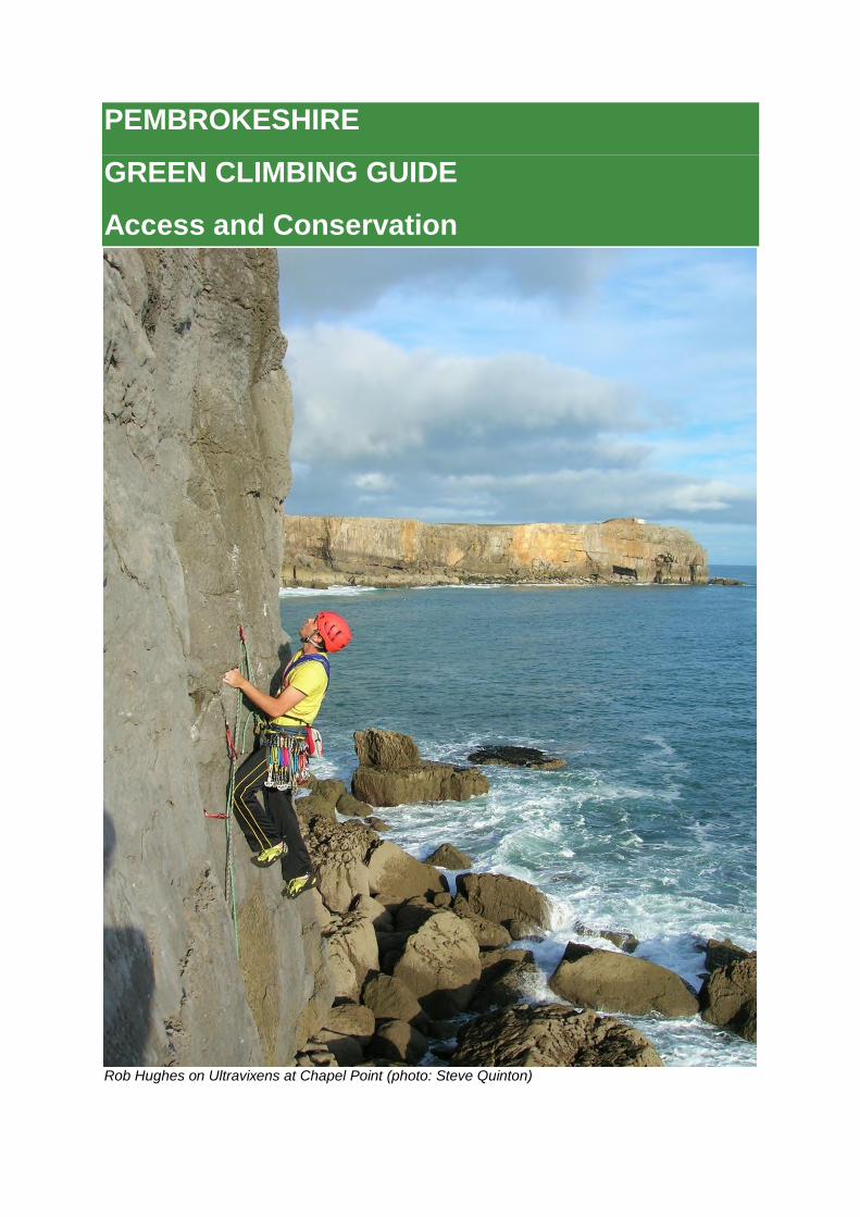
PEMBROKESHIRE GREEN CLIMBING GUIDE Access and Conservation Rob Hughes on Ultravixens at Chapel Point (photo: Steve Quinton)
Transcript of PEMBROKESHIRE GREEN CLIMBING GUIDE Access and...
PEMBROKESHIRE
GREEN CLIMBING GUIDE
Access and Conservation
Rob Hughes on Ultravixens at Chapel Point (photo: Steve Quinton)
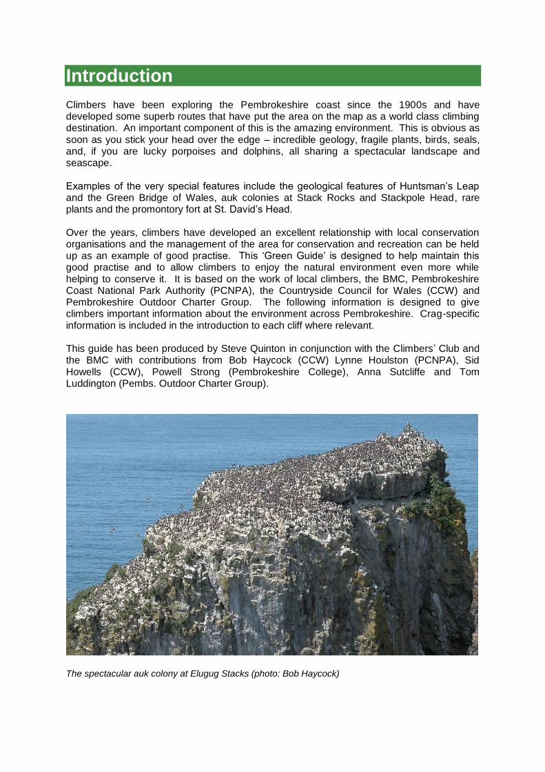
Introduction Climbers have been exploring the Pembrokeshire coast since the 1900s and have developed some superb routes that have put the area on the map as a world class climbing destination. An important component of this is the amazing environment. This is obvious as soon as you stick your head over the edge – incredible geology, fragile plants, birds, seals, and, if you are lucky porpoises and dolphins, all sharing a spectacular landscape and seascape. Examples of the very special features include the geological features of Huntsman‟s Leap and the Green Bridge of Wales, auk colonies at Stack Rocks and Stackpole Head, rare plants and the promontory fort at St. David‟s Head. Over the years, climbers have developed an excellent relationship with local conservation organisations and the management of the area for conservation and recreation can be held up as an example of good practise. This „Green Guide‟ is designed to help maintain this good practise and to allow climbers to enjoy the natural environment even more while helping to conserve it. It is based on the work of local climbers, the BMC, Pembrokeshire Coast National Park Authority (PCNPA), the Countryside Council for Wales (CCW) and Pembrokeshire Outdoor Charter Group. The following information is designed to give climbers important information about the environment across Pembrokeshire. Crag-specific information is included in the introduction to each cliff where relevant. This guide has been produced by Steve Quinton in conjunction with the Climbers‟ Club and the BMC with contributions from Bob Haycock (CCW) Lynne Houlston (PCNPA), Sid Howells (CCW), Powell Strong (Pembrokeshire College), Anna Sutcliffe and Tom Luddington (Pembs. Outdoor Charter Group).
The spectacular auk colony at Elugug Stacks (photo: Bob Haycock)
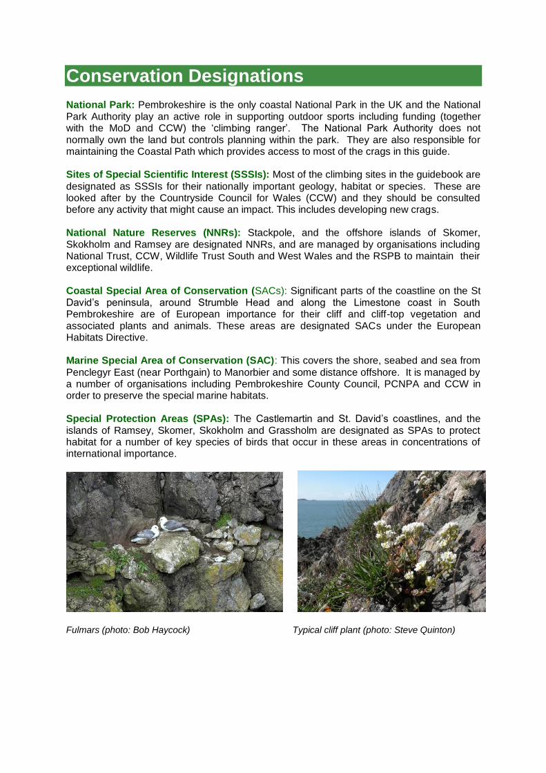
Conservation Designations National Park: Pembrokeshire is the only coastal National Park in the UK and the National Park Authority play an active role in supporting outdoor sports including funding (together with the MoD and CCW) the „climbing ranger‟. The National Park Authority does not normally own the land but controls planning within the park. They are also responsible for maintaining the Coastal Path which provides access to most of the crags in this guide. Sites of Special Scientific Interest (SSSIs): Most of the climbing sites in the guidebook are
designated as SSSIs for their nationally important geology, habitat or species. These are looked after by the Countryside Council for Wales (CCW) and they should be consulted before any activity that might cause an impact. This includes developing new crags. National Nature Reserves (NNRs): Stackpole, and the offshore islands of Skomer, Skokholm and Ramsey are designated NNRs, and are managed by organisations including National Trust, CCW, Wildlife Trust South and West Wales and the RSPB to maintain their exceptional wildlife. Coastal Special Area of Conservation (SACs): Significant parts of the coastline on the St David‟s peninsula, around Strumble Head and along the Limestone coast in South Pembrokeshire are of European importance for their cliff and cliff-top vegetation and associated plants and animals. These areas are designated SACs under the European Habitats Directive. Marine Special Area of Conservation (SAC): This covers the shore, seabed and sea from
Penclegyr East (near Porthgain) to Manorbier and some distance offshore. It is managed by a number of organisations including Pembrokeshire County Council, PCNPA and CCW in order to preserve the special marine habitats. Special Protection Areas (SPAs): The Castlemartin and St. David‟s coastlines, and the islands of Ramsey, Skomer, Skokholm and Grassholm are designated as SPAs to protect habitat for a number of key species of birds that occur in these areas in concentrations of international importance.
Fulmars (photo: Bob Haycock) Typical cliff plant (photo: Steve Quinton)
Land Owners The crags we climb on are generally owned by one of three types of land owners: The Ministry of Defence (MoD): Castlemartin, Manorbier and Penally ranges are all a part
of the Defence Training Estate. These are nationally important sites for preparing the armed forces for operations overseas. Castlemartin, in particular provides a unique area for artillery training that is becoming increasingly important in view of current conflicts and withdrawal of army training bases in Germany. MoD ownership leads to some slightly complex access arrangements – see below. National Trust (NT): Many of the crags in North Pembrokeshire and some in south Pembrokeshire. (including Carreg-y-Barcud, Porthclais, St. David‟s Head, Stackpole and Mother Carey‟s Kitchen) are on National Trust land. These are managed to preserve the landscape, heritage, habitat and recreational value. Private landowners: A few crags are on privately owned land. These include Craig Llong
near Trevine, Penmorfa and Becks Bay. A legal right of access is provided to these crags by the coastal path and the Countryside and Rights of Way (CROW) Act.
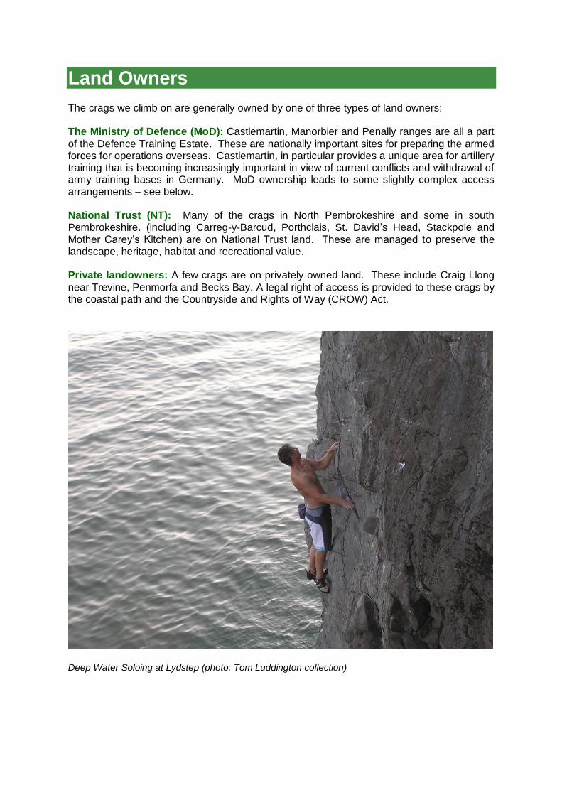
Deep Water Soloing at Lydstep (photo: Tom Luddington collection)
Access to MOD land in South Pembrokeshire St. Govans and Trevallen
This area is open every weekend and most weekdays and evenings. If closed for live-firing red flags are flying and the road from Bosherston to St. Govan‟s is closed. Range East (Chapel Point to Stack Rocks/Green Bridge area)
This area is usually closed on weekdays but open every weekend and most evenings. If the red flag is flying at St. Govan‟s gate, or Stack Rocks road, the range is closed. If the range is going to be used for night firing, there will be notices on the gate giving details of times. Range West (Perimeter Bays to Freshwater West) This area is very heavily used for live firing training and the ground is littered with ordnance debris some of which is very dangerous. Public access is therefore very limited. Climbers wishing to climb in the range must attend a briefing each year (currently May, June and July at Castlemartin Camp) and be issued with a photo ID pass. This must be carried at all times inside the range and climbers are only allowed on the coastal track and the area to seaward of this in order to access the climbs. The range is open to climbers when the range is not being used for firing (usually weekends, bank holidays and evenings).
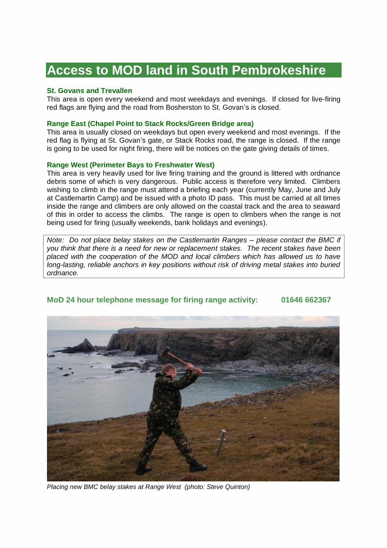
Note: Do not place belay stakes on the Castlemartin Ranges – please contact the BMC if you think that there is a need for new or replacement stakes. The recent stakes have been placed with the cooperation of the MOD and local climbers which has allowed us to have long-lasting, reliable anchors in key positions without risk of driving metal stakes into buried ordnance.
MoD 24 hour telephone message for firing range activity: 01646 662367
Placing new BMC belay stakes at Range West (photo: Steve Quinton)

Birds Pembrokeshire is an important breeding area for many species of cliff-nesting birds, some of which travel thousands of kilometres to use the ledges and deep cracks for nest sites during the spring nesting season. Other species such as the chough stay around the Pembrokeshire coast all year round. Choughs and Peregrines are protected as „Schedule 1‟ species under the Wildlife and Countryside Act (1981) which means that disturbance during the nesting season can result in a £5,000 fine and up to 6 months imprisonment. Climbers and conservation bodies agree on a system of climbing restrictions annually in order to minimise disturbance to nesting sites and these are published in the form of a leaflet available at the main car parks in south Pembrokeshire, from the National Park Authority office, Tourist Information Centres (TICs) and on the National Park Website (see below). In south Pembrokeshire, the locations of restricted climbing areas are also shown by red „flowerpot‟ markers above the cliffs. Individual crag entries in the guidebook will show where seasonal restrictions are likely but it is the climber‟s responsibility to check for up to date information before climbing. If your route climbs past an obvious bird nest in the nesting season, you should find another climb.
‘Flowerpot’ marker (photo: Steve Quinton) Chough (photo: Bob Haycock)
Chough
Rare in the UK with less than 500 breeding pairs, the chough is a member of the crow family. They have glossy black feathers, bright red legs and a red decurved beak and are very acrobatic when flying. They nest in rock crevices and rely on short cropped grassland where they dig for small insects for food. Look out for holes where choughs have been poking their beaks into the soil. Significant concentrations occur along the Castlemartin Coast and the Ramsey and St David‟s areas – which are designated SPA for them
Ravens
A member of the crow family, this large jet-black bird has a blue gloss to its feathers. Its
powerful bill allows it a varied diet including fruits, seeds, small invertebrates, carrion and
scraps. They can be seen near woodland, over mountains and also along rocky coasts and
they build a huge nest of twigs in which to lay their eggs. They nest on the coast, usually
under sheltered overhangs or in gullies at low density. There are about 70 pairs breeding on
the Pembrokeshire coast and offshore islands.

Raven in flight (photo: Bob Haycock) Peregrine Falcon (photo: Annie Haycock)
Peregrine Falcon
The fastest bird in the world, the peregrine predominantly feeds on other birds which it
swoops on with an incredible power dive. They have a slate grey back, white barred
underside and they nest on ledges on steep cliffs. Peregrine numbers have slowly increased
since the 1960s when their population crashed due to organo-chloride pesticides and
persecution, but they still only breed on the coast in favoured areas at very low density.
Kestrel
This small, long-tailed falcon often seen hovering in the air in search of prey on the ground,
is chiefly found near the coast where they nest in cliff-crevices. Kestrels breeding in
Pembrokeshire have declined, over the last 20 years or so. Being a local Biodiversity Action
Plan (BAP) species they are the subject of local studies and actions to try and reverse this
decline.
Guillemots and Razorbills
Very sociable members of the Auk family, these birds often sit in compact groups on cliff
ledges. They live out at sea in-between breeding seasons and feed on fish and crustaceans.
Thousands of these birds can be seen on Stack Rocks on Castlemartin Range, South
Pembrokeshire between April and July. Guillemots balance their eggs on their feet and pass
them from male to female – this obviously increases vulnerability to disturbance.
Guillemots (left) and Fulmars (right) (photos: Bob Haycock)
Puffins
This small burrowing member of the Auk family, with its comical triangular-shaped multi-
coloured beak and bright orange legs is mainly associated with the offshore seabird islands.
But a small number regularly visit the Limestone coast on the Castlemartin peninsula –
notably Stackpole Head, where they nest in natural cliff-crevices alongside Razorbills.
Kittiwakes
Kittiwakes spend winter at sea but nest on narrow cliff ledges. They are a member of the
Gull family and they eat small fish, invertebrates and crustaceans. Their loud call sounds like
their name and they have a pure white body, grey wings with jet black wing-tips and black
legs. A once numerous breeding bird along the limestone coast, now declining because it
seems they cannot find sufficient food to feed their young. At present they are still fairly
common on the offshore islands.
Fulmars
A gull-like bird with grey upperparts and a white head – really a close relative of the
albatrosses, of the southern oceans. They nest on steep cliffs and feed on dead fish, jellyfish
and the corpses of sea mammals (which might explain the foul-smelling oil they tend to spit
at intruders through the tubes on top of their bills).
Oystercatchers A conspicuous wader with black and white plumage, a long orange-red bill and reddish-pink legs. They nest on the ground, so prefer undisturbed shores including cliff-ledges along the exposed coast during breeding time but can be seen on beaches and estuaries during the winter. They feed on mussels, crustaceans and snails.
Cormorants A slender, black coloured bird with a white face patch and a large hooked bill. They plunge under the water to catch their fish; generally in shallower waters, estuaries and lakes. They are often seen with their wings hanging out to dry and they nest in colonies on a small number of steep cliffs and rocky islands.
Swifts, House Martins and Swallows
These birds can be seen throughout the summer months catching flies over grassland and
water or gliding along cliff edges. Swallows and Housemartins collect water and mud with
which to create their circular shaped nests although Housemartins, like Swifts, can nest in
cliff crevices. Swifts and possibly house martins too are declining nationally, but here in
Pembrokeshire they have very important nesting habitat in the sea-cliffs – especially along
the Castlemartin peninsula.
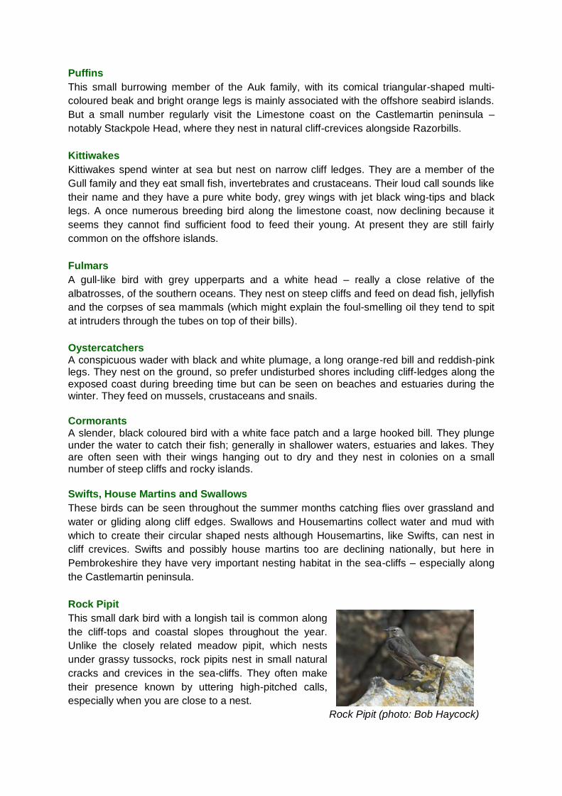
Rock Pipit
This small dark bird with a longish tail is common along
the cliff-tops and coastal slopes throughout the year.
Unlike the closely related meadow pipit, which nests
under grassy tussocks, rock pipits nest in small natural
cracks and crevices in the sea-cliffs. They often make
their presence known by uttering high-pitched calls,
especially when you are close to a nest.
Rock Pipit (photo: Bob Haycock)
Plants
Sea lavender (Limonium binervosum)
Parts of the Pembrokeshire coast are especially
important for rock-sea lavenders, whose pinkish-
lavender coloured flowers can be seen along
exposed sea coasts and cliffs in late summer (July to
September).
Sea Lavender (photo: Lynne Houlston/PCNPA)
Thrift (Armeria maritime)
The „Flower of Pembrokeshire‟; thrift forms dense
cushions of narrow fleshy leaves along the sea-
cliffs. The flower heads are globular in shape and
pink in colour and they flower between April and
July.
Thrift (photo: Steve Quinton)
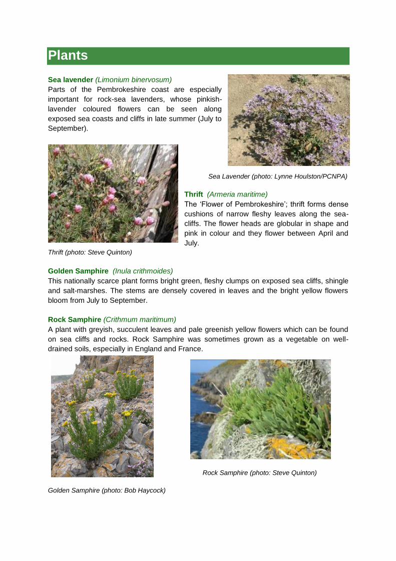
Golden Samphire (Inula crithmoides)
This nationally scarce plant forms bright green, fleshy clumps on exposed sea cliffs, shingle
and salt-marshes. The stems are densely covered in leaves and the bright yellow flowers
bloom from July to September.
Rock Samphire (Crithmum maritimum)
A plant with greyish, succulent leaves and pale greenish yellow flowers which can be found
on sea cliffs and rocks. Rock Samphire was sometimes grown as a vegetable on well-
drained soils, especially in England and France.
Rock Samphire (photo: Steve Quinton)
Golden Samphire (photo: Bob Haycock)
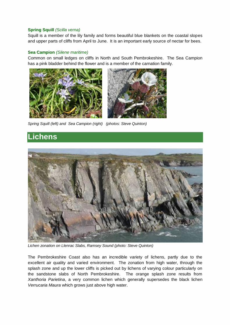
Spring Squill (Scilla verna)
Squill is a member of the lily family and forms beautiful blue blankets on the coastal slopes
and upper parts of cliffs from April to June. It is an important early source of nectar for bees.
Sea Campion (Silene maritime)
Common on small ledges on cliffs in North and South Pembrokeshire. The Sea Campion
has a pink bladder behind the flower and is a member of the carnation family.
Spring Squill (left) and Sea Campion (right) (photos: Steve Quinton)
Lichens
Lichen zonation on Llenrac Slabs, Ramsey Sound (photo: Steve Quinton)
The Pembrokeshire Coast also has an incredible variety of lichens, partly due to the
excellent air quality and varied environment. The zonation from high water, through the
splash zone and up the lower cliffs is picked out by lichens of varying colour particularly on
the sandstone slabs of North Pembrokeshire. The orange splash zone results from
Xanthoria Parietina, a very common lichen which generally supersedes the black lichen
Verrucaria Maura which grows just above high water.
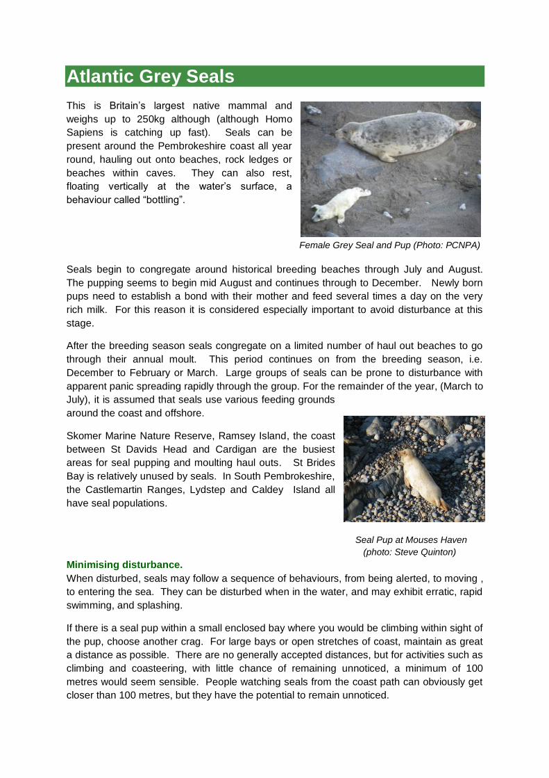
Atlantic Grey Seals This is Britain‟s largest native mammal and
weighs up to 250kg although (although Homo
Sapiens is catching up fast). Seals can be
present around the Pembrokeshire coast all year
round, hauling out onto beaches, rock ledges or
beaches within caves. They can also rest,
floating vertically at the water‟s surface, a
behaviour called “bottling”.
Female Grey Seal and Pup (Photo: PCNPA)
Seals begin to congregate around historical breeding beaches through July and August.
The pupping seems to begin mid August and continues through to December. Newly born
pups need to establish a bond with their mother and feed several times a day on the very
rich milk. For this reason it is considered especially important to avoid disturbance at this
stage.
After the breeding season seals congregate on a limited number of haul out beaches to go
through their annual moult. This period continues on from the breeding season, i.e.
December to February or March. Large groups of seals can be prone to disturbance with
apparent panic spreading rapidly through the group. For the remainder of the year, (March to
July), it is assumed that seals use various feeding grounds
around the coast and offshore.
Skomer Marine Nature Reserve, Ramsey Island, the coast
between St Davids Head and Cardigan are the busiest
areas for seal pupping and moulting haul outs. St Brides
Bay is relatively unused by seals. In South Pembrokeshire,
the Castlemartin Ranges, Lydstep and Caldey Island all
have seal populations.
Seal Pup at Mouses Haven
(photo: Steve Quinton)
Minimising disturbance.
When disturbed, seals may follow a sequence of behaviours, from being alerted, to moving ,
to entering the sea. They can be disturbed when in the water, and may exhibit erratic, rapid
swimming, and splashing.
If there is a seal pup within a small enclosed bay where you would be climbing within sight of
the pup, choose another crag. For large bays or open stretches of coast, maintain as great
a distance as possible. There are no generally accepted distances, but for activities such as
climbing and coasteering, with little chance of remaining unnoticed, a minimum of 100
metres would seem sensible. People watching seals from the coast path can obviously get
closer than 100 metres, but they have the potential to remain unnoticed.

Geology Notes
The Pembrokeshire coastline displays an extraordinary variety of rock types and landforms
and it was this „geo-diversity‟ (together with biodiversity and aesthetic value) that led to the
designation of a National Park. The area has attracted the attention of geologists since the
beginnings of science and is considered so significant for research that about 90% of the
coastline includes geological features that are protected by SSSI status. This includes the
St. Davids Peninsula and the Castlemartin cliffs.
The rocks of Pembrokeshire can be split into two geological areas, approximately split by a
line from Newgale beach in the west, through Haverfordwest to Tavernspite in the east.
North of this are older rocks of late Pre-Cambrian to Ordovician age (approx. 440-650M yrs
old) while the southern area consists mainly of younger Silurian to Carboniferous rocks (290-
440M yrs old).
North Pembrokeshire
The oldest (Pre-Cambrian) rocks are found west of Porthclais, at Dinas Fach (west of
Newgale) and inland near Treffgarne where the Roch rhyolite provides good bouldering.
These are exclusively igneous, mostly volcanic ashes, microgranites and diorites. These
rocks formed near the edge of a continent that was close to the present location of
Antarctica.
Up-ended Cambrian Sandstone layers at Carreg y Barcud (photo: Tom Luddington)
During the Cambrian period the area was flooded and a series of sediments was laid down
in a deepening marine environment. These rocks are well displayed around St. Non‟s and
Caerfai Bay including a pink conglomerate and yellow and grey sandstones interspersed
with mudstones. When climbing the slabs between Porthclais and Carreg y Barcud, you are
actually edging up the tilted seabed of an ancient ocean and the features result from waves
and currents that moved across this surface over 500M years ago. There are occasional
fossil trilobites within the Cambrian sediments which, like all fossils, should be left in-situ and
not hammered out.
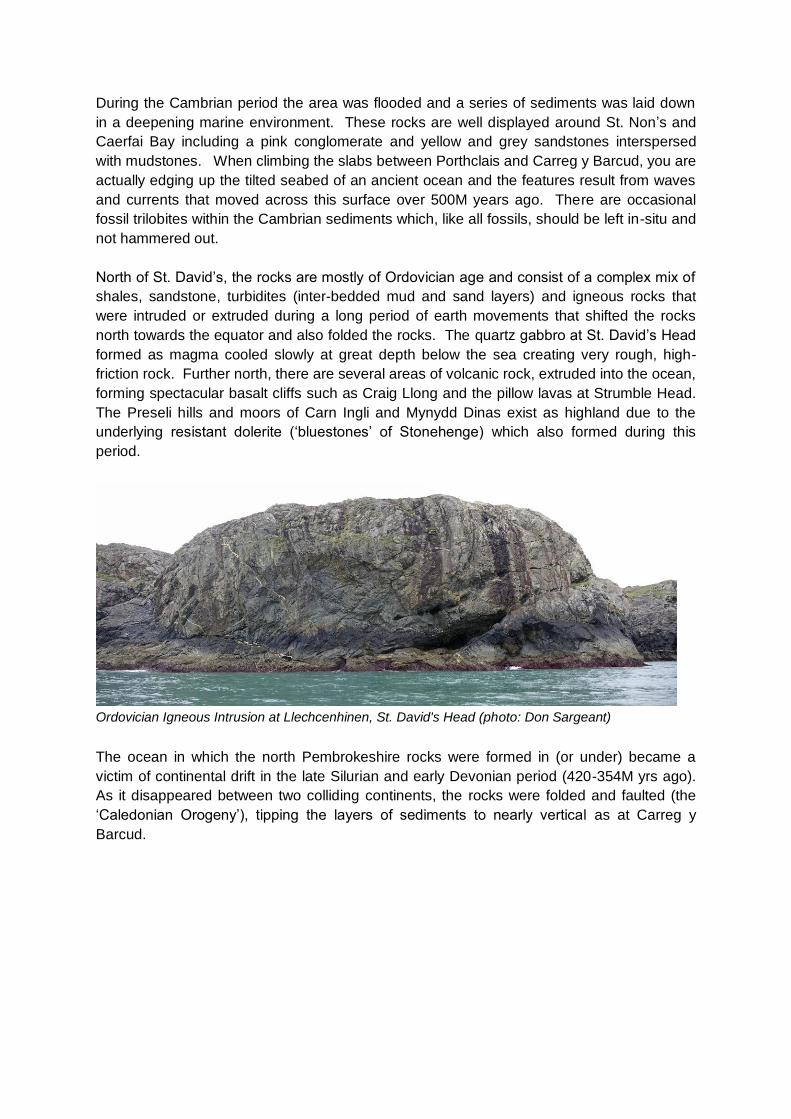
North of St. David‟s, the rocks are mostly of Ordovician age and consist of a complex mix of
shales, sandstone, turbidites (inter-bedded mud and sand layers) and igneous rocks that
were intruded or extruded during a long period of earth movements that shifted the rocks
north towards the equator and also folded the rocks. The quartz gabbro at St. David‟s Head
formed as magma cooled slowly at great depth below the sea creating very rough, high-
friction rock. Further north, there are several areas of volcanic rock, extruded into the ocean,
forming spectacular basalt cliffs such as Craig Llong and the pillow lavas at Strumble Head.
The Preseli hills and moors of Carn Ingli and Mynydd Dinas exist as highland due to the
underlying resistant dolerite („bluestones‟ of Stonehenge) which also formed during this
period.
Ordovician Igneous Intrusion at Llechcenhinen, St. David's Head (photo: Don Sargeant)
The ocean in which the north Pembrokeshire rocks were formed in (or under) became a
victim of continental drift in the late Silurian and early Devonian period (420-354M yrs ago).
As it disappeared between two colliding continents, the rocks were folded and faulted (the
„Caledonian Orogeny‟), tipping the layers of sediments to nearly vertical as at Carreg y
Barcud.
South Pembrokeshire
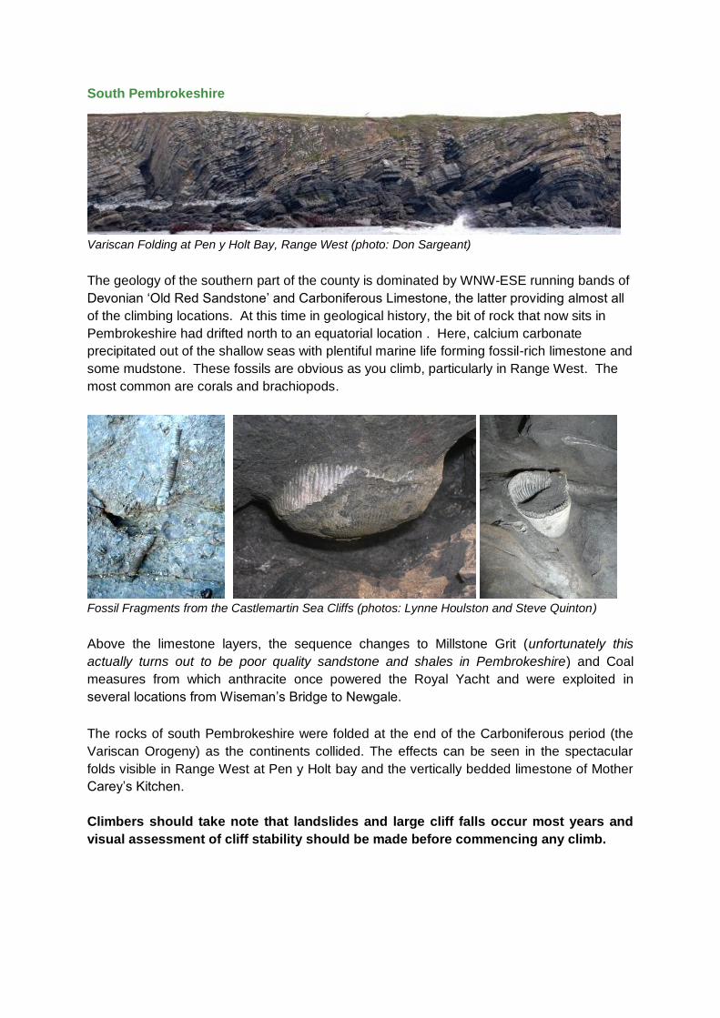
Variscan Folding at Pen y Holt Bay, Range West (photo: Don Sargeant)
The geology of the southern part of the county is dominated by WNW-ESE running bands of
Devonian „Old Red Sandstone‟ and Carboniferous Limestone, the latter providing almost all
of the climbing locations. At this time in geological history, the bit of rock that now sits in
Pembrokeshire had drifted north to an equatorial location . Here, calcium carbonate
precipitated out of the shallow seas with plentiful marine life forming fossil-rich limestone and
some mudstone. These fossils are obvious as you climb, particularly in Range West. The
most common are corals and brachiopods.
Fossil Fragments from the Castlemartin Sea Cliffs (photos: Lynne Houlston and Steve Quinton)
Above the limestone layers, the sequence changes to Millstone Grit (unfortunately this
actually turns out to be poor quality sandstone and shales in Pembrokeshire) and Coal
measures from which anthracite once powered the Royal Yacht and were exploited in
several locations from Wiseman‟s Bridge to Newgale.
The rocks of south Pembrokeshire were folded at the end of the Carboniferous period (the
Variscan Orogeny) as the continents collided. The effects can be seen in the spectacular
folds visible in Range West at Pen y Holt bay and the vertically bedded limestone of Mother
Carey‟s Kitchen.
Climbers should take note that landslides and large cliff falls occur most years and
visual assessment of cliff stability should be made before commencing any climb.

Archaeology
Many of the promontories around the coast were the sites of settlements and forts during the
Bronze and Iron Ages. Defendable locations were obviously important at this time in history
and steep sided headlands allowed small farming communities to create a protected area by
constructing a series of gated walls that cut across the headlands. Today these appear as
earth mounds and the remains of stone walls. Some of these sites coincide with the top of
climbing locations, notably at Pen Castell Coch, St. Davids Head and Penpleidiau (just east
of Craig Caerfai), the Cauldron and Linney Head (Range West). Many of these forts are
Scheduled Ancient Monuments and protected to prevent erosion and destruction of
archaeological evidence. Please minimise disturbance and avoid placing belay stakes in
these areas.
Promontory Fort at Penpleidiau (Caerfai) and Hut Circles at St. David’s Head (photos: Steve Quinton)
Linney Head Iron Age Fort
Linney Head is an Iron Age Hill Fort, one of at least seven on Castlemartin Range. It is
thought to date back 2500-3000 years. It would have been visible from land and sea and
was designed not only for defence but also for show and status. The fort was packed full of
buildings – both dwellings and stores – and the people who lived in and near it practised
both arable and livestock farming.
The Fort is designated a Scheduled Ancient Monument due to its national importance and to
protect it from ground breaking disturbance. The site is restricted to climbers to prevent
further erosion and to protect the archaeological evidence of buildings and living activity
littered in its interior.

Bolts and fixed gear
There were several periods in the 1980s and 1990s when individual climbers placed bolts in
some routes where natural protection was thought to be inadequate. After numerous
discussions the climbing community has come to an agreement that the natural rock of
Pembrokeshire should not be drilled and protection should be placed by the leader and
removed by the second as far as possible. Similarly, pitons and threads do not last well in
the salty environment so their use should also be minimised. Virtually all of the bolts have
now been removed from natural cliffs although some remain in quarries at Porthgain and
Tenby. Please do not place any new protection that involves drilling into natural rock faces.
NEW ROUTES – CONSERVATION ADVICE When developing new climbs please consider the following points and minimise disturbance to the rock and plant life. It may be reasonable to remove some loose rock if this poses a risk to others but this should be minimised. If new route preparation will result in the destruction of rare vegetation or disturbance to bird habitat then it should not go ahead, and climbers are encouraged to consider fully the following points before embarking upon new route activities: If a new line on an obscure buttress needs to be excavated from the hillside before it is climbable, then it should be left alone. If natural vegetation is removed, it may never return as the niche would very likely be colonised by different species. Some crags are really best left to nature – most of the best routes here required very little preparation and there are still plenty of lines left on solid clean rock that will provide better, more enjoyable climbing than would be revealed by excessive „gardening‟ activities. Consider the likely „life‟ of pegs and threads before placing them on new routes. Only place fixed gear as a last resort – routes on sea cliffs that rely on fixed pegs are often impossible to repeat at the same grade a few years after the first ascent due to corrosion. Finally, if challenged while climbing – avoid conflict and ascertain the challenger‟s identity, the organisation they represent, and their exact concerns. Remain calm and report the incident to the BMC – who have well-established links with the National Park Authority and other regional partners.

The ‘Good Practice’ guide to climbing in Pembrokeshire Respect Land Ownership, sustainable access depends on co-existence
Do not remove wild plants
If you hear obvious „alarm calling‟ birds – retreat from the area.
Adhere to the agreed seasonal bird nesting restrictions, updated annually and available in the Access & Conservation („RAD‟) section of the BMC website.
Avoid disturbing seals who may use coves at the base of crags for pupping
If you are leading a group, take care to minimise your impact on other climbers (talk to them and work around them) as well as the crag environment.
Do not place bolts or any other drilled gear on natural cliffs. (Also minimise use of pegs.)
Do what you can to minimise erosion at the cliff top, especially in the wet.
Consult with CCW or the National Park Authority before developing a new cliff.
Get in the habit of „going before you go‟ – if nature calls, bury any waste and bag and take home your toilet paper (but don‟t dig on MoD land!)
Take home all litter, even fruit skins – try to leave the crag in a better state than you found it.
Observe the Countryside Code – available from www.countrysideaccess.gov.uk
Smile a lot – you‟re climbing on some of the best sea cliffs in the world!
Note: Climbers should be familiar with the legal protection provided by the Wildlife and Countryside Act, 1981 (updated by the „CROW‟ Act, 2000). This prohibits up-rooting of wild plants and harassment or disturbance of wildlife. Outdoor Activity Groups including climbers are encouraged to join the Pembrokeshire Outdoor Charter. This is a cooperative group including virtually every outdoor activity and education group in the county together with the National Park Authority, CCW and National Trust. The group has for many years set a high standard of environmental good practice and arranges training workshops, site visits, information sharing meetings and has a very useful website at www.pembrokeshireoutdoors.org.uk .
Useful websites
Pembrokeshire Coast National Park: www.pembrokeshirecoast.org.uk/
Countryside Council for Wales: www.ccw.gov.uk/
Pembrokeshire Marine SAC: www.pembrokeshiremarinesac.org.uk/
National Trust: www.nationaltrust.org.uk/
Ministry of Defence: www2.army.mod.uk/ate/public/castlemartin.htm
British Mountaineering Council (BMC): www.thebmc.co.uk/bmccrag/
The Climbers Club: www.climbers-club.co.uk/
Pembrokeshire Outdoor Charter Group: http://www.pembrokeshireoutdoors.org.uk/
Royal Society for the Protection of Birds: http://www.rspb.org.uk/wildlife/birdguide/
Telephone Numbers
Pembrokeshire Coast National Park Authority: 08453 457275
MoD 24 hour telephone message for Castlemartin firing range activity: 01646 662367