
PEIR Chapter 13 Shipping and navigation
110
Rampion 2 PEIR. Volume 2, Chapter 13: Shipping and navigation 2.13 Volume 2, Chapter 13 Shipping and navigation
Transcript of PEIR Chapter 13 Shipping and navigation

Rampion 2 PEIR. Volume 2, Chapter 13: Shipping and navigation
2.13
Volume 2, Chapter 13
Shipping and navigation

1 © Wood Group UK Limited
Rampion 2 PEIR. Volume 2, Chapter 13: Shipping and navigation
Contents
13. Shipping and navigation 4
13.1 Introduction 4
13.2 Relevant legislation, policy and other information and guidance 5
Introduction 5
Legislation and national planning policy 5
Local planning policy 9
Other relevant information and guidance 10
13.3 Consultation and engagement 11
Overview 11
Early engagement 11
Scoping opinion 12
Informal consultation and engagement 14
13.4 Scope of the assessment 23
Overview 23
Spatial scope and study area 23
Temporal scope 24
Potential receptors 24
Potential effects 25
Activities or impacts scoped out of assessment 27
13.5 Methodology for baseline data gathering 28
Overview 28
Desk study 28
Site surveys 29
Data limitations 30
13.6 Baseline conditions 31
Current baseline 31
Future baseline 36
13.7 Basis for PEIR assessment 37
Maximum design scenario 37
Embedded environmental measures 42
13.8 Methodology for PEIR assessment 50
Introduction 50
Application of guidance 50
Impact significance ranking 50
13.9 Preliminary assessment: Construction phase 51
Displacement of vessels 51
Creation of vessel to vessel collision risk between a third-party vessel and a project vessel 59
Reduced access to local ports 61
13.10 Preliminary assessment: Operation and maintenance phase 66
Displacement of vessels 66

2 © Wood Group UK Limited
Rampion 2 PEIR. Volume 2, Chapter 13: Shipping and navigation
Creation of vessel to vessel collision risk between a third-party vessel and a project vessel 72
Creation of vessel to structure allision risk 73
Reduced access to local ports 78
Commercial risk 83
Reduction of under keel clearance 85
Increased anchor interaction with subsea cables 86
Reduction of emergency response provision including SAR capability 88
13.11 Preliminary assessment: Decommissioning phase 89
Displacement of vessels 89
Creation of vessel to vessel collision risk between a third-party vessel and a project vessel 90
Reduced access to local ports 91
13.12 Preliminary assessment: Cumulative effects 92
Approach 92
Cumulative effects assessment 92
13.13 Transboundary effects 93
13.14 Inter-related effects 93
13.15 Summary of residual effects 95
13.16 Further work to be undertaken for ES 97
Introduction 97
Baseline 98
Assessment 98
Consultation and engagement 98
Environmental measures 99
13.17 Glossary of terms and abbreviations 99
13.18 References 106
Table 13-1 Legislation relevant to shipping and navigation 5
Table 13-2 National planning policy relevant to shipping and navigation 7
Table 13-3 Local planning policy relevant to shipping and navigation 9
Table 13-4 PINS Scoping Opinion responses – shipping and navigation 12
Table 13-5 Receptors requiring assessment for shipping and navigation 24
Table 13-6 Potential effects on shipping and navigation receptors scoped in for further assessment 25
Table 13-7 Data sources used to inform the shipping and navigation PEIR assessment 28
Table 13-8 Site surveys undertaken 29
Table 13-9 Summary of key navigational features 31
Table 13-10 Details of main commercial routes within study area 34
Table 13-11 Maximum assessment assumptions for impacts on shipping and navigation 38
Table 13-12 Relevant shipping and navigation embedded environmental measures 44
Table 13-13 Risk ranking matrix for shipping and navigation 51

3 © Wood Group UK Limited
Rampion 2 PEIR. Volume 2, Chapter 13: Shipping and navigation
Table 13-14 Summary of post wind farm main route deviations within study area 52
Table 13-15 Summary of impact rankings for vessel displacement during construction phase (navigational safety) 59
Table 13-16 Summary of impact rankings for vessel displacement during construction phase (commercial risk) 59
Table 13-17 Summary of impact rankings reduced access to local ports during construction phase 66
Table 13-18 Summary of impact rankings for vessel displacement during operation and maintenance phase (navigational safety) 71
Table 13-19 Summary of impact rankings for vessel displacement during operation and maintenance phase (commercial risk) 71
Table 13-20 Summary of impact rankings for creation of vessel to structure allision risk during operation and maintenance phase 77
Table 13-21 Summary of impact rankings reduced access to local ports during operation and maintenance phase (navigational safety) 84
Table 13-22 Summary of impact rankings reduced access to local ports during operation and maintenance phase (commercial risk) 85
Table 13-23 Summary of impact rankings for vessel displacement during decommissioning phase 90
Table 13-24 Summary of impact rankings reduced access to local ports during decommissioning phase 91
Table 13-25 Inter-related receptor led effects 94
Table 13-26 Summary of preliminary assessment of residual effects 95
Table 13-27 Further consultation and engagement 98
Table 13-28 Glossary of terms and abbreviations 99
Volume 3 Figures
Figure 13.1 Shipping and navigation study area
Figure 13.2 Overview of navigational features
Figure 13.3 Summer vessel traffic survey data within study area by vessel type
Figure 13.4 Winter vessel traffic survey data within study area by vessel type
Figure 13.5 Main commercial routes and 90th percentiles within study area
Figure 13.6 MAIB incidents within study area by incident type
Figure 13.7 Maximum design scenario layout for shipping and navigation
Figure 13.8 Post wind farm main commercial routes within study area
Volume 4 Appendices
Appendix 13.1: Navigational Risk Assessment

4 © Wood Group UK Limited
Rampion 2 PEIR. Volume 2, Chapter 13: Shipping and navigation
13. Shipping and navigation
13.1 Introduction
13.1.1 This chapter of the Preliminary Environmental Information Report (PEIR) presents the preliminary results of the assessment of the likely significant effects of Rampion 2 with respect to shipping and navigation during the construction, operation and maintenance and decommissioning phases of the Proposed Development. It should be read in conjunction with the project description provided in Chapter 4: The Proposed Development, Appendix 13.1: Navigational risk assessment, Volume 4 and the relevant parts of the following chapters:
⚫ Chapter 7: Other marine users (other marine users are considered in this chapter from a safety of navigation perspective);
⚫ Chapter 10: Commercial fisheries (commercial fishing activity is considered in this chapter from a safety of navigation perspective); and
⚫ Chapter 15: Civil and military aviation (civil and military aviation receptors are considered in this chapter from a safety of navigation perspective including emergency response to a marine incident).
13.1.2 This chapter describes:
⚫ the legislation, planning policy and other documentation that has informed the assessment (Section 13.2: Relevant legislation, planning policy, and other documentation);
⚫ the outcome of consultation engagement that has been undertaken to date, including how matters relating to shipping and navigation within the Scoping Opinion received in August 2020 have been addressed (Section 13.3: Consultation and engagement);
⚫ the scope of the assessment for shipping and navigation (Section 13.4: Scope of the assessment);
⚫ the methods used for the baseline data gathering (Section 13.5: Methodology for baseline data gathering);
⚫ the overall baseline (Section 13.6: Baseline conditions);
⚫ embedded environmental measures relevant to shipping and navigation and the relevant maximum design scenario (Section 13.7: Basis for PEIR assessment);
⚫ the assessment methods used for the PEIR (Section 13.8: Methodology for PEIR assessment);
⚫ the assessment of shipping and navigation effects (Section 13.9 - 13.11: Preliminary assessment and Section 13.12: Preliminary assessment: Cumulative effects approach)
⚫ consideration of transboundary effects (Section 13.13: Transboundary effects);

5 © Wood Group UK Limited
Rampion 2 PEIR. Volume 2, Chapter 13: Shipping and navigation
⚫ consideration of inter-related effects (Section 13.14: Inter-related effects);
⚫ a summary of residual effects for shipping and navigation (Section 13.15: Summary of residual effects);
⚫ an outline of further work to be undertaken for the Environmental Statement (ES) (Section 13.16: Further work to be undertaken for ES);
⚫ a glossary of terms and abbreviations is provided in Section 13.17: Glossary of terms and abbreviations; and
⚫ a references list is provided in Section 13.18: References.
13.2 Relevant legislation, policy and other information and guidance
Introduction
13.2.1 This section identifies the legislation, policy and other documentation that has informed the assessment of effects with respect to shipping and navigation. Further information on policies relevant to the Environmental Impact Assessment (EIA) and their status is provided in Chapter 2: Policy and legislative context of this PEIR.
Legislation and national planning policy
13.2.2 Table 13-1 lists the legislation relevant to the assessment of the effects on shipping and navigation receptors.
Table 13-1 Legislation relevant to shipping and navigation
Legislation description Relevance to assessment
United Nations Convention on the Law of the Sea (UNCLOS) (United Nations (UN), 1982)
UNCLOS defines the rights and responsibilities of all nations with respect to their use of the sea, throughout the world. Article 60(7) “Artificial islands, installations and structures and the safety zones around them may not be established where interference may be caused to the use of recognised sea lanes essential to international navigation”.
Internationally recognised sea lanes and other identified routes are considered a key element of the shipping and navigation baseline and have been considered wherever “interference may be caused” including through vessel displacement, port access, collision risk and allision risk in the impact assessment. The methodology for baseline data gathering and baseline conditions are outlined in Section 13.5 and Section 13.6,

6 © Wood Group UK Limited
Rampion 2 PEIR. Volume 2, Chapter 13: Shipping and navigation
Legislation description Relevance to assessment
respectively and the impact assessment (which includes consideration of internationally recognised sea lanes) is provided in Section 13.9, Section 13.10 and Section 13.11.
Convention on the International Regulations for Preventing Collisions at Sea (COLREGs) (International Maritime Organization (IMO), 1972/77)
The COLREGs define the rules which must be adhered to by all vessels navigating internationally. Rule 8 Part (a) “Any action taken to avoid collision shall be taken in accordance with the Rules of this Part and shall, if the circumstances of the case admit, be positive, made in ample time and with due regard to the observance of good seamanship”. Rule 19 Part (b) “Every vessel shall proceed at a safe speed adapted to the prevailing circumstances and conditions of restricted visibility”.
The COLREGs in full are considered throughout with particular regard in the context of Rampion 2 to collision avoidance (Rule 8) and conduct of vessels in restricted visibility (Rule 19) when considering collision risk in the impact assessment. The impact assessment (which includes consideration of COLREGs) is provided in Section 13.9, Section 13.10 and Section 13.11.
Safety of Life at Sea (SOLAS) Chapter V (IMO, 1974)
SOLAS Chapter V is an international agreement that sets basic minimum criteria for all seafarers, dependent on the size and type of vessel1. Regulation 33 “The master of a ship at sea which is in a position to be able to provide assistance on receiving information from any source that persons are in distress at sea, is bound to proceed with all speed to their assistance”. Regulation 34 “Prior to proceeding to sea, the master shall ensure that the intended voyage has been planned using the appropriate nautical charts and nautical publications for the area concerned”.
SOLAS Chapter V in full is considered throughout with particular regard in the context of Rampion 2 to rendering assistance to persons in distress (Regulation 33) and passage planning (Regulation 34) when considering allision risk, anchor interaction with subsea cables and emergency response capability. The impact assessment (which includes consideration of SOLAS Chapter V) is provided in Section 13.9, Section 13.10 and Section 13.11.
1 SOLAS Chapter V applies to all ships on all voyages except warships, naval auxiliaries and other vessels owned or operated by a contracting government.

7 © Wood Group UK Limited
Rampion 2 PEIR. Volume 2, Chapter 13: Shipping and navigation
13.2.3 Table 13-2 lists the national planning policy relevant to the assessment of the effects on shipping and navigation receptors. It is noted that although the overarching guidance principles set out in EN-1 National Policy Statement (NPS) do not specifically refer to shipping and navigation they have been considered.
Table 13-2 National planning policy relevant to shipping and navigation
Policy description Relevance to assessment
EN-3 NPS for Renewable Energy (Department of Energy & Climate Change (DECC), 2011)
EN-3 NPS for Renewable Energy sets out guidance and requirements for nationally significant energy infrastructure projects.
As Rampion 2 is an offshore wind project of more than 100 Megawatts (MW) the Proposed Development falls under this NPS.
Paragraph 2.6.153 “Applicants should establish stakeholder engagement with interested parties in the navigation sector early in the development phase of the proposed offshore wind farm and this should continue throughout the life of the development including during the construction, operation and decommissioning phases. Such engagement should be taken to ensure that solutions are sought that allow offshore wind farms and navigation uses of the sea to successfully co-exist.”
Stakeholder engagement is considered a key input to the shipping and navigation baseline and impact assessment. Consultation undertaken is outlined in Section 13.3.
Paragraph 2.6.154 “Assessment should be underpinned by consultation with the Marine Management Organisation (MMO), Maritime and Coastguard Agency (MCA), the relevant General Lighthouse Authority (GLA), the relevant industry bodies (both national and local) and any representatives of recreational users of the sea, such as the Royal Yachting Association (RYA), who may be affected.”
The stated organisations are considered key stakeholders for shipping and navigation. Consultation undertaken is outlined in Section 13.3.
Paragraph 2.6.155 “Information on internationally recognised sea lanes is publicly available and this should be considered by applicants prior to undertaking assessments. The assessment should include reference to
Internationally recognised sea lanes, other identified routes and navigational features such as IMO routeing measures are considered a key element of the shipping and navigation baseline. The methodology for baseline data gathering and baseline
8 © Wood Group UK Limited
Rampion 2 PEIR. Volume 2, Chapter 13: Shipping and navigation
Policy description Relevance to assessment
any relevant, publicly available data available on the Maritime Database.”
conditions are outlined in Section 13.5 and Section 13.6, respectively.
Paragraph 2.6.156 “Applicants should undertake a Navigational Risk Assessment (NRA) in accordance with relevant Government guidance prepared in consultation with the MCA and the other navigation stakeholders listed above.”
The NRA is considered a key input to the shipping and navigation impact assessment including compliance with MCA guidance documents. The NRA is provided in Appendix 13.1, Volume 4 and its methodology was agreed during consultation with the MCA and Trinity House (Section 13.3).
Paragraph 2.6.160 “The potential effect on recreational craft, such as yachts, should be considered in any assessment.”
Small craft including recreational vessels are considered a relevant receptor to shipping and navigation. The impact assessment (which includes consideration of recreational vessels) is provided in Section 13.9, Section 13.10 and Section 13.11.
NPS for Ports
The NPS for Ports sets out the framework for decisions on proposals for new port development.
Although not directly applicable to Rampion 2, ports and port users are identified as potential receptors and therefore elements of the NPS are considered relevant.
Paragraph 5.14.2 “Where the project is likely to have socio-economic impacts at local or regional levels, the applicant should undertake and include in their application an assessment of these impacts as part of the ES.”
The socio-economic effect of Rampion 2 on local ports has been considered in Chapter 18: Socio-economics. For shipping and navigation the commercial impact on routes which could also impact on port use is considered in Section 13.10.
Paragraph 5.14.4 “Applicants should describe the existing socio-economic conditions in the areas surrounding the proposed development and should also refer to how the development’s socio-economic impacts correlate with local planning policies.”

9 © Wood Group UK Limited
Rampion 2 PEIR. Volume 2, Chapter 13: Shipping and navigation
Policy description Relevance to assessment
Paragraph 5.14.5 “Socio-economic impacts may be linked to other impacts.”
UK Marine Policy Statement (Her Majesty’s Government (HM Government), 2011)
The UK Marine Policy Statement proves a framework for preparing Marine Plans and taking decisions affecting the marine environment.
Paragraph 3.4.7 “Increased competition for marine resources may affect the sea space available for the safe navigation of ships. Marine plan authorities and decision makers should take into account and seek to minimise any negative impacts on shipping activity, freedom of navigation and navigational safety and ensure that their decisions are in compliance with international maritime law”.
Displacement of existing routes and activity and subsequent increases in collision risk has been considered. The impact assessment (which includes consideration of vessel displacement) is provided in Section 13.9, Section 13.10 and Section 13.11.
Local planning policy
13.2.4 Table 13-3 lists the local planning policy relevant to the assessment of the effects on shipping and navigation receptors.
Table 13-3 Local planning policy relevant to shipping and navigation
Policy description Relevance to assessment
South Inshore and South Offshore Marine Plan (Department for Environment, Food and Rural Affairs (DEFRA), 2018)
The South Inshore and South Offshore Marine Plan safeguards environments and enables sustainable use of its shipping channels. Policy S-PS-2 “Proposals that require static sea surface infrastructure or that significantly reduce under-keel clearance must not be authorised within IMO routeing systems unless there are exceptional circumstances”.
The Dover Strait Inshore Traffic Zone (ITZ) is an IMO routeing measure and overlaps with the PEIR Assessment Boundary.
The ITZ has been considered as part of the baseline and vessel routeing within the ITZ is considered in the impact assessment. The methodology for baseline data gathering and baseline conditions are outlined in Section 13.5 and Section 13.6, respectively and the impact assessment which demonstrates a safety case for development (including consideration of

10 © Wood Group UK Limited
Rampion 2 PEIR. Volume 2, Chapter 13: Shipping and navigation
Policy description Relevance to assessment
Policy S-PS-3 “Proposals that require static surface infrastructure or that significantly reduce under-keel clearance which encroach upon high density navigation routes, or that pose a risk to the viability of passenger ferry services, must not be authorised unless there are exceptional circumstances”.
internationally recognised sea lanes and development within the ITZ) is provided in Section 13.9, Section 13.10 and Section 13.11.
Other relevant information and guidance
13.2.5 A summary of other relevant information and guidance relevant to the assessment undertaken for shipping and navigation is provided as follows.
⚫ Marine Guidance Note (MGN) 543 Safety of Navigation: Offshore Renewable Energy Installations (OREIs) – Guidance on United Kingdom (UK) Navigational Practice, Safety and Emergency Response (MCA, 2016) – highlights the issues that need to be taken into consideration when assessing the impact on navigational safety and emergency response (search and rescue (SAR), salvage and towing, and counter pollution) caused by OREI developments2.
⚫ Methodology for Assessing the Marine Navigational Safety & Emergency Response Risks of Offshore Renewable Energy Installations (OREI) (MCA, 2013) – to be used as guidance in preparing navigation risk and emergency response assessments.
⚫ Revised Guidelines for Formal Safety Assessment (FSA) for Use in the Rule-Making Process (IMO, 2018) – outlines the FSA methodology as a tool.
⚫ Marine Guidance Note (MGN) 372 Offshore Renewable Energy Installations (OREIs): Guidance to Mariners Operating in the Vicinity of UK OREIs (MCA, 2008)– highlights the issues to be taken into account when planning and undertaking voyages in the vicinity of OREIs off the UK coast.
⚫ International Association of Marine Aids to Navigation and Lighthouse Authorities (IALA) Recommendation O-139 on The Marking of Man-Made Offshore Structures (IALA, 2013)– provides recommendations for developers with regard to the marking of structures fixed in position, which extend above or below the surface of the sea and which are obstructions to navigation (including OREIs).
⚫ The RYA’s Position on Offshore Renewable Energy Developments: Paper 1 (of 4) – Wind Energy (RYA, 2019) – enables developers to take account of recreational boating concerns when developing their ESs and NRAs.
2 MGN 543 has now been superseded by MGN 654 published in April 2021 – a comprehensive review of this Chapter against the updated version of the guidance document will be undertaken post-PEIR and updates made as appropriate.

11 © Wood Group UK Limited
Rampion 2 PEIR. Volume 2, Chapter 13: Shipping and navigation
⚫ Standard Marking Schedule for Offshore Installations (DECC, 2011) – outlines aids to navigation requirements for offshore installations.
13.3 Consultation and engagement
Overview
13.3.1 This section describes the outcome of, and response to, the Scoping Opinion in relation to shipping and navigation assessment and also provides details of the ongoing informal consultation that has been undertaken with stakeholders and individuals. An overview of engagement undertaken can be found in Section 1.5 of Chapter 1: Introduction.
13.3.2 It is noted that consultation in relation to marine aggregate dredging and port relations has been ongoing since the application for Rampion 1. This feedback has been incorporated into the assessment process for Rampion 2 as part of Chapter 7: Other marine users.
13.3.3 Given the restrictions which have been in place due to the COVID-19 pandemic during this period, all consultation has taken the form of conference calls using Microsoft Teams and email correspondence.
Early engagement
Overview
13.3.4 Early engagement was undertaken with a number of prescribed and non-prescribed consultation bodies and local authorities in relation to shipping and navigation. This engagement was undertaken to introduce the Proposed Development and the proposed approach to scoping the EIA.
Maritime and Coastguard Agency (MCA)
13.3.5 Early engagement with the MCA was undertaken in the form of email correspondence. MCA were content with the intended approach for the vessel traffic surveys in principle, although commented that October is considered quite early for a ‘winter’ survey3.
Trinity House
13.3.6 Early engagement with Trinity House was undertaken in the form of email correspondence. Trinity House commented that vessel traffic data from 2020 could be affected by the restrictions imposed in response to COVID-19, especially with regards to recreational traffic, and this will need to be assessed accordingly.
3 The winter vessel traffic survey was undertaken between 1 and 15 November 2020.

12 © Wood Group UK Limited
Rampion 2 PEIR. Volume 2, Chapter 13: Shipping and navigation
Royal Yachting Association (RYA)
13.3.7 Early engagement with the RYA was undertaken in the form of email correspondence. Key points raised by the RYA included:
⚫ the proposal to undertake visual identification of recreational craft in combination with surveys for other receptors is welcomed;
⚫ suggested that vessel traffic surveys are undertaken between mid-June and no later than the August bank holiday since bad weather at the end of August can give poor recreational vessel data. There is no preference for the timing of the winter vessel traffic survey;
⚫ the plan to validate the vessel traffic survey with clubs and training centres is welcomed provided that there is a clear method for translating the findings of the NRA into the EIA hierarchy to eliminate identified impacts. Additionally, it would be useful to speak directly with clubs around the landfall location; and
⚫ in addition to Automatic Identification System (AIS) data, the RYA Coastal Atlas identifies boating areas around the UK following consultation with member clubs.
Scoping opinion
13.3.8 Rampion Extension Development (RED) submitted a Scoping Report (RED, 2020) and request for a Scoping Opinion to the Secretary of State (administered by the Planning Inspectorate (PINS)) on 2 July 2020. A Scoping Opinion was received on 11 August 2020. The Scoping Report set out the proposed shipping and navigation assessment methodologies, outline of the baseline data collected to date and proposed, and the scope of the assessment. Table 13-4 sets out the comments received in Section 4 of the PINS Scoping Opinion ‘Aspect based scoping tables – Offshore’ and how these have been addressed in this PEIR. A full list of the PINS Scoping Opinion comments and responses is provided in Appendix 5.1: Response to the Scoping Opinion. Regard has also been given to other stakeholder comments that were received in relation to the Scoping Report.
13.3.9 The information provided in the PEIR is preliminary and therefore not all the Scoping Opinion comments have been able to be addressed at this stage, however all comments will be addressed within the ES.
Table 13-4 PINS Scoping Opinion responses – shipping and navigation
PINS ID number
Scoping Opinion comment How this is addressed in this PEIR
4.9.1 “The Inspectorate is unclear as to what refinement of offshore components or identification of additional impact pathways could occur that would lead to amendment of the study area. The ES should
The shipping and navigation study area used for the Scoping Report (RED, 2020) has been maintained despite a reduction in the size of the PEIR Assessment Boundary in order to ensure consistency.

13 © Wood Group UK Limited
Rampion 2 PEIR. Volume 2, Chapter 13: Shipping and navigation
PINS ID number
Scoping Opinion comment How this is addressed in this PEIR
clearly set out the study area with reference to the “standard” 10 nautical miles (nm) buffer that is stated and its basis within relevant legislation and guidance.”
Consequently, the study area considered in the PEIR is a minimum 10nm buffer of the PEIR Assessment Boundary. The study area is presented and justified in Section 13.4.
4.9.2 “There is a high degree of overlap in the assessment of effects on offshore recreational users across other marine users, shipping and navigation and socio-economics. The Inspectorate expects that these matters will be considered as part of the assessment(s) of inter-related effects.”
The effect on recreational users has been considered as an inter-related effect. The assessment of inter-related effects is provided in Section 13.14.
The socio-economic effect of Rampion 2 has been considered in Chapter 18: Socio-economics.
4.9.3 “The IMO FSA guidance will be followed when assessing impacts to shipping and navigation receptors, assessing each impact in terms of frequency and consequence. The ES should clearly set out how the risk assessment approach leads to an assessment of significance of effect are consistent/compatible with the terminology as set out in the Scoping Report.”
The Revised Guidelines for FSA for Use in the Rule-Making Process (IMO, 2018) have been applied to the preliminary assessment, noting that this differs from the standard assessment methodology being applied for other aspects. The methodology used for the preliminary assessment is outlined in Section 13.1 with further detail provided in Section 3 of Appendix 13.1, Volume 4.
4.9.4 “The Inspectorate notes the apparent importance of the “hazard workshop[s]” subsequent to the Scoping Opinion in refining the approach to the assessment. The scope, outcomes and agreements reached during this meeting should be specifically set out in the ES and NRA (such as in the form of technical appendices or other standalone reports).”
Points raised at the Hazard Workshop are outlined in Section 13.3 and the hazard log – the main output of the Hazard Workshop – is provided in full in Annex A of Appendix 13.1, Volume 4.
4.9.5 “The ES should explain how the assessment has factored in shipping and navigation effects on the nine
Consultation with marine aggregate dredging stakeholders has been undertaken and marine aggregate
14 © Wood Group UK Limited
Rampion 2 PEIR. Volume 2, Chapter 13: Shipping and navigation
PINS ID number
Scoping Opinion comment How this is addressed in this PEIR
marine aggregate dredging areas intersecting the study area. It is unclear if such effects are to be considered part of the ‘baseline’ conditions or whether a future baseline is required accounting for changes in dredging activity. Such effects may also need to be considered as part of the cumulative effects assessment of combined effects of the Proposed Development and aggregate activity on other receptors. The Inspectorate notes the Applicant’s identification of a “significant marine aggregate dredging route…within the north-west of the study area” in this regard.”
dredgers have been considered as a receptor in the impact assessment, both for the assessment of Rampion 2 in isolation and as part of the Cumulative Effect Assessment (CEA). The preliminary assessment (which includes consideration of marine aggregate dredgers) is provided in Section 13.9, Section 13.10 and Section 13.11.
Informal consultation and engagement
Overview
13.3.10 Informal consultation has been ongoing with a number of prescribed and non-prescribed consultation bodies and local authorities in relation to shipping and navigation. A summary of consultation undertaken between the completion of the Scoping Report (RED, 2020) and up to March 2021 is outlined in this section.
Maritime and Coastguard Agency (MCA) and Trinity House
13.3.11 Engagement with the MCA and Trinity House (jointly) has been ongoing since 29 July 2020 in the form of conference calls, email correspondence and the Hazard Workshop. Key points raised include:
⚫ vessel traffic issues which persisted during the impact assessment for Rampion 1 will still be a factor for Rampion 2, including the ITZ which will need to be assessed carefully;
⚫ the displacement of vessel traffic between the south of the existing Rampion 1 project and the Dover Strait Traffic Separation Scheme (TSS) may be an issue, with a general squeezing of traffic flows and potential subsequent impact on pilotage;
⚫ the Dover Strait Users Group is a good target audience and therefore would be useful to approach;

15 © Wood Group UK Limited
Rampion 2 PEIR. Volume 2, Chapter 13: Shipping and navigation
⚫ the existing Rampion 1 project is considered a good layout for SAR and it is important that this is not impacted by Rampion 2 noting that, given the general area, SAR access is of particular importance;
⚫ content with the NRA methodology, in line with MGN 543 and its annexes; and
⚫ infrastructure within a routeing measure is not allowed under the South Inshore and South Offshore Marine Plan, and the ITZ is part of the routeing measures referred to in the plan.
UK Chamber of Shipping
13.3.12 Engagement with the UK Chamber of Shipping has been ongoing since 10 August 2020 in the form of conference calls and the Hazard Workshop. Key points raised include:
⚫ access to the St. Helen’s anchorage may be impacted and additionally collision risk between moving and anchored vessels requires consideration;
⚫ the AIS data presented in the Scoping Report (RED, 2020) for cargo vessels and tankers is reflective of expectations in the area; and
⚫ the proposed NRA methodology is satisfactory and there are no considerable issues.
Royal Yachting Association (RYA)
13.3.13 Engagement with the RYA has been ongoing since 10 August 2020 in the form of conference calls, email correspondence and the Hazard Workshop. Key points raised include the following.
⚫ The south eastern corner of the Scoping Boundary (the project boundary available at the time) is close to the Dover Strait TSS and this causes some concern. The NRA should consider small numbers of recreational craft engaged in long distance cruising passing through the area.
⚫ The need to keep a safe distance when passing at the western extent of the Scoping Boundary may limit available sea room and squeeze small craft into a narrow channel given the likely presence of construction buoyage and the Owers/Looe.
⚫ The portions of the Scoping Boundary developed will determine the effects of displacement of recreational traffic with interaction more likely the closer inshore the development is undertaken. Refinement of the Scoping Boundary is key.
⚫ Initially recreational vessels were excluded from marinas and clubs due to COVID-19 but since the first lockdown (June 2020) the RYA has participated in campaigning to promote their return and a peak in recreational activity can be expected between mid-July and mid-August 2020.
⚫ The seasonal difference in recreational vessel traffic between summer and winter periods observed in the data used in the Scoping Report (RED, 2020) is to be expected noting that such traffic is largely located landward of Rampion 1. The displacement of any larger recreational craft into inshore waters could

16 © Wood Group UK Limited
Rampion 2 PEIR. Volume 2, Chapter 13: Shipping and navigation
result in interaction with small craft and should be considered in the NRA. Otherwise, smaller craft (such as dinghies) are unlikely to be affected by the presence of Rampion 2.
⚫ East-west traffic through the study area ranging between the Solent and Eastbourne will be most affected by the presence of Rampion 2 as would north-south traffic out of Newhaven and Brighton.
⚫ A large proportion of the recreational traffic in the area is under sail and therefore will be presented with additional challenges in certain weather conditions to make safe passage in proximity to the wind farm, particularly at the western extent of the Scoping Boundary (noting the previous point regarding the creation of a narrow channel) if sailing westwards into a prevailing south westerly wind.
⚫ From consultation undertaken by the RYA the national level of AIS uptake by recreational vessels is around 20 percent but the ratio may be higher in this area.
⚫ Whether recreational traffic at Shoreham may be significant was queried, particularly in relation to traffic associated with the Sussex Yacht Club. Furthermore, whether there is significant traffic at Brighton and Littlehampton other than recreational boating (such as fishing, diving or sightseeing tours) was queried.
⚫ Whether the high proportion of reported incidents being recreational vessels is a reflection of traffic volume, poor maintenance or lack of training was queried.
⚫ There are few safe havens for recreational craft seeking shelter along this coast with those that are available very tide dependent for access. Mitigation measures and construction should avoid restricting access to safe havens.
⚫ From a recreational boating point of view, Rampion 2 should be sited within the scoping envelope immediately to the west or to the south of Rampion 1 with the NRA to look very carefully at the risks to recreational boating when siting anywhere else within the scoping envelope.
⚫ In recent years the silting up of Brighton Marina has become a challenge and it is postured that disruption to the seabed from construction methods could create coastal navigation problems.
⚫ Consideration of the spacing between structures and use of Notices to Mariners may serve as suitable mitigation measures for hazards associated with recreational vessels.
⚫ Impacts relating to emergency response for recreational activity seaward of the array should be considered.
⚫ Any assessment should be based on accurate surveys of recreational traffic and should avoid an emphasis on AIS as most recreational craft are not fitted with AIS transponders.
⚫ Any assessment should determine recreational traffic densities north (inshore) and south (offshore) of the proposed development to ensure an accurate assessment.

17 © Wood Group UK Limited
Rampion 2 PEIR. Volume 2, Chapter 13: Shipping and navigation
⚫ Recreational representatives recommend siting the development south or west of Rampion 1 to avoid navigational squeeze in the area between the development and Selsey Bill but also to avoid recreational traffic being squeezed between the southern boundary and Dover Strait TSS.
⚫ The NRA should:
note the number of recreational vessels using and crossing the area;
include vessel traffic survey logs as an annex;
indicate the number of vessels carrying AIS and Radio Detection and Ranging (Radar) reflectors;
use vessel traffic surveys undertaken between 15 June and 15 August;
provide detailed assessments of how risk is determined as As Low As Reasonably Practicable (ALARP);
compare the NRA surveys and the appropriate MMO full yearly AIS survey for the UK;
consider the RYA Coastal Atlas and general boating areas against the vessel traffic surveys; and
consider recreational vessel movements in adverse weather.
Shoreham Port
13.3.14 Engagement with Shoreham Port has been ongoing since 12 August 2020 in the form of conference calls and the Hazard Workshop. Key points raised include:
⚫ the area of search and wide design envelope (noting that this differs from the PEIR Assessment Boundary) leads to similar concerns raised for Rampion 1, namely that there is significant uncertainty over what area will be developed;
⚫ should access to the Dover Strait TSS be blocked from the east of Rampion 1 then vessels will be required to travel much further west out of Shoreham to access the TSS which would have implications on the attractiveness of Shoreham as a port for commercial use, noting that the majority of commercial traffic out of Shoreham utilises the TSS. The economic effects on the port need to be considered;
⚫ any extension of Rampion 1 to the west may result in vessels holing up landward of the site;
⚫ these are no concerns with the Offshore Cable Corridor location;
⚫ the effects of COVID-19 are still present (as of August 2020) with a downturn in pleasure craft and visitors to ports infrequent. No yachts from France, Belgium and Germany have visited in 2020. Commercial volumes at Shoreham are down around 30 percent and there remains uncertainty over the possible effects post Brexit. The 12-month dataset from 2019 will be reflective of commercial vessel movements;

18 © Wood Group UK Limited
Rampion 2 PEIR. Volume 2, Chapter 13: Shipping and navigation
⚫ the indicative worst case layout for shipping and navigation does reflect the worst case for shipping given that it blocks access to the Dover Strait TSS lanes from Shoreham; and
⚫ notices to Mariners for the existing Rampion 1 project became somewhat excessive.
Newhaven Port & Properties
13.3.15 Engagement with Newhaven Port & Properties has been ongoing since 4 August 2020 in the form of conference calls and the Hazard Workshop. Key points raised include:
⚫ the south eastern corner of the Scoping Boundary (noting that this differs from the PEIR Assessment Boundary) is too close to the Dover Strait TSS and could create a pinch point for vessel traffic;
⚫ recreational traffic ceased entirely at Newhaven at the start of the COVID-19 outbreak but has now (as of August 2020) returned to normal levels;
⚫ the pilot boarding station for Newhaven is far enough from the Scoping Boundary that there is not expected to be any effect on pilot operations;
⚫ the AIS data presented in the Scoping Report (RED, 2020) is reflective of vessel traffic movements in the area, including non-AIS vessels; and
⚫ the proposed NRA methodology is satisfactory.
Cobelfret Ferries
13.3.16 Engagement with Cobelfret Ferries has been ongoing since 1 October 2020 in the form of email correspondence. Key points raised include:
⚫ Cobelfret Ferries have a number of vessels which pass by the Scoping Boundary every week, but they are transiting through the Dover Strait TSS and have no need to enter the site. There are no issues which will adversely affect Cobelfret Ferries’ current trade routes; and
⚫ a vessel breaking down is always an issue but that is the same for any offshore wind farm development.
United European Car Carriers
13.3.17 Engagement with United European Car Carriers (UECC) has been ongoing since 19 October 2020 in the form of email correspondence. Key points raised include:
⚫ UECC has four vessels whose passage out of Southampton will be impacted by the south western corner of the Scoping Boundary. Feedback from the Masters is that this will not have much effect and safe sailing will remain. The vessels will have to make a small adjustment on one waypoint, but the total distance of the route will remain about the same.

19 © Wood Group UK Limited
Rampion 2 PEIR. Volume 2, Chapter 13: Shipping and navigation
Britannia Aggregates
13.3.18 Engagement with Britannia Aggregates has been ongoing since 30 October 2020 in the form of email correspondence. Key points raised include:
⚫ Britannia Aggregates delivers cargoes into Shoreham and Newhaven (and occasionally Portsmouth and Southampton) that may be dredged on aggregate marine licence areas close to the Isle of Wight, in the central English Channel and in the Outer Thames/east coast; and
⚫ some of the routes to and from the licence areas to these ports could be impacted by Rampion 2 depending upon where the new WTGs are placed; in particular the Shoreham to East Channel licences could entail a detour of 8 to 10nm which is significant in terms of fuel and time. These transit routes should be considered.
DEME
13.3.19 Engagement with DEME has been ongoing since 30 October 2020 in the form of email correspondence. Key points raised are as follows.
⚫ The Scoping Boundary covers a relatively large region and there are concerns that DEME operated vessels sail in proximity to the area of search including over the export cable corridor and over the proposed area of build to reach destinations such as Shoreham and Newhaven. This may cause conflicts with transit routes and therefore these concerns should be taken into account when assessing the navigational risks and determining the areas where structures are installed.
Volker Dredging
13.3.20 Engagement with Volker Dredging Limited (VDL) has been ongoing since 5 November 2020 in the form of email correspondence. Key points raised are as follows.
⚫ VDL holds marine aggregate licences for Areas 340 and 351 East of the Isle of Wight and also for Area 461 and GIE St Nicolas in the East English Channel. Cargoes are regularly landed at Shoreham and Newhaven from the Isle of Wight and East Channel concessions and it is important that steaming times are not increased as a result of Rampion 2. Even small increases in steaming distances can have a significant impact on the profitability of operations.
Littlehampton Harbour Board
13.3.21 Engagement with Littlehampton Harbour Board has been ongoing since 18 November 2020 in the form of conference calls and email correspondence. Key points raised include:
⚫ less than 50 percent of the small commercial vessels operating out of Littlehampton are on AIS and it is anticipated that less than 20 percent of vessels inshore at Littlehampton are on AIS;
⚫ vessels can spend anywhere between six hours and two days at the Littlehampton anchorage area awaiting suitable weather;

20 © Wood Group UK Limited
Rampion 2 PEIR. Volume 2, Chapter 13: Shipping and navigation
⚫ any vessel operating within the Competent Harbour Authority area would likely require pilotage including any cable laying vessel that may be operating in the pilotage area for Rampion 2;
⚫ the non-AIS vessels observed in the summer survey data is accurate for the routes taken;
⚫ a route for a monthly (on average) 80m coaster extending direct from the Dover Strait TSS to the east to the anchorage and from the harbour direct to the TSS should be included in any assessment with any detour potentially meaning that Littlehampton becomes less attractive to shipping as many vessels rushing to make the tide would have a further delay. For those without a chance of making entry on arrival locally, the detour is less of an issue but the long stay at the anchorage is our key risk with the cable;
⚫ the indicative worst case layout for shipping and navigation cuts off Littlehampton entirely;
⚫ cable burial depth of 1m close to Littlehampton's charted anchorage for larger vessels is concerning but content that this will be addressed in the cable burial risk assessment (CBRA);
⚫ cable burial at 1m depth within 1nm of Mean High Water Springs (MHWS) is also concerning given the frequency of small leisure craft, fishermen, racing safety/committee boats, temporary race marks, visiting yachts and lifeboats anchoring in this area. Buoyage similar to that in place around the existing cable landing at Worthing will help to mitigate this;
⚫ all marine operations falling within Littlehampton's pilotage district should be consulted on with the Littlehampton Harbour Board in advance. Any operation of vessels over 20m in length at low under keel clearance or any vessels engaged in cable burial may be subject to pilotage;
⚫ a target burial depth is not a mitigation in itself but simply an intent to mitigate. A mitigation would be a minimal depth of cover at time of installation and also a minimum depth of cover throughout the cable's lifetime;
⚫ a 1m actual depth of cover is not expected to be sufficient to mitigate the risk of anchor interaction. It should be confirmed if analysis such as anchor penetration trials has or will be undertaken. The CBRA may account for this but should be reviewed and approved by the Littlehampton Harbour Board;
⚫ monitoring of cable burial via annual bathymetry surveys and a remedial response plan if shallower depths of cover than agreed are detected is considered as an expected mitigation;
⚫ a line of buoyage marking the cable route up to 1nm seaward from MWHS is expected to mitigate leisure mariners anchoring off the beach;
⚫ a permanent relocation of the western two charted Arun Yacht Club seasonal race markers may be required; and
⚫ anchor interaction should be considered for recreational vessels with a most likely consequence of 'no interaction' challenged in favour of anchors of any type or size of vessel snagging on the cable or its protection resulting in

21 © Wood Group UK Limited
Rampion 2 PEIR. Volume 2, Chapter 13: Shipping and navigation
dumping of the anchor and therefore an inability to use the anchor in an emergency thereafter4.
Cemex
13.3.22 Engagement with Cemex has been ongoing since 23 February 2021 in the form of the Hazard Workshop and email correspondence. Key points raised include:
⚫ fishing vessels avoid passing through the existing Rampion 1 project in winter and instead pass to the west. Any decision for routeing with a wider spacing between structures at Rampion 2 will be for the individual skippers;
⚫ the risk of a marine aggregate dredger breaking down and drifting on the ebb tide into the export cable route should be considered;
⚫ radar performance should be incorporated into the assessment;
⚫ the natural reluctance of seafarers to enter within the established development will inevitably result in compression of traffic routes between the north west boundary and the Owers buoy and similarly between the south east boundary and the western limit of the south west lane of the Dover Strait TSS;
⚫ the presence of the array area is likely to displace to the south, vessels making for the Dover Strait ITZ with the consequence that an increase in head-on or near head-on encounters will occur between vessels approaching the ITZ and vessels leaving the south west bound TSS;
⚫ AIS indicates that during winter commercial fishing vessels following the significant transit route to/from the south towards/departing Shoreham avoid passing through the existing Rampion 1 project. In the case that this practice is adopted with respect to Rampion 2 there will then be significant displacement of commercial fishing vessels to the east or west of the Proposed Development. This will increase the number of encounters between fishing vessels in transit and marine aggregate dredgers working the current active extraction areas;
⚫ the potential increase in encounters referred to should be considered in the context of potential reduced Radar performance of vessels navigating in close proximity to the wind farm structures. Radar performance considerations should be based on evidence of the Radar performance of relevant vessel types navigating in close proximity to the offshore structures proposed for the development as opposed to being based on generic Radar performance studies;
⚫ current active aggregate areas are hemmed in to the south and west by the northern limit of the array area and the eastern limit of the export cable corridor potentially reducing available sea room for marine aggregate dredgers to operate and take avoiding action in the case of encounters with other vessels;
⚫ given the close proximity of current aggregate areas the adequacy of the proposed cable burial depth of 1m must be confirmed and the possibility of it
4 Anchor interaction with subsea cables is assessed in Section 13.10.

22 © Wood Group UK Limited
Rampion 2 PEIR. Volume 2, Chapter 13: Shipping and navigation
being breached by the anchor penetration of a drifting vessel attempting to come to her anchor without power must be assessed; and
⚫ the draft hazard log generally underplays the potential impact of the development on general navigation in the area (interrelationship of all impacts) and the impact on marine aggregate dredgers and commercial fishing vessels in particular.
Tarmac Marine
13.3.23 Engagement with Tarmac Marine has been ongoing since 23 February 2021 in the form of the Hazard Workshop and email correspondence. Key points raised include:
⚫ the issue of marine aggregate dredgers in transit from port to dredging areas and dredging activity itself require consideration, particularly in relation to the risk of a vessel losing power leading to a drifting allision incident. A suitable clearance may be determined in consultation with British Marine Aggregate Producers Association (BMAPA) but should be sufficient to allow emergency anchoring in such circumstances;
⚫ the minimum width of the pinch point between the Owers Light Buoy and the array area of 1.9nm is sufficient but there is a preference for a lit buoy to be placed on the array side to better defined the gap for navigation;
⚫ there is a need for sufficient clearance between the southern limit of aggregate area 396 and the nearest turbine in case of a loss of propulsion during future dredging operations;
⚫ the location of the substation south east of area 396 would need siting somewhat further away from the licence boundary; and
⚫ suggested that RED consider the use of leading lights/lines to highlight the lay of cables from the wind farm.
Hanson Marine
13.3.24 Engagement with Hanson Marine has been ongoing since 23 February 2021 in the form of the Hazard Workshop. Key points raised include:
⚫ the minimum distance to aggregate area 435 of 1nm is the minimum acceptable for a contingency response in deploying of an anchor. However, there is concern over the proposed proximity to other aggregate areas should they ever be used as a third party;
⚫ concerned regarding the potential for a concentration of commercial, fishing and leisure craft into the Owers Light Buoy east/west transit area. The pinch point of 1.9nm should be an adequate distance with buoyage;
⚫ concerned regarding the potential impact of increased craft activity and movements across the aggregate area where the wind farm may significantly condense local activity. This also applies with craft coming from the south heading to a nearby port that will funnel into the areas en-route to land;

23 © Wood Group UK Limited
Rampion 2 PEIR. Volume 2, Chapter 13: Shipping and navigation
⚫ concerned regarding Radar interference from the wind farm and, in addition, the impact the wind farm may have on VHF communications and request further investigation; and
⚫ suggested that RED consider the use of leading lights/lines to highlight the lay of cables from the wind farm.
Other stakeholder approaches
13.3.25 In addition to the stakeholders outlined above, the following stakeholders have been informally approached for feedback on Rampion 2 or participated in the Hazard Workshop:
⚫ Cruising Association (CA);
⚫ BMAPA;
⚫ Associated British Ports (ABP) Southampton;
⚫ Tarmac Marine;
⚫ Langstone Harbour;
⚫ Chichester Harbour Conservancy;
⚫ Queen’s Harbour Master (QHM) Portsmouth; and
⚫ Royal National Lifeboat Institution (RNLI).
13.3.26 It is noted that a number of Regular Operators have been approached for feedback but have not responded; full details of the Regular Operators approached is provided in Section 4 of Appendix 13.1, Volume 4.
13.4 Scope of the assessment
Overview
13.4.1 This section sets out the scope of the PEIR assessment for shipping and navigation. This scope has been developed as the Rampion 2 design has evolved and responds to feedback received to date as set out in Section 13.3. As outlined in the PINS Advice Note Seven: Environmental Impact Assessment: Process, Preliminary Environmental Information and Environmental Statements (Version 7, the PINS, 2020), information presented in the PEIR is preliminary, therefore this scope will be reviewed and may be refined as Rampion 2 evolves and as a result of ongoing consultation.
Spatial scope and study area
13.4.2 The spatial scope of the shipping and navigation assessment is defined as a minimum 10nm buffer of the PEIR Assessment Boundary (cropped to the UK coastline) that has formed the basis of the study area described in this section and is presented in Figure 13.1, Volume 3.
13.4.3 It is noted that the shipping and navigation study area has only been used to provide local context to the analysis of risks by capturing the vessel traffic

24 © Wood Group UK Limited
Rampion 2 PEIR. Volume 2, Chapter 13: Shipping and navigation
movements and historical incidents within and in proximity to the PEIR Assessment Boundary. Other data used to inform the baseline (including the navigational features in the region) have not been restricted to the study area. For example, the Dover Strait TSS is only partially located within the study area but has been considered in full.
13.4.4 The study area’s spatial scope and application is considered standard and has been used within the majority of shipping and navigation assessments for UK offshore wind farms including, for example, the Hornsea Project Three Offshore Wind Farm and Norfolk Vanguard Offshore Wind Farm, both of which were awarded consent from a shipping and navigation perspective in 2020.
Temporal scope
13.4.5 The temporal scope of the assessment of shipping and navigation is the lifetime of Rampion 2, which therefore covers the construction, operation and maintenance and decommissioning periods. In particular, the construction and decommissioning phases have been assumed to last up to approximately four years and the operational phase up to approximately 30 years. The assessment of shipping and navigation considers all three phases in full.
Potential receptors
13.4.6 The spatial and temporal scope of the assessment enables the identification of receptors which may experience a change as a result of Rampion 2. The receptors identified that may experience likely significant effects for shipping and navigation are outlined in Table 13-5.
Table 13-5 Receptors requiring assessment for shipping and navigation
Receptor group Receptors included within group
Commercial vessels Cargo vessels, tankers, passenger vessels, marine aggregate dredgers, tugs and other offshore support vessels undertaking commercial operations.
Recreational vessels (2.4 to 24m length) Racing vessels, dive charter vessels, recreational sea fishing vessels and other recreational craft.
Commercial fishing vessels Commercial fishing vessels in transit.
Military vessels Military vessels in transit.
UK emergency responders RNLI lifeboats, SAR helicopters on behalf of the MCA and marine pollution responders.

25 © Wood Group UK Limited
Rampion 2 PEIR. Volume 2, Chapter 13: Shipping and navigation
13.4.7 The list of receptors will be kept under review during the EIA as more detailed information is obtained during baseline surveys and other forms of data collection by other aspects and will be reflected in the final ES.
Potential effects
13.4.8 Potential effects on shipping and navigation receptors that have been scoped in for assessment are summarised in Table 13-6.
Table 13-6 Potential effects on shipping and navigation receptors scoped in for further assessment
Receptor Activity or impact Potential effect
Construction
All vessels Displacement of vessels. Construction activities associated with the installation of structures and cables may displace existing routes/activity, increase grounding risk, increase encounters and collision risk with other third-party vessels.
All vessels Creation of vessel to vessel collision risk between a third-party vessel and a project vessel.
Vessels associated with construction activities may increase encounters and collision risk for other vessels already operating in the area.
All vessels Reduced access to local ports.
Construction activities associated with the installation of structures and cables may displace existing routes/activity restricting access to ports.
Operation and maintenance
All vessels Displacement of vessels. Presence of structures may displace existing routes/activity, increase

26 © Wood Group UK Limited
Rampion 2 PEIR. Volume 2, Chapter 13: Shipping and navigation
Receptor Activity or impact Potential effect
grounding risk, increase encounters and collision risk with other third-party vessels.
All vessels Creation of vessel to vessel collision risk between a third-party vessel and a project vessel.
Vessels associated with operation and maintenance activities may increase encounters and collision risk for other vessels already operating in the area.
All vessels Creation of vessel to structure allision risk.
Presence of structures in the offshore environment may increase allision risk for vessels (both powered and drifting).
All vessels Reduced access to local ports.
Presence of structures in the offshore environment may displace existing routes/activity restricting access to ports and prevent use of existing Aids to Navigation.
All vessels Reduction of under keel clearance.
Presence of export and inter array cable protection in the offshore environment may reduce charted water depths creating underwater allision risk.
Commercial vessels and commercial fishing vessels
Increased anchor interaction with subsea cables.
Presence of export and inter array cables in the offshore environment may increase the potential for interaction with subsea cables.
UK emergency responders Reduction of emergency response provision including SAR capability.
Presence of structures in the offshore environment including increased vessel activity and personnel

27 © Wood Group UK Limited
Rampion 2 PEIR. Volume 2, Chapter 13: Shipping and navigation
Receptor Activity or impact Potential effect
numbers may reduce emergency response capability by increasing the number of incidents, increase consequences or reducing access for the responders.
Decommissioning
All vessels Displacement of vessels. Decommissioning activities associated with the removal of structures and cables may displace existing routes/activity, increase grounding risk, increase encounters and collision risk with other third-party vessels.
All vessels Creation of vessel to vessel collision risk between a third-party vessel and a project vessel.
Vessels associated with decommissioning activities may increase encounters and collision risk for other vessels already operating in the area.
All vessels Reduced access to local ports.
Decommissioning activities associated with the removal of structures and cables may displace existing routes/activity restricting access to ports.
Activities or impacts scoped out of assessment
13.4.9 An impact relating to the interfering effect on equipment used on board all vessels (navigation, communications and position fixing equipment) due to the presence of structures, export and inter array cables within the offshore environment has been scoped out of the assessment based on the findings of the NRA.
13.4.10 No other potential effects have been scoped out of the assessment, noting that compliance with assessment parameters set out in MGN 543 (MCA, 2016) are mandatory for the NRA which is the technical assessment feeding into the PEIR.

28 © Wood Group UK Limited
Rampion 2 PEIR. Volume 2, Chapter 13: Shipping and navigation
13.5 Methodology for baseline data gathering
Overview
13.5.1 Baseline data collection has been undertaken to obtain information over the study area described in Section 13.4: Scope of the assessment. The current baseline conditions presented in Section 13.6: Baseline conditions sets out data currently available from the study area.
Desk study
13.5.2 The data sources that have been collected and used to inform this shipping and navigation assessment are summarised in Table 13-7.
Table 13-7 Data sources used to inform the shipping and navigation PEIR assessment
Source Date Summary Coverage of study area
Anatec 2012 Navigation Risk Assessment – Rampion Offshore Wind Farm.
Full coverage of the study area.
Anatec 2019 AIS data from onshore receivers covering 12 months.
Full coverage of study area.
Anatec 2020 ShipRoutes database.
Full coverage of the study area.
BMAPA5 2009 (downloaded 2020) BMAPA transit routes, indicating marine aggregate dredger activity.
Full outdated coverage of study area.
Department for Transport (DfT)
2015 to 2020 Maritime incident data including locations and details of all UK civilian SAR helicopter taskings.
Full coverage of study area.
Marine Accident
2008 to 2017 Maritime incident data including the
Full coverage of study area.
5 Given the age of this data source it was found to not be wholly reflective of marine aggregate dredger movements within the study area. It is noted that the AIS data (both the vessel traffic survey data and long-term vessel traffic data) was considered comprehensive for marine aggregate dredgers.

29 © Wood Group UK Limited
Rampion 2 PEIR. Volume 2, Chapter 13: Shipping and navigation
Source Date Summary Coverage of study area
Investigation Branch (MAIB)
locations and details of all MAIB reported incidents.
RNLI 2008 to 2017 Maritime incident data including locations and details of all RNLI reported incidents.
Full coverage of study area.
RYA 2019 UK Coastal Atlas of Recreational Boating 2.1
Full coverage of study area.
The Crown Estate (TCE)
2020 Marine aggregate dredging areas (licenced and active).
Full coverage of study area.
United Kingdom Hydrographic Office (UKHO
2017 Admiralty Sailing Directions Dover Strait Pilot NP28 (UKHO, 2017).
Full coverage of the study area.
UKHO 2020/21 Admiralty charts (1652, 1991, 2037, 2044, 2154, 2450 and 2675) and historical mapping.
Full coverage of study area.
Site surveys
13.5.3 The site surveys that have been undertaken and used to inform this shipping and navigation assessment are summarised in Table 13-8.
Table 13-8 Site surveys undertaken
Survey type Scope of survey Coverage of study area
Survey status
Vessel traffic survey, summer 2020
AIS, Radar and visual observations data covering 14 full days between 8 and 22 August 2020 to characterise vessel traffic
Full coverage of study area.
Completed.

30 © Wood Group UK Limited
Rampion 2 PEIR. Volume 2, Chapter 13: Shipping and navigation
Survey type Scope of survey Coverage of study area
Survey status
movements within and in proximity to the PEIR Assessment Boundary, in accordance with MGN 543 (MCA, 2016).
Vessel traffic survey, winter 2020
AIS, Radar and visual observations data covering 14 full days between 1 and 15 November 2020to characterise vessel traffic movements within and in proximity to the PEIR Assessment Boundary, in accordance with MGN 543 (MCA, 2016).
Full coverage of study area.
Completed.
Data limitations
Automatic Identification System data
13.5.4 The 12 months of AIS data used to validate the vessel traffic survey data assumes that vessels under a legal obligation to broadcast via AIS will do so. Both the 12 months of AIS data and the AIS component of the vessel traffic survey data assumes that the details broadcast via AIS is accurate (such as vessel type and dimensions) unless there is clear evidence to the contrary.
COVID-19
13.5.5 It is acknowledged that COVID-19 has had a substantial effect on shipping movements globally. Therefore, the vessel traffic survey data collected may be influenced by COVID-19. However, in line with Advice Note Seven (PINS, 2020), RED has agreed the approach to data collection and the results with relevant stakeholders including the MCA. Additionally, during consultation input has been sought from relevant stakeholders regarding the shifting pattern of vessel movements due to COVID-19, with the consensus that by the time of the vessel traffic surveys (undertaken in August and November 2020) commercial vessel movements could be considered to have returned to normal in the region (see Section 13.3).
Historical incident data
13.5.6 Although all UK commercial vessels are required to report accidents to the MAIB, non-UK vessels do not have to report unless they are in a UK port or within 12nm territorial waters (noting that the study area is not located entirely within 12nm territorial waters) or carrying passengers to a UK port. There are also no

31 © Wood Group UK Limited
Rampion 2 PEIR. Volume 2, Chapter 13: Shipping and navigation
requirements for non-commercial recreational craft to report accidents to the MAIB.
13.5.7 The RNLI incident data cannot be considered comprehensive of all incidents in the study area. Although, hoaxes and false alarms are excluded, any incident to which an RNLI resource was not mobilised has not been accounted for in this dataset.
United Kingdom Hydrographic Office admiralty charts
13.5.8 The UKHO admiralty charts are updated periodically and therefore the information shown may not reflect the real time features within the region with total accuracy. However, during consultation input has been sought from relevant stakeholders regarding the navigational features baseline, with the consensus that the baseline established is comprehensive and accurate (see Section 13.3).
13.6 Baseline conditions
Current baseline
Navigational features
13.6.1 A plot of the navigational features within and in proximity to the PEIR Assessment Boundary is presented in Figure 13.2, Volume 3.
13.6.2 The key navigational features identified within and in proximity to the PEIR Assessment Boundary are summarised in Table 13-9.
Table 13-9 Summary of key navigational features
Navigational feature
Details
Other offshore wind farm developments
The existing Rampion 1 project lies immediately north of Rampion 2 and shares its eastern, southern and western boundaries with the PEIR Assessment Boundary. Rampion 1 was fully commissioned in November 2018 and is currently the only UK offshore wind farm within the English Channel (including wind farms under construction or consented).
IMO routeing measures
The main IMO routeing measure present in the area is the Dover Strait routeing measure consisting of TSS lanes, separation zones and an ITZ. The Dover Strait TSS lies approximately 2.4nm from the PEIR Assessment Boundary at the closest point, and 4.2nm from the outer edge of the westbound lane. An ITZ covers the sea area eastward of the line joining Shoreham and the CS1 light buoy and intersects the eastern extent of the PEIR Assessment Boundary. The ITZ is designed to protect local traffic including small craft and its use is subject to various restrictions.

32 © Wood Group UK Limited
Rampion 2 PEIR. Volume 2, Chapter 13: Shipping and navigation
Navigational feature
Details
Marine aggregate dredging areas
The closest extraction areas lie immediately east of the offshore export cable corridor, and are operated by Cemex, Tarmac Marine and Hanson Aggregates Marine. There are also groups of marine aggregate dredging areas to the west of the PEIR Assessment Boundary (near the Isle of Wight) and to the south east of the PEIR Assessment Boundary (within and south of the Dover Strait TSS).
Ports and pilot boarding areas
Several ports and harbours are located along the coast close to the PEIR Assessment Boundary with the closest being Shoreham Port, located approximately 7.8nm to the north. Littlehampton Harbour lies immediately east of the Offshore Cable Corridor and the Port of Newhaven and Brighton Marina are also located in the area.
Anchorage areas There are anchorage areas associated with Shoreham, Newhaven and Littlehampton. There are no additional anchorage areas within or in proximity to the PEIR Assessment Boundary, although an anchorage off Eastbourne and a recommended anchorage off St Helens Fort are noted.
Aids to Navigation There are aids to navigation located on Significant Peripheral Structures (SPS) around the perimeter of Rampion 1, as well as at the exit/entrance to the Dover Strait TSS. The Owers Light Buoy, a south cardinal mark, is located approximately 1.8nm to the west and placed to protect vessels from the shallows of the Owers Bank.
Subsea cables Subsea cables in proximity to the PEIR Assessment Boundary include the export and inter array cables for Rampion 1 and the Interconnexion France-Angleterre 2 (IFA2) cable, which is located approximately 350m to the south west.
Military Practice and Exercise Areas (PEXA)
A firing practice area (D037) is located in the area and intersects the western extent of the PEIR Assessment Boundary. No restrictions are placed on the right to transit the firing practice area at any time, with operations conducted using a clear range procedure.
Wrecks A high number of charted wrecks are present within the area surrounding the PEIR Assessment Boundary with the shallowest located within the PEIR Assessment Boundary at a depth of 12m below Chart Datum (CD).
Vessel traffic
13.6.3 A plot of vessel traffic recorded via AIS, Radar and visual observations over 14 full days between 8 and 22 August 2020 (summer) within the study area, colour-coded

33 © Wood Group UK Limited
Rampion 2 PEIR. Volume 2, Chapter 13: Shipping and navigation
by vessel type, is presented in Figure 13.3, Volume 3. Following this, a similar plot over 14 full days between 1 and 15 November 2020 (winter) is presented in Figure 13.4, Volume 3.
13.6.4 Additionally, 12 months of AIS data (2019) to validate the vessel traffic survey data is presented in Annex B of Appendix 13.1, Volume 4.
13.6.5 A number of vessel tracks recorded during the two 14-day survey periods were classified as temporary (non-routine), such as the tracks of the survey vessel, vessels undertaking operations associated with Rampion 1, vessels surveying the IFA2 cable and a vessel undertaking a Unexploded Ordnance (UXO) survey at Brighton. These have therefore been excluded from the analysis.
13.6.6 Throughout the summer survey, approximately 94 percent of vessel tracks were recorded via AIS with the remaining six percent recorded via Radar. Throughout the winter survey, approximately 98 percent of vessel tracks were recorded via AIS with the remaining two percent recorded via Radar.
13.6.7 For the 14 days analysed in summer, there was an average of 158 unique vessels per day recorded within the study area. An average of 17 unique vessels per day was recorded intersecting the array area and 12 unique vessels per day intersecting the offshore export cable corridor.
13.6.8 The main vessel types recorded within the study area during the summer period were cargo vessels (37 percent), recreational vessels (24 percent), tankers (17 percent) and fishing vessels (ten percent).
13.6.9 For the 14 days analysed in winter, there was an average of 146 unique vessels per day recorded within the study area. An average of 17 unique vessels per day was recorded intersecting the array area and four unique vessels per day intersecting the offshore export cable corridor.
13.6.10 The main vessel types recorded within the study area during the winter period were cargo vessels (48 percent), tankers (21 percent) and fishing vessels (14 percent).
13.6.11 Vessel Length Overall (LOA) was available for approximately 93 percent of vessels recorded throughout the two 14-day survey periods and ranged from 3m for a sailing vessel to 400m for several containerships. Excluding the proportion of vessels for which a length was not available the average length of vessels within the study area throughout the summer and winter survey periods was 112m and 135m, respectively.
13.6.12 Vessel draught was available for approximately 68 percent of vessels recorded throughout the two 14-day survey periods and ranged from 1.0m for a fishing vessel to 21.2m for a crude oil tanker. Excluding the proportion of vessels for which a draught was not available the average draught of vessels within the study area throughout the summer and winter survey periods was 6.8m and 7.0m, respectively.
13.6.13 Main commercial routes have been identified using the principles set out in MGN 543 (MCA, 2016). Vessel traffic data are assessed and vessels transiting at similar headings and locations are identified as a main route and can consist of multiple vessels or a single vessel making the same transit regularly. A total of 17 main

34 © Wood Group UK Limited
Rampion 2 PEIR. Volume 2, Chapter 13: Shipping and navigation
commercial routes were identified within the study area using both the vessel traffic survey data and long-term vessel traffic data. A plot of the main commercial routes and corresponding 90th percentiles (the area within which 90 percent of the vessel traffic on a route is situated as per MGN 543) within the study area is presented in Figure 13.5, Volume 3. It is noted that the main routes reflect key directions of vessel traffic routeing within the study area; there are additional commercial vessel movements operating outside of these routes.
13.6.14 Details of each of the main routes including the average number of vessels per day, main destination ports and main vessel types are provided in Table 13-10. It is noted that the main route destination ports reflect the most frequently broadcast destinations via AIS on each route and vessels on any particular route may not be transiting between the ports specified.
Table 13-10 Details of main commercial routes within study area
Route number
Average vessels per day
Description
1 74 Westbound lane of Dover Strait TSS to westbound lane of Off Casquets TSS. Generally used by cargo vessels (66 percent) and tankers (30 percent). Includes regular commercial ferry traffic operated by Cobelfret Ferries.
2 10 Westbound lane of Dover Strait TSS to Le Havre (France). Generally used by cargo vessels (59 percent) and tankers (37 percent).
3 5 Westbound lane of Dover Strait TSS to Solent ports. Generally used by cargo vessels (62 percent), tankers (22 percent) and passenger vessels (12 percent).
4 4 to 5 Portsmouth (UK)–Le Havre. Generally used by passenger vessels (60 percent), cargo vessels (28 percent) and tankers (11 percent).
5 4 to 5 Westbound lane of Dover Strait TSS to Dublin (Ireland). Generally used by cargo vessels (85 percent) and tankers (10 percent).
6 4 to 5 Solent ports to eastbound lane of Dover Strait TSS. Generally used by cargo vessels (49 percent), tankers (31 percent) and passenger vessels (11 percent).
7 4 Newhaven (UK)–Dieppe (France). Used by passenger vessels (100 percent).
8 2 Shoreham (UK)–marine aggregate dredging areas near Isle of Wight. Generally used by marine aggregate dredgers (88 percent).

35 © Wood Group UK Limited
Rampion 2 PEIR. Volume 2, Chapter 13: Shipping and navigation
Route number
Average vessels per day
Description
9 1 to 2 Westbound lane of Dover Strait TSS to Solent ports. Generally used by cargo vessels (42 percent), tankers (35 percent) and marine aggregate dredgers (16 percent).
10 1 Westbound lane of Dover Strait TSS to Le Havre. Generally used by cargo vessels (58 percent), tankers (30 percent) and passenger vessels (11 percent).
11 1 Shoreham–Dover Strait TSS. Generally used by cargo vessels (80 percent) and marine aggregate dredgers (13 percent).
12 0 to 1 Shoreham–marine aggregate dredging areas near Owers Bank. Used by marine aggregate dredgers (100 percent).
13 0 to 1 Shoreham–North Sea ports. Generally used by cargo vessels (80 percent).
14 0 to 1 Southampton to eastbound lane of Dover Strait TSS. Generally used by cargo vessels (63 percent), tankers (23 percent) and passenger vessels (12 percent).
15 0 to 1 Poole (UK) to eastbound lane of Dover Strait TSS. Generally used by cargo vessels (83 percent).
16 0 to 1 Westbound lane of Dover Strait TSS to Solent ports. Generally used by cargo vessels (42 percent), tankers (39 percent) and tugs (10 percent).
17 Monthly* Littlehampton–Dover Strait TSS. Generally used by cargo vessels. Includes small coaster traffic operated by Van Dam Shipping headed to/from Antwerp (Belgium) and Amsterdam (Netherlands).
(*) Vessel traffic on this route is not considered sufficient in volume to constitute a main commercial route but has been included given sensitivities raised during consultation (see Littlehampton Harbour Board entry in Section 13.3).
13.6.15 Three main commercial ferry operators were identified throughout the vessel traffic surveys – Brittany Ferries, DFDS Seaways and Cobelfret Ferries. Britannia Ferries primarily operated routes between Portsmouth (UK) and Ouistreham (Caen) (France)/Le Havre. DFDS Seaways primarily operated a route between Newhaven and Dieppe. Cobelfret Ferries primarily operated routes through the English Channel utilising the IMO routeing measures. Each of these routes is among the main commercial routes identified in Figure 13.5, Volume 3.
13.6.16 For the purposes of the shipping and navigation preliminary assessment, recreational vessels are considered to be those between 2.4 and 24m LOA, including sailing and motor craft and those involving in racing, recreational diving

36 © Wood Group UK Limited
Rampion 2 PEIR. Volume 2, Chapter 13: Shipping and navigation
and recreational sea fishing. Throughout the summer survey period an average of 38 unique recreational vessels per day were recorded within the study area. Throughout the winter survey period an average of five unique recreational vessels per day was recorded within the study area. Across both vessel traffic surveys approximately 78 percent of recreational vessel tracks were recorded via AIS with the remaining 22 percent recorded via Radar.
13.6.17 Anchored vessels can be identified based on their navigational status which is programmed on the AIS transmitter on board a vessel. However, information is entered manually into the AIS, and therefore it is common for vessels not to update their navigational status if only at anchor for a short period of time. For this reason, those vessels which travelled at a speed of less than one knot (kt) for more than 30 minutes had their corresponding vessel tracks individually checked for patterns characteristic of anchoring activity. After applying this criteria, 40 anchored vessels were identified within the study area, with 63 percent of such vessels broadcasting an AIS navigational status of “at anchor”. The majority of anchoring activity was associated with Shoreham, Newhaven and the Solent, with only one anchored vessel associated with Littlehampton. Anchored vessels during the summer survey period were predominately recreational vessels (37 percent) and marine aggregate dredgers (26 percent). Anchored vessels during the winter survey period were predominantly marine aggregate dredgers (30 percent) and cargo vessels (26 percent). A plot of anchored vessels recorded within the study area throughout the survey periods is presented in Section 13 of Appendix 13.1, Volume 4.
Maritime incidents
13.6.18 All UK flagged vessels and non-UK flagged vessels in UK territorial waters (12nm), a UK port or carrying passengers to a UK port are required to report accidents to the MAIB. A plot of the locations of the incidents reported to the MAIB between 2008 and 2017 within the study area, colour-coded by incident type, is presented in Figure 13.6, Volume 3.
13.6.19 A total of 148 incidents were reported to the MAIB within the study area between 2008 and 2017, which corresponds to an average of approximately 15 incidents per year. Throughout the 10-year period, 11 incidents were reported within the array area and four incidents within the offshore export cable corridor. The most frequently reported incident types were “machinery failure” (37 percent within the study area) and “accident to person” (22 percent). The most frequently reported vessel types were fishing vessels (39 percent within the study area), “other commercial” (25 percent) and passenger vessels (14 percent).
Future baseline
Vessel traffic growth
13.6.20 During consultation, the Littlehampton Harbour Board noted that the upcoming construction of the A27 Arundel bypass resulting in increased aggregate arrivals, as well as the replacement of the harbour entrance breakwaters may lead to a significant increase in marine traffic volumes associated with Littlehampton. Noting that such activities will be short-term in duration and that commercial vessel
37 © Wood Group UK Limited
Rampion 2 PEIR. Volume 2, Chapter 13: Shipping and navigation
activity out of Littlehampton is very low currently, it is not anticipated that overall vessel traffic levels in the area will be affected substantially by the construction works.
13.6.21 Given the uncertainty associated with long-term predictions of vessel traffic growth including the potential for any major new developments in UK or transboundary ports and the long-term effects of Brexit, a conservative potential growth in commercial vessel movements of 10 percent has been estimated over the lifetime of Rampion 2.
13.6.22 There is similar uncertainty associated with long-term predictions for commercial fishing vessel transits given the limited reliable information on future trends upon which any firm assumption could be made. Therefore, a conservative potential growth in commercial fishing vessel movements of 10 percent has been estimated over the lifetime of Rampion 2. Changes in fishing activity is considered further in Chapter 10: Commercial fisheries.
13.6.23 There are no known major developments which will increase the activity of recreational vessels in the region. As with commercial fishing vessels, given the lack of reliable information on future activity levels or future trends, a conservative potential growth in recreational vessel movements of 10 percent has been estimated over the lifetime of Rampion 2.
Marine activities
13.6.24 As indicated in the current baseline, there are a number of marine aggregate dredging areas in proximity to the PEIR Assessment Boundary. All such areas are active and the current baseline indicates a substantial number of vessel traffic movements directly associated with such areas. In the future these areas may be discontinued, thus reducing the number of associated vessel traffic movements. Likewise, new marine aggregate dredging areas may be designated (noting that no exploration areas currently exist with the next TCE marine aggregate tender round for England and Wales scheduled for during 2021/22 (TCE, 2020)).
13.6.25 Given the lack of publicly available information on future changes to the marine aggregate dredging environment, no changes are considered in the future baseline, noting that marine aggregate dredgers are included in the 10 percent growth of commercial vessel movements described above.
13.7 Basis for PEIR assessment
Maximum design scenario
13.7.1 Assessing using a parameter-based design envelope approach means that the assessment considers a maximum design scenario whilst allowing the flexibility to make improvements in the future in ways that cannot be predicted at the time of submission of the Development Consent Order (DCO) Application. The assessment of the maximum adverse scenario for each receptor establishes the maximum potential adverse impact and as a result impacts of greater adverse significance will not arise should any other development scenario (as described in Chapter 4: The Proposed Development) to that assessed within this Chapter be taken forward in the final scheme design.

38 © Wood Group UK Limited
Rampion 2 PEIR. Volume 2, Chapter 13: Shipping and navigation
13.7.2 The maximum assessment assumptions that have been identified to be relevant to shipping and navigation are outlined in Table 13-11 below and are in line with the Project Design Envelope (Chapter 4: The Proposed Development). It is noted that these maximum assessment assumptions represent the maximum adverse scenario for shipping and navigation rather than Rampion 2 as a whole but fall within the scope of the Project Design Envelope.
Table 13-11 Maximum assessment assumptions for impacts on shipping and navigation
Project phase and activity/impact
Maximum assessment assumptions
Justification
Construction
Construction activities associated with the installation of structures and cables may displace existing routes/activity, increase grounding risk, increase encounters and collision risk with other third-party vessels.
Array area Buoyed construction area deployed around the maximum extent of the array area. Maximum array cable length of 135nm (250km). Maximum offshore interconnector cable length of approximately 27nm (50km) consisting of two cables each of 13nm (25km) length. Implementation of 500m radius construction safety zones. Implementation of 50m radius pre-commissioning safety zones.
Offshore cable corridor Maximum export cable length of approximately 41nm (76km) consisting of four cables each of 10nm (19km) length.
The assumptions represent the largest extent and the longest construction period.
Vessels associated with construction activities may increase encounters and collision risk for other vessels already operating in the area.
Project vessel movements For foundation installation, a maximum of 25 vessels making up to 660 return trips. For WTG installation, a maximum of 22 vessels
The assumptions represent the maximum number of project vessel movements and the longest construction period.

39 © Wood Group UK Limited
Rampion 2 PEIR. Volume 2, Chapter 13: Shipping and navigation
Project phase and activity/impact
Maximum assessment assumptions
Justification
making up to 1,340 return trips. For offshore substation installation, a maximum of 35 vessels making up to 96 return trips. For export cable installation, a maximum of 22 vessels making up to 222 return trips. For array cable installation, a maximum of 19 vessels making up to 318 return trips.
Construction activities associated with the installation of structures and cables may displace existing routes/activity restricting access to ports.
Array area Buoyed construction area deployed around the maximum extent of the array area. Implementation of 500m radius construction safety zones. Implementation of 50m radius pre-commissioning safety zones.
The assumptions represent the largest extent and the longest construction period.
Operation and Maintenance
Presence of structures may displace existing routes/activity, increase grounding risk, increase encounters and collision risk with other third-party vessels.
Array area Structure deployment across the maximum extent of the array area. Implementation of 500m radius maintenance safety zones.
The assumptions represent the largest extent and the longest operational period.
Vessels associated with operation and maintenance activities may increase encounters and collision risk for other vessels already operating in the area.
Project vessel movements A maximum of 21 vessels making up to 1,113 return trips per year.
The assumptions represent the maximum number of project vessel movements and the longest operational period.

40 © Wood Group UK Limited
Rampion 2 PEIR. Volume 2, Chapter 13: Shipping and navigation
Project phase and activity/impact
Maximum assessment assumptions
Justification
Presence of structures in the offshore environment may increase allision risk for vessels (both powered and drifting).
Array area Up to 116 WTGs on four-legged jacket with suction bucket and three offshore substations with topside dimensions of 80×50m. Minimum air gap above Highest Astronomical Tide (HAT) of 22m. Indicative array layout as per Figure 13.7, Volume 3 with minimum spacing between structures of 860m.
The assumptions represent the maximum number and size (at the sea surface) of structures, the largest extent and the longest operational period.
Presence of structures in the offshore environment may displace existing routes/activity restricting access to ports and prevent use of existing Aids to Navigation.
Array area Structure deployment across the maximum extent of the array area. Implementation of 500m radius maintenance safety zones.
The assumptions represent the largest extent and the longest operational period.
Presence of export and inter array cable protection in the offshore environment may reduce charted water depths creating underwater allision risk.
Array area Maximum array cable length of 135nm (250km). Maximum offshore interconnector cable length of approximately 27nm (50km) consisting of two cables each of 13nm (25km) length.
Offshore Cable Corridor Maximum export cable length of approximately 41nm (76km) consisting of four cables each of 10nm (19km) length.
The assumptions represent the largest extent and the longest operational period.
Presence of export and inter array cables in the offshore environment may increase the potential for
Array area Maximum array cable length of 135nm (250km). Maximum offshore interconnector cable length
The assumptions represent the largest extent and the longest operational period.

41 © Wood Group UK Limited
Rampion 2 PEIR. Volume 2, Chapter 13: Shipping and navigation
Project phase and activity/impact
Maximum assessment assumptions
Justification
interaction with subsea cables.
of approximately 27nm (50km) consisting of two cables each of 13nm (25km) length. Array and offshore interconnector cable target burial depth of 1.0m.
Offshore Cable Corridor Maximum export cable length of approximately 41nm (76km) consisting of four cables each of 10nm (19km) length. Export cable trench depth of 1.0 to 1.5m.
Presence of structures in the offshore environment including increased vessel activity and personnel numbers may reduce emergency response capability by increasing the number of incidents, increase consequences or reducing access for the responders.
Project vessel movements A maximum of 21 vessels making up to 1,113 return trips per year.
The assumptions represent the maximum number of project vessel movements and the longest construction period.
Decommissioning
Decommissioning activities associated with the removal of structures and cables may displace existing routes/activity, increase grounding risk, increase encounters and collision risk with other third-party vessels.
Array area Buoyed decommissioning area deployed around the maximum extent of the array area. Maximum array cable length of 135nm removed. Maximum offshore interconnector cable length of approximately 27nm removed. Implementation of 500m radius decommissioning safety zones.
The assumptions represent the largest extent and the longest decommissioning period.

42 © Wood Group UK Limited
Rampion 2 PEIR. Volume 2, Chapter 13: Shipping and navigation
Project phase and activity/impact
Maximum assessment assumptions
Justification
Vessels associated with decommissioning activities may increase encounters and collision risk for other vessels already operating in the area.
Project vessel movements For foundation decommissioning, a maximum of 25 vessels making up to 660 return trips. For WTG decommissioning, a maximum of 22 vessels making up to 1,340 return trips. For offshore substation decommissioning, a maximum of 35 vessels making up to 96 return trips. For export cable removal, a maximum of 22 vessels making up to 222 return trips. For array cable removal, a maximum of 19 vessels making up to 318 return trips.
The assumptions represent the maximum number of project vessel movements and the longest decommissioning period.
Decommissioning activities associated with the removal of structures and cables may displace existing routes/activity restricting access to ports.
Array area Buoyed decommissioning area deployed around the maximum extent of the array area. Implementation of 500m radius decommissioning safety zones.
The assumptions represent the largest extent and the longest decommissioning period.
13.7.3 Additionally, for all impacts it is assumed as a worst case for shipping and navigation that offshore construction will be undertaken over approximately four years as described in Chapter 4: The Proposed Development
Embedded environmental measures
13.7.4 As part of the Rampion 2 design process, a number of embedded environmental measures have been adopted to reduce the potential for impacts on shipping and navigation. These embedded environmental measures will evolve over the

43 © Wood Group UK Limited
Rampion 2 PEIR. Volume 2, Chapter 13: Shipping and navigation
development process as the EIA progresses and in response to consultation. They will be fed iteratively into the assessment process.
13.7.5 These measures typically include those that have been identified as good or standard practice and include actions that will be undertaken to meet existing legislation requirements. As there is a commitment to implementing these embedded environmental measures, and also to various standard sectoral practices and procedures, they are considered inherently part of the design of Rampion 2 and are set out in this PEIR.
13.7.6 Table 13-12 sets out the relevant embedded environmental measures within the design and how these affect the shipping and navigation assessment.
44 © Wood Group UK Limited
Rampion 2 PEIR. Volume 2, Chapter 13: Shipping and navigation
Table 13-12 Relevant shipping and navigation embedded environmental measures
ID Environmental measure proposed Project phase measure introduced
How the environmental measures will be secured
Relevance to the shipping and navigation assessment
C-41 The subsea array cables will typically be buried at a target burial depth of 1m below the seabed surface. The final depth of the cables will be dependent on the seabed geological conditions and the risks to the cable (e.g. from anchor drag damage).
Scoping DCO requirements or deemed Marine Licence (DML) conditions.
Reduces potential for impacts on shipping and navigation in relation to reduction of under keel clearance and anchor interaction.
C-45 Where possible, subsea cable burial will be the preferred option for cable protection. Cable burial will be informed by the cable burial risk assessment and detailed within the Cable Specification Plan.
Scoping DCO requirements or DML conditions.
Reduces potential for impacts on shipping and navigation in relation to reduction of under keel clearance and anchor interaction.
C-46 Advance warning and accurate location details of construction, maintenance and decommissioning operations, associated safety zones and advisory passing distances will be given via Notices to Mariners and Kingfisher Bulletins. The undertaker must ensure that a local Notice to Mariners (NtM) is issued at least 14 days prior to the commencement of the authorised project or any part thereof
Scoping DCO requirements or DML conditions.
Reduces potential for impacts on shipping and navigation in relation to displacement of vessels, creation of vessel to vessel collision risk and creation of vessel to structure allision risk.

45 © Wood Group UK Limited
Rampion 2 PEIR. Volume 2, Chapter 13: Shipping and navigation
ID Environmental measure proposed Project phase measure introduced
How the environmental measures will be secured
Relevance to the shipping and navigation assessment
advising of the start date of each activity and the expected vessel routes from the construction ports to the relevant location6.
C-47 Ongoing liaison with fishing fleets will be maintained during construction, maintenance and decommissioning operations via an appointed Fisheries Liaison Officer (FLO) and Fishing Industry Representative to ensure that the fishing community are fully informed of any offshore activities and works. Also see C-91, C-92 and C-93.
Scoping - updated at PEIR
DCO requirements or DML conditions.
Reduces potential for impacts on shipping and navigation in relation to displacement of vessels, creation of vessel to vessel collision risk and creation of vessel to structure allision risk.
C-48 Monitoring of vessel traffic will be undertaken for the duration of the construction period.
Scoping DCO requirements or DML conditions.
Reduces potential for impacts on shipping and navigation in relation to displacement of vessels.
C-53 An Outline Marine Pollution Contingency Plan (MPCP) will be developed. This Outline MPCP will outline procedures to protect personnel working and to safeguard the marine
Scoping DCO requirements or DML conditions.
Reduces potential for impacts on shipping and navigation in relation to displacement of vessels, creation of vessel to
6 Promulgation of information will include the charting of all project infrastructure (including subsea cables) on appropriately scaled nautical charts.
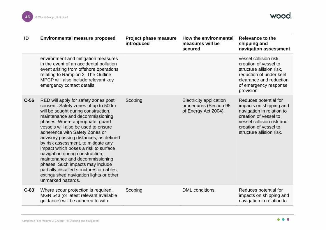
46 © Wood Group UK Limited
Rampion 2 PEIR. Volume 2, Chapter 13: Shipping and navigation
ID Environmental measure proposed Project phase measure introduced
How the environmental measures will be secured
Relevance to the shipping and navigation assessment
environment and mitigation measures in the event of an accidental pollution event arising from offshore operations relating to Rampion 2. The Outline MPCP will also include relevant key emergency contact details.
vessel collision risk, creation of vessel to structure allision risk, reduction of under keel clearance and reduction of emergency response provision.
C-56 RED will apply for safety zones post consent. Safety zones of up to 500m will be sought during construction, maintenance and decommissioning phases. Where appropriate, guard vessels will also be used to ensure adherence with Safety Zones or advisory passing distances, as defined by risk assessment, to mitigate any impact which poses a risk to surface navigation during construction, maintenance and decommissioning phases. Such impacts may include partially installed structures or cables, extinguished navigation lights or other unmarked hazards.
Scoping Electricity application procedures (Section 95 of Energy Act 2004).
Reduces potential for impacts on shipping and navigation in relation to creation of vessel to vessel collision risk and creation of vessel to structure allision risk.
C-83 Where scour protection is required, MGN 543 (or latest relevant available guidance) will be adhered to with
Scoping DML conditions. Reduces potential for impacts on shipping and navigation in relation to

47 © Wood Group UK Limited
Rampion 2 PEIR. Volume 2, Chapter 13: Shipping and navigation
ID Environmental measure proposed Project phase measure introduced
How the environmental measures will be secured
Relevance to the shipping and navigation assessment
respect to changes greater than 5 percent to the under-keel clearance in consultation with the MCA and Trinity House.
reduction of under keel clearance.
C-84 RED will exhibit lights, marks, sounds, signals and other aids to navigation as required by Trinity House, MCA and Civil Aviation Authority (CAA). This will include a buoyed construction area around the Rampion 2 array.
Scoping DML conditions. Reduces potential for impacts on shipping and navigation in relation to displacement of vessels, creation of vessel to vessel collision risk, creation of vessel to structure allision risk and reduced access to local ports.
C-85 RED will ensure that the local notice to mariners (NtM) is updated and reissued at weekly intervals during construction activities and at least five days before any planned operations and maintenance works and supplemented with VHF (very high frequency) radio broadcasts agreed with the Maritime & Coastguard Agency (MCA) in accordance with the construction and monitoring
Scoping DML conditions. Reduces potential for impacts on shipping and navigation in relation to displacement of vessels, creation of vessel to vessel collision risk and creation of vessel to structure allision risk.

48 © Wood Group UK Limited
Rampion 2 PEIR. Volume 2, Chapter 13: Shipping and navigation
ID Environmental measure proposed Project phase measure introduced
How the environmental measures will be secured
Relevance to the shipping and navigation assessment
programme approved under deemed marine licence condition.
C-86 A layout plan (including cables) will be agreed with the MMO following appropriate consultation with Trinity House and the Maritime & Coastguard Agency (MCA) setting out proposed details of the authorised Proposed Development.
Scoping DML conditions. Reduces potential for impacts on shipping and navigation in relation to creation of vessel to structure allision risk.
C-87 No part of the authorised Proposed Development may commence until the MMO, in consultation with the Maritime & Coastguard Agency (MCA), has confirmed in writing that the undertaker has taken into account and, so far as is applicable to that stage of the Proposed Development, adequately addressed all MCA recommendations as appropriate to the authorised Proposed Development contained within MGN543 "Offshore Renewable Energy Installations (OREIs) – Guidance on UK Navigational Practice, Safety and Emergency Response Issues" (Maritime & Coastguard Agency, 2016) and its annexes.
Scoping - updated at PEIR
DML conditions. Reduces potential for impacts on shipping and navigation in relation to reduction of emergency response provision.

49 © Wood Group UK Limited
Rampion 2 PEIR. Volume 2, Chapter 13: Shipping and navigation
ID Environmental measure proposed Project phase measure introduced
How the environmental measures will be secured
Relevance to the shipping and navigation assessment
C-88 Marine coordination will be implemented to manage Rampion 2 vessels throughout construction and maintenance periods.
Scoping Secured in the description of the development.
Reduces potential for impacts on shipping and navigation in relation to creation of vessel to vessel collision risk, reduced access to local ports, creation of vessel to structure allision risk and reduction of emergency response provision.
C-89 There will be a minimum blade tip clearance of at least 22m above highest astronomical tide (HAT).
Scoping Secured in the description of the development.
Reduces potential for impacts on shipping and navigation in relation to creation of vessel to structure allision risk.

50 © Wood Group UK Limited
Rampion 2 PEIR. Volume 2, Chapter 13: Shipping and navigation
13.8 Methodology for PEIR assessment
Introduction
13.8.1 The project-wide generic approach to assessment is set out in Chapter 5: Approach to the EIA. The assessment methodology for shipping and navigation for the PEIR is consistent with that provided in the Scoping Report (RED, 2020) and no changes have been made since the scoping phase.
Application of guidance
13.8.2 The guidance documents outlined in Section 13.2 have been considered in defining the assessment methodology for shipping and navigation.
13.8.3 As per the MCA methodology (MCA, 2013), an NRA has been undertaken, where impacts are assessed on a preliminary basis to determine which should be included within the EIA. This should be considered a technical document supporting the PEIR.
13.8.4 The IMO FSA methodology (IMO, 2018) is the internationally recognised approach for assessing effects on shipping and navigation receptors, and is the approach required under the MCA methodology (MCA, 2013). This methodology is centred on risk control and assesses each effect in terms of its frequency and consequence in order that its significance can be determined as “Broadly Acceptable”, “Tolerable” or “Unacceptable”. Any effect assessed as unacceptable requires additional environmental measures implemented beyond those considered embedded in order that the effect is reduced to within tolerable or broadly acceptable parameters.
Impact significance ranking
13.8.5 Impact significance is determined via a risk ranking matrix assessing frequency and consequence. The frequency and consequence, as part of the NRA process, is related to the parameters required by the IMO FSA.
13.8.6 The frequency and consequence rankings per effect are determined using a number of inputs, notably:
⚫ output of the baseline assessment including the summer vessel traffic survey;
⚫ consideration of embedded environmental measures in place;
⚫ lessons learnt from other offshore wind farm developments;
⚫ level of stakeholder concern; and
⚫ consultation output.
13.8.7 The risk ranking matrix is presented in Table 13-13.

51 © Wood Group UK Limited
Rampion 2 PEIR. Volume 2, Chapter 13: Shipping and navigation
Table 13-13 Risk ranking matrix for shipping and navigation
Co
nseq
ue
nce
Major Tolerable Tolerable Unacceptable Unacceptable Unacceptable
Serious Broadly Acceptable
Tolerable Tolerable Unacceptable Unacceptable
Moderate Broadly Acceptable
Broadly Acceptable
Tolerable Tolerable Unacceptable
Minor Broadly Acceptable
Broadly Acceptable
Broadly Acceptable
Tolerable Tolerable
Negligible Broadly Acceptable
Broadly Acceptable
Broadly Acceptable
Broadly Acceptable
Tolerable
Negligible Extremely Unlikely
Remote Reasonably Probable
Frequent
Frequency
13.8.8 Effects determined to be of Broadly Acceptable significance are low risk and not significant in EIA terms. Effects determined to be of Tolerable significance are intermediate risk and not significant in EIA terms. Effects determined to be of Unacceptable significance are high risk and significant in EIA terms.
13.9 Preliminary assessment: Construction phase
Displacement of vessels
Overview
13.9.1 Construction activities associated with the installation of structures and cables may displace existing routes/activity, increase grounding risk, increase encounters and collision risk with other third-party vessels.
13.9.2 The subject of vessel displacement and its potential consequences were raised by multiple stakeholders during consultation including Cobelfret Ferries, UECC, Britannia Aggregates, DEME, VDL, Cemex and Hanson Marine.
13.9.3 Each element of this impact is considered in turn in terms of frequency and consequence, with the resulting significance of the residual risk across the various elements summarised at the end of the assessment. The elements considered include:
⚫ vessel displacement;
⚫ adverse weather routeing;
⚫ encounters and collision risk;
⚫ grounding risk; and
⚫ commercial risk.

52 © Wood Group UK Limited
Rampion 2 PEIR. Volume 2, Chapter 13: Shipping and navigation
Vessel displacement
Overview
13.9.4 The volume of vessel traffic passing within or in proximity to the array area has been established using vessel traffic data collected during dedicated surveys (28 days, summer and winter 2020) and from coastal receivers (12 months, 2019), as well as Anatec’s ShipRoutes database. These datasets were interrogated to identify main routes using the principles set out in MGN 543 (MCA, 2016) (see Section 13.6).
13.9.5 Although there will be no restrictions on entry into the buoyed construction area, other than active construction or pre-commissioning safety zones, based on experience at previously under construction offshore wind farms (including at Rampion 1), it is anticipated that commercial vessels will choose not to navigate internally within the buoyed construction area and therefore some main route deviations will be required.
13.9.6 The full methodology for main route deviations is provided in Section 17 of Appendix 13.1, Volume 4, with deviations established in line with MGN 372 (MCA, 2008). A deviation will be required for six out of the 17 main routes identified within the study area, with the level of deviation varying between 0.1nm for Route 3 (westbound lane of the Dover Strait Traffic Separation Scheme (TSS) to westbound lane of the Off Casquet TSS) and 14.3nm for Route 17 (Littlehampton–Dover Strait TSS), noting that vessel traffic levels on Route 17 are very low (around once a month). Table 13-10 presents the increase in distance from the pre wind farm scenario7 for the displaced routes. Following this, an illustration of the anticipated worst case shift in the mean positions of the main routes is presented in Figure 13.8, Volume 3.
Table 13-14 Summary of post wind farm main route deviations within study area
Route number Average vessels per day Increase in Route Length (nm)
3 5 0.1
8 2 0.2
9 1 to 2 0.1
11 1 2.8
16 0 to 1 1.8
17 Monthly 14.3
13.9.7 Route 3 (westbound lane of the Dover Strait TSS to Solent ports) is the busiest main route identified within the study area for which a deviation will be required,
7 Use of the term ‘pre wind farm scenario’ relates specifically to shipping and navigation and refers to the current scenario with Rampion 1 in situ but not Rampion 2.

53 © Wood Group UK Limited
Rampion 2 PEIR. Volume 2, Chapter 13: Shipping and navigation
with an average of five vessels per day. The impact will be present throughout the construction phase.
13.9.8 Based on experience at previously under construction offshore wind farms (including at Rampion 1), it is anticipated that fishing vessels and recreational vessels will also choose not to navigate routinely internally within the buoyed construction area. There is sufficient sea room available (including at the eastern extent of the array area in proximity to the Dover Strait TSS and at the western extent of the array area in proximity to the Owers Bank) for such vessels to be accommodated. However, marine aggregate dredging stakeholders did note during consultation that there may be a risk of displaced fishing vessels passing in proximity to current active extraction areas – additional consultation will be undertaken with marine aggregate dredging stakeholders post-PEIR to address this concern in Chapter 7: Other marine users.
13.9.9 Noting a concern raised by the RYA in relation to larger recreational craft being displaced into inshore waters resulting in increased interaction with smaller craft, the increase in recreational traffic landward of the array area is likely to be low given that the majority of recreational traffic is already located landward of the array area. This landward traffic includes the east-west passage of recreational vessels between the Solent and Eastbourne, another potentially sensitive passage highlighted by the RYA. Displacement of active commercial fishing is assessed separately in Chapter 10: Commercial fisheries.
13.9.10 During consultation, the Ministry of Defence raised a concern that any installation in Danger Area D037 will impact on freedom of movement for military exercises. From the vessel traffic survey data, on average less than one unique military vessel per day was recorded within the entire study area, a volume validated by the long-term AIS data8. Additionally, the portion of Danger Area D037 overlapping the PEIR Assessment Boundary constitutes approximately 0.9 percent of the total area covered by Danger Area D037, and a substantially smaller portion of the total area covered by military PEXAs in the region as a whole. Therefore, the disruption to military exercises is likely to be very limited.
13.9.11 The main consequence of vessel displacement will be increased journey times and distances for affected third-party vessels, over a large spatial extent, particularly as it is assumed that the buoyed construction area will be deployed around the maximum extent of the array area.
Frequency of impact
13.9.12 The frequency of the impact in relation to displacement of vessel traffic is considered reasonably probable.
Consequences of impact
13.9.13 The consequences of the impact in relation to displacement of vessel traffic is considered negligible.
8 It is noted that during sensitive operations military vessels are allowed to switch off their AIS transmitter.

54 © Wood Group UK Limited
Rampion 2 PEIR. Volume 2, Chapter 13: Shipping and navigation
Adverse weather routeing
13.9.14 The need to consider routeing in adverse weather conditions was highlighted by the MCA during consultation. However, since no substantial alternative routeing was observed (based on the 12-months of AIS data as well as the 28-day vessel traffic survey data) nor any transit cancellations which could be traced to adverse weather, no impact on adverse weather routeing has been identified and, hence, assessed.
Encounters and collision risk
Overview
13.9.15 The deviation of vessels may result in an increased number of encounters between third-party vessels and subsequently an increased collision risk.
13.9.16 Given the small increase in route length associated with Routes 3, 8 and 9, there is not anticipated to be any substantial increase in the likelihood of an encounter from these routes. In the case of Route 3, UECC – a regular operator on Route 3 – indicated during consultation that only a small adjustment will be required with the total distance of the route remaining similar and no effect on safe passage.
13.9.17 For Route 11, although the deviation involves a greater change to the spatial extent of the route, there is limited other routeing traffic east of the array area. Given that traffic on this route is headed out of or into the Dover Strait TSS (and so is present in a north-south direction in the pre wind farm scenario), there is not expected to be any additional interaction with TSS based traffic, and so the creation of an encounter hotspot with other routeing commercial traffic is considered unlikely. During consultation the RYA raised a concern that this deviation could create additional interaction with small numbers of recreational vessels engaged in long distance cruising in the area; although this will be the case, such mariners are expected to be highly experienced (given the distances involved), display good seamanship and have a heightened level of awareness given the proximity to the end of the Dover Strait TSS. Therefore, the risk of an interaction with recreational vessels is considered low.
13.9.18 For Routes 16 and 17, the anticipated deviation results in these routes interacting with other main routes passing the north western and south western extents of the array area. Subsequently, the likelihood of an encounter in these areas is increased, although the low volumes of traffic on these routes (Route 17 in particular was identified through consultation with Littlehampton Harbour Board rather than from vessel traffic data) minimises the likelihood of an encounter occurring.
13.9.19 With the main commercial route deviations associated with the presence of Rampion 2 construction in place, the base case annual vessel to vessel collision frequency for third party vessels is estimated to be 1.03×10⁻¹, corresponding to a return period of approximately one in 9.7 years. It is noted that annual frequency is the number of expected occurrences per year, whereas the return period is the expected number of years between occurrences, the inverse of the annual frequency. For example, a return period of one in 100 years indicates that over a 100-year period the expected number of occurrences is one. This is different from the notion that it will take 100 years for one instance to occur. The use of annual
55 © Wood Group UK Limited
Rampion 2 PEIR. Volume 2, Chapter 13: Shipping and navigation
frequency and return period is a standard method of presenting the results of NRA modelling related to offshore installations.
13.9.20 The return period of one in 9.7 years is high compared to that estimated for other UK offshore wind farm developments and is reflective of the high volume of vessel traffic in the area, particularly within and out of the Dover Strait TSS and out of the Solent. However, the collision frequency represents only a 1.2 percent increase compared to the pre wind farm base case scenario, indicating that the influence of Rampion 2 on collision risk is low.
13.9.21 During consultation, the MCA noted that the squeeze of small craft into the routes of larger commercial vessels should be considered. Given that recreational traffic is primarily based nearshore, the effect of the main commercial route deviations outlined on such traffic is expected to be low. In particular, the area where commercial vessel density is most likely to increase (at the western extent of the PEIR Assessment Boundary in proximity to the Owers Bank) is not a prominent location for recreational vessel transits, with small craft primarily navigating through the shallows of the Looe closer to shore.
13.9.22 However, the deviation of Route 11 around the eastern extent of the PEIR Assessment Boundary will result in increased movements within the ITZ, an area designed to protect local traffic including small craft. Taking the movements of small craft into account, the level of interaction between this routeing traffic and small craft is not expected to increase markedly given that the route will still cross the two bands of recreational traffic out of Newhaven and Brighton (both headed for the Solent) that constitute the majority of small craft movements relevant to the approach to Shoreham from the Dover Strait TSS. Additionally, the restrictions which apply to the ITZ do allow for vessels to utilise it when on route to/from a port within the ITZ (such as Shoreham).
13.9.23 With respect to all vessels, the impact will be present throughout the construction phase, but the promulgation of information (C-46 and C-85, Table 13-12) relating to construction activities – including the deployment of the buoyed construction area – and charting of infrastructure will allow vessel Masters to passage plan in advance, minimising disruption. Additionally, information for fishing vessels will also be promulgated through ongoing liaison with fishing fleets via an appointed FLO (C-47, Table 13-12). Experience from previous under construction offshore wind farms indicates that the extensive promulgation of information is an effective mitigation, with evidence suggesting that Masters regularly choose to transit greater than 1nm from construction works.
13.9.24 As an extension to this, RED will exhibit lights, marks, sounds, signals and other aids to navigation as required by Trinity House, MCA and CAA, including the buoyed construction area (C-84, Table 13-12). These navigational aids will further maximise mariner awareness when in proximity, both in day and night conditions including in poor visibility.
13.9.25 Also, the minimum spacing between structures (860m) is sufficient to ensure the view of other vessels will not be blocked or hindered, again reducing the likelihood of an encounter occurring in proximity to Rampion 2.
13.9.26 In the event that an encounter does occur, it is likely to be very localised and occur for only a short duration, with collision avoidance action implemented by the

56 © Wood Group UK Limited
Rampion 2 PEIR. Volume 2, Chapter 13: Shipping and navigation
vessels involved, in line with the COLREGs, thus ensuring that the situation does not develop into a collision incident. This is supported by experience at previous under construction offshore wind farms, where no collision incidents involving two third-party vessels have been reported.
13.9.27 Should a collision occur, the most likely consequences will also be low based on historical collision incidents, with minor contact between the vessels resulting in minor damage and no injuries to persons, with both vessels able to resume their respective passages and undertake a full inspection at the next port. As an unlikely worst case, one of the vessels could be foundered resulting in a Potential Loss of Life (PLL) and pollution.
13.9.28 It is noted that monitoring of vessel traffic will be undertaken for the duration of the construction phase (C-48, Table 13-12) to characterise vessel displacement (relative to that predicted in the NRA) with the environmental measures adjusted accordingly. If pollution were to occur in proximity to Rampion 2, then the MPCP will be implemented (C-53, Table 13-12) to minimise the environmental effects.
Frequency of impact
13.9.29 The frequency of the impact in relation to encounters and collision risk is considered extremely unlikely.
Consequences of impact
13.9.30 The consequences of the impact in relation to encounters and collision risk is considered moderate.
Grounding risk
Overview
13.9.31 The deviation of vessels may result in an increased grounding risk for third-party vessels.
13.9.32 Water depths within and in proximity to the array area are generally suitably deep (greater than 20m) to prevent any risk of grounding. In particular, the displacement associated with Routes 3, 9, 11 and 16 does not result in vessels on these routes navigating in reduced water depths. The displacement associated with Routes 8 and 17 involves passing west of the PEIR Assessment Boundary, with Shoreham Port raising during consultation that such deviations may result in vessels being at greater risk of grounding landward of the site. Therefore, these two routes are assessed in further detail.
13.9.33 Route 8 (Shoreham–marine aggregate dredging areas near the Isle of Wight) is anticipated to pass closer to the Outer Owers where water depths drop considerably (less than 5m). However, the presence of the Owers Light Buoy, a south cardinal mark located approximately 1.8nm to the west of the array area, should serve its purpose of protecting vessels from the shallows of the Owers Bank by directing vessels to the south. There remains sufficient sea room for Route 8 to safely pass between the array area and the Owers Light Buoy (approximately 1.8nm), and thus the increase in grounding risk for vessels on Route 8 is not considered substantial.

57 © Wood Group UK Limited
Rampion 2 PEIR. Volume 2, Chapter 13: Shipping and navigation
13.9.34 Route 17 (Littlehampton–Dover Strait TSS) is also anticipated to pass close to the Outer Owers although did not do so in the pre wind farm scenario. Noting the water depths along the pre wind farm approach of the route to Littlehampton (as low as 12m) it is not considered that there will be any substantial reduction in water depth for vessels navigating on Route 17, particularly noting again the presence of the Owers Light Buoy to protect vessels from the shallows of the Owers Bank. Additionally, the vessels observed on Route 17 are small coasters which from the long-term vessel traffic data operate in this area with draughts of less than 5m. As with Route 8, there remains sufficient sea room for Route 17 to safely pass between the array area and the Owers Light Buoy (approximately 1.8nm), outside of areas where the water depth drops considerably (less than 5m inshore of the buoy), and thus the increase in grounding risk for vessels on Route 17 is not considered substantial.
13.9.35 In the case of both Routes 8 and 17, it is noted that the PEIR Assessment Boundary represents a reduction in the total area covered compared to the Scoping Boundary, including at the western extent of the array area. This reduction assists in ensuring vessels on these routes have sufficient sea room to avoid the shallows of the Owers Bank.
13.9.36 For small craft operating in nearshore waters – particularly in proximity to the export cables – the likelihood of a grounding incident is greater. Although the impact will be present throughout the construction phase, in line with good seamanship it is also anticipated that any vessel navigating in the area will check relevant nautical charts, and thus ensure the vessel does not navigate into a location where there is a substantial likelihood of grounding.
13.9.37 Should a grounding incident occur, the most likely consequences will be low based on historical grounding incidents, with minor damage incurred and no injuries to persons with the vessel able to resume passage and undertake a full inspection at the next port. As an unlikely worst case, the vessel could founder resulting in a PLL and pollution. Again, if pollution were to occur in proximity to Rampion 2, then the MPCP will be implemented (C-53, Table 13-12) to minimise the environmental effects.
Frequency of impact
13.9.38 The frequency of the impact in relation to grounding risk is considered remote.
Consequences of impact
13.9.39 The consequences of the impact in relation to grounding risk are considered moderate.
Commercial risk
Overview
13.9.40 Based on consultation with local vessel operators, there is a commercial risk posed by the presence of Rampion 2, specifically with regard to marine aggregate dredging transits. This subsection considers this element of the impact, separate from risks relating to navigational safety.

58 © Wood Group UK Limited
Rampion 2 PEIR. Volume 2, Chapter 13: Shipping and navigation
13.9.41 During consultation, Britannia Aggregates and VDL each raised a concern that established routes between Shoreham, Newhaven or Solent ports (Portsmouth and Southampton) and marine aggregate dredging areas close to the Isle of Wight, in the central English Channel or the Outer Thames/east coast could be impacted by the presence of Rampion 2. Britannia Aggregates raised a particular concern over the route between Shoreham and the East Channel licence areas since a detour of 8 to 10nm could have a commercial effect due to fuel and time increases.
13.9.42 It is noted that the PEIR Assessment Boundary represents a reduction in the total area covered compared to the Scoping Boundary, including at both the eastern and western extents of the array area. These reductions reduce the size of the deviation required for some of the routes outlined above.
13.9.43 The main routes identified within the study area include a number of routes with a proportion of marine aggregate dredgers (Routes 8, 9, 11 and 12) which characterise most the routeing raised by marine aggregate dredging representatives and constitute up to three vessels per day. As discussed in the vessel displacement component of this impact, there is either no deviation required for these routes due to the presence of Rampion 2 (Route 12); or the level of deviation is considered to be low (maximum 2.8nm for Route 11 – see Table 13-14). Therefore, the commercial effect on these routes, including additional transit time and fuel consumption is considered to be minimal with no substantial disruption caused.
13.9.44 One of the routes highlighted by Britannia Aggregates – between Newhaven and the central English Channel to the east of the PEIR Assessment Boundary – was observed in the vessel traffic survey data but not in sufficient numbers to constitute a main route. However, such traffic passes well clear of the PEIR Assessment Boundary and so the effect associated with such traffic is negligible.
Frequency of impact
13.9.45 The frequency of the impact in relation to commercial risk is considered remote.
Consequences of impact
13.9.46 The consequences of the impact in relation to commercial risk are considered minor.
Significance of residual effect
13.9.47 Table 13-15 summarises the assessment of frequency and consequence of impact and the resulting significance of the residual effect for each component of this impact in relation to navigational safety.

59 © Wood Group UK Limited
Rampion 2 PEIR. Volume 2, Chapter 13: Shipping and navigation
Table 13-15 Summary of impact rankings for vessel displacement during construction phase (navigational safety)
Component of impact
Frequency Consequence Residual effect
Vessel displacement
Reasonably Probable
Negligible Broadly Acceptable
Encounters and collision risk
Extremely Unlikely Moderate Broadly Acceptable
Grounding risk Remote Moderate Tolerable
13.9.48 Table 13-16 summarises the assessment of frequency and consequence of impact and the resulting significance of the residual effect for this impact in relation to commercial risk.
Table 13-16 Summary of impact rankings for vessel displacement during construction phase (commercial risk)
Component of impact
Frequency Consequence Residual effect
Commercial risk Remote Minor Broadly Acceptable
13.9.49 Overall, it is predicted that the effect is of Tolerable significance, which is Not Significant in EIA terms.
Creation of vessel to vessel collision risk between a third-party vessel and a project vessel
Overview
13.9.50 Vessels associated with construction activities may increase encounters and collision risk for other vessels already operating in the area.
13.9.51 Up to 2,636 return trips by construction vessels may be made throughout the construction phase, including vessels Restricted in their Ability to Manoeuvre (RAM). It is assumed that construction vessels will be on-site throughout the construction phase.
13.9.52 Encounter and collision risk involving a project vessel will be managed by marine coordination (C-88, Table 13-12) including the application of traffic management procedures such as the designation of entry and exit points to and from the array and routes to and from construction ports. Such procedures will take account of those areas where collision risk is assessed as greatest (where third-party vessels pass or undertake operational activities in proximity to the array area frequently

60 © Wood Group UK Limited
Rampion 2 PEIR. Volume 2, Chapter 13: Shipping and navigation
such as marine aggregate dredgers). Additionally, experience from and procedures established for Rampion 1 will be taken into account, project vessels will carry AIS and be compliant with Flag State regulations including IMO conventions such as the COLREGs and guidance such as MGN 372 (MCA, 2008), and information for fishing vessels will also be promulgated through ongoing liaison with fishing fleets via an appointed FLO (C-47, Table 13-12).
13.9.53 Furthermore, an application for safety zones of 500m will be sought during the construction phase (C-56, Table 13-12). These will serve to protect project vessels engaged in construction activities. Minimum advisory passing distances, as defined by risk assessment, may also be applied, with advanced warning and accurate locations of both safety zones and any minimum advisory safe passing distances provided by Notices to Mariners and Kingfisher Bulletins (C-46 and C-85, Table 13-12).
13.9.54 Also, RED will exhibit lights, marks, sounds, signals and other aids to navigation as required by Trinity House and MCA, including the buoyed construction area (C-84, Table 13-12). These navigational aids will further maximise mariner awareness when in proximity, both in day and night conditions including in poor visibility.
13.9.55 Third party vessels may experience restrictions on visually identifying project vessels entering and exiting the array during reduced visibility; however this hazard will be mitigated by the application of the COLREGs (reduced speeds) in adverse weather conditions and project vessels mandatorily will carry AIS regardless of size.
13.9.56 The likelihood of a collision is likely to be greater in reduced visibility when the identification of project vessels entering and exiting the array may be encumbered. However, the COLREGs regulate vessel movements in adverse weather conditions and require all vessels operating in reduced visibility to reduce speed to allow more time for reacting to encounters, thus minimising the collision risk.
13.9.57 Based on historical incident data, there have been two instances of a third-party vessel colliding with a project vessel. In both incidents moderate vessel damage was reported with no harm to persons. It is noted that the two incidents occurred in 2011 and 2012, respectively, and awareness of offshore wind developments and application of the measures outlined above has improved and been refined considerably in the interim, with no further collision incidents reported since.
13.9.58 Should an encounter occur between a third-party vessel and a project vessel, it is likely to be very localised and occur for only a short duration. With collision avoidance action implemented in line with the COLREGs, the vessels involved will likely be able to resume their respective passages and/or activities with no long-term consequences.
13.9.59 Should a collision occur, the most likely consequences will be similar to that outlined for the case of a collision between two third-party vessels, namely minor contact between the vessels resulting in minor damage and no injuries to persons with both vessels able safely make their next port to undertake a full inspection. As an unlikely worst case, one of the vessels could be foundered resulting in a PLL and pollution. If pollution were to occur in proximity to Rampion 2 or involving a

61 © Wood Group UK Limited
Rampion 2 PEIR. Volume 2, Chapter 13: Shipping and navigation
project vessel, then the MPCP will be implemented (C-53, Table 13-12) to minimise the environmental effects.
Frequency of impact
13.9.60 The frequency of the impact is considered to be extremely unlikely.
Consequence of impact
13.9.61 The consequences of the impact are considered to be moderate.
Significance of residual effect
13.9.62 Overall, it is predicted that the effect is of Broadly Acceptable significance, which is Not Significant in EIA terms.
Reduced access to local ports
Overview
13.9.63 Construction activities associated with the installation of structures and cables may displace existing routes/activity restricting access to ports.
13.9.64 To ensure the impact is assessed in as much detail as possible overall, a number of ports and harbours in the area are considered individually, taking account of the vessel traffic movements associated with these ports, based on vessel traffic data and consultation feedback.
13.9.65 Concerns were raised by port operators in relation to commercial risk to local ports, and therefore a separate assessment on this consequence has been undertaken as the last subsection for this impact. The ports considered include:
⚫ Shoreham Port;
⚫ Port of Newhaven;
⚫ Brighton Marina;
⚫ Littlehampton Harbour; and
⚫ ports within the Solent.
Shoreham Port
Overview
13.9.66 As described in Section 13 of Appendix 13.1, Volume 4, fishing vessel traffic is prominent out of Shoreham Port, with fishing vessels both in transit to fishing grounds located south of the array area and actively engaged in fishing within the eastern half of the array area. Therefore, access to Shoreham for fishing vessels may be compromised during the construction phase, assuming that fishing vessels choose not to pass through the buoyed construction area. There is available sea room to the east of the array area for fishing vessels to alter their passage, noting that such traffic is permitted to utilise the ITZ located immediately east of the array

62 © Wood Group UK Limited
Rampion 2 PEIR. Volume 2, Chapter 13: Shipping and navigation
area. Although this will involve passing in proximity to the end of the Dover Strait TSS, these vessels have good familiarity with operating in proximity to the end of the Dover Strait TSS anyway, have good manoeuvrability and are expected to display good seamanship and comply with the COLREGs.
13.9.67 Recreational vessel activity was also observed, although was mostly confined to the nearshore area and the summer period, and so disruption to recreational vessel movements out of Shoreham are not expected to be notable given the majority of vessel activity is a sufficient distance from the array area.
13.9.68 Marine aggregate dredgers were principally observed on two main routes out of Shoreham (Routes 8 and 12), headed for marine aggregate dredging areas near the Isle of Wight and the Owers Bank, constituting up to three vessels per day. Marine aggregate dredgers were also observed on Routes 11 and 13 alongside cargo vessels, between Shoreham and the Dover Strait TSS and North Sea ports, respectively, each constituting less than one vessel per day. Vessels on these routes are unlikely to be disrupted, noting the level of deviation for these routes is low (see the vessel displacement impact).
13.9.69 The pilot boarding station for Shoreham is located approximately 5.9nm north of the array area and therefore the presence of Rampion 2 is not anticipated to have an impact on access to pilotage services, noting that no impact has been reported due to the presence of Rampion 1. The MCA also raised a concern over how displacement of vessel traffic into the ITZ may impact the safety of active pilot vessels. From the vessel traffic data collected during dedicated surveys (28 days, summer and winter 2020) and from coastal receivers (12 months, 2019) it can be seen that pilot vessels operating in the ITZ are largely located within 2nm of Shoreham (also applicable to Newhaven) and therefore the effect of vessel displacement on pilotage operations is anticipated to be minimal.
Frequency of impact
13.9.70 The frequency of the impact for Shoreham Port in relation to navigational safety is considered to be reasonably probable.
Consequences of impact
13.9.71 The consequences of the impact for Shoreham Port in relation to navigational safety are considered to be minor.
Port of Newhaven
Overview
13.9.72 As analysed in Section 13 of Appendix 13.1, Volume 4, two passenger ferries operated by DFDS Seaways are prominent out of the Port of Newhaven, each making a cross-channel passage to Dieppe twice per day. The ferries operate a timetabled service and therefore any disruption will be more likely to have an effect on the operation of the route. However, the route heads south east out of Newhaven and crosses the Dover Strait TSS, staying well clear of the array area; therefore the service’s access to Newhaven is not anticipated to be disrupted. Moreover, by the nature of the timetabled service, it will be particularly straightforward for project vessels to be managed by marine coordination (C-88,

63 © Wood Group UK Limited
Rampion 2 PEIR. Volume 2, Chapter 13: Shipping and navigation
Table 13-12). It is noted that DFDS Seaways were approached as part of consultation outreach but did not choose to participate.
13.9.73 Other non-wind farm related commercial vessel activity at Newhaven is limited, mostly consisting of occasional single transits by cargo vessels and marine aggregate dredgers.
13.9.74 As with at Shoreham, recreational vessels were observed but mostly confined to the nearshore area and the summer period; however some recreational traffic was observed headed directly to/from ports in the Solent. Fishing vessel activity was also observed mostly within 3nm of the port. The effect on port access for fishing and recreational users operating nearshore is not anticipated to be substantial when considering the distance from the array area and the marine coordination that will be implemented for project vessels. Recreational traffic which transits east-west out of Newhaven passes north of the Array Area but crosses the offshore export cable corridor and therefore could be disrupted. However, it is anticipated that given the nature of the export cable installation, only a section of the offshore export cable corridor will have a cable laying vessel (and other construction vessels) present at any one time and so recreational vessels will still be able to safely navigate to Newhaven with minimal disruption. Additionally, export cable installation is expected to be last up to four months only.
13.9.75 The pilot boarding station for Newhaven is located approximately 7.1nm north east of the array area. Newhaven Port & Properties confirmed during consultation that there is not expected to be any impact on pilot operations given the distance from the PEIR Assessment Boundary. Also, as with Shoreham, Newhaven was a key base for the construction of Rampion 1 and no notable effects from this have been reported (including during consultation for Rampion 2).
Frequency of impact
13.9.76 The frequency of the impact for the Port of Newhaven in relation to navigational safety is considered to be reasonably probable.
Consequences of impact
13.9.77 The consequences of the impact for the Port of Newhaven in relation to navigational safety is considered to be negligible.
Brighton Marina
Overview
13.9.78 As analysed in Section 13 of Appendix 13.1, Volume 4, recreational vessel traffic is the predominant activity associated with Brighton Marina. The majority of such traffic is located nearshore or headed directly to/from ports in the Solent, although some visits to Rampion 1 do occur (wind farm trips) as well as recreational dive charter visits to numerous wrecks in the area.
13.9.79 As with fishing and recreational users operating nearshore at Newhaven, the effect on port access for those vessels is not anticipated to be substantial when considering the marine coordination that will be implemented for project vessels (C-88, Table 13-12). Recreational traffic which transits east-west out of Brighton passes north of the array area but crosses the offshore export cable corridor and

64 © Wood Group UK Limited
Rampion 2 PEIR. Volume 2, Chapter 13: Shipping and navigation
therefore could be disrupted. However, as noted above, it is anticipated that given the nature of the export cable installation, only a section of the offshore export cable corridor will have a cable laying vessel (and other construction vessels) present at any one time and so recreational vessels will still be able to safely navigate to Brighton with minimal disruption. Additionally, export cable installation is expected to be completed in up to four months only.
13.9.80 Recreational vessels undertaking visits to Rampion 1 are unlikely to face any additional challenges to port access, noting again the marine coordination that will be implemented for project vessels.
13.9.81 Activity featuring other vessel types related to Brighton including fishing vessels was sparse (noting that Radar data coverage in close proximity to Brighton may not be comprehensive given its location relative to the PEIR Assessment Boundary) and therefore minimal disruption is expected for these other vessel types.
Frequency of impact
13.9.82 The frequency of the impact for Brighton Marina in relation to navigational safety is considered to be remote.
Consequences of impact
13.9.83 The consequences of the impact for Brighton Marina in relation to navigational safety are considered to be negligible.
Littlehampton Harbour
Overview
13.9.84 As analysed in Section 13 of Appendix 13.1, Volume 4, recreational vessel traffic is prominent out of Littlehampton Harbour, including angling charter vessels. However, traffic levels for recreational vessels are generally lower than that observed at Shoreham, Newhaven and Brighton.
13.9.85 Additionally, three small coasters operate a route into Littlehampton from the Dover Strait TSS which, following consultation, has been designated as a main route (Route 17). This route is not used as frequently as other main routes, with transits occurring on a more monthly basis than daily basis on average across the year (on the spring tide).
13.9.86 Consultation also identified a limited volume of fishing vessel and resident workboat activity.
13.9.87 Access to Littlehampton will be compromised for the small coasters out of the Dover Strait TSS, as assessed as part of vessel displacement. Access to the port itself should be mitigated by the implementation of marine coordination for project vessels (C-88, Table 13-12) including the application of traffic management procedures such as the designation of routes to and from port.
13.9.88 Activities relating to the installation of the export cables could cause disruption given the proximity of the offshore export cable corridor to the port and the pilot boarding station (located approximately 120m to the east). As noted in relation to Newhaven and Brighton, it is anticipated that given the nature of the export cable

65 © Wood Group UK Limited
Rampion 2 PEIR. Volume 2, Chapter 13: Shipping and navigation
installation, only a section of the offshore export cable corridor will have a cable laying vessel (and other construction vessels) present at any one time and so the restrictions imposed on access will be much less severe than that associated with the buoyed construction area at the array area. Additionally, export cable installation is expected to be completed in up to four months only. Particular care will be required from project vessels in relation to the pilot boarding area but with marine coordination in place the impact is considered suitably mitigated.
13.9.89 It is noted that during consultation, the Littlehampton Harbour Board indicated that upcoming construction works associated with the A27 Arundel bypass (scheduled to start in 2023/24 and be completed by 2030) may lead to a significant increase in marine traffic volumes associated with Littlehampton. Should the construction phase of Rampion 2 coincide with these works then constraints on port access may be heightened but not to a level at which additional mitigation is required. Additional operations associated with replacement of the harbour entrance breakwaters at Littlehampton by 2025 are expected to have minimal temporal overlap with the offshore construction of Rampion 2.
Frequency of impact
13.9.90 The frequency of the impact for Littlehampton Harbour in relation to navigational safety is considered to be extremely unlikely.
Consequences of impact
13.9.91 The consequences of the impact for Littlehampton Harbour in relation to navigational safety are considered to be moderate.
Solent ports
Overview
13.9.92 The characterisation of the main routes (see Section 13.6) indicated that a substantial volume of commercial traffic in and out of ports in the Solent pass in proximity to Rampion 2. Specifically Routes 3, 4, 6, 9, 14 and 16 all consist of transits to and from ports in the Solent, constituting up to 16 vessels per day. These routes either enter/exit the Dover Strait TSS or link up with ports in France and feature a passenger ferry route operated by Brittany Ferries between Portsmouth and Ouistreham (Caen).
13.9.93 In terms of non-commercial traffic, some fishing vessel activity was observed out of the Solent although was lower than that associated with Shoreham and Newhaven. Recreational vessel activity was observed out of the Solent, mostly passing through the shallow waters of the Looe to and from Brighton and ports further along the UK south coast.
13.9.94 Given the distance from the PEIR Assessment Boundary, it is not anticipated that on-site construction activities will have any substantial effect on port access. Similarly, numerous navigational features associated with access to the Solent (including pilot boarding stations, designated anchorage areas and the NAB Deep Water Channel) are located a great enough distance from the PEIR Assessment Boundary that there is not anticipated to be any substantial effect on their use. This includes the St. Helen’s Road Anchorage located off the Isle of Wight which

66 © Wood Group UK Limited
Rampion 2 PEIR. Volume 2, Chapter 13: Shipping and navigation
was raised a possible concern by the UK Chamber of Shipping during consultation.
Frequency of impact
13.9.95 The frequency of the impact for Solent ports in relation to navigational safety is considered to be frequent.
Consequences of impact
13.9.96 The consequences of the impact for Solent ports in relation to navigational safety are considered to be negligible.
Significance of residual effect
13.9.97 Table 13-17 summarises the assessment of frequency and consequence of impact and the resulting significance of the residual effect for each receptor of this impact.
Table 13-17 Summary of impact rankings reduced access to local ports during construction phase
Receptor Frequency Consequence Residual effect
Shoreham Port Reasonably Probable
Minor Tolerable
Port of Newhaven Reasonably Probable
Negligible Broadly Acceptable
Brighton Marina Remote Negligible Broadly Acceptable
Littlehampton Harbour
Extremely Unlikely Moderate Broadly Acceptable
Solent ports Frequent Negligible Tolerable
13.9.98 Overall, it is predicted that the effect is of Tolerable significance, which is Not Significant in EIA terms.
13.10 Preliminary assessment: Operation and maintenance phase
Displacement of vessels
Overview
13.10.1 Presence of structures may displace existing routes/activity, increase grounding risk, increase encounters and collision risk with other third-party vessels.

67 © Wood Group UK Limited
Rampion 2 PEIR. Volume 2, Chapter 13: Shipping and navigation
13.10.2 As noted previously, the subject of vessel displacement and its potential consequences were raised by multiple stakeholders during consultation including Cobelfret Ferries, UECC, Britannia Aggregates, DEME, VDL, Cemex and Hanson Marine.
13.10.3 As with the construction phase version of this impact, each element is considered in turn in terms of frequency and consequence, with the resulting significance of the residual risk across the various elements summarised at the end of the assessment. The elements considered include:
⚫ vessel displacement;
⚫ adverse weather routeing;
⚫ encounters and collision risk;
⚫ grounding risk; and
⚫ commercial risk.
Vessel displacement
Overview
13.10.4 Based on experience at existing operational offshore wind farms (including at Rampion 1), it is anticipated that commercial vessels will choose not to navigate internally within the array and therefore the main route deviations established for the equivalent construction phase impact in line with MGN 372 (MCA, 2008) are again considered (see Figure 13.8, Volume 3 and Table 13-14). Consideration of impacts of each route is based on a frequency versus consequence perspective i.e., the size of the deviation against how often the route is used. The busiest main route identified within the study area for which a deviation will be required is Route 3 (westbound lane of the Dover Strait TSS to Solent ports), with an average of five vessels per day. However, the deviation associated with this route is relatively small (0.1nm). The largest main route deviation identified within the study area is Route 17 (Littlehampton–Dover Strait TSS), with a deviation of 14.3nm. However, the volume of vessel traffic associated with this route is very low (monthly). Given that vessels using this route will be able to consider the deviation as part of their passage planning (see paragraph 13.10.120) there are not considered to be significant consequences in relation to the impact as a whole. Additionally, vessels using this route are typically smaller commercial cargo vessels and there is potential that, depending upon the final array layout, these vessels may choose to navigate through the array. The impact will be present throughout the operation and maintenance phase.
13.10.5 Noting that there will be no restrictions on entry into the array, other than active operation and maintenance safety zones, and based on experience at Rampion 1, it is anticipated that both fishing vessels and recreational vessels will navigate internally within the array during the summer months, noting that the minimum spacing between structures at Rampion 2 (860m) is greater than that at Rampion 1 (750m). Subsequently the displacement of such vessels in transit is not anticipated to be substantial in the summer months, although may be analogous with the level of displacement anticipated for the construction phase during the winter months, depending on the spacing between structures in the final array

68 © Wood Group UK Limited
Rampion 2 PEIR. Volume 2, Chapter 13: Shipping and navigation
layout. This includes the potential for displacement of fishing vessels into current active extraction areas – additional consultation will be undertaken with marine aggregate dredging stakeholders post-PEIR to address this concern in Chapter 7: Other marine users. Displacement of active commercial fishing is assessed separately in Chapter 10: Commercial fisheries where consultation on spacing between structures will be considered.
13.10.6 Military vessels are less likely to choose to navigate internally within the array, and therefore the discussion relating to Danger Area D037 for the equivalent construction phase impact is again applicable. In particular, given the low frequency of military traffic9 and the portion of the military PEXA overlapping the PEIR Assessment Boundary relative to the PEXAs in the region as a whole, the disruption to military activities is likely to be minimal.
13.10.7 With the main route deviations matching those established for the equivalent construction phase impact, the main consequences of vessel displacement are considered to be the same, namely increased journey times and distances for affected third-party vessels, covering a large spatial extent.
Frequency of impact
13.10.8 The frequency of the impact in relation to displacement of vessel traffic is considered reasonably probable.
Consequences of impact
13.10.9 The consequences of the impact in relation to displacement of vessel traffic is considered negligible.
Adverse weather routeing
13.10.10 As per the construction phase, since no substantial alternative routeing was observed (based on the 12-months of AIS data as well as the 28-day vessel traffic survey data) nor any transit cancellations which could be traced to adverse weather, no impact on adverse weather routeing has been identified or assessed.
Encounters and collision risk
Overview
13.10.11 The deviation of vessels may result in an increased number of encounters between third-party vessels and subsequently an increased collision risk.
13.10.12 Since the main route deviations mirror those established for the equivalent construction phase impact, the likelihood of an encounter occurring is the same. In particular, Routes 16 and 17 pose the greatest increase in encounter risk, but the volumes of traffic on these routes minimise the likelihood of an encounter occurring. Additionally, the effect of the main route deviations on small craft is
9 As noted for the construction phase, during sensitive operations military vessels are allowed to switch off their AIS transmitter and therefore the volume of military traffic observed from vessel traffic analysis may be underrepresented.

69 © Wood Group UK Limited
Rampion 2 PEIR. Volume 2, Chapter 13: Shipping and navigation
expected to be low, including in relation to commercial traffic being displaced into the ITZ.
13.10.13 At the Hazard Workshop, development within the ITZ was raised as a potential restriction. The South Inshore and South Offshore Marine Plan states that “proposals that require static sea surface infrastructure or that significantly reduce under keel clearance which encroach upon high density navigation routes… must not be authorised unless there are exceptional circumstances.” (Department for Environment, Food and Rural Affairs (DEFRA), 2018). It also notes that “proposals that compromise these important IMO navigation routes should not be authorised”. An assessment of traffic displacement, use of the ITZ and collision risk all demonstrate that development at the edge of the ITZ in this instance does not compromise navigational routeing or safety, i.e. does not create high risk hotspots of collision risk/squeeze given the use (frequency of encounter) and sea room available for commercial vessels. However, it is noted that for recreational vessels (in peak summer months) and fishing activity (especially in winter when vessels currently avoid transiting the array) there could be additional squeeze on sea room. Consultation has also raised concerns with regards to multiple course alterations required by vessels and vessel aspect confusing mariners as to their true direction/ intention; further assessment and consultation will be undertaken post PEIR.
13.10.14 Concern was also raised as part of the Hazard Workshop in relation to the western extent of the array, although most felt that the increased sea room available (post scoping) was sufficient additional mitigation such as buoyage may be required to fully reduce the risk to acceptable levels. This will be considered further post PEIR in consultation with Trinity House.
13.10.15 For fishing vessels and recreational vessels navigating within the array, there is an increased encounter and collision risk associated with exiting the array. However, taking into account the expected good seamanship that will be exhibited and the minimum spacing between structures (860m) which is sufficient to ensure the view of other vessels will not be blocked or hindered, the risk is not anticipated to be substantial.
13.10.16 In the event that an encounter or collision does occur, the respective consequences are expected to be the same as for the equivalent construction phase impact, with minor damage incurred and no injuries to persons in the case of a collision the most likely consequences and the foundering of one of the vessels resulting in a PLL and pollution the unlikely worst case consequences, with the environmental effects of the latter minimised by the implementation of the MPCP (C-53, Table 13-12).
13.10.17 As with the equivalent construction phase impact, for all vessels the impact will be present throughout the operation and maintenance phase, but the promulgation of information (C-46 and C-85, Table 13-12) relating to maintenance activities and charting of infrastructure will allow vessel Masters to passage plan in advance, minimising disruption. Additionally, information for fishing vessels will also be promulgated through ongoing liaison with fishing fleets via an appointed FLO (C-47, Table 13-12).

70 © Wood Group UK Limited
Rampion 2 PEIR. Volume 2, Chapter 13: Shipping and navigation
Frequency of impact
13.10.18 The frequency of the impact in relation to displacement of vessel traffic is considered reasonably probable.
Consequences of impact
13.10.19 The consequences of the impact in relation to displacement of vessel traffic is considered moderate.
Grounding risk
Overview
13.10.20 The deviation of vessels may result in an increased grounding risk for third-party vessels.
13.10.21 Since the main route deviations mirror those established for the equivalent construction phase impact, the likelihood of a grounding incident for a commercial vessel occurring is the same. In particular, for Routes 8 and 17 there is an increased risk due to the proximity of these routes to the Outer Owers where water depths drop considerably (less than 5m), but the presence of the Owers Light Buoy will assist in protecting vessels from the shallows of the Owers Bank and there is sufficient sea room available for vessels to pass safely between the array area and Owers Light Buoy, particularly given the reduction in the area covered by the PEIR Assessment Boundary compared to the Scoping Boundary.
13.10.22 In the event that a grounding incident does occur, the consequences are expected to be the same as for the equivalent construction phase impact, with minor damage incurred and no injuries to persons the most likely consequence and the foundering of the vessel resulting in a PLL and pollution the unlikely worst case consequences, with the environmental effects of the latter minimised by the implementation of the MPCP (C-53, Table 13-12).
Frequency of impact
13.10.23 The frequency of the impact in relation to grounding risk is considered extremely unlikely.
Consequences of impact
13.10.24 The consequences of the impact in relation to grounding risk are considered moderate.
Commercial risk
Overview
13.10.25 As previously noted, based on consultation with local vessel operators, there is a commercial risk posed by the presence of Rampion 2, specifically with regard to local port users and marine aggregate dredging transits.
13.10.26 Given that the main route deviations established for the construction phase also apply to the operation and maintenance phase, the impact is considered broadly similar for commercial vessels, including marine aggregate dredgers.
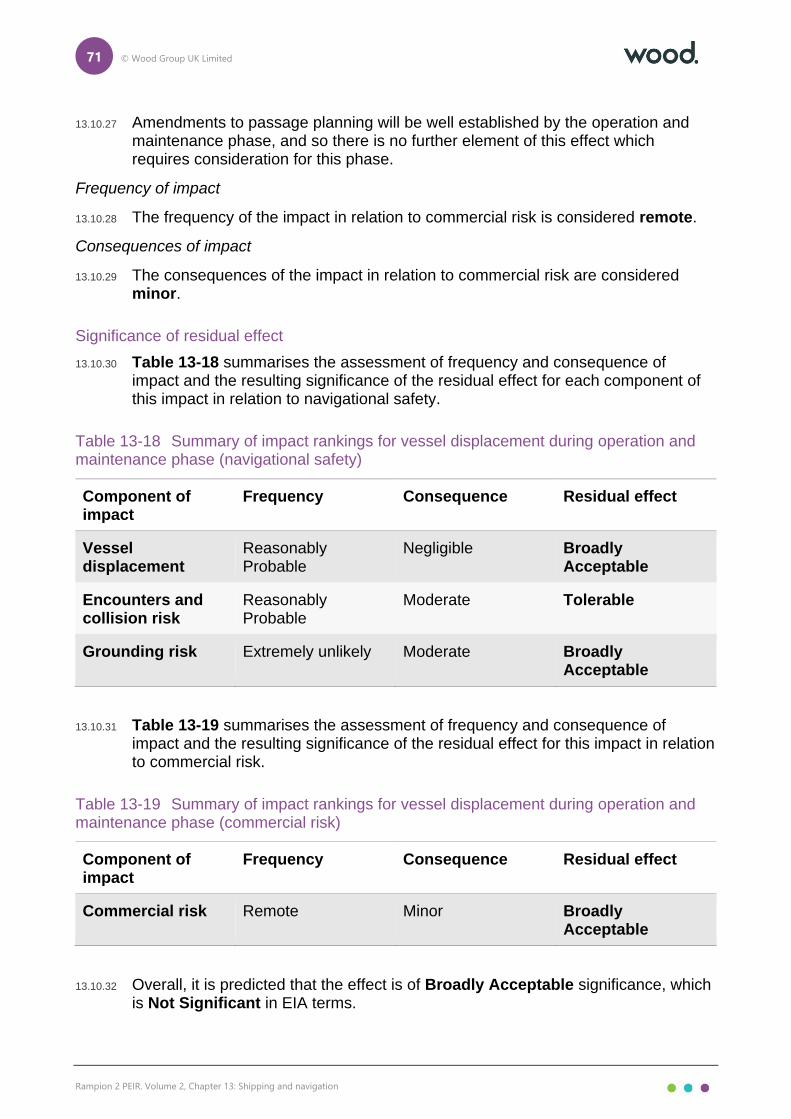
71 © Wood Group UK Limited
Rampion 2 PEIR. Volume 2, Chapter 13: Shipping and navigation
13.10.27 Amendments to passage planning will be well established by the operation and maintenance phase, and so there is no further element of this effect which requires consideration for this phase.
Frequency of impact
13.10.28 The frequency of the impact in relation to commercial risk is considered remote.
Consequences of impact
13.10.29 The consequences of the impact in relation to commercial risk are considered minor.
Significance of residual effect
13.10.30 Table 13-18 summarises the assessment of frequency and consequence of impact and the resulting significance of the residual effect for each component of this impact in relation to navigational safety.
Table 13-18 Summary of impact rankings for vessel displacement during operation and maintenance phase (navigational safety)
Component of impact
Frequency Consequence Residual effect
Vessel displacement
Reasonably Probable
Negligible Broadly Acceptable
Encounters and collision risk
Reasonably Probable
Moderate Tolerable
Grounding risk Extremely unlikely Moderate Broadly Acceptable
13.10.31 Table 13-19 summarises the assessment of frequency and consequence of impact and the resulting significance of the residual effect for this impact in relation to commercial risk.
Table 13-19 Summary of impact rankings for vessel displacement during operation and maintenance phase (commercial risk)
Component of impact
Frequency Consequence Residual effect
Commercial risk Remote Minor Broadly Acceptable
13.10.32 Overall, it is predicted that the effect is of Broadly Acceptable significance, which is Not Significant in EIA terms.

72 © Wood Group UK Limited
Rampion 2 PEIR. Volume 2, Chapter 13: Shipping and navigation
Creation of vessel to vessel collision risk between a third-party vessel and a project vessel
Overview
13.10.33 Vessels associated with operation and maintenance activities may increase encounters and collision risk for other vessels already operating in the area.
13.10.34 Up to 1,113 return trips per year by operation and maintenance vessels may be made throughout the operation and maintenance phase, including vessels restricted in their ability to manoeuvre. It is assumed that operation and maintenance vessels will be on-site throughout the operation and maintenance phase. It is noted that the movement of project vessels during the operation and maintenance phase represents a large decrease in movements in comparison to the construction phase.
13.10.35 As with the equivalent construction phase impact, encounter and collision risk involving a project vessel will be well mitigated, including through marine coordination (C-88, Table 13-12), carriage of AIS and compliance with Flag State regulations by project vessels, and promulgation of information to fishing fleets via an appointed FLO (C-47, Table 13-12).
13.10.36 Furthermore, an application for safety zones of 500m radius will be sought during the operation and maintenance phase (C-56, Table 13-12). These will serve to protect project vessels engaged in major maintenance activities. Minimum advisory passing distances, as defined by risk assessment, may also be applied, with advanced warning and accurate locations of both safety zones and any minimum advisory safe passing distances provided by Notices to Mariners and Kingfisher Bulletins (C-46 and C-85, ).
13.10.37 As with the equivalent construction phase impact, third party vessels may experience restrictions on visually identifying project vessels entering and exiting the array during reduced visibility; however this hazard will be mitigated by the application of the COLREGs (reduced speeds) in adverse weather conditions and project vessels mandatorily will carry AIS regardless of size (C-88, ).
13.10.38 As stated for the equivalent construction phase impact, based on historical incident data, there have been two instances of a third-party vessel colliding with a project vessel. In both incidents moderate vessel damage was reported with no harm to persons. It is noted that the two incidents occurred in 2011 and 2012, respectively, and awareness of offshore wind developments and application of the measures outlined above has improved and been refined considerably in the interim, with no further collision incidents reported since.
13.10.39 Should an encounter or collision occur between a third-party vessel and a project vessel, the consequences are expected to be the same as for the equivalent construction phase impact, with minor damage incurred and no injuries to persons in the case of a collision the most likely consequences and the foundering of one of the vessels resulting in a PLL and pollution the unlikely worst case consequences, with the environmental effects of the latter minimised by the implementation of the MPCP (C-53, Table 13-12).

73 © Wood Group UK Limited
Rampion 2 PEIR. Volume 2, Chapter 13: Shipping and navigation
Frequency of impact
13.10.40 The frequency of the impact is considered to be extremely unlikely.
Consequence of impact
13.10.41 The consequences of the impact are considered to be moderate.
Significance of residual effect
13.10.42 Overall, it is predicted that the effect is of Broadly Acceptable significance, which is Not Significant in EIA terms.
Creation of vessel to structure allision risk
Overview
13.10.43 Presence of structures in the offshore environment may increase allision risk for vessels (both powered and drifting).
13.10.44 The impact is considered in three distinct elements – powered allision risk, drifting allision risk and internal allision risk. In all cases, the spatial extent of the impact is small given that a vessel must be in close proximity to a wind farm structure for an allision incident to occur. The elements considered include:
⚫ powered allision risk;
⚫ drifting allision risk; and
⚫ internal allision risk.
Powered allision risk
Overview
13.10.45 Familiarity with offshore wind farms and navigating in their proximity will be high for vessels operating in proximity to Rampion 2, primarily due to the existing presence of Rampion 1, but – in the case of the large volume of vessel traffic out of the Dover Strait TSS coming from North Sea ports – also due to the increasing number of offshore wind farms present in the North Sea across multiple states.
13.10.46 With the main commercial route deviations associated with the presence of Rampion 2 construction in place, the base case annual powered vessel to structure allision frequency is estimated to be 1.25×10⁻³, corresponding to a return period of approximately one in 799 years. This is a moderate to high return period compared to that estimated for other UK offshore wind farm developments, and is reflective of the high volume of vessel traffic in the area, particularly within and out of the Dover Strait TSS and out of the Solent. The greatest powered vessel to structure allision risk was associated with structures at the western extent of the array area where multiple main commercial routes pass at the minimum mean distance from the array area (1nm) headed into the Solent. The greatest individual allision risk was associated with one of the two structures on the south western edge of the array area (approximately 2.44×10⁻⁴ or one in 4,090 years).

74 © Wood Group UK Limited
Rampion 2 PEIR. Volume 2, Chapter 13: Shipping and navigation
13.10.47 Based on historical incident data, there has been one reported instance of a third-party vessel alliding with an operational wind farm structure in the UK (in the Irish Sea). The incident in question involved fishing vessel where a crew member had left the autopilot on, resulting in the allision incident which was attended by an RNLI lifeboat. Given the navigational measures which exist in proximity to Rampion 2 (such as the Dover Strait TSS and approaches to the Solent) and subsequent heightened alertness, it is unlikely that such an incident will occur in relation to Rampion 2.
13.10.48 Should an allision occur, the consequences will depend on multiple factors including the energy of the impact, structural integrity of the vessel and sea state at the time of the impact. Fishing vessels and recreational vessels are considered most vulnerable to the impact given the potential for a non-steel construction and possible internal navigation within the array by such vessels. In such cases, the most likely consequences will be minor damage with the vessel able to resume passage and undertake a full inspection at the next port. As an unlikely worst case, the vessel could be foundered resulting in a PLL and pollution. If pollution were to occur, then the MPCP will be implemented (C-53, Table 13-12) to minimise the environmental effects.
13.10.49 The offshore substations carry increased powered allision risk and consequences due to their greater size and resistant force. However, the increase is not considered substantial and may be mitigated by the effective use of operational lighting and marking in accordance with requirements from Trinity House and MCA.
Frequency of impact
13.10.50 The frequency of the impact for powered allision risk is considered to be extremely unlikely.
Consequences of impact
13.10.51 The consequences of the impact for powered allision risk are considered to be moderate.
Drifting allision risk
Overview
13.10.52 With the main commercial route deviations associated with the presence of Rampion 2 construction in place, the base case annual drifting vessel to structure allision frequency is estimated to be 1.26×10⁻³, corresponding to a return period of approximately one in 792 years. This is a moderate return period compared to that estimated for other UK offshore wind farm developments, and is reflective of the high volume of vessel traffic in the area, particularly within and out of the Dover Strait TSS and out of the Solent. The greatest drifting vessel to structure allision risk is associated with structures at the western extent of the array area where multiple main commercial routes pass at the minimum mean distance from the array area (1nm) headed into the Solent and on the flood tide will drift towards these structures. The greatest individual allision risk is associated with one of the two structures on the south western edge of the array area (approximately 1.55×10⁻⁴ or one in 6,470 years).
75 © Wood Group UK Limited
Rampion 2 PEIR. Volume 2, Chapter 13: Shipping and navigation
13.10.53 Based on historical incident data, there have been no instances of a third-party vessel alliding with an operational wind farm structure whilst Not Under Command (NUC). However, there is higher potential for a vessel to be adrift; this is reflected in the MAIB incident data reviewed in proximity to Rampion 2 which indicates that machinery failure is the most common incident type (approximately 37 percent).
13.10.54 A vessel adrift may only develop into an allision situation if in proximity to a wind farm structure. This is only the case where the adrift vessel is located internally within or in close proximity to the array and the direction of the wind and/or tide directs the vessel towards a structure.
13.10.55 Given the high volume of traffic, the westbound lane of the Dover Strait TSS may be considered the most likely source for a drifting incident to originate. However, taking into account the distance to the array area (approximately 4.3nm from the end of the westbound lane of the TSS), it is very unlikely that the drifting incident will develop into an allision situation since the vessel could potentially regain power prior to reaching the array or take action as described in paragraph 13.10.56. Additionally, meteorological data suggest that prevailing north and north westerly winds (which would be required to direct a vessel out of the TSS towards a structure) constitute only a minor proportion of winds in the area. Cobelfret Ferries – a regular operator in the Dover Strait TSS – noted the drifting risk from the TSS during consultation but acknowledged that the issue was no different from that at any existing offshore wind farm.
13.10.56 Should an allision situation develop, the adrift vessel will initiate its emergency response procedures to avoid an allision occurring. This may include an emergency anchoring event which would involve checking relevant nautical charts to ensure that deployment of the anchor will not lead to other impacts (such as anchor snagging on a subsea cable) in line with emergency procedures. Additionally, project vessels may be able to swiftly render assistance including under SOLAS obligations (IMO, 1974) and will be managed via marine coordination (C-88, Table 13-12).
13.10.57 Another possible source for a drifting incident is a recreational vessel under sail in unfavourable weather conditions, particularly at the western extent of the PEIR Assessment Boundary if sailing westwards into a prevailing south westerly wind, a scenario highlighted by the RYA during consultation. Although south westerly winds constitute a notable proportion of winds in the area, there is considered to be sufficient sea room available for such a scenario, including at the western extent of the array area in proximity to the Owers Bank. The recreational vessel will also take emergency action if an allision situation were to develop which may include lowering the sails, hove to or deploying a drogue depending on the design of the vessel.
13.10.58 Should an allision occur, the consequences will be similar to those noted for the case of a powered allision. Additionally, a drifting vessel is likely to transit at a reduced speed compared to a powered vessel, thus reducing the energy of the impact.
13.10.59 The offshore substations again carry increased allision risk and consequences due to their greater size and resistant force, although this may again be mitigated by effective use of operational lighting and marking in accordance with requirements from Trinity House and MCA.

76 © Wood Group UK Limited
Rampion 2 PEIR. Volume 2, Chapter 13: Shipping and navigation
Frequency of impact
13.10.60 The frequency of the impact for drifting allision risk is considered to be negligible.
Consequences of impact
13.10.61 The consequences of the impact for drifting allision risk is considered to be moderate.
Internal allision risk
Overview
13.10.62 As noted previously, based on experience at existing operational offshore wind farms (including at Rampion 1), it is anticipated that commercial vessels will choose not to navigate internally within the array and therefore internal allision risk is expected to be limited to smaller craft including fishing vessels and recreational vessels.
13.10.63 The base case annual fishing vessel to structure allision frequency is estimated to be 4.54×10⁻¹, corresponding to a return period of approximately one in 2.2 years. This is a high return period compared to that estimated for other UK offshore wind farm developments and is reflective of the high volume of fishing vessel traffic in the area, both in transit and engaged in fishing activities. The greatest fishing vessel to structure allision risk was associated with structures at the eastern extent of the array area where active fishing activity was observed and west of Rampion 1 where fishing vessels regularly north east-south west out of Shoreham. The greatest individual allision risk was associated with one of the structures on the eastern edge of the array area (approximately 1.82×10⁻² or one in 55 years).
13.10.64 The array layout includes two main lines of orientation and a minimum spacing between structures of 860m which is considered sufficient for safe internal navigation, keeping clear of the wind farm structures. It is noted that this spacing is greater than that associated with many other offshore wind farms in the UK located near the coast, and is slightly greater than the minimum spacing at Rampion 1 where evidence suggests that fishing vessels and recreational vessels are comfortable operating internally in favourable conditions. A layout plan will be agreed with the MMO following appropriate consultation with Trinity House and the MCA (C-86, Table 13-12).
13.10.65 As with any passage, any vessel navigating within the array is expected to passage plan in accordance with SOLAS Chapter V (IMO, 1974) and promulgation of information (C-46 and C-85, Table 13-12) including through ongoing liaison with fishing fleets via an appointed FLO (C-47, Table 13-12) will ensure that such vessels have good awareness of any maintenance works being undertaken. This includes the placement of safety zones of 500m radius which will be applied for around major maintenance activities (C-56, Table 13-12) which itself will assist safe navigation internally within the array by guiding vessels on a safe passing distance.
13.10.66 Additionally, RED will exhibit lights, marks, sounds, signals and other aids to navigation as required by Trinity House, MCA and CAA (C-84, Table 13-12). This will include unique identification marking of each wind farm structure in an easily

77 © Wood Group UK Limited
Rampion 2 PEIR. Volume 2, Chapter 13: Shipping and navigation
understandable pattern to minimise the risk of a mariner navigating internally within the array becoming disoriented.
13.10.67 Should a recreational vessel under sail enter the proximity of a WTG, there is also potential for effects such as wind shear, masking and turbulence to occur. From previous studies of offshore wind developments it has been concluded that WTGs do reduce wind velocity downwind of a WTG (MCA, 2008) but that no negative effects on recreational craft have been reported, on the basis of the limited spatial extent of the effect and its similarity to that experienced when passing a large vessel or close to other large structures (such as bridges) or the coastline. In addition, no practical issues have been raised by recreational users to date when operating in proximity to existing offshore wind developments.
13.10.68 For recreational vessels with a mast there is an additional allision risk when navigating internally within the array associated with the WTG blades. However, the minimum blade tip clearance is 22m above HAT (C-89) which is aligned with the minimum clearance the RYA recommend for minimising allision risk (RYA, 2019).
Frequency of impact
13.10.69 The frequency of the impact for internal allision risk is considered to be remote.
Consequences of impact
13.10.70 The consequences of the impact for internal allision risk is considered to be moderate.
Significance of residual effect
13.10.71 Table 13-20 summarises the assessment of frequency and consequence of impact and the resulting significance of the residual effect for each component of this impact.
Table 13-20 Summary of impact rankings for creation of vessel to structure allision risk during operation and maintenance phase
Component of impact
Frequency Consequence Residual effect
Powered allision risk
Extremely Unlikely Moderate Broadly Acceptable
Drifting allision risk
Negligible Moderate Broadly Acceptable
Internal allision risk
Remote Moderate Tolerable
13.10.72 Overall, it is predicted that the effect is of Tolerable significance, which is Not Significant in EIA terms.

78 © Wood Group UK Limited
Rampion 2 PEIR. Volume 2, Chapter 13: Shipping and navigation
Reduced access to local ports
Overview
13.10.73 Presence of structures in the offshore environment may displace existing routes/activity restricting access to ports and prevent use of existing aids to navigation.
13.10.74 To ensure the impact is assessed in as much detail as possible overall, a number of ports and harbours in the area are considered individually, taking account of the vessel traffic movements associated with these ports, based on vessel traffic data and consultation feedback.
13.10.75 Concerns were raised by port operators in relation to commercial risk to local ports, and therefore a separate assessment on this consequence has been undertaken as the last subsection for this impact. The ports and elements considered include:
⚫ Shoreham Port;
⚫ Port of Newhaven;
⚫ Brighton Marina;
⚫ Littlehampton Harbour;
⚫ ports within the Solent; and
⚫ commercial risk for Shoreham Port and Littlehampton.
Shoreham Port
Overview
13.10.76 Since the main route deviations established for the construction phase also apply to the operation and maintenance phase, the impact is considered broadly similar for commercial vessels. In particular, routes used by marine aggregate dredgers are unlikely to be disrupted, noting that the level of deviation for such routes is low (see the vessel displacement impact).
13.10.77 Unlike during the construction phase, fishing vessels are anticipated to transit internally within the array, particularly during the summer months. Therefore, access to Shoreham for fishing vessels is unlikely to be compromised for the operation and maintenance phase during the summer months, although may be analogous with the level of displacement anticipated for the construction phase during the winter months, depending on the spacing between structures in the final array layout. Active commercial fishing is assessed separately in Chapter 10: Commercial fisheries where consultation on spacing between structures is considered post PEIR. Recreational vessel activity mostly confined to the nearshore area and the summer period, and so disruption to recreational vessel movements out of Shoreham are not expected to be notable.
13.10.78 As per the equivalent construction phase impact, the pilot boarding station for Shoreham is located far enough away from the array area that the presence of

79 © Wood Group UK Limited
Rampion 2 PEIR. Volume 2, Chapter 13: Shipping and navigation
Rampion 2 is not anticipated to have any impact on access to pilotage services, noting that no impact has been reported due to the presence of Rampion 1.
13.10.79 Similarly, the leading line for Shoreham ends approximately 3.4nm north of the array area and so the presence of Rampion 2 is not anticipated to encumber use of the leading lights (with 10nm nominal range) for the port for aiding approaches. Again, no issue has been raised regarding this matter due to the presence of Rampion 1.
Frequency of impact
13.10.80 The frequency of the impact for Shoreham Port in relation to navigational safety is considered to be remote.
Consequences of impact
13.10.81 The consequences of the impact for Shoreham Port in relation to navigational safety are considered to be minor.
Port of Newhaven
Overview
13.10.82 As discussed for the equivalent construction phase impact, the passenger ferry service operated by DFDS Seaways out of Newhaven is not anticipated to be disrupted given that that the route heads south east out of Newhaven and cross the Dover Strait TSS, staying well clear of the array area. Other commercial activity at Newhaven is limited.
13.10.83 Disruption to fishing and recreational users operating nearshore at Newhaven is again not anticipated to be substantial when considering the distance to the array area and the marine coordination that will be implemented for project vessels. Additionally, since the volume of project vessel movements will be lower during the operation and maintenance phase, the impact is less frequent than that considered in the equivalent impact for the construction phase.
13.10.84 Likewise, disruption to recreational traffic which transits east-west out of Newhaven and crosses the offshore export cable corridor will be lower given that maintenance activities will be limited to surveys and remedial burial and repairs where required. This activity will be present throughout the operation and maintenance phase although the interval between surveys may increase over time as cables are proven to be stable.
13.10.85 As per the equivalent construction phase impact, the pilot boarding station for Newhaven is located far enough away from the array area that the presence of Rampion 2 is not anticipated to have any impact on access to pilotage services.
13.10.86 There are no existing aids to navigation relating to Newhaven which may be encumbered by the presence of Rampion 2.
Frequency of impact
13.10.87 The frequency of the impact for Port of Newhaven in relation to navigational safety is considered to be remote.
Consequences of impact

80 © Wood Group UK Limited
Rampion 2 PEIR. Volume 2, Chapter 13: Shipping and navigation
13.10.88 The consequences of the impact for Port of Newhaven in relation to navigational safety are considered to be negligible.
Brighton Marina
Overview
13.10.89 Disruption to recreational users operating nearshore at Brighton Marina is again not anticipated to be substantial when considering the distance to the array area and the marine coordination that will be implemented for project vessels. Additionally, since the volume of project vessel movements will be lower during the operation and maintenance phase, the impact is less frequent than that considered in the equivalent impact for the construction phase.
13.10.90 Likewise, disruption to recreation traffic which transits east-west out of Newhaven and crosses the offshore export cable corridor will be lower given that maintenance activities will be limited to surveys and remedial burial and repairs where required. This activity will be present throughout the operation and maintenance phase although the interval between surveys may increase over time as cables are proven to be stable.
13.10.91 Recreational vessels undertaking visits to Rampion 1 are again unlikely to face any additional challenges to port access, noting again the marine coordination that will be implemented for project vessels.
13.10.92 There are no existing aids to navigation relating to Brighton which may be encumbered by the presence of Rampion 2.
Frequency of impact
13.10.93 The frequency of the impact for Brighton Marina in relation to navigational safety is considered to be extremely unlikely.
Consequences of impact
13.10.94 The consequences of the impact for Brighton Marina in relation to navigational safety are considered to be negligible.
Littlehampton Harbour
Overview
13.10.95 Since the main route deviations established for the construction phase also apply to the operation and maintenance phase, the impact is considered broadly similar for commercial vessels. In particular, the route used by three small coasters into Littlehampton from the Dover Strait TSS will be compromised, as assessed as part of vessel displacement. Access to the port itself should be mitigated by the implementation of marine coordination for project vessels (C-88, Table 13-12) including the application of traffic management procedures such as the designation of routes to and from port.
13.10.96 Disruption to the port and pilotage services due to maintenance activities relating to the offshore export cable corridor will be lower given that maintenance activities will be limited to surveys and remedial burial and repairs where required. This activity will be present throughout the operation and maintenance phase although

81 © Wood Group UK Limited
Rampion 2 PEIR. Volume 2, Chapter 13: Shipping and navigation
the interval between surveys may increase over time as cables are proven to be stable.
13.10.97 The leading line for Littlehampton ends approximately 4.0nm north of the array area and so the presence of Rampion 2 is not anticipated to encumber use of the leading lights (with 10nm nominal range) for the port for aiding approaches. It is noted that, as an unlikely worst case for vessel displacement, the post wind farm deviation for the small coaster route discussed above (Route 17) aligns with the leading line despite this incurring a greater transit distance.
13.10.98 There are several racing marks used by the Arun Yacht Club located in proximity to Littlehampton, two of which are located within the offshore export cable corridor. However, noting the distance of the array area from such aids to navigation and the limited maintenance activities which will be undertaken within the offshore export cable corridor as outlined above, there is not anticipated to be any impact on the use of these aids to navigation.
Frequency of impact
13.10.99 The frequency of the impact for Littlehampton Harbour in relation to navigational safety is considered to be extremely unlikely.
Consequences of impact
13.10.100 The consequences of the impact for Littlehampton Harbour in relation to navigational safety are considered to be moderate.
Solent Ports
Overview
13.10.101 As per the equivalent construction phase impact, given the distance from the PEIR Assessment Boundary, it is not anticipated that on-site maintenance activities will have any substantial effect on port access and likewise use of numerous navigational features associated with access to the Solent (including pilot boarding stations, designated anchorage areas and the NAB Deep Water Channel) will not be encumbered by the presence of Rampion 2. This includes the St. Helen’s Road Anchorage located off the Isle of Wight which was raised a possible concern by the UK Chamber of Shipping during consultation.
13.10.102 Additionally, the NAB Tower (located adjacent to some of the pilot boarding stations and the NAB Deep Water Channel approximately 11.4nm west of the array area) with a nominal range of 12nm is located a sufficient distance from the array area that the presence of structures will not encumber use of this navigational aid by vessels approaching the Solent.
Frequency of impact
13.10.103 The frequency of the impact for Solent ports in relation to navigational safety is considered to be frequent.
Consequences of impact
13.10.104 The consequences of the impact for Solent ports in relation to navigational safety are considered to be negligible.

82 © Wood Group UK Limited
Rampion 2 PEIR. Volume 2, Chapter 13: Shipping and navigation
Prevention of use of other aids to navigation
Overview
13.10.105 Although many aids to navigation in the area are directly linked to local ports (as discussed for the relevant ports above), there are other aids to navigation in the area which are not directly linked to local ports.
13.10.106 These include at Rampion 1 where SPS are equipped with flashing yellow lights with a nominal range of 5nm. There are also two special marks where the Rampion 1 site has a concave shape. The presence of Rampion 2 will prevent the use of those Rampion 1 aids to navigation which are on periphery structures sharing a boundary with Rampion 2. However, RED itself will exhibit lights, marks, sounds, signals and other aids to navigation as required by Trinity House, MCA and CAA (C-84), thus ensuring that the purpose of the aids to navigation at Rampion 1 – to assist vessels with safe navigation in proximity to an offshore wind farm – is maintained. It is noted that the aids to navigation associated with Rampion 1 may be reviewed in consultation with Trinity House following the installation of Rampion 2, including the potential removal of the southern special mark.
13.10.107 The previously mentioned Owers Light Buoy may be partially obscured to vessels approaching from the Dover Strait TSS with the intention of navigating around the array area. However, with suitable passage planning mariners should be aware of the shallows of the Owers Bank that it highlights and have a high level of awareness navigating in an area with shallow waters. The presence of the SPSs will also guide mariners around the array until they visually acquire the Owers Light Buoy.
13.10.108 Another buoy in proximity to the array area is the CS1 light buoy, a special mark indicating the end of the Dover Strait TSS. However, noting the direction from which vessels making passage in proximity to this buoy transit and its distance from the array area (approximately 3.3nm), there is not anticipated to be any effect on its use.
13.10.109 In the event that a vessel is unable to use an aid to navigation, the consequences will most likely be low, given that other means of position fixing available and no harm to persons or damage to a vessel is anticipated.
Frequency of impact
13.10.110 The frequency of the impact for all vessels in relation to use of existing aids to navigation is considered to be negligible.
Consequences of impact
13.10.111 The most likely consequences of the impact for all vessels in relation to use of existing aids to navigation are considered to be minor.

83 © Wood Group UK Limited
Rampion 2 PEIR. Volume 2, Chapter 13: Shipping and navigation
Commercial risk
Overview
13.10.112 Based on consultation with local port operators, there is a commercial risk posed by the presence of Rampion 2, specifically with regard to Shoreham Port and Littlehampton Harbour. This subsection considers this element of the impact, separate from risks relating to navigational safety.
Shoreham Port
Overview
13.10.113 Shoreham Port confirmed that any deviation of vessels much further west out of Shoreham to access the Dover Strait TSS could have implications on the attractiveness of the port for commercial use. There is an average of one vessel per day using such a route (Route 11).
13.10.114 As shown in Figure 13.8, Volume 3, it is anticipated that vessels routeing between the Dover Strait TSS and Shoreham will be able to safely pass east of Rampion 2, thus minimising the increase in route length. This is a result of a reduction in the PEIR Assessment Boundary compared to that under consideration at the Scoping phase (and during consultation for the PEIR), with the eastern extent of the array area reduced giving enough space between the end of the TSS and the array area to safely allow vessels to navigate around. Subsequently, the increase in route length is approximately 2.8nm which is not considered substantial and unlikely to have a notable negative effect on the attractiveness of Shoreham as a commercial port.
13.10.115 It is noted that no timetabled ferries were observed out of Shoreham and so the sensitivity of the relevant receptors is relatively lower than would be the case if timetabled ferries were present.
13.10.116 For smaller craft the impact may not be as substantial given that such vessels out of Shoreham are expected to navigate internally within the array, as has been experienced at Rampion 1 following installation, particularly during the summer months. This minimises the deviations required due to the presence of Rampion 2 for smaller craft out of Shoreham. However, it is recognised that the impact is most relevant to commercial vessels.
Frequency of impact
13.10.117 The frequency of the impact for Shoreham Port in relation to commercial risk is considered to be reasonably probable.
Consequences of impact
13.10.118 The consequences of the impact for Shoreham Port in relation to commercial risk are considered to be minor.
84 © Wood Group UK Limited
Rampion 2 PEIR. Volume 2, Chapter 13: Shipping and navigation
Littlehampton Harbour
Overview
13.10.119 Littlehampton Harbour Board confirmed that any deviation of vessels out of Littlehampton to access the Dover Strait TSS could have implications on the attractiveness of the port for commercial use. Such a route (Route 17) is used on a near monthly basis.
13.10.120 As shown in Figure 13.8, Volume 3, it is anticipated that vessels routeing between the Dover Strait TSS and Littlehampton will pass west of the Array Area. This involves a much greater increase in route length than that associated with the aforementioned route to Shoreham, of approximately 14.3nm. Any increases in route length can be largely offset by increases in speed in open waters to negate any time losses on the approach to Littlehampton, particularly given that the overall length of the route in question is large (headed to/from Amsterdam or Antwerp) and so there is sufficient opportunity to make up time losses. Increases in speed may incur additional fuel costs but these are not anticipated to be substantial.
13.10.121 Additionally, in some cases, there is potential that the increased journey time will result in reduced anchoring time in the approaches to the port, with the overall time to make berth at the port unaffected. In such circumstances there may be considered to be a positive effect on anchor interaction risk.
13.10.122 It is noted that no timetabled ferries were observed out of Littlehampton and so the sensitivity of the relevant receptors is relatively lower than would be the case if timetabled ferries were present.
Frequency of impact
13.10.123 The frequency of the impact for Littlehampton Harbour in relation to commercial risk is considered to be extremely unlikely.
Consequences of impact
13.10.124 The consequences of the impact for Littlehampton Harbour in relation to commercial risk are considered to be moderate.
Significance of residual effect
13.10.125 Table 13-21 summarises the assessment of frequency and consequence of impact and the resulting significance of the residual effect for each receptor of this impact in relation to navigational safety.
Table 13-21 Summary of impact rankings reduced access to local ports during operation and maintenance phase (navigational safety)
Receptor Frequency Consequence Residual effect
Shoreham Port Remote Minor Broadly Acceptable

85 © Wood Group UK Limited
Rampion 2 PEIR. Volume 2, Chapter 13: Shipping and navigation
Receptor Frequency Consequence Residual effect
Port of Newhaven Remote Negligible Broadly Acceptable
Brighton Marina Extremely Unlikely Negligible Broadly Acceptable
Littlehampton Harbour
Extremely Unlikely Moderate Broadly Acceptable
Solent ports Frequent Negligible Tolerable
All vessels (use of existing aids to navigation)
Negligible Minor Broadly Acceptable
13.10.126 Table 13-22 summarises the assessment of frequency and consequence of impact and the resulting significance of the residual effect for each receptor of this impact in relation to commercial risk.
Table 13-22 Summary of impact rankings reduced access to local ports during operation and maintenance phase (commercial risk)
Receptor Frequency Consequence Residual effect
Shoreham Port Reasonably Probable
Minor Tolerable
Littlehampton Harbour
Extremely Unlikely Moderate Broadly Acceptable
13.10.127 Overall, it is predicted that the effect is of Tolerable significance, which is Not Significant in EIA terms.
Reduction of under keel clearance
Overview
13.10.128 Presence of export and inter array cable protection in the offshore environment may reduce charted water depths creating underwater allision risk.
13.10.129 This impact was highlighted by the RYA during consultation, noting that disruption to the seabed from construction methods could create coastal navigation problems.
13.10.130 The need for and location of any external cable protection will be determined via the CBRA, with cable burial to be the preferred option for cable protection (C-41 and C-45, Table 13-12). RED intend to follow the guidance contained in MGN 543

86 © Wood Group UK Limited
Rampion 2 PEIR. Volume 2, Chapter 13: Shipping and navigation
in relation to cable protection (C-83, Table 13-12), namely cable protection will not change the charted water depth by more than 5 percent. This aligns with the RYA’s recommendation that the “minimum safe under keel clearance over submerged structures and associated infrastructure should be determined in accordance with the methodology set out in MGN 543” (RYA, 2019). With this guidance adhered to, the likelihood of an underwater allision is considered very low.
13.10.131 Should this percentage be exceeded, further assessment including consultation with the MCA and Trinity House may be required to determine whether any additional environmental measures are necessary to ensure the safety of navigation.
13.10.132 Should an underwater allision occur, the consequences are akin to those identified for a grounding incident, with grounding considered one such possible outcome. Minor damage incurred is the most likely consequence, and foundering of the vessel resulting in a PLL and pollution the unlikely worst case consequences, with the environmental effects of the latter minimised by the implementation of the MPCP (C-53, Table 13-12).
Frequency of impact
13.10.133 The frequency of the impact for powered allision risk is considered to be negligible.
Consequences of impact
13.10.134 The consequences of the impact for powered allision risk are considered to be moderate.
Significance of residual effect
13.10.135 Overall, it is predicted that the effect is of Broadly Acceptable significance, which is Not Significant in EIA terms.
Increased anchor interaction with subsea cables
Overview
13.10.136 Presence of export and inter array cables in the offshore environment may increase the potential for interaction with subsea cables.
13.10.137 The spatial extent of the impact is small given that a vessel must be in close proximity to an export or inter array cable for an interaction to occur, although a vessel could be present for a reasonable duration, with the Littlehampton Harbour Board noting during consultation that vessels may spend anywhere between six hours and two days at anchor in the approaches to their harbour. Additionally, marine aggregate dredging representatives noted during consultation that marine aggregate dredgers will likely operate in proximity to the offshore export cable corridor for extended periods, and should a marine aggregate dredger drift on the ebb tide this could lead to the vessel being directly over the export cables.

87 © Wood Group UK Limited
Rampion 2 PEIR. Volume 2, Chapter 13: Shipping and navigation
13.10.138 There are three anchoring scenarios which are considered for this impact:
⚫ planned anchoring – most likely as a vessel awaits a berth to enter port but may also result from adverse weather conditions, machinery failure or subsea operations;
⚫ unplanned anchoring – generally resulting from an emergency situation where the vessel has experienced steering failure; and
⚫ anchor dragging – caused by anchor failure.
13.10.139 Although the second of these scenarios may involve limited decision-making time if drifting towards a hazard, in all three scenarios it is anticipated that the charting of infrastructure including the export and inter array cables will inform the decision to anchor, as per Regulation 34 of SOLAS (IMO, 1974).
13.10.140 Using the vessel traffic survey data, anchored vessels were identified using both the AIS navigational status and a speed analysis of vessels travelling at a speed of less than one knot for more than 30 minutes followed by an individual check for patterns characteristic of anchoring activity. Applying this analysis, a total of 40 anchored vessels were identified corresponding to an average of between one and two anchored vessels per day. However, no anchored vessels were identified in proximity to the PEIR Assessment Boundary, with the closest approximately 2.2nm north of the array area. Additionally, the majority of anchoring activity was associated with Shoreham, Newhaven and the Solent, with only one anchored vessel associated with Littlehampton, where the export cables make landfall in proximity.
13.10.141 The likelihood of anchor interaction with a subsea cable is further minimised by the burial of the cables and use of external cable protection where required, which will be informed by the CBRA and detailed within the Cable Specification Plan (C-41 and C-45, Table 13-12).
13.10.142 Should an anchor interaction incident occur, the most likely consequences will be low based on historical anchor interaction incidents, with no damage incurred to the cable or the vessel. As an unlikely worst case, the vessel’s anchor and the cable could be damaged. For commercial fishing vessels the consequences may also include compromised stability of the vessel.
Frequency of impact
13.10.143 The frequency of the impact is considered negligible.
Consequence of impact
13.10.144 The consequences of the impact are considered minor.
Significance of residual effect
13.10.145 Overall, it is predicted that the effect is of Broadly Acceptable significance, which is Not Significant in EIA terms.

88 © Wood Group UK Limited
Rampion 2 PEIR. Volume 2, Chapter 13: Shipping and navigation
Reduction of emergency response provision including SAR capability
Overview
13.10.146 Presence of structures in the offshore environment including increased vessel activity and personnel numbers may reduce emergency response capability by increasing the number of incidents, increase consequences or reducing access for the responders.
13.10.147 Given the distances that may be covered by air-based SAR support (the SAR helicopter base at Lydd is located approximately 43nm from the PEIR Assessment Boundary), the spatial extent of this impact is considered reasonably large. Additionally, the array area covers approximately 78 square nautical miles (nm2) which represents a large area to search compared to other offshore wind farms. However, it is unlikely that a SAR operation will require the entire array area to be searched; it is much more likely that a search could be restricted to a smaller area within which a casualty is known to be located (inclusive of any assumptions on the drift of the casualty).
13.10.148 Up to 1,113 return trips per year by operation and maintenance vessels may be made throughout the operation and maintenance phase. It is assumed that operation and maintenance vessels will be on-site throughout the operation and maintenance phase. The presence of such vessels will increase the likelihood of an incident and subsequently increase the likelihood of multiple incidents occurring simultaneously, diminishing emergency response capability. As an unlikely worst case, the consequences of such a situation could include a failure of emergency response to an incident, resulting in a PLL and pollution.
13.10.149 However, with project vessels to be managed through marine coordination (C-88, Table 13-12) and compliant with Flag State regulations, the likelihood of an incident is minimised. Additionally, should an incident occur, project vessels will be well equipped to assist, either through self-help capability or – for an incident involving a nearby third-party vessel – through SOLAS obligations (IMO, 1974), all in liaison with the MCA. This is reflected in past experience, with nine known instances of a vessel (or persons on a vessel) being assisted by an industry vessel for a nearby UK offshore wind farm. The MPCP (C-53, Table 13-12) will also be implemented to minimise the environmental effects of any incident involving pollution.
13.10.150 From recent SAR helicopter taskings data, the frequency of SAR operations in proximity to Rampion 2 is moderate to high, reflecting the MCA’s stance during consultation that in this general area SAR access is particularly important. However, only a small proportion occurred within the PEIR Assessment Boundary and the majority occurred shoreward of the array area, and therefore any emergency response will not be directly obstructed by the presence of Rampion 2. This pattern is replicated by MAIB and RNLI incident data analysed in Section 12 of Appendix 13.1, Volume 4. The frequency of SAR operations in proximity to Rampion 2 is not anticipated to change markedly from the current level given the measures noted above which will be in place.
13.10.151 As noted previously, the number of reported collision or allision incidents associated with UK offshore wind farms is low, with only nine reported to date,

89 © Wood Group UK Limited
Rampion 2 PEIR. Volume 2, Chapter 13: Shipping and navigation
corresponding to an average of one incident per 1,740 operational WTG years (as of April 2021). Although this data covers only collisions and allisions, it is nevertheless not anticipated that the presence of Rampion 2 will result in any substantial increase in the need for SAR operations.
13.10.152 In terms of SAR access, the indicative array layout includes two lines of orientation and maintains the minimum spacing between structures established at Rampion 1, noting that the MCA stated during consultation that the Rampion 1 array layout is considered a good layout for SAR access. Moreover, no SAR access issues have been reported at Rampion 1 (noting that Rampion 1 was fully commissioned in April 2018). Therefore, SAR assets (both marine and air based) will have the ability to access the array for SAR purposes in the event of an incident occurring within the array and have a high probability of detection when searching for a casualty. It is noted that the final array layout will be agreed with the MCA and Trinity House post-consent as required under the DCO with discussions to include SAR. Additionally, an Emergency Response Cooperation Plan (ERCoP) will be prepared in line with the requirements of MGN 543 (MCA, 2016).
Frequency of impact
13.10.153 The frequency of the impact is considered extremely unlikely.
Consequence of impact
13.10.154 The consequences of the impact are considered moderate.
Significance of residual effect
13.10.155 Overall, it is predicted that the effect is of Broadly Acceptable significance, which is Not Significant in EIA terms.
13.11 Preliminary assessment: Decommissioning phase
Displacement of vessels
Overview
13.11.1 Decommissioning activities associated with the removal of structures and cables may displace existing routes/activity, increase grounding risk, increase encounters and collision risk with other third-party vessels.
13.11.2 Since the methods used to remove structures and cables are expected to be similar to those used to install them, this impact is expected to be similar in nature to the equivalent construction phase impact. It is noted that in the case of export cables and inter array cables it is expected that they will be left in situ, but for the purposes of this assessment it has been assumed that all cables will be removed during decommissioning with only cable protection left in situ.
13.11.3 The use of a buoyed decommissioning area analogous to the buoyed construction area is assumed and will result in similar main route deviations to those established for the equivalent construction phase impact.

90 © Wood Group UK Limited
Rampion 2 PEIR. Volume 2, Chapter 13: Shipping and navigation
Significance of residual effect
13.11.4 Therefore, the frequency and consequences of the impact in relation to all elements (vessel displacement, adverse weather routeing, encounters and collision risk and grounding risk) are considered to be equivalent to that determined for the equivalent construction phase impact, as summarised in Table 13-23.
Table 13-23 Summary of impact rankings for vessel displacement during decommissioning phase
Component of impact
Frequency Consequence Residual effect
Vessel displacement
Reasonably Probable
Negligible Broadly Acceptable
Encounters and collision risk
Extremely Unlikely Moderate Broadly Acceptable
Grounding risk Remote Moderate Tolerable
13.11.5 Overall, it is predicted that the effect is of Tolerable significance, which is Not Significant in EIA terms.
Creation of vessel to vessel collision risk between a third-party vessel and a project vessel
Overview
13.11.6 Vessels associated with decommissioning activities may increase encounters and collision risk for other vessels already operating in the area.
13.11.7 Since the methods used to remove structures and cables are expected to be similar to those used to install them, including the vessels involved, this impact is expected to be similar in nature to the equivalent construction phase impact, including the number of return trips by decommissioning vessels. It is noted that in the case of export cables and inter array cables it is expected that they will be left in situ but for the purposes of this assessment it has been assumed that all cables will be removed during decommissioning, with only cable protection will be left in situ.
Frequency of impact
13.11.8 The frequency of the impact is considered to be extremely unlikely.
Consequence of impact
13.11.9 The consequences of the impact are considered to be moderate.

91 © Wood Group UK Limited
Rampion 2 PEIR. Volume 2, Chapter 13: Shipping and navigation
Significance of residual effect
13.11.10 Overall, it is predicted that the effect is of Broadly Acceptable significance, which is Not Significant in EIA terms.
Reduced access to local ports
Overview
13.11.11 Decommissioning activities associated with the removal of structures and cables may displace existing routes/activity restricting access to ports.
13.11.12 Since the methods used to remove structures and cables are expected to be similar to those used to install them, this impact is expected to be similar in nature to the equivalent construction phase impact, including the number of return trips by decommissioning vessels. It is noted that in the case of export cables and inter array cables it is expected that they will be left in situ but for the purposes of this assessment it has been assumed that all cables will be removed during decommissioning, with only cable protection will be left in situ.
13.11.13 As with the construction phase, it is not yet known from which port(s) decommissioning activity will be based for Rampion 2 and therefore the same approach applied for the equivalent construction phase impact (considering a number of ports and harbours in the area individually) is again applicable for this decommissioning phase impact.
Significance of residual effect
13.11.14 Therefore, the frequency and consequences of the impact in relation to all elements (each port in terms of navigational safety and commercial risks) are considered to be equivalent to that determined for the equivalent construction phase impact, as summarised in Table 13-24.
Table 13-24 Summary of impact rankings reduced access to local ports during decommissioning phase
Receptor Frequency Consequence Residual effect
Shoreham Port Reasonably Probable
Minor Tolerable
Port of Newhaven Reasonably Probable
Negligible Broadly Acceptable
Brighton Marina Remote Negligible Broadly Acceptable
Littlehampton Harbour
Extremely Unlikely Moderate Broadly Acceptable
Solent ports Frequent Negligible Tolerable

92 © Wood Group UK Limited
Rampion 2 PEIR. Volume 2, Chapter 13: Shipping and navigation
13.11.15 Overall, it is predicted that the effect is of Tolerable significance, which is Not Significant in EIA terms.
13.12 Preliminary assessment: Cumulative effects
Approach
13.12.1 A preliminary cumulative effects assessment (CEA) has been carried out for Rampion 2 which examines the result from the combined impacts of Rampion 2 with other developments on the same single receptor or resource and the contribution of Rampion 2 to those impacts. The overall method followed in identifying and assessing potential cumulative effects in relation to the shipping and navigation environment is set out in Chapter 5, Section 5.10.
13.12.2 The offshore screening approach will follow the RenewableUK (RenewableUK, 2013) accepted guidance which is specific to the marine elements of an offshore wind farm, addressing the need to consider mobile wide-ranging species (foraging species, migratory routes etc).
Cumulative effects assessment
13.12.3 For shipping and navigation, no definitive Zone of Influence (ZOI) of the PEIR Assessment Boundary has been applied for the CEA to ensure direct and indirect cumulative effects can be appropriately identified and assessed. Instead, other developments are considered on a case-by-case basis, with other developments up to 60nm from the PEIR Assessment Boundary considered (but their inclusion in the CEA determined based on a number of criterion as outlined in Section 3 of Appendix 13.1, Volume 4).
13.12.4 A short list of other developments that may interact with the Rampion 2 ZOIs during their construction, operation or decommissioning is presented in Appendix 5.4: Cumulative effects assessment shortlisted developments, Volume 4 and on Figure 5.4.1, Volume 4. This short list has been generated applying criteria set out in Chapter 5: Approach to the EIA and has been collated up to the finalisation of the PEIR through desk study, consultation and engagement.
13.12.5 The following types of other development have the potential to result in cumulative effects on shipping and navigation.
⚫ Offshore wind farms;
⚫ Oil and gas infrastructure; and
⚫ Marine aggregate dredging areas.
13.12.6 On the basis of the above, no other developments contained within the short list in Appendix 5.4, Volume 4 are scoped into this CEA. In the case of other planned offshore wind farms and oil and gas infrastructure this is due to the distance from the PEIR Assessment Boundary. In the case of exploration areas for marine aggregate dredging this is either due to the distance from the PEIR Assessment Boundary or limited interaction with traffic which may be displaced by the array area.

93 © Wood Group UK Limited
Rampion 2 PEIR. Volume 2, Chapter 13: Shipping and navigation
13.12.7 Baseline data and further information on other developments will continue to be collected prior to the finalisation of the ES and iteratively fed into the assessment. Should any developments be scoped into the CEA for the ES then the CEA will be updated to provide a comprehensive assessment.
13.13 Transboundary effects
13.13.1 Transboundary effects arise when impacts from a development within one European Economic Area (EEA) state affects the environment of another EEA state(s). A screening of transboundary effects has been carried out and is presented in Appendix B of the Scoping Report (RED, 2020).
13.13.2 The screening exercise did not identify any potential for significant transboundary effects upon the interests of other EEA states, and therefore for this reason it is not discussed any further.
13.14 Inter-related effects
13.14.1 The inter-related effects assessment considers likely significant effects from multiple impacts and activities from the construction, operation and maintenance and decommissioning of Rampion 2 on the same receptor, or group of receptors.
13.14.2 Inter-relationships are considered to be the impacts and associated effects of different aspects of the project on the same receptor. These are considered to be:
⚫ Proposed Development lifetime effects: Assessment of the scope for effects that occur throughout more than one phase of the project (construction, operation and maintenance, decommissioning), to interact to potentially create a more significant effect on a receptor than if just assessed in isolation in these three key Proposed Development stages; and
⚫ Receptor-led effects: Assessment of the scope for all effects to interact, spatially and temporally, to create inter-related effects on a receptor. As an example, all effects on shipping and navigation, such as deviated vessels, may interact to produce a different or greater effect on this receptor than when the effects are considered in isolation. Receptor-led effects may be short term, temporary or transient effects, or incorporate longer term effects.
13.14.3 Following consideration, no inter-related Proposed Development lifetime effects have been assessed in relation to shipping and navigation. Table 13-25 notes the receptor led effects.

94 © Wood Group UK Limited
Rampion 2 PEIR. Volume 2, Chapter 13: Shipping and navigation
Table 13-25 Inter-related receptor led effects
Receptor-led effects
Inter-related effect from the combination of third-party vessel traffic displacement on vessels actively dredging in designated marine aggregate extraction areas.
During the construction, operation and maintenance and decommissioning phases displacement of vessels associated with the extraction of marine aggregates in designated areas will potentially have increased collision risk due to third-party vessel displacement associated with the development of Rampion 2. Impacts on other users has been carried out in Chapter 7: Other marine users and further consultation will be undertaken post PEIR.
Inter-related effect from the combination of the reduction in access to fishing grounds due to seasonal weather restrictions and increased collision risk (and squeeze) associated with the displacement of all vessel.
During the construction and decommissioning phases temporary displacement of commercial fishing may occur from the buoyed construction or decommissioning area resulting in inter-related effects such as increased collision risk with third-party vessel traffic. This effect will be temporary in nature.
A similar effect will also occur during the operation and maintenance phase, most notably during adverse seasonal weather in autumn and winter. This effect may be mitigated by a greater minimum spacing of internal structure than at Rampion 1 and by final site design, minimising deviations of all vessels. Impacts on commercial fishing vessels (engaged in fishing) are considered in Chapter 10: Commercial fisheries and further consultation will be undertaken post PEIR to understand future commercial fishing vessel transits.
Inter-related effect for recreational vessels/craft in transit and general marina use/ access.
Recreational vessels and other small craft will be displaced from the buoyed construction and decommissioning area. This may have some minor impacts on the use of marinas such as Brighton given the deviations required to access. This effect will be temporary in nature.
During the operation and maintenance phase a similar effect may occur including during adverse weather. This effect may be mitigated by a greater minimum spacing of internal structure than at Rampion 1 and by final site

95 © Wood Group UK Limited
Rampion 2 PEIR. Volume 2, Chapter 13: Shipping and navigation
Receptor-led effects
design minimising deviations for recreational vessels and ensuring full access to historic areas of shelter and marinas. Impacts on recreational marinas and divers have been considered in Chapter 7: Other marine users and Chapter 18: Socio-economics.
13.15 Summary of residual effects
13.15.1 Table 13-26 presents a summary of the preliminary assessment of significant impacts, any relevant embedded environmental measures and residual effects on shipping and navigation receptors. For impacts where multiple components were assessed (for example, powered, drifting and internal allision risk) the component(s) giving the worst-case residual effect is shown.
Table 13-26 Summary of preliminary assessment of residual effects
Activity and impact
Frequency of impact
Receptor and consequences of impact
Embedded environmental measures
Preliminary assessment of residual effect (significance)
Construction
Displacement of vessels (grounding risk).
Remote All vessels – Moderate
C-46 C-47 C-48 C-53 C-84 C-85
Tolerable
Creation of vessel to vessel collision risk between a third-party vessel and a project vessel.
Extremely Unlikely
All vessels - Moderate
C-46 C-47 C-53 C-56 C-84 C-85 C-88
Broadly Acceptable

96 © Wood Group UK Limited
Rampion 2 PEIR. Volume 2, Chapter 13: Shipping and navigation
Activity and impact
Frequency of impact
Receptor and consequences of impact
Embedded environmental measures
Preliminary assessment of residual effect (significance)
Reduced access to local ports (Shoreham).
Reasonably Probable
All vessels – Minor
C-88 Tolerable
Operation and maintenance
Displacement of vessels (encounters and collision risk/ grounding risk).
Reasonably Probable
All vessels – Moderate
C-46 C-47 C-53 C-84 C-85
Tolerable
Creation of vessel to vessel collision risk between a third-party vessel and a project vessel.
Extremely Unlikely
All vessels – Moderate
C-46 C-47 C-53 C-56 C-85 C-88
Broadly Acceptable
Creation of vessel to structure allision risk (internal allision risk).
Remote Recreational vessels and commercial fishing vessels – Moderate
C-46 C-47 C-53 C-56 C-84 C-85 C-86 C-88 C-89
Tolerable
Reduced access to local ports (commercial risk – Shoreham).
Reasonably Probably
All vessels – Minor
C-84 C-88
Tolerable
Reduction of under keel clearance.
Negligible All vessels – Moderate
C-41 C-45 C-53 C-83
Broadly Acceptable

97 © Wood Group UK Limited
Rampion 2 PEIR. Volume 2, Chapter 13: Shipping and navigation
Activity and impact
Frequency of impact
Receptor and consequences of impact
Embedded environmental measures
Preliminary assessment of residual effect (significance)
Increased anchor interaction with subsea cables.
Negligible Commercial vessels and commercial fishing vessels – Minor
C-41 C-45
Broadly Acceptable
Reduction of emergency response provision including SAR capability.
Extremely Unlikely
Emergency responders – Moderate
C-53 C-88
Broadly Acceptable
Decommissioning
Displacement of vessels (grounding risk).
Remote All vessels – Moderate
C-46 C-47 C-53 C-84 C-85
Tolerable
Creation of vessel to vessel collision risk between a third-party vessel and a project vessel.
Extremely Unlikely
All vessels – Moderate
C-46 C-47 C-53 C-56 C-84 C-85 C-88
Broadly Acceptable
Reduced access to local ports (Shoreham).
Reasonably Probable
All vessels – Minor
C-88 Tolerable
13.16 Further work to be undertaken for ES
Introduction
13.16.1 Further work that will be undertaken to support the shipping and navigation assessment and presented within the ES is set out below.

98 © Wood Group UK Limited
Rampion 2 PEIR. Volume 2, Chapter 13: Shipping and navigation
Baseline
Navigational features
13.16.2 The data sources outlined in Table 13-7 will be checked for updates for inclusion in the ES, including the Anatec ShipRoutes database, TCE’s marine aggregate dredging areas Geographical Information System (GIS) layer and UKHO admiralty charts.
Maritime incidents
13.16.3 It is anticipated that new maritime incident data from the MAIB may be available for use (encompassing 2019), and if so will be incorporated into the baseline characterisation in the ES.
Assessment
Consequences assessment
13.16.4 Using the results of the collision and allision risk modelling as input, a consequences assessment will be undertaken. This will be incorporated into the NRA and provide quantification of the consequences to people and the environment due to the presence of Rampion 2 to be considered in the impact assessment.
Cumulative effects assessment
13.16.5 The CEA will be undertaken in the ES, with the short list of other developments that may interact with Rampion 2 reviewed prior to the assessment being undertaken. At this time it is noted that there are no other developments short listed, and therefore no CEA is currently planned for the ES.
Consultation and engagement
13.16.6 Further consultation and engagement that will be undertaken to inform the shipping and navigation assessment and presented within the ES is set out in Table 13-27.
Table 13-27 Further consultation and engagement
Consultee Issues to be addressed Relevance to assessment
Dover Strait User Group Effects relevant to vessels operating within the Dover Strait TSS including displacement of existing routes/activity, increased allision risk and restricted access to ports.
Impact assessment may be revised post-PEIR based on feedback.

99 © Wood Group UK Limited
Rampion 2 PEIR. Volume 2, Chapter 13: Shipping and navigation
Consultee Issues to be addressed Relevance to assessment
TBC10 Issues raised in Section 42 representations.
Impact assessment may be revised based on feedback.
Environmental measures
13.16.7 No further environmental measures are planned for the ES at this time, although it is acknowledged that with the further work outlined above (baseline, assessment and consultation) it may be necessary to introduce further environmental measures. It is noted that the assessment boundary may be further refined for the ES but this will be considered a change to the Design Envelope rather than as an environmental measure.
13.17 Glossary of terms and abbreviations
Table 13-28 Glossary of terms and abbreviations
Term (acronym) Definition
ABP Associated British Ports
AIS
Automatic Identification System. A system by which vessels automatically broadcast their identity, key statistics including location ,destination, length, speed and current status. Most commercial vessels and European Union (EU) fishing vessels over 15m length overall (LOA) are required to carry AIS.
ALARP As Low As Reasonably Practicable
Allision The act or process of a moving object striking a stationary object.
Aspect An individual environmental topic. Shipping and navigation is one a number of offshore aspects.
Baseline Refers to existing conditions as represented by latest available survey and other data which is used as a benchmark for making comparisons to assess the impact of development.
Baseline conditions The environment as it appears (or would appear) immediately prior to the implementation of the Proposed
10 All consultees which provide a Section 42 response related to shipping and navigation will be offered the opportunity to discuss the issues raised further via a consultation meeting.

100 © Wood Group UK Limited
Rampion 2 PEIR. Volume 2, Chapter 13: Shipping and navigation
Term (acronym) Definition
Development together with any known or foreseeable future changes that will take place before completion of the Proposed Development.
BMAPA British Marine Aggregate Producers Association
CA Cruising Association
CAA Civil Aviation Authority
CBRA
Cable Burial Risk Assessment. Risk assessment to determine suitable burial depths for cables, based on hazards such as anchor strike, fishing gear interaction and seabed mobility.
CD Chart Datum
CEA Cumulative Effects Assessment. Assessment of impacts as a result of the incremental changes caused by other past, present and reasonably foreseeable human activities and natural processes together with the Proposed Development.
Collision The act or process of one moving object striking another moving object.
COLREGs Convention on International Regulations for Preventing Collisions at Sea
Construction effects Used to describe both temporary effects that arise during the construction phases as well as permanent existence effects that arise from the physical existence of development (for example new buildings).
Cumulative effects Additional changes caused by a Proposed Development in conjunction with other similar developments or as a combined effect of a set of developments.
DECC Department of Energy & Climate Change
Decommissioning The period during which a development and its associated processes are removed from active operation.
DEFRA Department for Environment, Food and Rural Affairs
Design envelope
A description of the range of possible elements that make up the design options under consideration for a development. This envelope is used to define a development for Environmental Impact Assessment (EIA) purposes when the exact engineering parameters are not

101 © Wood Group UK Limited
Rampion 2 PEIR. Volume 2, Chapter 13: Shipping and navigation
Term (acronym) Definition
yet known. This is also often referred to as the ‘Rochdale Envelope’ approach.
Development Consent Order (DCO) Application
An application for consent to undertake a Nationally Significant Infrastructure Project made to the Planning Inspectorate who will consider the application and make a recommendation to the Secretary of State, who will decide on whether development consent should be granted for the Proposed Development.
DfT Department for Transport
DML Deemed Marine Licence
EEA European Economic Area
EIA
Environmental Impact Assessment. The process of evaluating the likely significant environmental effects of a proposed project or development over and above the existing circumstances (or ‘baseline’).
Embedded environmental measures
They are measures to avoid or reduce and where possible offset any significant adverse environmental effects that are directly incorporated into the design for the Proposed Development.
EPP Evidence Plan Process. A voluntary consultation process with specialist stakeholders to agree the approach and the information required to support the EIA and HRA for certain aspects.
ERCoP Emergency Response Cooperation Plan
ES Environmental Statement. The written output presenting the full findings of the Environmental Impact Assessment.
FLO Fishing Liaison Officer
FSA Formal Safety Assessment. A structured and systematic process for assessing the risks and costs (if applicable) associated with shipping activity.
Future Baseline Refers to the situation in future years without the Proposed Development.
GIS
Geographical Information System. A system that captures, stores, analyses, manages and presents data linked to location. It links spatial information to a digital database.

102 © Wood Group UK Limited
Rampion 2 PEIR. Volume 2, Chapter 13: Shipping and navigation
Term (acronym) Definition
GLA General Lighthouse Authority
HAT Highest Astronomical Tide
HM Government Her Majesty’s Government
IALA International Association of Marine Aids to Navigation and Lighthouse Authority
IFA2 Interconnexion France-Angleterre 2
IMO International Maritime Organization
Impact The changes resulting from an action.
Indirect effects Effects that result indirectly from the Proposed Development as a consequence of the direct effects, often occurring away from the site, or as a result of a sequence of interrelationships or a complex pathway. They may be separated by distance or in time from the source of the effects.
Informal consultation Informal consultation refers to the voluntary consultation that RED undertake in addition to the formal consultation requirements.
International Maritime Organization (IMO) routeing measure
Predetermined shipping routes and areas established by the IMO to improve the safety of shipping at sea.
ITZ
Inshore Traffic Zone. An International Maritime Organization (IMO) routeing measure designed to protect local traffic including small craft. There are various restrictions associated with its use.
kt Knot
Likely Significant Effects It is a requirement of Environmental Impact Assessment Regulations to determine the likely significant effects of the Proposed Development on the environment which should relate to the level of an effect and the type of effect.
LOA Length Overall
m Metre
Magnitude (of change) A term that combines judgements about the size and scale of the effect, the extent of the area over which it occurs, whether it is reversible or irreversible and whether

103 © Wood Group UK Limited
Rampion 2 PEIR. Volume 2, Chapter 13: Shipping and navigation
Term (acronym) Definition
it is short term or long term in duration’. Also known as the ‘degree’ or ‘nature’ of change.
MAIB Marine Accident Investigation Branch
Main commercial route Defined transit route (mean position) of commercial vessels identified within a specified study area.
Marine aggregate Marine dredged sand and/or gravel.
MCA Maritime and Coastguard Agency
MGN
Marine Guidance Note. A system of guidance notes issued by the Maritime and Coastguard Agency (MCA) which provide significant advice relating to the improvement of the safety of shipping at sea, and to prevent or minimise pollution from shipping.
MHWS Mean High Water Springs
MMO Marine Management Organisation. An executive non-departmental public body, sponsored by the Department for Environment, Food & Rural Affairs (DEFRA).
MPCP Marine Pollution Contingency Plan
MW Megawatt
Nationally Significant Infrastructure Project (NSIP)
Nationally Significant Infrastructure Projects are major infrastructure developments in England and Wales which are consented by DCO. These include proposals for renewable energy projects with an installed capacity greater than 100MW.
nm Nautical Mile
NPS National Policy Statement
NRA
Navigational Risk Assessment. A document which assesses the overall impact to shipping and navigation of a proposed Offshore Renewable Energy Installation (OREI) based on Formal Safety Assessment (FSA).
NUC Not Under Control
OREI
Offshore Renewable Energy Installation. In the context of offshore wind development, offshore Wind Turbine Generators (WTG) and the associated electrical infrastructure such as offshore substations.

104 © Wood Group UK Limited
Rampion 2 PEIR. Volume 2, Chapter 13: Shipping and navigation
Term (acronym) Definition
PEIR Assessment Boundary
The PEIR Assessment Boundary combines the search areas for the offshore and onshore infrastructure associated with the Proposed Development. It is defined as the area within which the Proposed Development and associated infrastructure will be located, including the temporary and permanent construction and operational work areas.
PEXA Practice and Exercise Area
Planning Inspectorate (PINS)
The Planning Inspectorate deals with planning appeals, national infrastructure planning applications, examinations of local plans and other planning-related and specialist casework in England and Wales.
PLL Potential Loss of Life
PEIR Preliminary Environmental Information Report. The written output of the Environmental Impact Assessment (EIA) undertaken to date for the Proposed Development. It is developed to support formal consultation and presents the preliminary findings of the assessment to allow an informed view to be developed of the Proposed Development, the assessment approach that has been undertaken, and the preliminary conclusions on the likely significant effects of the Proposed Development and environmental measures proposed.
Proposed Development The development that is subject to the application for development consent, as described in Chapter 4.
QHM Queen’s Harbour Master
Radar Radio Detection and Ranging. An object-detection system which uses radio waves to determine the range, altitude, direction or speed of objects.
RAM Restricted in Ability to Manoeuvre
Receptor These are as defined in Regulation 5(2) of The Infrastructure Planning (Environmental Impact Assessment) Regulations 2017 and include population and human health, biodiversity, land, soil, water, air, climate, material assets, cultural heritage and landscape that may be at risk from exposure to pollutants which could potentially arise as a result of the Proposed Development.
RED Rampion Extension Development

105 © Wood Group UK Limited
Rampion 2 PEIR. Volume 2, Chapter 13: Shipping and navigation
Term (acronym) Definition
Regular operator A commercial operator whose vessel(s) are observed to transit through a particular region on a regular basis.
RNLI Royal National Lifeboat Institution
RYA Royal Yachting Association
Safety zone A statutory marine zone demarcated for the purposes of safety around a possibly hazardous installation or works/construction area.
SAR Search and Rescue
Scoping Boundary Area that encompasses all planned infrastructure at the submission of the Scoping Report.
Scoping Opinion A report presenting the written opinion of the Secretary of State as to the scope and level of detail of information to be provided in the Environmental Statement (ES) for a development.
Scoping Report A report that presents the findings of an initial stage in the Environmental Impact Assessment process.
Secretary of State The body who makes the decision to grant development consent.
Significance A measure of the importance of the environmental effect, defined by criteria specific to the environmental aspect.
Significant effects It is a requirement of the EIA Regulations to determine the likely significant effects of the development on the environment which should relate to the level of an effect and the type of effect. Where possible significant effects should be mitigated.
SOLAS Safety of Life at Sea
SPS Significant Periphery Structures
TCE The Crown Estate
Temporal Scope The temporal scope covers the time period over which changes to the environment and the resultant effects are predicted to occur and are typically defined as either being temporary or permanent.
Temporary or permanent effects
Effects may be considered as temporary or permanent. In the case of wind energy development the application is for an approximately 30-year period after which the
106 © Wood Group UK Limited
Rampion 2 PEIR. Volume 2, Chapter 13: Shipping and navigation
Term (acronym) Definition
assessment assumes that decommissioning will occur and that the site will be restored. For these reasons the development is referred to as long term and reversible.
The Applicant Rampion Extension Development Limited (RED)
TSS
Traffic Separation Scheme. A traffic management route system ruled by the International Maritime Organization (IMO). The traffic lanes (or clearways) indicate the general direction of transit which apply of the vessels in that zone; vessels navigating within a TSS all sail in the same direction or they cross the lane at an angle as close to 90 degrees (°) as possible.
UECC United European Car Carriers
UK United Kingdom
UKHO United Kingdom Hydrographic Office
UN United Nations
UNCLOS United Nations Conventions on the Law of the Sea
Unique vessel
An individual vessel identified on any particular calendar day, irrespective of how many tracks were recorded for that vessel on that day. This prevents vessels being over counted. Individual vessels are identified using their Maritime Mobile Service Identity (MMSI).
UXO
Unexploded Ordnance. Explosive weapons (bombs, shells, grenades, land mines, naval mines, etc.) that did not explode when they were employed and still pose a risk of detonation, potentially may decades after they were used or discarded.
VDL Volker Dredging Limited
VHF Very High Frequency
WTG Wind Turbine Generator
Zone of Influence (ZOI) The area surrounding the Proposed Development which could result in likely significant effects.
13.18 References
Anatec (2012). Navigation Risk Assessment – Rampion Offshore Wind Farm.

107 © Wood Group UK Limited
Rampion 2 PEIR. Volume 2, Chapter 13: Shipping and navigation
DECC (2011). National Policy Statement for Renewable Energy Infrastructure (EN-3).
DECC (2011). Standard Marking Schedule for Offshore Installations.
HM Government (2011). UK Marine Policy Statement.
IALA (2013). International Association of Marine Aids to Navigation and Lighthouse Authorities (IALA) Recommendation O-139 on The Marking of Man-Made Offshore Structures.
IMO (1972/77). Convention on International Regulations for Preventing Collisions at Sea (COLREGs).
IMO (1974). International Convention for the Safety of Life at Sea Chapter V (SOLAS).
IMO (2018). Revised Guidelines for Formal Safety Assessment (FSA) for Use in the Rule-Making Process.
MCA (2008). Marine Guidance Note (MGN) 372 Offshore Renewable Energy Installations (OREIs): Guidance to Mariners Operating in the Vicinity of UK OREIs.
MCA (2013). Methodology for Assessing the Marine Navigational Safety & Emergency Response Risks of Offshore Renewable Energy Installations (OREI).
MCA (2016). Marine Guidance Note (MGN) 543 Safety of Navigation: Offshore Renewable Energy Installations (OREIs) – Guidance on United Kingdom (UK) Navigational Practice, Safety and Emergency Response.
PINS (2020). Advice Note Seven: Environmental Impact Assessment.
RenewableUK (2014). Offshore Wind and Marine Energy Health and Safety Guidelines.
RenewableUK and Natural Environment Research Council. (2013). Cumulative Impact Assessment Guidelines - Guiding Principles For Cumulative Impact Assessment in Offshore Wind Farms. RUK13-020-2.
Rampion Extension Development Limited (RED). (2020). Rampion 2 Offshore Wind Farm – Environmental Impact Assessment Scoping Report, [online]. Available at: https://infrastructure.planninginspectorate.gov.uk/wp-content/ipc/uploads/projects/EN010117/EN010117-000006-EN010117%20-%20Scoping%20Report.pdf [Accessed 10 March 2021].
The Planning Inspectorate (PINS). (2020). Scoping Opinion: Proposed Rampion 2 Offshore Wind Farm. Case Reference EN010117, [online]. Available at: https://infrastructure.planninginspectorate.gov.uk/wp-content/ipc/uploads/projects/EN010117/EN010117-000045-EN010117%20Scoping%20Opinion.pdf [Accessed 10 March 2021].
RYA (2019). The RYA’s Position on Offshore Renewable Energy Developments: Paper 1 (of 4) – Wind Energy.
RYA (2019). UK Coastal Atlas of Recreational Boating 2.1.
TCE (2020). Aggregates, potash and other minerals. Available at http://thecrownestate.co.uk. Accessed 6 November 2020.
UKHO (2017). Admiralty Sailing Directions Dover Strait Pilot NP28.

108 © Wood Group UK Limited
Rampion 2 PEIR. Volume 2, Chapter 13: Shipping and navigation
UN (1982). United Nations Convention on the Law of the Sea.

Rampion 2 PEIR. Volume 2, Chapter 13: Shipping and navigation