Pedestrian navigation
5
34 InsideGNSS january/february 2007 www.insidegnss.com www.insidegnss.com january/february 2007 InsideGNSS 35 O ne of the primary uses of GNSS systems such as GPS is to help people navigate as they travel about the Earth. As with celes- tial navigation, GNSS enables us to find our position in unknown territories. With suitable means of communi- cations, GNSS functionality can also be extended to track people. Combining tracking techniques with geographical maps creates the possibility of providing guidance information to assist people in their movements, as is widely done for car navigation and safety-critical appli- cations in support of aircraſt, trains, and marine vessels. In contrast to motorized vehicles, however, a large part of pedestrian movement takes place indoors or in light indoor environments. (These environments describe areas where the surrounding construction/vegetation block GNSS satellite signals to a greater or lesser extent. Urban canyons, sport stadiums, or a building entrance made of glass illustrate light indoors.) For example, in the course of a sin- gle day a mobile maintenance worker receives new service requests and vis- its the associated area with his car. e worker spends the major part of his day repairing hardware inside buildings where he oſten needs navigation data in an unfamiliar environment. Moreover, he has an additional interest in any safety improvement that arises from his ability to navigate and be tracked on his work sites. In the outdoors, where there is a clear line of sight to the satellites, GNSS tech- nology is able to provide location with good accuracy and continuity of service. However, indoor and light indoor envi- ronments are quite challenging for satel- Pedestrian navigatio n Exploration of hybrid inertial/GPS systems to provide continuous positioning through varying environments represents a growing field of interest to researchers. In particular, first responders and public safety professional would like to see robust systems that can operate indoors. This article describes work under way to develop a pedestrian navigation system based on inertial sensors and an assisted GNSS receiver. Special attention is paid to efforts being made in “gait analysis” to fine-tune the behavior of the inertial sensors as well as the stochastic models used in the system. lite positioning and alternate navigation methods need to be sought that better suit these scenarios. e use of assisted- GPS (AGPS) and inertial navigation sys- tems (INS) can be considered as two of these alternate methods. AGPS techniques use data dissemi- nated by a telecommunication channel to a GPS receiver in order to improve the receiver’s sensitivity, reduce its time-to- fix, and minimize the complexity of its design. e techniques typically involve a mobile phone able to acquire GPS sig- nals, a cellular network, and an assis- tance data server. AGPS enlarges the working area of a stand-alone GPS receiver to urban can- yons or even indoors, where large sig- nal attenuation and degradation effects worsen receiver performance. However the recent success of AGPS must not hide its technical limitations. In these chal- lenging environments, signal strength might be too low even for AGPS. Even with sufficient signal strength, a high probability of acquiring only reflected (multipath) or cross-correlation signals introduces significant errors into the GPS measurements. Such situations highlight the need for complementary technology for reliable indoor naviga- tion or tracking.. is article describes development of a pedestrian navigation system based on inertial sensors and an assisted GNSS receiver, using a loosely coupled scheme. Inertial MEMS Inertial sensors used in pedestrian navigation typically use micro-electro- mechanical system (MEMS) designs. MEMS result from the integration of mechanical elements on a common sili- con substrate through micro-fabrication technology. ey were not specifically developed for positioning, but they offer great possibilities for indoor and outdoor navigation in an autonomous and inde- pendent manner. One of the first localization pro- cesses, largely based on step detection and identification algorithms, was developed at the Ecole Polytechnique Fédérale de Lausanne (EPFL). (See the article by Quentin Ladetto cited in the Additional Resources section at the end of this article.). Pedestrian navigation based on MEMS sensors is affected by large amounts of driſt and noise, typical Valérie renaudin, Okan yalak, and PhilliP TOmé MEMS-based algorithms provide only relative data from the previous position solution to the current one. We need to use absolute positioning data, such as AGPS, to relocate or reinitialize the MEMS-based walking path in an absolute geographical reference frame. hybridization of memS and assisted GPS for
Transcript of Pedestrian navigation

34 InsideGNSS j a n u a r y / f e b r u a r y 2 0 0 7 www.insidegnss.com www.insidegnss.com j a n u a r y / f e b r u a r y 2 0 0 7 InsideGNSS 35
One of the primary uses of GNSS systems such as GPS is to help people navigate as they travel about the Earth. As with celes-
tial navigation, GNSS enables us to find our position in unknown territories.
With suitable means of communi-cations, GNSS functionality can also be extended to track people. Combining tracking techniques with geographical
maps creates the possibility of providing guidance information to assist people in their movements, as is widely done for car navigation and safety-critical appli-cations in support of aircraft, trains, and marine vessels.
In contrast to motorized vehicles, however, a large part of pedestrian movement takes place indoors or in light indoor environments. (These
environments describe areas where the surrounding construction/vegetation block GNSS satellite signals to a greater or lesser extent. Urban canyons, sport stadiums, or a building entrance made of glass illustrate light indoors.)
For example, in the course of a sin-gle day a mobile maintenance worker receives new service requests and vis-its the associated area with his car. The worker spends the major part of his day repairing hardware inside buildings where he often needs navigation data in an unfamiliar environment. Moreover, he has an additional interest in any safety improvement that arises from his ability to navigate and be tracked on his work sites.
In the outdoors, where there is a clear line of sight to the satellites, GNSS tech-nology is able to provide location with good accuracy and continuity of service. However, indoor and light indoor envi-ronments are quite challenging for satel-
Pedestrian navigation
Exploration of hybrid inertial/GPS systems to provide continuous positioning through varying environments represents a growing field of interest to researchers. In particular, first responders and public safety professional would like to see robust systems that can operate indoors. This article describes work under way to develop a pedestrian navigation system based on inertial sensors and an assisted GNSS receiver. Special attention is paid to efforts being made in “gait analysis” to fine-tune the behavior of the inertial sensors as well as the stochastic models used in the system.
lite positioning and alternate navigation methods need to be sought that better suit these scenarios. The use of assisted-GPS (AGPS) and inertial navigation sys-tems (INS) can be considered as two of these alternate methods.
AGPS techniques use data dissemi-nated by a telecommunication channel to a GPS receiver in order to improve the receiver’s sensitivity, reduce its time-to-fix, and minimize the complexity of its design. The techniques typically involve a mobile phone able to acquire GPS sig-nals, a cellular network, and an assis-tance data server.
AGPS enlarges the working area of a stand-alone GPS receiver to urban can-yons or even indoors, where large sig-nal attenuation and degradation effects worsen receiver performance. However the recent success of AGPS must not hide its technical limitations. In these chal-lenging environments, signal strength might be too low even for AGPS.
Even with sufficient signal strength,
a high probability of acquiring only reflected (multipath) or cross-correlation signals introduces significant errors into the GPS measurements. Such situations highlight the need for complementary technology for reliable indoor naviga-tion or tracking.. This article describes
development of a pedestrian navigation system based on inertial sensors and an assisted GNSS receiver, using a loosely coupled scheme.
InertialMEMSInertial sensors used in pedestrian navigation typically use micro-electro-mechanical system (MEMS) designs. MEMS result from the integration of
mechanical elements on a common sili-con substrate through micro-fabrication technology. They were not specifically developed for positioning, but they offer great possibilities for indoor and outdoor navigation in an autonomous and inde-pendent manner.
One of the first localization pro-cesses, largely based on step detection and identification algorithms, was developed at the Ecole Polytechnique Fédérale de Lausanne (EPFL). (See the article by Quentin Ladetto cited in the Additional Resources section at the end of this article.). Pedestrian navigation based on MEMS sensors is affected by large amounts of drift and noise, typical
Valérie renaudin, Okan yalak, and PhilliP TOmé
MEMS-basedalgorithmsprovideonlyrelativedatafromthepreviouspositionsolutiontothecurrentone.Weneedtouseabsolutepositioningdata,suchasAGPS,torelocateorreinitializetheMEMS-basedwalkingpathinanabsolutegeographicalreferenceframe.
hybridization of memS and assisted GPS for

36 InsideGNSS j a n u a r y / f e b r u a r y 2 0 0 7 www.insidegnss.com www.insidegnss.com j a n u a r y / f e b r u a r y 2 0 0 7 InsideGNSS 37
PEdEStrIAnnAvIGAtIon
of these sensors. These factors introduce errors into the estimation of displace-ment and azimuth.
We can reduce the effect of these errors by exploiting the biomechani-cal and physical characteristics of the human stride, but also by hybridizing MEMS information with absolute posi-tion information provided from other sources. The need for hybridization is also dictated by the fact that MEMS-based algorithms provide only relative data from the previous position solution to the current one. We need to use abso-lute positioning data, such as AGPS, to relocate or reinitialize the MEMS-based walking path in an absolute geographi-cal reference frame.
The coupling of different navigation systems is an efficient way to improve positioning performances. The tech-nique consists of combining measure-ments from complementary navigation devices to yield a hybridized system with increased accuracy, availability, and robustness. Pedestrian navigation based on MEMS and AGPS offer non-correlated complementary features that present them themselves as good candi-dates for a hybridization scheme.
This coupling scheme has been stud-ied mainly in transition phases from out-doors to indoors and the opposite. We can also consider it in a broader sense as a hybridization algorithm of MEMS-based positioning combined with data from any absolute positioning system.
The research presented in this arti-cle has been mainly carried out in the framework of the European project LIAISON (LocatIon bAsed servIceS for the enhancement of the wOrking envi-ronment) in which EPFL participates. The global objective of this research is to cope with the kind of positioning errors described previously and to improve pedestrian navigation solutions mainly for emergency interventions.
LIAISON intends to facilitate the work of isolated workers, such as fire-fighters or taxi drivers, by providing them a mobile location device. The results of LIAISON will help forward the entry of Europe in the regulations such as the E112 standard. The project, which
is coordinated by Alcatel Alenia Space, officially began in September 2004 with a planned duration of 42 months.
MEMS-BasedAlgorithmMEMS sensors, such as accelerometers, gyroscopes, magnetometers, and barom-eters, are regularly used to quantify the displacements of a subject using integra-tion or pattern-recognition techniques.
Such techniques often rely on estima-tion models, for example, of step length or horizontal speed, which are primarily estimated in calibration phases. During calibration the person walks at a normal speed along a specific footpath with GPS fixed ambiguity position available to create an estimation model of a person’s particular walking style.
The use of estimation models, how-ever, limits our ability to follow the cur-rent stochastic behavior of a pedestrian. The calibration phase uses models that only estimate the displacement based on fixed values but don’t measure and com-pute the real displacement. This poses a problem if the walking cadence changes, for example.
To cope with the complexity result-ing from the entire freedom of move-ment of a subject, we developed a novel approach to pedestrian navigation. This included design of a MEMS-based algo-rithm to help characterize the human motion involved in walking.
Characterization of a worker’s physi-cal activity is a key element in the evalu-ation of his safety condition, particularly in the context of dangerous working sce-narios. For that purpose, we employed a distributed architecture of the MEMS sensors, illustrated in figure 1. This approach, described in the article by A. Paraschiv-Ionescu et al listed in Addi-tional Resources, enables the analysis in real time of a worker’s posture and movement.
Posture detection assesses basic activities such as sitting, standing, and lying. Detection of a possible emer-gency is accomplished by analyzing the posture and mobility of a person being monitored. For example, a worker in the same posture motionless for a duration of at least 90 seconds might indicate an emergency situation.
The inertial sensors, placed on the pedestrian’s trunk and thigh, provide the data for posture analysis and orientation determination. The accelerometers and the gyroscopes placed on the shank are used in gait analysis.
At the end of each gait cycle, the dis-tance travelled by a subject is calculated. The step length is computed from the angular rotation (α) of the shank fixed at a specific instant of the walking cycle using the following trigonometric rela-tion:
The MEMS-based algorithm esti-mates the length of the pedestrian’s leg value L assuming that it relates to the height of a person multiplied by a scale factor resulting from physiologi-cal statistical figures. MEMS hybridiza-tion with AGPS enables a more accu-rate determination of the leg length. A walker’s step length is described as the MEMS-based algorithm’s output affect-ed by a scale factor (λ) in the hybridiza-tion algorithm.
The MEMS-based algorithm pro-vides the step length only at the end of a walking cycle that lasts between 1 and 2.5 seconds and occurs asynchro-nously. In this context, it is difficult to consider the step length directly in the hybridization algorithm. The MEMS-based algorithm can also generate an instantaneous velocity figure for the pedestrian. The step length (s) is func-tion of the horizontal speed (v), the gait cycle duration (Δt) and the slope of the ground (γ).
Indoor and urban environments are generally constituted by flat ground. The slope of the ground can thus be ignored in the hybridization process and the
prev ious equat ion becomes:
The introduction of the horizontal speed instead of the step length in the state vec-tor of the hybridization process offer advantag-es. First, a pedestrian does not always walk at steady a pace. This is particularly true of public safety work-ers such as firefight-ers whose movements are irregular. There-fore, the estimation of instantaneous values like the walking speed in meters per second offers more realistic and current tracking of
a worker. Moreover, the AGPS receiver provides the horizontal speed and not the incremental distance travelled from the previous position. It can thus be used as a more accurate direct observation.
The MEMS-based positioning algo-rithm estimates the pedestrian’s changes in altitude. The gait analysis algorithm detects whether a walker is climbing or descending stairs and outputs the amount, n, of upward or downward stairs. The height variation results in the product of this number by a fixed stair height equal to 0.20 m.
AGPSmeasurementsIn order to implement a standardized AGPS format, we selected the 3GPP Universal Geographical Area Descrip-tion (UGAD) outlined in the publica-tion by European Telecommunications Standards Institute (ETSI) cited in the Additional Resources. Launched in 1998, the 3rd Generation Partnership Project (3GPP) is a collaboration agreement designed to establish a globally appli-cable third-generation mobile phone (GSM, UMTS) system specification and thus to define standards in telecommu-nication formats.
This 3GPP UGAD technical specifi-cation describes the content of the geo-graphical area, including the type and encoding process of data. Although the use of this format offers the advantage of working with a common standard, it introduces some constraints when deal-ing with hybrid systems such as ours.
figure 2 depicts the coding of the format and information elements of the 3GPP location message used for the AGPS data and contains the following elements:• the position in WGS84 geographical
coordinates with a corresponding position uncertainty ellipse
• the horizontal speed with the associ-ated uncertainty
• the bearing• the GPS time of week• the time to fix (TTF) position
The typical encoding resolution of the geographical position is lower than two meters in the east direction and lower than one meter in the northing. This limitation in AGPS position accu-racy is in the range of that for low-cost GNSS receivers commonly used for AGPS. Consequently, no major effect is expected on the AGPS/MEMS inte-gration scheme. However, the use of the 3GPP format for other indoor posi-tioning techniques, such as WiFi or Bluetooth, can induce a loss of the posi-tioning accuracy. The accuracy of these indoor techniques is often better than what the encoding format can provide.
velocity. The format provides the horizontal speed and the bearing in terms of the direction of the horizon-tal velocity component taken clockwise from north.
The AGPS horizontal velocity is derived from the Doppler frequency shift of the GPS carrier wave. As long as the satellite velocity is precisely known, the Doppler effect enables computa-tion with a high accuracy of the ground velocity of the pedestrian. The satel-lite velocity predicted by the broadcast ephemeris in the navigation message is sufficiently accurate to achieve accura-cies in the order of several centimeters per second. (For more discussion, see the article by L. Serrano et al in Additional
Bit n° MSB LSB
7 6 5 4 3 2 1 0
0 S 1
2 3 4 5 6
D 7 8
0 9 0 10
1 1 0 12 0 13
14 15 16 17 18 19 20 21 22
Shape
GPS TOW
byte n°
Id
uncertainty semi-major uncertainty semi-minor
orientation of major axis uncertainty altitude
confidence
latitude
longitude
altitude
TTF
spare bearing
horizontal Speed uncertainty speed
FIGURE 2 Shape description of the 3GPP message based on the 3GPP Technical Specification 23.031
FIGURE 1 MEMS sensors configuration

38 InsideGNSS j a n u a r y / f e b r u a r y 2 0 0 7 www.insidegnss.com www.insidegnss.com j a n u a r y / f e b r u a r y 2 0 0 7 InsideGNSS 39
PEdEStrIAnnAvIGAtIon
Resources.) Furthermore, the noise level of Doppler-derived velocity is far less compared with the noise level of posi-tion-derived velocity.
Commontime. Time synchroniza-tion is one of the major issues in the development of an inertial/AGPS cou-pling scheme. The AGPS location data includes the GPS Time Of Week (TOW) in seconds received from the GPS satel-lite broadcasts. A MEMS unit has its own clock. Therefore, a common time marker has to be defined between the MEMS and the AGPS observations. For the tests pre-sented later, we used the dynamics of the pedestrian to synchronize the navigation data generated by the two technologies. Each trial starts with a period of stand-ing motionless before walking.
AGPS position determination also provides the needed time to fix (TTF) the position. The AGPS computation can focus either on time to first fix (TTFF) performance or sensitivity. Because in urban and indoor environments the amount of available satellites in direct line of sight might be critical, sensitiv-ity performances are important. On the other hand, decreasing the TTF ensures the provision of GPS positions in a short time span and allows hybridization with MEMS observations. TTF might be used to reject old AGPS positions in a real-time hybridization process.
HybridizationProcessfigure 3 shows the extended Kalman fil-ter (EKF) designed for the hybridization of MEMS and AGPS information. Being continuous and independent of the envi-ronment configuration, the measure-ments provided by the inertial module are used for the mechanization part of the filter and the AGPS measurements for the update of the filter.
The state vector of the EKF contains the following parameters: the North N and East E components of the pedestri-an position, the horizontal velocity v, a scale factor λ affecting the MEMS-based velocity output and the MEMS-based heading perturbations δH.
The vertical component can be treat-ed either as a state vector component computed simultaneously in the coupled
scheme or in a separate process. As dis-cussed previously, pedestrian altitude is not directly related to MEMS sensor observations integration but rather to the gait analysis. Therefore, the utiliza-tion of height as a variable in the state vector is of less interest. A separate cou-pling architecture processes the height component using the AGPS height observation as the true height.
The case of a person changing floors using an elevator supports the approach of treating the height in a separate pro-cess. In such a situation, MEMS observa-tions cannot reflect the altitude change. Using the AGPS positions as measure-ments in the filter would deteriorate the output and affect the MEMS-based error estimations. The risk arises from inter-pretation of the change in the altitude as an error in the gait analysis, whereas the person was just standing in the lift.
The pedestrian trajectory is described by the following classical mechanism:
This system of equations is non-lin-ear with respect to the system variables, which is why the EKF is used.
AGPSIntegrityMonitoringSignal attenuation indoors due to walls reduces the availability of AGPS posi-tions, making it important to exploit all available AGPS measurements in
the coupling scheme. However, GNSS receiver operation indoors is also strong-ly affected by multipath, which decreases positioning accuracy.
In order to constrain this problem and reject measurements in which the uncertainty of the positioning accu-racy is too large, the modelling of the measurement error covariance matrix in the Kalman filter uses the incoming position uncertainty from AGPS mea-surements.
However, the reliability of the posi-tioning accuracy uncertainty provided by the AGPS receiver is also a concern. To assess this aspect, we consider the physical constraints of the pedestrian walk, the predictive capability of the MEMS-based algorithm, and study the innovation of the Kalman filter.
The specifics of human movements in walking can assist the adaptive manner of addressing the integrity monitoring of AGPS measurements, which enables the system to reject bad measurements. MEMS sensors record the changes in the cadence of walking that induce physical effects. The AGPS variations in time should be in line with the smooth con-tinuous changes recorded by the inertial sensors.
The positioning accuracy of the MEMS system decreases as a function of the travelled distance. A five percent average drift over the distance one walks has been observed. Experimental results
estimate the velocity of a pedestrian at between 0.8 and 1.2 meter per second. A dynamic threshold (τ), resulting from previous data and the time span between two AGPS updates, can be computed to test the innovation sequence.
where tAGPS,k+i is the AGPS position update associated with time (k+i), tAGPS,k is the previous AGPS position update associated with time k, and v is the MEMS-based estimation of the pedes-trian horizontal walking speed.
AdaptiveMeasurementCovarianceMatrixIndoors and in light indoor environ-ments, AGPS positioning accuracy may vary from several meters up to several thousands of meters. A well-modelled measurement error covariance matrix is important to ensure good performances from the Kalman filter.
Creating this matrix is a critical part of the hybridization scheme. Each new AGPS position provided is associated with a position uncertainty, which can be used in an adaptive manner in the filter. The semi-major axis uncertainty,
the semi-minor axis uncertainty, the semi-major axis orientation, and the confidence level are used to compute variances associated with easting and northing coordinates.
Horizontalspeeduncertainty. We have developed an additional enhancement to the adaptive treatment of the mea-surement covariance matrix based on the uncertainty of the AGPS horizontal velocity. The AGPS horizontal velocity varies with the quality of the AGPS mea-
surement, which in turn relates directly to the surrounding obstacles and the sig-nal to noise ratio for each tracked GNSS satellite.
Considering the fact that in our case the AGPS horizontal velocity results
directly from the Doppler shift of the GPS carrier wave, the reliability of the horizontal velocity estimate is expected to be better than the one provided by the position coordinates themselves. This also depends on any prefiltering that might be done to the AGPS results before being available in the 3GPP for-mat for the coupling scheme.
Because we expect a higher level of confidence in the size of the uncertain-ty in the AGPS horizontal velocity, the
thespecificsofhumanmovementsinwalkingcanassisttheadaptivemannerofaddressingtheintegritymonitoringofAGPSmeasurements,whichenablesthesystemtorejectbadmeasurements.
Assistance Data
AGPS receiver
Posture analysis
Attitude determination
Gait analysis
Inertial moduleEKF fusion algorithm
Prediction
Project the state ahead
Error models adaptation
Position of the pedestrian
Updating
Update the state
v uncertainty
Integrity monitoring of AGPS
3GPP response
H , s and v
v
MEMS Signals
FIGURE 3 Algorithms architecture
40 InsideGNSS j a n u a r y / f e b r u a r y 2 0 0 7 www.insidegnss.com www.insidegnss.com j a n u a r y / f e b r u a r y 2 0 0 7 InsideGNSS 41
PEdEStrIAnnAvIGAtIon
observation of the behavior of this data over time allows the adaptation of the measurement covariance matrix. This is done to adjust overly optimistic uncer-tainties of the accuracy of the AGPS geographical coordinates. A function — for example, an exponential func-tion — decreasing the weight of the mea-surement covariance matrix associated with the AGPS measurement is applied to cope with the weakness of the uncer-tainty integrity.
This scheme has been developed to cope with the specific behavior observed in the GPS receiver used in our pedes-trian navigation system. This low-cost receiver was used for testing purposes in the EPFL. This solution cannot easily be applied to any AGPS module.
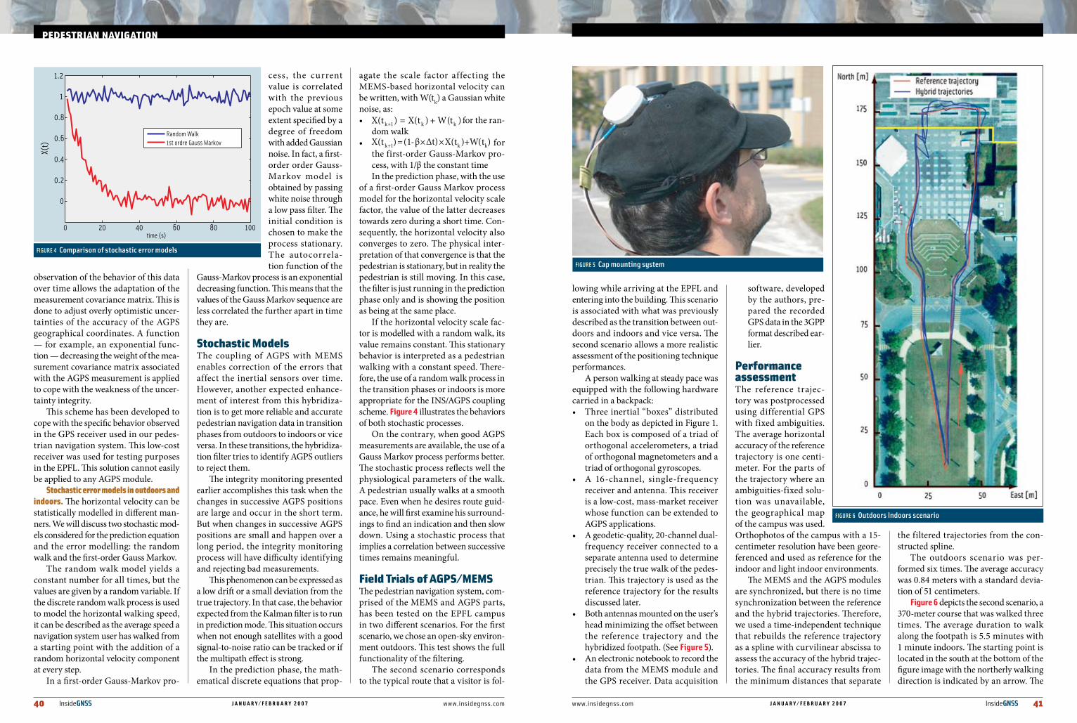
Stochasticerrormodelsinoutdoorsandindoors. The horizontal velocity can be statistically modelled in different man-ners. We will discuss two stochastic mod-els considered for the prediction equation and the error modelling: the random walk and the first-order Gauss Markov.
The random walk model yields a constant number for all times, but the values are given by a random variable. If the discrete random walk process is used to model the horizontal walking speed, it can be described as the average speed a navigation system user has walked from a starting point with the addition of a random horizontal velocity component at every step.
In a first-order Gauss-Markov pro-
cess, the current value is correlated with the previous epoch value at some extent specified by a degree of freedom with added Gaussian noise. In fact, a first-order order Gauss-Markov model is obtained by passing white noise through a low pass filter. The initial condition is chosen to make the process stationary. The autocorrela-tion function of the
Gauss-Markov process is an exponential decreasing function. This means that the values of the Gauss Markov sequence are less correlated the further apart in time they are.
StochasticModelsThe coupling of AGPS with MEMS enables correction of the errors that affect the inertial sensors over time. However, another expected enhance-ment of interest from this hybridiza-tion is to get more reliable and accurate pedestrian navigation data in transition phases from outdoors to indoors or vice versa. In these transitions, the hybridiza-tion filter tries to identify AGPS outliers to reject them.
The integrity monitoring presented earlier accomplishes this task when the changes in successive AGPS positions are large and occur in the short term. But when changes in successive AGPS positions are small and happen over a long period, the integrity monitoring process will have difficulty identifying and rejecting bad measurements.
This phenomenon can be expressed as a low drift or a small deviation from the true trajectory. In that case, the behavior expected from the Kalman filter is to run in prediction mode. This situation occurs when not enough satellites with a good signal-to-noise ratio can be tracked or if the multipath effect is strong.
In the prediction phase, the math-ematical discrete equations that prop-
agate the scale factor affecting the MEMS-based horizontal velocity can be written, with W(tk) a Gaussian white noise, as:• for the ran-
dom walk• for
the first-order Gauss-Markov pro-cess, with 1/β the constant timeIn the prediction phase, with the use
of a first-order Gauss Markov process model for the horizontal velocity scale factor, the value of the latter decreases towards zero during a short time. Con-sequently, the horizontal velocity also converges to zero. The physical inter-pretation of that convergence is that the pedestrian is stationary, but in reality the pedestrian is still moving. In this case, the filter is just running in the prediction phase only and is showing the position as being at the same place.
If the horizontal velocity scale fac-tor is modelled with a random walk, its value remains constant. This stationary behavior is interpreted as a pedestrian walking with a constant speed. There-fore, the use of a random walk process in the transition phases or indoors is more appropriate for the INS/AGPS coupling scheme. figure 4 illustrates the behaviors of both stochastic processes.
On the contrary, when good AGPS measurements are available, the use of a Gauss Markov process performs better. The stochastic process reflects well the physiological parameters of the walk. A pedestrian usually walks at a smooth pace. Even when he desires route guid-ance, he will first examine his surround-ings to find an indication and then slow down. Using a stochastic process that implies a correlation between successive times remains meaningful.
FieldtrialsofAGPS/MEMSThe pedestrian navigation system, com-prised of the MEMS and AGPS parts, has been tested on the EPFL campus in two different scenarios. For the first scenario, we chose an open-sky environ-ment outdoors. This test shows the full functionality of the filtering.
The second scenario corresponds to the typical route that a visitor is fol-
lowing while arriving at the EPFL and entering into the building. This scenario is associated with what was previously described as the transition between out-doors and indoors and vice versa. The second scenario allows a more realistic assessment of the positioning technique performances.
A person walking at steady pace was equipped with the following hardware carried in a backpack:• Three inertial “boxes” distributed
on the body as depicted in Figure 1. Each box is composed of a triad of orthogonal accelerometers, a triad of orthogonal magnetometers and a triad of orthogonal gyroscopes.
• A 16-channel, single-frequency receiver and antenna. This receiver is a low-cost, mass-market receiver whose function can be extended to AGPS applications.
• A geodetic-quality, 20-channel dual-frequency receiver connected to a separate antenna used to determine precisely the true walk of the pedes-trian. This trajectory is used as the reference trajectory for the results discussed later.
• Both antennas mounted on the user’s head minimizing the offset between the reference trajectory and the hybridized footpath. (See figure 5).
• An electronic notebook to record the data from the MEMS module and the GPS receiver. Data acquisition
software, developed by the authors, pre-pared the recorded GPS data in the 3GPP format described ear-lier.
PerformanceassessmentThe reference trajec-tory was postprocessed using differential GPS with fixed ambiguities. The average horizontal accuracy of the reference trajectory is one centi-meter. For the parts of the trajectory where an ambiguities-fixed solu-tion was unavailable, the geographical map of the campus was used. Orthophotos of the campus with a 15-centimeter resolution have been geore-ferenced and used as reference for the indoor and light indoor environments.
The MEMS and the AGPS modules are synchronized, but there is no time synchronization between the reference and the hybrid trajectories. Therefore, we used a time-independent technique that rebuilds the reference trajectory as a spline with curvilinear abscissa to assess the accuracy of the hybrid trajec-tories. The final accuracy results from the minimum distances that separate
the filtered trajectories from the con-structed spline.
The outdoors scenario was per-formed six times. The average accuracy was 0.84 meters with a standard devia-tion of 51 centimeters.
figure 6 depicts the second scenario, a 370-meter course that was walked three times. The average duration to walk along the footpath is 5.5 minutes with 1 minute indoors. The starting point is located in the south at the bottom of the figure image with the northerly walking direction is indicated by an arrow. The
FIGURE 5 Cap mounting system
FIGURE 4 Comparison of stochastic error models
0 20 40 60 80 100
0
0.2
0.4
0.6
0.8
1
1.2
time (s)
X(t)
Random Walk1st ordre Gauss Markov
FIGURE 6 Outdoors Indoors scenario
42 InsideGNSS j a n u a r y / f e b r u a r y 2 0 0 7 www.insidegnss.com
indoor portion lies to the north of the yellow line.
The three hybrid trajectories match with a good confidence level the true walked path drawn in red, at times over-lapping one another so closely as to be indistinguishable in the figure. The aver-age accuracy for this outdoor scenario is 0.93 meters associated with a standard deviation of 0.99 meters.
The EKF operates well as the pedes-trian moves from outdoors to light indoors. It handles the transition in a smooth manner that preserves the accuracy.
As expected, accuracy decreases inside the building. When a person walks indoors, the filter relies only on the MEMS sensors that are affected by large drift and noise. The longer this period lasts, the larger is the deviation from the true trajectory.
When the person exits the building and the AGPS measurement integrity is assessed, the filter is able to correct the accumulated deviation and converges back to the true footpath. This deviation is illustrated on figure 7.
ConclusionsThe extended Kalman filter and the enhancements presented earlier show interesting improvements for outdoors/indoors transition scenarios, compared to existing loosely coupled schemes. The main achievements result in an improved accuracy and reliability. Thanks to the distributed MEMS sensors configura-tion, the tracking of the movements of a person is also more precise. The filter is able to output accurate quasi-instan-
taneous data that are useful for safety applications.
Being able to identify the time a
person is entering a zone where AGPS data are not reliable remains a difficult task. The deterioration of AGPS is often correlated with surrounding obstacles. The provision of additional data that indicated if the pedestrian is still out-doors or has just gone indoors could improve the” filter performances.
Without thinking about more com-plex techniques, such as match-map-ping, for example, it certainly would be interesting to try to improve the hybridization process by incorporat-ing data on the number of satellites tracked and their signal-to-noise ratio in addition to the existing 3GPP loca-tion format.
AcknowledgementsWe are thankful to Kamiar Aminian and Bijan Najafi from the EFPL Labora-tory of Movements Analysis and Mea-surements for their collaboration.
ManufacturersThe hybrid navigation system described in this article used an Antaris GPS chipset from u-blox AG, Thalwil, Swit-zerland, and the Mtx 3DOF orientation tracker from Xsens Technologies B.V., Enschede, The Netherlands. A Legacy receiver from Javad Navigation Sys-tems, Santa Clara, California USA, and Moscow, Russia, connected to an XS1 GPS antenna from Antcom Corpora-tion, Torrance, California, was used to determine precisely the true walking motion of the pedestrian.
AdditionalresourcesEuropeanTelecommunicationsStandardsInstitute
(ETSI),“UniversalGeographicalAreaDescription”,ETSI TS 032,2004.
Gontran,H.,“Mobilemappingenquasitempsréelpourlasaisieautomatiquededonnéesroutières,”EcolePolytechniqueFédéraledeLausanne,ENACINTERTOPO,Ph.D.,2007
Ladetto,Q.,“Capteursetalgorithmespourlalocalisationautonomeenmodepédestre,”EcolePolytechniqueFédéraledeLausanneENACINTERTOPO,PhDdissertationno2710,2002
Paraschiv-Ionescu,A., andE.E.Buchser,B.Rutschmann,B.NajafiandK.Aminian,“Ambu-latorysystemforthequantitativeandqualita-tiveanalysisofgaitandpostureinchronicpainpatientstreatedwithspinalcordstimulation,”Gait & Posture,Vol.20(2),p.113-125,2004.
Serrano,L.,andD.Kim,R.B.Langley,K.ItaniandM.Ueno,“AGPSVelocitySensor:HowAccurateCanItBe?–AFirstLook”,Proceedingsof2004 ION National Technical Meeting,SanDiego,CA,26-28January2004.
AuthorsValérie RenaudinhasanM.S.degreeinsurveyingandgeodeticengineer-ing from the EcoleS u p é r i e u r e d e sGéomètresetTopogra-phesinLeMans,France.
SheiscurrentlyworkingtowardthePh.D.degreefromEcolePolytechniqueFédéraledeLausanneinSwitzerland.ShewasthetechnicaldirectoratSwissatCompanyspecializingincentimetre-levelreal-timepositioningbasedonGNSSpermanentreferencenetwork.
Okan YalakhasanM.S.inelectronicsengineeringfromtheInstitutNationaldesSciencesAppliquéesinLyon,France.HeiscurrentlyworkingtowardthePh.D.degreefromtheEcolePolytechniqueFédéraledeLausanneinSwitzerland.
Phillip ToméholdsaPh.D.insurveyingengineer-ingfromtheUniversityofPorto,Portugal,andanM.S.inelectronicsengineering.Currently,heisworkingasscientificcollaboratorattheEcolePolytechniqueFédéraledeLausanne(EPFL),Switzerland,inthefieldofsensorsintegrationfornavigationpurposes.
Asexpected,inthetestaccuracydecreasesinsidethebuilding.Whenapersonwalksindoors,thefilterreliesonlyontheMEMSsensorsthatareaffectedbylargedriftandnoise.thelongerthisperiodlasts,thelargeristhedeviationfromthetruetrajectory.
FIGURE 7 Indoors path
PEdEStrIAnnAvIGAtIon


![Pedestrian Dominance Modeling for Socially-Aware Robot ... · Control [17] has been used for robot navigation around pedestrians. Pedestrian trajectories have also been predicted](https://static.fdocuments.in/doc/165x107/6028335b7e76a842eb7414d1/pedestrian-dominance-modeling-for-socially-aware-robot-control-17-has-been.jpg)