PEDESTRIAN, CYCLIST & TRAFFIC CALMING ADVISORY COMMITTEE ... · PDF filePEDESTRIAN, CYCLIST &...
87
PEDESTRIAN, CYCLIST & TRAFFIC CALMING ADVISORY COMMITTEE TUESDAY, 24 APRIL 2012, AT 1.30PM A G E N D A 1. Apologies 2. Disclosures of Interest 3. Matters arising from Council’s resolution on the Pedestrian, Cyclist & Traffic Calming Advisory Committee minutes of 27 March 2012 4. Agenda Items SECTION “A” - TOWN PLANNING MATTERS No Items in this Section. SECTION “B” - TRAFFIC MATTERS Item No. Particulars Page No B1. Marrickville Road, Marrickville (South Ward) Options for a pedestrian crossing near Frampton Avenue 3 B2. Safe walking routes to Ferncourt Public School, Marrickville Marrickville South LATM Scheme (South Ward) 17 B3. Cavendish Street, Stanmore (North Ward) Proposed street tree planting in parking reserve 29 B4. Renwick Street, Marrickville (South Ward) Temporary road closure for Sewerage works 33 B5. Bellevue Street, Tempe (South Ward) Proposed ‘No U-Turn’ 39 SECTION “C” - PARKING MATTERS Item No. Particulars Page No C1. C1.1 C1.2 C1.3 C1.4 C1.5 Mobility Parking applications 32 Frazer Street, Dulwich Hill (Central Ward) 51 Charles Street, Marrickville (Central Ward) 17 Warburton Street, Marrickville (West Ward) 33 Holmwood Street, Newtown (North Ward) 67 Canonbury Grove, Dulwich Hill (West Ward) 42 47 52 57 62 C2. Holmwood Street, Newtown (North Ward) Request for a Resident Parking Scheme – Parking survey results 67
Transcript of PEDESTRIAN, CYCLIST & TRAFFIC CALMING ADVISORY COMMITTEE ... · PDF filePEDESTRIAN, CYCLIST &...
PEDESTRIAN, CYCLIST & TRAFFIC CALMING ADVISORY COMMITTEE TUESDAY, 24 APRIL 2012, AT 1.30PM
A G E N D A
1. Apologies 2. Disclosures of Interest 3. Matters arising from Council’s resolution on the Pedestrian, Cyclist & Traffic Calming Advisory Committee minutes of 27 March 2012
4. Agenda Items SECTION “A” - TOWN PLANNING MATTERS No Items in this Section. SECTION “B” - TRAFFIC MATTERS Item No. Particulars Page No
B1.
Marrickville Road, Marrickville (South Ward) Options for a pedestrian crossing near Frampton Avenue
3
B2. Safe walking routes to Ferncourt Public School, Marrickville Marrickville South LATM Scheme (South Ward)
17
B3. Cavendish Street, Stanmore (North Ward) Proposed street tree planting in parking reserve
29
B4. Renwick Street, Marrickville (South Ward) Temporary road closure for Sewerage works
33
B5. Bellevue Street, Tempe (South Ward) Proposed ‘No U-Turn’
39
SECTION “C” - PARKING MATTERS Item No. Particulars Page No
C1. C1.1 C1.2 C1.3 C1.4 C1.5
Mobility Parking applications 32 Frazer Street, Dulwich Hill (Central Ward) 51 Charles Street, Marrickville (Central Ward) 17 Warburton Street, Marrickville (West Ward) 33 Holmwood Street, Newtown (North Ward) 67 Canonbury Grove, Dulwich Hill (West Ward)
42 47 52 57 62
C2. Holmwood Street, Newtown (North Ward) Request for a Resident Parking Scheme – Parking survey results
67
C3. Terminus Street, Petersham (North Ward)
Request for a Resident Parking Scheme – Resident survey results
72
C4. Llewellyn & Juliett Streets, Marrickville (South Ward) Request for a Resident Parking Scheme – Resident survey results
77
C5. Belmore Street, Enmore (North Ward) Proposed statutory ‘No Stopping’ restrictions at Phillip Street
84
5. Late Items 6. General Business 7. Close of Meeting
Pedestrian, Cyclist & Traffic Calming Advisory Committee
24 April 2012
3
SECTION "B" - TRAFFIC MATTERS
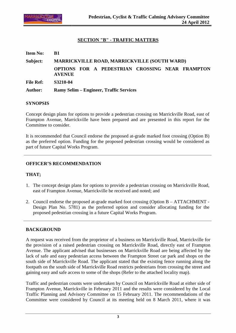
Item No: B1
Subject: MARRICKVILLE ROAD, MARRICKVILLE (SOUTH WAR D)
OPTIONS FOR A PEDESTRIAN CROSSING NEAR FRAMPTON AVENUE
File Ref: S3210-04
Author: Ramy Selim – Engineer, Traffic Services
SYNOPSIS Concept design plans for options to provide a pedestrian crossing on Marrickville Road, east of Frampton Avenue, Marrickville have been prepared and are presented in this report for the Committee to consider. It is recommended that Council endorse the proposed at-grade marked foot crossing (Option B) as the preferred option. Funding for the proposed pedestrian crossing would be considered as part of future Capital Works Program. OFFICER’S RECOMMENDATION THAT; 1. The concept design plans for options to provide a pedestrian crossing on Marrickville Road,
east of Frampton Avenue, Marrickville be received and noted; and
2. Council endorse the proposed at-grade marked foot crossing (Option B – ATTACHMENT - Design Plan No. 5781) as the preferred option and consider allocating funding for the proposed pedestrian crossing in a future Capital Works Program.
BACKGROUND
A request was received from the proprietor of a business on Marrickville Road, Marrickville for the provision of a raised pedestrian crossing on Marrickville Road, directly east of Frampton Avenue. The applicant advised that businesses on Marrickville Road are being affected by the lack of safe and easy pedestrian access between the Frampton Street car park and shops on the south side of Marrickville Road. The applicant stated that the existing fence running along the footpath on the south side of Marrickville Road restricts pedestrians from crossing the street and gaining easy and safe access to some of the shops (Refer to the attached locality map). Traffic and pedestrian counts were undertaken by Council on Marrickville Road at either side of Frampton Avenue, Marrickville in February 2011 and the results were considered by the Local Traffic Planning and Advisory Committee on 15 February 2011. The recommendations of the Committee were considered by Council at its meeting held on 8 March 2011, where it was
Pedestrian, Cyclist & Traffic Calming Advisory Committee
24 April 2012
4
resolved that “Council investigate a new pedestrian crossing in Marrickville Road near Frampton Avenue, Marrickville”. Concept design plans for options to provide a pedestrian crossing on Marrickville Road, east of Frampton Avenue, Marrickville have been prepared and are presented in this report for the Committee to consider. It should be noted that currently there are no funding allocated to this project. The project will be listed in Council’s Traffic Facilities Capital Works priority program for future budget consideration. DISCUSSION
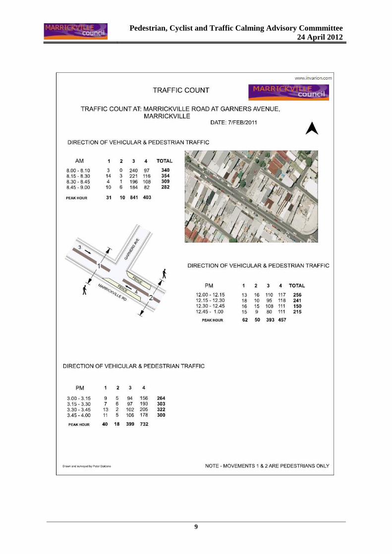
Marrickville Road is a Regional Road and the subject location is within the Marrickville Road shopping strip. At present, there is a central median island along Marrickville Road with gaps at intersecting local streets. The intersections of Marrickville Road with Victoria Road and Gladstone Street are controlled by traffic signals with pedestrian crossing facilities. The subject location of the requested pedestrian crossing at Frampton Avenue is approximately half way between these two sets of traffic signals and a pedestrian fence is installed along the footpath on the south side of Marrickville Road to protect people at the outdoor café and dining areas. Traffic volume and pedestrian counts Traffic and pedestrian counts were undertaken on Marrickville Road at either side of Frampton Avenue, Marrickville in February 2011. The counts were conducted between the times of 8.00am – 9.00am, 12.00pm – 1.00pm and 3.00pm – 4.00pm (Refer to the attached copy of the results of these counts). • In the morning period, there were 41 pedestrians and 1,244 vehicle movements. • In the midday period, there were 112 pedestrians and 850 vehicle movements. • In the afternoon peak period, there were 58 pedestrians and 1,131 vehicle movements. The RTA’s normal Warrant for the installation of a pedestrian crossing is for P (Pedestrians) to be ≥ 30 and V (Vehicles) to be ≥ 500 in any three separate one hour period on a typical day, with the product of the two figures to be equal to or greater than 60,000. The results of the counts indicated that the warrants for the installation of a pedestrian crossing have been met. Pedestrians The subject location has high pedestrian activity with pedestrians travelling between shops on both sides of the Marrickville Road. Three years ago, Council submitted a blackspot funding application to the RTA to address pedestrian accidents concern along Marrickville road and the suggested solution at the time was to place a pedestrian fence along the central median island to force pedestrians to cross the road using available crossing facilities at traffic signals. This application was not successful at that time.
Pedestrian, Cyclist & Traffic Calming Advisory Committee
24 April 2012
5
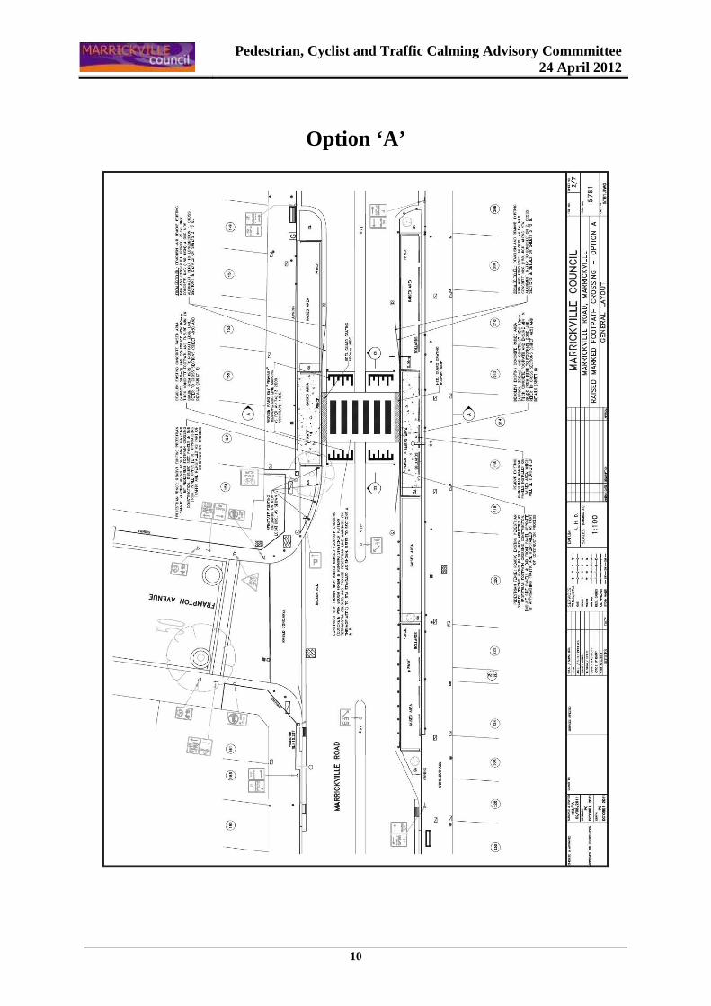
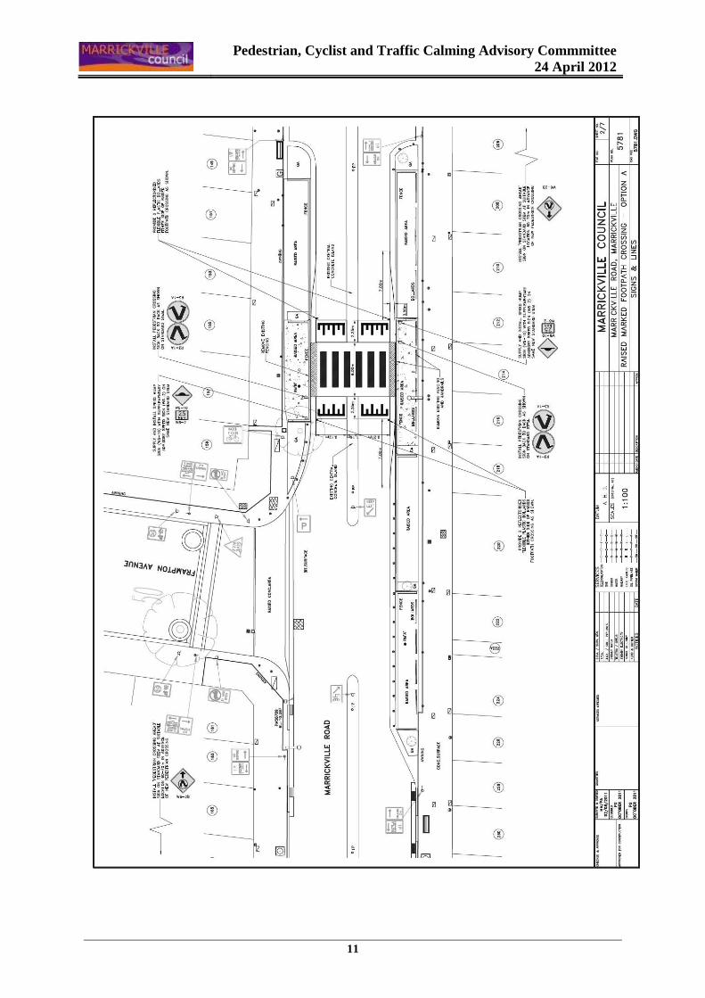
CONCEPT DESIGN OPTIONS • Option A – Raised pedestrian crossing (150mm high & flush with footpath)
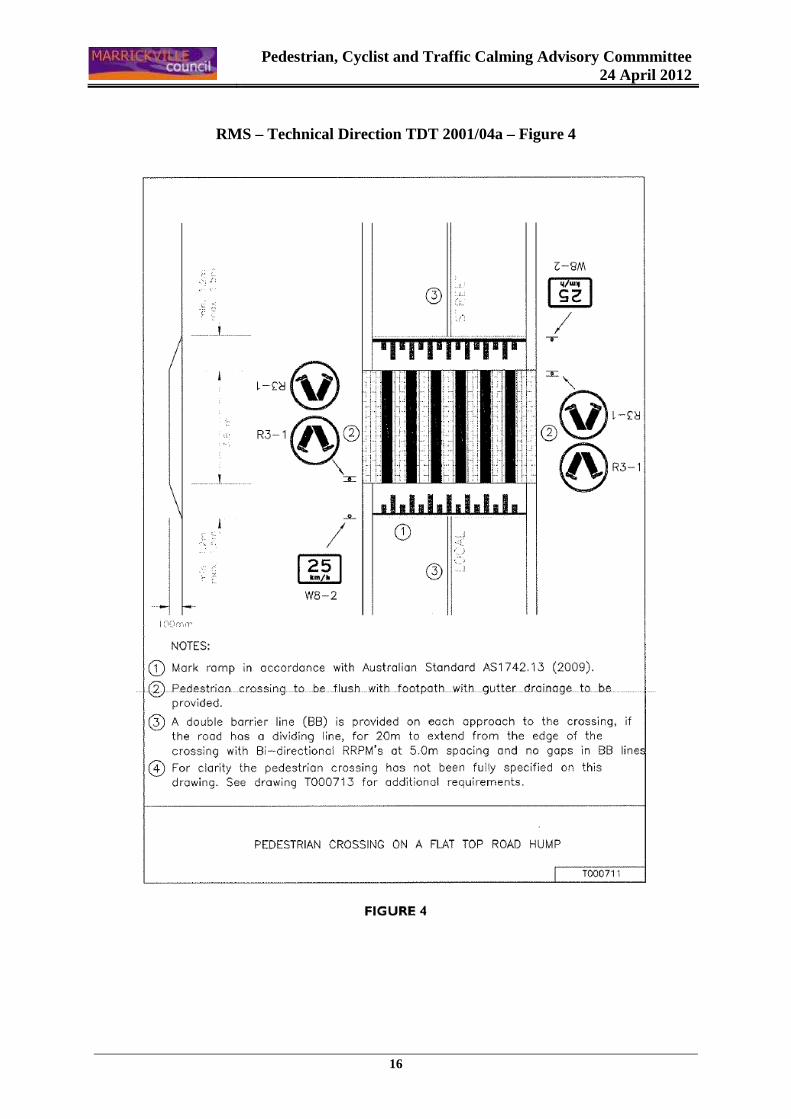
Description: Raised marked crossing 150mm high - to accommodate gutter flow (75mm thick grate + 75mm high orifice for the runoff flow) and to be flush with the footpath in accordance with RMS Technical Direction: TDT 2001/04a – Use of Traffic Calming Devices as Pedestrian Crossings - Figure 4 (attached), , with 2.25m long ramps – grade 1:15. Existing street lighting will need to be upgraded in accordance with Australian Standards AS1158.4:2009 – Part 4: Lighting of Pedestrian Crossings. Comments from the RMS: The following comments were provided by the Roads and Maritime Services (RMS) for this option: - This is on a bus route and the raised threshold should be total length of 9m (with 6m
platform), - The ramps should be 75mm in height, - Ramp grade 1:20, - The position of the W5-10 signs will obscure the R3-1A signs, and - Concerned with the removal of the existing fence at the crossing location with outdoor
dinning in close proximity. Constraints: - Non compliance with the RMS requirements for a maximum 75mm high raised traffic
device on bus routes. - Impact on existing drainage - overland/gutter flow will be obstructed if the proposed
raised platform has a maximum height of only 75mm. - Outdoor dinning area on footpath will need to be removed or relocated to provide
adequate space for pedestrians using the proposed crossing. Cost estimate: Approximately $55,000.
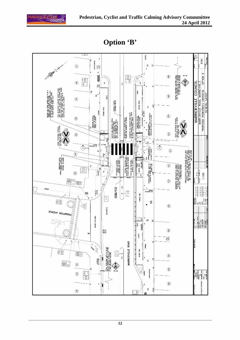
• Option B – At-grade marked foot crossing
Description: At-grade marked foot crossing (at existing road level) – saw cut and demolish 4m long section of existing central median island to accommodate a new pedestrian crossing. Provide new kerb ramps on both sides of the road.
Pedestrian, Cyclist & Traffic Calming Advisory Committee
24 April 2012
6
Existing street lighting will need to be upgraded in accordance with Australian Standards AS1158.4:2009 – Part 4: Lighting of Pedestrian Crossings. Constraints: - Outdoor dinning area on footpath will need to be removed or relocated to provide
adequate space for kerb ramps and pedestrians using the proposed crossing. Cost estimate: Approximately $35,000.
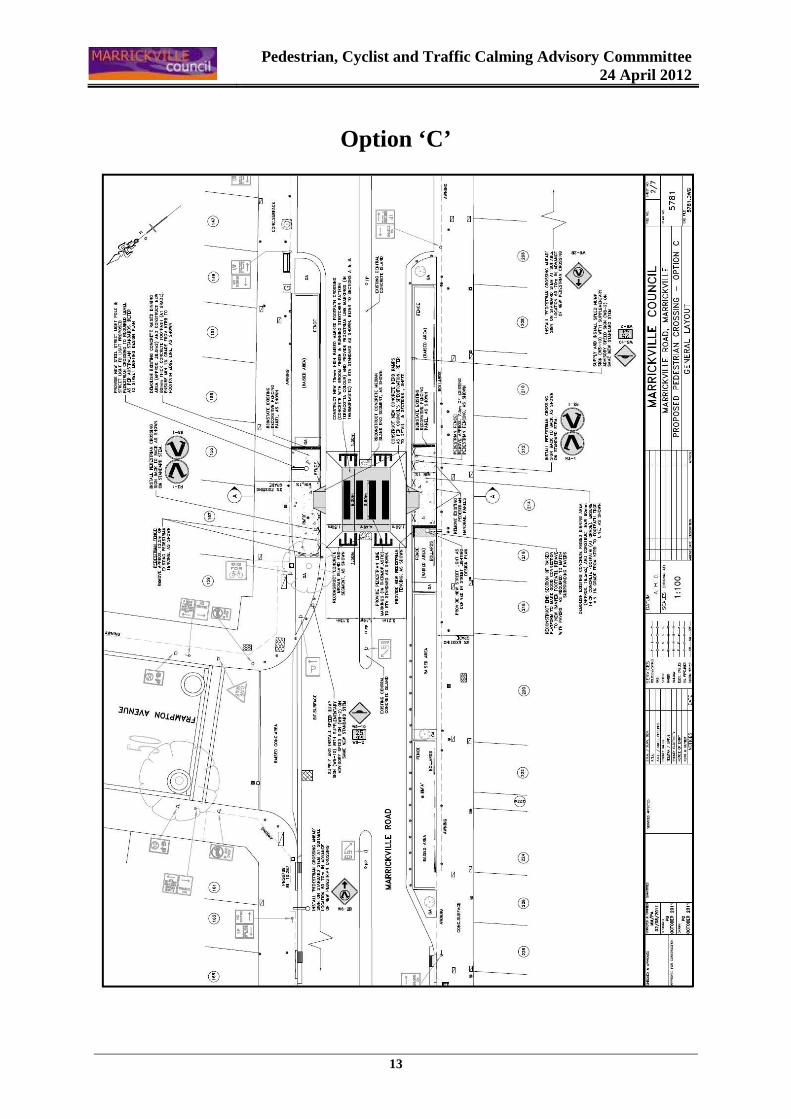
• Option C – Raised pedestrian crossing (75mm high with side ramps)
Description: Raised pedestrian crossing - saw cut and demolish 6m long section of existing central median island to accommodate a new raised pedestrian crossing, 6m wide flat top, 75mm high with four ramps, 1.5m long ramps – grade 1:20; Provide new kerb ramps on both sides of the road, flush with the side crossing ramps. Existing street lighting will need to be upgraded in accordance with Australian Standards AS1158.4:2009 – Part 4: Lighting of Pedestrian Crossings. Constraints: - The proposal does not comply with the RMS Technical Direction: TDT 2001/04a – Use of
Traffic Calming Devices as Pedestrian Crossings - Figure 4 (attached) which requires that the raised pedestrian crossing be flush with the footpath and gutter drainage to be provided.
- It should be noted that with this option that the wheel path for vehicles will be affected with one wheel being in contact with the top of the flat platform and the other wheel in contact with the inclined ramp. This type of arrangement is not safe for motorists.
- Outdoor dinning area on footpath will need to be removed or relocated to provide adequate space for kerb ramps and pedestrians using the proposed crossing.
Cost estimate: Approximately $50,000.
Pedestrian, Cyclist & Traffic Calming Advisory Committee
24 April 2012
7
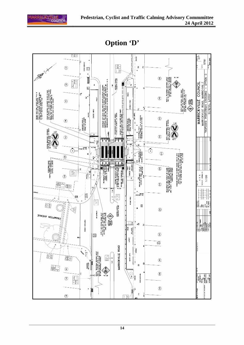
• Option D – Raised pedestrian crossing (75mm high – flat top flush with kerb ramps)
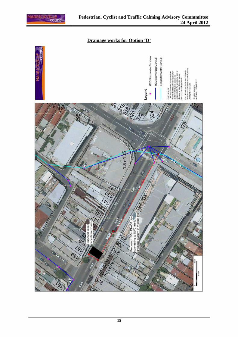
Description: Raised pedestrian crossing - saw cut and demolish 6m long section of existing central median island to accommodate a new raised pedestrian crossing, 6m wide flat top, 75mm high, 1.5m long ramps – grade 1:20; Provide new kerb ramps on both sides of the road, flush with the raised crossing flat top. Extension of a DN450 pipe from the trunk drain in Victoria Road 100m up and 10m across Marrickville Road to the upstream side of the proposed crossing and installation of two kerb inlet pits and two junction pits to accommodate a runoff flow (Refer to attached sketch showing proposed drainage works for this option). Existing street lighting will need to be upgraded in accordance with Australian Standards AS1158.4:2009 – Part 4: Lighting of Pedestrian Crossings. Constraints: - Outdoor dinning area on footpath will need to be removed or relocated to provide
adequate space for kerb ramps and pedestrians using the proposed crossing. - Works to relocate drainage are very expensive in comparison to the type of facility
provided. Cost estimate: Approximately $50,000 (traffic facility) + $200,000 to $250,000 for the
associated drainage works.
Public Consultation Consultation on the preferred concept design plan will be undertaken with all businesses and residents on both sides of Marrickville Road, between Victoria Road and Garners Avenue, once funding has been allocated. CONCLUSION
In reviewing the investigated options it is considered that an at-grade marked foot crossing (Option B) is the preferred option. This option has far less constraints in comparison with the other options presented and complies with the RMS Technical Directions. The option to provide a raised pedestrian crossing, that would be suitable for the existing bus route and satisfy the requirements of the RMS Technical Directions, will impact the gutter flow. The resulting connection to the nearest pit has very high construction costs in comparison with the type of facility to be provided. Therefore, such a proposal is not considered feasible.
Pedestrian, Cyclist & Traffic Calming Advisory Committee
24 April 2012
8
OFFICER’S RECOMMENDATION THAT; 1. The concept design plans for options to provide a pedestrian crossing on Marrickville Road,
east of Frampton Avenue, Marrickville be received and noted; and
2. Council endorse the proposed at-grade marked foot crossing (Option B – ATTACHMENT - Design Plan No. 5781) as the preferred option and consider allocating funding for the proposed pedestrian crossing in a future Capital Works Program.
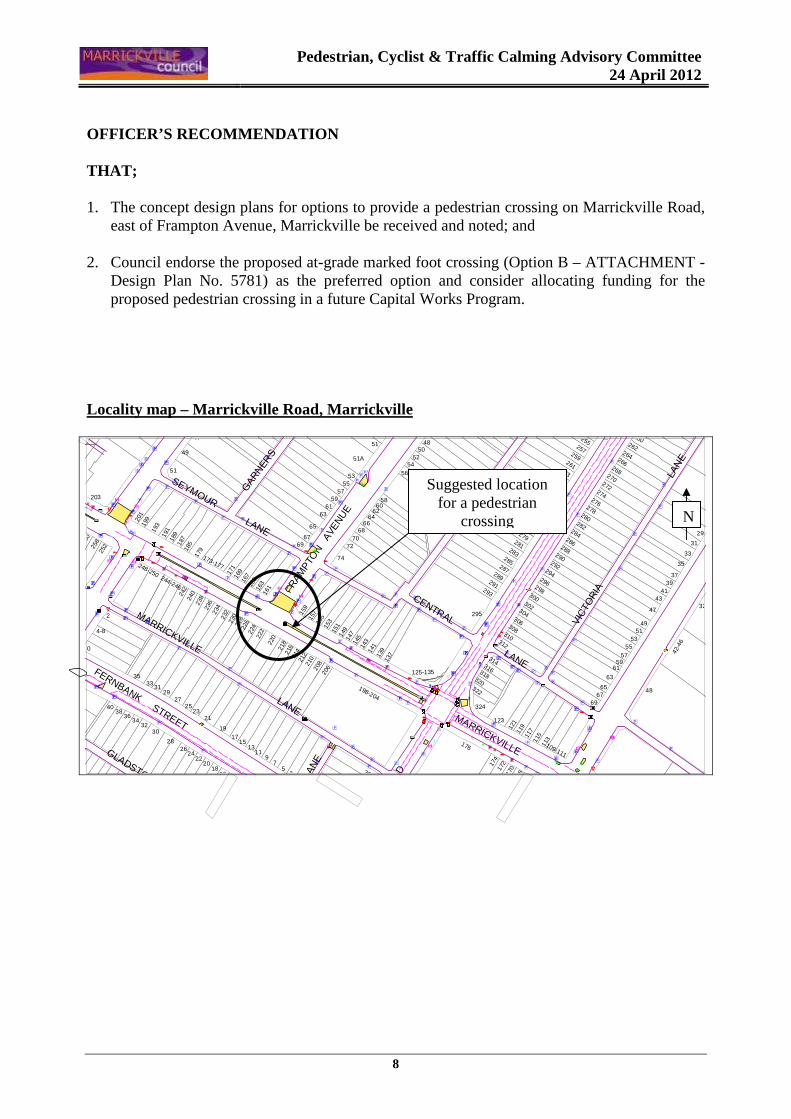
Locality map – Marrickville Road, Marrickville
MARRICKVILLE
LANE
CENTRAL
FRAM
PTO
N
LAN
E
VIC
TOR
IA
LAN
E
GLADSTONE LANE
VIC
TOR
IA
R
OAD
LANE
LAN
E
SEYMOUR LANE
GAR
NER
S
LANE
FERNBANK STREET
MARRICKVILLE
FRAM
PTO
N A
VENU
E
33
35
31
29
264
262
260
5250
48
54
58
7068
6664
6260
5653
6967
74
72
6361
5957
55
65
4951A
5147
37
5149
47
4341
39
32
69
65
63
6159
57
48
42-4
6
113
109-111
11511
7
310
306308
312
314316318320
170
322
324
123
11912
116
8
17217
4
176
139
125-135
137
198-204
303
14114
314514
714915
1
214
208
15315
520
621021
2
5
9
3
7
220
21621
8
22222
4226228230
1715
131126
2422
2018
16
28
21
2927
2325
1934
31
4038
36
3230
3335
10
4-8
253
266
267
276
274
272
270
268
280
288
286
284
282
278
290
265
261
255257
259
263
302
292294
296298
300
304
279
269271
273275
277
293
281283
285287289
291
295
167
16116
316516
9171
15715
9
240
179
173-177
23223
423623
8
64-68
248-250
18718
9191
19920
1
185
193
244-246
242
51
203
2
25225
8260
5553
67
KEEP
[
w
�
w
w
w
w
w
ww
ww–
�
w
�w
��
�
�{[
w
w
w
w
[
w
w
ww
w
wïï
ïw
w
wwww
w
ww
w
w
w
w
w
w
w
w
w
w
å}–
w
�π
w
y
wïï
–ïw
ww��
ww
w
ww
w
w
�
www
www
é
�
w
w
–
ww
www
ww
�é
�
�
��
ww–
ww
w
ww
é
ïw
w–
ïw
–
ww
w
ww
w
w
w
w
ww
w
ï
ïw
ww
ww
w
w
�w
ww
�ww �
ww{
w�
é
[
ww
w
w�
w
w
åå�
wé
w
�w
–
w
ww
w
ww
w
w
w
ww
[w
ww
w
�
www
w
w
w
w
w
w
�
w
w
w
ww
w
wwπ
w
[
w
–�–ww
�
ww
ww
ww�
w
w
w
éé
–
wï
�
{
ww
w
é
wïï
{
ww é
�ww
ww
w
w
–
–
–
–
–
w
w
ww
w
N
Suggested location for a pedestrian
crossing
Pedestrian, Cyclist and Traffic Calming Advisory Commmittee
24 April 2012
9
Pedestrian, Cyclist and Traffic Calming Advisory Commmittee
24 April 2012
10
Option ‘A’
Pedestrian, Cyclist and Traffic Calming Advisory Commmittee
24 April 2012
11
Pedestrian, Cyclist and Traffic Calming Advisory Commmittee
24 April 2012
12
Option ‘B’
Pedestrian, Cyclist and Traffic Calming Advisory Commmittee
24 April 2012
13
Option ‘C’
Pedestrian, Cyclist and Traffic Calming Advisory Commmittee
24 April 2012
14
Option ‘D’
Pedestrian, Cyclist and Traffic Calming Advisory Commmittee
24 April 2012
15
Drainage works for Option ‘D’
Pedestrian, Cyclist and Traffic Calming Advisory Commmittee
24 April 2012
16
RMS – Technical Direction TDT 2001/04a – Figure 4
Pedestrian, Cyclist and Traffic Calming Advisory Commmittee
24 April 2012
17
Item No: B2
Subject: SAFE WALKING ROUTES TO FERNCOURT PUBLIC SC HOOL, MARRICKVILLE - MARRICKVILLE SOUTH LATM SCHEME (SOUTH WARD)
File Ref: 2726
Author: Jenny Adams – Road Safety Officer
SYNOPSIS In response to Council’s resolution of 14 June 2011 Council has conducted further consultation with Ferncourt Public School. In relation to this a submission has been received from the Principal and P&C representative regarding proposals to improve the safety of walking routes to the school in Premier Street, Marrickville. This report details the results of investigations undertaken. OFFICER’S RECOMMENDATION THAT: 1. The proposal to install a pedestrian refuge at Excelsior Parade and Premier Street, as
adopted at Council meeting on 14 June 2011 as part of Marrickville South LATM Review, be noted;
2. The incidence of speeding traffic in Renwick Street and Richardsons Crescent, Marrickville, be referred to the NSW Police for enforcement action;
3. That the installation of speed cushions (1.8 m wide) on all the approaches to the
roundabout intersection of Renwick Street and Excelsior Parade, the provision of Edge-line marking along the length of Renwick Street (2.5 metres in from the kerb), and “SLOW” pavement markings be approved subject to detailed design;
4. The Principal of Ferncourt Public School and the P&C be advised in terms of this report;
and
5. Council incorporate these works into its priority program for Traffic Facilities Capital Works.
BACKGROUND
At its meeting on the 14 June 2011, Council considered the Marrickville South LATM Scheme (South Ward) Review of the Existing Scheme – Survey Results report - and resolved that: “ in line with Council’s 15 December 2009 resolution on safe walking routes to school ('Council Infrastructure Investment for Healthy, Safe and Happy Children's Home/School Journeys'), Council conduct a further consultation with Ferncourt P&C/parents, children and parents and
Pedestrian, Cyclist & Traffic Calming Advisory Committee
24 April 2012
18
school community to identify measures to improve the quality and safety of walking routes for children and parents to and from school and that the needs of local residents around the school be taken into account.” and that “a report be made to Council via the Traffic Committee following this consultation.” In considering the Scheme recommendations Council also resolved to delete Item H being the installation of: h) “A pedestrian refuge in Richards Avenue at Premier Street to improve pedestrian safety be
endorsed and prioritised within Councils Traffic Facility Capital Works program.” It is noted that this recommendation was not adopted because of resident opposition to the loss of parking outside adjacent residents. It is also noted that the refuge would have alleviated corner cutting at this intersection and would have aided pedestrians crossing the road at this location. This report details the results of the further consultation with Ferncourt Public School community in relation to the question of identifying measures to improve the quality and safety of walking routes for children and parents to and from school. DISCUSSION
Council wrote to the Principal of Ferncourt Public School in August 2011 requesting input from the school community and the P&C in relation to Council’s resolution above and safe walking routes to the school.
In response Ferncourt Public School P&C made a submission, in September 2011, and nominated, as an immediate priority, three on-the-ground works to improve Safe Walking Routes;
1. “Construction of at least two safe crossing points on Cary and Renwick Streets; North−south pathways across the area are impeded by the fact that there are no safe crossing points on these streets. Renwick Street, as noted above, is of particular concern.
2. Eastern entry point - There is no safe crossing point for pedestrians entering from Tempe
who need to negotiate Carrington Road and Richardsons Avenue. Given the strong relationship between Ferncourt as a feeder school for Tempe High School, and the need to use the recently renovated facilities at Mackey Park, this is of particular concern.
3. Western entry point - The existing crossing point at Illawarra Road near Hill Street has
been identified as a concern by a number of parents. The heavily used sporting facilities at Steel Park and the Debbie and Abbey Borgia Centre increase pedestrian traffic here.”
The P&C requested that Council consider their proposals and provide a formal response as to the degree which Council would support these proposals, and the extent to which they can be developed further and ultimately implemented.
Council’s Road Safety Officer met with the Principal and P&C representative in November 2011 and undertook several site visits to Ferncourt Public School between September 2011 and February 2012 to monitor the pedestrian and traffic conditions surrounding the school.
Pedestrian, Cyclist & Traffic Calming Advisory Committee
24 April 2012
19
The following are comments and recommendations corresponding to the issues raised in the P&C’s submission(s):
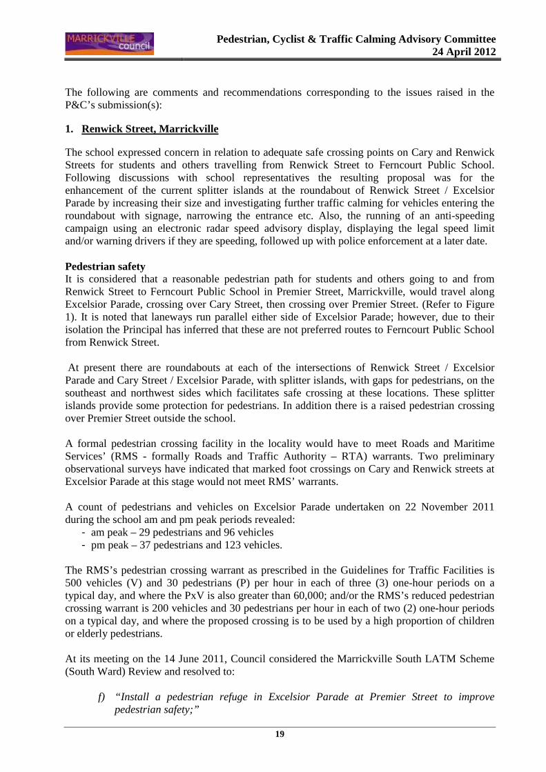
1. Renwick Street, Marrickville
The school expressed concern in relation to adequate safe crossing points on Cary and Renwick Streets for students and others travelling from Renwick Street to Ferncourt Public School. Following discussions with school representatives the resulting proposal was for the enhancement of the current splitter islands at the roundabout of Renwick Street / Excelsior Parade by increasing their size and investigating further traffic calming for vehicles entering the roundabout with signage, narrowing the entrance etc. Also, the running of an anti-speeding campaign using an electronic radar speed advisory display, displaying the legal speed limit and/or warning drivers if they are speeding, followed up with police enforcement at a later date. Pedestrian safety It is considered that a reasonable pedestrian path for students and others going to and from Renwick Street to Ferncourt Public School in Premier Street, Marrickville, would travel along Excelsior Parade, crossing over Cary Street, then crossing over Premier Street. (Refer to Figure 1). It is noted that laneways run parallel either side of Excelsior Parade; however, due to their isolation the Principal has inferred that these are not preferred routes to Ferncourt Public School from Renwick Street. At present there are roundabouts at each of the intersections of Renwick Street / Excelsior Parade and Cary Street / Excelsior Parade, with splitter islands, with gaps for pedestrians, on the southeast and northwest sides which facilitates safe crossing at these locations. These splitter islands provide some protection for pedestrians. In addition there is a raised pedestrian crossing over Premier Street outside the school. A formal pedestrian crossing facility in the locality would have to meet Roads and Maritime Services’ (RMS - formally Roads and Traffic Authority – RTA) warrants. Two preliminary observational surveys have indicated that marked foot crossings on Cary and Renwick streets at Excelsior Parade at this stage would not meet RMS’ warrants. A count of pedestrians and vehicles on Excelsior Parade undertaken on 22 November 2011 during the school am and pm peak periods revealed:
- am peak – 29 pedestrians and 96 vehicles - pm peak – 37 pedestrians and 123 vehicles.
The RMS’s pedestrian crossing warrant as prescribed in the Guidelines for Traffic Facilities is 500 vehicles (V) and 30 pedestrians (P) per hour in each of three (3) one-hour periods on a typical day, and where the PxV is also greater than 60,000; and/or the RMS’s reduced pedestrian crossing warrant is 200 vehicles and 30 pedestrians per hour in each of two (2) one-hour periods on a typical day, and where the proposed crossing is to be used by a high proportion of children or elderly pedestrians. At its meeting on the 14 June 2011, Council considered the Marrickville South LATM Scheme (South Ward) Review and resolved to:
f) “Install a pedestrian refuge in Excelsior Parade at Premier Street to improve pedestrian safety;”
Pedestrian, Cyclist & Traffic Calming Advisory Committee
24 April 2012
20
This provides a link between the northern and southern footpaths in Excelsior Parade at Premier Street. This project currently awaits funding within the Traffic Facilities Capital Works Program. In addition, to further enhance pedestrian safety and promote safe road crossing practices in the vicinity of Ferncourt Public School, Council recently applied to Roads and Maritime Services and was successful in obtaining extra funding to install ‘LOOK’ stencilling around the school. (LOOK stencils are applied on the pavement to remind pedestrians of their responsibility to watch out for vehicles before crossing the road. These markings also help identify the direction of traffic flow.) This work has been completed. Speeding Renwick Street is a wide (12.8 metres) mainly residential street running east-west between Illawarra and Carrington Roads and forming an intersection with Excelsior Parade at its mid point (Refer to Figure 2). The street, which parallels Warren Road to the north and Cary Street to the south, has a downhill gradient to the east for almost its entire length. It is classed as a local road and the urban default speed limit of 50km/h prevails. Several traffic management devices have been installed in Renwick Street including a ‘seagull’ (left in /left out treatment) island at its intersection with Illawarra Road, a roundabout at its intersection with Excelsior Parade and a pedestrian refuge island at its junction with Carrington Road. Speed humps and/or mid-block thresholds are installed in both adjacent streets, namely Warren Road and Cary Street. These devices were installed as a result of an early LATM scheme for the South Marrickville Area (2002). At that time, residents were opposed to the provision of speed control devices in Renwick Street. Similarly, in the recent Marrickville South LATM Review (2010) speed humps were proposed for Renwick Street, near property numbers 13, 29, 53, 79 and 40m west of Carrington Road, however again resident opposition resulted in the proposal not proceeding. Traffic volume data for Renwick Street is as follows: Date of count AADT 85th Percentile speed between Carrington Road and Excelsior Parade May 2000 4671 58.1km/h between Carrington Road and Excelsior Parade Mar 2007 4131 61.6km/h between Illawarra Road and Excelsior Parade Aug 2005 3883 55.8km/h between Illawarra Road and Excelsior Parade Oct 2009 4192 54.7km/h (Note: The 85th percentile speed is the speed at which 85 percent of vehicles travel at or less than and is used as the design criteria for traffic facilities.) In the past Council has conducted public speed education programs that have targeted streets throughout the LGA with speed issues and/or a speed related crash history, including Renwick Street. In Mid December 2009 a radar speed advisory trailer was located in Renwick Street, between Illawarra Road and Excelsior Parade, Marrickville (Westbound).
Pedestrian, Cyclist & Traffic Calming Advisory Committee
24 April 2012
21
This road safety education campaign, Speeding Prevention Program, was repeated in Renwick Street, in both directions, during March 2012. The speed trailer display gives vehicle controllers' real-time feedback on their vehicle speed in relation to the designated speed limit. (Refer to Figure 3 which shows a photograph of the speed display trailer in Renwick Street). Police enforcement of the speed limit in the street after the speed advisory trailer has been displayed was requested as part of the program. Speed is a concern in Renwick Street and Council Officers will continue to address the incidences of speeding on Renwick Street through NSW Police enforcement and public speed education programs. Traffic calming Although, traffic volumes in Renwick Street have remained relatively stable, speed levels are still of some concern. A 50km/h default urban speed limit applies in the street, yet the measured 85 percentile speed is above 50km/h. A check of RMS’ latest reported crash records for the period 2006 to 2010 revealed a total of seven (7) crashes along the length of Renwick Street (excludes any intersection crashes at Illawarra Road and Carrington Road with Renwick Street). Of the seven crashes recorded along Renwick Street five (5) were out of control crashes (RUM Codes 70 – 80) indicating that speed is a causal element in crashes along this section of road. Six (6) of the crashes were tow-away crashes and there was one injury crash. One crash occurred at the roundabout intersection of Renwick Street and Excelsior Parade, the remainder were all midblock crashes. One injury, cross traffic, crash occurred at the Cary Street and Excelsior Parade roundabout intersection in the five year reported period. A recent accident, which is not yet recorded in RMS data, occurred at the roundabout intersection of Renwick Street and Excelsior Parade at 9.14am on Thursday 5 April 2012. NSW Police released some details of the crash however causal factors are not definitive and at this stage they have said that it is undetermined whether speed was a factor in the crash. A car travelling north along Excelsior Parade entered the roundabout and was hit by another car travelling east on Renwick Street. The car hit overturned and the driver was conveyed to hospital with minor injuries, the other driver was not injured. There are a number of solutions available in relation to the issue of speed along Renwick Street. One solution would be to reintroduce the proposal of installing speed humps in Renwick Street as per Council’s latest LATM review of South Marrickville or Council installs speed cushions (1.8 m wide) on all the approaches to the roundabout intersection of Renwick Street and Excelsior Parade and also install Edge-line marking along the length of Renwick Street (Refer to Figure 4). As an initial step the latter options are recommended. Marking the road with the road marking ‘SLOW’ on the carriageway approaching the speed cushions on all approaches to the roundabout at Renwick Street and Excelsior Parade is also suggested. Edge-line markings in Renwick Street would be 2.5 metres from the kerb. The proposed Edge-line marking will physically and visually ‘narrow’ the carriageway in aid of reducing the speed. It is anticipated that vehicles will be encouraged to slow down significantly on the approaches to the roundabout at Renwick Street and Excelsior Parade when speed cushions are in place. The proposed devices will not result in the loss of any on-street parking spaces on Renwick Street or Excelsior Parade. Vehicular access to all residential properties will be retained.
Pedestrian, Cyclist & Traffic Calming Advisory Committee
24 April 2012
22
The slowing of vehicles at this roundabout will enhance pedestrian safety in the vicinity making crossing the roundabout approaches easier and safer for pedestrians with the slower vehicle speeds. 2. Richardsons Crescent, Tempe
Concern was expressed that there is no safe crossing point for pedestrians approaching from Tempe (schools) who need to negotiate Richardsons Crescent to get to Mackey Park and/or Carrington Road (and onto Ferncourt Public School). The installation of a pedestrian crossing approximately halfway between the Richardsons Crescent roundabout and the intersection with Carrington Road has been requested. Pedestrian safety and traffic conditions At present there is no formal provision for pedestrians to cross at Richardsons Crescent roundabout itself. Footpaths are provided on both sides of each leg of the roundabout intersection. Pedestrian activity at the roundabout, in the AM and PM peak periods is minimal. Small numbers of pedestrians use the footpaths on each leg of the roundabout intersection, but generally do not cross at or near the roundabout. There is also no formal pedestrian facility over Richardsons Crescent, between Carrington Road and the Roundabout, adjacent to Mackey Park, for pedestrians approaching from Tempe (schools). However, an indirect moderately longer path does exist which provides safe pedestrian crossing points for the journey of pedestrians entering from Tempe wanting to go to Mackey Park. Pedestrians can walk from Unwins Bridge Road across the traffic signalised pedestrian facility and marked crossing at Unwins Bridge Road and Richardsons Crescent intersection, continue up the eastern side of Richardsons Crescent, past the roundabout down to the pedestrian facility at the traffic signals adjacent Tempe Railway Station and cross over and onto Mackey Park. This is a 350 metre diversion however all the pedestrian facilities are in place. (Refer to Figure 5). At present Council is unable to provide a marked pedestrian crossing over Richardsons Crescent adjacent to Mackey Park as this location does not meet the warrant required for a marked pedestrian crossing as specified be the RMS. The mandatory warrant for the provision of a new marked pedestrian crossing is 500 vehicles and 30 pedestrians per hour, measured over three one hour periods during the day. Whereas the vehicle numbers are high, the pedestrian content of the warrant would not be met. Survey results conducted on 13 December 2011 show the number of pedestrians and vehicles midblock on Richardsons Crescent to be:
Pedestrians Vehicles 08.30 – 09.30 18 827 12.00 – 13.00 11 486 15.30 – 16.30 14 743
Observations in the vicinity of the roundabout, especially in the morning peak period, show a significant degree of traffic congestion in the approaches leading up to Richardsons Crescent roundabout from all approaches. In the section of Richardsons Crescent east of Carrington Road
Pedestrian, Cyclist & Traffic Calming Advisory Committee
24 April 2012
23
extensive queuing of vehicles occurs and the present traffic conditions would be compounded with the presence of any mid-block pedestrian facility. A review of the accident history for Richardsons Crescent (between Carrington Road and the Roundabout) over the last five years of recorded RMS data (2006-2010) shows that there has been one tow-away crash in this locality. In 2008 the driver of a car travelling east along Richardsons Crescent lost control and run into another vehicle parked on the side of the road. In May 2011 traffic and speed counts were undertaken in Richardsons Crescent, between Carrington Road and the Roundabout, to ascertain the extent of any speed issues. The results showed an average traffic flow of 12,930 vehicles per day and an 85th percentile speed of 55.8km/h. As indicated speed is an issue at this location and has dropped from an 85th percentile speed of 59km/h in October 2009 to the recent 85th percentile speed of 55.8km/h (May 2011). Richardsons Crescent has also been targeted for public speed education programs and a speed radar advisory trailer was located in Richardsons Crescent, between Cooks River and Roundabout, in November 2009 for a one week period. The trailer was also located in Richardsons Crescent at Carrington Street intersection for one week in March 2011. The latter location was repeated in March 2012. It is also recommended that the incidence of speeding traffic in Richardsons Crescent, Tempe, be referred to the NSW Police for enforcement action.
3. Illawarra Road
Concern was raised about the safety of the pedestrian crossing at Illawarra Road near Hill Street and the adequacy and enhancement of pedestrian facilities servicing Steel Park and the Debbie and Abbey Borgia Centre. Pedestrian safety and facilities near Steel Park Several pedestrian facilities (existing and/or in Council’s current Traffic facilities budget) service Steel Park and the Debbie and Abbey Borgia Centre and it is considered that at this time they provide adequate pedestrian crossing facilities across Illawarra Road for surrounding areas. A Marked Foot Crossing is installed on Illawarra Road, between Cahill Place and Hill Street. In April 2000 Council resolved to upgrade the original crossing facility to one with kerb blisters. Zig-zag advance pavement warnings for the crossing were installed in 1993. As part of the refurbishment works in Steel Park in November 2010 Council resolved to upgrade the existing pedestrian refuge island on Illawarra Road, at its junction with Wharf Street. In addition to the upgrading of the existing pedestrian refuge island, new and adjusted line markings are to be installed, along with 'No Stopping' zones on both sides of Illawarra Road at its junction with Wharf Street. Pedestrian facilities in this locality were also subject to an application for BlackSpot funding last year. Council was successful in obtaining funding for an additional pedestrian refuge island on Illawarra Road north of Wallace Street. Kerb blisters are to be installed this year, along with associated signs and road markings, making this location safer for pedestrians.
Pedestrian, Cyclist & Traffic Calming Advisory Committee
24 April 2012
24
Essentially there will be three pedestrian crossing facilities within a 355 metre span along Illawarra Road, and these would be sufficient to serve pedestrians wishing to use Steel Park and the Debbie and Abbey Borgia Centre from surrounding areas (Refer to Figure 6). Council has requested the RMS to reduce the speed limit to 50km/h (from 60km/h) on Illawarra Road. Although the RMS supported Council’s application, to date the speed limit is yet to be reduced. 4. Other issues raised
Local ‘Default Speed Limit’ Issues of lack of signage in the vicinity of Ferncourt Public School were raised. It is noted that the local ‘Default Speed Limit’ of 50km/h in urban (built-up) areas is a statutory speed limit that applies in the absence of speed limit signage and does not require signposting. The RMS sets and maintains speed signage.
PUBLIC CONSULTATION
Ferncourt Public School community and P&C were asked to comment and identify measures to improve the quality and safety of walking routes for children and parents/carers to and from the school and that the needs of the local residents around the school be taken into account.
FINANCIAL IMPLICATIONS
The estimated cost of works recommended in report is as follows:
a) Pedestrian refuge at Premier Street and Excelsior Parade - $10,000 b) Renwick Street speed cushions at roundabout, line marking and pavement symbols -
$25,000 Should Council wish to consider speed humps in Renwick Street in accordance with original LATM Review proposal – estimated cost $70,000. Council would need to fund these works in future budgets.
OFFICER’S RECOMMENDATION THAT: 1. The proposal to install a pedestrian refuge at Excelsior Parade and Premier Street, as adopted
at Council meeting on 14 June 2011 as part of Marrickville South LATM Review, be noted;
2. The incidence of speeding traffic in Renwick Street and Richardsons Crescent, Marrickville, be referred to the NSW Police for enforcement action;
3. That the installation of speed cushions (1.8 m wide) on all the approaches to the roundabout
intersection of Renwick Street and Excelsior Parade, the provision of Edge-line marking along the length of Renwick Street (2.5 metres in from the kerb), and “SLOW” pavement markings be approved subject to detailed design;
4. The Principal of Ferncourt Public School and the P&C be advised in terms of this report; and

Pedestrian, Cyclist & Traffic Calming Advisory Committee
24 April 2012
25
5. Council incorporate these works into its priority program for Traffic Facilities Capital
Works.
Pedestrian, Cyclist & Traffic Calming Advisory Committee
24 April 2012
26
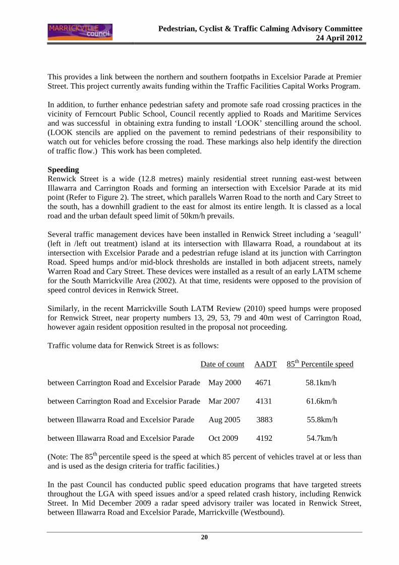
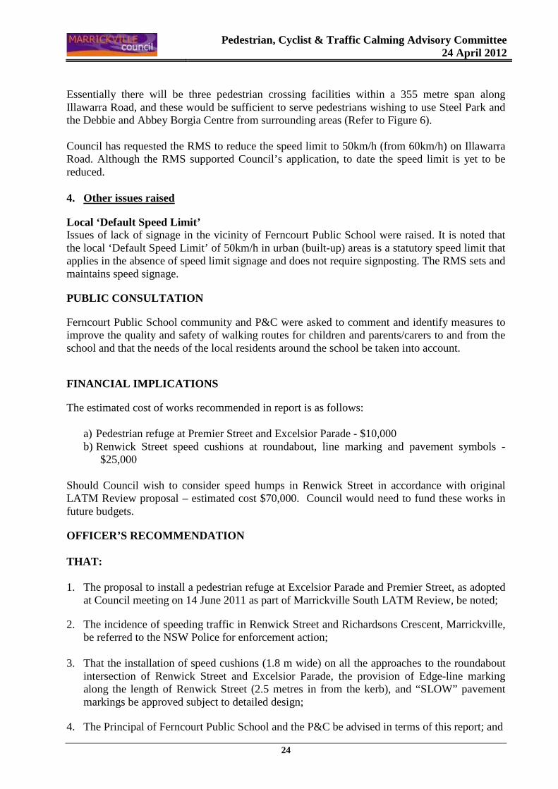
Figure 1 – Pedestrian path(s) from Renwick Street to Ferncourt Public School laneways Excelsior Parade Renwick Street
Existing wombat crossing over Premier Street in front of school Location of new pedestrian refuge to be built at Excelsior Parade and premier Street Figure 2 – Location map showing Renwick Street, Marrickville
Renwick Street Ferncourt Public School
w
w
%%w
ww
w
w
w
w
��
w
w
w
w
w
w
w
w
w
�w�
w�
ww
�
w w
w
w
�
w
www
w ww
�
wæ
�
ww
�
w
w
w
w
w
w
www
www
ww
ww
ww
�%
ïw
w
ww
w
w
w
w w
w
w
w
w
�
wï�
%�
��
ww
w
ww
�
ww
ww
w
ww
w
w
w
�ww
ww
wwï
���
ww
ww
ww
wwwww
�}
}
w
wwww
ww��w
w
w
w
}
}
}
w}
�
w
w
w
w
w
w
w
}��ww
ww
w
w
w
ww
w
ww
}
}
wïï
ï
ww
w
MA
IN
SU
BU
RB
AN
R
AIL
WA
Y
JUN
CTIO
N
STR
EET
CA
RRIN
GTO
N
RO
AD
HIG
H
S
TREE
T
SCHWEBEL STREET
RIC
HARDSO
N C
RESCENT
RUBY STREET
WARREN ROAD
FREDE LANE
EXC
ELSI
OR
PAR
ADE
IVAN
HO
E
S
TREE
T
RENWICK STREET
CAR
RIN
GTO
N
RO
AD
ESK
ST
REE
T
RENWICK STREET
WARREN ROAD
RENWICK STREET
PREMIER STREET
CARY STREET
PREMIER STREET
RIC
HAR
DS
A
VEN
UE
MAN
SIO
N
S
TRE
ET
PREMIER STREET
ILLAW
ARRA R
OAD
CARY STREET
HAM
PDE
N
AV
ENU
E
DAY STREET
ROSEBY STREET
11A
15
43
39
417
5
3
10
10B
19
17
6
25A
47
16
49
22
142
152
142
144
148
34
21
23
25
27
29
31
22
24A24
26
WAT
ER B
OAR
D
SCC
31
33
35
37
10
29
2
4
6
27
25
LAN
D
WAT
ER B
OA
RD
23
15B
21
19
50
52
17A
46
11
13
15
15
16
10
12
14
18
17
13
7
811
9
5
3
112
16A
13
2119
1715
11924
22
2018
16
6
8
10
12A
33 4
10A
11
36
32
30
SC
C
SCC
51-55
38
WATER BOARD
LAND(Pumping
101B
97A
97B
99A
99B
101A
103A
103B
106
110
WAT
ER B
OAR
D LA
ND
WAT
ER B
OAR
D LA
ND
86
85
87
89
82
88
90
91
81
83
7981
83
7274
76 78
80
62
77
69
71
7375
60
6466
6870
6769
73
75
77-79
71
74
56
22
24
65
67
5254
58
63A
68
57
5959A
61
65
34
26
28
30
32
36
37
39
41
43
35
33
38
40
64
45
62
2
66
53
55
26
132
139141
143145
147149
134
28-30
WAT
ER B
OARD LAND
1614A
47
43
41
39
37
35
4514
18
20
122120
124126
128
131133
135137
5250
4846
42
4038
25
23
127125
129
116118
100
69
7375
7779
102104
13
10
21
19A
19
17
15
32
3634
105
107
109111
113
92
94
98
112
117119
121123
108110
114
14
22
2018
16
12
65
59
61
9092A
92B
98
94
106
115
100102
104
23
29
27
2530
2826
24
5351
5557
8486
88
76
4547
49
7072
74
39A
41
686666B
99
8789
93
97
101103
88
85
1
3
91
76
4
2
1
3
5
2
90
8
6
4
57
911
13
10
12
66A8031
82
15
39
56
17
1958
6062
64
72
69
71
75
7779
74
78
7358
60
62
61
20
27
25
23
21
14
16
18
65
64
66
6870
63
67
76
8082
84
81
37
86
3335
5052
27
4648
3129
54
25A
4951
53
29
44
1921
23
25
38-4042
40
42
44
46
48
50
47
17
7
9
1315
18
68
1012
1416
24
459
10
5658
608
6
4
2
61A
66A
7
5
3
1
54
56
58
60
4
1
3
5
76
15
13
11
9
12
10
8
47
52
50
3941
4345
49
51
44
46
3333A
3537
20
12
14
16
18
49
5254
51
53
55
5759
3436
38
40
42
47
4345
39
4749
50
40
4244
4648
4738
3739
4143
45
4442
4648
37
3133
34
35
36
40
3638
28-30
2729
3133
35
36
32-34
26
2523
2729
2830
32
3133
35
20
1719
2123
25
2224
26
23A
34
2224
26
3032
25
2931
33
3739
41
36
3843
45
11A
911
1517
1921
26
30
3234
13
57
1618
2022
24
1A
30
2022
24
2628
32
2325
27
29
31
467424
422
420
418
469
465
416
2118
13
11
1719
426
436
434
432
430428
481
473475
477
471
4
14
10
86
2
483
485487489491
68
1012
1416
9
1
35
7
412
4101
1517
1921
1820
2224
27
29
48
25
Ð
Ð
Ð
Ð
ÐÐÐ
ÐÐÐ
ÐÐ
Ð
ÐÐ
ÐÐ
Ð
ÐÐÐ
Ð
Ð
ÐÐ
ÐÐ
ÐÐ
ÐÐ
Ð
Ð
ÐÐ
Ð
ÐÐ
Ð
Ð
Ð
ÐÐ
ÐÐ
ÐÐ
Ð
ÐÐ
Ð
Ð
Ð
Ð
Ð
Ð
Ð Ð Ð
Ð
Ð
ÐÐ
Ð
ÐÐÐ
ÐÐÐÐ
ÐÐ
Ð
Ð
Ð
ÐÐÐ
Ð Ð
Ð
ÐÐ
ÐÐ
Ð
ÐÐ ÐÐ
ÐÐ
Ð
Ð
ÐÐÐÐ
Ð
Ð
ÐÐÐ ÐÐ ÐÐ
Ð
Ð
Ð
ÐÐ ÐÐ
ÐÐÐ
ÐÐÐ
ÐÐÐ
Ð
Ð
Ð Ð
Ð
ÐÐ
Ð
ÐÐ ÐÐ
ÐÐ
Ð
Ð
Ð
Ð
ÐÐ
ÐÐÐ
Ð
Ð
ÐÐ
Ð
Ð
ÐÐ
Ð
Ð
Ð
ÐÐ
Ð
ÐÐ
ÐÐ
ÐÐ
Ð
ÐÐ
ÐÐ
Ð
Ð
ÐÐ
ÐÐÐ
ÐÐ
Ð
ÐÐÐ
ÐÐÐ
Ð
Ð
ÐÐ
Ð
Ð
ÐÐ
Ð Ð
Ð
ÐÐÐ
ÐÐ
Ð
ÐÐ
Ð
Ð
Ð
Ð
ÐÐ
ÐÐÐ
Ð
Ð
ÐÐÐ
Ð
ÐÐ
Ð
Ð
ÐÐ
ÐÐ
Ð
Ð
Ð
ÐÐ
Ð
Ð
Ð
ÐÐÐ
Ð
ÐÐ
Ð
ÐÐ
ÐÐ
Ð
ÐÐ
ÐÐÐÐ
Ð
ÐÐ
Ð
Ð
Ð
Ð
Ð
Ð
ÐÐ
ÐÐ
Ð
ÐÐÐ
Ð
ÐÐ
Ð
ÐÐ
ÐÐ
ÐÐÐÐ
Ð
Ð
Ð
ÐÐ
ÐÐÐÐÐ
Ð
ÐÐ
Ð
Ð
ÐÐ
Ð
Ð
Ð
ÐÐ
ÐÐÐÐÐ
ÐÐÐÐ
Ð
Ð
Ð
ÐÐ
ÐÐ
ÐÐÐÐÐ
ÐÐ
Ð
Ð
Ð
ÐÐ
Ð
ÐÐ
Ð
Ð
ÐÐ
ÐÐÐ
ÐÐ
Ð
Ð
Ð
Ð
ÐÐÐ
ÐÐÐÐ
ÐÐÐÐ
ÐÐ
ÐÐÐ
ÐÐ
Ð
Ð
Ð
Ð
Ð
Ð
Ð
ÐÐ
Ð
Ð
Ð
Ð
ÐÐ
ÐÐÐÐ
ÐÐÐ
Ð
Ð
ÐÐ
ÐÐ
Ð
ÐÐ
ÐÐ
Ð
ÐÐÐÐ
ÐÐ
Ð
Ð
ÐÐ
Ð
ÐÐ
Ð
Ð
ÐÐ
ÐÐ
ÐÐ
ÐÐ
Ð Ð
Ð
ÐÐ
Ð
Ð
Pedestrian, Cyclist & Traffic Calming Advisory Committee
24 April 2012
27
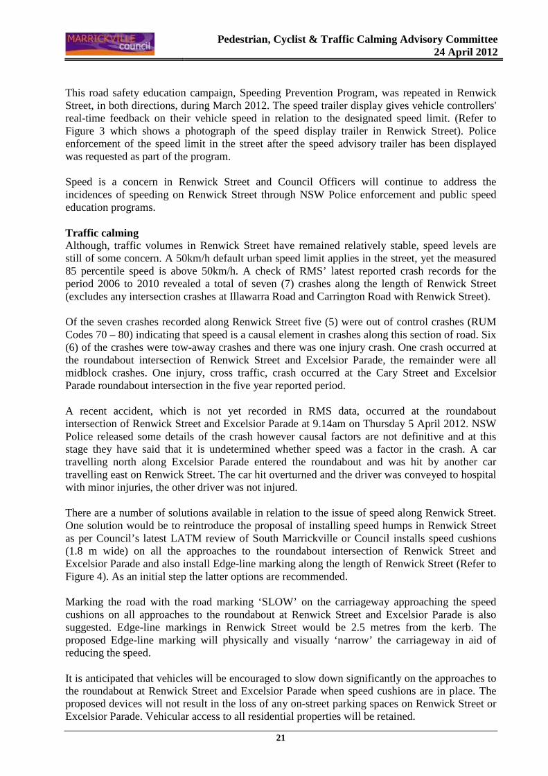
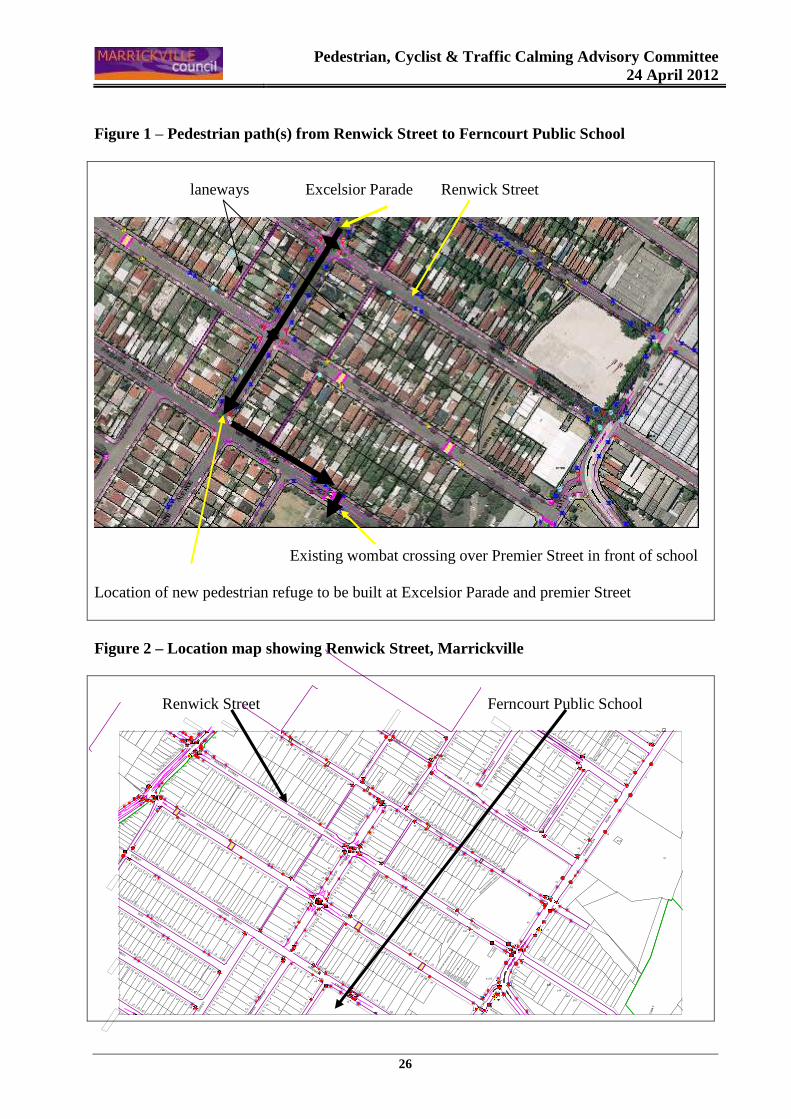
Figure 3 – Radar speed advisory display trailer in Renwick Street
Figure 4 – Proposed traffic calming treatment for Renwick Street
JUN
CTIO
N
STR
EET
CAR
RIN
GTO
N
R
OAD
CHA
RLO
TTE
A
VENU
E
HIG
H
ST
RE
ET
SCHWEBEL STREET
GROVE STREET
RUBY STREET
WARREN ROAD
FREDE LANE
EXC
ELS
IOR
PAR
ADE
IVA
NHO
E
ST
REET
RENWICK STREET
ESK
S
TREE
T
STIN
SON
LA
NE
RENWICK STREET
WARREN ROAD
RENWICK STREET
PREMIER STREET
CARY STREET
PREMIER STREET
RIC
HAR
DS
AV
ENUE
PREMIER STREET
ILLA
WARRA R
OAD
CARY STREET
HA
MPD
EN
A
VEN
UE
VIE
W
STR
EET
DAY STREET
ROSEBY STREET
Edge-line markings Speed cushions
Pedestrian, Cyclist & Traffic Calming Advisory Committee
24 April 2012
28
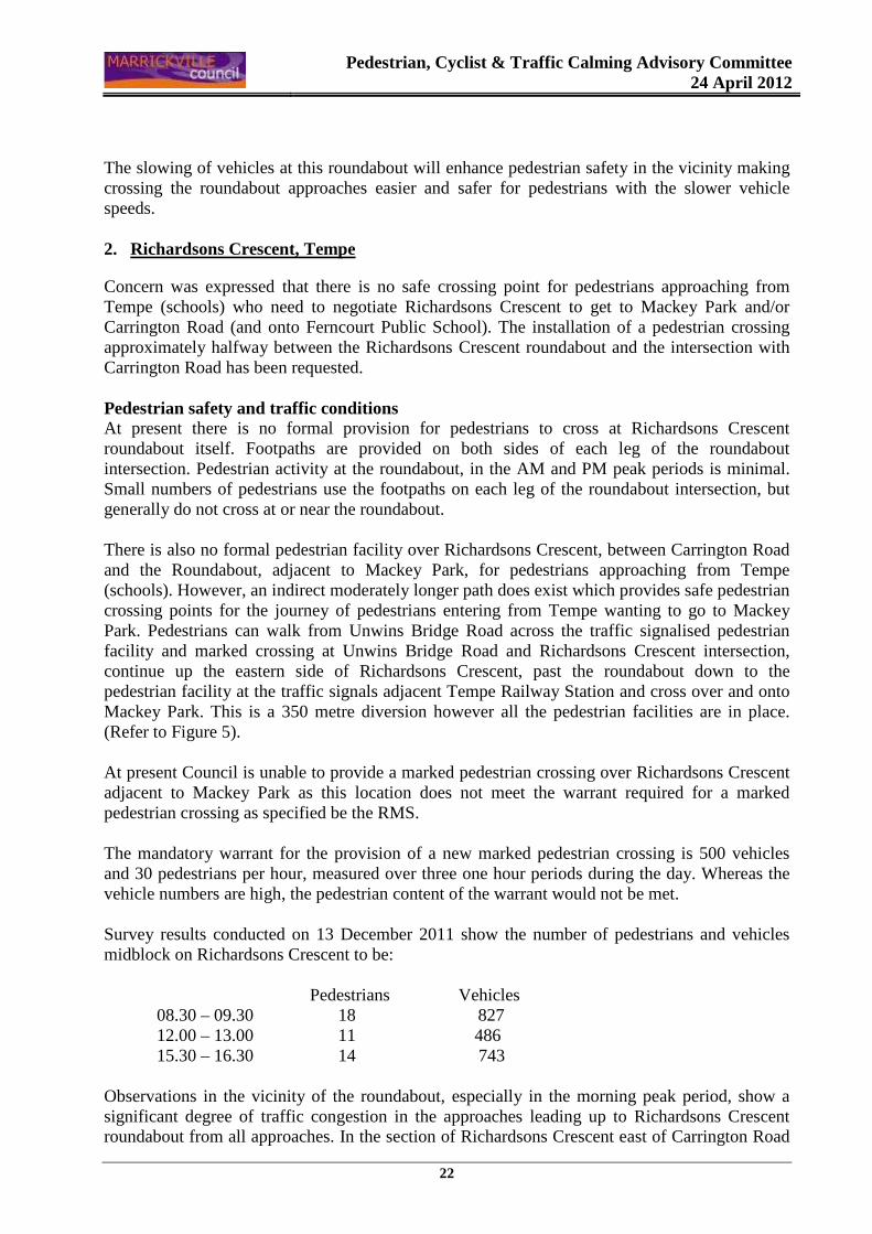
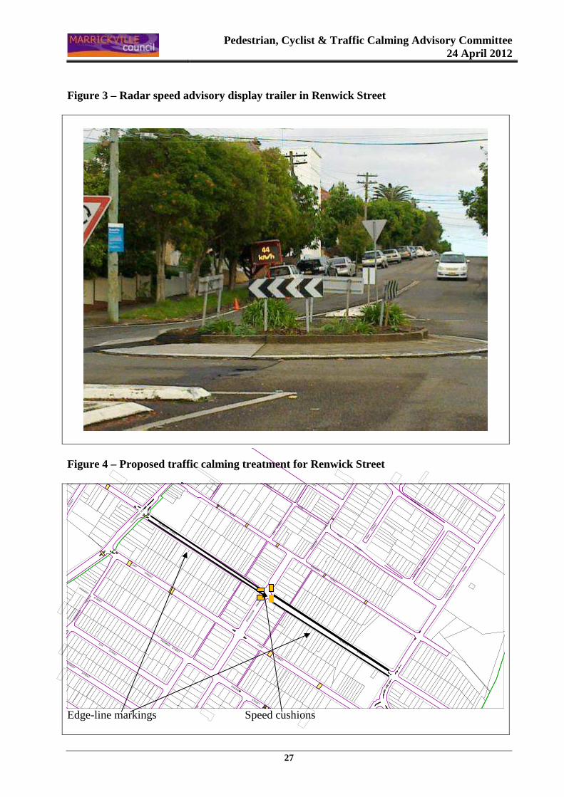
Figure 5 – Journey from Tempe to Mackey Park
From Ferncourt Public School From Tempe schools
UNWIN
S
BRID
GE
ROAD
LANE
STREET
LAN
E
UNIO
N
BRO
OKLYN STR
EET
UNION
IXION
LANE
FOREM
AN STREET
STANLEY STREET
STREET
ZUTTION
FARRO
W
STANLEY STREET
TRAMW
AY STREET
RICHARDSON CRESCENT
UNW
INS
BRIDGE
ROAD
EDW
IN S
TREET
EDWIN
STR
EET
EDGAR LANE
MA
IN
SU
BU
RB
AN
R
AIL
WA
Y
CO
LLINS STREET
EDG
AR STREET
UNWIN
S B
RIDGE
ROAD
WELLS
AVENUE
GR
IFF
ITH
S
STR
EE
T
MA
IN S
UB
UR
BA
N R
AIL
WA
Y
GAN
NON STREET
RIC
HARDSO
N C
RESCENT
RIC
HA
RD
SO
N C
RE
SC
EN
T
COOKS
CA
RRIN
GTO
N
RO
AD
ST
RE
ET
Mackey Park Figure 6 – Illawarra Road pedestrian facilities 355 metre length
w
ww
w
ww
w
�
ï
ww
ïw
ï
w
w
}}
w
ï
ï
ww
�
w
ï
ï�
w
w
ï
w
�
�}
�
�
w
w
w
w
w
w
w
ww
w
ww
RIVER
LIVI
NG
STO
NE
RO
AD
WHARF STREET
ILLA
WA
RRA
RO
AD
ILLA
WA
RRA
RO
AD
WAL
LAC
E L
ANE
CA
HIL
L
WARNE PL
HAM
PDEN
AV
ENUE
HAM
PDEN
AVE
NUE
ILLAWARRA
R
OAD
THORNLEY STREET
DAY STREET
DAY STREET
ROSEBY STREET
WALLACE STREET
HILLTOP AVE
BEA
UCH
AMP
STR
EET
Pedestrian refuge Proposed pedestrian refuge Pedestrian crossing
Pedestrian, Cyclist & Traffic Calming Advisory Committee
24 April 2012
29
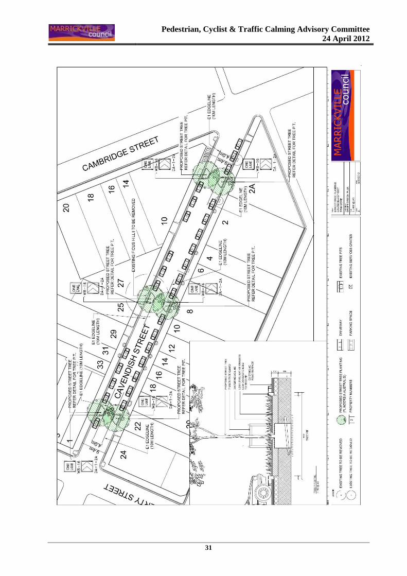
ITEM No: B3 LOCATION: CAVENDISH STREET, STANMORE (NORTH WARD) SUBJECT: PROPOSED STREET TREE PLANTING IN PARKING R ESERVE FILE REF: S0830-02 AUTHOR: James Lawton – Landscape Architect SYNOPSIS This report outlines a proposal to plant street trees in tree pits located within the road carriageway on either side of Cavendish Street between Liberty Street and Cambridge Street, Stanmore. The proposal aims to reinstate the tree lined character of this section of Cavendish Street following the removal of three large Ficus (Fig) trees from the footpath over the last three years.
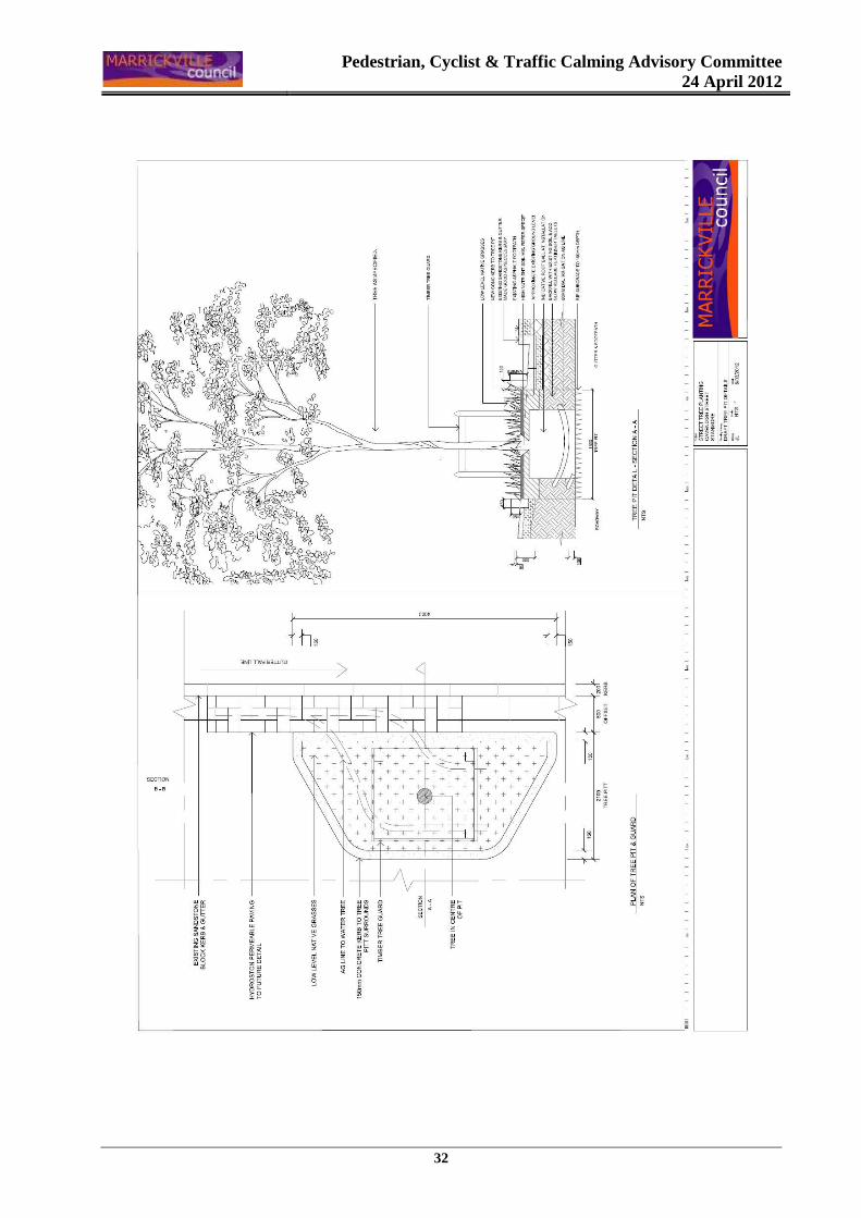
The tree pits will act as traffic calming devices and will be watered by AG lines running under permeable pavers within the gutter. The proposed tree species is Flindersia australis (Australian Teak).
OFFICER’S RECOMMENDATIONS THAT the design of the proposed Street Tree Planting Works in Cavendish Street, Stanmore (ATTACHMENT – Draft Design Plan & Draft Tree Pit Details) be APPROVED.
BACKGROUND Design of tree pits within the Cavendish Street road carriageway were included in the 2011-2012 Street Tree Planting Design Program with an intention to finance the construction works within the 2012-2013 Street Tree Planting Capital Budget. The proposed layout and design details of the tree pits are attached. The project aims to reinstate the large canopy trees which were removed from the footpath due to the invasive nature of Ficus tree roots and the close proximity of the trees to adjacent properties. To prevent this issue from recurring a more suitable tree species are proposed to be planted within the road carriageway away from adjacent properties. PARKING IMPLICATIONS Because of the positioning of the tree pits in existing no stopping areas (where possible), losses to parking has been minimised to around three to four parking spaces. This figure may be subject to change following detailed design and a site survey of the existing parking spaces. Preliminary investigations indicate that this area of Cavendish Street is reasonably popular for both resident and visitor parking due to its close proximity to Enmore Road. Five residents have off street parking within this section of the street.
Pedestrian, Cyclist & Traffic Calming Advisory Committee
24 April 2012
30
LAYOUT & DESIGN Due to the relatively narrow width of road (i.e 9.4m kerb to kerb) within this section of Cavendish Street, and the width of the tree pits, a single lane of traffic is recommended. The recommended layout is to position the tree pits opposite each other and to reduce the carriageway to 4m at these points to allow for one – way traffic and to provide a buffer between vehicles and the tree pit kerb. This section of Cavendish Street is a low volume, low speed environment. COMMUNITY CONSULTATION A letter inviting residents to a consultation session and outlining the proposal was mailed to the 18 residents within the Liberty Street to Cambridge Street section of Cavendish Street. Consultation was restricted to these residents as they will be most affected by the proposed changes to on - street parking. The consultation session was held on the 8th of March 2011 and no comments were received on the day. One comment was sent in to Council within the consultation period outlining rubbish concerns within the proposed tree pits. FINANCIAL IMPLICATIONS Preliminary cost estimates for the construction of the proposed works including concrete kerb tree pits, permeable paving and planting are within the proposed 2012-2013 Street Tree Planting Capital Works Budget of $60,000. The design and documentation of the works is being completed by Council staff. OFFICER’S RECOMMENDATIONS THAT the design of the proposed Street Tree Planting Works in Cavendish Street, Stanmore (ATTACHMENT – Draft Design Plan & Draft Tree Pit Details) be APPROVED.
Pedestrian, Cyclist & Traffic Calming Advisory Committee
24 April 2012
31
Pedestrian, Cyclist & Traffic Calming Advisory Committee
24 April 2012
32
Pedestrian, Cyclist & Traffic Calming Advisory Committee
24 April 2012
33
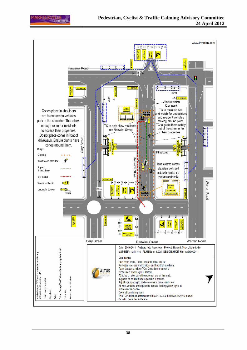
Item No: B4
Subject: RENWICK STREET, MARRICKVILLE (SOUTH WARD)
TEMPORARY ROAD CLOSURE FOR SEWERAGE WORKS
File Ref: S3970-02
Author: Ramy Selim – Engineer, Traffic Services
SYNOPSIS An application has been received from Interflow Pty Ltd for the temporary full road closure of a section of Renwick Street between the end of the Woolworths car park and Excelsior Parade, Marrickville, in order to undertake necessary maintenance works on the waste water pipeline in the street, for a period of one week. It is recommended that the proposed temporary road closures be approved, subject to the conditions outlined in this report. OFFICER’S RECOMMENDATION THAT: The proposed full road closure of Renwick Street (between the end of the Woolworths car park and Excelsior Parade), Marrickville be APPROVED for a period of one (1) week, to undertake necessary maintenance works on the waste water pipeline in the street, Subject to the following conditions;
1. A fee of $1,124.00 (incl. GST) for the temporary full road closure is payable by the applicant
in accordance with Council's Fees and Charges; 2. The temporary full road closure be advertised in the local newspaper providing 7 days notice
for submissions in accordance with Council's Consultation Policy; 3. A Traffic Control Plan (TCP) which has been prepared by a certified Traffic Controller, is to
be submitted to Council for review with a copy of the Traffic Controllers certification number attached to the plan, not less than 5 days prior to implementation of closure;
4. A Road Occupancy License be obtained by the applicant from the Roads and Maritime
Services’ Transport Management Centre;
5. Notice of the proposed closure be forwarded by the applicant to the NSW Police, the NSW Fire Brigades and the NSW Ambulance Services;
6. Notification signs advising of the proposed road closures and new traffic arrangements to be
strategically installed and maintained by the applicant at each end of the street at least 7 days prior to the closure;
7. All affected residents and businesses shall be notified in writing, by the applicant, of the
proposed temporary road closure at least 7 days in advance of the closure with the applicant making reasonable provision for residents;
Pedestrian, Cyclist & Traffic Calming Advisory Committee
24 April 2012
34
8. Vehicular and pedestrian access for residents and businesses to their off-street car parking
spaces be maintained where possible whilst site works are in progress; 9. Adequate vehicular traffic control shall be provided for the protection and convenience of
pedestrians and motorists including appropriate signage and flagging. Workers shall be specially designated for this role, as necessary to comply with this condition. This is to be carried out in accordance with the Australian Standard AS 1742.3 - Traffic Control Devices for works on roads;
10. The holder of this approval shall indemnify the Council against all claims, damages and costs
incurred by, or charges made against, the Council in respect to death or injury to any person or damage in any way arising out of this approval. In this regard, a public liability insurance policy for an amount not less than $10,000,000 for any one occurrence is to be obtained and is to note the Council as an interested party. The holder of this approval shall inform its insurer of the terms of this condition and submit a copy of the insurance policy to the Council prior to commencement of the work the subject of this approval;
11. The operator of any unit exercising this approval shall have this approval with them and
produce it if required along with any other relevant authority approvals granted in the connection with the work;
12. Mobile cranes, cherry packers or concrete boom pumps shall not stand within the public way
for extended periods when not in operation under this approval; 13. The operation of the mobile crane shall not give rise to an "offensive noise" as defined in the
Protection of Environment Operations Act, 1997. Furthermore, vibrations and/or emission of gases that are created during its operations and which are a nuisance, or dangerous to public health are not permitted;
14. All work is to be carried out in accordance with Work Cover requirements; and
15. The costs to repair damages, as a result of these works, to Council's footway and roadway
areas will be borne by the applicant.
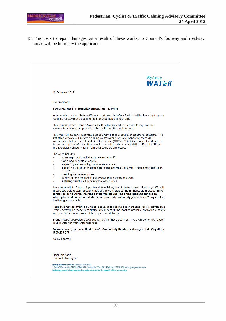
BACKGROUND
An application has been received from Interflow Pty Ltd for the temporary full road closure of a section of Renwick Street between the end of the Woolworths car park and Excelsior Parade, Marrickville, in order to undertake necessary maintenance works on the waste water pipeline in the street, for a period of one week operating 24 hours (Refer to the attached letter and Traffic Control Plan submitted by the applicant). The applicant has not provided exact proposed dates at this stage, due to some external factors. The applicant will need to advise Council of the proposed dates of the temporary road closure at least 7 days in advance and will notify residents.
Pedestrian, Cyclist & Traffic Calming Advisory Committee
24 April 2012
35
DISCUSSION
Renwick Street is a local residential street running west-east from Illawarra Rd and ends at the Eastern Suburbs and Illawarra Rail lines. The subject section of Renwick Street, between Illawarra Road and Excelsior Parade, has a length of approximately 250 metres and a carriageway width of 12 metres. The applicant advised that the works are scheduled to take place for a period of one week, commence on Late May / early June 2012 (weather permitting). Vehicular access for residents will be maintained at all times during the closure. Certified traffic controllers are to be positioned at the closure points to ensure the safety of motorists and pedestrians. Access to Woolworths will be maintained at all times from the western end of the closure from Illawarra road. Whilst the closure is in operation, local residents will be detoured to Illawarra Rd via Cary Street and Warren Road. As these streets are within close proximity and run parallel to Renwick Street, this will minimise affects to traffic flow. PUBLIC CONSULTATION
The applicant is to notify all affected residents and businesses in writing at least 7 days prior to the commencement of works. The proposed road closure is to be advertised in the local newspaper by the applicant in accordance with Council's Consultation Policy. CONCLUSION
It is recommended that the proposed temporary road closures be approved, subject to the conditions outlined in this report. FINANCIAL IMPLICATIONS
Under Council’s Fees & Charges, the applicant is to pay a fee of $1,124 (including GST) for the temporary full road closure. OFFICER’S RECOMMENDATION THAT: The proposed full road closure of Renwick Street (between the end of the Woolworths car park and Excelsior Parade), Marrickville be APPROVED for a period of one (1) week, to undertake necessary maintenance works on the waste water pipeline in the street, Subject to the following conditions;
1. A fee of $1,124.00 (incl. GST) for the temporary full road closure is payable by the applicant
in accordance with Council's Fees and Charges; 2. The temporary full road closure be advertised in the local newspaper providing 7 days notice
for submissions in accordance with Council's Consultation Policy;

Pedestrian, Cyclist & Traffic Calming Advisory Committee
24 April 2012
36
3. A Traffic Control Plan (TCP) which has been prepared by a certified Traffic Controller, is to be submitted to Council for review with a copy of the Traffic Controllers certification number attached to the plan, not less than 5 days prior to implementation of closure;
4. A Road Occupancy License be obtained by the applicant from the Roads and Maritime
Services’ Transport Management Centre;
5. Notice of the proposed closure be forwarded by the applicant to the NSW Police, the NSW Fire Brigades and the NSW Ambulance Services;
6. Notification signs advising of the proposed road closures and new traffic arrangements to be
strategically installed and maintained by the applicant at each end of the street at least 7 days prior to the closure;
7. All affected residents and businesses shall be notified in writing, by the applicant, of the
proposed temporary road closure at least 7 days in advance of the closure with the applicant making reasonable provision for residents;
8. Vehicular and pedestrian access for residents and businesses to their off-street car parking
spaces be maintained where possible whilst site works are in progress; 9. Adequate vehicular traffic control shall be provided for the protection and convenience of
pedestrians and motorists including appropriate signage and flagging. Workers shall be specially designated for this role, as necessary to comply with this condition. This is to be carried out in accordance with the Australian Standard AS 1742.3 - Traffic Control Devices for works on roads;
10. The holder of this approval shall indemnify the Council against all claims, damages and costs
incurred by, or charges made against, the Council in respect to death or injury to any person or damage in any way arising out of this approval. In this regard, a public liability insurance policy for an amount not less than $10,000,000 for any one occurrence is to be obtained and is to note the Council as an interested party. The holder of this approval shall inform its insurer of the terms of this condition and submit a copy of the insurance policy to the Council prior to commencement of the work the subject of this approval;
11. The operator of any unit exercising this approval shall have this approval with them and
produce it if required along with any other relevant authority approvals granted in the connection with the work;
12. Mobile cranes, cherry packers or concrete boom pumps shall not stand within the public way
for extended periods when not in operation under this approval; 13. The operation of the mobile crane shall not give rise to an "offensive noise" as defined in the
Protection of Environment Operations Act, 1997. Furthermore, vibrations and/or emission of gases that are created during its operations and which are a nuisance, or dangerous to public health are not permitted;
14. All work is to be carried out in accordance with Work Cover requirements; and
Pedestrian, Cyclist & Traffic Calming Advisory Committee
24 April 2012
37
15. The costs to repair damages, as a result of these works, to Council's footway and roadway areas will be borne by the applicant.
Pedestrian, Cyclist & Traffic Calming Advisory Committee
24 April 2012
38
Pedestrian, Cyclist & Traffic Calming Advisory Committee
24 April 2012
39
Item No: B5
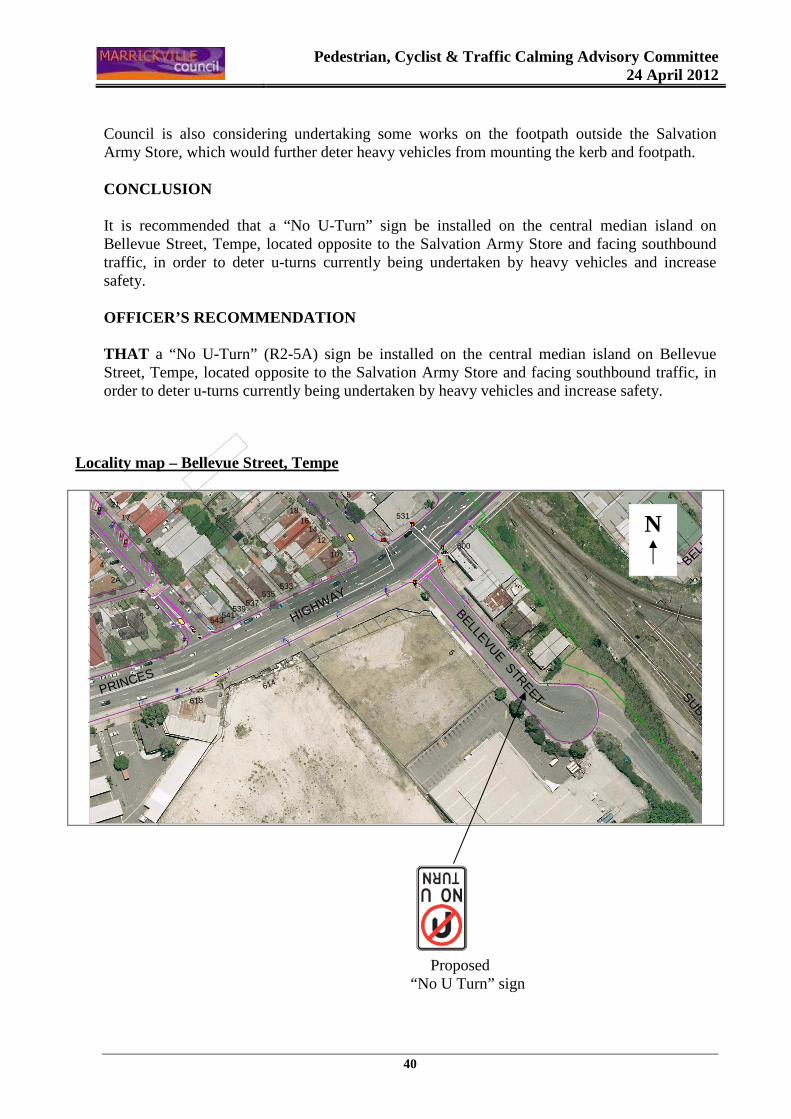
Subject: BELLEVUE STREET, TEMPE (NORTH WARD)
PROPOSED ‘NO U-TURN’
File Ref: S0440-02
Author: Ramy Selim – Engineer, Traffic Services
SYNOPSIS A submission has been received from the Salvation Army Store in Bellevue Street, Tempe raising safety concerns with heavy vehicles continuing to use their driveway to make U-turns and damaging ‘Keep Left’ signage on the median island and mounting the footpath on Bellevue Street. It is recommended that a “No U-Turn” sign be installed on the central median island on Bellevue Street, Tempe, located opposite to the Salvation Army Store and facing southbound traffic, in order to deter u-turns currently being undertaken by heavy vehicles and increase safety. OFFICER’S RECOMMENDATION THAT a “No U-Turn” (R2-5A) sign be installed on the central median island on Bellevue Street, Tempe, located opposite to the Salvation Army Store and facing southbound traffic, in order to deter u-turns currently being undertaken by heavy vehicles and increase safety.
BACKGROUND
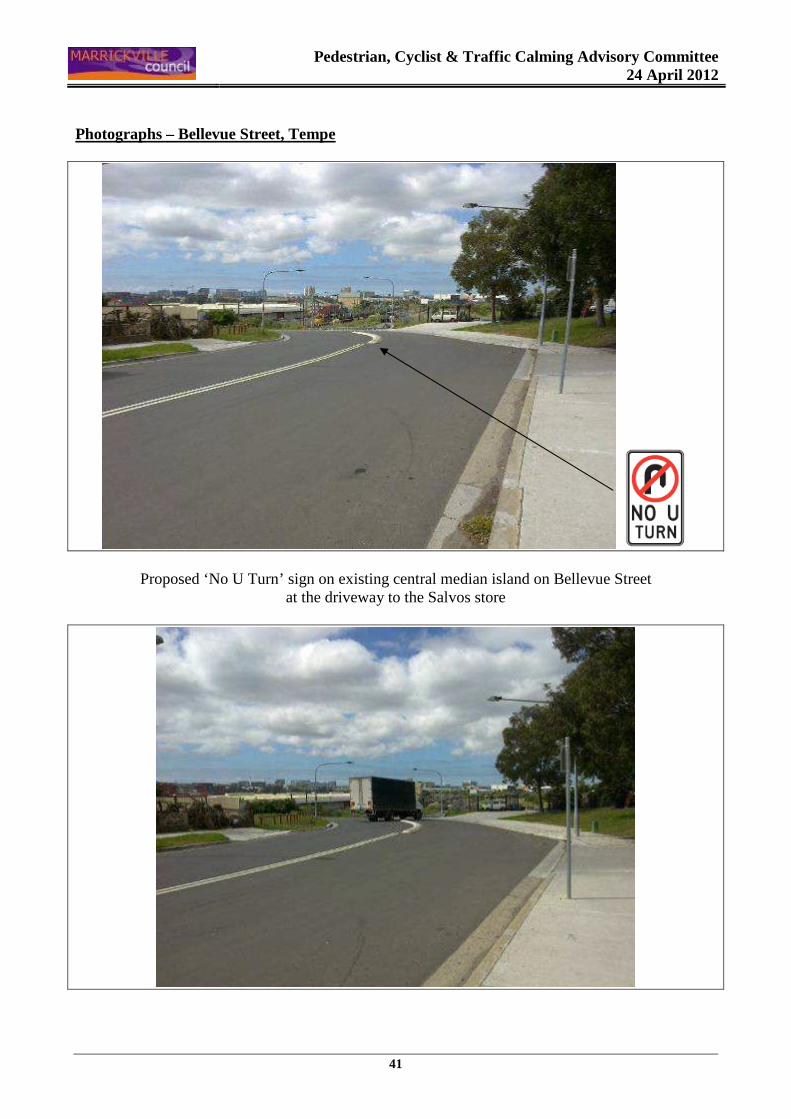
A submission has been received from the Salvation Army Store located in Bellevue Street, Tempe raising safety concerns with heavy vehicles continuing to use their driveway to make U-turns and damaging ‘Keep Left’ signage on the median island and mounting the footpath on Bellevue Street. The applicant is concerned that this may cause an accident one day with trucks doing u turns and three-point turns, while mounting the footpath at times. DISCUSSION
Bellevue Street is a two-way local street running off Princes Highway in an industrial area. It has a carriage way of approximately 12.8 metres in width (Refer to the attached locality map and photographs). The provision of a ‘No U Turn’ on the central median island at this location would assist in deterring the u-turns currently being undertaken by heavy vehicles. Some minor modifications to widen the existing island will be required in order to accommodate the proposed signage.
Pedestrian, Cyclist & Traffic Calming Advisory Committee
24 April 2012
40
Council is also considering undertaking some works on the footpath outside the Salvation Army Store, which would further deter heavy vehicles from mounting the kerb and footpath. CONCLUSION It is recommended that a “No U-Turn” sign be installed on the central median island on Bellevue Street, Tempe, located opposite to the Salvation Army Store and facing southbound traffic, in order to deter u-turns currently being undertaken by heavy vehicles and increase safety. OFFICER’S RECOMMENDATION THAT a “No U-Turn” (R2-5A) sign be installed on the central median island on Bellevue Street, Tempe, located opposite to the Salvation Army Store and facing southbound traffic, in order to deter u-turns currently being undertaken by heavy vehicles and increase safety.
Locality map – Bellevue Street, Tempe
���
�
�
�}
�
�}
w��
w
ww
w�ww
ï
w
ww
�
w
��
w
ww
w
��ww
w
��
�w
w
wBELL
EVUE STREET
BELLEVUE STREET SUBURBAN RAILWAY
PRINCES
HIGHWAY
1
4
2
34
600
2
7
5
618
543
4
2A
541539
537535
533
614
5
62
531
20
1816
1412
10
23
21
17
9 - 15
Proposed “No U Turn” sign
N
Pedestrian, Cyclist & Traffic Calming Advisory Committee
24 April 2012
41
Photographs – Bellevue Street, Tempe
Proposed ‘No U Turn’ sign on existing central median island on Bellevue Street at the driveway to the Salvos store
Pedestrian, Cyclist & Traffic Calming Advisory Committee
24 April 2012
42
SECTION "C" - PARKING MATTERS Item No: C1.1
Subject: FRAZER STREET, DULWICH HILL (CENTRAL WARD)
REQUEST FOR MOBILITY PARKING SPACE OUTSIDE PROPERT Y No. 32
File Ref: S1870-03
Author: Emilio Andari – Student Civil Engineer
SYNOPSIS A request has been received from a resident of Frazer Street, Dulwich Hill for the provision of a dedicated mobility parking space outside their residence. It is recommended that a 'Mobility Parking' space not be approved as the applicant's property has an off-street parking facility and the applicant’s condition does not necessitate the use of a wheel chair for mobility. OFFICER’S RECOMMENDATION THAT a dedicated 'Mobility Parking' space NOT be approved outside 32 Frazer Street, Dulwich Hill, as the applicant's property has an off-street parking facility and the applicant’s condition does not necessitate the use of a wheel chair for mobility.
BACKGROUND
A resident of 32 Frazer Street, Dulwich Hill has submitted an application for the provision of a 'Mobility Parking' space outside their residence. The applicant is elderly and his condition does not necessitate the use of a wheel chair for mobility. No further information was provided by the applicant. DISCUSSION
The applicant’s property is located on the southern side of Frazer Street, approximately 150 metres west of Wardell Road. The applicant’s property has vehicular access from the front on Frazer Street to a driveway that is approximately 2.6m in width, which leads to an undercover off-street parking space (Refer to the attached locality map and photographs). At present, unrestricted parking is permitted on both sides of Frazer Street. The nearest existing mobility parking space is located on the southern side of Frazer Street approximately 110 metres from the applicant’s property. It has been observed during a site inspection undertaken in the afternoon period that on-street parking spaces on Frazer Street were moderately utilised. It was also observed that a vehicle was parked in the off-street parking space at the applicant’s property at the time of the inspection.
Pedestrian, Cyclist & Traffic Calming Advisory Committee
24 April 2012
43
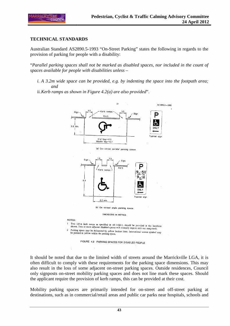
TECHNICAL STANDARDS
Australian Standard AS2890.5-1993 “On-Street Parking” states the following in regards to the provision of parking for people with a disability: “Parallel parking spaces shall not be marked as disabled spaces, nor included in the count of spaces available for people with disabilities unless –
i. A 3.2m wide space can be provided, e.g. by indenting the space into the footpath area; and
ii. Kerb ramps as shown in Figure 4.2(a) are also provided”.
It should be noted that due to the limited width of streets around the Marrickville LGA, it is often difficult to comply with these requirements for the parking space dimensions. This may also result in the loss of some adjacent on-street parking spaces. Outside residences, Council only signposts on-street mobility parking spaces and does not line mark these spaces. Should the applicant require the provision of kerb ramps, this can be provided at their cost. Mobility parking spaces are primarily intended for on-street and off-street parking at destinations, such as in commercial/retail areas and public car parks near hospitals, schools and
Pedestrian, Cyclist & Traffic Calming Advisory Committee
24 April 2012
44
public transport facilities where multiple usage can be expected. They were generally not intended for points of origin such as reserving on-street parking. A mobility parking space is not intended for the sole use of one applicant, but rather a shared facility that can used by all authorised persons having an RMS mobility permit. CONCLUSION
It is recommended that a 'Mobility Parking' space not be approved as the applicant's property has an off-street parking facility and the applicant’s condition does not necessitate the use of a wheel chair for mobility.
FINANCIAL IMPLICATIONS
There are no financial implications for Council. OFFICER’S RECOMMENDATION THAT a dedicated 'Mobility Parking' space NOT be approved outside 32 Frazer Street, Dulwich Hill, as the applicant's property has an off-street parking facility and the applicant’s condition does not necessitate the use of a wheel chair for mobility.
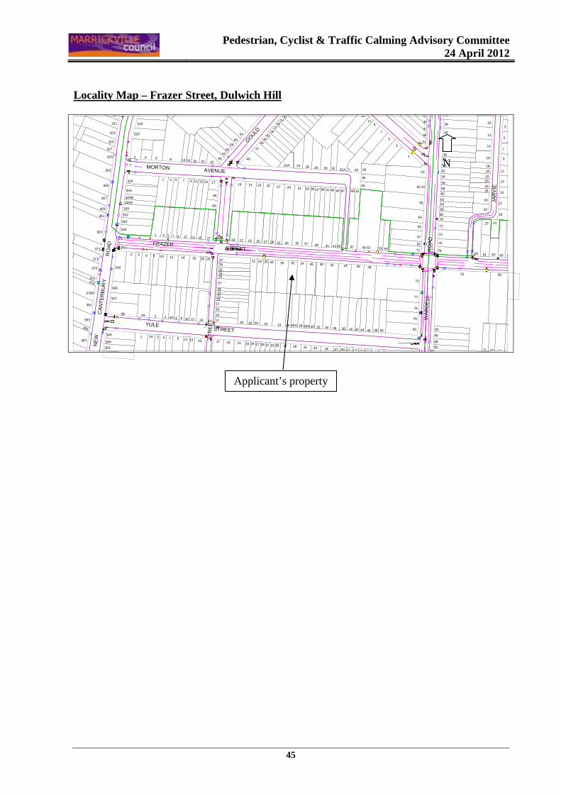
Pedestrian, Cyclist & Traffic Calming Advisory Committee
24 April 2012
45
Locality Map – Frazer Street, Dulwich Hill
w
��
�
�
}
�}
�
�
ww
�
ï
ïwï
ww�
ïw}
w
�
w
w w
��
w�www
www
w
w
www
w
wwwïw
ï
ïw�
�
��
w
}
}��
w
w
�
��
ww�
�
w�
w
w
w
�
æ
w
w
w�
w
w
w
w
www
��
æ�
w
�
�
w
w
w
w
w
w
��
w
ï
ï
w w
ï
wïï
w
w
w
w
w
w w
w
w
w
w
w
w
w
w
�
w
w w
w
w
ïw
FA
IRF
OW
L
S
TR
EE
T
NE
W
C
AN
TE
RB
UR
Y
RO
AD
MORTON AVENUE
FRAZER STREET
YULE STREET
J AR
VIE
WA
RD
ELL
RO
AD
GOULD
3
5
7
10
14
12
36
48
38
40
42
44
46
47
49
43
45
1921 17 15
84
88
86
90
6151 53 55 57 59
42 44 46
67
66
65
9
11
13
16
18
20
2224
26
21
63
28 15
17
19
30
32
52
7859 61
71
69
67
65
63
23
64
60
62
6870
72
74
76
66
51
54
50
52
56
53
55-57
59
58
5048 83
81
79
77
73
40
5349-51
4846
4755
5149
45
38
39 41
444236
43
5
13
119
7
3
1
38
45
3432A 36
47
4037
3230
35 39 41 43
28
35
24A 2624
29 31 33
3331
39
21 23
49
47
4543
41
37
19
54
222064
6260
17
18
9 11 13 15751
14 168
3
28A38
3028
47 4941 43 45
32 34 36
35 37
343230
33
25 27
2216 18 20 24 26 26A
3127
2422 26 28
25 29
2519 21 23 27 29 31 33 35 37 39
21
3537
19 23
5658
29
3331
27
252321
68
66
1917
15
17
14
15
13
1110 12
11 13
14 20
17
1816
13119 15
5
4A
1 1A 3 7 9
2 86
1210864
316
320
75
323
321
332
326A
330
31
326B
353
327
329
324
326
2 4 6
340
381
379A
342
346
383
2B 2A 4
385
325
319
357
355
363
359
361
334
336
379
375
2373
371
377
338
348
350
387
Applicant’s property
N
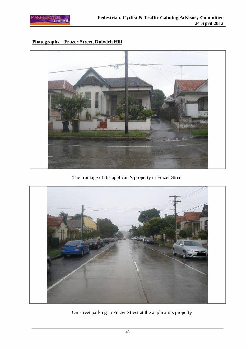
Pedestrian, Cyclist & Traffic Calming Advisory Committee
24 April 2012
46
Photographs – Frazer Street, Dulwich Hill
The frontage of the applicant's property in Frazer Street
On-street parking in Frazer Street at the applicant’s property
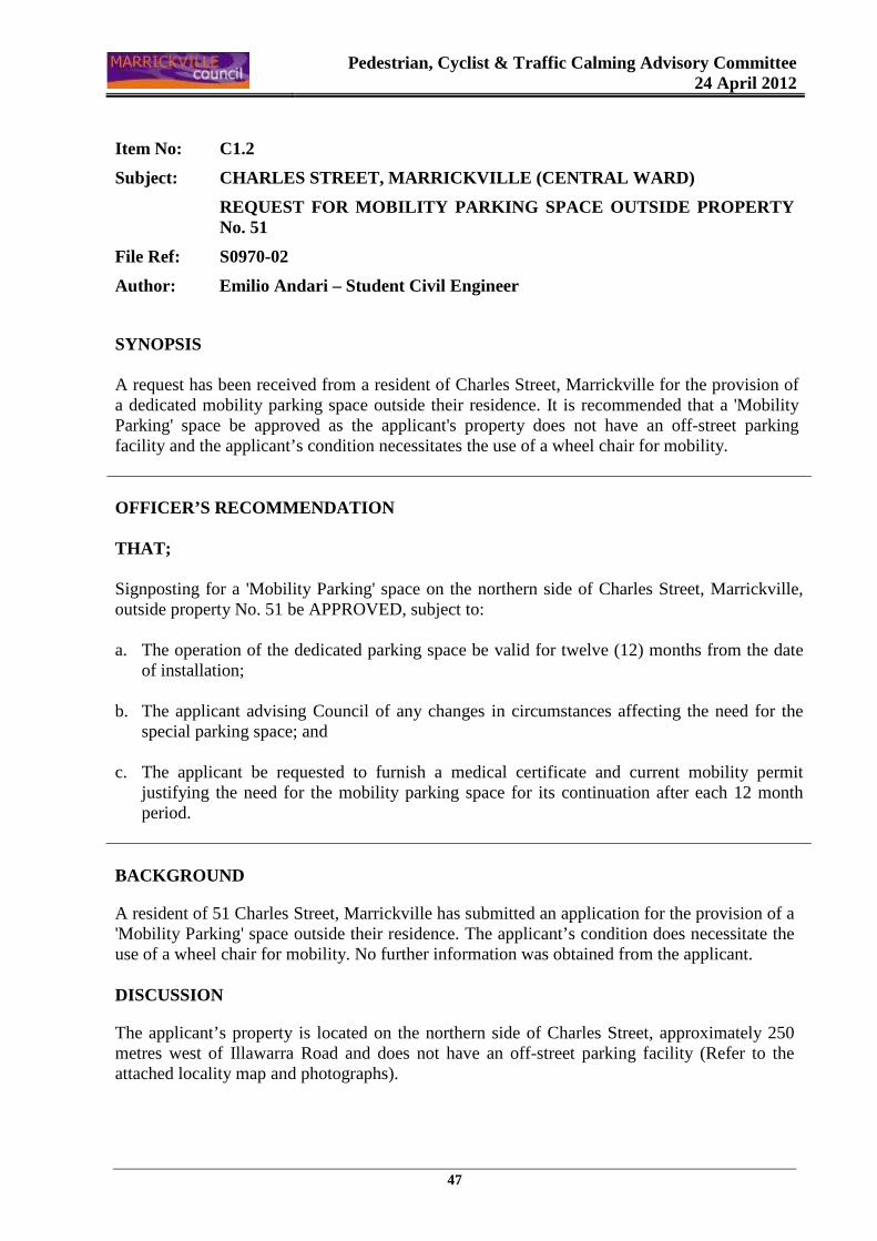
Pedestrian, Cyclist & Traffic Calming Advisory Committee
24 April 2012
47
Item No: C1.2
Subject: CHARLES STREET, MARRICKVILLE (CENTRAL WARD )
REQUEST FOR MOBILITY PARKING SPACE OUTSIDE PROPERT Y No. 51
File Ref: S0970-02
Author: Emilio Andari – Student Civil Engineer
SYNOPSIS A request has been received from a resident of Charles Street, Marrickville for the provision of a dedicated mobility parking space outside their residence. It is recommended that a 'Mobility Parking' space be approved as the applicant's property does not have an off-street parking facility and the applicant’s condition necessitates the use of a wheel chair for mobility. OFFICER’S RECOMMENDATION THAT; Signposting for a 'Mobility Parking' space on the northern side of Charles Street, Marrickville, outside property No. 51 be APPROVED, subject to: a. The operation of the dedicated parking space be valid for twelve (12) months from the date
of installation;
b. The applicant advising Council of any changes in circumstances affecting the need for the special parking space; and
c. The applicant be requested to furnish a medical certificate and current mobility permit
justifying the need for the mobility parking space for its continuation after each 12 month period.
BACKGROUND
A resident of 51 Charles Street, Marrickville has submitted an application for the provision of a 'Mobility Parking' space outside their residence. The applicant’s condition does necessitate the use of a wheel chair for mobility. No further information was obtained from the applicant. DISCUSSION
The applicant’s property is located on the northern side of Charles Street, approximately 250 metres west of Illawarra Road and does not have an off-street parking facility (Refer to the attached locality map and photographs).
Pedestrian, Cyclist & Traffic Calming Advisory Committee
24 April 2012
48
At present, unrestricted parking is permitted on both sides of Charles Street. The nearest existing mobility parking space is located approximately 30 metres from the applicant’s property on the northern side of Charles Street. It has been observed during a site inspection undertaken in the afternoon period that on-street parking spaces on Charles Street were moderately utilised. TECHNICAL STANDARDS
Australian Standard AS2890.5-1993 “On-Street Parking” states the following in regards to the provision of parking for people with a disability: “Parallel parking spaces shall not be marked as disabled spaces, nor included in the count of spaces available for people with disabilities unless –
iii. A 3.2m wide space can be provided, e.g. by indenting the space into the footpath area; and
iv. Kerb ramps as shown in Figure 4.2(a) are also provided”.

Pedestrian, Cyclist & Traffic Calming Advisory Committee
24 April 2012
49
It should be noted that due to the limited width of streets around the Marrickville LGA, it is often difficult to comply with these requirements for the parking space dimensions. This may also result in the loss of some adjacent on-street parking spaces. Outside residences, Council only signposts on-street mobility parking spaces and does not line mark these spaces. Should the applicant require the provision of kerb ramps, this can be provided at their cost. Mobility parking spaces are primarily intended for on-street and off-street parking at destinations, such as in commercial/retail areas and public car parks near hospitals, schools and public transport facilities where multiple usage can be expected. They were generally not intended for points of origin such as reserving on-street parking. A mobility parking space is not intended for the sole use of one applicant, but rather a shared facility that can used by all authorised persons having an RMS mobility permit. CONCLUSION
It is recommended that a 'Mobility Parking' space be approved as the applicant's property does not have an off-street parking facility and the applicant’s condition necessitates the use of a wheel chair for mobility. It should be noted that the proposed mobility parking space is not for the sole use of the applicant and may be used by other authorised persons.
FINANCIAL IMPLICATIONS
The costs of the supply and installation of the signposting associated with the recommended mobility parking space is approximately $700. OFFICER’S RECOMMENDATION THAT; Signposting for a 'Mobility Parking' space on the northern side of Charles Street, Marrickville, outside property No. 51 be APPROVED, subject to: a. The operation of the dedicated parking space be valid for twelve (12) months from the date
of installation;
b. The applicant advising Council of any changes in circumstances affecting the need for the special parking space; and
c. The applicant be requested to furnish a medical certificate and current mobility permit
justifying the need for the mobility parking space for its continuation after each 12 month period.
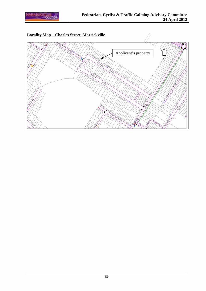
Pedestrian, Cyclist & Traffic Calming Advisory Committee
24 April 2012
50
Locality Map – Charles Street, Marrickville
��
}
�
w
}
�w
�
�
��
wï
ww
w
w
w
w
w
w
w�
w
w
w
�
w
www
ww
ww
w
w
w
ww
��w
w
w
YOR
K
S
TREE
T
ME
EKS
LAN
E
SURREY STREET
AMY
STR
EET
CHARLES STREETHORTON STREET
SHEP
HE
RD
S
TRE
ET
CH
APEL LANE
ILLA
WAR
RA
RO
AD
WOODLAND STREET
NE
VILL
E
STR
EET
NORWOOD LANE
CE
NTE
NN
IAL
STR
EET
70
62
68
109
66
87
85
83
81
91
5
119
7
31
68
2
2321
1917
1513
4
6
14
810
12
6
1
3
57
911 10
2830
30A32
32A
36
39-43
34
3840
42
2
47
51
49
53-55
45
5759
44
46
48
52
54
9
13
5
7
4
1113
Sydney Water
2
128
134
132
130
126
124
122
18
16
6
8
10
12
14
20
22
15
140
138
136
54A
34
24
28
30
3653
55
57
63
67
65
71
69
4846
5052
5456
5860
6
3
1315
8
42
10
18
2527
2119
17
20
1614
22
24
21
17
19
2325
27
41
33
2931
3537
39
59
58A
56
4042
44
51
47
4532 43
49
79
62
73
75
77
7966
64
2
4
7
9
5
16
27
25
1210
6
14
18
24-26
27A
23
37
3533
3129
1
2628
20-22
24
22
20
18
19
17 8
30
24
20
32
18
26
1614
1210
3634
37
46
48
50
54
56
27
29
318
6
4
68
72
70
33
35
2340-42
44
19
21
25
2
25
28
26
29
27
21
23
66
58
62
64
17
15
31
61-65
111
231
241
239
237
235
233
229
227
7
5
3
30
28
32
43
5351
4745
4139
49
33A
20
18
16
35
31
29
37
13
33
34
40
1315
119
38
36
15A
63
6765
6159
5755
58
7
9
19
1756
3
69
1
21
5
119
75
3
13
17
15
50
4244
4648
5254
33
Applicant’s property
N
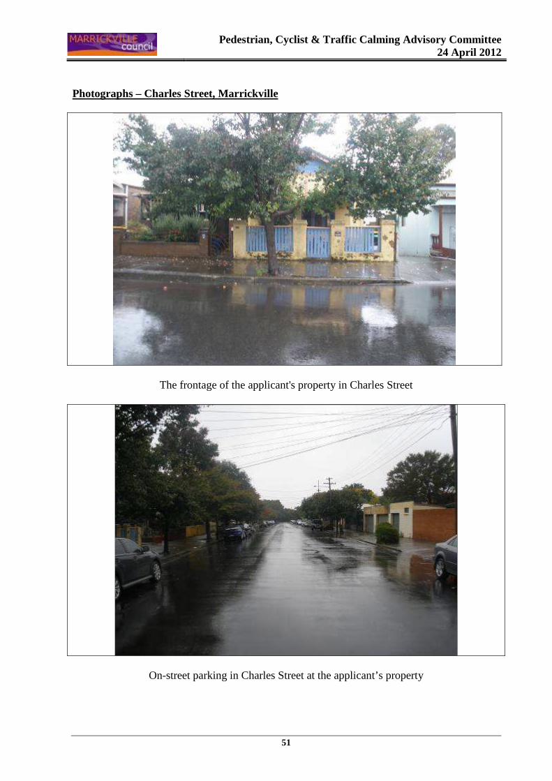
Pedestrian, Cyclist & Traffic Calming Advisory Committee
24 April 2012
51
Photographs – Charles Street, Marrickville
The frontage of the applicant's property in Charles Street
On-street parking in Charles Street at the applicant’s property
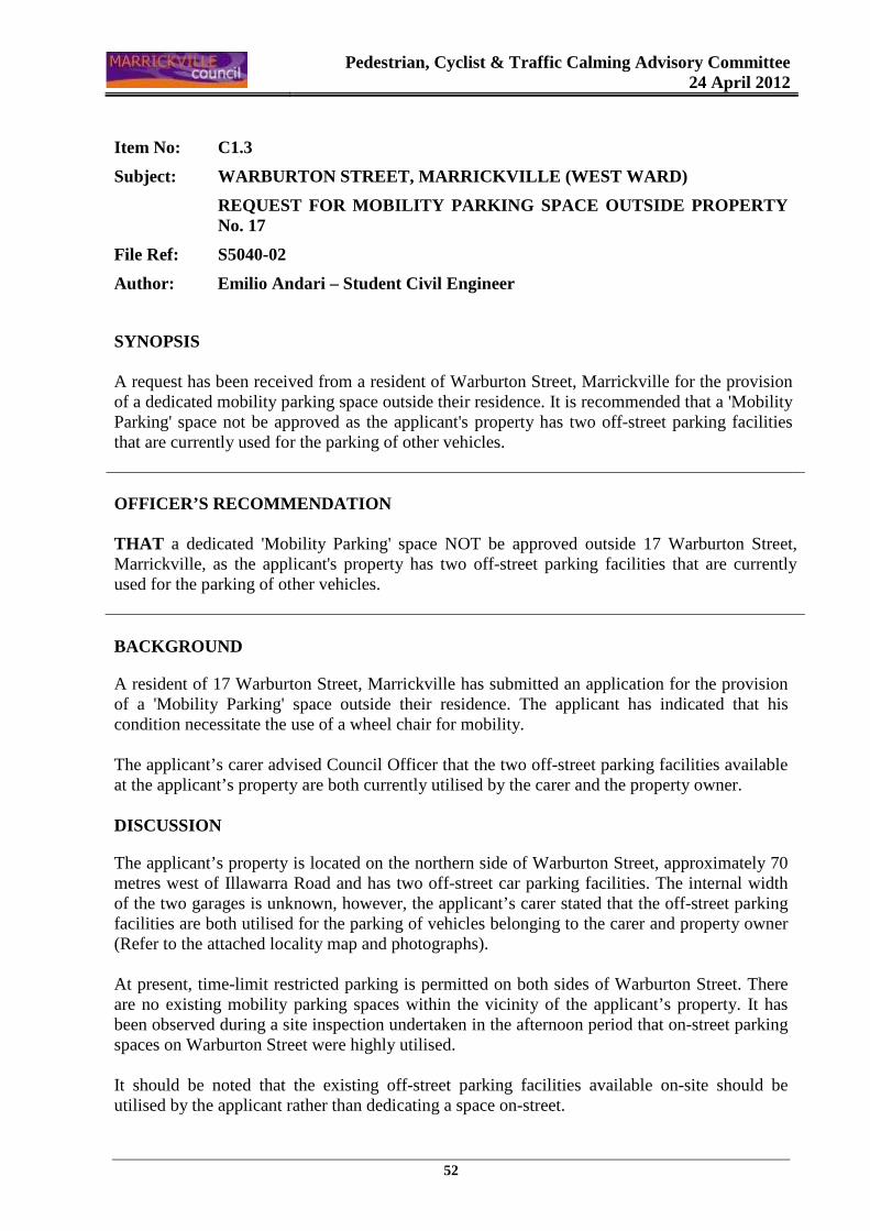
Pedestrian, Cyclist & Traffic Calming Advisory Committee
24 April 2012
52
Item No: C1.3
Subject: WARBURTON STREET, MARRICKVILLE (WEST WARD)
REQUEST FOR MOBILITY PARKING SPACE OUTSIDE PROPERT Y No. 17
File Ref: S5040-02
Author: Emilio Andari – Student Civil Engineer
SYNOPSIS A request has been received from a resident of Warburton Street, Marrickville for the provision of a dedicated mobility parking space outside their residence. It is recommended that a 'Mobility Parking' space not be approved as the applicant's property has two off-street parking facilities that are currently used for the parking of other vehicles. OFFICER’S RECOMMENDATION THAT a dedicated 'Mobility Parking' space NOT be approved outside 17 Warburton Street, Marrickville, as the applicant's property has two off-street parking facilities that are currently used for the parking of other vehicles.
BACKGROUND
A resident of 17 Warburton Street, Marrickville has submitted an application for the provision of a 'Mobility Parking' space outside their residence. The applicant has indicated that his condition necessitate the use of a wheel chair for mobility. The applicant’s carer advised Council Officer that the two off-street parking facilities available at the applicant’s property are both currently utilised by the carer and the property owner. DISCUSSION
The applicant’s property is located on the northern side of Warburton Street, approximately 70 metres west of Illawarra Road and has two off-street car parking facilities. The internal width of the two garages is unknown, however, the applicant’s carer stated that the off-street parking facilities are both utilised for the parking of vehicles belonging to the carer and property owner (Refer to the attached locality map and photographs). At present, time-limit restricted parking is permitted on both sides of Warburton Street. There are no existing mobility parking spaces within the vicinity of the applicant’s property. It has been observed during a site inspection undertaken in the afternoon period that on-street parking spaces on Warburton Street were highly utilised. It should be noted that the existing off-street parking facilities available on-site should be utilised by the applicant rather than dedicating a space on-street.

Pedestrian, Cyclist & Traffic Calming Advisory Committee
24 April 2012
53
TECHNICAL STANDARDS
Australian Standard AS2890.5-1993 “On-Street Parking” states the following in regards to the provision of parking for people with a disability: “Parallel parking spaces shall not be marked as disabled spaces, nor included in the count of spaces available for people with disabilities unless –
i. A 3.2m wide space can be provided, e.g. by indenting the space into the footpath area; and
ii. Kerb ramps as shown in Figure 4.2(a) are also provided”.
It should be noted that due to the limited width of streets around the Marrickville LGA, it is often difficult to comply with these requirements for the parking space dimensions. This may also result in the loss of some adjacent on-street parking spaces. Outside residences, Council only signposts on-street mobility parking spaces and does not line mark these spaces. Should the applicant require the provision of kerb ramps, this can be provided at their cost. Mobility parking spaces are primarily intended for on-street and off-street parking at destinations, such as in commercial/retail areas and public car parks near hospitals, schools and
Pedestrian, Cyclist & Traffic Calming Advisory Committee
24 April 2012
54
public transport facilities where multiple usage can be expected. They were generally not intended for points of origin such as reserving on-street parking. A mobility parking space is not intended for the sole use of one applicant, but rather a shared facility that can used by all authorised persons having an RMS mobility permit. CONCLUSION
It is recommended that a 'Mobility Parking' space not be approved as the applicant's property has two off-street parking facilities that are currently used for the parking of other vehicles.
FINANCIAL IMPLICATIONS
There are no financial implications for Council. OFFICER’S RECOMMENDATION THAT a dedicated 'Mobility Parking' space NOT be approved outside 17 Warburton Street, Marrickville, as the applicant's property has two off-street parking facilities that are currently used for the parking of other vehicles.
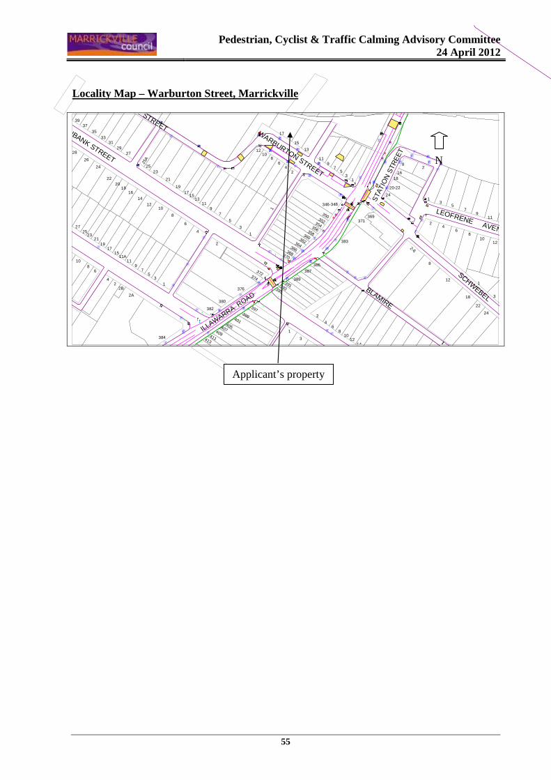
Pedestrian, Cyclist & Traffic Calming Advisory Committee
24 April 2012
55
Locality Map – Warburton Street, Marrickville
ww
�
�
ww
ww�
�
w
wwww
w
w
w
�
��
w
w
}w
�
w
�ww�
wwww
w
ww
w
w
�
w
��
��
�
ww
ww�
w
�
æ
ïï
�
wwww
ww�
w
w
w
w
��
ww
w
ww
ïw
w
ww
w
ww�
w
�w
��
w
w
w
w
w�w
w
w
w
ww
w
w
wï
ï
ww ww
ïw
www
ww
ww
www
www
ww
w
SCHWEBEL STREET
LEOFRENE AVENUE
BLAMIRE LANE
STA
TIO
N S
TRE
ET
ILLAWARRA ROAD
GREENBANK STREET
WARBURTON STREETWARBURTON STREET
12
8
12
18
22
24
1
3
6
31
911
10
57
42
8
2-6
18
20-22
24
369
12
810
14
1
371
383
346-348
6
3
5
2
4
366
356
350352354
358360362364368370
374
372
1
395393
397
391
387
385
1389
7
5
3
1
2
407
382
380
376
399401
405409411413
1210 1
1715
1311
9
8
6
4
384
27
2018
16
14
29
23
21
19
2B
1517
11A11
97
534
2
2A
53
16
118
29
7
8
17
15
131210
64
2
37
22
39
3533
31
28
26
24 25
25A
6
19
2725
2321
108
Applicant’s property
N
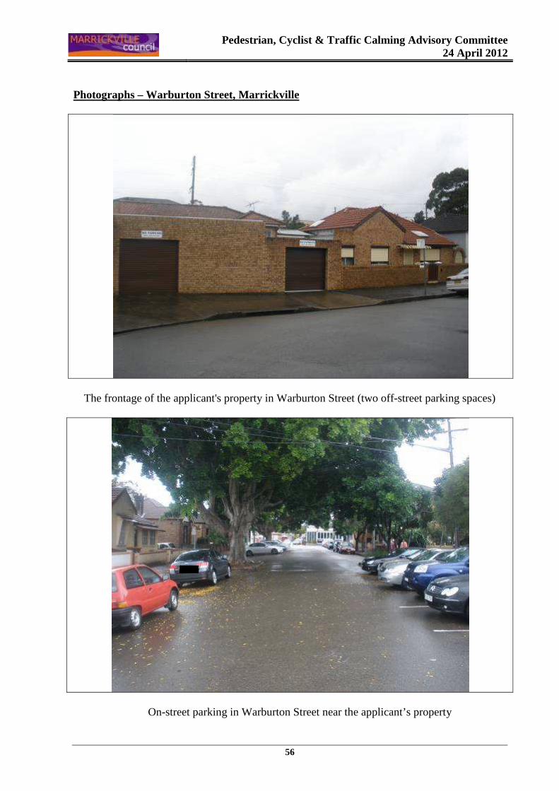
Pedestrian, Cyclist & Traffic Calming Advisory Committee
24 April 2012
56
Photographs – Warburton Street, Marrickville
The frontage of the applicant's property in Warburton Street (two off-street parking spaces)
On-street parking in Warburton Street near the applicant’s property
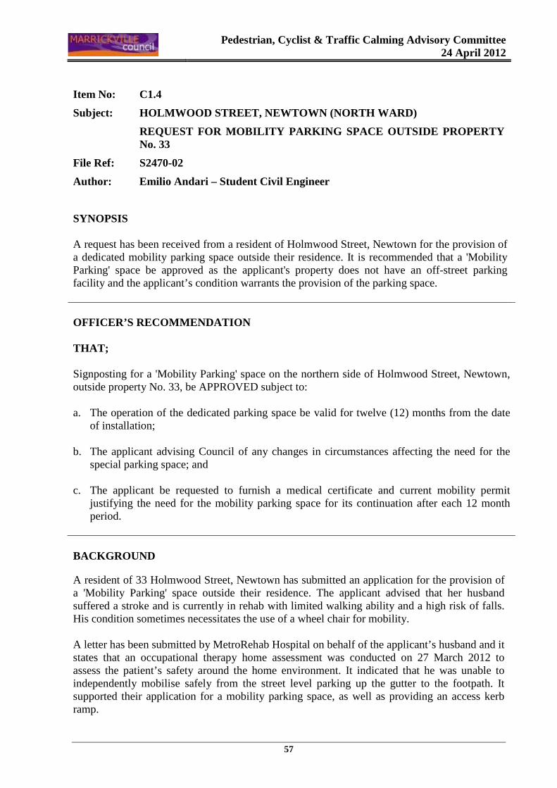
Pedestrian, Cyclist & Traffic Calming Advisory Committee
24 April 2012
57
Item No: C1.4
Subject: HOLMWOOD STREET, NEWTOWN (NORTH WARD)
REQUEST FOR MOBILITY PARKING SPACE OUTSIDE PROPERT Y No. 33
File Ref: S2470-02
Author: Emilio Andari – Student Civil Engineer
SYNOPSIS A request has been received from a resident of Holmwood Street, Newtown for the provision of a dedicated mobility parking space outside their residence. It is recommended that a 'Mobility Parking' space be approved as the applicant's property does not have an off-street parking facility and the applicant’s condition warrants the provision of the parking space. OFFICER’S RECOMMENDATION THAT; Signposting for a 'Mobility Parking' space on the northern side of Holmwood Street, Newtown, outside property No. 33, be APPROVED subject to: a. The operation of the dedicated parking space be valid for twelve (12) months from the date
of installation;
b. The applicant advising Council of any changes in circumstances affecting the need for the special parking space; and
c. The applicant be requested to furnish a medical certificate and current mobility permit
justifying the need for the mobility parking space for its continuation after each 12 month period.
BACKGROUND
A resident of 33 Holmwood Street, Newtown has submitted an application for the provision of a 'Mobility Parking' space outside their residence. The applicant advised that her husband suffered a stroke and is currently in rehab with limited walking ability and a high risk of falls. His condition sometimes necessitates the use of a wheel chair for mobility. A letter has been submitted by MetroRehab Hospital on behalf of the applicant’s husband and it states that an occupational therapy home assessment was conducted on 27 March 2012 to assess the patient’s safety around the home environment. It indicated that he was unable to independently mobilise safely from the street level parking up the gutter to the footpath. It supported their application for a mobility parking space, as well as providing an access kerb ramp.
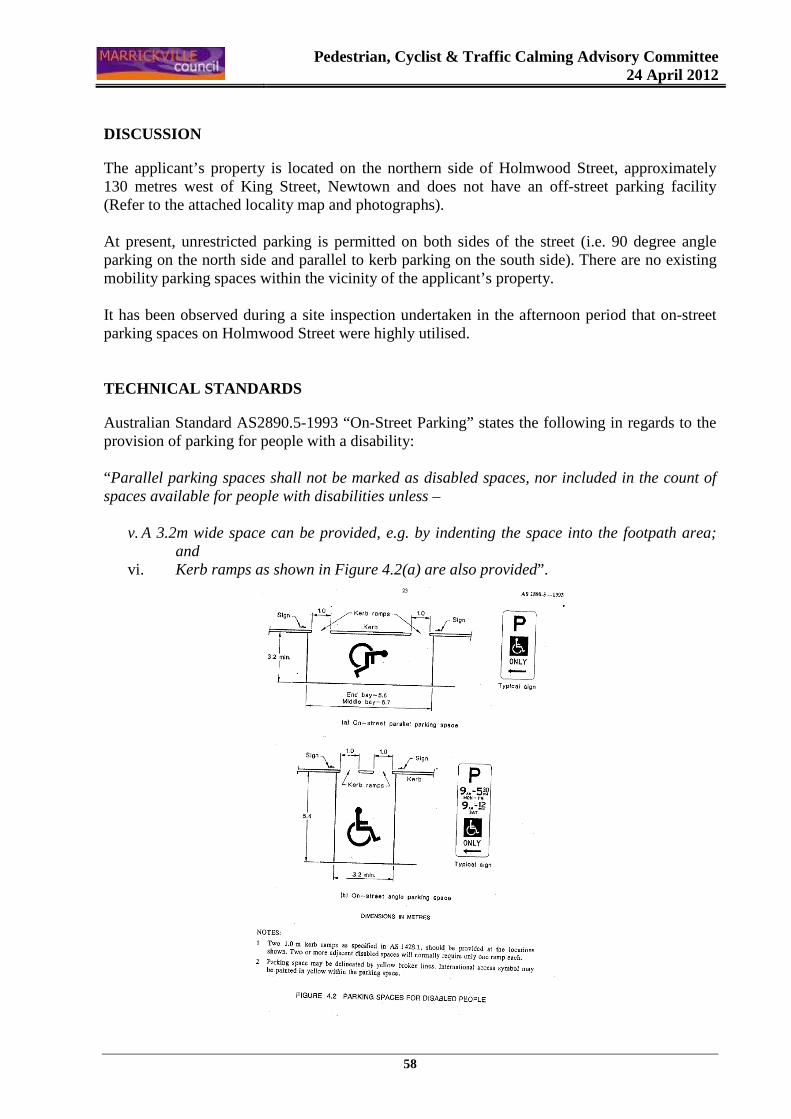
Pedestrian, Cyclist & Traffic Calming Advisory Committee
24 April 2012
58
DISCUSSION
The applicant’s property is located on the northern side of Holmwood Street, approximately 130 metres west of King Street, Newtown and does not have an off-street parking facility (Refer to the attached locality map and photographs). At present, unrestricted parking is permitted on both sides of the street (i.e. 90 degree angle parking on the north side and parallel to kerb parking on the south side). There are no existing mobility parking spaces within the vicinity of the applicant’s property. It has been observed during a site inspection undertaken in the afternoon period that on-street parking spaces on Holmwood Street were highly utilised. TECHNICAL STANDARDS
Australian Standard AS2890.5-1993 “On-Street Parking” states the following in regards to the provision of parking for people with a disability: “Parallel parking spaces shall not be marked as disabled spaces, nor included in the count of spaces available for people with disabilities unless –
v. A 3.2m wide space can be provided, e.g. by indenting the space into the footpath area; and
vi. Kerb ramps as shown in Figure 4.2(a) are also provided”.
Pedestrian, Cyclist & Traffic Calming Advisory Committee
24 April 2012
59
It should be noted that due to the limited width of streets around the Marrickville LGA, it is often difficult to comply with these requirements for the parking space dimensions. This may also result in the loss of some adjacent on-street parking spaces. Outside residences, Council only signposts on-street mobility parking spaces and does not line mark these spaces. Should the applicant require the provision of kerb ramps, this can be provided at their cost. Mobility parking spaces are primarily intended for on-street and off-street parking at destinations, such as in commercial/retail areas and public car parks near hospitals, schools and public transport facilities where multiple usage can be expected. They were generally not intended for points of origin such as reserving on-street parking. A mobility parking space is not intended for the sole use of one applicant, but rather a shared facility that can used by all authorised persons having an RMS mobility permit. CONCLUSION
It is recommended that a 'Mobility Parking' space be approved as the applicant's property does not have an off-street parking facility and the applicant’s condition warrants the provision of the parking space. It should be noted that the proposed mobility parking space is not for the sole use of the applicant and may be used by other authorised persons. FINANCIAL IMPLICATIONS
The costs of the supply and installation of the signposting associated with the recommended mobility parking space is approximately $700. OFFICER’S RECOMMENDATION THAT; Signposting for a 'Mobility Parking' space on the northern side of Holmwood Street, Newtown, outside property No. 33, be APPROVED subject to: a. The operation of the dedicated parking space be valid for twelve (12) months from the date
of installation;
b. The applicant advising Council of any changes in circumstances affecting the need for the special parking space; and
c. The applicant be requested to furnish a medical certificate and current mobility permit
justifying the need for the mobility parking space for its continuation after each 12 month period.
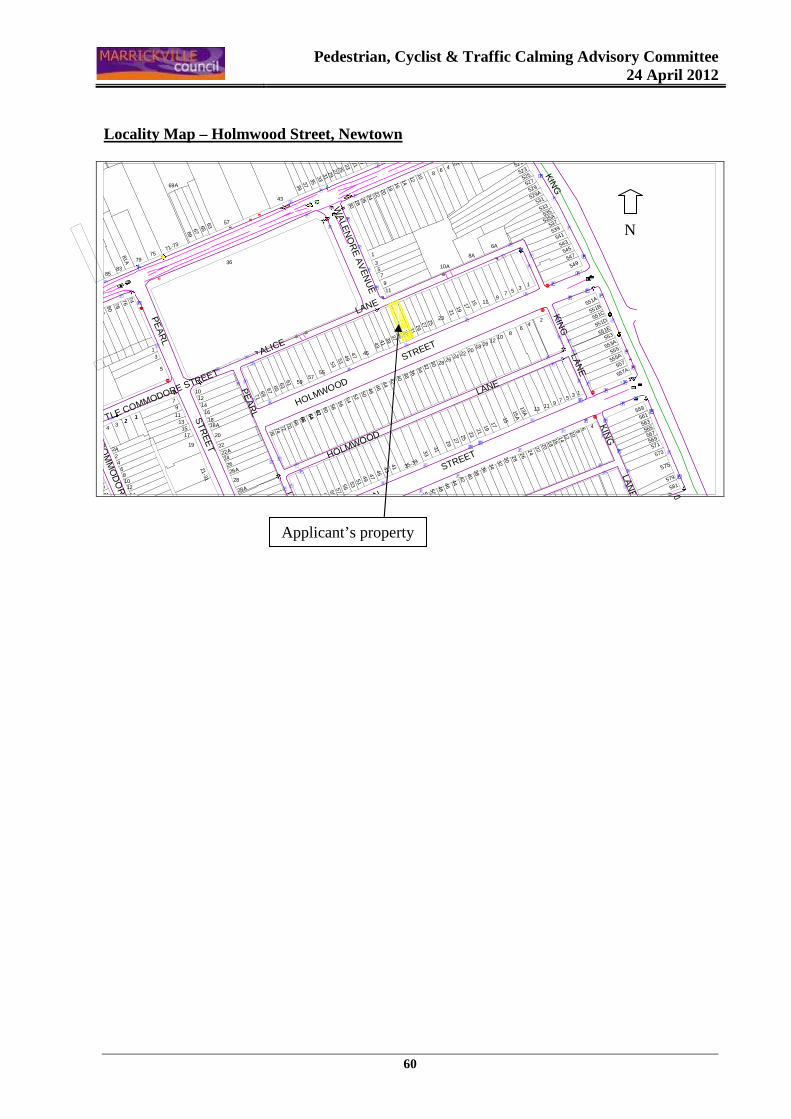
Pedestrian, Cyclist & Traffic Calming Advisory Committee
24 April 2012
60
Locality Map – Holmwood Street, Newtown
�
www
ww��
ww
www
�wwww
w
w
w
w
w
wïw
ï
ïw
ww��
w
w
ww
��w
w�
ww
www
w
ww
w
w
w
w
}
w
w
ww
w
w
}
w
w
w
w
w
ww
w
w
w
w
w
}
ww}
w
w
ww
w
w
w
w
w
w
�
w
ww
w
ww
w
w
w
w
ww
w
w
w
ww
w
w
w
w
w
ww
w
w
ww
ww
w
ï
w
w
ïï
}
w
ï
w
�
�ww
w
w
w
KIN
G
LAN
E
KING
DICKSON
STREETHOLMWOOD
LANE
WA
LEN
OR
E A
VE
NU
E
ALICE
LANE
HOLMWOOD
S
TREET
KIN
G LA
NE
CO
MM
OD
OR
E S
TRE
ET
LITTLE COMMODORE STREET
PE
AR
L STR
EE
T
PE
AR
L LAN
E
579
581
567
573571
569
575
559
561
563
565
1
48 6
9 7 5 3
555A
557
557A
1210
1614
2422
1315A
11
15
2018
262830323436
17192123252729
33
3150
4038
424446485254
35-39
553A
551A
551B
551C
551D
551E
553
555
549547
545543
541539
527
535A535
529A
525
521
523
531
533
529
537
24
68
10
5
6A
8A
13
7
11
16
9
1218
202224
2119
1715
2A
86 4
2528
2630
2927
23
1
357
9
10A
11
394341
3735
3331
18
1926
2422
20
1614
1210
28
29
21232527
30
3133353739
63
13A
36
4846
4442
4038
3432
4341
454749515347
5351
49
45
54
5860
56
5250
59
55576163
64
57
626466
62
66
59
55
687072747667
6563
61
1416
7169
28
3028A
26A26
2422A
21-31
18A18
20
22
12
43
57
69A
36
71-73
7579
6967
65
11
19
131517
79
10
1
5
3
4
1412
108
6
2
31
24
2A
12
8280
7876
74
1921
8583
81A
Applicant’s property
N
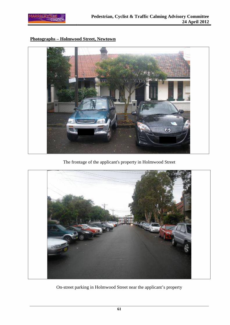
Pedestrian, Cyclist & Traffic Calming Advisory Committee
24 April 2012
61
Photographs – Holmwood Street, Newtown
The frontage of the applicant's property in Holmwood Street
On-street parking in Holmwood Street near the applicant’s property
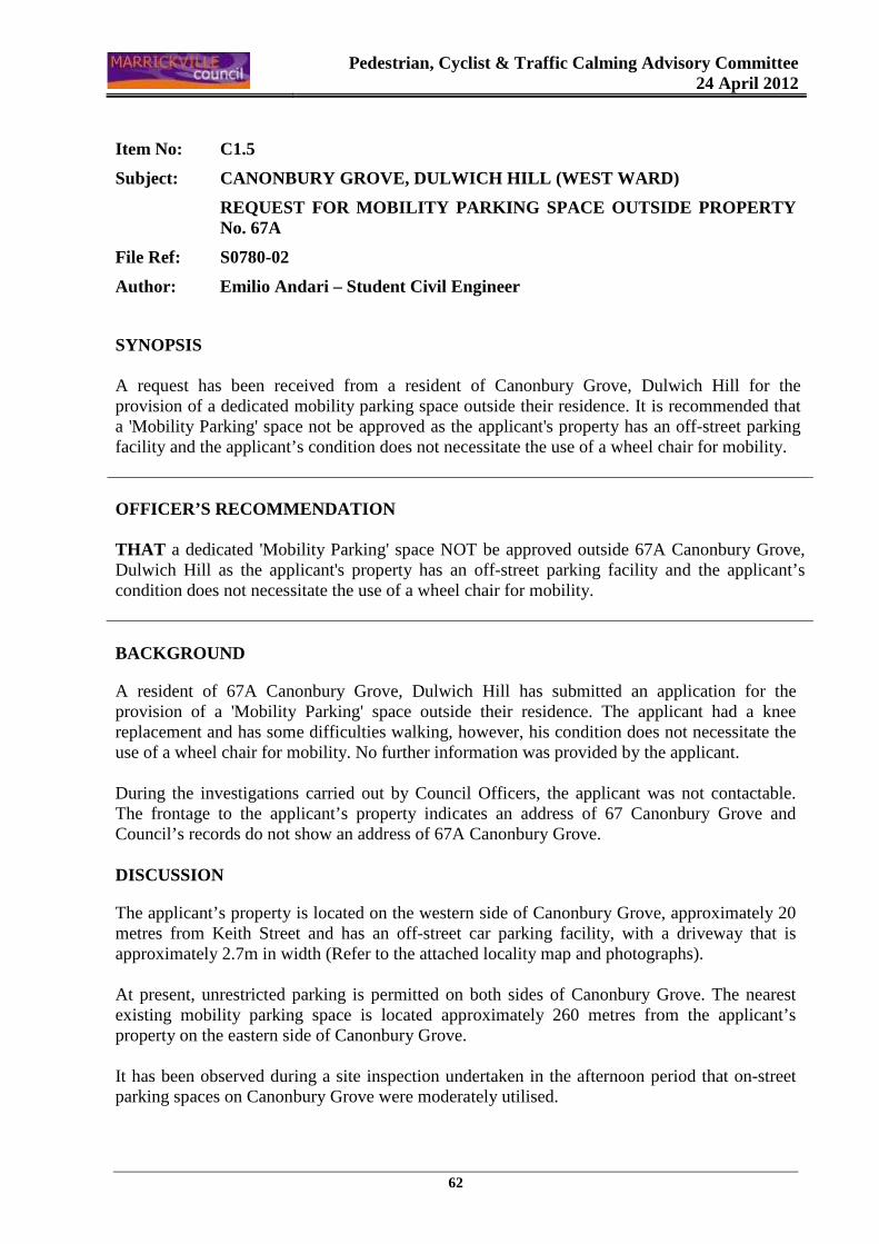
Pedestrian, Cyclist & Traffic Calming Advisory Committee
24 April 2012
62
Item No: C1.5
Subject: CANONBURY GROVE, DULWICH HILL (WEST WARD)
REQUEST FOR MOBILITY PARKING SPACE OUTSIDE PROPERT Y No. 67A
File Ref: S0780-02
Author: Emilio Andari – Student Civil Engineer
SYNOPSIS A request has been received from a resident of Canonbury Grove, Dulwich Hill for the provision of a dedicated mobility parking space outside their residence. It is recommended that a 'Mobility Parking' space not be approved as the applicant's property has an off-street parking facility and the applicant’s condition does not necessitate the use of a wheel chair for mobility. OFFICER’S RECOMMENDATION THAT a dedicated 'Mobility Parking' space NOT be approved outside 67A Canonbury Grove, Dulwich Hill as the applicant's property has an off-street parking facility and the applicant’s condition does not necessitate the use of a wheel chair for mobility.
BACKGROUND
A resident of 67A Canonbury Grove, Dulwich Hill has submitted an application for the provision of a 'Mobility Parking' space outside their residence. The applicant had a knee replacement and has some difficulties walking, however, his condition does not necessitate the use of a wheel chair for mobility. No further information was provided by the applicant. During the investigations carried out by Council Officers, the applicant was not contactable. The frontage to the applicant’s property indicates an address of 67 Canonbury Grove and Council’s records do not show an address of 67A Canonbury Grove. DISCUSSION
The applicant’s property is located on the western side of Canonbury Grove, approximately 20 metres from Keith Street and has an off-street car parking facility, with a driveway that is approximately 2.7m in width (Refer to the attached locality map and photographs). At present, unrestricted parking is permitted on both sides of Canonbury Grove. The nearest existing mobility parking space is located approximately 260 metres from the applicant’s property on the eastern side of Canonbury Grove. It has been observed during a site inspection undertaken in the afternoon period that on-street parking spaces on Canonbury Grove were moderately utilised.
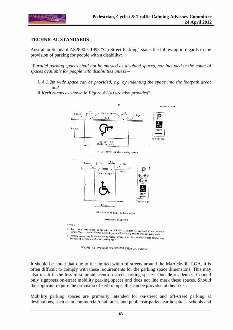
Pedestrian, Cyclist & Traffic Calming Advisory Committee
24 April 2012
63
TECHNICAL STANDARDS
Australian Standard AS2890.5-1993 “On-Street Parking” states the following in regards to the provision of parking for people with a disability: “Parallel parking spaces shall not be marked as disabled spaces, nor included in the count of spaces available for people with disabilities unless –
i. A 3.2m wide space can be provided, e.g. by indenting the space into the footpath area; and
ii. Kerb ramps as shown in Figure 4.2(a) are also provided”.
It should be noted that due to the limited width of streets around the Marrickville LGA, it is often difficult to comply with these requirements for the parking space dimensions. This may also result in the loss of some adjacent on-street parking spaces. Outside residences, Council only signposts on-street mobility parking spaces and does not line mark these spaces. Should the applicant require the provision of kerb ramps, this can be provided at their cost. Mobility parking spaces are primarily intended for on-street and off-street parking at destinations, such as in commercial/retail areas and public car parks near hospitals, schools and

Pedestrian, Cyclist & Traffic Calming Advisory Committee
24 April 2012
64
public transport facilities where multiple usage can be expected. They were generally not intended for points of origin such as reserving on-street parking. A mobility parking space is not intended for the sole use of one applicant, but rather a shared facility that can used by all authorised persons having an RMS mobility permit. CONCLUSION
It is recommended that a 'Mobility Parking' space not be approved as the applicant's property has an off-street parking facility and the applicant’s condition does not necessitate the use of a wheel chair for mobility.
FINANCIAL IMPLICATIONS
There are no financial implications for Council. OFFICER’S RECOMMENDATION THAT a dedicated 'Mobility Parking' space NOT be approved outside 67A Canonbury Grove, Dulwich Hill, as the applicant's property has an off-street parking facility and the applicant’s condition does not necessitate the use of a wheel chair for mobility.
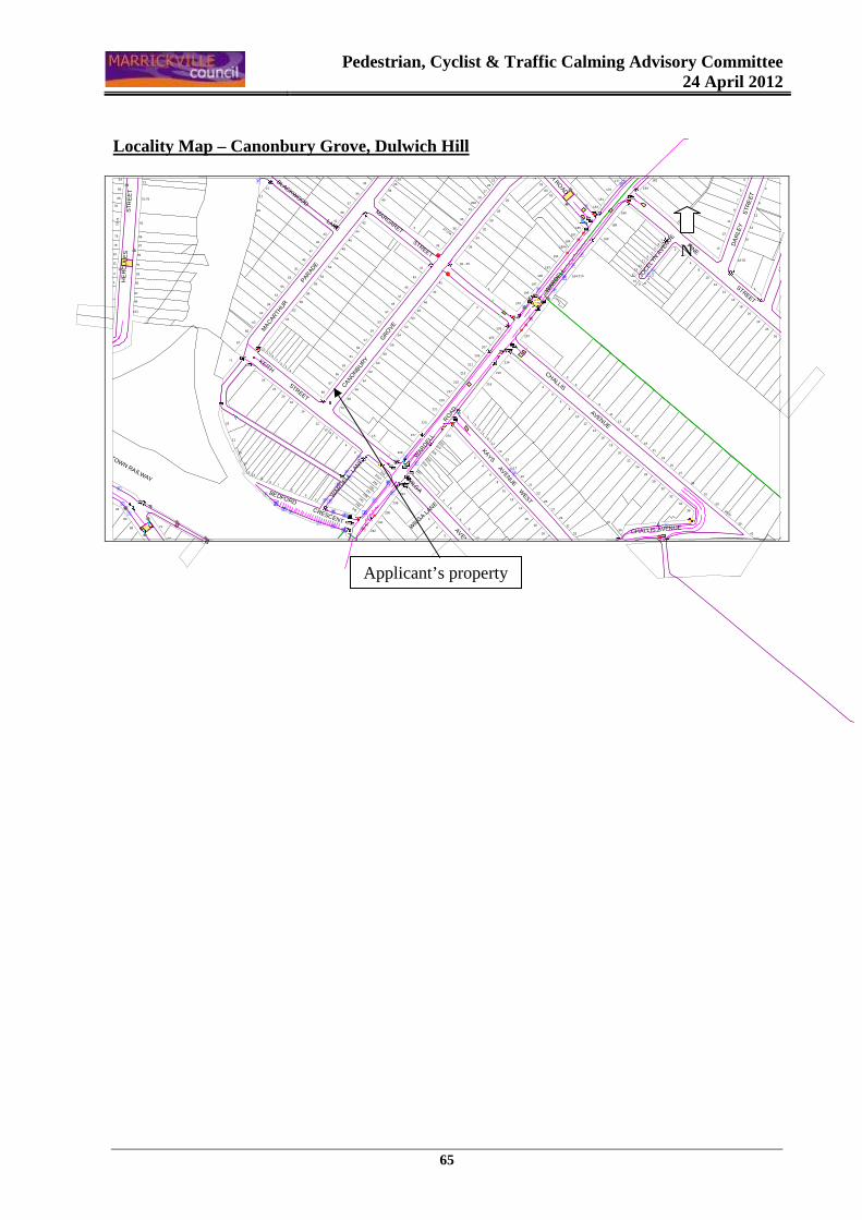
Pedestrian, Cyclist & Traffic Calming Advisory Committee
24 April 2012
65
Locality Map – Canonbury Grove, Dulwich Hill
æ
�
�
��
w
w
�ï
ï
ï
w
ww
w
w
w
ïwï
ï
��
�
��
��
�
�
���
��
�
��
}
w
w
w
ww
}
}
���
ww
�
ww
w
�
��
ww
w
w
ww
��
w
w
w ïww
wïï
�
www
��www
w
ww
ww
www
w
w
w w
ww
w
CHALLIS AVENUEWIL
GA LANE
DA
RLE
Y
S
TRE
ET
HA
RN
EY
ST
RE
ET
PINE STREET
WAR
DELL
BEACH ROAD
CHALLIS AVENUE
WAR
DELL
LAN
EKEITH STREET
BEDFORD CRESCENT
CANONBURY
GRO
VE
WAR
DELL
R
OAD
WILG
A AVENUE
KAYS AVENUE WEST
SYDNEY - BANKSTOWN RAILWAY
HE
RC
UL
ES
S
T RE
ET
JOCEL
YN A
VENU
E
BLACKWOOD LANE
MARGARET STREETM
ACARTH
UR
PA
RAD
E
BLAC
KWO
OD A
VENU
E
22
24
26
20
4
3
5
78
12
41
39
31
35-37
33
16
9
15
13
11
14
16
1
10
12
14
16
18
18-20
8
182
184
177
17980
76
78
82
193
195
191
1
29
23
25
27
31
26
28
30
32
3831
33
35
20
10
242 83
5
29
27
25
32
34
36
3
7
119
5
1
2
4
6
19
21
23
24
26
28
30
15
20
16
18
9
11
13
17
22
186
188
181
183
185
187
189
189A
190
42
619
17
8
1513
194-210
197
6
8
10
12
14
7
2940
2
7
218
216
4
3
5
48
211
209
207
205
203
2
214
212
20146
199
29A
3537-37A
34
3639
3
45
38 - 40
42
41
43
44
223
221
219
217
215
213
1
3
5
61
238
47
51
58
56
54
52
50
49
59
61
57
55
53
60
41
33
35
37
39
42
6669
67
65
63
70
68
64
62
12
108
52
43
45
44
46
48
50
56
53 54
58
60
62
47
49
51
53
1
22
20
18
24
14
119
7
13
6463
61
59
57
55
33
36
34
38
40
13
15
17
19
19
12
6
8
10
14
21
23
25
27
18
11
9
13
152
417
2
4
229
2271A 220
222224226
230
228
232
240
231A
241
239
236
234
243
237
235
233
231
245
3
1513
97
6
4
2
1
5
11
71
69
67
65
23
21
19
17
71
75-79
81
71
73
99
85
87
89
91
93
95
97
101
66
64
68
7 2- 7
4
70
76
78
80
82
84
86
88
90
92
90
88
Applicant’s property
N
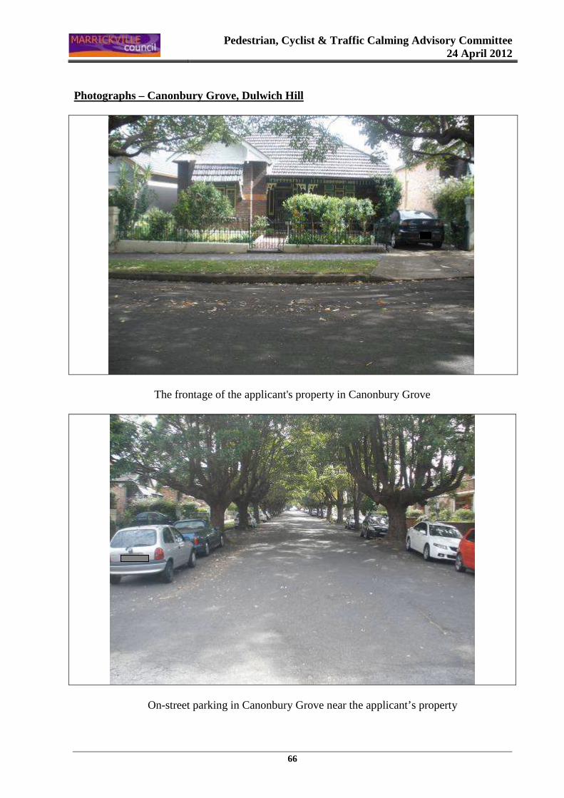
Pedestrian, Cyclist & Traffic Calming Advisory Committee
24 April 2012
66
Photographs – Canonbury Grove, Dulwich Hill
The frontage of the applicant's property in Canonbury Grove
On-street parking in Canonbury Grove near the applicant’s property
Pedestrian, Cyclist & Traffic Calming Advisory Committee
24 April 2012
67
Item No: C2
Subject: HOLMWOOD STREET, NEWTOWN (NORTH WARD)
REQUEST FOR A RESIDENT PARKING SCHEME – PARKING SURVEY RESULTS
File Ref: S2470-02
Author: Ramy Selim – Engineer, Traffic Services
SYNOPSIS A petition has been received from residents of Holmwood Street, Newtown for the provision of a Resident Parking Scheme in their street. Council Officers recently carried out an on-street parking utilisation survey in Holmwood Street. The results are presented in this report for the Committee to consider. Due to the high utilisation of on-street parking spaces, it is recommended that a Resident Parking survey be undertaken in Holmwood Street, Newtown and that the results of the survey be reported to the Committee for consideration. OFFICER’S RECOMMENDATION THAT: 1. The findings of the parking utilisation survey be received and noted;
2. A Resident Parking questionnaire survey be undertaken in Holmwood Street, Newtown, as
the results of the parking survey indicated that on-street parking utilisation was high and warrants the consideration of a Resident Parking Scheme;
The proposed scheme would have the following parking restrictions “2P 8.30am – 10.00pm Permit Holders Excepted – Area M14” on the north side of Holmwood Street (i.e. the existing angle parking spaces between Pearl Lane and King Lane); and
3. The results of the Resident Parking survey questionnaire be referred to the Pedestrian, cyclist and Traffic Calming Advisory Committee for consideration.
BACKGROUND
A petition signed by residents of 30 properties in Holmwood Street, Newtown has been received for the provision of a Resident Parking Scheme outside residential properties in their street. The head petitioner stated that on-street parking spaces in Holmwood Street are usually occupied by commuters utilising public transport, backpackers who live in shared accommodation and have multiple vehicles and customers of local businesses on King Street.
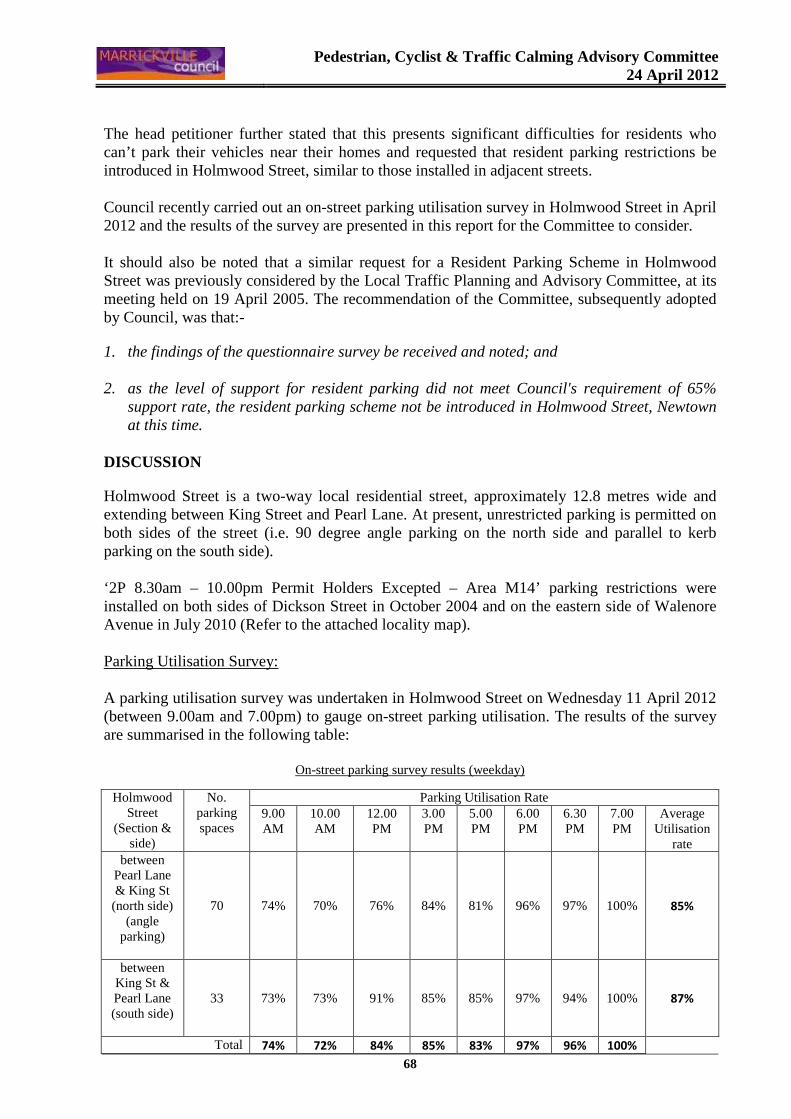
Pedestrian, Cyclist & Traffic Calming Advisory Committee
24 April 2012
68
The head petitioner further stated that this presents significant difficulties for residents who can’t park their vehicles near their homes and requested that resident parking restrictions be introduced in Holmwood Street, similar to those installed in adjacent streets. Council recently carried out an on-street parking utilisation survey in Holmwood Street in April 2012 and the results of the survey are presented in this report for the Committee to consider. It should also be noted that a similar request for a Resident Parking Scheme in Holmwood Street was previously considered by the Local Traffic Planning and Advisory Committee, at its meeting held on 19 April 2005. The recommendation of the Committee, subsequently adopted by Council, was that:-
1. the findings of the questionnaire survey be received and noted; and 2. as the level of support for resident parking did not meet Council's requirement of 65%
support rate, the resident parking scheme not be introduced in Holmwood Street, Newtown at this time.
DISCUSSION
Holmwood Street is a two-way local residential street, approximately 12.8 metres wide and extending between King Street and Pearl Lane. At present, unrestricted parking is permitted on both sides of the street (i.e. 90 degree angle parking on the north side and parallel to kerb parking on the south side). ‘2P 8.30am – 10.00pm Permit Holders Excepted – Area M14’ parking restrictions were installed on both sides of Dickson Street in October 2004 and on the eastern side of Walenore Avenue in July 2010 (Refer to the attached locality map). Parking Utilisation Survey: A parking utilisation survey was undertaken in Holmwood Street on Wednesday 11 April 2012 (between 9.00am and 7.00pm) to gauge on-street parking utilisation. The results of the survey are summarised in the following table:
On-street parking survey results (weekday)
Holmwood Street
(Section & side)
No. parking spaces
Parking Utilisation Rate 9.00 AM
10.00 AM
12.00 PM
3.00 PM
5.00 PM
6.00 PM
6.30 PM
7.00 PM
Average Utilisation
rate between
Pearl Lane & King St (north side)
(angle parking)
70 74% 70% 76% 84% 81% 96% 97% 100% 85%
between King St & Pearl Lane (south side)
33 73% 73% 91% 85% 85% 97% 94% 100% 87%
Total 74% 72% 84% 85% 83% 97% 96% 100%
Pedestrian, Cyclist & Traffic Calming Advisory Committee
24 April 2012
69
The results of the parking survey indicate that on-street parking spaces were generally highly utilised during the survey period. Council Policy/Guidelines Council's adopted Policy for the introduction of Permit Parking Schemes state "that before implementing a resident parking scheme in any area, a survey of residents be undertaken to ascertain the level of support for such a scheme and that such support should be in excess of 65% of submissions received provided that rate of return of submissions is reasonable (higher than 30%)". CONCLUSION
Due to the high utilisation of on-street parking spaces, it is recommended that a Resident Parking survey be undertaken in Holmwood Street, Newtown and that the results of the survey be reported to the Committee for consideration. The proposed scheme would have the following parking restrictions “2P 8.30am – 10.00pm Permit Holders Excepted – Area M14” on the north side of the street (i.e. the existing angle parking spaces between Pearl Lane and King Lane). It is suggested that the resident parking scheme in Holmwood Street, if approved, be introduced on the north side only, in order to manage competing parking demands in this area and balance both commercial and residential interests. OFFICER’S RECOMMENDATION THAT: 1. The findings of the parking utilisation survey be received and noted;
2. A Resident Parking questionnaire survey be undertaken in Holmwood Street, Newtown, as
the results of the parking survey indicated that on-street parking utilisation was high and warrants the consideration of a Resident Parking Scheme;
The proposed scheme would have the following parking restrictions “2P 8.30am – 10.00pm Permit Holders Excepted – Area M14” on the north side of Holmwood Street (i.e. the existing angle parking spaces between Pearl Lane and King Lane); and
3. The results of the Resident Parking survey questionnaire be referred to the Pedestrian, cyclist and Traffic Calming Advisory Committee for consideration.
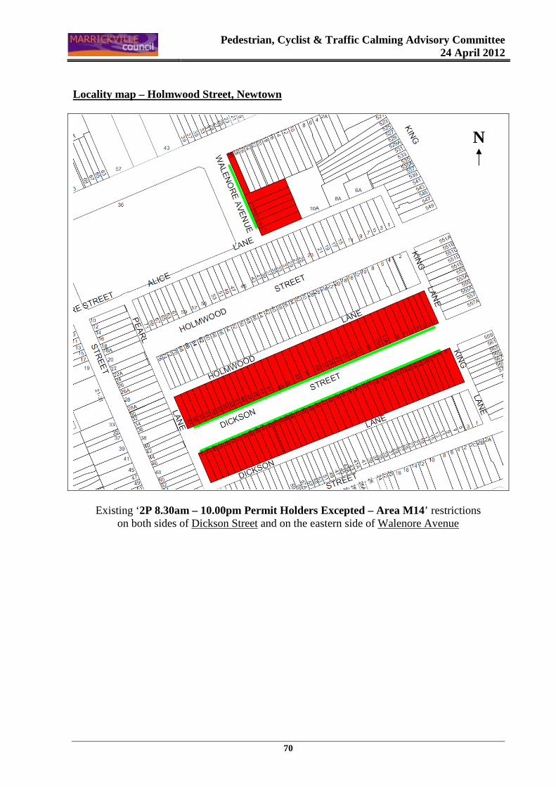
Pedestrian, Cyclist & Traffic Calming Advisory Committee
24 April 2012
70
Locality map – Holmwood Street, Newtown
Existing ‘2P 8.30am – 10.00pm Permit Holders Excepted – Area M14’ restrictions on both sides of Dickson Street and on the eastern side of Walenore Avenue
N
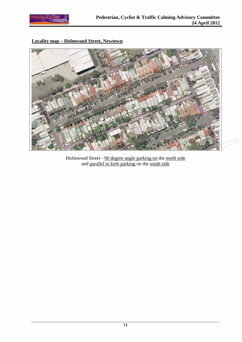
Pedestrian, Cyclist & Traffic Calming Advisory Committee
24 April 2012
71
Locality map – Holmwood Street, Newtown
w
ww
w
w
w
ïw
ww��
w
w
ww
��w
w�
ww
www
w
ww
w
w
w
w
}
w
w
ww
w
w
}
w
w
w
w
w
w
w
}
ww}
w
w
w
w
w
w
�
w
ww
w
ww
w
w
w
w
w
w
w
w
w
ww
w
ww
w
w
KIN
G
LAN
E
DICKSON
STREETHOLMWOOD
LANE
WA
LEN
OR
E A
VE
NU
E
ALICE
LANE
HOLMWOOD
S
TREET
KIN
G LA
NE
LITTLE COMMODORE STREET
PE
AR
L LAN
E
557A
555A
557
3
4
1210
8 6
9 7 51
1614
22
1315A
1113A
15
2018
242628303234363840
33
1719212325272931
553A
551A
551B
551C
551D
551E
553
555
549547
545
24
68
10
5
8A
13
7
16
9
1218
202224
11
2119
1715
27
282630
3129
25
23
1
3579
10A
11
34
4644
4240
3836
32
41
45
43
3937
3533
50
5856
5452
48
62
57
60
6466
61 59
55
5351
4947
43
47
4145
35-39
72
62646668707476
22A
26A26
24
20
22
7169
6367
36
65
18A
Holmwood Street - 90 degree angle parking on the north side and parallel to kerb parking on the south side
Pedestrian, Cyclist & Traffic Calming Advisory Committee
24 April 2012
72
Item No: C3
Subject: TERMINUS STREET, PETERSHAM (NORTH WARD)
REQUEST FOR A RESIDENT PARKING SCHEME – PARKING SURVEY RESULTS
File Ref: S4730-02
Author: Ramy Selim – Engineer, Traffic Services
SYNOPSIS Following a petition received from residents of Terminus Street, Petersham for the provision of a Resident Parking Scheme on the northern side of their street and a parking utilisation survey undertaken by Council Officers, a resident questionnaire survey was undertaken to obtain the opinion of residents. The results of the survey are presented in this report for the Committee to consider. As support from residents in the study area almost meets Council's criteria for a Resident Parking Scheme and due to the high utilisation of on-street parking spaces, it is recommended that the installation of Resident Parking restrictions on the north side of Terminus Street, between Palace Street and Crystal Street, Petersham, be approved outside residential properties only. OFFICER’S RECOMMENDATION THAT: 1. The findings of the resident questionnaire survey be received and noted; and
2. As support from residents in the study area almost meets Council's criteria and due to the
high utilisation of on-street parking spaces, the installation of a Resident Parking Scheme – Area M5 - be APPROVED, as follows:
"2P 8.30am – 6.00pm Mon-Fri Permit Holders Excepted – Area M5" parking restrictions be installed on the north side of Terminus Street, between Palace Street and Crystal Street, Petersham outside residential properties only.
BACKGROUND
A petition signed by residents of 11 properties in Terminus Street, Petersham was received for the provision of a Resident Parking Scheme outside residential properties on the northern side of their street. The head petitioner stated that on-street parking spaces in Terminus Street are usually occupied by commuters catching the trains from Petersham Railway Station. This presents difficulties for residents to park their vehicles near their homes on weekdays. Council carried out an on-street parking utilisation survey in August 2011 in Terminus Street and the results of the survey indicated high parking utilisation rates.
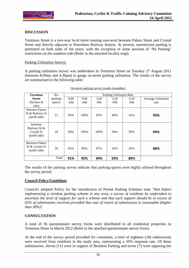
Pedestrian, Cyclist & Traffic Calming Advisory Committee
24 April 2012
73
DISCUSSION
Terminus Street is a two-way local street running east-west between Palace Street and Crystal Street and directly adjacent to Petersham Railway Station. At present, unrestricted parking is permitted on both sides of the street, with the exception of some sections of ‘No Parking’ restrictions on the southern side (Refer to the attached locality map). Parking Utilisation Survey: A parking utilisation survey was undertaken in Terminus Street on Tuesday 27 August 2011 (between 8.00am and 4.30pm) to gauge on-street parking utilisation. The results of the survey are summarised in the following table:
On-street parking survey results (weekday)
The results of the parking survey indicate that parking spaces were highly utilised throughout the survey period. Council Policy/Guidelines Council's adopted Policy for the introduction of Permit Parking Schemes state "that before implementing a resident parking scheme in any area, a survey of residents be undertaken to ascertain the level of support for such a scheme and that such support should be in excess of 65% of submissions received provided that rate of return of submissions is reasonable (higher than 30%)". CONSULTATION
A total of 36 questionnaire survey forms were distributed to all residential properties in Terminus Street in March 2012 (Refer to the attached questionnaire survey form). At the end of the survey period provided for comments, a total of eighteen (18) submissions were received from residents in the study area, representing a 50% response rate. Of these submissions, eleven (11) were in support of Resident Parking and seven (7) were opposing the
Terminus Street
(Section & side)
No. parking spaces
Parking Utilisation Rate 8.00 AM
9.00 AM
2.00 PM
3.30 PM
4.30 PM
Average Utilisation rate
between Palace St & Railway St
(north side)
21 95% 100% 95% 86% 91% 93%
between Railway St &
Crystal St (north side)
18 94% 100% 100% 94% 83% 94%
Between Palace St & Crystal St
(south side)
39 85% 85% 87% 95% 92% 89%
Total 91% 95% 94% 92% 89%
Pedestrian, Cyclist & Traffic Calming Advisory Committee
24 April 2012
74
proposed changes to the current parking conditions. Therefore, the support rate for the resident parking scheme from the responses was 61.1%. It should be noted that one of the submissions against the proposal was from the hotel/pub located on the corner of Terminus Street and Railway Street. A couple of other submissions against the proposal indicated that they have multiple cars and would not be able to obtain parking permits for all their vehicles. Collated comments from residents in support of Resident Parking Scheme: • The proposal will be effective if policed regularly. • Commuters and patrons of the adjacent pub regularly park their vehicles on the northern
side of Terminus Street outside residential houses. • Parking near our homes is becoming very difficult. • Parking permits should be free for rate payers. Collated comments from residents opposing Resident Parking Scheme: • I have no problems with parking in our street. People who work in the city need to park
their vehicles near the railway station and catch the trains. • Permit parking will make it more difficult for visitors to park in our street for longer than
two hours, which would be an inconvenience to our friends and guests. • Council should be encouraging people to leave their cars and catch the trains to work. • We have tenants with multiple cars and this proposal will cause more inconvenience to us. CONCLUSION
Parking for residents in Terminus Street is difficult at present and this is due to commuters in the main. Although the support from residents is just short of Council’s policy requirement (i.e. 61.1%), in this case given the high utilisation of parking, it would seem reasonable to introduce the Resident Parking Scheme on one side of Terminus Street. The proposed scheme would have the following parking restrictions “2P 8.30am – 6.00pm Mon-Fri Permit Holders Excepted – Area M5”. All eligible residential properties having a frontage with Terminus Street will be entitled to apply for parking permits. OFFICER’S RECOMMENDATION THAT: 1. The findings of the resident questionnaire survey be received and noted; and
2. As support from residents in the study area almost meets Council's criteria and due to the
high utilisation of on-street parking spaces, the installation of a Resident Parking Scheme – Area M5 - be APPROVED, as follows:
"2P 8.30am – 6.00pm Mon-Fri Permit Holders Excepted – Area M5" parking restrictions be installed on the north side of Terminus Street, between Palace Street and Crystal Street, Petersham outside residential properties only.
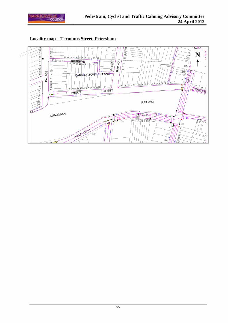
Pedestrain, Cyclist and Traffic Calming Advisory Committee
24 April 2012
75
Locality map – Terminus Street, Petersham
RA
ILW
AY
ST
RE
ET
CR
YS
TA
L
S
TRE
ET
TERMINUS STREET
CARRINGTON LANE
STREET
FISHERS RESERVE
TRAFALGAR
SUBURBAN
RAILWAY
YORK CRESCENT
PA
LA
CE
ST
RE
ET
SOUTH AVENUE
4
2
85
1816
89
95
93
91
259B
259A
259
6
112
116
106
114
11087
20
81
104102
100
83
98
1
63
53555759
65
67
61
50
54
68
58
60
626466
7072
4 2B
9 7 5
2
11 3 1
2A
97
120
122
124
101
99
142A24681012
26 7
261263
26 5
28 26 24 22 20 18 16
279
277
275
273
269271
463036384052 50 48 44 42 34 32
287
297
100
96
9856 54
15
14 6816 1218 10
1319 17
67
616365
69
81
71
73
75
83
8587
89
79
77
88
80
82
84
86
90
9294
78
106
110
102
108
BU
SE
S
EX
CE
PT
é
wé[
w
ππ
w
å {
w
ww
ww
wï
w
ï
wï
�
�w { ��-�π
��
w
w
ww
ww
[
ww
–π
å
}
–π��–
��
�
�w
w
ww��
w
ï
�
ww
ww
www
ww
w
�
{å�
wïï
ï
wïï
ww
w
w
w
����
�
ww
ww
w
w
w w
w
w
www
w
w
�
w
w
w�
��
�
�
�
�
w
ππ
�
ww
�
w
ww
w
w
[ [
N

Pedestrain, Cyclist and Traffic Calming Advisory Committee
24 April 2012
76
MARRICKVILLE COUNCIL RESIDENT PERMIT PARKING SURVEY
File No. S4730-02 Private, Confidential and Voluntary 1. Name …………………………………………………………………………………………………………
2. Address ……………………………………………………………………………………………………….
Please tick or number the answer boxes
3. Dwelling type � House � Self-contained flat � Other (please specify) ……………….................
4. How many vehicles registered to the above address are owned by members of the Household
� Private
� Commercial (under 3 tonne)
5. How many of your vehicles can be parked on your property?
� 0 � 1 � 2 � 3
6. Do you have difficulty finding parking near your residence?
� Never � Sometimes � Regularly
7. When does that difficulty occur? � Day � Night � Day � Night � Day � Night � Day � Night � Day � Night
� Monday - Friday � Thursday, Friday and Saturday � Saturday � Sunday � Seven days per week other (specify)............................................
8. Do you support the introduction of 2-hour parking restrictions (eligible residents excepted) outside residential properties on the north side of Terminus Street, between Palace Street and Crystal Street ?
� Yes � No
9. If resident parking zones are introduced in your street, are you willing to pay a fee for a permit once a year to have exemption from the 2 hour parking limit? (Fees outlined overleaf)
� Yes � No
10. Do you realise that resident parking restrictions may make it more difficult for your visitors to park near your home?
� Yes � No
Comments: ............................................................................................................................................................... ................................................................................................................................................................................... ................................................................................................................................................................................... ...................................................................................................................................................................................
Please return this questionnaire when completed in the pre-paid envelope to Council by FRIDAY, 30 MARCH 2012
Pedestrain, Cyclist and Traffic Calming Advisory Committee
24 April 2012
77
Item No: C4
Subject: LLEWELLYN & JULIETT STREETS, MARRICKVILLE (SOUTH WARD)
REQUEST FOR A RESIDENT PARKING SCHEME – RESIDENT SURVEY RESULTS
File Ref: S2970-02
Author: Ramy Selim – Engineer, Traffic Services
SYNOPSIS As part of Council’s determination of a Section 96 application for the Annette Kellerman Aquatic Centre at Enmore Park, Council resolved that an investigation of the current parking conditions in Llewellyn Street, Marrickville be undertaken. Requests were also received from residents in Llewellyn and Juliett Streets for the provision of Resident Parking restrictions. A parking utilisation survey carried out by Council Officers and a resident questionnaire survey was undertaken to obtain the opinion of residents. The result of the residents’ survey is presented in this report for the Committee to consider. As support from residents in the study area is well short of Council's criteria, it is recommended that the installation of Resident Parking restrictions in Llewellyn and Juliett Streets, Marrickville, not be approved at this time. OFFICER’S RECOMMENDATION THAT: 1. The findings of the resident questionnaire survey be received and noted; and
2. As support from residents in the study area has not met Council's criteria, the installation of a
Resident Parking Scheme in Llewellyn and Juliett Streets, Marrickville NOT be approved at this time.
BACKGROUND
As part of Council’s determination of a Section 96 application for the Annette Kellerman Aquatic Centre at Enmore Park in 2009, Council resolved: “ THAT Council’s Infrastructure Services be advised of the determination of this application and investigate the resident consultation in regards to no parking in the lane and all day restrictions at Llewellyn Street and resident parking permits”. Requests were also received from residents in Llewellyn and Juliett Streets for the provision of Resident Parking restrictions outside residential properties, in order to maintain on-street parking opportunities for residents around the aquatic centre.
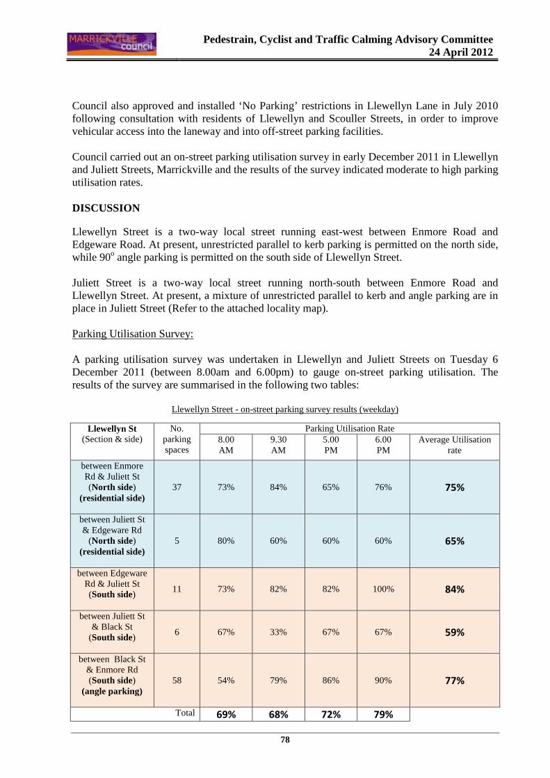
Pedestrain, Cyclist and Traffic Calming Advisory Committee
24 April 2012
78
Council also approved and installed ‘No Parking’ restrictions in Llewellyn Lane in July 2010 following consultation with residents of Llewellyn and Scouller Streets, in order to improve vehicular access into the laneway and into off-street parking facilities. Council carried out an on-street parking utilisation survey in early December 2011 in Llewellyn and Juliett Streets, Marrickville and the results of the survey indicated moderate to high parking utilisation rates. DISCUSSION
Llewellyn Street is a two-way local street running east-west between Enmore Road and Edgeware Road. At present, unrestricted parallel to kerb parking is permitted on the north side, while 90o angle parking is permitted on the south side of Llewellyn Street. Juliett Street is a two-way local street running north-south between Enmore Road and Llewellyn Street. At present, a mixture of unrestricted parallel to kerb and angle parking are in place in Juliett Street (Refer to the attached locality map). Parking Utilisation Survey: A parking utilisation survey was undertaken in Llewellyn and Juliett Streets on Tuesday 6 December 2011 (between 8.00am and 6.00pm) to gauge on-street parking utilisation. The results of the survey are summarised in the following two tables:
Llewellyn Street - on-street parking survey results (weekday)
Llewellyn St (Section & side)
No. parking spaces
Parking Utilisation Rate 8.00 AM
9.30 AM
5.00 PM
6.00 PM
Average Utilisation rate
between Enmore Rd & Juliett St (North side)
(residential side)
37 73% 84% 65% 76% 75%
between Juliett St & Edgeware Rd
(North side) (residential side)
5 80% 60% 60% 60% 65%
between Edgeware Rd & Juliett St (South side)
11 73% 82% 82% 100% 84%
between Juliett St & Black St
(South side)
6 67% 33% 67% 67% 59%
between Black St & Enmore Rd (South side)
(angle parking)
58 54% 79% 86% 90% 77%
Total 69% 68% 72% 79%
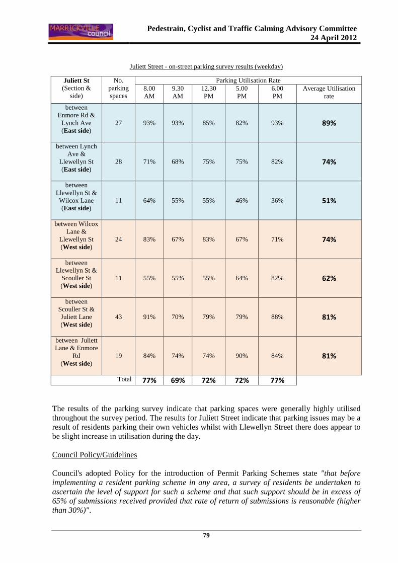
Pedestrain, Cyclist and Traffic Calming Advisory Committee
24 April 2012
79
Juliett Street - on-street parking survey results (weekday)
The results of the parking survey indicate that parking spaces were generally highly utilised throughout the survey period. The results for Juliett Street indicate that parking issues may be a result of residents parking their own vehicles whilst with Llewellyn Street there does appear to be slight increase in utilisation during the day. Council Policy/Guidelines Council's adopted Policy for the introduction of Permit Parking Schemes state "that before implementing a resident parking scheme in any area, a survey of residents be undertaken to ascertain the level of support for such a scheme and that such support should be in excess of 65% of submissions received provided that rate of return of submissions is reasonable (higher than 30%)".
Juliett St (Section &
side)
No. parking spaces
Parking Utilisation Rate 8.00 AM
9.30 AM
12.30 PM
5.00 PM
6.00 PM
Average Utilisation rate
between Enmore Rd &
Lynch Ave (East side)
27 93% 93% 85% 82% 93% 89%
between Lynch Ave &
Llewellyn St (East side)
28 71% 68% 75% 75% 82% 74%
between Llewellyn St & Wilcox Lane (East side)
11 64% 55% 55% 46% 36% 51%
between Wilcox Lane &
Llewellyn St (West side)
24 83% 67% 83% 67% 71% 74%
between Llewellyn St &
Scouller St (West side)
11 55% 55% 55% 64% 82% 62%
between Scouller St & Juliett Lane (West side)
43 91% 70% 79% 79% 88% 81%
between Juliett Lane & Enmore
Rd (West side)
19 84% 74% 74% 90% 84% 81%
Total 77% 69% 72% 72% 77%
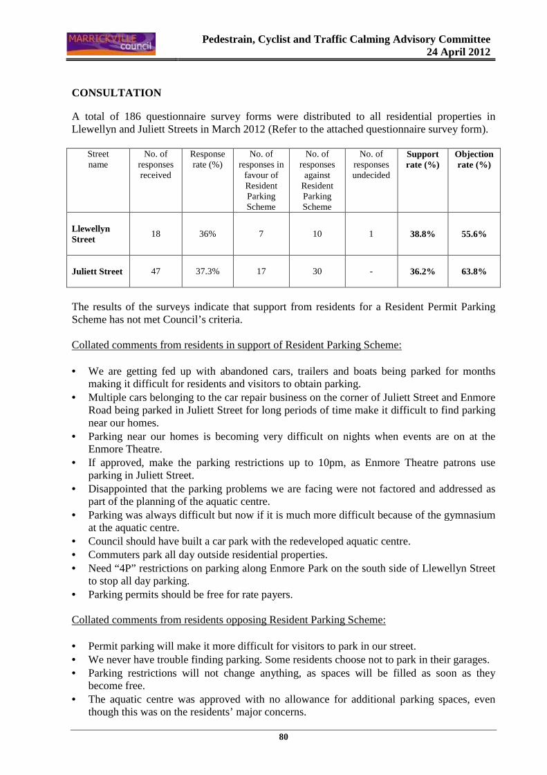
Pedestrain, Cyclist and Traffic Calming Advisory Committee
24 April 2012
80
CONSULTATION
A total of 186 questionnaire survey forms were distributed to all residential properties in Llewellyn and Juliett Streets in March 2012 (Refer to the attached questionnaire survey form).
Street name
No. of responses received
Response rate (%)
No. of responses in
favour of Resident Parking Scheme
No. of responses against
Resident Parking Scheme
No. of responses undecided
Support rate (%)
Objection rate (%)
Llewellyn Street
18 36% 7 10 1 38.8% 55.6%
Juliett Street
47 37.3% 17 30 - 36.2% 63.8%
The results of the surveys indicate that support from residents for a Resident Permit Parking Scheme has not met Council’s criteria. Collated comments from residents in support of Resident Parking Scheme: • We are getting fed up with abandoned cars, trailers and boats being parked for months
making it difficult for residents and visitors to obtain parking. • Multiple cars belonging to the car repair business on the corner of Juliett Street and Enmore
Road being parked in Juliett Street for long periods of time make it difficult to find parking near our homes.
• Parking near our homes is becoming very difficult on nights when events are on at the Enmore Theatre.
• If approved, make the parking restrictions up to 10pm, as Enmore Theatre patrons use parking in Juliett Street.
• Disappointed that the parking problems we are facing were not factored and addressed as part of the planning of the aquatic centre.
• Parking was always difficult but now if it is much more difficult because of the gymnasium at the aquatic centre.
• Council should have built a car park with the redeveloped aquatic centre. • Commuters park all day outside residential properties. • Need “4P” restrictions on parking along Enmore Park on the south side of Llewellyn Street
to stop all day parking. • Parking permits should be free for rate payers. Collated comments from residents opposing Resident Parking Scheme: • Permit parking will make it more difficult for visitors to park in our street. • We never have trouble finding parking. Some residents choose not to park in their garages. • Parking restrictions will not change anything, as spaces will be filled as soon as they
become free. • The aquatic centre was approved with no allowance for additional parking spaces, even
though this was on the residents’ major concerns.
Pedestrain, Cyclist and Traffic Calming Advisory Committee
24 April 2012
81
• The aquatic centre seems to have made no difference to parking in this area. • Do not introduce further parking restrictions for a minority of residents complaining. • We strongly opposed the proposal, as the current parking situation does not warrant any
changes. • Why pay for something which we currently have for free. Parking is barely an issue in
Juliett Street. • Parking restrictions would push the parking issues into other streets as well.
CONCLUSION
As support from residents in the study area is well short of Council's criteria, it is recommended that the installation of Resident Parking restrictions in Llewellyn and Juliett Streets, Marrickville, not be approved at this time. OFFICER’S RECOMMENDATION THAT: 1. The findings of the resident questionnaire survey be received and noted; and
2. As support from residents in the study area has not met Council's criteria, the installation of
a Resident Parking Scheme in Llewellyn and Juliett Streets, Marrickville NOT be approved at this time.
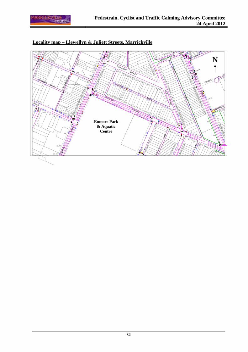
Pedestrain, Cyclist and Traffic Calming Advisory Committee
24 April 2012
82
Locality map – Llewellyn & Juliett Streets, Marrick ville
w
w
w
w
w
æ
}
��w
�
www
ww
�
ww
w
ww
w
w
ww
w
w
w
w
w
w
w
w
w
��
ww
w
w
w
w
w
w
w
w
�
�
æ
ww
w
�w
w
w
w
�w
w
�
�
�
ww
�
ww
w
w
w
w
w
w
w
�
w
w
w
��
w
w
�
w
w
�
w
�
w
�w
�
w
��
�w
w
w
w
ww
w
w
w
ww
ww
w
w
ww
w
w
w
w
w
w
æ
w
w
w
æ
w
w
w
ww
w
w
ww
wïïw
ïw
��ww
w
w
��
ww
w
w
w
�www
���}
wï
ï
ïïw
ïw
ww
ï
w
wï
w
w w
w
w
ww
w
�
w
�
w}
4
w
w
w
w
w
ww
w
w
w
w
w
w
w
w
wwwww
www
ww
wwww
ww
w
�w
} }
w}
}w
ww
w
w
��ww
w
JAMES
STREET
CAMDEN STREET
OC
ON
NO
R
LA
NE
SH
ELLE
YS
LA
NE
BLA
CK
S
TR
EE
T
JULI
ET
T
S
TRE
ETWILCOX
SARAH
STREET
JULIE
TT S
TRE
ET
LLEWELLYN LANE
LYN
CH
LAN
ELYNCH AVENUE
ED
GE
WA
RE
RO
AD
SCOULLER STREET
LLEWELLYN STREET
EN
MO
RE
R
OA
D
JULIE
TT
L AN
E
PH
ILP
OT
T
S
TRE
ET
ADDISON ROAD
STEVENS LANE
FOTH
ER
ING
HA
M
L
AN
E
EN
MO
RE
R
OA
D
9
142-166
1761
78180
188
180
182
184
186
190
192
194
178
132
2065
130
128
126
7977
136
134
12
200
246810
196
22
18
14
22A
16
24
30
124
1315
17
6361
67
75
19
2123
25
2773
7169
51
110-14045
4749
6
2A
3B 25
1C
3A
42
176
5
165
151
176A
143
141
149147
145
139
125
127
133
137135
131129
113
123121
119117
115
5
3
1
122
120
107
101
103
111109
105
99
97
95
93
91
89
104
118116
114112110108106
102100
59
92
119
9694
98
90
84
76
82
88
72
74
78
80
86
32
7
9
5
7
3634
38
13
11
13
6
55
57
42
70
58
53
60
62
64
6668
4341
39
23
13
2119
1715
25
5
106104
102100
108
87
85
8 106
4229
27
31
50
52
54
5633
97
37
35
290
13
296
294
292
288
286
284
38
315
301
1A
319
8
3937
3533
1210
3129
27
14
24
53
1
2220
18
16
11
36
3432
3028
26
45
5755
53 5149
47
43
41
6159
316
63
314
312
310
308
321
306
304
302
300
298323
325
349
333
331
341343
345347
351
369
357
353355
359361
363
367
365
371373
1
8
6
RTA
DEPT OF PLANNING
1A
75 1
9375379
3
383
5
10
1113
151719
23
12
14
20-24
2
10
37
33
8
1113151719
35
27
3638
40
3129
252321
45
39
41
47
53-5
5
43
4951
3331
26
1
3-9
391-393
399-403
N
Enmore Park & Aquatic
Centre

Pedestrain, Cyclist and Traffic Calming Advisory Committee
24 April 2012
83
MARRICKVILLE COUNCIL RESIDENT PERMIT PARKING SURVEY
File No. S2970-02 Private, Confidential and Voluntary 1. Name …………………………………………………………………………………………………………
2. Address ……………………………………………………………………………………………………….
Please tick or number the answer boxes
3. Dwelling type � House � Self-contained flat � Other (please specify) ……………….................
4. How many vehicles registered to the above address are owned by members of the Household
� Private � Commercial (under 3 tonne)
5. How many of your vehicles can be parked on your property?
� 0 � 1 � 2 � 3
6. Do you have difficulty finding parking near your residence?
� Never � Sometimes � Regularly
7. When does that difficulty occur? � Day � Night � Day � Night � Day � Night � Day � Night � Day � Night
� Monday - Friday � Thursday, Friday and Saturday � Saturday � Sunday � Seven days per week other (specify)............................................
8. Do you support the introduction of 2-hour parking restrictions (eligible residents excepted) outside residential properties on the north side of Llewellyn Street and both sides of Juliett Street?
� Yes � No
9. If resident parking zones are introduced in your street, are you willing to pay a fee for a permit once a year to have exemption from the 2 hour parking limit? (Fees outlined overleaf)
� Yes � No
10. Do you realise that resident parking restrictions may make it more difficult for your visitors to park near your home?
� Yes � No
Comments: ............................................................................................................................................................... ................................................................................................................................................................................... ................................................................................................................................................................................... ...................................................................................................................................................................................
Please return this questionnaire when completed in the pre-paid envelope to Council by FRIDAY, 30 MARCH 2012
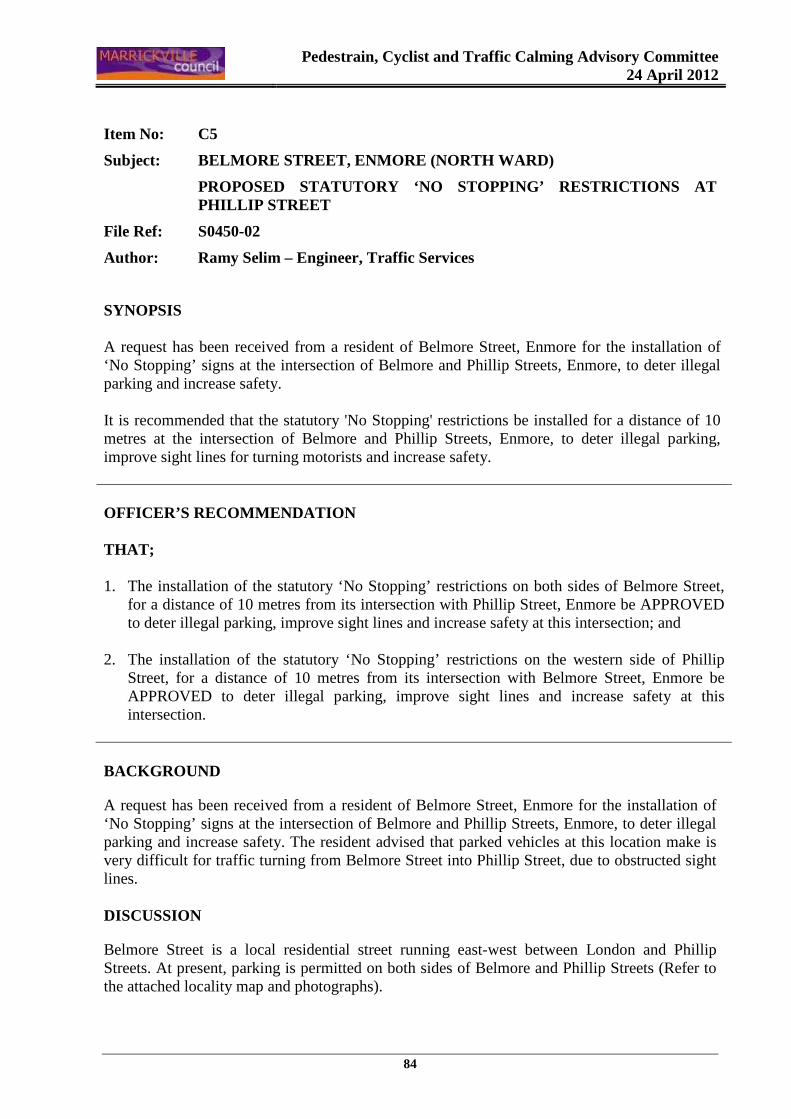
Pedestrain, Cyclist and Traffic Calming Advisory Committee
24 April 2012
84
Item No: C5
Subject: BELMORE STREET, ENMORE (NORTH WARD)
PROPOSED STATUTORY ‘NO STOPPING’ RESTRICTIONS AT PHILLIP STREET
File Ref: S0450-02
Author: Ramy Selim – Engineer, Traffic Services
SYNOPSIS A request has been received from a resident of Belmore Street, Enmore for the installation of ‘No Stopping’ signs at the intersection of Belmore and Phillip Streets, Enmore, to deter illegal parking and increase safety. It is recommended that the statutory 'No Stopping' restrictions be installed for a distance of 10 metres at the intersection of Belmore and Phillip Streets, Enmore, to deter illegal parking, improve sight lines for turning motorists and increase safety. OFFICER’S RECOMMENDATION THAT; 1. The installation of the statutory ‘No Stopping’ restrictions on both sides of Belmore Street,
for a distance of 10 metres from its intersection with Phillip Street, Enmore be APPROVED to deter illegal parking, improve sight lines and increase safety at this intersection; and
2. The installation of the statutory ‘No Stopping’ restrictions on the western side of Phillip Street, for a distance of 10 metres from its intersection with Belmore Street, Enmore be APPROVED to deter illegal parking, improve sight lines and increase safety at this intersection.
BACKGROUND
A request has been received from a resident of Belmore Street, Enmore for the installation of ‘No Stopping’ signs at the intersection of Belmore and Phillip Streets, Enmore, to deter illegal parking and increase safety. The resident advised that parked vehicles at this location make is very difficult for traffic turning from Belmore Street into Phillip Street, due to obstructed sight lines. DISCUSSION
Belmore Street is a local residential street running east-west between London and Phillip Streets. At present, parking is permitted on both sides of Belmore and Phillip Streets (Refer to the attached locality map and photographs).
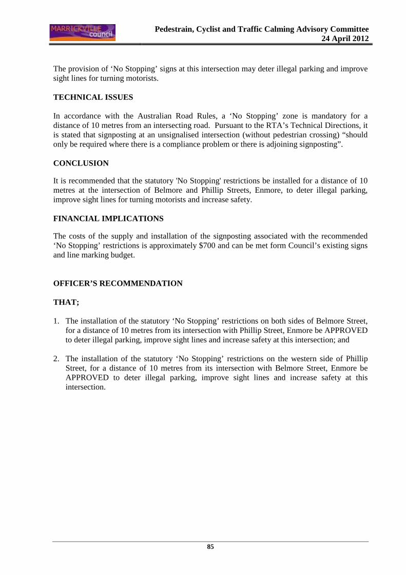
Pedestrain, Cyclist and Traffic Calming Advisory Committee
24 April 2012
85
The provision of ‘No Stopping’ signs at this intersection may deter illegal parking and improve sight lines for turning motorists. TECHNICAL ISSUES In accordance with the Australian Road Rules, a ‘No Stopping’ zone is mandatory for a distance of 10 metres from an intersecting road. Pursuant to the RTA’s Technical Directions, it is stated that signposting at an unsignalised intersection (without pedestrian crossing) “should only be required where there is a compliance problem or there is adjoining signposting”. CONCLUSION
It is recommended that the statutory 'No Stopping' restrictions be installed for a distance of 10 metres at the intersection of Belmore and Phillip Streets, Enmore, to deter illegal parking, improve sight lines for turning motorists and increase safety. FINANCIAL IMPLICATIONS
The costs of the supply and installation of the signposting associated with the recommended ‘No Stopping’ restrictions is approximately $700 and can be met form Council’s existing signs and line marking budget. OFFICER’S RECOMMENDATION THAT; 1. The installation of the statutory ‘No Stopping’ restrictions on both sides of Belmore Street,
for a distance of 10 metres from its intersection with Phillip Street, Enmore be APPROVED to deter illegal parking, improve sight lines and increase safety at this intersection; and
2. The installation of the statutory ‘No Stopping’ restrictions on the western side of Phillip Street, for a distance of 10 metres from its intersection with Belmore Street, Enmore be APPROVED to deter illegal parking, improve sight lines and increase safety at this intersection.
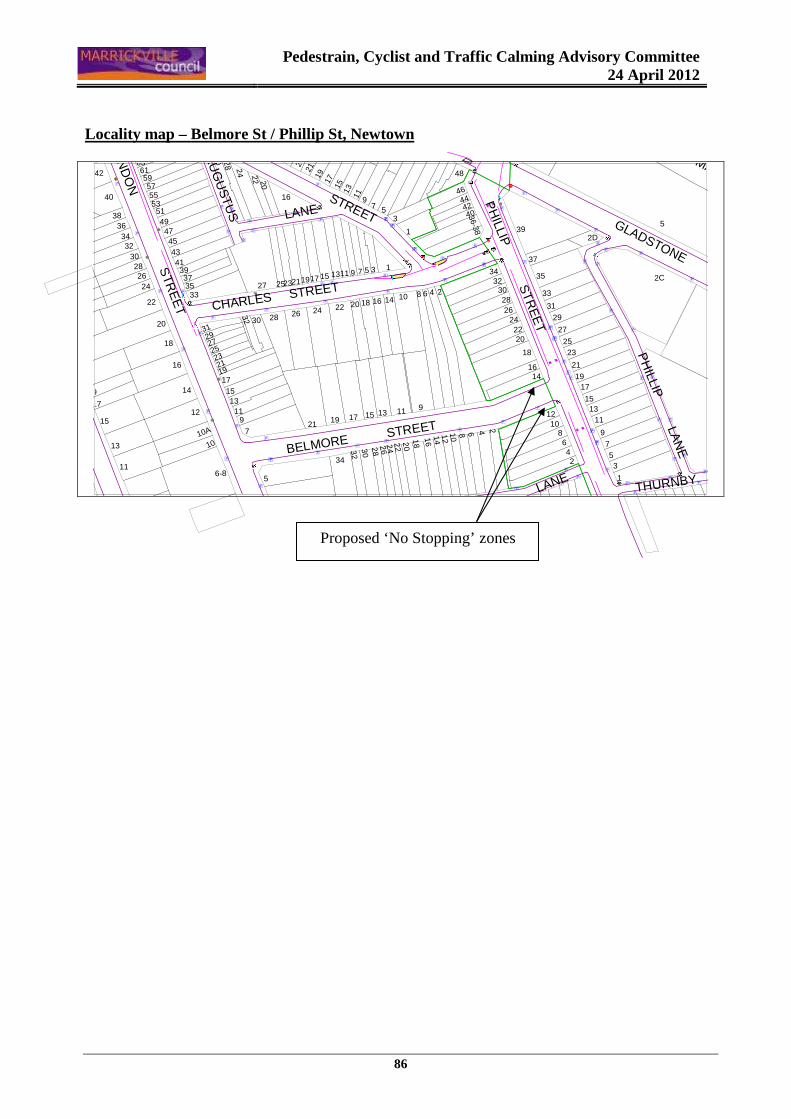
Pedestrain, Cyclist and Traffic Calming Advisory Committee
24 April 2012
86
Locality map – Belmore St / Phillip St, Newtown
w
w
w
w
w
w
w
w
w
w
w
w
w
w
w
w
w
w
w
w
w
w
w
w
w
}
w
w
w
w
w
w
w
w
ww
w
w
w
ww
ww
w
w
�
�
w
ww
w
w
w
w
w
w
w
w
w
w
w
w
ww
w
w
w
w
w
ww
w
ww
w
w
w
w
ww
w
w
w
w
w
w
w
w
w
w
w
THURNBY LANELANE
PH
ILLIP LA
NE
GLADSTONE
MAIN
AU
GU
ST
US
BELMORE STREET
LANE
CHARLES STREET
STREET
BELMORE
PH
ILLIP S
TRE
ET
LON
DO
N S
TRE
ET
48
4
2D
5
17
9
15
19
21
23
11
13
25
2022
16
24
30 28
57
42636159
5540
79
53
1
12
44
24 22 2026
34
36-38
4042
46
21
2931
27
2523
1917
108642
1311
15
28
39
37
3330
16
26242220
18
14
2315171925 21 2C32
35
14
11 9
201816
1210 8 6 4 2
3
7 5
1
14 10 8 6 4
1
2
24
15 13
302826
22
11 5
1618
37913
21
34
19 17
32
6-85
1-3
25
3327
30 28
312927
232119
32
18
14
16
20
12
535149
47454341
393735
97
1113
1517
1010A
34
3836
3230282624
22
17
11
13
15
19
Proposed ‘No Stopping’ zones
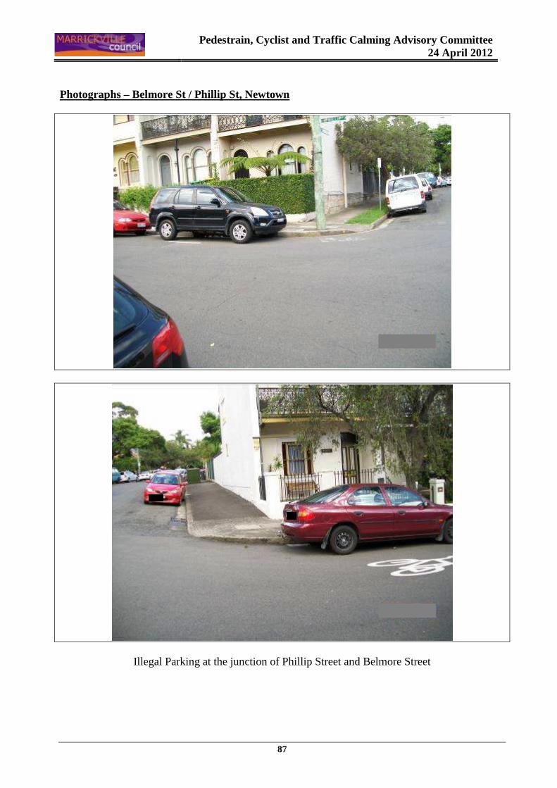
Pedestrain, Cyclist and Traffic Calming Advisory Committee
24 April 2012
87
Photographs – Belmore St / Phillip St, Newtown
Illegal Parking at the junction of Phillip Street and Belmore Street