Pedestrian and Bicycle Planning -...
37
Victoria Transport Policy Institute Website: www.vtpi.org Email: [email protected] 1250 Rudlin Street, Victoria, BC, V8V 3R7, CANADA Phone & Fax 250-360-1560 “Efficiency - Equity - Clarity” Pedestrian and Bicycle Planning Guide to Best Practices Appendices 18 April, 2009 by Todd Litman, Robin Blair, Bill Demopoulos, Nils Eddy, Anne Fritzel, Danelle Laidlaw, Heath Maddox, Katherine Forster Abstract This guide covers all aspects of pedestrian and bicycle planning. It is intended for policy makers, planners and advocates who want the best current information on ways to make their communities better places for walking and cycling. It provides basic information on various planning and design concepts, and offers extensive references to help implement them. It describes general nonmotorized planning practices, how to measure and predict nonmotorized travel, how to evaluate and prioritize projects, and how to implement various programs that support nonmotorized transportation. It covers planning for paths, sidewalks, bikelanes, street improvements, road and path maintenance, road safety, personal security, universal access (including features to accommodate people with disabilities), nonmotorized traffic law enforcement, education and encouragement programs, and integration with a community’s strategic plans and various other programs. There are also appendices that provide more detailed information on planning, design and evaluation. This is an ongoing project. We welcome your feedback.
Transcript of Pedestrian and Bicycle Planning -...
Victoria Transport Policy InstituteWebsite: www.vtpi.org Email: [email protected]
1250 Rudlin Street, Victoria, BC, V8V 3R7, CANADAPhone & Fax 2503601560
“Efficiency Equity Clarity”
Pedestrian and Bicycle PlanningGuide to Best Practices
Appendices
18 April, 2009
byTodd Litman, Robin Blair, Bill Demopoulos, Nils Eddy, Anne Fritzel, Danelle Laidlaw, Heath Maddox, Katherine Forster
AbstractThis guide covers all aspects of pedestrian and bicycle planning. It is intended for policy makers, planners and advocates who want the best current information on ways to make their communities better places for walking and cycling. It provides basic information on various planning and design concepts, and offers extensive references to help implement them. It describes general nonmotorized planning practices, how to measure and predict nonmotorized travel, how to evaluate and prioritize projects, and how to implement various programs that support nonmotorized transportation. It covers planning for paths, sidewalks, bikelanes, street improvements, road and path maintenance, road safety, personal security, universal access (including features to accommodate people with disabilities), nonmotorized traffic law enforcement, education and encouragement programs, and integration with a community’s strategic plans and various other programs. There are also appendices that provide more detailed information on planning, design and evaluation.
This is an ongoing project. We welcome your feedback.
Pedestrian and Bicycle Planning; Guide to Best Practices
Appendix 1 Model Pedestrian And Bicycle PlanThis section describes a typical municipal pedestrian and bicycle plan.
Planning Tip
Typical Plan Components
1. Goals and objectives. Define the outcomes that are to be achieved.
2. Bicycle network plan. Identifies infrastructure (trails, bike lanes, bike routes) that provides cycling access to major destinations (schools, commercial centers, intermodal terminals, and recreational areas), and connections to regional and provincial bicycle routes.
3. Design guidelines. This identifies specific dimensions, clearances, safety features, materials, surface treatments, signage, and pavement markings, etc., for facilities, usually based on published standards recommended by a major professional or government organization.
4. Maintenance policies and procedures. This includes maintenance standards and priorities, and indicates who is responsible for implementation.
5. Endoftrip bicycle facilities (bicycle storage racks or lockers, showers, and clothes changing facilities).
6. Capital expenditure plan. Identifies project costs and timing of implementation.
7. Support programs. Includes safety education, law enforcement, and promotion activities.
8. Evaluation. This includes ongoing monitoring of facility use, condition, and problems.
Purpose: • To identify needed improvements to enable and enhance walking and cycling.• To provide standards for planning, designing and maintaining bikeways and walkways.• To fulfill the requirements of the Growth Strategies Act.
Introduction The development of Bicycle and Pedestrian plans is an essential component of building cycling and walking communities. This plan outlines the policies for adoption to support cycling and walking in communities. It identifies goals, objectives, and evaluation criteria for pedestrian and bicycle planning, design, education, enforcement, and encouragement. It identifies actions for municipal agencies to implement these objectives. It provides a prioritized list of bicycle and pedestrian network programs and projects, and a recommended budget to ensure the plan’s implementation.
2
Pedestrian and Bicycle Planning; Guide to Best Practices
Vision: • Walking and bicycling provide safe and convenient access to all destinations within the City.• People can walk or ride to and from their transit stops and have a comfortable and
convenient place to wait or transfer.• Highways, streets, roads, paths, sidewalk, transportation terminals, and land use patterns
are designed to accommodate and encourage bicycling and walking.• Nonmotorized travel becomes increasingly common for transportation and recreation.• Appropriate transportation choices are available to all, including people who do not own or
drive an automobile.
BACKGROUND TO THE PLANBicycling and walking are increasingly recognized as a viable means of transportation in North America. Nonmotorized transport provides many benefits to users and nonusers alike, including travel choice and mobility, affordability, reduced road congestion, infrastructure savings, improved health, recreation and enjoyment, environmental protection, and economic development. Walking and cycling improvements are critical for creating more livable communities.
According to name travel survey X.X% of trips in the City are currently made by walking, and X.X% are made by cycling. Market surveys indicate that the use of nonmotorized travel could increase significantly if given appropriate community support. Walking and cycling are key forms of transportation through neighborhoods, around schools, and in business districts. They are also popular forms of recreation. Walking in particular is expected to gain in importance as our population ages for recreation, exercise, and transportation.
Actions that support cycling and walking include:
• Language in the Official Community Plan supporting increased cycling and walking.• Establishment of a Bicycle and Pedestrian Advisory Committee.• Establishment of a bicycle and pedestrian coordinator position.• Development of a trails or bikeway map.• Directives in the Growth Strategies Act requiring consideration of bicycle and pedestrian
infrastructure.• Inclusion of bicycle specific training in new driver education materials.
BICYCLING AND WALKING GOALS
1. The City recognizes that approximately onethird of its residents do not drive and seeks to enable those residents to travel more safely throughout the City on foot, by bicycle, and by wheelchair. The City seeks to accommodate nonmotorized travel in order to provide
3
Pedestrian and Bicycle Planning; Guide to Best Practices
equitable opportunity to all residents.
2. The City recognizes that nonmotorized travel can help develop a sense of community, encourage the patronage of local business, reduce noise and pollution, and improve the health of its residents. To realize these benefits, the City seeks to encourage nonmotorized travel, both functional and recreational.
3. The City recognizes that walking, jogging, hiking, and bicycling are popular forms of recreation and therefore it seeks to encourage and enhance those activities.
4. The City recognizes that walking and cycling are currently more dangerous than necessary, which causes unnecessary death and injuries, discourages nonmotorized travel, and imposes economic costs on the community. The City therefore seeks to make walking and cycling safer.
4
Pedestrian and Bicycle Planning; Guide to Best Practices
OBJECTIVES AND POLICIESA Pedestrian and Bicycle Advisory Committee shall be established to oversee the development and implementation of a Pedestrian and Bicycle Network Plan. The Committee should include representatives of cyclists, pedestrians, parents, the physically challenged and appropriate government agencies. This Committee will:
1. Establish a planning process outline and schedule to indicate who is responsible for each task, when it should be accomplished, and opportunities for public involvement.
2. Develop a scoping document that outlines what issues are to be considered, summarizes available data on walking and cycling in the City, and identifies what would be required to obtain additional data that might be needed for planning purposes.
3. Survey users and potential users to identify existing problems and barriers to nonmotorized travel in the City, and opportunities for improving conditions. This should identify potential facility improvements and other activities, including education, law enforcement, and encouragement programs, that help achieve nonmotorized transport goals.
4. Develop preliminary estimates of the costs of implementing potential programs and projects.
5. Develop a framework for evaluating and prioritizing potential improvements.
6. Develop a recommended plan and overall budget. This could include a target for completion, for example, that all priority improvements be implemented within 10 years.
7. Seek pedestrian and cycling network program funding, including federal, provincial, and regional grants, and funding from local foundations, service clubs, and private individuals.
8. Establish design and maintenance standards for pedestrian and bicycle facilities, and review standards used by City departments that affect walking and cycling conditions.
9. Establish requirements for bicycle parking facilities as part of municipal parking codes, and educate city officials and builders concerning appropriate bicycle rack and locker design.
10. Recommend changes to other municipal policies to support nonmotorized transportation, including roadway design and maintenance standards, changes to zoning codes, municipal traffic bylaws and law enforcement practices, and other appropriate changes.
11. Work with Transit agencies to integrate bicycling into the local transit system, including bicycle racks on buses, bicycle lockers and racks at park and ride lots and bus terminals.
12. Recommend standards for new development to create more pedestrian and bicycle friendly communities, such as a modified grid street system with minimal cul de sacs, and the provision of trail connections between cul de sac or dead end streets where possible.
13. Develop recommendations for any actions needed to coordinate pedestrian and bicycle planning with other jurisdictions, including regional and provincial agencies.
14. Develop bicycle education program in coordination with community partners which may include bicycle clubs, police agencies, service clubs, and other groups.
5
Pedestrian and Bicycle Planning; Guide to Best Practices
15. Prepare and distribute information about traffic laws, bicycle safety, bicycle theft, major collision types through bicycle and sport shops, and public information sites.
16. Support bicycle encouragement programs, such as Bicycle Commuter Week and bicycle tourism promotion efforts.
17. Establish policies for evaluation and updating pedestrian and bicycle plans in the future.
The Engineering Department Will:
1. Identify specific bicycle and pedestrian projects in its annual Capital and Current Budgets. The Bicycle and Pedestrian Advisory committee will have the opportunity to comment on these budgets before their consideration by City Council.
2. Implement pedestrian and bicycle facility design and maintenance standards, and modify roadway design and maintenance standards as needed to improve the cycling environment.
3. Collect information on walking and bicycle travel patterns in all future travel surveys.
4. Revise existing subdivision design standards and conditions to ensure that subdivisions are designed with direct pedestrian and bicycle connections and suitable transit access.
5. Organize bicycle and pedestrian planning workshops for Engineering staff, members of the Bicycle and Pedestrian Advisory committee, and other appropriate stakeholders.
6. Coordinate efforts with the Parks and Recreation Department to ensure that connections between onstreet and offstreet facilities are well designed.
7. Notify the Advisory Committee about all major road works and sewer projects where wide curb lanes, sidewalks, or pathways can be established.
8. Initiate a “Spot Improvement Program” to reduce hazards along popular cycling routes and major pedestrian routes through smallscale, low cost improvements. Bicycle hazards include dangerous potholes, sewer grates, and railway crossings. Pedestrian hazards include missing curb cuts, missing links, uneven and cracked sidewalks. Priority should be given to improvements along the routes identified on the Bicycle and Pedestrian Network Maps. It is recommended that funds from the existing road maintenance budget be used. A telephone “hotline” or postcard program should be established to provide cyclists and pedestrians with the convenient opportunity to suggest improvements.
9. Revise its design standards and specifications to ensure bicycle and pedestrian access across and beneath new and renovated bridges and overpasses.
10. Revise the standard tender specifications so that only bicyclesafe sewer grates are purchased.
11. Establish standards to ensure access and safety to pedestrians and cyclists during construction projects.
12. Ensure that all bicycle and pedestrian projects comply with recognized design standards,
6

Pedestrian and Bicycle Planning; Guide to Best Practices
such as the Guide for the Development of Bicycling Facilities prepared by the America Association of State Highway and Transportation officials (AASHTO).
7
Pedestrian and Bicycle Planning; Guide to Best Practices
The Parks and Recreation Department Will:
1. Identify specific bicycle and pedestrian projects in its annual capital and current budgets. The Bicycle and Pedestrian Advisory Committee will have the opportunity to comment on these budgets before their consideration by City Council.
2. Develop path and trail maintenance and repair programs, which should include maintenance standards, a well publicized method for users to report problems, scheduled maintenance, and, if appropriate, use of volunteers to help perform maintenance tasks.
3. Ensure that trails and path accommodate an appropriate range of users. This recognizes that many cyclists prefer to ride on separated paths instead of roads and that the development of pathways will attract walkers, dog walkers, inline skaters, joggers, and cyclists. It also means that users with special needs, including people with disabilities, children, and elderly will be accommodated on such facilities whenever possible.
4. Provide appropriate signage to identify paths and trails, encourage appropriate trail behaviour, and warn of hazards.
5. Monitor railrelated, utility, or natural area actions to ensure that opportunities to develop pathways within abandoned rail corridors are not missed.
6. Monitor conflicts on trails and paths and take appropriate actions to minimize conflicts.
7. Develop a city or regional bicycle map.
8. Identify priority locations for pathway improvements. This includes pathways that are too narrow, in poor repair, and poorly designed.
9. Prior to the City’s selling or otherwise disposing of public rights of way, the City consider the use of those lands as part of the overall paths/trails system or as informal walkways for nearby residents.
10. When deciding whether to accept lands proffered, either for purchase or otherwise, the City consider the possible use of those lands for offroad travel on foot or by bicycle.
Law Enforcement Agencies Will:
1. Establish policies for the enforcement of bicycle traffic laws. This should include education for traffic officers concerning bicycle laws and cyclists rights, education and outreach programs to cyclists and motorists, prioritization of violations that will be cited, policies for citing and fining cyclists (including children and other cyclists who do not have a drivers license), and development of a “diversion” program, by which cyclists who violate traffic laws can take a bicycling safety class as an alternative to paying a fine.
2. Provide an advanced bicycle skills course to all staff using bicycles for policing, to ensure safe and appropriate riding skills for safest riding, and to provide model examples for other cyclists.
8

Pedestrian and Bicycle Planning; Guide to Best Practices
3. Compile and analyze reported bicycle and pedestrian collision statistics on an annual basis. This information will be reviewed by the Pedestrian and Bicycle Advisory Committee and Engineering Department staff to determine ways to reduce road hazards.
Public InvolvementPublic involvement is essential to good pedestrian and bicycle planning. Public involvement can help educate stakeholders, gather information, identify public opinions and priorities, and develop new ideas and plans. The following techniques can make public involvement effective.
1. VisioningIt can be useful to begin a planning process with openended discussion of what might constitute optimal pedestrian and cycling conditions in a community’s future. This sort of visioning can involve any interested citizens. It looks for common ground among participants and produces a broadly based statement on what the community should strive to achieve.
2. BrainstormingBrainstorming involves freethinking for solutions to a particular problem or set of problems. Issues should be carefully defined prior to the brainstorming session. Generally, as many ideas as possible are listed without comment, then the ideas are evaluated, and finally prioritized. All participants are fully invited to give ideas and no one person is allowed to dominate. In this type of creative and noncritical environment, contentious issues can be viewed in a new light. Brainstorming requires a facilitator who must be sensitive to group dynamics and be able to draw statements and positions for participants.
3. CharretteA charrette is a special meeting involving all stakeholders and resource people to develop a plan or resolve a particular problem. It is typically a day or multiday event. The objective is to have a basic plan completed by the end of the meeting.
4. Public Meetings A public meeting is held to present information and obtain feedback from citizens. It provides for a presentation from the agency with opportunities for questions and public comment. Anyone may attend a public meeting. They should be well publicized, particularly to appropriate interest groups. Public meetings should be held in locations that are accessible to all users, and people with special needs should be accommodated as much as possible.
9
Pedestrian and Bicycle Planning; Guide to Best Practices
5. PublicityPublicity can be used to inform stakeholders about issues and events through newspapers, radio, TV and videos, billboards, posters, direct mail, or flyers. Media strategies should be incorporated into any project that needs public focus, consensus, and understanding for it to move forward.
6. Advisory CommitteeMany communities establish temporary or permanent pedestrian and bicycle advisory committees with representation from various stakeholder groups as part of nonmotorized transportation planning. The role of an advisory committee is to review and comment on transportation policies and plans from a pedestrian and cyclist perspective and to recommend policies and actions. In addition to helping develop a plan, an advisory committee can help solve future problems, negotiate solutions to conflicts, and support specific projects, such as field surveys, and safety education programs.
10
Pedestrian and Bicycle Planning; Guide to Best Practices
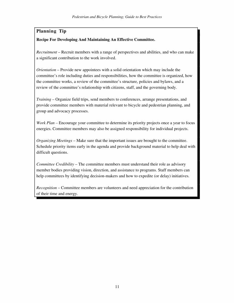
Planning TipRecipe For Developing And Maintaining An Effective Committee.
Recruitment – Recruit members with a range of perspectives and abilities, and who can make a significant contribution to the work involved.
Orientation – Provide new appointees with a solid orientation which may include the committee’s role including duties and responsibilities, how the committee is organized, how the committee works, a review of the committee’s structure, policies and bylaws, and a review of the committee’s relationship with citizens, staff, and the governing body.
Training – Organize field trips, send members to conferences, arrange presentations, and provide committee members with material relevant to bicycle and pedestrian planning, and group and advocacy processes.
Work Plan – Encourage your committee to determine its priority projects once a year to focus energies. Committee members may also be assigned responsibility for individual projects.
Organizing Meetings – Make sure that the important issues are brought to the committee. Schedule priority items early in the agenda and provide background material to help deal with difficult questions.
Committee Credibility – The committee members must understand their role as advisory member bodies providing vision, direction, and assistance to programs. Staff members can help committees by identifying decisionmakers and how to expedite (or delay) initiatives.
Recognition – Committee members are volunteers and need appreciation for the contribution of their time and energy.
11
Pedestrian and Bicycle Planning; Guide to Best Practices
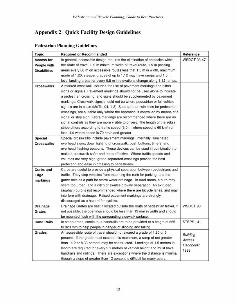
Appendix 2 Quick Facility Design Guidelines
Pedestrian Planning GuidelinesTopic Required or Recommended ReferenceAccess for People with Disabilities
In general, accessible design requires the elimination of obstacles within the route of travel, 0.9 m minimum width of travel route, 1.5 m passing areas every 60 m on accessible routes less that 1.5 m in width, maximum grade of 1:20, steeper grades of up to 1:12 may have ramps and 1.5 m level landing areas for every 0.8 m in elevations change along 1:12 ramps.
WSDOT 3347
Crosswalks A marked crosswalk includes the use of pavement markings and either signs or signals. Pavement markings should not be used alone to indicate a pedestrian crossing, and signs should be supplemented by pavement markings. Crosswalk signs should not be where pedestrian or full vehicle signals are in place (MoTh, 94, 13). Stop bars, or twin lines for pedestrian crossings, are suitable only where the approach is controlled by means of a signal or stop sign. Zebra markings are recommended where there are no signal controls as they are more visible to drivers. The length of the zebra stripe differs according to traffic speed (3.0 m where speed is 60 km/h or less, 4.0 where speed is 70 km/h and greater.
Special Crosswalks
Special crosswalks include pavement markings, internally illuminated overhead signs, down lighting of crosswalk, push buttons, timers, and overhead flashing beacons. These devices can be used in combination to make a crosswalk safer and more effective. Where traffic speeds and volumes are very high, grade separated crossings provide the best protection and ease in crossing to pedestrians.
Curbs and Edge markings
Curbs are useful to provide a physical separation between pedestrians and traffic. They stop vehicles from mounting the curb for parking, and the gutter acts as a path for storm water drainage. In rural areas, a curb may seem too urban, and a ditch or swales provide separation. An extruded (asphalt) curb is not recommended where there are bicycle lanes, and may interfere with drainage. Raised pavement markings are strongly discouraged as a hazard for cyclists.
Drainage Grates
Drainage Grates are best if located outside the route of pedestrian travel, if not possible, the openings should be less than 13 mm in width and should be mounted flush with the surrounding sidewalk surface.
WSDOT 90
Hand Rails In steep areas, continuous handrails are to be provided at a height of 865 to 920 mm to help people in danger of slipping and falling.
STEPS , 41
Grades An accessible route of travel should not exceed a grade of 1:20 or 5 percent. If the grade must exceed this maximum, a ramp of not greater than 1:12 or 8.33 percent may be constructed. Landings of 1.5 metres in length are required for every 9.1 metres of vertical height and must have handrails and railings. There are exceptions where the distance is minimal, though a slope of greater than 12 percent is difficult for many users.
Building Access Handbook: 1998.
12
Pedestrian and Bicycle Planning; Guide to Best Practices
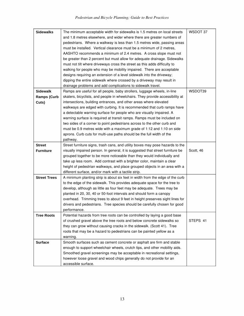
Sidewalks The minimum acceptable width for sidewalks is 1.5 metres on local streets and 1.8 metres elsewhere, and wider where there are greater numbers of pedestrians. Where a walkway is less than 1.5 metres wide, passing areas must be installed. Vertical clearance must be a minimum of 2 metres, AASHTO recommends a minimum of 2.4 metres. A cross slope must not be greater than 2 percent but must allow for adequate drainage. Sidewalks must not tilt where driveways cross the street as this adds difficulty to walking for people who may be mobility impaired. There are acceptable designs requiring an extension of a level sidewalk into the driveway; dipping the entire sidewalk where crossed by a driveway may result in drainage problems and add complications to sidewalk travel.
WSDOT 37
Sidewalk Ramps (Curb Cuts)
Ramps are useful for all people, baby strollers, luggage wheels, inline skaters, bicyclists, and people in wheelchairs. They provide accessibility at intersections, building entrances, and other areas where elevated walkways are edged with curbing. It is recommended that curb ramps have a detectable warning surface for people who are visually impaired. A warning surface is required at transit ramps. Ramps must be included on two sides of a corner to point pedestrians across to the other curb and must be 0.9 metres wide with a maximum grade of 1:12 and 1:10 on side aprons. Curb cuts for multiuse paths should be the full width of the pathway.
WSDOT39
Street Furniture
Street furniture signs, trash cans, and utility boxes may pose hazards to the visually impaired person. In general, it is suggested that street furniture be grouped together to be more noticeable than they would individually and take up less room. Add contrast with a brighter color, maintain a clear height of pedestrian walkways, and place grouped objects in an area with a different surface, and/or mark with a tactile strip.
Scott, 46
Street Trees A minimum planting strip is about six feet in width from the edge of the curb to the edge of the sidewalk. This provides adequate space for the tree to develop, although as little as four feet may be adequate. Trees may be planted in 20, 30, 40 or 50foot intervals and should form a canopy overhead. Trimming trees to about 9 feet in height preserves sight lines for drivers and pedestrians. Tree species should be carefully chosen for good performance.
Tree Roots Potential hazards from tree roots can be controlled by laying a good base of crushed gravel above the tree roots and below concrete sidewalks so they can grow without causing cracks in the sidewalk. (Scott 41). Tree roots that may be a hazard to pedestrians can be painted yellow as a warning.
STEPS 41
Surface Smooth surfaces such as cement concrete or asphalt are firm and stable enough to support wheelchair wheels, crutch tips, and other mobility aids. Smoothed gravel screenings may be acceptable in recreational settings, however loose gravel and wood chips generally do not provide for an accessible surface.
13
Pedestrian and Bicycle Planning; Guide to Best Practices
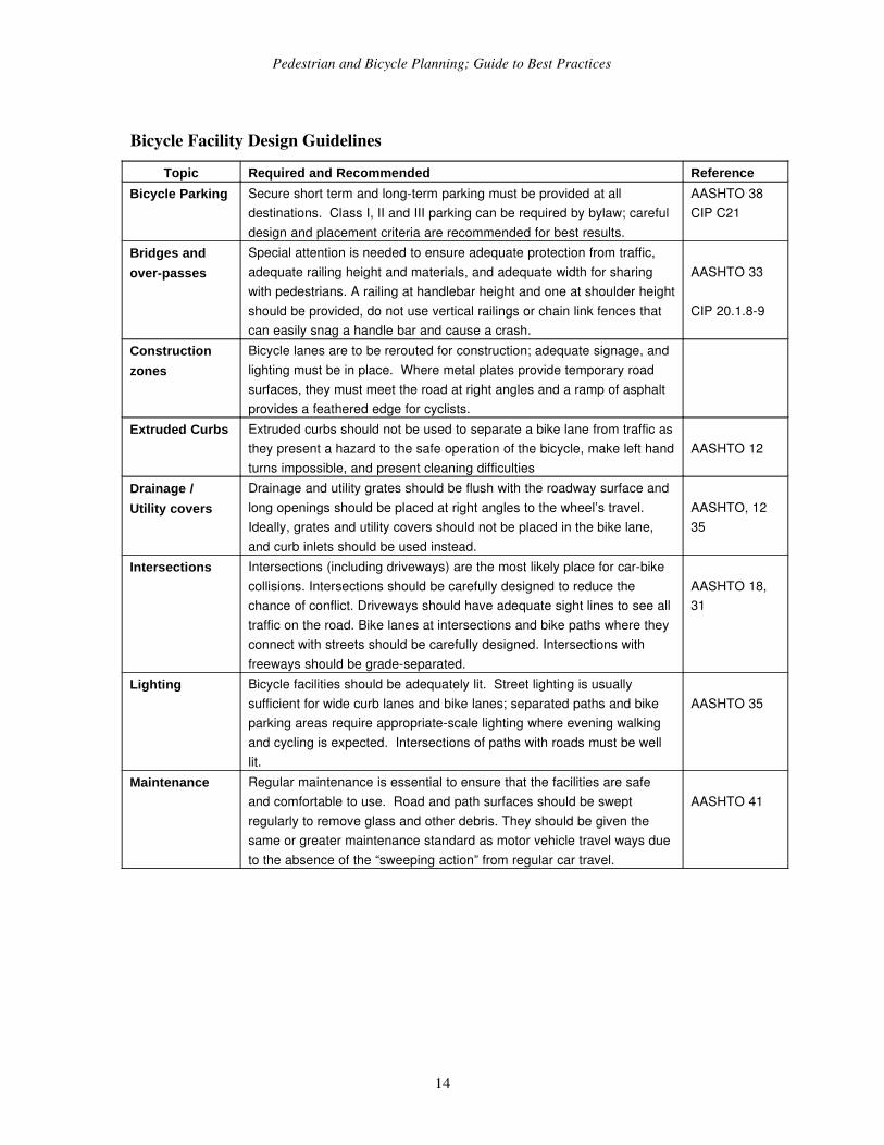
Bicycle Facility Design GuidelinesTopic Required and Recommended Reference
Bicycle Parking Secure short term and longterm parking must be provided at all destinations. Class I, II and III parking can be required by bylaw; careful design and placement criteria are recommended for best results.
AASHTO 38CIP C21
Bridges and overpasses
Special attention is needed to ensure adequate protection from traffic, adequate railing height and materials, and adequate width for sharing with pedestrians. A railing at handlebar height and one at shoulder height should be provided, do not use vertical railings or chain link fences that can easily snag a handle bar and cause a crash.
AASHTO 33
CIP 20.1.89
Construction zones
Bicycle lanes are to be rerouted for construction; adequate signage, and lighting must be in place. Where metal plates provide temporary road surfaces, they must meet the road at right angles and a ramp of asphalt provides a feathered edge for cyclists.
Extruded Curbs Extruded curbs should not be used to separate a bike lane from traffic as they present a hazard to the safe operation of the bicycle, make left hand turns impossible, and present cleaning difficulties
AASHTO 12
Drainage / Utility covers
Drainage and utility grates should be flush with the roadway surface and long openings should be placed at right angles to the wheel’s travel. Ideally, grates and utility covers should not be placed in the bike lane, and curb inlets should be used instead.
AASHTO, 1235
Intersections Intersections (including driveways) are the most likely place for carbike collisions. Intersections should be carefully designed to reduce the chance of conflict. Driveways should have adequate sight lines to see all traffic on the road. Bike lanes at intersections and bike paths where they connect with streets should be carefully designed. Intersections with freeways should be gradeseparated.
AASHTO 18, 31
Lighting Bicycle facilities should be adequately lit. Street lighting is usually sufficient for wide curb lanes and bike lanes; separated paths and bike parking areas require appropriatescale lighting where evening walking and cycling is expected. Intersections of paths with roads must be well lit.
AASHTO 35
Maintenance Regular maintenance is essential to ensure that the facilities are safe and comfortable to use. Road and path surfaces should be swept regularly to remove glass and other debris. They should be given the same or greater maintenance standard as motor vehicle travel ways due to the absence of the “sweeping action” from regular car travel.
AASHTO 41
14
Pedestrian and Bicycle Planning; Guide to Best Practices
On Road Facilities
Bike Lanes
All roads should be thought of forming the bicycle network. On major urban roads, bike lanes can increase safety and reduce conflicts with other vehicles. Bike lanes should always be oneway facilities carrying traffic in the same direction as adjacent motor vehicle traffic. The minimum width for a bike lane should be 1.2 m excluding curb and gutter, 1.5m when next to a parking lane). Bike lanes should end well in advance of intersections, with dashed lines adjacent to right turn lanes to encourage traffic to merge into the bike lane before turning. Bike lanes should be located to the far right of the road, or between the parking lane and the travel lane.
AASHTO 18 20
FHWA 1621
MUTCD 9C29C3
CIP20.23Wide Curb
LanesCurb lanes should be between 12 and 14 feet, or 3.74.3m. Wider curb lanes may encourage two motor vehicles to operate in one lane.
AASHTO 14, 15
Shoulder Width Wide shoulders are preferred for accommodating cyclists in rural areas and should be a minimum of 1.2 m when intended to accommodate bicycle travel. Where shoulders are narrower, they should not be signed as bikeways. Wider width is desirable when speeds are higher than 55km/h, there is a large percentage of truck traffic or if obstructions exist.
AASHTO 14, 15
Bicycle Boulevards and Local Streets
Bicycle boulevards are streets that encourage cycling and discourage motor vehicle traffic by means of traffic calming devices. On local streets, bicycle route signs may be desired where they form part of the bicycle network.
On–street parking
Onstreet parking can pose risks to cyclists who ride past, and people with disabilities as they exit their vehicles. Where cars are parallel parked, a bike lane may be provided between the road and parked cars if the bike lane is wide enough and far enough from the vehicles to avoid car doors opening into the bike lane. A bike lane should never be place to the right of parallel parking. Diagonal or perpendicular parking is very dangerous and bike facilities should be avoided in these areas. (WSDOT, 1995)
Pavement Structure
A bike facility may be cement, asphalt, or fine gravel screenings. However, the surface should be at least as smooth as that provided for vehicles and tree roots should be prevented from disrupting the smooth surface.
AASHTO 13, 32
Railroad Crossings
Railroad crossings should be at right angles to the rails as acute angles may trap the wheels and cause crashes. The travel way should be widened if the crossing angle is less than 45 degrees to permit a wider crossing angle. Warning signs and pavement markings should be posted before the crossing. Road surfaces should be flush with the rails. Rubberized flanges around the rails or removal of unused track can minimize the danger for cyclists.
AASHTO 12MUTCD 9C4
Intermodal Linkages
Airports, rail, buses, and ferries permit cyclists to reach distant destinations. All trains should be designed to permit bicycles as checked baggage, or in the passenger car. Terminals should provide for secure bicycle parking, and areas may be provided for bicycle set up, and clear access to the station should be provided. Transit buses should be equipped with racks to carry at least two bicycles.
AASHTO 38
15
Pedestrian and Bicycle Planning; Guide to Best Practices
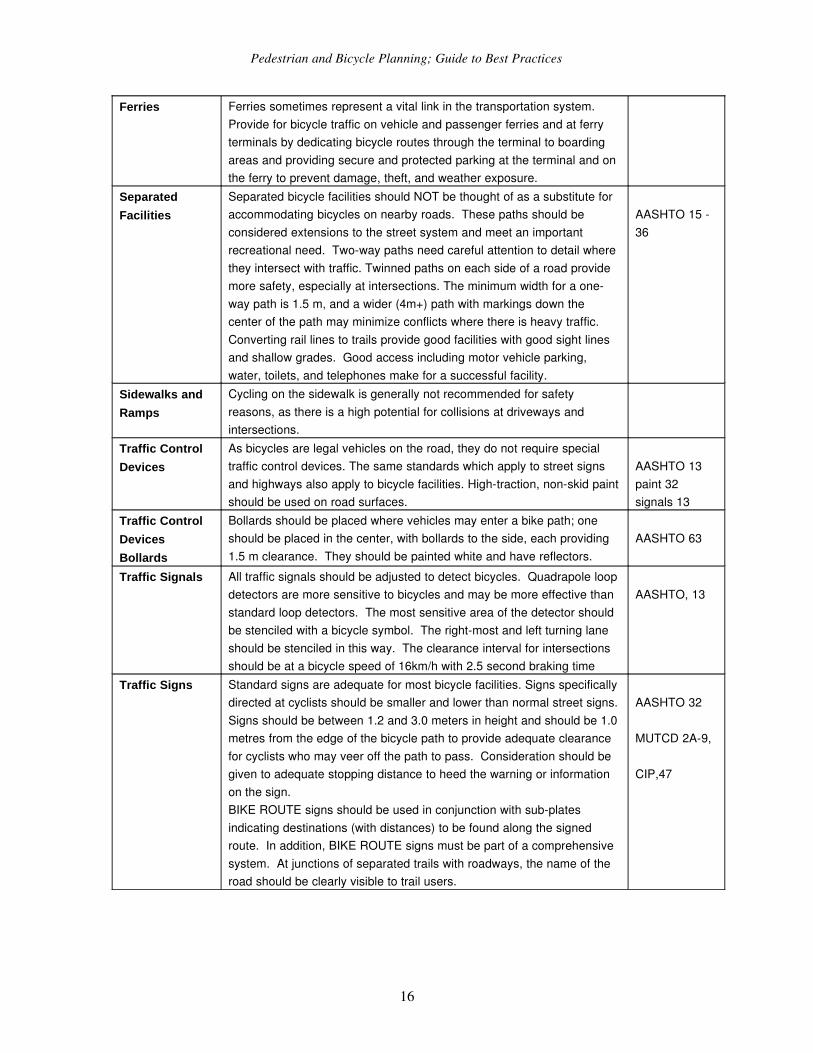
Ferries Ferries sometimes represent a vital link in the transportation system. Provide for bicycle traffic on vehicle and passenger ferries and at ferry terminals by dedicating bicycle routes through the terminal to boarding areas and providing secure and protected parking at the terminal and on the ferry to prevent damage, theft, and weather exposure.
Separated Facilities
Separated bicycle facilities should NOT be thought of as a substitute for accommodating bicycles on nearby roads. These paths should be considered extensions to the street system and meet an important recreational need. Twoway paths need careful attention to detail where they intersect with traffic. Twinned paths on each side of a road provide more safety, especially at intersections. The minimum width for a oneway path is 1.5 m, and a wider (4m+) path with markings down the center of the path may minimize conflicts where there is heavy traffic. Converting rail lines to trails provide good facilities with good sight lines and shallow grades. Good access including motor vehicle parking, water, toilets, and telephones make for a successful facility.
AASHTO 15 36
Sidewalks and Ramps
Cycling on the sidewalk is generally not recommended for safety reasons, as there is a high potential for collisions at driveways and intersections.
Traffic Control Devices
As bicycles are legal vehicles on the road, they do not require special traffic control devices. The same standards which apply to street signs and highways also apply to bicycle facilities. Hightraction, nonskid paint should be used on road surfaces.
AASHTO 13paint 32signals 13
Traffic Control DevicesBollards
Bollards should be placed where vehicles may enter a bike path; one should be placed in the center, with bollards to the side, each providing 1.5 m clearance. They should be painted white and have reflectors.
AASHTO 63
Traffic Signals All traffic signals should be adjusted to detect bicycles. Quadrapole loop detectors are more sensitive to bicycles and may be more effective than standard loop detectors. The most sensitive area of the detector should be stenciled with a bicycle symbol. The rightmost and left turning lane should be stenciled in this way. The clearance interval for intersections should be at a bicycle speed of 16km/h with 2.5 second braking time
AASHTO, 13
Traffic Signs Standard signs are adequate for most bicycle facilities. Signs specifically directed at cyclists should be smaller and lower than normal street signs. Signs should be between 1.2 and 3.0 meters in height and should be 1.0 metres from the edge of the bicycle path to provide adequate clearance for cyclists who may veer off the path to pass. Consideration should be given to adequate stopping distance to heed the warning or information on the sign. BIKE ROUTE signs should be used in conjunction with subplates indicating destinations (with distances) to be found along the signed route. In addition, BIKE ROUTE signs must be part of a comprehensive system. At junctions of separated trails with roadways, the name of the road should be clearly visible to trail users.
AASHTO 32
MUTCD 2A9,
CIP,47
16
Pedestrian and Bicycle Planning; Guide to Best Practices
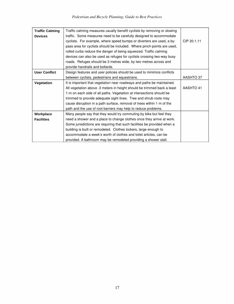
Traffic Calming Devices
Traffic calming measures usually benefit cyclists by removing or slowing traffic. Some measures need to be carefully designed to accommodate cyclists. For example, where speed bumps or diverters are used, a bypass area for cyclists should be included. Where pinchpoints are used, rolled curbs reduce the danger of being squeezed. Traffic calming devices can also be used as refuges for cyclists crossing twoway busy roads. Refuges should be 3 metres wide, by two metres across and provide handrails and bollards.
CIP 20.1.11
User Conflict Design features and user policies should be used to minimize conflicts between cyclists, pedestrians and equestrians. AASHTO 37
Vegetation It is important that vegetation near roadways and paths be maintained. All vegetation above .3 meters in height should be trimmed back a least 1m on each side of all paths. Vegetation at intersections should be trimmed to provide adequate sight lines. Tree and shrub roots may cause disruption in a path surface, removal of trees within 1 m of the path and the use of root barriers may help to reduce problems.
AASHTO 41
Workplace Facilities
Many people say that they would try commuting by bike but feel they need a shower and a place to change clothes once they arrive at work. Some jurisdictions are requiring that such facilities be provided when a building is built or remodeled. Clothes lockers, large enough to accommodate a week’s worth of clothes and toilet articles, can be provided. A bathroom may be remodeled providing a shower stall.
17
Pedestrian and Bicycle Planning; Guide to Best Practices
Appendix 3 Evaluating Nonmotorized TravelIt is generally a mistake to simply use kilometres of paths or bike lanes as an indicator of cycling network effectiveness, since this encourages the development of facilities where they are cheapest to build rather than where they provide the greatest benefits. Quantity (indicated by facility kilometres) must be balanced against quality (removing significant physical barriers). It is therefore important to use techniques that identify the most costeffective improvements. This section describes various techniques that can be used to evaluate walking and cycling conditions and potential improvements.
SurveysIt is often useful to survey the public to identify the problems they perceive with current pedestrian and cycling conditions, and opportunities and priorities for improvements. Public survey forms can be distributed throughout a region, or be targeted at a particular area. Survey forms can be handed out along a sidewalk, path or roadway, can be attached to bicycles and automobiles parked at a study site, or can be distributed through local newsletters and employers.
Special consideration should be given to pedestrian and bicycle planning along urban and suburban arterials, highways near urban areas, and highways that connect to parks, schools, residential neighborhoods, employment centres, and other trip generators.
18
Pedestrian and Bicycle Planning; Guide to Best Practices
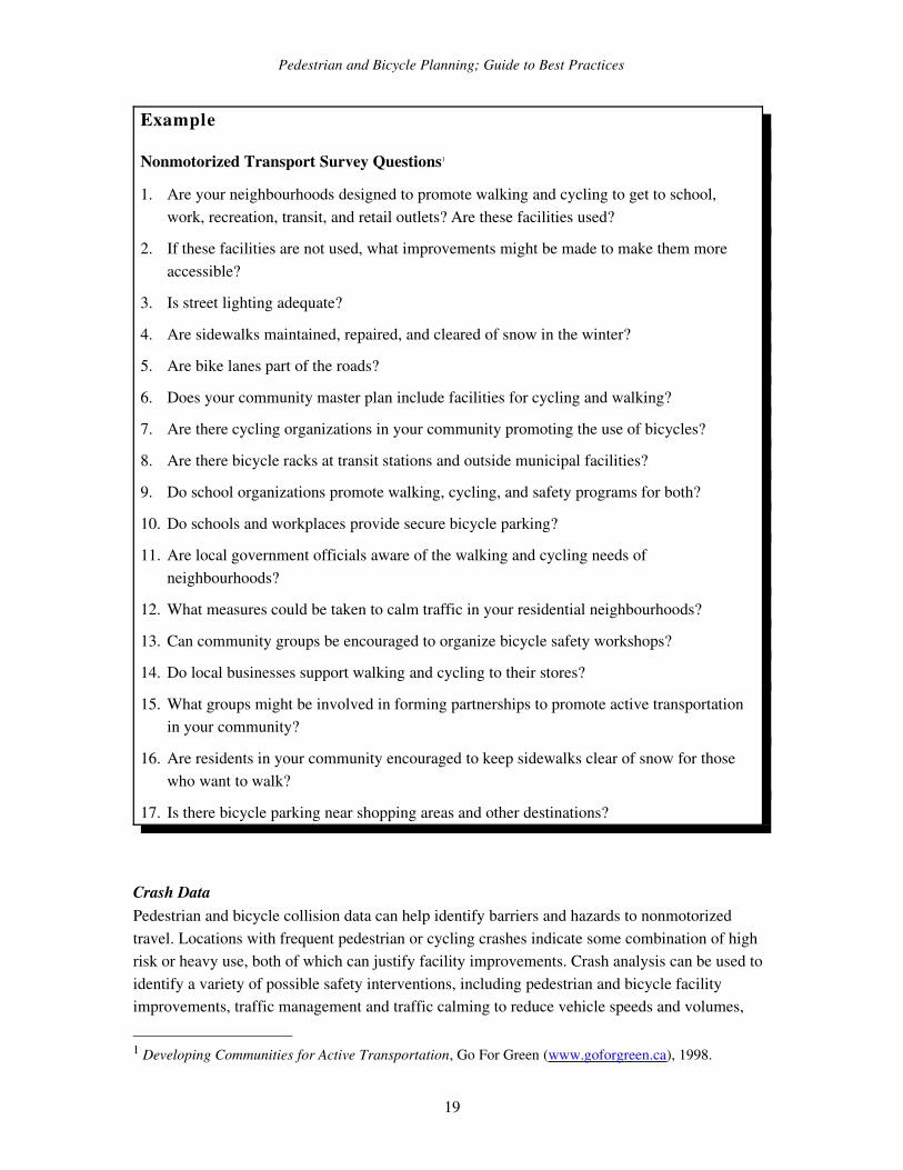
Example
Nonmotorized Transport Survey Questions1
1. Are your neighbourhoods designed to promote walking and cycling to get to school, work, recreation, transit, and retail outlets? Are these facilities used?
2. If these facilities are not used, what improvements might be made to make them more accessible?
3. Is street lighting adequate?
4. Are sidewalks maintained, repaired, and cleared of snow in the winter?
5. Are bike lanes part of the roads?
6. Does your community master plan include facilities for cycling and walking?
7. Are there cycling organizations in your community promoting the use of bicycles?
8. Are there bicycle racks at transit stations and outside municipal facilities?
9. Do school organizations promote walking, cycling, and safety programs for both?
10. Do schools and workplaces provide secure bicycle parking?
11. Are local government officials aware of the walking and cycling needs of neighbourhoods?
12. What measures could be taken to calm traffic in your residential neighbourhoods?
13. Can community groups be encouraged to organize bicycle safety workshops?
14. Do local businesses support walking and cycling to their stores?
15. What groups might be involved in forming partnerships to promote active transportation in your community?
16. Are residents in your community encouraged to keep sidewalks clear of snow for those who want to walk?
17. Is there bicycle parking near shopping areas and other destinations?
Crash DataPedestrian and bicycle collision data can help identify barriers and hazards to nonmotorized travel. Locations with frequent pedestrian or cycling crashes indicate some combination of high risk or heavy use, both of which can justify facility improvements. Crash analysis can be used to identify a variety of possible safety interventions, including pedestrian and bicycle facility improvements, traffic management and traffic calming to reduce vehicle speeds and volumes,
1 Developing Communities for Active Transportation, Go For Green (www.goforgreen.ca), 1998.
19
Pedestrian and Bicycle Planning; Guide to Best Practices
and increased traffic safety education and law enforcement for drivers, pedestrians, and cyclists. Pedestrian and cycling collisions tend to be underreported, so a variety of data collection methods may be needed.2
Crash data should be evaluated by type of crash and contributing factors, pedestrian and cyclist demographics, location type (for example, pedestrian crashes can be categorized by intersection crosswalk, midblock crosswalk, midblock no crosswalk, driveways, etc.) to identify possible patterns. Smaller communities may only have few pedestrian/cyclist crash reports to work with. Larger communities may find it valuable to establish an ongoing program to analyze pedestrian/cyclist crash data, and integrate it into a municipal mapping program.
Field SurveysSome transportation agencies use volunteers or hired college students to perform field surveys of pedestrian and cycling conditions. If possible, surveys should include special user groups, such as people in wheelchairs and elderly pedestrians, particularly in areas they frequent.
When evaluating facilities it is important to clearly maintain the distinction between nominal (“in name”) and functional (“working condition”) dimensions. For example, many sidewalks and paths are nominally 1.8 to 2 metres wide, but functionally they may be much narrower, due to objects such as telephone poles and signposts located in their right of way, and due to surface failures, such as cracks and potholes. As a result, a walkway that meets technical specifications may be inadequate for some potential users. Similarly, a bike lane may be useless if it has poor surface conditions or is frequently used for vehicle parking.
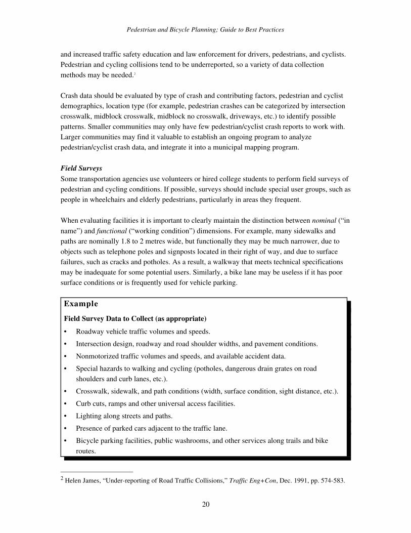
ExampleField Survey Data to Collect (as appropriate)• Roadway vehicle traffic volumes and speeds.• Intersection design, roadway and road shoulder widths, and pavement conditions.• Nonmotorized traffic volumes and speeds, and available accident data.• Special hazards to walking and cycling (potholes, dangerous drain grates on road
shoulders and curb lanes, etc.).• Crosswalk, sidewalk, and path conditions (width, surface condition, sight distance, etc.).• Curb cuts, ramps and other universal access facilities.• Lighting along streets and paths.• Presence of parked cars adjacent to the traffic lane.• Bicycle parking facilities, public washrooms, and other services along trails and bike
routes.
2 Helen James, “Underreporting of Road Traffic Collisions,” Traffic Eng+Con, Dec. 1991, pp. 574583.
20
Pedestrian and Bicycle Planning; Guide to Best Practices
• Security, cleanliness, vandalism, litter, and aesthetic conditions.• Community demographics (age, income, etc.)• Presence of activity centers that attract nonmotorized travel (schools, colleges, resorts,
etc.)• Land use factors, including density and mix, street connectivity, and building site design.• Topography and climate.
It may be difficult to obtain consistent evaluations of roadway conditions by different surveyors. Some cyclists are comfortable riding on roads with heavy, highspeed traffic, and are critical of paths that restrict cycling riding speed due to design limitations. Other cyclists have the opposite preferences. This problem can be minimized by establishing clear evaluation criteria. For example, rather than simply rating a highway condition as “good” or “bad” for cycling it may be better to record traffic volumes, shoulder width, shoulder condition, and “special problems for cyclists.” Training and supervision can help guarantee consistency between survey teams.
The Barrier EffectRoads are usually considered transportation links, but they can also be barriers, especially to nonmotorized travel.3 The “barrier effect” reduces walking and cycling mobility, and increases driving.4 This is not to imply that drivers intentionally cause harm, but rather that such impacts are unavoidable when fast, heavy vehicles share space with more vulnerable road users. These impacts tend to be inequitable because disadvantaged populations who depend on nonmotorized transport bear a disproportionate share of the costs.
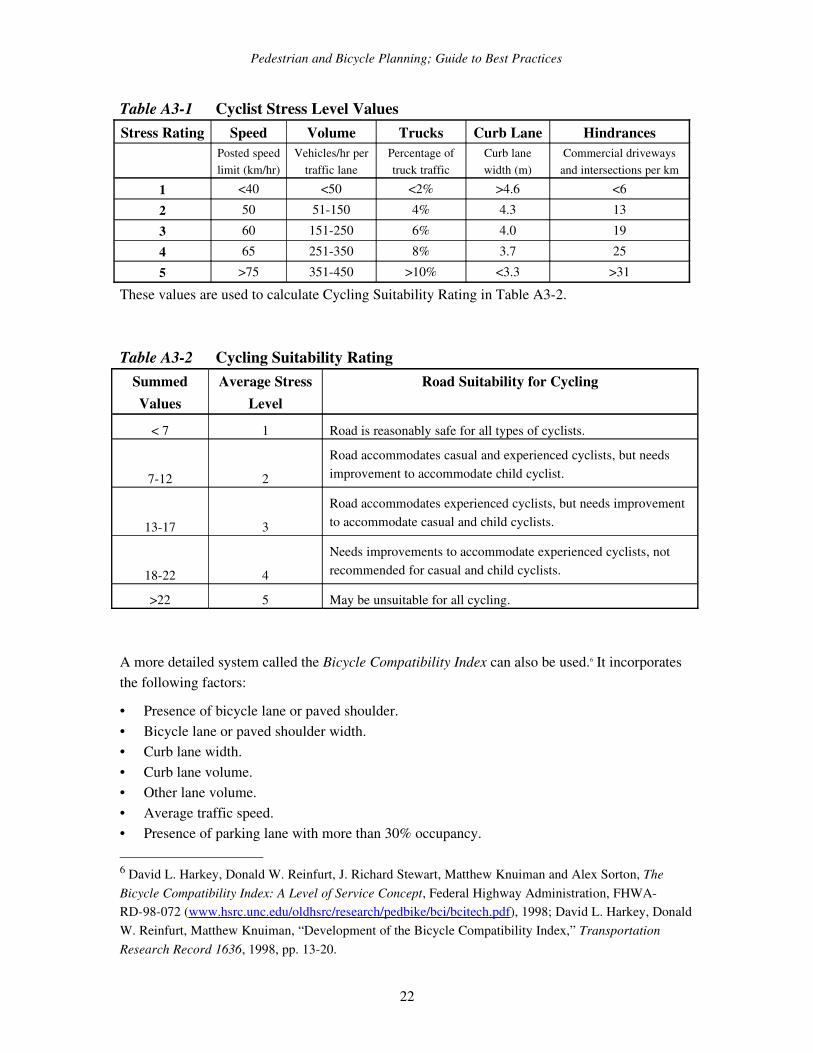
Cycling Condition Evaluation TechniquesTable A31 shows one method for evaluating cyclist stress levels, taking into account traffic speed, volume, type, operating space, and number of hindrances (intersections and commercial driveways) on a specific stretch of roadway.5
3 J.M. Clark and B.J. Hutton, The Appraisal of Community Severance, U.K. DoT, Transport Research Laboratory (Crowthorne, UK), Report #135, 1991.4 Todd Litman, Transportation Cost Analysis; Techniques, Estimates and Implications, VTPI (www.vtpi.org), 2000; Dr. Peter Bein, Monetization of Environmental Impacts of Roads, and Social Cost of Transverse Barrier Effects, Planning Services Branch, B.C. Ministry of Transportation and Highways (Victoria; www.th.gov.bc.ca/bchighways), 1997, 1995.5 David L. Harkey, Donald W. Reinfurt, J. Richard Stewart, Matthew Knuiman and Alex Sorton, The Bicycle Compatibility Index: A Level of Service Concept, Federal Highway Administration, FHWARD98072 (www.hsrc.unc.edu/oldhsrc/research/pedbike/bci/bcitech.pdf), 1998.
21
Pedestrian and Bicycle Planning; Guide to Best Practices
Table A31 Cyclist Stress Level ValuesStress Rating Speed Volume Trucks Curb Lane Hindrances
Posted speed limit (km/hr)
Vehicles/hr per traffic lane
Percentage of truck traffic
Curb lane width (m)
Commercial driveways and intersections per km
1 <40 <50 <2% >4.6 <62 50 51150 4% 4.3 133 60 151250 6% 4.0 194 65 251350 8% 3.7 255 >75 351450 >10% <3.3 >31
These values are used to calculate Cycling Suitability Rating in Table A32.
Table A32 Cycling Suitability RatingSummed Values
Average Stress Level
Road Suitability for Cycling
< 7 1 Road is reasonably safe for all types of cyclists.
712 2
Road accommodates casual and experienced cyclists, but needs improvement to accommodate child cyclist.
1317 3
Road accommodates experienced cyclists, but needs improvement to accommodate casual and child cyclists.
1822 4
Needs improvements to accommodate experienced cyclists, not recommended for casual and child cyclists.
>22 5 May be unsuitable for all cycling.
A more detailed system called the Bicycle Compatibility Index can also be used.6 It incorporates the following factors:
• Presence of bicycle lane or paved shoulder.• Bicycle lane or paved shoulder width.• Curb lane width.• Curb lane volume.• Other lane volume.• Average traffic speed.• Presence of parking lane with more than 30% occupancy.
6 David L. Harkey, Donald W. Reinfurt, J. Richard Stewart, Matthew Knuiman and Alex Sorton, The Bicycle Compatibility Index: A Level of Service Concept, Federal Highway Administration, FHWARD98072 (www.hsrc.unc.edu/oldhsrc/research/pedbike/bci/bcitech.pdf), 1998; David L. Harkey, Donald W. Reinfurt, Matthew Knuiman, “Development of the Bicycle Compatibility Index,” Transportation Research Record 1636, 1998, pp. 1320.
22
Pedestrian and Bicycle Planning; Guide to Best Practices
• Type of roadside development.• Truck volumes.• Parking turnover.• Right turn lanes.
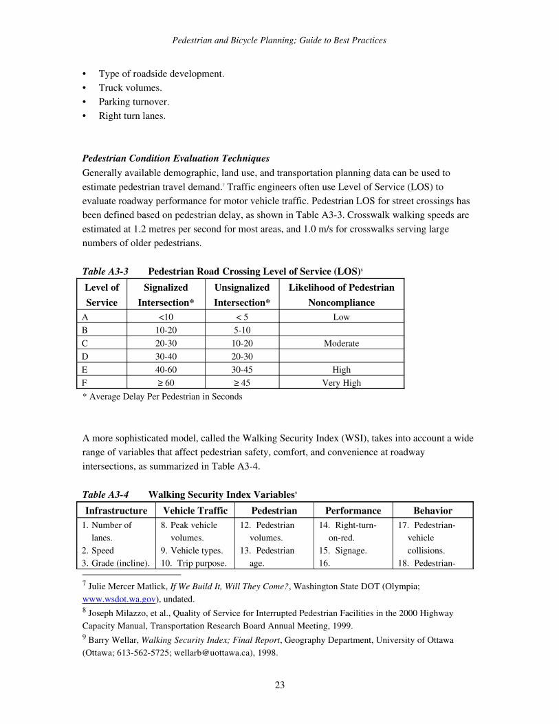
Pedestrian Condition Evaluation TechniquesGenerally available demographic, land use, and transportation planning data can be used to estimate pedestrian travel demand.7 Traffic engineers often use Level of Service (LOS) to evaluate roadway performance for motor vehicle traffic. Pedestrian LOS for street crossings has been defined based on pedestrian delay, as shown in Table A33. Crosswalk walking speeds are estimated at 1.2 metres per second for most areas, and 1.0 m/s for crosswalks serving large numbers of older pedestrians.
Table A33 Pedestrian Road Crossing Level of Service (LOS)8 Level of Service
Signalized Intersection*
Unsignalized Intersection*
Likelihood of Pedestrian Noncompliance
A <10 < 5 LowB 1020 510C 2030 1020 ModerateD 3040 2030E 4060 3045 HighF ≥ 60 ≥ 45 Very High* Average Delay Per Pedestrian in Seconds
A more sophisticated model, called the Walking Security Index (WSI), takes into account a wide range of variables that affect pedestrian safety, comfort, and convenience at roadway intersections, as summarized in Table A34.
Table A34 Walking Security Index Variables9
Infrastructure Vehicle Traffic Pedestrian Performance Behavior1. Number of
lanes.2. Speed3. Grade (incline).
8. Peak vehicle volumes.
9. Vehicle types.10. Trip purpose.
12. Pedestrian volumes.
13. Pedestrian age.
14. Rightturnonred.
15. Signage.16.
17. Pedestrianvehicle collisions.
18. Pedestrian
7 Julie Mercer Matlick, If We Build It, Will They Come?, Washington State DOT (Olympia; www.wsdot.wa.gov), undated.8 Joseph Milazzo, et al., Quality of Service for Interrupted Pedestrian Facilities in the 2000 Highway Capacity Manual, Transportation Research Board Annual Meeting, 1999.9 Barry Wellar, Walking Security Index; Final Report, Geography Department, University of Ottawa (Ottawa; 6135625725; [email protected]), 1998.
23
Pedestrian and Bicycle Planning; Guide to Best Practices
4. Turning lanes.5. Curb cut at
intersections.6. Stop bar
distance from crosswalk.
7. Sight lines
11. Turning movements. Ice/snow/slush
removal.
vehicle conflicts.
19. Vehicle moving violations.
The four criteria below are each rated on a scale from 13, the total of which represents the Pedestrian Environmental Factor (PEF).10 The results were found to correlate well with the use of nonautomobile travel in an urban area. Urban neighborhoods with a high PEF tend to have twice the walk/bicycle mode share as the overall average, as much as five times greater than areas with the lowest PEF.
• Ease of street crossings. This is based on street width, traffic volumes, and speeds.
• Sidewalk continuity. Sidewalks that do not connect create barriers to pedestrian travel. A pedestrian network is only as good as its weakest link, particularly for people with physical disabilities. Even problems that appear minor to ablebodied pedestrians may be a major barrier to people with significant mobility constraints.
• Local street characteristics (grid vs. cul de sac). A grid street system provides continuity, allowing more direct access to destinations.
• Topography. Steep slopes create barriers to pedestrians.
Prioritizing Improvements and Selecting Preferred OptionsThere are four factors to consider when evaluating barriers and gaps in pedestrian and cycling networks, and when prioritizing improvements:
1. Level of demand. How many people would use a facility if it were improved. In general, this increases around higher density areas, such as business districts and higherdensity residential areas, and around attractions, such as schools and parks.
2. Degree of barrier. This can range from minor difficulties (such as requiring pedestrians to use a longer route than would be the case if a proposed improvement is made) to a total barrier (“you can’t get there from here by walking or bicycling”). The degree of barrier also depends on who is traveling, and under what conditions. People with physical disabilities are more vulnerable to such barriers.
3. Potential benefits. This refers to the benefits that could result from increased walking and cycling on that corridor. For example, improvements that encourage more nonmotorized
10 PBQD, The Pedestrian Environment, 1000 Friends of Oregon (www.friends.org) 1993.
24
Pedestrian and Bicycle Planning; Guide to Best Practices
travel which replaces automobile use may provide more value to a community than improvements that are used primarily for recreational cycling and walking.
4. Cost and ease of improvement. This includes the incremental financial costs of the project, and any increase in future maintenance costs.
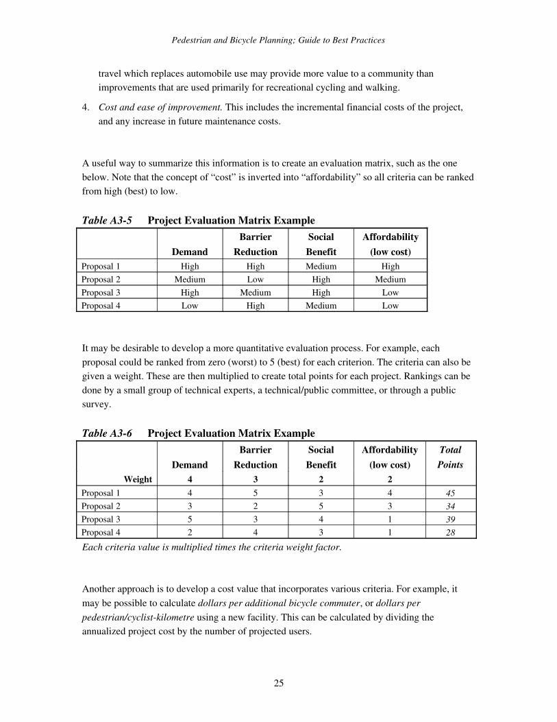
A useful way to summarize this information is to create an evaluation matrix, such as the one below. Note that the concept of “cost” is inverted into “affordability” so all criteria can be ranked from high (best) to low.
Table A35 Project Evaluation Matrix Example
DemandBarrier
ReductionSocial Benefit
Affordability(low cost)
Proposal 1 High High Medium HighProposal 2 Medium Low High MediumProposal 3 High Medium High LowProposal 4 Low High Medium Low
It may be desirable to develop a more quantitative evaluation process. For example, each proposal could be ranked from zero (worst) to 5 (best) for each criterion. The criteria can also be given a weight. These are then multiplied to create total points for each project. Rankings can be done by a small group of technical experts, a technical/public committee, or through a public survey.
Table A36 Project Evaluation Matrix Example
DemandBarrier
ReductionSocial Benefit
Affordability(low cost)
TotalPoints
Weight 4 3 2 2Proposal 1 4 5 3 4 45Proposal 2 3 2 5 3 34Proposal 3 5 3 4 1 39Proposal 4 2 4 3 1 28Each criteria value is multiplied times the criteria weight factor.
Another approach is to develop a cost value that incorporates various criteria. For example, it may be possible to calculate dollars per additional bicycle commuter, or dollars per pedestrian/cyclistkilometre using a new facility. This can be calculated by dividing the annualized project cost by the number of projected users.
25
Pedestrian and Bicycle Planning; Guide to Best Practices
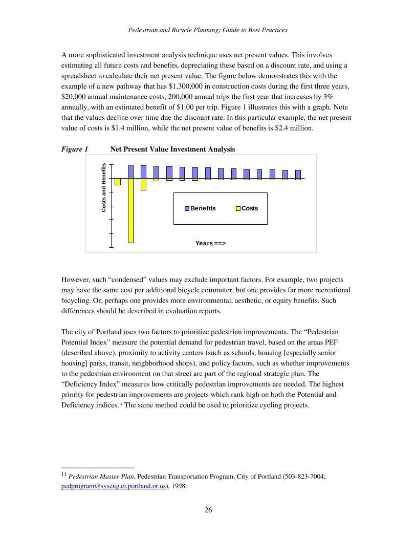
A more sophisticated investment analysis technique uses net present values. This involves estimating all future costs and benefits, depreciating these based on a discount rate, and using a spreadsheet to calculate their net present value. The figure below demonstrates this with the example of a new pathway that has $1,300,000 in construction costs during the first three years, $20,000 annual maintenance costs, 200,000 annual trips the first year that increases by 3% annually, with an estimated benefit of $1.00 per trip. Figure 1 illustrates this with a graph. Note that the values decline over time due the discount rate. In this particular example, the net present value of costs is $1.4 million, while the net present value of benefits is $2.4 million.
Figure 1 Net Present Value Investment Analysis
Years ==>
Cost
s an
d Be
nefit
s
Benefits Costs
However, such “condensed” values may exclude important factors. For example, two projects may have the same cost per additional bicycle commuter, but one provides far more recreational bicycling. Or, perhaps one provides more environmental, aesthetic, or equity benefits. Such differences should be described in evaluation reports.
The city of Portland uses two factors to prioritize pedestrian improvements. The “Pedestrian Potential Index” measure the potential demand for pedestrian travel, based on the areas PEF (described above), proximity to activity centers (such as schools, housing [especially senior housing] parks, transit, neighborhood shops), and policy factors, such as whether improvements to the pedestrian environment on that street are part of the regional strategic plan. The “Deficiency Index” measures how critically pedestrian improvements are needed. The highest priority for pedestrian improvements are projects which rank high on both the Potential and Deficiency indices.11 The same method could be used to prioritize cycling projects.
11 Pedestrian Master Plan, Pedestrian Transportation Program, City of Portland (5038237004; [email protected]), 1998.
26

Pedestrian and Bicycle Planning; Guide to Best Practices
ResourcesEvaluating Nonmotorized Transportation Conditions
AASHTO, Guide for the Development of Bicycle Facilities, 3rd Edition, American Association of State Highway and Transportation Officials (Washington DC; 8882274860; www.aashto.org), 1999; available online at www.bikefed.org.
Ronald Eash, “Destination and Mode Choice Models for Nonmotorized Travel,” Transportation Research Record 1674, 1999, pp. 18.
David L. Harkey, Donald W. Reinfurt, J. Richard Stewart, Matthew Knuiman and Alex Sorton, The Bicycle Compatibility Index: A Level of Service Concept, Federal Highway Administration, FHWARD98072 (www.hsrc.unc.edu/oldhsrc/research/pedbike/bci/bcitech.pdf), 1998
Bruce Landis, Russell Ottenberg, and Venkat Vattikuti, The Roadside Pedestrian Environment: Toward A Comprehensive Level of Service, Paper 990570, Transportation Research Board Annual Meeting (www4.nationalacademies.org/trb/homepage.nsf), 1999.
Yael M. Levitte, Bicycle Demand Analysis – A Toronto Case Study, Transportation Research Board Annual Meeting (www4.nationalacademies.org/trb/homepage.nsf), 1999.
William Moritz, Bicycle Facilities and Use, Washington State Department of Transportation, (Olympia; www.wsdot.wa.gov/ppsc/research/onepages/WARD3701.HTM), 1995.
PBQD, The Pedestrian Environment, 1000 Friends of Oregon (www.friends.org) 1993. Christopher Porter, John Suhrbier and William Schwartz, “Forecasting Bicycle and Pedestrian Travel,” Transportation Research Record 1674, 1999, pp. 94101.
Project for Public Spaces, Effects of Environmental Design on the Amount and Type of Bicycling and Walking, National Bicycling and Walking Study No. 20, FHWA, USDOT (available through www.bikefed.org), 1993.
Schwartz, W.L., C.D. Porter, G.C. Payne, J.H. Suhbier, P.C. Moe, and W.L. Wilkinson III. Guidebook on Methods to Estimate NonMotorized Travel: Overview of Methods. TurnerFairbank Highway Research Center (www.tfhrc.org), Federal Highway Administration, FHWARD98165, 1999.
Alex Sorton and Thomas Walsh, “Bicycle Stress Level as a Tool to Evaluate Urban and Suburban Bicycle Computability,” Transportation Research Record 1438, TRB, (www4.nationalacademies.org/trb/homepage.nsf), 1995, pp. 1724.
University of North Carolina, A Compendium of Available Bicycle and Pedestrian Trip Generation Data in the United States, Supplement to the National Bicycling and Walking Study, FHWA, USDOT (available through www.bikefed.org), 1994.
27
Pedestrian and Bicycle Planning; Guide to Best Practices
University of North Carolina Highway Safety Research Center (www.hsrc.unc.edu).
Ellen Vanderslice, Portland Pedestrian Design Guide and Pedestrian Master Plan, City of Portland (www.trans.ci.portland.or.us/Sidewalks_and_Pedestrians.html), 1998.
Barry Wellar, Walking Security Index; Final Report, Geography Department, University of Ottawa (Ottawa; 6135625725; [email protected]), 1998.
28
Pedestrian and Bicycle Planning; Guide to Best Practices
Appendix 4 Exemplary Bicycle and Pedestrian Plans
Bicycle Plans
City of Santa BarbaraA comprehensive plan for integrating bicycling infrastructure into the city's street network, including on and offroad facilities, and ancillary facilities such as bicycle parking, signing and other amenities. www.ci.santabarbara.ca.us/pworks/transp/bike_plan/bmp_toc.html.
City of Portland, Ore.During the 1990's the City of Portland has developed an extensive bicycling infrastructure including on and offstreet routes, bicycle parking, and other facilities. A Master Plan is at: www.trans.ci.portland.or.us/traffic_management/bicycle_program/BikeMasterPlan/Default.htm. Contact: City of Portland, 1120 SW Fifth Ave, Room 730, Portland, OR 97204. (503) 8237671.
City of Philadelphia, PaThe City was awarded more than $3 million of Congestion Mitigation and Air Quality program funds to plan and implement a citywide bicycle network featuring bike lanes, trails, and bicycle parking facilities. www.phila.gov/departments/street/html/the_bicycle_network.html.Contact: City of Philadelphia Streets Department, (215) 6865514,
City of Chicago, Ill.Mayor Daley announced in the early 1990’s that Chicago would become a bicyclefriendly city by the year 2000. A simple sevenpage plan launched a series of improvements to existing facilities and the striping of several miles of bike lane each year. The plan has spawned more detailed bicycle plans: www.cityofchicago.org/Transportation/Bikes/bicycle.htm. Contact: Bicycle Program, 30 N. LaSalle Street, #400, Chicago, IL 60602. 3127448093
City of Tucson, Ariz.With a network of more than 240 miles of bikeway already on the ground, the Tucson Bikeway Improvement Plan identifies more than 50 additional miles of striped bike lanes which will be added to the system by 2001. www.ci.tucson.az.us/transport/planning/overview.html. Contact: City of Tucson, 201 North Stone 6th Floor, Tucson, AZ 85726. (520) 7914372
New York City, NYThis awardwinning plan identifies more than 900 miles of on and offstreet facilities and recommends a series of policies and programs which would promote bicycle use, encourage integration with transit, and link to the City's greenway system. www.ci.nyc.ny.us/html/dcp/html/bndprods.html#b
Wisconsin Department of TransportationAdopted in December, 1998, the Wisconsin Bicycle Transportation Plan 2020 provides a
29
Pedestrian and Bicycle Planning; Guide to Best Practices
blueprint for more and safer bicycle trips with recommendations and roles for a variety of government agencies and groups. www.dot.state.wi.us/dtim/bop/finalbike.html. Contact: Tom Huber, Wisconsin DOT, P.O.Box 7913, Madison, WI 53707. 6082677757
Pennsylvania Department of TransportationOne of the first ISTEAgenerated statewide bicycle plans. The PennDOT plan included extensive public outreach and an intensive "inreach" program for PennDOT staff and agencies. The plan incorporates an extensive design manual. Contact: PennDOT, 7177838444
Pedestrian plans
City of West Palm Beach, Fla. The Transportation Element of the city's 1998 Comprehensive Plan establishes a new traffic hierarchy in which traffic calming is a key strategy in promoting walking and pedestrian safety. Contact: Tim Stillings, Planning Department, P.O. Box 3366, West Palm Beach,FL 33402. (561) 6598031.
City of Portland, Ore.The City has adopted a twopart plan: Part One outlines the policies and plans for improving conditions for walking and Part Two is a detailed design manual for pedestrian facilities. www.trans.ci.portland.or.us/Sidewalks_and_Pedestrians.html.Contact: Pedestrian Coordinator, City of Portland, 1120 SW Fifth Ave, Portland, OR 97204.
City of Madison, Wis. Adopted in September 1997, Madison's visionary plan for walking incorporates planning, design, maintenance, and longterm goals and objectives. Madison was one of the first communities to adopt a separate plan for walking. www.ci.madison.wi.us/reports/execsum2.pdf. Contact: Arthur Ross, City of Madison, P.O. Box 2986, Madison, WI 53701. 6082666225.
City of Tucson, Ariz.Closely matching the City's bicycling plan, Tucson has adopted an ambitious plan to improve conditions for walking that is clearly identifiable in the City's annual workplan. Contact: Tom Fisher, City of Tucson, 201 North Stone, Tucson, AZ 85726. 5207914372
Arlington County, Va.Arlington County is one of the nation's densest urban areas and has developed a pedestrian plan that builds on the accessibility of two major transit corridors in the County. An extensive sidewalk building program is complemented by a neighborhood traffic calming program, all directed by citizen task forces. www.co.arlington.va.us/dpw/planning/ped/ped.htm. Contact: Arlington County DPW, 2100 Clarendon Blvd Suite 717, Arlington, VA 22201
30
Pedestrian and Bicycle Planning; Guide to Best Practices
North Central Texas Council of GovernmentsBicycle and Pedestrian Facilities Planning and Design Guidelines, developed in December 1995 provides guidance on planning and designing facilities which improve bicycle and pedestrian mobility. www.nctcog.dst.tx.us/envir/bikeped/plandesign/execsumm.html. Contact: Mike Sims, NCTCOG, P.O. 5888, Arlington, TX 76005. 8176959226
Washington State Department of TransportationWashington State DOT adopted a Pedestrian Policy Plan in 1993 that focused on local and regional planning for pedestrians, necessary pedestrian facility types and locations, and who should pay for them. www.wsdot.wa.gov/hlrd/subdefaults/pedestriandefault.htm Contact: Julie Mercer Matlick, WSDOT, P.O. Box 47393, Olympia, WA 98504. (360) 7057505
Oregon Department of TransportationA comprehensive pedestrian (and bicycle) planning and design document. www.odot.state.or.us/techserv/bikewalk. Contact: Michael Ronkin, Bicycle and Pedestrian Program Manager, ODOT, Room210Transportation Building, Salem, OR 97310. (503) 9863555.
31
Pedestrian and Bicycle Planning; Guide to Best Practices
Appendix 5 Bicycle and Pedestrian Planning ResourcesRoadway Design Resources
A Policy on Geometric Design of Highways and Streets, 1994 (The Green Book). American Association of State Highway and Transportation Officials (AASHTO), P.O. Box 96716, Washington, DC, 200906716, Phone: (888) 2274860.
Stephen Burrington & Veronika Thiebach, Take Back Your Streets; How to Protect Communities from Asphalt and Traffic, Conservation Law Foundation (Boston; www.clf.org), 1995.
Wolfgang Homburger, et al., Residential Street Design and Traffic Control, Institute of Transportation Engineers (Washington DC; www.ite.org), 1989.
Highway Capacity Manual, Special Report 209, 1994. Transportation Research Board, Box 289, Washington, DC 20055, Phone: (202) 3343214. Next Edition: FHWA Research Program project has identified changes to HCM related to bicycle and pedestrian design.
LMN Architects, Model Code Provisions; Urban Streets and Subdivisions, Washington State Community, Trade and Economic Development (www.wsdot.wa.gov/hldr/pdf/cted.pdf ).
Manual on Uniform Traffic Control Devices, 1988. Federal Highway Administration (FHWA), Superintendent of Documents. P.O. Box 371954, Pittsburgh, PA 152507954. Includes standards for signing and marking both onroad and offroad bicycle facilities. Year 2000 edition will incorporate more bicycle and pedestrian standards.
Flexibility in Highway Design, 1997. FHWA. HEPH 10, 400 Seventh Street SW, Washington, DC 20590.
Pedestrian and Bicycle Planning Publications
Improving Conditions for Bicyclists and Pedestrians, A Best Practices Report, 1998. FHWA, HEP 10, 400 Seventh Street SW, Washington, DC 20590.
Making Streets That Work; Neighborhood Planning Tool, Engineering Dept., City of Seattle (www.ci.seattle.wa.us/npo/tblis.htm), 1996.
National Bicycle and Walking Study (24 volumes), FHWA, (Washington DC; www.bikefed.org), 199195.
National Highway Traffic Safety Administration's “Pedestrian and Bicycle Safety and Accommodation” course, (NHI Course NO. 38061, (www.ota.fhwa.dot.gov/walk). The course workbook is Publication No. FHWAHI96028.
Pedestrian/Bicyclist Resource Kit, FHWA (www.ota.fhwa.dot.gov/walk).
Rails to Trails Conservancy, Improving Conditions for Bicycling and Walking; A Best Practices Report, U.S. Federal highway Administration (www.fhwa.doc.gov) and Rails to Trails Conservancy (www.railtrails.org), 1999.
32

Pedestrian and Bicycle Planning; Guide to Best Practices
University of North Carolina, A Compendium of Available Bicycle and Pedestrian Trip Generation Data in the United States, Supplement to the National Bicycling and Walking Study, FHWA, USDOT (available through www.bikefed.org), 1994.
Pedestrian Planning Publications
Design and Safety of Pedestrian Facilities, A Recommended Practice, Institute of Transportation Engineers (2025548050; www.ite.org), 1998.
Implementing Pedestrian Improvements at the Local Level, FHWA, HSR 20, 6300 Georgetown Pike, McLean, VA, 1999.
Improving Pedestrian Access to Transit: An Advocacy Handbook, 1998. Federal Transit Administration / WalkBoston. NTIS, 5285 Port Royal Road, Springfield, VA 22161.
Planning and Implementing Pedestrian Facilities in Suburban and Developing Rural Areas, Report No. 294A, Transportation Research Board, Washington DC, Phone: (202) 3343214.
Pedestrian Crossing Control Manual, Transportation Association of Canada (Ottawa; 6137361350; www.tacatc.ca), 1998.
Pedestrian Facilities Guidebook: Incorporating Pedestrians Into Washington’s Transportation System, Washington State DOT (www.wsdot.wa.gov/ta/t2/t2pubs.htm), 1997.
Rhys Roth, Getting People Walking: Municipal Strategies to Increase Pedestrian Travel, WSDOT (Olympia; www.wsdot.wa.gov/ta/t2/t2pubs.htm), 1994.
Joseph P. Savage, et al., A Guidebook for Student Pedestrian Safety, Washington State Department of Transportation (Olympia; www.wsdot.wa.gov/ta/t2/t2pubs.htm) 1996.
Social Research Associates, Personal Security Issues in Pedestrian Journeys, UK Department of the Environment, Transport and the Regions (London; www.mobilityunit.detr.gov.uk/psi ), 1999.
Ellen Vanderslice, Portland Pedestrian Design Guide and Pedestrian Master Plan, City of Portland (www.trans.ci.portland.or.us/Sidewalks_and_Pedestrians.html), 1998.
Walk Tall; A Citizen’s Guide to Walkable Communities, Rodale Press (Emmaus) and Pedestrian Federation of America (Washington DC; www.bikefed.org), 1995.
Bicycle Planning Publications
Suzan Anderson Pinsof and Terri Musser, Bicycle Facility Planning, Planners Advisory Service, American Planning Association (Chicago; 3127866344), 1995.
AASHTO, Guide for the Development of Bicycle Facilities, 3rd Edition, American Association of State Highway and Transportation Officials (Washington DC; 8882274860; www.aashto.org),
33
Pedestrian and Bicycle Planning; Guide to Best Practices
1999; available online at www.bikefed.org.
Selecting Roadway Design Treatments to Accommodate Bicyclists, 1993. FHWA, R&T Report Center, 9701 Philadelphia Ct, Unit Q; Lanham, MD 20706. (301) 5771421 (fax only)
Bicycle Facility Design Standards, 1998. City of Philadelphia Streets Department, 1401 JFK Boulevard, Philadelphia, PA 19103.
Bikeway Traffic Control Guidelines, Transportation Association of Canada (Ottawa; 6137361350; www.tacatc.ca), 1999.
CIP, Community Cycling Manual, Canadian Institute of Planners (www.cipicu.ca), March 1999.
Evaluation of Shareduse Facilities for Bicycles and Motor Vehicles, 1996. Florida DOT, Pedestrian and Bicycle Safety Office, 605 Suwannee Street, Tallahassee, FL 32399.
Florida Bicycle Facilities Planning and Design Manual, 1994. Florida DOT, Pedestrian and Bicycle Safety Office, 605 Suwannee Street, Tallahassee, FL 32399.
John Forester, Bicycle Transportation: A Handbook for Cycling Transportation Engineers, MIT Press, 1994.
David L. Harkey, Donald W. Reinfurt, J. Richard Stewart, Matthew Knuiman and Alex Sorton, The Bicycle Compatibility Index: A Level of Service Concept, Federal Highway Administration (www.hsrc.unc.edu/research/pedbike/bci), 1998.
Implementing Bicycle Improvements at the Local Level, Federal Highway Administration, FHWA, HSR 20, 6300, (available online at www.bikefed.org/local.htm), 1998.
William Moritz, Bicycle Facilities and Use, Washington State Department of Transportation, (Olympia; www.wsdot.wa.gov/ta/t2/t2pubs.htm), 1995.
North Carolina Bicycle Facilities Planning and Design Guidelines, 1994. North Carolina DOT, P.O. Box 25201, Raleigh, NC 27611. (919) 7332804.
John Pucher, “Bicycling Renaissance in North America” Transportation Research A, Vol. 33, Nos. 7/8, September/November 1999, pp. 625254.
John Williams, Bruce Burgess, Peter Moe and Bill Wilkinson, Implementing Bicycle Improvements at the Local Level, FHWA, Report FHWARD98105, 1998.
Useful Organizations
America WALKs (www.webwalking.com/amwalks) is a coalition of walking advocacy groups.
American Planning Association (www.planning.org) is a professional society for planners which sponsors a “Growing Smart” initiative and provides many extensive resources.
American Trails (www.outdoorlink.com/amtrails) fosters communication among trail users.
34
Pedestrian and Bicycle Planning; Guide to Best Practices
Association for Commuter Transportation (Washington DC; 2023933497; http://tmi.cob.fsu.edu/act/act.htm) is a nonprofit organization supporting TDM programs.
Bicycle Information Center (18779255245; www.bicyclinginfo.org) is a comprehensive clearninghouse of bicycle planning and safety information supported by the U.S. Federal Highway Administration.
Bicycle Federation of America (Washington DC; 202.463.6625; www.bikefed.org) provides extensive resources for bicycle and pedestrian planning.
Canadian Cycling Association (Gloucester, Ontario; www.canadiancycling.com) manages the CanBike cycling education program.
Carfree.com (www.carfree.com) explores carfree cities past, present, and future, and provides practical solutions to the problems of urban automobile use.
Center for Livable Communities (www.lgc.org/clc) helps local governments and community leaders be proactive in their land use and transportation planning.
Children on the Move site on children and transport: www.ecoplan.org/children.
Community Transportation Association of America (www.ctaa.org) provides resources for improving mobility for disadvantaged populations.
Commuter Choice Program (www.epa.gov/oms/traq) provides information, materials and incentives for developing employee commute trip reduction programs.
Congress for New Urbanism (www.cnu.org) is a movement to develop urban communities built to a human scale.
David Engwicht Communications (www.lesstraffic.com.) provides information on “street reclaiming.”
The U.S. Federal Highway Administration’s Pedestrian Program (www.ota.fhwa.dot.gov/walk) provides pedestrian safety information and resources.
Green Lane Program, Environment Canada (www.ec.gc.ca/emission/51e.html) promotes TDM and other strategies for reducing transportation environmental impacts.
Go For Green, The Active Living & Environment Program (www.goforgree.ca) provides resources to promote nonmotorized transportation.
ICBC Road Sense (www.icbc.com) provides a variety of pedestrian and bicycle safety information including Safe Cycle Program material.
The International Council for Local Environmental Initiatives (www.iclei.org) provides planning resources to help communities become healthier and more environmentally responsible.
The Institute of Transportation Engineers (Washington DC; www.ite.org) has extensive technical resources on pedestrian and bicycle planning, traffic calming and TDM.
35
Pedestrian and Bicycle Planning; Guide to Best Practices
League of American Bicyclists (www.bikeleague.org/ec2/education.htm) provides a variety of bicycle education and encouragement resources.
The Local Government Commission (www.lgc.org/clc/pubinfo) provides a variety of useful resources, including pedestrian and bicycle planning publications.
National Highway Traffic Safety Administration (www.nhtsa.dot.gov) provides pedestrian and bicycle safety resources.
National Transportation Week Pedestrian Website (www.ota.fhwa.dot.gov/ntw/bikeped.htm) provides information and links to pedestrian planning websites.
Northwestern University Traffic Institute (Evanston, Illinois; 8003234011; www.nwu.edu/traffic) offers professional development workshops on bicycle planning and facility design, and other related subjects.
Oregon Bicycle and Pedestrian Planning (www.odot.state.or.us/techserv/bikewalk) is an example of nonmotorized planning at its best.
Partnership for a Walkable America (http://nsc.org/walk/wkabout.htm) promotes the benefits of walking and supports efforts to make communities more pedestrian friendly.
The Pedestrian Association (http://web.ukonline.co.uk/walkhf) has been campaigning since 1929 to make walking safer, more convenient, and easier.
The Pedestrian and Bicycle Information Center (1877WALKBIKE; www.bicyclinginfo.org) provides a variety of technical information on nonmotorized transport planning and programs.
Pedestrian Information Center (18779255245; www.walkinginfo.org) is a comprehensive clearninghouse of pedestrian planning and safety information supported by the U.S. Federal Highway Administration.
Pednet’s International Pedestrian Lexicon (glossary) http://user.itl.net/~wordcraf/lexicon.html
The City of Portland (www.trans.ci.portland.or.us/Traffic_Management/trafficcalming) provides excellent information and materials on traffic calming and pedestrian planning.
Project for Public Spaces (www.pps.org) is a nonprofit organization that offers resources and technical support to help create special places that build community life.
The RailsToTrails Conservancy (www.railtrails.org) provides information and resources on public trail development.
The Smart Growth Network (www.smartgrowth.org) includes planners, govt. officials, lenders, community developers, architects, environmentalists and activists.
Sustainable Communities Network (www.sustainable.org) provides tools for community sustainability planning.
Rodney Tolley, The Greening of Urban Transport, John Wiley (New York), 1997.
36
Pedestrian and Bicycle Planning; Guide to Best Practices
Transportation Association of Canada (Ottawa; www.tacatc.ca)provides a variety of resources related to transportation planning and TDM.
TAC, Bikeway Traffic Control Guidelines for Canada, Transportation Association of Canada (www.tacatc.ca), 1998
Transportation for Livable Communities (www.tlcnetwork.org) is a resource centre for people working to create more livable communities by improving transportation.
TurnerFairbank Highway Research Center (www.tfhrc.gov), has extensive resources for pedestrian and bicycle planning.
UK Department of the Environment, Transport and the Regions (www.roads.detr.gov.uk/roadsafety/rs/index.htm) publishes Road Safety Education in Schools Good Practice Guidelines that describe how to create a safer pedestrian environment.
UK Health Education Authority (www.hea.org.uk) has excellent material to promote “transport exercise” and better integration of nonmotorized transport in public health programs.
Victoria Transport Policy Institute (www.vtpi.org) provides resources for planning and evaluating TDM, bicycling and walking programs.
Walkable Communities, Inc. (www.walkable.org) works with communities to create more peopleoriented environments.
Washington Department of Transportation, TDM Resource Center (Seattle; 2064646145; www.wsdot.wa.gov) and Northwest Technology Transfer Center (Olympia; www.wsdot.wa.gov/TA/T2/publications.html) offer a variety of resources for TDM planning.
Way To Go! School Program (Vancouver; 18773253636; www.waytogo.icbc.bc.ca) provides resources and support for school traffic reduction programs.
World Health Organization Healthy Cities Project (www.who.dk/london99) provides information on international efforts to create healthy cities.
The WSDOT Bicycle and Pedestrian Websites (www.wsdot.wa.gov) provide extensive reference information for nonmotorized transport planning.
37