PDPlan #3, Map #191-32 - psbweb.co.kern.ca.us · Lozeau Drury LLP 410 – 12th Street, Suite 250...
57
-
Upload
trinhquynh -
Category
Documents
-
view
213 -
download
0
Transcript of PDPlan #3, Map #191-32 - psbweb.co.kern.ca.us · Lozeau Drury LLP 410 – 12th Street, Suite 250...
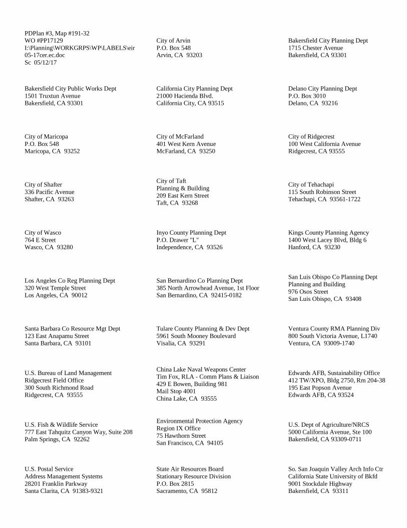
PDPlan #3, Map #191-32WO #PP17129I:\Planning\WORKGRPS\WP\LABELS\eir05-17cer.ec.docSc 05/12/17
City of ArvinP.O. Box 548Arvin, CA 93203
Bakersfield City Planning Dept1715 Chester AvenueBakersfield, CA 93301
Bakersfield City Public Works Dept1501 Truxtun AvenueBakersfield, CA 93301
California City Planning Dept21000 Hacienda Blvd.California City, CA 93515
Delano City Planning DeptP.O. Box 3010Delano, CA 93216
City of MaricopaP.O. Box 548Maricopa, CA 93252
City of McFarland401 West Kern AvenueMcFarland, CA 93250
City of Ridgecrest100 West California AvenueRidgecrest, CA 93555
City of Shafter336 Pacific AvenueShafter, CA 93263
City of TaftPlanning & Building209 East Kern StreetTaft, CA 93268
City of Tehachapi115 South Robinson StreetTehachapi, CA 93561-1722
City of Wasco764 E StreetWasco, CA 93280
Inyo County Planning DeptP.O. Drawer "L"Independence, CA 93526
Kings County Planning Agency1400 West Lacey Blvd, Bldg 6Hanford, CA 93230
Los Angeles Co Reg Planning Dept320 West Temple StreetLos Angeles, CA 90012
San Bernardino Co Planning Dept385 North Arrowhead Avenue, 1st FloorSan Bernardino, CA 92415-0182
San Luis Obispo Co Planning DeptPlanning and Building976 Osos StreetSan Luis Obispo, CA 93408
Santa Barbara Co Resource Mgt Dept123 East Anapamu StreetSanta Barbara, CA 93101
Tulare County Planning & Dev Dept5961 South Mooney BoulevardVisalia, CA 93291
Ventura County RMA Planning Div800 South Victoria Avenue, L1740Ventura, CA 93009-1740
U.S. Bureau of Land ManagementRidgecrest Field Office300 South Richmond RoadRidgecrest, CA 93555
China Lake Naval Weapons CenterTim Fox, RLA - Comm Plans & Liaison429 E Bowen, Building 981Mail Stop 4001China Lake, CA 93555
Edwards AFB, Sustainability Office412 TW/XPO, Bldg 2750, Rm 204-38195 East Popson AvenueEdwards AFB, CA 93524
U.S. Fish & Wildlife Service777 East Tahquitz Canyon Way, Suite 208Palm Springs, CA 92262
Environmental Protection AgencyRegion IX Office75 Hawthorn StreetSan Francisco, CA 94105
U.S. Dept of Agriculture/NRCS5000 California Avenue, Ste 100Bakersfield, CA 93309-0711
U.S. Postal ServiceAddress Management Systems28201 Franklin ParkwaySanta Clarita, CA 91383-9321
State Air Resources BoardStationary Resource DivisionP.O. Box 2815Sacramento, CA 95812
So. San Joaquin Valley Arch Info CtrCalifornia State University of Bkfd9001 Stockdale HighwayBakersfield, CA 93311
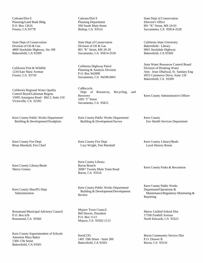
Caltrans/Dist 6Planning/Land Bank Bldg.P.O. Box 12616Fresno, CA 93778
Caltrans/Dist 9Planning Department500 South Main StreetBishop, CA 93514
State Dept of ConservationDirector's Office801 "K" Street, MS 24-01Sacramento, CA 95814-3528
State Dept of ConservationDivision of Oil & Gas4800 Stockdale Highway, Ste 108Bakersfield, CA 93309
State Dept of ConservationDivision of Oil & Gas801 "K" Street, MS 20-20Sacramento, CA 95814-3530
California State UniversityBakersfield - Library9001 Stockdale HighwayBakersfield, CA 93309
California Fish & Wildlife1234 East Shaw AvenueFresno, CA 93710
California Highway PatrolPlanning & Analysis DivisionP.O. Box 942898Sacramento, CA 94298-0001
State Water Resources Control BoardDivision of Drinking WaterAttn: Jesse Dhaliwal, Sr. Sanitary Eng4925 Commerce Drive, Suite 120Bakersfield, CA 93309
California Regional Water QualityControl Board/Lahontan Region15095 Amargosa Road - Bld 2, Suite 210Victorville, CA 92392
CalRecycleDept of Resources, Recycling, and
Recovery1001 "I" StreetSacramento, CA 95812
Kern County Administrative Officer
Kern County Public Works Department/ Building & Development/Floodplain
Kern County Public Works Department/ Building & Development/Survey
Kern County Env Health Services Department
Kern County Fire DeptBrian Marshall, Fire Chief
Kern County Fire Dept Cary Wright, Fire Marshall
Kern County Library/Beale Local History Room
Kern County Library/BealeSherry Gomez
Kern County LibraryBoron Branch26967 Twenty Mule Team RoadBoron, CA 93516
Kern County Parks & Recreation
Kern County Sheriff's Dept Administration
Kern County Public Works Department/ Building & Development/DevelopmentReview
Kern County Public WorksDepartment/Operations & Maintenance/Regulatory Monitoring &Reporting
Rosamond Municipal Advisory CouncilP.O. Box 626Rosamond, CA 93560
Mojave Town CouncilBill Deaver, PresidentP.O. Box 1113Mojave, CA 93502-1113
Muroc Unified School Dist17100 Foothill AvenueNorth Edwards, CA 93523
Kern County Superintendent of SchoolsAttention Mary Baker1300 17th StreetBakersfield, CA 93301
KernCOG1401 19th Street - Suite 300Bakersfield, CA 93301
Boron Community Service DistP.O. Drawer BBoron, CA 93516
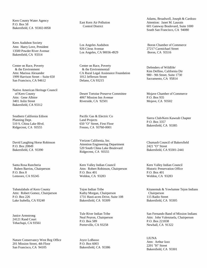
Kern County Water AgencyP.O. Box 58Bakersfield, CA 93302-0058
East Kern Air Pollution Control District
Adams, Broadwell, Joseph & CardozoAttention: Janet M. Laurain601 Gateway Boulevard, Suite 1000South San Francisco, CA 94080
Kern Audubon SocietyAttn: Harry Love, President13500 Powder River AvenueBakersfield, CA 93314
Los Angeles Audubon926 Citrus AvenueLos Angeles, CA 90036-4929
Boron Chamber of Commerce27217 Carmichael Street Boron, CA 93516
Center on Race, Poverty & the EnvironmentAttn: Marissa Alexander1999 Harrison Street – Suite 650San Francisco, CA 94612
Center on Race, Poverty & the Environmental/CA Rural Legal Assistance Foundation1012 Jefferson StreetDelano, CA 93215
Defenders of Wildlife/Kim Delfino, California Dir980 - 9th Street, Suite 1730Sacramento, CA 95814
Native American Heritage Council of Kern CountyAttn: Gene Albitre3401 Aslin StreetBakersfield, CA 93312
Desert Tortoise Preserve Committee4067 Mission Inn AvenueRiverside, CA 92501
Mojave Chamber of CommerceP.O. Box 935Mojave, CA 93502
Southern California EdisonPlanning Dept.510 S. China Lake Blvd.Ridgecrest, CA 93555
Pacific Gas & Electric CoLand Projects650 "O" Street, First FloorFresno, CA 93760-0001
Sierra Club/Kern Kaweah ChapterP.O. Box 3357Bakersfield, CA 93385
David Laughing Horse RobinsonP.O. Box 20849Bakersfield, CA 93390
Verizon California, Inc.Attention Engineering Department520 South China Lake BoulevardRidgecrest, CA 93555
Chumash Council of Bakersfield2421 "O" StreetBakersfield, CA 93301-2441
Santa Rosa Rancheria Ruben Barrios, ChairpersonP.O. Box 8Lemoore, CA 93245
Kern Valley Indian CouncilAttn: Robert Robinson, ChairpersonP.O. Box 401Weldon, CA 93283
Kern Valley Indian CouncilHistoric Preservation OfficeP.O. Box 401Weldon, CA 93283
Tubatulabals of Kern CountyAttn: Robert Gomez, ChairpersonP.O. Box 226Lake Isabella, CA 93240
Tejon Indian TribeKathy Morgan, Chairperson1731 Hasti-acres Drive, Suite 108Bakersfield, CA 93309
Kitanemuk & Yowlumne Tejon Indians Chairperson115 Radio StreetBakersfield, CA 93305
Janice Armstrong24121 Rand CourtTehachapi, CA 93561
Tule River Indian TribeNeal Peyron, ChairpersonP.O. Box 589Porterville, CA 93258
San Fernando Band of Mission IndiansAttn: John Valenzuela, ChairpersonP.O. Box 221838Newhall, CA 91322
Nature Conservancy West Reg Office201 Mission Street, 4th FloorSan Francisco, CA 94105
Joyce LoBassoP.O. Box 6003Bakersfield, CA 93386
LIUNAAttn: Arthur Izzo2201 "H" StreetBakersfield, CA 93301
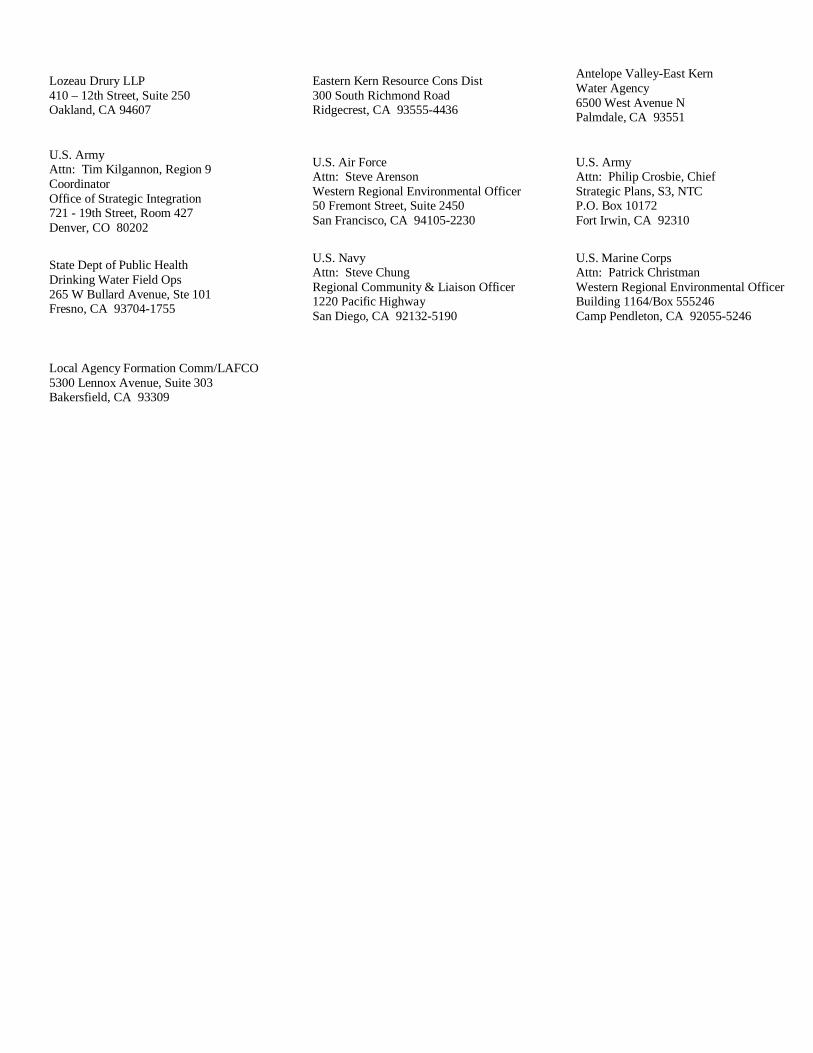
Lozeau Drury LLP410 – 12th Street, Suite 250Oakland, CA 94607
Eastern Kern Resource Cons Dist300 South Richmond RoadRidgecrest, CA 93555-4436
Antelope Valley-East KernWater Agency6500 West Avenue NPalmdale, CA 93551
U.S. ArmyAttn: Tim Kilgannon, Region 9CoordinatorOffice of Strategic Integration721 - 19th Street, Room 427Denver, CO 80202
U.S. Air ForceAttn: Steve ArensonWestern Regional Environmental Officer50 Fremont Street, Suite 2450San Francisco, CA 94105-2230
U.S. ArmyAttn: Philip Crosbie, ChiefStrategic Plans, S3, NTCP.O. Box 10172Fort Irwin, CA 92310
State Dept of Public HealthDrinking Water Field Ops265 W Bullard Avenue, Ste 101Fresno, CA 93704-1755
U.S. NavyAttn: Steve ChungRegional Community & Liaison Officer1220 Pacific HighwaySan Diego, CA 92132-5190
U.S. Marine CorpsAttn: Patrick ChristmanWestern Regional Environmental OfficerBuilding 1164/Box 555246Camp Pendleton, CA 92055-5246
Local Agency Formation Comm/LAFCO5300 Lennox Avenue, Suite 303Bakersfield, CA 93309

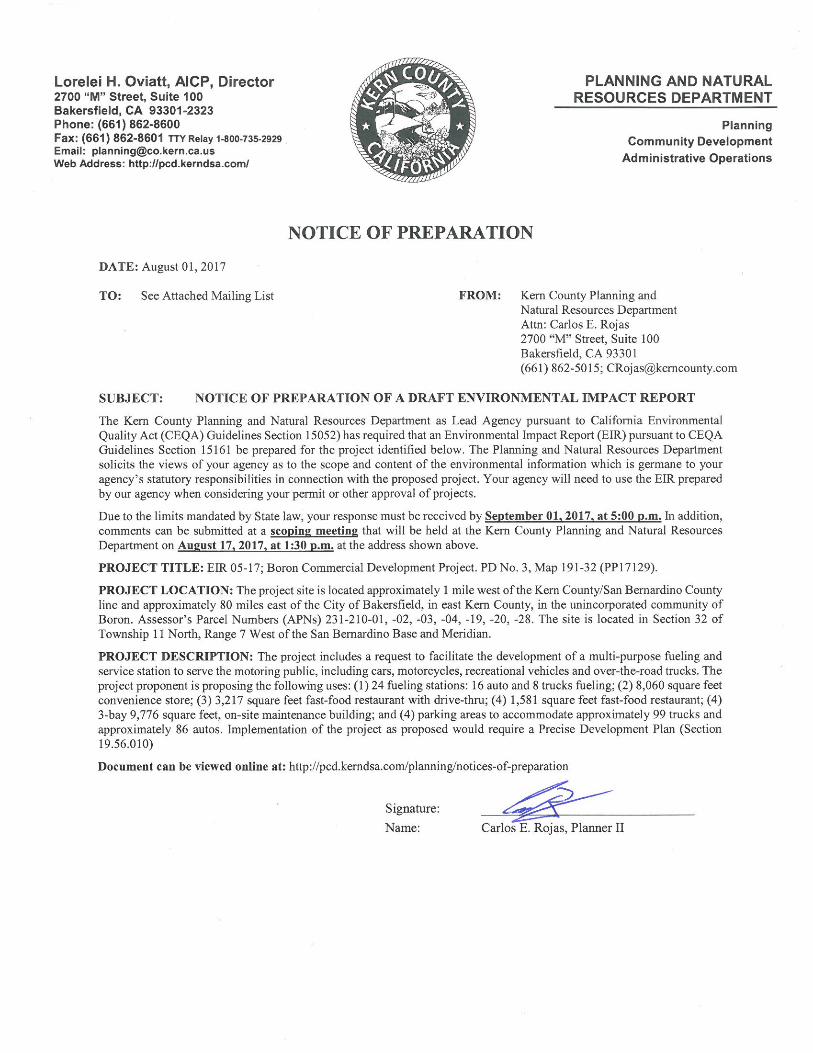
Notice of Completion & Environmental Document TransmittalMail to: State Clearinghouse, P. O. Box 3044, Sacramento, CA 95812-3044 (916) 445-0613For Hand Delivery/Street Address: 1400 Tenth Street, Sacramento, CA 95814
Project Title: EIR 5-17; Boron Commercial Development Project by Lane Engineers, Inc.Lead Agency: Kern County Planning Department Contact Person: Carlos E. RojasMailing Address: 2700 "M" Street Suite 100 Phone: (661) 862-5015City: Bakersfield Zip: 93301-2323 County: Kern
Project Location: County: Kern City/Nearest Community: BoronCross Streets: North of State Route 58, east of Boron Avenue and north of Boron Frontage Road Zip Code: 93516Lat. / Long.: 34° 59¢ 57² N / 117° 38’ 59² W Total Acres: 40
Assessor's Parcel No.: 231-210-01,-02,-03, 04,-19,-20,-28 Section: 32 Twp.: 11N Range: 7W Base: SBB&MWithin 2 Miles: State Hwy #: SR-58 Waterways: N/A
Airports: N/A Railways: Burlington Northern Santa Fe Schools: Boron Junior/Senior High
Document Type:CEQA: NOP Draft EIR NEPA: NOI Other: Joint Document
Early Cons Supplement/Subsequent EIR EA Final Document Neg Dec (Prior SCH No.) Draft EIS Other Mit Neg Dec Other FONSI
Local Action Type: General Plan Update Specific Plan Rezone Annexation General Plan Amendment Master Plan Prezone Redevelopment General Plan Element Planned Unit Development Use Permit Coastal Permit Community Plan Site Plan Land Division (Subdivision, etc.) Other: Precise Dev. Plan
Development Type: Residential: Units Acres Water Facilities: Type MGD Office: Sq.ft. Acres Employees Transportation: Type Commercial: Sq.ft. 22,634 Acres Employees Min. 64 Mining: Mineral Industrial: Sq.ft. Acres Employees Power: Type Solar MW Educational Waste Treatment: Type MGD Recreational Hazardous Waste: Type
Other:
Project Issues Discussed in Document: Aesthetic/Visual Fiscal Recreation/Parks Vegetation Agricultural Land Flood Plain/Flooding Schools/Universities Water Quality Air Quality Forest Land/Fire Hazard Septic Systems Water Supply/Groundwater Archeological/Historical Geologic/Seismic Sewer Capacity Wetland/Riparian Biological Resources Minerals Soil Erosion/Compaction/Grading Wildlife Coastal Zone Noise Solid Waste Growth Inducing Drainage/Absorption Population/Housing Balance Toxic/Hazardous Land Use Economic/Jobs Public Services/Facilities Traffic/Circulation Cumulative Effects Other
Present Land Use/Zoning/General Plan Designation:Undeveloped Land. Zoning: CH PD FPS (Exclusive Agriculture-Precise Development Combining-Floodplain Combining); CH PD; M-1 PD (Light Industrial); Kern County General Plan: 6.3/2.5 (Highway Commercial/Flood Hazard); 7.1 (Light Industrial)Project Description: (please use a separate page if necessary) The project includes a request to facilitate the development of a multi-purposefueling and service station to serve the motoring public, including cars, motorcycles, recreational vehicles and over-the-road trucks. Theproject proponent is proposing the following uses: (1) 24 fueling stations: 16 auto and 8 trucks fueling; (2) 8,060 square feet conveniencestore; (3) 3,217 square feet fast-food restaurant with drive-thru; (4) 1,581 square feet fast-food restaurant; (4) 3-bay 9,776 square feet,on-site maintenance building; and (4) parking areas to accommodate approximately 99 trucks and approximately 86 autos.Implementation of the project as proposed would require a Precise Development Plan (Section 19.56.010)
SCH #
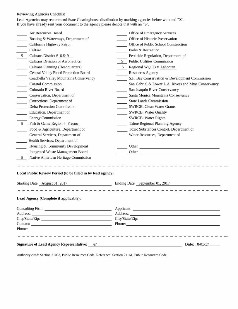
Reviewing Agencies ChecklistLead Agencies may recommend State Clearinghouse distribution by marking agencies below with and "X".If you have already sent your document to the agency please denote that with an "S".
Air Resources Board Office of Emergency Services Boating & Waterways, Department of Office of Historic Preservation California Highway Patrol Office of Public School Construction CalFire Parks & Recreation S Caltrans District # 6 & 9 Pesticide Regulation, Department of Caltrans Division of Aeronautics S Public Utilities Commission Caltrans Planning (Headquarters) S Regional WQCB # Lahontan Central Valley Flood Protection Board Resources Agency Coachella Valley Mountains Conservancy S.F. Bay Conservation & Development Commission Coastal Commission San Gabriel & Lower L.A. Rivers and Mtns Conservancy Colorado River Board San Joaquin River Conservancy Conservation, Department of Santa Monica Mountains Conservancy Corrections, Department of State Lands Commission Delta Protection Commission SWRCB: Clean Water Grants Education, Department of SWRCB: Water Quality
Energy Commission SWRCB: Water Rights S Fish & Game Region # Fresno Tahoe Regional Planning Agency
Food & Agriculture, Department of Toxic Substances Control, Department of General Services, Department of Water Resources, Department of Health Services, Department of Housing & Community Development Other Integrated Waste Management Board Other S Native American Heritage Commission
Local Public Review Period (to be filled in by lead agency)
Starting Date August 01, 2017 Ending Date September 01, 2017
Lead Agency (Complete if applicable):
Consulting Firm: Applicant:Address: Address:City/State/Zip: City/State/Zip:Contact: Phone:Phone:
Signature of Lead Agency Representative: /s/ Date: 8/01/17
Authority cited: Section 21083, Public Resources Code. Reference: Section 21161, Public Resources Code.

INITIAL STUDY/NOTICE OF PREPARATION
Boron Commercial Development Projectby Lane Engineers, Inc.
Precise Development Plan No. 3, Map 191-32
(PP17129)
LEAD AGENCY:
Kern County Planning and Natural Resources Department2700 M Street, Suite 100
Bakersfield, CA 93301-2370
Contact: Mr. Carlos E. Rojas(661) 862-5015
August 2017
KERN COUNTY PLANNING & NATURAL RESOURCES DEPARTMENTBoron Commercial Development Project
August 2017 i Initial Study/Notice of Preparation
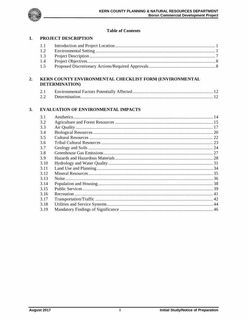
Table of Contents
1. PROJECT DESCRIPTION1.1 Introduction and Project Location ...................................................................................... 11.2 Environmental Setting ....................................................................................................... 11.3 Project Description ............................................................................................................ 71.4 Project Objectives.............................................................................................................. 81.5 Proposed Discretionary Actions/Required Approvals ......................................................... 8
2. KERN COUNTY ENVIRONMENTAL CHECKLIST FORM (ENVIRONMENTALDETERMINATION)2.1 Environmental Factors Potentially Affected ..................................................................... 122.2 Determination.................................................................................................................. 12
3. EVALUATION OF ENVIRONMENTAL IMPACTS
3.1 Aesthetics ........................................................................................................................ 143.2 Agriculture and Forest Resources .................................................................................... 153.3 Air Quality ...................................................................................................................... 173.4 Biological Resources ....................................................................................................... 203.5 Cultural Resources .......................................................................................................... 223.6 Tribal Cultural Resources ................................................................................................ 233.7 Geology and Soils ........................................................................................................... 243.8 Greenhouse Gas Emissions .............................................................................................. 273.9 Hazards and Hazardous Materials .................................................................................... 283.10 Hydrology and Water Quality .......................................................................................... 313.11 Land Use and Planning .................................................................................................... 343.12 Mineral Resources ........................................................................................................... 353.13 Noise ............................................................................................................................... 363.14 Population and Housing ................................................................................................... 383.15 Public Services ................................................................................................................ 393.16 Recreation ....................................................................................................................... 413.17 Transportation/Traffic ..................................................................................................... 423.18 Utilities and Service Systems ........................................................................................... 443.19 Mandatory Findings of Significance ................................................................................ 46
KERN COUNTY PLANNING & NATURAL RESOURCES DEPARTMENTBoron Commercial Development
August 2017 1 Initial Study/Notice of Preparation
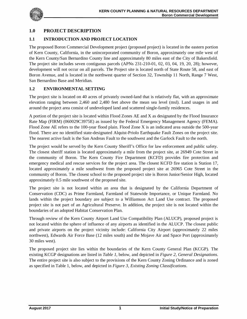
1.0 PROJECT DESCRIPTION
1.1 INTRODUCTION AND PROJECT LOCATION
The proposed Boron Commercial Development project (proposed project) is located in the eastern portionof Kern County, California, in the unincorporated community of Boron, approximately one mile west ofthe Kern County/San Bernardino County line and approximately 80 miles east of the City of Bakersfield.The project site includes seven contiguous parcels (APNs 231-210-01, 02, 03, 04, 19, 20, 28); however,development will not occur on all parcels. The Project site is located north of State Route 58, and east ofBoron Avenue, and is located in the northwest quarter of Section 32, Township 11 North, Range 7 West,San Bernardino Base and Meridian.
1.2 ENVIRONMENTAL SETTING
The project site is located on 40 acres of privately owned-land that is relatively flat, with an approximateelevation ranging between 2,460 and 2,480 feet above the mean sea level (msl). Land usages in andaround the project area consist of undeveloped land and scattered single-family residences.
A portion of the project site is located within Flood Zones AE and X as designated by the Flood InsuranceRate Map (FIRM) (060029C3975E) as issued by the Federal Emergency Management Agency (FEMA).Flood Zone AE refers to the 100-year flood plain. Flood Zone X is an indicated area outside the 500-yearflood. There are no identified state-designated Alquist-Priolo Earthquake Fault Zones on the project site.The nearest active fault is the San Andreas Fault to the southwest and the Garlock Fault to the north.
The project would be served by the Kern County Sheriff’s Office for law enforcement and public safety.The closest sheriff station is located approximately a mile from the project site, at 26949 Cote Street inthe community of Boron. The Kern County Fire Department (KCFD) provides fire protection andemergency medical and rescue services for the project area. The closest KCFD fire station is Station 17,located approximately a mile southwest from the proposed project site at 26965 Cote Street in thecommunity of Boron. The closest school to the proposed project site is Boron Junior/Senior High, locatedapproximately 0.5 mile southwest of the proposed site.
The project site is not located within an area that is designated by the California Department ofConservation (CDC) as Prime Farmland, Farmland of Statewide Importance, or Unique Farmland. Nolands within the project boundary are subject to a Williamson Act Land Use contract. The proposedproject site is not part of an Agricultural Preserve. In addition, the project site is not located within theboundaries of an adopted Habitat Conservation Plan.
Through review of the Kern County Airport Land Use Compatibility Plan (ALUCP), proposed project isnot located within the sphere of influence of any airports as identified in the ALUCP. The closest publicand private airports on the project vicinity include: California City Airport (approximately 22 milesnorthwest), Edwards Air Force Base (12 miles south) and the Mojave Air and Space Port (approximately30 miles west).
The proposed project site lies within the boundaries of the Kern County General Plan (KCGP). Theexisting KCGP designations are listed in Table 1, below, and depicted in Figure 2, General Designations.The entire project site is also subject to the provisions of the Kern County Zoning Ordinance and is zonedas specified in Table 1, below, and depicted in Figure 3, Existing Zoning Classifications.
KERN COUNTY PLANNING & NATURAL RESOURCES DEPARTMENTBoron Commercial Development
August 2017 2 Initial Study/Notice of Preparation
Table 1: Project Site and Surrounding Land Uses
Direction fromProject Site
Existing LandUse
Existing General Plan Designations Existing Zoning Classifications
Project Site Undeveloped 6.3/2.5 (Highway Commercial/FloodHazard); 7.1 (Light Industrial)
FPP (Floodplain Primary); CH-PD-FPS (Highway Commercial-FloodplainCombining- Precise DevelopmentCombining); CH-PD; M1-PD (LightIndustrial)
North Undeveloped7.1 (Light Industrial);8.3 Extensive Agriculture
E (1): Estate – 1 AcreA-1: Exclusive Agriculture
East Undeveloped 5.5 Residential (max. 1 unit per netacre)
E (1): Estate – 1 Acre
South SR-58,Undeveloped, andspare residentialDevelopment
4.1: Accepted County Plan Areas E (1): Estate – 1 Acre
West Sparse ResidentialDevelopment
5.4/2.5: Residential (max. 4 units peracre)/Flood Hazard
C-2: General CommercialR-1: Low Density Residential
BORO
N AV
TWENTY MULE TEAM RD
PD 3, Map 191-32Aerial Map
Lane Engineers, IncSec. 32 - T11N/R7W
Kern CountyPlanning & NaturalResources Department
07/29/2017 F0 350 700 1,050 Feet
SITE
Project BoundarySTATE HWYArterials
San BernardinoCounty
CITY OFCALIFORNIA
CITY
CITY OFTEHACHAPI
CITYOF RIDGECREST
COUNTY OF KERN
·|}þ58
·|}þ58
·|}þ202
·|}þ178·|}þ178 ·|}þ178
·|}þ58·|}þ58
·|}þ14 ·|}þ58 ·|}þ58
·|}þ14
£¤395
LOS ANGELES COUNTY
SAN
BERN
ARDI
NO C
OUNT
Y
PD No. 3,Map No. 191-32
Figure 1 -Vicinity Map
Boron Commercialby Lane Engineers, Inc.
SITE
Sec. 32 - T11N/R7W 07/19/17F
0 15,000 30,000 45,000 60,000 Feet
Kern CountyPlanning & NaturalResources Department
Project BoundaryNAMED HWYSTATE HWYUS HWYKern County BoundaryBordering CountiesCity Limits
APN: 231-210-01,-02,-03,-04,-19,-20,-28 Kern County
^
5.4/2.5
5.5
5.6
6.3/2.5 7.1
8.3/2.5
8.3
5.4
8.51.1
6.3
5.5
6.3
5.4/2.55.5/2.5
6.3/2.5
5.4
5.6
6.3
2930
32
31
4.1 Boron SP
Case No. 3,Map No. 191-32
Figure 2 - ExistingGeneral PlanDesignations
Boron Commercial by Lane Engineers, Inc.
Sec. 32 - T11N/R7W 07/19/2017 F0 190 380 570 760 Feet
Kern CountyPlanning & NaturalResources Department
Project SiteKern County BoundaryTownship/RangeSections
Specific Plans4.1 - Accepted County Plan Area
GENERAL PLAN BOUNDARIES4.1 - ACCEPTED COUNTY PLAN5.4 - MAXIMUM 4 UNITS/NET ACRE(10,890 SQ. FT. SITE AREA/UNIT)5.5 - MAXIMUM 1 UNIT/NET ACRE(43,560 SQ. FT. SITE AREA/UNIT)5.6 - MINIMUM 2.5 GROSS6.3 - HIGHWAY COMMERCIAL7.1 - LIGHT INDUSTRIAL8.3 - EXTENSIVE AGRICULTURE (MIN.20- OR 80-ACRE PARCEL SIZE)
SPECIFIC PLAN DESIGNATIONS1.1 - STATE AND FEDERAL5.4 - MAXIMUM 4 UNITS/NET ACRE(10,890 SQ. FT. SITE AREA/UNIT)5.5 - MAXIMUM 1 UNIT/NET ACRE(43,560 SQ. FT. SITE AREA/UNIT)5.6 - MINIMUM 2.5 GROSS6.3 - 6.3 HIGHWAY COMMERCIAL8.5 - RESOURCE MANAGEMENT (MIN.20- OR 80-ACRE PARCEL SIZE)
HAZARD DESIGNATIONS2.5 - Flood Hazard
APN: 231-210-01,-02,-03,-04,-19,-20,-28Kern County
^
2930
32
31
A-1
A-1
A-1
C-1
C-2 PD
C-2PD
CH PDCH PD
FPS
COE(1)
E(1)
E(1)
E(1)
E(1)
RS M
H
E(1) RSMH FPS
E(2 1/2)RS MH
FPP
M-1 PD
R-3
R-1
R-1
R-1
Case No. 3,Map No. 191-32
Figure 3 -Existing ZoneClassificationsBoron Commercial
by Lane Engineers, Inc.
Sec.32 - T11N/R7W07/19/17 F
0 250 500 750 1,000 Feet
Kern CountyPlanning & NaturalResources Department
Project BoundaryKern County BoundaryTownship/RangeSections
KERN COUNTY ZONINGDESIGNATIONS
A-1 - Limited AgricultureC-1 - Neighborhood CommercialC-2 - General CommercialCH - Highway CommercialCO - Commercial OfficeE(1) - Estate (1 acre)E(2 1/2) - Estate (2.5 acres)FPP - Floodplain PrimaryM-1 - Light IndustrialR-1 - Low Density ResidentialR-3 - High Density ResidentialPD - Precise Development CombiningRS - Residential Suburban CombiningFPS - Floodplain Secondary CombiningMH - Mobilehome CombiningFPS - Floodplain Secondary Combining
APN: 231-210-01,-02,-03,-04,-19,-20,-28
Kern County
^
KERN COUNTY PLANNING & NATURAL RESOURCES DEPARTMENTBoron Commercial Development
August 2017 7 Initial Study/Notice of Preparation
1.3 PROJECT DESCRIPTIONThe proposed project would develop a multi-purpose fueling and service station to serve the motoringpublic, including cars, motorcycles, recreational vehicles and over-the-road trucks, and would consist ofmultiple-uses, including:
· 24 fueling stations: 16 auto and 8 truck fueling,· 8,060 square feet convenience store,· 3,217 square feet fast-food restaurant with drive-thru,· 1,581 square feet fast-food restaurant,· 3-bay 9,776 square feet, on-site maintenance building, and· Parking areas to accommodate approximately 99 trucks and approximately 86 autos.
The proposed project includes a 3-bay 9,776 square feet, to provide minor services to over-the-road trucksonly. Minor over-the-road truck services proposed includes: new and used tire sales, replacement orinstallation, oil changes and lubrications, minor engine maintenance and repair.
The primary activities anticipated on site would be for travelers (automobile and truck) stopping to fuel,rest, and/or eat. The proposed project will be open and operational 24 hours, 7 days a week. The vastmajority of trucks expected to visit the site are “over-the-road” (OTR) trucks, which refers to drivers whotransport materials over long distances, as opposed to local routes. Over-the-road drivers haul all types offreight, including heavy freight, and are on the road for consecutive days, weeks, or months at a time anddrive-by motorists.
Diesel fuel on site would be stored in aboveground tanks. Gasoline and Diesel Exhaust Fluid (DEF) willbe stored in undergrounds storage tanks. The site will be serviced by a private waste hauler, andhazardous materials from the site will be properly disposed of by qualified contractor.
It is anticipated there would be approximately 1-3 small deliveries per day for the convenience store, andapproximately 2 deliveries per week for the fast food restaurants. The proposed minimum number ofemployees to serve the entire site is 37 employees per day. The proposed project will be continuouslyopen 24 hours, 7 days a week, and there is a projected approximate average of 600 truck visits, and 1,200auto visits per day.
Site AccessThe proposed project would have direct access via three separate driveways on Boron Frontage RoadNorth. Boron Frontage Road North runs parallel to and north of State Route 58, and dead ends just east ofthe proposed development and connects to Boron Avenue to the west. Vehicles will access the site fromState Route 58 via off-ramps at the Boron Avenue interchange, and will access Boron Frontage RoadNorth from Boron Avenue.
Water SupplyThe estimated domestic water demand and wastewater demand for the project is approximately 10,000gallons per day. The proposed project potable water would be supplied by Boron Community ServicesDistrict, as the proposed site is located within the water service boundary area. It is anticipated a watermain will be extended east along Boron Frontage Road North from intersection of Boron Avenue andBoron Frontage Road North to serve the proposed site.
Storm Water CollectionAdditional storm water runoff generated as a result of the development of the proposed project would becollected on site and drained to a private storm water conveyance system that will discharge into a
KERN COUNTY PLANNING & NATURAL RESOURCES DEPARTMENTBoron Commercial Development
August 2017 8 Initial Study/Notice of Preparation
proposed retention basin at the west end of the proposed project site. The proposed retention basin will bedesignated in accordance to the Kern County Development Standards.
Dry UtilitiesDry utilities include gas, electricity, phone, and cable services. Gas services would be provided by naturalgas pipelines and distribution facilities. New electricity, phone and cable service transmission lines for theproject generally would be placed, within, alongside, or beneath existing road, or the proposed roadnetwork for the site.
1.4 PROJECT OBJECTIVES
The project proponent has identified the following objectives for the proposed project:
· To develop the proposed property to accommodate all of the following:
o A main building to accommodate a convenience store, one fast food restaurant with nodrive-thru, and one fast food restaurant with a drive-thru, restrooms, and showers.
o An on-site maintenance building to provide minor services primarily for traveling over-the-road trucks.
o A truck and auto fuel dispensing areas of sufficient size to accommodate approximately1,200 autos per day, and approximately 600 trucks per day.
o Parking areas of sufficient size to accommodate approximately 99 trucks andapproximately 86 autos.
· To provide facilities for users that maximize the benefits of the proposed site’s proximity to StateRoute 58, thereby minimizing the following:
o Air pollution and greenhouse gas generation, ando Traffic generation on local streets and total vehicle miles traveled.
· To construct a facility with access to adequate existing or anticipated utility infrastructure tosupport proposed development operations.
· To maximize tax revenue to the County.· To provide jobs to support the current and future population of the unincorporated community of
Boron.
1.5 PROPOSED DISCRETIONARY ACTIONS/REQUIRED APPROVALS
Construction and operation of the project may require certain discretionary actions and approvalsincluding, but not limited to, the following:
Federal· United States Fish and Wildlife Service
State
· California Department of Fish and Wildlife (CDFW)o Section 1600 et seq. permits (Streambed Alteration Agreements)o Section 2081 Permit (State-listed endangered species)
· Lahontan Regional Water Quality Control Board (Lahontan RWQCB) and Central ValleyRegional Water Quality Control Board (Central Valley RWQCB)o National Pollutant Discharge Elimination System (NPDES) Construction General Permito General Construction Stormwater Permit (Preparation of a SWPPP)o Regional Water Quality Certification (401 Permit)
KERN COUNTY PLANNING & NATURAL RESOURCES DEPARTMENTBoron Commercial Development
August 2017 9 Initial Study/Notice of Preparation
· California Department of Transportationo Right-of-Way Encroachment Permito Oversized Loads Permit
Other additional permits or approvals from responsible agencies may be required for the project.
Local
· Kern County Board of Supervisorso Precise Development Plano Certification of Environmental Impact Reporto Adoption of Mitigation Monitoring Programo Adoption of 15091 and 15093 Findings of Overriding Consideration
· Kern County Public Works-Building and Development-Flood Plain & Survey§ Plan for the Disposal of Drainage Waters§ Grading and Building Plans
· Kern County Public Works- Development Review§ Proposed Access Road Design and Encroachment Permit
· Kern County Environmental Health Services Divisiono Food Safety Programo Hazardous Materials Business Plano Septic and Water System Permits
· Kern County Fire Departmento Fire Safety Plano Hazardous Materials Management Plan
· Eastern Kern County Air Pollution Control Districto Fugitive Dust Control Plano Authority to Constructo Permit to Operate

APN 231-210-04
APN 231-210-03
APN 231-210-02
APN 231-210-01
APN 231-210-19
APN 231-210-20
200 200 400100
1 INCH = 200 FT.
0
12
~. ----------------------K-E_R_N_c_o_u_N_TY __ P_L_A_N_N_I_N_G_&_N_A_T_U_R_A_L __ R_Es_o __ u_RC_E_S __ D_E_P_A_R_T_M_E __ NT - Boron Commercial Development
2.0 KERN COUNTY ENVIRONMENTAL CHECKLIST FORM
2.1 ENVIRONMENTAL FACTORS POTENTIALLY AFFECTED: The environmental factors checked below would be potentially affected by this project, involving at least one impact that is a "potentially significant impact" as indicated by the Kern County Environmental Checklist on the following pages. !ZI Aesthetics
IZI Biological Resources
IZI Geology and Soils
IZI Hydrology and Water Quality
IZI Noise
D Recreation
IZI Utilities and Service Systems
D Agriculture and Forestry Resources
IZI Cultural Resources
IZI Greenhouse Gas Emissions
IZI Land Use and Planning
IZI Population and Housing
IZI Transportation and Traffic
IZI Mandatory Findings of Significance
IZI Air Quality
IZI Tribal Cultural Resources
IZI Hazards and Hazardous Materials
D Mineral Resources
IZI Public Services
IZI Utilities and Service Systems
2.2 DETERMINATION (TO BE COMPLETED BY THE LEAD AGENCY) On the basis of this initial evaluation:
D I find that the proposed project COULD NOT have a significant effect on the environment, and a NEGATIVE DECLARATION will be prepared.
D I find that although the proposed project could have a significant effect on the environment, there will not be a significant effect in this case because revisions in the project have been made by or agreed to by the project proponent. A MITIGATED NEGATIVE DECLARATION will be prepared.
1Zl I find that the proposed project MAY have a significant effect on the environment, and an ENVIRONMENTAL IMPACT REPORT is required.
D I find that the proposed project MAY have a "potentially significant impact" or "potentially significant unless mitigated" impact on the environment, but at least one effect (a) has been adequately analyzed in an earlier document pursuant to applicable legal standards, and (b) has been addressed by mitigation measures based on the earlier analysis as described on attached sheets. An ENVIRONMENT IMPACT REPORT is required, but it must analyze only the effects that remain to be addressed.
D I find that although the proposed project could have a significant effect on the environment, because all potentially significant effects (a) have been analyzed adequately in an earlier EIR or NEGATIVE DECLARATION pursuant to applicable standards, and (b) have been avoided or mitigated pursuant to that earlier EIR or NEGATIVE DECLARATION, including revisions or mitigation measures that are imposed upon the proposed project, nothing further is required.
Sig~ Carlos E. Rojas, Planner II
Printed Name
August 2017
8/01/2017 Date Kern County Planning and Natural Resources Department
For
11 Initial Study/Notice of Preparation 12
KERN COUNTY PLANNING & NATURAL RESOURCES DEPARTMENTBoron Commercial Development
August 2017 13 Initial Study/Notice of Preparation
3.0 EVALUATION OF ENVIRONMENTAL IMPACTS(1) A brief explanation is required for all answers except “No Impact” answers that are adequately supported
by the information sources a lead agency cites in the parentheses following each question. A “No Impact”answer is adequately supported if the referenced information sources show that the impact simply does notapply to projects like the one involved (e.g., the project falls outside a fault rupture zone). A “No Impact”answer should be explained where it is based on project-specific factors as well as general standards (e.g.,the project will not expose sensitive receptors to pollutants, based on a project-specific screening analysis).
(2) All answers must take account of the whole action involved, including offsite as well as onsite, cumulativeas well as project-level, indirect as well as direct, and construction as well as operational impacts.
(3) Once the lead agency has determined that a particular physical impact may occur, then the checklistanswers must indicate whether the impact is potentially significant, less than significant with mitigation, orless than significant. “Potentially Significant Impact” is appropriate if there is substantial evidence that aneffect may be significant. If there are one or more “Potentially Significant Impact” entries when thedetermination is made, an EIR is required.
(4) “Negative Declaration: Less Than Significant With Mitigation Incorporated” applies where the incorpora-tion of mitigation measures has reduced an effect from “Potentially Significant Impact” to a “Less ThanSignificant Impact.” The lead agency must describe the mitigation measure and briefly explain how theyreduce the effect to a less than significant level (mitigation measures from “Earlier Analyses,” as describedin (5) below, may be cross-referenced).
(5) Earlier analyses may be used where, pursuant to the tiering, program EIR, or other CEQA process, an effecthas been adequately analyzed in an earlier EIR or Negative Declaration, Section 15063(c)(3)(D). In thiscase, a brief discussion should identify the following:(a) Earlier Analysis Used. Identify and state where they are available for review.(b) Impacts Adequately Addressed. Identify which effects from the above checklist where within the
scope of and adequately analyzed in an earlier document pursuant to applicable legal standards, andstate whether such effects were addressed by mitigation measures based on the earlier analysis.
(c) Mitigation Measures. For effects that are “Less Than Significant With Mitigation MeasuresIncorporated,” describe the mitigation measures which were incorporated or refined from the earlierdocument and the extent to which they address site-specific conditions for the project.
(6) Lead agencies are encouraged to incorporate into the checklist references to information sources forpotential impacts (e.g., general plans, zoning ordinances). Reference to a previously prepared or outsidedocument should, where appropriate, include a reference to the page or pages where the statement issubstantiated.
(7) Supporting Information Sources: A source list should be attached, and other sources used or individualscontacted should be cited in the discussion.
(8) This is only a suggested form, and lead agencies are free to use different formats; however, lead agenciesshould normally address the questions from this checklist that are relevant to a project's environmentaleffects in whatever format is selected.
(9) The explanation of each issue should identify:(a) The significance criteria or threshold, if any, used to evaluate each question; and(b) The mitigation measure identified, if any, to reduce the impact to a less-than-significant level.
(10) Have California Native American tribes traditionally and culturally affiliated with the project arearequested consultation pursuant to Public Resources Code section 21080.3.1. If so, has consultationbegun?Note: Conducting consultation early in the CEQA process allows tribal governments, lead agencies, andproject proponents to discuss the level of environmental review, identify and address potential adverseimpacts to tribal cultural resources, and reduce the potential for delay and conflict in the environmentalreview process. (See Public Resources Code section 21083.3.2.) Information may also be available fromthe California Native American Heritage Commission’s Sacred Lands File per Public Resources Codesection 5097.96 and the California Historical Resources Information System administered by the CaliforniaOffice of Historic Preservation. Please also note that Public Resources Code section 21082.3(c) containsprovisions specific to confidentiality.
KERN COUNTY PLANNING & NATURAL RESOURCES DEPARTMENTBoron Commercial Development
August 2017 14 Initial Study/Notice of Preparation
Aesthetics Discussion:
(a) With the construction of the proposed project, there is a potential for an adverse visual effect on theviewsheds of these lands and therefore this impact will be further evaluated in the EIR.
(b) The California Department of Transportation (Caltrans) states that a highway may be designatedscenic depending upon how much of the natural landscape can be seen by travelers, the scenicquality of the landscape, and the extent to which development intrudes upon the traveler’s enjoymentof the view. The construction and operation of the proposed project would alter the views of theproject area. Persons traveling in vehicles on nearby roads and SR-58 would observe alterations toexisting vistas. The alteration of vistas from SR-58 and other perspectives will be further evaluatedin the EIR.
(c) The majority of the project site is currently undeveloped land. Due to the development of theproposed project, the undeveloped character of the area may be adversely affected by the proposedproject, and therefore the project’s potential to substantially degrade its existing visual character orquality of the site and its surroundings will be further evaluated in the EIR.
(d) Both during and after construction, the proposed project has the potential to create a new sources oflight or glare that would adversely affect day or nighttime view. The implementation of fuelingstations, fast food restaurants and parking areas will create a substantial new light source; therefore,this potential impact will be further evaluated in the EIR.
PotentiallySignificant
Impact
PotentiallySignificant
ImpactUnless
Mitigated
Less ThanSignificant
ImpactNo
ImpactAESTHETICS. Would the project:
a. Have a substantial adverse effect on a scenicvista?
b. Substantially damage scenic resources,including, but not limited to, trees, rockoutcroppings, and historic buildings within astate scenic highway?
c. Substantially degrade the existing visualcharacter or quality of the site and itssurroundings?
d. Create a new source of substantial light or glarewhich would adversely affect day or nighttimeviews in the area?
KERN COUNTY PLANNING & NATURAL RESOURCES DEPARTMENTBoron Commercial Development
August 2017 15 Initial Study/Notice of Preparation
PotentiallySignificant
Impact
PotentiallySignificant
ImpactUnless
Mitigated
Less ThanSignificant
ImpactNo
Impact
AGRICULTURE AND FOREST RESOURCES. In determining whether impacts to agricultural resources aresignificant environmental effects, lead agencies may refer to the California Agricultural Land Evaluationand Site Assessment Model (1997) prepared by the California Department of Conservation as an optionalmodel to use in assessing impacts on agriculture and farmland. In determining whether impacts to forestresources, including timberland, are significant environmental effects, lead agencies may refer toinformation compiled by the California Department of Forestry and Fire Protection regarding the state’sinventory of forest land, including the Forest and Range Assessment Project and the Forest LegacyAssessment project; and forest carbon measurement methodology provided in Forest Protocols adopted bythe California Air Resources Board. Would the project:
a. Convert Prime Farmland, Unique Farmland, orFarmland of Statewide Importance (Farmland),as shown on the maps prepared pursuant to theFarmland Mapping and Monitoring Program ofthe California Resources Agency, tononagricultural use?
b. Conflict with existing zoning for agriculturaluse, or Williamson Act contract?
c. Conflict with existing zoning for, or causerezoning of, forest land (as defined in PublicResources Code section 12220(g)), timberland(as defined by Public Resources Code Section4526), or timberland zoned TimberlandProductions (as defined in Government Codesection 51104(g))?
d. Result in the loss of forest land or conversionof forest land to non-forest use?
e. Involve other changes in the existingenvironment which, due to their location ornature, could result in conversion of Farmlandto non-agricultural use or conversion of forestland to non-forest use?
f. Result in the cancellation of an open spacecontract made pursuant to the California LandConservation Act of 1965 or Farmland SecurityZone Contract for any parcel of 100 or moreacres (Section 15206(b)(3) Public ResourcesCode?
KERN COUNTY PLANNING & NATURAL RESOURCES DEPARTMENTBoron Commercial Development
August 2017 16 Initial Study/Notice of Preparation
Agriculture and Forest Resources Discussion:
(a) Prime Farmland, Unique Farmland, or Farmland of Statewide Importance are not identified withinthe project area, and land within the project boundaries is not subject to a William Act Contract.The California Department of Conservation (CDC) designates the project site as urban and built-upland, non-agricultural and natural vegetation. Therefore, construction and/or operation of the projectwould not result in the conversion of designated Farmland to a nonagricultural use. Therefore,further analysis is not warranted.
(b) The proposed project site is currently zoned Light Industrial (M-1) and Highway Commercial (CH),with a Precise Development Combining District (PD), Floodplain Secondary Combining (FPS) andFloodplain primary (FPP). No portion of the proposed project are zoned Exclusive Agriculture (A) orLimited Agriculture (A-1). The proposed project would not conflict with existing zoning foragriculture and impact would not occur. Therefore, further analysis is not warranted.
(c)(d) No land within or immediately adjacent to the project are zoned forest land or timberland or containany forested areas. Due to a lack of forest land on the site, the project does not involve any changesto the existing environment that, due to their location or nature, could result in impacts resulting inthe loss of forest land or conversion of forest land to non-forest use. Therefore, further analysis is notwarranted.
(e) The project site consists primarily of undeveloped desert land, with some residential uses in theproject vicinity. The proposed project site is comprised of non-agricultural uses, and not agriculturaluses are adjacent to the project site. Therefore, further analysis is not warranted.
(f) As noted in response above, the project site is not under a Williamson Act Contract andimplementation of the project would not result in the cancellation of an open space contract madepursuant to the California Land Conservation Act of 1965 or Farm Security Zone Contract for anyparcel of 100 or more acres (Public Resources Code Section 15206(b)(3)). Therefore, furtheranalysis is not warranted.
KERN COUNTY PLANNING & NATURAL RESOURCES DEPARTMENTBoron Commercial Development
August 2017 17 Initial Study/Notice of Preparation
PotentiallySignificant
Impact
PotentiallySignificant
ImpactUnless
Mitigated
Less ThanSignificant
ImpactNo
Impact
AIR QUALITY. Where available, the significance criteria established by the applicable air qualitymanagement or air pollution control district may be relied upon to make the following determinations.Would the project:
a. Conflict with or obstruct implementation of theapplicable air quality plan?
b. Violate any air quality standard as adopted in(c)I or (c)ii, or as established by EPA or airdistrict or contribute substantially to an existingor projected air quality violation?
c. Result in a cumulatively considerable netincrease of any criteria pollutant for which theproject region is nonattainment under anapplicable federal or state ambient air qualitystandard (including releasing emissions whichexceed quantitative thresholds for ozoneprecursors)? Specifically, wouldimplementation of the project exceed any of thefollowing adopted thresholds:
i. San Joaquin Valley Unified AirPollution Control District:
Operational and Area Sources:Reactive Organic Gases (ROG)10 tons per year.Oxides of Nitrogen (NOx)10 tons per year.Particulate Matter (PM10)15 tons per year.
Stationary Sources as Determinedby District Rules:
Severe Nonattainment25 tons per year.Extreme Nonattainment10 tons per year.
KERN COUNTY PLANNING & NATURAL RESOURCES DEPARTMENTBoron Commercial Development
August 2017 18 Initial Study/Notice of Preparation
PotentiallySignificant
Impact
PotentiallySignificant
ImpactUnless
Mitigated
Less ThanSignificant
ImpactNo
Impact
ii. Eastern Kern Air Pollution ControlDistrict:
Operational and Area Sources:Reactive Organic Gases (ROG)25 tons per year.Oxides of nitrogen (NOx)25 tons per year.Particulate Matter (PM10)15 tons per year.
Stationary Sources as Determinedby District Rules:
25 tons per year.
d. Expose sensitive receptors to substantialpollutant concentrations?
e. Create objectionable odors affecting asubstantial number of people?
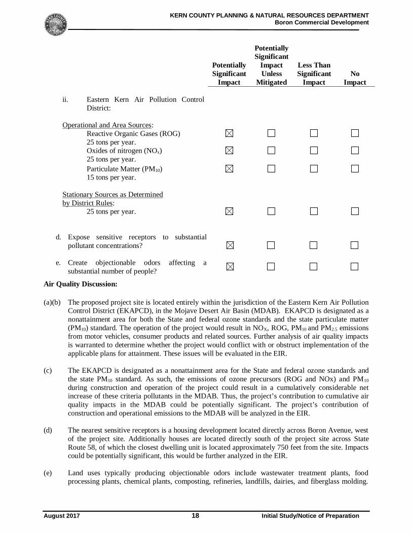
Air Quality Discussion:
(a)(b) The proposed project site is located entirely within the jurisdiction of the Eastern Kern Air PollutionControl District (EKAPCD), in the Mojave Desert Air Basin (MDAB). EKAPCD is designated as anonattainment area for both the State and federal ozone standards and the state particulate matter(PM10) standard. The operation of the project would result in NOX, ROG, PM10 and PM2.5 emissionsfrom motor vehicles, consumer products and related sources. Further analysis of air quality impactsis warranted to determine whether the project would conflict with or obstruct implementation of theapplicable plans for attainment. These issues will be evaluated in the EIR.
(c) The EKAPCD is designated as a nonattainment area for the State and federal ozone standards andthe state PM10 standard. As such, the emissions of ozone precursors (ROG and NOx) and PM10
during construction and operation of the project could result in a cumulatively considerable netincrease of these criteria pollutants in the MDAB. Thus, the project’s contribution to cumulative airquality impacts in the MDAB could be potentially significant. The project’s contribution ofconstruction and operational emissions to the MDAB will be analyzed in the EIR.
(d) The nearest sensitive receptors is a housing development located directly across Boron Avenue, westof the project site. Additionally houses are located directly south of the project site across StateRoute 58, of which the closest dwelling unit is located approximately 750 feet from the site. Impactscould be potentially significant, this would be further analyzed in the EIR.
(e) Land uses typically producing objectionable odors include wastewater treatment plants, foodprocessing plants, chemical plants, composting, refineries, landfills, dairies, and fiberglass molding.
KERN COUNTY PLANNING & NATURAL RESOURCES DEPARTMENTBoron Commercial Development
August 2017 19 Initial Study/Notice of Preparation
The project would not have any stationary sources or equipment located on-site that would generateobjectionable odors. During construction activities, only short-term, temporary odors from vehicleexhaust and construction equipment engines would occur. However, these odors would be temporaryand would not likely be noticeable for extended periods of time beyond the project’s site boundaries.However, operational uses of the proposed may be a source of odors. Therefore, potential diesel odorimpacts would therefore be potentially significant, this would be further analyzed in the EIR.
KERN COUNTY PLANNING & NATURAL RESOURCES DEPARTMENTBoron Commercial Development
August 2017 20 Initial Study/Notice of Preparation
PotentiallySignificant
Impact
PotentiallySignificant
ImpactUnless
Mitigated
Less ThanSignificant
ImpactNo
ImpactBIOLOGICAL RESOURCES. Would the project:
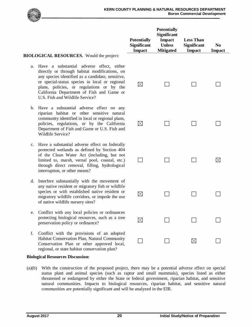
a. Have a substantial adverse effect, eitherdirectly or through habitat modifications, onany species identified as a candidate, sensitive,or special-status species in local or regionalplans, policies, or regulations or by theCalifornia Department of Fish and Game orU.S. Fish and Wildlife Service?
b. Have a substantial adverse effect on anyriparian habitat or other sensitive naturalcommunity identified in local or regional plans,policies, regulations, or by the CaliforniaDepartment of Fish and Game or U.S. Fish andWildlife Service?
c. Have a substantial adverse effect on federallyprotected wetlands as defined by Section 404of the Clean Water Act (including, but notlimited to, marsh, vernal pool, coastal, etc.)through direct removal, filling, hydrologicalinterruption, or other means?
d. Interfere substantially with the movement ofany native resident or migratory fish or wildlifespecies or with established native resident ormigratory wildlife corridors, or impede the useof native wildlife nursery sites?
e. Conflict with any local policies or ordinancesprotecting biological resources, such as a treepreservation policy or ordinance?
f. Conflict with the provisions of an adoptedHabitat Conservation Plan, Natural CommunityConservation Plan or other approved local,regional, or state habitat conservation plan?
Biological Resources Discussion:
(a)(b) With the construction of the proposed project, there may be a potential adverse effect on specialstatus plant and animal species (such as raptor and small mammals), species listed as eitherthreatened or endangered by either the State or federal government, riparian habitat, and sensitivenatural communities. Impacts to biological resources, riparian habitat, and sensitive naturalcommunities are potentially significant and will be analyzed in the EIR.
KERN COUNTY PLANNING & NATURAL RESOURCES DEPARTMENTBoron Commercial Development
August 2017 21 Initial Study/Notice of Preparation
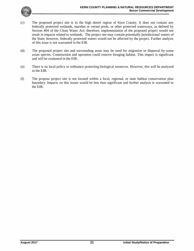
(c) The proposed project site is in the high desert region of Kern County. It does not contain anyfederally protected wetlands, marshes or vernal pools, or other protected waterways, as defined bySection 404 of the Clean Water Act; therefore, implementation of the proposed project would notresult in impacts related to wetlands. The project site may contain potentially jurisdictional waters ofthe State; however, federally protected waters would not be affected by the project. Further analysisof this issue is not warranted in the EIR.
(d) The proposed project site and surrounding areas may be used for migration or dispersal by someavian species. Construction and operation could remove foraging habitat. This impact is significantand will be evaluated in the EIR.
(e) There is no local policy or ordinance protecting biological resources. However, this will be analyzedin the EIR.
(f) The propose project site is not located within a local, regional, or state habitat conservation planboundary. Impacts on this issues would be less than significant and further analysis is warranted inthe EIR.
KERN COUNTY PLANNING & NATURAL RESOURCES DEPARTMENTBoron Commercial Development
August 2017 22 Initial Study/Notice of Preparation
PotentiallySignificant
Impact
PotentiallySignificant
ImpactUnless
Mitigated
Less ThanSignificant
ImpactNo
Impact
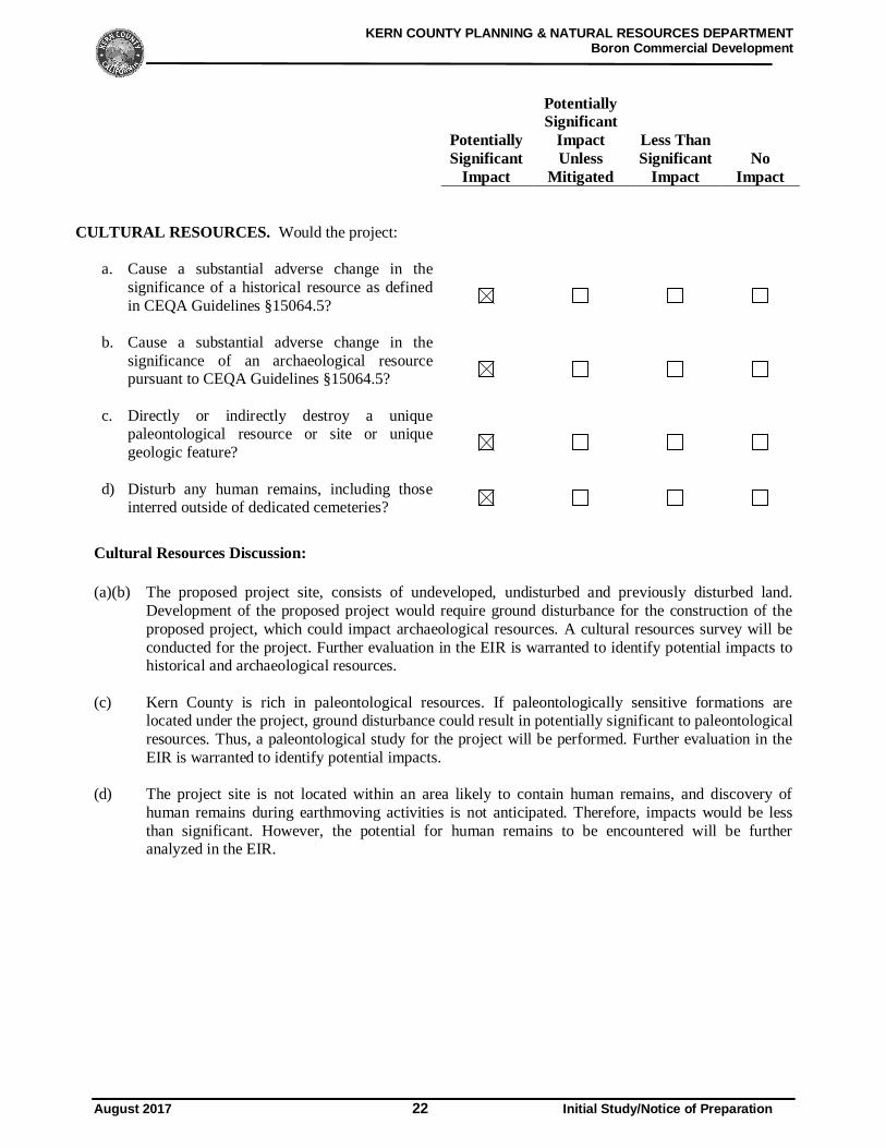
CULTURAL RESOURCES. Would the project:
a. Cause a substantial adverse change in thesignificance of a historical resource as definedin CEQA Guidelines §15064.5?
b. Cause a substantial adverse change in thesignificance of an archaeological resourcepursuant to CEQA Guidelines §15064.5?
c. Directly or indirectly destroy a uniquepaleontological resource or site or uniquegeologic feature?
d) Disturb any human remains, including thoseinterred outside of dedicated cemeteries?
Cultural Resources Discussion:
(a)(b) The proposed project site, consists of undeveloped, undisturbed and previously disturbed land.Development of the proposed project would require ground disturbance for the construction of theproposed project, which could impact archaeological resources. A cultural resources survey will beconducted for the project. Further evaluation in the EIR is warranted to identify potential impacts tohistorical and archaeological resources.
(c) Kern County is rich in paleontological resources. If paleontologically sensitive formations arelocated under the project, ground disturbance could result in potentially significant to paleontologicalresources. Thus, a paleontological study for the project will be performed. Further evaluation in theEIR is warranted to identify potential impacts.
(d) The project site is not located within an area likely to contain human remains, and discovery ofhuman remains during earthmoving activities is not anticipated. Therefore, impacts would be lessthan significant. However, the potential for human remains to be encountered will be furtheranalyzed in the EIR.
KERN COUNTY PLANNING & NATURAL RESOURCES DEPARTMENTBoron Commercial Development
August 2017 23 Initial Study/Notice of Preparation
PotentiallySignificant
Impact
PotentiallySignificant
ImpactUnless
Mitigated
Less ThanSignificant
ImpactNo
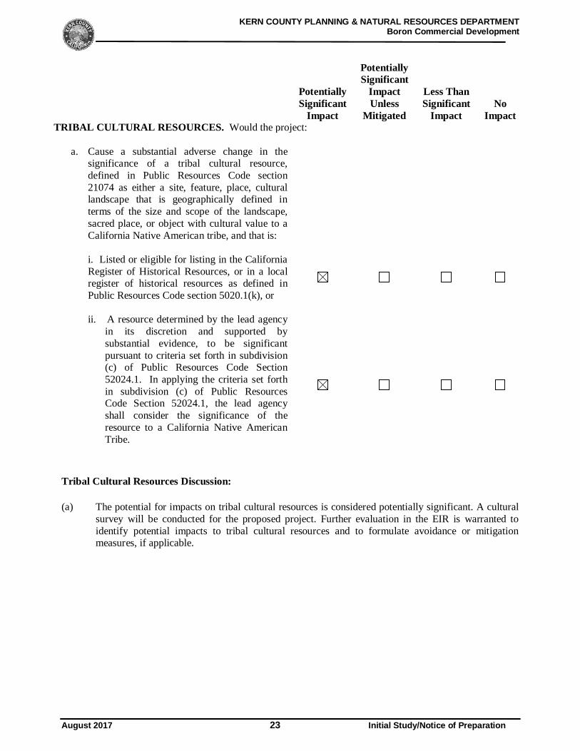
ImpactTRIBAL CULTURAL RESOURCES. Would the project:
a. Cause a substantial adverse change in thesignificance of a tribal cultural resource,defined in Public Resources Code section21074 as either a site, feature, place, culturallandscape that is geographically defined interms of the size and scope of the landscape,sacred place, or object with cultural value to aCalifornia Native American tribe, and that is:
i. Listed or eligible for listing in the CaliforniaRegister of Historical Resources, or in a localregister of historical resources as defined inPublic Resources Code section 5020.1(k), or
ii. A resource determined by the lead agencyin its discretion and supported bysubstantial evidence, to be significantpursuant to criteria set forth in subdivision(c) of Public Resources Code Section52024.1. In applying the criteria set forthin subdivision (c) of Public ResourcesCode Section 52024.1, the lead agencyshall consider the significance of theresource to a California Native AmericanTribe.
Tribal Cultural Resources Discussion:
(a) The potential for impacts on tribal cultural resources is considered potentially significant. A culturalsurvey will be conducted for the proposed project. Further evaluation in the EIR is warranted toidentify potential impacts to tribal cultural resources and to formulate avoidance or mitigationmeasures, if applicable.
KERN COUNTY PLANNING & NATURAL RESOURCES DEPARTMENTBoron Commercial Development
August 2017 24 Initial Study/Notice of Preparation
PotentiallySignificant
Impact
PotentiallySignificant
ImpactUnless
Mitigated
Less ThanSignificant
ImpactNo
Impact
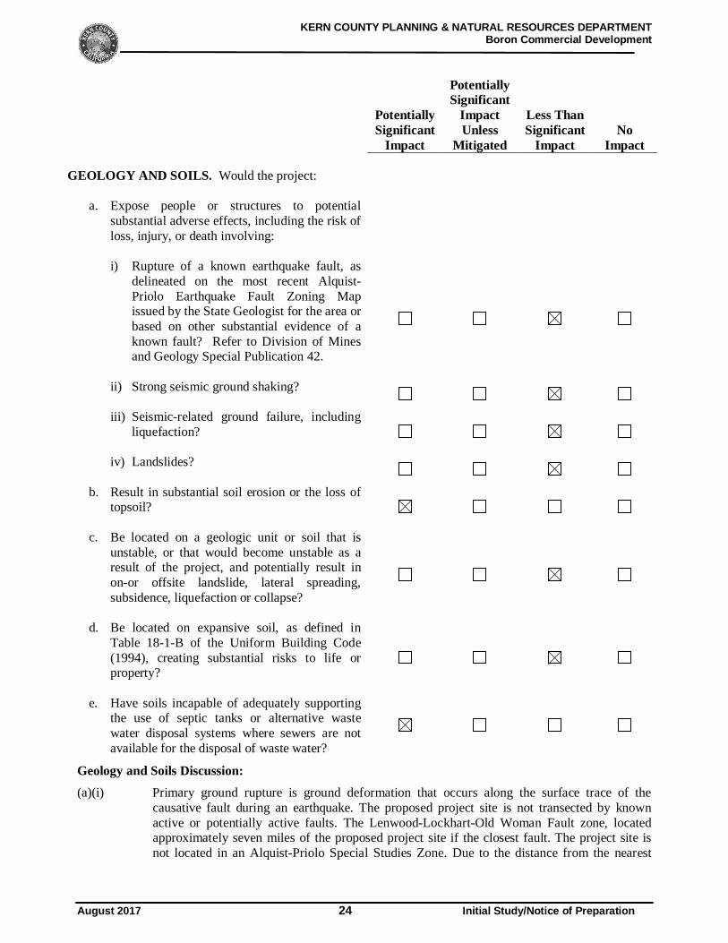
GEOLOGY AND SOILS. Would the project:
a. Expose people or structures to potentialsubstantial adverse effects, including the risk ofloss, injury, or death involving:
i) Rupture of a known earthquake fault, asdelineated on the most recent Alquist-Priolo Earthquake Fault Zoning Mapissued by the State Geologist for the area orbased on other substantial evidence of aknown fault? Refer to Division of Minesand Geology Special Publication 42.
ii) Strong seismic ground shaking?
iii) Seismic-related ground failure, includingliquefaction?
iv) Landslides?
b. Result in substantial soil erosion or the loss oftopsoil?
c. Be located on a geologic unit or soil that isunstable, or that would become unstable as aresult of the project, and potentially result inon-or offsite landslide, lateral spreading,subsidence, liquefaction or collapse?
d. Be located on expansive soil, as defined inTable 18-1-B of the Uniform Building Code(1994), creating substantial risks to life orproperty?
e. Have soils incapable of adequately supportingthe use of septic tanks or alternative wastewater disposal systems where sewers are notavailable for the disposal of waste water?
Geology and Soils Discussion:(a)(i) Primary ground rupture is ground deformation that occurs along the surface trace of the
causative fault during an earthquake. The proposed project site is not transected by knownactive or potentially active faults. The Lenwood-Lockhart-Old Woman Fault zone, locatedapproximately seven miles of the proposed project site if the closest fault. The project site isnot located in an Alquist-Priolo Special Studies Zone. Due to the distance from the nearest
KERN COUNTY PLANNING & NATURAL RESOURCES DEPARTMENTBoron Commercial Development
August 2017 25 Initial Study/Notice of Preparation
active fault to the project site, impacts are anticipated to be less than significant; however,further analysis in the EIR is warranted.
In addition, construction of the project would be subject to all applicable ordinances of theKern County Building Code (Chapter 17.08). Kern County has adopted the California BuildingCode (CBC), 2016 Edition (CCR Title 24), which imposes substantially the same requirementsas the International Building Code (IBC), 2015 Edition, with some modifications andamendments. Adherence to all applicable regulations would mitigate any potential impactsassociated with the project. As a result, project related impacts from surface rupture of aknown earthquake fault are anticipated to be less than significant; however, further analysis inthe EIR is warranted.
(ii) Due to the location of active faults in the region, strong seismic ground shaking could occur atthe project site, resulting in damage to structures that are not properly designed to withstandstrong ground shaking. Construction of the proposed project would be subject to all applicableordinances of the Kern County Building Code (Chapter 17.08), and IBC and CBC earthquakeconstruction standards, including those relating to soil characteristics. Adherence to allapplicable regulations would mitigate any potential impacts associated with seismic groundshaking at the project site. Although, the proposed project site would potentially be subject tomoderate to strong ground shaking from regional earthquake, the proposed project would notexpose substantial numbers of people to adverse impacts as a result. Potential impacts for thisissue are anticipated to be less than significant; nevertheless, further analysis in the EIR iswarranted.
(iii) Seismically induced liquefaction occurs when loose, water-saturated sediments of relativelylow density are subjected to cyclic shaking that causes soils to lose strengths or stiffness,because of increased pore water pressure. The California Geologic Survey (CGS) hasdesignated certain areas as potential liquefaction hazard zones. These are areas considered at arisk of liquefaction-related ground failure during a seismic event, based upon mapped surficialdeposits and the presence of a relatively shallow water table. The proposed project site has notbeen mapped by the CGS for liquefaction hazard potential. Based on the anticipated depth togroundwater and encountered subsurface conditions, liquefaction potential on this site shouldbe considered low. Potential impacts for this issue are less than significant and will beevaluated in the EIR.
(iv) The proposed project site is located in a relatively flat-lying plain, does not contain any steepslopes, and the likelihood of landslides is very low. Therefore, impacts related to landslides areless than significant and will be evaluated in the EIR.
(b) Removal of vegetation and excavation would be required for the construction of the project. It isanticipated that excavations for the proposed construction can be accomplished with conventionalearthmoving equipment. Excavations penetrating the very dense and cemented materials may requirethe use of specialized heavy-duty equipment, to facilitate break-up and removal. As a result, projectconstruction would have the potential to result in erosion, sedimentation, and discharge ofconstruction debris from the site. As required, a Storm Water Pollution Prevention Plan (SWPPP)would be developed to specify best management practices (BMPs) to prevent construction pollutants,including erosion of soils (such as topsoil), from moving off-site. Although impacts are anticipatedto be less than significant with implementation of the requirements, impacts related to soil erosion orthe loss of topsoil will be evaluated in the EIR.
KERN COUNTY PLANNING & NATURAL RESOURCES DEPARTMENTBoron Commercial Development
August 2017 26 Initial Study/Notice of Preparation
(c) The project site lies in a relatively flat-lying plain where landslides, lateral spreading, subsidence,liquefaction, and collapse are not expected to occur. Furthermore, the structures would be subject toall applicable ordinances of the Kern County Building Code (Chapter 17.08), as well as allapplicable IBC and CBC earthquake construction standards, including those relating to soilcharacteristics. Therefore, impacts related to geologic instability are not anticipated to occur or posea hazard to the project or surrounding area, and impacts would be less than significant and it will beevaluated in the EIR.
(d) Expansive soils are fine-grained soils (generally high plasticity clays) that can undergo a significantincrease in volume with an increase in water content and a significant decrease in volume with adecrease in water content. Changes in the water content of highly expansive soil can result in severedistress to structures constructed on or against soil. The expansion potential of on-site soils may beclassified as very low to low, and special design is not necessary. Nevertheless, the project would berequired to comply with applicable building codes and structural improvements to withstand theeffects of expansive soils. The implementation of Kern County Building Code requirements, asapplicable, would minimize the potential impact of expansive soils. Potential impacts for this issuearea are anticipated to be less than significant; nevertheless, further analysis in the EIR is warranted.
(e) The proposed project includes construction an 8,060-square-foot convenience store, a 3,217-square-foot restaurant with a drive-thru window, and a 1,581-square-foot fast-food restaurant without adrive thru. The proposal does not include septic systems or other alternative wastewater disposalsystems; therefore, impacts would be potentially significant and will be evaluated in the EIR.
KERN COUNTY PLANNING & NATURAL RESOURCES DEPARTMENTBoron Commercial Development
August 2017 27 Initial Study/Notice of Preparation
PotentiallySignificant
Impact
PotentiallySignificant
ImpactUnless
Mitigated
Less ThanSignificant
ImpactNo
Impact
GREENHOUSE GAS EMISSIONS. Would the project:
a. Generate greenhouse gas emissions, eitherdirectly or indirectly, that may have asignificant impact on the environment?
b. Conflict with an applicable plan, policy orregulation adopted for the purpose of reducingthe emissions of greenhouse gases?
Greenhouse Gas Emissions Discussion:
(a)(b) Global climate change is an international phenomenon, and the regulatory background and scientificdata are changing rapidly. In 2006, the California state legislature adopted Assembly Bill 32, theCalifornia Global Warming Solutions Act of 2006. Assembly Bill (AB) 32 describes how globalclimate change would affect the environment in California. The impacts described in AB 32 includechanging sea levels, changes in snow pack and availability of potable water, changes in storm flowsand flood inundation zones, and other impacts.
As required by AB 32, California Air Resources Board (CARB) determined what the statewidegreenhouse gas (GHG) emissions level was in 1990 and then approved a statewide GHG emissionslimit that is equivalent to that level, which is to be achieved by 2020. CARB approved the 2020 limiton December 6, 2007. CARB’s GHG inventory estimated the 1990 emissions level in California tobe 427 million metric tons carbon dioxide equivalent (MMTCO2e). In 2004, the emissions wereestimated to be 480 MMTCO2e.
GHGs emitted by human activity are implicated in global climate change or global warming. Theprincipal GHGs are carbon dioxide (CO2), methane (CH4), nitrous oxide (NOx), ozone (O3), watervapor, and fluorinated gases. Fossil fuel consumption in the transportation sector (on-road motorvehicles, off-highway mobile sources, and aircraft) is the single largest source of GHG emissions inCalifornia.
The primary source of GHG emissions from the project during construction would be mobilesources, including off-road equipment, material delivery and other trucks and worker vehicles. Theprimary source of GHG emissions from the project during operation would be mobile sources (motorvehicles). Not all GHGs exhibit the same ability to induce climate change (i.e., specific GHGs eachhave their own global warming potential); therefore, GHG contributions from projects are commonlyquantified in carbon dioxide equivalent, which has a global warming of 1. These impacts would befurther evaluated in the EIR. Consistency with applicable State GHG reduction measures andGeneral Plan policies will be evaluated in the EIR.
KERN COUNTY PLANNING & NATURAL RESOURCES DEPARTMENTBoron Commercial Development
August 2017 28 Initial Study/Notice of Preparation
PotentiallySignificant
Impact
PotentiallySignificant
ImpactUnless
Mitigated
Less ThanSignificant
ImpactNo
Impact
HAZARDS AND HAZARDOUS MATERIALS. Would the project:
a. Create a significant hazard to the public or theenvironment through the routine transport, useor disposal of hazardous materials?
b. Create a significant hazard to the public or theenvironment through reasonably foreseeableupset and accident conditions involving therelease of hazardous materials into theenvironment?
c. Emit hazardous emissions or handle hazardousor acutely hazardous materials, substances, orwaste within one-quarter mile of an existing orproposed school?
d. Be located on a site which is included on a listof hazardous materials sites compiled pursuantto Government Code Section 65962.5 and, as aresult, would it create a significant hazard tothe public or the environment?
e. For a project located within the adopted KernCounty Airport Land Use Compatibility Plan,would the project result in a safety hazard forpeople residing or working in the project area?
f. For a project within the vicinity of a privateairstrip, would the project result in a safetyhazard for people residing or working in theproject area?
g. Impair implementation of, or physicallyinterfere with, an adopted emergency responseplan or emergency evacuation plan?
h. Expose people or structures to a significant riskof loss, injury, or death involving wildlandfires, including where wildlands are adjacent tourbanized areas or where residences areintermixed with wildlands?
i. Would implementation of the project generatevectors (flies, mosquitoes, rodents, etc.) orhave a component that includes agricultural
KERN COUNTY PLANNING & NATURAL RESOURCES DEPARTMENTBoron Commercial Development
August 2017 29 Initial Study/Notice of Preparation
PotentiallySignificant
Impact
PotentiallySignificant
ImpactUnless
Mitigated
Less ThanSignificant
ImpactNo
Impactwaste? Specifically, would the project exceedthe following qualitative threshold:
The presence of domestic flies, mosquitoes,cockroaches, rodents, and/or any other vectorsassociated with the project is significant whenthe applicable enforcement agency determinesthat any of the vectors:
i. Occur as immature stages and adults innumbers considerably in excess ofthose found in the surroundingenvironment; and
ii. Are associated with design, layout, andmanagement of project operations; and
iii. Disseminate widely from the property;and
iv. Cause detrimental effects on the publichealth or wellbeing of the majority ofthe surrounding population.
Hazards and Hazardous Materials Discussion:
(a) The proposed project could involve the routine transport, use, or disposal of hazardous materials asdefined by the Hazardous Materials Transportation Uniform Safety Act. This issue will be evaluatedin the EIR.
(b) Construction and operation of the proposed project could result in the foreseeable upset and/oraccident conditions involving the release of hazardous materials into the environment. This issue willbe evaluated in the EIR.
(c) The closest school to the proposed project site is Boron Junior/Senior High, located approximately ahalf mile southwest of the proposed site. The next closest school is the West Boron Elementarylocated approximately three miles southwest of the project. Project related infrastructure would notemit hazardous materials or involve handling hazardous or acutely hazardous materials. Substancesor waste is not located within a quarter mile of an existing or proposed school, and it will beevaluated in the EIR.
(d) The project is not identified in any of the California hazardous materials lists: CaliforniaEnvironmental Protection Agency’s (CalEPA) Cortese List including the California Department ofToxic Substances and Control’s EnviroStor database of hazardous substances release sites; andGeotracker, the California database of leaking underground storage tanks. Finally, as provided byCalEPA, there are no active Cease and Desist Orders or Clean Up and Abatement Orders for
KERN COUNTY PLANNING & NATURAL RESOURCES DEPARTMENTBoron Commercial Development
August 2017 30 Initial Study/Notice of Preparation
hazardous materials/facilities in the immediate project vicinity of the project site. Therefore,significant impacts would be less than significant, and will be further analyzed in the EIR.
(e) The project area is no located within two miles of a public or public use airport, and the site is notwithin the sphere of influence if any airports as identified by the Kern County Airport Land UseCompatibility Plan (ALUCP). However, this impact may be less than significant; therefore, this willbe further analyzed in the EIR.
(f) The project site is not located within two miles of a private airstrip. However, further analysis will beprovided in the EIR.
(g) The proposed project would not physically impede the existing emergency response plan, emergencyvehicle access, or personal access to the proposed project site. The project site is located in areaswith several alternative access roads allowing access in the event of an emergency. Access would bemaintained throughout construction, and appropriate detours would be provided in the event ofpotential road closures. Further analysis of this issue is will be evaluated in the EIR.
(h) The potential for construction and operation of the proposed project to result in increased risk ofwildfires in the project areas will be evaluated in the EIR.
(i) Project related infrastructure such as the retention basin, if not properly managed, could providehabitat for vectors such as mosquitoes, flies, cockroaches or rodents. Travelers and workers willgenerate large quantities of solid waste (i.e. trash) that would be appropriately stored for permanentdisposal offsite. If properly managed, potential impacts should be negligible; however, this issue willbe addressed in the EIR.
KERN COUNTY PLANNING & NATURAL RESOURCES DEPARTMENTBoron Commercial Development
August 2017 31 Initial Study/Notice of Preparation
PotentiallySignificant
Impact
PotentiallySignificant
ImpactUnless
Mitigated
Less ThanSignificant
ImpactNo
Impact
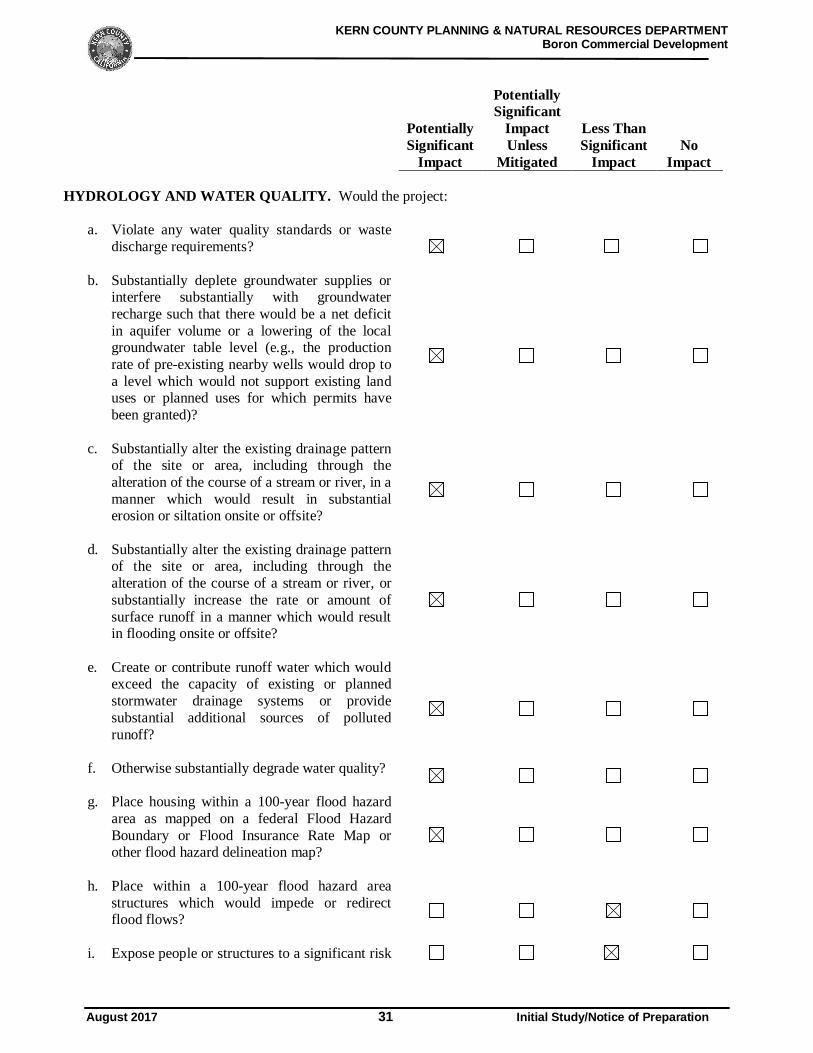
HYDROLOGY AND WATER QUALITY. Would the project:
a. Violate any water quality standards or wastedischarge requirements?
b. Substantially deplete groundwater supplies orinterfere substantially with groundwaterrecharge such that there would be a net deficitin aquifer volume or a lowering of the localgroundwater table level (e.g., the productionrate of pre-existing nearby wells would drop toa level which would not support existing landuses or planned uses for which permits havebeen granted)?
c. Substantially alter the existing drainage patternof the site or area, including through thealteration of the course of a stream or river, in amanner which would result in substantialerosion or siltation onsite or offsite?
d. Substantially alter the existing drainage patternof the site or area, including through thealteration of the course of a stream or river, orsubstantially increase the rate or amount ofsurface runoff in a manner which would resultin flooding onsite or offsite?
e. Create or contribute runoff water which wouldexceed the capacity of existing or plannedstormwater drainage systems or providesubstantial additional sources of pollutedrunoff?
f. Otherwise substantially degrade water quality?
g. Place housing within a 100-year flood hazardarea as mapped on a federal Flood HazardBoundary or Flood Insurance Rate Map orother flood hazard delineation map?
h. Place within a 100-year flood hazard areastructures which would impede or redirectflood flows?
i. Expose people or structures to a significant risk
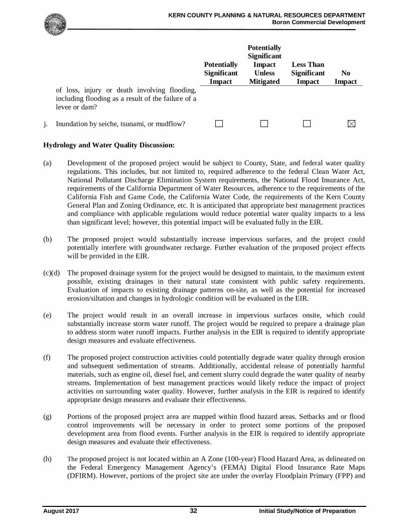
KERN COUNTY PLANNING & NATURAL RESOURCES DEPARTMENTBoron Commercial Development
August 2017 32 Initial Study/Notice of Preparation
PotentiallySignificant
Impact
PotentiallySignificant
ImpactUnless
Mitigated
Less ThanSignificant
ImpactNo
Impactof loss, injury or death involving flooding,including flooding as a result of the failure of alevee or dam?
j. Inundation by seiche, tsunami, or mudflow?
Hydrology and Water Quality Discussion:
(a) Development of the proposed project would be subject to County, State, and federal water qualityregulations. This includes, but not limited to, required adherence to the federal Clean Water Act,National Pollutant Discharge Elimination System requirements, the National Flood Insurance Act,requirements of the California Department of Water Resources, adherence to the requirements of theCalifornia Fish and Game Code, the California Water Code, the requirements of the Kern CountyGeneral Plan and Zoning Ordinance, etc. It is anticipated that appropriate best management practicesand compliance with applicable regulations would reduce potential water quality impacts to a lessthan significant level; however, this potential impact will be evaluated fully in the EIR.
(b) The proposed project would substantially increase impervious surfaces, and the project couldpotentially interfere with groundwater recharge. Further evaluation of the proposed project effectswill be provided in the EIR.
(c)(d) The proposed drainage system for the project would be designed to maintain, to the maximum extentpossible, existing drainages in their natural state consistent with public safety requirements.Evaluation of impacts to existing drainage patterns on-site, as well as the potential for increasederosion/siltation and changes in hydrologic condition will be evaluated in the EIR.
(e) The project would result in an overall increase in impervious surfaces onsite, which couldsubstantially increase storm water runoff. The project would be required to prepare a drainage planto address storm water runoff impacts. Further analysis in the EIR is required to identify appropriatedesign measures and evaluate effectiveness.
(f) The proposed project construction activities could potentially degrade water quality through erosionand subsequent sedimentation of streams. Additionally, accidental release of potentially harmfulmaterials, such as engine oil, diesel fuel, and cement slurry could degrade the water quality of nearbystreams. Implementation of best management practices would likely reduce the impact of projectactivities on surrounding water quality. However, further analysis in the EIR is required to identifyappropriate design measures and evaluate their effectiveness.
(g) Portions of the proposed project area are mapped within flood hazard areas. Setbacks and or floodcontrol improvements will be necessary in order to protect some portions of the proposeddevelopment area from flood events. Further analysis in the EIR is required to identify appropriatedesign measures and evaluate their effectiveness.
(h) The proposed project is not located within an A Zone (100-year) Flood Hazard Area, as delineated onthe Federal Emergency Management Agency’s (FEMA) Digital Flood Insurance Rate Maps(DFIRM). However, portions of the project site are under the overlay Floodplain Primary (FPP) and
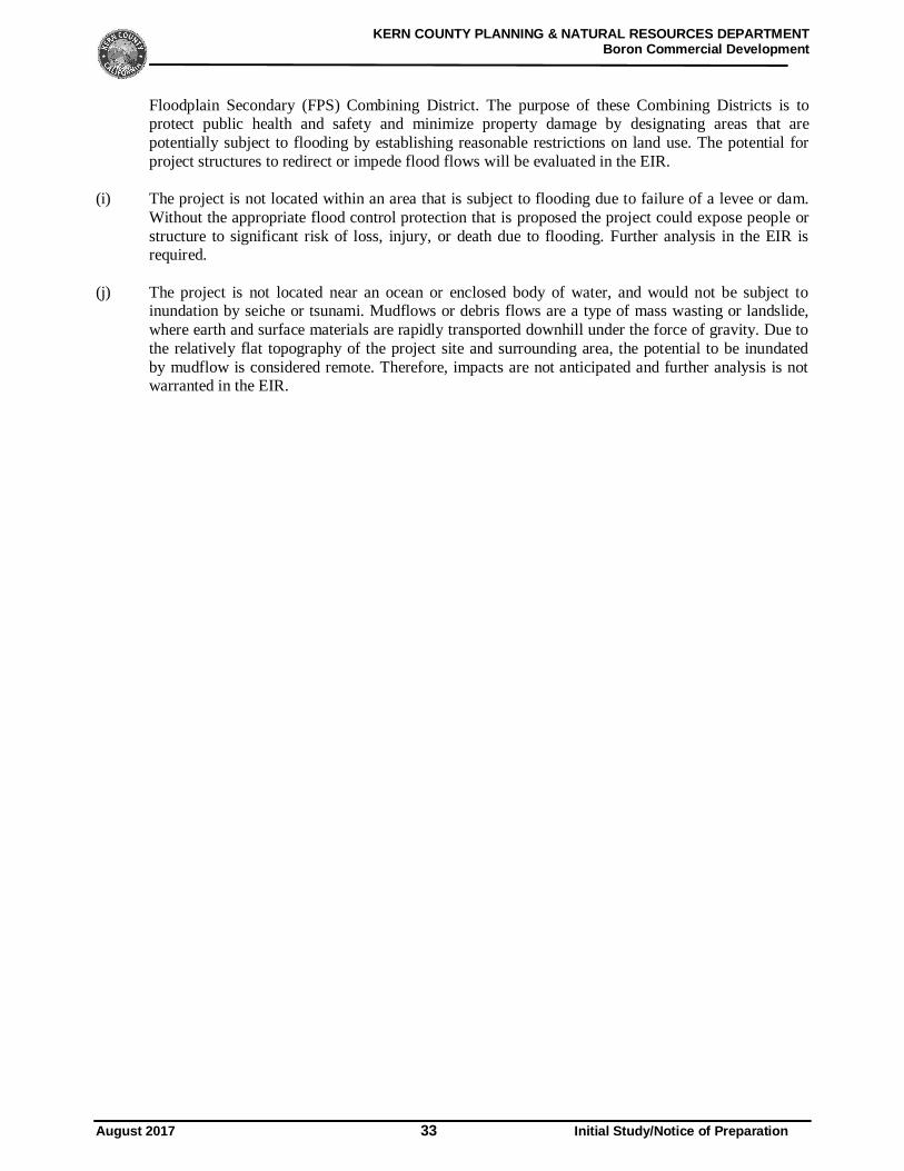
KERN COUNTY PLANNING & NATURAL RESOURCES DEPARTMENTBoron Commercial Development
August 2017 33 Initial Study/Notice of Preparation
Floodplain Secondary (FPS) Combining District. The purpose of these Combining Districts is toprotect public health and safety and minimize property damage by designating areas that arepotentially subject to flooding by establishing reasonable restrictions on land use. The potential forproject structures to redirect or impede flood flows will be evaluated in the EIR.
(i) The project is not located within an area that is subject to flooding due to failure of a levee or dam.Without the appropriate flood control protection that is proposed the project could expose people orstructure to significant risk of loss, injury, or death due to flooding. Further analysis in the EIR isrequired.
(j) The project is not located near an ocean or enclosed body of water, and would not be subject toinundation by seiche or tsunami. Mudflows or debris flows are a type of mass wasting or landslide,where earth and surface materials are rapidly transported downhill under the force of gravity. Due tothe relatively flat topography of the project site and surrounding area, the potential to be inundatedby mudflow is considered remote. Therefore, impacts are not anticipated and further analysis is notwarranted in the EIR.
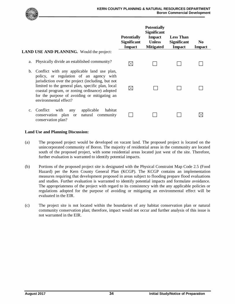
KERN COUNTY PLANNING & NATURAL RESOURCES DEPARTMENTBoron Commercial Development
August 2017 34 Initial Study/Notice of Preparation
PotentiallySignificant
Impact
PotentiallySignificant
ImpactUnless
Mitigated
Less ThanSignificant
ImpactNo
ImpactLAND USE AND PLANNING. Would the project:
a. Physically divide an established community?
b. Conflict with any applicable land use plan,policy, or regulation of an agency withjurisdiction over the project (including, but notlimited to the general plan, specific plan, localcoastal program, or zoning ordinance) adoptedfor the purpose of avoiding or mitigating anenvironmental effect?
c. Conflict with any applicable habitatconservation plan or natural communityconservation plan?
Land Use and Planning Discussion:
(a) The proposed project would be developed on vacant land. The proposed project is located on theunincorporated community of Boron. The majority of residential areas in the community are locatedsouth of the proposed project, with some residential areas located just west of the site. Therefore,further evaluation is warranted to identify potential impacts.
(b) Portions of the proposed project site is designated with the Physical Constraint Map Code 2.5 (FoodHazard) per the Kern County General Plan (KCGP). The KCGP contains an implementationmeasures requiring that development proposed in areas subject to flooding prepare flood evaluationsand studies. Further evaluation is warranted to identify potential impacts and formulate avoidance.The appropriateness of the project with regard to its consistency with the any applicable policies orregulations adopted for the purpose of avoiding or mitigating an environmental effect will beevaluated in the EIR.
(c) The project site is not located within the boundaries of any habitat conservation plan or naturalcommunity conservation plan; therefore, impact would not occur and further analysis of this issue isnot warranted in the EIR.
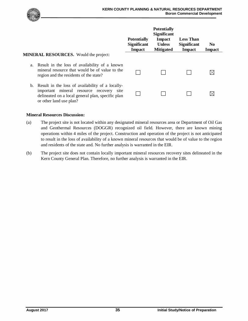
KERN COUNTY PLANNING & NATURAL RESOURCES DEPARTMENTBoron Commercial Development
August 2017 35 Initial Study/Notice of Preparation
PotentiallySignificant
Impact
PotentiallySignificant
ImpactUnless
Mitigated
Less ThanSignificant
ImpactNo
ImpactMINERAL RESOURCES. Would the project:
a. Result in the loss of availability of a knownmineral resource that would be of value to theregion and the residents of the state?
b. Result in the loss of availability of a locally-important mineral resource recovery sitedelineated on a local general plan, specific planor other land use plan?
Mineral Resources Discussion:
(a) The project site is not located within any designated mineral resources area or Department of Oil Gasand Geothermal Resources (DOGGR) recognized oil field. However, there are known miningoperations within 4 miles of the project. Construction and operation of the project is not anticipatedto result in the loss of availability of a known mineral resources that would be of value to the regionand residents of the state and. No further analysis is warranted in the EIR.
(b) The project site does not contain locally important mineral resources recovery sites delineated in theKern County General Plan. Therefore, no further analysis is warranted in the EIR.
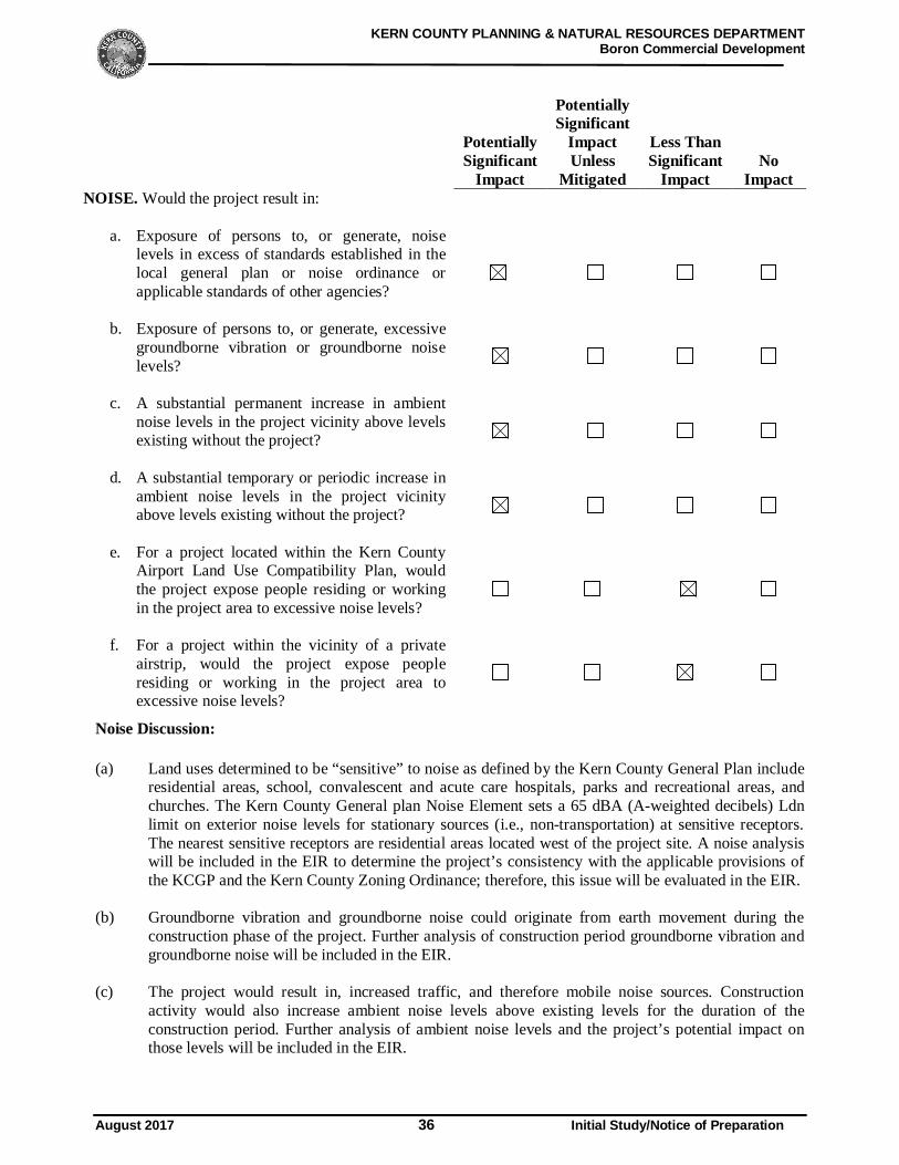
KERN COUNTY PLANNING & NATURAL RESOURCES DEPARTMENTBoron Commercial Development
August 2017 36 Initial Study/Notice of Preparation
PotentiallySignificant
Impact
PotentiallySignificant
ImpactUnless
Mitigated
Less ThanSignificant
ImpactNo
ImpactNOISE. Would the project result in:
a. Exposure of persons to, or generate, noiselevels in excess of standards established in thelocal general plan or noise ordinance orapplicable standards of other agencies?
b. Exposure of persons to, or generate, excessivegroundborne vibration or groundborne noiselevels?
c. A substantial permanent increase in ambientnoise levels in the project vicinity above levelsexisting without the project?
d. A substantial temporary or periodic increase inambient noise levels in the project vicinityabove levels existing without the project?
e. For a project located within the Kern CountyAirport Land Use Compatibility Plan, wouldthe project expose people residing or workingin the project area to excessive noise levels?
f. For a project within the vicinity of a privateairstrip, would the project expose peopleresiding or working in the project area toexcessive noise levels?
Noise Discussion:
(a) Land uses determined to be “sensitive” to noise as defined by the Kern County General Plan includeresidential areas, school, convalescent and acute care hospitals, parks and recreational areas, andchurches. The Kern County General plan Noise Element sets a 65 dBA (A-weighted decibels) Ldnlimit on exterior noise levels for stationary sources (i.e., non-transportation) at sensitive receptors.The nearest sensitive receptors are residential areas located west of the project site. A noise analysiswill be included in the EIR to determine the project’s consistency with the applicable provisions ofthe KCGP and the Kern County Zoning Ordinance; therefore, this issue will be evaluated in the EIR.
(b) Groundborne vibration and groundborne noise could originate from earth movement during theconstruction phase of the project. Further analysis of construction period groundborne vibration andgroundborne noise will be included in the EIR.
(c) The project would result in, increased traffic, and therefore mobile noise sources. Constructionactivity would also increase ambient noise levels above existing levels for the duration of theconstruction period. Further analysis of ambient noise levels and the project’s potential impact onthose levels will be included in the EIR.
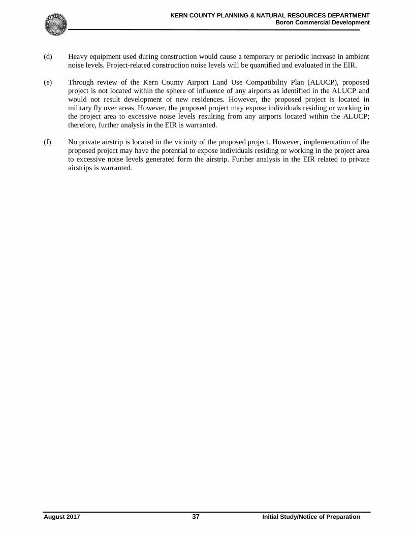
KERN COUNTY PLANNING & NATURAL RESOURCES DEPARTMENTBoron Commercial Development
August 2017 37 Initial Study/Notice of Preparation
(d) Heavy equipment used during construction would cause a temporary or periodic increase in ambientnoise levels. Project-related construction noise levels will be quantified and evaluated in the EIR.
(e) Through review of the Kern County Airport Land Use Compatibility Plan (ALUCP), proposedproject is not located within the sphere of influence of any airports as identified in the ALUCP andwould not result development of new residences. However, the proposed project is located inmilitary fly over areas. However, the proposed project may expose individuals residing or working inthe project area to excessive noise levels resulting from any airports located within the ALUCP;therefore, further analysis in the EIR is warranted.
(f) No private airstrip is located in the vicinity of the proposed project. However, implementation of theproposed project may have the potential to expose individuals residing or working in the project areato excessive noise levels generated form the airstrip. Further analysis in the EIR related to privateairstrips is warranted.
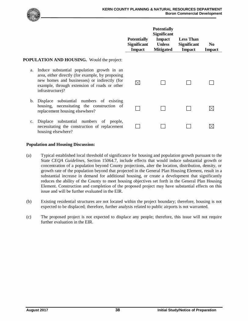
KERN COUNTY PLANNING & NATURAL RESOURCES DEPARTMENTBoron Commercial Development
August 2017 38 Initial Study/Notice of Preparation
PotentiallySignificant
Impact
PotentiallySignificant
ImpactUnless
Mitigated
Less ThanSignificant
ImpactNo
Impact
POPULATION AND HOUSING. Would the project:
a. Induce substantial population growth in anarea, either directly (for example, by proposingnew homes and businesses) or indirectly (forexample, through extension of roads or otherinfrastructure)?
b. Displace substantial numbers of existinghousing, necessitating the construction ofreplacement housing elsewhere?
c. Displace substantial numbers of people,necessitating the construction of replacementhousing elsewhere?
Population and Housing Discussion:
(a) Typical established local threshold of significance for housing and population growth pursuant to theState CEQA Guidelines, Section 15064.7, include effects that would induce substantial growth orconcentration of a population beyond County projections, alter the location, distribution, density, orgrowth rate of the population beyond that projected in the General Plan Housing Element, result in asubstantial increase in demand for additional housing, or create a development that significantlyreduces the ability of the County to meet housing objectives set forth in the General Plan HousingElement. Construction and completion of the proposed project may have substantial effects on thisissue and will be further evaluated in the EIR.
(b) Existing residential structures are not located within the project boundary; therefore, housing is notexpected to be displaced; therefore, further analysis related to public airports is not warranted.
(c) The proposed project is not expected to displace any people; therefore, this issue will not requirefurther evaluation in the EIR.

KERN COUNTY PLANNING & NATURAL RESOURCES DEPARTMENTBoron Commercial Development
August 2017 39 Initial Study/Notice of Preparation
PotentiallySignificant
Impact
PotentiallySignificant
ImpactUnless
Mitigated
Less ThanSignificant
ImpactNo
ImpactPUBLIC SERVICES. Would the project:
a. Result in substantial adverse physical impactsassociated with the provision of new orphysically altered governmental facilities, needfor new or physically altered governmentalfacilities, the construction of which could causesignificant environmental impacts, in order tomaintain acceptable service ratios, responsetimes, or to other performance objectives forany of the public services:
i) Fire protection?
ii) Police protection?
iii) Schools?
iv) Parks?
v) Other public facilities?
Public Services Discussion:
(a) During project construction it is expected that most workers would commute to the project site fromsurrounding communities. Public services facilities do not exist at the project site, thereforesubstantial temporary increases in population that would adversely affect local public facilities, suchas post office and library services, are not expected. However, as the project is built and operates,possible strains on public services might occur.
(i) Fire Protection: Fire suppression and emergency medical services are provided by theKCFP. The proposed project site is served by Fire Station #17, located approximately a milesouthwest from the proposed project site at 26965 Cote Street in the community of Boron.Adherence to all applicable regulations would reduce wildfire ignitions and prevent thespread of wildfires. However, construction and operation of the proposed project may resultin increased need for fire-fighting personnel and facilities. This will be evaluated in the EIR.
(ii) Police Protection: Police protection services are provided by the Kern County Sheriff’sOffice. The primary sheriff substation that would serve the project area in the Boronsubstation, located approximately a mile from the project site, at 26949 Cote Street in thecommunity of Boron. Although the potential is low, the proposed project may involvesecurity risks, and construction activities could result in increase in traffic volumes alongSR-58 that could increase demand on law enforcement services. The project’s impacts onsheriff services are considered potentially significant and will be evaluated in the EIR.
(iii) Schools: The closest school to the proposed project site is Boron Junior/Senior High, locatedapproximately half a mile southwest of the proposed site. It is expected that most of the
KERN COUNTY PLANNING & NATURAL RESOURCES DEPARTMENTBoron Commercial Development
August 2017 40 Initial Study/Notice of Preparation
workers would live in the region and would commute to the project site from where theirchildren are already enrolled in school. Even if these workers came from out of the area,they would likely return to their out-of-town residences once the facilities were built andwould not take their children out of their current schooling situation. Therefore, substantialtemporary increases in population that would adversely affect local school populations arenot expected, and new or expanded schools facilities would not be required. Thereforesignificant impacts would not occur and further analysis of this issue is not warranted in theEIR.
(iv)(v) Parks and Other Public Facilities: It is expected that most of these workers would live inthe region and would commute to the project site. The temporary workers duringconstruction would not result in a substantial addition demand for park facilities, nor wouldthey adversely affect local public facilities, such as post office, courthouse, and libraryservices. As result, no significant impacts to parks or other public services are anticipated tooccur, and further analysis of this issue is not warranted in the EIR.
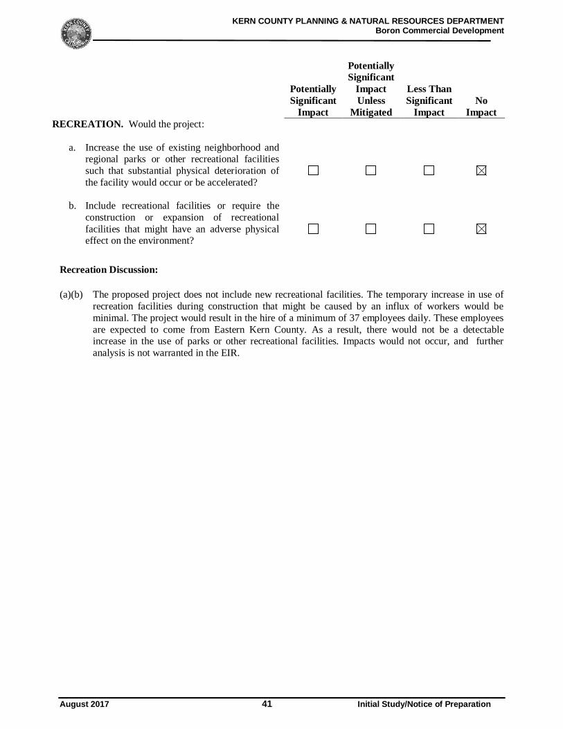
KERN COUNTY PLANNING & NATURAL RESOURCES DEPARTMENTBoron Commercial Development
August 2017 41 Initial Study/Notice of Preparation
PotentiallySignificant
Impact
PotentiallySignificant
ImpactUnless
Mitigated
Less ThanSignificant
ImpactNo
ImpactRECREATION. Would the project:
a. Increase the use of existing neighborhood andregional parks or other recreational facilitiessuch that substantial physical deterioration ofthe facility would occur or be accelerated?
b. Include recreational facilities or require theconstruction or expansion of recreationalfacilities that might have an adverse physicaleffect on the environment?
Recreation Discussion:
(a)(b) The proposed project does not include new recreational facilities. The temporary increase in use ofrecreation facilities during construction that might be caused by an influx of workers would beminimal. The project would result in the hire of a minimum of 37 employees daily. These employeesare expected to come from Eastern Kern County. As a result, there would not be a detectableincrease in the use of parks or other recreational facilities. Impacts would not occur, and furtheranalysis is not warranted in the EIR.
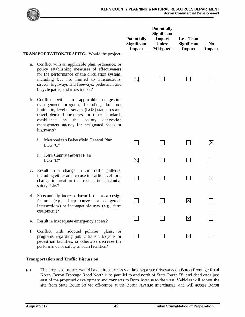
KERN COUNTY PLANNING & NATURAL RESOURCES DEPARTMENTBoron Commercial Development
August 2017 42 Initial Study/Notice of Preparation
PotentiallySignificant
Impact
PotentiallySignificant
ImpactUnless
Mitigated
Less ThanSignificant
ImpactNo
ImpactTRANSPORTATION/TRAFFIC. Would the project:
a. Conflict with an applicable plan, ordinance, orpolicy establishing measures of effectivenessfor the performance of the circulation system,including but not limited to intersections,streets, highways and freeways, pedestrian andbicycle paths, and mass transit?
b. Conflict with an applicable congestionmanagement program, including, but notlimited to, level of service (LOS) standards andtravel demand measures, or other standardsestablished by the county congestionmanagement agency for designated roads orhighways?
i. Metropolitan Bakersfield General Plan LOS "C"
ii. Kern County General Plan LOS "D"
c. Result in a change in air traffic patterns,including either an increase in traffic levels or achange in location that results in substantialsafety risks?
d. Substantially increase hazards due to a designfeature (e.g., sharp curves or dangerousintersections) or incompatible uses (e.g., farmequipment)?
e. Result in inadequate emergency access?
f. Conflict with adopted policies, plans, orprograms regarding public transit, bicycle, orpedestrian facilities, or otherwise decrease theperformance or safety of such facilities?
Transportation and Traffic Discussion:
(a) The proposed project would have direct access via three separate driveways on Boron Frontage RoadNorth. Boron Frontage Road North runs parallel to and north of State Route 58, and dead ends justeast of the proposed development and connects to Born Avenue to the west. Vehicles will access thesite from State Route 58 via off-ramps at the Boron Avenue interchange, and will access Boron
KERN COUNTY PLANNING & NATURAL RESOURCES DEPARTMENTBoron Commercial Development
August 2017 43 Initial Study/Notice of Preparation
Frontage Road North from Boron Avenue. The potential impact of the project operational andconstruction traffic on the area roadway system, and internally within the project, will be evaluatedin the EIR.
(b) (i) The proposed project site is not located in or near the metropolitan Bakersfield area. Therefore, nofurther analysis of this topic is warranted.
(ii) Construction of the project would generate construction trips. Operation of the proposed projectwould also generate trips on local roadways. The potential impacts of these trips on the LOS of arearoadways will be evaluated in the EIR.
(c) The closest public and private airports on the project vicinity include: California City Airport(approximately 22 miles northwest), Edwards Air Force Base (12 miles south) and the Mojave Airand Space Port (approximately 30 miles west). The project would not result in an increase in airtraffic levels or a change in location of air traffic patterns that would result in substantial safety risks.Because air traffic patterns would not be affected (i.e., the only mode of transport affected by theproject is automobile/truck operations). Therefore, impacts related to change in air traffic patternswould be less than significant, and further analysis is not warranted in the EIR.
(d) The proposed project would not include the development of sharp curves, dangerous intersections orother hazardous design features. Therefore, the project would not substantially increase hazards dueto a design feature or incompatible uses. Impacts would be less than significant and will be furtherevaluated in the EIR.
(e) The potential for project-related traffic to result in inadequate emergency access will be evaluated inthe EIR.
(f) Project consistency with adopted policies, plans or programs regarding transportation/circulation willbe evaluated in the EIR.
KERN COUNTY PLANNING & NATURAL RESOURCES DEPARTMENTBoron Commercial Development
August 2017 44 Initial Study/Notice of Preparation
PotentiallySignificant
Impact
PotentiallySignificant
ImpactUnless
Mitigated
Less ThanSignificant
ImpactNo
Impact
UTILITIES AND SERVICE SYSTEMS. Would the project:
a. Exceed wastewater treatment requirements ofthe applicable Regional Water Quality ControlBoard?
b. Require or result in the construction of newwater or wastewater treatment facilities orexpansion of existing facilities, theconstruction of which could cause significantenvironmental effects?
c. Require or result in the construction of newstormwater drainage facilities or expansion ofexisting facilities, the construction of whichcould cause significant environmental effects?
d. Have sufficient water supplies available toserve the project from existing entitlements andresources, or would new or expandedentitlements be needed?
e. Result in a determination by the wastewatertreatment provider which serves or may servethe project that it has adequate capacity toserve the project’s projected demand inaddition to the provider’s existingcommitments?
f. Be served by a landfill with sufficientpermitted capacity to accommodate theproject’s solid waste disposal needs?
g. Comply with federal, state, and local statutesand regulations related to solid waste?
Utilities and Service Systems Discussion:
(a)(b) The project would generate a volume of wastewater. The proposed project’s sanitary sewer dischargewill be collected by Boron Community Services District, as the proposed site is located within thesanitary sewer service district boundary area. At this time new water or wastewater treatmentfacilities or expansion of existing facilities are not being proposed. This will be further evaluated inthe EIR.

KERN COUNTY PLANNING & NATURAL RESOURCES DEPARTMENTBoron Commercial Development
August 2017 45 Initial Study/Notice of Preparation
(c) Additional stormwater runoff generated as a result of the development of the proposed project wouldbe collected on site and drained to a private stormwater conveyance system that will discharge into aproposed retention basin at the west end of the proposed project site. The proposed retention basinwill be designated in accordance to the Kern County Development Standards. This issue will beaddressed in the EIR.
(d) The proposed project’s potable water will be supplied by Boron Community Services District, as thesite is located within the water service boundary area. It is anticipated a water main will be extendedeast along Boron Frontage Road north from the intersection of Boron Avenue and Boron FrontageNorth to serve the project site. This will be further evaluated in the EIR.
(e) As previously mentioned, the proposed project’s sanitary sewer discharge will collected by BoronCommunity Services District, as the proposed site is located within the sanitary sewer service districtboundary area. This will be further evaluated in the EIR.
(f) The project is expected to generate an amount of waste and the capacity of local landfill needs to beevaluated. Waste generated from the proposed project includes construction, commercial andindustrial wastes. Disposal of potential hazardous waste will need to be addressed. These issues willbe further evaluated in the EIR.
(g) The project would generate solid waste during construction and operation of the project, thusrequiring the consideration of waste reduction and recycling measures. The 1989 CaliforniaIntegrated Waste Management Act (AB939) requires Kern County to attain specific waste diversiongoals. In addition, the California Solid Waste Reuse and Recycling Access Act of 1991, as amended,requires expanded or new development projects to incorporate storage areas for recycling bins intothe project design. The need for mitigation measures to confirm that the proposed project willcomply with the 1989 California Integrated Waste Management Act and the 1991 California SolidWaste Reuse and Recycling Access Act of 1991, as amended will be evaluated in the EIR.
KERN COUNTY PLANNING & NATURAL RESOURCES DEPARTMENTBoron Commercial Development
August 2017 46 Initial Study/Notice of Preparation
PotentiallySignificant
Impact
PotentiallySignificant
ImpactUnless
Mitigated
Less ThanSignificant
ImpactNo
Impact
MANDATORY FINDINGS OF SIGNIFICANCE
a. Does the project have the potential to degradethe quality of the environment, substantiallyreduce the habitat of a fish or wildlife species,cause a fish or wildlife population to dropbelow self-sustaining levels, threaten toeliminate a plant or animal community,substantially reduce the number or restrict therange of a rare or endangered plant or animal,or eliminate important examples of the majorperiods of California history or prehistory?
b. Does the project have impacts that areindividually limited, but cumulativelyconsiderable? (“Cumulatively considerable”means that the incremental effects of a projectare significant when viewed in connection withthe effects of past projects, the effects of othercurrent projects, and the effects of probablefuture projects)?
c. Does the project have environmental effectswhich would cause substantial adverse effectson human beings, either directly or indirectly?
Mandatory Findings of Significance Discussion:
(a) The EIR’s biological and cultural resources sections will discuss specific impacts from the project onplants and wildlife, and historical resources. The document will also evaluate the project’scontribution to cumulative resource impacts that is designed to reduce the impact to less-than-significant levels, where feasible.
(b) The proposed project has the potential to cumulatively contribute to aesthetics, air quality, biologicalresources, cultural resources, greenhouse gas emissions, and traffic impacts. The EIR will evaluatethe project’s contribution to cumulative impacts in these and other resources areas.
(c) The proposed project has the potential to cause substantial adverse effects on human beings, eitherdirectly or indirectly. Potential adverse effects on human beings resulting from environmental effectswill be evaluated in the EIR.