STATE OF NORTH CAROLINA … On-Hold...STATE OF NORTH CAROLINA DEPAR1MENTOFTRANSPORTATION...
23
STATE OF NORTH CAROLINA DEPAR1MENT OF TRANSPORTATION PAT 1.. MCCRORY GOVERNOR March 15,2013 N.C. Division of Water Quality 585 Waughtown St. Winston-Salem, NC 27107 ATTN: Ms. Amy Euliss NCDOT Division 7 Coordinator ANTHONY J. TATA SECRETARY SUBJECT: Response to On-hold Letter for Section 401 Water Quality Certification and Jordan Lake Watershed Riparian Buffer Authorization Application for the replacement of Bridge No. 161 over North Prong Stinking Quarter Creek on SR 1124 (Stafford Mill Road), Alamance County, North Carolina. Federal Aid Project No. BRZ - 1124 (5), TIP No. B-4401. REFERENCE: Application for Section 401 Water Quality Certification and Jordan Lake Watershed Riparian Buffer Authorization and Notice of Intent to Use Section 404 Nationwide Permits 3 and 13, dated February 20,2013. Per your on-hold letter, dated February 25, 2013, the N.C. Department of Transportation (NCDOT) has reviewed the permit application packet and addressed the issues that you had identified. Revisions resulting from this review include the following: • The Stormwater Management Plan (SMP) has been updated to sufficiently discuss the stormwater design of the project and the portions of the SMP that were either incomplete or absent in our original submission have been revised and/or added. • The buffer drawings were revised because, after review, it was determined that the buffer impacts resulting from two lateral base ditches should have been considered "Mitigable" along their entire length; however, the portions of the ditches that ran through the "Bridge" buffer impact zone were considered "Allowable" in our original permit application. The hatching for these impacts has been updated on the buffer drawings to reflect this change and the buffer impacts have been updated on the buffer impact summary sheet and in the Pre-Construction Notification (PCN). • The addition of these new "Mitigable" buffer impacts required NCDOT to request a revised Mitigation Acceptance Letter from the N.C. Ecosystem Enhancement Program (EEP). MAILING ADDRESS: NC DEPARTMENT OFTRANSPORTATION PROJECT DEVELOPMENT AND ENVIRONMENTAL ANALYSIS NATURAL ENVIRONMENT SECTION 1598 MAIL SERVICE CENTER RALEIGH NC 27699-1598 TELEPHONE: 919-707-6100 FAX: 919-212-5785 WEBSITE: PHYSICAL ADDRESS: Century Center - Building B 1020 Birch Ridge Dr Raleigh. NC 27610-4328
Transcript of STATE OF NORTH CAROLINA … On-Hold...STATE OF NORTH CAROLINA DEPAR1MENTOFTRANSPORTATION...
STATE OF NORTH CAROLINA
DEPAR1MENTOF TRANSPORTATIONPAT 1.. MCCRORY
GOVERNOR
March 15,2013
N.C. Division of Water Quality585 Waughtown St.Winston-Salem, NC 27107
ATTN: Ms. Amy EulissNCDOT Division 7 Coordinator
ANTHONY J. TATASECRETARY
SUBJECT: Response to On-hold Letter for Section 401 Water Quality Certificationand Jordan Lake Watershed Riparian Buffer Authorization Applicationfor the replacement of Bridge No. 161 over North Prong Stinking Quarter Creekon SR 1124 (Stafford Mill Road), Alamance County, North Carolina. FederalAid Project No. BRZ - 1124 (5), TIP No. B-4401.
REFERENCE: Application for Section 401 Water Quality Certification and Jordan LakeWatershed Riparian Buffer Authorization and Notice of Intent to Use Section404 Nationwide Permits 3 and 13, dated February 20,2013.
Per your on-hold letter, dated February 25, 2013, the N.C. Department of Transportation(NCDOT) has reviewed the permit application packet and addressed the issues that you hadidentified. Revisions resulting from this review include the following:
• The Stormwater Management Plan (SMP) has been updated to sufficiently discuss thestormwater design of the project and the portions of the SMP that were either incompleteor absent in our original submission have been revised and/or added.
• The buffer drawings were revised because, after review, it was determined that the bufferimpacts resulting from two lateral base ditches should have been considered "Mitigable"along their entire length; however, the portions of the ditches that ran through the"Bridge" buffer impact zone were considered "Allowable" in our original permitapplication. The hatching for these impacts has been updated on the buffer drawings toreflect this change and the buffer impacts have been updated on the buffer impactsummary sheet and in the Pre-Construction Notification (PCN).
• The addition of these new "Mitigable" buffer impacts required NCDOT to request arevised Mitigation Acceptance Letter from the N.C. Ecosystem Enhancement Program(EEP).
MAILING ADDRESS:NC DEPARTMENT OFTRANSPORTATIONPROJECT DEVELOPMENT AND ENVIRONMENTAL ANALYSIS
NATURAL ENVIRONMENT SECTION
1598 MAIL SERVICE CENTERRALEIGH NC 27699-1598
TELEPHONE: 919-707-6100
FAX: 919-212-5785
WEBSITE: WW'~:NCDOT.OR(;
PHYSICAL ADDRESS:Century Center - Building B
1020 Birch Ridge DrRaleigh. NC 27610-4328

The wetland and stream permit drawings and the impacts presented in them have not changedsince the submission ofthe original permit application.
Please find enclosed revised versions of the PCN, EEP Mitigation Acceptance Letter, SMP, andbuffer drawings. We hope that this new information addresses all of your concerns regarding theproject and will allow you to proceed with processing the permit application.
A copy of this on-hold . response packet will be posted on the NCDOT Website . at:https ://connect.ncdot.gov/resources/Environmental/Pages/default.aspx . .
Thank you for your assistance with this project. If you have ally questions or need additionalinformation, please contact Jim Mason at either [email protected] or (919) 707-6136.
O/sef",;p~ Gregory J. Thorpe, Ph.D., Manager
Project Development and Environmental Analysis Unit
cc: NCDOT Permit Application Standard Distribution ListMr. Andrew Williams, USACE
.....,.:..--
8-440 I Response to On-hold Letter2

Office Use Only:Corps action 10 no. _
DWQ project no. _
Form Version 1.3 Dec 10 2008
Pre-Construction Notification (PCN) Form
A. Applicant Information
1. Processing
1a. Type(s) of approval sought from theD Section 404 Permit D Section 10 Permit
Corps:
1b. Specify Nationwide Permit (NWP) number: 3 13 or General Permit (GP) number:
1c. Has the NWP or GP number been verified by the Corps? DYes [8J No
1d. Type(s) of approval sought from the DWQ (check all that apply):
[8J 401 Water Quality Certification - Regular D Non-404 Jurisdictional General Permit
D 401 Water Quality Certification - Express [8J Riparian Buffer Authorization
1e. Is this notification solely for the record For the record only for DWQ 401 For the record only for Corps Permit:because written approval is not required? Certification:
DYes [8J No [8J Yes DNo
H. Is payment into a mitigation bank or in-lieu fee program proposed for mitigation [8J Yes DNoof impacts? If so, attach the acceptance letter from mitigation bank or in-lieufee program.
19. Is the project located in any of NC's twenty coastal counties. If yes, answer 1h DYes [8J Nobelow.
1h. Is the project located within a NC DCM Area of Environmental Concern (AEC)? DYes [8J No1---.
2. Project Information
2a. Name of project:Replacement of Bridge No. 161 over North Prong Stinking Quarter Creek on SR 1124(Stafford Mill Road)
2b. County: Alamance
2c. Nearest municipality / town: Kimesville
2d. Subdivision name: not applicable
2e. NCDOT only, T.I.P. or stateB-4401
project no:
3. Owner Information
3a. Name(s) on Recorded Deed: North Carolina Department of Transportation........... - ... _.. .~---- ~----_ ..._...._--.._._-_ .._-
--~_.-.--..-'". ----_.~--_._._---"- ._ ....•- --
::So. Deed Book and Page No. not applicable
3c. Responsible Party (for LLC ifnot applicable
applicable):
3d. Street address: 1598 Mail Service Center
3e. City, state, zip: Raleigh, NC 27699.. 1598
3f. Telephone no.: (919) 707-6136
3g. Fax no.: (919) 212-5785
3h. Email address: jsmason @ ncdot.gov
4. Applicant Information (if different from owner)
4a. Applicant is: o Agent o Other, specify:
4b. Name: not applicable--
4c. Business name__ (if applicable):
4d. Street address:
4e. City, state, zip:f---.
4f. Telephone no.:
4g. Fax no.:1------ -
4h. Email address:
5. Agent/Consultant Information (if applicable)--_.
Sa. Name: not applicablef--- ._-----..- ..-
5b. Business name(if applicable):
1-----.
5c. Street address:
5d. City, state, zip:1--. -
5e. Telephone no.:-----Sf. Fax no.:
5g. Email address:
2
B. Project Information and Prior Project History
1. Property Identification
1a. Property identification no. (tax PIN or parceIID): not applicable
1b. Site coordinates (in decimal degrees):Latitude: 35.9747 Longitude: - 79.5336
(DDDDDDDD) (-DD.DDDDDD)
1c. Property size: 1.8 acres
2. Surface Waters
2a. Name of nearest body of water (stream, river, etc.) toNorth Prong Stinking Quarter Creek
proposed project:
2b. Water Quality Classification of nearest receiving water: . WS-V NSW
2c. River basin: Cape Fear
3. Project Description
3a. Describe the existing conditions on the site and the general land use in the vicinity of the project at the time of thisapplication:
SR 1124 is classified as a Rural Local Route. Land use within the vicinity includes Forested Land, Agriculture,Silviculture, and Low- to Medium-Density Residential.
3b. List the total estimated acreage of all existing wetlands on the property:
0.02 acres
3c. List the total estimated linear feet of all existing streams (intermittent and perennial) on the property:170 linear feet
3d. Explain the purpose of the proposed project:To replace a structurally deficient and functionally obsolete bridge.
3e. Describe the overall project in detail, including the type of equipment to be used:The project consists of replacing the existing four-span, 106-foot long bridge with a three-span, 140-foot bridge. Trafficwill be maintained via an off-site detour. Temporary causeways will be installed on both sides of the creek to assist withbridge demolition and construction; causeways will not be simultaneously placed in the creek. Standard road buildingequipment, such as trucks, dozers, and cranes will be used.
4. Jurisdictional Determinations
4a. Have jurisdictional wetland or stream determinations by theCorps or State been requested or obtained for this property /project (including all prior phases) in the past? IZI Yes DNo D UnknownComments: Site visit by USACE and NCDWQ on 3/8/10;NCDWQ JD received 3/15/10, USACE JD pending.
4b. If the Corps made the jurisdictional determination, what type IZI Preliminary D Finalof determination was made?
.-~ ,- !f /:S, who dolinoatsd tr,2 jurisdictional areas? Aqency/Consultant Company: NCDOT. _.Name (if known): Principal Investigator: Jim Mason Other:
4d. If yes, list the dates of the Corps jurisdictional determinations or State determinations and attach documentation.NCDWQ - March 15, 2010
5. Project History
5a. Have permits or certifications been requested or obtained forDYes IZI No D Unknown
this project (including all prior phases) in the past?
5b. If yes, explain in detail according to "help file" instructions.
3
6. Future Project Plans
6a. Is this a phased project? IDYes IZI No
6b. If yes, explain.
4

c. Proposed Impacts Inventory
1. Impacts Summary
1a. Which sections were completed below for your project (check all that apply):
~ Wetlands ~ Streams - tributaries ~ Buffers
o Open Waters o Pond Construction
2. Wetland ImpactsIf there are wetland impacts proposed on the site, then complete this question for each wetland area impacted.2a. 2b. 2c. 2d. 2e. 2f.
Wetland impact Type of jurisdictionnumber- Type of impact Type of wetland Forested (Corps - 404,10 Area of impact
Permanent (P) or (if known) OWQ - non-404, other) (acres). Temporary (T)
Site 1 0 PDTDYes o CorpsONo DOWQ
Site 2 0 PDTDYes o CorpsDNa OOWQ
Site 3 0 PDTDYes o CorpsDNa OOWQ
Site 4 0 PDTDYes o CorpsDNa OOWQ
Site 5 0 PDTDYes o CorpsDNa OOWQ
Site 6 0 pDTDYes o CorpsDNa OOWQ
2g. Total wetland impactsoPerm.oTemp.
2h. Comments: The entirety of Wetland WA (emergent, Non-tidal Freshwater Marsh), totaling 0.01 acres, will be hand-cleared.
3. Stream ImpactsIf there are perennial or intermittent stream impacts (including temporary impacts) proposed on the site, then complete thisquestion for all stream sites impacted.
3a. 3b. 3c. 3d. 3e. 3f. 3g.Stream impact Type of impact Stream name Perennial Type of Average Impact length
number - (PER) or jurisdiction stream (linear feet)Permanent (P) or intermittent (Corps - 404, 10 width
Temporary (T) (INT)? OWQ - non-404, (feet)other)
Temporary North Prong~PER ~ Corps
Site 1 0 P ~ T Rock Stinking QuarterDINT OOWQ
30-35 29Causeways Creek
BankNorth Prong
~PER ~ CorpsSite 2 ~ PDT
StabilizationStinking Quarter
DINT OOWQ30-35 87
Creek
o PER o Corps--
Site 3 0 PDTDINT OOWQ
Site 4 0 PDTo PER o CorpsDINT OOWQ
Site 5 ~POTo PER o CorpsDINT OOWQ
Site 6 OPOTo PER o CorpsDINT OOWQ
3h. Total stream and tributary impacts87 Perm29 Temp
5
3i. Comments:
4. Open Water Impacts
If there are proposed impacts to lakes, ponds, estuaries, tributaries, sounds, the Atlantic Ocean, or any other open water ofthe U.S. then individuallv list all open water impacts below.4a. 4b. 4c. 4d. 4e.
Open water Name ofimpact number- waterbody Type of impact Waterbody type Area of impact (acres)Permanent (P) or (if applicable)
Temporary (T)
01 DpDT
02 D pDT
03 DpDT
04 D PDT
41. Total open water impactsoPermanentoTemporary
4g. Comments:
5. Pond or Lake Construction
If pond or lake construction proposed, then complete the chart below.5a. 5b. 5c. 5d. 5e.
Wetland Impacts (acres) Stream Impacts (feet) UplandPond 10 Proposed use or (acres)number purpose of pond ExcavatFlooded Filled
edFlooded Filled Excavated Flooded
P1
P2
5f. Total
5g. Comments:
5h. Is a dam high hazard permit required?DYes DNo If yes, permit 10 no:
5i. Expected pond surface area (acres):
5j. Size of pond watershed (acres):
5k. Method of construction:
6
6. Buffer Impacts (for DWQ)
If project will impact a protected riparian buffer, then complete the chart below. If yes, then individually list all bufferimpacts below. If any impacts require mitiqation, then you MUST fill out Section D of this form.
6a.D Neuse D Tar-Pamlico [8] Other: Jordan
.Project is in which protected basin? D Catawba D Randleman
6b. 6c. 6d. 6e. 6f. 6g.Buffer impact
number- Reason for impact Buffer Zone 1 impact Zone 2 impactPermanent (P) or Stream name mitigation (square feet) (square feet)
Temporary (T) required?North Prong DYesB1 [8] pDT Bridge Stinking Quarter
[8] No3,538 1,788
Creek
North Prong [8] YesB2 [8] pDT Road Crossing Stinking Quarter
DNo291 2,619
CreekRoad Impacts OtherThan Crossings of North Prong [8] Yes
B3 [8] pDT Streams and Other Stinking QuarterDNa
14 519Surface Waters (Parallel Creek
Impacts)
Protection of ExistingStructures, Facilities,
and Stream Banks When North Prong DYesB4 [8] pDT This Requires Additional Stinking Quarter [8] No1,202 573
Disturbance of the CreekRiparian Buffer or the
Stream Channel
North Prong [8] YesB5 [8] pDT Ditch Impacts Stinking Quarter
DNa446 342
Creek
6h. Total buffer impacts 5,491 5,841
6i. Comments: Wetland in Buffer Impacts: 263 square feet in Zone 1, 139 square feet in Zone 2, all of which are within the"Protection of existing structures, facilities, and stream banks when this requires additional distrubance of the riparianbuffer or the stream channel" buffer impact type, which is Allowable.
7

D. Impact Justification and Mitigation
1. Avoidance and Minimization
1a. Specifically describe measures taken to avoid or minimize the proposed impacts in designing project.
An off-site detour will be employed; A special cut ditch with a Class B rip-rap pad at its terminus will be installed betweenSTA. 13+50 and STA. 14+25 LT; A pre-formed scour hole will be installed at STA. 15+80 RT; A rip-rap-lined lateral baseditch underlain with filter fabric will be installed between STA. 16+40 and STA. 18+50 LT. At the ditch's origin will be a an18-inch reinforced concrete pipe; at its terminus will be Class I rip-rap underlain with filter fabric starting at the end of theditch and extending to/onto the streambank; A PSRM-lined lateral base ditch will be installed between STA. 16+90 andSTA. 17+40 RT.
1b. Specifically describe measures taken to avoid or minimize the proposed impacts through construction techniques.
NCDOT Best Management Practices for Bridge Demolition and Removal will be implemented during the removal of theexisting bridge; Best Management Practices for the Protection of Surface Waters will be employed; Additionally, since thisproject is located within the Jordan Lake Watershed and buffer rules apply, Design Standards in Sensitive Watershedswill be employed.
2. Compensatory Mitigation for Impacts to Waters of the U.S. or Waters of the State
2a. Does the project require Compensatory Mitigation for r8]Yes DNoimpacts to Waters of the U.S. or Waters of the State?
If no, explain:
2b. If yes, mitigation is required by (check all that apply): r8] DWQ D Corps
D Mitigation bank2c. If yes, which mitigation option will be used for this
r8] Payment to in-lieu fee programproject?
D Permittee Responsible Mitiqation
3. Complete if Using a Mitigation Bank
3a. Name of Mitigation Bank: not applicable
IType IQuantity
--3b. Credits Purchased (attach receipt and letter)
3c. Comments:--
4. Complete if Making a Payment to In-lieu Fee Program.-
4a. Approval letter from in-lieu fee program is attached. r8] Yes.-
4b. Stream mitigation requested: o linear feet..
4c. If using stream mitiqation, stream temperature: Dwarm Dcool Ocold~ --_. ---~ -.
4d. Buffer mitigation requested (DWQ only): 7,473 square feet
4e. Riparian wetland mitigation requested: oacres
4f. Non-riparian wetland mitigation requested: o acres
4g. Coastal (tidal) wetland mitigation requested: o acres
4h. Comments:
5. Complete if Using a Permittee Responsible Mitigation Plan
5a. If using a permittee responsible mitigation plan, provide a description of the proposed mitigation plan.
8

6. Buffer Mitigation (State Regulated Riparian Buffer Rules) - required by DWQ
6a. Will the project result in an impact within a protected riparian buffer that requires ~Yes DNobuffer mitigation?
6b. If yes, then identify the square feet of impact to each zone of the riparian buffer that requires mitigation. Calculate theamount of mitigation required.
6c. 6d. 6e.
Zone Reason for impact Total impact Multiplier Required mitigation(square feet) (square feet)
Zone 1Road Crossing/Parallel
751 3 (2 for Catawba) 2,253Impact/Ditches
Zone 2 Road Crossing/Parallel3,480 1.5 5,220
Impact/Ditches
6f. Total buffer mitigation required: 7,473
6g. If buffer mitigation is required, discuss what type of mitigation is proposed (e.g., payment to private mitigation bank,permittee responsible riparian buffer restoration, payment into an approved in-lieu fee fund).
Payment into an approved in-lieu fee fund (EEP)
6h. Comments:
9
E. Stormwater Management and Diffuse Flow Plan (required by DWQ)
1. Diffuse Flow Plan
1a. Does the project include or is it adjacent to protected riparian buffers identified [8] Yes ONo
within one of the NC Riparian Buffer Protection Rules?
1b. If yes, then is a diffuse flow plan included? If not, explain why.ONo[8] Yes
Comments: See buffer drawings
2. Stormwater Management Plan
2a. What is the overall percent imperviousness of this project? N/A
2b. Does this project require a Stormwater Management Plan? [8] Yes ONo
2c. If this project DOES NOT require a Stormwater Management Plan, explain why:
2d. If this project DOES require a Stormwater Management Plan, then provide a brief, narrative description of the plan:
See attached permit drawings.
o Certified Local Government2e. Who will be responsible for the review of the Stormwater Management Plan? o DWO Stormwater Program
[8] DWO 401 Unit
3. Certified Local Government Stormwater Review
3a. In which local government's jurisdiction is this project? not applicable
o Phase"
3b. Which of the following locally-implernented stormwater management programs ONSWOUSMPapply (check all that apply): o Water Supply Watershedo Other:
3c. Has the approved Stormwater Management Plan with proof of approval been DYes ONoattached?
4. DWQ Stormwater Program Review
0 Coastal counties4a. Which of the following state-implemented stormwater management programs apply 0 HOW
(check all that apply): 0 ORW0 Session Law 2006-246n flth"'r·~
4b. Has the approved Stormwater Management Plan with proof of approval beenDYes ONoattached?
5. DWO 401 Unit Stormwater Review
5a. Does the Stormwater Management Plan meet the appropriate requirements? DYes o No N/A
5b. Have all of the 401 Unit submittal requirements been rnet? DYes o No N/A
10

F. Supplementary Information
1. Environmental Documentation (DWQ Requirement)
1a. Does the project involve an expenditure of public (federal/state/local) funds or the~Yes DNouse of public (federal/state) land?
1b. If you answered "yes" to the above, does the project require preparation of anenvironmental document pursuant to the requirements of the National or State ~Yes DNo(North Carolina) Environmental Policy Act (NEPNSEPA)?
1c. If you answered "yes" to the above, has the document review been finalized by theState Clearing House? (If so, attach a copy of the NEPA or SEPA final approval
~Yes DNoletter.)
Comments:
2. Violations (DWQ Requirement)
2a. Is the site in violation of DWQ Wetland Rules (15A NCAC 2H .0500), IsolatedWetland Rules (15A NCAC 2H .1300), DWQ Surface Water or Wetland Standards, DYes ~Noor Riparian Buffer Rules (15A NCAC 2B .0200)?
2b. Is this an after-the-fact permit application? DYes ~No
2c. If you answered "yes" to one or both of the above questions, provide an explanation of the violation(s):
3. Cumulative Impacts (DWQ Requirement)
3a. Will this project (based on past and reasonably anticipated future impacts) result in DYes
additional development, which could impact nearby downstream water quality? ~No
3b. If you answered "yes" to the above, submit a qualitative or quantitative cumulative impact analysis in accordance with themost recent DWQ policy. If you answered "no," provide a short narrative description.
Due to the minimal transportation impact resulting from this bridge replacement, this project will neither influence nearbyland uses nor stimulate growth. Therefore, a detailed indirect or cumulative effects study will not be necessary.
4. Sewage Disposal (DWQ Requirement)
4a. Clearly detail the ultimate treatment methods and disposition (non-discharge or discharge) of wastewater generated fromthe proposed project, or available capacity of the subject facility.
not applicable
11
5. Endangered Species and Designated Critical Habitat (Corps Requirement)
5a. Will this project occur in or near an area with federally protected species orDYes ~No
habitat?
5b. Have you checked with the USFWS concerning Endangered Species Act [8J Yes DNo. impacts?
[8J Raleigh5c. If yes, indicate the USFWS Field Office you have contacted.
Asheville0
5d. What data sources did you use to determine whether your site would impact Endangered Species or Designated CriticalHabitat?
NC Natural Heritage Program data , USFWS website, NCDOT survey for bald eagle (no threatened or endangeredspecies listed for Alamance Co.).
6. Essential Fish Habitat (Corps Requirement)
6a. Will this project occur in or near an area designated as essent ial fish habitat? DYes ~No
6b. What data sources did you use to determine whether your site would impact Essential Fish Habitat?
NMFS County Index
7. Historic or Preh istoric Cultural Resources (Corps Req uirement)
7a. Will this project occur in or near an area that the state, federal or tribalgovernments have designated as having historic or cultural preservation
DYes ~Nostatus (e.g., National Historic Trust designation or properties significant inNorth Carolina history and archaeology)?
7b. What data sources did you use to determine whether your site would impact historic or archeological resources?
NEPA Documentation
8. Flood Zone Designati on (Corps Requirement)
8a. Will this project occur in a FEMA-designated 1OO-year floodplain? [8J Yes DNo
8b. If yes, explain how project meets FEMA requirements : NCDOT Hydraulics Unit coordination with FEMA
8c. What source(s) did you use to make the floodplain determination? FEMA Maps
. <
,
Er-:!UJk,
Dr. Gregory J. Thorpe, Ph 0 ~3 ,/5' '/3
App licant/Agent's Printed Name VAPP I~~nt/Agent's Slqnature/"Date
(Agent's signature is valid nly if an authorization letter from the applicantis provided.)
12
~~Ecosystem
PROGRAM
Mach 12,2013
Mr. Gregory J. Thorpe, Ph.D.Environmental Management DirectorProject Development and Environmental Analysis UnitNorth Carolina Department of Transportation1548 Mail Service CenterRaleigh, North Carolina 27699-1548
Dear Dr. Thorpe:
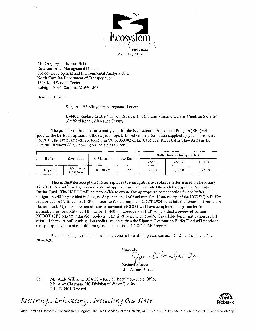
Subject: EEP Mitigation Acceptance Letter:
B-4401, Replace Bridge Number 161 over North Prong Stinking Quarter Creek on SR 1124(Stafford Road), Alamance County
The purpose of this letter is to notify you that the Ecosystem Enhancement Program (EEP) willprovide the buffer mitigation for the subject project. Based on the infonnation supplied by you on February15,2013, the buffer impacts are located in CU 03030002 of the Cape Fear River basin (Haw Ann) in theCentral Piedmont (CP) Eco-Region and are as follows: .
River BasinBuffer Impacts (in square feet)
Buffer CU Location Eco-RegionZone I Zone 2 TOTAL
ImpactsCape Fear-
03030002 CP 751.0 3,480.0 4,231.0Haw Ann
This mitigation acceptance letter replaces the mitigation acceptance letter issued on February19,2013. All buffer mitigation requests and approvals are administrated through the Riparian RestorationBuffer Fund. The NCDOT will be responsible to ensure that appropriate compensation for the buffermitigation will be provided in the agreed upon method of fund transfer. Upon receipt ofthe NCDWQ's BufferAuthorization Certification, EEP will transfer funds from the NCDOT 2984 Fund into the Riparian RestorationBuffer Fund. Upon completion of transfer payment, NCDOT will have completed its riparian buffermitigation responsibility for TIP number B-440 I. Subsequently, EEP will conduct a review of currentNCDOT ILF Program mitigation projects in the river basin to determine if available buffer mitigation creditsexist. If there are buffer mitigation credits available, then the Riparian Restoration Buffer Fund will purchasethe appropriate amount of buffer mitigation credits from NCDOT ILF Program.
~f)'(j',' ~~Ye "")' questionsor need additional information, please contact :.:v..2~~. E ...~.~;v .. ", :--:::
707-8420.
SinCerel
rl.--,
('" ~ C'"'.' Ii ~" }/,/y<~., [').. ~~:::.h"·~rk)~l,
( \) "Michael \~VlisonEEP Acting Director
Cc: Mr. Andy Williams, USACE - Raleigh Regulatory Field OfficeMs. Amy Chapman, NC Division of Water QualityFile: B-440 I Revised
RMtorUtj...E~ ... ProtectUtj Our sta:t~ !FANCDENR
North Carolina Ecosystem Enhancement Program. 1652 Mail Service Center. Raleigh. NC 27699-1652/919-707-8976/ http://porta1.ncdenr.org/web/eep
Highway North Carolina Department of Transportation
~~\Storrnvvater. t: . \I ~ < ' .. ;1\. ..." Highway Stormwater Program ~ ~
_. - ..'(~""-,=.,f~;STORMWATER MANAGEMENT PLAN ; q.'
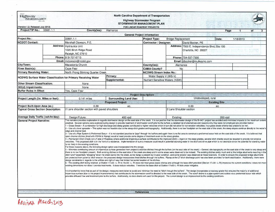
, c -- - --(Version 1.2; Released Ju ly 2012) FOR LINEAR ROADWAY PROJECTS -: ..ProjectrrlP No. : 33681.1.1 County(ies): Alamance Page 1 of 3
, <General Project Information '.
Project No.: 33681.1.1 Proiect Tvpe : Bridae Replacement Date : 1/18/2013NCDOT Contact: Marshall Clawson, P.E. Contractor 1Designer: David Boeker, PE : ;
Address : Hydraulics Unit Address: 7500 E. Independence Blvd,1Ste 100,
-1020 Birch Ridge Road Charlotte, NC 28227 .- - - -Raleiqh, NC 27610 -. .. - --
Phone: 919-707-6713 Phone: 704-537-7300Email: mclawson@ncdoLaov Email: [email protected]
CitylTown: Macedonia Church County(ies): Alamance I IRiver Basin(s): Cape Fear CAMA County? No I IPrimary Receiving Water: North Prone Stinkinq Quarter Creek NCDWQ Stream Index No.:
NCDWQ Surface Water Classification for Primary Receiving Water Primary: Water Supply V (WS-V)
Supplemental : Nutrient Sensitive Waters (NSW)Other Stream Classification: None303(d) Impa irments: NoneBuffer Rules in Effect Yes, Cape Fear
ecfDesCrlption .~7tP~1~0£~~f£ic,"*Q~~F,r~~,§21i'1i ..:1~"ti;r.~~~)t(~~~li:~.\~~~-" &'~~f?~
Project Length (lin. Miles or feet): 0.141 miles Surrounding Land Use: Undeveloped, rural
ii' ·'iii?"',·
Proiect Built-Upon Area (ac.) 0.39 ac. 0.33 ac.Typ ical Cross Section Description : 2 Lane shoulder section with paved shoulders 2 Lane Shoulder section
Average Daily Traffic (veh /hr /day) : Desiqn/Future : 400 vod Existina: 200 vodGeneral Project Narrative: This narrative provides explanation in regards stormwate r desig n on the east side of the creek. ~ is our position that the stormwater design of the B-4401 project has avoide d and minimized impacts to the maximum extend
practical. Seve ral options we re explo red during design to provide treatment of stormwater runoff prior to the buffe rs; a detailed list of alternatives and reasons why they were not empioyed are provide d below ;1 - Grass Swale - A combination for high discharge and steep grades contributed to higher velocities which in turn did not allow for non-erosion velocities: thus grass swale criteria was unable to be met.2 - Use of a level spreader - This option was not feasib le due to the steep ditch grades and topography. Additionally, there is no low floodplain on the east side of the creek , the steep slopes continue directly to the water'sedge and channel bed.3 - Use of a Pipe System & Preformed Scour - ~ is not standard practice to "pipe" through the buffe rs and again there is no flat area to construct a prefor med scour hole on the east side of the creek . It is believed thatopen-channel ditches (lined with PSR M & Ripra p) would at least provide some degree of treatme nt eve n on the steep grades .4 - Permanent Ditch Check (on LT side of Roadway where additio nal impervious surface cont ributes to the improved ditch) - Again on the steep grades , several ditch checks would be required to provide non-e rosivevelocities. This proposed ditch is in the front of a residence. Implementation of sure a measure could result in potential standing wate r in the ditch and drive pipe which is not desi rable since the potential for stand ing wate ris not likely in the existing conditions.For these reasons above , the following design option was incorporated into the design.5 - Minimize cont ributing amount of impervious surface generated fro m project & stabilize ditches through the buffers (on the east side of the creek ) - General site topography on the east side of the creek is very steep andthere is no low floodplain prese nt. Both existing ditches on the east side of the creek are steep and in some areas were observed to be incised . The exist ing ditches pretty much end at the bridge abutme nts resulting in theditch runoff essentially "dropping" down the creek banks into the creek. some riprap is prese nt but in poor cond ition. and some eros ion was observed at these locat ions. In order to ensure the proposed bridge abutme ntsare protected from potential ditch erosio n; the propose d des ign incorporates lined ditches through the buffers. Riprap at the LT ditch discharge point has also been prov ided for bank stabilization. Add itionally , there weredesign constraints in regards to the utilities and right-of-way that limited horizo ntal location of the ditches .6 - The existing ditch being retained at Stat ion 17+50 - L- Rt to 19+50 - L- Rt does not meet grass swale crietica and although the base ditch provide d (Stat ion 17+00 -L-Rt) impro ves the current conditions it does not meetexisting dim ensions nor does it provide treatments. ~ does reduce ve locites . Therefore the base ditch at Statio n 17+OO-L- Rt falls under mitigable.
It is important to know that as part of the desig n; meas ures were taken to avoi d and minimize the need to "ditch through the buffers". The design incorporates a roadway grade that ensures the majority of add itionalimpervious surface (due to the project improvements) that contribu tes to the stormwater runoff is directe d to the west side of the creek. The runoff drains to a pipe syste m and outlets via a preformed scour hole whichprovides diffused flow and treatment prior to the buffe rs. Add itionally. no deck drains will used for this project. The current design is an improvement to the existing conditions .
~eV l~~ {Vl Gv{ ~ 1o}?:J

Highw ay North Carolina Department of Transportation
~I. ' . \Storrnwater Highway Stormwater Program \., i )
I , " " ~ ~\,lol
STORMWATER MANAGEMENT PLAN <;«(Versi on 1.2; Released Ju ly 2012) FOR LINEAR ROADWAY PROJ ECTS
ProjectrrlP No.: 3368 1.1.1 County(ies): Alamance Page 2 of 3
Swales
Stream Drainage Recommended Actua l Longitudinal RockSheet Station Crossing Base Width Front Slope Back Slope Area Treatment Length Length Slope 0 2 V2 010 V10 ChecksNo. (From I To) Stat ion (ft) (H:V) (H:V) (ac) (ft) (ft) (%) (cts) (fps) (cts) (tps) Used
4 13+50 LT 14+50 0.0 4 2 0.08 8 75 1.00% 0.3 1.1 0.3 No14+25 LT 1.2
Avg. Slope = 3:1 0
0
0
0
0
0
0
0
0
0
0
0
0
0
0
0
0
0
0
0 YES o NO Have min imum des ign criter ia . as presented in the NCDOT Best Management Pract ices Toolbox, Version 1 (March 2008), been met and verified? If No ,provide furthe r explanantion of why design cri teria was not met.
I." .' .' ...• " :::: [;iN: ~"t1 ~ :>:J ;~ . ,~'f'~~'?J~J1~ R1V • ..:II •.~ ~~ IK ~lQAdditional Comments .,. _" ~o ~"f~~ ~-.,~ ~;~: : ....~r'p ;;DNJ. ~:;t. "">,
.;:.;~_!" 00 ~"" ~
~t V., ~cA vv'\ Cy(cL, un'?,

Referto the NCDOT Best Management PracticesToolbox, Version1 (March 2008),NCDOTStandard Details, the Federal HighwayAdministration (FHWA) HydraulicEngineering Circular No. 14 (HEC-14),Third Edition, Hydraulic Design of Energy Dissipators for Culverts and Channels (July 2006), as applicable, for design guidanceand criteria.
Highw a y North Carolina Department of Transportation
~S torm\vate r Highway Stormwater Program (;. ,;)• , ,.. ...~ l.\,,
~!.::~.=:;.~~-;: ISTORMWATER MANAGEMENT PLAN(Version1.2: ReleasedJuly 2012) FOR LINEAR ROADWAY PROJECTS
ProjeclfTlP No. : 3368 1.1.1 Countv(ies): Alamance PaQe 3 of 3
Preformed Scour Holes and Energy DisslpatorsPipe /Structure
Sheet Energy Dissipator Drainage Area Dimensions Ql0 Vl0No. Station Tvpe Riprap Tvne (ac) Conveyance Structure (in) (cts) (fp s)
4 15+75-L- Rt RiprapApron / Pad Class 'B' 0.23 Pipe 15 0.9 3.8
o YES o NO Have minimum design criteria , as p res en ted in th e NC DOT Best Man ag em ent Practices Toolbox (2008), NC DOT Stand ard Deta ils , o r FH W AHE C-14 (Ju ly 2006), been met and verif ied, as applicabl e? If No, provide furth er expl ana ntion of why design crite ria was not met.
,..~ ;'•. e"W' •. "~k11 ;J£.;·"~~~~~f~~t~~·'-~A : : :~,:f"')~ .':,:~Adaiti ohal Comments ' ~ '-. ::;,;::; ':.:~~~~;;;Z'" ".'" .: ~
~.. ,- . " '0 .0.
-
~0'lh sw. mtN et, L;J )~
P.E.
TOTALSHBaTS
PE
INCOMPLETE P LANSDO NOT USB FOR Rt W ACQUISITION
STATE HIGHWAY DESIGN ENGINEER
PRELIMIN ARY PLANSDO NOT USB f'OR CONSTRUCTI ON
DIVISION OF HIGHWAYSSTATE OF NORTH CAROLINA
BRZ-1l245
4
8-4401
End P ~ect B-4401-L- St .20+20.00
P.ll
33681.1.1
P.E.
.c.
,-'\ \
\ \
\ \\ \
\, \ 1124\ ',,5R __--
I \ ---- I adI >-- Mil ~ .- ---Siaf{Or
Cl<{Z
....oo
~eo
ROADWAY DESIGNENGINEER
HYDRAULICS ENGINEER
SIGNA7VR&
SIGNA TURE:
---------..End Bnd~"~. "'~Sta. ,'-----,,-- '''----.
PROJE CT ENGINEERJames Speer. PE
John lansford, PEPROJECT DESIGN ENGINEER
1000 Birch R idge D r. , Raleigh NC,27610
Prepared In the Office of:
DIVISION OF HIGHWAYS
PRODUCTIONLETTING DATE:
May 21,2013
PRODUCTIONRIGHT OF WAY DATE:
November 16, 2012
2006 S TANDARD SPECJFICilT/ONS
OF NOR1rH CAROLINAOF HIGHWAYS
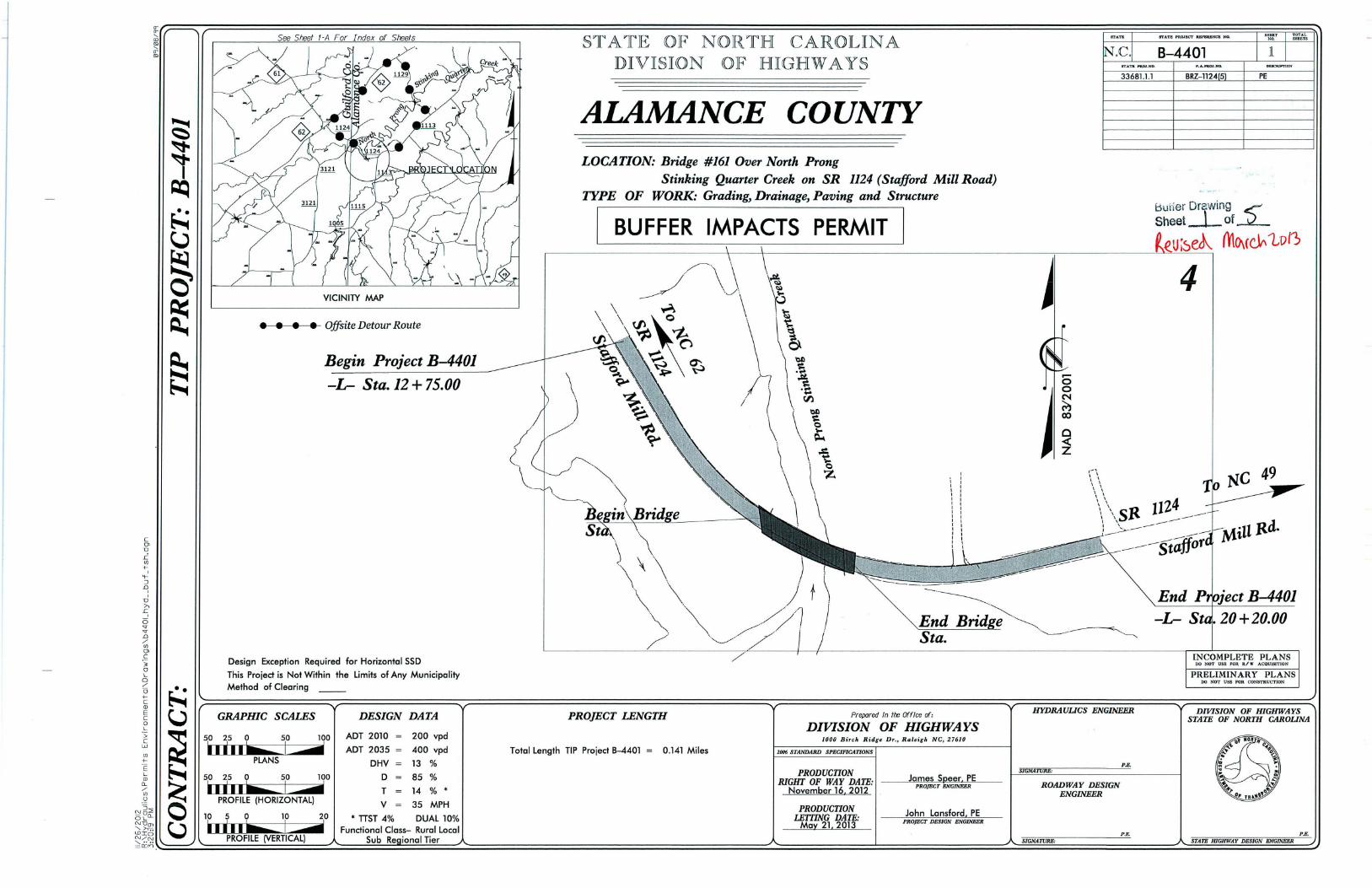
STATEDIVISION
LOCATION: Bridge #161 Over North ProngStinking Quarter Creek on SR 1124 (Stafford Mill Road)
ITPE OF WORK: Grading, Drainage, Paving and Structure
I BUFFER IMPACTS PERMIT I
ALAMANCE COUNTY
PROJECT LENGTH
~~::~~~f2~U;~eJ\ mO\(~'tv i)
c---------------\---+------------------------,--------L:~~_=_______,
Total length TIP Project 8-4401 = 0.141 Miles
DESIGN DATA
Begin Project B-4401
-L- Sta. 12+75.00
VICINITY MAP
100 ADT 2010 = 200 vpd
d ADT 2035 = 400 vpd
DHV 13 %
100 D 85 %
T 14 % •
V 35 MPH10 • TTST 4% DUAL 10%
Functional Class- Rural localSub Re ional Tier
• • • • Offsite Detour Route
Design Exception Required for Horizontal SSD
This Project is Not Within the Limits of Any MunicipalityMethod of Clearing __
GRAPHIC SCALES
50 25 a
c(J>
TI
.cU)
+-,.....:J.0,,TI;>,i:,6'T'T.0./U)(J>
,C;3oLo./
a+c(j)
EcoL
>CwU)
+-'EL(j)(L
./U)
,Y.N~2OLD....NTI(J)""-.:;>, -;;;W ION./N
~ n:~~==~~==:========~::=:====:::::=~=~~========================================~~=============================~~===================::::.:::::========~

300 '
4SHEET NO.
HYDRAUUCSENGINEER
200'
W'H SHEET NO.
B-4401PROJECT REFERENCE NO.
ROA DWAY DESIGNENGINEER
ALLOWABLE IMPACTS ZO NE 1
M ITIGABLE IMPACTS ZONE 1
ALLOWABLE IM PA CTS ZONE 2
roo'
~ MI TIGABL E IMPACTS ZON E 2
,,>8
B=: 4 ft.
0 ::: 1 ft
w= .4 ft.
WOODS
INUAlll£VH .....·40 flUS Hwrra NATUIiAL GRQUrJO
j
0'
STA. 15 -I-eo RT
SEqlON itA
\\\
m~..o o,""~ .,,~ \
\•
roo'
DETAIL F - PREFORMED SCOUR HOLE' NO T TO SCALE
PlAN VIEW
~ PIPE {d, - 151
~ ! ~O
,"FLOW~ ~l ~b'(Jh,/;L1NEl; ClASS 6 IW'AAP --.J Il- B--l' /'WT1ll flLTEll f ABRIC ~N. l' TUCK
lti pRop ;"bcmnof Ul-.t Ivf dorilt
J.W. BROWN, HEIRS
~
Design Exceptfon Required f or Horizontal SSD (25mph)See Smet 5 for - L- ProfileSee Steet S-I Thru S- For Str ucture PlansSee Steet J-A for Stoulde: Berm Gutter (SBG)Summary
Min.O .. 1 11.Ma,;.d .. 1 ft .8 ., 3 ft .1> - 5 Ft.
WOODS
LATERAl BASE DITCHw'PSRM
SEE DETAil E58 CY DOE
ANTHONY JOSEPH CARAVAGGIO
STA.16 +90 TO STA.\ +40 RTEST. 40 SY PSRM \
CJUnclassifiedStructureExcavatIon
(See Structur e Plans)
fROM
Min.O .. I F1.MQ.I".d n- 1 Ft8 .. 2 f t.b .. 5 Ft.
WOODSPROVIDE SHOULDER BERM GUITERFOR ORA.lNAGE TO TBDI - 24 If
STA.)5+03 - 15 + 27
BASEWIDTH""0.0FRONT SLOPE IH,\')="~~A~LP:JGtrn~7;-LONGrTUOINAL SLOPE.. I .O%Q2 ·O.3mV2.'.'lp>Ql0 =O.3mVlO= 1.2fps
DETAIL DLATERAL BASE DITCH
11'1<>110 $l;c~)
FROM STAJ6 + 40 TO S1A-.1 8 +50 ITEST. 94 TO NS CL B Riprop w'266 SY filler Fabric
TYJHl orUtiill''' ClASS 'S' Rip--$lop
\\\
,,,,
STANLEY W. TIMBLIN & EVELYN C.
DETAIL CRIP RAP AT EMBANKMENT
( Hollo $<0,",'
~ ClASS 'I' r
~TC~ X!~~,'/
DETAIL BRIP RAP StOPE PROTECTION
I N~ lo Sal lel
- '\ CLASS ,U' r-- ----
~Xi! fr "",,-L{N"
""s- " • rsr. u s roxs " "" W'" ." ~"... u - esr.ro ':' " ~:::~sr' " ." • esr, 'so ro~ " . " _ o sr " --- I
.>
\\
TANLEY ••~t.4 BlIN & EVELYN C•...
~~.:ORAINACE[J, Sf.!,IENT
DETNL SHONING BRIDGE/APPROACH RELATIONSHIPSBG = 'Stoulder Berm Gutter"
<-.-.\
\\\
f ROM STA.13+50 TO STA.l<l + 25 LT
DETAIL ASPECIAL CUT DITCH
~"" " ""'" f ro"
---f:l.a'1 .-1_ ,-. ~tf =G.....'" d .1:1 0 ~o
f HV" 0 .. 1 Fi. .
"'.------------------------------------------------------ ---------------------------------------- --r-- __- --...,..- ---,sr<,.,."If)

\
PROJECT REFERENCE NO. SHEff NO.
100' 150' B-4401 4
I IPIN SHEET NO.
ROADWAY DESIGN HYDRAULICSENGINEER ENGINEER
50'
WOODSLATERAL BASE DITCH
w/PSRM
ALLOWABLE IMPACTS ZONE 2
ALLOWABLE IMPACTS ZONE 1
MITIGABLE IMPACTS ZONE 1
MITIGABLE IMPACTS ZON E 2
I:1fJtBslDesign Exception Requir ed fo r Hori zontal SSD (25mph)See Steet 5 f or - L- ProfileSee Sf'eet S- I Thru S- For Str ucture PlansSee Steet J-A f or Stoulder Berm Gutter (SBG)Summary
LATERAL BASE DITCHCI. B RIPRAP
SEE DETAIL D159 CY DDE
50 ' 0 '
~~~~~GRAPHIC SCALE
c:=JUnclasslffedStructureExcavation
(See Structure Plans)
,I,,' -J,-' 0I V), ', 0, ,
WOODSPROVIDE SHOULDER BERM GUTTERFOR DRAINAGE TO TBDI - 24 LF
STA. 15 +03 - 15+27
RIPRAP SLOPE PROTECTIONSEE DETAIL B
I ENLARGEMENT SHEET IBASE WIDTH=O.OFRO NT SLOPE (H:V) = 4BACK SLOPE (H:V) = 2ACTUAL LENGTH = 75'LONGITUDINAL SLOPE= 1.0%Q2=0.3dsV2= l. lf psQlO=0.3ds. 1O =1.2fps
wnnn c;
\
DCTNL SHONING BRIDGE/APPROACH RELATIONSHIPSBG = 'Shoulder Berm Gutter"
Cm-o,;o~
<Sl
~-li~,.D
~C>
i-'i5:;:~tn
i~
o/'
"-'06 ~NC'co E':"NC'- 0N L'
>.:i L.- =.:::.=::..:...:..:...~~.:........:...._ _____=_ ___'

BUFFER IMPACTS SUMMARY
IMPACT BUFFERTYPE ALLOWAB LE MITIGABLE REPLACEMENT
STRUCTURE SIZE / STATIONSITE NO.
TYPE (FROMITO) ROAD PARALLEL ZONE 1 ZONE 2 TOTAL ZONE 1 ZONE 2 TOTAL ZONE 1 ZONE 2CROSSING
BRIDGEIMPACT (If) (If) (ft2) (ff) (ff) (If) (ft2) (If)
Existing Dam 13+25 Rt to 13+56 Rt X 14 519 533.0
Old Mill Ruins 13+45 Lt to 15+03 Lt ' See Note 1202 573 1775
Roadway Fill 14+36 Lt to 16+21 Rt X 291.0 1323.0 1614.0
Bridge 15+00 Lt to 16+54 Rt X 2000.0 955.0 2955.0
Bridge 16+07 Lt to 17+011 Rt X 1538.0 833.0 2371.0
Ditch 16+30 to 16+82 Lt 286.0 161.0 447.0
Ditch 16+90 to 17+13 Rt 160.0 181.0 341.0
Roadway Fill 16+83 Lt to 17+36 Rt X 1296.0 1296.0
TOTAL: 4740.0 2361.0 7101.0 751.0 3480.0 423 1.0
N.C. DEPT. OF TRANSPORTATION
GrassSwale criteria was not achieved due to stee p existing & proposed ditch grades (wh ich cause high velocities ) DiVISION OF HIGHWAYS
and general topographic relief in the vicinity of the east side of the bridge/creek. An attempt was made to treat additionairunoff generated as a resuit of this project via a preformed scour hole on the west side of the bridge/creek. ALAMANCE COUNTY
PROJECT: 3368 1.1.1 (B-4401)
* Impact Type: Protection of existing struc tures, facilit ies, and stream banks requires addit ional dist urbance of th e riparian
buffer or the stream channel.11/12120 12LJ- S-SHEET OF
fLvv 'ISe4 tJ:d:ZP13

WETLANDS IN BUFFER IMPACTS SUMMARY
WETLANDS INBUFFERS
STATION ZONE 1 ZONE 2SITE NO. (FROMffO) (ft2) (tt2)
Old Mill Ruins 14+13.17 to 14+49.54 263 139
TOTAL: 263 139
N.C. DEPT. OF TRANSPORTATIONDIVISION OF HIGHWAYS
ALAMANCE COUNTYPROJECT: 33681.1.1 (B-4401)
11/12/2012~ <)SHEET OF
... .. ... ...
fZe;v )'~<UA rn(V~ UJ;