GHANA LIQUID NATURAL GAS STUDIES AND...
284
GHANA LIQUID NATURAL GAS STUDIES AND DESIGN SCREENING REPORT Prepared for: U.S. Army Corps of Engineers, Europe District U.S. ARMY CORPS OF ENGINEERS, EUROPE CONTRACT NUMBER: W912GB-12-D-0020, Order 0004 In Association with: The Millennium Challenge Corporation By: CH2MHill March 2014 The report was funded with the proceeds of a grant from The Millennium Challenge Corporation to the Government of Ghana for the preparation of a compact, issued under Section 609(g) of the Millennium Challenge Act of 2003. The use of the information in the report is subject to the following: 252.227-7022 Government Rights (Unlimited) MAR 1979 The Government shall have unlimited rights, in all drawings, designs, specifications, notes and other works developed in the performance of this contract, including the right to use same on any other Government design or construction without additional compensation to the Contractor. The Contractor hereby grants to the Government a paid-up license throughout the world to all such works to which he may assert or establish any claim under design patent or copyright laws. The Contractor for a period of three (3) years after completion of the project agrees to furnish the original or copies of all such works on the request of the Contracting Officer. 252.227-7023 Drawings and Other Data to become Property of Government MAR 1979 All designs, drawings, specifications, notes and other works developed in the performance of this contract shall become the sole property of the Government and may be used on any other design or construction without additional compensation to the Contractor. [The term "Government" above refers to the US Government.]
Transcript of GHANA LIQUID NATURAL GAS STUDIES AND...

GHANA LIQUID NATURAL GAS STUDIES AND DESIGN SCREENING REPORT
Prepared for: U.S. Army Corps of Engineers, Europe District U.S. ARMY CORPS OF ENGINEERS, EUROPE CONTRACT NUMBER: W912GB-12-D-0020, Order 0004 In Association with: The Millennium Challenge Corporation By: CH2MHill March 2014 The report was funded with the proceeds of a grant from The Millennium Challenge Corporation to the Government of Ghana for the preparation of a compact, issued under Section 609(g) of the Millennium Challenge Act of 2003. The use of the information in the report is subject to the following: 252.227-7022 Government Rights (Unlimited) MAR 1979 The Government shall have unlimited rights, in all drawings, designs, specifications, notes and other works developed in the performance of this contract, including the right to use same on any other Government design or construction without additional compensation to the Contractor. The Contractor hereby grants to the Government a paid-up license throughout the world to all such works to which he may assert or establish any claim under design patent or copyright laws. The Contractor for a period of three (3) years after completion of the project agrees to furnish the original or copies of all such works on the request of the Contracting Officer. 252.227-7023 Drawings and Other Data to become Property of Government MAR 1979 All designs, drawings, specifications, notes and other works developed in the performance of this contract shall become the sole property of the Government and may be used on any other design or construction without additional compensation to the Contractor. [The term "Government" above refers to the US Government.]
F i na l
Ghana Liquid Natural Gas Studies and Design
Screening Report
Prepared for
U.S. Army Corps of Engineers, Europe District U.S. ARMY CORPS OF ENGINEERS, EUROPE CONTRACT NUMBER: W912GB-12-D-0020, Order 0004
In Association with
The Millennium Challenge Corporation
March 2014
Englewood, CO


Contents Acronyms and Abbreviations ................................................................................................................. VII
1 Introduction ............................................................................................................................. 1-1 1.1 Scope ...................................................................................................................................... 1-1 1.2 Proposed Project .................................................................................................................... 1-1 1.3 Assignment Objectives ........................................................................................................... 1-2 1.4 Structure of this Report ......................................................................................................... 1-2
2 Gas Supply and Demand in Ghana ............................................................................................. 2-1 2.1 Introduction ........................................................................................................................... 2-1 2.2 Gas Infrastructure in Ghana ................................................................................................... 2-1
2.2.1 Existing Facilities ....................................................................................................... 2-1 2.2.2 Facilities Under Construction .................................................................................... 2-2 2.2.3 Proposed Facilities .................................................................................................... 2-2 2.2.4 Capacity of Existing Infrastructure ............................................................................ 2-3
2.3 Gas Supply and Demand Forecasts ........................................................................................ 2-3
3 Overview of Port and Marine Facilities ...................................................................................... 3-1 3.1.1 Existing Facilities ....................................................................................................... 3-1 3.1.2 Proposed Facilities .................................................................................................... 3-1
4 Sites under Consideration ......................................................................................................... 4-1 4.1 Domunli .................................................................................................................................. 4-1
4.1.1 Site Description ......................................................................................................... 4-1 4.1.2 Proposed Concept ..................................................................................................... 4-1
4.2 Atuabo.................................................................................................................................... 4-2 4.2.1 Site Description ......................................................................................................... 4-2 4.2.2 Proposed Concept ..................................................................................................... 4-2
4.3 Esiama .................................................................................................................................... 4-2 4.3.1 Site Description ......................................................................................................... 4-2 4.3.2 Proposed Concept ..................................................................................................... 4-2
4.4 Takoradi ................................................................................................................................. 4-3 4.4.1 Site Description ......................................................................................................... 4-3 4.4.2 Proposed Concept ..................................................................................................... 4-3
4.5 Sekondi................................................................................................................................... 4-4 4.5.1 Site Description ......................................................................................................... 4-4 4.5.2 Proposed Concept ..................................................................................................... 4-4
4.6 Aboadze ................................................................................................................................. 4-4 4.6.1 Site Description ......................................................................................................... 4-4 4.6.2 Proposed Concept ..................................................................................................... 4-5
4.7 Tema ...................................................................................................................................... 4-5 4.7.1 Site Description ......................................................................................................... 4-5 4.7.2 Proposed Concept ..................................................................................................... 4-5
4.8 Summary of Options .............................................................................................................. 4-5
5 Metocean Conditions ................................................................................................................ 5-1 5.1 Introduction ........................................................................................................................... 5-1 5.2 Available Metocean Data Sources ......................................................................................... 5-1
5.2.1 NOAA WWIII Wind and Wave Hindcast .................................................................... 5-1
ES020414102958WDC III COPYRIGHT 2014 BY CH2M HILL INTERNATIONAL, LTD. • COMPANY CONFIDENTIAL

CONTENTS
5.2.2 Other Data Sources ................................................................................................... 5-3 5.3 Water Levels ........................................................................................................................... 5-4
5.3.1 Tides .......................................................................................................................... 5-4 5.3.2 Surge .......................................................................................................................... 5-4 5.3.3 Sea Level Rise ............................................................................................................ 5-4
5.4 Wind ....................................................................................................................................... 5-4 5.5 Waves ..................................................................................................................................... 5-8 5.6 Currents ................................................................................................................................ 5-13 5.7 Preliminary Conclusions for Metocean Conditions .............................................................. 5-14
6 Marine Facilities ....................................................................................................................... 6-1 6.1 Floating Storage and Regasification Unit ............................................................................... 6-1 6.2 Fixed Berth with Breakwater .................................................................................................. 6-3 6.3 Offshore Mooring ................................................................................................................... 6-3
6.3.1 Types of Moorings ..................................................................................................... 6-3 6.3.2 Environmental Forces ................................................................................................ 6-4 6.3.3 Transfer of High-Pressure Gas to Shore .................................................................... 6-4 6.3.4 Mooring an LNG Tanker to an FSRU .......................................................................... 6-7 6.3.5 Navigational Safety of the LNG Tanker ..................................................................... 6-8 6.3.6 Possible Offshore Mooring Concepts ........................................................................ 6-8
7 Considerations for Conceptual Design ....................................................................................... 7-1 7.1 Introduction ............................................................................................................................ 7-1 7.2 Design Life .............................................................................................................................. 7-1 7.3 FSRU Characteristics ............................................................................................................... 7-1 7.4 LNG Tanker Size ...................................................................................................................... 7-2 7.5 Water Depth Requirements ................................................................................................... 7-2
7.5.1 Fixed Sheltered Berth ................................................................................................ 7-2 7.5.2 Offshore Mooring ...................................................................................................... 7-3
7.6 Exclusion Zones ...................................................................................................................... 7-3 7.7 Operational Limits .................................................................................................................. 7-3 7.8 Vessel Calling Frequency ........................................................................................................ 7-4 7.9 Loading and Unloading Operations ........................................................................................ 7-4 7.10 Tugs and Other Support Services ........................................................................................... 7-4
8 Screening Evaluation ................................................................................................................. 8-1 8.1 Screening Criteria ................................................................................................................... 8-1 8.2 Basis of Scoring/Weighting ..................................................................................................... 8-1 8.3 Evaluation ............................................................................................................................... 8-4 8.4 Screening Results.................................................................................................................. 8-14
9 Cost Estimate ............................................................................................................................ 9-1 9.1 Estimate Classification and Methodology .............................................................................. 9-1 9.2 Basis of Estimate .................................................................................................................... 9-2
9.2.1 Basis Documents ....................................................................................................... 9-2 9.2.2 Key Assumptions ....................................................................................................... 9-2 9.2.3 Estimate Methodology .............................................................................................. 9-2 9.2.4 Scope of Work ........................................................................................................... 9-2 9.2.5 Exclusions .................................................................................................................. 9-3 9.2.6 Allowances and Unit Cost Basis ................................................................................. 9-3 9.2.7 Project Delivery Schedule and Methodology ............................................................ 9-4 9.2.8 Labor, Materials, Subcontracts and Other Direct Costs ............................................ 9-4
IV ES020414102958WDC COPYRIGHT 2014 BY CH2M HILL INTERNATIONAL, LTD. • COMPANY CONFIDENTIAL

CONTENTS
9.2.9 Markups, Taxes and Other Indirect Costs ................................................................. 9-4 9.2.10 Market Conditions .................................................................................................... 9-5 9.2.11 Escalation Costs ........................................................................................................ 9-5 9.2.12 Cost Resources .......................................................................................................... 9-5 9.2.13 Estimate Validity ....................................................................................................... 9-6 9.2.14 Disclaimer ................................................................................................................. 9-6
9.3 Capital Cost Estimate ............................................................................................................. 9-6 9.4 Operational Cost Estimate ..................................................................................................... 9-6
10 Environmental and Social Review ............................................................................................ 10-1 10.1 Overview .............................................................................................................................. 10-1 10.2 Offshore Impacts ................................................................................................................. 10-1
10.2.1 Dredging and Trenching Impacts to Benthic Habitat and Water Quality ............... 10-1 10.2.2 Operational Impacts to Marine Water Quality ....................................................... 10-1 10.2.3 Loss of Marine Biodiversity ..................................................................................... 10-2 10.2.4 Impacts to Marine Mammals .................................................................................. 10-2 10.2.5 Impacts to Turtle Nesting Beach Sites .................................................................... 10-2 10.2.6 Impacts to Other Protected Marine Species .......................................................... 10-2
10.3 Onshore Impacts .................................................................................................................. 10-3 10.3.1 Noise and Air Emissions .......................................................................................... 10-3 10.3.2 Shoreline Impacts ................................................................................................... 10-3 10.3.3 Impacts to Onshore Water Quality ......................................................................... 10-3 10.3.4 Impacts to Sensitive Habitats ................................................................................. 10-3 10.3.5 Impacts to Legally Protected and Internationally Recognized Areas ..................... 10-4 10.3.6 Impacts to Onshore Aquatic, Wetland or Terrestrial Biodiversity.......................... 10-4 10.3.7 Disturbance or Loss of Other Protected Onshore Species...................................... 10-4
10.4 Socioeconomic impacts ....................................................................................................... 10-4 10.4.1 Impacts to Cultural Heritage, Resources and Sacred Groves ................................. 10-4 10.4.2 Explosion or Fire Hazard to Communities .............................................................. 10-4 10.4.3 Noise, Dust, Traffic, Debris and Safety ................................................................... 10-5 10.4.4 Resettlement: Physical Displacement .................................................................... 10-5 10.4.5 Economic Displacement .......................................................................................... 10-5 10.4.6 Reduction in Artisanal Fishing Access ..................................................................... 10-5
11 Conclusions and Recommendations......................................................................................... 11-1 11.1 Situation Assessment ........................................................................................................... 11-1 11.2 Project Screening ................................................................................................................. 11-1 11.3 Indicative Costs .................................................................................................................... 11-2 11.4 Environmental and Social Review ........................................................................................ 11-2 11.5 Recommendations ............................................................................................................... 11-2
12 References .............................................................................................................................. 12-1
Appendixes
A Ghana Gas Market and LNG Market Study B Metocean Data Tables C Option Sketches D Environmental and Social Review
Tables
2-1 Existing Gas-fired Power Plants in Ghana ........................................................................................... 2-1
ES020414102958WDC V COPYRIGHT 2014 BY CH2M HILL INTERNATIONAL, LTD. • COMPANY CONFIDENTIAL

CONTENTS
2-2 LNG Demand under Different Scenarios for Selected Years ............................................................... 2-3
4-1 Summary of Sites and Mooring Options Considered .......................................................................... 4-6
5-1 Tidal Levels at Takoradi and Tema Ports ............................................................................................. 5-4 5-2 Estimated Wind Speed Extremes ........................................................................................................ 5-6 5-3 Extreme Wind Conditions for the Jubilee Field ................................................................................... 5-7 5-4 Extreme Wind Conditions .................................................................................................................... 5-7 5-5 EVA Estimated Extreme Significant Wave Heights ............................................................................ 5-10 5-6 Percentage Exceedance for a Range of Wave Height Thresholds ..................................................... 5-11 5-7 Offshore Directional Waves from WANE Data .................................................................................. 5-11 5-8 1-year Return Period Directional Currents ........................................................................................ 5-14 5-9 Metocean Conditions at WWIII Data Points...................................................................................... 5-14
6-1 Inventory of FSRUs .............................................................................................................................. 6-2
7-1 FSRU Typical Characteristics ................................................................................................................ 7-1 7-2 Typical LNG Tanker Characteristics ..................................................................................................... 7-2
8-1 Screening Criteria ................................................................................................................................ 8-2 8-2 Screening Results ............................................................................................................................... 8-15
9-1 AACE Cost Estimate Classes ................................................................................................................. 9-1 9-2 Capital Cost Estimate ........................................................................................................................... 9-6 9-3 Operational Cost Estimate................................................................................................................... 9-7 Figures
2-1 Gas Supply and Demand Forecast, Base Case Estimate (MMscfd) ..................................................... 2-4 2-2 Gas Supply and Demand Forecast, Base Case Estimate, Western Region (MMscfd) ......................... 2-5 2-3 Gas Supply and Demand Forecast, Base Case Estimate, Tema (MMscfd) .......................................... 2-5
3-1 Atuabo Free Port ................................................................................................................................. 3-2
4-1 Sites Considered in Screening Study ................................................................................................... 4-1
5-1 Available Data from WWIII Hindcast Data for the Area of Interest .................................................... 5-2 5-2 Wind Rose Plots of WWIII data ........................................................................................................... 5-4 5-3 Exceedance Probability versus Wind Speed for Point N4.5, W2.5 ...................................................... 5-5 5-4 Exceedance Probability versus Wind Speed for Point N4.5, W1.5 ...................................................... 5-5 5-5 Exceedance Probability versus Wind Speed for Point N5, W0 ............................................................ 5-6 5-6 Wind Rose ............................................................................................................................................ 5-8 5-7 Wave Rose Plots from NOAA Data ...................................................................................................... 5-8 5-8 Exceedance Probability versus the Significant Wave Height for Point N4.5, W2.5 ............................ 5-9 5-9 Exceedance Probability versus the Significant Wave Height for Point N4.5, W1.5 ............................ 5-9 5-10 Exceedance Probability versus the Significant Wave Height for Point N5, W0 ................................ 5-10 5-11 Offshore Swell Wave Rose ................................................................................................................ 5-12 5-12 Offshore Wind-sea Wave Rose .......................................................................................................... 5-13
6-1 FSU in Covenas .................................................................................................................................... 6-5 6-2 Sanha FPSO in Angola .......................................................................................................................... 6-5 6-3 FPSO with SPM Turret Mooring .......................................................................................................... 6-6 6-4 STL System ........................................................................................................................................... 6-6 6-5 Fixed Moored FPSO Offshore of Brazil ................................................................................................ 6-7 6-6 Possible Fixed Mooring Concept ......................................................................................................... 6-9
VI ES020414102958WDC COPYRIGHT 2014 BY CH2M HILL INTERNATIONAL, LTD. • COMPANY CONFIDENTIAL

Acronyms and Abbreviations AIS Atuabo Initial Station
BLV block valve station
EVA extreme value analysis
FEED Front End Engineering Design FPSO Floating Production Storage and Offload FSRU Floating Storage and Regasification Unit FSI Floating Storage Units
GNGC Ghana National Gas Company GoG Government of Ghana GSIA (National) Geospatial-Intelligence Agency (U.S.)
Hm0 (m) significant wave height Hs significant wave height
IFC International Finance Corporation IPP independent power producer
km kilometer(s) kW kilowatt(s)
LNG liquefied natural gas
m meter(s) m3 cubic meter(s) m/s meter(s) per second MCC Millennium Challenge Corporation MMscfd million standard cubic feet per day MW megawatts
NOAA National Oceanic and Atmospheric Administration (U.S.)
OWI Oceanweather, Inc.
R&M regulation and metering
s second(s) SPM single-point mooring STL submerged turret loading
USACE U.S. Army Corps of Engineers
VRA Volta River Authority
WAGP West African Gas Pipeline WANE West Africa Normals and Extremes WAPP West African Power Pool WWIII WaveWatch III
ES020414102958WDC VII COPYRIGHT 2014 BY CH2M HILL INTERNATIONAL, LTD. • COMPANY CONFIDENTIAL


Executive Summary As part of a grant to be provided to the Government of Ghana (GoG) under the authority of Section 609(g) of the Millennium Challenge Act of 2003, the Millennium Challenge Corporation (MCC) engaged U.S. Army Corps of Engineers (USACE)/CH2M HILL, on behalf of GoG, to undertake screening, feasibility, and engineering studies for the introduction of liquefied natural gas (LNG) to Ghana.
A three-phased program of study is planned including screening, feasibility, and Front End Engineering Design (FEED) and preparation of procurement documentation leading to an Engineering, Procurement, Construction, and Commissioning (EPCC) contract for the full scope of the works.
This report documents the Phase I screening studies that focused on the screening for site selection and mode of delivery for re-gasified natural gas from a floating storage and regasification unit (FSRU) to Ghana’s natural gas pipeline network.
The scope of the Phase I studies was as follows:
• Task 1 – Situation Assessment. Evaluation of the Ghana gas supply and LNG markets in order to establish some baseline conditions and key performance indicators for the project.
• Task 2 – Project Screening. Screening of alternative sites for an LNG import facility, taking into account key technical issues, potential environmental and social risks and impacts, and operational and cost considerations.
• Task 3 – Development of Indicative Costs. Development of Level 5 cost estimate for both capital investment and operational costs.
• Task 4 – Environmental and Social Review. Environmental and social review to characterize existing site conditions and identify potential environmental and social risks based on MCC environmental guidelines, which take into account International Finance Corporation (IFC) performance standards and applicable Ghanaian regulatory requirements.
• Screening Report. Preparation of this report documenting the methodology and results of the screening analysis and presenting recommendations for the preferred option for LNG import.
Situation Assessment • An evaluation of gas infrastructure in Ghana was undertaken, including an assessment of supply and
demand.
• Current gas demand is primarily for power generation and is focused around power plants at Aboadze and Tema. Industrial demand is also concentrated in these areas. Future power generation plans include expansion and new projects at these sites and also new projects at Atuabo, Esiama and Domunli.
• The current gas supply to Ghana is via the West African Gas Pipeline (WAGP). The contracted volume is 120 MMscfd, but this has not been achieved to date with average volumes closer to 60 MMscfd. The shortfall in fuel for power generation is made up by import of light crude oil via SPMs located at Aboadze and Tema.
• There has been significant investment in the Western Corridor infrastructure project which will import gas from the Jubilee field via a subsea pipeline at Atuabo to a gas processing plant. Natural gas will then be transported via pipeline to the power plants at Aboadze. This project is not yet operational and first gas for power generation is currently estimated to be available in the fourth quarter of 2014. Other offshore gas reserves have been identified and these are anticipated to come on stream from 2016 onwards.
ES020414102958WDC IX COPYRIGHT 2014 BY CH2M HILL INTERNATIONAL, LTD. • COMPANY CONFIDENTIAL

EXECUTIVE SUMMARY
• Supply and demand assessment has been undertaken which indicates a base case demand for additional gas of approximately 250 MMscfd out to 2025. There is considerable uncertainty associated with this estimate, primarily due to uncertainties in timing of new power plant developments and in the timing and volume of indigenous gas supplies and of volumes via the WAGP. Thus demand may be greater than this. There is also a possibility that demand could be less if power plant projects are delayed, WAGP contract volumes are delivered and indigenous supplies are greater than estimated in the base case.
Project Screening Seven sites were identified in the Scope of Work and preliminary site visits. Tema is located in the East and the other six are located in the Western Region of Ghana. The sites are as follows:
• Domunli – an undeveloped site approximately 115 km north west of Takoradi. There are future power generation and gas processing developments planned here.
• Atuabo – approximately 90 km north west of Takoradi. A gas processing plant is under construction here, fed by gas from the Jubilee offshore field. The pipeline from the Jubilee field makes landfall here and it is also the most westerly point on the Western Corridor pipeline which extends to Aboadze.
• Esiama – approximately 70 km north west of Takoradi. There is a distribution center on the Western corridor pipeline and a lateral extending north to Prestea,
• Takoradi – there is an existing port at Takoradi
• Sekondi – site of an existing naval facility
• Aboadze – site of the Takoradi power plants T1, T2 and T3, the most easterly point on the Western Corridor pipeline and also the most westerly point on the West African Gas Pipeline, delivering gas from Nigeria. Projects are currently underway to increase generation capacity at this location and further power generation plants are also being considered.
• Tema – site of numerous power plants, some of which have future expansion plans. A lateral from the West African Gas Pipeline makes landfall here.
The proposed LNG facility will make use of an FSRU. This offers a number of benefits over a land-based regasification facility, including lower capital cost and speed of implementation. Two alternative concepts for the associated marine facilities have been considered:
• A conventional fixed berth adjacent to an existing port facility. This would require construction of a breakwater for protection and a jetty against which the FSRU would be permanently moored.
• An offshore mooring, to be either a single point mooring or a fixed multi-point mooring.
Fixed berth options were considered for Sekondi and Takoradi. All other options considered offshore moorings.
A screening evaluation of the sites was undertaken. Screening criteria were selected that addressed location, operations, social and environmental impacts and cost. The criteria included assessment of proximity to gas demand and to supporting infrastructure for transport of gas and marine operations.
Indicative Costs Preliminary cost estimates indicate that capital costs for the offshore mooring are in the order of $30-40M, whereas fixed breakwater / breakwater options are in the region of US$195-270M.
X ES020414102958WDC COPYRIGHT 2014 BY CH2M HILL INTERNATIONAL, LTD. • COMPANY CONFIDENTIAL

EXECUTIVE SUMMARY
Environmental and Social Review Potential environmental and social issues were evaluated for each of the seven sites. Both offshore and onshore environmental and social impacts associated with the construction and operation of the berthing facilities, FSRU, and offshore and onshore pipelines were evaluated based on existing baseline information and the project descriptions for each site option.
The five site options with offshore moorings were found to have similar environmental impacts with the single most important issue being the impacts associated with the chilled water discharge from the regasification process. The full impact of the chilled water discharge is expected to be fairly localized around the FSRU, the full extent of which will be determined through thermal plume modeling conducted as part of Phase II. The two sites utilizing fixed berth technology, Takoradi and Sekondi were found to have greater environmental impacts because of their location near to the shoreline and sensitive habitats. The sites utilizing the fixed berth technology are expected to have somewhat greater impacts associated with their discharge of chilled water into shallower waters near shore.
Socioeconomic impacts associated with construction and operation of the sites with offshore moorings will all be minimal because of the distance between the mooring sites and the coastline and because construction activities, including the housing of workers, will be done for ships and floating work platforms. The two sites utilizing fixed berth technology will have additional socioeconomic impacts because of the need for quarrying and transportation of rock for construction of the breakwaters and housing of construction workers on shore within the existing population. All site options will require an exclusion zone around the FSRU that will have a small impact on artisanal fishing. The onshore natural gas pipelines associated with the various site options have differing lengths and different impact levels depending upon the characteristics of the areas crossed. In general, socioeconomic impacts associated with the offshore mooring options were found to be less than those associated with the fixed berth options because of the length of the onshore pipelines and density of residential and commercial development in the Takoradi and Sekondi areas.
Conclusions Screening identified Aboadze as the preferred site for the FSRU, primarily due to the proximity to current and future gas demand and to the Western Corridor pipeline. The sites of Tema, Atuabo and Esiama also scored highly and present viable options for location of the facility. Domunli scored lower due to the lack of current demand and infrastructure at this location.
From a marine operations perspective those options located furthest from the established ports of Tema, Sekondi and Takoradi present the greatest challenges in terms of accessibility to support services including tugs and workboats. This could change if the plans to develop a new port at Atuabo are executed and it is available at the time the FSRU facility goes into operation. The offshore mooring options scored more favorably than the fixed berth options due to cost and also because the options at Takoradi and Sekondi present challenges in terms of the onshore connection to the gas distribution network.
ES020414102958WDC XI COPYRIGHT 2014 BY CH2M HILL INTERNATIONAL, LTD. • COMPANY CONFIDENTIAL


SECTION 1
Introduction
1.1 Scope As part of a grant to be provided to the Government of Ghana (GoG) under the authority of Section 609(g) of the Millennium Challenge Act of 2003, the Millennium Challenge Corporation (MCC) engaged U.S. Army Corps of Engineers (USACE)/CH2M HILL, on behalf of GoG, to undertake screening, feasibility, and engineering studies for the introduction of liquefied natural gas (LNG) to Ghana.
A phased program of study is planned as follows:
1. Phase I: Screening for site selection and mode of delivery for regasified natural gas from a Floating Storage and Regasification Unit (FSRU) to Ghana’s natural gas pipeline network
2. Phase II: Feasibility study of selected options and related environmental, social, and economic studies
3. Phase III: Front End Engineering Design (FEED) and preparation of procurement documentation leading to an Engineering, Procurement, Construction, and Commissioning (EPCC) contract for the full scope of the works
This report documents the Phase I studies. The scope of the Phase I studies was as follows:
• Task 1 – Situation Assessment. Evaluation of the Ghana gas supply and LNG markets in order to establish some baseline conditions and key performance indicators for the project.
• Task 2 – Project Screening. Screening of alternative sites for an LNG import facility, taking into account key technical issues, potential environmental and social risks and impacts, and operational and cost considerations.
• Task 3 – Development of Indicative Costs. Development of Level 5 cost estimate for both capital investment and operational costs for two recommended options.
• Task 4 – Environmental and Social Review. Environmental and social review to characterize existing site conditions and identify potential environmental and social risks based on MCC environmental guidelines, which take into account International Finance Corporation (IFC) performance standards and applicable Ghanaian regulatory requirements.
• Screening Report. Preparation of this report documenting the methodology and results of the screening analysis and presenting recommendations for the preferred option for LNG import.
Currently, only Phase I has been authorized. Factors that will influence MCC’s decision to take up all three phases of study and design include the results of Phase I and further consultation with GoG. In addition, the current situation in the power sector in Ghana is very dynamic; governmental entities, donors and private companies are sponsoring various studies and projects. A decision to proceed will depend on coordination among numerous stakeholders, the timing of award and completion of other studies, and reaching mutual agreement about who will take lead responsibility for delivery of certain power sector activities and supporting studies.
The studies reported in this document have been undertaken by CH2M Hill with input from Gas Strategies on the situation assessment and ESL on the environmental and social review.
1.2 Proposed Project The proposed LNG project consists of a number of activities. These include purchasing and delivering LNG on behalf of end users, procuring or leasing an FSRU to store and regasify LNG for transport to end users in ES020414102958WDC 1-1
COPYRIGHT 2014 BY CH2M HILL INTERNATIONAL, LTD. • COMPANY CONFIDENTIAL

SECTION 1 INTRODUCTION
Ghana, procuring and installing offshore and onshore infrastructure connecting the FSRU to Ghana’s existing network of natural gas pipelines, and assessing any impact on the downstream pipeline network.
1.3 Assignment Objectives The overall objective of the work (Phases I to III) will be to recommend the most appropriate technical option, to establish the costs and schedule of the development, and define the basis for Engineering, Procurement, Construction and Commissioning contracts to develop and build the necessary LNG infrastructure facilities. In parallel with the technical work being done by CH2M HILL, other consultants to the GoG, MCC, and USACE are addressing other aspects of the LNG project such as:
• Reviewing and verifying/validating natural gas supply and demand
• Conducting a legal and commercial review to identify any barriers to project implementation and a project structure involving private sector participation
• Structuring and establishing a special purpose company or companies for purchasing LNG, leasing or owning and operating an FSRU, owning and operating the infrastructure for transporting regasified natural gas from the FSRU to Ghana’s network of natural gas pipelines (West African Gas Pipeline (WAGP), Ghana’s on-shore network)
• Developing an LNG purchasing strategy
• Establishing a credit-worthy natural gas off-taker
• Addressing project financing and other implementation considerations
The studies that CH2M HILL will produce (during Phases I to III), as well as the additional studies by the GoG and the US Government will:
• Select a site for location of the FSRU and method of interconnection with Ghana’s natural gas pipeline network
• Develop a project design
• Develop cost estimates for the project
• Perform economic and financial analyses
• Perform environmental and social impact assessment, including resettlement screening
• Evaluate the project’s social and gender impacts
• Develop a technical bid package for turnkey implementation of the project, as may be defined.
1.4 Structure of this Report Following this introductory section, this report is structured as follows:
Section 2 gives an overview of existing and proposed gas infrastructure in Ghana that might influence the siting of an LNG facility. It also gives an overview of the supply and demand analysis undertaken by Gas Strategies and presented in more detail in Appendix A. Appendix A also gives an overview of the LNG market. Section 3 summarizes existing marine facilities in Ghana.
Section 4 discusses the sites that have been considered for the FSRU facility and describes the selected option at each site that has been considered in the screening. Sketches showing the conceptual layouts are presented in Appendix C.
1-2 ES020414102958WDC COPYRIGHT 2014 BY CH2M HILL INTERNATIONAL, LTD. • COMPANY CONFIDENTIAL

SECTION 1 INTRODUCTION
The metocean conditions that might affect the design and operation of an FSRU are summarized in Section 5. Section 6 describes in more detail the types of marine facilities that are considered. Other design considerations are covered in Section 7.
The screening evaluation methodology and results are presented in Section 8. Preliminary cost estimates are presented in Section 9. A summary of the environmental and social review that was undertaken is presented in Section 10, supported by a more detailed environmental and social review in Appendix D. Conclusions are recommendations for future works stages are given in Section 11.
ES020414102958WDC 1-3 COPYRIGHT 2014 BY CH2M HILL INTERNATIONAL, LTD. • COMPANY CONFIDENTIAL


SECTION 2
Gas Supply and Demand in Ghana
2.1 Introduction Certain aspects of the situation assessment were undertaken as part of the Phase I LNG screening study scope of work. Specifically, this work included the following tasks:
• Ghana Fuel Supply. Review of fuel supply options for thermal power generation in Ghana, encompassing the gas supply infrastructure in Ghana, including the West African Gas Pipeline (WAGP), arrangements and contracts with WAGP, the Jubilee, Sankofa and TEN fields and any implications there may be for new LNG project development. The assessment examined the current state of existing processing facilities, pipelines, and related infrastructure and future development plans.
• Gas Demand. Assessment of future power generation plant proposals and the likely gas demand for power generation. Assessment of future non-power demand.
• LNG Markets. Appraisal of the international market for LNG: the value chain, including liquefaction plants, vessels, and receiving regasification terminals, both shore-side and floating; sources of supply, size of market, and the main participants; recent developments and outlook; and typical size of projects. Gas specifications that are normal for LNG projects: limits on impurities content and minimum acceptable calorific value.
This work was undertaken by Gas Strategies and is included in a standalone report provided as Appendix A to this report.
This section of the report provides a summary of the gas supply and demand assessment undertaken by Gas Strategies, as well as an overview of the key infrastructure with Ghana that influences that supply and demand, and future plans because these are all key factors that influence the screening assessment.
2.2 Gas Infrastructure in Ghana A detailed review of gas supply infrastructure is presented in Section 3 of the Gas Strategies report in Appendix A. The key components are summarized here, focusing on how they may influence the siting of an LNG facility.
2.2.1 Existing Facilities The primary means of gas supply to Ghana is currently via the WAGP, which makes landfall at Tema and Aboadze. It is contracted to supply 120 million standard cubic feet per day (MMscfd), but actual volumes delivered have been around 60MMscfd, dropping to 30 MMscfd in January 2014.
Most of Ghana’s gas supply is used for power generation. There are currently two main centers of thermal power generation—at Tema and Aboadze—where multiple power plants are located. The details of the power plants at these locations are summarized in Table 2-1.
TABLE 2-1 Existing Gas-fired Power Plants in Ghana
Tema Capacity
Volta River Authority (VRA) Tema Thermal 1 110
VRA Tema Thermal 2 49.5
Mines Reserve Plant 80
ES020414102958WDC 2-1 COPYRIGHT 2014 BY CH2M HILL INTERNATIONAL, LTD. • COMPANY CONFIDENTIAL

SECTION 2 GAS SUPPLY AND DEMAND IN GHANA
TABLE 2-1 Existing Gas-fired Power Plants in Ghana
Tema Capacity
Sunon Asogli* 200
Cenit power plant 110
Total 549.5 megawatts (MW)
Aboadze Capacity
Takoradi Thermal (TAPCo) 330
Takoradi Thermal (TICo) T2** 220
Takoradi Thermal 3 132
Total 682 MW
Source: Gas Strategies
*Gas-fired only; all others are also fueled by light crude oil.
** Currently under expansion to 330MW
2.2.2 Facilities Under Construction The Western Corridor project will provide key gas infrastructure to western Ghana. It will be undertaken in two phases. Phase 1 is currently under construction and comprises the following key components:
• A 12-inch-diameter, 45-kilometer (km) offshore pipeline from the Jubilee field to Atuabo, where the pipeline comes ashore
• A gas processing plant at Atuabo, which processes the gas from the Jubilee field, with an initial capacity of 150 MMscfd
• A 20–inch-diameter, 100km onshore gas pipeline from the gas processing plant at Atuabo to Aboadze, with a capacity of 400 MMscfd. This pipeline will transport natural gas to the Takoradi power plants at Aboadze.
• Atuabo Initial Station - (AIS) located at the gas processing plant
• Esiama Distribution Station - north of Esiama and the start of the branch line, distributing gas to Prestea
• Takoradi Metering and Regulating Station - north of the Takoradi thermal power plant at Aboadze, in the vicinity of the existing WAGP Company regulating and metering stations. This will be the custody metering facility for the onshore pipeline from Atuabo to Takoradi.
• Block Valve Stations (BLVs) – these are minimum facilities to provide pipeline isolation. They are located 55km (BLV1) and 87km (BLV2) from the AIS at Atuabo.
Current indications (February 2014) are that first gas will flow via this system to Aboadze in the fourth quarter of 2014.
2.2.3 Proposed Facilities There are numerous plans for future power generation, including proposals for the existing power generation sites at Takoradi and Tema, as well as at Domunli, Atuabo, Esiama and Prestea. Projects have been proposed by the GoG and by independent power producers (IPPs). Numerous projects have been granted provisional licenses by the Energy Commission.
2-2 ES020414102958WDC COPYRIGHT 2014 BY CH2M HILL INTERNATIONAL, LTD. • COMPANY CONFIDENTIAL

SECTION 2 GAS SUPPLY AND DEMAND IN GHANA
Phase 2 of the Western Corridor project would increase capacity at the Atuabo gas processing plant to 300 MMscfd. This would also include a natural gas liquids plant and export facility at Domunli and a new pipeline connecting the two sites.
2.2.4 Capacity of Existing Infrastructure A key factor for siting an LNG import facility will be ensuring that the gas and power can be readily transported to demand centers.
The Western Corridor pipeline from Atuabo to Aboadze has a capacity of 400 MMscfd. This pipeline will receive a 150 MMscfd natural gas output from the processing plant. Thus at the outset there will be spare capacity of at least 250 MMscfd in the pipeline. After the Phase 2 expansion, the plant capacity will increase to 300 MMscfd. This will leave at least 100 MMscfd spare capacity in the pipeline without the need for additional compressor capacity. The spare capacity is expected to be more than this, depending on the make-up of the supply gas and how much natural gas is output from the processing plant.
The Gas Strategies report (see Appendix A) discusses the WAGP in some detail. It notes that the pipeline has an initial capacity of 170 MMscfd and that it can be expanded over time to a capacity of 470 MMscfd, relatively easily by installing additional compressor stations. However, given the current low level of planned to be transported through the pipeline, it seems unlikely that capacity will be expanded in the near future.
It is understood that reverse flow through the pipeline is technically feasible, allowing gas to also be delivered into the western end of the pipeline (at Takoradi) for delivery to the east. It is understood that this could increase capacity to more than 600 MMscf/d by introducing reverse flow.
Generated power is evacuated via transmission lines owned by GRIDco from locations near Tema and Aboadze. It is understood that parts of this network are in the process of being upgraded. Although not part of this study, it is assumed that there will be sufficient capacity to evacuate current and future power generation.
2.3 Gas Supply and Demand Forecasts Ghana’s gas demand has been evaluated by Gas Strategies in the report presented in Appendix A. The report provides a range of estimates, but notes a high degree of uncertainty in the forecasts, based on the following key factors:
• Uncertainty in the timescale of power plant project developments • Uncertainty in supply from the WAGP • Uncertainty as to the start-up date of the Jubilee pipeline
The range of demand scenarios presented by Gas Strategies is summarized in Table 2-2.
TABLE 2-2 LNG Demand under Different Scenarios for Selected Years
Scenario
Demand from LNG (MMscfd)
2016 2020 2025
Base case supply – Base case demand (Gas Strategies 2014 demand forecast) 230 176 235
Low case supply – high case demand (Energy Commission demand forecast) 434 795 909
High case supply – low case demand (World Bank demand forecast) 139 7 -182
Source: Gas Strategies; see Appendix A. ES020414102958WDC 2-3
COPYRIGHT 2014 BY CH2M HILL INTERNATIONAL, LTD. • COMPANY CONFIDENTIAL

SECTION 2 GAS SUPPLY AND DEMAND IN GHANA
The base case supply and demand data from Gas Strategies is summarized in Figure 2-1. This indicates a fairly constant deficit of around 230 MMscfd, with some reduction around 2020-2022, based on the assumptions made regarding when indigenous supply comes online. There is then a steady increase as additional power generation capacity comes online.
FIGURE 2-1 Gas Supply and Demand Forecast, Base Case Estimate (MMscfd)
Data source: Gas Strategies; see Appendix A.
This can be further broken down by region, based on the regional demand data given in Appendix C of the Gas Strategies report. This is illustrated for the Western Region and Tema in Figures 2-2 and 2-3.
The figures indicate that in the longer term the bulk of the demand is in the Western region.
Assuming the domestic demand is met by the indigenous gas supply and that all WAGP gas goes to Tema, this indicates a deficit in the Western region of up to 100 MMscfd out to 2019, gradually decreasing to a small regional surplus around 2022, then increasing as more power demand comes online and yield from indigenous supplies reduces.
In the case of Tema, assuming that only 60 MMscfd is available from the WAGP, this indicates an average deficit of around 100MMscfd out to 2020, with some increase beyond that.
There is significant uncertainty around these values and the base case values used here are for illustrative purposes to show the regional split in supply and demand. In the short term, there is a fairly even split, between the two regions. The uncertainties identified above in terms of timing of the increase in generation capacity, and of indigenous supply indicate that a flexible approach that could balance shortfall between the two regions may be preferred. This would have to make use of the WAGP. Further study would be required to confirm technical feasibility and to determine if acceptable contract arrangements could be agreed with WAGP for use of the pipeline for transport.
2-4 ES020414102958WDC COPYRIGHT 2014 BY CH2M HILL INTERNATIONAL, LTD. • COMPANY CONFIDENTIAL

SECTION 2 GAS SUPPLY AND DEMAND IN GHANA
FIGURE 2-2 Gas Supply and Demand Forecast, Base Case Estimate, Western Region (MMscfd)
Data source: Gas Strategies; see Appendix A.
FIGURE 2-3 Gas Supply and Demand Forecast, Base Case Estimate, Tema (MMscfd)
Data source: Gas Strategies; see Appendix A.
ES020414102958WDC 2-5 COPYRIGHT 2014 BY CH2M HILL INTERNATIONAL, LTD. • COMPANY CONFIDENTIAL


SECTION 3
Overview of Port and Marine Facilities An FSRU facility will require marine support services, including tugs, workboats, security and a berth for loading equipment on tugs and workboats. This section discusses port and marine facilities that exist or are planned in the region because these may provide support services for the FSRU facility. Specific requirements for supporting the FSRU are discussed in Section 7.10.
3.1.1 Existing Facilities Takoradi
The existing port at Takoradi handles bulk exports, including manganese, bauxite, bulk and bagged cocoa beans, and forest products. A variety of bulk and containerized products are also imported. The port is served by a rail line that delivers bulk materials to the berths. Vessels supporting offshore oil and gas exploration and production also call at the port. Channel depth at the port entrance is 11.5 meters (m). The port is protected by a rubble mound breakwater with a roadway along the crest.
The port is currently undergoing expansion with construction of a 1,100m breakwater extension, and dredging and reclamation to create additional berths.
Two 40 ton bollard pull tugs are available as standard at the port. Tugs of up to 1,250 horsepower are available by special request.
Sekondi
The port at Sekondi is a naval facility, located to the northeast of Takoradi. It has a SMIT Lamnalco tug that currently services the single-point mooring (SPM) at Aboadze. Water depths at the harbor entrance are 8 to 9 m, too shallow for LNG carriers.
Tema
Tema is the largest port in Ghana and receives container vessels, general cargo vessels, tankers, Ro-Ro, and cruise vessels, amongst many others. The port has a dry dock facility. The port authority operates four tugs: two of 1,866 kilowatts (kW), one of 1,860 kW, and one of 1,644 kW. These tugs have a capacity of 20-25t bollard pull. All tugs are fitted with pumps and monitors for fire-fighting.
The port is currently dredged to a water depth of 12.5m. Expansion plans indicate deepening to 16m to accommodate larger-draft vessels.
3.1.2 Proposed Facilities Atuabo Free Port
There is a proposal by LonRho for an Oil Services Terminal at Atuabo, to be called the Atuabo Free Port. This facility would comprise the following:
• Harbor, turning basin, and access channel – The harbor is protected by breakwaters. The turning basin and access channel would be dredged to provide sufficient water depth for vessels that would use the facility.
• Sheltered Waiting Area – Temporary anchorage for vessels and rigs within the harbor, with a water depth of 12.5m.
ES020414102958WDC 3-1 COPYRIGHT 2014 BY CH2M HILL INTERNATIONAL, LTD. • COMPANY CONFIDENTIAL

SECTION 3 OVERVIEW OF PORT AND MARINE FACILITIES
• A number of quays to allow vessels to berth, and load and unload personnel and cargo. This would
include a naval logistics base and berths as follows:
− Berth 1: Marine offshore supply base (300m length)
− Berth 2: Storage and supply of liquid bulk products (200m length)
− Berth 3: Rig repair facilities (400m length)
− Multi-purpose vessel berth (200m length)
− 50m pier for mooring of various service vessels in a water depth of 6m. This would provide berths for seven general service vessels, including tugs, pilot vessels and a mooring launch.
This facility could potentially provide a tug support facility for an FSRU located at the sites under consideration west of Takoradi.
The project was given parliamentary approval to proceed in February 2014, and indications are that work will begin in the second quarter of 2014. Timescales of 18 to 25 months are suggested for completion, indicating the facility would be operational by late 2016.
The proposed layout for the Atuabo Free Port, shown in Figure 3-1 appears to overlap with the as-constructed route of the gas pipeline from the Jubilee field, which is shown to be much closer to the adjacent village to the east. It is therefore expected that there may be some reconfiguration of the port layout to accommodate the pipeline.
FIGURE 3-1 Atuabo Free Port
Source: Ghana Oil Services Terminal, Environmental and Social Impact Assessment (ERM, 2012) 3-2 ES020414102958WDC
COPYRIGHT 2014 BY CH2M HILL INTERNATIONAL, LTD. • COMPANY CONFIDENTIAL

SECTION 4
Sites under Consideration The sites that are have been considered as potential locations for an FSRU are indicated in Figure 4-1. Key design criteria and characteristics are summarized in Section 7.
FIGURE 4-1 Sites Considered in Screening Study
The key characteristics of each of the sites in terms of the proposed LNG facility are discussed in this section. A more-detailed environmental and social review of each site is provided in Appendix B. Sketches for each of the sites are included in Appendix C.
4.1 Domunli 4.1.1 Site Description Domunli is located approximately 37 km east of the border with Cote D’Ivoire. It is currently an undeveloped site. There are plans for power plant and gas processing plant developments to the north of this site, and a pipeline connection to the gas processing plant at Atuabo for natural gas liquids (NGLs). A 19 km2 area has been identified by Ghana National Gas Company (GNGC) as a power enclave, and VRA has plans to develop a 6 km2 area for power generation. Some site clearance work has commenced in relation to these developments. A tidal lagoon extends between the proposed power enclave area and the shoreline. Currently there is no connection into the gas pipeline network at this location.
The shoreline consists of broad sandy beaches, coconut palms, lagoons, mangroves, and other wetland and upland habitats. The immediate area is relatively undeveloped and is used primarily for artisanal fishing and coconut farming. Several small villages are located with the general area. Further detailed discussion on the site is provided in the Environmental and Social Review (Appendix D).
4.1.2 Proposed Concept The proposed concept is an offshore mooring at this location (see sketch SK-1). To minimize environmental impact, an onshore pipeline corridor is placed immediately adjacent to the roadway at the west of the site. The tie-in point would be at the future VRA/GNGC power generation sites.
ES020414102958WDC 4-1 COPYRIGHT 2014 BY CH2M HILL INTERNATIONAL, LTD. • COMPANY CONFIDENTIAL

SECTION 4 SITES UNDER CONSIDERATION
4.2 Atuabo 4.2.1 Site Description Atuabo is the site of a gas processing plant being constructed by SINOPEC contractors for GNGC. The gas processing plant will receive raw gas from the Jubilee field via a 12–inch-diameter pipeline that makes landfall at this location. The plant will produce various gas products, and natural gas will be transported via the Western Corridor pipeline to feed the Takoradi power plants at Aboadze.
The shoreline consists of a broad sandy beach with an area of coconut palms extending inland from the beach for a distance of approximately 225 m. A broad right-of-way has been cleared for the gas pipeline through the coconut palms from the shoreline to the gas processing plant. There are scattered residents and other land uses in the general area. Further detailed discussion on the site is provided in the Environmental and Social Review (Appendix D).
4.2.2 Proposed Concept An offshore mooring is considered at Atuabo (see sketch SK-2). It is assumed that the pipeline landfall would use the same corridor as the Jubilee pipeline. The pipeline would then tie in to the Western Corridor pipeline at the Atuabo Initial Station (AIS) on the downstream side of the processing plant (to the east of the plant).
The proposed FSRU would be located outside the “Area to be Avoided” around the Jubilee pipeline. The nearshore section of the pipeline would fall within this zone. Adequate distance from the existing pipeline would need to be maintained during construction.
A proposal for an oil services terminal at the Atuabo Free Port was recently approved by the GoG. This port would provide support services for an FSRU at this location, including tugs and other support facilities. The screening assessment has been undertaken assuming a base case excluding the port development. A sensitivity check has assumed the project is fully executed and in operation.
The presence of the port could make a fixed berth an option for consideration at this site, most likely by constructing a new sheltered berth outside the perimeter of the port. The harbor basin and turning circle will be dredged to -16.5mCD. The approach channel will be dredged to -17.5mCD. There would be additional complexities in the planning and integration of such a berth because the oil services terminal is not yet constructed, although there could be opportunities to optimize the design of both facilities if the projects are executed in parallel.
4.3 Esiama 4.3.1 Site Description Esiama, approximately 30 km east of Atuabo, is the location of a distribution station on the Western Corridor pipeline from Atuabo to Aboadze. It connects to a lateral line running north to Prestea and would be a possible tie-in point for gas from the FSRU. The town of Esiama lies between the shore and the GNGC pipeline, and the distribution station is approximately 1.7 km inland, to the north of the town.
The shoreline consists of a broad sandy beach with an area of coconut palms. The town of Esiama is characterized by fairly dense residential and commercial structures and covers an area of approximately 0.75 km east-to-west, with areas of palm plantation, native vegetation, and dispersed housing extending beyond either side of the town. Further detailed discussion on the site is provided in the Environmental and Social Review (Appendix D).
4.3.2 Proposed Concept An offshore mooring is proposed at Esiama (see sketch SK-3), with the offshore pipeline making landfall to the west of the town. The pipeline would follow a route to the north where it would meet the Western 4-2 ES020414102958WDC
COPYRIGHT 2014 BY CH2M HILL INTERNATIONAL, LTD. • COMPANY CONFIDENTIAL

SECTION 4 SITES UNDER CONSIDERATION
Corridor pipeline route and run parallel to this to the east, where it would connect at the distribution station.
4.4 Takoradi 4.4.1 Site Description The existing port at Takoradi handles bulk exports, including manganese, bauxite, bulk and bagged cocoa beans, and forest products. A variety of bulk and containerized products are also imported. The port is served by a rail line that delivers bulk materials to the berths. Vessels supporting offshore oil and gas exploration and production currently also call at the port, although this may change in the future, given the recent approval of the Atuabo Free Port, which is planned to be a dedicated facility to serve this industry. Channel depth at the port entrance is 11.5m, which is too shallow for LNG vessels. Two 40-ton bollard pull tugs are available at the port.
The port is undergoing expansion and the first phase of the project has just been commissioned. Marine Contractor Jan de Nul is currently onsite undertaking the contract, which includes construction of a 1.1-km extension to the existing rubble mound breakwater, dredging, reclamation, and construction of a new 200-m section of quay wall. Rock for breakwater construction is sourced from a local quarry, Justmac, adjacent to the shore road between Takoradi and Sekondi. The dredging includes some rock removal to be undertaken with a cutter suction dredger. Future phases of port expansion are planned.
The immediate shoreline consists of port-related seawalls and rock. Beyond the port area, the coast is characterized as sandy beach habitat. The town Takoradi north of the port is characterized by a mixed land use of dense industrial, commercial, and residential areas.
4.4.2 Proposed Concept The existing port provides an opportunity to construct a conventional sheltered berth for the FSRU (see sketches SK-4a and 4b), which would be prohibitively expensive at a greenfield site, primarily due to the amount of dredging and breakwater construction required. The LNG tankers would be able to make use of the existing dredged approaches, although some deepening of the approach would be required to accommodate the LNG tankers.
The proposed berth would be on the outer face of the existing breakwater, with a new rubble mound breakwater constructed to protect the new berth. The breakwater would include a roadway to provide access to the berth. The footprint of the new breakwater would cover an area of shallow water extending eastwards from the western corner of the existing breakwater, to minimize rock volumes required for construction. Based on feedback from dredging activities as part of the port expansion project currently in progress, this concept is likely to require rock dredging. The current work at the sites is being undertaken using a cutter suction dredger, and blasting is not required, although geotechnical investigation would need to be undertaken to confirm this.
There are various challenges in terms of connecting the imported gas to demand at Takoradi. The Western Corridor pipeline runs approximately 10 miles inland, so a pipeline route would need to be established through or around the town of Takoradi. For the purposes of screening, a route has been identified that would run along the breakwater to shore, with a subsea section that would parallel the shore before making landfall to the west of the town.
There is no existing connection point to the Western Corridor pipeline at this location. There may be a need to interrupt operation of the pipeline while a connection is made, or it may be possible to hot-tap depend on the pipeline pressure. A Block Valve Station (BLV) at Kwekutsiakrom to the west of the proposed tie-in location could be used to isolate the section of pipeline to the regulation and metering (R&M) station if isolation is required.
ES020414102958WDC 4-3 COPYRIGHT 2014 BY CH2M HILL INTERNATIONAL, LTD. • COMPANY CONFIDENTIAL

SECTION 4 SITES UNDER CONSIDERATION
The section of subsea pipeline is likely to present construction challenges in the surf zone, and there may also be an impact on artisanal fishing in the area because an exclusion zone would need to be enforced.
4.5 Sekondi 4.5.1 Site Description Sekondi is a naval port located to the northeast of Takoradi port. Water depths at the harbor entrance are 8 to 9 m, too shallow for LNG carriers. A SMIT Lamnalco tug is based here (overall length 28 m) that services the SPM at Aboadze.
The immediate shoreline consists of port-related seawalls and rock. Beyond the port area, the coast is characterized as sandy beach habitat. The town of Sekondi north of the port is characterized by a mixed land use of dense industrial, commercial, and residential areas.
4.5.2 Proposed Concept Similar to the port at Takoradi, the port at Sekondi provides an opportunity to construct a conventional sheltered berth for the FSRU (see Sketches SK-5a and 5b), which would be prohibitively expensive at a greenfield site, primarily due to the amount of dredging and breakwater construction required. The LNG tankers would be able to make use of the existing dredged approaches, although some deepening of the approach would be required to accommodate the LNG tankers.
The proposed berth would be on the outer face of the existing breakwater, with a new rubble mound breakwater constructed to protect the new berth. The existing breakwater does not have a roadway, so one would need to be constructed to provide access to the berth.
Like the Takoradi site, connection to the onshore gas pipeline is challenging at this site. An indicative pipeline route has been identified that would run overland through the eastern outskirts of the town to connect with the Western Corridor pipeline. There may be a need to interrupt operation of the pipeline while a connection is made, or it may be possible to hot-tap depend on the pipeline pressure. A Block Valve Station (BLV) at Kwekutsiakrom to the west of the proposed tie-in location could be used to isolate the section of pipeline to the regulation and metering (R&M) station if isolation is required.
There are various challenges in terms of connecting the imported gas to demand at Sekondi. The Western Corridor pipeline runs approximately 10 miles inland, so a pipeline route would need to be established through or round the town of Takoradi-Sekondi. For the purposes of screening, a route has been identified that would run along the breakwater to shore, then toward the east north through the eastern outskirts of the town to connect with the Western Corridor pipeline.
The section of subsea pipeline is likely to present construction challenges in the surf zone, and there may also be an impact on artisanal fishing in the area because an exclusion zone would need to be enforced.
4.6 Aboadze 4.6.1 Site Description There are several power plants at Aboadze:
• T1 – 330MW combined cycle (owned and operated by VRA). The plant has dual fuel capacity (gas and crude oil).
• T2 – 220MW single cycle – joint venture between TAQA of Abu Dhabi (90 percent) and VRA (10 percent). This plant is currently being expanded to 330MW combined cycle. The engineering-procurement-construction contract is being carried out by a consortium of KEPCO E&C and Mitsui. The plant is fueled by gas or crude oil.
• T3 – 132MW combined cycle (gas- or diesel-fueled). 4-4 ES020414102958WDC
COPYRIGHT 2014 BY CH2M HILL INTERNATIONAL, LTD. • COMPANY CONFIDENTIAL

SECTION 4 SITES UNDER CONSIDERATION
Another plant is proposed and is in the early stages of project development:
• T4 – 115MW combined cycle (gas- and crude oil-fueled)
Land to the west of the existing plants is available that could accommodate three to four 330MW plants. VRA is in the process of acquiring this land for joint venture or IPP projects. It is understood that there are three candidate IPPs who currently have provisional licenses from the Energy Commission.
The WAGP makes landfall at Aboadze and provides gas directly to the plants; however, supply from the pipeline currently falls below demand and was interrupted in 2012 due to damage to the pipeline, and crude oil is therefore used as a back-up fuel. This fuel is imported from an SPM located offshore of Aboadze and stored in three tanks onsite. These tanks were originally sized to support the T1 plant only and can provide about 3 weeks’ supply. Crude is currently delivered to the SPM in relatively small tankers (450,000 barrels).
The T2 power plant is being converted to once-through seawater cooling, and a submerged pipeline intake/outfall is under construction between the WAGP and the subsea pipeline from the SPM.
The shoreline consists of broad sandy beaches with mixed native vegetation and coconut palms to the north. A fairly large fishing village characterized by dense residential development is to the east of the power plant facilities. The area inland and west of the power plants is characterized by wetlands, native vegetation, and coconut palms. To the west, areas of residential and commercial development are approximately 2 km north of the coastline.
4.6.2 Proposed Concept An offshore mooring is proposed for Aboadze (See Sketch SK-06). The proposed location for the mooring is to the east of the WAGP exclusion zone and the existing SPM. The onshore pipeline would tie in to the Western Corridor R&M station approximately 1km north of the Takoradi Power Plants.
4.7 Tema 4.7.1 Site Description Tema is the most easterly of the sites being considered, located 30 km east of Accra. A lateral line from the WAGP makes landfall at Tema, east of the port, in the vicinity of a heavy industrial area where several power plants are located. An onshore metering station is a short distance inland. An 18-inch line serves a VRA power enclave at this location with various gas (and in some cases light crude oil) -fired plants located here, consisting of the Sunon Asogli plant, Cenit plant, and VRA Tema thermal power plant. An SPM is located offshore of Tema. When gas does not flow through the WAGP or when supply is deficient, crude oil imported from the SPM is used to fire the existing power plants, with the exception of Sunon Asogli plant, which is gas-fired only. Land available for expansion of the power generation enclave is limited, and evacuation of power is reportedly an issue here with the system at capacity.
The shoreline is characterized as a mixture of sandy and rocky habitats. The upland area along the coast contains a mixture of native vegetation mixed and small agricultural plots. Industrial, power generation, and residential land uses are present in the general area.
4.7.2 Proposed Concept The option proposed at Tema is an offshore mooring that would be located between the WAGP exclusion zone and the SPM. The onshore connection would be at the WAGP metering station.
4.8 Summary of Options The options considered are summarized in Table 4-1.
ES020414102958WDC 4-5 COPYRIGHT 2014 BY CH2M HILL INTERNATIONAL, LTD. • COMPANY CONFIDENTIAL

SECTION 4 SITES UNDER CONSIDERATION
TABLE 4-1 Summary of Sites and Mooring Options Considered
1 Domunli Offshore mooring
2 Atuabo Offshore mooring
3 Esiama Offshore mooring
4 Takoradi Fixed berth outside existing port, protected with breakwater
5 Sekondi Fixed berth outside existing port, protected with breakwater
6 Aboadze Offshore mooring
7 Tema Offshore mooring
4-6 ES020414102958WDC COPYRIGHT 2014 BY CH2M HILL INTERNATIONAL, LTD. • COMPANY CONFIDENTIAL

SECTION 5
Metocean Conditions
5.1 Introduction A metocean data review was conducted for the sites identified in Section 4 and shown in Figure 4-1. This section summarizes the data sources, analysis, and results and provides preliminary metocean data for use in the site screening studies.
5.2 Available Metocean Data Sources A number of data sources are available to describe the metocean conditions for the sites, including previous reports and a hindcast dataset. Wave hindcast data offshore of the Ghana coastline are available from the WaveWatch III (WWIII) global ocean wave model developed and operated by the U.S. National Oceanic and Atmospheric Administration (NOAA).
Other reports and references used by the study team include:
• A metocean study undertaken for the Jubilee field project (INTECSEA, 2009)
• Metocean analysis as part of a regional LNG study undertaken for the West African Power Pool (WAPP) (RINA, 2011)
• Sailing Directions for Southwest Coast of Africa (National Geospatial-Intelligence Agency [GSIA], 2013)
A review of data sources identified the following:
• NOAA’s National Data Buoy Center (NDBC) has only one buoy station (Station 13010 – Soul) offshore from the coast of Ghana that reports water and air temperature, wind speed, and wind direction (National Data Buoy Center, 2013).
• The Global Sea Level Observing System (2014) lists the tide station information for a tide gauge at Takoradi; however, there are no current data available for this gauge. There is also a tide gauge at Tema, however, it was not operational as of 2012, and data are not available for this gauge.
5.2.1 NOAA WWIII Wind and Wave Hindcast The NOAA WWIII wind and wave hindcast model provides approximately 9 years of hindcast time series data (from 2005 to 2013) at 3-hour intervals. The dataset includes significant wave height, peak wave period and wave direction, as well as wind data.
The hindcast data are available on a global grid with 0.5-degree resolution in both latitude and longitude. The data are stored in GRIB (GRIdded Binary) and/or GRIB 2 format. Figure 5-1 shows the model data output grids available from NOAA in front of the seven sites. Three data points were selected for use in this study. All data points are offshore of the sites of interest, in deep water.
CH2M HILL has developed an in-house program to decode and extract wind/wave hindcast data, at any given location from this public domain database, for direct use in engineering practices. The WWIII hindcast data have often been used to provide offshore wind/wave conditions for projects when longer periods of data are not necessary and also for initial study phases before obtaining more detailed site-specific data.
ES020414102958WDC 5-1 COPYRIGHT 2014 BY CH2M HILL INTERNATIONAL, LTD. • COMPANY CONFIDENTIAL

SECTION 5 METOCEAN CONDITIONS
FIGURE 5-1 Available Data from WWIII Hindcast Data for the Area of Interest
Note: Red circles mark the extracted data used in this analysis
Each of these data points gives a high-level indication of conditions at the various sites, as indicated below, and also an indication of the variability along the coastline of Ghana. The closest data points to the sites of interest are as follows:
• N4.5,W2.5 - Domunli, Atuabo, Esiama • N4.5, W1.5 - Takoradi, Sekondi • N5, W0 – Tema
The WWIII data were extracted and processed using the following steps:
• Data were checked and processed.
• Basic statistical analysis was performed.
• Wind and wave roses were produced.
• Joint frequency analyses were undertaken and results were tabulated.
• Extreme value analysis (EVA) was conducted to obtain the wind speeds and waves for the return periods of 1-year, 2-year, 5-year, 10-year and 25-year.
5-2 ES020414102958WDC COPYRIGHT 2014 BY CH2M HILL INTERNATIONAL, LTD. • COMPANY CONFIDENTIAL

SECTION 5 METOCEAN CONDITIONS
Because these data points are in deep water offshore of the sites in question, the results of the analysis do not include any nearshore, shallow water effects. Such effects would need to be studied in more detail at feasibility and FEED stage of project development.
5.2.2 Other Data Sources Metocean studies available from other projects in the area were also reviewed, including:
Jubilee Field Metocean Studies Report (INTECSEA, 2009)
The Jubilee oil field site is located 60 km offshore of Ghana, or 130 km west-southwest of Takoradi. The water depth across the entire Jubilee field area varies from 900 m to 1,700 m.
The following data sources were referenced in the report:
In-situ studies:
1. Current data collected by an Acoustic Doppler Current Profiler (ADCP) (April 2008 to July 2008). However, validity of data cannot be ensured because the data were for a short recording, and there was no calibration and no details of the recording.
2. An Evans-Hamilton metocean survey recording wind, wave and currents. Only 5 weeks of data were available at the time of writing of the referenced report though it as noted a full year program of data collection was in progress.
Hindcast data:
1. Studies undertaken by Fugro GEOS using data from the WANE (West Africa Normals and Extremes) dataset to develop the metocean criteria
2. Cote d’Ivoire area report (Baobab field study report) was used to update the Fugro GEOS report due to the proximity of the Cote d’Ivoire area to the Jubilee field.
The original data sets referenced in the Jubilee and WAPP reports were not available at this stage of the study. There may be value in obtaining these data sets for future design stages if permission can be obtained from the data owners.
WAPP Report (RINA, 2011)
This report presents a feasibility study for an FSRU in West Africa. The ‘Meteo Marine Site Suitability Study’ was reviewed, which includes offshore wind/wave/currents as well as a nearshore study at the Tema and Takoradi sites.
Navigation Charts and Sailing Directions (National GSIA, 2013)
These documents provide useful navigational information, including seabed bathymetry, hazards, and tidal information, as well as an overview of the winds, tides, currents, and weather conditions in the region.
Datasets for Future Studies
It is recommended that for site-specific analysis during the Phase II feasibility study a long-term hindcast data set be obtained.
Oceanweather, Inc. (OWI) includes both storm and operational datasets. The OWI hindcast storm time series of wind and waves are provided for the hindcast of 82 extra-tropical storms from the period of 1970–1999. In addition, operational datasets cover wind, waves, and currents for the continuous period of 1985–1999 and wind and waves for the period of August 1999–July 2001, which allowed for the inclusion of Quikscat satellite winds. Wave spectra at scattered locations are also available.
ES020414102958WDC 5-3 COPYRIGHT 2014 BY CH2M HILL INTERNATIONAL, LTD. • COMPANY CONFIDENTIAL

SECTION 5 METOCEAN CONDITIONS
5.3 Water Levels Water levels include contributions from the tide, storm surge, and sea level rise. There are limited data available for water levels at the sites.
5.3.1 Tides Astronomical tides in the region are semi-diurnal. Near the coast, the tide ranges are relatively small and decrease rapidly farther offshore. Storm surges are considered small throughout the region.
Tidal levels at the ports of Takoradi and Tema are summarized in Table 5-1.
TABLE 5-1 Tidal Levels at Takoradi and Tema Ports
Tidal Level (relative to Lowest Astronomical Tide at each port (Chart Datum) Takoradi Tema
Mean High Water Spring (MHWS) 1.30m 1.50m
Mean High Water Neap(MHWN) 1.10m 1.20 m
Mean Tidal Level (MTL) 0.76m 0.88m
Mean Low Water Neap(MLWN) 0.50m 0.60m
Mean Low Water Spring (MLWS) 0.20m 0.20m
Source: GSIA navigation charts 57062 and 57082
5.3.2 Surge Storm surges due to pressure gradients, onshore winds and passing storms can arise, causing elevated water levels. Design water levels at future stages of project development should include a detailed analysis of storm surge.
5.3.3 Sea Level Rise Intergovernmental Panel on climate Change (IPCC) estimates of sea level rise for the region very between 2 and 8 mm/year depending on the climate scenario considered. An appropriate allowance for sea level rise should be included in the design water levels at future design stages.
5.4 Wind Three WWIII hindcast datasets were analyzed, covering the extent of the sites of interest identified in Section 5.2.1. Wind roses for the three datasets are shown in Figure 5-2.
FIGURE 5-2 Wind Rose Plots of WWIII data
Note: Left: Data point (N4.5, W2.5); middle: Data point (N4.5, W1.5); right: Data point (N5, W0). See Figure 5-.1. Joint frequency analysis was undertaken and joint frequency tables (wind speed and direction) are provided in Appendix B. Wind speed exceedance probabilities are shown in Figures 5-3 to 5-5 for the three data 5-4 ES020414102958WDC
COPYRIGHT 2014 BY CH2M HILL INTERNATIONAL, LTD. • COMPANY CONFIDENTIAL

SECTION 5 METOCEAN CONDITIONS
points that were analyzed. Extreme value analysis (EVA) was undertaken to obtain wind speeds for a range of return periods up to 25 years, as listed in Table 5-2. Given the length of the dataset, identification of wind speeds for higher return periods would have a high degree of uncertainty.
FIGURE 5-3 Exceedance Probability versus Wind Speed for Point N4.5, W2.5
Note: See Figure 5-1 for data point location.
FIGURE 5-4 Exceedance Probability versus Wind Speed for Point N4.5, W1.5
Note: See Figure 5-1 for data point location.
0
10
20
30
40
50
60
70
80
90
100
0.0 2.0 4.0 6.0 8.0 10.0 12.0
EXCE
EDAN
CE P
ROBA
BILI
TY (%
)
WIND SPEED (METERS/SECOND)
WEST-N4.5, W2.5
0
10
20
30
40
50
60
70
80
90
100
0.0 2.0 4.0 6.0 8.0 10.0 12.0
EXCE
EDAN
CE P
ROBA
BILI
TY (%
)
WIND SPEED (METERS/SECOND)
MIDDLE-N4.5, W1.5
ES020414102958WDC 5-5 COPYRIGHT 2014 BY CH2M HILL INTERNATIONAL, LTD. • COMPANY CONFIDENTIAL

SECTION 5 METOCEAN CONDITIONS
FIGURE 5-5 Exceedance Probability versus Wind Speed for Point N5, W0
Note: See Figure 5-1 for data point location.
TABLE 5-2 Estimated Wind Speed Extremes
Return period (year)
Wind Speed (m/s)
West Area
(N4.5, W2.5)
Middle Area
(N4.5, W1.5)
East Area
(N5, W0)
1 9.4 9.4 9.9
2 9.8 9.8 10.2
5 10.3 10.2 10.5
10 10.7 10.6 10.8
25 11.3 11.1 11.1
m/s = meter(s) per second
The following preliminary conclusions can be drawn from the analysis presented above:
• Winds at the three selected offshore locations are quite similar, indicating there is no significant variability in offshore wind conditions for all of the sites under consideration.
• The predominant wind directions are southwest and south-southwest.
• Wind speeds are less than 8 m/s approximately 97 to 99 percent of the time. Strong winds are rare, only approximately 0.01 to 0.03 percent exceed the speed of 10 m/s.
The metocean studies for the Jubilee field analyzed the WANE operational dataset, which has non-squall data. These date indicated the primary wind direction is southwest throughout the entire year. Maximum
0
10
20
30
40
50
60
70
80
90
100
0.0 2.0 4.0 6.0 8.0 10.0 12.0
EXCE
EDAN
CE P
ROBA
BILI
TY (%
)
WIND SPEED (METERS/SECOND)
EAST-N5,W0
5-6 ES020414102958WDC COPYRIGHT 2014 BY CH2M HILL INTERNATIONAL, LTD. • COMPANY CONFIDENTIAL
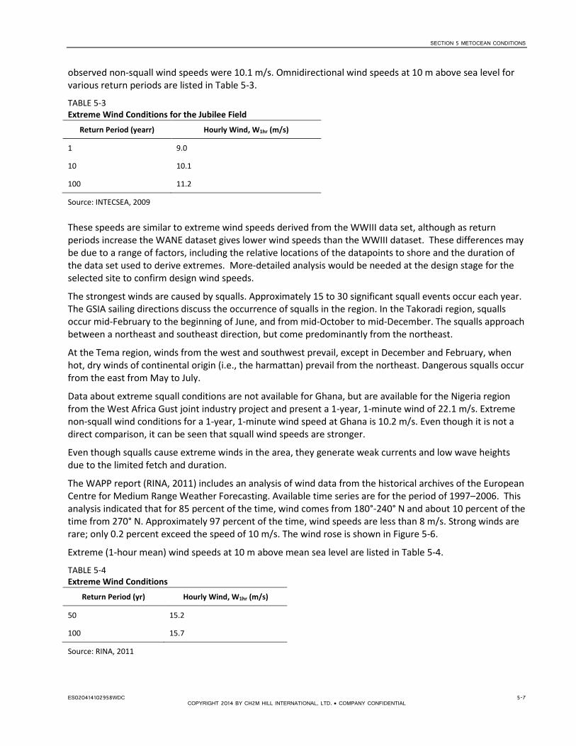
SECTION 5 METOCEAN CONDITIONS
observed non-squall wind speeds were 10.1 m/s. Omnidirectional wind speeds at 10 m above sea level for various return periods are listed in Table 5-3.
TABLE 5-3 Extreme Wind Conditions for the Jubilee Field
Return Period (yearr) Hourly Wind, W1hr (m/s)
1 9.0
10 10.1
100 11.2
Source: INTECSEA, 2009 These speeds are similar to extreme wind speeds derived from the WWIII data set, although as return periods increase the WANE dataset gives lower wind speeds than the WWIII dataset. These differences may be due to a range of factors, including the relative locations of the datapoints to shore and the duration of the data set used to derive extremes. More-detailed analysis would be needed at the design stage for the selected site to confirm design wind speeds.
The strongest winds are caused by squalls. Approximately 15 to 30 significant squall events occur each year. The GSIA sailing directions discuss the occurrence of squalls in the region. In the Takoradi region, squalls occur mid-February to the beginning of June, and from mid-October to mid-December. The squalls approach between a northeast and southeast direction, but come predominantly from the northeast.
At the Tema region, winds from the west and southwest prevail, except in December and February, when hot, dry winds of continental origin (i.e., the harmattan) prevail from the northeast. Dangerous squalls occur from the east from May to July.
Data about extreme squall conditions are not available for Ghana, but are available for the Nigeria region from the West Africa Gust joint industry project and present a 1-year, 1-minute wind of 22.1 m/s. Extreme non-squall wind conditions for a 1-year, 1-minute wind speed at Ghana is 10.2 m/s. Even though it is not a direct comparison, it can be seen that squall wind speeds are stronger.
Even though squalls cause extreme winds in the area, they generate weak currents and low wave heights due to the limited fetch and duration.
The WAPP report (RINA, 2011) includes an analysis of wind data from the historical archives of the European Centre for Medium Range Weather Forecasting. Available time series are for the period of 1997–2006. This analysis indicated that for 85 percent of the time, wind comes from 180°-240° N and about 10 percent of the time from 270° N. Approximately 97 percent of the time, wind speeds are less than 8 m/s. Strong winds are rare; only 0.2 percent exceed the speed of 10 m/s. The wind rose is shown in Figure 5-6.
Extreme (1-hour mean) wind speeds at 10 m above mean sea level are listed in Table 5-4.
TABLE 5-4 Extreme Wind Conditions
Return Period (yr) Hourly Wind, W1hr (m/s)
50 15.2
100 15.7
Source: RINA, 2011
ES020414102958WDC 5-7 COPYRIGHT 2014 BY CH2M HILL INTERNATIONAL, LTD. • COMPANY CONFIDENTIAL

SECTION 5 METOCEAN CONDITIONS
FIGURE 5-6 Wind Rose
Source: RINA, 2011
5.5 Waves The hindcast data for the three NOAA WWIII points were analyzed as described in Section 5.2.1. Wave roses for the three sites are shown in Figure 5-7. Frequency tables of wave height and frequency and wave height and period are provided in Appendix B. Exceedance probability curves are shown in Figures 5-8 to 5-10.
FIGURE 5-7 Wave Rose Plots from NOAA Data
Note: Left: data point (N4.5, W2.5); middle: Data point (N4.5, W1.5); right: Data point (N5, W0). See Figure 5-1.
5-8 ES020414102958WDC COPYRIGHT 2014 BY CH2M HILL INTERNATIONAL, LTD. • COMPANY CONFIDENTIAL

SECTION 5 METOCEAN CONDITIONS
FIGURE 5-8 Exceedance Probability versus the Significant Wave Height for Point N4.5, W2.5
FIGURE 5-9 Exceedance Probability versus the Significant Wave Height for Point N4.5, W1.5
05
101520253035404550556065707580859095
100
0.0 0.2 0.4 0.6 0.8 1.0 1.2 1.4 1.6 1.8 2.0 2.2 2.4 2.6 2.8 3.0 3.2 3.4 3.6
EXCE
EDAN
CE P
ROBA
BILI
TY (%
)
SIGNIFICANT WAVE HEIGHT, HM0 (METERS)
WEST-N4.5, W2.5
05
101520253035404550556065707580859095
100
0.0 0.2 0.4 0.6 0.8 1.0 1.2 1.4 1.6 1.8 2.0 2.2 2.4 2.6 2.8 3.0 3.2 3.4 3.6
EXCE
EDAN
CE P
ROBA
BILI
TY (%
)
SIGNIFICANT WAVE HEIGHT, HM0 (METERS)
MIDDLE-N4.5, W1.5
ES020414102958WDC 5-9 COPYRIGHT 2014 BY CH2M HILL INTERNATIONAL, LTD. • COMPANY CONFIDENTIAL

SECTION 5 METOCEAN CONDITIONS
FIGURE 5-10 Exceedance Probability versus the Significant Wave Height for Point N5, W0
Extreme Value Analysis (EVA) was also undertaken to calculate extreme wave heights for a number of return periods, up to 25 years. Extrapolation to higher return periods was not undertaken because of the duration of the dataset and the uncertainties arising from extrapolation to more extreme events. The extreme significant wave heights are listed in Table 5-5.
TABLE 5-5 EVA Estimated Extreme Significant Wave Heights
Return period (yr)
Significant Wave Height, Hm0 (m)
West
(N4.5, W2.5)
Middle
(N4.5, W1.5)
East
(N5, W0)
1 2.8 2.6 2.6
2 2.9 2.8 2.7
5 3.1 2.9 2.9
10 3.2 3.1 3.1
25 3.4 3.3 3.3
Date: WWIII
The following preliminary conclusions can be drawn:
• Wave conditions for the three selected offshore locations are similar; therefore it is anticipated that there would not be significant differences amongst the sites from the perspective of the offshore waves.
• The predominant wave directions are south-southwest and south.
• The majority of the wave heights are between 1.0m and 2.5 m. Table 5-6 presents percentage exceedance for a range of wave height thresholds.
05
101520253035404550556065707580859095
100
0.0 0.2 0.4 0.6 0.8 1.0 1.2 1.4 1.6 1.8 2.0 2.2 2.4 2.6 2.8 3.0 3.2 3.4 3.6
EXCE
EDAN
CE P
ROBA
BILI
TY (%
)
SIGNIFICANT WAVE HEIGHT, HM0 (METERS)
EAST-N5, W0
5-10 ES020414102958WDC COPYRIGHT 2014 BY CH2M HILL INTERNATIONAL, LTD. • COMPANY CONFIDENTIAL

SECTION 5 METOCEAN CONDITIONS
• The majority of the wave periods are between 8 and 16 seconds, as shown in the tables in Appendix B.
About 4.0 to 4.5 percent of waves have periods longer than 16 s. Long period swell waves dominate the wave climate in the region.
TABLE 5-6 Percentage Exceedance for a Range of Wave Height Thresholds Wave Height (m) 1.5 2.0 2.5
Percentage exceedance 37-42 7-10 1-2
The Jubilee field metocean study documents analysis of the WANE dataset, which provides some characterization of offshore conditions in the vicinity of the Jubilee field. This analysis indicated that swell dominates both operational and extreme offshore waves. Usually at least a 1m wave is present because of the constant southeast trade winds and/or southern swell. The swell wave direction is from the south most of the year. The significant wind sea is from the south and southwest direction.
The WANE offshore data were analyzed to derive extreme wave conditions for different directions, as shown in Table 5-7.
TABLE 5-7 Offshore Directional Waves from WANE Data
Return period (yr) Significant Wave Height, Hm0 (m) , Peak Period Tp (s)
SE S SW
1 1.4m, 8.6s 2.7m, 12.6s 2.7m, 12.6s
10 1.7m, 9.8s 3.3m, 14.3s 3.3m, 14.3s
100 2.1m, 10.8s 4.0m, 15.9s 4.0m, 15.9s
Source: INTECSEA, 2009
As part of the WAPP regional LNG study, wave data were studied from the following sources:
• KNMI/ERA-40 global wave climatology atlas with long term (30 years, from 1971 to 2000) wave statistics.
• Historical archives of the European Centre for Medium Range Weather Forecasting. Available time series are for the period of 1997–2006 (10 years) and in deep water.
This analysis indicated the following:
• Offshore swell waves dominate at 210° N (64 percent of events) and 180° N (35 percent of events). Omni-directional wave parameters are: 50-year Hs = 3.8 m and Tp = 16.0 s, 100-year Hs = 3.9 m, Tp = 16.2 s.
• Offshore wind sea waves dominate at 210° N and 240° N (almost 82 percent of the total). Omni-directional sea wave parameters are: 50-year Hs = 2.4 m and Tp = 7.4s, 100-year Hs = 2.5 m, Tp = 7.6 s.
• At Takoradi, nearshore wave height at a 20m water depth is always less than 3.5 m (93 percent less than 1.5 m); main directions are from 180° N (57 percent) to 170° N (31 percent).
• At Tema, nearshore wave height at a 20m water depth is always less than 3.5 m (86 percent less than 1.5m); main directions are from 180° N (61 percent) to 190° N (27 percent).
• 100-year, extreme nearshore wave at the 20m water depth Hs = 3.7m, Tp = 15.7s from 180° N.
The swell and wind-sea offshore wave roses from the study are shown in Figures 5-11 and 5-12, respectively. ES020414102958WDC 5-11
COPYRIGHT 2014 BY CH2M HILL INTERNATIONAL, LTD. • COMPANY CONFIDENTIAL

SECTION 5 METOCEAN CONDITIONS
FIGURE 5-11 Offshore Swell Wave Rose
Source: RINA, 2011
5-12 ES020414102958WDC COPYRIGHT 2014 BY CH2M HILL INTERNATIONAL, LTD. • COMPANY CONFIDENTIAL

SECTION 5 METOCEAN CONDITIONS
FIGURE 5-12 Offshore Wind-sea Wave Rose
Source: RINA, 2011
5.6 Currents Two key components influence currents at the sites under consideration:
• tidal current • Guinea current
The Guinea current is a warm-water current that flows easterly along the West African coast that lies by the Gulf of Guinea, which includes Ghana. The Guinea current is weakest in the winter months (December – February) and strongest in the summer months (July – September), with a current velocity of approximately 1 m/s (Ocean Data & Information Network of Africa. 2012). At Cape Three Points, the Guinea current travels at approximately 3 knots (1.5 m/s), and at Tema, the current travels northeast along the coast at 0.5 knot (GSIA, 2013).
The metocean studies undertaken as part of the Jubilee field metocean study provide directional currents for 1-year, 10-year and 100-year return periods (at depths from 10 m to 1,112 m) at the Jubilee field location. An example of the 1-year, current data at 10m depth is listed in Table 5-8. This indicates easterly flowing currents can be up to 1.7 m/s (almost 3.5 knots).
ES020414102958WDC 5-13
COPYRIGHT 2014 BY CH2M HILL INTERNATIONAL, LTD. • COMPANY CONFIDENTIAL

SECTION 5 METOCEAN CONDITIONS
TABLE 5-8 1-year Return Period Directional Currents
Return Period Depth
Cs (m/s) – DIRECTION (towards) OMNI
1-year
Depth 10m
N NE E SE S SW W NW
0.54 0.79 1.68 0.88 0.43 0.64 0.81 0.74 1.68
Source: INTECSEA, 2009 The WAPP report quotes current speeds of at least 1 m/s (RINA, 2011).
5.7 Preliminary Conclusions for Metocean Conditions Metocean conditions from WWIII data analysis for the three areas (west, middle, east) are summarized in Table 5-9.
TABLE 5-9 Metocean Conditions at WWIII Data Points
West Middle East
1-year wind (m/s) 9.4 9.4 9.9
10-year wind (m/s) 10.7 10.6 10.8
Exceedance frequency of Hs ≥ 2m (%) 10 8 7
1-year wave Hm0 (m) 2.8 2.6 2.6
10-year wave Hm0 (m) 3.2 3.1 3.1
Based on the initial study, the following preliminary conclusions can be drawn:
• Wind and wave conditions at the three selected offshore locations from WWIII data are similar. Therefore, it is anticipated that there would be no significant differences between the various sites under consideration from the perspective of the offshore wind and waves.
• Generally, the offshore wind statistics apply to all seven sites. The operational hourly wind in the 1-year return period is approximately 9 to 10 m/s. The 10-year hourly wind speed is about 11 m/s.
• The wave statistics show that the offshore 1-year significant wave height, Hm0, ranges from 2.6-2.8 m. The 100-year Hm0 is approximately 4 m.
• Except for the Takoradi and Sekondi sites, the sites are located near relatively deep water (deeper than 20 m); therefore, the wave dissipation through the transformation from offshore to the sites would not be significant. It is anticipated that the wave conditions at the sites are similar to their corresponding offshore conditions. The offshore waves could be considered as an approximation of the site waves at this stage, subject to more-detailed modeling and site-specific data collection at later design stages.
• The local waves at the sites would be contributed from wind waves and swells. Most of the wave periods are longer than 10 s; therefore, swell waves dominate. In addition, the wave height from swells is higher than the wind waves. Therefore, the swell will be a key factor in the ship navigation and mooring arrangement.
5-14 ES020414102958WDC COPYRIGHT 2014 BY CH2M HILL INTERNATIONAL, LTD. • COMPANY CONFIDENTIAL

SECTION 5 METOCEAN CONDITIONS
• The Guinea current travels in an easterly direction along the coast of Ghana and is the strongest in the
summer. The tidal current speed ranges from 1 to 2 m/s. The current is another important factor in configuring ship orientation in the layout design.
For future stages of design, it is recommended that long-term hindcast data be obtained for the selected site. Data can be obtained from OWI, which includes the WANE dataset. These data would then be used as input to a wave transformation model to characterize wave conditions at the selected site, ideally calibrated with site-specific measurements.
ES020414102958WDC 5-15 COPYRIGHT 2014 BY CH2M HILL INTERNATIONAL, LTD. • COMPANY CONFIDENTIAL


SECTION 6
Marine Facilities This section provides an overview of the components of the marine facilities that are considered for the sites discussed in Section 3 of this report.
Depending on the site under consideration, two alternative concepts have been identified for the marine facilities that will accommodate the FSRU:
• A fixed berth, protected by a breakwater • An offshore mooring where the FSRU is located in open water
The key characteristics of the FSRU and the marine facility concepts are discussed in the following sections.
6.1 Floating Storage and Regasification Unit All of the proposed options make use of an FSRU, which is an LNG tanker fitted with regasification equipment on board. The FSRU stores LNG in onboard tanks for regasification. Regasified gas product is distributed via pipeline to onshore users.
The first FSRUs were retro-fitted LNG tankers, but recently custom-built FSRUs have been designed and commissioned.
Generally, FSRUs are permanently moored in place and tankers call at the facility to offload cargo. In this scenario, the FSRU is able to ensure continuous supply because of the onboard LNG storage, provided there is no delay in arrival of the LNG tankers. Excelerate Energy offers an alternative approach, in which the FSRU travels as an LNG tanker between the supply point and a custom-designed mooring to regasify and offload cargo. The tanker must remain on the mooring until the full cargo is regasified and discharged to shore. With no permanent storage component in the system, there will be an interruption in gas supply when mooring is vacant.
FSRUs are generally leased from owners, with a minimum 10-year lease being typical.
FSRUs provide certain advantages over onshore regasification plants:
• They can be used as shorter-term supply options, particularly where there may be uncertainty in longer-term demand.
• The capital cost for installation is generally significantly less.
• The footprint of the facility is significantly smaller and can be located offshore.
• The timescale for implementation is shorter.
• They can avoid the need for major marine infrastructure to transfer LNG to shore for regasification, either via trestles to support cryogenic pipelines or dredging to provide a berth of sufficient water depth close to shore. Subsea cryogenic pipelines are under development but are not yet proven technology.
FSRUs have higher operational and maintenance costs compared with comparable onshore terminals and there will be a need for the facility to drydock every 10 years for maintenance.
Once installed, an onshore facility may provide greater flexibility for expansion if sufficient land is available, but there is significantly greater initial capital cost and the time for implementation is longer. This provids less flexibility to meet demand in the short term.
An inventory of a number of FSRUs is provided in Table 6-1. There are a limited number of FSRUs currently in operation, approximately 10, with some new FSRUs due to come into operation in the next 12 months. This
ES020414102958WDC 6-1 COPYRIGHT 2014 BY CH2M HILL INTERNATIONAL, LTD. • COMPANY CONFIDENTIAL

SECTION 6 MARINE FACILITIES
selection gives some representative vessels from the major operators, including new vessels under construction. It should be noted that there are vessels equipped with regasification systems that may predominantly operate as LNG carriers but have the capability to act as FSRU.
TABLE 6-1 Inventory of FSRUs
Owner Name
Storage volume
(m3)
Gas throughput
(bcm/yr)
Regas capacity
(MMscfd)
Length overall
(m)
Molded Breadth
(m)
Draft
(m)
Notes
Hoegh Hull No. 2548 170,000 2.5 240* 290 46 12.6 under construction
Hoegh Hull No. 2549 170,000 4.1 400 290 46 12.6 under construction
Hoegh Hull No. 2550 170,000 3.9 375 290 46 12.6 under construction
Hoegh Hull No. 2551 170,000 5.1 500 294 46 12.6 under construction
Hoegh Independence 170,000 4.1 400 294 46 12.6 FSRU
Hoegh Lampung 170,000 4.1 400 294 46 12.6 FSRU
Golar Freeze 125,000 4.9 475 288 43 11.5 Conversion
Golar Spirit 129,000 2.5 240 290 45 12.5 LNGC Conversion
Golar Winter 138,000 5.1 500 277 43 11.4 LNGC Conversion
Golar Satu 125,000 5 490 293 42 11.7 LNGC Conversion
Golar Igloo 170,000 7.5 725
Delivery 2014
Golar Eskimo 160,000 7.5 725 Delivery 2014
EON Ruhrgas/
IREN Mercato
Toscana (was Golar Frost) 137,000 3.75 360 306 48
12.3
permanently moored
Excelerate Excelsior 138,000 4.1 400 277 43 12.2 LNGC w/Regas
Capability
Excelerate Excelerate 138,000 4.1 400 277 43 12.2 LNGC w/Regas
Capability
Excelerate Excellence 138,000 4.1 400 277 43 12.2 LNGC w/Regas
Capability
Excelerate Exemplar 150,900 5.1 500 290 43 12.4 LNGC w/Regas
Capability
Excelerate Explorer 150,900 5.1 500 290 43 12.4 LNGC w/Regas
Capability
Excelerate Express 150,900 5.1 500 290 43 12.4 LNGC w/Regas
Capability
Excelerate Exquisite 150,900 5.1 500 290 43 12.4 LNGC w/Regas
Capability
Source: owner/operator websites
* with N+1 redundancy of regasification units
6-2 ES020414102958WDC COPYRIGHT 2014 BY CH2M HILL INTERNATIONAL, LTD. • COMPANY CONFIDENTIAL

SECTION 6 MARINE FACILITIES
6.2 Fixed Berth with Breakwater Of the sites under review, conventional fixed berth solutions have been considered for locations adjacent to existing ports (Takoradi, Sekondi).
The FSRU vessel would be moored at a conventional berth comprising a platform and mooring and breasting dolphins, protected by a breakwater. The LNG tanker would berth alongside the FSRU for cargo offload.
For these options, the approaching LNG tanker would use the existing navigation approaches to the port in question. There would be a need for deepening to accommodate the LNG tankers, depending on the fleet that would call at the facility. The breakwater would provide shelter to the berth from waves and maximize the berth operational time by reducing the amount of time that operation limits for key activities (mooring, cargo transfer) are exceeded. Operational limits are generally more restrictive for fixed berths than for offshore berths.
Detailed studies would be needed during design to confirm the berth layout, extent of the breakwater, and wave conditions at the berth, particularly given the long period swell conditions experienced along the coast of Ghana and West Africa in general.
Breakwaters may be constructed in a variety of ways. The two most common are:
• Rubble mound breakwater –such as currently exists at Sekondi and Takoradi. These are formed by a series of layers of rock of increasing size, and are protected by either large rock armorstone or concrete armor units such as Accropode or X-blocs.
• Caisson breakwater – formed by concrete caissons that are prefabricated, floated, and sunk into place on a rubble foundation. These are generally most cost-effective in deeper water (>15m) so they were not considered for these studies.
Rock for the current breakwater expansion at Takoradi is being sourced from a nearby quarry in sizes from 3 to 6 tons. It is considered that rock for a breakwater at either site could most likely be sourced locally. A quarry investigation would be required to confirm the quarry yield, quality, and maximum stone sizes available.
6.3 Offshore Mooring Mooring FSRUs offshore is a new concept, so very few units exist as shallow water applications (<50 m). There is, however, extensive experience with mooring Floating Storage Units (FSU) and Floating Production Storage and Offload (FPSO) units used for the storage of crude oil and in some cases liquid petroleum gas. Conceptually, there is no difference in mooring design between an FSRU and an FSU or FPSO used for crude oil or liquid petroleum gas. Therefore, the extensive experience from the application of FSU and FPSO in the offshore petroleum sector is directly applicable to the FSRU case.
In both cases, cargo transfer takes place between seagoing tankers and the storage unit. The only difference is the direction of the transfer. The FSRU receives cargo from the tanker, whereas FSU and FPSO deliver cargo to the tankers. In all cases the cargo is transferred between the storage unit and some other location by means of a subsea pipeline. In the case of FPSO, the pressure in the piping system to transfer the cargo between subsea pipelines and the storage unit may be similar to the pressure of the high-pressure gas being conveyed from the FSRU to shore. In other cases, the pressure may be much lower or in some case even higher. Therefore, ample experience exists for the transfer of the high-pressure gas between a subsea pipeline and the storage unit.
6.3.1 Types of Moorings Offshore moorings can be divided into two distinct classes:
ES020414102958WDC 6-3 COPYRIGHT 2014 BY CH2M HILL INTERNATIONAL, LTD. • COMPANY CONFIDENTIAL
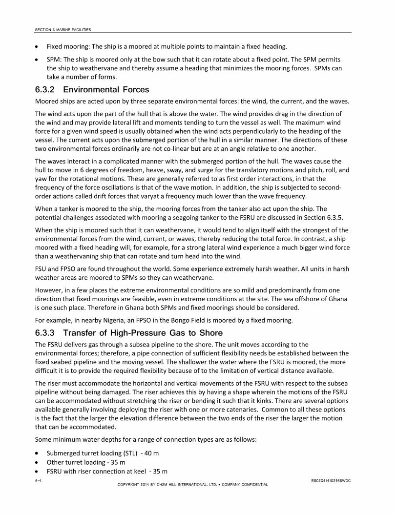
SECTION 6 MARINE FACILITIES
• Fixed mooring: The ship is a moored at multiple points to maintain a fixed heading.
• SPM: The ship is moored only at the bow such that it can rotate about a fixed point. The SPM permits the ship to weathervane and thereby assume a heading that minimizes the mooring forces. SPMs can take a number of forms.
6.3.2 Environmental Forces Moored ships are acted upon by three separate environmental forces: the wind, the current, and the waves.
The wind acts upon the part of the hull that is above the water. The wind provides drag in the direction of the wind and may provide lateral lift and moments tending to turn the vessel as well. The maximum wind force for a given wind speed is usually obtained when the wind acts perpendicularly to the heading of the vessel. The current acts upon the submerged portion of the hull in a similar manner. The directions of these two environmental forces ordinarily are not co-linear but are at an angle relative to one another.
The waves interact in a complicated manner with the submerged portion of the hull. The waves cause the hull to move in 6 degrees of freedom, heave, sway, and surge for the translatory motions and pitch, roll, and yaw for the rotational motions. These are generally referred to as first order interactions, in that the frequency of the force oscillations is that of the wave motion. In addition, the ship is subjected to second-order actions called drift forces that varyat a frequency much lower than the wave frequency.
When a tanker is moored to the ship, the mooring forces from the tanker also act upon the ship. The potential challenges associated with mooring a seagoing tanker to the FSRU are discussed in Section 6.3.5.
When the ship is moored such that it can weathervane, it would tend to align itself with the strongest of the environmental forces from the wind, current, or waves, thereby reducing the total force. In contrast, a ship moored with a fixed heading will, for example, for a strong lateral wind experience a much bigger wind force than a weathervaning ship that can rotate and turn head into the wind.
FSU and FPSO are found throughout the world. Some experience extremely harsh weather. All units in harsh weather areas are moored to SPMs so they can weathervane.
However, in a few places the extreme environmental conditions are so mild and predominantly from one direction that fixed moorings are feasible, even in extreme conditions at the site. The sea offshore of Ghana is one such place. Therefore in Ghana both SPMs and fixed moorings should be considered.
For example, in nearby Nigeria, an FPSO in the Bongo Field is moored by a fixed mooring.
6.3.3 Transfer of High-Pressure Gas to Shore The FSRU delivers gas through a subsea pipeline to the shore. The unit moves according to the environmental forces; therefore, a pipe connection of sufficient flexibility needs be established between the fixed seabed pipeline and the moving vessel. The shallower the water where the FSRU is moored, the more difficult it is to provide the required flexibility because of to the limitation of vertical distance available.
The riser must accommodate the horizontal and vertical movements of the FSRU with respect to the subsea pipeline without being damaged. The riser achieves this by having a shape wherein the motions of the FSRU can be accommodated without stretching the riser or bending it such that it kinks. There are several options available generally involving deploying the riser with one or more catenaries. Common to all these options is the fact that the larger the elevation difference between the two ends of the riser the larger the motion that can be accommodated.
Some minimum water depths for a range of connection types are as follows:
• Submerged turret loading (STL) - 40 m • Other turret loading - 35 m • FSRU with riser connection at keel - 35 m 6-4 ES020414102958WDC
COPYRIGHT 2014 BY CH2M HILL INTERNATIONAL, LTD. • COMPANY CONFIDENTIAL

SECTION 6 MARINE FACILITIES
• FSRU with riser deployed from deck level - 20 m
It is beyond the scope of this report to discuss all possible options; however, a few examples of similar mooring types from past or existing FSU or FPSO installation are illustrated herein.
An example of an FSU moored to an SPM in very shallow water is the FSU in Covenas that was decommissioned in 1998, shown in Figure 6-1.
FIGURE 6-1 FSU in Covenas
Source: Ecopetrol, Colombia
The FSU in Covenas was moored to a tower structure, which contained a structural swivel and a fluid swivel. The mooring flexibility was achieved by the heavy cylindrical weight hanging from the bow of the vessel. A piping system made flexible by connecting a series of steel pipes with fluid swivels can be seen above and to the left of the mooring in the figure. The minimum water depth required for this type of mooring is not affected by limitations in the flexibility of the piping system. Note the loading arms on both sides of the vessel. Tankers could moor and transfer cargo on both sides of this vessel.
A second example is the Sanha FPSO moored to an SPM in Angola, shown in Figure 6-2. In this case, the vessel is moored by mooring chains radially deployed from a structural swivel placed on an extension of the bow of the vessel. The fluid swivel is housed in the triangular structure above the structural swivel. A riser in form of a hose is seen entering the water nearly vertically. This arrangement provides the maximum practical distance between the seabed and the riser connection to the vessel. The moorings are conventional chains and anchors as opposed to the tower structure used for the FSU in Covenas.
FIGURE 6-2 Sanha FPSO in Angola
Source: Single Buoy Moorings (Copyrighted by SBM) ES020414102958WDC 6-5
COPYRIGHT 2014 BY CH2M HILL INTERNATIONAL, LTD. • COMPANY CONFIDENTIAL

SECTION 6 MARINE FACILITIES
Another common arrangement is a turret placed in the hull just aft of the bow. The turret is a large-diameter drum extending from the keel to the deck. The drum is mounted in a structural swivel that permits it to rotate freely with respect to the vessel. Figure 6-3 provided by Petrobras shows a typical SPM turret-moored FPSO. Note the very large number of flexible risers. Multiple concentric fluid swivels are provided above the turret to permit transfer of the fluids to the FPSO. In this case, the mooring chains are connected at the keel of the vessel and the fluid connections must also be made at this level. If the FSRU mooring is a turret, it is likely that the minimum water depth at the mooring site is dictated by the flexibility of the riser.
FIGURE 6-3 FPSO with SPM Turret Mooring
Source: Petrobras The first offshore FSRU was provided by the firm Excelerate In 2007. The firm used the STL mooring, which is a disconnectable variant of the SPM turret shown in Figure 6-3. This system puts the mooring chain connection points some distance below the keel, thereby potentially increasing the required water depth further. Because the mooring is disconnectable, there must be sufficient space below the mooring for the vessel to clear the mooring when it sails away. The system is shown in Figure 6-4.
FIGURE 6-4 STL System
Source: Excelerate 6-6 ES020414102958WDC
COPYRIGHT 2014 BY CH2M HILL INTERNATIONAL, LTD. • COMPANY CONFIDENTIAL

SECTION 6 MARINE FACILITIES
All of the systems shown in Figures 6-1 to 6-4 permit the vessel to weathervane around the mooring; for example, due to the change of direction of the current, waves or wind. They all include a high-pressure fluid swivel in the connection between the seabed pipeline and the piping system aboard the vessel.
In waters with a benign climate, such as offshore Brazil, FPSOs use fixed moorings, as shown in Figure 6-5.
FIGURE 6-5 Fixed Moored FPSO Offshore of Brazil
Source: Single Buoy Moorings (Copyrighted by SBM) Seven mooring lines are shown on the port bow. A similar number are deployed at the other quarters of the vessel. A large number of risers on the port side of the vessel can also be seen.
The pipes connecting the vessel to the seabed pipeline must have sufficient flexibility that the motions of the vessel can be accommodated without breaking or damaging the pipe. This section of the piping system is almost always an unbounded flexible pipe or composite pipe, effectively a high-pressure hose, comprising a number of layers of plastic and steel wire. It may be deployed in a number of configurations, as illustrated on the images above. Fluid swivels are not required for fixed moored vessels as the vessel will remain fixed in position.
6.3.4 Mooring an LNG Tanker to an FSRU Mooring an LNG tanker to an FSRU is conceptually similar to mooring a ship to a conventional fixed berth. The tanker must be brought to a dead stop, parallel to the FSRU, and then pushed laterally into position. To accomplish this, end powerful seagoing tugs are required. It is also a requirement that the current be from the FSRU toward the LNG tanker and, if not, that it is weak (not exceeding 1 to 1.5 knots). Ideally the current acts in a direction that it will push the tanker away should some mishap occur during the maneuver or if not it is weak such that it only contributes minimally to the resulting accident.
Based on the preliminary environmental data presented in Section 5, the current near the coast of Ghana is almost always from west to east. On the rare occasions when it is from the east to west, it rarely exceeds 1.5 knots. Consequently, the current will almost never impede the mooring of the tanker, provided that the mooring is on the east side of the FSRU. Mooring may take place in waves on the order of 2 to 2.5 m, provided the tugs are capable of operating in these conditions. The wind will interfere extremely rarely with the mooring operations. Once moored, the cargo transfer may take place up to about 3 to 3.5m significant wave height. ES020414102958WDC 6-7
COPYRIGHT 2014 BY CH2M HILL INTERNATIONAL, LTD. • COMPANY CONFIDENTIAL

SECTION 6 MARINE FACILITIES
Given the Ghana metocean conditions, we expect that a fixed moored FSRU will have a very high system availability/operability level, however an FSRU moored to a single point mooring will have an even higher uptime. A comprehensive study of the environmental data combined with performance data of each of the possible options will be required at later stages of design to confirm operational criteria. An initial appraisal suggests 4% downtime for the SPM and 6% for the multipoint mooring, as the SPM will have higher operational thresholds due to its ability to weathervane, though this would need detailed downtime assessment with site specific data to confirm this.
During future stages of design, a detailed mooring analysis will be required to assess relative vessel movements and mooring loads during ship-to-ship transfer.
6.3.5 Navigational Safety of the LNG Tanker Regardless of the type of mooring used for the FSRU, the mooring chains and the riser must be arranged such that contact between the LNG tanker and these elements is not possible. However, in order to properly moor the FSRU, some of the mooring chains must cross the navigation area of the LNG tanker, it is therefore incumbent that the mooring chain connection points to the FSRU be properly positioned relative to the LNG tanker and be placed sufficiently low such that the catenary action of the mooring chain always places the chain at depths below the keel of the LNG tanker in the navigation area.
This in turn affects the required water depth, because the weight of the mooring chain suspended in the water column must be adequate to achieve the required inclination of the mooring line. The illustrations of SPMs in Figures 6-1 to 6-4 comply with these requirements. The exception is the illustration of the fixed moored FPSO (Figure 6-5). This unit, with a large number of risers, is designed to transfer the cargo to a tanker moored in tandem through a floating hose.
6.3.6 Possible Offshore Mooring Concepts Based on the preliminary review of each location and the respective environmental data undertaken as part of this screening study, either a single-point, or fixed (multi-point) mooring scheme may be considered for the sites in question. Fixed moorings have the advantage of offering a smaller operating footprint and less-complex subsea pipeline connection. However, SPMs can withstand higher environmental forces and are currently in service at several locations in Ghana (Tema, Atuabo) for offloading oil products. The strongly uni-directional wave conditions at all the locations under consideration mean that the Ghana coastline is particularly favorable for a fixed mooring.
A major characteristic of all the sites is the very shallow sloping foreshore, meaning water depth increases gradually from shore. A water depth of 20m is reached within approximately 5km from shore, whereas a water depth of 35m is approximately 15km from shore.
As a result, consideration was given to mooring and subsea pipeline connection options that can operate in 20m water depth. A proposed fixed mooring concept and subsea pipeline connection is shown in Figure 6-6.
6-8 ES020414102958WDC COPYRIGHT 2014 BY CH2M HILL INTERNATIONAL, LTD. • COMPANY CONFIDENTIAL
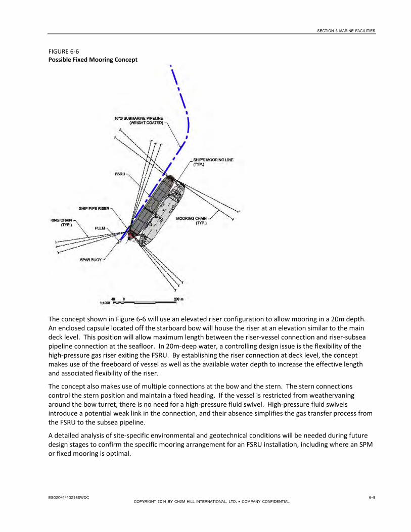
SECTION 6 MARINE FACILITIES
FIGURE 6-6 Possible Fixed Mooring Concept
The concept shown in Figure 6-6 will use an elevated riser configuration to allow mooring in a 20m depth. An enclosed capsule located off the starboard bow will house the riser at an elevation similar to the main deck level. This position will allow maximum length between the riser-vessel connection and riser-subsea pipeline connection at the seafloor. In 20m-deep water, a controlling design issue is the flexibility of the high-pressure gas riser exiting the FSRU. By establishing the riser connection at deck level, the concept makes use of the freeboard of vessel as well as the available water depth to increase the effective length and associated flexibility of the riser.
The concept also makes use of multiple connections at the bow and the stern. The stern connections control the stern position and maintain a fixed heading. If the vessel is restricted from weathervaning around the bow turret, there is no need for a high-pressure fluid swivel. High-pressure fluid swivels introduce a potential weak link in the connection, and their absence simplifies the gas transfer process from the FSRU to the subsea pipeline.
A detailed analysis of site-specific environmental and geotechnical conditions will be needed during future design stages to confirm the specific mooring arrangement for an FSRU installation, including where an SPM or fixed mooring is optimal.
ES020414102958WDC 6-9 COPYRIGHT 2014 BY CH2M HILL INTERNATIONAL, LTD. • COMPANY CONFIDENTIAL


SECTION 7
Considerations for Conceptual Design
7.1 Introduction This section presents the key preliminary design information and assumptions that were used for developing the concepts for evaluation in the screening assessment.
7.2 Design Life The design life for permanent marine infrastructure such as breakwaters, jetties is typically 50 years.
Offshore pipelines typically last about 35 years, but can be designed for longer life spans. Offshore moorings are often designed for a 25 year life span.
The FSRU will be leased for an agreed duration. For screening purposes, a lease duration of 10 years for the FSRU was assumed. This is typically the industry minimum lease term offered for FSRU charters.
7.3 FSRU Characteristics The LNG demand forecasts summarized in Tables 4-1 and 4-2 show significant uncertainty. The base case indicates there may be an initial demand in the region of 240 MMscfd of LNG, although this could be significantly greater in the longer term, based on upper-bound scenarios (for example, significant power plant development or shortfalls in indigenous supply).An inventory of typical FSRUs is provided in Table 4-3.
On this basis, a 170,000 cubic meter (m3) FSRU, with a nominal regasification capacity of 400 MMscfd, was assumed for the screening assessment. An FSRU with such regasification capabilities will adequately be able to meet the base case demand of approximately 250 MMscfd identified in Tables 2-1 and 2-2, and would accommodate some uncertainty in the upper-bound gas demand cases through 2030 identified in Table 2-2.
This FSRU when fully loaded can supply gas at the peak rate for 8 days and the base case demand for 13 days.
Typical FSRU characteristics are presented in Table 7-1, based on the inventory provided in Table 6-1.
TABLE 7-1 FSRU Typical Characteristics
Typical FSRU Characteristics Units
Capacity m3 170,000
Propulsion – boil-off gas (BOG) - Multi-fuel
Length Overall m 290
Length between Perpendiculars m 281
Beam m 43
Molded Depth (to main deck) m 26
Loaded Draft m 12.3
Design Send Out Maximum mmscfd 400
ES020414102958WDC 7-1 COPYRIGHT 2014 BY CH2M HILL INTERNATIONAL, LTD. • COMPANY CONFIDENTIAL

SECTION 7 CONSIDERATIONS FOR CONCEPTUAL DESIGN
7.4 LNG Tanker Size Typical LNG tanker characteristics are summarized in Table 7-2.
TABLE 7-2 Typical LNG Tanker Characteristics
LNG Carrier Range Identification Units 75,000 145,000 210,000
Type - Membrane Spherical Membrane
Capacity m3 75,000 145,000 210,000
Propulsion - Steam Steam Motor
Length Overall m 260.0 295.0 315.0
Length between Perpendiculars m 231.0 280.0 303.0
Beam m 34.8 50.0 50.0
Molded Depth (to main deck) m 20.7 28.0 27.0
Loaded Draft m 10.0 11.5 12.0
Ballasted Draft m 8.2 10.1 9.4
7.5 Water Depth Requirements The minimum water depth requirements for siting the FSRU depend on a number of factors:
• FSRU draft
• LNG tanker draft
• Underkeel clearance, which includes allowance for vessel motions due to waves and currents, uncertainty of seabed level, and seabed material
For an offshore mooring the following constraints also will apply:
• Depth required for adopted mooring technology
• Depth required for riser/subsea pipeline connection
7.5.1 Fixed Sheltered Berth To develop options for the screening assessment, the following minimum water depths were assumed for the fixed sheltered berth:
• 13.5 m at berth (sheltered by breakwater) • 14.5 m at the turning basin and approach channel
These depths were derived based on the potential LNG tanker and FSRU characteristics and using PIANC (2011, 1997) and USACE (2006) guidelines, which include allowances for the hard bottom material, local wave conditions, and approach direction. The berth area is controlled by the FSRU draft, assuming limited vessel movement due to the presence of the breakwater, whereas the approach channels and turning basin are controlled by the LNG carrier.
Based on available bathymetric data on the navigation charts of Takoradi and Sekondi harbors (GSIA, 2008), dredging in the turning basins will be more significant than in the approach channels and will be approximately 1-2 m, depending on the specific location.
7-2 ES020414102958WDC COPYRIGHT 2014 BY CH2M HILL INTERNATIONAL, LTD. • COMPANY CONFIDENTIAL

SECTION 7 CONSIDERATIONS FOR CONCEPTUAL DESIGN
7.5.2 Offshore Mooring The water depth required for the offshore options depends on the type of mooring and subsea pipeline connection. Some typical minimum water depths for different technologies are discussed in Section 6.3.3.
It was assumed that the FSRU will moor in 20m water depth, as discussed in Section 6.3.6.
7.6 Exclusion Zones An exclusion zone will need to be established and maintained around the FSRU facility. Vessel activity other than berth/unberthing LNG tankers and the necessary support vessels will not be permitted within this exclusion zone.
The following exclusion zones were assumed:
• Offshore mooring – 500m radius
• Fixed berth mooring – 300m radius, assuming that the FSRU berth is separated from the main port by a breakwater
Additionally, offshore moorings shall be located 2 km from any other existing marine facilities such as SPMs.
Subsea pipelines (proposed and existing) will have an “area to be avoided” to prevent damage by dragging anchors and fishing gear, extending 1 nautical mile either side of the pipeline. This is consistent with existing pipelines in the area (WAGP) and is indicated to mariners on the navigation charts for the region. The new exclusion zone will need to be included in updated navigation charts and sailing directions.
7.7 Operational Limits In general, FSRU operations have three activities:
1. Approach and mooring 2. Pipe connection and cargo transfer 3. Pipe disconnection and departure
The following is an indicative assessment of limiting environmental conditions:
Operation 1: Winds from easterly direction 10 m/s from all other directions 15 m/s Currents 0.5 m/s from east, no limit from west Hs 2.5 m
Operation 2: Winds from any direction 20 m/s Currents 0.75 m/ s from east, no limit from west
Hs 2.5 m
Operation 3: Winds from Easterly direction 15 m/ Currents from east 0.75 m/s, no limit from west Hs 3.0 m
If the FSRU has a stern thruster and is SPM-moored it can increase the threshold above by applying power to minimize the relative motions between the vessels. This applies to a lesser degree for the fixed mooring vessel with limited swing ability and not at all for the fixed mooring.
Preliminary statistics on exceedance of the wave height thresholds are listed in Table 5-6, indicating that the wave height limit for mooring is exceeded 1 to 2% percent of the time for an exposed berth, based on deep water wave conditions and assuming no significant changes in the waves when they reach the 20m water depth. Current velocities may exceed the thresholds given at times, due to the Guinea current. Detailed current data are not available at this stage. Currents should be studied in detail at later design stages and
ES020414102958WDC 7-3 COPYRIGHT 2014 BY CH2M HILL INTERNATIONAL, LTD. • COMPANY CONFIDENTIAL

SECTION 7 CONSIDERATIONS FOR CONCEPTUAL DESIGN
dynamic mooring analysis should be undertaken to assess the interactions and optimize the mooring configuration.
Limiting environmental conditions would need to be defined during detailed metocean modeling and dynamic mooring analysis conducted during engineering design.
7.8 Vessel Calling Frequency The frequency of vessels calling the FSRU depends on the upland gas demand and volume of delivery from the LNG carrier. An efficient LNG delivery schedule is one that minimizes time spent in cargo transfer and approach/mooring operations.
Based on an assumed demand of approximately 250 MMscfd, as identified in the base case in Table 6.2, the vessel calling frequency would be approximately every 10 days, assuming a 150,000m3 LNG tanker. If smaller vessels were used, calling frequency would be higher. In the case of a 70,000m3 vessel, a cargo would be required approximately every 4 days.
Ideally, the FSRU should have the flexibility to accept LNG shipments from a range of vessels to allow for operational flexibility and possible spot market arrangements. Based on the initial assessment, a carrier size ranging from 70,000m3 to 150,000m3 would be acceptable when considering the calling frequency.
It should be noted, however, that the transfer time for carriers larger than 150,000m3 will be significantly higher than those of a smaller size. In these circumstances, the LNG carrier will have to “stand by” for additional time because the delivery volume is greater than the storage volume. The standby time is equal to the difference in volume from the LNG carrier and the FSRU divided by the daily gas demand. Although a larger vessel may offer more economical shipping rates, the standby time will likely incur additional costs to the operation.
7.9 Loading and Unloading Operations It was assumed that the FSRU will operate on 24-hour availability, which would require port services (tugs, pilots, traffic control) that can give priority to LNG tanker handling.
In LNG port facilities the LNG tanker port turn-around time is approximately 24 hours, based on the typical unloading rate of 10,000 m3 per hour, leading to 18 to 20 hours of actual cargo transfer time and taking slow ramp-up of pumping into account. After considering approach, mooring, and departure times, it is expected that a complete LNG delivery would take approximately 24 hours.
It is anticipated that the fixed sheltered berths are available for almost 100% of the time, whereas for the offshore moored FSRU there will be occasions where the weather is too severe for berthing. At this time there is insufficient information available to quantify this additional time incurred when using the offshore mooring. Approximately 5 to 10% of the arriving LNG tankers may need to wait to moor to the FSRU. The waiting time cannot be determined at this time, but could for some tankers exceed 24 hours.
7.10 Tugs and Other Support Services It is anticipated that three large tugs and a minimum 60-ton bollard pull would be required to support tanker operations. A support workboat also would be required. These vessels would require a sheltered berth— for example, in the port of Takoradi. It may be possible to use existing tug services; however, several western locations under review pose a challenge for adequate marine support service because of their distance from a protected harbor.
Other local services and facilities that would be required are security, emergency response, divers, a berth to load equipment/materials on/off tugs, workboat, ship agents, and fuel deliveries for the FSRU.
7-4 ES020414102958WDC COPYRIGHT 2014 BY CH2M HILL INTERNATIONAL, LTD. • COMPANY CONFIDENTIAL

SECTION 8
Screening Evaluation
8.1 Screening Criteria Screening criteria were identified under the main categories of location, operations, environmental/social and cost/schedule, as listed below.
Location • Proximity/ease of connection to existing gas pipeline network • Road access • Proximity to current demand • Compatibility with power generation and gas master plans and current project development plans • Future expansion
Operational • Proximity to operational support services • Navigation/mooring • Impacts on other shipping traffic • Port turnaround time • Downtime • Proven technology • Safety/security
Environmental/social • Environmental impacts • Social impacts
Cost/schedule • Capital cost • Operating costs • Schedule • Qualitative risk assessment
The screening criteria are discussed in more detail in Table 8-1.
8.2 Basis of Scoring/Weighting Each of the criteria was given a ranking (importance) in terms of importance as follows:
• High (H) • Medium (M) • Low (L)
The ranking adopted is indicated in Table 8-1.
The range of possible score was greater for the criteria ranked as H, so these criteria had potential for a greater impact on the overall scoring. The scoring range adopted is as follows:
• H - 1 to 5 • M – 1 to 4 • L – 1 to 3
The total score for each site is a simple summation of the scores for each criterion.
ES020414102958WDC 8-1 COPYRIGHT 2014 BY CH2M HILL INTERNATIONAL, LTD. • COMPANY CONFIDENTIAL

SECTION 8 SCREENING EVALUATION
TABLE 8-1 Screening Criteria
Screening Criteria Importance Notes
1 Location
1.1 Proximity/ease of connection to existing gas pipeline network
H This assesses ease of connection to the onshore gas distribution network, notably the Western Corridor Pipeline, and associated existing infrastructure. It includes whether this is an existing tie-in point (valve station, R&M station, etc.) where connection could be made, need for any compressor stations, etc.
A sliding scale based on the following scoring has been adopted, based on onshore distance to an existing tie-in point:
5 – < 1 km
4 – < 2 km
3 - < 5 km
2 - < 10 km
1 – no existing pipeline or tie-in point within 10 km of the landfall
1.2 Road access L Ease of access to the facility by road for construction, operation and maintenance. While this would present some advantage during construction, and during the operation of the fixed berth options it is of less importance for the offshore options that would be serviced by boat, so this has been given a low importance. Scoring is as follows:
3 – roadway access to berth
2 – onshore facilities accessible by road
1 – no roadway access
1.3 Proximity to current demand M Proximity to current gas demand is important to meet short-term deficit. The following has been adopted:
4 – landfall adjacent to existing power plants/current gas demand
3 – landfall within 5 km of existing power plants
2 – landfall connects to pipeline that can transport gas to area of high demand
1 – no connection to current demand
1.4 Compatibility with power generation and gas master plans and current project development plans
H This includes an assessment of the proximity to future demand centers based on the Gas Strategies analysis in Appendix A. The scoring assumes the following;
5 – Plans at Aboadze are most near-term with current expansion at the Takoradi plants and the short-term forecast of gas demand is greatest here
4 – In the short term, demand at Tema is closely behind that at Aboadze
3 – Sites that easily tie in to onshore pipeline to transport gas to demand centers or sites that have longer-term demand forecasts
2 – Sites that do not easily tie in to existing infrastructure
1.5 Future expansion M 3 – Offshore mooring easier to expand, although there are challenges
1 – Fixed berths more challenging to expand due to space constraints, infrastructure required
8-2 ES020414102958WDC COPYRIGHT 2014 BY CH2M HILL INTERNATIONAL, LTD. • COMPANY CONFIDENTIAL

SECTION 8 SCREENING EVALUATION
TABLE 8-1 Screening Criteria
Screening Criteria Importance Notes
2 Operational
2.1 Proximity to operational support services
M Proximity to existing harbor with tugs, emergency response and other support services
4 – immediately adjacent to existing port facility
3 - < 10 km
2 - < 100 km
1 – remote from support facilities
2.2 Navigation/mooring L Ease of access, berthing and mooring. Berthing at a fixed sheltered berth is considered to be more difficult than an open water berth due to restrictions on maneuvering space and other marine traffic.
3- Offshore mooring
2 - Fixed sheltered berth
2.3 Impacts on other shipping traffic
L 3 – Minimal impact on existing traffic
2 - Some impact on port operations
1 - Major impact
2.4 Port turnaround time L 3 – Fixed berth allows more rapid hook-up
2 – Ship-to-ship connection in open water can take longer
2.5 Downtime L 3 – Breakwater provides additional protection, limiting downtime
2 – Potential for some downtime at unsheltered offshore mooring
2.6 Proven technology M 4 – Fixed berth with breakwater is conventional technology
3 – Offshore mooring less common for FSRU although technology tried and tested for FPSO/FSU
2.7 Safety/security M 4 – Adjacent to military facility
3 – Adjacent to port
2 – Offshore mooring
3 Environmental/social
3.1 Environmental impacts M Nature of the site and potential risks and impacts relative to IFC Performance Standards,
including effects on areas of: (1) Modified habitat with high biodiversity value (2) Natural habitat (3) Critical habitat (4) Protected areas
The scorings are derived from the Environmental and Social Reviews in Appendix D.
3.2 Social impacts M Potential risks and impacts with affected people, including:
(1) Resettlement (in terms of IFC Performance Standard 5, which includes potential physical and/or economic displacement) (2) Impact on fishing and local jobs (3) Other interactions with neighboring populations (4) Any potential risk to surrounding communities
The scorings are derived from the Environmental and Social Reviews in Appendix D.
ES020414102958WDC 8-3 COPYRIGHT 2014 BY CH2M HILL INTERNATIONAL, LTD. • COMPANY CONFIDENTIAL
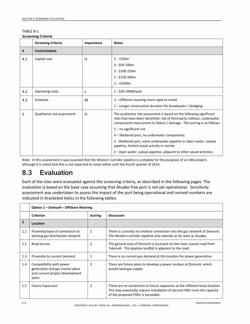
SECTION 8 SCREENING EVALUATION
TABLE 8-1 Screening Criteria
Screening Criteria Importance Notes
4 Cost/schedule
4.1 Capital cost H 5 - <$50m
4 - $50-100m
3 - $100-150m
2 - $150-200m
1 - >$200m
4.2 Operating costs L 2 - $50-100M/year
4.3 Schedule M 3 – Offshore mooring more rapid to install
2 – Longer construction duration for breakwater / dredging
5 Qualitative risk assessment H The qualitative risk assessment is based on the following significant risks that have been identified: risk of third party collision, underwater components more prone to failure / damage. The scoring is as follows:
5 – no significant risk
4 – Sheltered port, no underwater components
3 - Sheltered port, some underwater pipeline or Open water, subsea pipeline, limited vessel activity in vicinity
2 - Open water, subsea pipeline, adjacent to other vessel activities
Note: In this assessment it was assumed that the Western Corridor pipeline is complete for the purposes of an LNG project, although it is noted that this is not expected to come online until the fourth quarter of 2014.
8.3 Evaluation Each of the sites were evaluated against the screening criteria, as described in the following pages. The evaluation is based on the base case assuming that Atuabo free port is not yet operational. Sensitivity assessment was undertaken to assess the impact of the port being operational and revised numbers are indicated in bracketed italics in the following tables.
Option 1 – Domunli – Offshore Mooring
Criterion Scoring Discussion
1 Location
1.1 Proximity/ease of connection to existing gas distribution network
1 There is currently no onshore connection into the gas network at Domunli. The Western corridor pipeline only extends as far west as Atuabo.
1.2 Road Access 2 The general area of Domunli is accessed via the main coastal road from Takoradi. The pipeline landfall is adjacent to the road.
1.3 Proximity to current demand 1 There is no current gas demand at this location for power generation.
1.4 Compatibility with power generation and gas master plans and current project development plans
3 There are future plans to develop a power enclave at Domunli, which would need gas supply.
1.5 Future Expansion 3 There are no constraints to future expansion at the offshore buoy location. This may eventually require installation of second FSRU once the capacity of the proposed FSRU is exceeded.
8-4 ES020414102958WDC COPYRIGHT 2014 BY CH2M HILL INTERNATIONAL, LTD. • COMPANY CONFIDENTIAL
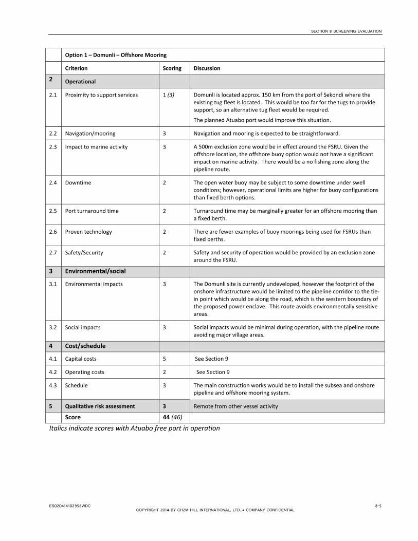
SECTION 8 SCREENING EVALUATION
Option 1 – Domunli – Offshore Mooring
Criterion Scoring Discussion
2 Operational
2.1 Proximity to support services 1 (3) Domunli is located approx. 150 km from the port of Sekondi where the existing tug fleet is located. This would be too far for the tugs to provide support, so an alternative tug fleet would be required.
The planned Atuabo port would improve this situation.
2.2 Navigation/mooring 3 Navigation and mooring is expected to be straightforward.
2.3 Impact to marine activity 3 A 500m exclusion zone would be in effect around the FSRU. Given the offshore location, the offshore buoy option would not have a significant impact on marine activity. There would be a no fishing zone along the pipeline route.
2.4 Downtime 2 The open water buoy may be subject to some downtime under swell conditions; however, operational limits are higher for buoy configurations than fixed berth options.
2.5 Port turnaround time 2 Turnaround time may be marginally greater for an offshore mooring than a fixed berth.
2.6 Proven technology 2 There are fewer examples of buoy moorings being used for FSRUs than fixed berths.
2.7 Safety/Security 2 Safety and security of operation would be provided by an exclusion zone around the FSRU.
3 Environmental/social
3.1 Environmental impacts 3 The Domunli site is currently undeveloped, however the footprint of the onshore infrastructure would be limited to the pipeline corridor to the tie-in point which would be along the road, which is the western boundary of the proposed power enclave. This route avoids environmentally sensitive areas.
3.2 Social impacts 3 Social impacts would be minimal during operation, with the pipeline route avoiding major village areas.
4 Cost/schedule
4.1 Capital costs 5 See Section 9
4.2 Operating costs 2 See Section 9
4.3 Schedule 3 The main construction works would be to install the subsea and onshore pipeline and offshore mooring system.
5 Qualitative risk assessment 3 Remote from other vessel activity
Score 44 (46)
Italics indicate scores with Atuabo free port in operation
ES020414102958WDC 8-5 COPYRIGHT 2014 BY CH2M HILL INTERNATIONAL, LTD. • COMPANY CONFIDENTIAL

SECTION 8 SCREENING EVALUATION
Option 2 – Atuabo – Offshore Mooring
Description Scoring Discussion
1 Location
1.1 Proximity/ease of connection to existing gas distribution network
5 The Western corridor pipeline will terminate at the gas processing plant at Atuabo, providing a convenient tie-in point, approx 2km from shore.
1.2 Road Access 2 The site at Atuabo is accessed via the main coastal road from Takoradi.
1.3 Proximity to current demand 2 There is no current gas demand at this location for power generation; however, the Western Corridor pipeline extends to here, taking natural gas from the processing plant, which provides a means of feeding gas into the network for distribution to the east.
1.4 Compatibility with power generation and gas master plans and current project development plans
3 There are future plans to develop a power enclave at Domunli, which would need gas supply. A future extension of the Western Corridor to Domunli would allow this gas to supply those power plants. Gas is also provided at this location from the Jubilee field. This gas is processed at the gas processing facility and then fed into the Western Corridor pipeline to provide supply to the east (Aboadze) and north (Prestea).
1.5 Future Expansion 3 There are no constraints to future expansion at the offshore buoy location. This may eventually require installation of second FSRU once the capacity of the proposed FSRU is exceeded.
2 Operational
2.1 Proximity to support services 1 (4) Atuabo is located approx. 150 km from the ports of Takoradi and Sekondi where the existing tug fleet is located.
The Atuabo free port would improve this situation.
2.2 Navigation/mooring 3 Navigation and mooring is expected to be straightforward.
2.3 Impact to marine activity 3 (2) A 500m exclusion zone would be in effect around the FSRU. Given the offshore location, the offshore buoy option would not have a significant impact on marine activity. There would be a no-fishing zone along the pipeline route.
2.4 Downtime 2 The open water buoy may be subject to some downtime under swell conditions; however, operational limits are higher for buoy moorings than fixed berth options.
2.5 Port turnaround time 2 Turnaround time may be marginally greater for an offshore mooring than a fixed berth.
2.6 Proven technology 2 There are fewer examples of buoy moorings being used for FSRUs than fixed berths.
2.7 Safety/Security 2 Safety and security of operation would be provided by an exclusion zone around the FSRU.
3 Environmental/social
3.1 Environmental impacts 4 Where possible, the onshore portion of the pipeline would adopt the same right of way as the Jubilee pipeline to minimize onshore impacts and tie in adjacent to the existing gas processing facility.
3.2 Social impacts 3 There are no towns in the immediate vicinity of the landfall, so social impacts would be minimized.
8-6 ES020414102958WDC COPYRIGHT 2014 BY CH2M HILL INTERNATIONAL, LTD. • COMPANY CONFIDENTIAL

SECTION 8 SCREENING EVALUATION
Option 2 – Atuabo – Offshore Mooring
Description Scoring Discussion
4 Cost/schedule
4.1 Capital costs 5 See Section 9
4.2 Operating costs 2 See Section 9
4.3 Schedule 3 The main construction works would be to install the subsea and onshore pipeline and offshore mooring system.
5 Qualitative risk assessment 3 (2) Remote from other vessel activity
Score 50 (51)
Italics indicate scores with Atuabo free port in operation
ES020414102958WDC 8-7 COPYRIGHT 2014 BY CH2M HILL INTERNATIONAL, LTD. • COMPANY CONFIDENTIAL

SECTION 8 SCREENING EVALUATION
Option 3 – Esiama – Offshore Mooring
Description Scoring Discussion
1 Location
1.1 Proximity/ease of connection to existing gas distribution network
4 A gas distribution station is located to the north of the town of Esiama on the Western Corridor pipeline.
1.2 Road Access 2 The distribution station and pipeline landfall are accessed via the main coastal road from Takoradi.
1.3 Proximity to current demand 2 There is no current gas demand at this location for power generation; however, this provides a convenient connection to the Western Corridor pipeline to distribute gas to Aboadze in the east and Prestea to the north.
1.4 Compatibility with power generation and gas master plans and current project development plans
3 This location provides gas into the Western Corridor that would support future power plant developments to the east and north and to Domunli if the Western Corridor pipeline is extended to there to support future power projects.
1.5 Future Expansion 3 There are no constraints to future expansion at the offshore buoy location. This may eventually require installation of a second FSRU once the capacity of the proposed FSRU is exceeded.
2 Operational
2.1 Proximity to support services 2 (3) Esiama is located approx. 90 km from the ports of Takoradi and Sekondi where the existing tug fleet is located, approx. 6 hours sailing time. The Atuabo free port would improve this.
2.2 Navigation/mooring 3 Navigation and mooring is expected to be straightforward.
2.3 Impact to marine activity 3 A 500m exclusion zone will be in effect around the FSRU. Given the offshore location, the offshore buoy option would not have a significant impact on marine activity. There would be a no-fishing zone along the pipeline route.
2.4 Downtime 2 The open water buoy may be subject to some downtime under swell conditions; however, operational limits are higher for buoy moorings than fixed berth options.
2.5 Port turnaround time 2 Turnaround time may be marginally greater for an offshore mooring than a fixed berth.
2.6 Proven technology 2 There are fewer examples of buoy moorings being used for FSRUs than fixed berths.
2.7 Safety/Security 2 Safety and security of operation would be provided by an exclusion zone around the FSRU.
3 Environmental/social
3.1 Environmental impacts 3 The proposed pipeline corridor is to the west of Esiama, crossing the highway to connect to the distribution station. There would be some loss of native vegetation.
3.2 Social impacts 3 The proposed corridor is to the west of any settlements, maintaining a minimum clearance of 35m. There would be some impact from clearing of areas of coconut plantation.
8-8 ES020414102958WDC COPYRIGHT 2014 BY CH2M HILL INTERNATIONAL, LTD. • COMPANY CONFIDENTIAL

SECTION 8 SCREENING EVALUATION
Option 3 – Esiama – Offshore Mooring
Description Scoring Discussion
4 Cost/schedule
4.1 Capital costs 5 See Section 9
4.2 Operating costs 2 See Section 9
4.3 Schedule 3 The main construction works would be to install the subsea and onshore pipeline and offshore mooring system.
5 Qualitative risk assessment 3 Remote from other vessel activity
Score 49 (50)
Italics indicate scores with Atuabo free port in operation
ES020414102958WDC 8-9 COPYRIGHT 2014 BY CH2M HILL INTERNATIONAL, LTD. • COMPANY CONFIDENTIAL

SECTION 8 SCREENING EVALUATION
Option 4 – Takoradi – Fixed berth Protected by Breakwater
Description Scoring Discussion
1 Location
1.1 Proximity/ease of connection to existing gas distribution network
1 The Western Corridor pipeline runs approximately 10 km to the north of the town of Takoradi. The area is heavily populated, so there would be challenges in establishing a pipeline corridor through this area. Additionally, there is no connection point on the pipeline to the north of Takoradi shutdown of the pipeline would be required while a connection is made.
1.2 Road Access 3 Road access to the port is good. Access to the berth would be via the existing roadway on the breakwater.
1.3 Proximity to current demand 2 The closest demand for power generation is at the Takoradi power stations at Aboadze (approx. 10 km).
1.4 Compatibility with power generation and gas master plans and current project development plans
2 This location would provide gas into the Western Corridor that would support future power plant developments to the east and north and to Domunli if the Western Corridor pipeline is extended to there to support future power projects.
1.5 Future Expansion 1 Any future expansion with an additional FSRU would require additional berth space and a breakwater extension. This could be planned as pre-investment but would have an impact on capital cost.
2 Operational
2.1 Proximity to support services 4 There is a tug fleet based at Sekondi that could support vessel operations into and out of the facility.
2.2 Navigation/mooring 2 Navigation and mooring is expected to be straightforward.
2.3 Impact to marine activity 2 A 500m exclusion zone would be in effect around the FSRU and LNG tanker. This may affect vessel activity in the navigation approaches to the port when an LNG tanker is arriving or departing. The berth layout would be designed to provide sufficient distance from existing operations.
2.4 Downtime 3 The fixed berth should be designed to provide a negligible level of downtime.
2.5 Port turnaround time 3 Turnaround at the fixed berth is expected to be straightforward assuming sufficient tug availability.
2.6 Proven technology 4 FSRUs at fixed berths are proven technology.
2.7 Safety/Security 3 Safety and security of operation would be provided by an exclusion zone around the FSRU that would be enforced by the harbor master.
3 Environmental/social
3.1 Environmental impacts 2 There would be some impacts where the pipeline runs parallel to the coast. Impacts would be concentrated on the onshore pipeline route. Some impacts would be expected from the quarry.
3.2 Social impacts 2 Potential for significant relocation along the onshore pipeline.
8-10 ES020414102958WDC COPYRIGHT 2014 BY CH2M HILL INTERNATIONAL, LTD. • COMPANY CONFIDENTIAL
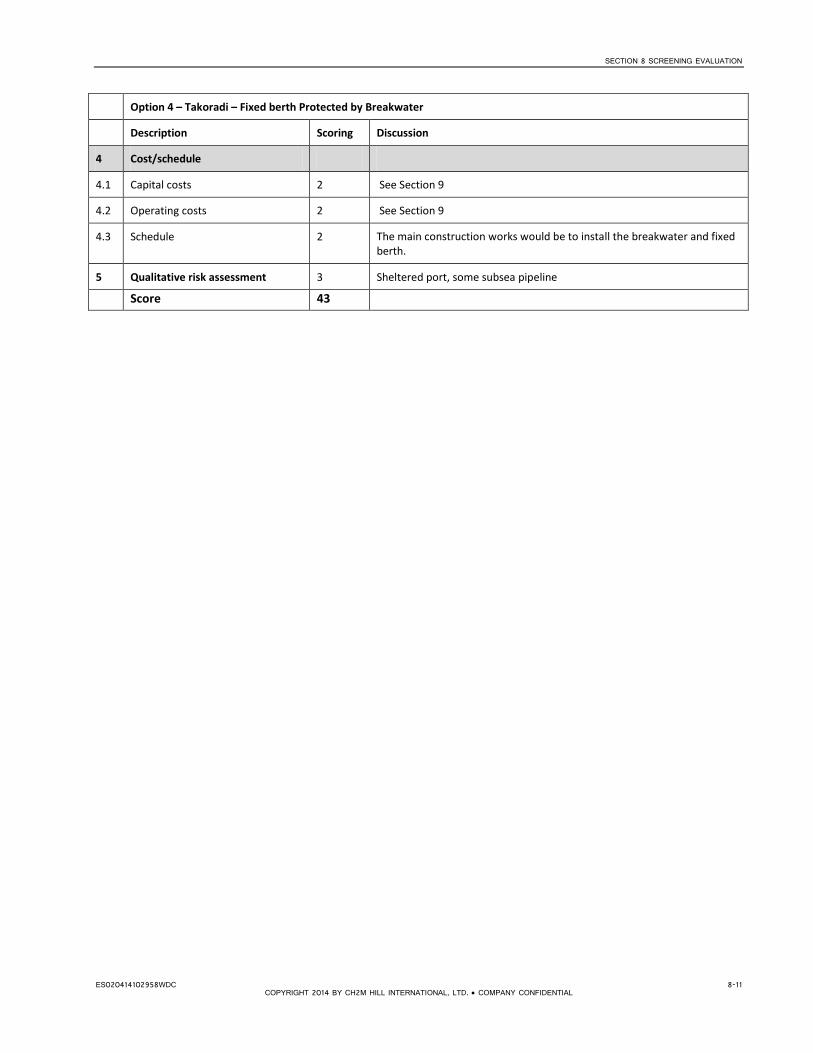
SECTION 8 SCREENING EVALUATION
Option 4 – Takoradi – Fixed berth Protected by Breakwater
Description Scoring Discussion
4 Cost/schedule
4.1 Capital costs 2 See Section 9
4.2 Operating costs 2 See Section 9
4.3 Schedule 2 The main construction works would be to install the breakwater and fixed berth.
5 Qualitative risk assessment 3 Sheltered port, some subsea pipeline
Score 43
ES020414102958WDC 8-11 COPYRIGHT 2014 BY CH2M HILL INTERNATIONAL, LTD. • COMPANY CONFIDENTIAL

SECTION 8 SCREENING EVALUATION
Option 5 – Sekondi – Fixed berth Protected by Breakwater
Description Scoring Discussion
1.1 Proximity/ease of connection to existing gas distribution network
1 The Western Corridor pipeline runs approximately 10km to the north of the town of Takoradi. The area is heavily populated, so there would be challenges in establishing a pipeline corridor through this area. Additionally, there is no connection point on the pipeline to the north of so shutdown of the pipeline would be required while a connection is made, or else a connection made at Aboadze to the east.
1.2 Road Access 2 Road access to the port is good. There is no roadway on the existing breakwater to provide access to the berth, so this would need to be modified.
1.3 Proximity to current demand 2 The closest demand for power generation is at the Takoradi power stations at Aboadze (approx. 10 km).
1.4 Compatibility with power generation and gas master plans and current project development plans
2 This location would provide gas into the Western Corridor that would support future power plant developments to the east and north and to Domunli if the Western Corridor pipeline is extended to there to support future power projects.
1.5 Future Expansion 1 Any future expansion with an additional FSRU would require additional berth space and a breakwater extension. This could be planned as pre-investment but would have an impact on capital cost.
2 Operational 2.1 Proximity to support services 4 There is a tug fleet based at Sekondi that could support vessel operations
into and out of the facility.
2.2 Navigation/mooring 2 Navigation and mooring is expected to be straightforward.
2.3 Impact to marine activity 2 A 500m exclusion zone would be in effect around the FSRU and LNG tanker. This may affect vessel activity in the navigation approaches to the port, when an LNG tanker is arriving or departing. The berth layout would be designed to provide sufficient distance from existing operations.
2.4 Downtime 3 The fixed berth should be designed to provide a negligible level of downtime.
2.5 Port turnaround time 3 Turnaround at the fixed berth is expected to be straightforward assuming sufficient tug availability.
2.6 Proven technology 4 FSRUs at fixed berths are proven technology.
2.7 Safety/Security 4 Safety and security of operation would be provided by an exclusion zone around the FSRU. This would be enforced by the harbormaster. Sekondi is a military installation and will have maximum security classification.
3 Environmental/social
3.1 Environmental impacts 2 Impacts would be concentrated on the onshore pipeline route which crosses through areas of both developed areas and native vegetation. Some impacts would be expected from the rock quarry and transportation of the rock to the port.
3.2 Social impacts 2 Potential for significant relocation along the onshore pipeline.
4 Cost/schedule 4.1 Capital costs 1 See Section 9 4.2 Operating costs 2 See Section 9 4.3 Schedule 2 The main construction works would be to install the breakwater and
fixed berth. 5 Qualitative risk assessment 4 Protected berth with no subsea pipeline.
Score 43
8-12 ES020414102958WDC COPYRIGHT 2014 BY CH2M HILL INTERNATIONAL, LTD. • COMPANY CONFIDENTIAL

SECTION 8 SCREENING EVALUATION
Option 6 – Aboadze – Offshore Mooring
Description Scoring Discussion 1 Location
1.1 Proximity/ease of connection to existing gas distribution network
4 The WAGP comes ashore at Aboadze and connects to a metering station north of the power plant, which would provide a convenient tie-in point. There is also an R&M station for the Western Corridor pipeline approximately 1 km to the north of the power plants.
1.2 Road Access 2 The site at Aboadze is accessed via the main coastal road from Takoradi.
1.3 Proximity to current demand 4 There is significant current demand at this location from the existing Takoradi power plants.
1.4 Compatibility with power generation and gas master plans and current project development plans
5 There is significant future demand at this location from the T3 plant under construction and future proposals for power plants.
1.5 Future Expansion 3 There are no constraints to future expansion at the offshore buoy location. This may eventually require installation of second FSRU once the capacity of the proposed FSRU is exceeded.
2 Operational
2.1 Proximity to support services 3 Aboadze is close to the ports of Sekondi and Takoradi with an existing port fleet.
2.2 Navigation/mooring 3 Navigation and mooring is expected to be straightforward.
2.3 Impact to marine activity 3 A 500m exclusion zone would in effect around the FSRU. Given the offshore location, the offshore buoy option would not have a significant impact on marine activity. There would be a no-fishing zone along the pipeline route.
2.4 Downtime 2 The open water buoy may be subject to some downtime under swell conditions; however, operational limits are higher for buoy moorings than fixed berth options.
2.5 Port turnaround time 2 Turnaround time may be marginally greater for an offshore mooring than a fixed berth.
2.6 Proven technology 2 There are fewer examples of buoy moorings being used for FSRUs than fixed berths.
2.7 Safety/Security 2 Safety and security of operation would be provided by an exclusion zone around the FSRU.
3 Environmental/social
3.1 Environmental impacts 3 Environmental impacts will be focused along the 2.3 km on shore pipeline, these impacts should be minimal due to the disturbed nature of the areas crossed.
3.2 Social impacts 3 The 500 m exclusion zone around the FSRU would have a minimal impact on the adjacent fishing village.
4 Cost/schedule
4.1 Capital costs 5 See Section 9
4.2 Operating costs 2 See Section 9
4.3 Schedule 3 The main construction works would be to install the subsea and onshore pipeline and offshore mooring system.
5 Qualitative risk assessment 2 Offshore mooring with subsea pipeline, adjacent to existing SPM
Score 53
ES020414102958WDC 8-13 COPYRIGHT 2014 BY CH2M HILL INTERNATIONAL, LTD. • COMPANY CONFIDENTIAL

SECTION 8 SCREENING EVALUATION
Option 7 – Tema – Offshore Mooring
Description Scoring Discussion 1 Location
1.1 Proximity/ease of connection to existing gas distribution network
1 There is an existing metering station where the WAGP comes ashore where connection could be made. An FSRU at Tema would serve the demand at that location, supplementing the gas that already comes onshore from the WAGP. There is limited onshore network for delivery of the gas to other locations.
1.2 Road Access 2 Good connection to road network to Tema town and port and beyond to Accra. Existing access roads to gas plants and pipeline infrastructure.
1.3 Proximity to current demand 4 There is significant demand at Tema from various power plants.
1.4 Compatibility with power generation and gas master plans and current project development plans
4 There is significant future demand at Tema from expansion of existing power plants and new power plant developments.
1.5 Future Expansion 3 There are no constraints to future expansion at the offshore buoy location. This may eventually require installation of second FSRU once the capacity of the proposed FSRU is exceeded.
2 Operational
2.1 Proximity to support services 3 The proposed site at Tema is close to the port, which could provide these support services.
2.2 Navigation/mooring 3 Navigation and mooring is expected to be straightforward.
2.3 Impact to marine activity 3 A 500m exclusion zone would be in effect around the FSRU. Given the offshore location, the offshore buoy option would not have a significant impact on marine activity. There would be a no-fishing zone along the pipeline route.
2.4 Downtime 2 The open water buoy may be subject to some downtime under swell conditions; however, operational limits are higher for buoy moorings than fixed berth options.
2.5 Port turnaround time 2 Turnaround time may be marginally greater for an offshore mooring than a fixed berth.
2.6 Proven technology 2 There are fewer examples of buoy moorings being used for FSRUs than fixed berths.
2.7 Safety/Security 2 Safety and security of operation would be provided by an exclusion zone around the FSRU.
3 Environmental/social
3.1 Environmental impacts 4 The onshore pipeline would run through an existing industrial area.
3.2 Social impacts 3 The onshore pipeline would not require any relocation.
4 Cost/schedule
4.1 Capital costs 5 See Section 9
4.2 Operating costs 2 See Section 9
4.3 Schedule 3 The main construction works would be to install the subsea and onshore pipeline and offshore mooring system.
5 Qualitative risk assessment 2 Offshore mooring with subsea pipeline, adjacent to existing SPM
Score 50
8.4 Screening Results The results of the screening are summarized in Table 8-2.
8-14 ES020414102958WDC COPYRIGHT 2014 BY CH2M HILL INTERNATIONAL, LTD. • COMPANY CONFIDENTIAL

SECTION 8 SCREENING EVALUATION
TABLE 8-2 Screening Results Option Importance 1 2 3 4 5 6 7 Location Domunli Atuabo Esiama Takoradi Sekondi Aboadze Tema Description Offshore
mooring Offshore mooring
Offshore mooring
Fixed berth outside existing port, protected with breakwater
Fixed berth outside existing port, protected with breakwater
Offshore mooring
Offshore mooring
1 Location
1.1 Proximity/ease of connection to existing gas distribution network
H 1 5 4 1 1 4 1
1.2 Road Access L 2 2 2 3 2 2 2
1.3 Proximity to current gas demand M 1 2 2 2 2 4 4 1.4 Compatibility with power
generation and gas master plans and current project development plans
H 3 3 3 2 2 5 4
1.5 Future Expansion M 3 3 3 1 1 3 3 2 Operational
2.1 Proximity to support services M 1 (3) 1 (4) 2 (3) 4 4 3 3 2.2 Ease of navigation L 3 3 3 2 2 3 3 2.3 Impact to marine activity L 3 3 (2) 3 2 2 3 3
2.4 Downtime L 2 2 2 3 3 2 2 2.5 Port turnaround time L 2 2 2 3 3 2 2
2.6 Proven technology M 2 2 2 4 4 2 2
2.7 Safety/Security M 2 2 2 3 4 2 2
ES020414102958WDC 8-15 COPYRIGHT 2014 BY CH2M HILL INTERNATIONAL, LTD. • COMPANY CONFIDENTIAL

SECTION 8 SCREENING EVALUATION
TABLE 8-2 Screening Results Option Importance 1 2 3 4 5 6 7 Location Domunli Atuabo Esiama Takoradi Sekondi Aboadze Tema Description Offshore
mooring Offshore mooring
Offshore mooring
Fixed berth outside existing port, protected with breakwater
Fixed berth outside existing port, protected with breakwater
Offshore mooring
Offshore mooring
3 Environmental/social
3.1 Environmental impacts M 3 4 3 2 2 3 4
3.2 Social impacts M 3 3 3 2 2 3 3
4 Cost/schedule
4.1 Capital costs H 5 5 5 2 1 5 5
4.2 Operating costs L 2 2 2 2 2 2 2
4.3 Schedule M 3 3 3 2 2 3 3
5 Qualitative risk assessment H 3 3 (2) 3 3 4 2 2
Score 44 (46) 50 (51) 49 (50) 43 43 53 50
Italics indicate scores with Atuabo free port in operation
8-16 ES020414102958WDC COPYRIGHT 2014 BY CH2M HILL INTERNATIONAL, LTD. • COMPANY CONFIDENTIAL

SECTION 8 SCREENING EVALUATION
The scoring indicates that Aboadze is the preferred site, with a score of 53. This is primarily because of its proximity to current demand, to the sites of future power generation capacity adjacent to the existing power plants, and its ease of connection to the Western Corridor pipeline to allow distribution of gas within the Western Region as other plants come online. This location also provides potential for use of WAGP to transport gas to Tema via reverse flow.
Tema, Atuabo, and Esiama obtained very similar scores (50, 49 and 50 respectively) and all present good alternatives to Aboadze.
Domunli scored next at 44, primarily because of the lack of existing infrastructure and demand at the site.
Both Takoradi and Sekondi with the fixed berth options scored lowest at 43. The biggest challenge at these sites is the onshore connection to the Western Corridor pipeline for transfer of the gas to the power plants to the east. The capital cost for these sites is also significantly greater because of the need to construct a breakwater and undertake dredging to create a berth of sufficient depth.
Sensitivity analysis of the effect of the proposed Atuabo port indicates that this makes the more westerly options marginally more favorable due to the presence of local support facilities in this area.
ES020414102958WDC 8-17 COPYRIGHT 2014 BY CH2M HILL INTERNATIONAL, LTD. • COMPANY CONFIDENTIAL


SECTION 9
Cost Estimate
9.1 Estimate Classification and Methodology The cost estimate provided in this section is considered a Class 5 estimate, as defined by the Association for the Advancement of Cost Engineering International (AACEI). The AACE classes are defined in Table 9-1.
TABLE 9-1 AACE Cost Estimate Classes
Primary Characteristic Secondary Characteristic
ESTIMATE CLASS
MATURITY LEVEL OF PROJECT DEFINITION
DELIVERABLES
Expressed as % of complete definition
END USAGE
Typical purpose of estimate
METHODOLOGY
Typical estimating method
EXPECTED ACCURACY RANGE
Typical variation in low and high ranges [a]
Class 5
0% to 2%
Functional area, or concept screening
SF or m2 factoring,
parametric models, judgment, or analogy
L: -20% to -30%
H: +30% to +50%
Class 4
1% to 15%
or Schematic design or concept study
Parametric models, assembly driven models
L: -10% to -20%
H: +20% to +30%
Class 3
10% to 40%
Design development, budget authorization, feasibility
Semi-detailed unit costs with assembly level line items
L: -5% to -15%
H: +10% to +20%
Class 2 30% to 75% Control or bid/tender, semi-detailed
Detailed unit cost with forced detailed take-off
L: -5% to -10%
H: +5% to +15%
Class 1 65% to 100% Check estimate or pre bid/tender, change order
Detailed unit cost with detailed take-off
L: -3% to -5%
H: +3% to +10%
Note: [a] The state of construction complexity and availability of applicable reference cost data affect the range markedly. The +/- value represents typical percentage variation of actual cost from the cost estimate after application of contingency (typically at a 50% level
Source: AACE
The cost estimate was prepared for guidance in project evaluation and implementation from the information available at the time of the estimate. The final cost of the project will depend on the actual labor and material costs, competitive market conditions, final project costs, implementation schedule, and other variable factors. As a result, the final project costs will vary from the estimate presented herein. Because of these factors, project feasibility and funding needs must be carefully reviewed before specific financial decisions are made to help ensure proper project evaluation and adequate funding. Our estimate is based on material, equipment, and labor pricing as of February 2014.
The cost estimate is based primarily on complete unit costs applied to gross quantities. Detailed items using separate labor, materials, and equipment costs were used where appropriate. The estimate uses parametric costs where design information or details were insufficient to allow a detailed item method. Quotations, allowances, benchmarking and other costs are as described in Section 9.2.
ES020414102958WDC 9-1 COPYRIGHT 2014 BY CH2M HILL INTERNATIONAL, LTD. • COMPANY CONFIDENTIAL

SECTION 9 COST ESTIMATE
The client should be cautioned that material prices can be volatile as a result of market conditions during the bidding process.
9.2 Basis of Estimate 9.2.1 Basis Documents The estimate is based on CH2M HILL-prepared sketches included in Appendix C, unstamped, dated February, 2014, as included in this report.
9.2.2 Key Assumptions Current assumptions were based on design information available as of February 2014. The estimate also was based on the assumption the work will be performed on a competitive bid basis and the contractor will have a reasonable amount of time to complete the work. The estimate assumed a reasonable project schedule, normal working hours, no overtime, constructed under a single contract, and no liquidated damages. It also was assumed that the contractor will have adequate site access and laydown area. This estimate should be evaluated for market changes after 60 days of the issue date.
9.2.3 Estimate Methodology During this concept-level design, CH2M HILL estimators provided parametric costing based on a unit of measurement (i.e., cost per square foot or cost per unit) with consideration to the design purpose, for any item without sufficient design detail to estimate. The cost was assigned per unit and may have been developed by averaging similar projects and analysis of historical costs. Also, CH2M HILL parametric estimates generated a basic system design fitting the parameters of the structure considering the application. Parametric estimating creates a system cost estimate based on basic inputs known or presumed. Pricing was geographically adjusted according to reflect local labor and material rates. Some scope areas provided few details and required allowances for the major components. This pre-feasibility-level design cost estimate uses a top-down approach, whereas scope items are specified but lack clarity or definition required for a detailed quantity take-off.
9.2.4 Scope of Work The project scope of work is as follows and was provided by design engineering personnel. All listed line items were assigned unit costs that are to be considered the total cost required for the complete supply and installation of the specified items. The following design concepts are named for the location of the specified option. • Domunli - Multi-Point Mooring and Pipeline • Atuabo - Multi-Point Mooring and Pipeline • Esiama - Multi-Point Mooring and Pipeline • Takoradi - Breakwater, Berth and Pipeline • Sekondi - Breakwater, Berth and Pipeline • Aboadze - Multi-Point Mooring and Pipeline • Tema - Multi-Point Mooring and Pipeline
A multi-point mooring was assumed for the purposes of this preliminary costing. A more detailed assessment of single versus multi-point mooring systems will be undertaken at later design stages.
Each option contains variables of scope in different quantities as it pertains to the specific design scheme, as follows:
1. Dredging Dredging Mobilization Dredge at Channel, Berth and Turning Basin Dredge Material Disposal
9-2 ES020414102958WDC COPYRIGHT 2014 BY CH2M HILL INTERNATIONAL, LTD. • COMPANY CONFIDENTIAL

SECTION 9 COST ESTIMATE
2. Breakwater – Rubble Mound
Breakwater Material Breakwater Construction
3. FSRU Berth
Loading Platform and Boat Landing Breasting Dolphin Mooring Dolphins Walkways Marine Mooring Fixtures Process Equipment at Berth
4. NG Pipeline
Platform to Jetty Pipeline - 16-inch-diameter Jetty and Breakwater Pipeline - 16-inch-diameter Ocean Entry Point Subsea Pipeline - 16-inch-diameter Shore Landing Point Land Pipeline - Buried - 16-inch-diameter Pipeline Tie-In Point Metering Station
9.2.5 Exclusions The cost estimate excludes the following costs:
• Non-construction or soft costs for permits, environmental studies, permitting, design, services during construction. These may be estimated as being in the range of 15-25% of the capital construction costs presented here.
• Land, legal and owner administration costs
• Hazardous material disposal
9.2.6 Allowances and Unit Cost Basis The current cost estimate includes lump sum units and specific allowances. This was modeled to identify and included costs for labor, equipment, and materials. These costs were based on costs for previous projects of similar scope and definition.
1. Dredging – Based on previous Takoradi investigations and current work by Jan de Nul
Dredging Mobilization – Percentage based on international industry benchmarks Dredge at Channel, Berth and Turning Basin – Unit cost for removal
Dredge Material Disposal – Unit cost for transport and disposal at dump site reclamation
2. Breakwater – Rubble Mound
Breakwater Material – Based on material source investigation and current work by Jan de Nul Breakwater Construction – Based on international contractors benchmark work rates
ES020414102958WDC 9-3 COPYRIGHT 2014 BY CH2M HILL INTERNATIONAL, LTD. • COMPANY CONFIDENTIAL

SECTION 9 COST ESTIMATE
3. FSRU Berth – Based on more than 10 previous detailed cost estimates of similar scope and design intent
Loading Platform and Boat Landing Breasting Dolphin Mooring Dolphins Walkways Marine Mooring Fixtures Process Equipment at Berth
4. NG Pipeline - Based on over 15 previous detailed cost estimates of similar scope and design intent
Platform to Jetty Pipeline - 16-inch-diameter Jetty and Breakwater Pipeline - 16-inch-diameter Ocean Entry Point Subsea Pipeline - 16-inch-diameter Shore Landing Point Land Pipeline - Buried - 16-inch-diameter Pipeline Tie-In Point Metering Station
9.2.7 Project Delivery Schedule and Methodology No project delivery dates have been specified and a start date is not reflected in this cost estimate. No escalation was included and all costs are for first quarter 2014 US dollars.
9.2.8 Labor, Materials, Subcontracts and Other Direct Costs 9.2.8.1 Labor Labor rates were tailored international contractor wages as experienced from previous similar projects and localized to the geographic area of Ghana where appropriate.
9.2.8.2 Materials Materials pricing was set to reflect true cost specific to the project’s geographic area, and some preliminary estimating quotes for major equipment and materials were referenced and checked.
9.2.8.3 Subcontracts It was assumed that the contractor may employ various specialty subcontractors, such as testing, electrical, line and earthwork subcontractors.
9.2.8.4 Construction Equipment Construction equipment makeup and pricing is indicative of what would be normally expected to be needed to perform the scope of work and was priced to reflect the local market conditions.
9.2.9 Markups, Taxes and Other Indirect Costs 9.2.9.1 Design Contingency Design contingency or allowance is intended to capture construction costs that will be incurred to complete the project but are not yet clearly identified in the design. As the design progresses in detail, this contingency will be reduced accordingly.
9.2.9.2 Construction Contingency Construction contingency or allowance captures costs that the contractor will incur relating to construction that cannot be specifically identified from the design. This could be acknowledged as a difficulty factor as to how complex or challenging a project may be to construct or to account for unforeseen conditions such as climate or adverse ground conditions, either of which could affect productivity.
9-4 ES020414102958WDC COPYRIGHT 2014 BY CH2M HILL INTERNATIONAL, LTD. • COMPANY CONFIDENTIAL

SECTION 9 COST ESTIMATE
9.2.9.3 General Conditions General conditions were included based on overall construction costs on a percentage basis. The following items are examples of what would be considered included in general conditions:
1. Onsite project management staff, salary, travel, room, board, transportation 2. Project offices, water, lights, air conditioning, telephone, equipment, supplies, temporary power 3. Project management tools, computers, software, schedules, reports 4. Site security, safety, survey, communications, access, housekeeping 5. Foreign trade workers, travel, room, board, transportation, incentives
9.2.9.4 Mobilization Mobilization is the cost associated with planning, preparing, and purchasing equipment and materials to set up a temporary site compound and office; the transportation of equipment and materials; road building for site access; and furnishing utilities to service the temporary site offices and related services. This item also gives the contractor an ability to invoice the owner for some startup financing to defray cost to purchase permanent materials to be used in this project.
The following typical contractor markups were applied to the cost estimate:
Mark Up Percentage
Sales Tax (material only) Included
Jobsite Overhead (General Condition) 6.0
Mobilization 8.0
Overhead (General Contractor Home Office)
8.0
Contractor Profit 15.0
Design Contingency 15.0
Escalation NIC
Market Adjustment Factor 0.0
Construction Contingency 15.0
9.2.10 Market Conditions Current market conditions affect the construction bid environment in local geographic areas. Past events have greatly introduced market price volatility to construction projects. This would be reflected in bids and in comparisons with other Engineer’s Estimates. Bids can be erratic with some projects. Having an expected average of four to eight numbers of bidders, despite estimator’s best practices and adjustments, cost are driven by market conditions.
9.2.11 Escalation Costs No escalation was added to this estimate and is priced in first quarter 2014 US dollars.
9.2.12 Cost Resources The following cost resources were used in the development of the cost estimate:
• R.S. Means • National Electrical Contractors Association - Labor Unit Manual • Mechanical Contractors Association– Labor productivity • CH2M HILL historical data • Vendor quotes (where available) • Estimator judgment
ES020414102958WDC 9-5 COPYRIGHT 2014 BY CH2M HILL INTERNATIONAL, LTD. • COMPANY CONFIDENTIAL

SECTION 9 COST ESTIMATE
9.2.13 Estimate Validity This estimate was prepared during February 2014 and is based on project layout details provided in the same month.. It represents a snapshot in time of what is known about the project and expected to occur. The commodities and energy markets are extremely active at this point in time. Changes in either will have dramatic affects to this estimate. Therefore, this estimate should be viewed in that light and if more than 60 days have passed, or there have been significant changes in the commodity markets, this estimate should be updated and reevaluated.
9.2.14 Disclaimer The opinions of cost (estimates) shown, and any resulting conclusions on project financial or economic feasibility or funding requirements, have been prepared for guidance in project evaluation and implementation from the information available at the time the opinion was prepared. The final costs of the project and resulting feasibility will depend on actual labor and material costs, competitive market conditions, actual site conditions, final project scope, implementation schedule, continuity of personnel and engineering, and other variable factors. The recent increases or decreases in material pricing may have a significant impact that is not predictable, so careful review or consideration must be used in evaluating material prices. As a result, the final project costs will vary from the opinions of cost presented herein. Because of these factors, project feasibility, benefit-cost ratios, risks, and funding needs must be carefully reviewed before specific financial decisions are made or project budgets are established to help ensure proper project evaluation and adequate funding.
9.3 Capital Cost Estimate The capital construction cost estimates for each of the sites are summarized in Table 9-2.
TABLE 9-2 Capital Cost Estimate
Site Capital cost ($Millions)
Domunli - Multi-Point Mooring and Pipeline: 30
Atuabo - Multi-Point Mooring and Pipeline: 30
Esiama - Multi-Point Mooring and Pipeline: 40
Takoradi - Breakwater, Berth and Pipeline: 195
Sekondi - Breakwater, Berth and Pipeline: 270
Aboadze - Multi-Point Mooring and Pipeline: 40
Tema - Multi-Point Mooring and Pipeline: 40
Costs provided are to be considered -30% / +40%, based on level of design and past experience on similar projects.
9.4 Operational Cost Estimate Operational cost estimates are given in Table 9-3 for the two alternative marine facility concepts, fixed sheltered berth and offshore mooring.
Operational costs include:
• Annual FSRU rental, assuming a lease duration of 10 years • Crew costs for berth operations • Operation and maintenance costs for both the subsea and onshore pipelines • Tug assistance for LNG tanker operations at the FSRU facility
9-6 ES020414102958WDC COPYRIGHT 2014 BY CH2M HILL INTERNATIONAL, LTD. • COMPANY CONFIDENTIAL

SECTION 9 COST ESTIMATE
TABLE 9-3 Operational Cost Estimate
Item Annual operating cost ($Millions/yr)
Fixed berth Offshore mooring
FSRU Annual Rental * 60 60
FSRU Berth Operations 6 6
Pipeline Operation and Maintenance Costs 4 3
Tug Assistance 2 3
Total 72 72
* assumes minimum 10-year lease
Notes: Accuracy Range of this estimate Should Be Considered +/- 30%.
Operational costs listed above are not escalated or discounted to present value.
ES020414102958WDC 9-7 COPYRIGHT 2014 BY CH2M HILL INTERNATIONAL, LTD. • COMPANY CONFIDENTIAL


SECTION 10
Environmental and Social Review
10.1 Overview A summary discussion of potential impacts associated with construction and operation of the project is presented in the following sections. The discussion of impacts is based on the current design information for each of the seven site options and the existing environmental and socioeconomic information presented in the baseline descriptions in Appendix D, which also includes more detailed discussion of the impacts for each of the sites. This analysis of impacts is based on existing available information and data and is not intended to be an exhaustive analysis of detailed site specific data. Further refinement of the pipeline routes for the selected site(s) will be conducted and will include the collection and analysis of site specific field data. Scoring of impacts for each of the sites is included in Appendix D.
10.2 Offshore Impacts 10.2.1 Dredging and Trenching Impacts to Benthic Habitat and Water Quality For the offshore mooring options, the only impacts will be from trenching across the subtidal and intertidal reaches of the pipeline route. This will cause temporary and short term loss of benthic flora and fauna and localized turbidity impacts during construction. Trenched areas will be recolonized post-construction. These impacts will also apply for the subsea pipeline that forms part of the Takoradi option. The scoring of impact significance among offshore mooring sites is proportional to the total length of the subsea LNG pipeline, but also considers that slightly greater short term impacts will result from trenching through rocky substrates than for softer sediments.
Extensive dredging and filling of nearshore marine habitats is required for the fixed berth options at Sekondi and Takoradi. Although some recolonization of the dredged footprints is expected, periodic maintenance dredging will be a continuing source of temporary disturbance followed by recolonization. Dredging will significantly and permanently impact the abundant, healthy, and diverse benthic habitats and biological communities of the existing Takoradi port, while causing only short-term, periodic turbidity impacts to local water quality.
10.2.2 Operational Impacts to Marine Water Quality The primary and most significant operational impact for all options will be cold water discharge from the FSRU using seawater heat for LNG regasification, causing localized decreases of ambient water temperature. Although thermal mixing and plume modeling has not yet been performed, the size of the mixing zone will be comparable among all offshore mooring sites due to comparable water depths at each site. Due to the shallower water depths for the fixed berth options at Sekondi and Takoradi, the footprint of the discharge plume will be larger and thermal impacts are likely to reach shallow benthic habitats.
Assuming cold water discharge at the surface, it is conceivable that localized convection will result in warmer waters beneath the FSRU being displaced by the colder discharge, leading to localized upwelling of nutrients with resultant localized increases in primary production. Any such beneficial impact to fish communities and their predators, such as marine mammals, would likely offset minor localized adverse effects on immobile and cold-intolerant species of benthic flora and macrofauna.
For Sekondi and Takoradi fixed berth options, operational impacts to water quality will also occur from periodic dredging.
ES020414102958WDC 10-1 COPYRIGHT 2014 BY CH2M HILL INTERNATIONAL, LTD. • COMPANY CONFIDENTIAL

SECTION 10 ENVIRONMENTAL AND SOCIAL REVIEW
10.2.3 Loss of Marine Biodiversity There is no significant risk for the offshore mooring sites of reduction in marine biodiversity at the FSRU or along the subsea pipeline trench. Trenching impacts will be short-term and temporary. Operational impacts of cold water discharges might permanently reduce the localized abundance of cold-intolerant species within the mixing zone, though the scale of this impact will be too small to alter the local abundance and biodiversity of aquatic biota outside of the mixing zone.
For Sekondi and Takoradi there is a moderate risk to marine biodiversity, both due to the physical loss of habitat from filling and dredging and periodic maintenance dredging, as well as from the operational cold water discharges from the FSRU. The shallower port waters are reportedly “teeming with fish” and support a rich biodiversity of flora and fauna, and operational impacts of cold water discharges may permanently reduce the localized abundance and diversity of cold-intolerant species within the mixing zone. Given the larger spatial extent of this zone in shallower waters, the scale of this impact will be greater than that at the deeper offshore sites. In addition, since the shallower port waters are likely to be warmer than those at the buoy sites it is possible that there is a proportionally greater representation of cold-intolerant flora and fauna in the vicinity of the fixed berth sites.
These hypothetical impacts and risks of cold water discharges to both abundance and biodiversity of marine biota should be addressed in the full ESIA to be prepared for the selected project site.
10.2.4 Impacts to Marine Mammals Construction and operational impacts to marine mammals, such as whales, dolphins, and manatees, are likely to be minimal, but will vary among sites based on the proximity of the buoy to natural attractions to these species, such as rich fishing grounds (e.g., “banks” of localize shallows in otherwise deeper water; nearby estuaries and/or coastal lagoons frequented by dolphins or manatees). Any such site-specific conditions that offer these mammals a superior habitat or greater abundance of prey will result in a higher risk of collision with vessels visiting the FSRU. If cold water discharges do result in some localized increased or decreased abundance of marine mammal prey, respectively, these may increase risks of collisions with vessels near the FSRU or decrease food supply in the thermal mixing zone. These hypothetical impacts and risks to marine mammals and the abundance of their prey within the thermal mixing zone of the FSRU should be addressed in the full ESIA to be prepared for the selected project site.
For Sekondi and Takoradi, although fishing prohibition at the ports has reportedly led to a higher abundance of fish in these nearshore waters, it is possible that this greater abundance of prey for dolphins is offset by the greater vessel traffic and other human activities at the port. Thus, localized risks of vessel collisions with dolphins and other marine mammals at/near the ports are unlikely to be significant now or to increase as a result of the project.
10.2.5 Impacts to Turtle Nesting Beach Sites Potential impacts to turtle nesting beaches at Domunli, Atuabo, Esiama, Takoradi, and Aboadze are scored as slight, as trenching across the beach for pipeline installation will have a very small impact footprint that will be fully restored to its original condition. There is no potential for impacts at Tema and Sekondi due to the rocky shoreline which is not conducive to nesting.
10.2.6 Impacts to Other Protected Marine Species Despite a lack of site-specific data on occurrences of other protected marine species of fish or macroinvertebrates, potential impacts to them at all sites are slight and commensurate with the risks of habitat or water quality impacts from pipeline trenching during construction and/or thermal, operational impacts of the FSRU.
10-2 ES020414102958WDC COPYRIGHT 2014 BY CH2M HILL INTERNATIONAL, LTD. • COMPANY CONFIDENTIAL

SECTION 10 ENVIRONMENTAL AND SOCIAL REVIEW
10.3 Onshore Impacts 10.3.1 Noise and Air Emissions This temporary impact is expected to be minimal at all sites because onshore air and noise impacts from construction at the offshore site will be virtually nil. For the offshore mooring options, the impacts to air quality and noise from onshore construction will generally be minimal and short-term due to trenching in sandy conditions. Impacts at Tema may be greater due to the rocky shoreline.
For the fixed berth options at Takoradi and Sekondi temporary air, dust, and noise impacts from dredging, filling, berth construction and associated onshore vehicular traffic will be equally severe at both fixed berth port sites. While onshore construction impacts to air quality and noise at the pipeline landfall locations east or west of each port location will be much lower than at the berth facility, the very long onshore pipeline routes also will result in significant, temporary air quality and noise impacts during pipeline construction. Taken together, the air and noise impacts from berth construction at the ports and onshore pipeline construction will have a significant, but temporary impact on air quality and noise for both port locations that will be a challenge to fully mitigate.
10.3.2 Shoreline Impacts Shoreline impacts are expected to be very low at most of the sites given the sandy shoreline (easy to trench). At Tema it is thought that localized coastal erosion has occurred here due to the installation and retention of a rocky breakwater that was used for equipment access during construction of the WAGP across the shoreline. Thus, if the Tema site is chosen, the ESIA should assess the potential for another pipeline installation at this area to exacerbate the current rate of coastal erosion here.
10.3.3 Impacts to Onshore Water Quality At Domunli, Atuabo, Aboadze, and Tema the project will not adversely impact water quality of any onshore water bodies or wetlands. At Esiama, the onshore pipeline construction may have a low, short-term impact to onshore water quality when trenching across the freshwater wetlands and streams in the headwaters of the estuary west of Esiama. Potential impacts to water quality at Esiama are ranked higher than several other offshore mooring sites due to the greater length of the onshore pipeline and its crossing of streams and adjacent habitats at Esiama.
For Sekondi and Takoradi, the long distances to be crossed by pipeline routes ranging from 10.5 to 14.5 km for the two fixed berth sites, the trenching across numerous streams, other water bodies, and wetlands will have a moderate impact to onshore water quality during construction. Potential impacts to water quality along pipeline ROWs from both port facilities are ranked higher than all buoy sites due to the much greater length of onshore pipeline.
These short-term impacts should be minimized with environmental best management practices (BMPs) such as erosion and sedimentation controls and low-impact water crossing methods, discharges from trench dewatering should be managed to reduce silt loads before release, and exposed soils of the ROW should be replanted to minimize post-construction sedimentation of surface waters.
10.3.4 Impacts to Sensitive Habitats For most sites temporary trenching disturbance and permanent conversion to a treeless ROW will have no adverse effect on native flora or faunal communities. At Esiama, there will be a slight impact to the natural habitats, native plant communities, and fish and wildlife flora of sensitive, wetland habitats of the estuarine headwaters to be crossed north of the road and west of Esiama.
For the Takoradi and Sekondi options, onshore pipeline construction from both port sites will temporarily disturb non-forested habitats but also permanently alter forested habitats (i.e., permanent removal of woody vegetation from pipeline ROW is needed to assure pipeline maintenance access and structural ES020414102958WDC 10-3
COPYRIGHT 2014 BY CH2M HILL INTERNATIONAL, LTD. • COMPANY CONFIDENTIAL

SECTION 10 ENVIRONMENTAL AND SOCIAL REVIEW
integrity). Given the long distances to be crossed by these pipelines, serious impacts to sensitive habitats may be more likely to occur and more difficult to fully mitigate, especially if populations of protected species are encountered during baseline surveys for the full project ESIA.
10.3.5 Impacts to Legally Protected and Internationally Recognized Areas There are small impacts to internationally recognized areas at Domunli and Esiama that can be easily and fully mitigated. No such impacts have been identified at other sites.
10.3.6 Impacts to Onshore Aquatic, Wetland or Terrestrial Biodiversity At Atuabo, Aboadze, and Tema, temporary disturbance from pipeline trenching across the beach will not adversely impact onshore biodiversity. At Domunli, impacts to shoreline and coastal forest biodiversity will be slight and can be fully mitigated, for example, by planting native species of woody plants to replace those that must be permanently removed from the pipeline.
For Sekondi and Takoradi, the pipelines coming from both port sites will permanently convert forested upland and wetland habitats to non-forested plant communities within the ROW, and the long distances to be crossed (from 10.5 to 14.5 km) will have serious and commensurate long-term impacts to the biodiversity of natural habitats being transformed.
10.3.7 Disturbance or Loss of Other Protected Onshore Species Potential for disturbance or loss of other protected onshore species is commensurate with other onshore impacts and is greatest for the fixed berth options due to the longer length on onshore pipeline. Impacts are none to slight for the offshore mooring options.
10.4 Socioeconomic impacts 10.4.1 Impacts to Cultural Heritage, Resources and Sacred Groves No known impacts to cultural heritage were identified for the offshore options. For Takoradi and Sekondi, there are no know cultural heritage resources or sacred groves crossed by the proposed pipeline routes. However, because of the overall length of the pipelines, it is possible that one or more of these resources may be impacted by the current route. Additional field surveys and analyses will be needed to determine the potential presence of these resources. Since the route as presented in this report is an initial alignment, it is likely that any cultural heritage resources or sacred groves could be avoided by refining the pipeline alignment. Therefore, it was determined that there would be a relatively low potential for impacts to cultural heritage or sacred groves associated with the Takoradi and Sekondi sites.
10.4.2 Explosion or Fire Hazard to Communities For the offshore options, the FSRU will be located several km from the shoreline and will therefore not present any hazards from explosion or fire to onshore communities. The FSRUs at Takoradi and Sekondi will be located approximately 1.8 to 2 km from the City and will have an exclusion zone to prevent the approach of other vessels. LNG, or liquefied natural gas in the liquid form is not explosive, however, once the LNG has been regasified into methane, it is flammable and if ignited in an enclosed space, can be explosive. Should a leak occur and methane is released to the atmosphere, the coastal winds would be expected to effectively disperse the methane to a non-hazardous level within a short distance from the FSRUs. With the proven safety record of LNG facilities in general, the exclusion zone and the 1.8 to 2 km distance between the FSRUs and the edge of the Cities of Takoradi and Sekondi, the proposed facilities will not present a significant hazard from explosion or fire under normal operating conditions. However, the fixed berth options for the FSRUs adjacent to the Ports of Takoradi and Sekondi do pose an incrementally higher risk to existing and future port operations.
The onshore buried pipeline for all options will be located within a 35m exclusion zone to ensure adequate separation between the buried natural gas pipeline and adjacent homes and businesses. Based on the good
10-4 ES020414102958WDC COPYRIGHT 2014 BY CH2M HILL INTERNATIONAL, LTD. • COMPANY CONFIDENTIAL

SECTION 10 ENVIRONMENTAL AND SOCIAL REVIEW
safety record of buried natural gas pipelines and the setback distance to all structures, there will be minimal risk of explosion or fire hazard to the on shore community.
10.4.3 Noise, Dust, Traffic, Debris and Safety Construction of the offshore FSRU mooring facilities and subsea pipeline will be conducted from ships and/or floating work platforms. These activities will not contribute to noise, dust, traffic or safety impacts to the onshore community. Similarly, operation of the FSRU and subsea pipeline will occur at sea and will not result in noise, dust, debris or safety impacts to the onshore community.
Construction of the onshore pipeline will result in a small increase in noise, dust, debris and thus a small impact to local safety. These impacts will be mitigated through the use of best management practices during construction and will be of short duration. Operation of the onshore pipeline will require periodic inspection and maintenance, these activities will likely result in minimal traffic and noise generation. Any debris generated will be removed and properly disposed of and measures will be taken to minimize any potential risks.
For the fixed berth options, construction of both FSRU mooring facilities will include dredging, construction of the breakwater, docking, and pipeline connection facilities. The major construction related impacts will be associated with the quarrying and transport of the breakwater material. This will result in increased noise, dust and traffic between the rock quarry and the port site. It is anticipated that impacts associated with construction of the breakwater will be similar to those associated with the current port expansion project at Takoradi. Safety impacts would be associated with increased truck traffic and worker health and safety. Impacts associated with construction would be of short duration and focused in the area between the rock quarry and the port facility. Operation of the FSRU will have minimal impacts to noise, dust, traffic debris and safety.
10.4.4 Resettlement: Physical Displacement For the offshore mooring options, it is anticipated that no resettlement will be required for construction of the FSRU mooring system or associated pipelines. Because of the dense residential and commercial development areas crossed by both the Takoradi and Sekondi pipelines, it is highly likely that resettlement of multiple residences will be required for both sites. Overall, it is anticipated that a greater number of resettlements would be required for the Sekondi option.
10.4.5 Economic Displacement At Domunli, Atuabo, and Esiama, the proposed alignment for the onshore pipeline crosses an area of coconut plantation. At Tema, a small amount of farming plots may be impacted.
The alignments for both the Takoradi and Sekondi sites cross numerous commercial and potential farming areas and would likely result in economic displacement in these areas. Compensation will have to be provided to the owners of the agricultural land impacted by the onshore pipeline.
10.4.6 Reduction in Artisanal Fishing Access A 500 meter exclusion zone will be maintained around the FSRU and fishing will not be permitted in this zone. This will result in a relatively minor impact to artesian fishing, given the distance to the FSRU for all offshore mooring options, and the abundance of other suitable fishing locations in the general area, this impact is considered to be minor.
At the sites of Tema and Aboadze, due to the proximity of the fishing fleet at the neighboring ports, a public information program will be necessary to establish the legal restrictions associated with the exclusion zone around the FSRU.
ES020414102958WDC 10-5 COPYRIGHT 2014 BY CH2M HILL INTERNATIONAL, LTD. • COMPANY CONFIDENTIAL


SECTION 11
Conclusions and Recommendations Key conclusions from the Phase 1 screening studies are as follows:
11.1 Situation Assessment • A range of gas demand scenarios were considered by Gas Strategies taking into account future supply
scenarios from WAGP and indigenous offshore sources. This identified significant uncertainty in gas demand.
• Current gas supply to Ghana is via the West African Gas Pipeline (WAGP). The contracted volume is 120 MMscfd, but this has not been achieved to date with average volumes closer to 60 MMscfd. The shortfall in fuel for power generation is made up by import of light crude oil via SPMs located at Aboadze and Tema.
• There has been significant investment in the Western Corridor infrastructure project (believed to be in the order of $850 million) which will import gas from the Jubilee field via a subsea pipeline at Atuabo to a gas processing plant. Natural gas will then be transported via pipeline to the power plants at Aboadze. This project is not yet operational and first gas for power generation is currently estimated to be available in the fourth quarter of 2014. Other offshore gas reserves have been identified and these are anticipated to come on stream from 2016 onwards.
• A range of demand scenarios were assessed, based on proposed power plants and also industrial users. These demands are currently focused around Tema and Aboadze, and future power plant development continues to be focused in these areas but with additional power plant proposals at Domunli and Esiama.
• The supply and demand assessment indicates a base case demand for additional gas of approximately 250 MMscfd out to 2025. There is considerable uncertainty associated with this estimate, primarily due to uncertainties in timing of new power plant developments and in the timing and volume of indigenous gas supplies and of volumes via the WAGP. Thus demand may be greater than this. There is also a possibility that demand could be less if power plant projects are delayed, WAGP contract volumes are delivered and indigenous supplies are greater than estimated in the base case. Upper and lower cases are given in Appendix A.
11.2 Project Screening • Screening of the sites was undertaken, evaluating them against a range of criteria that included location,
operations, environmental and social impacts and cost. This included appraisal of proximity to demand and to gas and port infrastructure.
• The options considered in the screening included offshore moorings at Domunli, Atuabo, Esiama, Aboadze and Tema and fixed sheltered berth options at the ports of Sekondi and Takoradi. The fixed berth options were found to be significantly more expensive and also presented significant challenges onshore in terms of connecting to the onshore gas distribution networks due to the distance to the pipeline and density of population in the area.
• The screening identified Aboadze as the preferred site for the FSRU facility. Aboadze has the advantages of being close to demand, close to the Western Corridor pipeline for transfer of gas to future projects to the west and also connection to the WAGP as a potential means of supplying gas to Tema by reverse flow, though this will require further study and discussion with WAGP. It is also close to the ports of Sekondi and Takoradi which can provide marine operations support including tugs and other services.
ES020414102958WDC 11-1 COPYRIGHT 2014 BY CH2M HILL INTERNATIONAL, LTD. • COMPANY CONFIDENTIAL

SECTION 11 CONCLUSIONS AND RECOMMENDATIONS
• Tema, Atuabo and Esiama all present viable alternatives though it is noted that Atuabo and Esiama are further from existing port facilities that provide tugs and other marine support services.
• The screening included a sensitivity assessment of the impact of the Atuabo free port that has just been approved. If this were operational by the time the FSRU started up then this would bring some advantage to the most westerly sites considered (Atuabo, Esiama and Domunli) as marine support facilities would be available.
11.3 Indicative Costs • Preliminary cost estimates indicate capital costs for the offshore mooring in the order of $30-40M, fixed
berth / breakwater options are in the region of US$195-270M. This includes the FSRU berth/mooring and subsea/onshore pipeline to a tie-in point onshore.
• Operational costs are estimated at $72 million/year, including FSRU leasing over a 10 year period.
11.4 Environmental and Social Review • The site options with offshore moorings were found to have similar environmental impacts with the
single most important issue being the impacts associated with the chilled water discharge from the regasification process. The full impact of the chilled water discharge is expected to be fairly localized around the FSRU, the full extent of which will be determined through thermal plume modeling conducted as part of Phase II.
• The two sites utilizing fixed berth technology, Takoradi and Sekondi were found to have greater environmental impacts because of their location near to the shoreline and sensitive habitats. The sites utilizing the fixed berth technology are expected to have somewhat greater impacts associated with their discharge of chilled water into shallower waters near shore.
• Socioeconomic impacts associated with construction and operation of the sites with offshore moorings will all be minimal because of the distance between the mooring sites and the coastline and because construction activities, including the housing of workers, will be done from ships and floating work platforms.
• The two sites utilizing fixed berth technology will have additional socioeconomic impacts because of the need for quarrying and transportation of rock for construction of the breakwaters and housing of construction workers on shore within the existing population.
• All site options will require an exclusion zone around the FSRU that will have a small impact on artisanal fishing.
• The onshore natural gas pipelines associated with the various site options have differing lengths and different impact levels depending upon the characteristics of the areas crossed. In general, socioeconomic impacts associated with the offshore mooring options were found to be less than those associated with the fixed berth options because of the length of the onshore pipelines and density of residential and commercial development in the Takoradi and Sekondi areas.
11.5 Recommendations Aboadze is recommended as the preferred site for location of the FSRU. It is recommended that this site is taken forward for further study. This should include, but not be limited to, gathering site specific data, detailed assessment of the onshore infrastructure and potential tie-in to the Western Corridor pipeline, detailed assessment of the mooring configuration and further evaluation of the feasibility of transport of gas to Tema via the WAGP both from a technical and commercial standpoint.
11-2 ES020414102958WDC COPYRIGHT 2014 BY CH2M HILL INTERNATIONAL, LTD. • COMPANY CONFIDENTIAL

SECTION 11 CONCLUSIONS AND RECOMMENDATIONS
It is noted that the studies to date have not identified any specific technical issues regarding feasibility of an offshore mooring. The options proposed at Takoradi and Sekondi present challenges from an onshore perspective in terms of routing the pipeline through the town, as well as being significantly more expensive.
ES020414102958WDC 11-3 COPYRIGHT 2014 BY CH2M HILL INTERNATIONAL, LTD. • COMPANY CONFIDENTIAL


SECTION 12
ES020414102958WDC 12-1 COPYRIGHT 2014 BY CH2M HILL INTERNATIONAL, LTD. COMPANY CONFIDENTIAL
References Note: Documents referenced in the main report are listed here. A more extensive list of environmental references and data sources consulted is given in Appendix D.
ERM. 2012. Ghana Oil Services Terminal, Environmental and Social Impact Assessment (ESIA), Draft ESIA Report and Environmental Impact Statement.
Global Sea Level Observing System (GLOSS). 2014., GLOSS Station Handbook, Station Information Sheet,” GLOSS number 335, Date Published: February 7. Available at: <https://www.bodc.ac.uk/data/information_and_inventories/gloss_handbook/stations/335/>. Accessed Feb 2014.
INTEC SEA. 2009. Jubilee Execution, “Metocean Data Interpretation and Design Criteria,” Prepared for Jubilee Field Unit, Doc. No.: 10‐01‐INT‐O02‐00002, February 18.
National Data Buoy Center. 2013. Station 13010. Date Published: September 12, Available at: <http://www.ndbc.noaa.gov/station_page.php? station=13010>. Accessed Feb 2014.
National Geospatial‐Intelligence Agency (GSIA). 2013. Sailing Directions (Enroute), Southwest Coast of Africa. Publication 123, Fourteenth Edition.
National Geospatial‐Intelligence Agency (GSIA). 2008.“Approaches to Takoradi and Sekondi,” Navigational Chart 57062. July 19.
National Geospatial‐Intelligence Agency, “Port of Tema,” Navigational Chart 57082, March 8, 2008.
Ocean Data & Information Network of Africa. 2012. “Ghana.”Available at: <http://www.odinafrica.org/ghana>. Accessed Feb 2014.
PIANC. 2011. “Harbour Approach Channel Design Guidelines.” PIANC MARCOM Working Group 48 PIANC, 1997. “Approach Channels – A Guide for Design.” Final Report of the Joint Working Group PIANC and IAPH, in Cooperation with IMPA and IALA. Supplement to Bulletin No. 95
RINA, 2011. West African Alternative Fuel Facility (AFF), “Feasibility Study of an FSRU in West Africa,” Document: 1626‐01‐18517‐REP, Revision 1, Status: Final issue, August 9.
USACE. 2006. “Hydraulic Design of Deep‐Draft Navigation Projects,” Engineering Manual 1110‐2‐1613. Washington DC.


Appendix A Ghana Gas Market and LNG Market Study

CONFIDENTIAL
Ghana gas market and LNG market study
CH2M Hill
17 February 2014

Ghana gas market and LNG market study – February 2014
Copyright © 2014 Gas Strategies Group Limited All rights reserved.
This report is prepared for the legal entity identified on the front cover for the purpose of the Ghana LNG import project. Gas Strategies understands that this report will be shared with the Ghana “LNG task force” including US Army Corps of Engineers (USACE) / Millennium Challenge Corporation (MCC) and Ghana state institutions, however except in special circumstances, agreed in writing by Gas Strategies, no other party may receive this report, and no other party may rely on this report or any part of it.
Disclaimer This report has been prepared by Gas Strategies with the degree of reasonable skill and care to be expected of consultants specialising in the area of energy consultancy. Such advice and information is provided in good faith and may include advice and information obtained from third party sources. The advice given is based upon the information available to Gas Strategies (such as the state of the market) and the methods applied by Gas Strategies at the time the advice is given or the report prepared. All advice and information is open to interpretation and typographical error.

Ghana gas market and LNG market study – February 2014
Contents
1 Background 5
2 Assessment of the fuel supply options in Ghana for thermal power generation 6
2.1 Historic source of power generation 6
2.2 Ghana power sector – commercial background 9
2.3 Historic power demand growth in Ghana 10
2.4 Power demand projection 11
2.5 Gas demand in the non-power sector 14
2.6 Overall gas demand projection 14
2.7 Gas supply forecast 16
2.8 Gas supply/demand gap – the opportunity for LNG 20
2.9 Conclusions – Fuel supply options for thermal power generation 21
3 Assessment of the gas supply infrastructure in Ghana 23
3.1 Jubilee gas infrastructure project – Early Phase 23
3.2 WAGP 24
4 Assessment of the arrangements and contracts with WAGP 26
4.1 Contractual volumes 26
4.2 Capacity and reverse flow capacity 26
4.3 Transportation tariffs 26
4.4 Access rights 27
4.5 Expansion plans 27
5 International market for LNG 28
5.1 Summary of findings 28
5.2 Overview of LNG market 29
5.3 Regional Pricing 30
5.4 Demand Outlook 32
5.5 Supply Outlook 34
5.6 Main Players in the LNG market 35
5.7 Liquefaction capacity 37
5.8 Regasification capacity 41
5.9 LNG Shipping 45
5.10 Gas specifications that are normal for LNG projects 47

Ghana gas market and LNG market study – February 2014
Appendix A: Energy Commission gas demand projection for the non- power sector 49
Appendix B: Gas Strategies comments on the “Natural Gas Pricing Policy” document May 2012 51
Appendix C: Gas Strategies gas demand projection for the Ghana power sector by location 54
Appendix D: Gas Strategies gas demand projection for the Ghana non-power sector by location 55

Ghana gas market and LNG market study – February 2014 5
1 Background
CH2M Hill has subcontracted Gas Strategies to produce a report on the Ghana gas market and international market for LNG. This report is being produced as input to a CH2M Hill led technical feasibility study for an LNG import project in Ghana being sponsored by US Army Corps of Engineers (USACE) / Millennium Challenge Corporation (MCC). Gas Strategies has been contracted by CH2M Hill because of its previous commercial expertise in LNG-to-power projects and its direct experience working in Ghana on the West African Gas Pipeline (WAGP) and with the Volta River Authority (VRA) in assessing the commercial feasibility of an LNG-to-power project. The scope of work Gas Strategies has been asked to cover is as follows:
Assessment of the fuel supply options in Ghana for thermal power generation.
Assessment of the gas supply infrastructure in Ghana, including the WAGP.
Assessment of the arrangements and contracts with WAGP and any implications there may be for new LNG project development.
International market for LNG – the value chain including liquefaction plants, vessels, and receiving regasification terminals, both shoreside and floating; sources of supply, size of market and the main players; recent developments and outlook. Typical size of projects.
Gas specifications that are normal for LNG projects – limits on impurities content and minimum acceptable calorific value.
The main aim of this report is to identify the commercial drivers of the LNG import project that will inform the technical design parameters.

Ghana gas market and LNG market study – February 2014 6
2 Assessment of the fuel supply options in Ghana for thermal power generation
2.1 Historic source of power generation
Ghana has historically generated the majority of electricity through hydro plants. Ghana’s first hydro plant, the Akosombo generating station in the Eastern region had a capacity of 588 MW in 1965 and the total level of installed hydro generation capacity today stands at 1,580 MW. The majority of capacity is still in the Akosombo region with additional plant on the Volta River at Kpong, also in the Eastern Region.
Ghana’s demand for electricity (12,763 GWh in 2012) has now outstripped the capacity of the three hydro generation systems and the shortfall in demand has been met through the development of thermal power stations. A 330 MW combined cycle thermal plant was commissioned at Aboadze near Takoradi in 1999, followed by the addition of a further 220 MW of simple cycle plant at the same site in 2000, which has now been upgraded to a combined cycle increasing its capacity to 330MW. As a long term strategy to meet growing power demand, the state owned power generation company, VRA, has developed further plant and a summary of total installed generation capacity (2813.5 MW as of December 2013) can be seen in the table below:
Table 1 Installed generation capacity as of December 2013
Plant Name Installed capacity (MW) Type Location
Akosombo Hydro Station 1020 Hydro Akosombo
Kpong Hydro Station 160 Hydro Akosombo
Bui Hydro Station 400 Hydro Bui
Solar 2 Solar Novrango
Takoradi Thermal (TAPCo) 330 CCGT Takoradi
Takoradi Thermal (TICo) T2 220 OCGT Takoradi
Takoradi Thermal 3 132 CCGT Takoradi
VRA Tema Thermal 1 110 OCGT Tema
VRA Tema Thermal 2 49.5 OCGT Tema
Mines Reserve Plant 80 OCGT Tema
Sunon Asogli 200 CCGT Tema
CENIT power plant 110 OCGT Tema
Total installed capacity 2813.5
Source: VRA

Ghana gas market and LNG market study – February 2014 7
All of Ghana’s existing thermal generation capacity is situated in Tema and Takoradi, although there are plans for new plant further West in Prestea, Essiama and Domunli as shown in the map below.
Figure 1 Map of Ghana’s current and planned power generation capacity
Source: Gas Strategies, VRA
Ghana’s decision to diversify supply and supplement hydro generation with thermal power generation was driven by strong power demand growth and the inability of hydro generation capacity to meet this increasing demand. This strategy was then reinforced by the completion of the WAGP in 2008 which was established to deliver a cost effective and plentiful source of gas supply from Nigeria. However, despite investing heavily in thermal power capacity, a lack of stable gas supply from the WAGP has meant that Ghana is still facing a power shortage with brownouts common across the country and load shedding being enforced regularly over the last two years. Because the Sunon Asogli CCGT power plant can only run on natural gas, 200

Ghana gas market and LNG market study – February 2014 8
MW of capacity is lost when gas supply is not received from the WAGP. Without gas supply Ghana has insufficient oil fired and hydro capacity to meet power demand.
Ghana has contracted to receive 120 MMscf/day from Nigeria via the WAGP, however gas supplies have been intermittent since gas first started flowing in December 2008. In fact Ghana received no gas supply at all between August 2012 and July 2013 after a ship dragged its anchor over the pipeline, forcing it to suspend operations. In addition gas from the Jubilee Field which was due to commence deliveries in 2012 has still not been delivered due to the gas processing facility and gas pipeline being incomplete. This infrastructure is being developed by Ghana National Gas Company.
All gas contracted from the WAGP into Ghana is owned by VRA, although VRA in turn supplies the (until recently) only operating Independent Power Producer (IPP), Sunon Asogli. Gas Strategies understands VRA prioritises gas supply from the WAGP to the Sunon Asogli plant because: unlike the majority of VRA owned plant, Sunon Asogli is not dual fuelled and so cannot operate on Light Crude Oil (LCO); and, it is the most efficient thermal plant in Ghana meaning that the maximum amount of power can be produced from the gas supply received.
As a result of the gas supply shortage and any available gas flowing to the Sunon Asogli plant, VRA has had to burn expensive LCO for power generation. The total cost of LCO imports rose from $258 million in 2011 to $582 million in 2012 as gas supply from the WAGP ceased and power demand rose further meaning that VRA had to import increasing volumes of LCO. This in turn caused VRA’s cost of power production to rise by nearly 10%. VRA made a loss of $38 million in 2012 due to the increased fuel costs despite receiving a government subsidy of $150 million. Figures are not yet available for 2013, although the situation is likely to have worsened due to lower gas supply from WAGP and higher power demand.
The Ghanaian government has indicated that gas fired power generation is the only medium to long term solution to Ghana’s power demand requirement with few other alternative options available. Ghana has now utilised all of the available sites for large hydro power projects, although new hydro capacity is being planned from around 2020 the combined capacity of the three new projects, according to GridCo, is just 227 MW compared to the three existing hydro plant which have a combined capacity of 1580 MW. The Ghanaian government has targeted 10% of power generation from other renewable sources by 2020 and in August 2013 published tariff mechanisms to support investment decisions. However current policies may not be sufficient to attract the required private sector investment as the tariff paid to investors is not supported by the power price and it is not clear whether the government will provide guarantees for renewable investments. VRA is investing in two industrial scale solar and wind power projects with a total capacity of 160 MW, envisaged to be in place by 2015 although it does not look as though a suitable site has not yet been identified for the wind power project which looks as though it will be delayed. Even with these projects operational renewables (excluding hydro) would only account for around one to two percent of power production.

Ghana gas market and LNG market study – February 2014 9
Beyond gas, coal fired generation has been considered and a plan for a 700 MW coal fired plant has been put forward by Shenzhen Energy, the parent company of IPP Sunon Asogli. The cost of the plant is reported to be $700 million according to Shenzen Energy and the project necessitates the construction of a dedicated coal port (assumed not to be included in the $700 million cost estimate), which would push the cost of the development significantly higher. Considering the project sits outside the government’s strategy to build a gas based economy, such a price tag is likely to be prohibitive.
2.2 Ghana power sector – commercial background
The state owned power generation company, VRA, is the main power generator in Ghana, producing approximately 85% of all electricity generated in 2012. VRA operates within an established commercial chain with around 80% of generation sold to the national distribution company, the Electricity Company of Ghana (ECG). The price paid by ECG is a regulated tariff and payment is made to VRA from ECG on a weekly basis. According to VRA, ECG’s payment record is quite reliable, though it should be noted that payments are not always current and that build ups of receivables occur from time to time. The remaining electricity production is sold direct to industrial customers at a premium to the ECG price.
Ghana is seeking to move to a power pool market and VRA’s generation strategy will be to run thermal plant for base load generation and use hydro plant to meet generation peaks at times of high demand and prices. VRA expects this approach to have been implemented prior to LNG imports commencing.
Ghana is also seeking investment from IPPs and the ECG has provisionally agreed power purchase agreements (PPAs) with four new thermal power generators in addition to the two already operating (Sunon Asogli – 200 MW and Cenit Energy – 110 MW). There is no standard form of PPA in the Ghanaian market. The tariff structure under precedent PPAs in Ghana (which are for thermal plant) provides for the payment of capacity charges for dependable capacity and energy charges for electrical energy delivered. Gas Strategies understanding based on conversations with VRA and a report written by Norton Rose1 is that at least some IPP’s have been able to fully pass through the cost of gas supply to ECG, therefore reducing risk. However, given that LNG is likely to be at a significantly higher price than WAGP gas, this arrangement may be more difficult to negotiate for IPP’s or indeed VRA when running plants on regasified LNG.
At present the ECG is the main buyer of power from IPP’s although IPP’s are also allowed to sell power directly to large consumers. The ECG then sells electricity to end users, with GridCo holding responsibility for the national transmission and distribution network. As discussed above, some electricity is also sold directly to end users by VRA via the transmission network at a premium, avoiding the need to sell power via the ECG. The customers that buy directly from VRA include VALCO, large mining and industrial companies.
11 http://www.nortonrosefulbright.com/files/investing-in-power-in-ghana-100588.pdf

Ghana gas market and LNG market study – February 2014 10
2.3 Historic power demand growth in Ghana
Power demand in Ghana has been constrained by supply since the mid-1990s when power demand outstripped the firm capacity of hydro generation of approximately 5.3 TWh a year. Year-on-year fluctuations in power generation have been significant, for example annual generation in 1998 was 26% lower than in 1997 due to lower rainfall and power generation jumped by 19% in 2006 as a result of higher output from thermal plant. Recent investment in thermal power generation has led to demand growth stabilising at around +9% over the last four years although this demand growth only represents that which is met by power supply. Power demand figures for 2013 are not yet available although the Energy Commission estimated in April 2013 that demand would be between 13.5 – 16.1 TWh, with the low side representing inadequate fuel supply for power generation. Gas Strategies’ understanding of the current fuel supply situation in Ghana leads it to think that generation would have been at the lower end of the estimate.
Power demand growth looks set to remain strong in the short-medium term in Ghana with growing demand from gold mining operations and the expanding operations of the Sentuo Steel company. In addition to this, the on-going network expansion works and improvements to the quality of distribution services by the Northern Electricity Distribution Company (NEDCo) are also expected to culminate in an increase in demand amongst domestic customers. The main drivers of future demand growth are outlined below:
GDP – Ghana has one of the highest GDP per capita in West Africa. The country has a diverse and rich resource base with gold, timber, cocoa, diamond, bauxite, and manganese being the most important source of foreign trade. GDP growth jumped in 2011 as a result of the start of oil production from the Jubilee field and the International Monetary Fund (IMF) projects that GDP growth will remain strong over the next few years averaging 6% per annum between 2014 and 2018. This is only slightly down on economic growth from the previous 10 years (6.7% per annum) if you exclude the jump in 2011.
Population growth – Ghana’s population grew at an average rate of 2.6% between 2000 and 2010 according to UN estimates and is forecast to grow from around 26 million (2013 estimate) to 32.5 million by 2025, with an average growth rate of 2%.
Urbanisation and access rates – Ghana’s urban population as a percentage of total population grew from 44% to 52% between 2000 and 2010 and is projected to increase to 60% by 2025. Urban populations have higher access rates to electricity supply and on average consume more electricity than rural customers and so this will increase demand for power. In addition to this GridCo is pursuing plans to increase access rates from 74% (already one of the highest in Africa) to achieve universal access to electricity before 2020.

Ghana gas market and LNG market study – February 2014 11
VALCO – VALCO is a company operating an aluminium smelting plant based in Tema and has historically been a major source of power demand in Ghana. However operations have been interrupted several times over the last 10 years due to power availability issues. At peak production in 2000, VALCO was consuming 2,500 GWh of electricity a year, which at the time accounted for around a third of all power demand. The plant operations have however now been restricted due to the energy intensive nature of the business and the requirement for load shedding across the country. VALCO is now limited to producing at about 20% of capacity and consumed around 600 GWh of electricity in 2013. VALCO has indicated that it would like to operate at a much higher capacity and may build its own power generation facilities to achieve this. This could lead to demand increasing by nearly 2000 GWh from its current level.
Availability of power supply – As mentioned above, power demand in Ghana has frequently been limited by available power supply and this will continue until sufficient gas supply is available for power generation In the short term power demand will therefore be driven by the availability of power supply.
2.4 Power demand projection
Projecting future power demand in Ghana is made challenging by to the fact that historical trends are masked by insufficient power supply. The limitations placed on VALCO aluminum production are the most obvious evidence of this as not only would power demand be directly increased by approximately 2000 GWh in 2014 were VALCO to operate at full capacity but it would also raise power demand indirectly through the creation of opportunities in sub-sectors which rely on aluminum supply from the plant to operate. This makes it difficult to identify the current level of power demand as well as potential unconstrained power demand growth.
Gas Strategies has assessed a selection of power demand projections including a projection by a member of the World Bank team assessing the opportunity of an FSRU LNG import scheme in Ghana in 2012, the GridCo 2013 Electricity Supply Plan and data provided by the Energy Commission. In addition to this Gas Strategies has produced its own independent projection. A comparison of these projections can be seen in the chart below:

Ghana gas market and LNG market study – February 2014 12
Figure 2 Comparison of power demand projections
Source: Gas Strategies, World Bank, Energy Commission, GridCo
The chart demonstrates the uncertain power demand in Ghana with the gap between the World Bank 2012 projection and the latest Energy Commission projection being 15,795 GWh in 2020 and over 19,000 GWh in 2025. All four projections contain significant differences between domestic demand growth, demand from VALCO and export growth. Defining a robust base case power demand projection with consideration of likely variances is therefore key for the LNG import project.
Gas Strategies considers the World Bank forecast as a conservative or low case demand scenario. The mains reasons for this are:
Domestic demand growth (excluding VALCO) is forecast to grow at an average of 7.1% between 2014 and 2025 which is lower than recent demand growth and lower than Gas Strategies forecast based on historic trends and expectations of GDP growth. VALCO is also assumed to only operate at 40% of capacity throughout the forecast period.
The World Bank forecast is based on total demand (including exports) of 11,739 GWh in 2012 and outturn was actually higher at approximately 12,763 GWh.
The World Bank has taken a conservative view of future power plant capacity being constructed
Power exports are not projected to grow higher than 2,726 GWh (compared to a historical peak of 1000 GWh in 2010) which is much lower than government targets.
Gas Strategies has spoken to the Ghanaian Energy Commission about its latest power demand projection and understands that the projection is only preliminary with further analysis required.
0
10,000
20,000
30,000
40,000
50,000
60,000
20
12
20
13
20
14
20
15
20
16
20
17
20
18
20
19
20
20
20
21
20
22
20
23
20
24
20
25
20
26
20
27
20
28
Po
we
r d
em
and
pro
ject
ion
(G
Wh
)
Energy commission Nov 2013 GridCo2013 electricity supply plan
World Bank May 2012 Gas Strategies 2013

Ghana gas market and LNG market study – February 2014 13
The level of exports in particular will be revisited. The Energy Commission forecast is considered to be a high case forecast for the following reasons:
Domestic demand is projected to grow at a rate of 13% per annum between 2012 and 2016 despite the fact that power demand will likely be limited by supply in this period. Growth between 2017 and 2021 then falls to 10% which is slightly higher than recent growth, although given latent power demand may be realistic. Growth post 2021 averages 6% per year.
Assumptions on the availability of new thermal power plant capacity are based on public announcements and companies stated intentions and Gas Strategies considers the timing of new capacity additions to be bullish. For example the Amandi power plant is assumed to be fully operational by 2015 despite not yet being under construction.
Power exports are assumed to jump from 1,533 in 2016 to 6,130 GWh in 2017 (~400% increase) as a result of the availability of sufficient gas supply for thermal power generation. The Energy Commission has indicated that this is not likely to be the case and that exports will increase gradually. Transmission lines to export power from Ghana are being constructed by GridCo and should not be a limitation to export power however the level of demand from neighbouring countries and the transmission capacity is less clear.
Gas Strategies considers its own projection to be a base case demand projection which has been constructed from previous analysis carried out in 2012 with VRA, the use of the GridCo 2013 electricity supply plan and discussions with the Energy Commission. The main assumptions of this projection are summarised below:
Domestic power demand growth (excluding VALCO) of 9% between 2012 and 2020, falling to 6% out to 2030. Gas Strategies forecast is 4000 GWh lower than the Energy Commission forecast in 2020 and 6,500 GWh lower by 2025.
VALCO power consumption reaches 2,610 GWh by 2017 on the assumption that load shedding is no longer required. This assumes the plant is operating at 90% capacity.
Exports grow gradually from 2000 GWh in 2017 to reach the 6000 GWh projected by the Energy Commission by 2028. This would still require demand for exports to grow by around 10% a year and may require significant new investment in transmission capacity outside of Ghana. However Gas Strategies understands that there is strong support for these export projects from the West African Power Pool (WAPP).
As in the Energy Commission and World Bank projections, Gas Strategies assumes that with the exception of some small renewable power projections all new power capacity additions are in the form of gas-fired thermal power plant.
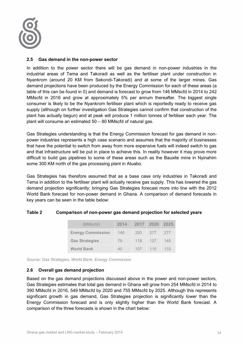
Ghana gas market and LNG market study – February 2014 14
2.5 Gas demand in the non-power sector
In addition to the power sector there will be gas demand in non-power industries in the industrial areas of Tema and Takoradi as well as the fertiliser plant under construction in Nyankrom (around 20 KM from Sekondi-Takoradi) and at some of the larger mines. Gas demand projections have been produced by the Energy Commission for each of these areas (a table of this can be found in 0) and demand is forecast to grow from 146 MMscfd in 2014 to 242 MMscfd in 2016 and grow at approximately 5% per annum thereafter. The biggest single consumer is likely to be the Nyankrom fertiliser plant which is reportedly ready to receive gas supply (although on further investigation Gas Strategies cannot confirm that construction of the plant has actually begun) and at peak will produce 1 million tonnes of fertiliser each year. The plant will consume an estimated 50 – 80 MMscfd of natural gas.
Gas Strategies understanding is that the Energy Commission forecast for gas demand in non-power industries represents a high case scenario and assumes that the majority of businesses that have the potential to switch from away from more expensive fuels will indeed switch to gas and that infrastructure will be put in place to achieve this. In reality however it may prove more difficult to build gas pipelines to some of these areas such as the Bauxite mine in Nyinahim some 300 KM north of the gas processing plant in Atuabo.
Gas Strategies has therefore assumed that as a base case only industries in Takoradi and Tema in addition to the fertiliser plant will actually receive gas supply. This has lowered the gas demand projection significantly; bringing Gas Strategies forecast more into line with the 2012 World Bank forecast for non-power demand in Ghana. A comparison of demand forecasts in key years can be seen in the table below:
Table 2 Comparison of non-power gas demand projection for selected years
(MMscfd) 2014 2017 2020 2025
Energy Commission 146 250 277 277
Gas Strategies 79 118 127 145
World Bank 40 107 115 133
Source: Gas Strategies, World Bank, Energy Commission
2.6 Overall gas demand projection
Based on the gas demand projections discussed above in the power and non-power sectors, Gas Strategies estimates that total gas demand in Ghana will grow from 254 MMscfd in 2014 to 390 MMscfd in 2016, 549 MMscfd by 2020 and 755 MMscfd by 2025. Although this represents significant growth in gas demand, Gas Strategies projection is significantly lower than the Energy Commission forecast and is only slightly higher than the World Bank forecast. A comparison of the three forecasts is shown in the chart below:

Ghana gas market and LNG market study – February 2014 15
Figure 3 Comparison of gas demand forecasts
Source: Gas Strategies, World Bank, Energy Commission
Table 3 Comparison of gas demand forecasts for selected years
(MMscfd) 2014 2017 2020 2025
Energy Commission 372 822 955 1,165
Gas Strategies 254 442 549 755
World Bank 295 427 492 653
Source: Gas Strategies, World Bank, Energy Commission
Gas Strategies has calculated gas demand in the power sector using power plant efficiency rates provided by the Energy Commission which are 31% for Open Cycle Gas Turbines (OCGTs) and 45% for Combined Cycle Gas Turbines (CCGTs). Gas Strategies also selected the merit order of thermal plant (i.e the order of priority in which they are run) largely based on the Energy Commission assumptions. Based on this analysis Gas Strategies projects that the Domunli area will have the largest gas demand for power generation in 2025 (224 MMscfd), followed by Tema (164 MMscfd) and Takoradi (156 MMscfd). However it should be noted that under the Energy Commission forecasts gas demand is spread much more evenly with the three areas each having demand of around 250 MMscfd each in 2025 because additional power plant in Tema and Takoradi are required to meet additional power demand. It is therefore important to understand the order in which planned power plants will be commissioned in order to inform the most appropriate location for the FSRU to be situated.
0
200
400
600
800
1,000
1,200
1,4002
013
20
14
20
15
20
16
20
17
20
18
20
19
20
20
20
21
20
22
20
23
20
24
20
25
20
26
20
27
20
28
20
29
20
30
Energy commission Dec 2013 World Bank May 2012
Gas Strategies 2014

Ghana gas market and LNG market study – February 2014 16
What is noticeable from the chart above is that Gas Strategies gas demand projection is only slightly higher than the World Bank’s despite having a much higher power demand forecast and similar non-power sector projections. The main cause of this is the different forecasts for hydro-plant. Whereas the World bank has projected power supply, based on firm availability, from hydro-plant to grow from 5,300 GWh in 2014 to 6,580 in 2022 and remain flat from there onwards, Gas Strategies has projected that hydro plant will be flat throughout the forecast period at 7,100 GWh. The rationale for this is explained below:
Gas Strategies has analysed generation from hydro plant in Ghana since 1990 and found that hydro generation averaged 5987 GWh over the last 23 years. This equates to an average load factor of approximately 60%.
Gas Strategies has assumed that hydro plant will be utilised as much as possible going forward as it is effectively free power generation and therefore as long as reservoir levels are sufficient, plants will be run at high load factors. The load factor will however come down slightly from historical levels as the over reliance on hydro plant has meant that plant have been run at unsustainable levels during some periods. An example of this can be seen in 1997, when the generation from hydro plant was 6,850 GWh and in the following year fell to 3,830 GWh due to depleted water reservoirs and low rainfall.
With the addition of the Bui hydro plant which was completed in 2013, total hydro capacity now stands at 1580 MW. Gas Strategies has assumed a load factor of 54% (i.e 6% lower than historical performance) for future hydro power generation and therefore estimates that 7,100 GWh can be produced on average each year.
2.7 Gas supply forecast
As of the start of January 2014, the only gas supply that Ghana is receiving is from the WAGP. Volumes in mid-January have however again been significantly lower than contracted volumes of 120 MMscfd and were as low as 30 MMscfd on Saturday 11th January. VRA has not received a full explanation for the lower than expected volumes however it is believed to be related to gas supply issues in Nigeria as opposed to technical issues with the pipeline. Given the history of disruption to WAGP gas supply and the fact that Nigeria’s domestic market suffers from a gas supply shortage which looks set to continue for the foreseeable future, Gas Strategies base case projection assumes that gas supply from WAGP averages only half of the contracted quantity over the forecast period.
Ghana’s first indigenous gas supply should be made available to the domestic market in the final quarter of 2014 when the gas processing plant at Atuabo is due to start operations and gas from the Jubilee field can be transported via the newly constructed gas pipeline to power stations in Takoradi. Gas has actually been produced in association with oil production from the Jubilee field (the largest oil discovery in Ghana’s history with an estimated one billion barrels of oil reserves) since the end of 2010, however the required gas processing plant and pipelines required to evacuate the gas are only now nearing completion. Existing production is being re-injected back into the field as a result.

Ghana gas market and LNG market study – February 2014 17
The Jubilee field is just the first of a number of promising oil and gas discoveries in Ghana and other gas discoveries (both associated and non-associated) from the TEN, META, Sankofa and other fields are due to start up over the next decade. All of these discoveries have been made in the west of Ghana in relatively close proximity to the Jubilee field and will utilise common pieces of infrastructure to be evacuated to shore. The map below shows Ghana’s existing oil and gas discoveries.
Figure 4 Map of Ghana oil and gas discoveries
Source: Gas Strategies
Gas Strategies has projected gas supply from each of the existing gas discoveries and from WAGP under three scenarios:
Low case – Gas Strategies is reasonably confident that gas supply at this level will be available
Base case – probable volumes which are expected to be available based on a reasonable development case for discovered reserves with priority given to oil production
High Case - volumes which might be available if evaluation of discoveries is successful and operators are aggressive in developing the discovered gas reserves.
The projection has been built through an assessment of publically available information, discussions with the World Bank in 2012 and taking into account the GNPC forecast and
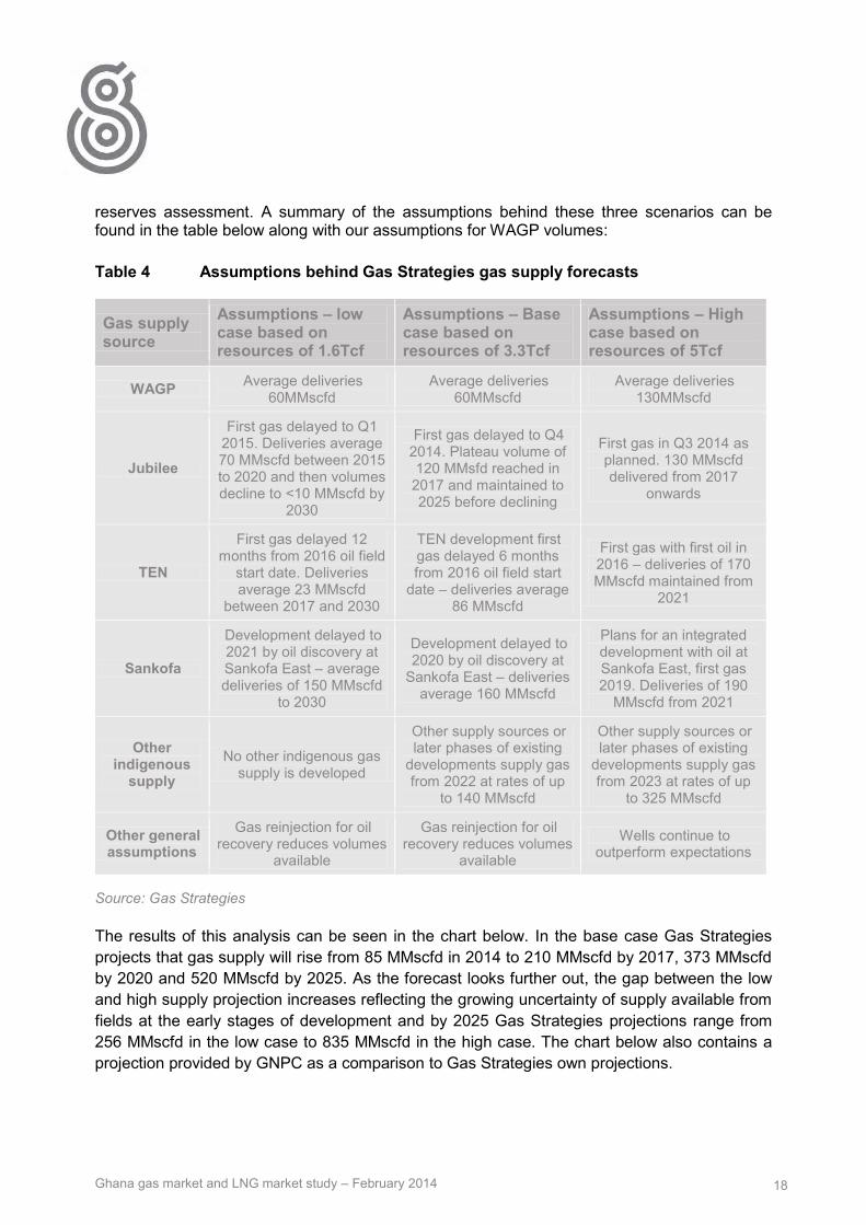
Ghana gas market and LNG market study – February 2014 18
reserves assessment. A summary of the assumptions behind these three scenarios can be found in the table below along with our assumptions for WAGP volumes:
Table 4 Assumptions behind Gas Strategies gas supply forecasts
Gas supply source
Assumptions – low case based on resources of 1.6Tcf
Assumptions – Base case based on resources of 3.3Tcf
Assumptions – High case based on resources of 5Tcf
WAGP Average deliveries 60MMscfd
Average deliveries 60MMscfd
Average deliveries 130MMscfd
Jubilee
First gas delayed to Q1 2015. Deliveries average 70 MMscfd between 2015 to 2020 and then volumes decline to <10 MMscfd by
2030
First gas delayed to Q4 2014. Plateau volume of 120 MMsfd reached in 2017 and maintained to 2025 before declining
First gas in Q3 2014 as planned. 130 MMscfd delivered from 2017
onwards
TEN
First gas delayed 12 months from 2016 oil field
start date. Deliveries average 23 MMscfd
between 2017 and 2030
TEN development first gas delayed 6 months from 2016 oil field start
date – deliveries average 86 MMscfd
First gas with first oil in 2016 – deliveries of 170 MMscfd maintained from
2021
Sankofa
Development delayed to 2021 by oil discovery at Sankofa East – average deliveries of 150 MMscfd
to 2030
Development delayed to 2020 by oil discovery at
Sankofa East – deliveries average 160 MMscfd
Plans for an integrated development with oil at Sankofa East, first gas 2019. Deliveries of 190
MMscfd from 2021
Other indigenous
supply No other indigenous gas
supply is developed
Other supply sources or later phases of existing
developments supply gas from 2022 at rates of up
to 140 MMscfd
Other supply sources or later phases of existing
developments supply gas from 2023 at rates of up
to 325 MMscfd
Other general assumptions
Gas reinjection for oil recovery reduces volumes
available
Gas reinjection for oil recovery reduces volumes
available
Wells continue to outperform expectations
Source: Gas Strategies
The results of this analysis can be seen in the chart below. In the base case Gas Strategies projects that gas supply will rise from 85 MMscfd in 2014 to 210 MMscfd by 2017, 373 MMscfd by 2020 and 520 MMscfd by 2025. As the forecast looks further out, the gap between the low and high supply projection increases reflecting the growing uncertainty of supply available from fields at the early stages of development and by 2025 Gas Strategies projections range from 256 MMscfd in the low case to 835 MMscfd in the high case. The chart below also contains a projection provided by GNPC as a comparison to Gas Strategies own projections.

Ghana gas market and LNG market study – February 2014 19
Figure 5 Gas Strategies forecast for Ghana gas supply – indigenous and WAGP
Source: Gas Strategies, GNPC
Gas Strategies has not been able to speak to GNPC about the assumptions behind its WAGP and indigenous gas supply forecast, although Gas Strategies assessment is that it takes a relatively conservative view on indigenous supply, being more aligned with Gas Strategies low case forecast. The GNPC forecast is however more bullish on supply from the WAGP with a forecast of 120 MMscfd from 2014. This is why GNPC’s forecast is higher than Gas Strategies base case in the early years of the forecast before moving below in later years as the WAGP makes up a smaller share of total gas supply.
The upshot of this analysis is that plans for the LNG import project will have to factor in the range of indigenous gas supply scenarios that could transpire.
0
100
200
300
400
500
600
700
800
900
1000
Gas
su
pp
ly (
MM
scfd
)
Low case Base Case High Case GNPC forecast

Ghana gas market and LNG market study – February 2014 20
2.8 Gas supply/demand gap – the opportunity for LNG
Taking Gas Strategies gas demand forecast and the base case supply forecast we estimate that Ghana would require an average of 234 MMscfd of gas supply from LNG between 2016 and 2025. This equates to LNG demand of approximately 1.74 mtpa. Gas Strategies would deem this volume sufficient for an LNG FSRU; looking at six existing FSRU projects in South America, Indonesia and Kuwait, LNG imports ranged from 1.26 mtpa to 3.18 mtpa in 2013.
In all scenarios Gas Strategies projects that there will be a requirement for LNG imports in the short-term to at least 2019, however if gas supply from indigenous production and from the WAGP is closer to the high case supply projection it is quite feasible that there will not be any requirement for LNG after this date. The chart and table below highlight this fact, demonstrating the range of LNG demand scenarios that may transpire and indicate potential boundaries for the operational capacity of the LNG import project.
Figure 6 Ghana gas supply/demand gap that could be filled by LNG
Source: Gas Strategies, World Bank, Energy Commission
0
200
400
600
800
1000
1200
1400
gas
sup
ply
/de
man
d p
roje
ctio
ns
(MM
scfd
)
High Case supply Base Case supply
Low case supply Energy commission Dec 2013 demand
World Bank May 2012 demand Gas Strategies 2014 demand

Ghana gas market and LNG market study – February 2014 21
Table 5 LNG demand under different scenarios for selected years
(gas demand from LNG - MMscfd) 2016 2020 2025
Base case supply – Base case demand (Gas Strategies 2014 demand forecast)
230 176 235
Low case supply – high case demand (Energy Commission demand forecast)
434 795 909
High case supply – low case demand (World Bank demand forecast) 139 7 -182
Source: Gas Strategies, World Bank, Energy Commission
2.9 Conclusions – Fuel supply options for thermal power generation
Gas Strategies’ analysis indicates that there is a demonstrable need for additional feed gas for gas fired power generation in Ghana between now and 2019, beyond supplies from indigenous production and WAGP gas supply. Imports of gas in the form of LNG represent a viable solution to meet this supply/demand gap. In the longer term, Gas Strategies’ base case scenario estimates that there is demand for LNG out until 2030.
However, uncertainties regarding the volume and timing of indigenous gas supply and the timing of the construction of new gas fired power generation facilities result in both upside and downside potential for volume of gas delivered through an FSRU project. This uncertainty is not uncommon in FSRU projects, and is one of the drivers behind application of an FSRU project over a conventional and more expensive land based terminal (for example in Argentina and Brazil which both have short term gas requirements in advance of the production of indigenous gas reserves, the timing of which are also uncertain).
As a result of the uncertainty regarding the LNG throughput and duration of requirement, the technical and commercial design of the project should provide flexibility to allow the project to respond to different scenarios as best it can. This flexibility will add commercial and technical complexity and cost to the project.
For example, the project may choose to size the FSRU to cater for a high LNG demand scenario whilst only signing an LNG SPA for volumes at the lower end of the demand projection to mitigate against a gas/LNG oversupply situation. Entering into a smaller volume/duration LNG contract may not be as cost efficient (per unit of LNG) as signing a higher volume/longer duration contract, however it may avoid costly Take or Pay provisions for unwanted volumes that are more expensive than indigenous or WAGP gas. However if it transpires that a volume of LNG above the contract volume is required then the project may be exposed to the need to purchase spot-cargoes which will be based against the most competitive market price at that time.

Ghana gas market and LNG market study – February 2014 22
Given the uncertainty of demand, lenders to the project as well as LNG and FSRU suppliers will want to see that robust analysis has been carried out in assessing the requirement for LNG. Although it is clear that LNG is required to substitute oil products in Ghana and LNG supply would be expected to be available at a lower price than alternative oil products, the gas price paid by power generators will also need to cover the FSRU charter and marine infrastructure costs associated with the project. This can add costs anywhere from $0.5 - $3/MMbtu to the cost of LNG supply depending on the project costs, volume of LNG throughput, project duration and rate-of-return being sought by the project developer. There are numerous examples around the world (for example in the Caribbean and Mediterranean) of planned FSRU projects failing to fully assess the costs of the full LNG supply chain and subsequently finding the project non-economic because the power price does not support the investment in an LNG import project.
As well as demonstrating the requirement for LNG, the project sponsor will also have to demonstrate that there is a robust commercial chain that sits behind the project. Currently VRA (the largest power generator in Ghana) purchases crude oil on a cargo by cargo basis and has Letters of Credit in place with various oil traders to give sufficient security for the purchase of individual cargoes of oil. VRA has also required government subsidies to meet its growing fuel bills because the power price it receives does not support the fuel cost. Assuming that 1.74 mtpa of LNG (equivalent of 234 MMscf/d of gas) is contracted on a medium term basis of 4 years, this will require a buyer to a commit to a contract worth in the region of $4.5 billion, a commitment that will certainly be beyond the financial capacity of VRA, given that its annual revenue in 2012 was approximately $0.75 billion, and perhaps beyond the financial capacity of the Ghanaian Government (currently Ghana has a B- Credit Rating according to ratings agency Fitch, which is non-investment grade and considered “highly speculative”). LNG suppliers will need to have certainty about a robust commercial chain and the presence of a credit worthy buyer that can stand behind the contract.
The buyer of LNG and the LNG project developer will need to have addressed these issues before approaching potential LNG suppliers in order to have credibility in the LNG market. An LNG procurement plan will also need to be developed, with consideration of the need for a secure source of gas supply for Ghana balanced with the potential risk of oversupply. The ability to flex hydro power generation, the potential swing in non-associated indigenous gas production and take or pay levels from WAGP gas will all need to be assessed as potential measures to mitigate oversupply of LNG volumes.

Ghana gas market and LNG market study – February 2014 23
3 Assessment of the gas supply infrastructure in Ghana
3.1 Jubilee gas infrastructure project – Early Phase
After the discovery of associated gas in the Jubilee gas field Western Ghana, Ghana Gas Company was given the responsibility for developing gas infrastructure to transport gas to shore, process the gas and separate LPG and ultimately supply affordable gas supply to thermal power plants. In addition to bringing gas to the domestic market, the gas infrastructure project will enable the operator of the field, Tullow Oil, to optimise the recovery of crude oil without the need to re-inject or flare the associated gas.
The overall cost of the project is estimated at $750 million and is funded from a $3 billion loan from the China Development Bank (CDB). Sinopec was selected as the lead contractor for the project and began work in August 2012. The “Early Phase Gas Infrastructure Project” as termed by Ghana Gas Company consists of three main elements:
a) 12 inch, 45 KM shallow water offshore pipeline transporting Jubilee gas onshore to Atuabo2
b) Onshore gas processing plant with an initial capacity to process 150 MMscf/day of gas supply
c) 20 inch onshore gas pipeline to transport gas to power generation facilities in Takoradi (111 KM) and a lateral pipeline to Prestea (75 KM).
Dr George Sipa Yankey, CEO of the Ghana Gas Company announced in December 2013 that “the overall Ghana Gas Infrastructure Project is 75 per cent complete. The gas processing plant component is 60% complete, while the onshore and offshore pipelines are 94% and 95% complete.” He added that construction work on the overall project should be complete by the end of April 2014 meaning that first gas supply could follow shortly afterwards. Although the project now looks to be nearing completion it was originally scheduled for completion at the end of 2012 and has been hit by a number of delays caused by site selection issues, technical problems and payment delays. Given the challenges that deadlines for project completion have changed a number of times over the last year, Gas Strategies believes that there is a strong chance that gas may not be available as projected in May and it may be later in 2014. This view is supported by an announcement by the Ghanaian Energy Minister in January 2014 stating that gas processing plant would only be ready by the final the last quarter of 2014.
The initial phase of the project scheduled to be complete this year, will be capable of handling 150 MMscf/day of gas supply. Should additional gas supply become available as projected there are plans for a second train at the processing plant which will increase capacity to 300 MMscfd. There are also plans to evacuate gas from the TEN field post 2016 via the Jubilee field in order to utilise existing infrastructure.
2 Tullow had laid a gas pipeline from the Floating production and storage ship located in deepwater into shallow water while it had a deepwater lay barge in the area.

Ghana gas market and LNG market study – February 2014 24
Figure 7 Jubilee gas infrastructure project
Source: Ghana Gas Company
3.2 WAGP
The WAGP was built to supply gas from Nigeria's Escravos region of Niger Delta area to Benin, Togo and Ghana. It is the first regional natural gas transmission system in sub-Saharan Africa. The 20 inch pipeline is 678 km in length and links the existing Escravos-Lagos pipeline at Itoki Natural Gas Export Terminal in Nigeria to the coast of Benin, Togo and Ghana. Delivery laterals from the main line extend to Cotonou (Benin), Lome (Togo) and Tema and Takoradi (Ghana). The WAGP system was designed to initially carry a volume of 170MMscfd and expand over time to a capacity of 470MMscfd.
Construction on the pipeline began in 2005 and it was commissioned in 2008 however Ghana only started receiving a regular supply of gas in March 2010 after problems with construction and supply challenges delayed and constrained supplies. The continued gas supply shortage in the Nigerian domestic gas market has further limited gas supply through WAGP supply to Ghana.
WAGP is currently contracted to supply 120 MMscfd to Ghana, however continued supply disruptions in Nigeria resulted in an average delivery of approximately 80 MMscfd in 2011 and deliveries were halted for almost a year after a loss of pressure around the Lome segment of the pipeline at the end of August 2012. Media reports suggest that the problem was caused by a dropped ship anchor from a ship off the coast of Lome, which subsequently damaged the

Ghana gas market and LNG market study – February 2014 25
pipeline. Gas supplies resumed in July 2013 although Gas Strategies understands that deliveries have still not reached full contracted volumes with gas supply received in January 2014 being at times as low as 30 MMscfd. VRA has not received a full explanation for the lower than expected volumes however it is believed to be related to gas supply issues in Nigeria as opposed to technical issues with the pipeline.
The West African Gas Pipeline Company (WAPCo) is owned by Chevron West African Gas Pipeline Ltd (36.9%); Nigerian National Petroleum Corporation (24.9%); Shell Overseas Holdings Limited (17.9%); and VRA (16.3%), Societe Togolaise de Gaz (2%) and Societe BenGaz S.A. (2%). The West African Gas Pipeline Authority (WAGPA) based in Abuja is the regulatory body for WAPCo.
As can be seen in the map below the main trunk line currently has a capacity of 170 MMscfd whilst capacity at the offtake points in Benin, Togo, and Ghana vary widely. Gas Strategies understands that increasing the capacity at most of these offtakes points can be achieved by installing additional compressor stations. The maximum capacity at Cotonou and Lome is in the region of 100 MMscfd, Tema can ultimately take approximately 234 MMscfd whereas WAGPCo reports that capacity at Takoradi cannot be expanded easily.
Figure 8 West African gas pipeline map
Source: WAGPCo, Ghana Gas Company, Gas Strategies
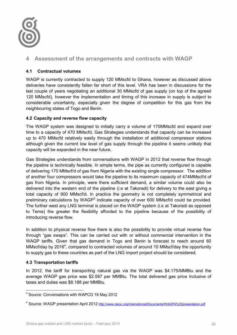
Ghana gas market and LNG market study – February 2014 26
4 Assessment of the arrangements and contracts with WAGP
4.1 Contractual volumes
WAGP is currently contracted to supply 120 MMscfd to Ghana, however as discussed above deliveries have consistently fallen far short of this level. VRA has been in discussions for the last couple of years negotiating an additional 30 MMscfd of gas supply (on top of the agreed 120 MMscfd), however the implementation and timing of this increase in supply is subject to considerable uncertainty, especially given the degree of competition for this gas from the neighbouring states of Togo and Benin.
4.2 Capacity and reverse flow capacity
The WAGP system was designed to initially carry a volume of 170MMscfd and expand over time to a capacity of 470 MMscfd. Gas Strategies understands that capacity can be increased up to 470 MMscfd relatively easily through the installation of additional compressor stations although given the current low level of gas supply through the pipeline it seems unlikely that capacity will be expanded in the near future.
Gas Strategies understands from conversations with WAGP in 2012 that reverse flow through the pipeline is technically feasible. In simple terms, the pipe as currently configured is capable of delivering 170 MMscf/d of gas from Nigeria with the existing single compressor. The addition of another four compressors would take the pipeline to its maximum capacity of 474MMscf/d of gas from Nigeria. In principle, were there sufficient demand, a similar volume could also be delivered into the western end of the pipeline (i.e at Takoradi) for delivery to the east giving a total capacity of 900 MMscf/d. In practice the geometry is not completely symmetrical and preliminary calculations by WAGP3 indicate capacity of over 600 MMscf/d could be provided. The further west any LNG terminal is placed on the WAGP system (i.e at Takoradi as opposed to Tema) the greater the flexibility afforded to the pipeline because of the possibility of introducing reverse flow.
In addition to physical reverse flow there is also the possibility to provide virtual reverse flow through “gas swaps”. This can be carried out with or without commercial intervention in the WAGP tariffs. Given that gas demand in Togo and Benin is forecast to reach around 60 MMscf/day by 20164, compared to contracted volumes of around 10 MMscf/day the opportunity to supply gas to these countries as part of the LNG import project should be considered.
4.3 Transportation tariffs
In 2012, the tariff for transporting natural gas via the WAGP was $4.175/MMBtu and the average WAGP gas price was $2.587 per MMBtu. The total delivered gas price inclusive of taxes and duties was $8.188 per MMBtu.
3 Source: Conversations with WAPCO 18 May 2012 4 Source: WAGP presentation April 2012 http://www.naruc.org/international/Documents/WAGPA%20presentation.pdf

Ghana gas market and LNG market study – February 2014 27
For 2013, the new tariff for transporting natural gas was estimated by the Ghana Energy Commission to be between $4.20-4.30 per MMBtu; less than a one percent rise over the previous year. The average WAGP gas price was expected to be within $2.58-2.60/MMBtu and the total delivered gas price $8.50-9.00/MMBtu.
4.4 Access rights
According to the West African Gas Pipeline Authority which is the regulator of the pipeline, it was originally intended that "Open Access" would apply to the WAGP transmission system either when; contracted capacities reached 200 MMscfd or; 10 years after commencement of commercial operations or; when a prospective shipper met the terms and conditions for pipeline access stipulated in the Access Code, whichever occurs first. However WAGPA subsequently announced in June 2012 that third party shippers would be eligible to sell gas via the WAGP from July 2012.
According the WAGP website third party shippers can now apply for capacity after following the procedures set out in the Access Code. The WAGPA website states that “To sell gas through the WAGP, one has to sign Gas Sales and Purchase Agreement (s) with Buyer (s) and Gas Transportation Agreement(s) with WAPCo”
4.5 Expansion plans
Plans for expanding the WAGP westwards to the Ivory Coast have been discussed publically since 2009 when the Ivory Coast formally applied to become a state signatory of the protocol governing the WAGP. However, despite a tender for a feasibility study of the expansion being launched in mid-2013, Gas Strategies doubts that the project will get the go ahead while domestic supply to Nigerian consumers remains constrained.
Gas production in the Ivory Coast reached approximately 220 MMscf/day in 2013 and demand was around 270 MMscf/day. The short fall of 50 MMscf/day is expected to grow to approximately 100 MMscf/day by 2016. There is therefore a clear need for additional gas supply. However the case for expanding the WAGP is weakened by three key factors:
As in Ghana the gas import requirement is difficult to forecast because of on-going investment in indigenous gas production. Gas production doubled in 2013 and is set to increase further with the development of the Gazelle and Manta gas fields by 2016. It is therefore difficult to justify the estimated $650 million investment in extending the WAGP whilst uncertainty over the supply/demand gap remains.
The Ivory Coast requires additional gas for power generation and given the recent performance of the WAGP it may opt for a more secure source of gas imports – particularly as it is would be at the far end of the pipeline system.
The Ivory Coast’s national oil and gas company, Petroci, is also pursuing an LNG FSRU import project to meet the forecast supply gap. Reuters reported in November that the Ivory Coast was close to agreeing a deal with Qatar for LNG supply from 2015, although Gas Strategies believes that the deal may not be as close as the report suggested.

Ghana gas market and LNG market study – February 2014 28
5 International market for LNG
5.1 Summary of findings
Ghana’s entry into the LNG market coincides with probably the most fundamental shift in market dynamics in recent history: the emergence of the US as a major LNG exporter. The explosion in shale gas production has re-drawn the global energy nexus, which had previously envisaged the US drawing in greater and greater hydrocarbon imports. Although there is much ground to cover, it is increasingly likely that a sizeable amount of LNG will leave US facilities in the next decade. The US is not alone; Gas Strategies’ analysis has shown that there is considerable potential supply from other sources and that the currently tight LNG market will give way to a buyer friendly market.
There are many implications of this development but one of specific importance to Ghana; although the majority of LNG supply will still be sold on long-term (~20 year) contracts a growing proportion of this “new” LNG will be flexible in nature, allowing for variable contract lengths and divertible cargoes. Currently there is uncertainty over Ghana’s demand for LNG and how this demand will evolve, this stems from uncertainty on the supply side (Jubilee and WAGP) and also pace of gas demand growth from the power sector. This degree of uncertainty lends itself to a source of supply that is not rigid in nature, allowing for the possibility for the diversion of cargoes at times of low demand and not long in duration. An eventual supply deal may be on a purely cargo-by-cargo basis or a medium term basis using “strips” of cargoes. Ghana’s likely entry to the market ~2016, would open it to the possibility of purchasing US LNG from a player with a portfolio of US supply.
There are some challenges within this approach. First, the LNG market is highly reputational with many suppliers seeking out counterparties they know to be creditworthy and with experience in purchasing LNG. While this will not preclude Ghana from buying LNG, it may limit the pool of suppliers that are willing to enter a supply agreement. The other major challenge is the likely high cost of LNG bought on a short-term basis. Prices for spot cargoes at the start of 2014 are in the region of $18-19/MMBtu due to slow LNG supply growth over the last two years and high Asian LNG demand, particularly from China and although short-term market liquidity is expected to increase, Ghana will be exposed to a high degree of market risk if it purchases cargoes on a spot or short term basis.
The alternative will be for Ghana to sign up to a medium term contract of at least three years in which it will be able to obtain either an oil indexed price or one linked to one of the liquid gas markets in Europe or the US. Given Ghana’s proximity to new US LNG projects and existing West African exporters, Ghana should be able to attract a supply deal at a discount to long-term Asian LNG prices (currently at a level of ~$16/MMbtu), although prices will almost certainly be higher than in Europe ($10 – 11/MMBtu) given the flexibility that the European market offers LNG suppliers, whereby some suppliers have the option to divert cargoes to higher priced markets when opportunities arise.

Ghana gas market and LNG market study – February 2014 29
5.2 Overview of LNG market
Global and regional markets The global LNG market consists broadly of two main regional markets: the first is Asia (comprising the established markets in Japan, Korea and Taiwan known as JKT; the newer markets in China and India; and more recently other smaller markets in South East Asia); and the second is the Atlantic Basin (comprising Europe, including Mediterranean markets, and the Americas). The Middle East has emerged recently as a minor LNG importer outside these two regions.
According to Waterborne Energy, 2013 gross global LNG imports (including re-exports) measured 244.3 million tonnes (mt), showing an increase from the 241.8 mt observed in 2012. Behind this headline figure is an important development in the regional split of global imports; the Asia Pacific region’s share of imports has continued to grow, reaching 74% in 2013, a 10% increase in just two years. Japan, the largest LNG market in Asia, was forced to contend with a complete absence of nuclear capacity in its power sector during 2013, reflecting the continued effect of the Fukushima earthquake on the economy. Concerns over nuclear power spread to Korea, causing a similar rise in LNG demand in the power sector. Latin America has also drawn in more LNG in 2013 on the back of a significant increase in demand (+39.6 % year-on-year), which places its share of the global LNG market at 9%. The sizeable growth in Latin American LNG imports was spurred by decline in hydroelectric output after lower than expected rainfall and shortfalls in domestic production. Mexico emerged as a major LNG importer in 2013 because rising industrial demand for gas could not be met by already fully utilised cross-border pipelines from the US, causing Mexican state-owned utility CFE to put out a series of tenders for short-term LNG deliveries.
Figure 9 Regional LNG imports 2013
Source: Waterbourne Energy

Ghana gas market and LNG market study – February 2014 30
These changes in the geographical distribution of LNG imports have been facilitated by sizeable declines in demand in both Europe and North America. Europe’s well documented financial difficulties over the last 2-3 years has badly affected energy demand, while the explosion in gas production in the USA has seen imports of LNG drop off sharply in North America. In 2013 North America’s share of global LNG imports stood at just 1%, while Europe’s share declined from 27% to 15%. LNG supply grew only marginally between 2012-2013 after plants in the Atlantic Basin (Angola, Yemen, Algeria and Nigeria) fell short of nameplate capacities due to reasons including gas supply shortages, technical difficulties and political instability. Therefore, rising demand in Asia and Latin America was met by the diversion of cargoes from other plants in the Atlantic Basin and the Middle East that would have otherwise ended up in European or North American markets.
The LNG market in 2012/2013 has been characterised by a prevailing tightness as post- Fukushima expansion in Asian demand and growth in Latin American markets was met by supply side constraints. This has been echoed by the performance of the short-term market, where volumes have been stretched and prices high.
5.3 Regional Pricing
Due to the capital intensive nature of LNG liquefaction projects, lenders demand future revenues are under written by long-term supply contracts. Therefore, the majority of LNG is sold under long term contracts and has historically varied according to the destination: Long term contract pricing in Asia is almost exclusively based on formulae linking the price
to crude oil (JCC – Japan Custom Cleared crude oil) European LNG contract pricing is either based on a liquid traded hub price (e.g. the UK
NBP price) or on an oil price index (either oil products or crude oil) US LNG import contract prices have been indexed to a US traded price, mostly commonly
the Henry Hub price In recent years, there has been a considerable divergence in wholesale gas pricing in the different regions. Currently Asian LNG imports are priced at around $16/MMBtu while at the other extreme the US Henry Hub price has been less than $4/MMBtu since late 2011. In addition to varying in terms of average price, the different LNG markets also vary in the structure of pricing. In liquid traded markets such as North West Europe, LNG has to be priced to deliver gas into the market at, or very near, the market price. Supply contracts are therefore priced on a formula linking the price to the market price (e.g. indexed to NBP), and prices from different suppliers will be within a fairly narrow band. In Asia, however, there are no liquid traded markets, and buyers with a portfolio of supplies may have very different supply costs from different sources, and there is no one specific gas price.

Ghana gas market and LNG market study – February 2014 31
Figure 10 Natural gas prices in different markets 2008-2013
Source: Gas Strategies
As Figure 10 illustrates, gas prices have been relatively stable in 2012-2013, reflecting a relatively stable oil price, low prices in the US in early 2012 reflected a very warm winter. European market prices, represented by NBP in Figure 10 , have increased slightly as LNG supply has decreased, attracted away by high prices in Asia. Looking ahead international gas benchmark prices are likely to re-converge to a certain degree as weakening oil prices cause a softening in Asian LNG pricing, US gas prices begin to rise due to growing gas consumption and LNG exports from the Lower 48 commencing in 2016. It should however be noted that Gas Strategies still expects a gas price differential to remain between Europe and Asia as a result of the cost of transporting gas between the two markets. The cost of shipping LNG from the Atlantic Basin to Asia Pacific is currently around $2.50/MMbtu and so the gas price differential cannot be completely arbitraged away.
Potential US LNG exporters’ intent to sell volumes linked to Henry Hub has been well documented and represents one of the key advantages that these projects will hold in the race to bring volumes to market. This development in LNG pricing will be the first time LNG has been sold on this basis and has been well received by buyers in Asia used to paying considerably more for their LNG than other parts of the world. The effect of HH linked LNG sales is likely to reduce the link with the oil price from projects outside the US, though oil is likely to remain the primary element in the indexation. US supplies generally use long term capacity contracts to underwrite the construction costs of the export facilities, so will not have the same supply security as dedicated export contracts.
Short-term pricing is reflective of short-term market fundamentals (i.e supply and demand); however, this market is not liquid and deals are still individually negotiated. Short-term cargoes are often priced either on the basis of the most appropriate index, when delivered into relevant markets (e.g NBP in the Europe) or will be priced in relation to a marker published by one of the
0
2
4
6
8
10
12
14
16
18
20Ja
n-0
0
Jan
-01
Jan
-02
Jan
-03
Jan
-04
Jan
-05
Jan
-06
Jan
-07
Jan
-08
Jan
-09
Jan
-10
Jan
-11
Jan
-12
Jan
-13
$/M
MB
tu
Henry Hub NBP GBA Average Japanese LNG

Ghana gas market and LNG market study – February 2014 32
major pricing reporting agencies; the most prominent are ICIS Heren and Platt’s. Platt’s JKM marker is probably the most widely used in the Asian market and is increasingly being employed for spot sales into Latin American markets. Short-term prices have risen in 2013 whilst also exhibiting greater volatility; prices in Asia have been pushed up by thin trading volumes and colder temperatures than anticipated. Available volumes have been reduced by the strong demand from Latin America, which apart from Mexico, imports LNG exclusively on a spot basis.
Figure 11 JKM prices 2008-2013
Source: Gas Strategies
5.4 Demand Outlook
The LNG industry has a strong track record of consistent growth, the average annual growth rate in the period 2000 to 2012 was 7%; 2012 was only the fourth year that LNG volumes have shown a year-on-year decline. At the time of writing, 2013 imports are up on the previous year, though demand growth was not as strong as has been noted in previous years. This slowdown has its roots in the fragile state of the global economy as many countries struggle to build a sustainable recovery - LNG’s role in power generation has come under pressure from lower-cost coal in both OECD and non OECD nations – reflecting unfavourable economic conditions. Demand growth has also faced supply side headwinds; late plant start-ups and production issues have restricted supply growth, capping the expansion in demand.
0
5
10
15
20
25
Jan
-11
Mar
-11
May
-11
Jul-
11
Sep
-11
No
v-1
1
Jan
-12
Mar
-12
May
-12
Jul-
12
Sep
-12
No
v-12
Jan
-13
Mar
-13
May
-13
Jul-
13
Sep
-13
$/M
MB
Tu
JKM Brent Crude Oil
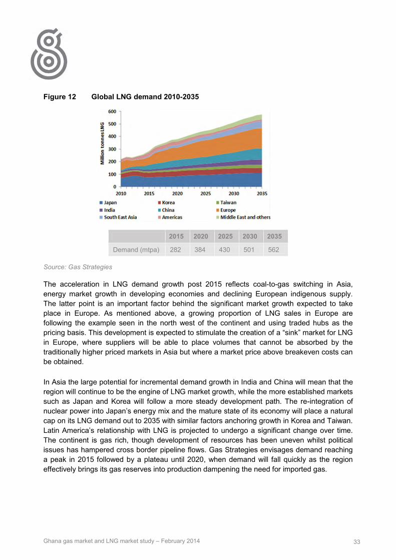
Ghana gas market and LNG market study – February 2014 33
Figure 12 Global LNG demand 2010-2035
2015 2020 2025 2030 2035
Demand (mtpa) 282 384 430 501 562
Source: Gas Strategies
The acceleration in LNG demand growth post 2015 reflects coal-to-gas switching in Asia, energy market growth in developing economies and declining European indigenous supply. The latter point is an important factor behind the significant market growth expected to take place in Europe. As mentioned above, a growing proportion of LNG sales in Europe are following the example seen in the north west of the continent and using traded hubs as the pricing basis. This development is expected to stimulate the creation of a “sink” market for LNG in Europe, where suppliers will be able to place volumes that cannot be absorbed by the traditionally higher priced markets in Asia but where a market price above breakeven costs can be obtained.
In Asia the large potential for incremental demand growth in India and China will mean that the region will continue to be the engine of LNG market growth, while the more established markets such as Japan and Korea will follow a more steady development path. The re-integration of nuclear power into Japan’s energy mix and the mature state of its economy will place a natural cap on its LNG demand out to 2035 with similar factors anchoring growth in Korea and Taiwan. Latin America’s relationship with LNG is projected to undergo a significant change over time. The continent is gas rich, though development of resources has been uneven whilst political issues has hampered cross border pipeline flows. Gas Strategies envisages demand reaching a peak in 2015 followed by a plateau until 2020, when demand will fall quickly as the region effectively brings its gas reserves into production dampening the need for imported gas.

Ghana gas market and LNG market study – February 2014 34
5.5 Supply Outlook
Existing production capacity plus that currently under construction is sufficient to take global LNG production to around 342 mtpa by 2018, corresponding to an average growth rate of 5.5% per annum from 2012 to 2018. Of the 106.5 mtpa of new capacity under construction globally, 75% is in Asia-Pacific and 60% in Australia alone. The inevitable falling off in supply capability from older plants and growing demand causes a supply gap to open up from around 2017; this gap will be filled by “planned” projects that have not yet taken FID.
2013 was a bumper year for the announcement of proposed projects, with the overwhelming majority coming from the US, where an explosion in shale and tight gas production has opened up an attractive opportunity to export LNG. LNG export plans are also unfurling in Canada after vast shale deposits were opened up through technological advances in drilling and the gas market saturation in the USA – Canada’s usual market for its hydrocarbon exports. The on-going evolution in floating LNG technology (FLNG) has opened up further export potential in Australia, where many of the large gas fields are stranded in deep waters causing high cost of development if gas is piped to the shore. East Africa (Mozambique and Tanzania) has also emerged an important LNG producer in the future after a succession of huge gas discoveries offshore.
Although the numbers are changing regularly, more than 600 mtpa of new liquefaction capacity is currently being planned by project sponsors with the aim of entering the market post-2017. In Figure 13 Gas Strategies has analysed this slate of projects and produced a “risked” view of future supplies split on a regional basis. The supply gap that opens up is quickly filled in 2017 leading to a period of over-supply lasting until 2026. It should be noted predicting FID timings is difficult due to flexible nature of LNG “demand” in some markets where there are competing sources of supply. Visibility of projects expected to be developed after 2020 is very poor, but Gas Strategies does expect projects to be developed to maintain a supply and demand balance.

Ghana gas market and LNG market study – February 2014 35
Figure 13 LNG supply/demand balance to 2035
Source: Gas Strategies
5.6 Main Players in the LNG market
As with any commodity market, the LNG market is made up by a large number of participants with a diverse set of objectives and capabilities. The traditional LNG business model centres on project companies (oil and gas players) selling directly to gas and power utility companies. On the seller side, the high capital investment required to develop an LNG project has led to a large degree of consolidation by the major integrated oil and gas companies such as ExxonMobil, Shell and Total. This model continues to be an important part of the LNG industry, especially in the Asia pacific region where utility companies are the most active buyers of LNG.
Since 2000, growing market flexibility and the advent of liquid trading hubs in the Atlantic Basin has allowed market participants to move away from the “liner trade” model – cargoes delivered to specific destinations exclusively - and pursue portfolio trading strategies that seek to exploit arbitrage opportunities in higher value markets. This evolution in LNG trading has led to the emergence of “portfolio players” in the market; BG Group is probably the most well-known of these operators. In this model, oil and gas companies source gas from both projects in which they hold an equity stake and from those they do not, in order to either meet their supply obligations or exploit arbitrage opportunities.
Below, Gas Strategies has taken a representative sample of the main players within the LNG industry with the aim of analysing their strategies and aims.

Ghana gas market and LNG market study – February 2014 36
Utility companies (e.g TEPCO, Kansai Electric, Centrica)
Gas and power utilities have traditionally been the buyers of LNG and their purchasing strategy echoes their need for a dependable source of supply to meet demand in their respective home markets. These companies buy LNG on long-term contracts with set annual quantities on a take-or-pay basis, therefore taking on the volume risk. These companies own and operate regasification terminals in their home markets and develop the markets downstream of the receiving terminal. Beyond contracted sales, utility companies also use the short-term market to top up supplies. This practice is prevalent in north Asian countries (Japan, Korea) where large swings in temperature accompany seasonal changes.
Project Based Sellers (e.g. NLNG, QatarGas, Shell)
As indicated above, the sphere of LNG project development and marketing is restricted to large oil and gas companies with considerable financial and technical capability. In the traditional business model of direct sales between project and buyer, the seller will hold equity in the both the gas reserves and the liquefaction plant and this entity will market LNG on behalf of the project consortium. Lenders to LNG projects demand long-term contracts to be in place with dependable parties before providing financing, usually restricting potential buyers to those looking for a lengthy off-take agreement; re-contracting can take place at either the expiration of existing contracts or in the event of capacity expansion. These companies, while having access to LNG supply, the vast majority is locked into specific markets and not “flexible” or available to other buyers. Project based LNG sellers are also active in the short-term market either at soon after start-up when the project has ramp gas (excess volumes during at a time when contracted amounts are still increasing to a plateau level), in the event of contract expiry freeing up volumes or if the liquefaction plant is producing above nameplate capacity.
Portfolio players (e.g. BG, BP)
Portfolio players are market participants that operate a portfolio of LNG contracts and have the ability to optimise between their LNG sourcing and LNG delivery commitments. In addition these players may have secured LNG supply which exceeds their delivery commitments and therefore have additional LNG volumes that are available. These excess volumes can be classified as “flexible” and are able to be diverted to higher value markets to meet openings in demand. In order to pursue this trading model, portfolio players require shipping and regasification capacity. From the buyer’s perspective, portfolio LNG traders offer flexibility and a source of supply that is not rigid and long-term, for example if the demand for LNG is not expected to be long-lasting, buying LNG from portfolio is an attractive option.
In the table below Gas Strategies has identified potential LNG suppliers with access to flexible LNG supplies and those with involvement in West African LNG projects.

Ghana gas market and LNG market study – February 2014 37
Table 6 Companies with access to flexible volumes in the West Africa region
Company Name Potential access to flexible LNG supply
Involvement in LNG in West Africa
BG Group Yes Equatorial Guinea
BP Yes Angola
ENI Yes Nigeria and Angola
GDF Suez Yes Cameroon
Repsol YPF Yes
Shell Yes Nigeria
Total Yes Nigeria and Angola
Qatari LNG Projects Yes
Source: Gas Strategies
5.7 Liquefaction capacity
Current capacity split by region Global liquefaction capacity in 2013 was approximately 240 mt, reflecting a very marginal year-on-year gain of around 1 million tonnes through capacity additions at the Skikda plant in Algeria. The total could have been higher but a troubled start-up at Angola acted as a drag on capacity growth. The following chart shows our projection of LNG supply from existing projects and those under construction, and is based on Gas Strategies’ best estimates of current production capability (taking into account, for example, restrictions in output in Indonesia and gas supply depletion in older plants) together with estimated of start-up dates for capacity currently under construction. The Middle East’s position as largest capacity holder reflects significant build out of capacity in Qatar, where seven trains have been constructed giving a total capacity of 73 mtpa with the remainder coming from Oman, Yemen and the UAE. In Asia, capacity is spread throughout Australia, SE Asia (Malaysia and Indonesia), eastern Russia and Peru. Atlantic basin liquefaction projects have a wide geographical distribution and are found in Nigeria, Angola, Equatorial Guinea, Egypt, Norway and Trinidad.

Ghana gas market and LNG market study – February 2014 38
Figure 14 Global LNG plant capacities by region
Source: Gas Strategies
Table 7 Global producing liquefaction capacity by region
Region Capacity (mtpa)
Atlantic Basin 84.30
Asia Pacfic 61.77
Middle East 94.14
Total 240.2
Source: Gas Strategies
0
100
200
300
400
500
600
2012 2013 2014 2015 2016 2017 2018 2019 2020 2021 2022 2023 2024 2025 2026 2027 2028 2029 2030 2031 2032 2033 2034 2035
mtp
a
Asia Pacific Middle East Atlantic Basin LNG capacity under constructionNWS Darwin Pluto ArunBontang Tangguh Brunei MalaysiaAlaska Sakhalin Peru Abu DhabiQatar Oman Yemen ELNGSEGAS Algeria Libya TrinidadNigeria Equatorial Guinea Norway Gorgon-UCQCLNG-UC Prelude-UC GLNG-UC APLNG-UCWheatstone-UC Ichthys-UC Donggi Senoro-UC Arzew-UC
Atlantic Basin supply
Asia Pacific supply
Middle East Supply
Supply under Construction

Ghana gas market and LNG market study – February 2014 39
Under construction Currently there is 92.6 mtpa of liquefaction capacity under construction and as Table 8 shows the vast majority is in Asia, specifically Australia. The exception is Sabine Pass, the first US LNG export project to receive approval in the US. Most of these volumes are already subject to contract agreements and will not be freely available to the market. Involvement of aggregators/portfolio players in Sabine Pass and the QCLNG project in Australia could translate into a slight increase in the quantity of flexible LNG in the market. Most of the volumes from these projects will stay in the Asian basin, continuing the market trend of Asian buyers seeking contracted supplies from projects in the same region.
Table 8 LNG projects under construction
Liquefaction Plant Expected Startup Year
Capacity (mtpa)
Contracted Volume (mtpa)
Uncontracted Volume (mtpa)
Australia Pacific LNG 2015 9.0 8.6 0.4
Donggi-Senoro LNG 2015 2.0 2.0 0.0
GLNG* 2014 7.8 5.5 2.3
Gorgon LNG* 2014 15.6 14.4 1.2
Ichthys* 2016 8.4 8.4 0.0
Papua New Guinea LNG 2014 6.6 6.5 0.1
Prelude LNG 2016 3.6 3.6 0.0
Queensland Curtis LNG* 2014 8.5 5.2 3.3
Sabine Pass* 2015 18.0 16.7 1.3
MLNG Train 9 2016 3.6 3.6 0.0
Malaysia Floating LNG 2015 1.2 1.2 0.0
Wheatstone LNG 2016 8.9 8.4 0.5
Total 93.2 84.1 9.1
Source: Gas Strategies
Planned projects The projects in this category range from ones which are still at a conceptual stage to those which have completed Front End Engineering Design (FEED) and are approaching FID. While the nature of the industry is such that there are always a sizeable number of potential projects – and some remain at this stage for a considerable period of time – there has been a marked change in the structure of the new LNG project inventory over the last few years. Up until mid-
*Denotes aggregator involvement or sales agreement with aggregator/sponsor **QCLNG all contracted volumes are presumed to be taken into BG’s portfolio

Ghana gas market and LNG market study – February 2014 40
2012, Australia was the country with the largest potential new capacity, amounting to around 75 mtpa. But since that time there has been a proliferation of North American LNG export projects, with the total capacity of all proposed export projects from the USA alone amounting to approximately 259 mtpa, according to the DOE.
It is clear that only a small proportion of these planned projects are likely to reach FID in the near future. History suggests that even projects which appear close to taking FID can suffer delays amounting to several years. The start dates of LNG projects which are not at this stage are even less certain, indeed some projects currently planned may not materialise at all. Forecasting of LNG capacity and production from 2017 is therefore particularly difficult.
Table 9 Selection of planned projects by region
Project Earliest possible FID
Comments/Potential impediments Capacity
Arrow LNG (Aus Greenfield) Q1 2015 Supply issues may see gas sold to other CSG project 8
Browse (Aus Greenfield) Q4 2015 Cost issues has caused divestments 12
Gorgon Train 4 (Aus Brownfield) Q3 2015 FEED won't start before end of year - cost issues 5.2
Scarborough FLNG (Aus Greenfield) Q4 2016 ExxonMobil says project very challenged on cost 7
Kitimat (Canada) Q3 2014 Strong backers and good reserve basis but regulatory risks remain 5
LNG Canada Q2 2015 Shell backing, in FEED. Unlikely to be 24 mtpa in 1st phase 24
Pacific Northwest LNG (Canada) Q1 2016 Very early stage of development 12
Mozambique LNG Phase 1 (ENI) Q1 2014 Regulatory and consortium issues 5
Mozambique LNG Phase 1 (Anadarko) Q1 2015 Regulatory and consortium issues 5
Tanzania LNG Phase 1 Q2 2015 Relatively early stage of development 12
Vladivostok LNG (Russia) 2015 Strong backing among Asian buyers 10
Sakhalin Train 3 (Russia) 2014 Economies of scale and strong project developers 4.8
Cove Point (USA Brownfield) Q4 2014 Well placed in regulatory queue but not in Gulf Coast 5.25
Freeport (USA Brownfield) Q2 2014 Well positioned with offtake agreements and regulatory permissions 13.2
Lake Charles (USA Brownfield) Q1 2014 Promising BG involvement; DOE approved 15
Jordan Cove (USA Greenfield) Q3 2015 Fourth in order of priority for approval: greenfield development risk 6
Total 258.35
Source: Gas Strategies

Ghana gas market and LNG market study – February 2014 41
5.8 Regasification capacity
Global/regional capacity Global import capacity already far out numbers liquefaction capacity and has continued to grow in recent years; in 2013, three more countries, Singapore, Malaysia and Israel, became LNG importers, bringing the number of importing countries to 29. Conventional on-shore regasification capacities range from 47 mtpa (Incheon, South Korea) to less than 1 mtpa for some satellite or small scale terminals.
Table 10 Global regasification capacity by region
Region Capacity (mtpa)
Atlantic Basin 287.5
Asia Pacfic 376.7
Middle East 8.7
Total 672.9
Source: Gas Strategies
LNG’s role as a “bridging fuel” in some countries has spurred the growth in floating regasification terminals (FSRUs). By placing the regasification facilities onto a vessel, the importer opens up the option of importing LNG for a relatively short period of time, rather than the long-term commitment that goes with building a shore side facility. Currently, functioning FSRU capacity stands at 31.72 mtpa with terminals in Brazil, Argentina, Dubai and Israel; all of these countries have considerable gas production potential and see LNG imports as a stopgap measure to meet demand in the short to medium term. Although FSRU projects in Italy, Indonesia and China show that floating regasification terminals are also seen in some countries to be a longer term solution. Due to constraints on available size FSRU facilities have smaller capacities than conventional land based terminals, usually around 3 mtpa.
Regasification capacity growth is heavily weighted towards China, reflecting the country’s growing demand for LNG. Four of the terminals commissioned in 2013 were in China, taking the country’s overall capacity to 34mtpa, which is almost double the level of imports observed in 2013 and there is 14 mtpa of capacity under construction.

Ghana gas market and LNG market study – February 2014 42
Table 11 2013 Regasification capacity additions
Country Terminal First Cargo Capacty (mtpa)
Israel Hadera* Jan-13 3.8
India Dhabol Jan-13 5
India Kochi Aug-13 5
Singapore Jurong Mar-13 3.5
Malaysia Malacca Apr-13 3.5
Italy Offshore Livorno* Sep-13 3
Brazil Bahia* Dec-13 3.8
Japan Naoetsu Aug-13 1.5
China Dongguan Sep-13 1
China Zuhai Oct-13 3.5
China Tanshang Nov-13 3.5
China Tianjin* Dec-13 2.2
Total 39.3
Source: Gas Strategies
*Floating Storage and Regasification Unit (FSRU)

Ghana gas market and LNG market study – February 2014 43
5.8.1 Sample of utilisation rates of LNG import terminals
Zeebrugge, Belgium
Figure 15 Zeebrugge LNG utilisation 2011-2013
Source: Gas Strategies, Waterbourne
The Zeebrugge terminal sits within the liquid, traded market of North-western Europe in which LNG competes with European indigenous production and Russian and Norwegian gas, delivered by pipeline. Higher cost LNG has found its share of the North-western European market reduced as the power and industrial sectors came under economic pressures. Utilisation rates at the 6.52 mtpa terminal declined from 76% in 2011 to 38% in 2013, reflecting the wider fall in energy demand across the region. Also, owing to the flexible nature of LNG imports into North-western Europe, buyers of LNG with capacity reservations at Zeebrugge diverted a large proportion of imported volumes to Asian markets in 2012 and 2013. Zeebrugge’s ability to offer re-loading offered some support to utilisation that was not seen at other European terminals, where usage was significantly lower.
0
1
2
3
4
5
6
0
20
40
60
80
100
2011 2012 2013
mtp
a LN
G
% u
tilis
atio
n r
ate

Ghana gas market and LNG market study – February 2014 44
Mina Al-Ahmadi GasPort, Kuwait
Figure 16 Mina Al-Ahmadi LNG, Kuwait utilisation 2011-2013
Source: Gas Strategies, Waterbourne
The Kuwaiti LNG import terminal is vessel based (FSRU) and is the country’s only import facility. Kuwait began importing LNG on a seasonal basis in 2009 in reaction to gas demand in the power sector outstripping associated gas production in the OPEC producer. Kuwait’s geographical position exposes it to high summer temperatures that stimulate high demand for air conditioning and water desalination; therefore, Kuwait imports LNG in order to meet these peaks in seasonal power demand without having to burn greater volumes of valuable crude oil. Utilisation levels at the Mina Al-Ahamdi GasPort declined over the period, reaching 36% in 2013, despite announcements by the state owned oil company KNPC that exports all year-round exports would commence in 2013. Countries like Kuwait where the LNG terminal is the sole point of entry for imported gas, utilisation rates will be altered by changes in indigenous production and fluctuations in end-user demand. In the case of Kuwait, the decrease in imports may relate to greater associated gas production in step with Kuwait’s rising oil output to make up for shortfalls amongst other OPEC members (Nigeria, Iran).
Bahia Blanca, Argentina
The Bahia Blanca terminal in Argentina serves as an example of LNG infrastructure being constructed in response to an emerging need for the fuel. Utilisation at the Bahia Blanca terminal rose to 69% in 2013 as Argentina put forward a succession of supply tenders for short and medium-term LNG imports; the short-term nature of Argentine imports makes utilisation levels of the terminal slightly more volatile than those served by long-term contracted supplies. Following the government’s decision in 2001 to devalue the currency through breaking the link with the US Dollar and a move to cap domestic end-user prices, gas demand in Argentina has
0
1
2
3
4
0
20
40
60
80
100
2011 2012 2013
mtp
a LN
G
% u
tilis
atio
n r
ate

Ghana gas market and LNG market study – February 2014 45
grown significantly The vast shale gas potential of the Vaca Muerta formation does open the possibility of curtailing imports at some stage, though as long as the situation of falling domestic output and low gas prices for domestic users persists, LNG import terminals in the country are expected to be busy.
Figure 17 Bahia Blanca LNG, Argentina utilisation 2011-2013
Source: Gas Strategies, Waterbourne
5.9 LNG Shipping
Global fleet overview – existing – focus on average size of vessels With LNG ships largely linked to project needs, the pattern of new ships entering the fleet corresponds roughly to the pattern of FIDs in LNG projects. The LNG shipping industry underwent a large expansion from 2004 as orders were placed corresponding to the build-up in global LNG capacity, particularly in Qatar. From 2004 to 2006 orders were placed for over 150 new ships. These ships entered into service in the period 2007-2010. A slowdown followed, in coordination with a slowdown in FIDs.
There are currently 378 LNG ships in operation; with capacities ranging from 8,000m3 to 266,000m3 this total includes FSRU vessels. The majority (>80%) of these ships are in the 122,000 to 177,000m3 range. A further 87 ships are on order, with capacities ranging from 145,400m3 to 177,000m3. These are scheduled for delivery within the next four years. Ships are in general built for use on a long-term charter basis, but there are some that are chartered for short-term trades. The growth in spot market trading and the prioritisation of diversification in LNG player’s portfolios lends itself to an expansion in the LNG shipping fleet. At present there are a significant number of ships on order without contracts in place, pointing to a possible period of looseness in the shipping market, especially if projects under construction miss start-up dates. In addition to LNG ships used for transportation, some of the ships on order are
0
1
2
3
4
0
20
40
60
80
100
2011 2012 2013
mtp
a LN
G
% u
tilis
atio
n r
ate
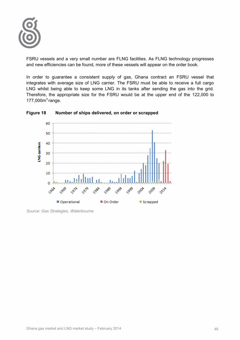
Ghana gas market and LNG market study – February 2014 46
FSRU vessels and a very small number are FLNG facilities. As FLNG technology progresses and new efficiencies can be found, more of these vessels will appear on the order book.
In order to guarantee a consistent supply of gas, Ghana contract an FSRU vessel that integrates with average size of LNG carrier. The FSRU must be able to receive a full cargo LNG whilst being able to keep some LNG in its tanks after sending the gas into the grid. Therefore, the appropriate size for the FSRU would be at the upper end of the 122,000 to 177,000m3 range.
Figure 18 Number of ships delivered, on order or scrapped
Source: Gas Strategies, Waterbourne

Ghana gas market and LNG market study – February 2014 47
5.10 Gas specifications that are normal for LNG projects
Table 12 LNG characteristics in different regions
Origin Project Nitrogen N2 %
Methane C1 %
Ethane C2%
Propane C3 % C4+ % TOTAL
Higher Heating Value Btu/Scf
Wobbe Index MJ/m3 (n)
Algeria Skikda 0.63 91.4 7.35 0.57 0.05 100 1135.3 54.62
Algeria Bethioua 0.64 89.55 8.2 1.3 0.31 100 1160.0 55.12
Algeria Arzew 0.71 88.93 8.42 1.59 0.37 100 1167.0 55.23
Egypt Idku 0.02 95.31 3.58 0.74 0.34 100 1120.8 54.61
Eqypt Damietta 0.02 97.25 2.49 0.12 0.12 100 1096.9 54.12
Equatorial Guinea 0 93.41 6.52 0.07 0 100 1125.9 54.73
Nigeria 0.03 91.7 5.52 2.17 0.58 100 1165.1 55.5
Norway 0.46 92.03 5.75 1.31 0.45 100 1145.8 54.91
Oman 0.2 90.68 5.75 2.12 1.24 100 1180.7 55.73
Peru 0.57 89.07 10.26 0.1 0.01 100 1151.4 55
Qatar 0.27 90.91 6.43 1.66 0.74 100 1165.6 55.4
Russia Sakhalin 0.07 92.53 4.47 1.97 0.95 100 1162.2 55.43
Trinidad 0.01 96.78 2.78 0.37 0.06 100 1101.8 54.23
Yemen 0.02 93.17 5.93 0.77 0.12 100 1135.0 54.91
Source: GIGGNL
Assessment of Ghanaian LNG specification Table 12 shows the chemical composition and combustion properties of LNG produced from current LNG exporting countries that are judged by Gas Strategies to be likely supplies to the Ghana LNG project. Gas Strategies has compared these figures to the gas specification provided by VRA for thermal power plants in Ghana, in order to identify any misalignment. The data, provided by GIIGNL, does not include information on other components such as water, sulphur or carbon dioxide nor does it include information on impurities like sand, dust or gums. It should be noted that the gas pipeline grid in Ghana is still underdeveloped and there is scope to alter the specification if it makes commercial sense to do so.
Nitrogen
There are no potential misalignments of nitrogen content; all the LNG listed above is below the VRA maximum of 10%.

Ghana gas market and LNG market study – February 2014 48
Methane
Egypt’s, average methane content is above the maximum provided by VRA (95%). The gas contained in the future US LNG exports will be shale gas, sourced from the lower 48 states. This gas is not profiled by GIIGNL but is generally understood to be a dry gas with high methane content. Gas Strategies has analysed the SPA executed by Cheniere Energy from its Sabine Pass liquefaction project and the methane quantity specified is within the acceptable range for Ghana. Taking the Sabine Pass SPA to be representative of the US projects, Gas Strategies believes there should be no issue in accepting US LNG into the Ghanaian gas pipeline gird.
Ethane
The provided gas specification sets a limit of 10% for ethane content. Only Peruvian LNG has a higher average ethane content than specified by VRA.
Propane
No misalignments exist.
C4+
No misalignments exist.
Higher heating value
VRA states that the acceptable range for higher heating value is between 950-1150. The table above shows that Algeria, Nigeria, Oman, Peru and Qatar have higher heating value above the upper end of the VRA range.
Wobbe Index
All countries in the table have a higher Wobbe index than the accepted specifications, this is something that will have to be managed as part of the project.

Ghana gas market and LNG market study – February 2014 49
Appendix A: Energy Commission gas demand projection for the non- power sector
Tema gas demand 2012 2013 2014 2015 2016 2017 2018 2019 2020
ALUWORK 0.6 0.6 0.7 0.7 0.7 0.8 0.8 0.8 0.9
VALCO 0.6 0.7 0.7 0.7 0.8 0.8 0.9 0.9 0.9
GTP 0.6 0.6 0.6 0.7 0.7 0.7 0.8 0.8 0.9
TEMA STEEL 0.4 0.5 0.5 0.5 0.5 0.6 0.6 0.6 0.7
NESTLE 0.4 0.5 0.5 0.5 0.5 0.6 0.6 0.6 0.6
UNILEVER 0.8 0.9 0.9 1.0 1.0 1.1 1.1 1.2 1.2
FERROFABRIK 0.1 0.1 0.1 0.1 0.1 0.1 0.1 0.1 0.1
WESTERN STEEL 0.5 0.5 0.6 0.6 0.6 0.6 0.7 0.7 0.7
BARRY C 0.1 0.1 0.1 0.1 0.1 0.1 0.1 0.1 0.1
PZ 0.2 0.2 0.2 0.2 0.2 0.2 0.2 0.2 0.2
INTRINSIC 0.9 1.0 0.0 0.1 1.1 1.2 1.2 1.3 1.4
CPC 0.3 0.3 0.3 0.3 0.4 0.4 0.4 0.4 0.4
TOR 16.8 17.6 18.5 19.4 20.4 21.4 22.5 23.6 24.8
CARGILL 0.6 0.6 0.6 0.7 0.7 0.7 0.8 0.8 0.9
W GLOBE 0.6 0.6 0.6 0.7 0.7 0.7 0.8 0.8 0.9
LUBCOM 0.6 0.6 0.6 0.7 0.7 0.7 0.8 0.8 0.9
AEL 0.6 0.6 0.6 0.7 0.7 0.7 0.8 0.8 0.9
GRL 0.6 0.6 0.6 0.7 0.7 0.7 0.8 0.8 0.9
GHACEM 0.6 0.6 0.6 0.7 0.7 0.7 0.8 0.8 0.9
ADM 0.6 0.6 0.6 0.7 0.7 0.7 0.8 0.8 0.9
SITOS 0.6 0.6 0.6 0.7 0.7 0.7 0.8 0.8 0.9
CROWN 0.6 0.6 0.6 0.7 0.7 0.7 0.8 0.8 0.9
TEMA LUBE 0.6 0.6 0.6 0.7 0.7 0.7 0.8 0.8 0.9
PFOODS 0.3 0.3 0.3 0.3 0.4 0.4 0.4 0.4 0.4
OTHERS 1.2 1.2 1.3 1.3 1.4 1.5 1.6 1.6 1.7
Tema Total 29.5 31.0 31.6 33.2 35.9 37.7 39.6 41.6 43.6

Ghana gas market and LNG market study – February 2014 50
Non-Tema gas demand 2012 2013 2014 2015 2016 2017 2018 2019 2020
TAKORADI INDUSTRIES 15.8 16.5 17.4 18.2 19.1 20.1 21.1 22.2 23.3
TARKWA, MANGANESE ORE 9.5 9.9 10.4 10.9 11.5 12.1 12.7 13.3 14.0
NYINAHIM,BAUXITE 38.9 40.8 42.8 45.0 47.2 49.6 52.1 54.7 57.4
BUIPE, LIMESTONE 16.8 17.6 18.5 19.4 20.4 21.4 22.5 23.6 24.8
MAJOR CITIES 12.6 13.2 13.9 14.6 15.3 16.1 16.9 17.7 18.6
OTHERS * 10.5 11.0 11.6 12.2 12.8 13.4 14.1 14.8 15.5
TOTAL 104.0 109.1 114.6 120.3 126.4 132.7 139.3 146.3 153.6

Ghana gas market and LNG market study – February 2014 51
Appendix B: Gas Strategies comments on the “Natural Gas Pricing Policy” document May 2012
Key Components of Gas Pricing Policy The policy sets out that VRA and all other market participants will buy gas from GNGC, the aggregator of domestic gas supply. The gas price paid to GNGC will be set by negotiation but will be no less than the Weighted Average Cost of imported gas. Prices will be reviewed on a bi-annual basis to reflect inflation and exchange rate movements if the contract is denominated in cedi. The policy states that power generation companies will be able to pass through the cost of gas and transportation to consumers assuming that the purchase contract complies with the Gas Pricing Policy.
The policy implies that VRA and other buyers will take title to domestic gas at the outlet of the gas processing plant and arrange for transportation with the Transmission System Operator (BOST). The tariff system for transportation will be a postage stamp rather than distance based or entry exit system. The tariff has been calculated at $1.20 -1.30 / MMBtu in the Gas Pricing Policy document although Gas Strategies has been informed that the price is now likely to be in the range of $2.80 – 3.00/MMBtu. In a relatively small system a postage stamp tariff is perhaps sensible and is promoted as part of national policy of access to energy. As the network expands this policy should be kept under review as it does represent cross subsidy between those near to the gas delivery points and those more distant
The policy is not clear on how gas imports will be treated in future and whether GNGC will also act as the aggregator for gas imports or whether other entities can also import and sell gas to end users.
The policy calls for contract transparency so that details of gas purchase contracts will be available for inspection, probably via the PURC.
Risks Created by Policy for the LNG project develpment There are a number of areas within the Draft Gas Pricing Policy that may create significant risks for VRA or indeed whoever else may be lead the LNG project and much of this risk will lie in the detail of the policy arrangements much of which has yet to be defined. Some of the key issues that will need to address include:
There is currently no guidance on the basis on which prices will be negotiated between power producers and GNGC except that the price must be a minimum of the Weighted Average Cost of Imports, this clearly represents a risk in that as a monopoly seller GNGC will hold a strong negotiating position with its buyers and there is no clarity about regulatory oversight of downstream pricing arrangements except for the setting of the minimum price

Ghana gas market and LNG market study – February 2014 52
There is currently no mechanism within the Gas Pricing Policy which deals with the costs of balancing the gas system. Balancing could be provided, at least in part, through modulation of upstream production but if this is not built into the upstream pricing regime there is a risk that VRA could be asked to balance the system through the flexibility in its generation portfolio (specifically hydro). This is likely to create additional cost for VRA, which it may not be able to pass through to consumers, as well as complex regulation across gas and electricity.
The LNG buyer will need to ensure full back to back provisions in the gas contract chain
and, before signing a contract, will need to insist on conditions precedent either being in place or required to be in place prior to incurring obligations under the contract including:
On gas purchase that GNGC has gas purchase agreement with producers Gas processing plant fully functioning and commissioned If executing a Transportation contract with BOST (or GNPC) that gas will be
available at the delivery meter
The contracting party for LNG imports will need to ensure that any LNG import agreements are agreed (by the PURC &/or Government) to be compliant with the Gas Pricing Policy. The policy states that future LNG supplies should be “at a $/MMBTU price as close as possible to the WAGP landed price”. There is a risk that the LNG buyer could be penalised in some way if the LNG price negotiated is deemed “too high” by the regulatory authorities
More generally the Gas Pricing Policy creates a risk that there will be insufficient incentive
to drive future investment in the upstream for gas supply. Although not directly impacting power producers in the near term this may have an impact on the future sustainability of indigenous gas production and lead to future shortages. Specifically, there is a risk that the PURC in an attempt to ensure “fair value” for Ghana
from its gas resources will set the return on upstream investment too low to interest international upstream investors to invest in production facilities and/or exploration to discover new gas. There is also an issue whereby at some point in the future the associated gas fields will have depleted the oil and unproduced gas will remain, these fields will need to be reclassified as non-associated gas to attract investment to blow down the remaining gas
A foot note in the Gas Pricing Policy states that it is a temporary measure and will be
substituted by the Gas Master Plan which is under development. Parties contracting on a basis that is consistent with the current policy need to be sure any agreement can be grandfathered so that any change in regime under the Gas Master Plan does not have adverse effects.

Ghana gas market and LNG market study – February 2014 53
The Gas Pricing Policy sets out a prioritisation of supply from Power Sector downwards. The detail of how prioritisation will work with the commercial agreements will need to be clarified to ensure that gas is allocated on a transparent and well understood basis
A final key issue in the pricing regime proposed under the Gas Pricing Policy is that it is institutionally complex and relies on a number of entities with limited experience both to develop, build and operate the system and to regulate it.

Ghana gas market and LNG market study – February 2014 54
Appendix C: Gas Strategies gas demand projection for the Ghana power sector by location
MMscfd Takoradi Tema Domunli Essiama Prestea Total
2014 110 66 - - - 175
2015 129 90 - - - 219
2016 130 145 - - - 275
2017 124 199 - - - 324
2018 116 176 59 - - 351
2019 141 155 85 - - 382
2020 153 158 85 26 - 422
2021 153 158 98 47 - 456
2022 153 158 116 63 - 490
2023 153 158 153 63 - 527
2024 153 158 192 63 - 566
2025 156 164 224 65 - 609
2026 160 170 254 68 - 651
2027 164 199 264 70 - 696
2028 171 232 269 73 - 745
2029 202 232 277 73 - 784
2030 203 253 281 96 - 833
Source: Gas Strategies

Ghana gas market and LNG market study – February 2014 55
Appendix D: Gas Strategies gas demand projection for the Ghana non-power sector by location
MMscfd Tema Takoradi Nyankrom Total
2014 32 17 30 79
2015 33 18 60 111
2016 36 19 60 115
2017 38 20 60 118
2018 40 21 60 121
2019 42 22 60 124
2020 44 23 60 127
2021 46 24 60 130
2022 48 26 60 134
2023 51 27 60 137
2024 53 28 60 141
2025 56 30 60 145
2026 58 31 60 150
2027 61 33 60 154
2028 64 34 60 159
2029 68 36 60 164
2030 71 38 60 169
Source: Gas Strategies


Appendix B Metocean Data Tables


TABLE B-1 Wind speed-direction frequency, WWIII point (N4.5, W2.5)
TABLE B-2 Wind speed-direction frequency, WWIII point (N4.5, W1.5)
Wind speed (m/s)
N NNE NE ENE E ESE SE SSE S SSW SW WSW W WNW NW NNW Sum Exceedance Probability
<=2 0.02 0.05 0.08 0.06 0.12 0.17 0.24 0.43 0.67 0.75 0.63 0.44 0.26 0.08 0.07 0.05 4.12 99.982 - 4 0.02 0.01 0.05 0.07 0.14 0.29 0.79 2.42 5.57 9.08 8.42 4.04 0.94 0.20 0.08 0.04 32.15 95.864 - 6 0.02 0.03 0.00 0.02 0.03 0.10 0.41 1.87 6.24 14.38 18.22 7.54 0.98 0.15 0.02 0.01 50.03 63.706 - 8 0.00 0.00 0.00 0.00 0.01 0.02 0.03 0.22 1.47 3.73 4.63 2.36 0.31 0.03 0.00 0.00 12.82 13.678 - 10 0.00 0.00 0.00 0.00 0.00 0.00 0.00 0.00 0.12 0.28 0.34 0.10 0.01 0.01 0.00 0.00 0.86 0.8610 -12 0.00 0.00 0.00 0.00 0.00 0.00 0.00 0.00 0.00 0.01 0.00 0.00 0.00 0.00 0.00 0.00 0.02 0.00
Sum 0.07 0.09 0.12 0.15 0.29 0.59 1.48 4.95 14.07 28.23 32.23 14.48 2.51 0.47 0.17 0.10 100
Wind Speed - Wind Direction Occurrence Frequency Table in %
Wind speed (m/s)
N NNE NE ENE E ESE SE SSE S SSW SW WSW W WNW NW NNW Sum Exceedance Probability
<=2 0.03 0.07 0.07 0.10 0.10 0.15 0.23 0.42 0.51 0.56 0.60 0.36 0.20 0.13 0.08 0.06 3.66 99.992 - 4 0.02 0.03 0.04 0.06 0.15 0.30 0.70 1.83 4.52 7.37 7.39 3.63 1.04 0.29 0.05 0.04 27.44 96.334 - 6 0.02 0.02 0.00 0.02 0.05 0.12 0.40 1.09 5.01 14.24 19.53 8.39 1.16 0.16 0.02 0.01 50.24 68.896 - 8 0.00 0.00 0.00 0.00 0.05 0.01 0.02 0.08 1.09 3.86 8.21 3.77 0.36 0.05 0.00 0.00 17.49 18.658 - 10 0.00 0.00 0.00 0.00 0.00 0.00 0.00 0.00 0.06 0.28 0.56 0.22 0.03 0.00 0.00 0.00 1.16 1.1610 -12 0.00 0.00 0.00 0.00 0.00 0.00 0.00 0.00 0.00 0.00 0.00 0.00 0.00 0.00 0.00 0.00 0.01 0.00
Sum 0.07 0.11 0.11 0.18 0.34 0.58 1.36 3.42 11.19 26.31 36.30 16.36 2.79 0.63 0.15 0.11 100
Wind Speed - Wind Direction Occurrence Frequency Table in %

TABLE B-3 Wind speed-direction frequency, WWIII point (N5, W0)
TABLE B-4 Wave height-direction frequency, WWIII point (N4.5, W2.5)
Wind Speed - Wind Direction Occurrence Frequency Table in %Wind speed (m/s)
N NNE NE ENE E ESE SE SSE S SSW SW WSW W WNW NW NNW Sum Exceedance Probability
<=2 0.03 0.06 0.05 0.10 0.07 0.13 0.18 0.25 0.37 0.48 0.47 0.28 0.19 0.13 0.09 0.05 2.93 99.972 - 4 0.06 0.03 0.05 0.07 0.14 0.31 0.46 1.13 2.66 5.00 5.68 3.33 1.06 0.20 0.08 0.05 20.32 97.044 - 6 0.02 0.02 0.02 0.03 0.10 0.14 0.14 0.48 2.48 12.80 20.60 9.43 1.51 0.19 0.04 0.01 48.03 76.716 - 8 0.00 0.00 0.01 0.02 0.02 0.01 0.01 0.02 0.41 4.51 14.75 5.41 0.60 0.06 0.01 0.00 25.83 28.688 - 10 0.00 0.00 0.00 0.00 0.00 0.00 0.00 0.00 0.02 0.21 1.93 0.64 0.03 0.01 0.00 0.00 2.85 2.8510 -12 0.00 0.00 0.00 0.00 0.00 0.00 0.00 0.00 0.00 0.00 0.03 0.00 0.00 0.00 0.00 0.00 0.03 0.00
Sum 0.12 0.12 0.12 0.23 0.34 0.59 0.79 1.89 5.94 23.00 43.46 19.10 3.40 0.59 0.23 0.10 100
Hm0
(m)N NNE NE ENE E ESE SE SSE S SSW SW WSW W WNW NW NNW Sum
Exceedance Probability
0.0 - 0.3 0.01 0.00 0.00 0.00 0.00 0.00 0.00 0.00 0.00 0.00 0.01 0.00 0.00 0.00 0.00 0.00 0.02 99.980.3 - 0.6 0.00 0.00 0.00 0.00 0.00 0.00 0.00 0.00 0.08 0.01 0.02 0.00 0.00 0.00 0.00 0.00 0.10 99.950.6 - 0.9 0.00 0.00 0.00 0.00 0.00 0.00 0.00 0.22 0.55 2.12 0.06 0.00 0.00 0.00 0.00 0.00 2.95 99.850.9 - 1.2 0.00 0.00 0.00 0.00 0.00 0.00 0.00 2.34 5.45 14.19 0.58 0.01 0.00 0.00 0.00 0.00 22.57 96.901.2 - 1.5 0.00 0.00 0.00 0.00 0.00 0.00 0.00 2.50 7.71 20.76 1.14 0.02 0.00 0.00 0.00 0.00 32.11 74.321.5 - 1.8 0.00 0.00 0.00 0.00 0.00 0.00 0.00 1.46 6.82 14.02 0.80 0.00 0.00 0.00 0.00 0.00 23.11 42.211.8 - 2.1 0.00 0.00 0.00 0.00 0.00 0.00 0.00 0.63 3.54 7.47 0.47 0.00 0.00 0.00 0.00 0.00 12.11 19.102.1 - 2.4 0.00 0.00 0.00 0.00 0.00 0.00 0.00 0.25 1.40 2.74 0.09 0.00 0.00 0.00 0.00 0.00 4.48 6.982.4 - 2.7 0.00 0.00 0.00 0.00 0.00 0.00 0.00 0.05 0.76 1.16 0.00 0.00 0.00 0.00 0.00 0.00 1.97 2.502.7 - 3.0 0.00 0.00 0.00 0.00 0.00 0.00 0.00 0.02 0.20 0.22 0.00 0.00 0.00 0.00 0.00 0.00 0.44 0.533.0 - 3.3 0.00 0.00 0.00 0.00 0.00 0.00 0.00 0.00 0.03 0.06 0.00 0.00 0.00 0.00 0.00 0.00 0.09 0.093.3 => 0.00 0.00 0.00 0.00 0.00 0.00 0.00 0.00 0.00 0.02 0.00 0.00 0.00 0.00 0.00 0.00 0.02 0.00Sum 0.01 0.00 0.00 0.00 0.00 0.00 0.00 7.48 26.54 62.78 3.16 0.03 0.00 0.00 0.00 0.00 100
Hm0-Mean Wave Direction Occurrence Frequency Table in %

TABLE B-5 Wave height-wave period frequency, WWIII point (N4.5, W2.5)
0 -2 2- 4 4 - 6 6 - 8 8 - 10 10 - 12 12 - 14 14 - 16 16 - 18 18 - 20 20< 0.0 - 0.3 0.00 0.01 0.00 0.00 0.00 0.00 0.00 0.00 0.00 0.00 0.00 0.01 99.980.3 - 0.6 0.00 0.03 0.07 0.00 0.00 0.00 0.00 0.00 0.00 0.00 0.00 0.10 99.970.6 - 0.9 0.00 0.00 0.02 0.05 0.99 1.07 0.56 0.20 0.03 0.02 0.00 2.95 99.860.9 - 1.2 0.00 0.00 0.09 0.82 5.06 8.32 5.71 1.99 0.56 0.02 0.00 22.58 96.911.2 - 1.5 0.00 0.00 0.09 0.61 4.74 11.33 9.95 4.13 1.12 0.12 0.02 32.12 74.331.5 - 1.8 0.00 0.00 0.07 0.22 2.26 7.72 8.59 3.34 0.80 0.11 0.00 23.11 42.211.8 - 2.1 0.00 0.00 0.03 0.11 0.47 3.50 5.00 2.50 0.46 0.04 0.00 12.11 19.102.1 - 2.4 0.00 0.00 0.00 0.02 0.08 0.76 1.98 1.31 0.32 0.00 0.00 4.48 6.982.4 - 2.7 0.00 0.00 0.00 0.00 0.00 0.24 0.68 0.85 0.19 0.00 0.00 1.97 2.502.7 - 3.0 0.00 0.00 0.00 0.00 0.00 0.00 0.13 0.24 0.05 0.01 0.00 0.44 0.533.0 - 3.3 0.00 0.00 0.00 0.00 0.00 0.00 0.02 0.06 0.02 0.00 0.00 0.09 0.093.3 => 0.00 0.00 0.00 0.00 0.00 0.00 0.00 0.01 0.02 0.00 0.00 0.02 0.00Sum 0.00 0.05 0.38 1.83 13.61 32.95 32.62 14.64 3.57 0.32 0.02 100
Exceedance Probability
Hm0-Tp Occurrence Frequency Table in %Hm0
(m)Tp (s) Sum

TABLE B-6 Wave height-direction frequency, WWIII point (N4.5, W1.5)
Hm0
(m)N NNE NE ENE E ESE SE SSE S SSW SW WSW W WNW NW NNW Sum Exceedance
Probability
0.0 - 0.3 0.01 0.00 0.00 0.00 0.00 0.00 0.00 0.00 0.00 0.01 0.00 0.00 0.00 0.00 0.00 0.00 0.02 100.000.3 - 0.6 0.00 0.00 0.00 0.00 0.00 0.00 0.00 0.00 0.07 0.02 0.01 0.00 0.00 0.00 0.00 0.00 0.10 99.980.6 - 0.9 0.00 0.00 0.00 0.00 0.00 0.00 0.00 0.31 0.89 2.82 0.01 0.00 0.00 0.00 0.00 0.00 4.03 99.880.9 - 1.2 0.00 0.00 0.00 0.00 0.00 0.00 0.00 2.34 7.88 15.79 0.14 0.02 0.00 0.00 0.00 0.00 26.16 95.851.2 - 1.5 0.00 0.00 0.00 0.00 0.00 0.00 0.00 2.08 9.87 20.18 0.12 0.02 0.00 0.00 0.00 0.00 32.28 69.681.5 - 1.8 0.00 0.00 0.00 0.00 0.00 0.00 0.00 1.09 8.44 12.46 0.03 0.00 0.00 0.00 0.00 0.00 22.03 37.401.8 - 2.1 0.00 0.00 0.00 0.00 0.00 0.00 0.00 0.49 3.85 5.70 0.01 0.00 0.00 0.00 0.00 0.00 10.04 15.372.1 - 2.4 0.00 0.00 0.00 0.00 0.00 0.00 0.00 0.17 1.82 2.06 0.00 0.00 0.00 0.00 0.00 0.00 4.04 5.332.4 - 2.7 0.00 0.00 0.00 0.00 0.00 0.00 0.00 0.03 0.57 0.45 0.00 0.00 0.00 0.00 0.00 0.00 1.05 1.292.7 - 3.0 0.00 0.00 0.00 0.00 0.00 0.00 0.00 0.00 0.16 0.03 0.00 0.00 0.00 0.00 0.00 0.00 0.19 0.233.0 - 3.3 0.00 0.00 0.00 0.00 0.00 0.00 0.00 0.00 0.00 0.04 0.00 0.00 0.00 0.00 0.00 0.00 0.04 0.043.3 => 0.00 0.00 0.00 0.00 0.00 0.00 0.00 0.00 0.00 0.00 0.00 0.00 0.00 0.00 0.00 0.00 0.00 0.00Sum 0.01 0.00 0.00 0.00 0.00 0.00 0.00 6.52 33.55 59.56 0.32 0.04 0.00 0.00 0.00 0.00 100
Hm0-Mean Wave Direction Occurrence Frequency Table in %

TABLE B-7 Wave height-wave period frequency, WWIII point (N4.5, W1.5)
0 -2 2- 4 4 - 6 6 - 8 8 - 10 10 - 12 12 - 14 14 - 16 16 - 18 18 - 20 20< 0.0 - 0.3 0.00 0.01 0.00 0.00 0.00 0.00 0.00 0.00 0.00 0.00 0.00 0.01 100.000.3 - 0.6 0.00 0.03 0.07 0.00 0.00 0.00 0.00 0.00 0.00 0.00 0.00 0.10 99.990.6 - 0.9 0.00 0.00 0.03 0.06 1.32 1.56 0.75 0.23 0.05 0.02 0.00 4.03 99.890.9 - 1.2 0.00 0.00 0.15 0.79 5.34 9.64 7.05 2.44 0.72 0.04 0.00 26.17 95.861.2 - 1.5 0.00 0.00 0.08 0.44 4.24 11.28 10.67 4.32 1.09 0.15 0.01 32.29 69.691.5 - 1.8 0.00 0.00 0.07 0.19 1.74 7.19 8.47 3.44 0.82 0.12 0.00 22.03 37.401.8 - 2.1 0.00 0.00 0.03 0.10 0.25 2.54 4.35 2.36 0.39 0.03 0.00 10.05 15.372.1 - 2.4 0.00 0.00 0.00 0.02 0.03 0.65 1.63 1.41 0.31 0.00 0.00 4.04 5.332.4 - 2.7 0.00 0.00 0.00 0.00 0.00 0.07 0.37 0.48 0.13 0.01 0.00 1.05 1.292.7 - 3.0 0.00 0.00 0.00 0.00 0.00 0.00 0.03 0.12 0.03 0.00 0.00 0.19 0.233.0 - 3.3 0.00 0.00 0.00 0.00 0.00 0.00 0.00 0.02 0.03 0.00 0.00 0.04 0.043.3 => 0.00 0.00 0.00 0.00 0.00 0.00 0.00 0.00 0.00 0.00 0.00 0.00 0.00Sum 0.00 0.05 0.42 1.60 12.93 32.94 33.31 14.81 3.57 0.36 0.02 100
Exceedance Probability
Hm0-Tp Occurrence Frequency Table in %Hm0
(m)Tp (s) Sum

TABLE B-8 Wave height-direction frequency, WWIII point (N5, W0)
Hm0
(m)N NNE NE ENE E ESE SE SSE S SSW SW WSW W WNW NW NNW Sum Exceedance
Probability0.0 - 0.3 0.00 0.00 0.00 0.00 0.00 0.00 0.00 0.00 0.00 0.02 0.00 0.00 0.00 0.00 0.00 0.00 0.02 100.000.3 - 0.6 0.00 0.00 0.00 0.00 0.00 0.00 0.00 0.00 0.05 0.04 0.00 0.00 0.00 0.00 0.00 0.00 0.09 99.980.6 - 0.9 0.00 0.00 0.00 0.00 0.00 0.00 0.00 0.27 0.95 2.81 0.12 0.00 0.00 0.00 0.00 0.00 4.16 99.890.9 - 1.2 0.00 0.00 0.00 0.00 0.00 0.00 0.00 1.23 6.22 17.83 0.92 0.00 0.00 0.00 0.00 0.00 26.20 95.731.2 - 1.5 0.00 0.00 0.00 0.00 0.00 0.00 0.00 1.05 8.39 21.87 1.59 0.00 0.00 0.00 0.00 0.00 32.90 69.531.5 - 1.8 0.00 0.00 0.00 0.00 0.00 0.00 0.00 0.38 6.79 14.11 1.02 0.00 0.00 0.00 0.00 0.00 22.29 36.631.8 - 2.1 0.00 0.00 0.00 0.00 0.00 0.00 0.00 0.23 2.53 6.27 0.48 0.00 0.00 0.00 0.00 0.00 9.52 14.342.1 - 2.4 0.00 0.00 0.00 0.00 0.00 0.00 0.00 0.07 1.19 2.26 0.13 0.00 0.00 0.00 0.00 0.00 3.64 4.832.4 - 2.7 0.00 0.00 0.00 0.00 0.00 0.00 0.00 0.02 0.41 0.51 0.01 0.00 0.00 0.00 0.00 0.00 0.95 1.182.7 - 3.0 0.00 0.00 0.00 0.00 0.00 0.00 0.00 0.00 0.07 0.11 0.00 0.00 0.00 0.00 0.00 0.00 0.19 0.233.0 - 3.3 0.00 0.00 0.00 0.00 0.00 0.00 0.00 0.00 0.00 0.04 0.00 0.00 0.00 0.00 0.00 0.00 0.04 0.043.3 => 0.00 0.00 0.00 0.00 0.00 0.00 0.00 0.00 0.00 0.00 0.00 0.00 0.00 0.00 0.00 0.00 0.00 0.00Sum 0.00 0.00 0.00 0.00 0.00 0.00 0.00 3.25 26.60 65.87 4.27 0.00 0.00 0.00 0.00 0.00 100
Hm0-Mean Wave Direction Occurrence Frequency Table in %

TABLE B-9 Wave height-wave period frequency, WWIII point (N5, W0)
0 -2 2- 4 4 - 6 6 - 8 8 - 10 10 - 12 12 - 14 14 - 16 16 - 18 18 - 20 20< 0.0 - 0.3 0.00 0.02 0.00 0.00 0.00 0.00 0.00 0.00 0.00 0.00 0.00 0.02 100.000.3 - 0.6 0.00 0.03 0.05 0.00 0.00 0.00 0.00 0.00 0.00 0.00 0.00 0.09 99.980.6 - 0.9 0.00 0.01 0.05 0.10 1.24 1.65 0.84 0.21 0.05 0.03 0.00 4.16 99.900.9 - 1.2 0.00 0.00 0.15 0.48 5.11 9.87 7.09 2.66 0.79 0.05 0.00 26.20 95.731.2 - 1.5 0.00 0.00 0.07 0.41 3.84 11.53 11.36 4.37 1.16 0.14 0.02 32.90 69.541.5 - 1.8 0.00 0.00 0.04 0.18 1.24 7.37 8.74 3.68 0.90 0.15 0.00 22.29 36.641.8 - 2.1 0.00 0.00 0.01 0.07 0.15 2.24 4.20 2.40 0.42 0.02 0.00 9.52 14.342.1 - 2.4 0.00 0.00 0.00 0.03 0.00 0.48 1.52 1.30 0.30 0.01 0.00 3.64 4.832.4 - 2.7 0.00 0.00 0.00 0.01 0.00 0.06 0.29 0.47 0.12 0.00 0.00 0.95 1.182.7 - 3.0 0.00 0.00 0.00 0.00 0.00 0.00 0.01 0.12 0.05 0.00 0.00 0.19 0.233.0 - 3.3 0.00 0.00 0.00 0.00 0.00 0.00 0.00 0.02 0.03 0.00 0.00 0.04 0.043.3 => 0.00 0.00 0.00 0.00 0.00 0.00 0.00 0.00 0.00 0.00 0.00 0.00 0.00Sum 0.00 0.06 0.37 1.28 11.57 33.20 34.06 15.23 3.81 0.40 0.02 100
Exceedance Probability
Hm0-Tp Occurrence Frequency Table in %Hm0
(m)Tp (s) Sum


Appendix C Option Sketches


Appendix D Environmental and Social Review


Copy of Ghana LNG Sites Env Soc Impact Matrix REV 6_PMRFinal 2/19/2014 Page 1 of 1
Liquefied Natural Gas Import Project: Potential Environmental and Social Interactions
Construction and Operational Scenarios for Environmental and Socioeconomic
Impacts
Rele
vant
IFC
Perf
orm
ance
St
anda
rds (
1) Domunli: Buoy
Mooring Offshore
Atuabo: Buoy
Mooring Offshore
Esiama: Buoy
Mooring Offshore
Takoradi: Fixed Berth
at Port & Breakwater
Sekondi: Fixed Berth
at Port & Breakwater
Aboadze: Buoy
Mooring Offshore
Tema: Buoy Mooring Offshore
Dredging and Trenching Impacts to Benthic Habitat and Water Quality
6 3 3 3 1 2 3 3
Operational Impacts to Offshore/Marine Water Quality
6 3 3 3 1 1 3 3
Loss of Marine Biodiversity 6 4 4 4 2 2 4 4
Impacts to Marine Mammals 6 3 3 3 3 3 3 3
Impacts to Turtle Nesting Beach Sites 6 3 3 3 3 4 3 4
Impacts to Other Protected Marine Species 6 3 3 3 3 3 3 3
Noise and Air Emissions 3 3 3 3 1 1 3 3
Shoreline Impacts 3 3 3 3 3 3 3 3
Impacts to Onshore Water Quality 6 4 4 3 2 2 4 4
Impacts to Onshore Sensitive Habitats 6 3 4 3 1 1 4 4
Impacts to Legally Protected and Internationally Recognized Areas
6 3 4 3 3 3 4 4
Impacts to Onshore Aquatic, Wetland or Terrestrial Biodiversity
6 3 4 3 1 1 4 4
Disturbance or Loss of Other Protected Onshore Species
6 3 4 3 2 2 4 4
3.15 3.46 3.08 2.00 2.15 3.46 3.54
Impacts to Cultural Heritage, Resources and Sacred Groves
7 & 8 3 4 4 3 3 4 4
Explosion or Fire Hazard to Communities 4 3 3 3 2 2 3 3
Construction Impacts: Noise, Dust, Traffic, Debris and Safety
4 3 3 3 2 2 3 3
Resettlement: Physical Displacement 5 & 7 4 4 4 1 1 4 4
Economic Displacement 5 & 7 3 3 3 1 1 3 3
Reduction in Artisanial Fishing Access 5 3 3 3 3 3 3 3
3.17 3.33 3.33 2.00 2.00 3.33 3.33
4
3
2
1
1IFC Performance Standards
Project Sites and Facility Description
Comparative Ranking of Impact Severity Among Sites
Comparative Ranking of Impact Severity among Sites
Relative Severity Ranking for Potential Impacts
Average Environmental Impact Score
Average Socioeconomic Impact Score
Socioeconomic Impacts
Environmental Impacts
Potential Impacts
MCC-funded activities must meet the IFC Performance Standards on
Environmental & Social Responsibility. These include the
assessment of associated infrastructure.
None
Slight: interactions (a) not likely to be significant (even if not mitigated) or (b) be easily mitigated with standard, proven measuresModerate: interactions may be significant and are not always easily mitigated with standard, proven measuresSerious: interactions have potential to cause significant harm and may require specially design measures


Aboadze Site
Overview of Aboadze Area
Aboadze is a town in the Western Region of Ghana. It serves both as a dormitory town as well as an industrialized zone. Aboadze started as a village with the name Akuraban (meaning hamlet) and was predominantly settled by migrant fishermen. The landowners of Aboadze are believed to have migrated southward on hunting expeditions and settled at the village of Dwomo, 2.5 km off the main Accra-Takoradi road in Inchaban. Located in the Aboadze Township is the Takoradi Thermal Power Station (TTPS), one of Ghana's thermal power plants. Vegetation types in the general area include mangrove and other shrubs as well as coconut trees.
Aboadze is located in the Western Region, about 20 kilometers east of the center of Takoradi, the region’s capital city. It is bordered on east by Shama on the west by Kojokrom and on the south by Atlantic Ocean.
Climatic Conditions The coastal area of Ghana has an equatorial climate with minimal annual temperature variations. Ghana has a bimodal rainfall distribution (June/July and September/October) with distinct differences in the amount and seasonal distribution of precipitation. (Church, 1980 in WAPC, 2004).
There are two main seasons during the course of the year, i.e., wet and dry, with a short break in the wet season in August (WAPC, 2004). During the dry season, the coastal areas of Ghana are dominated by the NE trade wind system, which is relatively free of clouds and rain, and is cool, dry, and dust-laden; it is known as the “Harmattan.” During the wet season, the SE Trade winds are associated with more periods of increased clouds and precipitation
Rainfall - Aboadze lies in the same region with Takoradi with annual rainfall between 1250 mm and 1500 mm. May and June are the wettest months. More than 250 mm of rain is usually recorded during this period (WAPC, 2004).
Temperature - At the Aboadze site, mean daily minimum temperature varies between 21° C and 23°C, while the mean daily maximum temperature varies between 27°C and 31°C. There is little temperature variation during the year (WAPC, 2004).
Relative Humidity - Aboadze lies in a region where there is a consistent daily variation in relative humidity with night values (95 to 100%), slightly higher than daytime values (70 to 80 %) (WAPC, 2004).
Wind - The prevailing SW wind is relatively light but steady throughout the year, with distinct diurnal variation relative to the land/sea breeze effect. At Takoradi, which is near the Aboadze Township, the average monthly wind speed rarely exceeds 2.3 meters per second (m/s) (WAPC, 2004). Available data and research indicate that there is no recorded occurrence of cyclones in the area (HPL, 2009).
Air Quality Air quality studies have shown the Aboadze area to have better ambient air quality than many other parts of the country because the Aboadze area is not as highly industrialized (HPL, 2009, WAPC, 2004). Air quality at the Aboadze Site is impacted by salt spray from the surf zone, wood smoke from fish smoking operations and the existing TTPS (WAPC, 2004).
Available air quality monitoring data for the TTPS for 2011 indicate that plant emissions fall within the maximum allowable limits set by Ghana Environmental Protection Agency, including a compliance level of 99.6% for NOx (TICO, 2011).
1

ABOADZE SITE
Offshore Characteristics Oceanography The oceanography of the West African region is influenced by the meteorological and oceanographic processes of the South and North Atlantic Oceans, principally their oceanic gyral currents (Merle and Arnault, 1985; Fontaine et al., 1999 in WAPC, 2004).
The Gulf of Guinea coast shows slight concave curves between a series of capes (Palmas, Three Points, St. Paul and Formosa). The Volta and Niger rivers, both some distance to the east of the Aboadze Site, are the only large rivers discharging into the Gulf of Guinea and were historically the main sources of sediments for formation of the shores (HPL, 2009).
The coastal orientation and the continuous action of the ocean swell from the southwest results in sediments being transported away from the capes and deposited on the shore between them. On a smaller scale, this pattern of deposition is repeated within the larger concave curves, making the coast a series of beaches intersected by rocky promontories and some cliffs. This pattern is apparent in the vicinity of Aboadze where the shore consists primarily of sandy beaches with rocky outcrops. The depth of the sand deposits is not likely large as evidenced by the occurrence of several exposed rocks in the near shore area. In shore of the 10 m contour at the Aboadze Site, the bottom substrate consists of sand with rock outcrops changing to mud and sand in deeper waters. Immediately in front of the TTPS, several rock outcrops are evident at low tide intermixed with areas of sand. In addition, the Sherbro Banks occur about 1.5 to 2km offshore from TTPS and form a shallow area only 5.6 meters deep at the inner edge of the 10 meter bathymetric contour.
Low sand cliffs (1 to 1.5 m) are apparent at the shoreline interface, indicating the presence of a mildly erosive environment. Sand-winning activities, which are illegal, occurred along the eastern margin of the site and may have impacted the local sediment transport regime. Beyond the beach/tide zone the bottom slope is more gentle, progressing seaward to the edge of the continental shelf, about 75 km from shore (HPL, 2009)
Physical processes driven by waves and currents do occur in the littoral zone leading to littoral drift. Littoral drift includes long shore drift and on-offshore drift, movements parallel and perpendicular to the shore respectively. The littoral zone extends seaward from the shoreline to just beyond the breaker zone. Some predictions of in-shore water movements can be made based on the shape of the shoreline and the presence of a major river (Pra) discharging into the nearby bay (Shama Bay). This would indicate the likely presence of a counter clockwise gyre to the east of the site in Shama Bay (HPL, 2009).
The coastal surface currents are predominantly wind-driven and are confined to a layer of 10– 40 m. thickness. Littoral drift, which is the main driving forces in coastal circulation in this area, is generated by breaking waves. These littoral drifts, generally flowing in an eastward direction, flow at rates less than 1 m/s, but are responsible for transporting large volumes of littoral sediments. The direction of tidal current around the coast of Ghana is mostly North or North-East. The velocity of the tidal current is generally less than 0.1m/s. the maximum velocity of tidal current observed in a day of strong winds is about 0.5m/s. The wave induced long shore currents are generally in the west to east direction which is an indication of the direction the waves impinge the shoreline. The long shore currents may average about 1m/s and vary between 0.5 and 1.5 m/s. The magnitude increases during rough sea conditions (HPL, 2009).
Waves reaching the shores of Ghana consist of swells originating from the oceanic area around the Antarctica Continent and seas generated by locally occurring winds. The significant height of the waves generally lies between 0.9 m and 1.4 m and rarely attains 2.5 m or more. The most common amplitude of waves in the region is 1.0 m but annual significant swells could reach 3.3 m in some instances. Swells attaining heights of 4.8-6 m, however, occur with a 10-20 year periodicity. The peak wave period for the swells generally falls in the range of 7 to 14 seconds. The swell wave direction is almost always south or southwest. Other observations on the wave climate include a long swell of distant origin and with
2

ABOADZE SITE
wavelengths varying between 160 and 220 m. This swell has a primary period of 12 seconds and a relatively regular averaged height between 1.0 and 2.0 m. The swells generally travel from southwest to northeast (HPL, 2009).
The tide on Ghana's coast is regular and semi-diurnal. The tidal wave has virtually the same phase across the coast of the country. The average range of Neap and Spring tides increases from west to east. Tidal currents are low and have an insignificant influence on coastal processes except within tidal inlets.
Generally, the Tropical Surface Water (TSW) is characterized by warm, well-mixed water that extends from the surface to the depth of the thermocline (about 30 m to 40 m). Sea surface temperatures and salinities along the coast of Ghana can vary widely, with the oceanographic regime characterized by a seasonal major upwelling and a minor upwelling. The major upwelling occurs for approximately 3 months each year, beginning late June or early July and ending in late September or early October. This event is defined as that period when sea surface temperature falls below 25º C. The upwelling is stronger and lasts longer along the western section of the coast. The minor upwelling occurs for approximately 3 weeks; as early as December or as late as March, however usually in either January or February. Minor upwelling occurs when ocean surface temperatures fluctuate between 27.5 and 26.0º C (HPL, 2009).
Surface temperatures can drop to as low as 17.5º C during the upwelling, while salinity generally increases and dissolved oxygen declines. Sea temperatures tend to be lowest during this period as solar heating is limited by cloud cover and upwelling is frequent. The upwelling is known to have considerable influence on both the local fisheries and sub-region. The upwelling influences the migratory patterns of pelagic fishes and is linked with the marine fish catch in Ghana (HPL, 2009). In the off-shore region, the depth of the thermocline varies from 10 to 50 m on an annual basis, resulting in isothermal waters in shore of the 10-m contour, and often the 20- or 30-m contours. These nearshore waters thus are considered to be representative of the temperature of the water mass above the thermocline.
Salinity on average is highest in August and lowest in late October and November. Salinity is influenced by rains and high volume river discharges which dilute near-shore waters and upwelling that brings deeper, more saline waters to the surface (HPL, 2009).
Bathymetry and Seabed Topography The continental shelf varies in width from a minimum of about 20km off Cape St. Paul to about 90km at the widest portion between Takoradi and Cape Coast. Submarine canyons exist off the Volta Delta (Edwards et al., 1997). The entire shelf is traversed by a belt of ancient, fossilized madreporarian coral (stony, reef-building corals of tropical seas) beginning at a depth of 75m. Beyond this coral belt, the bottom falls sharply, marking the transition from the continental shelf to the slope of some 2000m deep over the next 10km. Soft sediments predominate along the coastline up to the coral belt (WAPC, 2004).
Marine Water Quality Previous works done on physicochemical properties of the water column in the Gulf of Guinea Ocean indicate a healthy marine environment. Turbidity is generally low in the offshore, oceanic waters; however, a coastal zone of turbid, greenish water meets the clearer oceanic water approximately 6-8km from the coast. Concentrations of metals in sediments are below toxic levels (e.g. Institute of Marine Research, 2010). However, the high population density in the coastal zone is associated with increasing amounts of untreated domestic waste being discharged into the marine environment. There has been concurrent fecal and nutrient-pollution of the marine environment, especially in high pollution areas like Tema and Takoradi (Afoakwa et al., 1988; Wiafe and Quist, 2002 in WAPC, 2004).
Marine and Intertidal Ecology Beach profile - The continental shelf is at its widest, up to 90 km from the coast. The substrate is estimated to be predominantly sandy-mud, with patches of harder sand. Onshore and nearshore rocky outcrops exist composed of folded rocks, metamorphosed sediments and volcanic rocks associated with granite. The upper
3

ABOADZE SITE
shore at Aboadze is dominated by an upper shore sandy belt and a spray zone with coconut palms and maritime strand association. The maritime strand extends from the beach across a sandy road to a concrete drainage canal which borders the TTPS.
Shoreline Ecology (Sandy & Rocky) - Aboadze is an area of occasionally exposed rocky shores intermixed with larger expanses of sandy beaches subject to persistent waves. The distribution of coastal marine flora and fauna is dependent on tidal levels, coastal geomorphology and seasonal variations. Several species of rocky shore epibenthic fauna consisting of gastropods, bivalves, crustaceans, echinoderms, and actinarians are present (HPL, 2009).
A clear distinct band of macro algae is easily visible from the upper intertidal to the lower intertidal during the low tide period. Macro algal and epibenthic faunal species were identified and quantified in a previous study which obtained through a belt transect located from the low tide mark to the upper shore at Aboadze (HPL, 2009). The study found a total of 15 rocky shore species on groyne berm. This comprised 4 species (20.7%) of macroalgae and 11 species (73.3%) of epibenthic fauna. The most occurred species on the groyne berm transect were Cheatomorpha linum (100%), Thais heamastoma (80%) and Patella siafiana (60%).
Some marine ecological studies at Aboadze indicate that polychaete, crustacean and molluscan species are present in the Aboadze intertidal and sandy beach habitats. The dominant species reported were polychaetes and crustacean in the lower intertidal zone. Polychaetes ranked very low in the upper intertidal zone than crustacean (HPL, 2009).
Fish - The marine fish and shellfish species found in Ghanaian waters can be grouped as pelagic fish (small and large), demersal fish, molluscs, and crustaceans. Some of the deep water species may also be relevant but their importance to the fisheries is less well understood. A small number of marine fish are considered to be endangered, especially deep sea species (as listed on the International Union for the Conservation of Nature and Natural Resources (IUCN) Red List.
The small pelagic fish species found at depths from 50 to 400 meters are the most abundant marine resources exploited by artisanal and to a lesser extent, semi-industrial fishing fleets. Historically, seasonal increases in the abundance of small pelagic fish species are influenced by upwelling regimes which occurs between July and September. Four main small pelagic species of high economic value found in the Ghanaian waters (mainly in shallow water) are round Sardinella (Sardinella aurita), Madeira/flat Sardinella (S. maderensis), European anchovy (Engraulis encrasicolus) and chub mackerel (Scomber japonicus) (MoFA, 2004).
Tuna, billfishes and some sharks make up the large class of pelagic fish species. The main tuna species found in Ghanaian waters are skipjack tuna (Katsuwonus pelamis), yellowfin tuna (Thunnus albacares) and bigeye tuna (Thunnus obesus). Billfish species, exploited in much lower numbers, are found in shelf waters and open ocean, often above the thermocline, although they are known to frequently make short dives to depths of up to 800 m., such as the Atlantic blue marlin (Makaira nigricans). The main billfish species are Atlantic blue marlin, Atlantic sailfish (Istiophorus albicans) and swordfish (Xiphias gladius). Billfish species like Atlantic blue marlin and sailfish spawn in West African shelf waters throughout the year (Nakamura, 1985). The main species of sharks caught in Ghanaian waters include blue shark (Prionace glauca) and hammerhead shark (Sphyrna spp.) (MoFA, 2004).
Demersal fish are widespread on the continental shelf along the entire length of the Ghanaian coastline with a tropical assemblage of species representing several families (Koranteng 2001):
• Triggerfish (e.g., grey triggerfish - Balistes capriscus);
• Grunts (Haemulidae) (e.g., bigeye grunt Brachydeuterus auritus and to a lesser degree sompat grunt Pomadasys jubelini and bastard grunt (Pomadasys incisus);
• Croakers or Drums (Sciaenidae - e.g., red Pandora - Pellagus bellottii, cassava croaker - Pseudotolithus senegalensis);
4

ABOADZE SITE
• Seabreams (Sparidae) or Porgies (e.g., bluespotted seabream - Pagrus caeruleostictus, Angola dentex - Dentex angolensis, Congo dentex – D. congoensis, canary dentex – D. canariensis and pink dentex – D. gibbosus;
• Goatfishes (Mullidae - e.g., West African goatfish/red mullet - Pseudupeneus prayensis);
• Snappers (Lutjanidae: golden African snapper - Lutjanus fulgens, Gorean snapper - Lutjanus goreensis);
• Groupers (Serranidae: e.g., white grouper - Epinephelus aeneus);
• Threadfins (Polynemidae: e.g., lesser African threadfin - Galeoides decadactylus); and
• Emperors (Lethrinidae: e.g., Atlantic emperor - Lethrinus atlanticus).
Although the major stocks of Sardinella species are concentrated about 15 km offshore from Aboadze, in spawning areas influenced by seasonal upwelling, Sardinella larvae and juveniles also are known to come in shore to feed near estuaries and beach zones such as those found near the Anankwari River and estuary at Aboadze. There also are a number of local shallows offshore of Aboadze that are reportedly rich fishing areas and used by marine mammals as feeding grounds. Two such areas offshore from the TTPS are the Sherbro Bank about 1.5 km from shore and as shallow as 5.6 meters, and the Roani Bank which is about 4.5 km from shore with 12 meter depths but flanked seaward by greater depths of 20 meters.
Molluscs and crustaceans are demersal species that can be found on the continental shelf and upper slope at depths ranging from 5 to 500 meters. The main species include the common cuttlefish, pink cuttlefish (Sepia orbignyana), common squid (Loligo vulgaris), common octopus (Octopus vulgaris), the royal spiny lobster (Panulirus regius), deep-sea rose shrimp (Parapenaeus longirostris) and other shrimps (mainly southern pink shrimp Penaeus notialis, caramote prawn Penaeus kerathurus and Guinea shrimp Parapenaeopsis atlantica). Of these species the highest catches are of the cuttlefish species, followed by the crustaceans, particularly royal spiny lobster. The common squid lives between depths of approximately 0 to 500 m. but is most abundant from 20 to 250 m. depth, while the royal spiny lobster species inhabits shallow water down to depths of 40 m. but is mostly found between 5 and 15 m.
Marine Mammals - Dolphins and whales inhabit the coastal areas of Ghana (WAPC, 2004). In a survey conducted by Waerbeek and Ofori-Danson (1999 in WAPC, 2004), six cetacean species were recorded: clymene dolphin (Stenella clymene), rough-toothed dolphin (Steno bredanensis), bottlenose dolphin (Tursiops truncatus), dwarf sperm whale (Kogia simus), sperm whale (Physeter macrocephalus), and humpback whale (Megaptera novaeangliae). The Bryde’s whale (Balaenoptera edeni), humpback whale (Megaptera novaeangliae), and common dolphin (Delphnis capensis) have also been sighted (WAPC, 2004).
Marine Turtles - The Gulf of Guinea serves as an important migration route, feeding ground, and nesting site for marine turtles. Six species have been identified: loggerhead (Caretta caretta), olive ridley (Lepidochelys olivacea), Kemp’s ridley (Lepidochelys kempii), hawksbill (Eretmochelys imbricata), green (Chelonia mydas), and leatherback (Dermochelys coriacea) (Armah et al., 1997a). Though they all have international protection status, populations have decreased due to poaching and habitat destruction (WAPC, 2004).
In Ghana, sandy beaches constitute most of the coastline and much of it could serve as prime turtle nesting sites. The nesting period stretches from July to December, with a peak in November (Armah et al., 1997b). The young turtles begin to appear in the sea in April. The gravid female turtles lay their eggs in burrow-nests along the sandy beaches during a particular period of the year, usually starting in the month of August.
Past works conducted on the dynamics of the sea turtle on the coastline of Ghana clearly indicate that most of the beaches provide sites suitable for nesting by all the five species of turtle in Ghana. In general, most of the beaches are known to provide nesting sites for the leatherbacks (WAPC, 2004).
Protected Marine Species - Species of both international and national conservation concern such as green sea turtle, leatherback sea turtle, hawksbill sea turtle, dwarf sperm whale, short-snouted seahorse, and West African manatee, among others are known to be present in the area. Other marine species of
5

ABOADZE SITE
international conservation concern including false killer whale, pan-tropical spotted dolphin, rough-toothed dolphin, and the northern star coral have also been found in the area.
None of the 50 marine bird species known to occur in the Aboadze area is of international conservation significance, but 14 species including the black kite (Milvus migrans), hooded vulture (Neophron monachus), bronze manikin (Lonchura cucullata) and village weaver (Ploceus cucullatus) are of national conservation significance (WAPC, 2004).
Protected Marine Areas There are no marine protected areas in Ghana.
Onshore Characteristics Geology and Soils The coastal geological formations of Ghana were likely determined by continental drift during the Cretaceous period (about 135 million years ago), when Africa broke away from South America. The geological composition consists of hard granites, granodiorites, metamorphosed lava, and pyroclastic rock. Some coastal areas are covered by Ordovician, Silurian, and Devonian sandstone and shale. Seismic studies have indicated that Ghana's seismicity is associated with active faulting, particularly near the intersection of the east-west trending Coastal Boundary Fault and the northeast to southeast Akwapim Fault Zone (HPL, 2009, WAPC, 2004).
The underlying bedrock in the project area is of Precambrian to Carboniferous age with basement rocks consisting primarily of gneiss, granites and schist. Throughout most of the region, these rock types are overlain by sediments of the Sekondi Series which are believed to be of Devonian or Carboniferous age. They consist mainly of sandstones and shale; with occasional conglomerate strata. Overburden in the region consists of weathered bedrock that can reach thicknesses of 20 m (HPL, 2009).
Studies show that Sedimentary rock of the Ajua Shale and Elmina Sandstone units of the Sekondi Series underlie the TTPS site. The Ajua Shales are present in an east-west depression across the north end or the site, but there are no surface outcrops (HPL, 2009).
Outcrops of Elmina sandstone occur east of the Aboadze Site along the shoreline on the outer edge of the TTPS site, and along the basal ridge near the northern contact with the Ajua Shale. Surface outcrops along the tidal zone of the shoreline consist of fresh to slightly weathered sound rock; whereas, outcrops exposed further inland usually have a completely weathered mantle of 0.5 to 1 m overlying sound bedrock. The rock weathers to a brown, hard sand, and clay to clayey, sand (HPL, 2009).
Major soils in the project area are forest and coastal savanna ochrosols. Forest ochrosols are developed in forest and savanna environment under rainfall between 900 mm and 1650 mm. The organic matter content of such soils is low, with pH generally less than 5.5. Coastal savanna ochrosols are mainly red and brown, moderately well drained medium to light-texture soils developed over Voltaian sandstone, granite, phyllites and schists. They are also generally low in organic matter due to insufficient accumulation of biomass (< 2% in the topsoil; HPL, 2009).
Land Topography The general on-shore area has an irregular, hilly surface, rising in elevation from sea level to 50 m inland HPL, 2009). The shoreline shows evidence of both deposit and erosion features. Located about 2.5 km east of Sekondi are cliffs, rising 5 to 10 m in elevation, and then recede along the shoreline in an eastwardly direction. More characteristic of the area is a wave cut platform, backed by a sandy beach/ridge. There are rocky headlands at Aboadze with sandy bays between. Land elevation at the TTPS site ranges between 1 and 8-10 m with the higher ground forming a discontinuous ridge on the north side of the site (HPL, 2009)
6

ABOADZE SITE
Hydrology and Surface Waters The main watercourse in the area is the Pra River and it discharges into the sea through a coastal lagoon just east of Shama. Immediately to the west of the TTPS site is the Anankwari River and its tributaries which flow through a very low-lying, wet floodplain. This river is generally isolated from the ocean by a sand bar that builds up across its mouth during the dry season. This river is controlled by a dam at Inchaban. Water is discharged from the reservoir depending upon rainfall amount, but otherwise the flow in the lower reaches results from a few small tributaries downstream of the dam. The water in the Anankwari River have been reported to be of generally good quality (HPL, 2009). The freshwater swamp at west of the Aboadze thermal plant occupies a depression between the strand vegetation and the scrub or thicket vegetation.
Groundwater is also found at the surface in the low lying areas and between 0 and 2m elevation elsewhere (HPL, 2009)
Terrestrial Ecology Flora and Fauna - The general vegetation of the Aboadze area is comprised of thickets, wetlands, and strand. Broadly, the regional vegetation pattern of the area inland of Sekondi-Takoradi and extending east just beyond Shama Bay, is dry semi-deciduous. Mangrove communities are prevalent along the banks of the Pra River, extending upstream as far as the main highway bridge (HPL, 2009).
The vegetation composition at Aboadze is characterized by flora of the Cyperus-Ipomeoa association dominated by Cannavalia obtusifolia, Cocos nucifera, Cyperus articulatus, C. maritimus, Imperata cylindrica, Ipomoea pes-caprae, Opuntia vulgaris, Paspalum vaginatum, Phoenix reclinata, Sporobolus virginicus, Thespesia populnea, and Triumfetta rhomboidea. The Cyperus-Ipomoea association is clearly evident in the area. Gramineae and Papilionaceae are the dominant families, with herbs dominating the life form. Portions of the Aboadze have been converted into coconut (Cocos nucifera) plantations (HPL, 2009).
Coconut palms, sisal, and Sesuvium sp. are the dominant plant species in the coastal belt. The coastal strand is characterized by flora of the Cyperus-Ipomeoa association. The freshwater swamp at Aboadze occupies a depression between the strand vegetation and the scrub or thicket vegetation. It is dominated by Cyperus articulatus. Further inland, the wet low-land area is dominated by grasses and sedges; while native shrubs are present in limited numbers on one of the higher knolls near the north boundary of the site.
Numerous reptiles (such as the Royal Python, Rainbow Lizard, Gecko, Skink, Orange-flanked skink, Chameleon, etc.), birds (such as Black kite and Hooded vulture) mammals (e.g. Mona monkey, royal antelope, Gambian giant pouched rat, etc.) and a high diversity and abundance of soil organisms have been found in the general Aboadze area (WAPC, 2004). It is likely that the abundance of these species has been reduced in the areas immediately adjoin the TTPS because of vegetation removal and increased industrial activity.
Avian Fauna - Several species of birds including the Black Kite (Milvus migrans) and the hooded vulture (Neophron monachus) are found in Aboadze. Table 1 below shows species of some shore birds reported to occur there as well.
7

ABOADZE SITE
TABLE 1 Species of Birds
Common Name Scientific Name
Waders
Black winged stilt Himantopus himantopus
Whimbrel Numenius phaeopus
Grey plover Pluvialis squatarola
Common sandpiper Tringa hypoleucos
Sanderling Calidris alba
Ringed plover Charadrius hiaticula
Others
Grey heron Ardea cinera
Little egret Egretta garzetta
Western reef heron Egretta gluaris
Purplep heron Ardea purpurea
Great-white egret Egreta alba
Pied kingfisher Geryle rudis
Black kite Milvus migrans
(Source: HPL, 2009)
Protected Onshore Species - Species of birds which are of both national (National Schedule I) and international (CITES Appendix II) conservation concern in the Aboadze area include the Black Kite (Milvus migrans) and the Neophron monachus (Hooded vulture). Also found in the Aboadze area are the Village Weaver (Ploceus cucullatus), Bronze Mannikin (Lonchura cucullata), and Red-eyed Dove (Streptopelia semitorquata), all of which are of national conservation concern (National Schedule II) (HPL, 2009).
Six of the 19 mammal species present in the general area are of international conservation significance. Three of these, Crocidura oliveri (white-toothed shrew), Cephalophus maxwelli (Maxwell's duiker), and Neotragus pygmaeus (royal antelope), are categorized on the IUCN Red List of Endangered Species (WAGP, 2004).
From previous studies, about 20 species of herpetofauna, 50 species of birds, and 19 species of mammals were recorded in the vicinity of the project site (WAGP 2004). Six herpetofaunal species are of international conservation significance, out of which one species, Kinixys homeana (hinged tortoise) is designated data deficient (DD) on the IUCN Red List of Endangered Species. The other five species, Chamaeleo gracilis (chameleon), Varanus niloticus (Nile monitor), V. exanthematicus (savanna monitor), Python regius (royal python), and P. sebae (African python) are listed in Appendix II by CITES. These five species were all in the Aboadze/Takoradi area during the West African Gas Pipeline (WAGP) environmental surveys in 2004.
Protected Areas - A Cyperus articulatus dominated wetland which is an ecologically sensitive area is located to the west of the TTPS (Oteng-Yeboah, 1994 in WAPC, 2004).
8

ABOADZE SITE
Socioeconomics and Cultural Governance and Administrative Structures In Ghana, two parallel government systems operate at the local level: the district assembly administrative structure and the traditional administrative system. While the district administration consists of elected representatives and central government appointed personnel, the traditional administration derives from the chieftaincy institutions. At the community level, the elected assemblyperson serves as the main link between the district assembly and the community and these play important roles in community mobilization and development.
Chiefs and elders constitute the traditional administrative institution and they play both judicial and executive functions within the communities. Chiefs, elders, and other opinion leaders are important figures in the leadership structure in the Coastal regions as indeed in other parts of the country. The preferred dispute resolution mechanisms in the Coastal regions are courts of law, and to a lesser extent, traditional councils, followed by the meeting of parties, and then by an independent arbitrator. The district assembly and the police are the least preferred arbiters of disputes. Other sources of dispute resolution include government officials, surveyors, non-government organizations (NGOs), and chief fishermen (ISSER, 2001 in WAPC, 2004).
In Aboadze, a council of seven elders, representing different groups in the village, historically ruled the village. A chief fisherman (Apofohene) was also added to the council, showing the importance of fishing as an economic activity for the village (Acres, 1995 in WAPC, 2004).
In the Aboadze area the land is termed “Stool Lands” and comes under the control of the Paramount Chief but the right of use lies with the families who are direct beneficiaries of any returns from the land. The Dwomo Stool (the Stool with custody of land in the vicinity of Aboadze) resides in Dwomo, 3 km from the Takoradi-Accra highway to the north of Inchaban. The inhabitants of Aboadze are migrant fishermen who have no legal ownership rights to the land. The Stool is the custodian of the land and as such can release land for projects of community or national interest. They can also reassign land for example making land available to compensate displaced farmers (HPL, 2009).
Under the Volta River Development Act (amended), the Authority is empowered to acquire land compulsorily for their operations, using the State Lands Act (HPL, 2009).
Land Use Patterns The regional area exhibits a range of land uses from intense urbanization in the Sekondi-Takoradi area to well established plantations of coconut and oil palm, to areas of native forests and savannahs further to the north (HPL, 2009).
Land use at the Aboadze town is not extensive (WAPC, 2004).The Aboadze town is typified by closely spaced houses that extend down to the shoreline (HPL, 2009). Planted along the beach ridge and on the high knolls on either side of the Aboadze-lnchaban road are Coconut palms. Farm plots are also found among heavily wooded area around the town site. A small settlement is present on the beach ridge (HPL, 2009).
Demographic Profile The population of the Aboadze community increased from 4,495 in 1984 to 9,399 in 2000, a growth rate of 4.7 percent as compared with an annual growth rate of 2.7 percent for the period 1970 to 1984 (GSS, 2002). The increase in the growth rate is attributable to migration following the construction and establishment of the TTPS within the past seven years (WAPC, 2004).
A household survey indicated that there are very few residents in the area from other countries. Migration from communities in the Southern region of the country is substantial, while migration from the north of the country occurs, it is less pronounced. In Abuesi and Aboadze, approximately 30 percent of the population is from the Southern region, and 5 percent are originally from the north of the country (WAPC)
9

ABOADZE SITE
In 1984, the entire Western Region had a slightly higher male population to female (50.6% compared to 49.4%). In Aboadze, the male population is slightly larger than the female population, a 51 percent and 49 percent breakdown respectively (GSS, 1998 in WAPC, 2004). Household decision-making in traditional matters is usually the responsibility of the men in the community while household duties are typically the responsibility of the women in all the communities (WAPC, 2004)
The Aboadze community has an average family size slightly above the national average of 5.1 members and also above the regional average (Western Region) of 4.7 members (ISSER, 2001 in WAPC, 2004). The district were Aboadze lies, the Shama District area is generally known to have a high dependency ratio (i.e., the ratio of the non- productive or economically inactive persons (persons between 0 – 14 and above 65 years) to the productive or economically active persons (persons of age 15 to 64). The economically active people in the area are predominantly unskilled and heavily burdened. Consequently, the standard of living of the people in the area is low (HPI, 2009).
Fertility rate in the Shama district is 3.1 percent, which is lower than that of the national rate of 4.0. Thus on the average there are 3 children per woman in the district (HPL, 2009). About a third of the population in the district live in houses owned privately by other individuals (renting) while another third live in their own houses (HPL, 2009).
Migratory pattern in the area has basically been internal. This pattern has been influenced by the predominance of agriculture, the extended family system and lack of education in the Shama district, among others. The in-migrants to the region are mostly from the Central (7.2%) and Ashanti (5.1%) regions (HPL, 2009).
Religion and Ethnicity Christianity is the predominant religion practiced in the Coastal regions of Ghana, including Aboadze, followed to a far lesser extent by traditional beliefs, Islam, and atheism (ISSSER, 2001 in (WAPC, 2004).) In Aboadze, Catholicism and Protestantism are the major forms of Christianity practiced. It is believed that the first Methodist Church in the village was established by Albert Nkrumah, a Fante from Ekumfi, who settled at Aboadze in the 18th Century (as a fisherman) (HPL, 2009).
The village also has one of the highest proportions of Muslims in Southern Ghana. Village elders recognize two main fetish shrines and three minor shrines in the community to which libations are poured during the annual August Apaatwa festival of the traditional landowners (the Dwomo). Both shrines are located in southeast Aboadze and consist of a pool of water and a circular outcrop of sandstone rock. Certain rites have to be performed when the premises and sanctity of a shrine is violated (Acres, 1995 as cited in WAPC, 2004).
The people of Aboadze are predominantly of the Akan extraction (mainly Fante). The ethnic groups include Fantes, Elmina, Ekumfi, Komenda and Sekondi. The population of Aboadze is predominantly Fantes who have migrated from the surrounding areas. They account for 86.49% of the population while settlers account for about 13.51% of the population. The common local dialects of the people in this area are Ahanta and Fante (HPL, 2009).
Economic Profile Livelihood Practices - Agriculture (including fishing, animal husbandry and hunting), production and transport works, sales work and professional and technical works are the four broad category of employment avenues or occupations in the district where Aboadze is located. A majority of the people in the district are involved in agriculture. More people in the district are employed in the production and transport sector than in the sales work and professional or technical work sectors (HPL, 2009). People in the district also engage in mining and quarrying activities.
Aboadze is a very active fishing town. The economy of the coastal dwellers is tied to the extractive sector of fishing, salt production and subsistence farming. Subsistence exploitation for fishing, using traditional
10

ABOADZE SITE
methods, occurs in coastal lagoons as well as the marine environment (HPL, 2009). Also, the coconut palm belt is owned by the VRA TTPS is an economic element for people in the area.
Quality of Life - The quality of life in Aboadze is relatively higher than other rural communities in the western region. This is because of the presence of a lot of social infrastructure and employment by the local power plants. A VRA Hospital, schools (nursery, primary, JHS and SHS), health center, pharmacy, chemical shops, boreholes, KVIP, electricity, telephone, rural bank, police station, market and small industries (HPL, 2009) are all present in the community
There is a water treatment plant at Inchaban that provides potable water to 65% of Aboadze and Aboesi (HPL, 2009). The Anankwari River at Inchaban is the major source of supply of piped water in the district. The waterline is located beside the Aboadze-Inchaban road. Water supply in the area has been described as erratic at times (HPL, 2009) and also is known to cause operational problems for the TTPS. There is cellular phone network service covering the entire district (HPL, 2009). The Aboadze community also enjoys fixed line services from Vodafone. The ratio of telephones per population is lower than the regional average of 1:148. People at Aboadze also have access to electricity. There is a rural bank and a police station located at the Aboadze. Crime rate is reported to be low in Aboadze (HPL, 2009).
Cultural Profile Community Lifestyle and Identity - The indigenous people of Aboadze have maintained their identity over the years as a typical fishing community. The presence of the TTPS has resulted in the introduction of “foreign” culture into the community. In view of this one cannot narrowly describe Aboadze as a rural community since the level of economic activity/industrial is quite high, but it is also not a highly urbanized community. Apart from the TTPS, other energy development projects that influence the socioeconomic conditions of the local community are the West African Gas Pipeline Company and other independent power producers are earmarked to be built at Aboadze.
Cultural Practices & Norms - Like all fishing communities scattered along the shores of Ghana, people of Aboadze also observe certain traditional rituals, celebrations and practices. The celebration of their festival is critical for their existence. Rituals are done during such periods to purify the community and protect the community against calamities. Fishermen do not go to fish on Tuesday as this is observed as a respect to the sea god it is also a resting day for the fishermen.
Festivals - The Nye-yi Pra festival is an annual festival celebrated by the people in the area from September to November. The festival is a major source of tourist attraction and can serve as a major source of revenue generation for the district if given the needed attention (HPL, 2009)
Cultural, Sacred Sites and Totems - Fetish shrines in the Aboadze area are considered important for social and cultural purposes (Acres, 1995 in WAPC, 2004). A significant feature of the Ghanaian coast is the presence of historical monuments. The castle at Shama, in the same District as Aboadze, is considered to be a very important historical and tourist site.
Impacts A discussion of potential impacts associated with construction and operation of the project including the FSRU Mooring facilities, FSRU, Subsea pipeline and on shore pipeline is presented in the following sections. The discussion of impacts is based on the current design information for each of the seven site options and the existing environmental and socioeconomic information presented in the baseline descriptions. This analysis of impacts is based on existing available information and data and is not intended to be an exhaustive analysis of detailed site specific data. Further refinement of the pipeline routes for the selected site(s) will be conducted and will include the collection and analysis of site specific field data.
11

ABOADZE SITE
The proposed FSRU would be placed about 5.9 km offshore in water at least 20 meters deep and the subsea LNG delivery pipeline would run northwest, coming ashore almost 2 km east of the mouth of the Anankwari estuary/river, then crossing the sandy beach into an upland field of weedy grass and herbaceous vegetation opposite the southeast corner of the TTPS site. This 2.3 km onshore pipeline would continue north from the coastal strand, following the southern, eastern and northern perimeters of the TTPS facility, then continue northwest along an existing paved road to a R&M station north of TTPS. A comparative evaluation matrix of project impacts and risks at the Aboadze site versus the other six candidate project locations is presented in the Potential Environmental and Social Interactions Table presented in Appendix D.
Offshore Dredging and Trenching Impacts to Benthic Habitat and Water Quality – Since no dredging is expected for the offshore construction of the FSRU moorings and subsea gas delivery pipeline the only impacts will be from trenching across the subtidal and intertidal reaches of the pipeline route along a distance of 5.9 km. The localized loss of benthic flora and fauna along the trench and turbidity impacts to the water column will be temporary and short term, only during construction, so that benthic flora, macroinvertebrates and other fauna will recolonize trenched sea floor and fish, turtles, and marine mammals will return to the associated water column after turbidity subsides. The scoring of impact significance among sites, thus, is proportional to the total length of the subsea LNG pipeline, but also considers that slightly greater short term impacts will result from trenching through rocky substrates than for soft bottom portions of the pipeline alignment. Since the sea floor at Aboadze is a mix of rocky substrate and soft sediments or sand the pipeline trenching is likely to be routine and of relatively short duration, so that the trenching impacts will be slight and easily mitigated.
Operational Impacts to Marine Water Quality – Because no maintenance dredging will be needed for this FSRU buoy location or the subsea pipeline, there will be no operational dredging impacts to water quality. The most significant operational impact will be thermal (cold water) discharges from the FSRU that uses seawater heat for LNG revaporization, thus causing localized decreases of ambient water temperature during the revaporization process. Although thermal mixing and plume modeling has not yet been performed, the size of the mixing zone at Aboadze will be comparable to those of other buoy sites, due to comparable water depths at each site. Considering site-specific mitigating factors, however, these water quality impacts at Aboadze are expected to be slight and easily mitigated, should a full ESIA suggest that potential, but minor impacts require mitigation.
However, the existing thermal discharge of cooling water from the adjacent TTPS may be a significant thermal impact mitigating factor, unique to Aboadze. This influence on offshore water temperatures at Aboadze will become even more influential after completion of the ongoing expansion of the TTPS and start-up of the new once through cooling water (OTCW) system. Because the increased thermal discharges from the TTPS OTCW may help to mitigate cold water discharges from the FSRU, thermal plume impact modeling to be done in the ESIA for this FSRU mixing zone site should incorporate the OTCW thermal plume modeling results for the TTPS expansion to determine what mitigation benefit the TTPS warm water discharges may convey to the cold water mixing zone at the FSRU.
Assuming cold water discharge from the FSRU will occur at the surface it is conceivable that warmer waters beneath the FSRU will be displaced upward by the colder discharge, perhaps even bringing nutrient-laden bottom water to the surface and increasing primary production within the mixing zone. Any such beneficial impact to fish communities and their predators, such as marine mammals, would likely offset minor localized adverse effects on immobile and cold-intolerant species of benthic flora and macrofauna. Other operational impacts expected to be minor at the Aboadze buoy site are periodic releases of bilge water, other wastes, or fuel/chemical spills from LNG tankers or vessels performing maintenance work at the FSRU.
Loss of Marine Biodiversity – There is no significant risk at Aboadze of reductions in marine biodiversity at the FSRU from operational cold water discharges nor from benthic habitat disturbances or localized turbidity increases along the subsea pipeline trench during subsea pipeline construction. Trenching impacts will be
12
ABOADZE SITE
short-term and temporary, since the same biota will recolonize the benthic habitats and water column along the pipeline after construction. While chronic, operational impacts of cold water discharges at some sites might permanently reduce the localized abundance of cold-intolerant species within the mixing zone, the scale of this impact will be too small to alter the local abundance and biodiversity of aquatic biota outside of the mixing zone. As noted above, Aboadze also is unique among the buoy sites due to the potential for thermal discharges from the nearby TTPS to convey a mitigating effect on the FSRU cold water discharges. Because of the buoy site proximity to the rich fishing grounds of the Roani Bank, mitigation of potentially adverse cold water impacts to the local fishery is an important consideration. Thus, if this buoy site is chosen, the ESIA should assess hypothetical impacts and risks of cold water discharges to both abundance and biodiversity of marine biota, as well as the potential extent to which TTPS thermal discharges might mitigate those impacts.
Impacts to Marine Mammals – Construction and operational impacts to marine mammals, such as whales, dolphins and manatees, are likely to be minimal, but will vary among sites based on the proximity of the buoy to natural attractions to these species, such as rich fishing grounds (e.g., nearby estuaries and/or coastal lagoons frequented by dolphins or manatees; “banks” of localize shallows in otherwise deeper water). Any such site-specific conditions that offer these mammals a superior habitat or greater abundance of prey will increase the risk of marine mammal collisions with vessels visiting the FSRU. Because the proposed buoy site has been located away from the rich fishing grounds of the Roani Bank there is only a slight risk that marine mammals feeding preferentially at Roani would be at greater risk of collision with vessels visiting the FSRU than would occur at other buoy sites. Also, because the nearby Anankwari River and estuary are small and do not flow heavily throughout the year, they are not likely to attract a greater number of small marine mammals, such as dolphins and manatee, than would normally occur at other buoy sites.
Any cold water discharges do result in some localized increase or decrease in abundance of marine mammal prey, respectively, may increase risks of vessel collisions with mammals near the FSRU or decrease their food supply within the mixing zone. As for any buoy site chosen for the project, these hypothetical impacts and risks to marine mammals and the abundance of their prey within the thermal mixing zone of the FSRU should be addressed in the full ESIA to be prepared for the selected project site.
Impacts to Turtle Nesting Beach Sites – Potential impacts to turtle nesting beaches at Aboadze are scored as slight, despite the presence of a wide sandy beach and well vegetated back beach, because the adjacent areas is highly developed and the ongoing TTPS expansion has disturbed a large area adjacent to the landfall site. Pipeline trenching across the beach also will have a small impact footprint and can be done during the least vulnerable seasons for turtle reproduction, before any eggs are laid or after the hatchlings return to the sea. Periodic excavation to inspect or maintain the pipeline also will be infrequent and likely can be scheduled to avoid the most vulnerable periods of the nesting and hatching cycle.
Impacts to Other Protected Marine Species – Despite a lack of site-specific data on occurrences of other protected marine species of fish or macroinvertebrates, potential impacts to them at the Aboadze site are slight and commensurate with the risks of habitat or water quality impacts from pipeline trenching during construction and/or thermal, operational impacts of the FSRU. Only those immobile species at the FSRU and along the pipeline trench that are cold intolerant or hypersensitive to short-term turbidity increases would be at risk whereas more mobile fish and other species could leave the pipeline construction corridor and avoid the thermal mixing zone at the FSRU. Because the potential stressors are identical among all candidate buoy sites the relative scoring for this impact among sites is proportional to their subsea pipeline lengths. As noted above, however, it is conceivable that existing and increased future thermal discharges from the TTPS OTCW system also may help to mitigate any localized, chronic impacts of cold water discharges from the FSRU to cold-intolerant marine species. Additionally, no impacts are expected to occur to 14 locally occurring species of marine birds of national conservation significance reported for Aboadze in the WAGP EIA, such as the black kite, hooded vulture, bronze manikin and village weaver (WAPC, 2004).
13

ABOADZE SITE
On Shore Noise and Air Emissions – The levels of noise and air quality impacts from construction and operation of the project varies among sites as a function of project siting and design (e.g., offshore buoy vs. fixed berth port facility) as well as the difficulty and lengths of pipeline trenching across the shoreline (for buoy sites) and/or inland portions of the pipeline routes needed to connect to the onshore gas pipeline system, from all seven LNG delivery points. This impact is expected to be low and temporary at the Aboadze site because air and noise impacts from construction at the buoy site will be virtually nil. Onshore construction impacts to air quality and noise will be slightly greater but still minimal and short-term, given the sandy beach at the gas pipeline landfall and because the total onshore pipeline length (2.3 km) will be trenched with relative ease across flat areas of coastal scrub vegetation, along the TTPS facility perimeter and along an existing paved road to the new R&M station site.
Shoreline Impacts – The severity of shoreline impacts from installing the offshore gas pipeline where it makes landfall is proportional to the difficulty of pipeline trenching and ecological quality/value of habitats to be lost or altered along the shoreline. Potential impacts from trenching across the shoreline can be destabilization of non-rocky shorelines that may cause or exacerbate existing coastal erosion problems. At the Aboadze pipeline landfall, only a slight, temporary shoreline disturbance will occur to 30 meters of sandy beach and 100 meters of sparsely vegetated, sandy upland soils en route to a perimeter access road around the adjacent power plant. Although this site also is the landfall location area for the WAGP and an oil delivery line to the TTPS, the installation of those pipelines across the beach has not resulted in any significant coastal erosion, so that the addition of a new pipeline here also is not expected to trigger shoreline erosion.
Impacts to Onshore Water Quality – The 2.3 km onshore pipeline route from landfall to a new R&M station within an existing developed area is expected to have no adverse impact on water quality of the nearby Anankwari River and wetlands because the route is well removed from these habitats and separated from them by the TTPS and densely vegetated upland habitats west of the power plant. Given the great depths to ground water along the route (TTPS has not been able to find a shallow groundwater supply) there should be no need for trench dewatering that otherwise might find its way into the nearby streams via stormwater drainage pipes.
Impacts to Sensitive Habitats – Since onshore construction of the gas pipeline will only temporarily disturb a moderate distance (2.3 km) of beach, herbaceous coastal vegetation, and a developed landscape surrounding the existing power station, there will be no trenching disturbance or permanent alterations of natural habitats, although removal of woody landscape plantings may be required within the pipeline ROW to assure pipeline access and integrity.
Impacts to Legally Protected and Internationally Recognized Areas – None of the onshore habitats or managed landscapes to be crossed by the gas pipeline en route from the beach to the new R&M station are legally protected or internationally recognized areas or natural habitats.
Impacts to Onshore Aquatic, Wetland or Terrestrial Biodiversity – There will be no impacts to biodiversity of the shoreline, disturbed onshore habitats, or managed landscapes to be crossed by the pipeline along its 2.3 km route around the existing power station then along a paved road to the new R&M station north of the TTPS. The greatest abundance and species diversity of native flora and fauna at the Aboadze site is the Anankwari River and wetlands located approximately 2 km west of the TTPS but these will not be directly or indirectly impacted by the project.
Disturbance or Loss of Other Protected Onshore Species – For the same reasons explained in previous sections, there is no risk of adverse impact to other protected onshore species at Aboadze, just as there is no such risk to onshore biodiversity and most other impact metrics, because short-term disturbances along the 2.3 km pipeline route will occur in developed areas with managed landscapes rather than natural, undisturbed habitats of native flora and fauna.
14
ABOADZE SITE
Socioeconomic Potential socioeconomic impacts associated with the construction and operation of the FSRU and mooring proposed for the Aboadze site, subsea pipeline and on shore pipeline are discussed in this section
Impacts to Cultural Heritage, Resources and Sacred Groves – The FSRU will be located at a distance of approximately 5.9 km from the shoreline and will not have any impacts to cultural heritage, resources or sacred groves during either construction or operation. Similarly, the offshore pipeline will not impact these resources. A relatively short segment of on shore pipeline of approximately 2.3 km will traverse from the shoreline northward to a planned M&R station associated with the West Corridor Pipeline. There are no known cultural resources or sacred groves in the area to be crossed by the on shore pipeline. Therefore, no impacts to cultural heritage, resources or sacred groves is anticipated for the Aboadze Site.
Explosion or Fire Hazard to Communities – The FSRU will be located approximately 5.9 km from the shoreline and will therefore not present any hazards from explosion or fire to on shore communities. The approximately 2.3 km on shore pipeline will be located within a 35m exclusion zone to ensure adequate separation between the buried natural gas pipeline and adjacent homes and businesses. Based on the good safety record of buried natural gas pipelines, there will be minimal risk of explosion or fire hazard to on shore communities.
Noise, Dust, Traffic, Debris and Safety – Construction of the FSRU mooring facilities and subsea pipeline will be conducted from ships and/or floating work platforms. These activities will not contribute to noise, dust, traffic or safety impacts to the on shore community. Similarly, operation of the FSRU and subsea pipeline will occur at sea and will not result in noise, dust, debris or safety impacts to the on shore community.
Construction of the 2.3 km on shore portion of the pipeline will result in a small increase in noise, dust, debris and thus a small impact to local safety. These impacts will be mitigated through the use of best management practices during construction and will be of short duration. Operation of the on shore pipeline will require periodic inspection and maintenance, these activities will likely result in minimal traffic and noise generation. Any debris generated will be removed and properly disposed of and measures will be taken to minimize any potential risks.
Resettlement: Physical Displacement – No resettlement will be required for construction of the FSRU mooring system, or associated pipelines.
Economic Displacement – The proposed initial alignment for the on shore pipeline does not cross through areas of commercial use, few if any impacts to economic activities in the project area are anticipated.
Reduction in Artisanal Fishing Access - A 500 meter exclusion zone will be maintained around the FSRU, fishing will not be permitted in this zone. Because of the proximity of the fishing fleet at the Port of Sekondi, a public information program will be necessary to establish the legal restrictions associated with the exclusion zone around the FSRU. This will result in a relatively minor impact to artesian fishing, given the distance to the FSRU, i.e., 5.9 km, and the abundance of other suitable fishing locations in the general area, this impact is considered to be minor.
References Anderson, D. M., Andersen, P., Bricelj, V. M., Cullen, J. J. and Rensel, J.E.J. 2001. Monitoring and management strategies for harmful algal blooms in coastal waters. APEC# 201-MR-01.1. Asia pacific Economic Program, Singapore and Intergovernmental Oceanographic Commission Technical Series no. 59, Paris.
Armah, A. K., Biney, C., Dahl, S. O. and Povlsen, E. 2004. Environmental Sensitivity Map for the Coastal Areas of Ghana Volume II – Coastal Environment. UNOPS/UNDP, Accra. 80p.
Armah, A.K. and Amlalo, D.S. 1998. Coastal Zone Profile of Ghana. Gulf of Guinea Large Marine Ecosystem Project. Ministry of Environment, Science and Technology, Accra, Ghana
15

ABOADZE SITE
Armah, A.K., Darpaah, G.A., Wiafe, G., Adomako, J.K., Quartey, S.Q., Abotchie, C., Ansah, F. and Fiagbedzi, S. 1997. Traditional and modern perspectives of marine turtle conservation in Ghana Biodiversity Conservation: traditional knowledge and modern concepts (eds. Amlalo, D.S., Atsiatorme, L.D. and Fiati, C.) EPA/MAB/UNESCO 80-87 pp.
CSA International, Inc. 2010. Preliminary Environmental Report - West Cape Three Points - 2011 Exploration and Appraisal Program. November 2010.
Ghana Statistical Service. 2012. 2010 Population and Housing Census – Summary Report of Final Results. May 2012. Accessed 20 January, 2014 from: http://www.statsghana.gov.gh/docfiles/2010phc/Census2010_Summary_report_of_final_results.pdf
Ghana Statistical Service. 2002. 2000 Population and Housing Census – Summary Report of Final Results
HPI. 2009. Takoradi Thermal Power Plant Expansion Project (T3). Environmental Impact Assessment (EIA) for Volta River Authority. Revision 5. June 2009.
Institute of Marine Research. 2010. 2009 Marine Environmental Survey of Bottom Sediments in Ghana. Cruise reports “Dr. Fridtjof Nansen.” NORAD - FAO Project GCP/INT/003/NOR. Institute of Marine Research, Bergen, Norway.
Jacobs Engineering. 2011. Asona Thermal Power Plant T2 Expansion Project Environmental Statement - Clarifications on Air Quality Chapter, March 2011.
Jacobs Engineering. 2011. Project AsonaT2 Conversion to Combined Cycle Cumulative Air Quality Assessment for EIA Update, March 2011.
Takoradi International Company. 2011. Annual Environmental Report. Submitted to Ghana EPA.
Wiafe G. 2002. Spatial and temporal dynamics of plankton communities in the Gulf of Guinea ecosystem. PhD Thesis, University of Ghana (Ghana), 200 pp.
WAPC. 2004. West African Gas Pipeline Environmental Impact Assessment. Ghana Final Draft. Rev 1. Prepared for West African Pipeline Company.
www.mofa.gov.gh
www.sankofaholidays.com/services/festivals-ghana
www.slutchtours.com/Festivals/festivals_held_in_ghana.htm
16

Atuabo Site
Overview of Atuabo Area
Atuabo is the first coastal community of the Ellembelle District from the Jomoro District. It shares boundaries with Asemdasuazo and Menzezor on the north, Ekabaku to the west, and Anochi to the east. The landscape is relatively flat with no major peaks. The land to the north is mainly used for farming and dominated with coconut plantations and patches of cassava farms. The Greater Amanzule Wetlands (aka Amansuri Wetlands) is a large swampy area bordering the northern part of the community. Although historically known as Amansuri Wetlands, a Resolution for the Conservation of Greater Amanzule Wetlands passed by local and regional stakeholders in June 2013 declared that the official spelling should be Amanzule instead of Amansuri (Adupong and Gormey, 2013). The coastline is an open sandy and characterized by stretches of coconut trees. Atuabo is located approximately 200 km west of the country’s capital, Accra and 100 km west of Takoradi on longitude 4°58'49.59" N and 2°33'12.17" W.
Climatic Conditions The regional climate is controlled by two air masses: one over the Sahara desert (tropical continental) and the other over the Atlantic Ocean (maritime). These two air masses meet at the Inter-Tropical Convergence Zone (ITCZ). During the boreal winter, the tropical continental air from the northern anticyclone over the Sahara brings in north-easterly trade winds which are dry and have a high dust load. During the boreal summer, warm humid maritime air reaches inland over the region. In general, the region is characterized by two distinct climatic periods, namely the dry and wet seasons. The dry season usually begins in late September or early October and ends in April while the wet season usually starts from May and ends in October. The dry season is characterized by the dry dusty wind blowing across the Sahara Desert from the northwest coast of Africa while the wet season brings in rains. The hazy dry north-east wind is locally called Harmattan.
Rainfall – Generally, in Ghana there are two rainy seasons, the first begins in May and ends in mid-July and the second begins in late August and ends in October. The average annual rainfall is about 730 mm. Half Assini and Axim, both in close proximity to the project site, experience rainfall throughout the year. The average rainfall recorded in the Project area during the last ten year period ranged from 0 to 1290.2 mm.
Temperature - Atuabo is relatively warm with very little variation throughout the year. The average temperature is higher between February to May and from November to December with peak temperatures recorded in March. Lower temperatures for the two areas were recorded between June and October with the coolest month usually being August.
Relative Humidity – Average relative humidity shows a consistent daily variation, reaching over 95 percent overnight and decreasing to 70 to 80 percent during the day (HPI, 2009). Humidity over the sea, according to the US Navy Marine Climatic Atlas of the World, varies between 80 and 85 percent throughout the year (ERM, 2009).
Wind - Surface atmospheric circulation in the region is largely influenced by north and south trade winds and the position of the ITCZ. The wind direction at the site can confidently be considered to be southwest since onshore wind direction for Axim almost consistently from south-westerly such that the average wind direction from 2002 – 2011 at Axim was measured as from the southwest except for January and February 2006 (westerly) (Ghana Meteorological Agency, 2012). During the day the wind circulation is generally from southwest while at night it is usually from northwest due to a land breeze which occurs at night. However, inter-annual variability in direction occurs for some months.
1

ATUABO SITE
Air Quality Atuabo has been considered to be a pristine environment in terms of air quality based on the rural nature, prevalence of trees and vegetation and lack of industrial development which was the attributing factor to the clean air in the area (Lonrho OST, 2012). The only previous sources of air emissions having to do with elevated sulfur dioxide were from exhaust fumes of vehicles along the highway. Recently there has been a significant growth in industrialization in the Atuabo area with the construction of a gas processing plant. While this facility is not currently in operation, it is expected that the facility will meet applicable air emission regulations established by the Government of Ghana.
Offshore Characteristics Oceanography Atuabo is located on the coast of western Ghana, of the Gulf of Guinea. The oceanography of the Gulf of Guinea is largely influenced by the meteorological and oceanographic processes of the South and North Atlantic Oceans. The circular ocean currents called gyral (Fontaine et al., 1999; Merle and Arnault, 1985) drive the oceanographic processes in the region.
The principal current along the Ghana coastline is the Guinea Current, which is an offshoot of the Equatorial Counter Current (EEC). The ECC is driven by westward wind stress. When this subsides during February to April and October to November, the direction of the ECC is reversed. The Guinea Current reaches a maximum strength between May and July during the strongest South-West Monsoon Winds when it peaks at 1 to 2 knots [approximately 1 m/s]. For the rest and greater part of the year, the current is weaker.
The coastal surface currents are predominantly wind-driven and confined to a layer approximately 10 - 40 m in diameter. Littoral drift, main driving force behind local coastal circulation, is predominantly generated by breaking waves. These littoral drifts generally flow in an eastward direction, with flow rates of less than 1 m/s. They are also responsible for transporting large volumes of sediments.
Water masses offshore of the Ghanaian coast consist of five principal layers (Longhurst, 1962). These are Tropical Surface Water (TSW); South Atlantic Central Water (SACW); Antarctic Deep Water (ADW); North Atlantic Deep Water (NADW); and Antarctic Bottom Water (ABW). The topmost layer is the Tropical Surface Water (TSW), warm and of variable salinity which extends down to a maximum of about 45 m depending on the seasonal position of the thermocline. Below the thermocline (which varies from 5 to 35 m) occurs the South Atlantic Central Water (SACW, cool and high salinity) down to a depth of about 700 m. Below this are consecutively, three cold layers, namely the Antarctic Deep Water (ADP, 700-1,500 m), the North Atlantic Deep Water (NADP, 1,500-3,500 m) and the Antarctic Bottom Water (ABW, 3,500- 3,800).
Sea surface Temperatures (SST) typically vary between 27 - 29°C, although strong seasonal cooling occurs during the season related to coastal upwelling processes. In general, the surface waters are much warmer than waters at greater depth. Most of the year, the coastal waters are thermally stratified with a well-mixed layer of warm, low salinity water (33.67 – 34.22 percent) 30 – 40 m above a sharp thermocline. Salinity is at maximum (35.05 – 35.38 percent) below the thermocline at 60 – 80 m depth. During upwelling, the thermocline weakens and rises to the surface resulting in a vertically homogeneous salinity profile above the shelf (Mensah and Anang, 1998)
The nature of the tide on the coast of Ghana is regular and semi-diurnal (Armah et al, 2003). The average range of neap and spring tides increases from west to east. The tidal currents are low and have insignificant influences on coastal processes except within tidal inlets.
Waves reaching the shores of Ghana consist of swells originating from the oceanic area around the Antarctica Continent and seas generated by locally occurring winds (Noble-Denton, 2008). The coast is open south-south-easterly long swells induced by dominant wind forcing over a large fetch in the South Atlantic Ocean. Wave heights are generally between 0.9 m and 1.4 m and rarely greater than 2.5m or more. During occasional swells, the wave amplitude may peak to six meters.
2

ATUABO SITE
Bathymetry and Seabed Topography The continental shelf (200 m water depth) off the coast of the Western Region of Ghana is at its narrowest (20 km wide) off Cape St Paul in the east and at its widest (90 km) between Takoradi and Cape Coast in the west (Armah and Amlalo, 1998). The continental slope is steep and the depths increase sharply from approximately 100 m on the shelf, dropping to approximately 1,500 m at the deepest part of the slope.
Ghana’s near shore area comprises various sediment types, varying from soft sediment (mud and sandy-mud), sandy bottoms to hard bottoms (Martos et al, 1991). On the continental shelf, seabed sediments range from coarse sand on the inner shelf to fine sand and dark grey mud on the outer shelf (Armah et al, 2004). Sediments on the shelf and upper continental slope are predominantly terrigenous (derived from erosion of rocks from land), with smaller amounts of glauconite-rich (iron silicate) sediments, and biogenic carbonate from mollusk shells.
Marine Water Quality The quality of the seawater at Atuabo is known to be good. The average temperature of low tide sea water samples was 26.8C with a range between 25.90C and 29.20C. Average temperatures of the low tide samples (27.0 °C) were moderately higher than that of the high tide samples (26.7oC) (Lonrho OST,2012). Average conductivity and dissolved solids of the sea water samples was 49.46 mS/cm and 32.13 mg/l respectively. The dissolved solids concentrations ranged between 39.9 mg/l and 32.9 mg/l. The pH of both the low and high tide sea water samples were found to be moderately alkaline with a minimum value of 8.2 and a maximum of 8.3. However, the average pH of the high tide sea water samples (8.3) was slightly higher than that of the low tide samples (8.24) (Lonrho OST, 2012).
Marine and Intertidal Ecology Beach Profile - The shores of Ghana have been reported to exhibit variable beach morphology. Furthermore, coastal erosion, flooding, and shoreline retreat are serious problems along the coast (Boateng, 2009). Generally, the beach within the Project area between Atuabo and Anochi has a moderate profile, with intermittent sharp scarps at certain parts. Although the greater part of the project site appeared firm in terms of beach stability, erosion along the beach profile was observed (ERM, 2012).
Shoreline and Intertidal Ecology (Sandy Beach) - The sandy beach and intertidal habitats of Atuabo and Anochi are home to numerous benthic and terrestrial macroinvertebrates. A 2012 study near Atuabo revealed over 3,900 individuals of 16 different species belonging to five major taxa. Bivalvia was the dominant group and in terms of abundance and accounted for about 97 percent of the (intertidal) benthic macroinvertebrate population. Polychaeta was the next dominant, contributing 1.08 percent, followed by Nemertenia (1.02 percent), Crustacea (1.02 percent), and Nematoda (0.02 percent). The fauna density ranged from 0 to 25,510 individuals per square meter (ind. /sq.m.). The highest frequency of occurrence (44 percent) and abundance (> 3,500) were recorded for the bivalve, Donax pulchellus.
Fish - The marine fish and shellfish species found in Ghanaian waters can be grouped as pelagic fish (small and large), demersal fish, molluscs, and crustaceans. Some of the deep water species may also be relevant but their importance to the fisheries is less well understood. A small number of marine fish are considered to be endangered, especially deep sea species (as listed on the International Union for the Conservation of Nature and Natural Resources (IUCN) Red List.
The small pelagic fish species found at depths from 50 to 400 meters are the most abundant marine resources exploited by artisanal and to a lesser extent, semi-industrial fishing fleets. Historically, seasonal increases in the abundance of small pelagic fish species are influenced by upwelling regimes which occurs between July and September. Four main small pelagic species of high economic value found in the Ghanaian waters (mainly in shallow water) are round Sardinella (Sardinella aurita), Madeira/flat Sardinella (S. maderensis), European anchovy (Engraulis encrasicolus) and chub mackerel (Scomber japonicus) (MoFA, 2004).
3
ATUABO SITE
Other small pelagic species include horse mackerel (Trachurus sp.), little tunny (Euthynnus alletteratus), bonga shad (Ethmalosa fimbriata), African moonfish (Selene dorsalis), West African ilisha (Ilisha africana) and very similar looking long-finned herring (Opisthopterus tardoore), crevalle jack (Caranx hippos), Atlantic bumper (Chloroscombrus chrysurus), barracuda (Sphyraena spp.), kingfish/West African Spanish mackerel (Scomberomorus tritor) and frigate mackerel (Auxis thazard) (TFS, 2011).
Tuna, billfishes and some sharks make up the large class of pelagic fish species. The main tuna species found in Ghanaian waters are skipjack tuna (Katsuwonus pelamis), yellowfin tuna (Thunnus albacares) and bigeye tuna (Thunnus obesus). Billfish species, exploited in much lower numbers, are found in shelf waters and open ocean, often above the thermocline, although they are known to frequently make short dives to depths of up to 800 m, such as the Atlantic blue marlin (Makaira nigricans). The main billfish species are Atlantic blue marlin, Atlantic sailfish (Istiophorus albicans) and swordfish (Xiphias gladius). Billfish species like Atlantic blue marlin and sailfish spawn in West African shelf waters throughout the year (Nakamura, 1985). The main species of sharks caught in Ghanaian waters include blue shark (Prionace glauca) and hammerhead shark (Sphyrna spp.) (MoFA, 2004).
Demersal fish are widespread on the continental shelf along the entire length of the Ghanaian coastline with a tropical assemblage of species representing several families (Koranteng 2001):
• Triggerfish (e.g., grey triggerfish - Balistes capriscus);
• Grunts (Haemulidae) (e.g., bigeye grunt Brachydeuterus auritus and to a lesser degree sompat grunt Pomadasys jubelini and bastard grunt (Pomadasys incisus);
• Croakers or Drums (Sciaenidae - e.g., red Pandora - Pellagus bellottii, cassava croaker - Pseudotolithus senegalensis);
• Seabreams (Sparidae) or Porgies (e.g., bluespotted seabream - Pagrus caeruleostictus, Angola dentex - Dentex angolensis, Congo dentex – D. congoensis, canary dentex – D. canariensis and pink dentex – D. gibbosus;
• Goatfishes (Mullidae - e.g., West African goatfish/red mullet - Pseudupeneus prayensis);
• Snappers (Lutjanidae: golden African snapper - Lutjanus fulgens, Gorean snapper - Lutjanus goreensis);
• Groupers (Serranidae: e.g., white grouper - Epinephelus aeneus);
• Threadfins (Polynemidae: e.g., lesser African threadfin - Galeoides decadactylus); and
• Emperors (Lethrinidae: e.g., Atlantic emperor - Lethrinus atlanticus).
Molluscs and Crustaceans are demersal species that can be found on the continental shelf and upper slope at depths ranging from 5 to 500 meters. The main species include the common cuttlefish, pink cuttlefish (Sepia orbignyana), common squid (Loligo vulgaris), common octopus (Octopus vulgaris), the royal spiny lobster (Panulirus regius), deep-sea rose shrimp (Parapenaeus longirostris) and other shrimps (mainly southern pink shrimp Penaeus notialis, caramote prawn Penaeus kerathurus and Guinea shrimp Parapenaeopsis atlantica). Of these species the highest catches are of the cuttlefish species, followed by the crustaceans, particularly royal spiny lobster. The common squid lives between depths of approximately 0 to 500 m. but is most abundant from 20 to 250 m. depth, while the royal spiny lobster species inhabits shallow water down to depths of 40 m. but is mostly found between 5 and 15 m.
Marine Mammals - The natural history, abundance and distribution status of marine mammals in Ghana has received very little attention leading to the low level of knowledge about the conservation needs of the species. Demographic studies and sporadic data from by-catch and have reported the presence of species of marine mammals in the coastal waters of Ghana especially towards the Western coast of Ghana. Their biology and behavior indicated that they prefer coastal and estuarine waters less than 20 meters deep on more open coast which is present in most of the coastal area along Ghana. The species of marine mammals
4

ATUABO SITE
found in Ghana is diverse and is made up of cetacean fauna, comprising at least 18 species belonging to five families: 14 species of Delphinidae (dolphins) and one species each of families Ziphiidae (beaked whales), Physeteridae (sperm whales), Kogiidae (pygmy sperm whales) and Balaenopteridae (rorquals). A number of marine mammals can be expected to be fund in the area around Atuabo.
Marine Turtles - Research has shown that the Gulf of Guinea provides suitable and important migratory route, feeding grounds and nesting habitats for sea turtles. In Ghana, five species of sea turtles historically used the coastal areas for foraging and nesting habitat. The loggerhead, green, hawksbill, olive ridley, and leatherback all utilize Ghanaian waters (Irvine, 1994).
The beaches in the Western Region of Ghana, including the project area provide suitable nesting habitat for the leatherback, the olive ridley and the green, with hawksbills and loggerhead reported to have nested in the area. All the turtles that nest in the project area and beyond are classified as vulnerable, endangered or critically endangered and appear on the IUCN list of endangered species. Table 1 below shows the species of sea turtles in the project area and their IUCN conservation status.
TABLE 1 Marine Turtle Species of the Project Area and Their IUCN Conservation Status
Species IUCN Status
Olive ridley (Lepidochelys olivacea) Vulnerable
Leatherback (Dermochelys coriacea) Critically Endangered
Green turtle (Chelonia mydas) Endangered
Beaches around Atuabo and Anochi are recognized as an important nesting ground for marine turtles (CRC, 2011; Doak, 2009). Many turtle nest sites occur along Ellembelle District beaches from Bonyere to Esiama, including beaches on either side of the Jubilee pipeline landfall at the Atuabo gas plant site. Based on the 2008-2009 monitoring of 142 turtle nesting events along 14 km of beach by the Green Turtle Lodge and Beyin Beach Resort, Doak (2009) estimated nesting densities of 10.75 nests per kilometer of beach. The Beyin Beach Resort has been a leader in proactive conservation and monitoring of marine turtle nests since 2007. The resort also has a turtle hatchery where eggs are removed from beach nests to prevent human predation then incubated and the hatchlings returned to the sea at the original nest sites. In 2008, 42 of 53 relocated clutches hatched at the Beyin Beach Resort turtle hatchery for a 79 percent success rate (Doak, 2009). Reports on sea turtle conservation and monitoring by Beyin Beach Resort can be seen at: http://www.beyinbeachresort.com/Files/Turtle%20volunteer%20information.pdf.
Studies conducted in Atuabo revealed that sea turtles provide essential benefits to the fishing communities and also business (resort) operators and so are very much protected in the area (ERM, 2012). Apart from national wildlife laws that conserve sea turtles, some of the communities have traditional regulations that further protect the species.
Protected Marine Species The IUCN Red List of fish species is presented in Table 2. Threatened and endangered fish species in Ghanaian waters are found at depths of above 550m with most being found shallower than 200m. The burgeoning shark fishery in Ghana (see Diop and Dossa, 2011) and non-specific fishing gear which catch untargeted species pose threats to some species listed as ‘Endangered’ or ‘Critically Endangered’ on the IUCN Red List (IUCN 2011). In addition, there is a global concern regarding tuna stocks. Bigeye tuna, is listed as ‘Vulnerable’ on the IUCN Red List and southern bluefin tuna (Thunnus maccoyii or Thunnus thynnus maccoyii) is listed as ‘Critically Endangered.’ The International Commission for the Conservation of Atlantic Tunas (ICCAT) has listed bigeye tuna as the species of greatest concern after the bluefin tuna, in terms of its dwindling population status due to the levels of unsustainable exploitation.
5

ATUABO SITE
TABLE 2 IUCN Red List of Threatened and Endangered Fish Species
Scientific Name Common Name Red List category
Thunnus maccoyii Southern Bluefin Tuna Critically Endangered
Epinephelus itajara Goliath Grouper Critically Endangered
Pristis pectinata Wide sawfish Critically Endangered
Pristis perotteti Largetooth sawfish Critically Endangered
Squatina aculeata Sawback angelshark Critically Endangered
Squatina oculata Smoothback angelshark Critically Endangered
Dasyatis margarita Daisy stingray Endangered
Epinephelus marginatus Dusky grouper Endangered
Raja undulate Undulate ray Endangered
Rhinobatus cemiculus Blackchin guitarfish Endangered
Rhynchobatus luebberti Lubbert’s guitarfish Endangered
Rostroraja alba Bottlenose Skate Endangered
Sphyrna lewini Scalloped hammerhead Endangered
Sphyrna mokarran Great hammerhead Endangered
Rhinobatus rhinobatus Common guitarfish Endangered
Source: (IUCN, 2011).
Marine Protected Areas There are no offshore protected areas in Ghana even though there is evidence of whale migratory routes in the Gulf of Guinea. However, the Biodiversity Threats Assessment of the Western Region of Ghana recommended establishing Marine Protected Areas and Coastal Ramsar Sites at the Amanzule wetlands and Esiama beach because of their special biodiversity features (de Graft-Johnson et al., 2010).
Onshore Characteristics Geology and Soils The project site lies within the Western Region of Ghana and forms the southernmost part of the Ashanti volcanic belt. The area has a comparatively prominent morphology, defined by NE-SW trending ranges of hill mostly underlain by volcanic rocks. The geology of south western Ghana is dominated by greenstone belts composed of mafic volcanic rocks and intervening basins typically consisting of fine-grained deep marine sediments metamorphosed at green schist facies. The sedimentary rocks of the Tano Basin, which includes the project area, are grouped together as the “Apollonian System” of the lower cretaceous, Mesozoic rocks. These rocks overlie a pre-Cambrian basement of metamorphic rocks known as the Birimian System. The Birimian rocks are schists, phyllites and greywackes.
The rocks of the project area are comprised of limestone, marl, mudstone with intercalated sandy beds. Higher ground in the region, which is considered to represent a deeply dissected peneplain, reaches elevations of 70-120 m above sea level and rises distinctly above the adjoining lower ground, which is frequently underlain by intrusive rocks and does not exceed 50 m in elevation. The terrain covered by basin sediments and Cretaceous rocks is very flat and swampy in most parts. With regards to seismic activity, southern Ghana is not considered a highly active area; however it is capable of experiencing significant earthquakes (HPI, 2009).
6

ATUABO SITE
The major soils of the area are forest and savanna ochrosols, which are usually red and brown in color and moderately well-drained. Fertile soils exist in the low lying coastal regions as a result of the previous dominance of thick coastal forests combined with high levels of rainfall (CRC, 2010).
Land Topography The coastline where the Project site is located is comprised of regular sandy beaches with no headlands or rocky outcrops. The hinterland is generally low lying and relatively flat. These costal low lying areas extend inland after which the topography of the region becomes hilly.
Hydrology and Surface Waters Ghana’s western region experiences the country’s highest rainfall and as a result many brackish and freshwater lagoons and wetlands occur in the low lying coastal region of this province (Aggrey-Fynn et al., 2011 and Yankson, 1999). An increasing number of these lagoon and wetland systems are becoming degraded due to the influence of anthropogenic activities (Aggrey-Fynn et al., 2011, Karikari et al., 2006). These regions are particularly important as they serve as ecotones between freshwater, marine and terrestrial environments, and as a result exhibit high species diversity and heterogeneous habitat types (Aggrey-Fynn et al., 2011 and Basset et al., 2006). These areas are typically surrounded by mangrove forests.
The Amansuri River is located to the north of the Project site and flows eastwards, ultimately reaching the coast and widening significantly into the Amanzule Lagoon, which discharges to the ocean about 1.6 km Southeast of Azulenloano and 3 km West of Esiama. Seasonally inundated areas of the Amanzule wetland ecosystem occur less than 1 km north and to the north west of the Project site. These wetlands are seasonally flooded up to a depth of approximately 1 meter in some areas and have been proposed (but not yet designated) as a Ramsar wetland site. The Amanzule wetland contains the largest freshwater marsh in the western region (approximately 8, 000 ha), with a catchment of approximately 1,010 km3 (Ramsar, 2012). The wetland surrounds the Amanzule (Amansuri) Lake (approximately 2.5 x 1 km in size) and drains (via the Amansuri River) into the Amanzule coastal lagoon (11 km East of Bakanta, at approx. 2°23’ W) - (FAO, 2012), which then reaches the ocean about 3 km West of Esiama. The Greater Amanzule Wetland system receives water from several streams including the Adenimumio, Evini, Bosoke, Eivla and Myejini, and drains to the east behind an elevated coastal area (including the Project site) which obstructs more direct drainage seawards, until finally reaching the ocean about 1 km West of Esiama (Ramsar, 2012).
Terrestrial Ecology Flora and Fauna - The project site lies in the Wet Evergreen forest type of Ghana. This type is floristically very rich and has more characteristic species than any forest type in Ghana (Hall and Swaine, 1981). The typical undisturbed Wet Evergreen forest type has trees occurring in three layers with the upper most or the emergent layer hardly exceeding 40 m in height. Some of the characteristic plant species are Agelaea trifolia, Cola chlamydantha, Cola umbratilis, Coula edulis, Heritiera utilis, Pentadesma butyracea, Placodiscus oblongifolia, Scaphopeta lumamoenum, Soyauxia grandifolia, and Trichomanes guineense. Permanently flooded areas are occupied by well-developed freshwater swamp forest dominated by the palm Raphia hookeri (raphia palm) and the aroid Cyrtosperma senegalense (swamp arum). Local communities report (and mapping indicates) that areas behind the coast are subjected to seasonal freshwater flooding. These areas are expected to have heavily leached podzolic soils which support only short grassland with many herbaceous species.
During the vegetation baseline studies for the construction of an Oil Service Terminal at Atuabo, three main vegetation types were identified: Coastal Strand, Grassland and Thicket, and Freshwater Swamp Forest. The survey encountered 86 species in 77 genera belonging to 37 families. The dominant families were the Papilionaceae (10 spp.), Graminae (7 spp.), Rubiaceae (6 spp.) and the Euphorbiaceae, Cyperaceae and Mimosaceae with 5 species each. These families account for 44.2 percent of the species encountered – an indication that the floral diversity of the project site is poor. Very few species dominated the flora. The thicket clumps that dot the grassland between Atuabo and Asemdasuazo are dominated by the small tree
7

ATUABO SITE
Syzygium guineense, which occurs in almost pure stands (groups of growing trees or vegetation in a particular area). The swamp forest was dominated by Raphia hookeri in the upper storey and by Cyrtosperma senegalense in the under story. A dominance of Calophyllum inophyllum was observed from the dune to the roadside, within the project site, which existed in pure stands under the broken canopy of the coconut plantation along the sand dune, behind the coastal vegetation (ERM, 2012).
Terrestrial fauna include relatively small animals living in primary or secondary vegetation in the region. These include frogs, toads, snakes and mice as well as smaller antelope species such as bushbuck. Notable among the mammals in the Western Region are forest elephant (Loxodonta cyclotis), Red River Hog (Potamochoerus porcus), and Leopards (Panthera pardus). The Primates species include Senegalese bush baby (Galago senegalensis), Bosman’s potto (Perodicticus potto), Mona monkey (Cercopithecus mona), Spot-nosed monkey (Cercopithecus spp.), and Black-and-white colobus (Colobus angolensis).
The herpetofauna of the coastal wetland and nearby marine habitats of the Western Region comprise about 25 species including three endangered marine turtle species: Leatherback turtle (Dermochelys coriecea); Green turtle (Chelonia mydas); Olive ridley turtle (Lepidochelys olivacea); and several other reptiles such as the Slender-snouted crocodile (Crocodylus cataphractus) and Dwarf crocodile (Osteolamus tetraspis). Most of the herpetofauna species are quiet common and widespread throughout Ghana (Attuquayefio, 2001). Reptiles are also fairly represented in Ankasa (approximately 20 km north of the Project site) and the surrounding areas.
Terrestrial invertebrates of the area include 62 butterfly species as well as 21 dragon flies. Whilst butterflies mainly inhabit the forested areas, the dragon flies are found in the open areas of farmlands as well as near water bodies.
Avian Fauna - Over 250 bird species are known in the western coastal areas of the Western Region and most of the coastal wetlands in the region harbor about 70 species of resident and migratory bird life (Ntiamoa-Baidu et al., 2001). About ten of these are listed on the IUCN Red List of Threatened or Vulnerable species, including the hooded vulture (Necrosyrtes monachus), green-tailed Bristlebill (Bleda eximia), grey parrot (Psittacus erithacus), and Yellow-bearded Bulbul (Criniger olivaceous) (GWS, 2006).
The west coast of Africa forms an important section of the East Atlantic Flyway, an internationally-important migration route for a range of bird species, especially shore birds and seabirds (Boere et al, 2006; Flegg, 2004).
Protected Onshore Species – Parts of the Greater Amanzule Wetland, located less than 1 km north and northwest of the Project site, is the largest stand of intact swamp-forest in Ghana, with large portions of the wetland still in a relatively pristine condition. This 8,000 hectare wetland system includes mangroves as well as freshwater habitats bordering the Amansuri (Amanzule) Lake, including seasonally inundated areas. The Amansuri River, located north of the Project site, flows eastwards and drains the wetlands towards the tidally influenced Amasuri (Amanzule) lagoon, which connects to the ocean about 1 km West of Esiama. Dominant flora where there is mixing of fresh and saline waters in these estuarine wetlands includes three red mangrove species (Rhizophora harisonii, R. mangle, and R. racemosa), black mangrove (Avicennia germinans) and buttonwood (Conocarpus erecta) (de Graft-Johnson et al., 2010). It is notable that the mangrove acreage of the Greater Amazule Wetlands increased from 335 hectares in 1986 to 450 ha. in 2012, whereas open water bodies decreased from 165 ha. to 80 ha. (Mensah, 2013).
Although the wetland area is not considered a protected area in terms of Ghanaian legislation, there are conservation efforts related to it for example, the ACID Project (Amansuri Conservation and Integrated Development Project), which aims to develop eco-tourism. The Ghana Wildlife Society (with funding from the Dutch government) is involved in a process to designate the Amanzule area as a certified Ramsar site (Birdlife International, 2012) and the establishment of the area as a Community Nature Reserve. The Biodiversity Threats Assessment of the Western Region of Ghana advised that rare birds such as the Oystercatcher (Himantopus ostralegus) must be protected in the Amanzule wetlands, along with
8

ATUABO SITE
important bird species including gallinules, crakes, and jacanas (de Graft-Johnson, 2010). Government of Ghana is taking steps to designate the Greater Amanzule Wetlands, including some wetlands in Nzema East and Ellembele, as Ramsar Sites. The area is used by local communities such as the Nzulenso, a community living on stilt houses within the Amansuri Lake, which has become a very popular ecotourism attraction. The Nzulenso community fishes within the freshwater lagoon and this is regulated by well-enforced cultural practices to ensure sustainability and pollution prevention (Birdlife International, 2012).
Protected Onshore Areas - Ghana has 18 wildlife protected areas that include 7 national parks, 6 resources reserves, 4 wildlife sanctuaries and 5 coastal Ramsar sites. The Western Region holds two (2) of these protected areas namely, Ankasa and Bia Conservation Areas. Also close to Atuabo are the Greater Amanzule Wetlands (aka Amansuri wetlands) which are recognized as one of six (6) Important Bird Areas (IBA) in coastal Ghana recognized by Birdlife International.
The protected areas have been set aside for biodiversity conservation and also in some cases for tourism development. In the case of Ankasa and Bia, being rainforest areas, they may also play a major role in the following contributing to the maintenance of the rainfall and humidity necessary for agriculture in surrounding areas; absorbing CO2 to make air safe for humans and mitigate climate change.
Socioeconomics and Cultural Governance and Administrative Structures Ghana is a multi-party democracy with a President as head of state and head of the government. Legislative power rests with the parliament and the judiciary is independent of both the executive and the legislature.
The government administration in Ghana is made up of ten administrative Regions subdivided into Metropolitan, Municipal and Districts areas, each with an administrative assembly comprised of a combination of appointed and elected officials.
Administratively, the District Assembly acts as the arm of government that develops and manages projects, sometimes in collaboration with chiefs and their subjects. Atuabo falls under the Ellembelle district of the western region of Ghana, administrative and political body in the district, headed by the District Chief Executive (DCE). The Ellembelle District Assembly has an executive committee, which formulates and executes policies of the Assembly through a number of subcommittees including finance and administration, social services, development planning, works, justice, security, health and sanitation.
The District also comprises ten Area Councils, which are essential to local level development as they create an interface between the Assembly and local communities. The Area Council is a sub-structure of the District Assembly created for a number of settlements/villages which are grouped together but whose individual populations are less than 5000. Area Councils cover areas with predominantly rural populations and in some cases can be identified with spheres of influence of a particular traditional authority. The Unit Committee is the last sub-structure in the local governance system. A Unit is normally a settlement or a group of settlements with a population of between 500–1000 in the rural areas, and a higher population (1500) for the urban areas. Each Unit is represented by a Unit Committee, which is made up of elected members.
Mobilizing subjects for development and communal labor is increasingly becoming the work of Assemblymen and members of the Unit Committees. In Atuabo the Assemblyman, who represents the District Assembly is an elected representative and as a local resident is well connected to issues on the ground. His responsibilities include educating local residents on government policies and District Assembly programs and projects, supervising and advising the Unit Committee, lobbying for projects on behalf of his community, and initiating and taking part in the communal and development activities.
Traditional Authorities Paramount chiefs are the traditional heads of the people and custodians of the land, and they carry great local influence. Traditional structures, including the paramount chiefs and traditional council are the sole
9

ATUABO SITE
traditional authority and law makers of the land. Traditional councils are composed of the elders who carry out the instructions of the chief and safeguard traditional customs and knowledge about an area for future generations.
The Ellembelle District has one Paramountcy, the Eastern Nzema Traditional Council, which is headed by Awulae Amehere Kpanyinle II and is situated at Atuabo. The three districts of Nzema East, Ellembelle and Jomoro constitute the Nzema Manle Council (District House of Chiefs). The Paramount Chief of the Eastern Nzema Traditional Area exerts control over the divisional and sub-chiefs (in the Study Area these are chiefs of the communities of Anokyi and Asemdasuazo). The Queen Mother is mainly responsible for selecting a new chief. In Atuabo, there is a traditional council that assists the Chief to administer his area of jurisdiction. The Council will normally be made up of at least the Chief, the Queen Mother, various family heads and the linguist. The Council is the supreme organization of the stool and must approve all decisions taken by the Chief. This traditional structure is used to deal with family and land disputes and as well as with town development issues.
Land Use Patterns In Atuabo, all the land originally belonged to the chief but because it is not acceptable for a chief to farm he “gives” access to the land to different families and in return receives some form of rent; a percentage of the crop produced or of crop sales, or a combination of both. The main use of land in Atuabo besides building homes are for farming. Large tracts of lands especially along the beach are used in coconut farming, farming of other food crops can also be found. Animal rearing is quite common in Atuabo. Animals such as pigs, cattle are reared on a large scale. Currently the land use pattern is changing from its usually agrarian usage to a more industrialized usage with large tracts of land being used to construct the Ghana Gas Processing Plant. Other numerous commercial usage of the available lands will commence soon.
Demographic Profile According to the preliminary results of the National Population Census (2010), Ghana currently has a population of 24,223,431, with the Western Region comprising nine percent of the total population (2,325,597 people) and Atuabo has a population size of 1419 people with 765 being females and 654 being males. Population used to be predominately stable, limited to seasonal influx but the current developments going on the population increased. This perceive population growth is as a result of direct employment of skilled labor, an influx of job seekers and entrepreneurs as well as a small number of community members returning home in response to development opportunities.
According to the 2010 population and census, the median population age is 21 years and a life expectancy of 64 was reported thus Atuabo exhibited a predominately young population. In terms of life expectancy, women live longer than their male counterparts. The age distribution of Atuabo seems to mirror the District statistics, suggesting that households comprise approximately 40 percent of children under the age of 14 or elderly people over 64 (although this last cohort would be a very small percentage). The remainder of the population would therefore be in the potentially economically active age group.
Religion and Ethnicity In Ghana, ethnicity is characterized by one’s language or mother tongue. English is the official language of Ghana and the main medium of teaching at schools. According to the Ellembelle District Profile, the Akonu and Nzema ethnic groups are predominantly found in the district. In Atuabo, Nzema is the dominant group. Other groups present are Fanti, Ewe and Hausa. The Fante are migrants whose origins are to the northeast of Cape Coast and in Atuabo, are usually involved in cattle herding on behalf of Nzema residents. The major language spoken is Nzema; other dialects like Evalue and Gwira, Fante and Twi are also widely spoken.
Christianity is the main religion practiced by the majority of the population of Ghana, and this trend is reflected in the Western region where 81percent of people are Christian, followed by Islam (8.5 percent). According to Ellembelle’s District Profile, Christians constitute about 79 percent of the population, while Muslims comprise eight percent, traditionalists three percent and others ten percent (Lonrho OST, 2012). 10

ATUABO SITE
Churches recorded in Atuabo include Catholic, Methodist and Sacred Action as the largest three, as well as Pentecostal, Church of Christ and Jehovah’s Witnesses, the latter having the smallest following. The Twelve Apostles, a syncretic denomination reconciling or fusing the religious beliefs of Christianity and traditional practices, has a strong following in the community.
Economic Profile Livelihood Practices - In the Atuabo area, livelihood practices can be broadly divided into agriculture and fisheries, natural resource use, petty trading and self-employment, salaried employment and other livelihood strategies. Farming, fishing and fish mongering and agro-processing are the key livelihood activities in Atuabo.
In terms of farming, farmers consume small amounts of their produce for actual subsistence and selling the larger proportion for cash. The absence of storage facilities necessitates the sale of excess produce – usually resulting in lower prices based on seasonal supply and demand factors. Agricultural activities rely on low-tech, manual operations with men involved in clearing of land and women in planting and harvesting of produce. Some of the crops planted include tomato, cassava, groundnuts, maize, beans, banana, plantain and coconut which is all year round. The major cash crops grown in Atuabo and used in agro-processing are coconuts and oil palm. Many residents are involved in growing and then processing the coconuts and palm nuts into oil for sale.
Probably the largest income-generating livelihood activity in Atuabo is seasonal marine fishing and fish mongering. Fishing activities on the other hand are divided along gender lines with men catching the fish and women processing and selling. The fishermen use the beach seine method for fishing mainly pelagics and some demersals such as sardines, ribbon fish, cassava fish, silver fish etc. Children catch crabs along the beach and near the river and streams and these are eaten at home or sold at local markets or around town as small supplementary family incomes. Fish mongering is the domain of women and is a key livelihood activity. The women wait for the day’s catch to be brought in to buy the fish for sale. Fish can be sold fresh or smoked.
The main fishing season starts, in general, towards the end of June, then peaks during August and September and declines in October. A secondary fishing season begins towards the end of November and peaks between late January and March, declining towards the end of April. April to May is considered a rest period and the fishermen use this time to mend nets, repair boats and plan for future expeditions. Artisanal works such as carpentry and masonry are done to supplement incomes during rest periods (April/May). Other fishing-related activities include outboard motor repairs done by the local mechanic and commercial drivers also work all year round, usually after fishing. Fishermen are finding it increasingly difficult to sustain themselves due to lower fish catches and challenges associated with fisheries in the region.
According to de Graft-Johnson et al. (2010), the Amanzule wetlands comprise a network of freshwater and brackish water lagoons that is very important to the local fishing community.
Livestock rearing is carried out on a much smaller scale than crop farming, agro-processing and fishing in the Study Area. Domestic animals are raised predominantly for ceremonial occasions rather than for home consumption or market sale. Most households do, however, keep a few chickens, goats, sheep and pigs. The Atuabo elders estimated that about 40 percent of the community own livestock. Members with cattle pool the livestock (reportedly approximately 400 herds of cattle) and a Fulane herdsman oversees all of them.
Petty trading (small and sometimes informal businesses) is a significant supplementary economic activity for many residents. Petty trading is mainly done on the side of the main roads, in small kiosks or at small tables and also carry their goods and sell around the towns... Women and youth are involved in it. Much of the trading is directly related to fishing and agriculture, although some manufactured goods. Some of the main goods traded in the area include, amongst others fish products, agricultural products, food and beverages, ice, household products, medicines and cosmetics, clothing and electronic products.
11

ATUABO SITE
There are very few formal employment positions in Atuabo and these exist in education and health sector, District Administration and street and beach cleaning. The remainder of those employed are either self-employed or work for local residents as farm laborers or in fishing crews, hairdressing, carpentry, drivers and electricians,
Quality of Life - The quality of life in Atuabo is not good such that poverty levels are pretty high. There are relatively high illiteracy levels and a lack of employment opportunities. The lack of income is also seen in the small number of business ventures undertaken by the community.
Infrastructure and service delivery is extremely poor. Electricity is available in Atuabo. Water quality is said to be low and there are only a few functioning boreholes. Road infrastructure cannot easily accommodate existing low levels of traffic. Waste management is fairly ad hoc and while this may be adequate for current population sizes it will not cope with any significant population growth. Sanitation is poor with a lack of public KVIP facilities and a small number of private facilities. In terms of education, there are kindergarten, primary and junior high schools in Atuabo. There is no Senior High School in the town, which means that the majority of children drop out of the education system after a maximum of 8 years of education (including kindergarten). There is no health care facility in Atuabo and people travel either to the Ekabaku clinic (on the western border) or to Eikwe Hospital (approximately 7 km away on the eastern border). As a result, residents tend to use locally available traditional remedies either self-sourced or through a traditional healer.
Cultural Profile Community Lifestyle and Identity - Atuabo is a quiet rural town with a relatively homogenous group of inhabitants. Local residents value the peace and quiet. There is a strong sense of community identity and the ability to rely on others in the community for support if necessary (particularly among the elderly). The community members are related by marriage and family ties. Enactment of culture and tradition, although somewhat diminished by monotheistic religions, continues to be a central part of society and community. The general absence of crime is an appealing asset to residents as is the negligible occurrence of domestic or other violence.
Cultural Practices and Norms - The rural and fairly remote geographic nature of Atuabo has resulted in the maintenance of many traditional beliefs and practices, which contribute to the sense of community identity, unity and shaping social behavior. The community demonstrated hierarchical structures based on traditional lines with respect for the chiefs and elders as a core social behavior.
Some of these cultural practices are being influenced negatively by religion. Nonetheless they are being practiced. In the past people invoked curses on thieves and other criminals and that kept the level of crime in Atuabo at almost nil. Now people only issue threats of invoking curses and rarely actually proceed. However, the threats are seen to be effective enough to inhibit some criminal behavior and on occasion, to make people confess to their crimes.
Another important traditional practice that is seen to help maintain social order and family structures is that of puberty rites for girls. Traditional law imposes that no woman is allowed to get married without having gone through the puberty rites and every young woman is expected to remain a virgin prior to this. Amongst other considerations of influencing the behavior of women in patriarchal society, the stigma of breaking this law and risks of being ostracized has traditionally discouraged premature motherhood and unwanted children.
Festivals - The main festival of the people of Atuabo is Kundum Festival. Every year between September and October the festival is celebrated. The festival is used to mark their migratory history or reveals their agricultural success in a newly settled area. Thousands of indigenes of Atuabo living outside (Accra, Takoradi, Cote d’Ivoire, etc.) move into the town during this period and it’s usually used a homecoming event.
12

ATUABO SITE
Besides the main festival, the usual Christmas and Easter festivities are also held in high esteem. It also marks a period for indigenes to visit their homeland Atuabo.
Cultural, Sacred Sites and Totems - The political totem of the ruling family in the Eastern Nzema state is the AHWEA (Dog Clan) whose totem is a dog with flame in its mouth representing symbol of power and sovereignty. The Chief of Atuabo is from this clan. Whales are also seen as demi-gods by the fishermen of Atuabo and as such revere their existence.
Sacred sites are quite common in Atuabo, sites such as burial grounds are revered as sacred. Certain trees in the community are also revered as homes to their ancestral gods who watches over the town. Occasionally, rituals and the pouring of libation is done.
An unnamed Sacred Grove was reported in Annex 9 of the Draft ESIA for the Ghana National Gas Company onshore pipeline as a “Swamp forest-site of cultural significance, sacred grove” with 26 different plant species, along the pipeline route at Anorkyi (SAL Consult Ltd., 2012). On page 86, this same source referred to it as “a shrine a [sic] single Baphia pubescens tree.” While this ESIA Annex did not include maps of sacred grove locations reported near Atuabo and Essiama, the proposed landfall location where the LNG pipeline will enter the new gas processing plant is not a forested wetland habitat even remotely matching the description of this grove.
Impacts A discussion of potential impacts associated with construction and operation of the project including the FSRU Mooring facilities, FSRU, Subsea pipeline and on shore pipeline is presented in the following sections. The discussion of impacts is based on the current design information for each of the seven site options and the existing environmental and socioeconomic information presented in the baseline descriptions. This analysis of impacts is based on existing available information and data and is not intended to be an exhaustive analysis of detailed site specific data. Further refinement of the pipeline routes for the selected site(s) will be conducted and will include the collection and analysis of site specific field data.
The proposed landfall site for the LNG delivery pipeline is a sandy beach located 2.5 km East of Atuabo, adjacent to the existing landfall location of the Jubilee gas pipeline South of the new Ghana Gas Processing Plant, and 1 km West of Anochi village. A comparative evaluation matrix of project impacts and risks at the Atuabo site versus the other six candidate project locations is presented in the Potential Environmental and Social Interactions Table presented in Appendix D.
Offshore Dredging and Trenching Impacts to Benthic Habitat and Water Quality – Since no dredging is expected for the offshore construction of the FSRU moorings and subsea LNG delivery pipeline the only impacts will be from trenching across the subtidal and intertidal reaches of the pipeline route along a distance of 3 km. Both the loss of benthic flora and fauna along the trench and localized turbidity impacts to the water column will be temporary and short term, only during construction, so that benthic flora, macroinvertebrates and other fauna will recolonize trenched areas and fish, turtles, and marine mammals will return to the area after turbidity subsides. The scoring of impact significance among sites, thus, is proportional to the total length of the subsea LNG pipeline, but also considers that slightly greater short term impacts will result from trenching through rocky substrates than for soft bottom portions of the pipeline alignment.
Operational Impacts to Marine Water Quality – Because no maintenance dredging is required for this FSRU buoy location or the subsea pipeline, there will be no operational dredging impacts to water quality. The primary and most significant operational impact at the Atuabo buoy site will be cold water discharges from the FSRU using seawater heat for LNG revaporization, causing localized decreases of ambient water temperature during the revaporization process. Although thermal mixing and plume modeling has not yet been performed, the size of the mixing zone will be comparable among all offshore buoy sites, due to comparable water depths at each site. Assuming cold water discharge at the surface it is conceivable that
13

ATUABO SITE
localized convection will result in warmer waters beneath the FSRU being displaced by the colder discharge leading to localized upwelling of nutrients with resultant localized increases in primary production. Any such beneficial impact to fish communities and their predators, such as marine mammals, would likely offset minor localized adverse effects on immobile and cold-intolerant species of benthic flora and macrofauna. Other operational impacts expected to be minor at the Atuabo buoy site are periodic releases of bilge water, other wastes, or fuel/chemical spills from vessels delivering LNG to or performing maintenance work at the FSRU.
Loss of Marine Biodiversity – There is no significant risk at the Atuabo site of reductions in marine biodiversity at the FSRU nor along the subsea pipeline trench caused by the operational cold water discharges from the FSRU and benthic habitat disturbances or localized turbidity increases during subsea pipeline construction. Trenching impacts will be short-term and temporary, since the same biota will recolonize the benthic habitats and water column along the pipeline after construction. While chronic, operational impacts of cold water discharges might permanently reduce the localized abundance of cold-intolerant species within the mixing zone, the scale of this impact will be too small to alter the local abundance and biodiversity of aquatic biota outside of the mixing zone. However, the hypothetical impacts and risks of cold water discharges to both abundance and biodiversity of marine biota should be addressed in the full ESIA to be prepared for the selected project site.
Impacts to Marine Mammals – Construction and operational impacts to marine mammals, such as whales, dolphins and manatees, are likely to be minimal, but will vary among sites based on the proximity of the buoy to natural attractions to these species, such as rich fishing grounds (e.g., “banks” of localize shallows in otherwise deeper water; nearby estuaries and/or coastal lagoons frequented by dolphins or manatees). Any such site-specific conditions that offer these mammals a superior habitat or greater abundance of prey will result in a higher risk of collision with vessels visiting the FSRU. If cold water discharges do result in some localized increased or decreased abundance of marine mammal prey, respectively, may increase risks of collisions with vessels near the FSRU or decrease food supply in the thermal mixing zone. This facet of the hypothetical impacts and risks to marine mammals and the abundance of their prey within the thermal mixing zone of the FSRU should be addressed in the full ESIA to be prepared for the selected project site. This is only a risk slight at the Atuabo buoy site due to the absence of habitat features that would make it a preferential feeding area for marine mammals.
Impacts to Turtle Nesting Beach Sites – Potential impacts to turtle nesting beaches at the Atuabo (Anochi) LNG pipeline landfall site are scored as slight, despite being along a stretch of beaches known to have abundant nest sites (Doak, 2009), because trenching across the beach for pipeline installation will have a very small impact footprint that will be fully restored to its original condition, and can be done before eggs are laid or after the hatchlings return to the sea. Similarly, any periodic excavation to uncover the pipeline for inspection and maintenance can be scheduled to avoid the most vulnerable periods of the nesting and hatching cycle.
Impacts to Other Protected Marine Species – Despite a lack of site-specific data on occurrences of other protected marine species of fish or macroinvertebrates, potential impacts to them at the Atuabo site are slight and commensurate with the risks of habitat or water quality impacts from pipeline trenching during construction and/or thermal, operational impacts of the FSRU. Only those immobile species at the FSRU and along the pipeline trench that are cold intolerant or hypersensitive to short-term turbidity increases would be at risk whereas more mobile fish and other species could leave the pipeline construction corridor and avoid the thermal mixing zone at the FSRU. Because the potential stressors are identical among all candidate buoy sites the relative scoring for this impact among sites is proportional to their subsea pipeline lengths.
On Shore Noise and Air Emissions – The levels of noise and air quality impacts from construction and operation of the project varies among sites as a function of project siting and design (e.g., offshore buoy vs. fixed berth port facility) as well as the difficulty and lengths of pipeline trenching across the shoreline (for buoy sites) and/or
14

ATUABO SITE
inland portions of the pipeline routes needed to connect with the onshore gas pipeline system from all seven LNG delivery points. This temporary impact is expected to be minimal at the Atuabo site because onshore air and noise impacts from construction at the buoy site will be virtually nil and the impacts to air quality and noise from onshore construction will be minimal and short-term given the sandy shoreline (easy to trench) at the natural gas pipeline landfall and bundling of the natural gas pipeline with the existing Jubilee pipeline ROW over a very short distance (220 meters) across the coconut grove to be trenched from the beach to the terminus at the newly constructed gas plant.
Shoreline Impacts - The spatial extent and severity of shoreline impacts from construction of the LNG delivery pipeline varies among sites as a function of project siting and design (e.g., offshore buoy vs. fixed berth port facility), as well as the difficulty, lengths of pipeline trenching and quality/value of habitats to be lost or altered across the shoreline (for buoy sites) and/or inland portions of the pipeline routes needed to connect with the onshore gas pipeline system from all seven LNG delivery points. This impact is expected to be very low at the Atuabo (Anochi) site given the sandy beach (easy to trench) at the LNG pipeline landfall and very short distance (220 meters) to be trenched along the existing Jubilee pipeline ROW crossing of a coconut palm plantation, from the beach to the newly constructed gas plant. Since only some additional removal of cultivated coconut palms will be needed to expand the existing Jubilee pipeline ROW, there will be no loss or alteration of existing native plant communities.
Impacts to Onshore Water Quality – The project will not adversely impact water quality of any onshore water bodies or wetlands because the pipeline will only cross a coconut plantation before terminating at the new gas processing plant and any dewatering discharge or rainfall related runoff from the short length (220 meters) of onshore pipeline trench will be managed to reduce turbidity and directed downslope into the ocean.
Impacts to Sensitive Habitats – Since onshore construction of the npipeline will disturb only a short distance (220 meters) of beach and coconut palm plantation, the temporary trenching disturbance and permanent conversion from coconut plantation to a treeless ROW will have no adverse effect on native flora or faunal communities between the beach and the new gas plant.
Impacts to Legally Protected and Internationally Recognized Areas – The short (220 meters) onshore pipeline will not impact any legally protected or internationally recognized areas because although a possible marine turtle nesting area, this shoreline is not part of the Greater Amanzule Wetlands proposed for Ramsar wetland status nor designated as an Important Bird Area (IBA) by Birdlife International.
Impacts to Onshore Aquatic, Wetland or Terrestrial Biodiversity – Temporary disturbance from pipeline trenching across the beach will not adversely impact onshore biodiversity and even the permanent removal of cultivated coconut palms from widening the Jubilee pipeline ROW will have no adverse ecological impacts to natural habitat and native flora or fauna that would warrant mitigation for this 220 meter length of widened pipeline ROW. Although trees must be permanently removed from the pipeline ROW to assure access to and the integrity of the pipeline this removal of a few coconut palms does not constitute a loss of native habitat.
Disturbance or Loss of Other Protected Onshore Species – Impacts to other protected onshore species at Atuabo are commensurate with the total lack of adverse impacts to onshore natural habitats and native biodiversity because the widening of the existing short (220 meters) Jubilee pipeline ROW across a coconut plantation will not affect onshore abundance or biodiversity of native flora or fauna of natural habitats.
Socioeconomic Potential socioeconomic impacts associated with the construction and operation of the FSRU and mooring proposed for the Atuabo site, subsea pipeline and on shore pipeline are discussed in this section. A single point mooring is proposed for the Atuabo site, along with subsea and onshore pipelines of 3 km and 220m respectively.
15

ATUABO SITE
Impacts to Cultural Heritage, Resources and Sacred Groves – The FSRU will be located at a distance of approximately 3 km from the shoreline and will not have any impacts to cultural heritage, resources or sacred groves during either construction or operation. Similarly, the offshore pipeline will not impact these resources. A relatively short segment of on shore pipeline of approximately 220 m will be located immediately adjacent to the cleared right-of-way for the gas pipeline from the Jubilee offshore field to the existing natural gas process plant being constructed by GNGC. The existing clearing will be expanded by approximately 35m to accommodate the onshore pipeline from the FSRU. The on shore pipeline will cross the coastal road and will enter into the gas processing plant property where it will interconnect with the Western Corridor Pipeline. The on shore segment of the pipeline will result in a minimal amount of additional clearing and will not disturb any known cultural heritage resources or sacred groves.
Explosion or Fire Hazard to Communities – The FSRU will be located approximately 3 km from the shoreline and will therefore not present any hazards from explosion or fire to on shore communities. The approximately 220 m on shore buried pipeline will be located within a 35m exclusion zone to ensure adequate separation between the buried natural gas pipeline and adjacent homes and businesses. The nearest structure to the proposed buried on shore pipeline is approximately 700 meters to the east in Anochi village. Based on the good safety record of buried natural gas pipelines and the distance to the nearest structure, there will be minimal risk of explosion or fire hazard to on shore communities.
Noise, Dust, Traffic, Debris and Safety – Construction of the FSRU mooring facilities and subsea pipeline will be conducted from ships and/or floating work platforms. These activities will not contribute to noise, dust, traffic or safety impacts to the on shore community. Similarly, operation of the FSRU and subsea pipeline will occur at sea and will not result in noise, dust, debris or safety impacts to the on shore community.
Construction of the 220 m on shore portion of the pipeline will result in a small increase in noise, dust, debris and thus a small impact to local safety. These impacts will be mitigated through the use of best management practices during construction and will be of short duration. Operation of the on shore pipeline will require periodic inspection and maintenance, these activities will likely result in minimal traffic and noise generation. Any debris generated will be removed and properly disposed of and measures will be taken to minimize any potential risks.
Resettlement: Physical Displacement – No resettlement will be required for construction of the FSRU mooring system, or associated pipelines.
Economic Displacement – The proposed initial alignment for the on shore pipeline does not cross through areas of commercial use, however, the alignment would require the clearing of a 35m wide right-of-way through an existing coconut plantation for a distance of approximately 220 meters. The economic losses associated with removal of the coconut trees would have to be offset through appropriate compensation.
Reduction in Artisanal Fishing Access - A 500 meter exclusion zone will be maintained around the FSRU, fishing will not be permitted in this zone. This will result in a relatively minor impact to artesian fishing, given the distance to the FSRU, i.e., 3 km, and the abundance of other suitable fishing locations in the general area, this impact is considered to be minor.
References Adupong, R., and Gormey, B. 2013. Proceedings and Outcome of Second Amanzule Conservation Planning Retreat. Friends of the Nation and Coastal Resources Center, USAID Integrated Coastal and Fisheries Governance Initiative for the Western Region, Ghana. 23 pages.
Aggrey-Fynn, J., Galyuon, I., Aheto, D.W., and Okyere, I. 2011. Assessment of the environmental conditions and benthic macroinvertebrate communities in two coastal lagoons in Ghana. Annals of Biological Research 2(5) 413-424.
Agyekumhene, A. 2009. Nesting Ecology, hatching Success and Management of Sea turtle sin Ada Foah, Ghana. M. Phil Thesis. University of Ghana, Legon. 16

ATUABO SITE
Amiteye, B.T. 2002. Distribution and Ecology of sea turtles in Ghana. M. Phil. Thesis. University of Ghana, Legon, 2001.
Anderson, D. M., Andersen, P., Bricelj, V. M., Cullen, J. J. and Rensel, J.E.J. 2001. Monitoring and management strategies for harmful algal blooms in coastal waters. APEC# 201-MR-01.1. Asia pacific Economic Program, Singapore and Intergovernmental Oceanographic Commission Technical Series no. 59, Paris.
Armah, A. K., Biney, C., Dahl, S. O, and Povlsen, E. 2004. Environmental sensitivity map for the coastal areas of Ghana Volume II- Coastal Environment. UNOPS/ UNDP, Accra. 80p.
Armah, A.K, Amlalo, D.S., Tetteh, F. and Wellens-Mensah, K. 2003. Ghana National Report Phase 1. Integrated Problem Analysis GEFMFP Sub-Saharan African Project (DF/6061-0016) 94 pp.
Armah, A.K., Amlalo, D.S. 1998. Coastal Zone Profile of Ghana. Ministry of Environment, Science and Technology/Large Marine Ecosystems Project of the Gulf of Guinea. Ghana Ministry of Environmental Science and Technology, Accra, Ghana.
Armah, A.K., Darpaah, G.A., Wiafe, G., Adomako, J.K., Quartey, S.Q., Abotchie, C., Ansah, F. and Fiagbedzi, S. 1997. Traditional and modern perspectives of marine turtle conservation in Ghana Biodiversity Conservation: traditional knowledge and modern concepts (eds. Amlalo, D.S., Atsiatorme, L.D. and Fiati, C.), EPA/MAB/UNESCO 80-87 pp.
Attuquayefio, D.K. 2001. Baseline biodiversity survey -herpetofauna and mammals of the Amanzuri Wetlands. An unpublished technical report submitted to the Ghana Wildlife Society, Accra.
Basset, A., Galuppo, N, and Sabetta, L. 2006. Transitional Waters Bulletin 1 48-63 pp.
Birdlife International. 2012. Important Bird Areas (IBAs) www.birdlife.org . Accessed May 2012.
Boateng I. 2009. Development of an Integrated Shoreline Management Planning: A case study of Keta, Ghana. Coastal Zone Management. Coastal Zone Management. FIG working Week, Eilat, Israel
Boere, G.C. 2006. The African Eurasian Migratory Waterbird Agreement: a review. Wetlands International.
Coastal Resources Center/Friends of the Nation. 2011. Assessment of Critical Coastal Habitats of the Western Region, Ghana. Integrated Coastal and Fisheries Governance Initiative for the Western Region of Ghana. Coastal Resources Center, University of Rhode Island. 132 pages.
CRC-URI. 2010. Our Coast, Our Future. Western Region of Ghana, Building capacity for adapting to a rapidly changing coastal zone. HeN Mpoano. Prepared by Coastal Resources Center – University of Rhode Island (CRC-URI) and SustainaMetrix 66 pp.
De Graft-Johnson, K.A.A., J. Blay, F.K.E. Nunoo and C.C. Amankwah. 2010. “Biodiversity Threats Assessment of the Western Region of Ghana”. The Integrated Coastal and Fisheries Governance (ICFG) Initiative, Ghana. Prepared by Coastal Resources Center (CRC).
Diop, M. and Dossa, J. 2011. 30 Years of Shark Fishing in West Africa: Development of fisheries, catch trends, and their conservation status in Sub-Regional Fishing Commission member countries.
Doak, K. 2009. Sea Turtle Conservation on the West Coast of Ghana – A Background Report. Prepared on behalf of Nature Conservation Research Centre and Beyin Beach Resort. October 2009.
Entsua-Mensah, M. and de Graft-Johnson, K. A. A. 2004. Fishing Villages on Water- Nzulezo (Ghana) and Ganvie (Benin). Report Prepared for the FAO Regional Office, Accra, November 2004. Water Research Institute Report No. 26.
Environmental Resources Management (ERM). 2012. Ghana Oil Services Terminal Draft ESIA Report. Vol. 1. Prepared for Lonrho by ERM, UK and ESL Consulting, Ghana.
17

ATUABO SITE
ERM. 2012. Ghana Oil Services Terminal Draft ESIA Report. Vol. 2 - ANNEXES. Prepared for Lonrho by ERM, UK and ESL Consulting, Ghana.
ERM. 2009. Ghana Jubilee Field Phase 1 Development Environmental Impact Statement. Prepared by ERM and ESL Consulting Ltd., Accra. November 7, 2009.
ERM. 2009. Jubilee Field EIA – Partial Excerpts of Chapters 4 (marine mammals and turtles) and 5 (modeling of shoreline oil spill risks).
FAO. 2011. FAO FishFinder [online]. FAO Fisheries and Aquaculture Department [online]. Rome. Available at http://www.fao.org/fishery/fishfinder/about/en [Accessed August 2011].
Fontaine, B., Janicot, S. and P. Roucou. 1999. Coupled ocean-atmosphere surface variability and its climate in the tropical Atlantic region. Climate Dynamics 15: 451-473.
Flegg, J. 2004. Time to Fly. Exploring Bird Migration. BTO, Thetford.
Ghana Meteorological Agency. (2012). Meteorological Data. http://www.meteo.gov.gh/. [Accessed June 2012].
Ghana Wildlife Society (GWS). 2006. Biodiversity Management Plan of the Amanzuri Wetland.
HPI. 2009. Takoradi Thermal Power Plant Expansion Project (T3). Environmental Impact Assessment (EIA) for Volta River Authority. Prepared by HPI. 311 pp.
Hall JB, Swaine MD. (1981). Distribution and Ecology of Vascular Plants in Ghana. W. Junk, The Hague.
ICCAT. 2010. Report of the Standing Committee on Research and Statistics. Available at http://www.iccat.int [Accessed January 2011].
IUCN. 2011. IUCN Red List of Threatened Species. http://www.iucnredlist.org/. [Accessed June 2012].
Karikari AY, Asante KA, Biney CA. 2006. West African Journal of Applied Ecology 73-85 pp.
King, C. A. M. 1959. Beaches and Coasts. Edward Arnold Ltd. London.
Koranteng, K.A. 2001. Structure and Dynamics of Demersal Assemblages on the Continental Shelf and Upper Slope off Ghana, West Africa, Mar-Ecol-Prog-Ser. 220: 1-12 pp.
Longhurst, A. R. 1962. A review of the oceanography of the Gulf of Guinea. Bulletin IFAN (Series A), 24: 633-663.
Martos, A.R., Yraola, I., Peralta, S. and Gonzales, J.F. 1991. The “Guinea 90” Survey CECAF/ECAF SERIES 91/52 FAO Rome at http://www.fao.org/docrep/003/U1509E/U1509e00.htm Accessed June 2009.
Mensah, M.A. and Anang, E. 1998. The state of the Coastal and Marine Environment of Ghana. In, Ide, A. C. and Zabi, S. G. (Eds) State of the Coastal and Marine Environment of the Gulf of Guinea. 69-74 pp.
Mensah, J. 2013. Remote Sensing Application for Mangrove Mapping in the Ellembelle District in Ghana. USAID Integrated Coastal and Fisheries Governance Program for the Western Region of Ghana. Narragansett, RI: Coastal Resources Center, Graduate School of Oceanography, University of Rhode Island. 24 pp.
Merle, J. and Arnault, S. 1985. Seasonal variability of the tropical South Atlantic and linkages to the Pacific. Geophysical Research Letters 13: 1039-1092 pp.
Ministry of Food and Agriculture, Ghana. MoFA. 2004. Information on Fisheries in Ghana.
Nakamura, I. 1985. FAO Species Catalogue. Vol. 5. Billfishes of the world. An annotated and illustrated catalogue of marlins, sailfishes, spearfishes and swordfishes known to date. FAO Fish Synop. 125(5):65p.
Noble, D. 2008. Offshore Ghana MetOcean data report. Report No: L22898/NDC/IGA 45pp.
18

ATUABO SITE
Ntiamoa-Baidu, Y., Owusu, E. H., Dramani, D.T., and Nouh, A. A. 2001 Ghana, Pp. 367-389 in L. D. C. Fishpool and M. I. Evans, eds. Important Bird Areas in Africa and associated islands: Priority sites for conservation. Newbury and Cambridge, UK: Pisces Publication and BirdLife International (BirdLife Conservation Series No.11).
Pethick J. 1984. An Introduction to Coastal Geomorphology. Edward Arnold Ltd. London.
Ramsar. 2012. Ramsar information site, wetlands portal, Ghana. http://ramsar.wetlands.org/Portals/15/GHANA.pdf [Accessed July 2012]
SAL Consult, Ltd. 2012. Annexes of ESIA for the Onshore Gas Pipeline Component of the Gas Infrastructure Project. September 2012
Tullow Fish and Fisheries Study (TFS), 2011. Final Report prepared by ERM and ESL Consulting Limited and submitted the on 26th September 2011.
WAPC. 2004. West African Gas Pipeline Project- Environmental Baseline Study. Vols. I & II.
Wiafe, G. 2002. Spatial and temporal dynamics of plankton communities in the Gulf of Guinea ecosystem. PhD Thesis, University of Ghana (Ghana), 200 pp.
Yankson, K. 1999. EA Obodai. Journal of the Ghana Science Association 2(26) 26- 31 pp
19


Domunli Site
Overview of Domunli Area
Bonyere is a coastal community located at 5.02° N and 2.73° W, in the Jomoro District of the Western Region of Ghana. Bonyere is the nearest town located approximately 8.5 km west of the Domunli Site. Bonyere is a typical rural town of the Western Region in a general area that contains numerous key ecosystems with high value biodiversity, including the Domunli Lagoon and mangrove wetlands, which were designated as a critical habitat of Western Ghana (CRC, 2011). Bonyere is bounded on the south by the sea; on the east by coconut plantations separating it from the Enzilibo community. On the west are the freshwater-influenced Domunli estuary, lagoon and adjacent coconut plantations. The Domunli lagoon is bordered by mangrove trees and is of insufficient depth for navigation of larger craft. The lagoon stretches from Egbazo through Old Kabenlesuazo up to Bonyere. The northern part of the town shares a boundary with Ndumsuazo, a community on a hill above the Bonyere settlement (CRC, 2010).
There are several small villages located near the location of the proposed on shore pipeline alignment. The eastern tip of the open water Domunli Lagoon is about 1.5 km west of the town of Bonyere. It should be noted that at least two other spellings for the Domunli Lagoon have been used by different authors/reports, including “Domini” used in Jubilee Field EIA (ERM, 2009) and “Dormuli” in the biodiversity threats assessment by de Graft-Johnson et al. (2010). Despite these inconsistent spellings, there is no doubt that all refer to the same location and habitat. Its associated onshore and offshore habitats include lagoon-wetland systems, estuarine mangroves, sandy beaches, and rocky shorelines. Bonyere is the fourth most populated urban settlement in the district.
Climatic Conditions The climatic conditions of Bonyere are influenced by its location within the wet semi-equatorial climatic zone of West Africa Sub-Sahara. It is wet and highly humid. Humidity is about 60% (can be more the 80% in the morning) while mean rainfall ranges from 1,600 mm per annum. It is wet throughout the year with May and June being the wettest.
The average temperature in the Bonyere is not much different from the general characteristics temperature of the Western Region. The temperature variance is 29 ± 5 degrees Celsius.
Generally, Bonyere community is a rural town with no major industrial activity so that urban waste and industrial pollution are nonexistent. Other than human fecal wastes left along beaches and lagoon edges, due to a widespread lack of proper domestic or public sanitary facilities.
The atmospheric circulation regime in Bonyere is governed by the north and south trade winds and the shifting position of the ITCZ. The wind is dominantly south-western directed with average speed between 3.8 m/s that decreases gradually as one moves inland.
Air Quality The Bonyere area, including several small villages is relatively unpolluted with no nearby existing industrial development and has good ambient air quality.
1

DOMUNLI SITE
Offshore Characteristics Oceanography There are two types of currents in the region. The dominant current along the coast is the Guinea Current driven by westward wind stress. This current subsides and reverses direction between February and April and also between October and November. The guinea Current is strongest between May and July with speeds barely exceeding 1 meter per second (m/s). There is a strong counter current far offshore along the equator called the Equatorial Counter Current postulated to be a branch of the Benguela Current.
Tidal current is experienced in the region; however, with relatively weak speed significantly less than 1 m/s. There is relatively strong wave induced longshore current directed eastward that can reach more than 1.5 m/s during storms or rough sea conditions.
The coastal waves reaching the coast of Ghana, including Bonyere, are dominantly swells arriving from the Antarctica. Sea swells also are generated by local winds. Significant wave height is between 1 m and 1.5 m with mean period of 12 seconds. Sea swells of wave height up to 6 m. can be observed on a cycle of 10 to 20 years. The general wave direction is from the south-south-west.
Regular semi-diurnal tides occur along the coast of Ghana. The tidal range at Bonyere is typical of that of the Western Region, 0.58 m for the Neap tide and 1.22 m for Spring tide. The mean tide range is 0.90 m. with a phase angle of 107 degrees.
Bathymetry and Seabed Topography Figure 1 shows the nearshore seabed profile of Bonyere. The seabed slopes gently from 0 m onshore to about 60 m depth around 9 km offshore. It drops sharply to 150 m below mean sea level about 15 km offshore then remains nearly constant until the foot of the continental shelf. The bathymetry is fairly regular running parallel to the shoreline with constant isobaths.
The continental shelf near Bonyere (Figure 2) is relatively wide, approximately 35 km. It is gently sloping but increases in gradient at the 75 m contour then drops steeply to almost a 1:1 slope from the 175 m. depth contour to the base of continental shelf at a depth of 500 m. The sediment on the shelf and the continental slope of Bonyere are mostly from eroded rocks and soils from land. This comprises mainly soft to firm clay and silts with significant traces of glauconites (iron silicate) and biogenic carbonate.
2

DOMUNLI SITE
FIGURE 1 Nearshore Seabed Profile at Bonyere near Domunli Lagoon
FIGURE 2 Continental Shelf Profile at Bonyere near Domunli Lagoon
3

DOMUNLI SITE
Marine Water Quality Previous works done on physicochemical properties of the water column in the Gulf of Guinea Ocean indicate a healthy marine environment. Turbidity is generally low in the offshore, oceanic waters; however, a coastal zone of turbid, greenish water meets the clearer oceanic water approximately 6-8km from the coast. Concentrations of metals in sediments are below toxic levels (e.g. Institute of Marine Research, 2010). Because of the relatively low level of development at the Domunli Site, marine water quality can be expected to be good, with the possible exception of some areas of increased fecal coliforms and other contaminants associated with human populations.
Marine and Intertidal Ecology Beach Profile - The beach adjacent to the Domunli Lagoon West of Bonyere is mostly flat and sandy with a relatively wide intertidal area. Topographic elevation ranges between 2-3 m above mean sea level at the back beach. The topographic transition to the intertidal bathymetry has regular and parallel contours along the beach.
Beach Ecology (Sandy & Rocky) – The Domunli area has a sandy beach ecology with notable patches of rocky outcrops. Two major groups of macroinvertebrate fauna occur near the Domunli Lagoon. Polychaetes are the dominant group, constituting 79% (83 individuals) while others comprise 21% (22 individuals) of the 105 individual organisms observed. The dominant species is Capitella capitata, an opportunistic polychaete that is considered a universal indicator of organic pollution in marine sediments (e.g. Mendez et al., 2000), thus confirming the relatively degraded water quality observed in the area.
Fish - Fish abundance, composition and distribution in Bonyere waters follow the same pattern as the general Ghanaian case. They are mainly influenced by seasonal upwelling when cold and nutrient-rich deep waters rise to the surface increasing primary productivity of the surface waters. The main classes of fish found in this area are pelagic species (small and large), demersal species and deep sea species.
Small pelagic species are the most important commercially constituting almost 80% of total landed catch. They are found both in coastal and offshore waters, including the waters off the Domunli Site. The most common small pelagic species are round Sardinella (Sardinella aurita); flat sardinella (S. maderensis); European anchovy (Engraulis encrasicolus); and chub mackerel (Scomber japonicus). Horse mackerel (Tracliurus sp.), little tunny (Eutliyniius allefterafus), bonga shad (Ethmalosa fimbriata), African moonfish (Selene dorsalis), West African Ilisha (Ilisha africana), largehead hairtail (Triciurus lepturus), crevalle jack (Caranx hippos), Atlantic bumper (Chloroscombrus chrysurus), and barracuda (Sphyraena sp.) are also commercially important particularly to local Bonyere fishing industry.
The large pelagic fish are commercially important particularly for industrial fishing industry. They are widely distributed across the whole surface of the tropical and subtropical Atlantic waters. They are mainly skipjack tuna (Katsuwonus pelamis), yellowfin tuna (Thunnus albacares) and bigeye tuna (Thunnus obesus); and billfish such as swordfish (Xipliias gladius), Atlantic blue marlin (Makaira nigricans) and Atlantic sailfish (Istiophorus albicans). The main species of sharks caught in Ghanaian waters include blue shark (Prionace glauca) and hammerhead shark (Sphyrna spp.) (MoFA, 2004).
The tuna species are important species in the ecosystem as both predators and prey. These species are highly migratory and occupy the surface waters of the entire tropical and subtropical Atlantic Ocean but the skipjack tuna are less migratory keeping to approximately a 5 km radius of their spawning area. Depth distribution ranges from the surface to about 260 m during the day, however, they remain close to the surface during the night and their vertical distribution is influenced by water temperature and thermocline depth, although yellowfin tuna tend to have a narrower temperature range.
4

DOMUNLI SITE
Spawning takes place throughout the year in a vast zone in the vicinity of the equator with temperatures above 24ºC. The Gulf of Guinea is one of the most important spawning areas for these species (FAO, 2011) where it tends to spawn between April and June (TFS, 2011). ICCAT carry out regular population assessments of exploited populations within their convention area and assess the status of the Atlantic populations of each species. The most recent population assessments indicate that resources of yellowfin tuna and bigeye tuna in the Atlantic, key economic large pelagic species, are being fully exploited and any increase in catches would be detrimental to the fish populations. The status of skipjack tuna populations is difficult to assess with traditional stock assessment models due to their particular biological and fishery characteristics, but currently the stock is not thought to be being overexploited (ICCAT, 2010).
Billfish species are found in shelf waters and open ocean, often above the thermocline, although they are known to frequently make short dives to depths of up to 800 m such as the Atlantic blue marlin. Billfish species like Atlantic blue marlin and sailfish have been observed to be spawning in West African shelf waters throughout the year (Nakamura, 1985).
Demersal fish species found in Bonyere are typically of those found within the Western Region and Ghanaian waters in Ghana. Their distribution is widespread along the continental shelf of Ghanaian. Its geographical abundance is however influenced by seasonal upwelling of cold and saline waters. Their composition is mainly tropical assemblage. The common families include three Porgies or seabreams (Sparidae), Two Grunts (Haemulidae), Croakers or drums (Sciaenidae), Goatfishes (Mullidae), Snappers (Lutjanidae), Groupers (Serranidae), Threadfins (Polynemidae) and Emperors (Lethrinidae). The common species are Sparidae: Pagellus bellottii, Pagrus caeruleostictus, Den tex canariensis, Dentex gibbosus, Den tex angolensis and Den tex con goensis; Haemulidae: Pomadasys incisus, P. jubelini and Brachydeuterus auritus; Sciaenidae: Pseudotolithus senegalensis; lethrinidae: Lethrinus atlanticus; Lutjanidae: Lutjanus fulgens and L. goreensis; Serranidae : Epinephelus aeneus; Polynemidae: Galeoides decadactylus; and Mullidae: Pseudupeneus prayensis.
Deep sea species that are likely to be found in Ghanaian waters including Bonyere waters at depth between 1100 m and 1700 m are about 89 species from 28 families. Information on their distribution is not much. However, potential species could include those found in similar waters in Nigeria e.g. sharks (squalidae), chimaera (chimaeridae), grenadiers (macrouridae), rays (rajidae) and Guentherus altivela (Ateleopodidae) were observed in deep water.
Demersal fish are widespread on the continental shelf along the entire length of the Ghanaian coastline (Koranteng 2001). Species composition is a typical tropical assemblage including the following families:
• Triggerfish (e.g., grey triggerfish - Balistes capriscus);
• Grunts (Haemulidae) (e.g., bigeye grunt Brachydeuterus auritus and to a lesser degree sompat grunt Pomadasys jubelini and bastard grunt (Pomadasys incisus);
• Croakers or Drums (Sciaenidae - e.g., red Pandora - Pellagus bellottii, cassava croaker - Pseudotolithus senegalensis);
• Seabreams (Sparidae) or Porgies (e.g., bluespotted seabream - Pagrus caeruleostictus, Angola dentex - Dentex angolensis, Congo dentex – D. congoensis, canary dentex – D. canariensis and pink dentex – D. gibbosus;
• Goatfishes (Mullidae - e.g., West African goatfish/red mullet - Pseudupeneus prayensis);
• Snappers (Lutjanidae: golden African snapper - Lutjanus fulgens, Gorean snapper - Lutjanus goreensis);
• Groupers (Serranidae: e.g., white grouper - Epinephelus aeneus);
5

DOMUNLI SITE
• Threadfins (Polynemidae: e.g., lesser African threadfin - Galeoides decadactylus); and
• Emperors (Lethrinidae: e.g., Atlantic emperor - Lethrinus atlanticus).
Molluscs and Crustaceans are demersal species that can be found on the continental shelf and upper slope at depths ranging from 5 to 500 meters. The main species include the common cuttlefish, pink cuttlefish (Sepia orbignyana), common squid (Loligo vulgaris), common octopus (Octopus vulgaris), the royal spiny lobster (Panulirus regius), deep-sea rose shrimp (Parapenaeus longirostris) and other shrimps (mainly southern pink shrimp Penaeus notialis, caramote prawn Penaeus kerathurus and Guinea shrimp Parapenaeopsis atlantica). Of these species the highest catches are of the cuttlefish species, followed by the crustaceans, particularly royal spiny lobster. The common squid lives at depths from 0 to 500 meters but is most abundant from 20 to 250 meters, while the royal spiny lobster species inhabits mostly shallow waters between 5 and 15 meters but is also found to a depth of 40 meters.
Marine Mammals - Dolphins and whales inhabit the coastal areas of Ghana (WAPC, 2004). In a survey conducted by Waerbeek and Ofori-Danson (1999 in WAPC, 2004), six cetacean species were recorded: clymene dolphin (Stenella clymene), rough-toothed dolphin (Steno bredanensis), bottlenose dolphin (Tursiops truncatus), dwarf sperm whale (Kogia simus), sperm whale (Physeter macrocephalus), and humpback whale (Megaptera novaeangliae). The Bryde’s whale (Balaenoptera edeni), humpback whale (Megaptera novaeangliae), and common dolphin (Delphnis capensis) have also been sighted (WAPC, 2004).No site-specific data on marine mammal occurrences in the vicinity of the project at Bonyere are available.
Marine Turtles - Five species of sea turtles historically used Ghana’s coastal areas for foraging and nesting habitat. The loggerhead, green, hawksbill, olive ridley, and leatherback all utilize Ghanaian waters (Irvine, 1994). While the olive ridley sea turtle is the most commonly observed and abundant species to nest, green and leatherback turtles also utilize beaches in Ghana for nesting. However, most recent (last few decades) nesting activity has been documented for the green, olive ridley, and leatherback turtles (Armah et al., 1997; Amiteye, 2002; Agyekumhene, 2009; Doak, 2009).
Many turtle nest sites occur along Ellembelle District beaches from Bonyere to Esiama. Based on the 2008-2009 monitoring of 142 turtle nesting events along 14 km of beach by the Green Turtle Lodge and Beyin Beach Resort, Doak (2009) estimated nesting densities of 10.75 nests per kilometer of beach. Nests of olive ridley, green and leatherback turtles occur near the Beyin Beach Resort, about 20 km East of the Domunli site, which is very active in ecotourism, leading the proactive conservation and monitoring of marine turtle nests along a 10 km stretch of beach centered on the resort since 2007. The resort also has a turtle hatchery where eggs are removed from beach nests to prevent human predation then incubated and the hatchlings returned to the sea at the original nest sites. In 2008, 42 of 53 relocated clutches hatched at the Beyin Beach Resort turtle hatchery for a 79 percent success rate (Doak, 2009).
Protected Marine Species Detailed surveys of protected marine species has not been carried out for the Domunli site. Species of both international and national conservation concern such as green sea turtle, leatherback sea turtle, hawksbill sea turtle, dwarf sperm whale, short-snouted seahorse, and West African manatee, among others are known to be present in the area. Other marine species of international conservation concern including false killer whale, pan-tropical spotted dolphin, rough-toothed dolphin, and the northern star coral have also been found in the area.
6

DOMUNLI SITE
A number of fish species are endangered or sensitive, including some of commercial importance. These species are protected by national and international laws. Species in Ghanaian waters that appeared in the IUCN Red list (2008). All these species are present in our marine waters.
TABLE 1 IUCN 2008 Red List of Endangered & Threatened Fish Species in Ghana
Scientific Name Common Name Red List Status
Epinephelus itajara Goliath Grouper Critically Endangered
Epinephelus marginatus Dusky Grouper Endangered
Thunnus obesus Bigeye Tuna Vulnerable
Epinephelus aeneus White Grouper Near Threatened
Thunnus albacares Yellowfin tuna Lower Risk
Cephalopliolis taeniops African Hind Data Deficient
Epinephelus caninus Dogtooth Grouper Data Deficient
Epineplielus costae Goldblotch Grouper Data Deficient
Epinephelus goreensis Dungat Grouper Data Deficient
Epinephelus haifensis Haifa Grouper Data Deficient
Hippocampus algiricus West African Seahorse Data Deficient
Thunnus alalunga Albacore Tuna Data Deficient
Xiphias gladius Swordfish Data Deficient
Marine Protected Areas There are no marine protected areas in Ghana.
Onshore Characteristics Geology and Soils Geology of Bonyere area is of the Tarkwaian origin. The soils are mostly underlain by Cambrian Rocks of the Birimean formation and the Tarkwaian sandstone-Association Quartzite and Phyllites types and have serious implications for development as they contain minerals like kaolin, silica and gold, sand and stone deposits.
Land Topography The topography in the general project site is flat. Northern of Bonyere is characterized by more hilly topography. A notable relief feature in the Bonyere area is a ridge of highland running northwest to southeast from the Tano and terminates on its northern side in the Nawulley scarp. The hills meander and undulate but gradually reduce to nearly flat lands towards the beach. Near the seashore, the beach is relatively flat and sandy. The contours along the beach are regular and parallel.
Hydrology and Surface Waters Domunli Lagoon (Figure 3) is an open lagoon with mangroves that cover an area of 1.4 km2 but appears in satellite imagery to lack a surface water connection to the ocean. This corroborates its classification by CRC (2011) as an estuarine system with a freshwater-influenced hydrologic regime. As noted by CRC (2011) the Domunli Lagoon is currently unsuitable for recreational purposes, including bathing and swimming, due to degraded water quality.
7

DOMUNLI SITE
Blooms of green algae (Enteromorpha clatharata) are occasionally observed in the Domunli Lagoon causing high concentrations of chlorophyll-a. Excessive amounts of dissolved organic matter (DOM) have also be documented, presumably from decomposing E. clatharata, aquatic vegetation and organic waste discharges from the surrounding communities. These data are correlated with concurrently high levels of Biological Oxygen Demand (BOD) in the lagoon.
High levels of phosphate have been recorded in the lagoon. This also contributes towards the bloom of Enteromorpha clatharata. Refuse dumping and defecating along the lagoon; polluted run-off from farms and open or sand-covered defecation along the estuary could be contributing towards the poor water quality situation along the coast. CRC (2011) also reported low levels of metals (Cu, Zn and Fe) are present in the area.
According to the community members, the mangroves have become more abundant over the years with stands moving closer to the community (CRC, 2011). They have observed no significant changes in water quality, despite the periodic blooms of algae they refer to as “greengreen,” but over time the lagoon has become shallower and once-abundant clams have disappeared in the last five years.
FIGURE 3 The Domunli Lagoon
Terrestrial Ecology Flora and Fauna - As reported in the study of the Critical Habitats of West Ghana (CRC, 2011) and in the assessment of threats to biodiversity in Western Ghana (de Graft-Johnson et al., 2010), the Domunli wetland (aka “Dormuli” by the latter authors), although small, has an intact mangrove forest and estuary inhabited by monkeys, crocodiles, turtles and birds. It is also part of the Greater Amanzule Wetland. The lagoon has abundant Tilapia spp. due to reduced fishing pressure because the abundance of mats of Enteromorpha clathrata, which destroy the fishing nets, has rendered the lagoon not conducive to fishing.
Some dominant plant species encountered in or around Bonyere and the Domunli wetlands include but are not limited to trees and shrubs such as mangroves (Rhizophora spp., Avicennia germinans and Conocarpus erecta); African oil palm (Elaeis guianensis); Abrus precatorius, Calophyllum inophyllum, Chromolaena odorata, Mimosa pigra, Rauvolfia vomitoria, Triumfetta rhomboidea and Walthera indica; as well as
8

DOMUNLI SITE
herbaceous plants and vines such as Canavallia rosea, Catharanthus roseus, Centrosema pubescens, Crotalaria retusa, Cyperus maritimus and C. rotundus, Desmodium ascendens, and Stachytarpheta indica. It is notable that most of these plants have medicinal uses.
Avian Fauna - Nine bird species were reported by CRC (2011) in the Domunli wetlands at Bonyere, including five wader species and four shorebird species. Of the 41 total individuals recorded, 32 (78%) were waders and 9 (22%) were shorebirds. Table 2 lists the bird species observed in the vicinity of the Domunli site in the critical habitats study by CRC (2011).
TABLE 2 Bird Species From Domunli Area
Bird Type Common Name
Scientific Name Abundance
Waders Whimbrel Numenius phaeopus 6
Grey Plover Pluvialis squatarola 4
Common Sandpiper Actitis hypoleucos 7
Greenshank Tringa nebularia 4
Sanderlings Calidris alba 11
Others Pied Kingfisher Ceryle rudis 3
Little Egret Egretta garzeua 1
Africa Jackana Actophilornis africanus 2
Western Reef Heron Egretta gularis 4
Onshore Protected Species - Several flora and faunal species of conservational importance inhabit the Domunli Lagoon/Wetland ecosystem. Mangrove species found in the Domunli enclave are deemed as protected species.
The following table lists faunal species of conservational importance found in the Greater Amanzule Wetlands, some of which may be located in the Domunli Lagoon/Wetland, which is a part of the greater Amanzule Wetland.
TABLE 3 Faunal Species of Conservational Importance
SPECIES COMMON NAME IUCN STATUS NATIONAL STATUS
REPTILIA
Chelonia mydas Green turtle Endangered Wholly Protected
Dermochelys coriacea Leatherback turtle Endangered Wholly Protected
Lepidochelys olivacea Olive ridley turtle Endangered Wholly Protected
Crocodylus cataphractus Long-snouted crocodile Data Deficient Wholly Protected
Crocodylus niloticus Nile crocodile Wholly Protected
Osteolaemus tetraspis Dwarf crocodile Near Threatened Wholly Protected
9

DOMUNLI SITE
TABLE 3 Faunal Species of Conservational Importance
SPECIES COMMON NAME IUCN STATUS NATIONAL STATUS
PRIMATE
Galago senegalensis Senegal bush baby (galago) Wholly Protected
Perodicticus potto Bosman’s potto Wholly Protected
Colobus polykomos Black-and-white colobus Wholly Protected
RODENTIA
Anomalurus beecrofti Beecroft’s flying squirrel Wholly Protected
Epixerus ebii Red-headed forest squirrel Wholly Protected
PHOLIDOTA
Phataginus tricuspis Tree pangolin Wholly Protected
Uromanis tetradactyla Long-tailed pangolin Wholly Protected
CARNIVORA
Civettictis civetta African civet Wholly Protected
Nandina binotata African Palm civet Wholly Protected
Panthera pardus Leopard Vulnerable Wholly Protected
PROBOSCIDEA
Loxodonta africana African elephant Vulnerable Wholly Protected
Onshore Protected Areas - There are no strictly sacred, protected or conserved areas in Bonyere (Domunli). However, a grave site located near the beach is regarded highly. The mangroves are considered sacred and are not to be cut, especially given the abundance of wood in the forest or farm areas. But a few people have been seen cutting them.
In a comprehensive study of critical coastal habitats in Western Ghana, the CRC (2011) found the Domunli Lagoon/Mangrove/Estuary to be worthy of conservation, concluding as follows:
“The Domunli lagoon appears to be pristine and highly productive with a luxuriant stretch of mangroves. The inhabitants are aware of the ecological services of the mangroves, mainly for supporting both the lagoonal and marine fisheries. However, there are no established traditional or conservation practices specifically to protect it. There are a few people who cut down the mangroves for firewood; however, inhabitants claim that most of the firewood is obtained from the farm areas. There are no sacred groves, although some grave sites were observed near the beach.”
A recent assessment of threats to biodiversity in Western Ghana also recommended that the Greater Amanzule Wetlands, which includes Domunli Lagoon, be established as a Ramsar Wetland of International Significance (de Graft-Johnson, 2010) and that designation is being pursued by the Government of Ghana.
10
DOMUNLI SITE
Socioeconomic and Cultural Governance and Administrative Structures Administratively, Bonyere and the Domunli Site are within the Jomoro District Assembly and the district acts as the arm of government that develops and manages projects, sometimes in collaboration with chiefs and their subjects. This administrative and political body in the district is headed by the District Chief Executive (DCE). The DCE works in close collaboration with Assembly members, Area council and Unit committee in the various towns within the district.
Traditionally, Jomoro District falls under the paramount chief of the Western Nzema paramountcy which is situated at Benyin. The chief works in close association with the traditional council. The traditional council will normally be made up of at least the Chief, the Queen Mother, various family heads and the linguist. The Council is the supreme organization of the stool and must approve all decisions taken by the Chief. This traditional structure is used to deal with family and land disputes and as well as with town development issues. There is a chieftaincy dispute in Bonyere so there is currently no chief. There are two elected assembly members who are currently in charge of mobilizing the people for community programmers (CRC, 2010). Also there exist a chief fisherman in Bonyere who acts a leader for the fishing community and very influential in decision making.
Land Use Patterns Similar to other areas in the Western Region, the lands in Bonyere community and surrounding villages are owned by the traditional leadership. Heads of clans and the various sub-chiefs hold the lands in trust to the paramount chief. Traditional leadership gives access to the land to different families and in return receives some form of rent. The main use of land in Bonyere besides building homes is for farming. Large tracts of lands are used in coconut farming, especially along the beach, and other food crops also are farmed. Animal rearing is quite common in Bonyere and surrounding villages, with pigs and cattle reared on a large scale.
Demographic Profile The population of Bonyere (Domunli) is very small relative to the population of the other places in the Jomoro district where it is located. According to the 2010 population census, the Jomoro district has a population of 150,107 of which almost 52% are female. The population of Bonyere was estimated at 7,500. It is also estimated that there are more females than males in the community. The population goes up during festivities like the annual Kundum festival, Christmas, Easter and funerals. During the fishing season, the population also increases.
Religion and Ethnicity Christianity is the main religion practiced by the majority of the population of Ghana, and this trend is reflected in the Western region where 81percent of people are Christian, followed by Islam (8.5 percent). Traditional religion is also very common in the Nzema lands which Bonyere is inclusive. Bonyere is populated by Nzemas, Fantes and a few Kusasi ethnic groupings.
Economic Profile Livelihood Practices - Bonyere residents just like other settlers in the District, are predominantly engaged in farming or fishing. Given its location on the coast, Bonyere is a fishing community with little farming activity. Trading is usually done on very small scale (petty trading). Similar livelihood practices are found in the surrounding villages.
Fishing in Bonyere and surrounding villages is artisanal. They have a number of canoes which are used for fishing. Most of these are one-man canoes (dokuwa) which use hook and line while the rest are used for
11

DOMUNLI SITE
beach seines. As reported by CRC (2011), sandy beaches adjacent to the Domunli Lagoon are important for beach seining, with extensive activities occurring from Bonyere to Elonyi. Fishing is all year round for the dokuwa canoes but the raining season is a holidays for the bigger canoes using nets. The fish are processed (smoked) and marketed at Agona Nkwanta, Bogoso and Kumasi. Because they use basic tools in fishing they are disadvantaged in the fishing industry. The numerous problems faced in the fishing industry are felt heavily by the people of Bonyere. These include declining fish catch, poor fish quality, expensive fishing equipment, illegal fishing practices, and unfair fishing practices by bigger or industrial fishers.
CRC (2011) reported experimental fishing in Domunli Lagoon for one hour in the early hours of the morning using a cast net, catching in a total of 76 grams of fish in one hour, with an income value of Five Ghana Cedis (GH₵ 5.00) per hour. Both brackish-water fish (S. melanotheron) and estuarine species (Mugil cephalus and Elops lacerta) were caught, but local inhabitants said the lagoon is dominated by tilapia species, fiddler crabs Uca tangerii and oysters. A very high average of 42 fiddler crab holes per square meter was found on the exposed banks of the coconut lagoon and the estuarine sesarmid crab (Sesarma huzardi) was also reported to occur in the area, but not in abundance (CRC, 2011).
Farmers in the Bonyere area cultivate food or cash crops, such as coconut, cassava, plantain, sugarcane, oil palm, rubber, vegetables, groundnut and maize. Some farmers are also considering going into rice cultivation. Farmers claim that there is more money in farming than fishing. Farming is done on 4 to 5 acre plots and may either inter-crop or crop rotate. The farms are located behind the mangroves and are accessed by a small wooden bridge across the lagoon. According to the farmers, food crops like cassava and sugarcane are sent to Axim for sale. The oil palm is sold to palm oil companies through produce buyers every two weeks.
Coconut oil processing is done in the community by mixed groups (Nzema, Fante and Kusasi women) with a few men taking part. The chaff from processing the oil is collected by pig farmers to feed their animals (some oil processors are also pig rearers). There about 20 pig farmers in the community with each one owing between 8-20 animals of various ages and sizes. Pigs and sometimes pork are sold to individuals and local restaurants (chops bars) in Bonyere, Kumasi and other places. Local inhabitants reported that chickens were no longer reared after bird flu destroyed most of their flocks (CRC, 2011).
Quality of Life - The people of Bonyere and surrounding villages are mostly poor farmers and fishermen. They are either not educated or have minimal or basic education. Their children have their basic education in the community. After basic school, they are enrolled into one of the two Senior High Schools in the district: one in Half Assin and the other in Ezinlibo.
There is no health facility in the Bonyere community and the people have to rely on herbal medicine or travel to government hospital located at Half Assini or any of four health centers at Samenye, Elubo, Ekabuku and Tikobo No.1 in the district for healthcare. There are few toilet facilities available leading to people using the beaches for sanitary activities. The community has electricity but lacks potable water so it relies on wells or boreholes.
Cultural Profile Community Lifestyle and Identity - The people of Bonyere, and Jomoro as a district, are mostly Nzemas. They constitute more than 65% of the total population. Other ethnic group mainly Fanties and Ewes form a significant portion of the population. Bonyere and all the other settlements in Jomoro are under one paramountcy with the traditional capital located in Beyin. There is a Divisional Chief who also report to one of the Paramount Chief. There is a Chief Fisherman who is also an opinion leader and well respected.
12

DOMUNLI SITE
The annual festival of the people called Kundum brings all the citizenry from afar and near to their respective towns and villages. Chieftaincy dispute is becoming an issue at Bonyere. The dispute has brought about divisions in the area and created factions. This has affected local level governance in terms of the performance of the Area Councils and has led to non-functioning of the Bonyere Area Council. This situation has retarded development and reduction in resource mobilization.
Cultural Practices & Norms - The people of Bonyere like most other communities in the Western Nzema area have rituals, customs and norms that are practiced for the development of the community. Also, rituals are performed for the protection of the community against evil, bad omens, disease and also for abundant harvest in the course of the year. Most of the rituals are done by the chief of the community in association with the tradition council and the fetish priest.
Pouring libation are cultural practices that are done to pray to the gods of the land especially during festivals and any other occasion. Rituals such as killing of sheep/cow are mostly done as sacrifices to the gods on festival days.
Fishing in Bonyere is not done at all times of the year. Fishing holidays are observed during the raining season for the larger canoes. Also no fishing is done on Tuesday. However, small scale fishing, using hook and line is allowed during these times.
Local residents have a fish sharing system where proceeds accruing from fishing activity (usually beach seine) are among the crew and the canoe owner. The proceeds are divided into two: one for the canoe owner and the other half for the crew.
Festivals - The people of Bonyere celebrate the Kundum festival during the months of September and October yearly. The usual Christmas and Easter festivities are celebrated also.
Cultural, Sacred Sites and Totems - There are a number of grave sites in the community that are revered as sacred. The people of Bonyere recognize the Domunli Lagoon as a demi-god and as such sacrifices are offered to it on special days, especially during the period leading to the celebration of the Kundum festival.
Impacts A discussion of potential impacts associated with construction and operation of the project including the FSRU Mooring facilities, FSRU, Subsea pipeline and on shore pipeline is presented in the following sections. The discussion of impacts is based on the current design information for each of the seven site options and the existing environmental and socioeconomic information presented in the baseline descriptions. This analysis of impacts is based on existing available information and data and is not intended to be an exhaustive analysis of detailed site specific data. Further refinement of the pipeline routes for the selected site(s) will be conducted and will include the collection and analysis of site specific field data.
The LNG pipeline landfall envisioned for this site alternative is about 3 km East of Ahobre, 8 km West of Bonyere, and 2 km west of the ecologically sensitive Domunli Lagoon and mangrove wetlands (see Sketch SK-1). A comparative evaluation matrix of project impacts and risks at the Domunli site versus the other six candidate project locations is presented in the Potential Environmental and Social Interactions Table presented in Appendix D.
Offshore Dredging and Trenching Impacts to Benthic Habitat and Water Quality – Since no dredging is expected for the offshore construction of the FSRU moorings and subsea LNG delivery pipeline the only impacts will be from trenching across the subtidal and intertidal reaches of the pipeline route along a distance of 2.7 km. Both the loss of benthic flora and fauna along the trench and localized turbidity impacts to the water column
13

DOMUNLI SITE
will be temporary and short term, only during construction, so that benthic flora, macroinvertebrates and other fauna will recolonize trenched areas and fish, turtles, and marine mammals will return to the area after turbidity subsides. The scoring of impact significance among sites, thus, is proportional to the total length of the subsea LNG pipeline, but also considers that slightly greater short term impacts will result from trenching through rocky substrates than for soft bottom portions of the pipeline alignment.
Operational Impacts to Marine Water Quality – Because no maintenance dredging is required for this FSRU buoy location or the subsea pipeline, there will be no operational dredging impacts to water quality. The primary and most significant operational impact will be thermal (cold water) discharges from the FSRU using seawater heat for LNG revaporization, causing localized decreases of ambient water temperature during the revaporization process. Although thermal mixing and plume modeling has not yet been performed, the size of the mixing zone will be comparable among all offshore buoy sites, due to comparable water depths at each site. Assuming cold water discharge at the surface it is conceivable that localized convection will result in warmer waters beneath the FSRU being displaced by the colder discharge leading to localized upwelling of nutrients with resultant localized increases in primary production. Any such beneficial impact to fish communities and their predators, such as marine mammals, would likely offset minor localized adverse effects on immobile and cold-intolerant species of benthic flora and macrofauna. Other operational impacts expected to be minor are periodic releases of bilge water, other wastes, or fuel/chemical spills from vessels delivering LNG to or performing maintenance work at the FSRU
Loss of Marine Biodiversity – There is only a slight risk of localized reductions in marine biodiversity at the FSRU and along the subsea pipeline trench caused by cold water discharges from the FSRU or benthic habitat disturbances and localized turbidity increases during pipeline construction. While the trenching impacts are expected to be short term and temporary, the chronic, operational impacts of cold water discharges might permanently reduce the localized diversity of cold-intolerant species. These hypothetical impacts and risks should be addressed in the full ESIA to be prepared for the selected project site.
Impacts to Marine Mammals – Construction and operational impacts to marine mammals, such as whales, dolphins and manatees, are likely to be minimal, but will vary among sites based on the proximity of the buoy to natural attractions to these species, such as rich fishing grounds (e.g., “banks” of localize shallows in otherwise deeper water; nearby estuaries and/or coastal lagoons frequented by dolphins or manatees). Any such site-specific conditions that offer these mammals a superior habitat or greater abundance of prey will result in a higher risk of collision with vessels visiting the FSRU. If cold water discharges do result in some localized increased or decreased abundance of marine mammal prey, respectively, may increase risks of collisions with vessels near the FSRU or decrease food supply in the thermal mixing zone. This facet of the hypothetical impacts and risks to marine mammals and the abundance of their prey within the thermal mixing zone of the FSRU should be addressed in the full ESIA to be prepared for the selected project site. This risk is only slight at the Domunli buoy site due to the absence of habitat features that would make it a preferential feeding area for marine mammals.
Impacts to Turtle Nesting Beach Sites – Potential impacts to turtle nesting beaches at Domunli are scored as slight, despite being along a stretch of beaches known to have abundant nest sites (Doak, 2009), because the trenching across the beach for LNG pipeline installation has a small impact footprint and can be done before eggs are laid or after the hatchlings return to the sea. Similarly, any periodic excavation to uncover the pipeline for inspection and maintenance can be scheduled to avoid the most vulnerable periods of the nesting and hatching cycle.
Impacts to Other Protected Marine Species – Despite a lack of site-specific data on occurrences of other protected marine species of fish or macroinvertebrates, potential impacts to them at the Domunli site are
14

DOMUNLI SITE
slight and commensurate with the risks of habitat or water quality impacts from pipeline trenching during construction and/or thermal, operational impacts of the FSRU. Only those immobile species at the FSRU and along the pipeline trench that are cold intolerant or hypersensitive to short-term turbidity increases would be at risk whereas more mobile fish and other species could leave the pipeline construction corridor and avoid the thermal mixing zone at the FSRU. Because the potential stressors are identical among all candidate buoy sites the relative scoring for this impact among sites is proportional to their subsea pipeline lengths.
On Shore Noise and Air Emissions – The levels of noise and air quality impacts from construction and operation of the project varies among sites as a function of project siting and design (e.g., offshore buoy vs. fixed berth port facility) as well as the difficulty and lengths of pipeline trenching across the shoreline (for buoy sites) and/or inland portions of the pipeline routes needed to connect with the onshore gas pipeline system from all seven LNG delivery points. This impact is expected to be very low and temporary at the Domunli site because onshore air and noise impacts from construction at the buoy site will be virtually nil and the construction impacts to air quality and noise will be minimal and short-term given the sandy shoreline (easy to trench) at the natural gas pipeline landfall and very short distance (2.3 km) to be trenched from the beach to the terminus along a nearby road.
Shoreline Impacts - The spatial extent and severity of shoreline impacts from construction of the LNG delivery pipeline varies among sites as a function of project siting and design (e.g., offshore buoy vs. fixed berth port facility), as well as the difficulty, lengths of pipeline trenching and quality/value of habitats to be lost or altered across the shoreline (for buoy sites) and/or inland portions of the pipeline routes needed to connect with the onshore gas pipeline system from all seven LNG delivery points. This impact is expected to be very low and temporary at the Domunli site given the sandy (easy to trench) and sparsely vegetated shoreline at the LNG pipeline landfall, as well as the very short distance (2.3 km) to be trenched from the beach to the pipeline terminus along a nearby road. It should be noted that this impact assessment does not consider any additional, cumulative impacts that might occur onshore to extend the existing onshore gas pipeline network across other valuable habitats, such as the Domunli wetlands, so as to receive the new LNG supply. However, if Domunli were to be selected as the LNG delivery point, the full ESIA for the project would need to incorporate such cumulative impact evaluations to comply with the IFC guidance on ESIA and related performance standards.
Impacts to Onshore Water Quality – The project will not adversely impact water quality of the Domunli lagoon or any other any onshore water bodies or wetlands because the pipeline will terminate at an existing road and any runoff from the short length of onshore pipeline (2.3 km) will be managed to reduce turbidity and directed downslope into the ocean.
Impacts to Sensitive Habitats – Since onshore construction of the LNG pipeline will disturb only a short distance (2.3 km) of beach and coastal vegetation, the temporary trenching disturbance and any permanent habitat alteration (e.g., removal of woody vegetation from pipeline ROW) has a low risk of adverse, indirect impact to the adjacent Domunli lagoon and mangrove wetlands, which are a part of the Greater Amanzule Wetlands ecosystem.
Impacts to Legally Protected and Internationally Recognized Areas – Although the short (2.3 km) onshore pipeline will not impact any legally protected areas, it will alter a small area of shoreline recognized as an Important Bird Area and turtle nesting beach, as well as inland woody vegetation adjacent to the internationally recognized Domunli wetland and lagoon, which as part of the Greater Amanzule Wetlands ecosystem, has been recommended for protection as a Ramsar Wetland of international significance.
15

DOMUNLI SITE
Despite the ecological importance of this onshore ecosystem, this small impact footprint can be easily and fully mitigated.
Impacts to Onshore Aquatic, Wetland or Terrestrial Biodiversity – Impacts to shoreline and coastal forest biodiversity from the short (2.3 km) onshore pipeline will be slight and can be fully mitigated, for example, by planting native species of woody plants to replace those that must be permanently removed from the pipeline ROW to assure access to and the integrity of the pipeline. Although some fauna will be temporarily displaced during construction, most species will be able to return to the pipeline ROW once replanted and the conversion of the ROW from forested to open, grassy or herbaceous vegetation could even provide a net increase in non-forested habitat that would attract faunal species not currently using the forested area.
Disturbance or Loss of Other Protected Onshore Species – Potential impacts to other protected onshore species at Domunli are commensurate with the very low risk of adverse impacts to onshore biodiversity because such impacts from the short (2.3 km) onshore pipeline will be temporary and permanent conversions of plant communities within the pipeline ROW are likely to be insignificant, especially given the vast expanse of adjacent coastal forest, estuarine and wetland habitats provided to protected species by the Domunli wetland ecosystem. If this site is chosen for the project, a full ESIA will further assess such risks by incorporating full baseline surveys and impact assessments for local occurrences of protected flora and fauna.
Socioeconomic Impacts Socioeconomic Potential socioeconomic impacts associated with the construction and operation of the FSRU and mooring proposed for the Domunli site, subsea pipeline and on shore pipeline are discussed in this section. A single point mooring is proposed for the Domunli site, along with subsea and onshore pipelines of 2.7 km and 2.3 km respectively.
Impacts to Cultural Heritage, Resources and Sacred Groves – The FSRU will be located at a distance of approximately 2.7 km from the shoreline and will not have any impacts to cultural heritage, resources or sacred groves during either construction or operation. Similarly, the offshore pipeline will not impact these resources. The pipeline from the FSRU will make landfall approximately 8.5 km west of Bonyere, between two small villages and will continue north for 1 km till it meets Mpataba Halh Assini Road, The pipeline will follow adjacent to the road till it enters the proposed future power enclave. There are no known cultural heritage resources or sacred groves in the area to be crossed. However, there are a number of grave sites in this general area and the potential for unmarked graves exists. Therefore there is a possibility that cultural resources could be located in the general area. Final refined siting of the on shore pipeline should be able to avoid any gravesites of other potential cultural resources in this area. Therefore, impacts to cultural heritage resources and sacred groves is considered to be a minor impact.
Explosion or Fire Hazard to Communities – The FSRU will be located approximately 2.7 km from the shoreline and will therefore not present any hazards from explosion or fire to on shore communities. The approximately 2.3 km on shore buried pipeline will be located within a 35m exclusion zone to ensure adequate separation between the buried natural gas pipeline and adjacent homes and businesses. The proposed buried on shore pipeline will be between 100 to 200 m from residents of the two small villages. Based on the good safety record of buried natural gas pipelines and the distance to the villages, there will be minimal risk of explosion or fire hazard to the on shore community.
Noise, Dust, Traffic, Debris and Safety – Construction of the FSRU mooring facilities and subsea pipeline will be conducted from ships and/or floating work platforms. These activities will not contribute to noise, dust,
16

DOMUNLI SITE
traffic or safety impacts to the on shore community. Similarly, operation of the FSRU and subsea pipeline will occur at sea and will not result in noise, dust, debris or safety impacts to the on shore community.
Construction of the 2.3 km on shore portion of the pipeline will result in a small increase in noise, dust, debris and thus a small impact to local safety. These impacts will be mitigated through the use of best management practices during construction and will be of short duration. Operation of the on shore pipeline will require periodic inspection and maintenance, these activities will likely result in minimal traffic and noise generation. Any debris generated will be removed and properly disposed of and measures will be taken to minimize any potential risks.
Resettlement: Physical Displacement – Based on the existing land use, it is anticipated that resettlement of residents will not be required for construction of the on shore pipeline.
Economic Displacement – The alignment for the on shore pipeline does cross an area of coconut plantation. The alignment does not cross through other area of commercial operations that would be impacted. A cleared area of approximately 25 to 30m will need to be cleared and all trees within this area will be removed. Compensation will have to be provided to the owners of the agriculture land impacted by the on shore pipeline.
Reduction in Artisanal Fishing Access - A 500 meter exclusion zone will be maintained around the FSRU, fishing will not be permitted in this zone. It is assumed that the pipeline will be buried off shore and as it makes landfall, therefore, shoreline seine netting should not be impacted. Therefore, the project will result in a relatively minor impact to artesian fishing, given the distance to the FSRU, i.e., 2.7 km, and the abundance of other suitable fishing locations in the general area, this impact is considered to be minor.
References Agyekumhene, A. (2009). Nesting Ecology, hatching Success and Management of Sea turtle sin Ada Foah, Ghana. . M. Phil Thesis. University of Ghana, Legon.
Amiteye, B.T. (2002). Distribution and Ecology of sea turtles in Ghana. M. Phil. Thesis. University of Ghana, Legon, 2001.
Armah A K, Darpaah G A, Wiafe G, Adomako J K, Quartey S Q, Abotchie C, Ansah F and Fiagbedzi S (1997). Traditional and modern perspectives of marine turtle conservation in Ghana Biodiversity Conservation: traditional knowledge and modern concepts (eds. Amlalo DS, Atsiatorme LD and Fiati C), p. 80-87: EPA/MAB/UNESCO.
Coastal Resources Center / Friends of the Nation (2011). Assessment of Critical Coastal Habitats of the Western Region, Ghana. Integrated Coastal and Fisheries Governance Initiative for the Western Region of Ghana. Coastal Resources Center, University of Rhode Island, 132 pages.
Coastal Resources Center/Friends of the Nation. CRC, (2010). Report on Characterization of Coastal Communities and Shoreline environments in the Western region of Ghana. Integrated Coastal and Fisheries Governance Initiative for Wester Region of Ghana. Coastal resources center, University of Rhode Ishland, 425pp.
Doak, K. 2009. Sea Turtle Conservation on the West Coast of Ghana – A Background Report. Prepared on behalf of Nature Conservation Research Centre and Beyin Beach Resort. October 2009.
Environmental Resources Management (ERM). 2009. Jubilee Field EIA – Partial Excerpts of Chapters 4 (marine mammals and turtles) and 5 (modeling of shoreline oil spill risks). November 7, 2009.
17
DOMUNLI SITE
IUCN. (2008). IUCN Red List of Threatened Species. http://www.iucnredlist.org/. Accessed June 2012.
K.A.A. de Graft-Johnson, J. Blay, F.K.E. Nunoo, C.C. Amankwah, 2010. “Biodiversity Threats Assessment of the Western Region of Ghana”. The Integrated Coastal and Fisheries Governance (ICFG) Initiative Ghana.
Mendez, N., Linke-Gamenick, I. & Forbes, V.E., (2000) Variability in reproductive mode and larval development within the Capitella capitata species-complex. Invertebrate Reproduction and Development 38: 131-142.
Jubilee EIA. (2009). Ghana Jubilee Field Phase 1 Development. Environmental Impact Statement. Prepared by ERM and ESL consulting Limited Accra.
WAGP, 2004. West African Gas Pipeline Environmental Impact Assessment. Ghana. Final Draft. Rev 1. Prepared for West African Pipeline Company.
18

Esiama Site
Overview of Esiama Area
Esiama is a coastal community located on 4°55'58" N and 2°20'49"W in the Ellembele District Assembly of the Western Region of Ghana. It is bounded in the west by the Amanzule estuary/coastal lagoon and town of Azulenoano, in the east by Kikam and on the north by Nkroful. It is the most populated town in the District. The Esiama area hosts numerous ecosystem types with high value biodiversity. It has diverse habitats of ecological importance including Amanzule lagoon-wetland systems and sandy beaches.
Climatic Conditions The coastal area of Ghana has an equatorial climate with minimal annual temperature variations. Ghana has a bimodal rainfall distribution (June/July and September/October) with distinct differences in the amount and seasonal distribution of precipitation. (Church, 1980 as cited in WAPC, 2004).
There are two main seasons during the course of the year, i.e., wet and dry, with a short break in the wet season in August (WAPC, 2004). During the dry season, the coastal areas of Ghana are dominated by the NE trade wind system, which is relatively free of clouds and rain, and is cool, dry, and dust-laden; it is known as the “Harmattan.” During the wet season, the SE Trade winds are associated with more periods of increased clouds and precipitation
Rainfall – The climate in the Esiama are is wet and highly humid throughout the year with highest rainfall in May and June. Mean rainfall ranges from 1300 to 1600 mm per annum.
Temperature - The average temperature in the Esiama is similar to the general characteristics temperature of the Western Region, with a mean temperature is 29.4 degrees Celsius.
Relative Humidity – Humidity in the Esiama area ranges between 60% and 75%.
Wind - The wind regime in Esiama is influenced by the north and south trade winds and the shifting position of the Intertropical Convergence Zone (ITCZ). The wind direction is south-western with average speed of 3.8 m/s that gradually decreases moving inland.
Air Quality There is little industrial activity in the area, therefore, the general area has good air quality with main sources of emissions from the local communities.
Offshore Characteristics Oceanography There are two types of currents in the western region. The dominant current along the coast is the Guinea Current driven by westward wind stress. This current subsides and reverses direction between February and April and also between October and November. The Guinea Current is strongest between May and July with speed barely exceeding 1 m/s. There is a strong counter current far offshore along the equator called the Equatorial Counter Current postulated to be a branch of the Benguela Current.
Tidal current in the region has a relatively low speed, significantly less than 1 m/s. There is relatively strong wave induced longshore current directed eastward that can reach more than 1.5 m/s during storms or rough sea conditions. Ocean waves reaching the coast of Ghana and Esiama, are dominantly swells arriving from Antarctica. Sea swells also are generated by local winds. Significant wave heights are between 1 m and 1.5 m with a mean period of 12 seconds and larger swells of wave height up to 6 m can occur on a cycle of 10 to 20 years. The general wave direction is from the south-south-west.
1

ESIAMA SITE
Regular semi-diurnal tides occurrence along the coast of Ghana. The tidal range at Esiama is typical of that of the Western Region, with 0.58 m for the Neap tide and 1.22 m for Spring tide. The mean tidal range is 0.90 m with a phase angle of 107 degrees.
Bathymetry and Seabed Topography At Esiama, the seabed slopes gently from 0 m onshore to about 60 m depth around 15 km offshore. About 20 km offshore it drops slightly to 90 m below mean sea level (MSL) and then remains nearly constant till the foot of the continental shelf. The bathymetry is fairly regular along the coast, running parallel to the shoreline with constant isobaths.
The continental shelf at Esiama is approximately 42 km wide with a gentle slope of approximately 1:200 to the base of continental shelf. The sediments on the continental shelf and slope at Esiama are mostly from rocks and soils eroded from land. They comprise mainly soft to firm clay and silts with significant traces of glauconites (iron silicate) and biogenic carbonate. The topography at the back beach ranges from 2 to 3 m above MSL.
Marine Water Quality Previous works done on physicochemical properties of the water column in the Gulf of Guinea Ocean indicate a healthy marine environment. Turbidity is generally low in the offshore, oceanic waters; however, a coastal zone of turbid, greenish water meets the clearer oceanic water approximately 6-8km from the coast. Concentrations of metals in sediments are below toxic levels (e.g. Institute of Marine Research, 2010). However, the high population density in the coastal zone is associated with increasing amounts of untreated domestic waste being discharged into the marine environment.
High levels of metals (Cu, Zn and Fe) were present in the nearby Azulenoano estuary exceeding WHO recommended levels (CRC, 2011). This contamination is believed to have been introduced from surrounding communities such Azulenoano and Esiama through Nobay and Frenza rivers. Levels of dissolved oxygen (DO) were high due to mixing at the mouth of the estuary. High biological activity was indicated by the high levels of biological oxygen demand (BOD) recorded as a result of waste indiscriminate waste damping Azulenoano and more so Esiama.
Marine and Intertidal Ecology Beach Profile -The beach is relatively flat with relatively wider intertidal area. Near the shoreline is a relatively long flat and sandy beach. The beach is oriented parallel along the east with a slight tilt in the NNW and the ESE plane. The beach is well noted for its suitability for tourists, swimming and recreational purposes.
Shoreline and Intertidal Ecology (Sandy Beach) - Esiama’s beach is mostly sandy. Not many biological surveys have been done in the area, but like all sandy beaches in the region the main invertebrates groups in the intertidal area are Bivalvia, Polychaeta, Nemertenia, Crustacean and Nematoda. The most common species include bivalve (Donax pulchellus), polychaetes (Capitella capitata and Notomastus spp.), amphipoda, and cumacea. In its assessment of critical coastal habitats in western Ghana, the CRC (2011) provided the following description of the beach and intertidal macroinvertebrate community found at Esiama Beach and at the mouth of the Greater Amanzule (aka Amansuri) estuary: “The macrobenthic fauna recorded at Amansuri sandy beach was mainly Excirolana latipes (Isopod). A total of 108 individuals were recorded. Ostensibly, the species may constitute the dominant food item for the numerous Sanderlings observed feeding along the swash. The E. latipes were observed wave-riding and quickly bored into the fine sediment during the period of the backwash. It is during the period of the back wash that the Sanderlings follow and feed on the isopod. In the main, estuarine mouth, however, only 1 species of the polychaete was observed.”
Fish - Fish abundance, composition and distribution at Esiama are typical of Ghanaian marine waters. Their abundance and community composition are mainly influenced by seasonal upwelling when cold and
2

ESIAMA SITE
nutrient-rich deep waters rise to the surface increasing productivity of the surface waters. The marine fish and shellfish species found in Ghanaian waters can be grouped as pelagic fish (small and large), demersal fish, molluscs, and crustaceans. A small number of marine fish are considered to be endangered, especially deep sea species (as listed on the International Union for the Conservation of Nature and Natural Resources (IUCN) Red List.
The small pelagic fish species found at depths from 50 to 400 meters are the most abundant marine resources exploited by artisanal and to a lesser extent, semi-industrial fishing fleets. Historically, seasonal increases in the abundance of small pelagic fish species are influenced by upwelling regimes which occurs between July and September. Four main small pelagic species of high economic value found in the Ghanaian waters (mainly in shallow water) are round Sardinella (Sardinella aurita), Madeira/flat Sardinella (S. maderensis), European anchovy (Engraulis encrasicolus) and chub mackerel (Scomber japonicus) (MoFA, 2004).
Other small pelagic species include horse mackerel (Trachurus sp.), little tunny (Euthynnus alletteratus), bonga shad (Ethmalosa fimbriata), African moonfish (Selene dorsalis), West African ilisha (Ilisha africana) and very similar looking long-finned herring (Opisthopterus tardoore), crevalle jack (Caranx hippos), Atlantic bumper (Chloroscombrus chrysurus), barracuda (Sphyraena spp.), kingfish/West African Spanish mackerel (Scomberomorus tritor) and frigate mackerel (Auxis thazard) (TFS, 2011).
Tuna, billfishes and some sharks make up the large class of pelagic fish species. The main tuna species found in Ghanaian waters are skipjack tuna (Katsuwonus pelamis), yellowfin tuna (Thunnus albacares) and bigeye tuna (Thunnus obesus). Billfish species, exploited in much lower numbers, are found in shelf waters and open ocean, often above the thermocline, although they are known to frequently make short dives to depths of up to 800 m., such as the Atlantic blue marlin (Makaira nigricans). The main billfish species are Atlantic blue marlin, Atlantic sailfish (Istiophorus albicans) and swordfish (Xiphias gladius). Billfish species like Atlantic blue marlin and sailfish spawn in West African shelf waters throughout the year (Nakamura, 1985). The main species of sharks caught in Ghanaian waters include blue shark (Prionace glauca) and hammerhead shark (Sphyrna spp.) (MoFA, 2004).
Demersal fish are widespread on the continental shelf along the entire length of the Ghanaian coastline with a tropical assemblage of species representing several families (Koranteng 2001):
• Triggerfish (e.g., grey triggerfish - Balistes capriscus);
• Grunts (Haemulidae) (e.g., bigeye grunt Brachydeuterus auritus and to a lesser degree sompat grunt Pomadasys jubelini and bastard grunt (Pomadasys incisus);
• Croakers or Drums (Sciaenidae - e.g., red Pandora - Pellagus bellottii, cassava croaker - Pseudotolithus senegalensis);
• Seabreams (Sparidae) or Porgies (e.g., bluespotted seabream - Pagrus caeruleostictus, Angola dentex - Dentex angolensis, Congo dentex – D. congoensis, canary dentex – D. canariensis and pink dentex – D. gibbosus;
• Goatfishes (Mullidae - e.g., West African goatfish/red mullet - Pseudupeneus prayensis);
• Snappers (Lutjanidae: golden African snapper - Lutjanus fulgens, Gorean snapper - Lutjanus goreensis);
• Groupers (Serranidae: e.g., white grouper - Epinephelus aeneus);
• Threadfins (Polynemidae: e.g., lesser African threadfin - Galeoides decadactylus); and
• Emperors (Lethrinidae: e.g., Atlantic emperor - Lethrinus atlanticus).
As part of an assessment of critical coastal habitats in western Ghana, the CRC (2011) observed the catch returned from beach seining near the mouth of the Amanzule lagoon and estuary at Esiama, using 6 sets of net gear. They reported that “the fish catch was mainly dominated by the tilapias and catfish.” They also
3

ESIAMA SITE
reported that “the land crab Cardiosoma armatum was very common and popular in the area. Children, youth and adults set many crab traps in the mangroves adjacent to the estuary, and the yield is abundant. Crab trapping is a very lucrative business in the area; crab catch which is surplus to subsistence needs are usually sold commercially on the local market as a high value product.”
Molluscs and Crustaceans are demersal species that can be found on the continental shelf and upper slope at depths ranging from 5 to 500 meters. The main species include the common cuttlefish, pink cuttlefish (Sepia orbignyana), common squid (Loligo vulgaris), common octopus (Octopus vulgaris), the royal spiny lobster (Panulirus regius), deep-sea rose shrimp (Parapenaeus longirostris) and other shrimps (mainly southern pink shrimp Penaeus notialis, caramote prawn Penaeus kerathurus and Guinea shrimp Parapenaeopsis atlantica). Of these species the highest catches are of the cuttlefish species, followed by the crustaceans, particularly royal spiny lobster. The common squid lives between depths of approximately 0 to 500 m. but is most abundant from 20 to 250 m. depth, while the royal spiny lobster species inhabits shallow water down to depths of 40 m. but is mostly found between 5 and 15 m.
Marine Mammals - There are a number of marine mammals found in Ghanaian waters but all are wide ranging and likely to occur offshore of Esiama. Several dolphin species also may feed locally in the Amanzule coastal lagoon, estuary and river. Since the African manatee (Trichechus senegalensis) inhabits similar estuaries of western Ghana and is listed by the IUCN as Vulnerable, it is presumed to potentially inhabit the Amanzule coastal lagoon and estuary at Esiama. Although much larger marine mammals such as whales usually found in deeper waters also may feed in coastal shallows, during upwelling seasons when prey are more abundant, it is very unlikely for whales to feed seasonally within the Amanzule coastal lagoon and estuary.
Marine Turtles - Five species of sea turtles historically used Ghana’s coastal areas for foraging and nesting habitat. The loggerhead, green, hawksbill, olive ridley, and leatherback all utilize Ghanaian waters (Irvine, 1994). While the olive ridley sea turtle is the most commonly observed and abundant species to nest, green and leatherback turtles also utilize beaches in Ghana for nesting. But most nesting activity over the last few decades has been documented for the green, olive ridley, and leatherback turtles (Agyekumhene, 2009; Amiteye, 2002; Armah et al., 1997; Doak, 2009).
Esiama Beach is recognized as an important nesting ground for marine turtles (CRC, 2011; Doak, 2009). Many turtle nest sites occur along Ellembelle District beaches from Bonyere to Esiama. Based on the 2008-2009 monitoring of 142 turtle nesting events along 14 km of beach by the Green Turtle Lodge and Beyin Beach Resort, Doak (2009) estimated nesting densities of 10.75 nests per kilometer of beach. The Beyin Beach Resort has been a leader in proactive conservation and monitoring of marine turtle nests since 2007. The resort also has a turtle hatchery where eggs are removed from beach nests to prevent human predation then incubated and the hatchlings returned to the sea at the original nest sites. In 2008, 42 of 53 relocated clutches hatched at the Beyin Beach Resort turtle hatchery for a 79 percent success rate (Doak, 2009). Reports on sea turtle conservation and monitoring by Beyin Beach Resort can be seen at: http://www.beyinbeachresort.com/Files/Turtle%20volunteer%20information.pdf.
Marine Protected Species Although there are no marine protected area in Ghana, the seas of the western regions are very important migratory routes for marine mammals such as whales and dolphins and tourists visit the region to watch whales at specific times of the year. Also, three of the marine turtles present at Esiama and the western region are protected species as classified by the IUCN Red Book as shown below.
4

ESIAMA SITE
TABLE 1 Protected Species as Classified by the IUCN Red Book
Species IUCN Status
Olive ridley (Lepidochelys olivacea) Vulnerable
Leatherback (Dermochelys coriacea) Critically Endangered
Green turtle (Chelonia mydas) Endangered
Marine Protected Areas There are no marine protected area in Ghana. At least two ecological assessments of the western region have recommended that the beaches and estuarine/mangrove ecosystems of the Greater Amanzule Wetland at Esiama should be designated as Ramsar Wetlands and a Marine Protected Area.
Onshore Characteristics Geology and Soils The beaches and estuaries around Esiama are comprise of primarily of white sand soils underlain by rock. Cambrian Rocks are of the Birimean formation and the Tarkwaian sandstone-Association Quartzite and Phyllites types and have serious implications for development as they contain minerals like kaolin, silica and gold, sand and stone deposits.
The soil composition of Esiama follows the general nature of the soil in the District. It mainly ferric acrisols (almost 98%) and dysric fluvisols. The ferric acrisols are very favorable for the large scale cultivation of cash crops such as cocoa, coffee, and oil palm, as well as food crops like cassava and plantain.
Land Topography The town of Esiama is in a low-lying area with a maximum elevation slightly above 50 m located in the NE part of the community. Near the shoreline the beach is relatively flat and sandy. The topography is nearly flat decreasing gently towards the shore. The contours along the beach are regular and parallel.
Hydrology and Surface Waters The primary surface water body near Esiama is the Nobaya River which is located north and west of Esiama. The Nobaya River drains a wetland that flows to the west over 2.2 km into the coastal Amanzule lagoon (aka Azulenoano lagoon), south of Azulenoano (“Azulewanu” on Google Earth) and west of Esiama. This lagoon, an estuarine component of the Greater Amanzule Wetlands, is an open lagoon which stretches over 7.6 km in length and is bordered by a mixture of mangrove wetlands and freshwater marshland. The Amanzule River and Lagoon enter the sea between Esiama and Azuleloanu where heavy rainfall and sea rise is quickly eroding the estuary at an alarming rate.
CRC (2011) provided the following ecological profile for the estuarine habitats at Esiama:
“The Amansuri wetland enters the sea at Azulenoanu in the Jomoro District creating the Amansuri estuary. The estuary is lined by mangroves with significant submerged stands of the water lily plant, Nymphaea lotus. The water lily is usually harvested by local inhabitants of the adjacent towns as a source of fuel. The estuary mainly serves as a fishing habitat with the adjacent wetlands as the source of crabs that sustains the economy of local inhabitants.”
Terrestrial Ecology Flora and Fauna - The vegetation type found in the Esiama area is savanna or strand vegetation interspersed with estuarine/mangrove wetlands and a secondary forest area in the north of the town. The western and eastern perimeters of the town are characterized by coconut plantation. Rattan and bamboo are very common in the north of the town while coconut and mangroves are also found on the shore. The dominant mangroves of these wetlands are Avicennia germinans, Laguncularia racemosa and Rhizophora racemosa,
5

ESIAMA SITE
with the latter red mangrove being most abundant along the edges of the lagoon and estuary. CRC (2011) also reported that “the mangrove associates Thespesia populnea and Achrostichum aureum are also well represented” and that “the presence of A. aureum is indicative of degradation.” They reported that the freshwater reaches of the estuary supported woody species such as Lonchocarpus sericeus and Albizia adianthifolia. Some of the perennial forbs and grasses found in the area include Crotalaria retusa, Ipomoea spp., Sesuvium spp., Paspalum vaginatum and Sporobolus spp.
The terrestrial habitats nearest to Esiama are developed and thus much poorer in fauna diversity than the less disturbed estuarine and freshwater wetland habitats, due to the influence of human activities. Common domesticated animals are found loitering around such as dogs, cats, donkey, sheep, goats, pigs and chickens. But as noted above, the rivers, coastal lagoon, and mangrove wetlands comprising the local portions of the Greater Amanzule Wetland ecosystem are biologically diverse with very high ecological and socioeconomic value, and thus are critical to the ecological integrity of the entire region west of Cape Three Points.
Avian Fauna - The biodiversity threats assessment for the region noted that the beach at Esiama hosts about 10,000 shore birds annually (de Graft-Johnson et al., 2010) and CRC (2011) ranked these beaches highly as both unique and biodiverse habitats for shore birds. Birdlife International (2009) reported that the Amanzule coastal lagoon, estuary and Esiama beach support appreciable numbers of water birds and that up to thirty (30) Eurasian oystercatcher (Haematopus ostralegus) are regularly seen on Esiama beach, which is the only site along the Ghana coast where the species is seen with any degree of frequency. They also reported that in addition to Sterna maxima, small flocks of S. sandvicensis, S. hirundo and Chlidonias niger regularly roost on sandbanks in the Amanzule estuary at Esiama.
Esiama is home to common birds of prey such as the black and white crow, African hawk, common vulture, and hooded vulture. Over a thousand (1,081) individuals of twelve bird species were recorded in Esiama in the critical coastal habitats assessment by CRC (2011). Eight of these species (67% - 987 birds) were waders, two (16% - 87 birds) were terns, and two (16% - 7 birds) were piscivores. Table 2 below from CRC (2011) lists the bird species seen along the beach in Esiama and at the mouth of Amanzule coastal lagoon and estuary.
Photos of Sanderlings (left) and Grey Plovers (right) from Figures 7 & 8 of CRC (2011)
6

ESIAMA SITE
TABLE 2 Avian Species at the Mouth of the Amanzule Estuary near Esiama
Shorebird Common Name & Abundance Scientific Name
Waders
Whimbrel - 3 Numenius phaeopus
Grey plover – 25 Pluvialis squatarola
Common sandpiper – 1 Tringa hvpoleucos
Sanderling - 901 Calidris atha
Black tailed godwit - 37 Limosa limosa
Eurasian oystercatcher – 3 Haematopus ostralegus
Little stint – 1 Calidris minuta
Ringed plover - 16 Charadrius hiaticula
Terns Common tern – 3 Sterna hirundo
Royal tern - 87 Sterna maxima
Others Pied kingfisher - 2 Ceryle rudis
Reef heron - 5 Egreita gularis
Onshore Protected Species – Limited species surveys have been conducted in the Esiama area. However, because of the high quality of the coastal and wetland habitat in the general area it is likely that species of birds which are of both national (National Schedule I) and international (CITES Appendix II) conservation concern do occur in the Esiama area including the Black Kite (Milvus migrans) and the Neophron monachus (Hooded vulture). Also likely found in the Esiama area are the Village Weaver (Ploceus cucullatus), Bronze Mannikin (Lonchura cucullata), and Red-eyed Dove (Streptopelia semitorquata), all of which are of national conservation concern (National Schedule II) (HPL, 2009).
Onshore Protected Areas - There are no strictly sacred, protected or conserved areas in Esiama or the wetlands in and around the Amanzule coastal lagoon, estuary and mangrove wetlands (aka Azulenoano lagoon, named after the adjacent town west of Esiama). However, the beaches are known to be important sea turtle nesting ground while the wetland/estuary is visited by migratory birds.
Esiama Beach and its associated Amanzule lagoon/mangrove estuary are internationally recognized as an important nesting and feeding area for birds. BirdLife International (2009) has designated 36 sites in Ghana as Important Bird Areas, of which five are along the coast, including the Greater Amanzule Wetland and its estuarine habitats at Esiama. Considered an Important Bird Area (IBA), this estuary and adjacent beach at Esiama were proposed for protection as both a Ramsar Wetland and Marine Protected Area in assessments of biodiversity threats and critical coastal habitats in western Ghana (de Graft-Johnson et al., 2010; CRC, 2011).
Socioeconomic and Cultural Governance and Administrative Structures Esiama is located 70 km (43 mi) west of the regional capital, Takoradi, in the Western Region. Esiama falls within the Ellembele District Assembly, one of the newly created districts in the Western Region. The district is bounded by Nzema East Municipal Assembly (on the east), Wassa Amenfi District (on the north) and Jomoro District (on the west). There is one electoral constituency in the Ellembele District called the Ellembele Constituency, seven Area Councils and one Electoral Area. Esiama has an Area Council. There are
7

ESIAMA SITE
three paramount chiefs in the Nzema land under the Nzema Manle Traditional Council with its headquarters at Esiama. There are divisional under the paramount chiefs within the district. Within the community the Chief fisherman is a respected opinion leader.
Land Use Patterns Land uses in Esiama includes residences, farms and recreation facilities. Currently, land has been acquired by the Ghana Gas Company to build a gas supply point/station to supply gas to the mining firms up north of the Ellembelle and Tarkwa districts.
Demographic Profile The population of Esiama is large relative to the population of the other towns in the Ellembele District. It is the second largest town in the district. According to the 2010 census, the district has a population of 87,501 with male to female ratio of 1: 0.7 while the population of Esiama is 9,982 constituting 11% of the districts population. There are over 600 housed with an average household size of 4 individuals. Most of the houses in the northern part of the town are built of cement and roofed with aluminum sheets. This area is densely populated. There are structures made of palm fronds and thatch- roof along the beach which belong to the fisher folks who are mostly migrants.
Religion and Ethnicity The people of Esiama are Nzemas. There are however a few Ewes in the community mainly fisher folks residing along the coast. They speak Nzema and Fanti languages. Ethnicity of the area is made up of 80% Nzemas, 9% Fantes, 4% Ewes, 4% Mole/Dagbani and 3% Gadangbe.
About 75% of inhabitants are Christians, 10% are Muslims, 5% are Traditional African Worshippers, and the rest represent other religions or no religion (atheist).
Economic Profile Livelihood Practices - Unlike other settlements in the Districts, Esiama is engaged in diverse economic activities. It is, in fact, the most economically vibrant town in the District. The major economic activities in the area are farming, fishing, coconut oil production and trading.
Artisanal fishing is an important activity to the people of Esiama. There is an active landing site that has been expanding and currently stretches to over 600 m along the coast. There are close to 25 fishing canoes with most powered by 40 HP outboard motors. Fishermen also use seine nets along the beach and close to the mouth of the estuary. As noted above, CRC (2011) reported at least 6 beach seine gears in the community. The catch is processed and smoked by women, who are the local fishmongers. The fish are then marketed at places like Ainyinasi, Agona and Nkwanta. At times when the community experiences low catch, the fishmongers import fish from Takoradi. The community faces problems similar to those in other artisanal fishing communities: declining fish catch; poor fish quality; expensive fishing supplies; illegal fishing practices; and unfair fishing practices by bigger or industrial fishers.
Farmers in Esiama cultivate crops or engage in livestock rearing. They cultivate both cash and food crops. The main crops grown are coconut, cocoa, oil palm, cassava, plantain and maize. Farming is done on few acres of land and may either inter crop or crop rotate. The copra is sold to Nigeria buyers while the oil palm is sold to oil palm companies through produce buyers.
Livestock farming is another major economic activity in Esiama. The main stock is pig and this business is mostly done by women, including 80% of fish mongers, as a part-time job. They use coconut chaff mixed with fish meal, wheat bran or corn chaff as feed. The processed pork is sent to Asanata and Kumasi for marketing.
Esiama is the major commercial town in the Ellembele District. There are many small shops lined up along the street but few ones inside the town. A commercial bank, the Nzemaman Rural Bank, is the only bank in the District. Tourism is another flourishing business in the town, with two accommodations for tourists to
8

ESIAMA SITE
choose from. There are two Chinese restaurants in Esiama and many local restaurants known in local parlance as ”chop bars.”
Quality of Life - Most of the people in Esiama have had some level of education, mostly basic education. There are a number of basics schools located in the community. The community has a secondary school called Esiama Secondary-Technical School and a Community Health Workers training school.
There is one public health facility, Esiama Health Center, in the community that serves the people from Esiama and the surrounding area. The community is privileged to have a public library facility. Very few places in the community have access to pipe-born water, most people rely on 17 dug wells located at vantage points in the community, with the exception of Esiama Secondary-Technical School which has access to a hand-pump borehole.
Few individuals have sanitary facility in their homes. The majority of the people use four public latrines available in the community. Communal containers are available at vantage places for solid waste disposal. The resulting sanitation conditions in the community are not good. While indiscriminate disposal of solid waste is uncommon, plastics and other solid waste have littered the environment especially in drains.
Cultural Profile Community Lifestyle and Identity – The people of Esiama are mostly Nzemas. They speak mostly the Nzema language, with exception of those migrants (mostly Anlos) living along the coast who speaks Ewe in addition. More than half of the people speak or understand some fort of Fante language. The Chief Fisherman and the ‘kokonhene’ are the most respected opinion leaders in the fishing community. They oversee and regulate activities concerning fisheries. They are represented at the Local Government (the District) by an assemblyman. The overall traditional leader is the Chief who is under the under the Eastern Nzema paramount chief. Chieftaincy dispute is not an issue in the Esiama community. They have one chief to whom the people owe allegiance and respect.
Cultural Practices & Norms - Some of the cultural practices in Esiama are connected to fishing since majority of the residents are fishermen. For instance, a rest day is strictly adhered to by all fishermen on Tuesdays when no fishing is done. They have a fish sharing system where proceeds accruing from fishing activity (usually beach seine) are shared among the crew and the canoe owner. The proceeds are divided into two portions: one-half for the canoe owner and the other half for distribution among the crew. The people of Esiama revere whales as demi-gods of the sea and are very sad when a whale beaches on their shore. They perform traditional rituals for the dead whale after which is it buried.
Festivals - The indigenous people of Esiama are Nzemas and celebrate the Kundum festival annually between the month of September and November.
Impacts A discussion of potential impacts associated with construction and operation of the project including the FSRU Mooring facilities, FSRU, Subsea pipeline and on shore pipeline is presented in the following sections. The discussion of impacts is based on the current design information for each of the seven site options and the existing environmental and socioeconomic information presented in the baseline descriptions. This analysis of impacts is based on existing available information and data and is not intended to be an exhaustive analysis of detailed site specific data. Further refinement of the pipeline routes for the selected site(s) will be conducted and will include the collection and analysis of site specific field data.
The proposed FSRU would be placed about 4 km offshore in water at least 20 meters deep and the subsea natural gas delivery pipeline would run northeast, come ashore almost 2.3 km east of the mouth of the Amanzule estuary/lagoon, cross the road west of Esiama, then turn east within a densely vegetated, likely freshwater wetland area and continue to the western corridor pipeline valve station. A comparative evaluation matrix of project impacts and risks at the Esiama site versus the other six candidate project locations is presented in the Potential Environmental and Social Interactions Table presented in Appendix D.
9
ESIAMA SITE
Offshore Dredging and Trenching Impacts to Benthic Habitat and Water Quality – Since no dredging is expected for the offshore construction of the FSRU moorings and subsea LNG delivery pipeline the only impacts will be from trenching across the subtidal and intertidal reaches of the pipeline route along a distance of 4 km. The localized loss of benthic flora and fauna along the trench and turbidity impacts to the water column will be temporary and short term, only during construction, so that benthic flora, macroinvertebrates and other fauna will recolonize trenched sea floor and fish, turtles, and marine mammals will return to the associated water column after turbidity subsides. The scoring of impact significance among sites, thus, is proportional to the total length of the subsea LNG pipeline, but also considers that slightly greater short term impacts will result from trenching through rocky substrates than for soft bottom portions of the pipeline alignment. Since the sea floor at Esiama is expected to comprise soft sediments or sand the pipeline trenching impacts are likely to be minimal and of relatively short duration, trenching impacts will be slight.
Operational Impacts to Marine Water Quality – Because no maintenance dredging will be needed for this FSRU buoy location or the subsea pipeline, there will be no operational dredging impacts to water quality. The most significant operational impact will be thermal (cold water) discharges from the FSRU that uses seawater heat for LNG revaporization, thus causing localized decreases of ambient water temperature during the revaporization process. Although thermal mixing and plume modeling has not yet been performed, the size of the mixing zone will be comparable among all offshore buoy sites, due to comparable water depths at each site. Assuming cold water discharge at the surface it is conceivable that localized convection will result in warmer waters beneath the FSRU being displaced by the colder discharge leading to localized upwelling of nutrients with resultant localized increases in primary production. Any such beneficial impact to fish communities and their predators, such as marine mammals, would likely offset minor localized adverse effects on immobile and cold-intolerant species of benthic flora and macrofauna. Other operational impacts expected to be minor at the Esiama buoy site are periodic releases of bilge water, other wastes, or fuel/chemical spills from LNG tankers or vessels performing maintenance work at the FSRU.
Loss of Marine Biodiversity – There is no significant risk at Esiama of reductions in marine biodiversity at the FSRU nor along the subsea pipeline trench caused by the operational cold water discharges from the FSRU and benthic habitat disturbances or localized turbidity increases during subsea pipeline construction. Trenching impacts will be short-term and temporary, since the same biota will recolonize the benthic habitats and water column along the pipeline after construction. While chronic, operational impacts of cold water discharges might permanently reduce the localized abundance of cold-intolerant species within the mixing zone, the scale of this impact will be too small to alter the local abundance and biodiversity of aquatic biota outside of the mixing zone. However, the hypothetical impacts and risks of cold water discharges to both abundance and biodiversity of marine biota should be addressed in the full ESIA to be prepared for the selected project site.
Impacts to Marine Mammals – Construction and operational impacts to marine mammals, such as whales, dolphins and manatees, are likely to be minimal, but will vary among sites based on the proximity of the buoy to natural attractions to these species, such as rich fishing grounds (e.g., nearby estuaries and/or coastal lagoons frequented by dolphins or manatees; “banks” of localize shallows in otherwise deeper water). Any such site-specific conditions that offer these mammals a superior habitat or greater abundance of prey will increase the risk of marine mammal collisions with vessels visiting the FSRU. Given the proximity of the buoy site to the Amanzule coastal lagoon and estuary the potential exists for slightly more frequent collisions of vessels visiting the FSRU with dolphins (or manatees) that are en route to or from feeding grounds in the estuary. However, because these risks are not expected to be significantly higher than other areas, Esiama was scored the same regarding risks to marine mammals to the other 6 sites.
Any cold water discharges do result in some localized increase or decrease in abundance of marine mammal prey, respectively, may increase risks of vessel collisions with mammals near the FSRU or decrease their food supply within the mixing zone. These hypothetical impacts and risks to marine mammals and the
10

ESIAMA SITE
abundance of their prey within the thermal mixing zone of the FSRU should be addressed in the full ESIA to be prepared for the selected project site. Since this very low thermal mixing zone risk is comparable to that for the other sites, the site proximity to the Amanzule coastal lagoon and estuary is the key driver for the slightly lower suitability/higher marine mammal risk score at this site.
Impacts to Turtle Nesting Beach Sites – Potential impacts to turtle nesting beaches at Esiama are scored as slight, despite being along a stretch of beaches known to have abundant nest sites (Doak, 2009), because the trenching across the beach for LNG pipeline installation has a small impact footprint and can be done before eggs are laid or after the hatchlings return to the sea. Similarly, any periodic excavation to uncover the pipeline for inspection and maintenance can be scheduled to avoid the most vulnerable periods of the nesting and hatching cycle.
Impacts to Other Protected Marine Species – Despite a lack of site-specific data on occurrences of other protected marine species of fish or macroinvertebrates, potential impacts to them at the Esiama site are slight and commensurate with the risks of habitat or water quality impacts from pipeline trenching during construction and/or thermal, operational impacts of the FSRU. Only those immobile species at the FSRU and along the pipeline trench that are cold intolerant or hypersensitive to short-term turbidity increases would be at risk whereas more mobile fish and other species could leave the pipeline construction corridor and avoid the thermal mixing zone at the FSRU. Because the potential stressors are identical among all candidate buoy sites the relative scoring for this impact among sites is proportional to their subsea pipeline lengths.
On Shore Noise and Air Emissions – The levels of noise and air quality impacts from construction and operation of the project varies among sites as a function of project siting and design (e.g., offshore buoy vs. fixed berth port facility) as well as the difficulty and lengths of pipeline trenching across the shoreline (for buoy sites) and/or inland portions of the pipeline routes needed to connect to the onshore gas pipeline system, from all seven LNG delivery points. This impact is expected to be low and temporary at the Esiama site because air and noise impacts from construction at the buoy site will be virtually nil. Onshore construction impacts to air quality and noise will be slightly greater but still minimal and short-term, given the sandy beach at LNG pipeline landfall and because the total onshore pipeline length (2.3 km) will be trenched with relative ease across flat areas of coastal scrub vegetation, freshwater wetlands and a palm plantation before ending at the meter station.
Shoreline Impacts - The spatial extent and severity of shoreline impacts from construction of the LNG delivery pipeline varies among sites as a function of project siting and design (e.g., offshore buoy vs. fixed berth port facility), as well as the difficulty, lengths of pipeline trenching and quality/value of habitats to be lost or altered across the shoreline (for buoy sites) and/or inland portions of the pipeline routes needed to connect with the onshore gas pipeline system from all seven LNG delivery points. This impact is expected to be very low and temporary at the Esiama site for the same reasons discussed above regarding the ease of trenching across 2.3 km of coastal scrub, freshwater marsh and palm plantations inshore of the beach.
Impacts to Onshore Water Quality – The 2.3 km onshore pipeline construction may have a low, short-term impact to onshore water quality when trenching across the freshwater wetlands and streams in the headwaters of the estuary west of Esiama. Potential impacts to water quality at Esiama are ranked higher than several other buoy sites due to the greater length of the onshore pipeline and its crossing of streams and adjacent habitats at Esiama. However, this localized and short-term impact can be minimized with environmental best management practices (BMPs) such as erosion and sedimentation controls and low-impact stream crossing methods. Discharges from trench dewatering can be managed to reduce silt loads before release and exposed soils can be stabilized and replanted to minimize post-construction sedimentation of the streams.
Impacts to Sensitive Habitats – Since onshore construction of the natural gas pipeline will only temporarily disturb a moderate distance (2.3 km) of beach, coastal vegetation, this trenching disturbance and
11
ESIAMA SITE
permanent habitat alteration (e.g., removal of woody vegetation from pipeline ROW to assure pipeline access and integrity) will have a slight impact to the natural habitats, native plant communities and fish and wildlife flora of the most sensitive, wetland habitats of the estuarine headwaters to be crossed north of the road and west of Esiama. These are considered sensitive habitats because they are part of the Greater Amanzule Wetlands ecosystem and drain directly into the Amanzule coastal lagoon, estuary and mangrove wetlands between Esiama and Azuleano.
Impacts to Legally Protected and Internationally Recognized Areas – Slight impacts to the these onshore habitats at Esiama are given the same score as for sensitive habitats, discussed above for the 2.3 km pipeline construction, because these and all other habitats of the Greater Amanzule Wetlands ecosystem are internationally recognized for their ecological value and have been proposed for designation as Ramsar Wetlands of International Importance. The mosaic of beach and estuarine/freshwater wetland habitats at Esiama crossed by the pipeline are also recognized as an Important Bird Area and turtle nesting beach. Despite the ecological importance of this onshore coastal scrub and wetland ecosystem, this relatively small pipeline ROW impact footprint can be easily and fully mitigated.
Impacts to Onshore Aquatic, Wetland or Terrestrial Biodiversity – Impacts to shoreline and coastal forest biodiversity from the 2.3 km onshore pipeline will be slight and can be fully mitigated, for example, by planting native species of woody plants to replace those that must be permanently removed from the pipeline ROW to assure access to and the integrity of the pipeline. Although vegetation will be removed and some fauna will be temporarily displaced during construction, most species will be able to return to the pipeline ROW after it is replanted with native flora and the conversion of any forested portions of the ROW to open, grassy or herbaceous vegetation may even provide additional edge habitat and a net increase in faunal species not currently using the forested or palm plantation areas.
Disturbance or Loss of Other Protected Onshore Species – Risks of adverse impact to other protected onshore species at Esiama are commensurate with the low risk of adverse impacts to onshore biodiversity and most other impact metrics because short-term disturbances and permanent plant community alterations within the 2.3 km pipeline ROW will be ecologically insignificant within the local and regional context of a vast expanse of adjacent coastal forest, estuarine and wetland habitats provided to protected species of the Greater Amanzule wetland ecosystem. In addition, all of the temporary and permanent impacts of the pipeline ROW, across both natural habitat and palm plantations, can be fully mitigated by replanting native flora within the ROW and perhaps additional habitat enhancement elsewhere. But if the Esiama site is chosen, a full ESIA for the project will need to more comprehensively and precisely identify and assess site-specific risks to any resident or migratory populations of protected species that now use the affected habitats for feeding and nesting/breeding.
Socioeconomic Potential socioeconomic impacts associated with the construction and operation of the FSRU and mooring proposed for the Esiama site, subsea pipeline and on shore pipeline are discussed in this section. A single point mooring is proposed for the Esiama site, along with subsea and onshore pipelines of 4 and 2.3 km respectively.
Impacts to Cultural Heritage, Resources and Sacred Groves – The FSRU will be located at a distance of approximately 4 km from the shoreline and will not have any impacts to cultural heritage, resources or sacred groves during either construction or operation. Similarly, the offshore pipeline will not impact these resources. The pipeline from the FSRU will make landfall approximately 330 m west of the town of Esiama and will continue to the north and east to an existing value station on the Western Corridor Pipeline, a distance of approximately 2.3 km. The on shore pipeline will be buried and located within a 35 m wide exclusion zone. Based on existing information, there are no cultural heritage resources or sacred groves within the area to be crossed by the pipeline.
12

ESIAMA SITE
Explosion or Fire Hazard to Communities – The FSRU will be located approximately 4 km from the shoreline and will therefore not present any hazards from explosion or fire to on shore communities. The approximately 2.3 km on shore buried pipeline will be located within a 35m exclusion zone to ensure adequate separation between the buried natural gas pipeline and adjacent homes and businesses. The proposed buried on shore pipeline will be approximately 330m west of the town of Esiama. Based on the good safety record of buried natural gas pipelines and the distance to Esiama, there will be minimal risk of explosion or fire hazard to the on shore community.
Noise, Dust, Traffic, Debris and Safety – Construction of the FSRU mooring facilities and subsea pipeline will be conducted from ships and/or floating work platforms. These activities will not contribute to noise, dust, traffic or safety impacts to the on shore community. Similarly, operation of the FSRU and subsea pipeline will occur at sea and will not result in noise, dust, debris or safety impacts to the on shore community.
Construction of the 2.3 km on shore portion of the pipeline will result in a small increase in noise, dust, debris and thus a small impact to local safety. These impacts will be mitigated through the use of best management practices during construction and will be of short duration. Operation of the on shore pipeline will require periodic inspection and maintenance, these activities will likely result in minimal traffic and noise generation. Any debris generated will be removed and properly disposed of and measures will be taken to minimize any potential risks.
Resettlement: Physical Displacement – Based on the existing land use, it is anticipated that resettlement of residents will not be required for construction of the on shore pipeline.
Economic Displacement – The alignment for the on shore pipeline does cross areas of coconut plantation and possibly other crops. The alignment does not cross through other area of commercial operations that would be impacted. A cleared area of approximately 25 to 30m will need to be cleared and all trees within this area will be removed. Compensation will have to be provided to the owners of the agriculture land impacted by the on shore pipeline.
Reduction in Artisanal Fishing Access - A 500 meter exclusion zone will be maintained around the FSRU, fishing will not be permitted in this zone. It is assumed that the pipeline will be buried off shore and as it makes landfall, therefore, shoreline seine netting should not be impacted. Therefore, the project will result in a relatively minor impact to artesian fishing, given the distance to the FSRU, i.e., 4 km, and the abundance of other suitable fishing locations in the general area, this impact is considered to be minor.
References Agyekumhene, A. (2009). Nesting Ecology, hatching Success and Management of Sea turtle sin Ada Foah, Ghana. M. Phil. Thesis. University of Ghana, Legon.
Amiteye, B.T. (2002). Distribution and Ecology of sea turtles in Ghana. M. Phil. Thesis. University of Ghana, Legon, 2001.
Armah A K, Darpaah G A, Wiafe G, Adomako J K, Quartey S Q, Abotchie C, Ansah F and Fiagbedzi S (1997). Traditional and modern perspectives of marine turtle conservation in Ghana Biodiversity Conservation: traditional knowledge and modern concepts (eds. Amlalo, D.S., Atsiatorme, L.D. and Fiati, C.), pp. 80-87: EPA/MAB/UNESCO.
Coastal Resources Center/Friends of the Nation (2011). Assessment of Critical Coastal Habitats of the Western Region, Ghana. Integrated Coastal and Fisheries Governance Initiative for the Western Region of Ghana. Coastal Resources Center, University of Rhode Island, 132 pages.
Coastal Resources Center/Friends of the Nation. CRC, (2010). Report on Characterization of Coastal Communities and Shoreline Environments in the Western Region of Ghana. Integrated Coastal and Fisheries Governance Initiative for Western Region of Ghana. Coastal resources Center, University of Rhode Island, 425pp.
13

ESIAMA SITE
de Graft-Johnson, K.A.A., J. Blay, F.K.E. Nunoo and C.C. Amankwah. 2010. “Biodiversity Threats Assessment of the Western Region of Ghana”. The Integrated Coastal and Fisheries Governance (ICFG) Initiative, Ghana. Prepared by Coastal Resources Center (CRC).
Diop, M. and Dossa, J. 2011. 30 Years of Shark Fishing in West Africa: Development of fisheries, catch trends, and their conservation status in Sub-Regional Fishing Commission member countries.
Doak, K. 2009. Sea Turtle Conservation on the West Coast of Ghana – A Background Report. Prepared on behalf of Nature Conservation Research Centre and Beyin Beach Resort. October 2009.
Environmental Resources Management (ERM). 2009. Jubilee Field EIA – Partial Excerpts of Chapters 4 (marine mammals and turtles) and 5 (modeling of shoreline oil spill risks). November 7, 2009.
Environmental Resources Management (ERM). 2012. Ghana Oil Services Terminal Draft ESIA Report. Vol. 1. Prepared for Lonrho by ERM, UK and ESL Consulting, Ghana.
Environmental Resources Management (ERM). 2012. Ghana Oil Services Terminal Draft ESIA Report. Vol. 2 - ANNEXES. Prepared for Lonrho by ERM, UK and ESL Consulting, Ghana.
Koranteng, K.A. 2001. Structure and Dynamics of Demersal Assemblages on the Continental Shelf and Upper Slope off Ghana, West Africa, Mar-Ecol-Prog-Ser. 220: 1-12 pp.
Ministry of Food and Agriculture, Ghana. MoFA. 2004. Information on Fisheries in Ghana.
WAPC. 2004. West African Gas Pipeline Environmental Impact Assessment. Ghana. Final Draft. Rev 1. Prepared for West African Pipeline Company.
14

Sekondi - Takoradi Sites
Overview of Sekondi - Takoradi Area Because of the close proximity and similarities between the Takoradi and Sekondi sites, both have been addressed in this single report. Sekondi is the older and larger of the twin cities, Sekondi-Takoradi. It is the administrative capital of the Sekondi-Takoradi Metropolis which occupies the south-eastern part of Western Region of Ghana. Sekondi is the third most populated city of the country, and one of Ghana's fastest growing cities. The metropolitan area of Sekondi is the most highly developed of all the districts of the Western Region.
Sekondi flourished in the 1900s after construction of the railroad (1903) to the mineral and timber resources of the hinterland & the interior goldfields. In the early 1900s, Sekondi was dubbed a ‘European Town’, because of the increased presence of European migrants attracted by industrial and commercial developments in the growing metropolis. Following the construction of a deep water harbor in 1927, however, the economic center shifted west to Takoradi. One of the Forts in Sekondi, Fort Orange which was built by the Dutch in 1642, is currently being used as a lighthouse by the Ghana Ports and Harbors Authority. Currently, the city continues to host a growing community of expatriates seeking to capitalize on new economic opportunities. This is largely due to the 2007 discovery of the Jubilee oil field off Ghana’s west coast which has seen Sekondi-Takoradi transformed into a so-called ‘Oil City.’
Takoradi is the smallest half of the twin cities Sekondi-Takoradi, and is the capital of the Western Region and the fourth largest city in Ghana. Takoradi is famous for being the home of Ghana's first deepwater seaport, built in 1928 and has also become the “oil city” of Ghana because of the recent oil-find in commercial quantities in the region. It is an important industrial and commercial hub and has magnificent beaches, historical sites and coastal villages. The only airport in Takoradi is located at the military air base. Located in the heart of the city is a square/large shopping destination, popularly called Market Circle.
Sekondi and Takoradi are located at Latitude 452'59.988"N 5°38'1"N and Longitude 145'0.000"W. The area is part of the Sekondi-Takoradi Metropolitan Area which is bounded to the North by Mpohor-Wassa East, to the South by the Gulf of Guinea, West by Ahanta West District and to the East by Shama District. Takoradi has a total land area of 49.78 km² while Sekondi has a total land area of 219 km².
Climatic Conditions The coastal areas of Ghana is known to have an equatorial climate with a bimodal rainfall distribution (June/July and September/October) and slight annual temperature variations (Church, 1980 in WAPC, 2004). The coastal areas are dominated by the NE trade wind system, known as the “Harmattan,” which is relatively free of clouds and rain, but is cool, dry, and dust-laden. In contrast, the SE Trade winds are associated with more clouds and precipitation. While there are two main seasons during the course of the year, the annual weather patterns are a bit more complicated due to a short break in the wet season in August (WAPC, 2004).
The typical weather in Ghana is characterized by a long summer rainy period which stretches from April to July and starts with storms and strong, humid southwesterly winds. There is an upwelling event along the shoreline in July. A short dry period occurs in August as rainfall amounts suddenly decline about 75%. A short rainy period, associated with decreasing winds and a weak upwelling occurs during October and November. Ocean surface temperatures increase during September, reaching 28 degrees Celsius (°C). Stretching from December to March is a long dry season with persistent Harmattan winds derived from anticyclone systems in the north (WAPC, 2004).
Rainfall - Annual rainfall at Sekondi -Takoradi is between 1250mm and 1500mm. May and June are the wettest months. More than 250mm of rain is normally recorded during this period.
1

SEKONDI - TAKORADI SITES
Temperature - Weather conditions at Sekondi-Takoradi exhibit stable temperatures. Generally, temperature variation recorded during the year is little. The mean daily minimum temperature in the area varies between 21° C and 23°C. Mean daily maximum temperature varies between 27°C and 31°C from July to September.
Relative Humidity - Sekondi-Takoradi lies in a region with a consistent daily variation in relative humidity with night values (95 to 100%) slightly higher than daytime values (70 to 80 %) (WAPC, 2004).
Wind - The prevailing SW wind in Sekondi-Takoradi is relatively light but steady throughout the year, with distinct diurnal variation relative to the land/sea breeze effect. The average monthly wind speed hardly exceeds 2.3 meters per second (m/s) (WAPC, 2004). Available data and research indicate that there is no recorded occurrence of cyclones in the area (HPL, 2009). The highest instantaneous wind speed recorded between 1961 and 1993 is 25.2 m/s (HPL, 2009).
Air Quality The high numbers of manufacturing industries including cement factories are accounting for a moderate level of particulates within the harbor area of Sekondi-Takoradi. Recently, a significant increase in vehicular traffic in the Takoradi metropolis has led to releases of particulates and other emissions into the atmosphere at levels detrimental to human health. The particulates are localized and dissipate over a short period of time due to weather conditions pertaining in Sekondi-Takoradi.
In addition to vehicular and industrial sources of ambient particulates, concentrations of dust increase during the dry season because of the Harmattan winds that carry dust into Ghana from the Sahara desert. Air quality in Sekondi-Takoradi is relatively good but at the current rate of industrialization, the air quality may decline in the future.
Offshore Characteristics Oceanography Sekondi-Takoradi is a coastal city located on the western coast of Ghana, within the Gulf of Guinea. The oceanography of the Gulf of Guinea is largely influenced by the meteorological and oceanographic processes of the South and North Atlantic Oceans, principally their oceanic gyral (circular) currents (Fontaine et al., 1999; Merle and Arnault, 1985). Surface water is warm (24 to 29 ºC) with the daily sea surface temperature cycle showing annual variability. The thermal cycle occurs only in the upper two elements of the water column which together comprise the tropical surface water mass. The oceanic gyral currents of the North and South Atlantic Oceans create a counter current, the Equatorial Counter Current (ECC) which flows in an eastward direction. This ECC becomes known as the Guinea Current since it runs from Senegal to Nigeria.
During upwelling, cold nutrient-rich water from depths rises to the surface, resulting in increased biological productivity in the surface waters. The major upwelling season along the coast of Ghana occurs from July through to September, while a minor upwelling occurs between December and January. The rest of the year is characterised by a strong temperature thermocline which fluctuates in depth between 10 and 40 m. During early May the thermocline is reportedly at a depth of 30 m (EAF Nansen, 2009). The major and minor upwellings increase primary production and attract important pelagic (living in the water column) species into the upper layers of the water column, thereby increasing fish catches.
Bathymetry and Seabed Topography The continental shelf, reaching a depth of 200 meters off the western Ghana coast, ranges from 20 km wide off Cape St. Paul in the east to 90 km between Takoradi and Cape Coast in the west (Armah and Amlalo, 1998). The continental slope is steep with depths increasing sharply from 100 m on the shelf to 1,500 m at the deepest part of the slope. The entire shelf is traversed by a belt of ancient, fossilized madreporarian coral (stony, reef-building corals of tropical seas) beginning at a depth of 75 m. Beyond this coral belt, the bottom falls sharply over the next 10 km from the continental shelf to a depth of 2,000 m.
2

SEKONDI - TAKORADI SITES
Soft sediments are known to predominate along the coastline up to the coral belt (WAPC, 2004). Ghana’s near shore area comprises various sediment types, varying from soft sediment (mud and sandy-mud), sandy bottoms to hard bottoms (Martos et al, 1991). Seabed sediments on the continental shelf, range from coarse sand on the inner shelf to fine sand and dark gray mud on the outer shelf (Armah et al., 2004). Sediments on the shelf and upper continental slope are predominantly terrigenous (derived from erosion of rocks from land), with smaller amounts of glauconite-rich (iron silicate) sediments, and biogenic carbonate from mollusc shells.
Marine Water Quality Previous studies of water column physicochemical properties in the Gulf of Guinea indicate a healthy marine environment. Turbidity is generally low in the offshore, oceanic waters, although a coastal zone of turbid, greenish water meets the clearer oceanic water approximately 6-8 km from the coast (WAPC, 2004). High population density in the coastal zone is associated with increasing amounts of untreated domestic waste being discharged into the marine environment. There has been concurrent faecal and nutrient-pollution of the marine environment, especially in high pollution areas like Takoradi and Tema (Afoakwa et al., 1988; Wiafe and Quist, 2002 in WAPC, 2004).
Water quality studies of the port of Takoradi conducted in support of on-going construction at the port revealed moderately polluted conditions. The report indicated that oil/grease concentrations were in excess of the Assumed Environmental Criteria (AEC) in the absence of coastal water quality standards for Ghana (SAL, 2012). Water quality samples from inside of the port from four sampling locations showed typical port water quality regime with excessive anion and cation concentrations; magnesium hardness is elevated; Zinc, Lead, Cadmium and Copper recorded relatively lower levels without much variations and Coliform levels were elevated.
The JICA study of 2002 confirmed contamination of the bottom sediments in the port basin, especially the innermost part, which showed severe pollution both in organic matter and heavy metals. The JICA report further indicated that the innermost part of the port showed the most severe pollution both in organic matter and heavy metals, with COD and Lead and Mercury showing levels in excess of the AEC for sediments. Since the proposed LNG berth is located outside of the existing harbor, the elevated parameters reported for inside of the harbor may not be present in the area proposed for the LNG project. Sediment sampling will be required to appropriately characterize the existing conditions at the proposed project sites for both the Port of Takoradi and the Port of Sekondi.
Marine and Intertidal Ecology Beach profile – Previous studies show that the continental shelf extends up to 80km broad off the eastern to central part of Ghana from Takoradi and eastwards. The beach profile west of the port facility is a mix of sandy and rock covered areas, generally gently sloping to the upland portion of the coastal zone.
Beach (Sandy & Rocky) Ecology - The intertidal zone adjacent to both of the port facilities in Sekondi-Takoradi is characterized by medium to high energy, rocky substrate with extensive algal growth and diverse fauna. Although some shoreline areas in the area also have stretches of sandy beach, none of these occur immediately adjacent to the existing port facilities which are highly developed with heavily armored shorelines.
As reported in the Final ESIA for port infrastructure development at the Takoradi Port (SAL, 2012), the fauna at the harbor is dominated by rocky intertidal macro-benthic fauna. The community was visibly dominated by the barnacle, Chthamalus dentate, the upper shore littorinid, Echinolittorina pulchella and the oyster Ostrea tulipa. They are abundant on the sides of the wharf, rocks, breakers, and tyres alongside the wharf. Other taxa represented are gastropods, crustaceans, echinoderms and the cnidaria.
3
SEKONDI - TAKORADI SITES
The macroalgae was dominated by the brown alga, Bachelotia antillarum. Other phaeophytes recorded are the Chnoospora minima and Ralfsia expansa as well as a chlorophyte, Chaetomorpha linum. They are dominant on the rocks and other substratum avialble for attachment. Many of these epibenthic fauna are indicators of ecological healthiness and also constitute an important food resource to marine organisms (e.g., fishes) and also humans. The higher the species diversity of these epibenthic organisms is an indication of lack of ecological disturbance (natural and anthropogenic), albeit most ecologist correlate moderate disturbance with higher species diversity.
Commonly encountered fauna on sandy beaches in Ghana are mysids and polychaetes (deGraft-Johnson et al., 2010), and the bivalve Donax pulcherimus. The littoral benthic organisms include polychaetes, arthropods, bryozoans, and echinoderms. Edmunds (1978) recorded 68 taxonomic families. Some species such as the gastropods Cymbium spp. and the spiny lobster Panulirus sp. appear to be declining in abundance while the sea star Astropecten sp. and other starfishes have completely disappeared (deGraft-Johnson et al., 2010).
Similar conditions are expected to be present at the Sekondi Port.
Fish – Generally, important gill net fishing grounds and purse seine fishing extend from the shore to 40km from the coastline including the nearby New Takoradi area. According to the Fisheries Department of Western Region, there are spawning and fishing grounds for shrimps off Takoradi at water depths between 20m and 50m, and spawning and feeding grounds for the Round Sardinella from 30m depth outward to the shelf (JICA/ GPHA, 2002).
The following information on fish abundance at the Port of Takoradi was obtained from SAL (2012). “The waters of the port were teeming with large numbers of fish. Fishes of various sizes, both small and large were found in the port waters. Because fishing was officially prohibited in the port, fish had a free hand to feed and grow in the rich waters. A few workers interviewed indicated under anonymity that they fished occasionally with hook and lines catching huge sized quality fishes. The port was serving as a de facto marine protected area for fishes thereby helping to restock the open seas with fish. Serving as a nursery area, fishes migrate to the port for feeding and spawning. A wide range of marine and estuarine species are found in the port.”
There are four main groups of fish species found in Ghana waters - small pelagic, large pelagic, demersal (bottom-dwelling), and deep sea species. Small pelagic fish are commercially important to the fisheries industry in Ghana, accounting for approximately 80 percent of the total catch. The community composition and distribution of fish species in Ghanaian waters is influenced by the seasonal upwelling that occurs between Nigeria and the Ivory Coast mainly in July to September and to a lesser extent in December to February. Fish abundance is influenced largely by the availability of nutrient rich water during seasonal upwelling events. The transport of nutrient-rich deep waters to the nutrient-depleted surface water stimulates high levels of primary productivity. This in turn increases production in zooplankton and fish.
The most important pelagic fish species found in the coastal and offshore waters of Ghana are round sardinella (Sardinella aurita), flat sardinella (S. maderensis), European anchovy (Engraulis encrasicolus) and chub mackerel (Scomber japonicus), representing about 80 percent of the total annual catch of 200,000 tonnes represent almost 60 percent of the total biomass caught in Ghanaian waters (FAO and UNDP, 2006).
The migratory tuna and billfish are the most abundant and commercially important large pelagic species in Ghana, including skipjack tuna (Katsuwonus pelamis), yellowfin tuna (Thunnus albacares) and bigeye tuna (T. obesus). Billfish such as swordfish (Xiphias gladius), Atlantic blueray (Makaira nigricans) and Atlantic sailfish (Istiophorus albicans) occur in much lower numbers.
Other commercially important pelagic species found in Ghanaian waters include horse mackerel (Trachurus sp), little tunny (Euthynnus alletteratus), bonga shad (Ethmalosa fimbriata), African moonfish (Selene dorsalis), West African Ilisha (Ilisha africana), largehead hairtail (Triciurus lepturus), crevalle jack (Caranx hippos), Atlantic bumper (Chloroscombrus chrysurus), barracuda (Sphyraena sp), long-finned Herring
4

SEKONDI - TAKORADI SITES
(Opisthopterus tardoore), kingfish / West African Spanish mackerel (Scomberomorus tritor) and frigate mackerel (Auxis thazard). A small, but significant shark fishery in Ghana targets blue sharks (Prionace glauca) and hammerhead sharks (Sphyrna sp).
Demersal fish are widespread on the continental shelf along the entire length of the Ghanaian coastline with a tropical assemblage of species representing several families (Koranteng 2001):
• Triggerfish (e.g., grey triggerfish - Balistes capriscus);
• Grunts (Haemulidae) (e.g., bigeye grunt Brachydeuterus auritus and to a lesser degree sompat grunt Pomadasys jubelini and bastard grunt (Pomadasys incisus);
• Croakers or Drums (Sciaenidae - e.g., red Pandora - Pellagus bellottii, cassava croaker - Pseudotolithus senegalensis);
• Seabreams (Sparidae) or Porgies (e.g., bluespotted seabream - Pagrus caeruleostictus, Angola dentex - Dentex angolensis, Congo dentex – D. congoensis, canary dentex – D. canariensis and pink dentex – D. gibbosus;
• Goatfishes (Mullidae - e.g., West African goatfish/red mullet - Pseudupeneus prayensis);
• Snappers (Lutjanidae: golden African snapper - Lutjanus fulgens, Gorean snapper - Lutjanus goreensis);
• Groupers (Serranidae: e.g., white grouper - Epinephelus aeneus);
• Threadfins (Polynemidae: e.g., lesser African threadfin - Galeoides decadactylus); and
• Emperors (Lethrinidae: e.g., Atlantic emperor - Lethrinus atlanticus).
As part of an assessment of critical coastal habitats in western Ghana, the CRC (2011) observed the catch returned from beach seining near the mouth of the Amanzule lagoon and estuary at Esiama, using 6 sets of net gear. They reported that “the fish catch was mainly dominated by the tilapias and catfish.” They also reported that “the land crab Cardiosoma armatum was very common and popular in the area. Children, youth and adults set many crab traps in the mangroves adjacent to the estuary, and the yield is abundant. Crab trapping is a very lucrative business in the area; crab catch which is surplus to subsistence needs are usually sold commercially on the local market as a high value product.”
Molluscs and Crustaceans are demersal species that can be found on the continental shelf and upper slope at depths ranging from 5 to 500 meters. The main species include the common cuttlefish, pink cuttlefish (Sepia orbignyana), common squid (Loligo vulgaris), common octopus (Octopus vulgaris), the royal spiny lobster (Panulirus regius), deep-sea rose shrimp (Parapenaeus longirostris) and other shrimps (mainly southern pink shrimp Penaeus notialis, caramote prawn Penaeus kerathurus and Guinea shrimp Parapenaeopsis atlantica). Of these species the highest catches are of the cuttlefish species, followed by the crustaceans, particularly royal spiny lobster. The common squid lives between depths of approximately 0 to 500 m. but is most abundant from 20 to 250 m. depth, while the royal spiny lobster species inhabits shallow water down to depths of 40 m. but is mostly found between 5 and 15 m.
Marine Mammals - The ecological significance of Ghana’s coastal waters for dolphins and whales has only recently become the subject of scientific studies, which partially explains the lack of population abundance estimates and why their natural history in the region remains largely unknown. The conditions created by the seasonal upwelling in the northern Gulf of Guinea are however considered to be favourable for marine mammals.
Studies show that Ghana to have moderately diverse cetacean fauna, comprising at least 18 species belonging to five families: 14 species of Delphinidae (dolphins) and one species each of families Ziphiidae (beaked whales), Physeteridae (sperm whales), Kogiidae (pygmy sperm whales) and Balaenopteridae (rorquals).
5

SEKONDI - TAKORADI SITES
Marine Turtles - The Gulf of Guinea serves as an important migration route, feeding ground and nesting site for sea turtles. Five species of sea turtles have been identified within Ghanaian waters, namely the loggerhead (Caretta caretta), hawksbill (Erectmochelys imbricata), green turtle (Chelonia mydas), leatherback (Dermochelys coriacea) and the olive ridley (Lepidochelys olivacea), which is the most abundant turtle species in Ghana (Armah et al., 1997; Fretey, 2001). Although these turtles all have international protection status, their populations in Ghana have decreased significantly due to poaching and habitat destruction (WAPC, 2004).
There is no evidence of turtle nesting activity along the shorelines of the Sekondi-Takoradi port area, partly due to the highly developed waterfront area and armored or naturally rocky nature of the shoreline with only occasional, short and narrow stretches of sandy beaches of low quality for turtle nesting.
Protected Marine Species - Species of both international (CITES, IUCN Red Book) and national conservation concern are known to inhabit offshore waters in the Sekondi-Takoradi project area, such as the green, leatherback, and hawksbill sea turtles, and invertebrates such as the northern star coral (Astrangia poculata) and short-snouted seahorse (Hippocampus hippocampus). Marine mammals of international conservation concern also inhabit the area, including the dwarf sperm whale (Kogia sima), false killer whale (Pseudorca crassidens), pantropical spotted dolphin (Stenella attenuata), rough-toothed dolphin (Steno bredanensis) and West African manatee (Trichechus senegalensis). Marine birds of national conservation concern include the Black tern (Chlidonias niger), Common tern (Sterna hirundo), Damara tern (Sterna balaenarum), Royal tern (Sterna maxima), and Sandwich tern (Sterna sandvicensis) (WAPC, 2004).
All sea turtles found in the project area are classified as vulnerable, endangered or critically endangered and appear on the IUCN list of endangered species, as summarized in Table 1.
TABLE 1 Marine Turtle Species of the Project Area and Their IUCN Conservation Status
Species IUCN Status
Olive ridley (Lepidochelys olivacea) Vulnerable
Leatherback (Dermochelys coriacea) Critically Endangered
Green turtle (Chelonia mydas) Endangered
There are no significant aquatic species endangered or academically valuable that has been encountered in the Takoradi port basin (Sal 2012).
Protected Marine Areas There are no marine protected areas in Ghana.
Onshore Characteristics Geology and Soils Most of the Ghana coastal region consists of hard granites, granodiorites, metamorphosed larva and pyroclastic rock formations created during the Cretaceous period (135 million years ago). In some cases these coastal formations are covered by Ordovician, Silurian and Devonian sandstone and shale (HPI, 2009). The major soils of the area are forest and savanna ochrosols, which are usually red and brown in colour and moderately well-drained. Fertile soils exist in the low lying coastal regions as a result of the previous dominance of thick coastal forests combined with high levels of rainfall (CRC-URI, 2010 in ERM, 2012). Southern Ghana is not a very seismically active area but it is capable of producing significant earthquakes (HPI, 2009).
6

SEKONDI - TAKORADI SITES
Land Topography The Sekondi-Takoradi Metropolis has a varied topography with a low-lying central area in Takoradi occupied by muddy lagoons interspersed with ridges and hills. Sekondi is located in an area of varied topography with a coastline of capes and bays which have been formed by coastal erosion. The metropolis has an undulating landscape with ridges and hills except for the central, low lying portion that has an elevation about 6 meters below mean sea level.
Hydrology and Surface Waters The five major drainage basins at Sekondi-Takoradi are the Pokuantra, Kansawura, Buwen, Anankwari and Whin. Sekondi-Takoradi is bordered to the west by the Whin River, with its main tributary, the Ayire, joining the Whin lagoon before entering the sea. The major estuary is the Whin River while Essei and Butua are the main lagoons. The Pra River flows on the east side of the metropolis and other rivers include the Anankwari, Kansawurodo, Subin and Whin.
Terrestrial Ecology Flora and Fauna - Onshore terrestrial plant communities include coastal strand, coastal scrub and grassland vegetation with areas of very tall trees adjacent to the port. The flora of Sekondi-Takoradi is typical of Ghana but does not include any plants on the national or international lists of endangered species. Natural vegetation is very sparse or has been degraded at the ports being considered for siting the LNG import facility. Woodland vegetation occurs in the north and central portions of the metropolis while mangroves are sparsely distributed along the coast.
Terrestrial fauna include relatively small animals living in primary or secondary forests or early successional vegetation in disturbed areas. These include frogs, toads, snakes, mice and smaller antelope species such as the duiker (Sylvicapra grimmia).
Avian Fauna – As reported in Sal, 2012, there were reasonably large numbers of shore and coastal birds at the port of Takoradi, which were dominated by terns, curlews and plovers. A small number of pied kingfisher were seen within the marine section of the port. These birds feed on the large numbers of worms and other macro-benthic invertebrates exposed at low tides.
The west coast of Africa lies along the East Atlantic Flyway, an internationally-important migration route for a range of bird species, especially shore birds and seabirds. The highest local concentrations of seabirds occur during the spring and autumn migrations, from March to April, and September to October. Waders are present during the winter months from October to March. Seabirds known to follow this migration route include a number of tern species (Sterna spp.), skuas (Stercorarius and Catharacta spp.) and petrels (Hydrobatidae). Birds of prey, ringed plover, partridge, cuckoo, swift kingfisher and hornbill are typical birds identified in Takoradi’s scrub and freshwater vegetation.
Protected Onshore Species - Mangrove forests in the area are associated with the Essei Lagoon and the Whin river estuary. Over the years, these habitats have been negatively impacted by human activities, particularly felling of mangrove trees for fuel wood and housing construction. While approximately 32 acres of the mangrove forests occur around the Whin estuary, large sections of the original mangroves along the Essei lagoon have been fragmented and reduced to approximately 3 acres (CRC, 2010).
Protected Onshore Areas A 12.6 hectare sanctuary for monkeys, called the Monkey Hill Forest Reserve, occurs approximately 500 meters northeast of Takoradi Harbor. This sanctuary used to cover a much larger acreage of forested area than at the current time. This forest reserve is inhabited by three monkey species (Olive Colobus, Mona and Spot-nosed), 58 species of birds, and 128 species of vascular plants with medicinal properties (Owusu, Asamoah and Ekpe, 2004). Adjacent to the Monkey Hill forest reserve is an estimated 150 acres of marshlands associated with the Butua Lagoon. There are significant threats to this marshland as portions of
7

SEKONDI - TAKORADI SITES
it have been filled and earmarked for establishment of an oil storage facility (CRC, 2010). This area is not formally protected.
Socioeconomics and Cultural Governance and Administrative Structures The Sekondi- Takoradi Metropolitan Assembly (STMA) is the highest political and administrative body in the Sekondi-Takoradi-metropolis. It is made up of two thirds elected members from the electoral areas and one-third Government appointees from the community. There are two Sub-Metropolitan District Councils namely Sekondi and Takoradi. These are made up of 56 electoral areas. The Metropolis also has four constituencies: Effia-Kwesimintsim, Takoradi, Sekondi and Esikadu-Ketan.
There are two Traditional Councils namely in the Sekondi-Takoradi Metropolis; Sekondi and Essikado. The Councils meet regularly to discuss issues affecting the development of the various communities. Council meetings are also used to settle chieftaincy disputes among the various families. The traditional councils thus serve as alternative source of settling disputes and a focal point for initiation and implementation of development projects. Land Use Patterns
Land use patterns in the Sekondi-Takoradi metropolis used to be predominantly residential. Commerce frequently exists within residential areas, creating a “mixed-use” pattern. There are also several central commercial business districts, and industry is limited to the western and eastern ends (CHF International, 2010).
The construction of the Takoradi Harbor marked a significant land use change from settlement to seaport in the 1930s. Around the same time, the development of an urbanization plan for Takoradi (Ghana districts, 2005) spurred what later became an urban land use trajectory based on settlement and industrial development in Sekondi-Takoradi. While the development of human settlements was predominantly coastal, the inland native vegetation has also been gradually converted into new settlement areas.
Since the mid-1980s, rapid and unplanned settlement development has continued as the dominant land use trend. Agricultural lands are sparse and located mainly in the inland areas and the Western borders of Sekondi-Takoradi. Large tracts of lands in Sekondi-Takoradi have been earmarked for Export Processing Zones as part of a national program to develop commercial and service activities at seaport and airport areas. The coastline towards the Eastern border has been extensively developed as private residential and hotel facilities. Increasingly, private developers are acquiring lands along the coastal strip resulting in restricted access to public beaches and parks along the coast. The future uses of these private lands are still not clear but the ongoing land rush by oil companies has caused an astronomical rise in the cost of land.
Demographic Profile Sekondi-Takoradi Metropolis has a population of 559,548 people comprising 273,436 males and 286,112 females (2010 Population and Housing Census) (GSS, 2012). Demographically, nearly 45 percent of the population in the Sekondi-Takoradi Metropolis is below the age of 14, and 52 percent are between 15 and 64, while 69 percent of the area’s population is urban (2000 Population and Housing Census) (STMA, 2012). As one of the fastest growing cities in Ghana, Sekondi-Takoradi is experiencing a steady increase in population (3.25% annual rate by 2013) which will increase the number of inhabitants to a 660,000 estimate by 2030 (World Bank, 2013).
Religion and Ethnicity In terms of religion, 81% of residents are Christians, including Catholics, Protestants and Pentecostals, 9% are Islamic, 2% practice traditional African religion, and 8% have no religion (CRC, 2010). The main indigenous ethnic groupings in Sekondi -Takoradi are made up of Fanti, Shama, Ahanta, Ga, Ada and Ewe. Since the mid twentieth centuries, these ethnic groups have co-existed peacefully in the community and jointly participated in social and cultural activities at the community level.
8

SEKONDI - TAKORADI SITES
Economic Profile Livelihood Practices - The Secondi-Takoradi Metropolis is one of the hubs of industrial activity in Ghana and is the third most industrialized city in the country. The metropolis has a number of manufacturing industries such as cement, cocoa, timber processing and other small scale industries. Recently, the number of crude oil businesses and facilities has grown significantly so that the city likely will continue to grow rapidly. There are also individuals in micro enterprises such as confectionery, sachet water production, batik, tie and dye and leather works. The major agro-processed items are crops like cassava or palm kernel and fish that are mostly smoked.
The services sector is the largest employer of the labour force in the Metropolis, employing 59.9% of the active labour force, mostly in white collar jobs at private and public institutions. The dominant service sectors are Shipping/Forwarding; Hotel/Hostel/Restaurant; Bulk Oil Storage and Distribution; Transport Services; Harbour and Port Services; and Commerce (STMA, 2013).
Most people engaged in agriculture farm crops, still at a subsistence level, due to topographic constraints that preclude mechanized farming and other challenges that limit production. Fishing is the other predominant occupation due the long stretch of coastline. Fish production in the metropolis has decreased since 2007 for reasons attributed to artisanal fishing, pair trawling by big trawlers, and damaging fishing practices conducted over long periods of time. Also losses of fish harvest are common due to insufficient cold storage facilities at the landing beaches.
Quality of Life - In 2012, a combined team from CHF International and Sekondi Takoradi Metropolitan Assembly conducted a survey dubbed the Sekondi Takoradi Citizen Report Card which revealed that most residents (69 per cent) had the view that their quality of life was moderate. They explained that they had decent lifestyles, were generally satisfied, and were not too depressed or unnecessarily stressed. About 22 per cent indicated that they had low standard of living which they would like to improve. These people claimed they were unhappy at most times of the day because meeting basic needs such as food and shelter has always been a great challenge. Only 9% see themselves as enjoying a high standard of living and being able to meet all the needs of their family and dependents without any difficulty. People in this group were the most comfortable and happy at most times of the day (CHF Intl., 2012).
The city is fairly well supplied with infrastructural facilities, including urban roads, electricity, piped water, permanent market structures, police posts, hospitals and other health centers, schools, and postal and communication facilities. However, like any growing city, issues of greatest concern in the Metropolis include the provision of housing, civic and social amenities and alternate modes of transportation, heavy road traffic congestion, the protection of natural areas, and an adequate supply of infrastructure facilities (CHF International, 2011).
Cultural Profile Community Lifestyle and Identity - Sekondi- Takoradi has become a very cosmopolitan town with the influx of foreigners leading to the currently mixture of several ethnic groups and nationals from all over the world. Many of the people of Sekondi-Takoradi have adapted the lifestyle of foreigners and city dwellers since the completion of the Takoradi Harbor and Naval Base Harbor in the 1920s. This trend has been strengthened by the current oil and gas activities now flourishing in the region.
Cultural Practices & Norms - The people of the area have rich traditions and customs. Early settlers of present time Sekondi-Takoradi migrated from the Central region, these people were attracted by the favorable marine environment and associated fishing opportunities. A number of the people of the area have maintained their culture of being fishermen. Practices such as “No fishing on Tuesday” was strictly observed and is still observed in present times. The roles of Konkohene and Chief fishermen have been modified by rapidly changing demographic conditions. In the past, the sea was conceived of as a god containing lesser gods and fish abundance or scarcity was attributed to the activities of these gods. In the event of fish scarcity, the gods were pacified through performance of religious rituals connected to the sea.
9

SEKONDI - TAKORADI SITES
Overall, a number of these traditions are observed less than in the past because of the urbanization of the overall area.
Festivals - Like many other regions in Ghana, festival celebrations in Takoradi incorporate the region's heritage and cultural beliefs. In the Western Region of Ghana the Kundum festival is celebrated annually from August to November. The Ahantas and Nzemas in the region, as well the people of Sekondi, celebrate this Kundum festival, which is known to attract a lot of people of all ages who enjoy the festivities. Also celebrated by the people of Sekondi are the Ekyen Kofie (Yam Festival) and Bombei festivals, both of which are celebrated in July, and the Edim Kese Festival which is celebrated in August.
Cultural, Sacred Site and Totem - Buildings of cultural relevance at Sekondi include Fort Orange (now being used as a lighthouse by the Ghana Ports and Harbors Authority), and the Old High Court Building. The people of Sekondi have the Buffalo as their totem as they believe their ancestors were powerful warriors. Based on currently available information, no Sacred Groves occur at either of the port sites being considered for the development of new LNG import facilities.
Impacts A discussion of potential impacts associated with construction and operation of the project including the FSRU Mooring facilities, FSRU, Subsea pipeline and on shore pipeline is presented in the following sections. The discussion of impacts is based on the current design information for each of the seven site options and the existing environmental and socioeconomic information presented in the baseline descriptions. This analysis of impacts is based on existing available information and data and is not intended to be an exhaustive analysis of detailed site specific data. Further refinement of the pipeline routes for the selected site(s) will be conducted and will include the collection and analysis of site specific field data.
At both candidate port sites, the proposed facility will consist of a fixed berth protected by a newly constructed breakwater, with a natural gas delivery pipeline that, depending on the onshore pipeline route selection, will either come ashore directly or cross adjacent open water habitats from the offloading facility to make landfall either east or west of the port. A comparative evaluation matrix of project impacts and risks at the Sekondi and Takoradi sites versus the other five candidate project locations is presented in the Potential Environmental and Social Interactions Table presented in Appendix D.
Offshore Dredging and Trenching Impacts to Benthic Habitat and Water Quality – Since extensive dredging and filling of nearshore marine habitats is required for the LNG delivery berth construction and FSRU at both port locations, significant permanent losses of habitat (filling) and conversions to deeper dredging-induced losses of benthic communities will be unique to these two candidate sites. Although some recolonization of the dredged footprints is expected by benthic flora, macroinvertebrates and fish after construction and once turbidity abates, periodic maintenance dredging of the berth area and approach channels also will be a continuing source of temporary disturbance followed by recolonization. Dredging for berth construction and the navigation approach channels will significantly and permanently impact the abundant, healthy and diverse benthic habitats and biological communities of the existing Takoradi port (SAL/RH, 2012), while causing only short-term, periodic turbidity impacts to local water quality.
In addition to these port impacts, the offshore pipeline route options for connecting the Takoradi FSRU to the existing onshore gas pipeline network will temporarily remove benthic habitat and increase water turbidity from pipeline trenching. Losses of benthic flora and fauna along the trench and turbidity impacts to the water column will be temporary and short term, only during construction, benthic macroalgae, macroinvertebrates, and other fauna will recolonize the trenched sea floor area after construction and fish, turtles, and perhaps marine mammals will return to the associated water column after turbidity subsides. The relative ecological significance of temporary impacts from trenching the subtidal and intertidal reaches of the pipeline route will be proportional to the route-specific length of the offshore natural gas delivery pipeline carrying revaporized natural gas to the existing onshore pipeline system. The Takoradi option will
10
SEKONDI - TAKORADI SITES
include a subsea pipeline segment from the FSRU berth toward the west for a distance of approximately 7.5 km, where the pipeline will head north to the existing Western Corridor Pipeline. This submarine pipeline segment is intended to minimize impacts to onshore resources and development. The scoring of impact significance among sites, thus, is proportional to the total length of the subsea natural gas pipeline, but also considers that slightly greater short term impacts will result from trenching through rocky substrates than for soft bottom portions of the pipeline alignment. However, given the length of the offshore pipeline from Takoradi, the trenching impacts will be serious for the Takoradi port option, regardless of whether the 7.5 km route crosses hard or soft bottom areas before making landfall. There will be no subsea pipeline associated with the Sekondi Site.
Operational Impacts to Marine Water Quality – Because maintenance dredging will be needed for these fixed berth LNG receiving an regasification facilities, operational impacts to water quality at the port will occur from periodic dredging. However, the most significant operational impact will be thermal (cold water) discharges from the FSRU that uses seawater heat for LNG revaporization, thus causing localized decreases of ambient water temperature during the revaporization process. Although thermal mixing and plume modeling has not yet been performed, the surface footprint of the thermal mixing zone will be much larger than that at the offshore buoy sites since water depths within the portions of the port facility dredged to at least -14 meters will be at least 6 meters deeper than the shallowest buoy sites. Since it is likely that cold water discharges at the surface will be fully mixed throughout the water column, thermal impacts are expected to reach the shallow benthic habitats throughout the mixing zone. Other normal operational and maintenance impacts are likely to be minor at the Takoradi and Sekondi port locations, whereas any uncontrolled releases or fuel/chemical spills from the facility may have greater impact to water quality due to the shallower depths resulting in less dilution, as well as greater risk of shoreline fouling.
Loss of Marine Biodiversity – Although the risks of biodiversity losses along the offshore pipeline route is low and comparable to those for subsea pipelines from the five buoy sites, there is a moderate risk of marine biodiversity reductions at both port locations, both due to the physical loss of habitat from filling and dredging and periodic maintenance dredging, as well as from the operational cold water discharges from the FSRU. Trenching impacts will be short-term and temporary, since the same biota will recolonize the benthic habitats and water column along the pipeline after construction. However, since the shallower port waters are reportedly “teeming with fish” and support a rich biodiversity of flora and fauna chronic, operational impacts of cold water discharges may permanently reduce the localized abundance and diversity of cold-intolerant species within the mixing zone. Given the larger spatial extent of this zone in shallower waters, the scale of this impact will be greater than that at the deeper buoy sites. In addition, since the shallower port waters are likely to be warmer than those at the buoy sites it is possible that there is a proportionally greater representation of cold-intolerant flora and fauna in the vicinity of the fixed berth sites. If so, the chromic cold water discharges may permanently reduce the abundance and biodiversity of the existing biota or alter the localized species composition of the benthic and water column communities. However, these hypothetical impacts and risks of cold water discharges to both abundance and biodiversity of marine biota should be addressed in the full ESIA to be prepared for the selected project site.
Impacts to Marine Mammals – Construction and operational impacts to marine mammals, such as whales, dolphins and manatees, are likely to be minimal, but will vary among sites based on the proximity of the buoy to natural attractions to these species, such as rich fishing grounds (e.g., nearby estuaries and/or coastal lagoons frequented by dolphins or manatees; “banks” of localize shallows in otherwise deeper water). Any such site-specific conditions that offer these mammals a superior habitat or greater abundance of prey will increase the risk of marine mammal collisions with vessels visiting the FSRU. Although fishing prohibition at the ports have reportedly led to a higher abundance of fish in these nearshore waters, it is possible that this greater abundance of prey for dolphins is offset by the greater vessel traffic and other human activities at the port. Thus, localized risks of vessel collisions with dolphins at/near the port are unlikely to be significant now or to increase as a result of the project. Larger marine mammals such as whales are even less likely to be attracted to the ports and any (unreported) local occurrences of the African
11

SEKONDI - TAKORADI SITES
manatee also are unlikely to increase due to the project, partly due to the apparent lack of significant seagrass beds within the port area. As a result, both ports and most buoy sites are considered as posing only a slight risk to marine mammals.
Impacts to Turtle Nesting Beach Sites – Potential impacts to turtle nesting beaches at the Takoradi port are scored as slight, because although shoreline adjacent to the port lacks suitable turtle nesting sites, the likely landfall location for the offshore gas pipeline running west from the port is likely to be a sandy beach more conducive to turtle nesting. However, even if the landfall location proves to be an active turtle nesting beach the pipeline installation will have a very small impact footprint and can be done before eggs are laid or after the hatchlings return to the sea. Any periodic excavation to uncover the pipeline for inspection and maintenance also can be scheduled to avoid the most vulnerable periods of the nesting and hatching cycle. In contrast to Takoradi, there is little or no risk of adverse impact to marine turtle nesting sites at possible landfall locations for the pipeline from Sekondi port since these sites are more rocky and/or more heavily developed than the landfall site for the pipeline from the Takoradi port.
Impacts to Other Protected Marine Species – Despite a lack of site-specific data on occurrences of other protected marine species of fish or macroinvertebrates at either port berthing site, potential impacts to them at the ports are slight and commensurate with the risks of habitat or water quality impacts from dredging, filling, pipeline trenching during construction and/or thermal, operational impacts of the FSRU. Only those immobile species inhabiting the FSRU thermal mixing zone and along the pipeline trench, that are cold intolerant or hypersensitive to short-term turbidity increases, would be at risk. More mobile fish and other species could leave the impact areas during berth and pipeline construction and avoid the thermal mixing zone at the FSRU. Because the potential stressors are identical at both port sites and the pipeline related impacts will be temporary, the relative scoring for this impact is the same at both port sites.
On Shore Noise and Air Emissions – The levels of noise and air quality impacts from construction and operation of the project varies among sites as a function of project siting and design (e.g., offshore buoy vs. fixed berth port facility) as well as the difficulty and lengths of pipeline trenching across the shoreline and/or inland portions of the pipeline routes needed to connect to the onshore gas pipeline system, from all seven LNG delivery points. Although temporary, these air, dust, and noise impacts from dredging, filling, berth construction and associated onshore vehicular traffic will be equally severe at both fixed berth port sites. While onshore construction impacts to air quality and noise at the pipeline landfall locations east or west of each port location will be much lower than at the berth facility, the very long onshore pipeline routes also will result in significant, temporary air quality and noise impacts during pipeline construction. Taken together, the air and noise impacts from berth construction at the ports and onshore pipeline construction will have a significant, but temporary impact on air quality and noise for both port locations that will be a challenge to fully mitigate.
Shoreline Impacts - The severity of shoreline impacts from the construction of the fixed berth facilities and trenching to install the offshore pipeline where it makes landfall is proportional to the difficulty of pipeline trenching and ecological quality/value of habitats to be lost or altered along the shoreline. For pipelines coming from the Takoradi port site, this impact will be minor since the pipeline will be buried. Other potential impacts from trenching across the shoreline can be destabilization of the non-rocky shorelines that may cause or exacerbate existing coastal erosion problems. However, since these erosion risks cannot be evaluated without an actual routing study and field observations at landfall locations, it is assumed that these risks will be similar at all locations, except that rocky shorelines will be less prone to such long term impacts. The site at Sekondi will not have a subsea pipeline and therefore there will not at any impacts to the shoreline resulting from the pipeline.
Impacts to Onshore Water Quality – The spatial extent and severity of onshore water quality impacts from pipeline construction to deliver revaporized gas from the fixed berth port sites to the onshore gas pipeline network varies among sites as a function of pipeline route lengths and the number of surface waters and
12

SEKONDI - TAKORADI SITES
wetlands crossed by the pipeline and/or indirectly affected by erosion and sedimentation from the adjacent construction activity. Since pipelines that are properly constructed, with full stabilization and vegetative restoration of the ROW, rarely have long term impacts to water quality these impacts will be temporary. However, given the long distances to be crossed by pipeline routes ranging from 10.5 to 14.5 km for the two fixed berth sites, the trenching across numerous streams, other water bodies, and wetlands will have a moderate impact to onshore water quality during construction and until the disturbed soils of the new ROW are fully stabilized and revegetated. Potential impacts to water quality along pipeline ROWs from both port facilities are ranked higher than all buoy sites due to the much greater lengths of the onshore pipelines from the port locations as contrasted to the shorter lengths of onshore pipelines coming from the buoy sites. These short-term impacts should be minimized with environmental best management practices (BMPs) such as erosion and sedimentation controls and low-impact water crossing methods, discharges from trench dewatering should be managed to reduce silt loads before release, and exposed soils of the ROW should be replanted to minimize post-construction sedimentation of surface waters.
Impacts to Sensitive Habitats – The spatial extent and severity of onshore impacts to sensitive habitats from construction of the pipeline delivering revaporized gas from the fixed berth port sites to the onshore gas pipeline network varies among sites as a function of pipeline routing and total distances, ecological value of undisturbed estuaries, wetlands, streams and forests to be crossed, relative lengths of each crossing, and the extent to which human development along each route already has eliminated sensitive, natural habitats. Onshore pipeline construction from both port sites will temporarily disturb non-forested habitats but also permanently alter forested habitats (i.e., permanent removal of woody vegetation from pipeline ROW is needed to assure pipeline maintenance access and structural integrity). Given the long distances to be crossed by these pipelines, serious impacts to sensitive habitats may be more likely to occur and more difficult to fully mitigate, especially if populations of protected species are encountered during baseline surveys for the full project ESIA.
Impacts to Legally Protected and Internationally Recognized Areas – Despite the significant and likely serious ecological impacts will occur to sensitive onshore habitats from the great lengths of pipelines coming from either port facility, available information does not indicate that any legally protected or internationally recognized areas will be impacted by the pipelines. Thus, while there appears to be potential for only a slight impact to such areas, a detailed routing study and field assessment of such potential impacts will be needed as part of the ESIA for the selected project site and onshore pipeline system.
Impacts to Onshore Aquatic, Wetland or Terrestrial Biodiversity – Onshore biodiversity impacts to habitats crossed by the pipeline are commensurate with the previously discussed pipeline impacts to sensitive habitats. Biodiversity impacts vary among pipeline routes as a function of total distances and the biodiversity supported by undisturbed estuaries, wetlands, streams and forests to be crossed, the relative lengths of each crossing, and the extent to which human development along each route already has eliminated natural habitats and reduced biodiversity. Since pipelines coming from both port sites will permanently convert forested upland and wetland habitats to non-forested plant communities within the ROW, the long distances to be crossed (from 10.5 to 14.5 km) will have serious and commensurate long-term impacts to the biodiversity of natural habitats being transformed. While these impacts can be partially mitigated for either option, the Takoradi pipeline will fragment large intact habitats and likely alter biodiversity. Although the route from Sekondi is shorter, it crosses heavily developed areas where habitats and biodiversity already have been greatly reduced, so that the additional impacts to remnant habitats along the route from Sekondi may not be as large in terms of acreage but may be even more ecologically damaging due to the scarcity of habitats.
Disturbance or Loss of Other Protected Onshore Species – Risks of adverse impact to other protected onshore species along the pipeline routes from either port site are proportional to but slightly less than the serious risks of adverse impacts to onshore sensitive habitats and their biodiversity. This lower impact score reflects the likelihood that most other protected species that might occur along the pipeline routes will be fauna that can avoid the pipeline ROW during construction and return to it after it is stabilized and
13

SEKONDI - TAKORADI SITES
replanted. If any protected species of non-forest flora or fauna occur in the project area it may even be feasible to replant the ROW with native plants that would benefit such protected species. However, until a comprehensive baseline survey of actual protected species occurrences along each pipeline route alternative is completed, as part of the full project ESIA, their likely impacts to protected biota cannot be fully evaluated. In addition, all of the temporary impacts of the pipeline ROW to non-forested habitats used by protected species can be mitigated by restoring the original soils, topography and hydrology along the route and replanting the same native flora within the ROW that were found prior to construction Regardless of which LNG delivery site is chosen, a full project ESIA will need to fully assess impacts and risks to any resident or migratory populations of protected species that now use the affected habitats for feeding and nesting/breeding.
Socioeconomic Potential socioeconomic impacts associated with the construction and operation of the FSRU and mooring proposed for the Takoradi and Sekondi sites, subsea pipeline and on shore pipelines are discussed in this section. A fixed berth with breakwater adjacent to the existing Ports of Takoradi and Sekondi are proposed for the two sites, along with a subsea and onshore pipeline of 7.5 km and 14.5 km respectively for Takoradi and an on shore pipeline of 10.5 km for Sekondi.
Impacts to Cultural Heritage, Resources and Sacred Groves – The FSRUs for Takoradi and Sekondi will be located within fixed berth facilities adjacent to the existing ports, the FSRU will be approximately 1.8 to 2 km from the edge of the cities and will not have any direct impacts to cultural heritage, resources or sacred groves during either construction or operation. Because of the density of commercial and residential in Takoradi directly between the port and the Western Corridor Pipeline (a straight line distance of approximately 11 km), a route for the pipeline was selected that follows the shoreline to the west for approximately 7.5 km and then turns north for a distance of 12.5 km till it interconnects with the existing Western Corridor Pipeline. This general route was selected to minimize potential impacts to the City of Takoradi. It is important to note that this alignment presents a representative route for the pipeline that would need to be further refined based on field studies of environmental and social issues. Based on available information, there are no know cultural heritage resources of sacred groves crossed by the proposed pipeline route. However, because of the overall length of the subsea and on shore pipelines, it is possible that one or more of these resources may be impacted by the current route. Additional field surveys and analyses will be needed to determine the potential presence of these resources. Since the route as presented in this report is an initial alignment, it is likely that any cultural heritage resources or sacred groves could be avoided by refining the pipeline alignment. Therefore, it was determined that there would be a relatively low potential for impacts to cultural heritage or sacred groves associated with the Takoradi site.
The pipeline route from the fixed berth facility at Sekondi to the existing Western Corridor pipeline, a distance of 10.5 km, crosses a mixture of high density residential and commercial areas interspersed with areas of natural vegetation. As with the Takoradi onshore pipeline, there are no known cultural heritage resources or sacred groves crossed by the on shore pipeline for the Sekondi option. However, as with the Takoradi onshore pipeline, it is possible that one or more cultural heritage resources of sacred groves may exist in the general area.
Explosion or Fire Hazard to Communities – The FSRUs at Takoradi and Sekondi will be located approximately 1.8 to 2 km from the City and will have a 500 m exclusion zone around it to prevent the approach of other vessels. LNG, or liquefied natural gas in the liquid form is not explosive, however, once the LNG has been regasified into methane, it is farmable and if ignited in an enclosed space, can be explosive. Should a leak occur and methane is released to the atmosphere, the costal winds would be expected to effectively disperse the methane to a non-hazardous level within a short distance from the FSRUs. With the proven safety record of LNG facilities in general, the 500 m exclusion zone and the 1.8 to 2 km distance between the FSRUs and the edge of the Cities of Takoradi and Sekondi, the proposed facilities
14

SEKONDI - TAKORADI SITES
will not present a significant hazard from explosion or fire under normal operating conditions. However, the fixed berth options for the FSRUs adjacent to the Ports of Takoradi and Sekondi do pose and incrementally higher risk to existing and future port operations.
The on shore buried pipelines for both Takoradi and Sekondi will be located within a 35m exclusion zone to ensure adequate separation between the buried natural gas pipeline and adjacent homes and businesses. Based on the good safety record of buried natural gas pipelines and the setback distance to all structures, there will be minimal risk of explosion or fire hazard to the on shore community.
Noise, Dust, Traffic, Debris and Safety – Construction of both FSRU mooring facilities will include dredging, construction of the breakwater, docking and pipeline connection facilities. The major construction related impacts will be associated with the quarrying and transport of the breakwater material. This will result in increased noise, dust and traffic between the rock quarry and the port site. It is anticipated that impacts associated with construction of the breakwater will be similar to those associated with the current port expansion project at Takoradi. Safety impacts would be associated with increased truck traffic and worker health and safety. Impacts associated with construction would be of short duration and focused in the area between the rock quarry and the port facility. Operation of the FSRUs will have minimal impacts to noise, dust, traffic debris and safety.
The subsea pipeline will be conducted from ships and/or floating work platforms. These activities will not contribute to noise, dust, traffic or safety impacts to the on shore community. Similarly, operation of the subsea pipeline will occur at sea and will not result in noise, dust, debris or safety impacts to the on shore community.
Construction of the on shore pipelines will result in an increase in noise, dust, debris and thus a small impact to local safety. These impacts will be mitigated through the use of best management practices during construction and will be of short duration. Operation of the on shore pipeline will require periodic inspection and maintenance, these activities will likely result in minimal traffic and noise generation. Any debris generated will be removed and properly disposed of and measures will be taken to minimize any potential risks.
Resettlement: Physical Displacement – Because of the dense residential and commercial development areas crossed by both the Takoradi and Sekondi pipelines, it is highly likely that resettlement of multiple residences will be required for both sites. Overall, it is anticipated that a greater number of resettlements would be required for the Sekondi option.
Economic Displacement –The alignments for both the Takoradi and Sekondi sites cross numerous commercial and potential farming areas and would likely result in economic displacement in these areas. Compensation will have to be provided to the owners of the agriculture land impacted by the on shore pipeline.
Reduction in Artisanal Fishing Access - A 500 meter exclusion zone will be maintained around the FSRUs, fishing will not be permitted in this zone. It is assumed that the pipeline will be buried off shore and as it makes landfall, therefore, shoreline seine netting should not be impacted. Therefore, the project will result in a relatively minor impact to artesian fishing, given the limited exclusion zone around the FSRUs.
References Adupong, R., and Gormey, B. 2013. Proceedings and Outcome of Second Amanzule Conservation Planning Retreat. Friends of the Nation and Coastal Resources Center, USAID Integrated Coastal and Fisheries Governance Initiative for the Western Region, Ghana. 23 pages.
Aggrey-Fynn, J., Galyuon, I., Aheto, D.W., and Okyere, I. 2011. Assessment of the environmental conditions and benthic macroinvertebrate communities in two coastal lagoons in Ghana. Annals of Biological Research 2(5) 413-424.
15

SEKONDI - TAKORADI SITES
Agyekumhene, A. 2009. Nesting Ecology, hatching Success and Management of Sea turtle sin Ada Foah, Ghana. M. Phil Thesis. University of Ghana, Legon.
Amiteye, B.T. 2002. Distribution and Ecology of sea turtles in Ghana. M. Phil. Thesis. University of Ghana, Legon, 2001.
Anderson, D. M., Andersen, P., Bricelj, V. M., Cullen, J. J. and Rensel, J.E.J. 2001. Monitoring and management strategies for harmful algal blooms in coastal waters. APEC# 201-MR-01.1. Asia pacific Economic Program, Singapore and Intergovernmental Oceanographic Commission Technical Series no. 59, Paris.
Armah, A. K., Biney, C., Dahl, S. O, and Povlsen, E. 2004. Environmental sensitivity map for the coastal areas of Ghana Volume II- Coastal Environment. UNOPS/ UNDP, Accra. 80p.
Armah, A.K, Amlalo, D.S., Tetteh, F. and Wellens-Mensah, K. 2003. Ghana National Report Phase 1. Integrated Problem Analysis GEFMFP Sub-Saharan African Project (DF/6061-0016) 94 pp.
Armah, A.K., Amlalo, D.S. 1998. Coastal Zone Profile of Ghana. Ministry of Environment, Science and Technology/Large Marine Ecosystems Project of the Gulf of Guinea. Ghana Ministry of Environmental Science and Technology, Accra, Ghana.
Armah, A.K., Darpaah, G.A., Wiafe, G., Adomako, J.K., Quartey, S.Q., Abotchie, C., Ansah, F. and Fiagbedzi, S. 1997. Traditional and modern perspectives of marine turtle conservation in Ghana Biodiversity Conservation: traditional knowledge and modern concepts (eds. Amlalo, D.S., Atsiatorme, L.D. and Fiati, C.), EPA/MAB/UNESCO 80-87 pp.
Attuquayefio, D.K. 2001. Baseline biodiversity survey -herpetofauna and mammals of the Amanzuri Wetlands. An unpublished technical report submitted to the Ghana Wildlife Society, Accra.
Basset, A., Galuppo, N, and Sabetta, L. 2006. Transitional Waters Bulletin 1 48-63 pp.
Birdlife International. 2012. Important Bird Areas (IBAs) www.birdlife.org . Accessed May 2012.
Boateng I. 2009. Development of an Integrated Shoreline Management Planning: A case study of Keta, Ghana. Coastal Zone Management. Coastal Zone Management. FIG working Week, Eilat, Israel
Boere, G.C. 2006. The African Eurasian Migratory Waterbird Agreement: a review. Wetlands International.
Coastal Resources Center/Friends of the Nation. 2011. Assessment of Critical Coastal Habitats of the Western Region, Ghana. Integrated Coastal and Fisheries Governance Initiative for the Western Region of Ghana. Coastal Resources Center, University of Rhode Island. 132 pages.
CRC-URI. 2010. Our Coast, Our Future. Western Region of Ghana, Building capacity for adapting to a rapidly changing coastal zone. HeN Mpoano. Prepared by Coastal Resources Center – University of Rhode Island (CRC-URI) and SustainaMetrix 66 pp.
de Graft-Johnson, K.A.A., J. Blay, F.K.E. Nunoo and C.C. Amankwah. 2010. “Biodiversity Threats Assessment of the Western Region of Ghana”. The Integrated Coastal and Fisheries Governance (ICFG) Initiative, Ghana. Prepared by Coastal Resources Center (CRC).
Diop, M. and Dossa, J. 2011. 30 Years of Shark Fishing in West Africa: Development of fisheries, catch trends, and their conservation status in Sub-Regional Fishing Commission member countries.
Doak, K. 2009. Sea Turtle Conservation on the West Coast of Ghana – A Background Report. Prepared on behalf of Nature Conservation Research Centre and Beyin Beach Resort. October 2009.
Entsua-Mensah, M. and de Graft-Johnson, K. A. A. 2004. Fishing Villages on Water- Nzulezo (Ghana) and Ganvie (Benin). Report Prepared for the FAO Regional Office, Accra, November 2004. Water Research Institute Report No. 26.
16

SEKONDI - TAKORADI SITES
Environmental Resources Management (ERM). 2012. Ghana Oil Services Terminal Draft ESIA Report. Vol. 1. Prepared for Lonrho by ERM, UK and ESL Consulting, Ghana.
ERM. 2012. Ghana Oil Services Terminal Draft ESIA Report. Vol. 2 - ANNEXES. Prepared for Lonrho by ERM, UK and ESL Consulting, Ghana.
ERM. 2009. Ghana Jubilee Field Phase 1 Development Environmental Impact Statement. Prepared by ERM and ESL Consulting Ltd., Accra. November 7, 2009.
ERM. 2009. Jubilee Field EIA – Partial Excerpts of Chapters 4 (marine mammals and turtles) and 5 (modeling of shoreline oil spill risks).
FAO. 2011. FAO FishFinder [online]. FAO Fisheries and Aquaculture Department [online]. Rome. Available at http://www.fao.org/fishery/fishfinder/about/en [Accessed August 2011].
Fontaine, B., Janicot, S. and P. Roucou. 1999. Coupled ocean-atmosphere surface variability and its climate in the tropical Atlantic region. Climate Dynamics 15: 451-473.
Flegg, J. 2004. Time to Fly. Exploring Bird Migration. BTO, Thetford.
Ghana Meteorological Agency. (2012). Meteorological Data. http://www.meteo.gov.gh/. [Accessed June 2012].
Ghana Wildlife Society (GWS). 2006. Biodiversity Management Plan of the Amanzuri Wetland.
HPI. 2009. Takoradi Thermal Power Plant Expansion Project (T3). Environmental Impact Assessment (EIA) for Volta River Authority. Prepared by HPI. 311 pp.
Hall JB, Swaine MD. (1981). Distribution and Ecology of Vascular Plants in Ghana. W. Junk, The Hague.
ICCAT. 2010. Report of the Standing Committee on Research and Statistics. Available at http://www.iccat.int [Accessed January 2011].
IUCN. 2011. IUCN Red List of Threatened Species. http://www.iucnredlist.org/. [Accessed June 2012].
Karikari AY, Asante KA, Biney CA. 2006. West African Journal of Applied Ecology 73-85 pp.
King, C. A. M. 1959. Beaches and Coasts. Edward Arnold Ltd. London.
Koranteng, K.A. 2001. Structure and Dynamics of Demersal Assemblages on the Continental Shelf and Upper Slope off Ghana, West Africa, Mar-Ecol-Prog-Ser. 220: 1-12 pp.
Longhurst, A. R. 1962. A review of the oceanography of the Gulf of Guinea. Bulletin IFAN (Series A), 24: 633-663.
Martos, A.R., Yraola, I., Peralta, S. and Gonzales, J.F. 1991. The “Guinea 90” Survey CECAF/ECAF SERIES 91/52 FAO Rome at http://www.fao.org/docrep/003/U1509E/U1509e00.htm Accessed June 2009.
Mensah, M.A. and Anang, E. 1998. The state of the Coastal and Marine Environment of Ghana. In, Ide, A. C. and Zabi, S. G. (Eds.) State of the Coastal and Marine Environment of the Gulf of Guinea. 69-74 pp.
Mensah, J. 2013. Remote Sensing Application for Mangrove Mapping in the Ellembelle District in Ghana. USAID Integrated Coastal and Fisheries Governance Program for the Western Region of Ghana. Narragansett, RI: Coastal Resources Center, Graduate School of Oceanography, University of Rhode Island. 24 pp.
Merle, J. and Arnault, S. 1985. Seasonal variability of the tropical South Atlantic and linkages to the Pacific. Geophysical Research Letters 13: 1039-1092 pp.
Ministry of Food and Agriculture, Ghana. MoFA. 2004. Information on Fisheries in Ghana.
Nakamura, I. 1985. FAO Species Catalogue. Vol. 5. Billfishes of the world. An annotated and illustrated catalogue of marlins, sailfishes, spearfishes and swordfishes known to date. FAO Fish Synop. 125(5):65p.
17

SEKONDI - TAKORADI SITES
Noble, D. 2008. Offshore Ghana MetOcean data report. Report No: L22898/NDC/IGA 45pp.
Ntiamoa-Baidu, Y., Owusu, E. H., Dramani, D.T., and Nouh, A. A. 2001 Ghana, Pp. 367-389 in L. D. C. Fishpool and M. I. Evans, eds. Important Bird Areas in Africa and associated islands: Priority sites for conservation. Newbury and Cambridge, UK: Pisces Publication and BirdLife International (BirdLife Conservation Series No.11).
Pethick J. 1984. An Introduction to Coastal Geomorphology. Edward Arnold Ltd. London.
Ramsar. 2012. Ramsar information site, wetlands portal, Ghana. http://ramsar.wetlands.org/Portals/15/GHANA.pdf [Accessed July 2012]
SAL Consult, Ltd. 2012. Annexes of ESIA for the Onshore Gas Pipeline Component of the Gas Infrastructure Project. September 2012.
SAL Consult Ltd./Royal Haskoning (SAL/RH). 2012. Final EIS. EIA Studies for the Port Infrastructure Development, including Dredging at the Takoradi Port. December 2012.
Tullow Fish and Fisheries Study (TFS), 2011. Final Report prepared by ERM and ESL Consulting Limited and submitted the on 26th September 2011.
WAPC. 2004. West African Gas Pipeline Project- Environmental Baseline Study. Vols. I & II.
Wiafe, G. 2002. Spatial and temporal dynamics of plankton communities in the Gulf of Guinea ecosystem. PhD Thesis, University of Ghana (Ghana), 200 pp.
Yankson, K. 1999. EA Obodai. Journal of the Ghana Science Association 2(26) 26- 31 pp
18

Tema Site
Overview of Tema Area The Tema metropolitan area forms part of the sixteen (16) Metropolis, Municipalities and Districts in the Greater Accra Region. Tema is regarded as the industrial city of Ghana and is located in Southeast Ghana, near Accra. The city of Tema was built in 1960 as a manmade harbor. Its port, which is the busiest port in Ghana, was developed in the 1950s and opened in 1961. With the opening of an artificial harbor in 1961, Tema developed from a small fishing village to become Ghana's leading seaport and an industrial center. Tema is now a major trading center, home to an oil refinery and numerous factories, and is linked to Accra by a highway and railway.
Tema is located about 25 km east of Accra in the Greater Accra Region and lies within the coastal savannah zone at Latitude 5°38'1" N and Longitude 0°0’47” E. The Tema Metropolis covers an area of 396 sq. km. and is bound on the North East by the Dagme West District (DWD), Southwest by Ledzekuku Krowor Municipal, Northwest by Adenta Municipal and the Ga East Municipal (GEMA), on the North by the Akuapim South District, and on the south by the Gulf of Guinea.
Climatic Conditions Tema’s dry equatorial climate is strongly influenced by the Inter Tropical Convergence Zone (ITCZ). The north-south oscillation of the warm, humid southwesterly winds and the hot, dry north-easterly winds of the ITCZ determines the two main seasons in this area; namely the dry season and the wet season. The dry season usually begins in late September or early October and ends in April while the wet season usually starts from May and ends in October. The dry season is characterized by the dry dusty wind blowing across the Sahara Desert from the northwest coast of Africa while the wet season brings in rains. The hazy dry north-east wind is locally called Harmattan.
Rainfall - The Tema area experiences moderate annual rainfall ranging from 730 to 790 mm. The highest amount of rain is experienced in May, June and early July (www.mofa.gov.gh) with a mean rainfall of about 370 mm in June (WAPC, 2004).
Temperature - Temperatures are high all year round with significant daily and seasonal variations. The yearly average temperature ranges between 25°C and 30°C in the major rainy season while in the minor season temperatures range between 34 °C and 40 °C (www.mofa.gov.gh). The average monthly duration of solar radiation ranges between 4.4 and 9.3 hours (WAPC, 2004). The mean monthly temperature is estimated to be 26.7°C, while the mean monthly minimum temperature may be as low as 15° C, and mean monthly maximum temperature could be as high as 35°C. Day length is approximately 12 hrs, varying by less than 0.5 hr. over the year (Rider Steel EIA, 2012).
Relative Humidity - Tema is considered one of the driest places in the country (WAPC, 2004). During the wet season, humidity at Tema varies from 60 - 80% or more at daytime and night respectively, and falls to less than 30% during the dry season (December - January), when the dry North-East Trade winds reach the coastline. The highest humidity is experienced around August after the rainy season and the lowest in December (Halcrow Engineers PC, 2009).
Wind - The North-East Trade and the South-West Monsoon are the major winds which influence the Tema area. In addition to this is the daily changes in the wind direction, resulting from the differential heating and cooling of the land and sea. During the day, the local breeze is therefore from off-shore and the reverse occurs in the night. (Halcrow Engineers PC, 2009). Wind of generally low velocity blows over the area from the south during the day and evening, then from the west in the night and early morning (www.mofa.gov.gh). Occasional high winds gusts occur with thunderstorm activity occur with the seasonal
1

TEMA SITE
line squall along the coast. The highest wind speed ever recorded within the Accra-Tema Metropolis was 107.4 km/hr. (or 58 knots) (Rider Steel EIA, 2012).
Air Quality The general air quality in the Accra-Tema metropolis is good. Point sources of atmospheric emissions such as manufacturing industries and the incineration of garbage and wastes constitute major sources of atmospheric pollution, but are generally localized. The dry season (Harmattan) usually carries dust and fine particles and this increases the particulate matter concentration in the atmosphere. Additionally, alternation between land and sea breezes can change the concentrations of particulates within the course of a single day. Studies conducted over several years indicate that air pollution within the Tema harbor and its immediate environs is not high and air pollutants occur at low concentrations below EPA maximum limits. The regular strong onshore winds and the early morning land breeze which flow in the opposite direction generally tend to dissipate any local build-ups of aerial pollutants.
Offshore Characteristics Oceanography The Atlantic Ocean and the South Westerly Monsoon wind directly influence the ocean conditions at Tema. The principal oceanic factors that tend to influence the coastline of the Tema area include tides, currents and waves. The oceanography of the area, which is within the Gulf of Guinea, is influenced largely by subtropical gyres of the north and south Atlantic oceans. The major current influencing the area is the Guinea Current flowing from west to east, running opposite to the southwesterly equatorial current between Africa and South America. It is however subject to periodical and usually short-term reversals.
The Guinea Current reaches a maximum between May and July during the strongest South-West Monsoon Winds when it peaks at 1 to 2 knots. For the rest and greater part of the year, the current is weaker. Near the coast, the strength of the current is attenuated by locally generated currents and winds. The current is less persistent near-shore than farther offshore. Geostrophic effects induce the tendency of Guinea Current to drift away from the coast especially during its maximum strength.
The coastal surface currents are predominantly wind-driven and are reach depths of 10 to 40 meters. Littoral drift, the main driving force in coastal circulation at Tema, is generated by breaking waves. These littoral drifts, generally flowing in an eastward direction, flows at rates less than 1 m/s, but are responsible for transporting large volumes of littoral sediments. The direction of tidal current around the coast of Ghana is mostly north or northeast, with a velocity generally less than 0.1 m/s, but reaching a maximum of about 0.5 m/s on days of strong winds. The wave-induced longshore currents in Ghana generally flow from west to east and vary in speed between 0.5 and 1.5 m/s but may average about 1m/s, but their magnitude increases during rough sea conditions.
RINA (2011) studied oceanographic conditions at Takoradi and Tema, reporting that neither was characterized by severe marine conditions since extreme sea wave heights were less than 4 m, but noted that over 75% of significant wave heights exceeded one meter in Tema versus only about 50% in Takoradi. RINA also reported that offshore currents in both areas were quite significant, with speeds between 0.8 and 0.9 m/s, which are average for Ghana waters.
Generally, the Tropical Surface Water (TSW) is characterized by warm, well-mixed water that extends from the surface to the depth of the thermocline (about 30 m to 40 m). Sea surface temperatures and salinities along the coast of Ghana can vary widely, with the oceanographic regime characterized by a seasonal major upwelling and a minor upwelling. The major upwelling occurs for approximately 3 months each year, beginning late June or early July and ending in late September or early October. This event is defined as that period when sea surface temperature falls below 25º C. The upwelling is stronger and lasts longer along the western section of the coast. The minor upwelling occurs for approximately 3 weeks, as early as December
2

TEMA SITE
or as late as March, but usually in either January or February. Minor upwelling occurs when surface temperatures fluctuate between 27.5 and 26.0º C (HPL, 2009).
Surface temperatures can drop to as low as 17.5º C during the upwelling, while salinity generally increases and dissolved oxygen declines. Sea temperatures tend to be lowest during this period as solar heating is limited by cloud cover and upwelling is frequent. The upwelling is known to have considerable influence on both the local fisheries and sub-region. The upwelling influences the migratory patterns of pelagic fishes and is linked with the marine fish catch in Ghana (HPL, 2009). In the off-shore region, the depth of the thermocline varies from 10 to 50 m on an annual basis, resulting in isothermal waters in shore of the 10-m contour, and often the 20- or 30-m contours. These nearshore waters thus are considered to be representative of the temperature of the water mass above the thermocline.
Salinity on average is highest in August and lowest in late October and November. Salinity is influenced by rains and high volume river discharges which dilute near-shore waters and upwelling that brings deeper, more saline waters to the surface (HPL, 2009).
Bathymetry and Seabed Topography Ghana's continental shelf varies in width from about 20 km off Cape St. Paul to about 90 km at the widest portion between Takoradi and Cape Coast. The entire shelf is traversed by a belt of ancient, fossilized madreporarian coral (stony, reef-building corals of tropical seas) beginning at a depth of 75 m. Beyond this coral belt, the bottom falls sharply, marking the transition from the continental shelf to the slope of some 2,000 m deep over the next 10 km. Soft sediments predominate along the coastline up to the coral belt. At Tema, the nearshore sediment could be described as being sandy and the offshore as sandy-mud (WAPC, 2004). RINA (2011) reported that metal concentrations in sediments are below toxic levels.
Marine Water Quality While site specific water quality data is not available for the Tema Site, data from the West African Gas Pipeline Environmental Baseline Survey (EBS) done in 2002 revealed that all physico-chemical and nutrient parameters that were analyzed fell within the Ghana EPA’s permissible levels for tropical waters.
Temperature profiles taken in the dry season EBS showed a thermally stratified water column. Surface temperatures of the photic zone averaged a 27.8°C. The general trend in turbidity was low readings (3NTU to 5NTU range). Chlorophyll-a concentrations ranged from 0.0 parts per billion (ppb) and 62.8ppb throughout the water column. Water column pH profiles were uniform with an overall average pH of 8.4.
Marine and Intertidal Ecology Beach Profile – Generally, the Tema Area is a low lying area with a consistent elevation of approximately 6 m. The coastline near the proposed landing site is characterized by a steep slope and a series of resistant rock outcrops and sandy beaches. The coastline is exposed and because of the harbor and close proximity of the continental shelf, strong coastal and wind action, the coastline is subjected to severe erosion.
Shoreline and Intertidal Ecology (Sandy & Rocky) - The shoreline landscape at Tema is a mixture of a rocky or sandy intertidal zone, a rocky shore or sandy beach, maritime strand, coastal scrub, and grassland vegetation for a distance of approximately 500 meters from the shoreline (RINA, 2011). The high-energy, rocky intertidal substrate is home to extensive algal growth and diverse fauna. The nearshore sediments of Tema are mostly sandy and the offshore waters have more of a sandy-mud bottom, with pockets of muddy sediments at depths of 30 – 40 m. Erosion of the shore line is quite prominent in areas where the onshore land consist of unconsolidated material. Significant erosion occurs east and west of the Port of Tema and armored rocks have been used to construct revetments to limit erosion near the mouth of the Sakumo lagoon and mangrove wetland.
A number of sensitive habitats occur along the coast on either side of the Tema port, including rocky shores and intertidal areas that support high biodiversity of flora and fauna. WAPC (2004) reported a macroinvertebrate community from the intertidal zones of Tema with up to 50 species belonging to four
3

TEMA SITE
major taxa, dominated by molluscs, but with a lower species diversity at Tema. An especially low occurrence of polychaetes and molluscs was seen at Tema, perhaps reflecting a less favorable environment due to the steeper slope of the upper intertidal zone, lower algal cover, and prolonged exposure of the Gao Lagoon at low tide. The polychaete (Onuphis sp.), which prefers living in sandy sediments, occurred in densities over 500 individuals/square meter in the mid-intertidal zone at Tema.
Some intertidal species in the Tema area appear to be declining in abundance, such as the gastropod Cymbium spp. and the economically important spiny lobster (Panulirus spp.), while sea stars (Astropecten spp.) have disappeared (Armah and Amlalo, 1998). The sandy shorelines at Tema are also inhabited by macrobenthic fauna, mainly ghost crabs of the genus Ocypoda. Results from the WAGP wet season baseline survey suggest that the Gao lagoon at Tema does not support many macrobenthic fauna since very few species were recorded, mostly polychaetes, crustaceans, and molluscs.
Fish - There are four main groups of fish species found in Ghana waters - small pelagic, large pelagic, demersal (bottom-dwelling), and deep sea species. Small pelagic fish are commercially important to the fisheries industry in Ghana, accounting for approximately 80 percent of the total catch. Their abundance is influenced largely by the availability of nutrient rich water during seasonal upwelling events.
Seasonal upwelling events influence the distribution of demersal species on the continental shelf along Ghanaian coastline. During upwelling season, the bathymetric extension of croakers is reduced to a minimum while deepwater porgies are found nearer the coast. In terms of catch volumes, demersal species of commercial importance caught in Ghanaian waters are Pseudotolithus senegalensis (cassava croaker), Brachyuepterus auritus (bigeye grunt), Pegellus bellotti (red pandora), Dentex angolensis (Angola dentex), D. congoensis (Congo dentex) and Pseudupeneus prayensis (West African goatfish).
As reported by WAPC (2004), the Gao Lagoon, which opens to the marine system, is the main estuarine water body that supports finfish and shellfish fisheries near the Tema project site. This lagoon is about 500 m east of the existing WAGP onshore ROW and about 400 m east of the proposed landfall for the new gas pipeline. The WAGP dry season baseline survey found that the lagoon supports a relatively small fishery of 14 species of marine, brackish, and freshwater fish and shellfish species, exploited largely by the Kpone community. With an estimated annual catch of 9 million tons, yielding about 465 kg/ha, this fairly productive lagoon compares favorably with similar coastal lagoons, such as the Sakumo Lagoon farther west, which is a designated Ramsar wetland.
Marine Mammals - Marine monitoring in Ghana over the past few years has documented at least 18 different species of dolphins and whales belonging to five families. These cetacean fauna are moderately diverse, tropical and pelagic. Fourteen (14) species of Delphinidae (dolphins), one species of Ziphiidae (beaked whales), one species of Physeteridae (sperm whales), one species of Kogiidae (pygmy sperm whales) and a species of Balaenopteridae (rorquals) have been identified (Van Waerebeek et al, 2004). The Clymene dolphin is the main dolphin species found in Ghana and is listed by the IUCN as a vulnerable species due to fishing industry exploitation. Dolphins and whales have been sighted along the coastline. All of these species could be present at the Tema Project site.
Marine Turtles - Ghana serves as a vital migration destination, feeding ground and nesting site for sea turtles. The green turtle (Chelonia mydas), logger head (Caretta caretta), hawksbill (Erectmochelys imbricata), leatherback (Dermochelys coriacea) and olive ridely (Lepidochelys olivacea) are the five species of sea turtles found in Ghana waters. The sandy beaches of Ghana, from Keta to Half-Assini are important nesting areas for sea turtle species, this area includes the Tema project site. About 70 percent of Ghana’s coastline is found as suitable nesting grounds for the green turtle, olive ridley and leatherback turtles (Armah et al, 1997). Prime nesting areas include the coastline from Prampram to Ada and areas beyond the Volta estuary to Denu, in the Volta Region. These prime nesting sites are located to the east and well away from the Tema project site.
4

TEMA SITE
Although the project site adjacent to the WAGP landfall and meter station has no records or observations of sea turtles, eggs, or their tracks, loggerhead, olive ridley, green, and leatherback turtles are known to use the sandy beaches farther east of the site near the mouth of the Gao Lagoon for nesting (Amiteye, 2002). Although the beach area in the general vicinity of the WAGP Tema R&M site is recognized as a potential location for sea turtle nesting, no turtles were seen nesting in the project area at Tema during the WAGP baseline survey (WAPC, 2004). Similarly, the landfall location envisioned for a new gas pipeline connecting a FSRU to the existing WAGP M&R station is a rocky shoreline area located at least 500 m west of the nearest sandy beach found at the mouth of the Gao Lagoon.
Marine Protected Species Tuna and swordfish are the only two sensitive species according to the IUCN red list (IUCN, 2008) that are likely to be present in the marine environment of the Project Area. Marine turtles found in Ghana are at risk to varying degrees. The IUCN listed the hawksbill and leatherback turtles as critically endangered, loggerhead and green turtles as endangered, and the olive ridley as vulnerable.
Marine Protected Areas There are no marine protected areas in Ghana and available information suggest that no offshore habitats at the project site are currently proposed for special protection.
Onshore Characteristics Geology and Soils The Tema area is underlain by the Precambrian rocks of the Dahomeyan formation, metamorphic rocks mainly consisting of granite gneiss and schist probably derived from sedimentary layers. These rocky formations are weathered or decomposed at the surface with a thickness of the weathered component not exceeding 12 m (www.mofa.gov.gh). Soils in Tema area are composed of sand clay humus, gravel and stone. The sandy and humus nature of the soil support the cultivation of vegetable (MOFA web). At Tema, soils close to shore are more acidic than inland soils, with low total organic carbon and organic matter (WAPC, 2004). Soil particle composition at the Tema landfall location for WAGP and the proposed gas pipeline consists largely of sand (70 – 85%), with 10 to 20% clay and less than 10 percent silt (WAPC, 2004). These soils are prone to erosion due to their relatively low total organic carbon (TOC 0.2 to 1.1%) and total organic matter (TOM 0.25 to 1.9%) content. Soils in the Tema area are generally free from contamination except for localized patches with elevated concentrations of metals or hydrocarbon concentrations (WAPC, 2004).
Land Topography The topography of the Tema area is generally flat and forms part of the coastal plains, ranging from 0 m along the shoreline to 35 m above sea level at the WAGP M&R station. The terrain of the area barely rises up to 65 m high. The almost flat nature of the Tema area has the district flood prone and hence high cost of construction of drainage (www.mofa.gov.gh). The proposed landfall site for the new gas pipeline is a rocky shoreline situated below the higher elevation upland area at the WAGP M&R station. The land elevation at the terminus of the proposed LNG pipeline, at the WAGP M&R station, is approximately 35 m and the average slope in the area varies from six to eight percent. Much of the area is used as farmland where vegetables, grains, and pulses are grown on a small scale.
Hydrology and Surface Waters Streams in the Tema area are generally seasonal in nature and do not flow throughout the year. A number of streams however flow through depressions into the sea during the rainy season. Notable among them are the Gynakorgyor that flows into the Gao Lagoon located east of the project site, between Manhean and Kpone. Water from the industrial area and the Eastern part of the township converge into a major drain ending up in the Chemu Lagoon located between the harbor area and Tema Manhean. Chemicals washed from the industries have contributed to the death of aquatic life in the Chemu lagoon (www.mofa.gov.gh).
5

TEMA SITE
In the western part of the Tema port is the Sakumo Ramsar site, which supports diverse populations of migratory and residence shorebirds, including annual visits by rare and endangered, migratory palearctic species. It is broadly comprised of a coastal brackish-saline lagoon whose main habitats are open lagoon, surrounding floodplains, freshwater marsh, and coastal savanna grassland, with a narrow connection to the sea through culverts. The Sakumo is a tourist point for seabird watching and also is a source of livelihood for fishers. The dominant fish in the lagoon is the black-chin tilapia (Sarotherodon melanotheron).
There are no surface water bodies or streams at the WAGP M&R site where the proposed LNG pipeline will make landfall and connect to the onshore gas pipeline system. The nearest onshore surface water is the Gao Lagoon, about 500 meters east of the proposed LNG landfall.
Terrestrial Ecology Flora and Fauna - The vegetation zones in Tema comprise of shrub land, grassland and few semi deciduous forests. The grassland in areas such as Appollonia, Gbetsile, Santeo, and Katamansu supports livestock farming (www.mofa.gov.gh).
The coastal strand and coastal scrub vegetation of at the Tema project site, located about 40 m inland from the beach or rocky shoreline, has been greatly disturbed by human activities (mainly farming and shingles collection). The coastal strand community is now comprised of farms with okra (Abelmoschus esculentus) or re-growth of grasses such as southern sandspur (Cenchrus echinatus) and crowfoot grass (Dactyloctenium aegyptium), and forbs such as flattop mille grain (Oldenlandia corymbosa), red hogweed (Boerhavia diffusa), and nettleleaf vervain (Stachytarpheta indica). The Papilionaceae, Euphorbiaceae and Graminae are the dominant and most diverse families of herb and shrub life forms.
The Gao Lagoon in Tema is fringed with a narrow strip (about 4m wide) of mangrove composed of mainly (80%) black mangrove (Avicennia germinans) and red mangrove (Rhizophora mangle). Mangrove-associated species include sea purslane (Sesuvium portulacastrum) and grasses (Paspalum vaginatum).
Terrestrial fauna of the Tema area potentially found at the proposed project site include species of snakes (some venomous), lizards, rodents, frogs, ants and bats. Common species identified include Agama agama (common lizard), Varanu sexanthematicus (savanna monitor lizard), Hemidactylus mabouia (common house gecko), frogs of the genera Hyperolius and Hylarana, Amietophrynus regularis (toad), Monomorium pharaonis (pharaoh’s ants), Bitis arietans (puff adder), Pseudaspis cana (mole snake), Lamprophis sp. (house snakes), Rattus rattus (common rat) and Mus musculus (mice). Common insects at Tema include the house fly (Musca domestica), mosquito (Anopheles sp), butterflies, bees, and spiders. Apart from the above-mentioned fauna a great number of domestic animals –dogs, cats, horses, donkey, sheep, goats, pigs and chicken - are kept by residents and farmers.
Avian Fauna - The area is relatively poor in avifauna species diversity and abundance this is due to the anthropogenic impacts associated with a harbor town like Tema. Common species encountered include the Palm-nut Vulture (Gypohierax angolensis), African Harrier Hawk (Polyboroides typus), African Wood Owl (Strix woodfordii), Pigeon, sparrows, and dove. Seabirds known to visit the wetlands at Tema include a number of tern species (Sterna spp.), skuas (Stercorarius and Catharacta spp.) and petrels (Hydrobatidae). Species of waders known to migrate along the flyway include sanderling (Calidris alba) and knot (Calidris canuta) but these birds would use the Gao Lagoon or other wetlands and intertidal habitats rather than upland project site. Although the WAGP EIA did not report fauna at the site of the M&R station, a low abundance and diversity of terrestrial birds and other fauna can be expected there due to the highly disturbed, populated and farmed area, except for a well preserved, sacred grove of non-native neem trees (Azadirachta indica) surrounding a large baobab (Adansonia digitata) that is believed to be inhabited at night by a deity from the Gao Lagoon.
Onshore Protected Species Protected species known to occur in undeveloped habitats of the Tema area include the Nile monitor (Varanus niloticus), savanna monitor (V. exanthematicus), royal python (Python regius), Gambian mongoose
6

TEMA SITE
(Mungos gambianus), Maxwell’s duiker (Philantomba maxwellii), royal antelope (Neotragus pygmaeus), and several migratory bird species. The Sakumo II Ramsar site also has two mangrove species of of ecological significance, the black mangrove (Avicennia germinans) and red mangrove (Rhizophora mangle). Due to the highly degraded nature of the habitat in the general area of the proposed LNG project, the above mentioned species are not likely to be present.
Onshore Protected Areas The Ramsar designated Sakumo II wetland in the Tema vicinity is one of the 6 Important Bird Areas (IBAs) designated by Birdlife International along the coastline of Ghana. The Sakumo lagoon lies about 10 km to the West of the Tema LNG project site. Bird species recorded in the site include sanderling (Calidris alba), terns (Sterna spp.), skuas (Stercorarius and Catharacta spp.), petrels (Hydrobatidae spp.), black tern (Chlidonias niger), common tern (Sterna hirundo), greater black-back gull (Larus marinus), white winged black tern (Chlidonias leucopterus), and lesser black back gull (Catharacta skua).
Other than a small sacred grove located about 80 meters south of the WAGP M&R station, which is even farther away from the proposed LNG onshore pipeline, no protected habitats or species are known or expected to inhabit the onshore portions of the project site.
Socioeconomics and Cultural Governance and Administrative Structures In Ghana two parallel government systems operate at the local level—the district assembly administrative structure with elected and central government appointed personnel, and the traditional administrative system deriving from chieftaincy institutions. At the community level, the elected assemblyperson serves as the main link between the district assembly and the community and these play important roles in community mobilization and development.
Chiefs and elders constitute the traditional administrative institution and they play both judicial and executive functions within the communities. Chiefs, elders, and other opinion leaders are important figures in the leadership structure in the Coastal regions as indeed in other parts of the country. The preferred dispute resolution mechanisms in the Coastal regions are courts of law, and to a lesser extent, traditional councils, followed by the meeting of parties, and then by an independent arbitrator. The district assembly and the police are the least preferred arbiters of disputes. Other sources of dispute resolution include government officials, non-government organizations (NGOs), and chief fishermen (ISSER, 2001). (WAGP, 2004)
Land Use Patterns The total land coverage of the Tema Metropolitan Area is approximately 369 sq. km of which about 45% has been planned, approved and developed. Land uses within Tema are diverse including residential, agricultural, fishing industrial, commercial and recreational facilities. A major facility in the area is a sea port operated by the Ghana Ports and Harbors Authority. Around the port, land use includes a wide range of industrial and commercial companies, producing or handling among others petroleum products, cement, food items, iron and steel, aluminum products, textiles and chemical industries. Most of the country’s primary export, cocoa beans, is shipped from Tema.
The eastern side of the harbor (towards the Gao lagoon) is characterized with developments including a berm crossing constructed by the West African Gas Pipeline project. This area is also traversed by a number of small pipelines carrying refined and crude oil to the refinery at Tema. Other pipelines in the area are intended for cooling water for power plants currently under construction. Additionally, there is a sewer outfall pipe which discharges wastes from the Tema Municipality into the ocean.
Currently, the total land use of the land in the Tema Metropolis includes about 36% residential and 20% with agricultural. Agriculture in Tema is mostly subsistence farming practiced at the peripheral areas as the major source of income from food crops like maize and cassava, as well as animal rearing.
7

TEMA SITE
The urban centers also engage in market-gardening to produce vegetables such onions, okra, tomatoes, pepper and exotic vegetables like cabbage, carrots, lettuce, cucumber, cauliflower etc. for sale. The major problem associated with farming in the Metropolis is shrinking of size of farmlands due to estate development (www.mofa.gov.gh). Industrial land use is approximately 7.5% of the total land area. It is the pulling factor of influx of people into the southern parts of the Metropolis and into the City of Tema seeking for employment. Commercial land use and activities in the Tema Metropolis is estimated to be 4.1% of the total land area. The biggest commercial concentration is located at the Central Business District (CBD) of the city of Tema (www.mofa.gov.gh).
Onshore after making landfall just east of the WAGP ROW, the proposed LNG pipeline will cross a developed upland site and connect to the WAGP R&M station located at elevation 35 meters above MSL and about 500 meters west of the Gao Lagoon. There are no residential facilities within 200 m on either side of the WAGP ROW centerline and the nearest structures are temporary wooden structures for seasonal fish smokers. A number of subsistence (maize and vegetables) farms are situated near both the WAGP and proposed new LNG pipeline ROWs, with survey pillars demarcating the land for future building purposes. A Sacred Grove about 20 m. in diameter, consisting of neem trees surrounding a large baobab tree, is located about 80 m south of the WAGP R&M station and is separated from the proposed LNG pipeline ROW by the existing WAGP ROW. An existing sewage discharge station is located at about 50m from the shoreline crossing of the WAGP and a strong odor of sewage was noted during a recent visit to the R&M station site. Combined with chronic sewage discharges into the adjacent Gao Lagoon this outfall may contribute to chronic odor problems at the site.
Demographic Profile In the year 2000, the Tema Municipal Area (TMA) had a population of 506,400 (GSS, 2002). In 2010, the Tema Metropolis recorded a population of 402, 637 comprising 193,334 and 209,303 males and females respectively (GSS, 2010). Migration from communities in the Southern region of the country is substantial, while migration from the north of the country occurs, it is less pronounced (WAGP).
Less than 10% of the population live in rural communities. Several communities have sprung up in the last couple of years with the development of housing estates. Furthermore, communities that might have been described as hamlets have registered dramatic increases in population.
Religion and Ethnicity The population of Tema is of diverse ethnic and religious backgrounds. The majority of the individuals, approximately 63 percent, in Ghana practice Christianity, followed by indigenous beliefs (21 percent), and Islam (16 percent) (CIA World Factbook, 2002). In the coastal regions of Ghana including Tema, Christianity is the predominant religion practiced, followed to a far lesser extent by traditional beliefs, Islam, and atheism (ISSSER, 2001 in WAGP, 2004). The fetish priests (or wulomei) play very crucial roles in the Ga traditional areas in Tema (WAGP, 2004).
The dominant ethnic group in the Greater Accra Region, where Tema is located is the Ga-Adangbe. The ethnic composition in the Tema area is heterogeneous. A survey conducted in two selected communities (Kpone and Tema New Town) in the Tema Metropolitan Area indicated the largest ethnic group in the area is the Ga-Adangbe, followed by Akan, Ewe, and Mole-Dagbani in that order.
Economic Profile Livelihood Practices - More than half of the economically active population is employed in the services sector. Employment in agriculture and related activities in the Municipality is not as widespread as in other parts of the country because of the concentration of industry in the Municipality. In recent years agriculture activity may be described as coming under threat. In those communities that may be described as peri-urban, a major concern is the loss of agriculture land to new developers.
8

TEMA SITE
Fishing is one of the major economic ventures in the Tema Metropolitan Assembly (TMA). Artisanal, semi-industrial and industrial fishing activities are very prominent in the TMA. The number of canoes increased from 472 in 1995 to 500 in 2007. Out of 230 semi-industrial vessels operating nationally, 150 operate from the port of Tema. In addition, there are 60 industrial trawlers, 6 shrimpers and 40 tuna vessels base in the port of Tema. The Port of Tema provides ideal landing and marketing facilities for the industry. It is estimated that there are 15,250 active fishermen in the TMA. Fisheries in the TMA support directly some industries. There are 3 tuna canneries based in Tema which processed 55,000 metric tons of tuna in 2007. The 3 canneries employ over 3000 people. Export earnings from canned tuna in 2007 was US$99 million (www.mofa.gov.gh).
The industrial zone in Tema is growing rapidly, with much of the industrial growth associated with aluminum mining and processing, the petroleum sector, and light industry. There are also transportation and shipping industries related to the port, with the number of ships using Tema continuing to rise. Residential areas for housing the workers in these industries are also growing.
Women are concentrated in the wholesale and retail trade sectors. The majority of workers are self-employed and this is especially the case for women of whom about 76% are self-employed (www.mofa.gov.gh)
Unemployment rate in the Municipality was estimated at 11.7% in 2003. This is higher than the national unemployment rate of 5.5%. During periods of unemployment the most frequently used support mechanism was support from household members (www.mofa.gov.gh). Surveys conducted in Kpone and Tema New Town in the Tema Metropolitan Area in 2004 indicated that over the past five years, the number of jobs has declined, particularly in the fishing sector. The factors contributing to the decline include oversupply of labor, diminishing source of work, and general macroeconomic declines (WAGP, 2004).
Quality of Life - The quality and standard of living in Tema can be categorized as high. This is very common with most port cities as prices of goods and services are quite expensive. The Tema Municipality is fairly well supplied with infrastructural facilities, including urban roads, electricity, piped water, permanent market structures, police posts, hospitals and other health centers, schools, postal and communication facilities. Primary modes of transport in Tema are walking, cycling, motorcycles and vehicular transportation.
Goods are largely transported with heavy duty vehicles. The Tema municipality alone has some 220 km of roads (ISSER, 2001) and is linked to Accra via both a first class road and the national railway for the transport goods and persons to Accra and beyond. The rapid population expansion in the Municipality has brought with it attendant environmental and sanitation problems and challenges. Like all port cities the level of crime is somewhat high in Tema, with a reduced number of robberies and thefts since 1999 but with an increasing number of domestic violence and defilement cases.
Cultural Profile Community Lifestyle and Identity - Tema is well known for its status as a port city and thus has become a very cosmopolitan town with the influx of foreigners. Currently there is a mixture of several ethnic groups and nationals from all over the world. The indigenous people of Tema have tried to maintain their heritage as Ga-Adangbe people but the strong presence of migrants has gradually diluted their traditions.
Cultural Practices & Norms - Similar to other coastal areas in the Greater Accra Region, fishing is permitted every day of the week except on Tuesday, which is a day set aside by the traditional authorities for purification and prayers to the gods in the fishing communities in the Tema.
Festivals - The Ga-Adangbe annual “Homowo” festival is of vital importance to the people in Tema. During Homowo festival celebrations, the traditional chiefs of the area, together with the fetish priests, perform rituals to usher in the traditional new year. The celebration of the Homowo festival is accompanied by a period where a ban is placed on noise making including drumming and the playing of loud music.
9

TEMA SITE
Cultural, Sacred Sites and Totems - Located about 650 m southwest of the Gao lagoon and 80 m south of the WAGP M&R station is a Sacred Grove consisting of undisturbed neem trees and a large baobab tree, which serves as a shrine for the people of the area. The shrine is well-known for its healing powers and the people of area believe it cannot be disturbed. It is believed that the god of Gao Lagoon resides in the lagoon during the day and moves into the sacred grove in the night to rest. The god is said to dislike light. During festive periods and other important occasions, rites are performed at this shrine to seek for the blessings of the gods and deities, and to usher in a new year. Also regarded as a deity by the traditional people of Tema, is similar tree near the Meridian Hotel. The Sakumo lagoon (a Ramsar wetland) and the badly polluted Chemu lagoon are also worshipped as deities with annual rites.
Impacts The following sections discuss potential impacts from construction and operation of the project including the FSRU Mooring facilities, FSRU, subsea pipeline and onshore. The discussion of impacts is based on the current design information for each of the seven site options and the existing environmental and socioeconomic information presented in the baseline descriptions. This analysis of impacts is based on existing available information and data and is not intended to be an exhaustive analysis of detailed site specific data. Further refinement of the pipeline routes for the selected site(s) will be conducted and will include the collection and analysis of site specific field data. A comparative evaluation matrix of project impacts and risks at the Tema site versus the other six candidate project locations is presented in the Potential Environmental and Social Interactions Table presented in Appendix D.
Offshore Dredging and Trenching Impacts to Benthic Habitat and Water Quality – Since no dredging is expected for the offshore construction of the FSRU moorings and subsea gas delivery pipeline slight impacts will occur only from trenching across the subtidal and intertidal reaches of the pipeline route along a distance of 5 km. Since the localized loss of benthic flora and fauna along the pipeline trench and turbidity impacts to the water column will be temporary and short term, the original benthic flora, macroinvertebrates and other fauna will recolonize the trenched sea floor and any fish, turtles, and marine mammals driven away by the disturbance will return to the associated water column after turbidity subsides, if not sooner. The scoring of impact significance among sites, thus, is proportional to the total length of the subsea gas pipeline, but also considers that slightly greater short term impacts will result from trenching through rocky substrates than for soft bottom portions of the pipeline alignment. Since the sea floor at Tema is a mix of rocky substrate and soft sediments or sand the pipeline trenching is likely to be routine and of relatively short duration, so that the trenching impacts will be slight and easily mitigated.
Operational Impacts to Marine Water Quality – Because no maintenance dredging will be needed for this FSRU buoy location or the subsea pipeline, there will be no operational dredging impacts to water quality. The most significant operational impact will be thermal (cold water) discharges from the FSRU that uses seawater heat for LNG revaporization, thus causing localized decreases of ambient water temperature during the revaporization process. Although thermal mixing and plume modeling has not yet been performed, the size of the mixing zone at Tema will be comparable to those of other buoy sites, due to comparable water depths at each site. These impacts to water temperatures within the cold water discharge mixing zone around the FSRU at Tema are expected to be slight, but a full ESIA based on thermal mixing model results should determine if any minor thermal impacts will warrant mitigation.
Assuming cold water will be discharged to the surface from the FSRU it is conceivable that warmer waters beneath the FSRU will be displaced upward by the colder discharge, perhaps even bringing nutrient-laden bottom water to the surface and increasing primary production within the mixing zone. Any such beneficial impact to fish communities and their predators, such as marine mammals, would likely offset minor localized adverse effects on immobile and cold-intolerant species of benthic flora and macrofauna. Other operational impacts expected to be slight at the Tema buoy site are periodic releases of bilge water, other
10

TEMA SITE
wastes, or accidental fuel/chemical spills from LNG tankers or vessels performing maintenance work at the FSRU.
Loss of Marine Biodiversity – There is no significant risk at Tema of reductions in marine biodiversity at the FSRU from operational cold water discharges nor from benthic habitat disturbances or localized turbidity increases along the 5 km pipeline trench during subsea pipeline construction. Trenching impacts will be short-term and temporary, since the same resident biota will recolonize the benthic habitats and water column along the pipeline after construction. While chronic, operational impacts of cold water discharges might reduce the localized abundance of cold-intolerant species within the mixing zone, the scale of this impact will be too small to alter the local abundance and biodiversity of aquatic biota outside of the mixing zone. However, if the Tema buoy site is chosen, the ESIA should assess hypothetical impacts and risks of cold water discharges from the FSRU to temperature profiles, localized nutrient upwelling and both abundance and biodiversity of marine biota.
Impacts to Marine Mammals – Construction and operational impacts to marine mammals, such as whales, dolphins and manatees, are likely to be minimal, but will vary among sites based on the proximity of the buoy to natural attractions to these species, such as rich fishing grounds (e.g., nearby estuaries and/or coastal lagoons frequented by dolphins or manatees; “banks” of localize shallows in otherwise deeper water). Any such site-specific conditions that offer these mammals a superior habitat or greater abundance of prey will increase the risk of marine mammal collisions with vessels visiting the FSRU. Because the proposed buoy site is not known to occur in proximity to any especially rich fishing grounds and the nearby Gao Lagoon is too polluted and mostly cut off from the ocean by a large sand bar, this lagoon is very unlikely to attract greater numbers of dolphins (or manatees) than would otherwise occur throughout the deeper waters of the area. Thus, there is only a slight risk of impact to marine mammals, mostly from collisions with vessels visiting the FSRU.
If cold water discharges from the FSRU do trigger localized increases or decreases in the abundance of marine mammal prey within the thermal mixing zone, that may respectively increase risks of vessel collisions with feeding mammals near the FSRU or decrease their prey supply within the mixing zone. As for any buoy site, these hypothetical impacts and risks to marine mammals and the abundance of their prey within the thermal mixing zone of the FSRU should be addressed in the full project ESIA for Tema if selected as the buoy site.
Impacts to Turtle Nesting Beach Sites – There is no potential for impacts to turtle nesting beaches at the Tema pipeline landfall site because it is a rocky shoreline well removed from the nearest known or potential turtle nesting sites at sandy beaches located farther east and at or beyond the mouth of the Gao Lagoon, which is more than 500 meters away.
Impacts to Other Protected Marine Species – Because prior studies of the offshore area along the route of the existing WAGP pipeline, that makes landfall at the proposed landfall site for the new delivery line from the FSRU, did not indicate any local on occurrences of other protected marine species of fish or macroinvertebrates, there is only a slight risk of potential construction or operational impacts to them at the Tema site. This slight risk is commensurate with the equally low risks of habitat or water quality impacts from pipeline trenching during construction and/or thermal, operational impacts of the FSRU on marine mammals. Only those immobile species at the FSRU and along the pipeline trench that are cold intolerant or hypersensitive to short-term turbidity increases would be at risk whereas more mobile fish and other species could leave the pipeline construction corridor and avoid the thermal mixing zone at the FSRU. Because the potential stressors are identical among all candidate buoy sites the relative scoring for this impact among sites is proportional to their subsea pipeline lengths.
On Shore Noise and Air Emissions – The levels of noise and air quality impacts from construction and operation of the project varies among sites as a function of project siting and design (e.g., offshore buoy vs. fixed berth port
11

TEMA SITE
facility) as well as the difficulty and lengths of pipeline trenching across the shoreline (for buoy sites) and/or inland portions of the pipeline routes needed to connect to the onshore gas pipeline system, from all seven LNG delivery points. These impacts are expected to be low and temporary at the Tema site because air and noise impacts from construction at the buoy site will be imperceptible to onshore receptors. Onshore pipeline trenching and construction impacts to air quality and noise will be slightly greater due to the rocky shoreline at the gas pipeline landfall and because of the total very short onshore pipeline length (0.6 km) leading to the existing WAGP R&M station in a developed, upland area.
Shoreline Impacts – The severity of shoreline impacts from installing the offshore gas pipeline where it makes landfall is proportional to the difficulty of pipeline trenching and ecological quality/value of habitats to be lost or altered along the shoreline. Potential impacts from trenching across the shoreline can be destabilization of non-rocky shorelines that may cause or exacerbate existing coastal erosion problems. At the Tema pipeline landfall, only a temporary shoreline disturbance will occur to 30 meters of rocky shoreline or soil sparsely vegetated with coastal scrub before crossing another 100 meters of sparsely vegetated, upland slope en route to the WAGP R&M station, at an elevation of 35 meters. This rocky shoreline also is the landfall location for the WAGP and it is thought that localized coastal erosion has occurred here due to the installation and retention of a rocky breakwater that was used for equipment access during construction of the WAGP across the shoreline. Thus, if the Tema site is chosen, the ESIA should assess the potential for another pipeline installation at this area to exacerbate the current rate of coastal erosion here.
Impacts to Onshore Water Quality – The project will not impact onshore water quality because the short (0.6 km) onshore pipeline route from landfall to a WAGP R&M station crosses a sparsely vegetated upland area that lacks any surface water or wetland areas and is at least 200 meters away from the adjacent Gao Lagoon. Given the high elevation and sloping terrain along the route there also should be no need for trench dewatering that otherwise might run off towards the Gao Lagoon.
Impacts to Sensitive Habitats – Since onshore construction of the gas pipeline will only temporarily disturb a moderate distance (0.6 km) of beach, coastal scrub and herbaceous vegetation, a developed landscape with gardens and fish smoking huts, and the WAGP R&M station, there will be no trenching disturbance or permanent alterations of sensitive natural habitats.
Impacts to Legally Protected and Internationally Recognized Areas – None of the onshore habitats or managed landscapes to be crossed by the gas pipeline en route from the beach to the WAGP R&M station are legally protected or internationally recognized areas or natural habitats. Although a sacred grove located about 80 meters south of the WAGP R&M station is a legally protected area in Ghana, the new gas pipeline will not impact this grove and will only come within 200 meters of the grove at the point where it reaches the R&M station.
Impacts to Onshore Aquatic, Wetland or Terrestrial Biodiversity – No impacts will occur to the biodiversity of the shoreline, disturbed onshore habitats, or managed landscapes to be crossed by the pipeline along its 0.6 km route to the existing WAGP R&M meter station. The project also will not directly or indirectly impact the nearest valuable onshore habitats of the Gao Lagoon, which contains a fringe of mangrove, other wetland vegetation, and important fish and wildlife habitat, but is located about 200 meters north of the pipeline landfall site.
Disturbance or Loss of Other Protected Onshore Species – For the same reasons explained in previous sections, there is no risk of adverse impact to other protected onshore species at Tema, just as there is no such risk to onshore biodiversity and most other impact metrics, because short-term disturbances along the 0.6 km pipeline route will occur in developed areas of managed landscapes rather than natural habitats of native flora and fauna.
Socioeconomic Potential socioeconomic impacts associated with the construction and operation of the FSRU and mooring proposed for the Tema site, subsea pipeline and on shore pipeline are discussed in this section. A single
12

TEMA SITE
point mooring is proposed for the Tema site, along with subsea and onshore pipelines of 8 km and 0.6 km respectively.
Impacts to Cultural Heritage, Resources and Sacred Groves – The FSRU will be located at a distance of approximately 5 km from the shoreline and will not have any impacts to cultural heritage, resources or sacred groves during either construction or operation. Similarly, the offshore pipeline will not impact these resources. A relatively short segment of on shore pipeline of approximately NN km will traverse from the shoreline northward to the existing M&R station associated with the West African Gas Pipeline (WAGP) lateral. Located about 650 m southwest of the Gao lagoon and 80 m south of the WAGP M&R station is a Sacred Grove consisting of undisturbed neem trees and a large baobab tree, which serves as a shrine for the people of the area. This shrine is well marked and will not be impacted by the proposed on shore pipeline. It is believed that the god of Gao Lagoon resides in the lagoon during the day and moves into the sacred grove in the night to rest. The proposed on shore pipeline will be routed not to disturb Gao Lagoon. Therefore, no impacts to cultural heritage, resources or sacred groves is anticipated for the Tema Site.
Explosion or Fire Hazard to Communities – The FSRU will be located approximately 5 km from the shoreline and will therefore not present any hazards from explosion or fire to on shore communities. The approximately 0.6 km on shore pipeline will not be located adjacent to any residences and based on the good safety record of buried natural gas pipelines, there will be minimal risk of explosion or fire hazard to on shore communities.
Noise, Dust, Traffic, Debris and Safety – Construction of the FSRU mooring facilities and subsea pipeline will be conducted from ships and/or floating work platforms. These activities will not contribute to noise, dust, traffic or safety impacts to the on shore community. Similarly, operation of the FSRU and subsea pipeline will occur at sea and will not result in noise, dust, debris or safety impacts to the on shore community.
Construction of the 0.6 km on shore portion of the pipeline will result in a small increase in noise, dust, debris and thus a small impact to local safety. These impacts will be mitigated through the use of best management practices during construction and will be of short duration. Operation of the on shore pipeline will require periodic inspection and maintenance, these activities will likely result in minimal traffic and noise generation. Any debris generated will be removed and properly disposed of and measures will be taken to minimize any potential risks.
Resettlement: Physical Displacement – No resettlement will be required for construction of the FSRU mooring system, or associated pipelines.
Economic Displacement –A small amount of the local farming plots may be impacted by the on shore pipeline. These impacts are anticipated to be relatively minor given the limited footprint of the project and the overall abundance of farming plots available in the general area. No other impacts to economic activities in the project area are anticipated.
Reduction in Artisanal Fishing Access - A 500 meter exclusion zone will be maintained around the FSRU, fishing will not be permitted in this zone. Because of the proximity of the fishing fleet at the Port of Tema, a public information program will be necessary to establish the legal restrictions associated with the exclusion zone around the FSRU. This will result in a relatively minor impact to artesian fishing, given the distance to the FSRU, i.e., 5 km, and the abundance of other suitable fishing locations in the general area, this impact is considered to be minor.
References Anderson D. M., Andersen P., Bricelj V. M., Cullen J. J. and Rensel J.E.J. (2001). Monitoring and management strategies for harmful algal blooms in coastal waters. APEC# 201-MR-01.1. Asia pacific Economic Program, Singapore and Intergovernmental Oceanographic Commission Technical Series no. 59, Paris.
Armah, A.K. and Amlalo, D.S. (1998): Coastal Zone Profile of Ghana. Gulf of Guinea Large Marine Ecosystem Project. Ministry of Environment, Science and Technology, Accra, Ghana
13

TEMA SITE
Armah A K, Biney C, Dahl S O and Povlsen E (2004). Environmental Sensitivity Map for the Coastal Areas of Ghana Volume II – Coastal Environment. UNOPS/UNDP, Accra. 80p.
Armah A K, Darpaah G A, Wiafe G, Adomako J K, Quartey S Q, Abotchie C, Ansah F and Fiagbedzi S (1997). Traditional and modern perspectives of marine turtle conservation in Ghana Biodiversity Conservation: traditional knowledge and modern concepts (eds. Amlalo DS, Atsiatorme LD and Fiati C), p. 80-87: EPA/MAB/UNESCO.
CIA World Factbook, (2002). US Central Intelligence Agency, The World Factbook: Ghana. http://www.cia.gov/cia/publications/factbook/geos/gh.html
CSA International, Inc. 2010. Preliminary Environmental Report - West Cape Three Points - 2011 Exploration and Appraisal Program. November 2010.
Froese Rand Pauly D (Eds). (2009). FishBase .World Wide Web electronic publication. www.fishbase.org. Accessed March 2009.
Ghana Statistical Service, 2012. 2010 Population and Housing Census – Summary Report of Final Results. May 2012. Available from http://www.statsghana.gov.gh/docfiles/2010phc/Census2010_Summary_report_of_final_results.pdf [Accessed 20 January, 2014).
Ghana Statistical Service, 2002. 2000 Population and Housing Census – Summary Report of Final Results
Halcrow Engineers PC, 2009. Feasibility Study for the Ghana Ports of Tema and Takoradi Master Plans. Volume 2. December 2009.
HPL. 2009. Takoradi Thermal Power Plant Expansion Project (T3). Environmental Impact Assessment (EIA) for Volta River Authority. Revision 5. June 2009.
Institute of Marine Research. 2010. 2009 Marine Environmental Survey of Bottom Sediments in Ghana. Cruise reports “Dr. Fridtjof Nansen.” NORAD - FAO Project GCP/INT/003/NOR. Institute of Marine Research, Bergen, Norway.
Rider Steel EIA (2012). An Environmental Impact Assessment for the Development of a Steel Manufacturing Plant at Tema, Freezones Enclave, Ghana. Prepared by ESL Consulting Limited , Accra.
RINA. 2011. West African Alternative Fuel Facility - Feasibility Study of an FSRU in West Africa. Document 1626-01-18517-REP. August 9th, 2011. RINA Services S.p.A. Genoa, Italy
Tema Municipality Human Development Report, 2004. Available from http://www.undp-gha.org/design/docs/Copy%20of%20Tema%20DHDR%20Final%20Report.pdf.[Accessed16 January 2014]
TMA, 2013.The composite budget of the Tema Metropolitan Assembly for the 2013 fiscal year. Available from www.mofep.gov.gh or www.ghanadistricts.com. [Accessed 21 January 2014)
Van Waerebeek K, Barnett L, Camara A, Cham A, Diallo M, Djiba A, Jallow AO, Ndiaye E, Samba Ould Bilal AO and Bamy IL (2004) Distribution, status and biology of the Atlantic humpback dolphin Sousa teuszii (Kükenthal, 1892) Aq. Mamm. 30 (1): 56-83.
Wiafe, G. 2002. Spatial and temporal dynamics of plankton communities in the Gulf of Guinea ecosystem. PhD Thesis, University of Ghana (Ghana), 200 pp.
WAGP, 2004. West African Gas Pipeline Environmental Impact Assessment. Ghana. Final Draft. Rev 1. Prepared for West African Pipeline Company.
www.ghanadistricts.com
www.mofa.gov.gh
www.sankofaholidays.com/services/festivals-ghana.htm
14

TEMA SITE
www.slutchtours.com/Festivals/festivals_held_in_ghana.htm
15