
PCIEERD DOST, DLSU Manila, UP NCTS, TSSP Current State of ...
37
Current State of ITS Applications in DPWH Engr. Jonathan L. Araullo Bureau of Quality and Safety Intelligent Transport Systems (ITS) Forum 2017 February 17, 2017 Republic of the Philippines Sponsored by PCIEERD – DOST, DLSU – Manila, UP – NCTS, TSSP 5 th Floor, Henry Sy Sr. Hall, DLSU, Manila Department of Public Works and Highways
Transcript of PCIEERD DOST, DLSU Manila, UP NCTS, TSSP Current State of ...

Current State of ITS
Applications in DPWH
Engr. Jonathan L. Araullo
Bureau of Quality and Safety
Intelligent Transport Systems (ITS) Forum 2017
February 17, 2017
Republic of the Philippines
Sponsored by
PCIEERD – DOST, DLSU – Manila, UP – NCTS, TSSP
5th Floor, Henry Sy Sr. Hall, DLSU, Manila
Department of Public Works and Highways

DPWH Profile
Planning, design, construction and maintenance of national roads and
bridges and major flood control systems
(EO 124, s1987)
6 Bureaus
9 Services
17 Regional Offices
183 District Engineering Offices
20 Project Management Offices

Simplify and innovate
processes
Engage the public
and business partners in
governance
Right Project. Right Cost. Right Quality. Right on Time. Right People.
As of March 30, 2012
MISSION
To provide and manage quality
infrastructure facilities and
services responsive to the needs
of the Filipino people
in the pursuit of
national development
objectives.
CORE VALUES
Public Service
Integrity
Excellence
Professionalism
Teamwork
Safe environment
VISION: By 2030, DPWH is an effective and efficient government agency,
improving the life of every Filipino through quality infrastructure.
Transparent and accountable
organization
Institutionalize improved
processes
Nurture a corporate environment with a
shared mission
Uphold professionalism based on merit
and performance
Optimize available
resources
Promote PPP investments
Increased mobility and total
connectivity
2nd Magsaysay Bridge, Butuan City
Soci
al
Imp
act
Res
ou
rce
St
ewar
dsh
ip
Peo
ple
P
roce
sse
s Ex
tern
al
Stak
eho
lder
s

The Philippine Road Network
Based on 2015 Road Condition Data
Department of Public Works and Highways
Basic Mandate
Plan, Design, Construct and Maintain National Roads and Bridges and Flood Control Systems
in Major and Principal Rivers
216,124 kms Total Overall Road Network
32,633 kms Total National Road Length
0.72 km/sq. km Road Density
0.20 km/sq. km Paved Road Density
0.28 Overall Paved Road Ratio
0.89 Paved Road Ratio for Nat’l. Roads
length unpaved paved %
*National Road 32,633.37 3,714.20 28,919.17 88.62%
Primary 7,066.74 7.83 7,058.91 99.89%
Secondary 14,118.49 1,465.05 12,653.43 89.62%
Tertiary 11,448.14 2,241.31 9,206.83 80.42%
Prov’l Roads 31,233.230 21,457.630 9,775.600 31.30%
City Roads 14,739.385 5,537.614 9,201.771 62.43%
**Municipal Roads 15,816.000 10,422.000 5,394.000 34.10%
**Barangay Roads 121,702.000 113,682.000 8,020.000 6.59%
Total 216,123.99 154,813.44 61,310.54 28.37%
* Based on Road Condition Data as of cy2015
** As of cy2002

DPWH ITS
Initiatives

ITS Background in the Philippines
In 2012, the GOJ, thru JICA, undertake the study on the Mega Manila
Region Highway Network Intelligent Transportation System (ITS) Master
Plan
DPWH and MMDA, on behalf of the GOP, act as counterpart to the
Japanese Study Team
The study area covered expressways and urban roads in National Capital
Region, Region III and Region IV-A
The Study was completed in 2013

Traffic Congestion of Urban Section of National Road
Traffic Bottlenecks (Intersection, Toll Booths,
etc.)
Limited Traffic Information to Road Users
Road Crash
Bad Driving Manner and
Violation of Traffic Rules and Regulations
Bad Pavement due to Overloaded Trucks
Paralyzed Traffic by Flooding and other Natural Disasters
No interoperability operation
except between Skyway and SLEx. Toll expressway
users are stopped at connection point from one toll expressway to another
(1) To provide enough traffic information for comfortable travel and maximization of the use of existing transport facilities
(2) To reduce traffic congestion and bottlenecks as well as to achieve better environment
(3) To improve traffic safety
(4) To assist enforcement of traffic rules and regulations
(5) To improve resiliency to natural disaster by information
(6) To assist better road management
(7) To achieve seamless travel
Faster and more reliable
travel
Safer and comfortable travel
Economical travel
Environmentally sound travel
Major Traffic Problems Objectives of ITS Service ITS Services in relation to Development Visions
Overall Goal of ITS Service
•To reduce traffic congestion •To provide safe, comfortable and less frustrating travel
•To contribute for sound environment
The ITS Master Plan in
Mega Manila
Source: Mega Manila Region Highway Network
Intelligent Transport System (ITS) Integration Project

Overall Goal of ITS Service
•To reduce traffic congestion •To provide safe, comfortable and less frustrating travel
•To contribute for sound environment
ITS Development Areas
•Traffic Signal Control : (2)
•Traffic Information Provision : (1), (2), (5)
•Traffic Safety Assistance : (3)
•Public Utility Vehicle Management : (4)
•Traffic Enforcement Assistance : (4)
•Road Management Assistance : (6)
•Automated Toll and Fare Collection : (7)
The ITS Master Plan in
Mega Manila Source: Mega Manila Region Highway Network
Intelligent Transport System (ITS) Integration Project

Traffic Congestion of Urban Section of National Road
Traffic Bottlenecks (Intersection, Toll Booths,
etc.)
Limited Traffic Information to Road Users
Road Crash
Bad Driving Manner and
Violation of Traffic Rules and Regulations
Bad Pavement due to Overloaded Trucks
Paralyzed Traffic by Flooding and other Natural Disasters
No interoperability operation
except between Skyway and SLEx. Toll expressway
users are stopped at connection point from one toll expressway to another
(1) To provide enough traffic information for comfortable travel and maximization of the use of existing transport facilities
(2) To reduce traffic congestion and bottlenecks as well as to achieve better environment
(3) To improve traffic safety
(4) To assist enforcement of traffic rules and regulations
(5) To improve resiliency to natural disaster by information
(6) To assist better road management
(7) To achieve seamless travel
Faster and more reliable
travel
Safer and comfortable travel
Economical travel
Environmentally sound travel
Major Traffic Problems Objectives of ITS Service ITS Services in relation to Development Visions
Overall Goal of ITS Service
•To reduce traffic congestion •To provide safe, comfortable and less frustrating travel
•To contribute for sound environment
The ITS Master Plan in
Mega Manila
Source: Mega Manila Region Highway Network
Intelligent Transport System (ITS) Integration Project

Overall Goal of ITS Service
•To reduce traffic congestion •To provide safe, comfortable and less frustrating travel
•To contribute for sound environment
ITS Development Areas
•Traffic Signal Control : (2)
•Traffic Information Provision : (1), (2), (5)
•Traffic Safety Assistance : (3)
•Public Utility Vehicle Management : (4)
•Traffic Enforcement Assistance : (4)
•Road Management Assistance : (6)
•Automated Toll and Fare Collection : (7)

CURRENT ITS APPLICATION ON NATIONAL HIGHWAYS
[1] TRAFFIC SIGNALIZATION
SUMMARY BY PROVINCE
SIGNALIZED UNSIGNALIZED
BULACAN 20 4
PAMPANGA 14 5
TARLAC 19 4
TOTAL 53 13
Traffic Management Project along Manila North Road (MNR)
• Microprocessor-based
Traffic Controllers
• LED-based Traffic Signal
Heads
• Fully-actuated design using
loop-based detection on
each lane near stop lines
Video Camera Sensor (Trial Scheme
on 2 locations)
• Aldridge Traffic Controllers (Australia)
• Swarco Traffic Controllers (Austria)
[3] ANTI-TRUCK OVERLOADING PROGRAM
Permanent Weighbridge Stations
Mobile Enforcement Stations
Low-Speed WIM
Portable Low-Speed WIM
[2] NRTSP
RTIA
RBIA
Permanent Stations Temporary Stations
Loop-Piezo-Loop Road Tubes
Automated Count Manual Count
The Road and Bridge Information
Applications (RBIA) is the DPWH’s
central repository for network-level
Road and Bridge related data.
AADT ESAL
1,666 Automated Survey Sites:
• Permanent 578
• Temporary 1,088
Axle Load Survey Sites 87
National Road Traffic Survey Program Manual Axle
Load Survey

Metro Manila has 'worst
traffic on Earth,' longest
commute – Waze
CNN Philippines
October 2, 2015
• Metro Manila’s traffic
jams estimated at least 3
billion pesos ($64 million)
a day (0.8% of GDP) http://www.philstar.com/headlines/2015/09/16/1500512/metro-manila-traffic-costing-philippines-p3-billion-day
THE CURRENT ISSUE of TRAFFIC CONGESTION
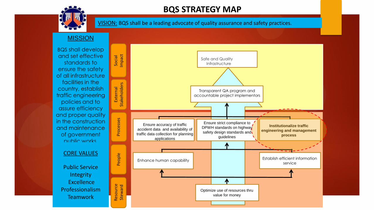
BQS STRATEGY MAP
VISION: BQS shall be a leading advocate of quality assurance and safety practices.
MISSION
BQS shall develop and set effective
standards to ensure the safety
of all infrastructure facilities in the
country, establish traffic engineering
policies and to assure efficiency
and proper quality
in the construction and maintenance
of government public works.
CORE VALUES
Public Service Integrity
Excellence Professionalism
Teamwork
Resse re
Soci
al
Imp
act
Exte
rnal
St
akeh
old
ers
Pro
cess
es
Peo
ple
Transparent QA program and
accountable project implementors
Enhance human capability
Optimize use of resources thru
value for money
as Establish efficient information
service
Res
ou
rce
Stew
ard
as
Ensure strict compliance to
DPWH standards on highway
safety design standards and
guidelines
Safe and Quality
Infrastructure
as Institutionalize traffic
engineering and management
process as
Ensure accuracy of traffic
accident data and availability of
traffic data collection for planning
applications

MEASURE BL 2017 2018 2019 2020 2021 2022
Provide the engineering
solution to road safety
concern
% of critical intersections along N1 and primary
roads along priority corridors with completed
traffic engineering interventions
(Intersection with VCR ranging from 0.66 to 1.20
= 943 int)
6% 10% 15% 21% 26%
PGS Scorecard 2017 – 2022 (proposed)
PGS Scorecard 2011 – 2016
Renewal of DPWH Scorecard and Strategy Map

Highlight of Major Transport & Traffic Improvement Projects implemented by DPWH
1977 1982 1989 1990
Metro Manila TEAM
Phase I
Fund Source : World Bank – IBRD;
component of Manila Urban Dev’t
Project
No. of Intersections : 134
Cost : MPhp 137.641
Scope of Works:
(1) 1 Radio Base Station
(2) 1 Control Center
(3) 10 CCTV Monitoring System
(4) Traffic Signs & Road Markings,
bus/jeepney priority lanes, bus
stop & pedestrian waiting shed
Metro Manila TEAM
Phase II Fund Source : OECF under 10th Yen
Credit Loan Package
No. of Intersections : 176 (172
intersections & 4 pedestrian crossing
w/in C2 & C4 EDSA)
Cost : MPhp 518.903
Scope of Works:
(1) 4 Radio Base Station
(2) 4 CCTV Cameras
(3) 2 Driver Information System
(4) 60 mobile radios
(5) 80 motorcycle radios
(6) 100 portable radios
(7) 2 Sub-Station (Makati & Cubao)
Metro Manila TEAM
Phase III
Fund Source : OECF under 14th Yen
Credit Loan Package
No. of Intersections : 145
Cost : MPhp 811.497
Scope of Works:
(1) 5 CCTV cameras at EDSA
(2) 4 Pollution Monitoring System
(3) 60 Portable Radio
(4) 82 streetlighting
(5) 1 Sub-Station in Caloocan
Metro Cebu TEAM
Project
Fund Source : Australian Gov’t
No. of Intersections : 68
The TEAM-PMO provided the
technical assistance during
implementation
Scope of Works:
(1) Radio Base Station
(2) Control Center
(3) 4 Mobile Radio
(4) 2 Motorcycle Radio
(5) 10 Portable Radio
Year Started
[1] TRAFFIC SIGNALIZATION

1995 2003 2004
DPWH TEAM-PMO function for Metro Manila was transferred to
MMDA
DPWH operationalized the TEAM-PMO under D.O. 150,
s2003
DPWH TEAM-PMO to handle
traffic engineering & mng’t function nationwide except
Metro Manila
Metro Manila TEAM
Phase IV
Fund Source : EFIC (Australia)
No. of Intersections : 419
Cost : BPhp 1.7
Scope of Works:
(1) Introduction of SMART (State of
the Art Metro Manila Adaptive &
Responsive Traffic Signal System)
(2) Upgrading & Rehabilitation of
exisitng traffic signals adopting the
SCATs System (Sydney
Coordinated Adaptive Traffic
Signal System
Year Started
Traffic Management
along Manila North
Road Project
Fund Source : DPWH Regular Infra
No. of Intersections : 66
Cost : MPhp 899.98 fr 2004 -2011
Scope of Works:
(1) Intersection geometric
improvement
(2) Fully-adaptive traffic signals using
loop and video detectors
DPWH Rationalization Plan was implemented
DPWH TEAM-PMO was dissolved and traffic engineering function was integrated into the newly-created Bureau of Quality and
Safety
2013
Highlight of Major Transport & Traffic Improvement Projects implemented by DPWH
[1] TRAFFIC SIGNALIZATION

Summary of Intersections along MNR with completed Traffic Management
SIGNALIZED UNSIGNALIZED
BULACAN 20 4
PAMPANGA 14 5
TARLAC 19 4
TOTAL 53 13
In 2004, DPWH was tasked to develop and implement traffic improvement programs along major arterial roads
DPWH selected McArthur Highway (or Manila North Road) from Bulacan to Tarlac for immediate road widening with doable traffic management because of noted increase in traffic demand and high frequency of traffic accidents. Likewise, the public is clamoring for an alternate route to the North in view of increased toll rates at new NLEX
NEDA, at that time, was also promoting McArthur Highway as a heritage highway leading to tourist spot destinations in the North
Traffic Management along
Manila North Road (MNR) Project
[1] TRAFFIC SIGNALIZATION

Microprocessor-based Traffic
Controller
LED-based Traffic Signal Lanterns
Fully-Actuated Design using Loop-
based and Video Camera Sensors
[1] TRAFFIC SIGNALIZATION
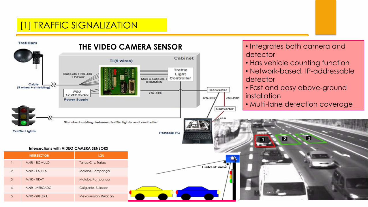
• Integrates both camera and
detector
• Has vehicle counting function
• Network-based, IP-addressable
detector
• Fast and easy above-ground
installation
• Multi-lane detection coverage
THE VIDEO CAMERA SENSOR
INTERSECTION LGU
1. MNR – ROMULO Tarlac City, Tarlac
2. MNR – FAUSTA Malolos, Pampanga
3. MNR – TIKAY Malolos, Pampanga
4. MNR - MERCADO Guiguinto, Bulacan
5. MNR - SULLERA Meycauayan, Bulacan
Intersections with VIDEO CAMERA SENSORS
[1] TRAFFIC SIGNALIZATION

Contract
Management
Procurement
Cost Estmation
Contract
Management System
(CMS)
Program Review
Multi Criteria
Analysis
Program
Generation
Multi Year
Programming &
Scheduling (MYPS))
RTIA
RBIA
TARAS
BMS
HDM-4
RMMS
On Going Works
Candidate Road
Safety Projects
Summary Traffic Accident Locations
On Going Works Candidate Work
Program
Candidate Work
Program Road Network
Inventory &
Conditions
Routine Maintenance
Needs
Multi Year Programs
DPWH database, although
representing network-level
information, plays a vital role
in road management and
could be tapped for ITS
model development
RTIA
RBIA
TARAS
Summary Traffic Accident Locations
THE DPWH TRAFFIC DATA COLLECTION AND
MANAGEMENT APPLICATIONS
[2] The National Road Traffic Survey Program (NRTSP)
THE DPWH INTEGRATED INFRASTRUCTURE PLANNING PROCESS

RTIA
RBIA
Automated Count Manual Count
The Road and Bridge Information Applications (RBIA) is
the DPWH’s central repository for network-level Road and
Bridge related data.
AADT ESAL
Manual Axle Load Survey
The RTIA is a set of applications that supports the
activities of NRTSP. The traffic information is an important
input in HDM-4, an application tool for an improved
Highway Planning Processes being implemented by
DPWH.
[2] The National Road Traffic Survey Program (NRTSP)
• The volume of vehicles and traffic mix converted into annual average
daily traffic (AADT) or equivalent passenger car units (pcu) per
day/hour are needed to determine volume/capacity ratios for
assessment of widening of existing roads/bridges or construction of
new roads/bridges.
• Asset preservation planning (i.e. asphalt overlay) also requires traffic
data to determine the optimal schedule for project implementation.
At the project level, heavy vehicle count data for buses
and freight vehicle are needed in the design of
pavement structures (thickness of subbase course, base
course and surfacing) and maintenance.
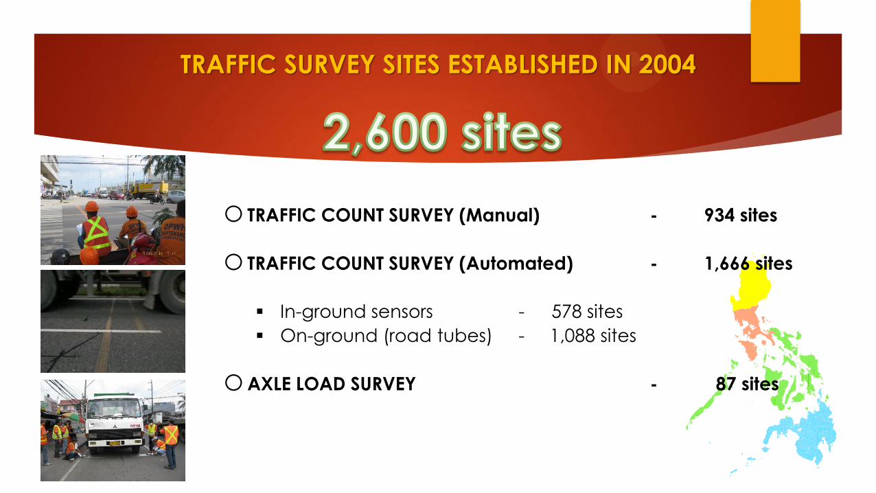
o TRAFFIC COUNT SURVEY (Manual) - 934 sites
o TRAFFIC COUNT SURVEY (Automated) - 1,666 sites
In-ground sensors - 578 sites
On-ground (road tubes) - 1,088 sites
oAXLE LOAD SURVEY - 87 sites
TRAFFIC SURVEY SITES ESTABLISHED IN 2004

Traffic Survey Sites Established in 2004
Traffic Survey Type (frequency) Duration Total Automated Manual
Long-Duration
In-G
rou
nd
Permanent 365 days 60 60 0
12 times a year 1 week 137 113 24
Medium-Duration
4 times a year 1 week 489 405 84
Twice a year 1 week 364
On
-Gro
un
d
225 139
Once a year 1 week 814 675 139
Short-Duration
Once in every 3 years 1 week
536 188 348
Daylight only 12 hours x 2 days 200
0 200
TOTAL 2,600 1,666 934

Location of the 60 Permanent In-
Ground Traffic Survey Sites
Permanent
Axle 1
Axle 2
Loop
Loop Piezo
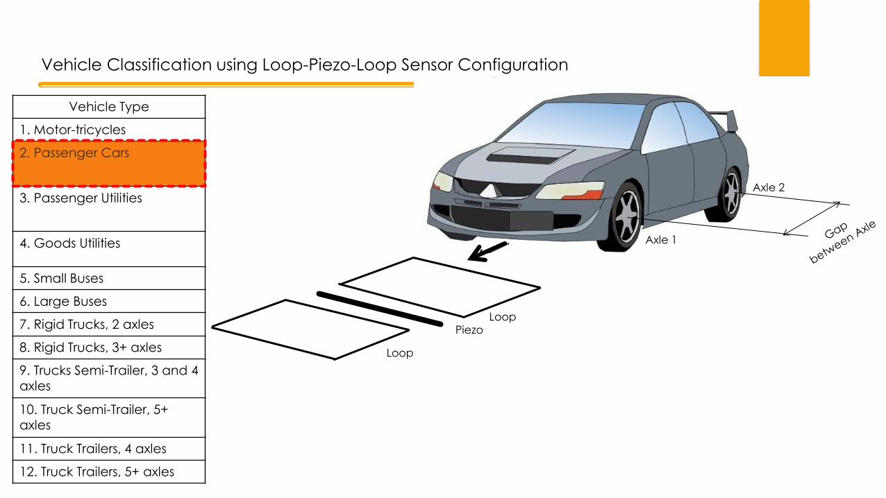
Vehicle Classification using Loop-Piezo-Loop Sensor Configuration
Vehicle Type
1. Motor-tricycles
2. Passenger Cars
3. Passenger Utilities
4. Goods Utilities
5. Small Buses
6. Large Buses
7. Rigid Trucks, 2 axles
8. Rigid Trucks, 3+ axles
9. Trucks Semi-Trailer, 3 and 4 axles
10. Truck Semi-Trailer, 5+ axles
11. Truck Trailers, 4 axles
12. Truck Trailers, 5+ axles

Two Types of Automated Traffic Counting In-Ground
Loop Sensor
Piezo Sensor
Detector Pit
Road Tubes
Permanent Stations Temporary Stations
Loop Sensor
Piezo Sensor
On-Ground
[1] The National Road Traffic Survey Program (NRTSP)
578 sites
1,088 sites

THE CURRENT ISSUE of OVERLOADED TRUCKS

0.00
2,000.00
4,000.00
6,000.00
8,000.00
10,000.00
12,000.00
14,000.00
16,000.00
Primary Secondary Tertiary
No assessment 547.73 1,454.68 988.73
Bad 654.59 836.01 976.38
Poor 1,189.06 2,143.10 1,887.63
Fair 2,125.54 4,969.39 3,386.67
Good 2,549.81 4,715.29 4,208.73
kilo
me
ter
of
roa
d
National Road by Pavement Condition, cy2015
67% with good to fair condition 24% with poor to bad condition
[3] ANTI-TRUCK OVERLOADING PROGRAM

TRUCK CLASS TRUCK WITH 2 AXLES
(6 WHEELS)
18,000
TRUCK WITH TANDEM REAR AXLE
3 AXLES (10 WHEELS)
33,300
TRUCK WITH TANDEM REAR AXLE
4 AXLES (14 WHEELS)
35,600
MAX. ALLOWABLE GVW (in kg)
TRUCK SEMI-TRAILER WITH 3 AXLES
(10 WHEELS) 34,000
TRUCK SEMI-TRAILER WITH 4 AXLES
(14 WHEELS) 40,600
TRUCK SEMI-TRAILER WITH 4 AXLES
(14 WHEELS) 39,700
TRUCK SEMI-TRAILER WITH 5 AXLES
(18 WHEELS) 41,500
TRUCK CLASS
41,000
39,700
43,500
MAX. ALLOWABLE GVW (in kg)
42,000
43,500
45,000
TRUCK-TRAILER WITH 2 AXLES
AT MOTOR VEHICLE & 3 AXLES AT TRAILER
(18 WHEELS)
TRUCK-TRAILER WITH 2 AXLES
AT MOTOR VEHICLE & 2 AXLES AT TRAILER
(14 WHEELS)
TRUCK-TRAILER WITH 2 AXLES
AT MOTOR VEHICLE & 3 AXLES AT TRAILER
(18 WHEELS)
TRUCK-TRAILER WITH 3 AXLES
AT MOTOR VEHICLE & 3 AXLES AT TRAILER
(22 WHEELS)
TRUCK-TRAILER WITH 3 AXLES
AT MOTOR VEHICLE & 2 AXLES AT TRAILER
(18 WHEELS)
TRUCK-TRAILER WITH 3 AXLES
AT MOTOR VEHICLE & 3 AXLES AT TRAILER
(22 WHEELS)
REVISED as of CY2013 REVISED as of CY2013
COLLECTION
Penalty for Overloading
MVUC
• Legal Framework: Republic Act No. 8794 – An act imposing a motor vehicle user’s charge on owners of all types of motor vehicles
Special
Road
Support
Fund
Special
Local
Road
Fund
Special
Road
Safety Fund
Special
Vehicle
Pollution
Control
Fund
• A truck is considered to be overloaded when any of its individual axle exceeded 13.5 tons or it
gross vehicle weight exceeded the allowable GVW.
• Penalty for overloading is equivalent to 25% of the Motor Vehicle User’s Charge (MVUC) applicable to the truck at the time of infringement. This penalty can be waived when the recorded GVW is less than 5% of the allowable GVW.
[3] ANTI-TRUCK OVERLOADING PROGRAM

•Install and Operate Weighbridge & Mobile Weighing stations
DPWH
•Impose Penalties thru issuance of TOP DOTC
•Disallow overloaded trucks on the roadway DILG
• For more than thirty-five (35) years, DPWH is managing truck overloading operations by administration with the frontline units (Regional Offices) directly fielding personnel and carrying-
out weighing operations 24 hours a day, in 3 shifts, including Saturdays, Sundays and Holidays.
MECHANICS FOR IMPLEMENTING ANTI-
TRUCK OVERLOADING PROGRAM
Permanent Weighbridge Stations with Lay-Bays
[3] ANTI-TRUCK OVERLOADING PROGRAM

EXISTING ANTI-TRUCK OVERLOADING DEPLOYMENT ON NATIONAL HIGHWAYS
• 18 Permanent Weighbridges
on Primary National Highways
1
2
3 4
5
11
12
6
7
8
9
14
13
10
15
• 15 Mobile Station within the Metro
Manila Region
[3] ANTI-TRUCK OVERLOADING PROGRAM

• The Government of the Philippines has received a Loan from Japan International Cooperation (JICA) towards the cost of Road Upgrading and Preservation Project (RUPP) dated March 31, 2011;
• It is intended that part of the proceeds of this Loan will be applied to eligible payments under the contract for ICD-1: Overloaded Vehicle Control Enhancement;
• As part of the implementation of the JRUPP ICD Component, there is a proposal to install High-Speed Weigh-In-Motion (HWIM) System on a pilot project basis focused on the Pre-Selection
Application; • Two sites were chosen along Maharlika Highway
and currently under the Long Term Performance Based Maintenance (LTPBM) Contracts;
Site #1: Aritao, Nueva Vizcaya
Site #2: Gapan, Nueva
Ecija – Bulacan Boundary
Utilizing the new technology
approach to replace the
manual based decisions in the
process thru weigh in motion
sensors and other advance
peripheral equipment.
[3] ANTI-TRUCK OVERLOADING PROGRAM
Overloaded Vehicle Control
Enhancement Project

Apprehension – the LTO officer or its duly deputized personnel assigned at the station issues to the driver of the overloaded truck a Temporary Operator’s Permit (TOP) indicating therein the excess load and the corresponding penalty to be paid.
Recording – The recorder monitors the reading in the weighing equipment and records the actual load per axle, the gross vehicle weight and the time and date it
was taken on the prescribed form. In case of violation, the recorder fills-up the apprehension papers and records the corresponding data taken for the truck
weighed and gives the copy to the Land Transportation Office (LTO) officer or to the LTO-deputized personnel detailed at the weighing station;
Weighing – Once the truck enters the weighing area, the scalemen, directs the driver to move the truck at the required speed for weighing using appropriate
equipment. He gets the Official Receipt (OR) and/or Certificate of Registration (CR) of the truck and other documents from the driver and endorses them to the
recorder. At the end of the process, he gives back the documents to the driver after processing and documentation;
Pre-Selection – The flagman, located at the approach of the weighing station, identifies trucks that are possibly overloaded. Once possible overloaded trucks are
spotted, the flagmen directs and guides the truck to the weighing area;
MECHANICS FOR IMPLEMENTING ANTI-
TRUCK OVERLOADING PROGRAM
Permanent Weighbridge Stations with Lay-Bays
PRE-SELECTION + WEIGHING + RECORDING + APPREHENSION
• The flagman identifies potentially
overloaded trucks utilizing individual judgment based on observable characteristics of the truck such as speed, tire pressure, etc…
Pre-Selection Process
[3] ANTI-TRUCK OVERLOADING PROGRAM

Permanent Weighbridge Stations with Lay-Bys
High-Speed Weigh-In-Motion equipment (HSWIM)
Sensing Technology: • Weight and Axle Sensor
per lane using the Loop-Piezo-Loop Configuration
Video Camera Surveillance with
License Plate Recognition System
TRUCK WITH PLATE # TGS 459 PLEASE PROCEED TO NEXT
WEIGHBRIDGE STATION
THE PILOT PROJECT: REMOTE TRUCK IDENTIFICATION AND MONITORING SYSTEM
Low-Speed Weigh-In-Motion equipment (LSWIM)
Output Data:
• Gross Vehicle Weight (GVW) • Axle Load • Axle Count • Truck/Trailer Class
PRE-SELECTION WEIGHING + RECORDING + APPREHENSION
[3] ANTI-TRUCK OVERLOADING PROGRAM

MOVING FORWARD: AN INTEGRATED ROAD MANAGEMENT SYSTEM
TRAFFIC SIGNALIZATION ANTI-RUCK OVERLOADING PROGRAM
Traffic Signalization of Critical Intersections Nationwide
• Intelligent Intersection
Sensors using video camera
that can detect pedestrians and vehicles
NRTSP
RTIA
RBIA
Permanent Stations Temporary Stations
Loop-Piezo-Loop Road Tubes
Automated Count Manual Count
AADT ESAL
Automated Axle
Load Survey
National Road Traffic Survey Program
Computer Server
Video Wall System
Console Desk
Remote Truck Identification and Monitoring System
An Integrated System for Highway Planning, Operations & Maintenance

DIRECTION OF ITS DEPLOYMENT
IN DPWH
DPWH envisions to have pilot ITS projects
involving the following services:
1. A fully-automated traffic and axle load
survey;
2. Traffic signalization of critical intersections
along national roads using intelligent vehicle
and pedestrian sensors (i.e., video
technology);
3. A Traffic Monitoring Center outside Metro
Manila (initially covering Manila North Road and
eventually major arterial roads nationwide)
4. Expansion of Incident and Accident
Monitoring System with the use of CCTV
Cameras;
5. Provision of Variable Message Signboards;
6. Remote Truck Identification and Monitoring
System


![NCTS+ +Information+for+the+Transit+Trader[1]](https://static.fdocuments.in/doc/165x107/55cf9cc5550346d033aaf9d1/ncts-informationforthetransittrader1.jpg)


![Design Document for National Transit Application (DDNTA)b792f24c-4a02-44e7... · Web viewThe DDNTA volume is applicable to NCTS-P5. It has as a starting point the FSS-UCC NCTS [R9]](https://static.fdocuments.in/doc/165x107/5ebabb3d6af2f666c8113246/design-document-for-national-transit-application-ddnta-b792f24c-4a02-44e7.jpg)