1 STL ASR PRECISION SURVEY JULY 17, 2012. 2 10 Miles 6 Miles 4 Miles.

Patterns of Physical Geography
Use the Unit Atlas to addto your knowledge ofSouth Asia. As you lookat the maps and charts,notice geographicpatterns and specificdetails about the region.For example, the chart to the right gives detailsabout the rivers andmountains of SouthAsia.
After studying theillustrations, graphs, andphysical map on thesetwo pages, jot down in your notebook theanswers to the followingquestions.
Making Comparisons1. How much longer is the
Nile than each of the
three major rivers of
South Asia?
2. Compare the size and
population of South Asia
to that of the United
States. Which is larger
in terms of size? Which
is larger in terms of
population?
3. How do the tallest
mountains of South Asia
compare to the tallest
U.S. mountain?
542 UNIT 8
Mt. Everest Nepal-China
29,035 feet
Mt. McKinleyUnited States
20,320 feet
K2Pakistan
28,250 feet
Kanchenjunga India-Nepal
28,208 feet
MakaluNepal-China
27, 824 feet
World’s Tallest U.S. Tallest
0 1000 2000 3000 4000
Nile4,160 miles
Mississippi2,357 miles
Indus1,800 miles
Brahmaputra1,800 miles
Ganges1,560 miles
Length (in miles)
World’s Longest
U.S. Longest
0 250 500 750 1000 1250 1500
United States281,422,000
South Asia1,325,185,000
Population (in millions)
South Asia
1,656,401 sq mi
ContinentalUnited States
3,165,630 sq mi
Comparing Data
Landmass
Rivers
Mountains
Population
For updated statistics on South Asia . . .
DATA UPDATECLASSZONE .COM

.RsudnI
Ganges R.
Narmada R.
Brahmaputra R.
Ganges Delta
Godavari R.Krishna R.
Indus R.
60°E 70°E
70°E 80°E 90°E
80°E 90°E
30°N
40°N
30°N
20°N
10°N
0°
20°N
10°N
0°
Equator
Tropic of Cancer
Mt. Everest29,035 ft.(8,850 m.)
K228,250 ft.(8,611 m.)
D E C C A N
P L A T E A U
C h o t a N a g p u r
P l a t e a u
I ND
O- G
A N G E T I CP L A I N
Rann ofKutch
Tha rD e s e r t
Laccadive Is.
AndamanIs.
NicobarIs.
EA
ST
ER
N
GH
AT S
WE
ST
ER
NG
HA
TS
HI
MA
LA
Y AM
T S .
HINDU KUSH KarakoramRange
Sula
iman
Ran
ge
Vindhya Range
Khyber Pass
Arabian
Sea Gulf ofKhambhat
Bay ofBengal
I N D I A N O C E A N
PalkStr.
La
c ca
di v
eS
ea
An
da
ma
nS
ea
Gulf ofMannar
I N D I A
P A K I S T A N
BANGLADESH
M Y A N M A R
BHUTAN
AFGHANISTAN C H I N A
NEPAL
SRI LANKA
MALDIVES
Elevation
Mountain peak
(4,000 m.)(2,000 m.)
(500 m.)(200 m.)
(0 m.)Below sea level
13,100 ft.6,600 ft.1,600 ft.
650 ft.0 ft.
0
0 250 500 kilometers
250 500 miles
Two-Point Equidistant Projection
N
S
EW
543
South Asia: Physical
SO
UTH
AS
IA

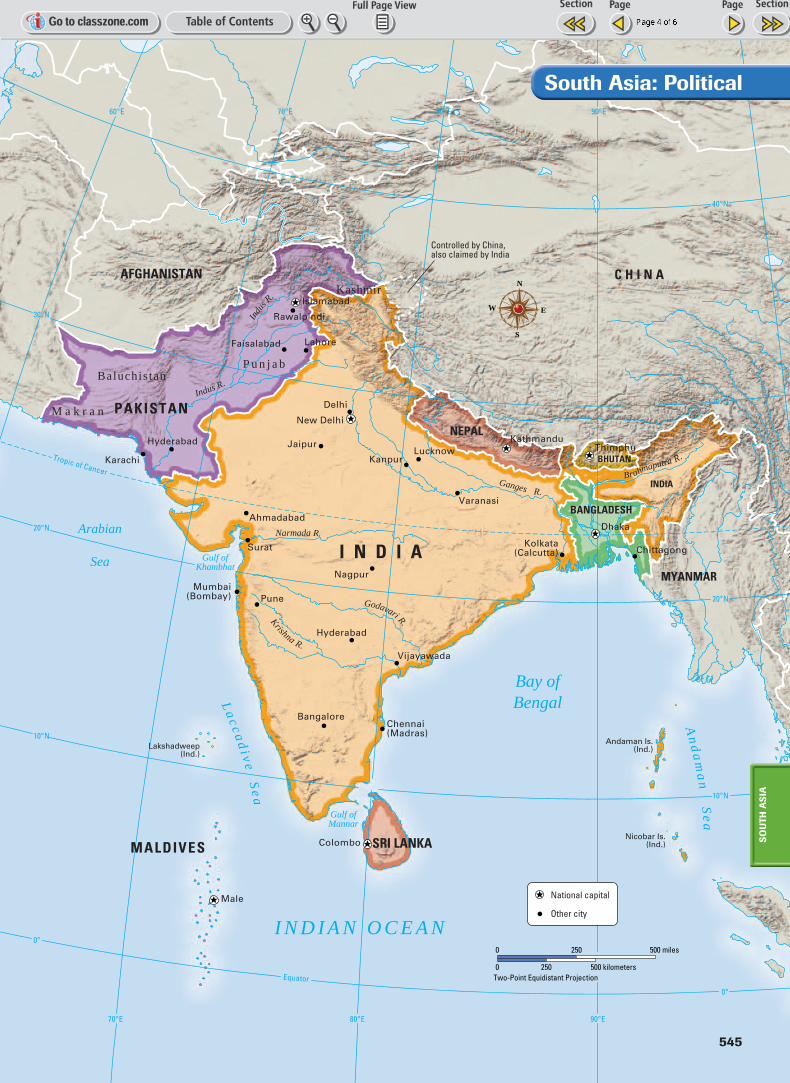
The first great civiliza-tion of South Asiadeveloped along thebanks of the Indus Rivermore than 4,000 yearsago. Study the historicalmap of the Indus Valleycivilization and thepolitical map of SouthAsia on these two pages.In your notebook, jotdown the answers tothese questions.
Making Comparisons1. In which countries of
modern South Asia
was the Indus Valley
civilization located?
Which of these countries
is the larger country?
2. What might have been
some of the reasons for a
civilization developing at
that location?
3. What modern city or
cities are closest to the
locations of ancient
Mohenjo-Daro, Harappa,
Kalibangan, and Lothal?
(In some cases, more
than one city will be an
acceptable answer.)
544 UNIT 8
Patterns of Human Geography
HI
MA
LA
YA
MT S .
THAR DESERT
Harappa
Mohenjo-Daro
Kalibangan
LothalA r a b i a n S e a
Indus R.
Sutlej R.
Chenab R.
70°E 75°E 80°E65°E
25°N
20°N
30°N
35°N
0
0 200 400 kilometers
200 400 miles
Two-Point Equidistant Projection
N
S
EW
Indus Valley civilization, 2500 B.C.
Indus Valley Civilization
.RsudnI
Ganges R.
Narmada R.
Brahmaputra R.
Godavari R.Krishna R.
Indus R.
60°E 70°E
70°E 80°E 90°E
80°E 90°E
30°N
40°N
30°N
20°N
10°N
0°
20°N
10°N
0°
Equator
Tropic of Cancer
Arabian
Sea Gulf ofKhambhat
Gulf ofMannar
Bay ofBengalL
acc
ad
i ve
Se
a
An
da
ma
nS
ea
I N D I A N O C E A N
I N D I A
INDIA
PAKISTAN
BANGLADESH
MYANMAR
BHUTAN
AFGHANISTAN C H I N A
NEPAL
SRI LANKAMALDIVES
Kashmir
M a k r a n
Baluchis tanP u n j a b
Lakshadweep(Ind.)
Andaman Is.(Ind.)
Nicobar Is.(Ind.)
Islamabad
Lahore
Rawalpindi
Faisalabad
Kathmandu
New Delhi
Kolkata(Calcutta) Chittagong
Bangalore
Mumbai(Bombay)
ThimphuKanpur
Lucknow
Varanasi
Delhi
JaipurHyderabad
Karachi
Ahmadabad
Surat
Hyderabad
Nagpur
Pune
Chennai(Madras)
Vijayawada
Dhaka
Male
Colombo
Controlled by China,also claimed by India
National capital
Other city
0
0 250 500 kilometers
250 500 miles
Two-Point Equidistant Projection
N
S
EW
South Asia: Political
SO
UTH
AS
IA
545

Regional Patterns
546 UNIT 8
60°E 70°E 80°E 90°E
30°N
20°N
10°N
Tropic of Cancer
Arabian
Sea
Bay of
Bengal
INDIAN OCEAN
I N D I A
PAKISTAN
BANGLADESH
BHUTANNEPAL
SRI LANKAMALDIVES
Mixed Christian
Islam – Sunni
Buddhism
Sikhism
Hinduism
Traditional
0
0 150 300 kilometers
150 300 miles
Two-Point Equidistant Projection
N
S
EW
Religions of South Asia
0 10 20 30 40 50 60 70 80 90 100
Sri Lanka
Pakistan
Nepal
Maldives
India
Bhutan
Bangladesh
South Asia: Religions by Country
SOURCE: The World Factbook 2000
Islam SikhismChristian HinduismBuddhism Traditional
Percent (%) of the Population
These two pages containa graph and three the-matic maps. The graphshows the religions ofSouth Asia. The mapsshow other importantinformation about reli-gion, population density,and economics. Studythese two pages andthen jot down in yournotebook the answers tothe questions below.
Making Comparisons1. What percentage of the
population of Sri Lanka
is Hindu, and where
are most of the Hindus
located? Why might
Hindus have settled in
Sri Lanka rather than in
other areas?
2. Which is the most
densely populated
country of South Asia?
3. What is the main
economic activity in
much of South Asia?

70°E 80°E 90°E 100°E
30°N
20°N
10°N
Tropic of CancerAhmadabad
Karachi
Lahore
Lucknow
Islamabad
Faisalabad
Jaipur
Kanpur
Nagpur
Pune
Rawalpindi
Delhi
Kathmandu Thimphu
Dhaka
Kolkata
Hyderabad
Bangalore Chennai
Colombo
Male
Mumbai
ChittagongSurat
ArabianSea
Bay of Bengal
INDIAN OCEAN
Personsper
sq mi
Personspersq km
Over 520260–519130–259
25–1291–24
0
Over 200100–19950–9910–491–90
Metropolitan areagreater than 10 million
0
0 250 500 kilometers
250 500 miles
Two-Point Equidistant Projection
N
S
E
W
ArabianSea
Bay of Bengal
INDIAN OCEAN
I N D I A
PAKISTAN
BANGLADESH
BHUTANNEPAL
SRI LANKAMALDIVES
Manufacturing and trade
Commercial farming
Subsistence farming
Nomadic herding
Forestry
Commercial fishing
Little or no economic activity
N
S
E
W
0
0 250 500 kilometers
250 500 miles
Two-Point Equidistant Projection
547
SO
UTH
AS
IA
Population Density of South Asia
Economic Activity of South Asia