Paths Around Fort Augustus
2
www.enjoylochness.com The Great Glen The Great Glen slices Scotland in two from Inverness to Fort William. Glaciers sheared along an underlying fault line 20,000 years ago, during the Ice Age, to carve out the U-shaped valley that today contains Loch Ness, Loch Oich, Loch Lochy and Loch Linnhe. The Great Glen formed an ancient travelling route across Scotland and the first visitors to this area probably came along the Glen. Today, people still travel along the Great Glen by boat on the Caledonian Canal, on foot or bicycle on the Great Glen way or by car on the A82. Fort Augustus Ancient crossroads - Fort Augustus has been a crossroads for travellers for centuries. People travelling along the Great Glen on foot, by boat, and by road meet with people travelling along General Wade's roads to Skye and Speyside. Fort Augustus still offers excellent walking links. The Great Glen Way carries walkers and cyclists between Inverness and Fort William and the Wade roads still carry walkers over the Corrieyairack Pass to Speyside and northwest to Glenelg. Today, walkers have the benefit of baggage transport, comfortable accommodation and services. Ask locally for details. The Great Glen Way Opened April 2002, this 79mile/127km cross Scotland route links the Atlantic Ocean in the west with the North Sea in the east. Inverness and Fort William make good start and finish points. There are many interesting villages steeped in history along the Way, giving you a chance to learn about the history or even just stop for refreshments. There are a variety of walking surfaces - from level canal towpaths, to loch side woodland paths and to steeper forest roads with glorious views. The Great Glen Way has it all. www.outdoorhighlands.co.uk Frequently asked questions What shall I take? Stout shoes or boots are best as some of the paths go over rough or wet ground. Take waterproofs just in case it rains. Take a snack and a drink too. It ’ s always a good excuse to stop for a rest and admire the view. Can I take my dog? Yes but please keep dogs under close control or on a lead if there is livestock. What else should I know? Check your map and route before you go. If going alone, let someone know where you are going and your return time. ......and the Country and Forest Code? Avoid all risk of fire Take all your litter with you Go carefully on country roads Please park considerately Leave livestock, crops and machinery alone Follow advice about forestry operations Help keep all water sources clean Protect trees, plants and wildlife Leave things as you find them, take nothing away Keep dogs under proper control Avoid damage to buildings, fences, hedges, walls and paths Come prepared for likely extremes of weather Take notice of warning signs Where are we? Produced by Fort Augustus, Glenmoriston and Glengarry Business Initiative. Reproduced With permission of The Highland Council Planning and Development Service. www.enjoylochness.com Bed & Breakfasts Hotels Camping Self Catering Attractions Activities Site Seeing Loch Ness Caledonian Canal Shopping Exhibitions Boat Cruises Paths Around Fort Augustus
Transcript of Paths Around Fort Augustus

www.enjoylochness.com
The Great Glen The Great Glen slices Scotland in two from Inverness to Fort William.
Glaciers sheared along an underlying fault line 20,000 years ago, during
the Ice Age, to carve out the U-shaped valley that today contains Loch
Ness, Loch Oich, Loch Lochy and Loch Linnhe. The Great Glen formed
an ancient travelling route across Scotland and the first visitors to this
area probably came along the Glen. Today, people still travel along the
Great Glen by boat on the Caledonian Canal, on foot or bicycle on the
Great Glen way or by car on the A82.
Fort Augustus Ancient crossroads - Fort Augustus has been a crossroads for travellers
for centuries. People travelling along the Great Glen on foot, by boat,
and by road meet with people travelling along General Wade's roads to
Skye and Speyside. Fort Augustus still offers excellent walking links.
The Great Glen Way carries walkers and cyclists between Inverness
and Fort William and the Wade roads still carry walkers over the
Corrieyairack Pass to Speyside and northwest to Glenelg.
Today, walkers have the benefit of baggage transport, comfortable
accommodation and services. Ask locally for details.
The Great Glen Way Opened April 2002, this 79mile/127km cross Scotland route links the
Atlantic Ocean in the west with the North Sea in the east. Inverness and
Fort William make good start and finish points.
There are many interesting villages steeped in history along the Way,
giving you a chance to learn about the history or even just stop for
refreshments. There are a variety of walking surfaces - from level canal
towpaths, to loch side woodland paths and to steeper forest roads with
glorious views. The Great Glen Way has it all.
www.outdoorhighlands.co.uk
Frequently asked questions What shall I take?
Stout shoes or boots are best as some of the paths go over rough or
wet ground. Take waterproofs just in case it rains. Take a snack and a
drink too. It ’ s always a good excuse to stop for a rest and admire the
view.
Can I take my dog?
Yes but please keep dogs under close control or on a lead if there is
livestock.
What else should I know?
Check your map and route before you go. If going alone, let someone
know where you are going and your return time.
......and the Country and Forest Code?
Avoid all risk of fire
Take all your litter with you
Go carefully on country roads
Please park considerately
Leave livestock, crops and machinery alone
Follow advice about forestry operations
Help keep all water sources clean
Protect trees, plants and wildlife
Leave things as you find them, take nothing away
Keep dogs under proper control
Avoid damage to buildings, fences, hedges, walls and paths
Come prepared for likely extremes of weather
Take notice of warning signs
Where are we?
Produced by Fort Augustus,
Glenmoriston and Glengarry
Business Initiative.
Reproduced With permission of
The Highland Council Planning
and Development Service.
www.enjoylochness.com
Bed & Breakfasts Hotels
Camping Self Catering
Attractions Activities
Site Seeing Loch Ness
Caledonian Canal Shopping
Exhibitions Boat Cruises
Paths Around
Fort Augustus
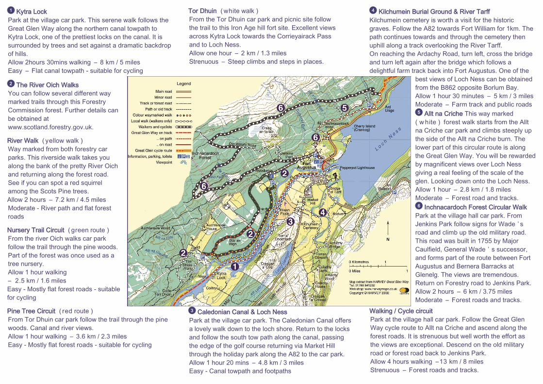
Kytra Lock
Park at the village car park. This serene walk follows the
Great Glen Way along the northern canal towpath to
Kytra Lock, one of the prettiest locks on the canal. It is
surrounded by trees and set against a dramatic backdrop
of hills.
Allow 2hours 30mins walking – 8 km / 5 miles
Easy – Flat canal towpath - suitable for cycling
The River Oich Walks
You can follow several different way
marked trails through this Forestry
Commission forest. Further details can
be obtained at
www.scotland.forestry.gov.uk.
River Walk ( yellow walk )
Way marked from both forestry car
parks. This riverside walk takes you
along the bank of the pretty River Oich
and returning along the forest road.
See if you can spot a red squirrel
among the Scots Pine trees.
Allow 2 hours – 7.2 km / 4.5 miles
Moderate - River path and flat forest
roads
Nursery Trail Circuit ( green route )
From the river Oich walks car park
follow the trail through the pine woods.
Part of the forest was once used as a
tree nursery.
Allow 1 hour walking
– 2.5 km / 1.6 miles
Easy - Mostly flat forest roads - suitable
for cycling
Pine Tree Circuit ( red route )
From Tor Dhuin car park follow the trail through the pine
woods. Canal and river views.
Allow 1 hour walking – 3.6 km / 2.3 miles
Easy - Mostly flat forest roads - suitable for cycling
1
2
Tor Dhuin ( white walk )
From the Tor Dhuin car park and picnic site follow
the trail to this Iron Age hill fort site. Excellent views
across Kytra Lock towards the Corrieyairack Pass
and to Loch Ness.
Allow one hour – 2 km / 1.3 miles
Strenuous – Steep climbs and steps in places.
Caledonian Canal & Loch Ness
Park at the village car park. The Caledonian Canal offers
a lovely walk down to the loch shore. Return to the locks
and follow the south tow path along the canal, passing
the edge of the golf course returning via Market Hill
through the holiday park along the A82 to the car park.
Allow 1 hour 20 mins – 4.8 km / 3 miles
Easy - Canal towpath and footpaths
3
Kilchumein Burial Ground & River Tarff
Kilchumein cemetery is worth a visit for the historic
graves. Follow the A82 towards Fort William for 1km. The
path continues towards and through the cemetery then
uphill along a track overlooking the River Tarff.
On reaching the Ardachy Road, turn left, cross the bridge
and turn left again after the bridge which follows a
delightful farm track back into Fort Augustus. One of the
best views of Loch Ness can be obtained
from the B862 opposite Borlum Bay.
Allow 1 hour 30 minutes – 5 km / 3 miles
Moderate – Farm track and public roads
Allt na Criche This way marked
( w hite ) forest walk starts from the Allt
na Criche car park and climbs steeply up
the side of the Allt na Criche burn. The
lower part of this circular route is along
the Great Glen Way. You will be rewarded
by magnificent views over Loch Ness
giving a real feeling of the scale of the
glen. Looking down onto the Loch Ness.
Allow 1 hour – 2.8 km / 1.8 miles
Moderate – Forest road and tracks.
Inchnacardoch Forest Circular Walk
Park at the village hall car park. From
Jenkins Park follow signs for Wade ’ s
road and climb up the old military road.
This road was built in 1755 by Major
Caulfield, General Wade ’ s successor,
and forms part of the route between Fort
Augustus and Bernera Barracks at
Glenelg. The views are tremendous.
Return on Forestry road to Jenkins Park.
Allow 2 hours – 6 km / 3.75 miles
Moderate – Forest roads and tracks.
Walking / Cycle circuit
Park at the village hall car park. Follow the Great Glen
Way cycle route to Allt na Criche and ascend along the
forest roads. It is strenuous but well worth the effort as
the views are exceptional. Descend on the old military
road or forest road back to Jenkins Park.
Allow 4 hours walking –13 km / 8 miles
Strenuous – Forest roads and tracks.
4
5
6