Past,present,andfutureofsimultaneouslocalizationandmapping ...
25
Zurich Open Repository and Archive University of Zurich Main Library Strickhofstrasse 39 CH-8057 Zurich www.zora.uzh.ch Year: 2016 Past, present, and future of simultaneous localization and mapping: Toward the robust-perception age Cadena, Cesar ; Carlone, Luca ; Carrillo, Henry ; Latif, Yasir ; Scaramuzza, Davide ; Neira, Jose ; Reid, Ian ; Leonard, John J Abstract: Simultaneous localization and mapping (SLAM) consists in the concurrent construction of a model of the environment (the map), and the estimation of the state of the robot moving within it. The SLAM community has made astonishing progress over the last 30 years, enabling large-scale real-world applications and witnessing a steady transition of this technology to industry. We survey the current state of SLAM and consider future directions. We start by presenting what is now the de-facto standard formulation for SLAM. We then review related work, covering a broad set of topics including robustness and scalability in long-term mapping, metric and semantic representations for mapping, theoretical per- formance guarantees, active SLAM and exploration, and other new frontiers. This paper simultaneously serves as a position paper and tutorial to those who are users of SLAM. By looking at the published research with a critical eye, we delineate open challenges and new research issues, that still deserve careful scientifc investigation. The paper also contains the authors’ take on two questions that often animate discussions during robotics conferences: Do robots need SLAM? and Is SLAM solved? DOI: https://doi.org/10.1109/tro.2016.2624754 Posted at the Zurich Open Repository and Archive, University of Zurich ZORA URL: https://doi.org/10.5167/uzh-138892 Journal Article Accepted Version Originally published at: Cadena, Cesar; Carlone, Luca; Carrillo, Henry; Latif, Yasir; Scaramuzza, Davide; Neira, Jose; Reid, Ian; Leonard, John J (2016). Past, present, and future of simultaneous localization and mapping: Toward the robust-perception age. IEEE Transactions on Robotics, 32(6):1309-1332. DOI: https://doi.org/10.1109/tro.2016.2624754
Transcript of Past,present,andfutureofsimultaneouslocalizationandmapping ...

Zurich Open Repository andArchiveUniversity of ZurichMain LibraryStrickhofstrasse 39CH-8057 Zurichwww.zora.uzh.ch
Year: 2016
Past, present, and future of simultaneous localization and mapping: Towardthe robust-perception age
Cadena, Cesar ; Carlone, Luca ; Carrillo, Henry ; Latif, Yasir ; Scaramuzza, Davide ; Neira, Jose ; Reid,Ian ; Leonard, John J
Abstract: Simultaneous localization and mapping (SLAM) consists in the concurrent construction of amodel of the environment (the map), and the estimation of the state of the robot moving within it. TheSLAM community has made astonishing progress over the last 30 years, enabling large-scale real-worldapplications and witnessing a steady transition of this technology to industry. We survey the currentstate of SLAM and consider future directions. We start by presenting what is now the de-facto standardformulation for SLAM. We then review related work, covering a broad set of topics including robustnessand scalability in long-term mapping, metric and semantic representations for mapping, theoretical per-formance guarantees, active SLAM and exploration, and other new frontiers. This paper simultaneouslyserves as a position paper and tutorial to those who are users of SLAM. By looking at the publishedresearch with a critical eye, we delineate open challenges and new research issues, that still deserve carefulscientific investigation. The paper also contains the authors’ take on two questions that often animatediscussions during robotics conferences: Do robots need SLAM? and Is SLAM solved?
DOI: https://doi.org/10.1109/tro.2016.2624754
Posted at the Zurich Open Repository and Archive, University of ZurichZORA URL: https://doi.org/10.5167/uzh-138892Journal ArticleAccepted Version
Originally published at:Cadena, Cesar; Carlone, Luca; Carrillo, Henry; Latif, Yasir; Scaramuzza, Davide; Neira, Jose; Reid, Ian;Leonard, John J (2016). Past, present, and future of simultaneous localization and mapping: Toward therobust-perception age. IEEE Transactions on Robotics, 32(6):1309-1332.DOI: https://doi.org/10.1109/tro.2016.2624754

IEEE TRANSACTIONS ON ROBOTICS, VOL. XX, NO. X, XXXXX XXXX 1
Past, Present, and Future of Simultaneous
Localization And Mapping: Towards the
Robust-Perception AgeCesar Cadena, Luca Carlone, Henry Carrillo, Yasir Latif,
Davide Scaramuzza, Jose Neira, Ian Reid, John J. Leonard
Abstract—Simultaneous Localization And Mapping (SLAM)consists in the concurrent construction of a model of theenvironment (the map), and the estimation of the state of the robotmoving within it. The SLAM community has made astonishingprogress over the last 30 years, enabling large-scale real-worldapplications, and witnessing a steady transition of this technologyto industry. We survey the current state of SLAM and considerfuture directions. We start by presenting what is now the de-factostandard formulation for SLAM. We then review related work,covering a broad set of topics including robustness and scalabilityin long-term mapping, metric and semantic representations formapping, theoretical performance guarantees, active SLAM andexploration, and other new frontiers. This paper simultaneouslyserves as a position paper and tutorial to those who are users ofSLAM. By looking at the published research with a critical eye,we delineate open challenges and new research issues, that stilldeserve careful scientific investigation. The paper also containsthe authors’ take on two questions that often animate discussionsduring robotics conferences: Do robots need SLAM? and Is SLAMsolved?
Index Terms—Robots, SLAM, Localization, Mapping, Factorgraphs, Maximum a posteriori estimation, sensing, perception.
MULTIMEDIA MATERIAL
Additional material for this paper, including an ex-
tended list of references (bibtex) and a table of point-
ers to online datasets for SLAM, can be found at
https://slam-future.github.io/.
C. Cadena is with the Autonomous Systems Lab, ETH Zurich, Switzerland.e-mail: [email protected]
L. Carlone is with the Laboratory for Information and Decision Systems,Massachusetts Institute of Technology, USA. e-mail: [email protected]
H. Carrillo is with the Escuela de Ciencias Exactas e Ingenierıa, UniversidadSergio Arboleda, Colombia, and Pontificia Universidad Javeriana, Colombia.e-mail: [email protected]
Y. Latif and I. Reid are with the School of Computer Science, Universityof Adelaide, Australia, and the Australian Center for Robotic Vision. e-mail:[email protected], [email protected]
J. Neira is with the Departamento de Informatica e Ingenierıa de Sistemas,Universidad de Zaragoza, Spain. e-mail: [email protected]
D. Scaramuzza is with the Robotics and Perception Group, University ofZurich, Switzerland. e-mail: [email protected]
J.J. Leonard is with Marine Robotics Group, Massachusetts Institute ofTechnology, USA. e-mail: [email protected]
This paper summarizes and extends the outcome of the workshop “TheProblem of Mobile Sensors: Setting future goals and indicators of progress forSLAM” [26], held during the Robotics: Science and System (RSS) conference(Rome, July 2015).
This work has been partially supported by the following grants: MINECO-FEDER DPI2015-68905-P, Grupo DGA T04-FSE; ARC grants DP130104413,CE140100016 and FL130100102; NCCR Robotics; PUJ 6601; EU-FP7-ICT-Project TRADR 609763, EU-H2020-688652 and SERI-15.0284.
I. INTRODUCTION
SLAM comprises the simultaneous estimation of the state
of a robot equipped with on-board sensors, and the con-
struction of a model (the map) of the environment that the
sensors are perceiving. In simple instances, the robot state is
described by its pose (position and orientation), although other
quantities may be included in the state, such as robot velocity,
sensor biases, and calibration parameters. The map, on the
other hand, is a representation of aspects of interest (e.g.,
position of landmarks, obstacles) describing the environment
in which the robot operates.
The need to use a map of the environment is twofold.
First, the map is often required to support other tasks; for
instance, a map can inform path planning or provide an
intuitive visualization for a human operator. Second, the map
allows limiting the error committed in estimating the state of
the robot. In the absence of a map, dead-reckoning would
quickly drift over time; on the other hand, using a map, e.g.,
a set of distinguishable landmarks, the robot can “reset” its
localization error by re-visiting known areas (so-called loop
closure). Therefore, SLAM finds applications in all scenarios
in which a prior map is not available and needs to be built.
In some robotics applications the location of a set of
landmarks is known a priori. For instance, a robot operating on
a factory floor can be provided with a manually-built map of
artificial beacons in the environment. Another example is the
case in which the robot has access to GPS (the GPS satellites
can be considered as moving beacons at known locations). In
such scenarios, SLAM may not be required if localization can
be done reliably with respect to the known landmarks.
The popularity of the SLAM problem is connected with the
emergence of indoor applications of mobile robotics. Indoor
operation rules out the use of GPS to bound the localization
error; furthermore, SLAM provides an appealing alternative
to user-built maps, showing that robot operation is possible in
the absence of an ad hoc localization infrastructure.
A thorough historical review of the first 20 years of the
SLAM problem is given by Durrant-Whyte and Bailey in
two surveys [8, 70]. These mainly cover what we call the
classical age (1986-2004); the classical age saw the intro-
duction of the main probabilistic formulations for SLAM,
including approaches based on Extended Kalman Filters, Rao-
Blackwellised Particle Filters, and maximum likelihood esti-
mation; moreover, it delineated the basic challenges connected

2 IEEE TRANSACTIONS ON ROBOTICS, VOL. XX, NO. X, XXXXX XXXX
to efficiency and robust data association. Two other excellent
references describing the three main SLAM formulations
of the classical age are the book of Thrun, Burgard, and
Fox [240] and the chapter of Stachniss et al. [234, Ch. 46].
The subsequent period is what we call the algorithmic-analysis
age (2004-2015), and is partially covered by Dissanayake et
al. in [65]. The algorithmic analysis period saw the study
of fundamental properties of SLAM, including observability,
convergence, and consistency. In this period, the key role of
sparsity towards efficient SLAM solvers was also understood,
and the main open-source SLAM libraries were developed.
We review the main SLAM surveys to date in Table I,
observing that most recent surveys only cover specific aspects
or sub-fields of SLAM. The popularity of SLAM in the last 30
years is not surprising if one thinks about the manifold aspects
that SLAM involves. At the lower level (called the front-end
in Section II) SLAM naturally intersects other research fields
such as computer vision and signal processing; at the higher
level (that we later call the back-end), SLAM is an appealing
mix of geometry, graph theory, optimization, and probabilistic
estimation. Finally, a SLAM expert has to deal with practical
aspects ranging from sensor calibration to system integration.
The present paper gives a broad overview of the current state
of SLAM, and offers the perspective of part of the community
on the open problems and future directions for the SLAM
research. Our main focus is on metric and semantic SLAM,
and we refer the reader to the recent survey by Lowry et
al. [160], which provides a comprehensive review of vision-
based place recognition and topological SLAM.
Before delving into the paper, we first discuss two questions
that often animate discussions during robotics conferences:
(1) do autonomous robots need SLAM? and (2) is SLAM
solved as an academic research endeavor? We will revisit these
questions at the end of the manuscript.
Answering the question “Do autonomous robots really need
SLAM?” requires understanding what makes SLAM unique.
SLAM aims at building a globally consistent representation
of the environment, leveraging both ego-motion measurements
and loop closures. The keyword here is “loop closure”: if we
sacrifice loop closures, SLAM reduces to odometry. In early
applications, odometry was obtained by integrating wheel
encoders. The pose estimate obtained from wheel odometry
quickly drifts, making the estimate unusable after few me-
ters [128, Ch. 6]; this was one of the main thrusts behind the
development of SLAM: the observation of external landmarks
is useful to reduce the trajectory drift and possibly correct
it [185]. However, more recent odometry algorithms are based
on visual and inertial information, and have very small drift
(< 0.5% of the trajectory length [83]). Hence the question
becomes legitimate: do we really need SLAM? Our answer is
three-fold.
First of all, we observe that the SLAM research done
over the last decade has itself produced the visual-inertial
odometry algorithms that currently represent the state of the
art, e.g., [163, 175]; in this sense Visual-Inertial Navigation
(VIN) is SLAM: VIN can be considered a reduced SLAM
system, in which the loop closure (or place recognition) mod-
ule is disabled. More generally, SLAM has directly led to the
TABLE I: Surveying the surveys and tutorials
Year Topic Reference
2006Probabilistic approachesand data association
Durrant-Whyte and Bailey [8, 70]
2008 Filtering approaches Aulinas et al. [7]
2011 SLAM back-end Grisetti et al. [98]
2011Observability, consistencyand convergence
Dissanayake et al. [65]
2012 Visual odometry Scaramuzza and Fraundofer [86, 218]
2016 Multi robot SLAM Saeedi et al. [216]
2016 Visual place recognition Lowry et al. [160]
2016SLAM in the Handbookof Robotics
Stachniss et al. [234, Ch. 46]
2016 Theoretical aspects Huang and Dissanayake [110]
study of sensor fusion under more challenging setups (i.e., no
GPS, low quality sensors) than previously considered in other
literature (e.g., inertial navigation in aerospace engineering).
The second answer regards the true topology of the envi-
ronment. A robot performing odometry and neglecting loop
closures interprets the world as an “infinite corridor” (Fig. 1-
left) in which the robot keeps exploring new areas indefinitely.
A loop closure event informs the robot that this “corridor”
keeps intersecting itself (Fig. 1-right). The advantage of loop
closure now becomes clear: by finding loop closures, the
robot understands the real topology of the environment, and
is able to find shortcuts between locations (e.g., point B
and C in the map). Therefore, if getting the right topology
of the environment is one of the merits of SLAM, why
not simply drop the metric information and just do place
recognition? The answer is simple: the metric information
makes place recognition much simpler and more robust; the
metric reconstruction informs the robot about loop closure op-
portunities and allows discarding spurious loop closures [150].
Therefore, while SLAM might be redundant in principle (an
oracle place recognition module would suffice for topological
mapping), SLAM offers a natural defense against wrong data
association and perceptual aliasing, where similarly looking
scenes, corresponding to distinct locations in the environment,
would deceive place recognition. In this sense, the SLAM map
provides a way to predict and validate future measurements:
we believe that this mechanism is key to robust operation.
The third answer is that SLAM is needed for many ap-
plications that, either implicitly or explicitly, do require a
globally consistent map. For instance, in many military and
civilian applications, the goal of the robot is to explore an
environment and report a map to the human operator, ensuring
that full coverage of the environment has been obtained.
Another example is the case in which the robot has to perform
structural inspection (of a building, bridge, etc.); also in this
case a globally consistent 3D reconstruction is a requirement
for successful operation.
This question of “is SLAM solved?” is often asked
within the robotics community, c.f. [88]. This question is
difficult to answer because SLAM has become such a
broad topic that the question is well posed only for a
given robot/environment/performance combination. In particu-
lar, one can evaluate the maturity of the SLAM problem once
the following aspects are specified:
• robot: type of motion (e.g., dynamics, maximum speed),
available sensors (e.g., resolution, sampling rate), avail-

CADENA et al.: PAST, PRESENT, AND FUTURE OF SIMULTANEOUS LOCALIZATION AND MAPPING: TOWARDS THE ROBUST-PERCEPTION AGE 3
Fig. 1: Left: map built from odometry. The map is homotopic to a long corridorthat goes from the starting position A to the final position B. Points that areclose in reality (e.g., B and C) may be arbitrarily far in the odometric map.Right: map build from SLAM. By leveraging loop closures, SLAM estimatesthe actual topology of the environment, and “discovers” shortcuts in the map.
able computational resources;
• environment: planar or three-dimensional, presence of
natural or artificial landmarks, amount of dynamic ele-
ments, amount of symmetry and risk of perceptual alias-
ing. Note that many of these aspects actually depend on
the sensor-environment pair: for instance, two rooms may
look identical for a 2D laser scanner (perceptual aliasing),
while a camera may discern them from appearance cues;
• performance requirements: desired accuracy in the esti-
mation of the state of the robot, accuracy and type of
representation of the environment (e.g., landmark-based
or dense), success rate (percentage of tests in which the
accuracy bounds are met), estimation latency, maximum
operation time, maximum size of the mapped area.
For instance, mapping a 2D indoor environment with a robot
equipped with wheel encoders and a laser scanner, with
sufficient accuracy (< 10cm) and sufficient robustness (say,
low failure rate), can be considered largely solved (an example
of industrial system performing SLAM is the Kuka Navigation
Solution [145]). Similarly, vision-based SLAM with slowly-
moving robots (e.g., Mars rovers [166], domestic robots [2]),
and visual-inertial odometry [95] can be considered mature
research fields.
On the other hand, other robot/environment/performance
combinations still deserve a large amount of fundamental
research. Current SLAM algorithms can be easily induced to
fail when either the motion of the robot or the environment
are too challenging (e.g., fast robot dynamics, highly dynamic
environments); similarly, SLAM algorithms are often unable to
face strict performance requirements, e.g., high rate estimation
for fast closed-loop control. This survey will provide a com-
prehensive overview of these open problems, among others.
In this paper, we argue that we are entering in a third era
for SLAM, the robust-perception age, which is characterized
by the following key requirements:
1) robust performance: the SLAM system operates with low
failure rate for an extended period of time in a broad set of
environments; the system includes fail-safe mechanisms
and has self-tuning capabilities1 in that it can adapt the
selection of the system parameters to the scenario.
2) high-level understanding: the SLAM system goes beyond
basic geometry reconstruction to obtain a high-level un-
derstanding of the environment (e.g., high-level geometry,
1The SLAM community has been largely affected by the “curse of manualtuning”, in that satisfactory operation is enabled by expert tuning of the systemparameters (e.g., stopping conditions, thresholds for outlier rejection).
Fig. 2: Front-end and back-end in a typical SLAM system. The back-end canprovide feedback to the front-end for loop closure detection and verification.
semantics, physics, affordances);
3) resource awareness: the SLAM system is tailored to
the available sensing and computational resources, and
provides means to adjust the computation load depending
on the available resources;
4) task-driven perception: the SLAM system is able to select
relevant perceptual information and filter out irrelevant
sensor data, in order to support the task the robot has to
perform; moreover, the SLAM system produces adaptive
map representations, whose complexity may vary depend-
ing on the task at hand.
Paper organization. The paper starts by presenting a
standard formulation and architecture for SLAM (Section II).
Section III tackles robustness in life-long SLAM. Section IV
deals with scalability. Section V discusses how to represent
the geometry of the environment. Section VI extends the
question of the environment representation to the modeling
of semantic information. Section VII provides an overview
of the current accomplishments on the theoretical aspects of
SLAM. Section VIII broadens the discussion and reviews the
active SLAM problem in which decision making is used to
improve the quality of the SLAM results. Section IX provides
an overview of recent trends in SLAM, including the use of
unconventional sensors and deep learning. Section X provides
final remarks. Throughout the paper, we provide many pointers
to related work outside the robotics community. Despite its
unique traits, SLAM is related to problems addressed in
computer vision, computer graphics, and control theory, and
cross-fertilization among these fields is a necessary condition
to enable fast progress.
For the non-expert reader, we recommend to read Durrant-
Whyte and Bailey’s SLAM tutorials [8, 70] before delving
in this position paper. The more experienced researchers can
jump directly to the section of interest, where they will find
a self-contained overview of the state of the art and open
problems.
II. ANATOMY OF A MODERN SLAM SYSTEM
The architecture of a SLAM system includes two main
components: the front-end and the back-end. The front-end
abstracts sensor data into models that are amenable for
estimation, while the back-end performs inference on the
abstracted data produced by the front-end. This architecture
is summarized in Fig. 2. We review both components, starting
from the back-end.

4 IEEE TRANSACTIONS ON ROBOTICS, VOL. XX, NO. X, XXXXX XXXX
Maximum a posteriori (MAP) estimation and the SLAM
back-end. The current de-facto standard formulation of SLAM
has its origins in the seminal paper of Lu and Milios [161],
followed by the work of Gutmann and Konolige [102].
Since then, numerous approaches have improved the efficiency
and robustness of the optimization underlying the problem
[64, 82, 101, 125, 192, 241]. All these approaches formulate
SLAM as a maximum a posteriori estimation problem, and
often use the formalism of factor graphs [143] to reason about
the interdependence among variables.
Assume that we want to estimate an unknown variable X ; as
mentioned before, in SLAM the variable X typically includes
the trajectory of the robot (as a discrete set of poses) and
the position of landmarks in the environment. We are given
a set of measurements Z = zk : k = 1, . . . ,m such that
each measurement can be expressed as a function of X , i.e.,
zk = hk(Xk)+ǫk, where Xk ⊆ X is a subset of the variables,
hk(·) is a known function (the measurement or observation
model), and ǫk is random measurement noise.
In MAP estimation, we estimate X by computing the
assignment of variables X ⋆ that attains the maximum of the
posterior p(X|Z) (the belief over X given the measurements):
X ⋆ .= argmax
X
p(X|Z) = argmaxX
p(Z|X )p(X ) (1)
where the equality follows from the Bayes theorem. In (1),
p(Z|X ) is the likelihood of the measurements Z given the
assignment X , and p(X ) is a prior probability over X . The
prior probability includes any prior knowledge about X ; in
case no prior knowledge is available, p(X ) becomes a constant
(uniform distribution) which is inconsequential and can be
dropped from the optimization. In that case MAP estimation
reduces to maximum likelihood estimation. Note that, unlike
Kalman filtering, MAP estimation does not require an explicit
distinction between motion and observation model: both mod-
els are treated as factors and are seamlessly incorporated in the
estimation process. Moreover, it is worth noting that Kalman
filtering and MAP estimation return the same estimate in the
linear Gaussian case, while this is not the case in general.
Assuming that the measurements Z are independent (i.e.,
the corresponding noises are uncorrelated), problem (1) fac-
torizes into:
X ⋆ = argmaxX
p(X )
m∏
k=1
p(zk|X ) =
argmaxX
p(X )
m∏
k=1
p(zk|Xk) (2)
where, on the right-hand-side, we noticed that zk only depends
on the subset of variables in Xk.
Problem (2) can be interpreted in terms of inference over a
factors graph [143]. The variables correspond to nodes in the
factor graph. The terms p(zk|Xk) and the prior p(X ) are called
factors, and they encode probabilistic constraints over a subset
of nodes. A factor graph is a graphical model that encodes
the dependence between the k-th factor (and its measurement
zk) and the corresponding variables Xk. A first advantage of
the factor graph interpretation is that it enables an insightful
Fig. 3: SLAM as a factor graph: Blue circles denote robot poses atconsecutive time steps (x1, x2, . . .), green circles denote landmark positions(l1, l2, . . .), red circle denotes the variable associated with the intrinsiccalibration parameters (K). Factors are shown as black squares: the label“u” marks factors corresponding to odometry constraints, “v” marks factorscorresponding to camera observations, “c” denotes loop closures, and “p”denotes prior factors.
visualization of the problem. Fig. 3 shows an example of a
factor graph underlying a simple SLAM problem. The figure
shows the variables, namely, the robot poses, the landmark
positions, and the camera calibration parameters, and the
factors imposing constraints among these variables. A second
advantage is generality: a factor graph can model complex
inference problems with heterogeneous variables and factors,
and arbitrary interconnections. Furthermore, the connectivity
of the factor graph in turn influences the sparsity of the
resulting SLAM problem as discussed below.
In order to write (2) in a more explicit form, assume that
the measurement noise ǫk is a zero-mean Gaussian noise with
information matrix Ωk (inverse of the covariance matrix).
Then, the measurement likelihood in (2) becomes:
p(zk|Xk) ∝ exp(−1
2||hk(Xk)− zk||
2
Ωk) (3)
where we use the notation ||e||2Ω= eTΩe. Similarly, assume
that the prior can be written as: p(X ) ∝ exp(− 1
2||h0(X ) −
z0||2
Ω0), for some given function h0(·), prior mean z0, and
information matrix Ω0. Since maximizing the posterior is
the same as minimizing the negative log-posterior, the MAP
estimate in (2) becomes:
X ⋆ = argminX
−log
(
p(X )
m∏
k=1
p(zk|Xk)
)
=
argminX
m∑
k=0
||hk(Xk)− zk||2
Ωk(4)
which is a nonlinear least squares problem, as in most prob-
lems of interest in robotics, hk(·) is a nonlinear function.
Note that the formulation (4) follows from the assumption of
Normally distributed noise. Other assumptions for the noise
distribution lead to different cost functions; for instance, if the
noise follows a Laplace distribution, the squared ℓ2-norm in (4)
is replaced by the ℓ1-norm. To increase resilience to outliers, it
is also common to substitute the squared ℓ2-norm in (4) with
robust loss functions (e.g., Huber or Tukey loss) [113].
The computer vision expert may notice a resemblance
between problem (4) and bundle adjustment (BA) in Structure
from Motion [244]; both (4) and BA indeed stem from a
maximum a posteriori formulation. However, two key features

CADENA et al.: PAST, PRESENT, AND FUTURE OF SIMULTANEOUS LOCALIZATION AND MAPPING: TOWARDS THE ROBUST-PERCEPTION AGE 5
make SLAM unique. First, the factors in (4) are not con-
strained to model projective geometry as in BA, but include a
broad variety of sensor models, e.g., inertial sensors, wheel
encoders, GPS, to mention a few. For instance, in laser-
based mapping, the factors usually constrain relative poses
corresponding to different viewpoints, while in direct methods
for visual SLAM, the factors penalize differences in pixel
intensities across different views of the same portion of the
scene. The second difference with respect to BA is that, in
a SLAM scenario, problem (4) typically needs to be solved
incrementally: new measurements are made available at each
time step as the robot moves.
The minimization problem (4) is commonly solved via
successive linearizations, e.g., the Gauss-Newton or the
Levenberg-Marquardt methods (alternative approaches, based
on convex relaxations and Lagrangian duality are reviewed in
Section VII). Successive linearization methods proceed itera-
tively, starting from a given initial guess X , and approximate
the cost function at X with a quadratic cost, which can be
optimized in closed form by solving a set of linear equations
(the so called normal equations). These approaches can be
seamlessly generalized to variables belonging to smooth man-
ifolds (e.g., rotations), which are of interest in robotics [1, 83].
The key insight behind modern SLAM solvers is that
the matrix appearing in the normal equations is sparse and
its sparsity structure is dictated by the topology of the un-
derlying factor graph. This enables the use of fast linear
solvers [125, 126, 146, 204]. Moreover, it allows designing
incremental (or online) solvers, which update the estimate of
X as new observations are acquired [125, 126, 204]. Current
SLAM libraries (e.g., GTSAM [62], g2o [146], Ceres [214],
iSAM [126], and SLAM++ [204]) are able to solve problems
with tens of thousands of variables in few seconds. The hands-
on tutorials [62, 98] provide excellent introductions to two of
the most popular SLAM libraries; each library also includes
a set of examples showcasing real SLAM problems.
The SLAM formulation described so far is commonly
referred to as maximum a posteriori estimation, factor graph
optimization, graph-SLAM, full smoothing, or smoothing and
mapping (SAM). A popular variation of this framework is pose
graph optimization, in which the variables to be estimated are
poses sampled along the trajectory of the robot, and each factor
imposes a constraint on a pair of poses.
MAP estimation has been proven to be more accurate
and efficient than original approaches for SLAM based on
nonlinear filtering. We refer the reader to the surveys [8, 70]
for an overview on filtering approaches, and to [236] for
a comparison between filtering and smoothing. We remark
that some SLAM systems based on EKF have also been
demonstrated to attain state-of-the-art performance. Excellent
examples of EKF-based SLAM systems include the Multi-
State Constraint Kalman Filter of Mourikis and Roumelio-
tis [175], and the VIN systems of Kottas et al. [139] and
Hesch et al. [106]. Not surprisingly, the performance mismatch
between filtering and MAP estimation gets smaller when the
linearization point for the EKF is accurate (as it happens
in visual-inertial navigation problems), when using sliding-
window filters, and when potential sources of inconsistency in
the EKF are taken care of [106, 109, 139].
As discussed in the next section, MAP estimation is usually
performed on a pre-processed version of the sensor data. In
this regard, it is often referred to as the SLAM back-end.
Sensor-dependent SLAM front-end. In practical robotics
applications, it might be hard to write directly the sensor
measurements as an analytic function of the state, as required
in MAP estimation. For instance, if the raw sensor data is an
image, it might be hard to express the intensity of each pixel
as a function of the SLAM state; the same difficulty arises
with simpler sensors (e.g., a laser with a single beam). In both
cases the issue is connected with the fact that we are not able
to design a sufficiently general, yet tractable representation
of the environment; even in the presence of such a general
representation, it would be hard to write an analytic function
that connects the measurements to the parameters of such a
representation.
For this reason, before the SLAM back-end, it is common
to have a module, the front-end, that extracts relevant features
from the sensor data. For instance, in vision-based SLAM,
the front-end extracts the pixel location of few distinguishable
points in the environment; pixel observations of these points
are now easy to model within the back-end. The front-end is
also in charge of associating each measurement to a specific
landmark (say, 3D point) in the environment: this is the so
called data association. More abstractly, the data association
module associates each measurement zk with a subset of
unknown variables Xk such that zk = hk(Xk)+ǫk. Finally, the
front-end might also provide an initial guess for the variables
in the nonlinear optimization (4). For instance, in feature-
based monocular SLAM the front-end usually takes care of
the landmark initialization, by triangulating the position of the
landmark from multiple views.
A pictorial representation of a typical SLAM system is given
in Fig. 2. The data association module in the front-end includes
a short-term data association block and a long-term one. Short-
term data association is responsible for associating correspond-
ing features in consecutive sensor measurements; for instance,
short-term data association would track the fact that 2 pixel
measurements in consecutive frames are picturing the same
3D point. On the other hand, long-term data association (or
loop closure) is in charge of associating new measurements to
older landmarks. We remark that the back-end usually feeds
back information to the front-end, e.g., to support loop closure
detection and validation.
The pre-processing that happens in the front-end is sensor
dependent, since the notion of feature changes depending on
the input data stream we consider.
III. LONG-TERM AUTONOMY I: ROBUSTNESS
A SLAM system might be fragile in many aspects: failure
can be algorithmic2 or hardware-related. The former class
includes failure modes induced by limitation of the existing
SLAM algorithms (e.g., difficulty to handle extremely dy-
namic or harsh environments). The latter includes failures due
2We omit the (large) class of software-related failures. The non-expertreader must be aware that integration and testing are key aspects of SLAMand robotics in general.

6 IEEE TRANSACTIONS ON ROBOTICS, VOL. XX, NO. X, XXXXX XXXX
to sensor or actuator degradation. Explicitly addressing these
failure modes is crucial for long-term operation, where one can
no longer make simplifying assumptions about the structure
of the environment (e.g., mostly static) or fully rely on on-
board sensors. In this section we review the main challenges
to algorithmic robustness. We then discuss open problems,
including robustness against hardware-related failures.
One of the main sources of algorithmic failures is data as-
sociation. As mentioned in Section II data association matches
each measurement to the portion of the state the measurement
refers to. For instance, in feature-based visual SLAM, it
associates each visual feature to a specific landmark. Per-
ceptual aliasing, the phenomenon in which different sensory
inputs lead to the same sensor signature, makes this problem
particularly hard. In the presence of perceptual aliasing, data
association establishes erroneous measurement-state matches
(outliers, or false positives), which in turn result in wrong
estimates from the back-end. On the other hand, when data
association decides to incorrectly reject a sensor measurement
as spurious (false negatives), fewer measurements are used for
estimation, at the expense of estimation accuracy.
The situation is made worse by the presence of unmodeled
dynamics in the environment including both short-term and
seasonal changes, which might deceive short-term and long-
term data association. A fairly common assumption in current
SLAM approaches is that the world remains unchanged as the
robot moves through it (in other words, landmarks are static).
This static world assumption holds true in a single mapping
run in small scale scenarios, as long as there are no short term
dynamics (e.g., people and objects moving around). When
mapping over longer time scales and in large environments,
change is inevitable.
Another aspect of robustness is that of doing SLAM in harsh
environments such as underwater [74, 131]. The challenges
in this case are the limited visibility, the constantly changing
conditions, and the impossibility of using conventional sensors
(e.g., laser range finder).
Brief Survey. Robustness issues connected to incorrect
data association can be addressed in the front-end and/or in
the back-end of a SLAM system. Traditionally, the front-end
has been entrusted with establishing correct data association.
Short-term data association is the easier one to tackle: if the
sampling rate of the sensor is relatively fast, compared to the
dynamics of the robot, tracking features that correspond to
the same 3D landmark is easy. For instance, if we want to
track a 3D point across consecutive images and assuming that
the framerate is sufficiently high, standard approaches based
on descriptor matching or optical flow [218] ensure reliable
tracking. Intuitively, at high framerate, the viewpoint of the
sensor (camera, laser) does not change significantly, hence the
features at time t + 1 (and its appearance) remain close to
the ones observed at time t.3 Long-term data association in
the front-end is more challenging and involves loop closure
detection and validation. For loop closure detection at the
front-end, a brute-force approach which detects features in
3In hindsight, the fact that short-term data association is much easier andmore reliable than the long-term one is what makes (visual, inertial) odometrysimpler than SLAM.
the current measurement (e.g., image) and tries to match them
against all previously detected features quickly becomes im-
practical. Bag-of-words models [226] avoid this intractability
by quantizing the feature space and allowing more efficient
search. Bag-of-words can be arranged into hierarchical vo-
cabulary trees [189] that enable efficient lookup in large-
scale datasets. Bag-of-words-based techniques such as [54]
have shown reliable performance on the task of single session
loop closure detection. However, these approaches are not
capable of handling severe illumination variations as visual
words can no longer be matched. This has led to develop
new methods that explicitly account for such variations by
matching sequences [173], gathering different visual appear-
ances into a unified representation [49], or using spatial as well
as appearance information [107]. A detailed survey on visual
place recognition can be found in Lowry et al. [160]. Feature-
based methods have also been used to detect loop closures in
laser-based SLAM front-ends; for instance, Tipaldi et al. [242]
propose FLIRT features for 2D laser scans.
Loop closure validation, instead, consists of additional ge-
ometric verification steps to ascertain the quality of the loop
closure. In vision-based applications, RANSAC is commonly
used for geometric verification and outlier rejection, see [218]
and the references therein. In laser-based approaches, one can
validate a loop closure by checking how well the current laser
scan matches the existing map (i.e., how small is the residual
error resulting from scan matching).
Despite the progress made to robustify loop closure detec-
tion at the front-end, in presence of perceptual aliasing, it is
unavoidable that wrong loop closures are fed to the back-
end. Wrong loop closures can severely corrupt the quality
of the MAP estimate [238]. In order to deal with this is-
sue, a recent line of research [34, 150, 191, 238] proposes
techniques to make the SLAM back-end resilient against
spurious measurements. These methods reason on the validity
of loop closure constraints by looking at the residual error
induced by the constraints during optimization. Other methods,
instead, attempt to detect outliers a priori, that is, before any
optimization takes place, by identifying incorrect loop closures
that are not supported by the odometry [215].
In dynamic environments, the challenge is twofold. First, the
SLAM system has to detect, discard, or track changes. While
mainstream approaches attempt to discard the dynamic portion
of the scene [180], some works include dynamic elements as
part of the model [12, 253]. The second challenge regards
the fact that the SLAM system has to model permanent or
semi-permanent changes, and understand how and when to
update the map accordingly. Current SLAM systems that deal
with dynamics either maintain multiple (time-dependent) maps
of the same location [61], or have a single representation
parameterized by some time-varying parameter [140].
Open Problems. In this section we review open problems
and novel research questions arising in long-term SLAM.
Failsafe SLAM and recovery: Despite the progress made on
the SLAM back-end, current SLAM solvers are still vulnerable
in the presence of outliers. This is mainly due to the fact that
virtually all robust SLAM techniques are based on iterative
optimization of nonconvex costs. This has two consequences:

CADENA et al.: PAST, PRESENT, AND FUTURE OF SIMULTANEOUS LOCALIZATION AND MAPPING: TOWARDS THE ROBUST-PERCEPTION AGE 7
first, the outlier rejection outcome depends on the quality of
the initial guess fed to the optimization; second, the system is
inherently fragile: the inclusion of a single outlier degrades the
quality of the estimate, which in turn degrades the capability
of discerning outliers later on. These types of failures lead
to an incorrect linearization point from which recovery is not
trivial, especially in an incremental setup. An ideal SLAM
solution should be fail-safe and failure-aware, i.e., the system
needs to be aware of imminent failure (e.g., due to outliers
or degeneracies) and provide recovery mechanisms that can
re-establish proper operation. None of the existing SLAM
approaches provides these capabilities. A possible way to
achieve this is a tighter integration between the front-end and
the back-end, but how to achieve that is still an open question.
Robustness to HW failure: While addressing hardware fail-
ures might appear outside the scope of SLAM, these failures
impact the SLAM system, and the latter can play a key role
in detecting and mitigating sensor and locomotion failures.
If the accuracy of a sensor degrades due to malfunctioning,
off-nominal conditions, or aging, the quality of the sensor
measurements (e.g., noise, bias) does not match the noise
model used in the back-end (c.f. eq. (3)), leading to poor
estimates. This naturally poses different research questions:
how can we detect degraded sensor operation? how can we
adjust sensor noise statistics (covariances, biases) accordingly?
more generally, how do we resolve conflicting information
from different sensors? This seems crucial in safety-critical
applications (e.g., self-driving cars) in which misinterpretation
of sensor data may put human life at risk.
Metric Relocalization: While appearance-based, as opposed
to feature-based, methods are able to close loops between
day and night sequences or between different seasons, the
resulting loop closure is topological in nature. For metric
relocalization (i.e., estimating the relative pose with respect to
the previously built map), feature-based approaches are still
the norm; however, current feature descriptors lack sufficient
invariance to work reliably under such circumstances. Spatial
information, inherent to the SLAM problem, such as trajectory
matching, might be exploited to overcome these limitations.
Additionally, mapping with one sensor modality (e.g., 3D
lidar) and localizing in the same map with a different sensor
modality (e.g., camera) can be a useful addition. The work of
Wolcott et al. [260] is an initial step in this direction.
Time varying and deformable maps: Mainstream SLAM
methods have been developed with the rigid and static world
assumption in mind; however, the real world is non-rigid both
due to dynamics as well as the inherent deformability of ob-
jects. An ideal SLAM solution should be able to reason about
dynamics in the environment including non-rigidity, work over
long time periods generating “all terrain” maps and be able to
do so in real time. In the computer vision community, there
have been several attempts since the 80s to recover shape
from non-rigid objects but with restrictive applicability. Recent
results in non-rigid SfM such as [92, 97] are less restrictive
but only work in small scenarios. In the SLAM community,
Newcombe et al. [182] have address the non-rigid case for
small-scale reconstruction. However, addressing the problem
of non-rigid maps at a large scale is still largely unexplored.
Automatic parameter tuning: SLAM systems (in particular,
the data association modules) require extensive parameter
tuning in order to work correctly for a given scenario. These
parameters include thresholds that control feature matching,
RANSAC parameters, and criteria to decide when to add new
factors to the graph or when to trigger a loop closing algorithm
to search for matches. If SLAM has to work “out of the box”
in arbitrary scenarios, methods for automatic tuning of the
involved parameters need to be considered.
IV. LONG-TERM AUTONOMY II: SCALABILITY
While modern SLAM algorithms have been successfully
demonstrated mostly in indoor building-scale environments,
in many application endeavors, robots must operate for an
extended period of time over larger areas. These applications
include ocean exploration for environmental monitoring, non-
stop cleaning robots in our ever changing cities, or large-scale
precision agriculture. For such applications the size of the
factor graph underlying SLAM can grow unbounded, due to
the continuous exploration of new places and the increasing
time of operation. In practice, the computational time and
memory footprint are bounded by the resources of the robot.
Therefore, it is important to design SLAM methods whose
computational and memory complexity remains bounded.
In the worst-case, successive linearization methods based
on direct linear solvers imply a memory consumption which
grows quadratically in the number of variables. When using
iterative linear solvers (e.g., the conjugate gradient [63])
the memory consumption grows linearly in the number of
variables. The situation is further complicated by the fact
that, when re-visiting a place multiple times, factor graph
optimization becomes less efficient as nodes and edges are
continuously added to the same spatial region, compromising
the sparsity structure of the graph.
In this section we review some of the current approaches
to control, or at least reduce, the growth of the size of the
problem and discuss open challenges.
Brief Survey. We focus on two ways to reduce the com-
plexity of factor graph optimization: (i) sparsification methods,
which trade off information loss for memory and computa-
tional efficiency, and (ii) out-of-core and multi-robot methods,
which split the computation among many robots/processors.
Node and edge sparsification: This family of methods
addresses scalability by reducing the number of nodes added
to the graph, or by pruning less “informative” nodes and
factors. Ila et al. [115] use an information-theoretic approach
to add only non-redundant nodes and highly-informative mea-
surements to the graph. Johannsson et al. [120], when pos-
sible, avoid adding new nodes to the graph by inducing new
constraints between existing nodes, such that the number of
variables grows only with size of the explored space and not
with the mapping duration. Kretzschmar et al. [141] propose
an information-based criterion for determining which nodes to
marginalize in pose graph optimization. Carlevaris-Bianco and
Eustice [29], and Mazuran et al. [170] introduce the Generic
Linear Constraint (GLC) factors and the Nonlinear Graph
Sparsification (NGS) method, respectively. These methods

8 IEEE TRANSACTIONS ON ROBOTICS, VOL. XX, NO. X, XXXXX XXXX
operate on the Markov blanket of a marginalized node and
compute a sparse approximation of the blanket. Huang et
al. [108] sparsify the Hessian matrix (arising in the normal
equations) by solving an ℓ1-regularized minimization problem.
Another line of work that allows reducing the number of pa-
rameters to be estimated over time is the continuous-time tra-
jectory estimation. The first SLAM approach of this class was
proposed by Bibby and Reid using cubic-splines to represent
the continuous trajectory of the robot [13]. In their approach
the nodes in the factor graph represented the control-points
(knots) of the spline which were optimized in a sliding window
fashion. Later, Furgale et al. [89] proposed the use of basis
functions, particularly B-splines, to approximate the robot
trajectory, within a batch-optimization formulation. Sliding-
window B-spline formulations were also used in SLAM with
rolling shutter cameras, with a landmark-based representation
by Patron-Perez et al. [196] and with a semi-dense direct
representation by Kim et al. [133]. More recently, Mueggler et
al. [177] applied the continuous-time SLAM formulation to
event-based cameras. Bosse et al. [22] extended the continuous
3D scan-matching formulation from [20] to a large-scale
SLAM application. Later, Anderson et al. [5] and Dube et
al. [68] proposed more efficient implementations by using
wavelets or sampling non-uniform knots over the trajectory,
respectively. Tong et al. [243] changed the parametrization
of the trajectory from basis curves to a Gaussian process
representation, where nodes in the factor graph are actual robot
poses and any other pose can be interpolated by computing the
posterior mean at the given time. An expensive batch Gauss-
Newton optimization is needed to solve for the states in this
first proposal. Barfoot et al. [4] then proposed a Gaussian
process with an exactly sparse inverse kernel that drastically
reduces the computational time of the batch solution.
Out-of-core (parallel) SLAM: Parallel out-of-core algo-
rithms for SLAM split the computation (and memory) load of
factor graph optimization among multiple processors. The key
idea is to divide the factor graph into different subgraphs and
optimize the overall graph by alternating local optimization of
each subgraph, with a global refinement. The corresponding
approaches are often referred to as submapping algorithms,
an idea that dates back to the initial attempts to tackle large-
scale maps [19]. Ni et al. [187] and Zhao et al. [267] present
submapping approaches for factor graph optimization, organiz-
ing the submaps in a binary tree structure. Grisetti et al. [99]
propose a hierarchy of submaps: whenever an observation is
acquired, the highest level of the hierarchy is modified and
only the areas which are substantially affected are changed at
lower levels. Some methods approximately decouple localiza-
tion and mapping in two threads that run in parallel like Klein
and Murray [135]. Other methods resort to solving different
stages in parallel: inspired by [223], Strasdat et al. [235] take
a two-stage approach and optimize first a local pose-features
graph and then a pose-pose graph; Williams et al. [259] split
factor graph optimization in a high-frequency filter and low-
frequency smoother, which are periodically synchronized.
Distributed multi robot SLAM: One way of mapping a
large-scale environment is to deploy multiple robots doing
SLAM, and divide the scenario in smaller areas, each one
mapped by a different robot. This approach has two main
variants: the centralized one, where robots build submaps and
transfer the local information to a central station that performs
inference [67, 210], and the decentralized one, where there is
no central data fusion and the agents leverage local commu-
nication to reach consensus on a common map. Nerurkar et
al. [181] propose an algorithm for cooperative localization
based on distributed conjugate gradient. Araguez et al. [6]
investigate consensus-based approaches for map merging.
Knuth and Barooah [137] estimate 3D poses using distributed
gradient descent. In Lazaro et al. [151], robots exchange
portions of their factor graphs, which are approximated in the
form of condensed measurements to minimize communication.
Cunnigham et al. [55] use Gaussian elimination, and develop
an approach, called DDF-SAM, in which each robot exchanges
a Gaussian marginal over the separators (i.e., the variables
shared by multiple robots). A recent survey on multi-robot
SLAM approaches can be found in [216].
While Gaussian elimination has become a popular approach
it has two major shortcomings. First, the marginals to be
exchanged among the robots are dense, and the communication
cost is quadratic in the number of separators. This motivated
the use of sparsification techniques to reduce the communica-
tion cost [197]. The second reason is that Gaussian elimination
is performed on a linearized version of the problem, hence
approaches such as DDF-SAM [55] require good lineariza-
tion points and complex bookkeeping to ensure consistency
of the linearization points across the robots. An alternative
approach to Gaussian elimination is the Gauss-Seidel approach
of Choudhary et al. [48], which implies a communication
burden which is linear in the number of separators.
Open Problems. Despite the amount of work to reduce
complexity of factor graph optimization, the literature has
large gaps on other aspects related to long-term operation.
Map representation: A fairly unexplored question is how to
store the map during long-term operation. Even when memory
is not a tight constraint, e.g. data is stored on the cloud, raw
representations as point clouds or volumetric maps (see also
Section V) are wasteful in terms of memory; similarly, storing
feature descriptors for vision-based SLAM quickly becomes
cumbersome. Some initial solutions have been recently pro-
posed for localization against a compressed known map [163],
and for memory-efficient dense reconstruction [136].
Learning, forgetting, remembering: A related open question
for long-term mapping is how often to update the information
contained in the map and how to decide when this information
becomes outdated and can be discarded. When is it fine, if
ever, to forget? In which case, what can be forgotten and
what is essential to maintain? Can parts of the map be “off-
loaded” and recalled when needed? While this is clearly task-
dependent, no grounded answer to these questions has been
proposed in the literature.
Robust distributed mapping: While approaches for outlier
rejection have been proposed in the single robot case, the
literature on multi robot SLAM barely deals with the problem
of outliers. Dealing with spurious measurements is particularly
challenging for two reasons. First, the robots might not share
a common reference frame, making it harder to detect and
CADENA et al.: PAST, PRESENT, AND FUTURE OF SIMULTANEOUS LOCALIZATION AND MAPPING: TOWARDS THE ROBUST-PERCEPTION AGE 9
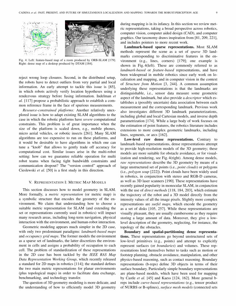
Fig. 4: Left: feature-based map of a room produced by ORB-SLAM [179].Right: dense map of a desktop produced by DTAM [184].
reject wrong loop closures. Second, in the distributed setup,
the robots have to detect outliers from very partial and local
information. An early attempt to tackle this issue is [85],
in which robots actively verify location hypotheses using a
rendezvous strategy before fusing information. Indelman et
al. [117] propose a probabilistic approach to establish a com-
mon reference frame in the face of spurious measurements.
Resource-constrained platforms: Another relatively unex-
plored issue is how to adapt existing SLAM algorithms to the
case in which the robotic platforms have severe computational
constraints. This problem is of great importance when the
size of the platform is scaled down, e.g., mobile phones,
micro aerial vehicles, or robotic insects [261]. Many SLAM
algorithms are too expensive to run on these platforms, and
it would be desirable to have algorithms in which one can
tune a “knob” that allows to gently trade off accuracy for
computational cost. Similar issues arise in the multi-robot
setting: how can we guarantee reliable operation for multi
robot teams when facing tight bandwidth constraints and
communication dropout? The “version control” approach of
Cieslewski et al. [50] is a first study in this direction.
V. REPRESENTATION I: METRIC MAP MODELS
This section discusses how to model geometry in SLAM.
More formally, a metric representation (or metric map) is
a symbolic structure that encodes the geometry of the en-
vironment. We claim that understanding how to choose a
suitable metric representation for SLAM (and extending the
set or representations currently used in robotics) will impact
many research areas, including long-term navigation, physical
interaction with the environment, and human-robot interaction.
Geometric modeling appears much simpler in the 2D case,
with only two predominant paradigms: landmark-based maps
and occupancy grid maps. The former models the environment
as a sparse set of landmarks, the latter discretizes the environ-
ment in cells and assigns a probability of occupation to each
cell. The problem of standardization of these representations
in the 2D case has been tackled by the IEEE RAS Map
Data Representation Working Group, which recently released
a standard for 2D maps in robotics [114]; the standard defines
the two main metric representations for planar environments
(plus topological maps) in order to facilitate data exchange,
benchmarking, and technology transfer.
The question of 3D geometry modeling is more delicate, and
the understanding of how to efficiently model 3D geometry
during mapping is in its infancy. In this section we review met-
ric representations, taking a broad perspective across robotics,
computer vision, computer aided design (CAD), and computer
graphics. Our taxonomy draws inspiration from [81, 209, 221],
and includes pointers to more recent work.
Landmark-based sparse representations. Most SLAM
methods represent the scene as a set of sparse 3D land-
marks corresponding to discriminative features in the en-
vironment (e.g., lines, corners) [179]; one example is
shown in Fig. 4(left). These are commonly referred to as
landmark-based or feature-based representations, and have
been widespread in mobile robotics since early work on lo-
calization and mapping, and in computer vision in the context
of Structure from Motion [3, 244]. A common assumption
underlying these representations is that the landmarks are
distinguishable, i.e., sensor data measure some geometric
aspect of the landmark, but also provide a descriptor which es-
tablishes a (possibly uncertain) data association between each
measurement and the corresponding landmark. Previous work
also investigates different 3D landmark parameterizations,
including global and local Cartesian models, and inverse depth
parametrization [174]. While a large body of work focuses on
the estimation of point features, the robotics literature includes
extensions to more complex geometric landmarks, including
lines, segments, or arcs [162].
Low-level raw dense representations. Contrary to
landmark-based representations, dense representations attempt
to provide high-resolution models of the 3D geometry; these
models are more suitable for obstacle avoidance, or for visual-
ization and rendering, see Fig. 4(right). Among dense models,
raw representations describe the 3D geometry by means of a
large unstructured set of points (i.e., point clouds) or polygons
(i.e., polygon soup [222]). Point clouds have been widely used
in robotics, in conjunction with stereo and RGB-D cameras,
as well as 3D laser scanners [190]. These representations have
recently gained popularity in monocular SLAM, in conjunction
with the use of direct methods [118, 184, 203], which estimate
the trajectory of the robot and a 3D model directly from the
intensity values of all the image pixels. Slightly more complex
representations are surfel maps, which encode the geometry
as a set of disks [105, 257]. While these representations are
visually pleasant, they are usually cumbersome as they require
storing a large amount of data. Moreover, they give a low-
level description of the geometry, neglecting, for instance, the
topology of the obstacles.
Boundary and spatial-partitioning dense representa-
tions. These representations go beyond unstructured sets of
low-level primitives (e.g., points) and attempt to explicitly
represent surfaces (or boundaries) and volumes. These rep-
resentations lend themselves better to tasks such as motion or
footstep planning, obstacle avoidance, manipulation, and other
physics-based reasoning, such as contact reasoning. Boundary
representations (b-reps) define 3D objects in terms of their
surface boundary. Particularly simple boundary representations
are plane-based models, which have been used for mapping
by Castle et al. [45] and Kaess [124, 162]. More general b-
reps include curve-based representations (e.g., tensor product
of NURBS or B-splines), surface mesh models (connected sets

10 IEEE TRANSACTIONS ON ROBOTICS, VOL. XX, NO. X, XXXXX XXXX
of polygons), and implicit surface representations. The latter
specify the surface of a solid as the zero crossing of a function
defined on R3 [17]; examples of functions include radial-basis
functions [39], signed-distance function [56], and truncated
signed-distance function (TSDF) [264]. TSDF are currently
a popular representation for vision-based SLAM in robotics,
attracting increasing attention after the seminal work [183].
Mesh models have been also used in [257, 258].
Spatial-partitioning representations define 3D objects as a
collection of contiguous non-intersecting primitives. The most
popular spatial-partitioning representation is the so called
spatial-occupancy enumeration, which decomposes the 3D
space into identical cubes (voxels), arranged in a regular
3D grid. More efficient partitioning schemes include octree,
Polygonal Map octree, and Binary Space-Partitioning tree [81,
§12.6]. In robotics, octree representations have been used
for 3D mapping [76], while commonly used occupancy grid
maps [72] can be considered as probabilistic variants of
spatial-partitioning representations. In 3D environments with-
out hanging obstacles, 2.5D elevation maps have been also
used [24]. Before moving to higher-level representations, let us
better understand how sparse (feature-based) representations
(and algorithms) compare to dense ones in visual SLAM.
Which one is best: feature-based or direct methods?
Feature-based approaches are quite mature, with a long history
of success [60]. They allow to build accurate and robust SLAM
systems with automatic relocation and loop closing [179].
However, such systems depend on the availability of features
in the environment, the reliance on detection and matching
thresholds, and on the fact that most feature detectors are
optimized for speed rather than precision. On the other hand,
direct methods work with the raw pixel information and
dense-direct methods exploit all the information in the image,
even from areas where gradients are small; thus, they can
outperform feature-based methods in scenes with poor texture,
defocus, and motion blur [184, 203]. However, they require
high computing power (GPUs) for real-time performance.
Furthermore, how to jointly estimate dense structure and
motion is still an open problem (currently they can be only be
estimated subsequently to one another). To avoid the caveats
of feature-based methods there are two alternatives. Semi-
dense methods overcome the high-computation requirement of
dense method by exploiting only pixels with strong gradients
(i.e., edges) [73, 84]; semi-direct methods instead leverage
both sparse features (such as corners or edges) and direct
methods [84] and are proven to be the most efficient [84];
additionally, because they rely on sparse features, they allow
joint estimation of structure and motion.
High-level object-based representations. While point
clouds and boundary representations are currently dominating
the landscape of dense mapping, we envision that higher-level
representations, including objects and solid shapes, will play
a key role in the future of SLAM. Early techniques to include
object-based reasoning in SLAM are “SLAM++” from Salas-
Moreno et al. [217], the work from Civera et al. [51], and
Dame et al. [57]. Solid representations explicitly encode the
fact that real objects are three-dimensional rather than 1D (i.e.,
points), or 2D (surfaces). Modeling objects as solid shapes
allows associating physical notions, such as volume and mass,
to each object, which is definitely important for robots which
have to interact the world. Luckily, existing literature from
CAD and computer graphics paved the way towards these
developments. In the following, we list few examples of solid
representations that have not yet been used in a SLAM context:
• Parameterized Primitive Instancing: relies on the definition
of families of objects (e.g., cylinder, sphere). For each
family, one defines a set of parameters (e.g., radius, height),
that uniquely identifies a member (or instance) of the family.
This representation may be of interest for SLAM since it
enables the use of extremely compact models, while still
capturing many elements in man-made environments.
• Sweep representations: define a solid as the sweep of a 2D or
3D object along a trajectory through space. Typical sweeps
representations include translation sweep (or extrusion) and
rotation sweep. For instance, a cylinder can be represented
as a translation sweep of a circle along an axis that is orthog-
onal to the plane of the circle. Sweeps of 2D cross-sections
are known as generalized cylinders in computer vision [14],
and they have been used in robotic grasping [200]. This
representation seems particularly suitable to reason on the
occluded portions of the scene, by leveraging symmetries.
• Constructive solid geometry: defines complex solids by
means of boolean operations between primitives [209]. An
object is stored as a tree in which the leaves are the primi-
tives and the edges represent operations. This representation
can model fairly complicated geometry and is extensively
used in computer graphics.
We conclude this review by mentioning that other
types of representations exist, including feature-based mod-
els in CAD [220], dictionary-based representations [266],
affordance-based models [134], generative and procedural
models [172], and scene graphs [121]. In particular, dictionary-
based representations, which define a solid as a combination
of atoms in a dictionary, have been considered in robotics and
computer vision, with dictionary learned from data [266] or
based on existing repositories of object models [149, 157].
Open Problems. The following problems regarding metric
representation for SLAM deserve a large amount of funda-
mental research, and are still vastly unexplored.
High-level, expressive representations in SLAM: While most
of the robotics community is currently focusing on point
clouds or TSDF to model 3D geometry, these representations
have two main drawbacks. First, they are wasteful of memory.
For instance, both representations use many parameters (i.e.,
points, voxels) to encode even a simple environment, such
as an empty room (this issue can be partially mitigated by
the so-called voxel hashing [188]). Second, these represen-
tations do not provide any high-level understanding of the
3D geometry. For instance, consider the case in which the
robot has to figure out if it is moving in a room or in
a corridor. A point cloud does not provide readily usable
information about the type of environment (i.e., room vs.
corridor). On the other hand, more sophisticated models (e.g.,
parameterized primitive instancing) would provide easy ways
to discern the two scenes (e.g., by looking at the parameters

CADENA et al.: PAST, PRESENT, AND FUTURE OF SIMULTANEOUS LOCALIZATION AND MAPPING: TOWARDS THE ROBUST-PERCEPTION AGE 11
defining the primitive). Therefore, the use of higher-level
representations in SLAM carries three promises. First, using
more compact representations would provide a natural tool
for map compression in large-scale mapping. Second, high-
level representations would provide a higher-level description
of objects geometry which is a desirable feature to facilitate
data association, place recognition, semantic understanding,
and human-robot interaction; these representations would also
provide a powerful support for SLAM, enabling to reason
about occlusions, leverage shape priors, and inform the infer-
ence/mapping process of the physical properties of the objects
(e.g., weight, dynamics). Finally, using rich 3D representa-
tions would enable interactions with existing standards for
construction and management of modern buildings, including
CityGML [193] and IndoorGML [194]. No SLAM techniques
can currently build higher-level representations, beyond point
clouds, mesh models, surfels models, and TSDFs. Recent
efforts in this direction include [18, 52, 231].
Optimal Representations: While there is a relatively large
body of literature on different representations for 3D geometry,
few works have focused on understanding which criteria
should guide the choice of a specific representation. Intuitively,
in simple indoor environments one should prefer parametrized
primitives since few parameters can sufficiently describe the
3D geometry; on the other hand, in complex outdoor en-
vironments, one might prefer mesh models. Therefore, how
should we compare different representations and how should
we choose the “optimal” representation? Requicha [209]
identifies few basic properties of solid representations that
allow comparing different representation. Among these prop-
erties we find: domain (the set of real objects that can be
represented), conciseness (the “size” of a representation for
storage and transmission), ease of creation (in robotics this
is the “inference” time required for the construction of the
representation), and efficacy in the context of the application
(this depends on the tasks for which the representation is
used). Therefore, the “optimal” representation is the one that
enables preforming a given task, while being concise and
easy to create. Soatto and Chiuso [229] define the optimal
representation as a minimal sufficient statistics to perform a
given task, and its maximal invariance to nuisance factors.
Finding a general yet tractable framework to choose the best
representation for a task remains an open problem.
Automatic, Adaptive Representations: Traditionally, the
choice of a representation has been entrusted to the roboticist
designing the system, but this has two main drawbacks. First,
the design of a suitable representation is a time-consuming
task that requires an expert. Second, it does not allow any
flexibility: once the system is designed, the representation of
choice cannot be changed; ideally, we would like a robot to
use more or less complex representations depending on the
task and the complexity of the environment. The automatic
design of optimal representations will have a large impact on
long-term navigation.
VI. REPRESENTATION II: SEMANTIC MAP MODELS
Semantic mapping consists in associating semantic concepts
to geometric entities in a robot’s surroundings. Recently, the
limitations of purely geometric maps have been recognized
and this has spawned a significant and ongoing body of work
in semantic mapping of environments, in order to enhance
robot’s autonomy and robustness, facilitate more complex
tasks (e.g. avoid muddy-road while driving), move from path-
planning to task-planning, and enable advanced human-robot
interaction [10, 27, 217]. These observations have led to
different approaches for semantic mapping which vary in
the numbers and types of semantic concepts and means of
associating them with different parts of the environments. As
an example, Pronobis and Jensfelt [206] label different rooms,
while Pillai and Leonard [201] segment several known objects
in the map. With the exception of few approaches, semantic
parsing at the basic level was formulated as a classification
problem, where simple mapping between the sensory data and
semantic concepts has been considered.
Semantic vs. topological SLAM. As mentioned in Sec-
tion I, topological mapping drops the metric information and
only leverages place recognition to build a graph in which the
nodes represent distinguishable “places”, while edges denote
reachability among places. We note that topological mapping
is radically different from semantic mapping. While the former
requires recognizing a previously seen place (disregarding
whether that place is a kitchen, a corridor, etc.), the latter is
interested in classifying the place according to semantic labels.
A comprehensive survey on vision-based topological SLAM
is presented in Lowry et al. [160], and some of its challenges
are discussed in Section III. In the rest of this section we focus
on semantic mapping.
Semantic SLAM: Structure and detail of concepts. The
unlimited number of, and relationships among, concepts for
humans opens a more philosophical and task-driven decision
about the level and organization of the semantic concepts. The
detail and organization depend on the context of what, and
where, the robot is supposed to perform a task, and they impact
the complexity of the problem at different stages. A semantic
representation is built by defining the following aspects:
• Level/Detail of semantic concepts: For a given robotic task,
e.g. “going from room A to room B”, coarse categories
(rooms, corridor, doors) would suffice for a successful
performance, while for other tasks, e.g. “pick up a tea cup”,
finer categories (table, tea cup, glass) are needed.
• Organization of semantic concepts: The semantic concepts
are not exclusive. Even more, a single entity can have
an unlimited number of properties or concepts. A chair
can be “movable” and “sittable”; a dinner table can be
“movable” and “unsittable”. While the chair and the table
are pieces of furniture, they share the movable property but
with different usability. Flat or hierarchical organizations,
sharing or not some properties, have to be designed to handle
this multiplicity of concepts.
Brief Survey. There are three main ways to attack semantic
mapping, and assign semantic concepts to data.
SLAM helps Semantics: The first robotic researchers work-
ing on semantic mapping started by the straightforward ap-
proach of segmenting the metric map built by a classical
SLAM system into semantic concepts. An early work was that
of Mozos et al. [176], which builds a geometric map using a

12 IEEE TRANSACTIONS ON ROBOTICS, VOL. XX, NO. X, XXXXX XXXX
Fig. 5: Semantic understanding allows humans to predict changes in theenvironment at different time scales. For instance, in the construction siteshown in the figure, humans account for the motion of the crane and expectthe crane-truck not to move in the immediate future, while at the same time wecan predict the semblance of the site which will allow us to localize even afterthe construction finishes. This is possible because we reason on the functionalproperties and interrelationships of the entities in the environment. Enhancingour robots with similar capabilities is an open problem for semantic SLAM.
2D laser scan and then fuses the classified semantic places
from each robot pose through an associative Markov network
in an offline manner. Similarly, Lai et al. [148] build a 3D
map from RGB-D sequences to then carry out an offline object
classification. An online semantic mapping system was later
proposed by Pronobis et al. [206], who combine three layers of
reasoning (sensory, categorical, and place) to build a semantic
map of the environment using laser and camera sensors.
More recently, Cadena et al. [27] use motion estimation, and
interconnect a coarse semantic segmentation with different
object detectors to outperform the individual systems. Pillai
and Leonard [201] use a monocular SLAM system to boost
the performance in the task of object recognition in videos.
Semantics helps SLAM: Soon after the first semantic maps
came out, another trend started by taking advantage of known
semantic classes or objects. The idea is that if we can
recognize objects or other elements in a map then we can
use our prior knowledge about their geometry to improve the
estimation of that map. First attempts were done in small scale
by Castle et al. [45] and by Civera et al. [51] with a monocular
SLAM with sparse features, and by Dame et al. [57] with
a dense map representation. Taking advantage of RGB-D
sensors, Salas-Moreno et al. [217] propose a SLAM system
based on the detection of known objects in the environment.
Joint SLAM and Semantics inference: Researchers with
expertise in both computer vision and robotics realized that
they could perform monocular SLAM and map segmentation
within a joint formulation. The online system of Flint et
al. [80] presents a model that leverages the Manhattan world
assumption to segment the map in the main planes in indoor
scenes. Bao et al. [10] propose one of the first approaches to
jointly estimate camera parameters, scene points and object
labels using both geometric and semantic attributes in the
scene. In their work, the authors demonstrate the improved
object recognition performance and robustness, at the cost of a
run-time of 20 minutes per image-pair, and the limited number
of object categories makes the approach impractical for on-
line robot operation. In the same line, Hane et al. [103] solve
a more specialized class-dependent optimization problem in
outdoors scenarios. Although still offline, Kundu et al. [147]
reduce the complexity of the problem by a late fusion of the
semantic segmentation and the metric map, a similar idea was
proposed earlier by Sengupta et al. [219] using stereo cameras.
It should be noted that [147] and [219] focus only on the
mapping part and they do not refine the early computed poses
in this late stage. Recently, a promising online system was
proposed by Vineet et al. [251] using stereo cameras and a
dense map representation.
Open Problems. The problem of including semantic in-
formation in SLAM is in its infancy, and, contrary to metric
SLAM, it still lacks a cohesive formulation. Fig. 5 shows a
construction site as a simple example where we can find the
challenges discussed below.
Consistent semantic-metric fusion: Although some progress
has been done in terms of temporal fusion of, for instance,
per frame semantic evidence [219, 251], the problem of
consistently fusing several sources of semantic information
with metric information coming at different points in time is
still open. Incorporating the confidence or uncertainty of the
semantic categorization in the already well known factor graph
formulation for the metric representation is a possible way to
go for a joint semantic-metric inference framework.
Semantic mapping is much more than a categorization
problem: The semantic concepts are evolving to more spe-
cialized information such as affordances and actionability4 of
the entities in the map and the possible interactions among
different active agents in the environment. How to represent
these properties, and interrelationships, are questions to answer
for high level human-robot interaction.
Ignorance, awareness, and adaptation: Given some prior
knowledge, the robot should be able to reason about new
concepts and their semantic representations, that is, it should
be able to discover new objects or classes in the environment,
learning new properties as result of active interaction with
other robots and humans, and adapting the representations
to slow and abrupt changes in the environment over time.
For example, suppose that a wheeled-robot needs to classify
whether a terrain is drivable or not, to inform its navigation
system. If the robot finds some mud on a road, that was
previously classified as drivable, the robot should learn a new
class depending on the grade of difficulty of crossing the
muddy region, or adjust its classifier if another vehicle stuck
in the mud is perceived.
Semantic-based reasoning5: As humans, the semantic repre-
sentations allow us to compress and speed-up reasoning about
the environment, while assessing accurate metric representa-
tions takes us some effort. Currently, this is not the case for
robots. Robots can handle (colored) metric representation but
they do not truly exploit the semantic concepts. Our robots
4The term affordances refers to the set of possible actions on a givenobject/environment by a given agent [93], while the term actionability includesthe expected utility of these actions.
5Reasoning in the sense of localization and mapping. This is only a sub-areaof the vast area of Knowledge Representation and Reasoning in the field ofArtificial Intelligence that deals with solving complex problems, like havinga dialogue in natural language or inferring a person’s mood.

CADENA et al.: PAST, PRESENT, AND FUTURE OF SIMULTANEOUS LOCALIZATION AND MAPPING: TOWARDS THE ROBUST-PERCEPTION AGE 13
are currently unable to effectively, and efficiently localize and
continuously map using the semantic concepts (categories,
relationships and properties) in the environment. For instance,
when detecting a car, a robot should infer the presence of a
planar ground under the car (even if occluded) and when the
car moves the map update should only refine the hallucinated
ground with the new sensor readings. Even more, the same
update should change the global pose of the car as a whole
in a single and efficient operation as opposed to update, for
instance, every single voxel.
VII. NEW THEORETICAL TOOLS FOR SLAM
This section discusses recent progress towards establishing
performance guarantees for SLAM algorithms, and elucidates
open problems. The theoretical analysis is important for three
main reasons. First, SLAM algorithms and implementations
are often tested in few problem instances and it is hard
to understand how the corresponding results generalize to
new instances. Second, theoretical results shed light on the
intrinsic properties of the problem, revealing aspects that may
be counter-intuitive during empirical evaluation. Third, a true
understanding of the structure of the problem allows pushing
the algorithmic boundaries, enabling to extend the set of real-
world SLAM instances that can be solved.
Early theoretical analysis of SLAM algorithms were based
on the use of EKF; we refer the reader to [65, 255] for a
comprehensive discussion, on consistency and observability
of EKF SLAM.6 Here we focus on factor graph optimiza-
tion approaches. Besides the practical advantages (accuracy,
efficiency), factor graph optimization provides an elegant
framework which is more amenable to analysis.
In the absence of priors, MAP estimation reduces to max-
imum likelihood estimation. Consequently, without priors,
SLAM inherits all the properties of maximum likelihood
estimators: the estimator in (4) is consistent, asymptotically
Gaussian, asymptotically efficient, and invariant to transfor-
mations in the Euclidean space [171, Theorems 11-1,2]. Some
of these properties are lost in presence of priors (e.g., the
estimator is no longer invariant [171, page 193]).
In this context we are more interested in algorithmic prop-
erties: does a given algorithm converge to the MAP estimate?
How can we improve or check convergence? What is the
breakdown point in presence of spurious measurements?
Brief Survey. Most SLAM algorithms are based on iterative
nonlinear optimization [64, 100, 125, 126, 192, 204]. SLAM
is a nonconvex problem and iterative optimization can only
guarantee local convergence. When an algorithm converges
to a local minimum7 it usually returns an estimate that
is completely wrong and unsuitable for navigation (Fig. 6).
State-of-the-art iterative solvers fail to converge to a global
minimum of the cost for relatively small noise levels [33, 38].
6Interestingly, the lack of observability manifests itself very clearly infactor graph optimization, since the linear system to be solved in iterativemethods becomes rank-deficient; this enables the design of techniques thatcan explicitly deal with problems that are not fully observable [265].
7We use the term “local minimum” to denote a minimum of the cost whichdoes not attain the globally optimal objective.
Failure to converge in iterative methods has triggered efforts
towards a deeper understanding of the SLAM problem. Huang
and collaborators [111] pioneered this effort, with initial works
discussing the nature of the nonconvexity in SLAM. Huang et
al. [112] discuss the number of minima in small pose graph
optimization problems. Knuth and Barooah [138] investigate
the growth of the error in the absence of loop closures.
Carlone [30] provides estimates of the basin of convergence
for the Gauss-Newton method. Carlone and Censi [33] show
that rotation estimation can be solved in closed form in 2D
and show that the corresponding estimate is unique. The recent
use of alternative maximum likelihood formulations (e.g.,
assuming Von Mises noise on rotations [35, 211]) has enabled
even stronger results. Carlone and Dellaert [32, 37] show
that under certain conditions (strong duality) that are often
encountered in practice, the maximum likelihood estimate is
unique and pose graph optimization can be solved globally,
via (convex) semidefinite programming (SDP). A very recent
overview on theoretical aspects of SLAM is given in [110].
As mentioned earlier, the theoretical analysis is sometimes
the first step towards the design of better algorithms. Besides
the dual SDP approach of [32, 37], other authors proposed
convex relaxation to avoid convergence to local minima. These
contributions include the work of Liu et al. [159] and Rosen et
al. [211]. Another successful strategy to improve convergence
consists in computing a suitable initialization for iterative
nonlinear optimization. In this regard, the idea of solving for
the rotations first and to use the resulting estimate to bootstrap
nonlinear iteration has been demonstrated to be very effective
in practice [21, 31, 33, 38]. Khosoussi et al. [130] leverage the
(approximate) separability between translation and rotation to
speed up optimization.
Recent theoretical results on the use of Lagrangian duality
in SLAM also enabled the design of verification techniques:
given a SLAM estimate these techniques are able to judge
whether such estimate is optimal or not. Being able to as-
certain the quality of a given SLAM solution is crucial to
design failure detection and recovery strategies for safety-
critical applications. The literature on verification techniques
for SLAM is very recent: current approaches [32, 37] are able
to perform verification by solving a sparse linear system and
are guaranteed to provide a correct answer as long as strong
duality holds (more on this point later).
We note that these results, proposed in a robotics context,
provide a useful complement to related work in other commu-
nities, including localization in multi agent systems [47, 199,
202, 245, 254], structure from motion in computer vision [87,
96, 104, 168], and cryo-electron microscopy [224, 225].
Open Problems. Despite the unprecedented progress of the
last years, several theoretical questions remain open.
Generality, guarantees, verification: The first question re-
gards the generality of the available results. Most results on
guaranteed global solutions and verification techniques have
been proposed in the context of pose graph optimization.
Can these results be generalized to arbitrary factor graphs?
Moreover, most theoretical results assume the measurement
noise to be isotropic or at least to be structured. Can we
generalize existing results to arbitrary noise models?

14 IEEE TRANSACTIONS ON ROBOTICS, VOL. XX, NO. X, XXXXX XXXX
Fig. 6: The back-bone of most SLAM algorithms is the MAP estimation of therobot trajectory, which is computed via non-convex optimization. The figureshows trajectory estimates for two simulated benchmarking problems, namelysphere-a and torus, in which the robot travels on the surface of a sphereand a torus. The top row reports the correct trajectory estimate, correspondingto the global optimum of the optimization problem. The bottom row showsincorrect trajectory estimates resulting from convergence to local minima.Recent theoretical tools are enabling detection of wrong convergence episodes,and are opening avenues for failure detection and recovery techniques.
Weak or Strong duality? The works [32, 37] show that when
strong duality holds SLAM can be solved globally; moreover,
they provide empirical evidence that strong duality holds in
most problem instances encountered in practical applications.
The outstanding problem consists in establishing a priori
conditions under which strong duality holds. We would like
to answer the question “given a set of sensors (and the
corresponding measurement noise statistics) and a factor graph
structure, does strong duality hold?”. The capability to answer
this question would define the domain of applications in
which we can compute (or verify) global solutions to SLAM.
This theoretical investigation would also provide fundamental
insights in sensor design and active SLAM (Section VIII).
Resilience to outliers: The third question regards estimation
in the presence of spurious measurements. While recent results
provide strong guarantees for pose graph optimization, no
result of this kind applies in the presence of outliers. Despite
the work on robust SLAM (Section III) and new modeling
tools for the non-Gaussian noise case [212], the design of
global techniques that are resilient to outliers and the design
of verification techniques that can certify the correctness of a
given estimate in presence of outliers remain open.
VIII. ACTIVE SLAM
So far we described SLAM as an estimation problem that
is carried out passively by the robot, i.e. the robot performs
SLAM given the sensor data, but without acting deliberately to
collect it. In this section we discuss how to leverage a robot’s
motion to improve the mapping and localization results.
The problem of controlling robot’s motion in order to mini-
mize the uncertainty of its map representation and localization
is usually named active SLAM. This definition stems from the
well-known Bajcsy’s active perception [9] and Thrun’s robotic
exploration [240, Ch. 17] paradigms.
Brief Survey. The first proposal and implementation of
an active SLAM algorithm can be traced back to Feder [78]
while the name was coined in [152]. However, active SLAM
has its roots in ideas from artificial intelligence and robotic
exploration that can be traced back to the early eight-
ies (c.f. [11]). Thrun in [239] concluded that solving the
exploration-exploitation dilemma, i.e., finding a balance be-
tween visiting new places (exploration) and reducing the
uncertainty by re-visiting known areas (exploitation), provides
a more efficient alternative with respect to random exploration
or pure exploitation.
Active SLAM is a decision making problem and there are
several general frameworks for decision making that can be
used as backbone for exploration-exploitation decisions. One
of these frameworks is the Theory of Optimal Experimental
Design (TOED) [198] which, applied to active SLAM [42, 44],
allows selecting future robot action based on the predicted
map uncertainty. Information theoretic [164, 208] approaches
have been also applied to active SLAM [41, 232]; in this
case decision making is usually guided by the notion of infor-
mation gain. Control theoretic approaches for active SLAM
include the use of Model Predictive Control [152, 153]. A
different body of works formulates active SLAM under the
formalism of Partially Observably Markov Decision Process
(POMDP) [123], which in general is known to be compu-
tationally intractable; approximate but tractable solutions for
active SLAM include Bayesian Optimization [169] or efficient
Gaussian beliefs propagation [195], among others.
A popular framework for active SLAM consists of selecting
the best future action among a finite set of alternatives. This
family of active SLAM algorithms proceeds in three main
steps [16, 36]: 1) The robot identifies possible locations to
explore or exploit, i.e. vantage locations, in its current estimate
of the map; 2) The robot computes the utility of visiting each
vantage point and selects the action with the highest utility;
and 3) The robot carries out the selected action and decides
if it is necessary to continue or to terminate the task. In the
following, we discuss each point in details.
Selecting vantage points: Ideally, a robot executing an active
SLAM algorithm should evaluate every possible action in
the robot and map space, but the computational complexity
of the evaluation grows exponentially with the search space
which proves to be computationally intractable in real appli-
cations [25, 169]. In practice, a small subset of locations in the
map is selected, using techniques such as frontier-based explo-
ration [127, 262]. Recent works [250] and [116] have proposed
approaches for continuous-space planning under uncertainty
that can be used for active SLAM; currently these approaches
can only guarantee convergence to locally optimal policies.
Another recent continuous-domain avenue for active SLAM
algorithms is the use of potential fields. Some examples are
[249], which uses convolution techniques to compute entropy
and select the robot’s actions, and [122], which resorts to the
solution of a boundary value problem.
Computing the utility of an action: Ideally, to compute the
utility of a given action the robot should reason about the
evolution of the posterior over the robot pose and the map,
taking into account future (controllable) actions and future

CADENA et al.: PAST, PRESENT, AND FUTURE OF SIMULTANEOUS LOCALIZATION AND MAPPING: TOWARDS THE ROBUST-PERCEPTION AGE 15
(unknown) measurements. If such posterior were known, an
information-theoretic function, as the information gain, could
be used to rank the different actions [23, 233]. However,
computing this joint probability analytically is, in general,
computationally intractable [36, 77, 233]. In practice, one
resorts to approximations. Initial work considered the uncer-
tainty of the map and the robot to be independent [246] or
conditionally independent [233]. Most of these approaches
define the utility as a linear combination of metrics that
quantify robot and map uncertainties [23, 36]. One drawback
of this approach is that the scale of the numerical values of the
two uncertainties is not comparable, i.e. the map uncertainty is
often orders of magnitude larger than the robot one, so manual
tuning is required to correct it. Approaches to tackle this issue
have been proposed for particle-filter-based SLAM [36], and
for pose graph optimization [41].
The Theory of Optimal Experimental Design (TOED) [198]
can also be used to account for the utility of performing an
action. In the TOED, every action is considered as a stochastic
design, and the comparison among designs is done using their
associated covariance matrices via the so-called optimality
criteria, e.g. A-opt, D-opt and E-opt. A study about the usage
of optimality criteria in active SLAM can be found in [43, 44].
Executing actions or terminating exploration: While execut-
ing an action is usually an easy task, using well-established
techniques from motion planning, the decision on whether
or not the exploration task is complete, is currently an open
challenge that we discuss in the following paragraph.
Open Problems. Several problems still need to be ad-
dressed, for active SLAM to have impact in real applications.
Fast and accurate predictions of future states: In active
SLAM each action of the robot should contribute to reduce the
uncertainty in the map and improve the localization accuracy;
for this purpose, the robot must be able to forecast the effect of
future actions on the map and robots localization. The forecast
has to be fast to meet latency constraints and precise to effec-
tively support the decision process. In the SLAM community
it is well known that loop closings are important to reduce
uncertainty and to improve localization and mapping accuracy.
Nonetheless, efficient methods for forecasting the occurrence
and the effect of a loop closing are yet to be devised. Moreover,
predicting the effects of future actions is still a computational
expensive task [116]. Recent approaches to forecasting future
robot states can be found in the machine learning literature,
and involve the use of spectral techniques [230] and deep
learning [252].
Enough is enough: When do you stop doing active SLAM?
Active SLAM is a computationally expensive task: therefore
a natural question is when we can stop doing active SLAM
and switch to classical (passive) SLAM in order to focus
resources on other tasks. Balancing active SLAM decisions
and exogenous tasks is critical, since in most real-world tasks,
active SLAM is only a means to achieve an intended goal.
Additionally, having a stopping criteria is a necessity because
at some point it is provable that more information would
lead not only to a diminishing return effect but also, in
case of contradictory information, to an unrecoverable state
(e.g. several wrong loop closures). Uncertainty metrics from
TOED, which are task oriented, seem promising as stopping
criteria, compared to information-theoretic metrics which are
difficult to compare across systems [40].
Performance guarantees: Another important avenue is to
look for mathematical guarantees for active SLAM and for
near-optimal policies. Since solving the problem exactly is
intractable, it is desirable to have approximation algorithms
with clear performance bounds. Examples of this kind of effort
is the use of submodularity [94] in the related field of active
sensors placement.
IX. NEW FRONTIERS: SENSORS AND LEARNING
The development of new sensors and the use of new
computational tools have often been key drivers for SLAM.
Section IX-A reviews unconventional and new sensors, as well
as the challenges and opportunities they pose in the context of
SLAM. Section IX-B discusses the role of (deep) learning as
an important frontier for SLAM, analyzing the possible ways
in which this tool is going to improve, affect, or even restate,
the SLAM problem.
A. New and Unconventional Sensors for SLAM
Besides the development of new algorithms, progress in
SLAM (and mobile robotics in general) has often been trig-
gered by the availability of novel sensors. For instance, the
introduction of 2D laser range finders enabled the creation of
very robust SLAM systems, while 3D lidars have been a main
thrust behind recent applications, such as autonomous cars. In
the last ten years, a large amount of research has been devoted
to vision sensors, with successful applications in augmented
reality and vision-based navigation.
Sensing in robotics has been mostly dominated by lidars
and conventional vision sensors. However, there are many
alternative sensors that can be leveraged for SLAM, such
as depth, light-field, and event-based cameras, which are
now becoming a commodity hardware, as well as magnetic,
olfaction, and thermal sensors.
Brief Survey. We review the most relevant new sensors and
their applications for SLAM, postponing a discussion on open
problems to the end of this section.
Range cameras: Light-emitting depth cameras are not new
sensors, but they became commodity hardware in 2010 with
the advent the Microsoft Kinect game console. They operate
according to different principles, such as structured light,
time of flight, interferometry, or coded aperture. Structure-
light cameras work by triangulation; thus, their accuracy is
limited by the distance between the cameras and the pattern
projector (structured light). By contrast, the accuracy of Time-
of-Flight (ToF) cameras only depends on the time-of-flight
measurement device; thus, they provide the highest range
accuracy (sub millimeter at several meters). ToF cameras
became commercially available for civil applications around
the year 2000 but only began to be used in mobile robotics in
2004 [256]. While the first generation of ToF and structured-
light cameras was characterized by low signal-to-noise ratio
and high price, they soon became popular for video-game
applications, which contributed to making them affordable

16 IEEE TRANSACTIONS ON ROBOTICS, VOL. XX, NO. X, XXXXX XXXX
and improving their accuracy. Since range cameras carry their
own light source, they also work in dark and untextured
scenes, which enabled the achievement of remarkable SLAM
results [183].
Light-field cameras: Contrary to standard cameras, which
only record the light intensity hitting each pixel, a light-field
camera (also known as plenoptic camera), records both the
intensity and the direction of light rays [186]. One popular type
of light-field camera uses an array of micro lenses placed in
front of a conventional image sensor to sense intensity, color,
and directional information. Because of the manufacturing
cost, commercially available light-field cameras still have
relatively low resolution (< 1MP), which is being overcome by
current technological effort. Light-field cameras offer several
advantages over standard cameras, such as depth estimation,
noise reduction [58], video stabilization [227], isolation of
distractors [59], and specularity removal [119]. Their optics
also offers wide aperture and wide depth of field compared
with conventional cameras [15].
Event-based cameras: Contrarily to standard frame-based
cameras, which send entire images at fixed frame rates,
event-based cameras, such as the Dynamic Vision Sensor
(DVS) [156] or the Asynchronous Time-based Image Sensor
(ATIS) [205], only send the local pixel-level changes caused
by movement in a scene at the time they occur.
They have five key advantages compared to conventional
frame-based cameras: a temporal latency of 1ms, an update
rate of up to 1MHz, a dynamic range of up to 140dB (vs 60-
70dB of standard cameras), a power consumption of 20mW
(vs 1.5W of standard cameras), and very low bandwidth
and storage requirements (because only intensity changes are
transmitted). These properties enable the design of a new class
of SLAM algorithms that can operate in scenes characterized
by high-speed motion [90] and high-dynamic range [132, 207],
where standard cameras fail. However, since the output is
composed of a sequence of asynchronous events, traditional
frame-based computer-vision algorithms are not applicable.
This requires a paradigm shift from the traditional computer
vision approaches developed over the last fifty years. Event-
based real-time localization and mapping algorithms have
recently been proposed [132, 207]. The design goal of such
algorithms is that each incoming event can asynchronously
change the estimated state of the system, thus, preserving the
event-based nature of the sensor and allowing the design of
microsecond-latency control algorithms [178].
Open Problems. The main bottleneck of active range cam-
eras is the maximum range and interference with other external
light sources (such as sun light); however, these weaknesses
can be improved by emitting more light power.
Light-field cameras have been rarely used in SLAM because
they are usually thought to increase the amount of data
produced and require more computational power. However,
recent studies have shown that they are particularly suitable for
SLAM applications because they allow formulating the motion
estimation problem as a linear optimization and can provide
more accurate motion estimates if designed properly [66].
Event-based cameras are revolutionary image sensors that
overcome the limitations of standard cameras in scenes char-
acterized by high dynamic range and high speed motion.
Open problems concern a full characterization of the sensor
noise and sensor non idealities: event-based cameras have a
complicated analog circuitry, with nonlinearities and biases
that can change the sensitivity of the pixels, and other dynamic
properties, which make the events susceptible to noise. Since
a single event does not carry enough information for state
estimation and because an event camera generate on average
100, 000 events a second, it can become intractable to do
SLAM at the discrete times of the single events due to the
rapidly growing size of the state space. Using a continuous-
time framework [13], the estimated trajectory can be approx-
imated by a smooth curve in the space of rigid-body motions
using basis functions (e.g., cubic splines), and optimized
according to the observed events [177]. While the temporal
resolution is very high, the spatial resolution of event-based
cameras is relatively low (QVGA), which is being overcome
by current technological effort [155]. Newly developed event
sensors overcome some of the original limitations: an ATIS
sensor sends the magnitude of the pixel-level brightness; a
DAVIS sensor [155] can output both frames and events (this
is made possible by embedding a standard frame-based sensor
and a DVS into the same pixel array). This will allow tracking
features and motion in the blind time between frames [144].
We conclude this section with some general observations
on the use of novel sensing modalities for SLAM.
Other sensors: Most SLAM research has been devoted to
range and vision sensors. However, humans or animals are able
to improve their sensing capabilities by using tactile, olfaction,
sound, magnetic, and thermal stimuli. For instance, tactile cues
are used by blind people or rodents for haptic exploration
of objects, olfaction is used by bees to find their way home,
magnetic fields are used by homing pigeons for navigation,
sound is used by bats for obstacle detection and navigation,
while some snakes can see infrared radiation emitted by hot
objects. Unfortunately, these alternative sensors have not been
considered in the same depth as range and vision sensors
to perform SLAM. Haptic SLAM can be used for tactile
exploration of an object or of a scene [237, 263]. Olfaction
sensors can be used to localize gas or other odor sources [167].
Although ultrasound-based localization was predominant in
early mobile robots, their use has rapidly declined with the
advent of cheap optical range sensors. Nevertheless, animals,
such as bats, can navigate at very high speeds using only echo
localization. Thermal sensors offer important cues at night and
in adverse weather conditions [165]. Local anomalies of the
ambient magnetic field, present in many indoor environments,
offer an excellent cue for localization [248]. Finally, pre-
existing wireless networks, such as WiFi, can be used to
improve robot navigation without any prior knowledge of the
location of the antennas [79].
Which sensor is best for SLAM? A question that naturally
arises is: what will be the next sensor technology to drive
future long-term SLAM research? Clearly, the performance
of a given algorithm-sensor pair for SLAM depends on the
sensor and algorithm parameters, and on the environment
[228]. A complete treatment of how to choose algorithms and
sensors to achieve the best performance has not been found

CADENA et al.: PAST, PRESENT, AND FUTURE OF SIMULTANEOUS LOCALIZATION AND MAPPING: TOWARDS THE ROBUST-PERCEPTION AGE 17
yet. A preliminary study by Censi et al. [46], has shown
that the performance for a given task also depends on the
power available for sensing. It also suggests that the optimal
sensing architecture may have multiple sensors that might be
instantaneously switched on and off according to the required
performance level or measure the same phenomenon through
different physical principles for robustness [69].
B. Deep Learning
It would be remiss of a paper that purports to consider future
directions in SLAM not to make mention of deep learning. Its
impact in computer vision has been transformational, and, at
the time of writing this article, it is already making significant
inroads into traditional robotics, including SLAM.
Researchers have already shown that it is possible to learn
a deep neural network to regress the inter-frame pose between
two images acquired from a moving robot directly from the
original image pair [53], effectively replacing the standard
geometry of visual odometry. Likewise it is possible to localize
the 6DoF of a camera with regression forest [247] and with
deep convolutional neural network [129], and to estimate the
depth of a scene (in effect, the map) from a single view solely
as a function of the input image [28, 71, 158].
This does not, in our view, mean that traditional SLAM
is dead, and it is too soon to say whether these methods are
simply curiosities that show what can be done in principle, but
which will not replace traditional, well-understood methods,
or if they will completely take over.
Open Problems. We highlight here a set of future directions
for SLAM where we believe machine learning and more
specifically deep learning will be influential, or where the
SLAM application will throw up challenges for deep learning.
Perceptual tool: It is clear that some perceptual problems
that have been beyond the reach of off-the-shelf computer
vision algorithms can now be addressed. For example, object
recognition for the imagenet classes [213] can now, to an
extent, be treated as a black box that works well from the
perspective of the roboticist or SLAM researcher. Likewise
semantic labeling of pixels in a variety of scene types reaches
performance levels of around 80% accuracy or more [75].
We have already commented extensively on a move towards
more semantically meaningful maps for SLAM systems, and
these black-box tools will hasten that. But there is more at
stake: deep networks show more promise for connecting raw
sensor data to understanding, or connecting raw sensor data
to actions, than anything that has preceded them.
Practical deployment: Successes in deep learning have
mostly revolved around lengthy training times on supercom-
puters and inference on special-purpose GPU hardware for a
one-off result. A challenge for SLAM researchers (or indeed
anyone who wants to embed the impressive results in their
system) is how to provide sufficient computing power in an
embedded system. Do we simply wait for the technology to
catch up, or do we investigate smaller, cheaper networks that
can produce “good enough” results, and consider the impact
of sensing over an extended period?
Online and life-long learning: An even greater and impor-
tant challenge is that of online learning and adaptation, that
will be essential to any future long-term SLAM system. SLAM
systems typically operate in an open-world with continuous
observation, where new objects and scenes can be encountered.
But to date deep networks are usually trained on closed-
world scenarios with, say, a fixed number of object classes. A
significant challenge is to harness the power of deep networks
in a one-shot or zero-shot scenario (i.e. one or even zero
training examples of a new class) to enable life-long learning
for a continuously moving, continuously observing SLAM
system.
Similarly, existing networks tend to be trained on a vast
corpus of labelled data, yet it cannot always be guaranteed
that a suitable dataset exists or is practical to label for
the supervised training. One area where some progress has
recently been made is that of single-view depth estimation:
Garg et al. [91] have recently shown how a deep network
for single-view depth estimation can be trained simply by
observing a large corpus of stereo pairs, without the need to
observe or calculate depth explicitly. It remains to be seen if
similar methods can be developed for tasks such as semantic
scene labelling.
Bootstrapping: Prior information about a scene has increas-
ingly been shown to provide a significant boost to SLAM
systems. Examples in the literature to date include known ob-
jects [57, 217] or prior knowledge about the expected structure
in the scene, like smoothness as in DTAM [184], Manhattan
constraints as in [80], or even the expected relationships
between objects [10]. It is clear that deep learning is capable
of distilling such prior knowledge for specific tasks such as
estimating scene labels or scene depths. How best to extract
and use this information is a significant open problem. It is
more pertinent in SLAM than in some other fields because
in SLAM we have solid grasp of the mathematics of the
scene geometry – the question then is how to fuse this well-
understood geometry with the outputs of a deep network. One
particular challenge that must be solved is to characterize the
uncertainty of estimates derived from a deep network.
SLAM offers a challenging context for exploring potential
connections between deep learning architectures and recursive
state estimation in large-scale graphical models. For example,
Krishan et al. [142] have recently proposed Deep Kalman
Filters; perhaps it might one day be possible to create an
end-to-end SLAM system using a deep architecture, without
explicit feature modeling, data association, etc.
X. CONCLUSION
The problem of simultaneous localization and mapping
has seen great progress over the last 30 years. Along the
way, several important questions have been answered, while
many new and interesting questions have been raised, with
the development of new applications, new sensors, and new
computational tools.
Revisiting the question “is SLAM necessary?”, we believe
the answer depends on the application, but quite often the an-
swer is a resounding yes. SLAM and related techniques, such

18 IEEE TRANSACTIONS ON ROBOTICS, VOL. XX, NO. X, XXXXX XXXX
as visual-inertial odometry, are being increasingly deployed
in a variety of real-world settings, from self-driving cars to
mobile devices. SLAM techniques will be increasingly relied
upon to provide reliable metric positioning in situations where
infrastructure-based solutions such as GPS are unavailable or
do not provide sufficient accuracy. One can envision cloud-
based location-as-a-service capabilities coming online, and
maps becoming commoditized, due to the value of positioning
information for mobile devices and agents.
In some applications, such as self-driving cars, precision
localization is often performed by matching current sensor
data to a high definition map of the environment that is
created in advance [154]. If the a priori map is accurate,
then online SLAM is not required. Operations in highly
dynamic environments, however, will require dynamic online
map updates to deal with construction or major changes to
road infrastructure. The distributed updating and maintenance
of visual maps created by large fleets of autonomous vehicles
is a compelling area for future work.
One can identify tasks for which different flavors of SLAM
formulations are more suitable than others. For instance, a
topological map can be used to analyze reachability of a given
place, but it is not suitable for motion planning and low-level
control; a locally-consistent metric map is well-suited for ob-
stacle avoidance and local interactions with the environment,
but it may sacrifice accuracy; a globally-consistent metric map
allows the robot to perform global path planning, but it may
be computationally demanding to compute and maintain.
One may even devise examples in which SLAM is unneces-
sary altogether and can be replaced by other techniques, e.g.,
visual servoing for local control and stabilization, or “teach
and repeat” to perform repetitive navigation tasks. A more
general way to choose the most appropriate SLAM system is
to think about SLAM as a mechanism to compute a sufficient
statistic that summarizes all past observations of the robot, and
in this sense, which information to retain in this compressed
representation is deeply task-dependent.
As to the familiar question “is SLAM solved?”, in this
position paper we argue that, as we enter the robust-perception
age, the question cannot be answered without specifying a
robot/environment/performance combination. For many appli-
cations and environments, numerous major challenges and
important questions remain open. To achieve truly robust
perception and navigation for long-lived autonomous robots,
more research in SLAM is needed. As an academic endeavor
with important real-world implications, SLAM is not solved.
The unsolved questions involve four main aspects: robust
performance, high-level understanding, resource awareness,
and task-driven inference. From the perspective of robust-
ness, the design of fail-safe, self-tuning SLAM systems is a
formidable challenge with many aspects being largely unex-
plored. For long-term autonomy, techniques to construct and
maintain large-scale time-varying maps, as well as policies that
define when to remember, update, or forget information, still
need a large amount of fundamental research; similar problems
arise, at a different scale, in severely resource-constrained
robotic systems.
Another fundamental question regards the design of metric
and semantic representations for the environment. Despite the
fact that the interaction with the environment is paramount
for most applications of robotics, modern SLAM systems are
not able to provide a tightly-coupled high-level understanding
of the geometry and the semantic of the surrounding world;
the design of such representations must be task-driven and
currently a tractable framework to link task to optimal repre-
sentations is lacking. Developing such a framework will bring
together the robotics and computer vision communities.
Besides discussing many accomplishments and future chal-
lenges for the SLAM community, we also examined oppor-
tunities connected to the use of novel sensors, new tools
(e.g., convex relaxations and duality theory, or deep learning),
and the role of active sensing. SLAM still constitutes an
indispensable backbone for most robotics applications and
despite the amazing progress over the past decades, existing
SLAM systems are far from providing insightful, actionable,
and compact models of the environment, comparable to the
ones effortlessly created and used by humans.
ACKNOWLEDGMENT
We would like to thank all the contributors and members of
the Google Plus community [26], especially Liam Paul, Ankur
Handa, Shane Griffith, Hilario Tome, Andrea Censi, and Raul
Mur Artal, for their inputs towards the discussion of the open
problems in SLAM. We are also thankful to all the speakers
of the RSS workshop [26]: Mingo Tardos, Shoudong Huang,
Ryan Eustice, Patrick Pfaff, Jason Meltzer, Joel Hesch, Esha
Nerurkar, Richard Newcombe, Zeeshan Zia, Andreas Geiger.
We are also indebted to Guoquan (Paul) Huang and Udo Frese
for the discussions during the preparation of this document,
and Guillermo Gallego and Jeff Delmerico for their early
comments on this document. Finally, we are deeply thankful to
the T-RO editorial team, including the Editor-in-Chief Frank
Park, the Associate Editor, and all the Reviewers, for their
prompt, valuable, and constructive feedback, which largely
improved the quality of this manuscript.
REFERENCES
[1] P. A. Absil, R. Mahony, and R. Sepulchre. Optimization Algorithms
on Matrix Manifolds. Princeton University Press, 2007.[2] E. Ackerman. Dyson’s Robot Vacuum Has 360-Degree Camera, Tank
Treads, Cyclone Suction. IEEE Spectrum, September 2014.[3] S. Agarwal, N. Snavely, I. Simon, S. M. Seitz, and R. Szeliski. Bundle
adjustment in the large. In European Conference on Computer Vision
(ECCV), pages 29–42. Springer, 2010.[4] S. Anderson, T. D. Barfoot, C. H. Tong, and S. Sarkka. Batch Nonlinear
Continuous-time Trajectory Estimation As Exactly Sparse GaussianProcess Regression. Autonomous Robots (AR), 39(3):221–238, Oct.2015.
[5] S. Anderson, F. Dellaert, and T. D. Barfoot. A hierarchical waveletdecomposition for continuous-time SLAM. In Proceedings of the IEEE
International Conference on Robotics and Automation (ICRA), pages373–380. IEEE, 2014.
[6] R. Aragues, J. Cortes, and C. Sagues. Distributed Consensus onRobot Networks for Dynamically Merging Feature-Based Maps. IEEE
Transactions on Robotics (TRO), 28(4):840–854, 2012.[7] J. Aulinas, Y. Petillot, J. Salvi, and X. Llado. The SLAM Problem: A
Survey. In Proceedings of the International Conference of the Catalan
Association for Artificial Intelligence, pages 363–371. IOS Press, 2008.[8] T. Bailey and H. F. Durrant-Whyte. Simultaneous Localisation and
Mapping (SLAM): Part II. Robotics and Autonomous Systems (RAS),13(3):108–117, 2006.

CADENA et al.: PAST, PRESENT, AND FUTURE OF SIMULTANEOUS LOCALIZATION AND MAPPING: TOWARDS THE ROBUST-PERCEPTION AGE 19
[9] R. Bajcsy. Active Perception. Proceedings of the IEEE, 76(8):966–1005, 1988.
[10] S. Y. Bao, M. Bagra, Y. W. Chao, and S. Savarese. Semantic structurefrom motion with points, regions, and objects. In Proceedings of
the IEEE Conference on Computer Vision and Pattern Recognition
(CVPR), pages 2703–2710. IEEE, 2012.[11] A. G. Barto and R. S. Sutton. Goal seeking components for adaptive
intelligence: An initial assessment. Technical Report Technical ReportAFWAL-TR-81-1070, Air Force Wright Aeronautical Laboratories.Wright-Patterson Air Force Base, Jan. 1981.
[12] C. Bibby and I. Reid. Simultaneous Localisation and Mapping inDynamic Environments (SLAMIDE) with Reversible Data Association.In Proceedings of Robotics: Science and Systems Conference (RSS),Atlanta, GA, USA, June 2007.
[13] C. Bibby and I. D. Reid. A hybrid SLAM representation for dynamicmarine environments. In Proceedings of the IEEE International
Conference on Robotics and Automation (ICRA), pages 1050–4729.IEEE, 2010.
[14] T. O. Binford. Visual perception by computer. In IEEE Conference on
Systems and Controls. IEEE, 1971.[15] T. E. Bishop and P. Favaro. The light field camera: Extended depth
of field, aliasing, and superresolution. IEEE Transactions on Pattern
Analysis and Machine Intelligence, 34(5):972–986, 2012.[16] J. L. Blanco, J. A. Fernandez-Madrigal, and J. Gonzalez. A Novel Mea-
sure of Uncertainty for Mobile Robot SLAM with RaoBlackwellizedParticle Filters. The International Journal of Robotics Research (IJRR),27(1):73–89, 2008.
[17] J. Bloomenthal. Introduction to Implicit Surfaces. Morgan Kaufmann,1997.
[18] A. Bodis-Szomoru, H. Riemenschneider, and L. Van-Gool. Efficientedge-aware surface mesh reconstruction for urban scenes. Journal of
Computer Vision and Image Understanding, 66:91–106, 2015.[19] M. Bosse, P. Newman, J. J. Leonard, and S. Teller. Simultaneous
Localization and Map Building in Large-Scale Cyclic EnvironmentsUsing the Atlas Framework. The International Journal of Robotics
Research (IJRR), 23(12):1113–1139, 2004.[20] M. Bosse and R. Zlot. Continuous 3D Scan-Matching with a Spinning
2D Laser. In Proceedings of the IEEE International Conference on
Robotics and Automation (ICRA), pages 4312–4319. IEEE, 2009.[21] M. Bosse and R. Zlot. Keypoint design and evaluation for place
recognition in 2D LIDAR maps. Robotics and Autonomous Systems
(RAS), 57(12):1211–1224, 2009.[22] M. Bosse, R. Zlot, and P. Flick. Zebedee: Design of a Spring-
Mounted 3D Range Sensor with Application to Mobile Mapping. IEEE
Transactions on Robotics (TRO), 28(5):1104–1119, 2012.[23] F. Bourgault, A. A. Makarenko, S. B. Williams, B. Grocholsky, and
H. F. Durrant-Whyte. Information Based Adaptive Robotic Exploration.In Proceedings of the IEEE/RSJ International Conference on Intelligent
Robots and Systems (IROS), pages 540–545. IEEE, 2002.[24] C. Brand, M. J. Schuster, H. Hirschmuller, and M. Suppa. Stereo-Vision
Based Obstacle Mapping for Indoor/Outdoor SLAM. In Proceedings
of the IEEE/RSJ International Conference on Intelligent Robots and
Systems (IROS), pages 2153–0858. IEEE, 2014.[25] W. Burgard, M. Moors, C. Stachniss, and F. E. Schneider. Coordinated
Multi-Robot Exploration. IEEE Transactions on Robotics (TRO),21(3):376–386, 2005.
[26] C. Cadena, L. Carlone, H. Carrillo, Y. Latif, J. Neira, I. D.Reid, and J. J. Leonard. Robotics: Science and Systems (RSS),Workshop “The problem of mobile sensors: Setting future goalsand indicators of progress for SLAM”. http://ylatif.github.io/movingsensors/, Google Plus Community: https://plus.google.com/communities/102832228492942322585, June 2015.
[27] C. Cadena, A. Dick, and I. D. Reid. A Fast, Modular Scene Understand-ing System using Context-Aware Object Detection. In Proceedings
of the IEEE International Conference on Robotics and Automation
(ICRA), pages 4859–4866. IEEE, 2015.[28] C. Cadena, A. Dick, and I. D. Reid. Multi-modal Auto-Encoders as
Joint Estimators for Robotics Scene Understanding. In Proceedings of
Robotics: Science and Systems Conference (RSS), 2016.[29] N. Carlevaris-Bianco and R. M. Eustice. Generic factor-based node
marginalization and edge sparsification for pose-graph SLAM. InProceedings of the IEEE International Conference on Robotics and
Automation (ICRA), pages 5748–5755. IEEE, 2013.[30] L. Carlone. Convergence Analysis of Pose Graph Optimization via
Gauss-Newton methods. In Proceedings of the IEEE International
Conference on Robotics and Automation (ICRA), pages 965–972. IEEE,2013.
[31] L. Carlone, R. Aragues, J. A. Castellanos, and B. Bona. A fastand accurate approximation for planar pose graph optimization. The
International Journal of Robotics Research (IJRR), 33(7):965–987,2014.
[32] L. Carlone, G. Calafiore, C. Tommolillo, and F. Dellaert. PlanarPose Graph Optimization: Duality, Optimal Solutions, and Verification.IEEE Transactions on Robotics (TRO), 32(3):545–565, 2016.
[33] L. Carlone and A. Censi. From Angular Manifolds to the IntegerLattice: Guaranteed Orientation Estimation With Application to PoseGraph Optimization. IEEE Transactions on Robotics (TRO), 30(2):475–492, 2014.
[34] L. Carlone, A. Censi, and F. Dellaert. Selecting good measurements viaℓ1 relaxation: a convex approach for robust estimation over graphs. InProceedings of the IEEE/RSJ International Conference on Intelligent
Robots and Systems (IROS), pages 2667 –2674. IEEE, 2014.[35] L. Carlone and F. Dellaert. Duality-based Verification Techniques for
2D SLAM. In Proceedings of the IEEE International Conference on
Robotics and Automation (ICRA), pages 4589–4596. IEEE, 2015.[36] L. Carlone, J. Du, M. Kaouk, B. Bona, and M. Indri. Active SLAM and
Exploration with Particle Filters Using Kullback-Leibler Divergence.Journal of Intelligent & Robotic Systems, 75(2):291–311, 2014.
[37] L. Carlone, D. Rosen, G. Calafiore, J. J. Leonard, and F. Dellaert.Lagrangian Duality in 3D SLAM: Verification Techniques and OptimalSolutions. In Proceedings of the IEEE/RSJ International Conference
on Intelligent Robots and Systems (IROS), pages 125–132. IEEE, 2015.[38] L. Carlone, R. Tron, K. Daniilidis, and F. Dellaert. Initialization
Techniques for 3D SLAM: a Survey on Rotation Estimation and its Usein Pose Graph Optimization. In Proceedings of the IEEE International
Conference on Robotics and Automation (ICRA), pages 4597–4604.IEEE, 2015.
[39] J. C. Carr, R. K. Beatson, J. B. Cherrie, T. J. Mitchell, W. R. Fright,B. C. McCallum, and T. R. Evans. Reconstruction and Representationof 3D Objects with Radial Basis Functions. In SIGGRAPH, pages67–76. ACM, 2001.
[40] H. Carrillo, O. Birbach, H. Taubig, B. Bauml, U. Frese, and J. A.Castellanos. On Task-oriented Criteria for Configurations Selectionin Robot Calibration. In Proceedings of the IEEE International
Conference on Robotics and Automation (ICRA), pages 3653–3659.IEEE, 2013.
[41] H. Carrillo, P. Dames, K. Kumar, and J. A. Castellanos. AutonomousRobotic Exploration Using Occupancy Grid Maps and Graph SLAMBased on Shannon and Renyi Entropy. In Proceedings of the IEEE
International Conference on Robotics and Automation (ICRA), pages487–494. IEEE, 2015.
[42] H. Carrillo, Y. Latif, J. Neira, and J. A. Castellanos. Fast MinimumUncertainty Search on a Graph Map Representation. In Proceedings
of the IEEE/RSJ International Conference on Intelligent Robots and
Systems (IROS), pages 2504–2511. IEEE, 2012.[43] H. Carrillo, Y. Latif, M. L. Rodrıguez, J. Neira, and J. A. Castellanos.
On the Monotonicity of Optimality Criteria during Exploration inActive SLAM. In Proceedings of the IEEE International Conference
on Robotics and Automation (ICRA), pages 1476–1483. IEEE, 2015.[44] H. Carrillo, I. Reid, and J. A. Castellanos. On the Comparison of
Uncertainty Criteria for Active SLAM. In Proceedings of the IEEE
International Conference on Robotics and Automation (ICRA), pages2080–2087. IEEE, 2012.
[45] R. O. Castle, D. J. Gawley, G. Klein, and D. W. Murray. Towardssimultaneous recognition, localization and mapping for hand-held andwearable cameras. In Proceedings of the IEEE International Confer-
ence on Robotics and Automation (ICRA), pages 4102–4107. IEEE,2007.
[46] A. Censi, E. Mueller, E. Frazzoli, and S. Soatto. A Power-PerformanceApproach to Comparing Sensor Families, with application to compar-ing neuromorphic to traditional vision sensors. In Proceedings of the
IEEE International Conference on Robotics and Automation (ICRA),pages 3319–3326. IEEE, 2015.
[47] A. Chiuso, G. Picci, and S. Soatto. Wide-sense Estimation onthe Special Orthogonal Group. Communications in Information and
Systems, 8:185–200, 2008.[48] S. Choudhary, L. Carlone, C. Nieto, J. Rogers, H. I. Christensen,
and F. Dellaert. Distributed Trajectory Estimation with Privacy andCommunication Constraints: a Two-Stage Distributed Gauss-SeidelApproach. In Proceedings of the IEEE International Conference on
Robotics and Automation (ICRA), pages 5261–5268. IEEE, 2015.[49] W. Churchill and P. Newman. Experience-based navigation for long-
term localisation. The International Journal of Robotics Research
(IJRR), 32(14):1645–1661, 2013.

20 IEEE TRANSACTIONS ON ROBOTICS, VOL. XX, NO. X, XXXXX XXXX
[50] T. Cieslewski, L. Simon, M. Dymczyk, S. Magnenat, and R. Siegwart.Map API - Scalable Decentralized Map Building for Robots. InProceedings of the IEEE International Conference on Robotics and
Automation (ICRA), pages 6241–6247. IEEE, 2015.[51] J. Civera, D. Galvez-Lopez, L. Riazuelo, J. D. Tardos, and J. M. M.
Montiel. Towards semantic SLAM using a monocular camera. InProceedings of the IEEE/RSJ International Conference on Intelligent
Robots and Systems (IROS), pages 1277–1284. IEEE, 2011.[52] A. Cohen, C. Zach, S. Sinha, and M. Pollefeys. Discovering and
Exploiting 3D Symmetries in Structure from Motion. In Proceedings
of the IEEE Conference on Computer Vision and Pattern Recognition
(CVPR), 2012.[53] G. Costante, M. Mancini, P. Valigi, and T. A. Ciarfuglia. Exploring
Representation Learning With CNNs for Frame-to-Frame Ego-MotionEstimation. IEEE Robotics and Automation Letters, 1(1):18–25, Jan2016.
[54] M. Cummins and P. Newman. FAB-MAP: Probabilistic Localizationand Mapping in the Space of Appearance. The International Journal
of Robotics Research (IJRR), 27(6):647–665, 2008.[55] A. Cunningham, V. Indelman, and F. Dellaert. DDF-SAM 2.0:
Consistent distributed smoothing and mapping. In Proceedings of the
IEEE International Conference on Robotics and Automation (ICRA),pages 5220–5227. IEEE, 2013.
[56] B. Curless and M. Levoy. A volumetric method for building complexmodels from range images. In SIGGRAPH, pages 303–312. ACM,1996.
[57] A. Dame, V. A. Prisacariu, C. Y. Ren, and I. D. Reid. DenseReconstruction using 3D Object Shape Priors. In Proceedings of
the IEEE Conference on Computer Vision and Pattern Recognition
(CVPR), pages 1288–1295. IEEE, 2013.[58] D. G. Dansereau, D. L. Bongiorno, O. Pizarro, and S. B. Williams.
Light field image denoising using a linear 4d frequency-hyperfan all-in-focus filter. In Proceedings of the SPIE Conference on Computational
Imaging, volume 8657, 2013.[59] D. G. Dansereau, S. B. Williams, and P. Corke. Simple Change
Detection from Mobile Light Field Cameras. Computer Vision and
Image Understanding, 2016.[60] A. Davison, I. Reid, N. Molton, and O. Stasse. MonoSLAM: Real-
Time Single Camera SLAM. IEEE Transactions on Pattern Analysis
and Machine Intelligence (PAMI), 29(6):1052–1067, 2007.[61] F. Dayoub, G. Cielniak, and T. Duckett. Long-term experiments with
an adaptive spherical view representation for navigation in changingenvironments. Robotics and Autonomous Systems (RAS), 59(5):285–295, 2011.
[62] F. Dellaert. Factor Graphs and GTSAM: A Hands-on Introduction.Technical Report GT-RIM-CP&R-2012-002, Georgia Institute of Tech-nology, Sept. 2012.
[63] F. Dellaert, J. Carlson, V. Ila, K. Ni, and C. E. Thorpe. Subgraph-preconditioned Conjugate Gradient for Large Scale SLAM. In Proceed-
ings of the IEEE/RSJ International Conference on Intelligent Robots
and Systems (IROS), pages 2566–2571. IEEE, 2010.[64] F. Dellaert and M. Kaess. Square Root SAM: Simultaneous Local-
ization and Mapping via Square Root Information Smoothing. The
International Journal of Robotics Research (IJRR), 25(12):1181–1203,2006.
[65] G. Dissanayake, S. Huang, Z. Wang, and R. Ranasinghe. A reviewof recent developments in Simultaneous Localization and Mapping. InInternational Conference on Industrial and Information Systems, pages477–482. IEEE, 2011.
[66] F. Dong, S.-H. Ieng, X. Savatier, R. Etienne-Cummings, and R. Benos-man. Plenoptic cameras in real-time robotics. The International Journal
of Robotics Research (IJRR), 32(2), 2013.[67] J. Dong, E. Nelson, V. Indelman, N. Michael, and F. Dellaert.
Distributed real-time cooperative localization and mapping using anuncertainty-aware expectation maximization approach. In Proceedings
of the IEEE International Conference on Robotics and Automation
(ICRA), pages 5807–5814. IEEE, 2015.[68] R. Dube, H. Sommer, A. Gawel, M. Bosse, and R. Siegwart. Non-
uniform sampling strategies for continuous correction based trajectoryestimation. In Proceedings of the IEEE International Conference on
Robotics and Automation (ICRA), pages 4792–4798. IEEE, 2016.[69] H. F. Durrant-Whyte. An Autonomous Guided Vehicle for Cargo
Handling Applications. The International Journal of Robotics Research
(IJRR), 15(5):407–440, 1996.[70] H. F. Durrant-Whyte and T. Bailey. Simultaneous Localisation and
Mapping (SLAM): Part I. IEEE Robotics and Automation Magazine,13(2):99–110, 2006.
[71] D. Eigen and R. Fergus. Predicting depth, surface normals andsemantic labels with a common multi-scale convolutional architecture.In Proceedings of the IEEE International Conference on Computer
Vision (ICCV), 2015.[72] A. Elfes. Occupancy Grids: A Probabilistic Framework for Robot
Perception and Navigation. Journal on Robotics and Automation, RA-3(3):249–265, 1987.
[73] J. Engel, J. Schops, and D. Cremers. LSD-SLAM: Large-scale directmonocular SLAM. In European Conference on Computer Vision
(ECCV), pages 834–849. Springer, 2014.[74] R. M. Eustice, H. Singh, J. J. Leonard, and M. R. Walter. Visually
Mapping the RMS Titanic: Conservative Covariance Estimates forSLAM Information Filters. The International Journal of Robotics
Research (IJRR), 25(12):1223–1242, 2006.[75] M. Everingham, L. Van-Gool, C. K. I. Williams, J. Winn, and
A. Zisserman. The PASCAL Visual Object Classes (VOC) Challenge.International Journal of Computer Vision, 88(2):303–338, 2010.
[76] N. Fairfield, G. Kantor, and D. Wettergreen. Real-Time SLAM withOctree Evidence Grids for Exploration in Underwater Tunnels. Journal
of Field Robotics (JFR), 24(1-2):03–21, 2007.[77] N. Fairfield and D. Wettergreen. Active SLAM and Loop Prediction
with the Segmented Map Using Simplified Models. In Proceedings of
International Conference on Field and Service Robotics (FSR), pages173–182. Springer, 2010.
[78] H. J. S. Feder. Simultaneous Stochastic Mapping and Localization.PhD thesis, Massachusetts Institute of Technology, 1999.
[79] B. Ferris, D. Fox, and N. D. Lawrence. WiFi-SLAM using gaussianprocess latent variable models. In International Joint Conference on
Artificial Intelligence, 2007.[80] A. Flint, D. Murray, and I. D. Reid. Manhattan Scene Understanding
Using Monocular, Stereo, and 3D Features. In Proceedings of the IEEE
International Conference on Computer Vision (ICCV), pages 2228–2235. IEEE, 2011.
[81] J. Foley, A. van Dam, S. Feiner, and J. Hughes. Computer Graphics:
Principles and Practice. Addison-Wesley, 1992.[82] J. Folkesson and H. Christensen. Graphical SLAM for outdoor
applications. Journal of Field Robotics (JFR), 23(1):51–70, 2006.[83] C. Forster, L. Carlone, F. Dellaert, and D. Scaramuzza. On-Manifold
Preintegration for Real-Time Visual–Inertial Odometry. IEEE Trans-actions on Robotics (TRO), accepted, June 2016.
[84] C. Forster, Z. Zhang, M. Gassner, M. Werlberger, and D. Scaramuzza.SVO: Semi-Direct Visual Odometry for Monocular and Multi-CameraSystems. IEEE Transactions on Robotics (TRO), 2017.
[85] D. Fox, J. Ko, K. Konolige, B. Limketkai, D. Schulz, and B. Stewart.Distributed Multirobot Exploration and Mapping. Proceedings of the
IEEE, 94(7):1325–1339, July 2006.[86] F. Fraundorfer and D. Scaramuzza. Visual Odometry. Part II: Matching,
Robustness, Optimization, and Applications. IEEE Robotics and
Automation Magazine, 19(2):78–90, 2012.[87] J. Fredriksson and C. Olsson. Simultaneous Multiple Rotation Aver-
aging using Lagrangian Duality. In Asian Conference on Computer
Vision (ACCV), pages 245–258. Springer, 2012.[88] U. Frese. Interview: Is SLAM Solved? KI - Kunstliche Intelligenz,
24(3):255–257, 2010.[89] P. Furgale, T. D. Barfoot, and G. Sibley. Continuous-Time Batch
Estimation using Temporal Basis Functions. In Proceedings of the
IEEE International Conference on Robotics and Automation (ICRA),pages 2088–2095. IEEE, 2012.
[90] G. Gallego, J. Lund, E. Mueggler, H. Rebecq, T. Delbruck, andD. Scaramuzza. Event-based, 6-DOF Camera Tracking for High-SpeedApplications. In Arxiv, 2016.
[91] R. Garg, V. Kumar, G. Carneiro, and I. Reid. Unsupervised CNN forSingle View Depth Estimation: Geometry to the Rescue. In European
Conference on Computer Vision (ECCV), pages 740–756, 2016.[92] R. Garg, A. Roussos, and L. Agapito. Dense Variational Reconstruction
of Non-Rigid Surfaces from Monocular Video. In Proceedings of
the IEEE Conference on Computer Vision and Pattern Recognition
(CVPR), pages 1272–1279, 2013.[93] J. J. Gibson. The ecological approach to visual perception: classic
edition. Psychology Press, 2014.[94] D. Golovin and A. Krause. Adaptive Submodularity: Theory and
Applications in Active Learning and Stochastic Optimization. Journal
of Artificial Intelligence Research, 42(1):427–486, 2011.[95] Google. Project tango. https://www.google.com/atap/projecttango/.[96] V. M. Govindu. Combining Two-view Constraints For Motion Estima-
tion. In Proceedings of the IEEE Conference on Computer Vision and
Pattern Recognition (CVPR), pages 218–225. IEEE, 2001.

CADENA et al.: PAST, PRESENT, AND FUTURE OF SIMULTANEOUS LOCALIZATION AND MAPPING: TOWARDS THE ROBUST-PERCEPTION AGE 21
[97] O. Grasa, E. Bernal, S. Casado, I. Gil, and J. M. M. Montiel. VisualSLAM for Handheld Monocular Endoscope. IEEE Transactions on
Medical Imaging, 33(1):135–146, 2014.[98] G. Grisetti, R. Kummerle, C. Stachniss, and W. Burgard. A tutorial
on graph-based SLAM. IEEE Intelligent Transportation Systems
Magazine, 2(4):31–43, 2010.[99] G. Grisetti, R. Kummerle, C. Stachniss, U. Frese, and C. Hertzberg.
Hierarchical Optimization on Manifolds for Online 2D and 3D Map-ping. In Proceedings of the IEEE International Conference on Robotics
and Automation (ICRA), pages 273–278. IEEE, 2010.[100] G. Grisetti, C. Stachniss, and W. Burgard. Nonlinear Constraint
Network Optimization for Efficient Map Learning. IEEE Transactions
on Intelligent Transportation Systems, 10(3):428 –439, 2009.[101] G. Grisetti, C. Stachniss, S. Grzonka, and W. Burgard. A Tree Parame-
terization for Efficiently Computing Maximum Likelihood Maps usingGradient Descent. In Proceedings of Robotics: Science and Systems
Conference (RSS), 2007.[102] J. S. Gutmann and K. Konolige. Incremental Mapping of Large Cyclic
Environments. In IEEE International Symposium on Computational
Intelligence in Robotics and Automation (CIRA), pages 318–325. IEEE,1999.
[103] C. Hane, C. Zach, A. Cohen, R. Angst, and M. Pollefeys. Joint3D Scene Reconstruction and Class Segmentation. In Proceedings
of the IEEE Conference on Computer Vision and Pattern Recognition
(CVPR), pages 97–104. IEEE, 2013.[104] R. Hartley, J. Trumpf, Y. Dai, and H. Li. Rotation Averaging.
International Journal of Computer Vision, 103(3):267–305, 2013.[105] P. Henry, M. Krainin, E. Herbst, X. Ren, and D. Fox. RGB-D mapping:
Using depth cameras for dense 3d modeling of indoor environments. InProceedings of the International Symposium on Experimental Robotics
(ISER), 2010.[106] J. A. Hesch, D. G. Kottas, S. L. Bowman, and S. I. Roumeliotis.
Camera-IMU-based localization: Observability analysis and consis-tency improvement. The International Journal of Robotics Research
(IJRR), 33(1):182–201, 2014.[107] K. L. Ho and P. Newman. Loop closure detection in SLAM by
combining visual and spatial appearance. Robotics and Autonomous
Systems (RAS), 54(9):740–749, 2006.[108] G. Huang, M. Kaess, and J. J. Leonard. Consistent sparsification for
graph optimization. In Proceedings of the European Conference on
Mobile Robots (ECMR), pages 150–157. IEEE, 2013.[109] G. P. Huang, A. I. Mourikis, and S. I. Roumeliotis. An observability-
constrained sliding window filter for SLAM. In Proceedings of the
IEEE/RSJ International Conference on Intelligent Robots and Systems
(IROS), pages 65–72. IEEE, 2011.[110] S. Huang and G. Dissanayake. A critique of current developments
in simultaneous localization and mapping. International Journal of
Advanced Robotic Systems, 13(5), 2016.[111] S. Huang, Y. Lai, U. Frese, and G. Dissanayake. How far is SLAM
from a linear least squares problem? In Proceedings of the IEEE/RSJ
International Conference on Intelligent Robots and Systems (IROS),pages 3011–3016. IEEE, 2010.
[112] S. Huang, H. Wang, U. Frese, and G. Dissanayake. On the Numberof Local Minima to the Point Feature Based SLAM Problem. InProceedings of the IEEE International Conference on Robotics and
Automation (ICRA), pages 2074–2079. IEEE, 2012.[113] P. J. Huber. Robust Statistics. Wiley, 1981.[114] IEEE RAS Map Data Representation Working Group.
IEEE Standard for Robot Map Data Representation forNavigation, Sponsor: IEEE Robotics and Automation Society.http://standards.ieee.org/findstds/standard/1873-2015.html/, June 2016.IEEE.
[115] V. Ila, J. M. Porta, and J. Andrade-Cetto. Information-Based CompactPose SLAM. IEEE Transactions on Robotics (TRO), 26(1):78–93,2010.
[116] V. Indelman, L. Carlone, and F. Dellaert. Planning in the Continu-ous Domain: a Generalized Belief Space Approach for AutonomousNavigation in Unknown Environments. The International Journal of
Robotics Research (IJRR), 34(7):849–882, 2015.[117] V. Indelman, E. Nelson, J. Dong, N. Michael, and F. Dellaert. In-
cremental Distributed Inference from Arbitrary Poses and UnknownData Association: Using Collaborating Robots to Establish a CommonReference. IEEE Control Systems Magazine (CSM), 36(2):41–74, 2016.
[118] M. Irani and P. Anandan. All About Direct Methods. In Proceedings of
the International Workshop on Vision Algorithms: Theory and Practice,pages 267–277. Springer, 1999.
[119] J. Jachnik, R. A. Newcombe, and A. J. Davison. Real-time surface
light-field capture for augmentation of planar specular surfaces. InIEEE and ACM International Symposium on Mixed and Augmented
Reality (ISMAR), pages 91–97. IEEE, 2012.[120] H. Johannsson, M. Kaess, M. Fallon, and J. J. Leonard. Temporally
scalable visual SLAM using a reduced pose graph. In Proceedings
of the IEEE International Conference on Robotics and Automation
(ICRA), pages 54–61. IEEE, 2013.[121] J. Johnson, R. Krishna, M. Stark, J. Li, M. Bernstein, and L. Fei-
Fei. Image Retrieval using Scene Graphs. In Proceedings of the IEEE
Conference on Computer Vision and Pattern Recognition (CVPR),pages 3668–3678. IEEE, 2015.
[122] V. A. M. Jorge, R. Maffei, G. S. Franco, J. Daltrozo, M. Giambastiani,M. Kolberg, and E. Prestes. Ouroboros: Using potential field inunexplored regions to close loops. In Proceedings of the IEEE
International Conference on Robotics and Automation (ICRA), pages2125–2131. IEEE, 2015.
[123] L. P. Kaelbling, M. L. Littman, and A. R. Cassandra. Planning andacting in partially observable stochastic domains. Artificial Intelligence,101(12):99–134, 1998.
[124] M. Kaess. Simultaneous Localization and Mapping with Infinite Planes.In Proceedings of the IEEE International Conference on Robotics and
Automation (ICRA), pages 4605–4611. IEEE, 2015.[125] M. Kaess, H. Johannsson, R. Roberts, V. Ila, J. J. Leonard, and
F. Dellaert. iSAM2: Incremental Smoothing and Mapping Using theBayes Tree. The International Journal of Robotics Research (IJRR),31:217–236, 2012.
[126] M. Kaess, A. Ranganathan, and F. Dellaert. iSAM: IncrementalSmoothing and Mapping. IEEE Transactions on Robotics (TRO),24(6):1365–1378, 2008.
[127] M. Keidar and G. A. Kaminka. Efficient frontier detection for robotexploration. The International Journal of Robotics Research (IJRR),33(2):215–236, 2014.
[128] A. Kelly. Mobile Robotics: Mathematics, Models, and Methods.Cambridge University Press, 2013.
[129] A. Kendall, M. Grimes, and R. Cipolla. PoseNet: A ConvolutionalNetwork for Real-Time 6-DOF Camera Relocalization. In Proceedings
of the IEEE International Conference on Computer Vision (ICCV),pages 2938–2946. IEEE, 2015.
[130] K. Khosoussi, S. Huang, and G. Dissanayake. Exploiting the SeparableStructure of SLAM. In Proceedings of Robotics: Science and Systems
Conference (RSS), 2015.[131] A. Kim and R. M. Eustice. Real-time visual SLAM for autonomous
underwater hull inspection using visual saliency. IEEE Transactions
on Robotics (TRO), 29(3):719–733, 2013.[132] H. Kim, S. Leutenegger, and A. J. Davison. Real-Time 3D Recon-
struction and 6-DoF Tracking with an Event Camera. In European
Conference on Computer Vision (ECCV), pages 349–364, 2016.[133] J. H. Kim, C. Cadena, and I. D. Reid. Direct semi-dense SLAM for
rolling shutter cameras. In Proceedings of the IEEE International
Conference on Robotics and Automation (ICRA), pages 1308–1315.IEEE, May 2016.
[134] V. G. Kim, S. Chaudhuri, L. Guibas, and T. Funkhouser. Shape2Pose:Human-centric Shape Analysis. ACM Transactions on Graphics (TOG),33(4):120:1–120:12, 2014.
[135] G. Klein and D. Murray. Parallel tracking and mapping for small ARworkspaces. In IEEE and ACM International Symposium on Mixed
and Augmented Reality (ISMAR), pages 225–234. IEEE, 2007.[136] M. Klingensmith, I. Dryanovski, S. Srinivasa, and J. Xiao. Chisel: Real
Time Large Scale 3D Reconstruction Onboard a Mobile Device usingSpatially Hashed Signed Distance Fields. In Proceedings of Robotics:
Science and Systems Conference (RSS), 2015.[137] J. Knuth and P. Barooah. Collaborative localization with heterogeneous
inter-robot measurements by Riemannian optimization. In Proceedings
of the IEEE International Conference on Robotics and Automation
(ICRA), pages 1534–1539. IEEE, 2013.[138] J. Knuth and P. Barooah. Error Growth in Position Estimation from
Noisy Relative Pose Measurements. Robotics and Autonomous Systems
(RAS), 61(3):229–224, 2013.[139] D. G. Kottas, J. A. Hesch, S. L. Bowman, and S. I. Roumeliotis. On
the consistency of vision-aided Inertial Navigation. In Proceedings of
the International Symposium on Experimental Robotics (ISER), pages303–317. Springer, 2012.
[140] T. Krajnık, J. P. Fentanes, O. M. Mozos, T. Duckett, J. Ekekrantz, andM. Hanheide. Long-term topological localisation for service robotsin dynamic environments using spectral maps. In Proceedings of the
IEEE/RSJ International Conference on Intelligent Robots and Systems
(IROS), pages 4537–4542. IEEE, 2014.

22 IEEE TRANSACTIONS ON ROBOTICS, VOL. XX, NO. X, XXXXX XXXX
[141] H. Kretzschmar, C. Stachniss, and G. Grisetti. Efficient information-theoretic graph pruning for graph-based SLAM with laser range finders.In Proceedings of the IEEE/RSJ International Conference on Intelligent
Robots and Systems (IROS), pages 865–871. IEEE, 2011.[142] R. G. Krishnan, U. Shalit, and D. Sontag. Deep Kalman Filters. arXiv
preprint arXiv:1511.05121, 2015.[143] F. R. Kschischang, B. J. Frey, and H. A. Loeliger. Factor Graphs
and the Sum-Product Algorithm. IEEE Transactions on Information
Theory, 47(2):498–519, 2001.[144] B. Kueng, E. Mueggler, G. Gallego, and D. Scaramuzza. Low-Latency
Visual Odometry using Event-based Feature Tracks. In Proceedings
of the IEEE/RSJ International Conference on Intelligent Robots and
Systems (IROS), 2016.[145] Kuka Robotics. Kuka Navigation Solution. http://www.kuka-robotics.
com/res/robotics/Products/PDF/EN/KUKA Navigation Solution EN.pdf, 2016.
[146] R. Kummerle, G. Grisetti, H. Strasdat, K. Konolige, and W. Burgard.g2o: A General Framework for Graph Optimization. In Proceedings
of the IEEE International Conference on Robotics and Automation
(ICRA), pages 3607–3613. IEEE, 2011.[147] A. Kundu, Y. Li, F. Dellaert, F. Li, and J. M. Rehg. Joint Semantic
Segmentation and 3D Reconstruction from Monocular Video. InEuropean Conference on Computer Vision (ECCV), pages 703–718.Springer, 2014.
[148] K. Lai, L. Bo, and D. Fox. Unsupervised Feature Learning for 3DScene Labeling. In Proceedings of the IEEE International Conference
on Robotics and Automation (ICRA), pages 3050–3057, 2014.[149] K. Lai and D. Fox. Object Recognition in 3D Point Clouds Using Web
Data and Domain Adaptation. The International Journal of Robotics
Research (IJRR), 29(8):1019–1037, 2010.[150] Y. Latif, C. Cadena, , and J. Neira. Robust loop closing over time
for pose graph slam. The International Journal of Robotics Research
(IJRR), 32(14):1611–1626, 2013.[151] M. T. Lazaro, L. Paz, P. Pinies, J. A. Castellanos, and G. Grisetti.
Multi-robot SLAM using condensed measurements. In Proceedings
of the IEEE/RSJ International Conference on Intelligent Robots and
Systems (IROS), pages 1069–1076. IEEE, 2013.[152] C. Leung, S. Huang, and G. Dissanayake. Active SLAM using Model
Predictive Control and Attractor Based Exploration. In Proceedings
of the IEEE/RSJ International Conference on Intelligent Robots and
Systems (IROS), pages 5026–5031. IEEE, 2006.[153] C. Leung, S. Huang, N. Kwok, and G. Dissanayake. Planning Under
Uncertainty using Model Predictive Control for Information Gathering.Robotics and Autonomous Systems (RAS), 54(11):898–910, 2006.
[154] J. Levinson. Automatic Laser Calibration, Mapping, and Localization
for Autonomous Vehicles. PhD thesis, Stanford University, 2011.[155] C. Li, C. Brandli, R. Berner, H. Liu, M. Yang, S. C. Liu, and
T. Delbruck. Design of an RGBW Color VGA Rolling and GlobalShutter Dynamic and Active-Pixel Vision Sensor. In IEEE International
Symposium on Circuits and Systems. IEEE, 2015.[156] P. Lichtsteiner, C. Posch, and T. Delbruck. A 128×128 120 dB 15 µs
latency asynchronous temporal contrast vision sensor. IEEE Journal
of Solid-State Circuits, 43(2):566–576, 2008.[157] J. J. Lim, H. Pirsiavash, and A. Torralba. Parsing IKEA objects: Fine
pose estimation. In Proceedings of the IEEE International Conference
on Computer Vision (ICCV), pages 2992–2999. IEEE, 2013.[158] F. Liu, C. Shen, and G. Lin. Deep convolutional neural fields for depth
estimation from a single image. In Proceedings of the IEEE Conference
on Computer Vision and Pattern Recognition (CVPR), 2015.[159] M. Liu, S. Huang, G. Dissanayake, and H. Wang. A convex optimiza-
tion based approach for pose SLAM problems. In Proceedings of the
IEEE/RSJ International Conference on Intelligent Robots and Systems
(IROS), pages 1898–1903. IEEE, 2012.[160] S. Lowry, N. Sunderhauf, P. Newman, J. J. Leonard, D. Cox, P. Corke,
and M. J. Milford. Visual Place Recognition: A Survey. IEEE
Transactions on Robotics (TRO), 32(1):1–19, 2016.[161] F. Lu and E. Milios. Globally consistent range scan alignment for
environment mapping. Autonomous Robots (AR), 4(4):333–349, 1997.[162] Y. Lu and D. Song. Visual Navigation Using Heterogeneous Landmarks
and Unsupervised Geometric Constraints. IEEE Transactions on
Robotics (TRO), 31(3):736–749, 2015.[163] S. Lynen, T. Sattler, M. Bosse, J. Hesch, M. Pollefeys, and R. Siegwart.
Get out of my lab: Large-scale, real-time visual-inertial localization.In Proceedings of Robotics: Science and Systems Conference (RSS),2015.
[164] D. J. C. MacKay. Information Theory, Inference & Learning Algo-
rithms. Cambridge University Press, 2002.
[165] M. Magnabosco and T. P. Breckon. Cross-spectral visual simultaneouslocalization and mapping (slam) with sensor handover. Robotics and
Autonomous Systems (RAS), 61(2):195–208, 2013.[166] M. Maimone, Y. Cheng, and L. Matthies. Two years of Visual
Odometry on the Mars Exploration Rovers. Journal of Field Robotics,24(3):169–186, 2007.
[167] L. Marques, U. Nunes, and A. T. de Almeida. Olfaction-based mobilerobot navigation. Thin solid films, 418(1):51–58, 2002.
[168] D. Martinec and T. Pajdla. Robust Rotation and Translation Estimationin Multiview Reconstruction. In Proceedings of the IEEE Conference
on Computer Vision and Pattern Recognition (CVPR), pages 1–8. IEEE,2007.
[169] R. Martinez-Cantin, N. de Freitas, E. Brochu, J. Castellanos, andA. Doucet. A Bayesian Exploration-exploitation Approach for OptimalOnline Sensing and Planning with a Visually Guided Mobile Robot.Autonomous Robots (AR), 27(2):93–103, 2009.
[170] M. Mazuran, W. Burgard, and G. D. Tipaldi. Nonlinear factor recoveryfor long-term SLAM. The International Journal of Robotics Research
(IJRR), 35(1-3):50–72, 2016.[171] J. Mendel. Lessons in Estimation Theory for Signal Processing,
Communications, and Control. Prentice Hall, 1995.[172] P. Merrell and D. Manocha. Model Synthesis: A General Procedural
Modeling Algorithm. IEEE Transactions on Visualization and Com-
puter Graphics, 17(6):715–728, 2010.[173] M. J. Milford and G. F. Wyeth. SeqSLAM: Visual route-based
navigation for sunny summer days and stormy winter nights. InProceedings of the IEEE International Conference on Robotics and
Automation (ICRA), pages 1643–1649. IEEE, 2012.[174] J. M. M. Montiel, J. Civera, and A. J. Davison. Unified Inverse Depth
Parametrization for Monocular SLAM. In Proceedings of Robotics:
Science and Systems Conference (RSS), Aug. 2006.[175] A. I. Mourikis and S. I. Roumeliotis. A Multi-State Constraint Kalman
Filter for Vision-aided Inertial Navigation. In Proceedings of the IEEE
International Conference on Robotics and Automation (ICRA), pages3565–3572. IEEE, 2007.
[176] O. M. Mozos, R. Triebel, P. Jensfelt, A. Rottmann, and W. Burgard.Supervised semantic labeling of places using information extractedfrom sensor data. Robotics and Autonomous Systems (RAS), 55(5):391–402, 2007.
[177] E. Mueggler, G. Gallego, and D. Scaramuzza. Continuous-TimeTrajectory Estimation for Event-based Vision Sensors. In Proceedings
of Robotics: Science and Systems Conference (RSS), 2015.[178] E. Mueller, A. Censi, and E. Frazzoli. Low-latency heading feedback
control with neuromorphic vision sensors using efficient approximatedincremental inference. In Proceedings of the IEEE Conference on
Decision and Control (CDC), pages 992–999. IEEE, 2015.[179] R. Mur-Artal, J. M. M. Montiel, and J. D. Tardos. ORB-SLAM: a
Versatile and Accurate Monocular SLAM System. IEEE Transactions
on Robotics (TRO), 31(5):1147–1163, 2015.[180] J. Neira and J. D. Tardos. Data Association in Stochastic Mapping
Using the Joint Compatibility Test. IEEE Transactions on Robotics
and Automation (TRA), 17(6):890–897, 2001.[181] E. D. Nerurkar, S. I. Roumeliotis, and A. Martinelli. Distributed max-
imum a posteriori estimation for multi-robot cooperative localization.In Proceedings of the IEEE International Conference on Robotics and
Automation (ICRA), pages 1402–1409. IEEE, 2009.[182] R. Newcombe, D. Fox, and S. M. Seitz. DynamicFusion: Reconstruc-
tion and tracking of non-rigid scenes in real-time. In Proceedings
of the IEEE Conference on Computer Vision and Pattern Recognition
(CVPR), pages 343–352. IEEE, 2015.[183] R. A. Newcombe, A. J. Davison, S. Izadi, P. Kohli, O. Hilliges,
J. Shotton, D. Molyneaux, S. Hodges, D. Kim, and A. Fitzgibbon.KinectFusion: Real-Time Dense Surface Mapping and Tracking. InIEEE and ACM International Symposium on Mixed and Augmented
Reality (ISMAR), pages 127–136, Basel, Switzerland, Oct. 2011.[184] R. A. Newcombe, S. J. Lovegrove, and A. J. Davison. DTAM: Dense
Tracking and Mapping in Real-Time. In Proceedings of the IEEE
International Conference on Computer Vision (ICCV), pages 2320–2327. IEEE, 2011.
[185] P. Newman, J. J. Leonard, J. D. Tardos, and J. Neira. Explore andReturn: Experimental Validation of Real-Time Concurrent Mappingand Localization. In Proceedings of the IEEE International Conference
on Robotics and Automation (ICRA), pages 1802–1809. IEEE, 2002.[186] R. Ng, M. Levoy, M. Bredif, G. Duval, M. Horowitz, and P. Hanrahan.
Light Field Photography with a Hand-Held Plenoptic Camera. InStanford University Computer Science Tech Report CSTR 2005-02,2005.

CADENA et al.: PAST, PRESENT, AND FUTURE OF SIMULTANEOUS LOCALIZATION AND MAPPING: TOWARDS THE ROBUST-PERCEPTION AGE 23
[187] K. Ni and F. Dellaert. Multi-Level Submap Based SLAM Using NestedDissection. In Proceedings of the IEEE/RSJ International Conference
on Intelligent Robots and Systems (IROS), pages 2558–2565. IEEE,2010.
[188] M. Nießner, M. Zollhofer, S. Izadi, and M. Stamminger. Real-time 3DReconstruction at Scale Using Voxel Hashing. ACM Transactions on
Graphics (TOG), 32(6):169:1–169:11, Nov. 2013.[189] D. Nister and H. Stewenius. Scalable Recognition with a Vocabulary
Tree. In Proceedings of the IEEE Conference on Computer Vision and
Pattern Recognition (CVPR), volume 2, pages 2161–2168. IEEE, 2006.[190] A. Nuchter. 3D Robotic Mapping: the Simultaneous Localization and
Mapping Problem with Six Degrees of Freedom, volume 52. Springer,2009.
[191] E. Olson and P. Agarwal. Inference on networks of mixtures for robustrobot mapping. The International Journal of Robotics Research (IJRR),32(7):826–840, 2013.
[192] E. Olson, J. J. Leonard, and S. Teller. Fast Iterative Alignment ofPose Graphs with Poor Initial Estimates. In Proceedings of the IEEE
International Conference on Robotics and Automation (ICRA), pages2262–2269. IEEE, 2006.
[193] Open Geospatial Consortium (OGC). CityGML 2.0.0.http://www.citygml.org/, Jun 2016.
[194] Open Geospatial Consortium (OGC). OGC IndoorGML standard.http://www.opengeospatial.org/standards/indoorgml, Jun 2016.
[195] S. Patil, G. Kahn, M. Laskey, J. Schulman, K. Goldberg, and P. Abbeel.Scaling up Gaussian Belief Space Planning Through Covariance-FreeTrajectory Optimization and Automatic Differentiation. In Proceedings
of the International Workshop on the Algorithmic Foundations of
Robotics (WAFR), pages 515–533. Springer, 2015.[196] A. Patron-Perez, S. Lovegrove, and G. Sibley. A Spline-Based Trajec-
tory Representation for Sensor Fusion and Rolling Shutter Cameras.International Journal of Computer Vision, 113(3):208–219, 2015.
[197] L. Paull, G. Huang, M. Seto, and J. J. Leonard. Communication-Constrained Multi-AUV Cooperative SLAM. In Proceedings of the
IEEE International Conference on Robotics and Automation (ICRA),pages 509–516. IEEE, 2015.
[198] A. Pazman. Foundations of Optimum Experimental Design. Springer,1986.
[199] J. R. Peters, D. Borra, B. Paden, and F. Bullo. Sensor NetworkLocalization on the Group of Three-Dimensional Displacements. SIAM
Journal on Control and Optimization, 53(6):3534–3561, 2015.[200] C. J. Phillips, M. Lecce, C. Davis, and K. Daniilidis. Grasping surfaces
of revolution: Simultaneous pose and shape recovery from two views.In Proceedings of the IEEE International Conference on Robotics and
Automation (ICRA), pages 1352–1359. IEEE, 2015.[201] S. Pillai and J. J. Leonard. Monocular SLAM Supported Object Recog-
nition. In Proceedings of Robotics: Science and Systems Conference
(RSS), 2015.[202] G. Piovan, I. Shames, B. Fidan, F. Bullo, and B. Anderson. On frame
and orientation localization for relative sensing networks. Automatica,49(1):206–213, 2013.
[203] M. Pizzoli, C. Forster, and D. Scaramuzza. REMODE: Probabilistic,Monocular Dense Reconstruction in Real Time. In Proceedings of the
IEEE International Conference on Robotics and Automation (ICRA),pages 2609–2616. IEEE, 2014.
[204] L. Polok, V. Ila, M. Solony, P. Smrz, and P. Zemcik. Incremental BlockCholesky Factorization for Nonlinear Least Squares in Robotics. InProceedings of Robotics: Science and Systems Conference (RSS), 2013.
[205] C. Posch, D. Matolin, and R. Wohlgenannt. An asynchronous time-based image sensor. In IEEE International Symposium on Circuits and
Systems (ISCAS), pages 2130–2133. IEEE, 2008.[206] A. Pronobis and P. Jensfelt. Large-scale semantic mapping and
reasoning with heterogeneous modalities. In Proceedings of the IEEE
International Conference on Robotics and Automation (ICRA), pages3515–3522. IEEE, 2012.
[207] H. Rebecq, T. Horstschaefer, G. Gallego, and D. Scaramuzza. EVO:A Geometric Approach to Event-based 6-DOF Parallel Tracking andMapping in Real-Time. IEEE Robotics and Automation Letters, 2016.
[208] A. Renyi. On Measures Of Entropy And Information. In Proceedings of
the 4th Berkeley Symposium on Mathematics, Statistics and Probability,pages 547–561, 1960.
[209] A. G. Requicha. Representations for Rigid Solids: Theory, Methods,and Systems. ACM Computing Surveys (CSUR), 12(4):437–464, 1980.
[210] L. Riazuelo, J. Civera, and J. M. M. Montiel. C2TAM: A cloudframework for cooperative tracking and mapping. Robotics and
Autonomous Systems (RAS), 62(4):401–413, 2014.[211] D. M. Rosen, C. DuHadway, and J. J. Leonard. A convex relaxation
for approximate global optimization in Simultaneous Localization andMapping. In Proceedings of the IEEE International Conference on
Robotics and Automation (ICRA), pages 5822–5829. IEEE, 2015.[212] D. M. Rosen, M. Kaess, and J. J. Leonard. Robust Incremental Online
Inference Over Sparse Factor Graphs: Beyond the Gaussian Case. InProceedings of the IEEE International Conference on Robotics and
Automation (ICRA), pages 1025–1032. IEEE, 2013.[213] O. Russakovsky, J. Deng, H. Su, J. Krause, S. Satheesh, S. Ma,
Z. Huang, A. Karpathy, A. Khosla, M. Bernstein, A. C. Berg, andL. Fei-Fei. ImageNet Large Scale Visual Recognition Challenge.International Journal of Computer Vision, 115(3):211–252, 2015.
[214] S. Agarwal et al. Ceres Solver. http://ceres-solver.org, June 2016.Google.
[215] D. Sabatta, D. Scaramuzza, and R. Siegwart. Improved Appearance-based Matching in Similar and Dynamic Environments Using a Vocab-ulary Tree. In Proceedings of the IEEE International Conference on
Robotics and Automation (ICRA), pages 1008–1013. IEEE, 2010.[216] S. Saeedi, M. Trentini, M. Seto, and H. Li. Multiple-Robot Simultane-
ous Localization and Mapping: A Review. Journal of Field Robotics
(JFR), 33(1):3–46, 2016.[217] R. Salas-Moreno, R. Newcombe, H. Strasdat, P. Kelly, and A. Davison.
SLAM++: Simultaneous Localisation and Mapping at the Level ofObjects. In Proceedings of the IEEE Conference on Computer Vision
and Pattern Recognition (CVPR), pages 1352–1359. IEEE, 2013.[218] D. Scaramuzza and F. Fraundorfer. Visual Odometry [Tutorial]. Part I:
The First 30 Years and Fundamentals. IEEE Robotics and Automation
Magazine, 18(4):80–92, 2011.[219] S. Sengupta and P. Sturgess. Semantic octree: Unifying recognition,
reconstruction and representation via an octree constrained higherorder MRF. In Proceedings of the IEEE International Conference on
Robotics and Automation (ICRA), pages 1874–1879. IEEE, 2015.[220] J. Shah and M. Mantyla. Parametric and Feature-Based CAD/CAM:
Concepts, Techniques, and Applications. Wiley, 1995.[221] V. Shapiro. Solid Modeling. In G. E. Farin, J. Hoschek, and M. S. Kim,
editors, Handbook of Computer Aided Geometric Design, chapter 20,pages 473–518. Elsevier, 2002.
[222] C. Shen, J. F. O’Brien, and J. R. Shewchuk. Interpolating andApproximating Implicit Surfaces from Polygon Soup. In SIGGRAPH,pages 896–904. ACM, 2004.
[223] G. Sibley, C. Mei, I. D. Reid, and P. Newman. Adaptive relativebundle adjustment. In Proceedings of Robotics: Science and Systems
Conference (RSS), 2009.[224] A. Singer. Angular synchronization by eigenvectors and semidefi-
nite programming. Applied and Computational Harmonic Analysis,30(1):20–36, 2010.
[225] A. Singer and Y. Shkolnisky. Three-Dimensional Structure Determina-tion from Common Lines in Cryo-EM by Eigenvectors and Semidefi-nite Programming. SIAM Journal of Imaging Sciences, 4(2):543–572,2011.
[226] J. Sivic and A. Zisserman. Video Google: A Text Retrieval Approach toObject Matching in Videos. In Proceedings of the IEEE International
Conference on Computer Vision (ICCV), pages 1470–1477. IEEE,2003.
[227] B. M. Smith, L. Zhang, H. Jin, and A. Agarwala. Light field videostabilization. In Proceedings of the IEEE International Conference on
Computer Vision (ICCV), pages 341–348. IEEE, 2009.[228] S. Soatto. Steps Towards a Theory of Visual Information: Active
Perception, Signal-to-Symbol Conversion and the Interplay BetweenSensing and Control. ArXiv e-prints, 2011.
[229] S. Soatto and A. Chiuso. Visual Representations: Defining Propertiesand Deep Approximations. ArXiv e-prints, 2016.
[230] L. Song, B. Boots, S. M. Siddiqi, G. J. Gordon, and A. J. Smola.Hilbert Space Embeddings of Hidden Markov Models. In International
Conference on Machine Learning (ICML), pages 991–998, 2010.[231] N. Srinivasan, L. Carlone, and F. Dellaert. Structural Symmetries from
Motion for Scene Reconstruction and Understanding. In Proceedings
of the British Machine Vision Conference (BMVC). BMVA Press, 2015.[232] C. Stachniss. Robotic Mapping and Exploration. Springer, 2009.[233] C. Stachniss, G. Grisetti, and W. Burgard. Information Gain-based
Exploration Using Rao-Blackwellized Particle Filters. In Proceedings
of Robotics: Science and Systems Conference (RSS), 2005.[234] C. Stachniss, S. Thrun, and J. J. Leonard. Simultaneous Localization
and Mapping. In B. Siciliano and O. Khatib, editors, Springer
Handbook of Robotics, chapter 46, pages 1153–1176. Springer, 2ndedition, 2016.
[235] H. Strasdat, A. J. Davison, J. M. M. Montiel, and K. Konolige. DoubleWindow Optimisation for Constant Time Visual SLAM. In Proceedings

24 IEEE TRANSACTIONS ON ROBOTICS, VOL. XX, NO. X, XXXXX XXXX
of the IEEE International Conference on Computer Vision (ICCV),pages 2352 – 2359. IEEE, 2011.
[236] H. Strasdat, J. M. M. Montiel, and A. J. Davison. Visual SLAM: Whyfilter? Computer Vision and Image Understanding (CVIU), 30(2):65–77, 2012.
[237] C. Strub, F. Worgtter, H. Ritterz, and Y. Sandamirskaya. CorrectingPose Estimates during Tactile Exploration of Object Shape: a Neuro-robotic Study. In International Conference on Development and
Learning and on Epigenetic Robotics, 2014.[238] N. Sunderhauf and P. Protzel. Towards a robust back-end for pose
graph SLAM. In Proceedings of the IEEE International Conference
on Robotics and Automation (ICRA), pages 1254–1261. IEEE, 2012.[239] S. Thrun. Exploration in Active Learning. In M. A. Arbib, editor,
Handbook of Brain Science and Neural Networks, pages 381–384. MITPress, 1995.
[240] S. Thrun, W. Burgard, and D. Fox. Probabilistic Robotics. MIT Press,2005.
[241] S. Thrun and M. Montemerlo. The GraphSLAM Algorithm With Appli-cations to Large-Scale Mapping of Urban Structures. The International
Journal of Robotics Research (IJRR), 25(5-6):403–430, 2005.[242] G. D. Tipaldi and K. O. Arras. Flirt-interest regions for 2D range data.
In Proceedings of the IEEE International Conference on Robotics and
Automation (ICRA), pages 3616–3622. IEEE, 2010.[243] C. H. Tong, P. Furgale, and T. D. Barfoot. Gaussian process Gauss-
Newton for non-parametric simultaneous localization and mapping.The International Journal of Robotics Research (IJRR), 32(5):507–525,2013.
[244] B. Triggs, P. McLauchlan, R. Hartley, and A. Fitzgibbon. BundleAdjustment - A Modern Synthesis. In W. Triggs, A. Zisserman, andR. Szeliski, editors, Vision Algorithms: Theory and Practice, pages298–375. Springer, 2000.
[245] R. Tron, B. Afsari, and R. Vidal. Intrinsic Consensus on SO(3) withAlmost Global Convergence. In Proceedings of the IEEE Conference
on Decision and Control (CDC), pages 2052–2058. IEEE, 2012.[246] R. Valencia, J. Vallve, G. Dissanayake, and J. Andrade-Cetto. Active
Pose SLAM. In Proceedings of the IEEE/RSJ International Conference
on Intelligent Robots and Systems (IROS), pages 1885–1891. IEEE,2012.
[247] J. Valentin, M. Niener, J. Shotton, A. Fitzgibbon, S. Izadi, and P. Torr.Exploiting Uncertainty in Regression Forests for Accurate CameraRelocalization. In Proceedings of the IEEE Conference on Computer
Vision and Pattern Recognition (CVPR), pages 4400–4408. IEEE, 2015.[248] I. Vallivaara, J. Haverinen, A. Kemppainen, and J. Roning. Simul-
taneous localization and mapping using ambient magnetic field. InMultisensor Fusion and Integration for Intelligent Systems (MFI), IEEE
Conference on, pages 14–19. IEEE, 2010.[249] J. Vallve and J. Andrade-Cetto. Potential information fields for mobile
robot exploration. Robotics and Autonomous Systems (RAS), 69:68–79,2015.
[250] J. van den Berg, S. Patil, and R. Alterovitz. Motion Planning UnderUncertainty Using Iterative Local Optimization in Belief Space. The
International Journal of Robotics Research (IJRR), 31(11):1263–1278,2012.
[251] V. Vineet, O. Miksik, M. Lidegaard, M. Niessner, S. Golodetz, V. A.Prisacariu, O. Kahler, D. W. Murray, S. Izadi, P. Peerez, and P. H. S.Torr. Incremental dense semantic stereo fusion for large-scale seman-tic scene reconstruction. In Proceedings of the IEEE International
Conference on Robotics and Automation (ICRA), pages 75–82. IEEE,2015.
[252] N. Wahlstrom, T. B. Schon, and M. P. Deisenroth. Learning deepdynamical models from image pixels. In IFAC Symposium on System
Identification (SYSID), pages 1059–1064, 2015.[253] C. C. Wang, C. Thorpe, S. Thrun, M. Hebert, and H. F. Durrant-Whyte.
Simultaneous localization, mapping and moving object tracking. The
International Journal of Robotics Research (IJRR), 26(9):889–916,2007.
[254] L. Wang and A. Singer. Exact and Stable Recovery of Rotations forRobust Synchronization. Information and Inference: A Journal of the
IMA, 2(2):145–193, 2013.[255] Z. Wang, S. Huang, and G. Dissanayake. Simultaneous Localization
and Mapping: Exactly Sparse Information Filters. World Scientific,2011.
[256] J. W. Weingarten, G. Gruener, and R. Siegwart. A State-of-the-Art3D Sensor for Robot Navigation. In Proceedings of the IEEE/RSJ
International Conference on Intelligent Robots and Systems (IROS),pages 2155–2160. IEEE, 2004.
[257] T. Whelan, S. Leutenegger, R. F. Salas-Moreno, B. Glocker, and A. J.
Davison. ElasticFusion: Dense SLAM Without A Pose Graph. InProceedings of Robotics: Science and Systems Conference (RSS), 2015.
[258] T. Whelan, J. B. McDonald, M. Kaess, M. F. Fallon, H. Johannsson,and J. J. Leonard. Kintinuous: Spatially Extended Kinect Fusion. InRSS Workshop on RGB-D: Advanced Reasoning with Depth Cameras,2012.
[259] S. Williams, V. Indelman, M. Kaess, R. Roberts, J. J. Leonard, andF. Dellaert. Concurrent filtering and smoothing: A parallel architecturefor real-time navigation and full smoothing. The International Journal
of Robotics Research (IJRR), 33(12):1544–1568, 2014.[260] R. W. Wolcott and R. M. Eustice. Visual localization within LIDAR
maps for automated urban driving. In Proceedings of the IEEE/RSJ
International Conference on Intelligent Robots and Systems (IROS),pages 176–183. IEEE, 2014.
[261] R. Wood. RoboBees Project. http://robobees.seas.harvard.edu/, June2015.
[262] B. Yamauchi. A Frontier-based Approach for Autonomous Exploration.In Proceedings of IEEE International Symposium on Computational
Intelligence in Robotics and Automation (CIRA), pages 146–151. IEEE,1997.
[263] K.-T. Yu, A. Rodriguez, and J. J. Leonard. Tactile Exploration: Shapeand Pose Recovery from Planar Pushing. In Proceedings of the
IEEE/RSJ International Conference on Intelligent Robots and Systems
(IROS), 2015.[264] C. Zach, T. Pock, and H. Bischof. A Globally Optimal Algorithm
for Robust TV-L1 Range Image Integration. In Proceedings of the
IEEE International Conference on Computer Vision (ICCV), pages 1–8. IEEE, 2007.
[265] J. Zhang, M. Kaess, and S. Singh. On Degeneracy of Optimization-based State Estimation Problems. In Proceedings of the IEEE Interna-
tional Conference on Robotics and Automation (ICRA), pages 809–816,2016.
[266] S. Zhang, Y. Zhan, M. Dewan, J. Huang, D. Metaxas, and X. Zhou.Towards Robust and Effective Shape Modeling: Sparse Shape Compo-sition. Medical Image Analysis, 16(1):265–277, 2012.
[267] L. Zhao, S. Huang, and G. Dissanayake. Linear SLAM: A LinearSolution to the Feature-Based and Pose Graph SLAM based on SubmapJoining. In Proceedings of the IEEE/RSJ International Conference on
Intelligent Robots and Systems (IROS), pages 24–30. IEEE, 2013.