Paso Robles, Paso Robles Creek Watershed - US...
17
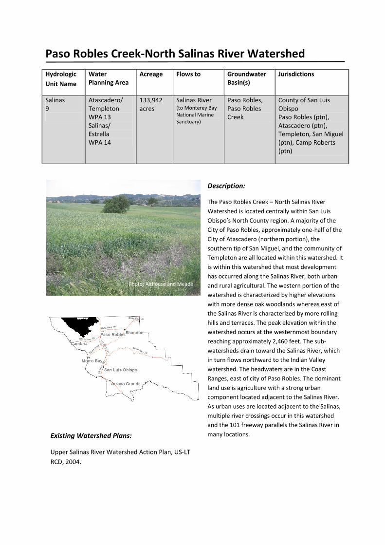
Paso Robles Creek-North Salinas River Watershed Hydrologic Unit Name Water Planning Area Acreage Flows to Groundwater Basin(s) Jurisdictions Salinas 9 Atascadero/ Templeton WPA 13 Salinas/ Estrella WPA 14 133,942 acres Salinas River (to Monterey Bay National Marine Sanctuary) Paso Robles, Paso Robles Creek County of San Luis Obispo Paso Robles (ptn), Atascadero (ptn), Templeton, San Miguel (ptn), Camp Roberts (ptn) Description: The Paso Robles Creek – North Salinas River Watershed is located centrally within San Luis Obispo’s North County region. A majority of the City of Paso Robles, approximately one-half of the City of Atascadero (northern portion), the southern tip of San Miguel, and the community of Templeton are all located within this watershed. It is within this watershed that most development has occurred along the Salinas River, both urban and rural agricultural. The western portion of the watershed is characterized by higher elevations with more dense oak woodlands whereas east of the Salinas River is characterized by more rolling hills and terraces. The peak elevation within the watershed occurs at the westernmost boundary reaching approximately 2,460 feet. The sub- watersheds drain toward the Salinas River, which in turn flows northward to the Indian Valley watershed. The headwaters are in the Coast Ranges, east of city of Paso Robles. The dominant land use is agriculture with a strong urban component located adjacent to the Salinas River. As urban uses are located adjacent to the Salinas, multiple river crossings occur in this watershed and the 101 freeway parallels the Salinas River in many locations. Existing Watershed Plans: Upper Salinas River Watershed Action Plan, US-LT RCD, 2004. Photo: Althouse and Meade
Transcript of Paso Robles, Paso Robles Creek Watershed - US...
Paso Robles Creek-North Salinas River Watershed
Hydrologic
Unit Name
Water
Planning Area
Acreage Flows to Groundwater
Basin(s)
Jurisdictions
Salinas
9
Atascadero/
Templeton
WPA 13
Salinas/
Estrella
WPA 14
133,942
acres
Salinas River (to Monterey Bay
National Marine
Sanctuary)
Paso Robles,
Paso Robles
Creek
County of San Luis
Obispo
Paso Robles (ptn),
Atascadero (ptn),
Templeton, San Miguel
(ptn), Camp Roberts
(ptn)
Description:
The Paso Robles Creek – North Salinas River
Watershed is located centrally within San Luis
Obispo’s North County region. A majority of the
City of Paso Robles, approximately one-half of the
City of Atascadero (northern portion), the
southern tip of San Miguel, and the community of
Templeton are all located within this watershed. It
is within this watershed that most development
has occurred along the Salinas River, both urban
and rural agricultural. The western portion of the
watershed is characterized by higher elevations
with more dense oak woodlands whereas east of
the Salinas River is characterized by more rolling
hills and terraces. The peak elevation within the
watershed occurs at the westernmost boundary
reaching approximately 2,460 feet. The sub-
watersheds drain toward the Salinas River, which
in turn flows northward to the Indian Valley
watershed. The headwaters are in the Coast
Ranges, east of city of Paso Robles. The dominant
land use is agriculture with a strong urban
component located adjacent to the Salinas River.
As urban uses are located adjacent to the Salinas,
multiple river crossings occur in this watershed
and the 101 freeway parallels the Salinas River in
many locations. Existing Watershed Plans:
Upper Salinas River Watershed Action Plan, US-LT
RCD, 2004.
Photo: Althouse and Meade

Paso Robles Creek-North Salinas River Watershed
Characteristics:
Physical Setting
Rainfall Average Annual: 12-18 in, (northeast portion), 25-33 in. (southeast
portion) (NRCS shapefile, 2010)
Air Temperature Summer Range (August 1990-2012): 52°-92°F
Winter Range (December 1990-2012): 32°-61°F
(Paso Robles, NOAA National Climatic Data Center, viewed 2013)
Geology Description Fern Canyon, Neals Spring, Templeton and Asuncion sub-watersheds
are composed of flat highly infiltrative Quaternary materials –
Category #3.
Graves Creek and Upper Paso Robles Creek are steep pre-Quaternary
non-infiltrative headwaters with steep moderately infiltrative early
to mid-Tertiary valleys – Category #5.
Sheepcamp Creek and Summit Creek are composed of steep
moderately infiltrative early to mid-Tertiary fill – Category #8.
Mustard Creek has steep pre-Quaternary non-infiltrative headwaters
with flat highly infiltrative Quaternary valley floor – Category #12.
Upper San Marcos Creek, San Francisco Canyon, Cienega Canyon and
Santa Rita Creek have steep pre-Quaternary non-infiltrative
headwaters – Category #13.
Lower San Marcos Creek, Bethel School and Lower Paso Robles
Creek sub-watersheds have moderately infiltrative early to mid-
Tertiary headwaters with flat Quaternary highly infiltrative valleys –
Category #14 (Bell, pers. comm., 2013).
Groundwater is found in Holocene age alluvium and the Pleistocene
age Paso Robles Formation. Specific yield values in the Paso Robles
Subbasin range from 7 to 11 percent, with an average specific yield
of 9 percent (Fugro West 2001c). DWR (1958) estimated the average
specific yield for the subbasin at 8 percent. DWR (1999) estimated
the average specific yield at 15 percent for the alluvium and 9
percent for the Paso Robles Formation. Holocene age alluvium
consists of unconsolidated, fine- to coarse-grained sand with pebbles
and boulders. This alluvium provides limited amounts of
groundwater and reaches 130 feet thick near the Salinas River, but is
generally less than 30 feet thick in the minor stream valleys (DWR
1999). Its high permeability results in a well production capability
that often exceeds 1,000 gpm (Fugro West, 2001). Groundwater in
Holocene alluvium is mostly unconfined. Pleistocene age Paso Robles
Formation, which is the most important source of groundwater in
the subbasin, is unconsolidated, poorly sorted, and consists of sand,

Paso Robles Creek-North Salinas River Watershed
silt, gravel, and clay (DWR, 1979). This formation reaches a thickness
of 2,000 feet and groundwater within it is generally confined (DWR
1958).
Hydrology
Stream Gage Yes; USGS 11147500 (Salinas River at 13th Street, Paso Robles); USGS
11147070 (Santa Rita Creek near Santa Rita Road); USGS 11147040
(Santa Rita Creek near Old Creek Road); USGS 11147000 (Jack Creek
near Highway 46W)
Hydrology Models Yes; SLO County Flood Control and Water Conservation District,
2008, Paso Robles Groundwater Subbasin Water Banking Feasibility
Study. Todd Engineers, 2013, Paso Robles Groundwater Basin
Update.
Peak Flow Peak flow: 28,400 cfs (USGS)
Base Flow Salinas River: 0-600 cfs (USGS)
Flood Control
Structures
No data identified
Flood Reports The SLO County Flood Control and Water Conservation District
commissioned a community wide master drainage study for
Templeton. The initial and subsequent phases of the study are
intended to characterize existing drainage patterns, analyze flood
problems and identify proposed near and short term solutions
(Fugro, 2010: SLO County Flood Control and Water Conservation
District, 2009) Areas of Heightened
Flood Risk
Templeton lacks a formal drainage system and flood control
infrastructure. Tributaries of Toad Creek collect drainage from the
west
side of the town, and convey them under Highway 101 through
densely developed residential neighborhoods between Highway
101 and Main Street. (County of SLO facilities Inventory, draft viewed
2013)
The freeway culverts at both the south and middle area are
undersized, restricting flow causing potential flooding at the inlets.
The length of Toad Creek between Main Street and the Southern
Pacific Railroad is susceptible to flooding. Urbanization of the north
sub area could have a very significant impact on this flooding. The
area east of Main Street is currently in a Flood Hazard Zone.
(Templeton Design Plan, 1990)
1.38 square miles of Paso Robles is within an identified floodplain of
the Salinas River and its tributaries. San Luis Obispo County has also
identified additional areas in the vicinity of Marquita Road, and an
area bounded by Herdsman Way to the south, West Bethel Road to
the west, and Highway 46 West to the north; and an area north of
Highway 46 West, west of Arbor Road, and south of Live Oak Road as

Paso Robles Creek-North Salinas River Watershed
flood prone (City of Paso Robles, 2005).
Biological Setting
Vegetation Cover Primarily coastal oak woodland consisting mainly of continuous coast
live oak; chamise-redshank chaparral consisting mainly of chamise;
orchards and vineyards with non-native annual grassland; valley oak
woodland consisting mainly of continuous coast live oak and blue
oak; urban; mixed chaparral consisting mainly of continuous
chamise; montane hardwood consisting mainly of continuous coast
live oak. . (SLO County vegetation shapefile, 1990)
Bunchgrass grasslands, wetlands, riparian woodlands, seeps, and
vernal pools are also present. These habitats support uniquely
adapted plants and provide important ecological functions. They also
provide habitat for wildlife, including rare and endangered species.
The Salinas River Riparian corridor is mature, multi-layered
woodland habitat with sycamore (Platanus racemosa), cottonwood
(Populus fremontii), and willow (Salix spp.) that provide habitat for
many species of songbirds and raptors. Riparian canopy also
provides shade that can regulate water temperature (Althouse and
Meade, 2013).
Invasive Species The following invasive species have been identified in the Paso
Robles Creek Watershed: Giant reed grass (Arundo donax), tree of
heaven (Ailanthus altissima), pampas grass (Cortaderia selloana),
Perennial pepperweed (Lepidium latifolium), Skeleton weed
(Chondrilla juncea) , common unicorn (Proboscidea louisianica),
Russian thistle (Salsola tragus), Medusahead (Taeniatherum caput-
medusae), Tamarisk (Tamarix sp.) (Althouse and Meade, 2013).
Special Status
Wildlife and Plants
Cypress Mountain Quadrangle: California red-legged frog-FT;
Steelhead trout-FT
Templeton Quadrangle: San Joaquin kit fox-FE, ST
Adelaida Quadrangle: San Joaquin kit fox-FE, ST; pool fairy shrimp-FT
York Mountain Quadrangle: California red-legged frog-FT
Vernal pool fairy shrimp - FT; least Bell’s vireo – FT, SE; silvery legless
lizard (CDFG species of concern); western pond turtle (CDFW-SSC);
Monterey dusky-footed woodrat (CDFW-SSC); Salinas pocket mouse
(CDFW-SSC); western spadefoot (CDFW-SSC); Coast Range newt
(CDW-SSC); American badger (CDFW-SSC). (CNDDB, viewed 2013)
Key: Federal endangered – FE, Federal threatened – FT, State endangered – SE, State
threatened – ST, California Department of Fish and Wildlife Species of Concern -
CDFW - SSC

Paso Robles Creek-North Salinas River Watershed
Steelhead Streams Yes; Paso Robles Creek, Jack Creek (watershed fisheries report)
Salinas River, Graves Creek, Santa Rita Creek, Summit Creek,
Sheepcamp Creek, San Marcos Creek (US Fish and Wildlife – Critical
Habitat Mapper)
Likely to be present: Willow Creek (NMFS South-Central California
Coast Steelhead Trout Dataset, 2005).
Stream Habitat
Inventory
Yes; DFG, 1997.
Fish Passage Barriers No total, partial, temporal or unassessed barriers on Paso Robles
Creek (CalFish PAD).
PAD ID: 718835- Dam at Hartzell Dam on Santa Rita Creek, Tributary
to Paso Robles Creek. Total Barrier. 14.86411 miles upstream.
PAD ID: 736536- Culvert at Highway 46 on Sheepcamp Creek,
tributary to Paso Robles Creek. Unknown Status
Designated Critical
Habitat
Yes; Paso Robles Creek, Jack Creek, Sheepcamp Creek, Santa Rita
Creek, Graves Creek, San Marcos Creek, and Summit Creek for
Steelhead trout; South-Central California Coast Steelhead Trout
Recovery Plan (50 CFR 226 - National Marine Fisheries Service -
NOAA); Vernal Pool Fairy Shrimp (USFWS Critical Habitat Portal,
viewed 2013)
Habitat Conservation
Plans
Yes; North San Luis Obispo County Habitat Conservation Program,
City of Paso/SLO County, multiple species, initially San Joaquin kit fox
Other Environmental
Resources
Paso Robles Groundwater Basin (SLO County IRWM, 2007)
Land Use
Jurisdictions &
Local Communities
County of San Luis Obispo, City of Atascadero (ptn); City of Paso
Robles (ptn); Templeton; San Miguel (ptn), Camp Roberts (ptn)
% Urbanized 6.7% City of Paso; 6.4% City of Atascadero; 3% Public Facility; 1.7%
Residential Suburban; Less than 1% each Commercial Retail,
Industrial, Recreational, Residential Multi-family, Residential Single
Family, Office Professional and Commercial Service
% Agricultural 62.5%; row crops, vineyards, orchards and rangeland
% Other 9.4% Rural Lands; 7.4% Residential Rural
Planning Areas Salinas River, Adelaida, El-Pomar-Estella Planning Areas
Potential growth
areas
Adelaida, Olsen Ranch, Chandler Ranch, Beechwood, Borkey, Union
Road, Wellsona Area (City of Paso General Plan, 2011)
Templeton
Facilities Present Mission San Miguel (ptn), Paso Robles Waste Water Treatment Plant,
Machado WWTP (San Miguel), Paso Robles Youth Correctional
Facility, Mid State Fair Grounds, Atascadero Mutual Water Company
facilities are found near the Salinas River, at the south end of this
watershed.

Paso Robles Creek-North Salinas River Watershed
Commercial Uses Industrial facilities - North River Road Pit operated by Viborg
Construction; North River Road Pit operated by County of SLO;
Mountain Springs Shale Pit operated by Viborg Construction;
Templeton/Ormonde Sand and Gravel Pit operated by Borzini Sand
and Gravel; Smith Sand Pit operated by Paul Viborg; Hartzell Red
Rock #1 & Hartzell Red Rock #2 Sand and Gravel Pit operated by
Hartzell Ranch; Santa Rita Stone Quarry operated by Santa Rita
Quarry, tourism, agriculture – vineyards, orchards, ranches, Paso
Robles Airport
Demographics
Population 52,460 in watershed (US Census Blocks, 2010)
9,078 in the City of Atascadero (US Census Blocks, 2010)
29,524 in the City of Paso Robles (US Census Blocks, 2010)
7,674 in the community of Templeton (US Census, 2010)
13 in the community of San Miguel (US Census Blocks, 2010)
Race and Ethnicity Watershed: 69.1% Caucasian; 25.1% Latino; 2% Mixed Race; 1.7%
Asian; 1.2% African American; Less than 1% each American Indian
and Pacific Islander (US Census Blocks, 2010)
City of Atascadero: 83.2% Caucasian; 11.4% Latino; 0.4% Black; 0.5%
American Indian and Alaska Native; 2% Asian; 2.2% Mixed Race (US
Census Blocks, 2010)
City of Paso Robles: 58.9% Caucasian; 34.6% Latino; 1.8% Black; 0.5%
American Indian and Alaska Native; 1.8% Asian; 2% Mixed Race (US
Census Blocks, 2010)
Community of Templeton: 79.5% Caucasian; 15.3% Hispanic; 2.2%
Mixed Race; 1.6% Asian; 0.7% Black or African American; 0.5%
American Indian and Alaskan Native (US Census, 2010)
Community of San Miguel: 69% Caucasian; 23% Latino; 7.6%
American Indian and Alaska Native;
Income MHI $67,028 in watershed (interpolated from 9 US Census tracts,
2010)
MHI $49,097 in San Miguel (US Census, 2010)
MHI $57,927 in Paso Robles (US Census, 2010)
MHI $70,820 in Templeton (US Census, 2010)
MHI $68,502 in Atascadero (US Census, 2010)
Disadvantaged
Communities
Yes; San Miguel (DWR); 16.8% of individuals are below poverty level
6.0% of individuals are below poverty level in the watershed (US
Census Tracts, 2010) (interpolated from 13 tracts spanning multiple
watersheds)
8.7% of individuals are below poverty level in Atascadero (2007-2011
American Community Survey 5-Year Estimates)

Paso Robles Creek-North Salinas River Watershed
10.2% of individuals are below poverty level in Paso Robles (2007-
2011 American Community Survey 5-Year Estimates)
4.1% of individuals are below poverty level in Templeton (2007-2011
American Community Survey 5-Year Estimates)
Water Resources
Water Management
Entities
Atascadero Mutual Water Company, Templeton CSD, City of Paso
Robles, San Miguel CSD, outlying areas served by individual wells
Groundwater Yes; Paso Robles Groundwater Basin
Surface Water No public reservoirs.
The rights to surface water flows in the Salinas River and associated
pumping from the alluvium have been fully appropriated by the
State Board and no future plans exist to increase these demands
beyond the current allocations. (Carollo, 2012)
Imported Water The cities of Atascadero, Paso Robles, and Templeton are signors of
the Nacimiento Water Project, which allows them to draw
supplemental water from Lake Nacimiento for their users (Carollo,
2012).
Atascadero Mutual Water Company – 2,000 afy
City of Paso Robles – 4,000 afy
Templeton Community Services District – 250 afy
Recycled/Desalinated
Water
The City of Paso Robles has a wastewater recycling plant in planning
phase, scheduled for completion in 2015 (City of El Paso de Robles,
2003).
Key infiltration zone Salinas River/Highway 46 Recharge Area (SLO County Flood Control
and Water Conservation District, 2008).
“Due to the geology of the area, we’re only able to recapture about
25 percent of the water.” That’s because the city’s wells physically
can’t capture the water fast enough before it trickles out of reach (The San Luis Obispo Tribune, July 17, 2013)
Water budget Yes; Todd Engineers, 2013. Paso Robles Groundwater Basin Update.
Water Uses
Beneficial Uses Paso Robles Creek - Municipal and Domestic Supply (MUN),
Agricultural Supply (AGR), Ground Water Recharge (GWR), Water
Contact Recreation (REC-1), Non-Contact Water Recreation (REC-2),
Wildlife Habitat (WILD), Warm Freshwater habitat (WARM),
Migration of Aquatic Organisms (MIGR), Spawning, Reproduction,
and/or Early Development (SPWN), Threatened, or Endangered
Species (RARE), and Commercial and Sport Fishing (COMM)
San Marcos Creek - Municipal and Domestic Supply (MUN),
Agricultural Supply (AGR), Ground Water Recharge (GWR), Water
Contact Recreation (REC-1), Non-Contact Water Recreation (REC-2),

Paso Robles Creek-North Salinas River Watershed
Wildlife Habitat (WILD), Warm Freshwater habitat (WARM), and
Commercial and Sport Fishing (COMM)
Salinas River (Nacimiento River-Santa Margarita Reservoir) -
Municipal and Domestic Supply (MUN), Agricultural Supply (AGR),
Industrial Process Supply (PRO), Ground Water Recharge (GWR),
Water Contact Recreation (REC-1), Non-Contact Water Recreation
(REC-2), Wildlife Habitat (WILD), Cold Fresh Water Habitat (COLD),
Warm Freshwater habitat (WARM), Migration of Aquatic Organisms
(MIGR), Spawning, Reproduction, and/or Early Development (SPWN),
Threatened, or Endangered Species (RARE) and Commercial and
Sport Fishing (COMM).
(CCRWQCB, 2011)
Other Unique Characteristics
Hot Springs A geothermal pressure aquifer is located approx.. 650 feet below the
surface in the Paso Robles and Templeton areas. The water
contained in this pressure aquifer is hot (122 degrees +), high in TDS
and other minerals including boron. Improper construction of wells
in the area may be contributing to contamination of the upper
aquifer (CCRWQCB, 2002)
Historical Resources Rotta Winery (250 Winery Road, Templeton); York Mountain Winery
(7505 York Mountain Rd, Templeton); San Marcos Cemetery
(Chimney Rock Road & 24th Street West, Paso Robles); Willow Creek
Cemetery (Vineyard & Dover Canyon Roads, Paso Robles); Estrella
Adobe Church (Airport Rd, Paso Robles); Bethel Lutheran Church
(295 Old County Road, Templeton); Geneseo School (moved in
2004); C.H. Phillips House (91 Main Street, Templeton)
(PLN_DES_HISTORIC_POINTS GIS layer)
Camp Roberts Thirteen ponds and reservoirs (65 acres) which are either natural or
artificially created for use as livestock ponds or flood control. A total
of 120 aquatic species representing 64 families of organisms were
recorded from rivers, ponds, and reservoirs on Camp Roberts. Eight
species of fish, 44% of species native to Salinas River drainage, have
been recorded at Camp Roberts from Nacimiento River
Jack Creek Reservoir Over 250 acres of designated Open Space
Los Padres National Forest Ecosystems in Los Padres National Forest range from semi-desert in
interior areas to redwood forest on the coast. Forest vegetation
classified into two major types: chaparral and forested lands.
Provides a diverse wildlife habitat with 23 threatened and
endangered animals. Member of the California Condor Recovery
Program and has been an active player in the reintroduction of
California condors in the wild. The Forest has one endangered plant,
two threatened plant species and 71 sensitive plant species.
Management of riparian vegetation focuses on supporting fish and
wildlife populations. There are over 870,000 acres of livestock

Paso Robles Creek-North Salinas River Watershed
Watershed Codes:
Calwater/DWR
Number
HA Hydrologic
Area Name
HSA Hydrologic
Sub-Area
Name
SWRCB
Number
CDF Super
Planning
CDF Watershed
Name
3309.811406 8 Paso Robles 1 Atascadero 309.81 Atascadero
Lake Graves Creek
3309.811407 8 Paso Robles 1 Atascadero 309.81 Atascadero
Lake Asuncion
3309.811701 8
Paso Robles 1 Atascadero 309.81 Paso Robles
Creek
San Francisco
Canyon
3309.811702 8 Paso Robles 1 Atascadero 309.81 Paso Robles Upper Paso Robles
grazing allotments in the Forest.
Templeton Park, Duveneck
Regional Park (Undeveloped)
County operated day-use recreation areas.
Climate Change
Considerations
San Luis Obispo County expected to become 2-4°F warmer by 2050,
and depending on emissions, 4-8°F warmer by late-century, with
greater warming in summer as compared to winter. Northern and
northeastern parts of the county, especially areas of higher
elevation, could see increases in the area burned annually by wildfire
due to higher temperatures and stress to vegetation from climate
change. The state’s $30 billion agriculture industry could be
disrupted by changes in temperature and rainfall patterns and the
increased pests and diseases that may accompany those changes.
Differential social vulnerabilities, with the elderly, infants, socially
and culturally isolated individuals, and outdoor workers – especially
in the hotter inland areas – experiencing relatively greater exposure,
sensitivity and/or lower adaptive capacity. Threats to agriculture
include higher temperatures causing heat stress to plants, reduced
water availability, potential for increased water costs, more intense
downpours leading to fruit, vegetable and flower damage, increased
risk of soil erosion, increased water demand by plants and animals
and increased risk of pest infestations and spread of invasive plants.
Freshwater and riparian systems will be affected by increased
groundwater pumping, sedimentation, higher peak flows during
severe storms, sensitive species at risk due to stress, negative
impacts on vernal pools, and new dams or dam expansions. Oak
woodlands and coniferous forest may decline due to increased
temperatures, disease, drought and fire (ClimateWise, 2010).
See IRWMP, 2014 Section X. Climate Change

Paso Robles Creek-North Salinas River Watershed
Creek Creek
3309.811703 8 Paso Robles 1 Atascadero 309.81 Paso Robles
Creek Sheepcamp Creek
3309.811704 8 Paso Robles 1 Atascadero 309.81 Paso Robles
Creek Cienega Creek
3309.811705 8 Paso Robles 1 Atascadero 309.81 Paso Robles
Creek Santa Rita Creek
3309.811706 8 Paso Robles 1 Atascadero 309.81 Paso Robles
Creek
Lower Paso Robles
Creek
3309.811707 8 Paso Robles 1 Atascadero 309.81 Paso Robles
Creek Summit Creek
3309.811801 8 Paso Robles 1 Atascadero 309.81 Templeton to
Paso Robles Bethel School
3309.811802 8 Paso Robles 1 Atascadero 309.81 Templeton to
Paso Robles Neals Spring
3309.811803 8 Paso Robles 1 Atascadero 309.81 Templeton to
Paso Robles Golden Hill
3309.811804 8 Paso Robles 1 Atascadero 309.81 Templeton to
Paso Robles Fern Canyon
3309.811805 8 Paso Robles 1 Atascadero 309.81 Templeton to
Paso Robles Mustard Creek
3309.811806 8 Paso Robles 1 Atascadero 309.81 Templeton to
Paso Robles Templeton
3309.811901 8 Paso Robles 1 Atascadero 309.81 Lower
Nacimiento
River
Lower San Marcos
Creek
3309.811908 8 Paso Robles 1 Atascadero 309.81 Lower
Nacimiento
River
Upper San Marcos
Creek
Source: Excerpt from California Interagency Watershed Map of 1999, Calwater 2.2.1 (CA Resource Agency, 2004
Update)
Major Changes in the Watershed
• In 1797, Franciscan padres built Mission San Miguel near the Paso Robles hot springs to take
advantage of the waters curative powers. They constructed a crude abutment of logs
around the edge of the main spring and an aqueduct that brought the water to the mission.
Later, the main spring became the center of the town of Paso Robles. With the demise of
the Mission, the Mexican government granted the original 10,519 hectare (25,':;1':;13 acres)
of the Rancho de Paso Robles (Ranch of the Pass of the Oaks) to Pedro Narvaez in 1844. In
1857, with the decaying logs of the padres still at the spring, the Blackburn brothers and
partner purchased the rancho for $8,000. A rough bathhouse was built over the main
sulphur spring, a stagecoach station was established, and a small hotel was built to
accommodate occasional travelers.

Paso Robles Creek-North Salinas River Watershed
• In 1886, the Southern Pacific Railroad passed the hotel, and in 1889, the City of Paso Robles
was incorporated. That same year, the Blackburns began construction of the Hotel El Paso
de Robles near the main sulphur spring.
• Adelaida area first settled in the 1870’s for immigrating European farmers. Included a
general store, post office, school, church, and cemetery at its height.
• Mining activity important: minerals extracted include cinnabar (mercury-bearing ore),
quicksilver, and limestone.
• On September 3, 1942 construction began on the Airfield, which was to be used as a Marine
Corps Bomber Base. On April 8, 1943, the field was dedicated as Estrella Army Airfield to be used
by the Army Air Corps. Estrella Army Airfield consisted of 1259 acres of land, two 4,700-foot long
runways, an operations building and a small, three bay fire station.
• The Marine Corps Units occupied buildings to the west, across Airport Road in what is now the
California Youth Authority. On August 29, 1947 the Federal Government transferred 1,057 acres
to the County of San Luis Obispo to be used as a commercial airport, and 202 acres and buildings
to the State of California to be used as a Correctional Facility.
• The County of San Luis Obispo extended runway 01/19 from 4,700 feet to 6,009 feet; installed
high intensity lights; and built a large hangar, ten T-Hangars and a terminal building between
1949 and 1952. In 1952 commercial air service for San Luis Obispo County began, with
Southwest Airways serving the area, became Pacific Airlines, and later yet merged into Hughes
Air West. This service continued until 1974.
• On May 7, 1973, the County of San Luis Obispo sold the airport to the City of Paso Robles for
$1.00. At that time the County was unable to derive enough income to support the cost of
running the airport. The City subdivided unused land into 81 parcels for commercial
development. The City formed an all-volunteer Fire, Crash and Rescue Department to serve the
airport and the surrounding area. The City took over the water wells and the sewer treatment
plant from the State to serve both the Airport and the Youth Authority. In 1973 there were four
businesses employing 22 people on the airport. Today the Paso Robles Municipal Airport houses
almost 40 businesses, employing over 700 people.
•
Watershed Heath by Major Tributary
Tributary Name Ephemeral /
Perennial
303d Listed/
TMDLs
Pollution Sources
NP (non-point)
MP (Major Point)
Environmental
Flows
Salinas River Intermittent
Perennial
Yes, Sodium and
Chloride
Asuncion Unknown None n/a
Bethel School Unknown None n/a
Cienega Canyon Unknown None n/a
Fern Canyon Unknown None n/a
Graves Creek Unknown None n/a
Lower Paso Robles
Creek
Unknown None n/a
Lower San Marcos
Creek
Unknown None n/a

Paso Robles Creek-North Salinas River Watershed
Mustard Creek Unknown None n/a
Neals Spring Unknown None n/a
San Francisco
Canyon
Unknown None n/a
Santa Rita Creek Unknown None n/a
Sheepcamp Creek Unknown None n/a
Summit Creek Unknown None n/a
Templeton Unknown None n/a
Upper Paso Robles
Creek
Unknown None n/a
Upper San Marcos
Creek
Unknown None n/a
Watershed Health by Major Groundwater Basin
Groundwater
Basin
Estimated Safe
Yield (Master
Water Report)
Water Availability
Constraints
Drinking Water
Standard
Exceedance
Water Quality
Objective
Exceedance
Paso Robles 97,700 AF (SLO
County RCS,
2011).
Physical
Limitations, Water
Rights, Water
Quality Issues
(Carollo, 2012).
Yes; see
description below.
None (CCRWQCB,
2011
Groundwater Quality Description: The predominant cations are calcium and sodium and the
predominant anion is bicarbonate (DWR 1981; Fugro West, 2001b). Analysis of 48 public supply wells in
the subbasin show an average Total Dissoved Solid (TDS) content of 614 ppm and a range of 346 to
1,670 ppm.
In one study, (Fugro West 2001b), 23 of 74 samples collected exceeded one or more drinking water
standards. The maximum contaminant level (MCL) for nitrate was exceeded in 4 samples (Fugro West,
2001b). Water quality trends indicate an increasing concentration of TDS and chloride in the deep,
historically artesian aquifer northeast of Creston (Carollo, 2012).
Another major problem is the unpredictable occurrence of hydrogen sulfide in the ground water (DWR,
1981)
Critical Issues
Issue Potential Causes Referenced from
significant water level declines range of groundwater uses in
close proximity, including
agricultural irrigation, municipal
supply wells, golf course
Carollo, 2012

Paso Robles Creek-North Salinas River Watershed
irrigation, and a relatively dense
aggregation of rural “ranchette”)
users
Groundwater Quality high concentrations of TDS,
chlorides, sulfates, and boron
Carollo, 2012
Groundwater: Paso Robles Groundwater Basin
According to multiple studies of this basin, annual basin pumping is now at or near the basin’s perennial
yield (Paso Robles Groundwater Management Plan, 2011). From 1997–2009, water levels declined on
average of 2–6 feet per year, depending on the location. A Todd Engineering monitoring report (2007)
indicated that the Basin was not approaching the safe yield level and some areas were experiencing
significant declines in groundwater elevations. A later study completed in 2009 suggested groundwater
pumping was approaching the safe yield level of the Basin. The 2010 Resource Capacity Study prepared
by the San Luis Obispo County Planning Department stated that the Basin is now near or at perennial
yield levels. The County Board of Supervisors certified a Level of Severity III for the Paso Robles Basin in
October, 2012, due to declining water levels. In August 2013, the County Board of Supervisors adopted
an urgency ordinance to limit new draws from the Paso Robles Groundwater basin.
The Paso Robles Groundwater Basin encompasses an area of approximately 790 square miles and is the
primary, and in many places the only, source of water available to property owners throughout
Northern San Luis Obispo County. The basin extends from the Garden Farms area south of Atascadero to
San Ardo in Monterey County, and from the Highway 101 corridor east to Shandon. The basin supplies
water for 29% of SLO County’s population and an estimated 40% of the agricultural production of the
County (Paso Robles Groundwater Basin Blue Ribbon Committee, 2013).
Paso Robles, Atascadero, and Templeton draw their water from the groundwater basin (primarily the
Atascadero sub-basin), the underflow of the Salinas River and from the Nacimiento Pipeline Project. The
remaining communities (Shandon, San Miguel, Creston, Bradley, Camp Roberts, Whitley Gardens, and
Garden Farms) are entirely dependent on the groundwater basin for their water supply.
An established bi-annual well monitoring program overseen by the SLO County Flood Control and Water
Conservation District reported these water declines in groundwater dependent communities (Through
April, 2013):
a. Shandon: Water levels have dropped approximately 17 feet from 2011 to 2013.
b. Creston: Water levels have dropped approximately 25 feet from 2011 to 2013.
c. Estrella: Water levels have dropped approximately 25 feet from 2011 to 2013.
d. San Juan: Water levels have dropped approximately 5 feet from 2012 to 2013.
Bibliography:
Technical Reports
Althouse and Meade, Inc. 2000-2013. Biological Reports and Field Data.
Paso Robles Creek-North Salinas River Watershed
Burch, S. H. and D. L. Durham. (1970). Complete Bouguer Gravity and General Geology of the Bradley,
San Miguel, Adelaida, and Paso Robles Quadrangles, California. Geological Survey Professional
Paper 646-B. Washington, D.C.
CAL FIRE/San Luis Obispo County Fire. (2013). Unit Strategic Fire Plan.
http://www.calfireslo.org/Documents/Plans/UnitFirePlan/SLU_Unit_Fire_Plan_v13_1_(Complet
e).pdf
California Department of Water Resources. (2003). California’s Groundwater Bulletin 118 Update 2003.
http://www.water.ca.gov/pubs/groundwater/bulletin_118/california's_groundwater__bulletin_
118_-_update_2003_/bulletin118_entire.pdf
California Department of Conservation, Mines, and Geology. (1983). Resource Investigation of Low- and
Moderate-Temperature Geothermal Areas in Paso Robles, SLO County, CA.
http://repository.stategeothermaldata.org/metadata/record/98ddf901b9782a25982e01af3b06f
b20/file/ofr_83-11_report_8plates.pdf
California Department of Water Resources. (2009). San Luis Obispo County Flood Control and Water
Conservation District Guide to Implementing Flood Control Projects.
http://www.slocountywater.org/site/Hydraulic%20Planning/pdf/Guide%20to%20Implementing
%20Flood%20Control%20Projects.pdf
Carollo. (2012). San Luis Obispo County Master Water Report.
http://www.slocountywater.org/site/Frequent%20Downloads/Master%20Water%20Plan
Chipping, D. H. (1987). The Geology of San Luis Obispo County: A Brief Description and Guide. Cal Poly
Press. San Luis Obispo, CA.
City of El Paso de Robles. (2003). City of El Paso de Robles General Plan.
http://www.prcity.com/government/departments/commdev/planning/general-plan-final.asp
City of ElPaso Robles. (2005). Hazard Mitigation Plan.
http://www.prcity.com/government/pdf/LHMP/.pdf
City of El Paso de Robles. (2011). El Paso de Robles Housing Element.
http://www.prcity.com/government/departments/commdev/housing/pdf/2011HousingElemen
t.pdf
ClimateWise. (2010). Integrated climate change adaptation planning in San Luis Obispo County.
http://www.lgc.org/adaptation/slo/docs/SLOClimateWiseFinal.pdf
Fugro West, Inc. (2010). Paso Robles Groundwater Basin Water Balance Review and Update.
http://www.slocountywater.org/site/Water%20Resources/Reports/pdf/Paso%20Robles%20Gro
undwater%20Basin%20Water%20Balance%20Review%20and%20Update.pdf
Paso Robles Creek-North Salinas River Watershed
Monterey County. (2004). Upper Salinas Watershed Action Plan.
http://www.mcwra.co.monterey.ca.us/Agency_data/USLS%20RCD%20Watershed%20Action%2
0Plan/Chapter%201%20-%20Introduction.pdf
NOAA Fisheries. (2012). South-Central Ca Coast Steelhead Recovery Plan.
http://swr.nmfs.noaa.gov/recovery/centralvalleyplan.htm
National Marine Fisheries Service. (2005) South-Central California Coast Steelhead Trout Dataset.
Surface Water Ambient Monitoring Program. (2013). CalWater 2.2.1
http://swamp.mpsl.mlml.calstate.edu/resources-and-downloads/database-management-
systems/swamp-25-database/templates-25/gis-shapefile-layers
Paso Robles Groundwater Basin – Groundwater Advisory Committee. (2011). Paso Robles Basin
Groundwater Management Plan.
http://www.slocounty.ca.gov/Assets/PL/PR+Groundwater/gwp.pdf
Regional Water Quality Control Board Central Coast Region 3. (2002). Watershed management Initiative.
http://www.waterboards.ca.gov/centralcoast/water_issues/programs/wmi/docs/wmi2002_fina
l_document_revised_1_22_02.pdf
San Luis Obispo County. (1990). Templeton Community Design Plan.
http://www.slocounty.ca.gov/Assets/PL/Design+Plans/Templeton+Design+Plan.pdf
San Luis Obispo County. (2003). Adelaida Planning Area.
http://www.slocounty.ca.gov/Assets/PL/Area+Plans/Adelaida+Inland+Area+Plan.pdf
San Luis Obispo County Flood Control and Water Conservation District. (2005). Water Years 2001-02 and
2002-03 Hydrologic Report.
http://www.slocountywater.org/site/Water%20Resources/Reports/pdf/Hydrologic%20Report%
202002.pdf
San Luis Obispo County Flood Control and Water Conservation District. (2008). Paso Robles
Groundwater Subbasin Water Banking Feasibility Study.
http://www.prcity.com/government/departments/publicworks/water/pdf/GBMP/reports/Wate
rBankingFeasibilityStudyApr08.pdf
San Luis Obispo County. (2009). Salinas River Area Plan, SLO County.
http://www.slocounty.ca.gov/Assets/PL/Area+Plans/Salinas+River+Inland+Area+Plan.pdf
San Luis Obispo County Board of Supervisors. (2011). Water Supply in the Paso Robles Groundwater
Basin. http://www.slocounty.ca.gov/Assets/PL/PR+Groundwater/rcs.pdf
San Luis Obispo County. (2013). North County Area Plan.
http://www.slocounty.ca.gov/Assets/PL/Draft+Plans/North.pdf

Paso Robles Creek-North Salinas River Watershed
San Luis Obispo County General Plan. (2011).
http://www.slocounty.ca.gov/planning/General_Plan__Ordinances_and_Elements.htm
Stillwater Sciences. (2011). Development and Implementation of Hydromodification Control
Methodology. Watershed Characterization Part 1: Watershed Charcterization Part 1.
Precipitation and Landscape.
http://www.waterboards.ca.gov/rwqcb3/water_issues/programs/stormwater/docs/lid/hydrom
od_lid_docs/watershed_character_part_1.pdf
Titus R. G., D. C. Erman and W. M. Snider. (2013). History of steelhead in California coastal drainages
south of San Francisco Bay. In preparation.
The Tribune of San Luis Obispo: Paso sends Nacimiento water to river to help recharge supply, July 17,
2011: http://www.sanluisobispo.com/2013/07/17/2587046/paso-sends-nacimiento-water-
to.html#storylink=cpy
Upper Salinas – Las Tablas Resource Conservation District. (2002). Upper Salinas and Tributaries
Watershed Fisheries Report and Early Actions. http://www.us-
ltrcd.org/downloads/Watershed_Fisheries_Report.pdf
Upper Salinas – Las Tablas Resource Conservation District. (2004). Upper Salinas River Watershed Action
Plan. US-LT RCD.
http://www.mcwra.co.monterey.ca.us/Agency_data/USLS%20RCD%20Watershed%20Action%2
0Plan/Chapter%201%20-%20Introduction.pdf
U. S. Environmental Protection Agency. (2011). Climate Change Handbook for Regional Water Planning.
http://www.water.ca.gov/climatechange/CCHandbook.cfm
GIS Layers
Aerial Information Systems. (2008). San Luis Obispo County Vegetation Polygons.
National Hydrography Dataset. (2013). San Luis Obispo County Streams.
San Luis Obispo County Environmental Division. (2013). San Luis Obispo County Mines.
San Luis Obispo County Planning and Building Geographic Technology and Design. (2013). Various GIS
shapefiles and layers.
State Water Resources Control Board. (2013). Water Rights/Fully Appropriated Streams.
United States Census Bureau Master Address File/Topologically Integrated Geographic Encoding and
Referencing Database. (2013). 2010 Census Tracts.
United States Department of Agriculture. (2013). Soil Survey Geographic Database

Paso Robles Creek-North Salinas River Watershed
Databases
Department of Fish and Game. (2013). California Natural Diversity Database.
http://www.dfg.ca.gov/biogeodata/cnddb/
National Atlas of the United States. (2013). Streamer. http://www.nationalatlas.gov/streamer
National Oceanic and Atmospheric Administration. (2013). National Climatic Data Center.
http://www.ncdc.noaa.gov/
NOAA. National Marine Fisheries Service. 50 CFR 226. (2013).
National Marine Fisheries Service. (2005) South-Central California Coast Steelhead Trout Dataset.
U. S. Fish and Wildlife Service. (2013). Critical Habitat Portal. http://criticalhabitat.fw.gov/crithab.
U. S. Fish and Wildlife Service. (2013). National Wetlands Inventory. http://www.fws.gov/wetlands/
U.S. Geological Survey. (2013). California Water Science Center. http://ca.water.usgs.gov/
U.S. Geological Survey. (2013). Protected Areas Database. http://gapanalysis.usgs.gov/padus/
Significant Studies in Progress:
Regional Board Salt Balance Study – define the need and methods of salt reduction