Part I: Caribbean Contours Caribbean Introductions ... Introductions: History, Geography, Ecology...
15
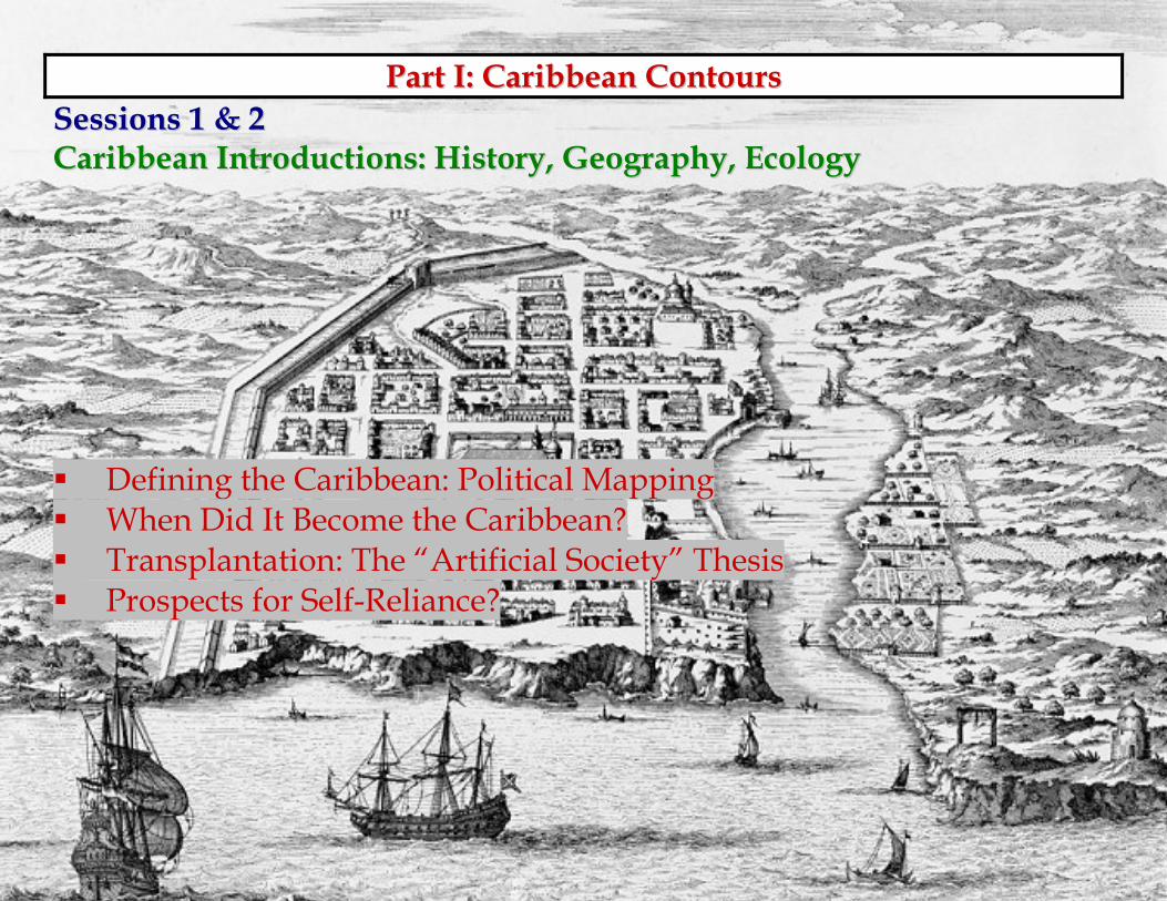
1 P P a a r r t t I I : : C C a a r r i i b b b b e e a a n n C C o o n n t t o o u u r r s s S S e e s s s s i i o o n n s s 1 1 & & 2 2 C C a a r r i i b b b b e e a a n n I I n n t t r r o o d d u u c c t t i i o o n n s s : : H H i i s s t t o o r r y y , , G G e e o o g g r r a a p p h h y y , , E E c c o o l l o o g g y y D D e e f f i i n n i i n n g g t t h h e e C C a a r r i i b b b b e e a a n n : : P P o o l l i i t t i i c c a a l l M M a a p p p p i i n n g g W W h h e e n n D D i i d d I I t t B B e e c c o o m m e e t t h h e e C C a a r r i i b b b b e e a a n n ? ? T T r r a a n n s s p p l l a a n n t t a a t t i i o o n n : : T T h h e e “ “ A A r r t t i i f f i i c c i i a a l l S S o o c c i i e e t t y y ” ” T T h h e e s s i i s s P P r r o o s s p p e e c c t t s s f f o o r r S S e e l l f f - - R R e e l l i i a a n n c c e e ? ?
Transcript of Part I: Caribbean Contours Caribbean Introductions ... Introductions: History, Geography, Ecology...
1
PPaarrtt II:: CCaarriibbbbeeaann CCoonnttoouurrss SSeessssiioonnss 11 && 22 CCaarriibbbbeeaann IInnttrroodduuccttiioonnss:: HHiissttoorryy,, GGeeooggrraapphhyy,, EEccoollooggyy DDeeffiinniinngg tthhee CCaarriibbbbeeaann:: PPoolliittiiccaall MMaappppiinngg WWhheenn DDiidd IItt BBeeccoommee tthhee CCaarriibbbbeeaann?? TTrraannssppllaannttaattiioonn:: TThhee ““AArrttiiffiicciiaall SSoocciieettyy”” TThheessiiss PPrroossppeeccttss ffoorr SSeellff--RReelliiaannccee??
2
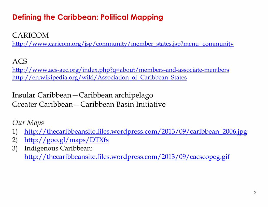
Defining the Caribbean: Political Mapping CARICOM http://www.caricom.org/jsp/community/member_states.jsp?menu=community ACS http://www.acs-aec.org/index.php?q=about/members-and-associate-members http://en.wikipedia.org/wiki/Association_of_Caribbean_States Insular Caribbean—Caribbean archipelago Greater Caribbean—Caribbean Basin Initiative Our Maps 1) http://thecaribbeansite.files.wordpress.com/2013/09/caribbean_2006.jpg 2) http://goo.gl/maps/DTXfs 3) Indigenous Caribbean:
http://thecaribbeansite.files.wordpress.com/2013/09/cacscopeg.gif
3
From the Bahamas to Trinidad, and the mainland territories of Belize, Guyana, Suriname, and French Guiana
Defining the extent of the Caribbean has long been a contentious
subject.
“the Caribbean” is not just a place, it is a sociohistorical category a cultural zone many Caribbeans
“West Indies” or “Caribbean”? 1940s-1960s West Indies Federation, West Indies Cricket Team, University of the
West Indies, British West Indian Airways, etc. US expansion, redefinition Anglo-American Caribbean Commission in 1942 US President Ronald Reagan’s Caribbean Basin Initiative Caribbean Free Trade Association (CARIFTA) in the 1960s, and
CARICOM, and the Caribbean Development Bank in the 1970s. there is no one “correct” definition: content depends on context
4
Spanish-speaking “Caribbean”: Hispanic or African?
Edgardo Rodríguez Julio (1987):
“For us Puerto Ricans the term Antillean has clear significance, but
not the terms Caribbean or Caribbeanness. The former makes us part of the historical and cultural experience of the Greater Antilles, the latter ... imposes on us a suprahistorical category, an invented object of a sociological, anthropological and ethnological character that is Anglophone in origin, and that functions against the colonized person.”
French-speaking Caribbean: Antillean
http://en.wikipedia.org/wiki/Antillia
The Dutch islands: “Antilles”
Fragmented and heterogeneous region.
5
37 million people 28 distinct political entities 16 independent states 22 countries have populations of under one million Although the majority of Caribbean entities are English speaking, the
majority of the population is Spanish speaking, with French being second in importance.
Independent states: Antigua, the Bahamas, Barbados, Belize, Cuba,
Dominica, the Dominican Republic, Grenada, Guyana, Haiti, Jamaica, Saint Lucia, Saint Kitts-Nevis, Saint Vincent and the Grenadines, Suriname, and Trinidad and Tobago.
French “departments”: French Guiana, Guadeloupe, and Martinique
Netherlands: Saba, Saint Martin (shared with the French), Saint
Eustatius, Curaçao, Bonaire, and Aruba
6
USA: Puerto Rico is associated with the United States; U.S. Virgin Islands
UK colonies: The British Virgin Islands, the Cayman Islands,
Montserrat, and the Turks and Caicos islands
7
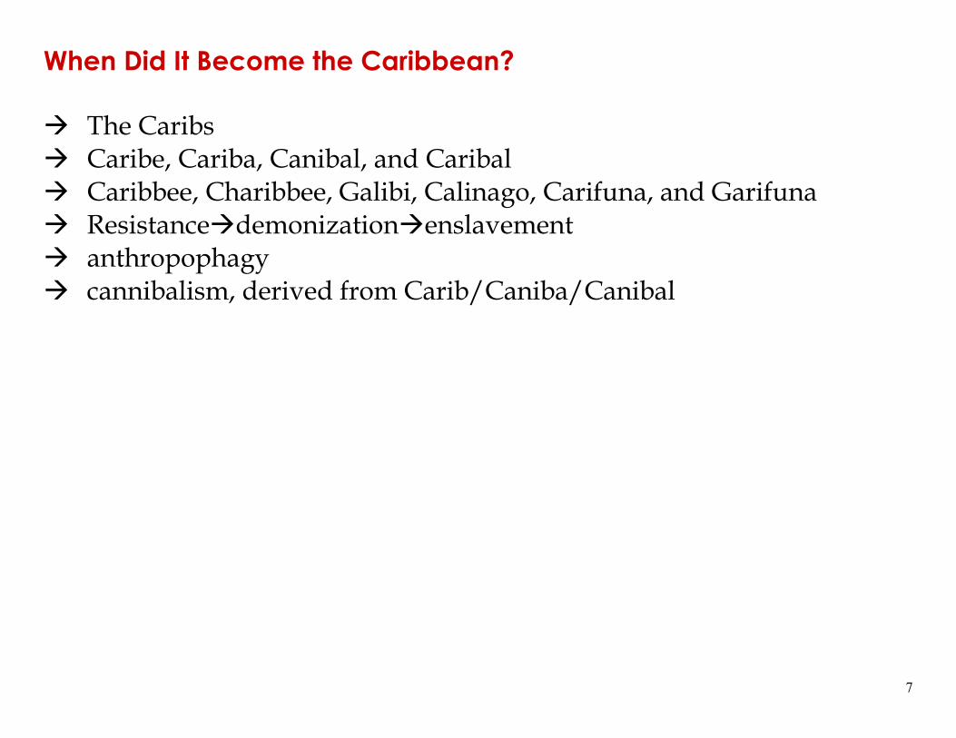
When Did It Become the Caribbean?
The Caribs Caribe, Cariba, Canibal, and Caribal Caribbee, Charibbee, Galibi, Calinago, Carifuna, and Garifuna Resistance demonization enslavement anthropophagy cannibalism, derived from Carib/Caniba/Canibal
8
Evolution of the political naming of the region: 1507, “Western Ocean”, Latin:
http://www.caribmap.org/index.php?id=wies&link=1507-wi-waldseemuller&src=&sub= 1513, “Western Ocean”, Latin:
http://www.caribmap.org/index.php?id=wies&link=1513-wi-waldseemuller&src=&sub= 1579, “Carib Gulf”, Italian map in Latin:
http://www.caribmap.org/index.php?id=wies&link=1579-wi-ortelius&src=&sub= 1635, “American Islands in the Northern Ocean”, Dutch map in Latin:
http://www.caribmap.org/index.php?id=wies&link=1635-wi-blaeu&src=&sub= 1656, “The Antillean Islands, between the Lucayans and Caribs”, French:
http://www.caribmap.org/index.php?id=wies&link=1635-wi-blaeu&src=&sub= 1659, “West Indies”, Dutch:
http://www.caribmap.org/index.php?id=wies&link=1659-westindies-doncker&src=&sub= 1659, “Carib Islands”, Dutch:
http://www.caribmap.org/index.php?id=wies&link=1659-wi-doncker&src=&sub= 1680, “Caribe Islands”, English:
http://www.caribmap.org/index.php?id=wies&link=1680-westindies-thornton&src=&sub= 1680, “Islands in America, of the Spanish, French, English, Dutch, and of
the natives of the country”, Italian: http://www.caribmap.org/index.php?id=wies&link=1680-wi-freschot&src=&sub=
9
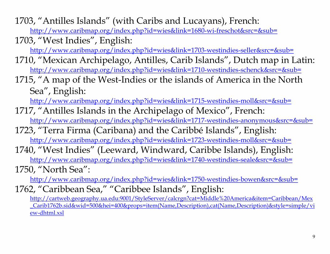
1703, “Antilles Islands” (with Caribs and Lucayans), French: http://www.caribmap.org/index.php?id=wies&link=1680-wi-freschot&src=&sub=
1703, “West Indies”, English: http://www.caribmap.org/index.php?id=wies&link=1703-westindies-seller&src=&sub=
1710, “Mexican Archipelago, Antilles, Carib Islands”, Dutch map in Latin: http://www.caribmap.org/index.php?id=wies&link=1710-westindies-schenck&src=&sub=
1715, “A map of the West-Indies or the islands of America in the North Sea”, English: http://www.caribmap.org/index.php?id=wies&link=1715-westindies-moll&src=&sub=
1717, “Antilles Islands in the Archipelago of Mexico”, French: http://www.caribmap.org/index.php?id=wies&link=1717-westindies-anonymous&src=&sub=
1723, “Terra Firma (Caribana) and the Caribbé Islands”, English: http://www.caribmap.org/index.php?id=wies&link=1723-westindies-moll&src=&sub=
1740, “West Indies” (Leeward, Windward, Caribbe Islands), English: http://www.caribmap.org/index.php?id=wies&link=1740-westindies-seale&src=&sub=
1750, “North Sea”: http://www.caribmap.org/index.php?id=wies&link=1750-westindies-bowen&src=&sub=
1762, “Caribbean Sea,” “Caribbee Islands”, English: http://cartweb.geography.ua.edu:9001/StyleServer/calcrgn?cat=Middle%20America&item=Caribbean/Mex_Carib1762b.sid&wid=500&hei=400&props=item(Name,Description),cat(Name,Description)&style=simple/view-dhtml.xsl
10
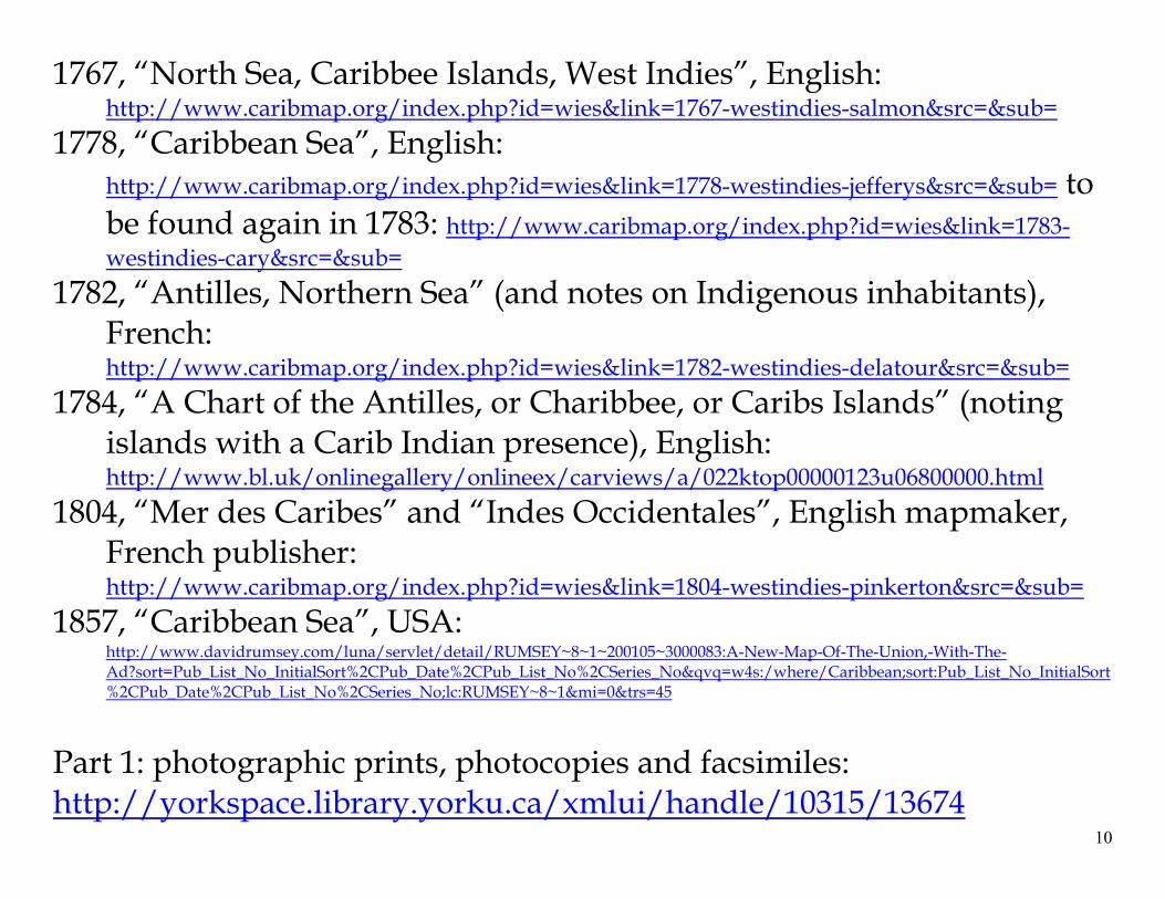
1767, “North Sea, Caribbee Islands, West Indies”, English: http://www.caribmap.org/index.php?id=wies&link=1767-westindies-salmon&src=&sub=
1778, “Caribbean Sea”, English: http://www.caribmap.org/index.php?id=wies&link=1778-westindies-jefferys&src=&sub= to be found again in 1783: http://www.caribmap.org/index.php?id=wies&link=1783-westindies-cary&src=&sub=
1782, “Antilles, Northern Sea” (and notes on Indigenous inhabitants), French: http://www.caribmap.org/index.php?id=wies&link=1782-westindies-delatour&src=&sub=
1784, “A Chart of the Antilles, or Charibbee, or Caribs Islands” (noting islands with a Carib Indian presence), English: http://www.bl.uk/onlinegallery/onlineex/carviews/a/022ktop00000123u06800000.html
1804, “Mer des Caribes” and “Indes Occidentales”, English mapmaker, French publisher: http://www.caribmap.org/index.php?id=wies&link=1804-westindies-pinkerton&src=&sub=
1857, “Caribbean Sea”, USA: http://www.davidrumsey.com/luna/servlet/detail/RUMSEY~8~1~200105~3000083:A-New-Map-Of-The-Union,-With-The-Ad?sort=Pub_List_No_InitialSort%2CPub_Date%2CPub_List_No%2CSeries_No&qvq=w4s:/where/Caribbean;sort:Pub_List_No_InitialSort%2CPub_Date%2CPub_List_No%2CSeries_No;lc:RUMSEY~8~1&mi=0&trs=45
Part 1: photographic prints, photocopies and facsimiles: http://yorkspace.library.yorku.ca/xmlui/handle/10315/13674
11
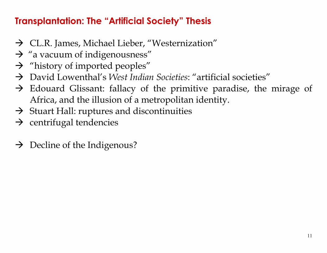
Transplantation: The “Artificial Society” Thesis
CL.R. James, Michael Lieber, “Westernization” “a vacuum of indigenousness” “history of imported peoples” David Lowenthal’s West Indian Societies: “artificial societies” Edouard Glissant: fallacy of the primitive paradise, the mirage of
Africa, and the illusion of a metropolitan identity. Stuart Hall: ruptures and discontinuities centrifugal tendencies
Decline of the Indigenous?
12
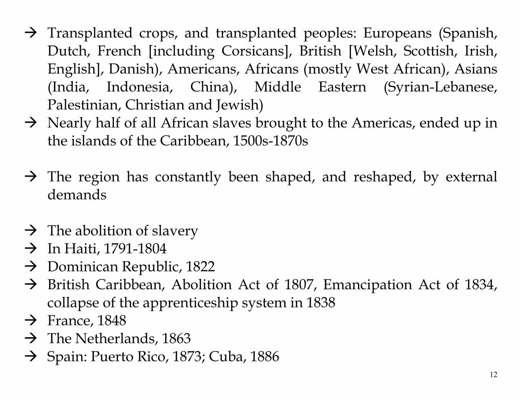
Transplanted crops, and transplanted peoples: Europeans (Spanish, Dutch, French [including Corsicans], British [Welsh, Scottish, Irish, English], Danish), Americans, Africans (mostly West African), Asians (India, Indonesia, China), Middle Eastern (Syrian-Lebanese, Palestinian, Christian and Jewish)
Nearly half of all African slaves brought to the Americas, ended up in the islands of the Caribbean, 1500s-1870s
The region has constantly been shaped, and reshaped, by external
demands
The abolition of slavery In Haiti, 1791-1804 Dominican Republic, 1822 British Caribbean, Abolition Act of 1807, Emancipation Act of 1834,
collapse of the apprenticeship system in 1838 France, 1848 The Netherlands, 1863 Spain: Puerto Rico, 1873; Cuba, 1886
13
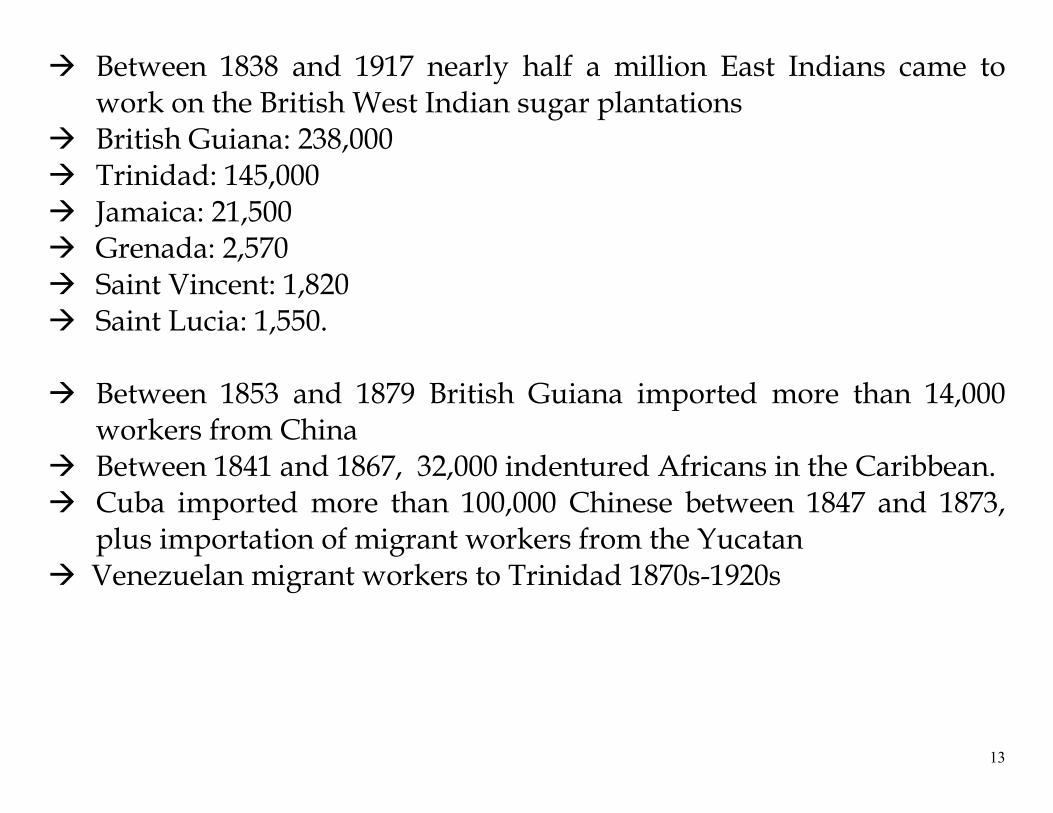
Between 1838 and 1917 nearly half a million East Indians came to work on the British West Indian sugar plantations
British Guiana: 238,000 Trinidad: 145,000 Jamaica: 21,500 Grenada: 2,570 Saint Vincent: 1,820 Saint Lucia: 1,550.
Between 1853 and 1879 British Guiana imported more than 14,000
workers from China Between 1841 and 1867, 32,000 indentured Africans in the Caribbean. Cuba imported more than 100,000 Chinese between 1847 and 1873,
plus importation of migrant workers from the Yucatan Venezuelan migrant workers to Trinidad 1870s-1920s
14
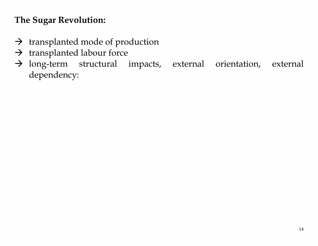
The Sugar Revolution:
transplanted mode of production transplanted labour force long-term structural impacts, external orientation, external
dependency:
15
Prospects for Self-Reliance?
The natural resources of the Caribbean are extremely limited
Limited support for agriculture
Industrialization
Taste for foreign goods, plus impact of globalization on currencies and trade


![[2012] CCJ 1 (OJ) IN THE CARIBBEAN COURT OF …. Jaiprakash Benie, ... The Caribbean Court of Justice ... Suriname issued a Ministerial Order suspending for an indefinite time the](https://static.fdocuments.in/doc/165x107/5af758377f8b9ae9488ff966/2012-ccj-1-oj-in-the-caribbean-court-of-jaiprakash-benie-the-caribbean.jpg)