Part 6 Local Area Plans - City of Gold Coast · Ver.1.2 Chevron Island 1 of 32 Part 6 Local Area...
32
Ver.1.2 Chevron Island 1 of 32 Part 6 Local Area Plans Division 2 Local Area Plans Chapter 7 Chevron Island 1.0 Intent The purpose of this Local Area Plan (LAP) is to provide a planning framework to guide development within Chevron Island which recognises the central location of the island relative to major centres within the Gold Coast City. Chevron Island is located within walking distance of the Surfers Paradise central area, the Bundall Office and Showroom Precincts, the Gold Coast City Council administration centre and the Gold Coast City Arts Centre at Evandale. As the City's population grows and consolidates, the locational advantages of Chevron Island will cause it to be increasingly desirable for residential purposes. This LAP seeks to facilitate an increase in residential density on the island, in a way that maintains the local amenity for residents, promotes the use of transport modes other than the private vehicle, and also provides an increased variety of building types and styles. This LAP seeks to achieve a distinctive urban design form on Chevron Island that emphasises and delivers 'a sense of island'. It proposes to do this by encouraging a concentration of taller buildings within the centre of Chevron Island, with lower building heights on the water's edge. It is also intended to maximise the open space between buildings to promote views, cooling breezes and a sense of openness. This LAP also provides for the expansion of the existing commercial area on Thomas Drive to the river front properties to the south. There is to be no significant expansion of the commercial area along Thomas Drive. Chevron Island is recognised as a local centre in this Planning Scheme. Accordingly, any retail or office expansion will be limited to that which services the needs of the increased resident population. However, there will continue to be opportunities for the expansion of cafes, restaurants and other low key entertainment facilities that may have a wider service catchment. Council will not support intensive commercial activities that are beyond a local centre scale. Such developments will be expected to locate in the nearby centres of Surfers Paradise, Bundall or Southport. This LAP is intended to be instrument of change. Its primary purpose is to provide a framework for growth that will result in an attractive, high amenity form of development, which takes advantage of the accessibility advantages of the location. The LAP also provides a mechanism to fund infrastructure improvements that are aimed at providing appropriate infrastructure necessary to service the anticipated growth, as well as complementing and improving pedestrian and cyclist facilities for the increased residential population. Access to high quality pedestrian and cycle facilities is a central component of this LAP as, without such facilities, the existing road infrastructure will become congested. 2.0 Application 2.1 This LAP applies to all development subject to the Planning Scheme and located within the LAP area, as indicated in Chevron Island LAP Map 7.1 – Boundary. 2.2 The Table of Development indicated in Clause 6.0 identifies the level of assessment for development occurring within this LAP area. 2.3 The codes that may be relevant to the assessment of development in this LAP area are listed in Clause 7.0. 2.4 It should be noted that self assessable development is consistent with the intent and Desired Environmental Outcomes (DEOs) of this LAP, and therefore need only comply with the acceptable solutions of the Chevron Island LAP Place Code contained in Clause 8.0 and any other acceptable solutions identified in the relevant codes explicitly referred to in Subclause 7.1. 3.0 Desired Environmental Outcomes 3.1 The achievement of a significant increase in the resident population of Chevron Island, while maintaining its high standards of residential amenity and its strong local identity (refer to DEO Soc.1).
Transcript of Part 6 Local Area Plans - City of Gold Coast · Ver.1.2 Chevron Island 1 of 32 Part 6 Local Area...

Ver.1.2 Chevron Island 1 of 32
Part 6 Local Area Plans Division 2 Local Area Plans Chapter 7 Chevron Island
1.0 Intent The purpose of this Local Area Plan (LAP) is to provide a planning framework to guide development within Chevron Island which recognises the central location of the island relative to major centres within the Gold Coast City. Chevron Island is located within walking distance of the Surfers Paradise central area, the Bundall Office and Showroom Precincts, the Gold Coast City Council administration centre and the Gold Coast City Arts Centre at Evandale. As the City's population grows and consolidates, the locational advantages of Chevron Island will cause it to be increasingly desirable for residential purposes. This LAP seeks to facilitate an increase in residential density on the island, in a way that maintains the local amenity for residents, promotes the use of transport modes other than the private vehicle, and also provides an increased variety of building types and styles.
This LAP seeks to achieve a distinctive urban design form on Chevron Island that emphasises and delivers 'a sense of island'. It proposes to do this by encouraging a concentration of taller buildings within the centre of Chevron Island, with lower building heights on the water's edge. It is also intended to maximise the open space between buildings to promote views, cooling breezes and a sense of openness.
This LAP also provides for the expansion of the existing commercial area on Thomas Drive to the river front properties to the south. There is to be no significant expansion of the commercial area along Thomas Drive.
Chevron Island is recognised as a local centre in this Planning Scheme. Accordingly, any retail or office expansion will be limited to that which services the needs of the increased resident population. However, there will continue to be opportunities for the expansion of cafes, restaurants and other low key entertainment facilities that may have a wider service catchment. Council will not support intensive commercial activities that are beyond a local centre scale. Such developments will be expected to locate in the nearby centres of Surfers Paradise, Bundall or Southport.
This LAP is intended to be instrument of change. Its primary purpose is to provide a framework for growth that will result in an attractive, high amenity form of development, which takes advantage of the accessibility advantages of the location. The LAP also provides a mechanism to fund infrastructure improvements that are aimed at providing appropriate infrastructure necessary to service the anticipated growth, as well as complementing and improving pedestrian and cyclist facilities for the increased residential population. Access to high quality pedestrian and cycle facilities is a central component of this LAP as, without such facilities, the existing road infrastructure will become congested.
2.0 Application 2.1 This LAP applies to all development subject to the Planning Scheme and located within the LAP
area, as indicated in Chevron Island LAP Map 7.1 – Boundary. 2.2 The Table of Development indicated in Clause 6.0 identifies the level of assessment for
development occurring within this LAP area. 2.3 The codes that may be relevant to the assessment of development in this LAP area are listed in
Clause 7.0. 2.4 It should be noted that self assessable development is consistent with the intent and Desired
Environmental Outcomes (DEOs) of this LAP, and therefore need only comply with the acceptable solutions of the Chevron Island LAP Place Code contained in Clause 8.0 and any other acceptable solutions identified in the relevant codes explicitly referred to in Subclause 7.1.
3.0 Desired Environmental Outcomes 3.1 The achievement of a significant increase in the resident population of Chevron Island, while
maintaining its high standards of residential amenity and its strong local identity (refer to DEO Soc.1).

2 of 32 Chevron Island Ver.1.2
3.2 The promotion of new development that is attractive, energy efficient, fit for purpose and contributes positively to the achievement of distinctive streetscapes and townscapes on Chevron Island (refer to DEO Soc.1).
4.0 Local Area Features The medium density residential character of Chevron Island, its compact neighbourhood identity, its waterfront location and its proximity to Surfers Paradise and Bundall/Evandale are the key local characteristics and valuable features. Chevron Island offers the opportunity to accommodate a significantly increased residential population in close proximity to the facilities and workplaces in nearby areas. It provides an opportunity to develop a high quality urban village which caters for the needs of permanent residents rather than tourists.
Chevron Island offers a desirable residential choice for a range of community residents. It is attractive to retirees, young workers employed in the nearby activity nodes, office workers employed in the Bundall area and beyond, and those who wish to pursue a waterfront lifestyle. In addition, its commercial area provides services and facilities for the day to day needs of Chevron's resident population, business and low key office uses for residents and areas beyond, and a range of convenient restaurant and entertainment facilities for residents and the general Gold Coast City community.
In particular, Chevron Island is well placed to provide accommodation for those persons who are employed in Surfers Paradise, Bundall or Evandale, and who wish to walk or cycle to work. It is also well placed to accommodate those persons who wish to pursue an inner city lifestyle with little or no need for access to a private motor vehicle.
Chevron Island is a distinctive residential area with a village size commercial focus. It has a strong sense of local character and exhibits a robust and vibrant social mix. More than most areas on the Gold Coast City, Chevron Island projects a strong sense of community. This LAP seeks to protect and enhance this strong sense of local identity.
Chevron Island is bisected by a busy road which currently caters for high volumes of through traffic. Current traffic planning in the area seeks to de-emphasise the role of Thomas Drive as an east-west arterial route, in favour of the Isle of Capri route to the south and the Nerang Southport Road at Southport to the north. Nevertheless, Thomas Drive is likely to remain an attractive route for regional traffic or access Surfers Paradise. For this reason, it is not proposed to widen or improve the traffic handling capacity of Thomas Drive, as such increased capacity is likely to bestow no benefit on Chevron Island residents, but will simply exacerbate existing problems caused by through traffic, such as traffic congestion, air pollution and road noise. The existing high volumes of traffic create adverse noise and amenity impacts for residential development fronting Thomas Drive, in particular. Accessibility to sites is compromised by these heavy traffic volumes, which also pose a danger to pedestrians and cyclists.
This LAP does not propose any work to widen the Thomas Drive route, but anticipates work to reduce vehicle speeds, create a safer pedestrian environment, and generally encourage through traffic to use alternate east-west road routes at Isle of Capri and Southport.
5.0 Precincts This LAP is divided into four precincts, as follows:
Precinct 1 Commercial
Precinct 2 Inner Residential
Precinct 3 Waterfront Residential
Precinct 4 Open Space
Precinct 1 is further divided into four sub-precincts. These are: Core Commercial; Peripheral Commercial; Buffer Commercial; and Waterfront Commercial.
These precincts and sub-precincts are shown on Chevron Island LAP Map 7.2 – Precincts.

Ver.1.2 Chevron Island 3 of 32
5.1 Precinct 1 Commercial
5.1.1 Existing Land Use and Development Character
This precinct contains the existing focus of commercial and retail development on Chevron Island, predominantly located on Thomas Drive between Anembo Street and Adori/Parnoo Streets. It is characterised by a mix of retail and commercial activities, contained within one and two storey buildings, which have been built to the Thomas Drive frontage and generally have zero side boundary clearances. The street level is generally utilised for lower order retail uses, dominated by personal services, shops, cafes and takeaway shops. Commercial offices are the predominant land use above street level. Occupancy levels within the centre are high.
The majority of development is 15 to 20 years old, with many developments not realising the full development potential of the sites on which they are located. Many existing buildings, particularly single storey developments, are reaching the end of their economic life, and are located on highly attractive redevelopment sites. Buildings on the southern side of Thomas Drive generally have a low site cover, with the rear of the allotments (facing Karloo Street) utilised for servicing. This has generally resulted in an unattractive interface between these buildings and the Karloo Street park and public car park facility.
The Commercial Centre also contains four peripheral commercial sites which have been developed predominantly for commercial office and commercial service uses. While several substantial and attractive commercial office buildings have been developed, other peripheral commercial sites remain to be redeveloped in the future.
The link between the Karloo Street car park and Thomas Drive is restricted, as no walkway or pedestrian arcade is available mid block. This has led to the poor utilisation of the car park by centre users. Centre road parking is available in Thomas Drive, as is parking on either side of the street. This is heavily utilised, with a high turnover of traffic. There is also overflow parking in surrounding streets, due to the lack of parking within Thomas Drive and the under utilisation of the Karloo Street car park.
The heavy volume of through traffic adversely affects the general amenity of Thomas Drive.
5.1.2 Planning Intent
The Chevron Island Commercial Precinct is intended to retain its local centre role in the City, in which it provides goods and services to satisfy the needs of the residents of Chevron and Cronin Islands and also satisfies the limited commercial needs of people beyond the immediate catchment. The broader catchment of the centre would incorporate employees in the Bundall and Evandale office locations, and the through traffic trade which utilises Thomas Drive. As this LAP proposes to increase the resident population of Chevron Island, and closely integrate the Island with the Evandale and Bundall employment areas, there is considered to be justification in increasing the size of the commercial area, while essentially maintaining its local centre status.
Specifically, this LAP intends to expand the area of the existing (1994 Gold Coast City Planning Scheme) Commercial Precinct, through the addition of the following sites/areas: land located on the waterfront (southern) side of Stanhill Drive, opposite Mawarra Street, the
Karloo Street park/car park and Burra Street. The reason for the inclusion of this land is that it will enable public access to the waterfront, will facilitate a link for a pedestrian bridge to Evandale to be created and will allow for development which will assist in the provision of funds to allow a pedestrian bridge to be constructed;
land on the western side of Mawarra Street and the eastern side of Burra Street, between Stanhill Drive (south) and Thomas Drive, opposite the Karloo Street park/carpark. The reason for the inclusion of this land is that it will facilitate low key commercial uses at ground level which will emphasise the role of the Karloo Street park as an important and central public facility; and
the 562m2 site located on the north eastern corner of Burra and Adori Streets, between the existing TAB development and the Thomas Drive commercial strip. The reason for the inclusion of this site is that it will provide a logical link between existing commercial uses and will have a complementary role in allowing the proposed closure of Adori Street at Thomas Drive to become a high quality open space area.

4 of 32 Chevron Island Ver.1.2
5.1.3 Precinct 1 Sub-precincts
The Chevron Island Commercial Precinct has been divided into four sub-precincts to recognise the desired range and intensity of commercial uses that are intended to occur. It is not intended to allow the entire commercial core to develop for intensive retail and commercial uses, but to allow each sub-precinct to serve a different, but complementary, role. The four sub-precincts are described below.
Sub-precinct 1a Core Area
This sub-precinct consists of all land bounded by Barranbali, Burra, Karloo and Mawarra Streets and incorporates the Thomas Drive retail and business focus of Chevron Island. It is intended that Sub-precinct 1a be characterised by mixed use development, providing for active street level retail and commercial uses, second floor commercial office space uses, with the remainder of any building being utilised for residential development up to a total height of eight storeys. All buildings will be required to a have a two to four metre setback, from Thomas Drive, to allow for widening of the pedestrian way as part of the development of the Thomas Drive pedestrian boulevard. No vehicular access will be permitted from Thomas Drive, with all parking and servicing access being from the Karloo and Barranballi Streets frontages. Residential access to mixed use buildings will be separated, to ensure the retention of a high level of residential amenity. The stepping back of buildings above the first and second (retail and commercial) levels will be required to ensure that noise and other intrusion from Thomas Drive does not detract from residential amenity. It is intended that pedestrian arcades be provided within developments to provide a direct pedestrian link from Thomas Drive to the Karloo Street park/car park and onto the waterfront development Sub-precinct 1d and the pedestrian bridge to Evandale. It is envisaged that all redevelopment sites on the southern side of Thomas Drive within Sub-precinct 1a will incorporate a pedestrian link to improve connectivity to Karloo Street, where such a link is reasonably possible. Council will require the provision of a mid-block pedestrian link to connect the existing pedestrian crossing facility on Thomas Drive through to Karloo Street. By providing connections through to Karloo Street from Thomas Drive, the Karloo Street park/car park will become a focal point, and also increase the utilisation of the park and car park. By retaining the car park at ground level, it will be visually integrated into the centre and be more likely to be used. Landscaping will further increase the amenity of the park and car park and, as redevelopment occurs along Thomas Drive, the interface between the rear service areas of Thomas Drive buildings and Karloo Street will be improved. Thomas Drive is intended to provide a pleasant streetscape and pedestrian amenity, with buildings required to provide appropriate landscaping and protection from the elements for pedestrians. Building design must address all public streets (particularly Thomas Drive and Karloo Street), complement adjoining development, and promote a high level of visual amenity.
Sub-precinct 1b Peripheral Area
This sub-precinct consists of a grouping of sites located to the east and west of the Thomas Drive core area. Specifically, the sub-precinct consists of five separate sites which all front onto Thomas Drive. Three of these five sites have already been developed for commercial office and commercial service type developments, while the remaining two sites remain relatively undeveloped. Sub-precinct 1b is not intended to be a continuation of the intensive retail development which is located in Sub-precinct 1a. It is intended that Sub-precinct 1b will be developed for mixed use ground and, possibly, first floor level commercial development, consisting of offices, banks, medical centres and other non-retail forms of commercial development. Uses such as cafes, restaurants and bars will also be considered in this sub-precinct, where such uses will not adversely impact on adjoining residential development. Shops are not considered to be an appropriate land use in this Sub-precinct, due to the desire to concentrate shops in Sub-precinct 1a and the under-developed nature of existing development in that sub-precinct. Non residential development will only be permitted on the ground and first floor levels of buildings, while residential development will be encouraged above ground level to a maximum height of eight storeys. Council will not favourably consider applications to develop commercial-only uses on the sites within this sub-precinct, but will encourage mixed use development proposals which incorporate residential uses above ground level. As a general rule, the floor area of the residential component of a development should be at least double the floor area devoted to commercial uses. Development within this sub-precinct should be designed to address the street, with all buildings located close to the street frontage. All car parking areas are to be concealed beneath buildings, and designed to be safe, convenient and accessible from the developments they serve.

Ver.1.2 Chevron Island 5 of 32
Sub-precinct 1c Buffer Commercial
Sub-Precinct 1c consists of the sites, located on the western side of Mawarra Street and on the eastern side of Burra Street, between Stanhill Drive (south) and Thomas Drive. These sites are generally located opposite the Karloo Street park/car park and the southern portion of the Thomas Drive commercial area Sub-precinct 1a. This Sub-precinct currently consists of older dwellings homes and small unit developments, which are anticipated to be redeveloped over time, as many are approaching the end of their economic life.
Sub-precinct 1c is intended to cater for mixed use development, consisting generally of low key commercial uses at ground level with residential uses above ground level to a maximum height of eight storeys. The ground level commercial uses within this sub-precinct are intended to complement other commercial uses located around the edge of the Karloo Street park/car park. As this park/car park area is intended to become a focus of activity, ground level commercial uses in Sub-precinct 1c will complement this activity.
Commercial uses within Sub-precinct 1c will be restricted to the ground floor level, and will only be permitted to occupy 60% of the ground level floor area, with the remainder of the ground level floor area to be devoted to non-commercial activities. Commercial uses at ground level must occupy the street frontage portion of sites. In order to ensure that an adequate buffer is provided to adjoining residential developments, commercial activities will not be permitted to utilise the rear portion of any site.
Sub-precinct 1c is not considered to be appropriate for retail uses such as shops. Such activities are to be concentrated on Thomas Drive within Sub-precinct 1a. Appropriate commercial uses within this sub-precinct may include entertainment uses, such as cafes, and restaurants, and professional offices for doctors, accountants, solicitors and the like.
Development for commercial uses alone is not considered appropriate in this sub-precinct. Any proposal that incorporates commercial uses at ground level must also incorporate residential development above.
Ground level commercial uses will be permitted to develop close to the street frontage of Burra and Mawarra Streets but will not be permitted to face Stanhill Drive, as this area is located at the interface between residential and commercial development. Residential development above ground level should be set back from the street frontage to maintain residential amenity.
Sub-precinct 1d Waterfront Commercial
The Waterfront Commercial Sub-precinct is located immediately south of the Thomas Drive commercial area Sub-precinct 1a and opposite the Karloo Street park/car park. Existing development consists of a mix of one and two storey duplex and single detached dwellings. This sub-precinct incorporates all riverfront sites on the southern side of Stanhill Drive (south), between Mawarra and Burra Streets. These properties have direct river frontage and views toward the Evandale community and cultural centre. Public access to the riverfront is very restricted at present and this plan aims to improve public views and access to the waterfront through the provision of a public boardwalk. An opportunity exists to provide a non-vehicular bridge link between Evandale and the sites within Sub-precinct 1d, to improve pedestrian and cycle connectivity and provide public access to the riverfront.
The Karloo Street car park area is located between the Thomas Drive commercial area and the Waterfront Commercial sub-precinct, with no pedestrian link between the two at present. This poor linkage, in combination with the poor amenity of the rear service areas of the Thomas Drive commercial area, results in an unattractive area that does not encourage visitation by the public.
It is intended that the Waterfront Commercial Sub-precinct develop as an integral part of the broad Chevron Island Commercial Precinct. However, Sub-precinct 1d is not intended to cater for retail activities which are currently focussed on Thomas Drive. The redevelopment of the sub-precinct’s existing low density residential dwellings will facilitate a greater level of public access to the waterfront. Public access is intended to be via a boardwalk or public walkway, provided as part of the development of new mixed use and residential unit buildings, linking with the pedestrian bridge to Evandale.
The land within this Sub-precinct is to be comprehensively redeveloped, to take advantage of the riverfront location and to generate funding to contribute towards the costs of providing a pedestrian bridge to Evandale. The ground storey of any new development is intended to consist of restaurants, cafes and other low key entertainment and recreational facilities, with the remainder of the building (above ground level) consisting of residential units. Shops and other intensive retail uses will not be

6 of 32 Chevron Island Ver.1.2
permitted in Sub-precinct 1d. Commercial development will only be permitted as part of a mixed use development proposal which achieves the maximum building height and density parameters which are possible and permissible on any development site, and incorporates residential development above the commercial component. Any mixed use development proposal which takes advantage of the allowable height and density controls within this sub-precinct will be required to construct a boardwalk, to Council's specifications, on the riverside frontage of the site.
The renovation of existing housing for commercial purposes within this sub-precinct is not envisaged and will not be favourably considered by Council. It is envisaged, that all new development will consist of ground level restaurant/cafe style commercial use, with up to seven storeys of residential development above. Ground level development is to be focused both on the riverfront and on Stanhill Drive, and ground level construction is to be relatively transparent to allow views through to the water from Stanhill Drive.
Pedestrian links are intended to link the riverfront boardwalk with Stanhill Drive at three points, namely, at the eastern end, the western end and in the centre of this sub-precinct, to link with and complement the proposed pedestrian bridge which is to link Evandale with Chevron Island. The central pedestrian link to the pedestrian bridge is intended to directly link up with a pathway and central arcade through the Thomas Drive commercial area at or near the existing signalised pedestrian crossing point on Thomas Drive. This link will further consolidate the two sub-precincts and provide a focus for pedestrian movements from the Evandale Bridge through to Thomas Drive. A high quality streetscape along Stanhill Drive, will be achieved via landscaping and quality design of building facades.
A corridor to allow for the placement of the approach to the Evandale pedestrian bridge is intended to utilise the existing Council owned easement, located at the southern end of Mawarra Street, between Lot 447 and Lot 448 on RP93882. This corridor is to be widened through the dedication of a two metre strip of land from each of the lots which adjoin the Council-owned easement. To compensate for the loss of these strips, development on Lots 447 and 448 on RP93882 adjoining the easement, will be permitted to have a second level of commercial floor space dedicated to office use. Development on these sites will also be permitted to have a zero setback to the street frontage of Stanhill Drive for ground level restaurant/cafe uses, provided that such development faces away from adjoining low density residential development in Precinct 3.
The dedication of a two metre strip of land to the side boundary of the Council-owned easement and located at the southern end of Burra Street (between Lots 456 and 457 on RP 93882), is also required. Such a setback provide enable a pedestrian linkage between Stanhill Drive and the waterfront boardwalk. To compensate for the dedication of this land, Lots 456 and 457 on RP93882 will also be permitted to be developed with a second level of non-residential development, consisting of office uses at first floor level. A zero setback to the street frontage of Stanhill Drive will also be permitted for ground level restaurant/cafe use on these sites, provided that such development faces away from adjoining low density residential development in Precinct 3.
Development Objectives
a) The Thomas Drive commercial area Sub-precinct 1a will remain the focus of retail, entertainment, community and business activity on Chevron Island. Specialist and/or less intensive commercial uses will be permitted within the other sub-precincts.
b) The Chevron Island Commercial Precinct will serve a predominantly local centre role, particularly with respect to retail uses. However, some commercial components will draw custom from a catchment area beyond Chevron and Cronin Islands.
c) Buildings within the Commercial Precinct will incorporate a mixture of uses, with the intensity and scale of commercial uses varying between the different sub-precincts. Commercial uses will be located on the ground floor, with a second level of commercial office uses possible within Sub-precincts 1a, 1b, and partly in Sub-precinct 1d, with the remainder of any building to be used for residential purposes.
d) Development in the Commercial Precinct will contribute to the creation of an attractive, accessible and functionally efficient centre that provides opportunities for the public to enjoy high levels of retail, commercial and entertainment service.
e) A high level of residential amenity will be created in the residential component of mixed use buildings, with potential land use conflicts avoided or minimised through effective urban design.

Ver.1.2 Chevron Island 7 of 32
f) Within Sub-precinct 1d, restaurants, cafes, taverns and similar uses will be developed at ground floor level. Residential apartments will be located above ground level, and will take advantage of the views over the water and to the north.
g) Development within Sub-precinct 1d will provide a continuous pedestrian walkway or boardwalk at the waterfront that is open to the public and becomes a focus for the entertainment uses at ground floor level. The riverfront boardwalk or walkway will be connected to a pedestrian bridge linking Evandale to the Waterfront Commercial Precinct.
5.2 Precinct 2 Inner Residential
5.2.1 Land Use and Development Character
The Inner Residential Precinct incorporates all land within the circumference of Stanhill Drive and Tarcoola Crescent, excluding land located within Precinct 1 (Commercial Precinct) and the public open space land. Land within this precinct is bisected by Thomas Drive, which is the central transport artery of the Island and provides a link from Surfers Paradise to the suburbs to the west of the coastal strip.
Development in this precinct is currently characterised by a mix of older (1960s and 1970s style) detached dwellings, older low rise apartment buildings and modern residential apartment buildings up to three storeys. Some low key, home-based commercial activities can also be found in this precinct.
In recognition of the fact that Chevron Island is very centrally located to major employment and business centres, this LAP aims to increase the ultimate population within Precinct 2, by promoting a higher development yield and encouraging tall buildings which efficiently utilise the sites on which they are located.
5.2.2 Planning Intent
The Inner Residential Precinct is intended to cater predominantly for medium and high density residential development in a mid rise tower configuration. A general building height limit of up to eight storeys applies in this precinct. However, in limited circumstances, buildings up to ten storeys in height may be permitted, providing compliance with performance criteria is achieved. A maximum residential density of RD6 is possible within this precinct, provided that criteria relating to building height and design are achieved (as set out in Clause 8.0). This precinct is intended to provide predominantly residential unit accommodation for permanent residential occupation. There is limited scope for non-residential land use, restricted to very low key business uses at ground floor and small home based businesses which do not involve the display of goods.
Retail, commercial, industrial and other non residential uses are not considered appropriate in this precinct, as land within Precinct 1 has clearly been identified as the focus of commercial activity on Chevron Island. It is considered there is ample opportunity for future commercial development within Precinct 1 and, as a result, there is no identifiable need to allow commercial uses into Precinct 2.
All applications for development within Precinct 2 will be evaluated on their ability to ensure a high level of residential amenity for future residents. Development facing Thomas Drive should be designed in a manner which will protect future residents from noise nuisance generated by traffic on Thomas Drive. Allowable height and density will be based on the performance of any application with respect to the size of the site, traffic impacts, urban design and streetscape merit. Buildings will need to be designed and constructed in accordance with the precinct-specific and general performance criteria set out in this LAP.
Development Objectives
a) Development will be predominantly for permanent residential accommodation, with only minor non-residential uses permitted.
b) The Inner Residential Precinct will contain the highest intensity of residential development and the equally tallest buildings in the LAP area.
c) Development will be designed and constructed in a way that minimises the adverse impact of traffic noise generated from Thomas Drive.
d) Buildings will be designed and constructed to achieve high levels of residential amenity, and will limit the adverse impacts associated with overshadowing, traffic and noise. Buildings will be designed to take advantage of the solar access and views available on each site.
e) Development will achieve a high level of urban design and landscaping, and will contribute to a high quality streetscape.

8 of 32 Chevron Island Ver.1.2
5.3 Precinct 3 Waterfront Residential 5.3.1 Existing Land Use and Development Character The Waterfront Residential Precinct generally contains all the waterfront land other than that included in the Open Space Precinct or the Commercial Precinct, Waterfront Commercial Sub-precinct Precinct 1, Sub-precinct 1d. Development within this precinct currently consists of older detached houses and small apartment buildings. Recent development on the waterfront includes high quality duplex dwellings (two attached dwellings and medium density detached dwellings on allotments that previously accommodated detached houses), which are generally two storeys in height. Currently, the precinct enjoys a high level of residential amenity, but tends to preclude any public access to the waterfront and views of the river. Existing dwellings tend not to address Stanhill Drive, as they are primarily focused on the waterfront and are a barrier to the water for the remainder of the Island. Stanhill Drive acts as a buffer between the existing low intensity development along the waterfront and the increasing intensities of development which are occurring inland from Stanhill Drive (within Precinct 2). Stanhill Drive, functioning as a residential access road, experiences low volumes of traffic. However, future traffic congestion on Thomas Drive may increasingly lead to Stanhill Drive being used as a 'rat run' route for through traffic. The opportunity exists for improved landscape and streetscape treatments along Stanhill Drive and Tarcoola Crescent. This LAP aims to ensure that high quality low to medium density residential housing continues to be developed on the waterfront allotments which provide an attractive outlook to Stanhill Drive, Tarcoola Crescent and the Nerang River. As the waterfront portion of Chevron Island is visible from Surfers Paradise, Bundall, Southport and the Isle of Capri, it is vitally important that land within this precinct is developed in an attractive manner. Anticipated development includes a variety of residential building types, including detached dwellings, attached dwellings and medium density detached dwellings and apartment buildings of two or, in certain circumstances, three storeys in height. This LAP allows two to three storey development and, in extremely limited circumstances, development of up to six storeys subject to compliance with performance criteria. Controls on development in this precinct are expected to perpetuate the existing building scale and character. 5.3.2 Planning Intent The Waterfront Residential Precinct is intended to contain lower building heights and development densities than those promoted for Precincts 1 and 2. The precinct allows for development to two storeys, with limited opportunities for up to six storeys under certain circumstances. It is intended that a range of dwelling types be provided, including detached dwellings, attached dwellings and medium density detached dwellings and small scale apartment buildings. The precinct is intended to provide for predominantly residential development. However, limited scope exists for low impact home business and home occupation activities. These activities would be evaluated according to the likely impact on residential amenity. Retail, commercial, industrial and other non-residential uses are not considered appropriate on the following grounds: a) potential adverse impacts on residential amenity; b) detracting from the intent to create a low intensity, high amenity residential area; c) attraction of traffic and customers from outside the Island; and d) would diminishing the primacy and dominance of the commercial core in Precinct 1. This precinct seeks to achieve a high level of residential amenity, in recognition of its unique waterfront aspect. To ensure the long-term amenity of the precinct, it is intended to upgrade existing landscaping to Stanhill Drive, associated with new development. Development Objectives a) The Waterfront Residential Precinct will contain a mix of residential building types and will not
accommodate any significant non-residential development. b) Development will contribute to the creation of a distinctive built form for the Island by
accommodating buildings of the lowest development intensity and height. c) The precinct will accommodate permanent residents, and is not intended to incorporate tourist
accommodation. d) Buildings will be designed and constructed to achieve high levels of residential amenity and due
to their small scale, will limit the adverse impacts associated with overshadowing, traffic generation and noise.
e) Development will achieve a high level of urban design and landscaping, and will contribute to a high quality streetscape.

Ver.1.2 Chevron Island 9 of 32
5.4 Precinct 4 Open Space
5.4.1 Existing Land Use and Development Character
The Open Space Precinct contains the major parkland, at the western entrance to the island as well as the Karloo Street car park area. There are also two smaller parkland allotments at the eastern end of Thomas Dive and on Tarcoola Crescent.
5.4.2 Planning Intent
The parkland area, at the western entrance to Chevron Island is to be upgraded to provide a high standard landscaped area for passive recreation purposes, servicing the increased population of the Island. It is intended to enhance the urban nature of Chevron Island by incorporating urban design and artwork features that identify this location as a gateway to the island and as the green peaceful 'lungs' of the Island community.
The Karloo Street car park is intended to retain its ground level car park function, with enhanced landscape features. It is intended to upgrade the Karloo Street car park area to improve its performance as a car park area for the surrounding commercial areas. Visually, it is intended that this area be an attractive open space area that complements the new development to occur on the surrounding land.
The smaller pocket parks are to be upgraded and maintained to a high standard, offering opportunities for passive recreation and vantage points that emphasise the special island character of Chevron's location and topography. Chevron Island will maintain its 'island feel' through the retention and enhancement of views from public land on the waterfront of the island.
Development Objectives
a) The achievement of a high standard of landscape design in the Island’s parkland. b) The enhancement of the Karloo Street carpark area to include urban design features that
complement the surrounding commercial development. c) The continued use of pocket parks to provide scenic outlooks from the Island to the surrounding
waterways.
6.0 Chevron Island Local Area Plan Table of Development Note: This table must be read in conjunction with the explanation provided in Part 6,
Division 1, Chapter 2 – Using Local Area Plans.
A: Material Change of Use
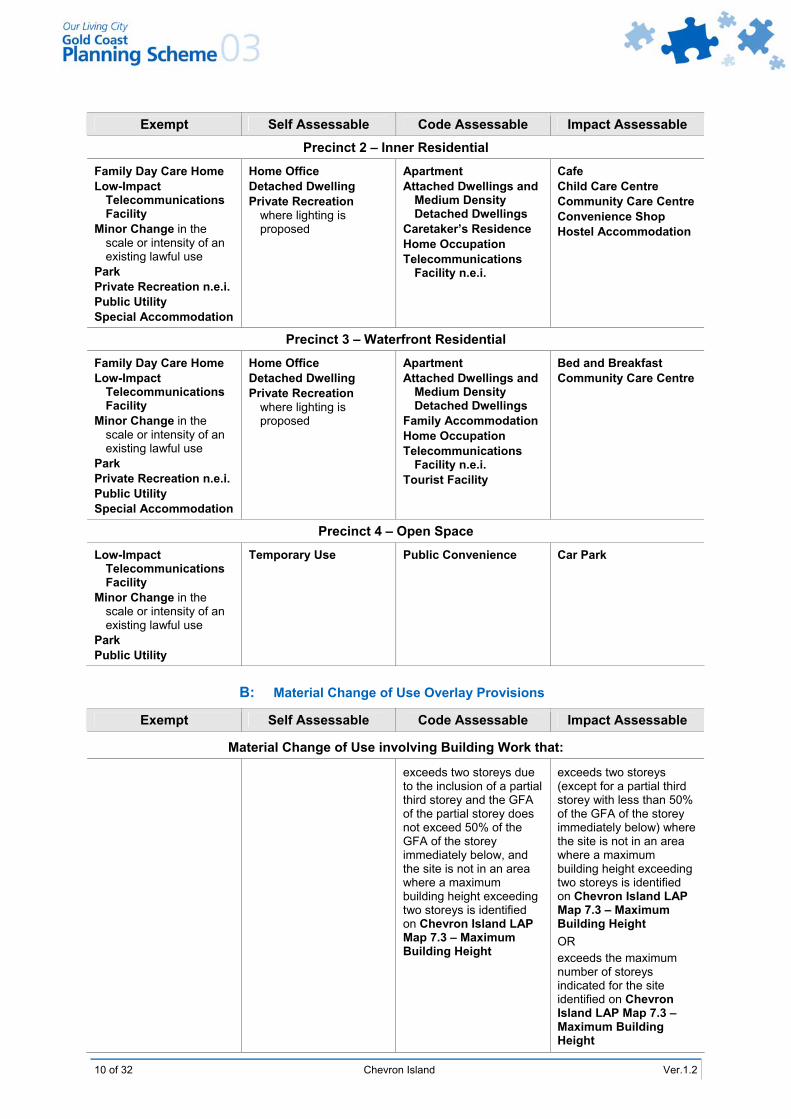
Exempt Self Assessable Code Assessable Impact Assessable
Precinct 1 – Commercial
Family Day Care Home Home Office Low-Impact
Telecommunications Facility
Minor Change in the scale or intensity of an existing lawful use
Park Public Utility Special Accommodation
Convenience Shop Home Occupation Service Industry in Sub-
precinct 1a Shop in Sub-precinct 1a Take-Away Food
Premises in Sub-precincts 1a, 1b and 1d
Temporary Use
Apartment when located above ground storey
Car Park Commercial Services in
Sub-precincts 1a, 1b and 1c
Caretaker’s Residence Fast Food Premises in
Sub-precincts 1a and 1b
Medical Centre Office with less than
500m2 GFA Restaurant Retail Nursery Telecommunications
Facility n.e.i. Veterinary Clinic in Sub-
precincts 1a, 1b and 1c
Amusement Parlour Apartment n.e.i. Café in Sub-precinct 1c Child Care Centre Community Care Centre Educational
Establishment Hostel Accommodation Minor Tourist Facility Office n.e.i. Reception Room Restaurant in Sub-
precinct 1c
10 of 32 Chevron Island Ver.1.2
Exempt Self Assessable Code Assessable Impact Assessable
Precinct 2 – Inner Residential
Family Day Care Home Low-Impact
Telecommunications Facility
Minor Change in the scale or intensity of an existing lawful use
Park Private Recreation n.e.i. Public Utility Special Accommodation
Home Office Detached Dwelling Private Recreation
where lighting is proposed
Apartment Attached Dwellings and
Medium Density Detached Dwellings
Caretaker’s Residence Home Occupation Telecommunications
Facility n.e.i.
Cafe Child Care Centre Community Care Centre Convenience Shop Hostel Accommodation
Precinct 3 – Waterfront Residential
Family Day Care Home Low-Impact
Telecommunications Facility
Minor Change in the scale or intensity of an existing lawful use
Park Private Recreation n.e.i. Public Utility Special Accommodation
Home Office Detached Dwelling Private Recreation
where lighting is proposed
Apartment Attached Dwellings and
Medium Density Detached Dwellings
Family Accommodation Home Occupation Telecommunications
Facility n.e.i. Tourist Facility
Bed and Breakfast Community Care Centre
Precinct 4 – Open Space
Low-Impact Telecommunications Facility
Minor Change in the scale or intensity of an existing lawful use
Park Public Utility
Temporary Use Public Convenience
Car Park
B: Material Change of Use Overlay Provisions
Exempt Self Assessable Code Assessable Impact Assessable
Material Change of Use involving Building Work that:
exceeds two storeys due to the inclusion of a partial third storey and the GFA of the partial storey does not exceed 50% of the GFA of the storey immediately below, and the site is not in an area where a maximum building height exceeding two storeys is identified on Chevron Island LAP Map 7.3 – Maximum Building Height
exceeds two storeys (except for a partial third storey with less than 50% of the GFA of the storey immediately below) where the site is not in an area where a maximum building height exceeding two storeys is identified on Chevron Island LAP Map 7.3 – Maximum Building Height OR exceeds the maximum number of storeys indicated for the site identified on Chevron Island LAP Map 7.3 – Maximum Building Height

Ver.1.2 Chevron Island 11 of 32
Exempt Self Assessable Code Assessable Impact Assessable
Precinct 1 exceeds a residential density of one dwelling per 100m2 of site area Precinct 2 exceeds a residential density of one dwelling per 150m2 of site area Precinct 3 exceeds a residential density of one dwelling per 168m2 of site area
is on Overlay Map OM13 – Building Setback Line from Canals and Waterways as being affected by a waterway building setback, and is in compliance with the Acceptable Solutions of Constraint Code 3 – Canals and Waterways
is on Overlay Map OM13 – Building Setback Line from Canals and Waterways as being affected by a waterway building setback, and alternative solutions to the Acceptable Solutions of Constraint Code 3 – Canals and Waterways are proposed
is on or adjacent to a site listed on the Queensland Heritage Register (Queensland Heritage Act 1992) or the Register of the National Estate (Australian Heritage Commission Act 1975) or the National Trust of Queensland list
is within or adjoins an allotment containing places, sites, or landscapes of indigenous cultural heritage significance listed on the Queensland Heritage Register – Cultural Records (Landscapes Queensland and Queensland Estate) Act 1987; OR is located on land which is the subject of a native title claim; OR is located on land that is known to the owner and/or the developer to be of indigenous cultural heritage value
Ver.1.2 Amended Jan 2010

12 of 32 Chevron Island Ver.1.2
Exempt Self Assessable Code Assessable Impact Assessable
is on a site identified on the Domain Maps as being affected by Future Road Requirement and complies with the Acceptable Solutions of Constraint Code 4 – Car Parking, Access and Transport Integration
is on a site identified on the Domain Maps as being affected by Future Road Requirement and alternative solutions to the Acceptable Solutions of Constraint Code 4 – Car Parking, Access and Transport Integration are proposed
C: Operational Work – Changes to Ground Level
Exempt Self Assessable Code Assessable Impact Assessable
Operational Work that involves extraction, excavation or fill that:
Precincts 1 and 3 exceeds a volume of 20 cubic metres of fill or excavation or is closer than two metres from the allotment boundary
Precincts 2 and 4 exceeds a volume of 50 cubic metres of fill or excavation, or is closer than two metres from the allotment boundary
is on or adjoins a site listed on the Queensland Heritage Register (Queensland Heritage Act 1992) or the Register of the National Estate (Australian Heritage Commission Act 1975) or the National Trust of Queensland list
is within or adjoins an allotment containing places, sites, or landscapes of indigenous cultural heritage significance listed on the Queensland Heritage Register – Cultural Records (Landscapes Queensland and Queensland Estate) Act 1987; OR is located on land which is the subject of a native title claim; OR is located on land that is known to the owner and/or the developer to be of indigenous cultural heritage value

Ver.1.2 Chevron Island 13 of 32
D: Operational Work – Advertising Device
Exempt Self Assessable Code Assessable Impact Assessable
Advertising Device that is: a) Not illuminated, nor
animated, and where the total area of signage per street frontage does not exceed the following for each precinct: Precinct 1 10m2 Precinct 2 0.6m2 Precinct 3 0.6m2 Precinct 4 5m2;
b) Not visible from any State-controlled road
Advertising Devices n.e.i.
E: Operational Work – Infrastructure and Landscape Work
Exempt Self Assessable Code Assessable Impact Assessable
Minor Landscape Work Landscape Work n.e.i.
Landscape Work associated with a Detached Dwelling or a Caretaker’s Residence
Works for Infrastructure
F: Operational Work – Vegetation Clearing
Exempt Self Assessable Code Assessable Impact Assessable
Vegetation Clearing that:
results in the removal of, or damage to, vegetation that is equal to, or in excess of, 40 centimetres in girth (circumference) measured at 1.3 metres above average ground level, and complies with the Acceptable Solutions of Specific Development Code 36 – Vegetation Management
results in the removal of, or damage to, vegetation that is equal to, or in excess of, 40 centimetres in girth (circumference) measured at 1.3 metres above average ground level, and alternate solutions to the Acceptable Solutions of Specific Development Code 36 – Vegetation Management are proposed
results in the removal of, or damage to, vegetation over which a Vegetation Protection Order has been made by Council
Ver.1.2 Amended Jan 2010

14 of 32 Chevron Island Ver.1.2
G: Reconfiguring a Lot Exempt Self Assessable Code Assessable Impact Assessable
Reconfiguring a Lot that: results in no lots with an
area less than 500m2; OR entails only a Community Title Subdivision (including Standard Format Plans and/or Volumetric Lots), or a Volumetric Lot within a building, or a leasehold subdivision of an existing or approved development
results in one or more lots with an area less than 500m2
7.0 Relevant Codes Codes relevant for development assessment in the Chevron Island LAP are listed below. The Place Code applies in all cases. A Specific Development Code will only apply if that specific development is proposed. A Constraint Code will only apply where the proposed development is directly impacted by the constraint that is the subject of that code.
7.1 Self Assessable Development The following codes apply to development that is self assessable in the Chevron Island LAP area.
Place Code Specific Development Codes Constraint Codes Chevron Island LAP Place Code 2 Advertising Devices
13 Detached Dwellings 24 Office 25 Private Recreation 27 Retail and Related
Establishments 34 Temporary Use 36 Vegetation Management 38 Working From Home
3 Canals and Waterways 4 Car Parking, Access and
Transport Integration 8 Flood Affected Areas
7.2 Material Change of Use The following codes apply to development that is code or impact assessable Material Change of Use in the Chevron Island LAP area.
Place Code Specific Development Codes Constraint Codes Chevron Island LAP Place Code 6 Attached Dwellings and
Medium Density Detached Dwellings
7 Bed and Breakfast Tourist Accommodation
10 Caretaker’s Residence 12 Child Care Centres 13 Detached Dwellings 16 Family Accommodation 19 High Rise Residential and
Tourist Accommodation 21 Landscape Work 22 Low Rise Apartment Building 23 Low Rise Commercial Tourist
Accommodation 24 Office 25 Private Recreation 27 Retail and Related
Establishments 33 Telecommunications Facilities 38 Working From Home 39 Works for Infrastructure
1 Gold Coast Airport and Aviation Facilities
3 Canals and Waterways 4 Car Parking, Access and
Transport Integration 5 Cultural Heritage (Historic) 6 Cultural Heritage (Indigenous) 8 Flood Affected Areas 9 Natural Wetland Areas and
Natural Waterways 13 Road Traffic Noise
Management 14 Sediment and Erosion Control 16 Steep Slopes or Unstable Soils

Ver.1.2 Chevron Island 15 of 32
7.3 Operational Work – Changes to Ground Level
The following codes apply to development that is code or impact assessable Operational Work – Changes to Ground Level (extracting gravel, rock, sand or soil from the place where it occurs naturally, or excavating or filling that materially affects premises or their use) in the Chevron Island LAP area.
Place Code Specific Development Codes Constraint Codes
Chevron Island LAP Place Code 11 Changes to Ground Level and Creation of New Waterbodies
3 Canals and Waterways 5 Cultural Heritage (Historic) 6 Cultural Heritage (Indigenous) 8 Flood Affected Areas 9 Natural Wetland Areas and
Natural Waterways 14 Sediment and Erosion Control
7.4 Operational Work – Advertising Devices, Landscape Work and Infrastructure
The following codes apply to development that is code or impact assessable Operational Work – Advertising Devices (placing an Advertising Device on premises), Landscape Work (undertaking Landscape Work in, on, over or under premises that materially affects premises or their use) or Infrastructure (undertaking Works for Infrastructure) in the Chevron Island LAP area.
Place Code Specific Development Codes Constraint Codes
Chevron Island LAP Place Code 2 Advertising Devices 21 Landscape Work 39 Works for Infrastructure
3 Canals and Waterways 4 Car Parking, Access and
Transport Integration 5 Cultural Heritage (Historic) 6 Cultural Heritage (Indigenous) 8 Flood Affected Areas 9 Natural Wetland Areas and
Natural Waterways 14 Sediment and Erosion Control
7.5 Operational Work – Vegetation Clearing
The following codes apply to development that is code or impact assessable Operational Work – Vegetation Clearing in the Chevron Island LAP area.
Place Code Specific Development Codes Constraint Codes
Chevron Island LAP Place Code 36 Vegetation Management 3 Canals and Waterways 4 Car Parking, Access and
Transport Integration 5 Cultural Heritage (Historic) 6 Cultural Heritage (Indigenous) 8 Flood Affected Areas 9 Natural Wetland Areas and
Natural Waterways 14 Sediment and Erosion Control

16 of 32 Chevron Island Ver.1.2
7.6 Reconfiguring a Lot
The following codes apply to development that is code or impact assessable Reconfiguring a Lot in the Chevron Island LAP area.
Place Code Specific Development Codes Constraint Codes Chevron Island LAP Place Code 11 Changes to Ground Level and
Creation of New Waterbodies 21 Landscape Work 28 Reconfiguring a Lot 36 Vegetation Management 39 Works for Infrastructure
3 Canals and Waterways 4 Car Parking, Access and
Transport Integration 5 Cultural Heritage (Historic) 6 Cultural Heritage (Indigenous) 8 Flood Affected Areas 9 Natural Wetland Areas and
Natural Waterways 13 Road Traffic Noise
Management 14 Sediment and Erosion Control 16 Steep Slopes or Unstable Soils
8.0 Chevron Island LAP Place Code 8.1 Purpose
This Place Code seeks to ensure that the scale and density of development and, in particular, the design and appearance of medium density residential development, mixed use development and commercial premises is consistent with the function of Chevron Island as an inner city residential area with important tourist and commercial services. 8.2 Application 8.2.1 The Chevron Island LAP Place Code applies to development indicated as self, code or
impact assessable in the Chevron Island LAP Table of Development at Clause 6.0 of this LAP.
8.2.2 Performance Criteria PC1-PC56 apply to all code and impact assessable development in this LAP. For development identified as self assessable in Clause 6.0, only the Acceptable Solutions to Performance Criteria PC1-PC13 apply.
8.3 Development Requirements
Performance Criteria Acceptable Solutions
Development that is Self Assessable, Code Assessable or Impact Assessable
Building Height
PC1 The height of buildings must contribute to an overall built form for Chevron Island that reflects its medium density character, emphasises a 'sense of island' with greater building heights in the central part of the island, and complements, rather than competes with, the taller buildings of the nearby Surfers Paradise coastal strip.
AS1.1 The building has a maximum of two storeys. OR AS1.2 The height of buildings in each precinct does not exceed the maximums shown on Chevron Island LAP Map 7.3 – Maximum Building Height.
Precinct 1, Sub-precincts 1a and 1d PC2 Building height must be limited to eight storeys within Precinct 1: a) except where a through block pedestrian arcade is
provided, a bonus in building height may be achieved.
Precinct 1, Sub-precincts 1a and 1d AS2.1.1 The maximum building height does not exceed eight storeys. OR AS2.1.2 Sub-precinct 1a The maximum building height does not exceed ten storeys and a through block pedestrian arcade is provided. This pedestrian arcade provides an effective link between Thomas Drive and either Barranbali or Karloo Streets. OR

Ver.1.2 Chevron Island 17 of 32
Performance Criteria Acceptable Solutions AS2.1.3 Sub-precinct 1d The maximum building height does not exceed ten storeys and a through block pedestrian arcade is provided. This pedestrian arcade provides an effective link between Stanhill Drive and a public access boardwalk with frontage to the Nerang River.
Precinct 2 PC3 This precinct must be developed for high density residential uses, with building heights up to a maximum of eight storeys. However, where large sites are provided and where site coverage is minimised, a bonus in building height may be achieved.
Precinct 2 AS3.1.1 The maximum building height does not exceed eight storeys. OR AS3.1.2 The maximum building height does not exceed ten storeys, and the site has a minimum area not less than 3000m2.
Precinct 3 PC4 This precinct must be developed at a low intensity, and with the lowest building heights in the LAP area, to safeguard the amenity of existing detached dwellings and duplex dwellings.
AS4.1 Building height does not exceed two storeys in height. OR AS4.2 Apartments are constructed to a height not exceeding six storeys where: a) a development site with a site area of 1,450m2 or
greater is assembled to accommodate the proposed building;
b) setbacks of 6 metres to the street frontage, 10 metres to the side boundaries and 10 metres to the Nerang River frontage are achieved;
c) a maximum site coverage of 20% or a maximum building footprint of between 300m2 and 350m2 in area is achieved.
Podium Heights
Precinct 1 PC5 Multi-storey mixed use buildings are expected to take the form of a residential tower, placed upon a podium containing commercial uses. The height of the podium is to be restricted, to limit the total commercial activity on the Island and to encourage residential uses on upper floors.
Precinct 1 AS5.1 For buildings with a frontage to Thomas Drive, the maximum podium height does not exceed two storeys. AS5.2 For buildings with a frontage to Stanhill Drive, the maximum podium height does not exceed one storey.
Accommodation Density
PC6 Accommodation density must be consistent with the inner city urban character of Chevron Island. Accordingly, medium to high density development that can be comfortably accommodated on the development site and supports mixed uses in the local commercial centre is appropriate.
AS6 The maximum accommodation density does not exceed one dwelling per allotment.

18 of 32 Chevron Island Ver.1.2
Performance Criteria Acceptable Solutions Site Coverage
PC7 Development must be designed and constructed to ensure that there is adequate space between buildings to safeguard privacy and amenity, and ensure appropriate ventilation. Buildings are to be substantially centred on the site to achieve effective open space separations between buildings at ground level.
Precinct 1 AS7.1 The maximum site coverage does not exceed 80% of the site area. Precinct 2 AS7.2.1 The building is not more than 4 storeys in height, and the site coverage does not exceed 40%. OR AS7.2.2 The building is more than 4 storeys in height, and the site coverage does not exceed 30%. Precinct 3 AS7.3.1 The building is not more than 2 storeys in height, and the site coverage does not exceed 50%. OR AS7.3.2 The building is more than two storeys in height, and the site coverage does not exceed 20%. Precinct 4 AS7.4 The maximum site coverage does not exceed 5% of the site area. AS7.5 No car parking basement podium is visible from Thomas Drive, Burra, Adori and Mawarra Streets or Stanhill Drive. Car park podiums may be constructed to a height of one metre above natural ground level, where not visible from any public area.
Building Setback
Sub-Precincts 1a, 1b and 1c PC8 Buildings must be designed and located in a way that contributes to a pleasant streetscape and results in a spacious and accessible street environment for shoppers and other visitors to the centre.
Sub-Precincts 1a, 1b and 1c AS8.1 All buildings are set back from the frontage of Thomas Drive, Burra and Mawarra Streets a distance of two metres at ground and first floor level, and a minimum distance of six metres above first floor level. AS8.2 All buildings are setback from the frontages of Karloo and Barranbali Streets, four metres at ground and first floor levels, and a minimum of six metres above first floor level. AS8.3 Buildings may have a zero side boundary setback at ground and first floor levels, except in situations where the boundary is to an open pedestrian arcade. In this case, a two metre side setback is provided. AS8.4 Side boundary setbacks above first floor level are a minimum of two metres for the first 7.5 metres above first floor level, and then an additional 0.5 metres for every three metres above 7.5 metres. AS8.5 Buildings are set back a minimum of 2 metres from rear boundaries.

Ver.1.2 Chevron Island 19 of 32
Performance Criteria Acceptable Solutions
Sub-Precinct 1d PC9 Buildings must be designed and located in a way that contributes to a pleasant streetscape and results in a spacious and accessible environment with access to the Nerang River.
Sub-Precinct 1d AS9.1.1 Buildings are set back from the frontage of Stanhill Drive a distance of four metres at ground level and a minimum of six metres above ground floor level. OR AS9.1.2 Buildings on sites located adjacent to the two pedestrian easements to the river have a two metre ground level setback from Stanhill Drive, unless the street frontage is used for ground level cafe or restaurant purposes, in which case a zero setback applies. AS9.2.1 Buildings are set back from the river frontage a minimum of four metres at ground level and a minimum of six metres above ground floor level. OR AS9.2.2 Buildings on sites located adjacent to the two pedestrian easements to the river have a two metre ground level setback to the river. AS9.3.1 Buildings have a zero side boundary setback at ground level. OR AS9.3.2 Buildings on sites located adjacent to pedestrian easements or that adjoin properties located within Precinct 3 (waterfront residential), have a minimum three metre side setback at ground level. AS9.4.1 Side boundary setbacks above ground floor level are a minimum of two metres for the first 7.5 metres above first floor level, and then an additional 0.5 metres for every three metres above 7.5 metres. OR AS9.4.2 Buildings on sites which adjoin Precinct 3 (waterfront residential) have a minimum setback of three metres for the first 7.5 metres, with an additional 0.5 metres of setback for every additional 3.5 metres of height.
Precinct 2 PC10 Buildings must be designed and located in a way that contributes to a pleasant streetscape and results in a spacious and attractive residential environment.
Precinct 2 AS10.1 Buildings are set back from any street frontage a minimum distance of six metres. AS10.2 Buildings are set back from the side or rear boundaries a minimum of: a) 1.5 metres for that part of the building less than 4.5
metres above natural ground level; b) 2 metres for that part of a building which is
between 4.5 and 7.5 metres above natural ground level;
c) 2 metres, plus 0.5 metres for every 3 metres the building exceeds 7.5 metres above natural ground level.

20 of 32 Chevron Island Ver.1.2
Performance Criteria Acceptable Solutions
Precinct 3 PC11 Development must be designed and constructed to ensure that there is adequate space between buildings to safeguard privacy, and amenity, and ensure appropriate ventilation. In addition, building setbacks are intended to facilitate access for building maintenance and to contribute toward a high level of visual amenity.
Precinct 3 AS11.1.1 Buildings not exceeding 2 storeys in height are set back from any street frontage at a minimum distance of six metres, and are set back from Nerang River at a minimum distance of 6.3 metres. OR AS11.1.2 Buildings exceeding 2 storeys in height are set back 6 metres from any street frontage and ten metres from the Nerang River. AS11.2.1 Buildings not exceeding 2 storeys in height are set back at a minimum of 2 metres from any side boundary to an adjoining property. OR AS11.2.2 Buildings exceeding 2 storeys in height are set back at a minimum of 10 metres from any side boundary to an adjoining property.
Site Area
PC12 The site area of the development must be sufficient to comfortably accommodate the type of development envisaged by this LAP. A mixture of building heights and types will result, dependant on the size of amalgamated development sites and the impacts of development on adjoining sites
Precincts 1 and 2 AS12.1 The minimum site area for an apartment building: a) up to 4 storeys in height is 1,000m2; b) exceeding 4 storeys but not exceeding 8 storeys in
height is 1,450m2; c) exceeding 8 storeys in height is 3,000m2. AS12.2 The minimum road frontage of any site intended to be developed for an apartment building exceeding 2 storeys is 25 metres. Precinct 3 AS12.3 The minimum site area for the development of: a) a detached dwelling or an attached dwelling is
400m2; b) an apartment building is 600m2; c) any development exceeding 2 storeys in height is
1,450m2.
Vehicular Crossings
PC13 Vehicular crossings associated with the development must be designed and constructed to ensure: a) a safe footpath environment; b) safe vehicular access to the property; c) appropriate hydraulic performance of the
stormwater infrastructure; d) no damage to vehicle or road infrastructure; e) minimal loss of on-street parking spaces; f) continued amenity of the neighbourhood.
AS13.1 Driveways are designed and constructed in accordance with relevant sections of Planning Scheme Policy 11 – Land Development Guidelines.

Ver.1.2 Chevron Island 21 of 32
Performance Criteria Acceptable Solutions
Development that is Code Assessable or Impact Assessable
Siting
PC14 All buildings must be sited to complement the local area character and the built form of the surrounding area, and to reduce potential conflicts between uses having regard to a site analysis, prepared in accordance with Planning Scheme Policy 17 – Site Analysis.
AS14 No acceptable solution provided.
PC15 The layout of the site must provide a clear separation between the public access areas and the areas set aside for servicing the building.
AS15 No acceptable solution provided.
Accommodation Density
PC16 Accommodation density must be consistent with the inner city urban character of Chevron Island. Accordingly, medium to high density development that can be comfortably accommodated on the development site and supports mixed uses in the local commercial centre is appropriate.
Precinct 1 AS16.1 The maximum accommodation density does not exceed D2 as shown in the Table to PC16a. Precinct 2 AS16.2.1 The maximum accommodation density does not exceed D1 as shown in the Table to PC16a. OR AS16.2.2 The maximum allowable accommodation exceeds D1, but is within the range of allowable density for the subject site area and building height as shown in the Table to PC16b.
Table to PC16a Density Table Table to PC16b
Density Site Area per Unit (m2) Allowable Development Intensity 1 Bed 2 Bed > 2 Bed Site Area Building Height (Storeys)
D1 50 100 150 up to 6 7 or 8 9 or 10
D1+ 45 83 125 < 1500 m2 D1 D1+
D2 33 67 100 1500-2000 m2 D1 D2
D2+ 32 58 88 2000-3000 m2 D1 D2+
3000m2 + D1 D2+ D2+
Precinct 3 AS16.3 The maximum accommodation density does not exceed one dwelling unit per 168m2 of net site area.
Building Appearance and Safety
PC17 Building materials and finishes must maintain and enhance the quality of the urban environment and reduce the perceived bulk of development.
AS17.1 Development utilises high quality materials and finishes which are carefully detailed and selected, having regard to form, texture, colour, scale and quality. AS17.2 Buildings incorporate variations in materials, colours and textures between the lower and upper levels. AS17.3 Building finishes and materials can be easily maintained, and do not readily stain, discolour or deteriorate.

22 of 32 Chevron Island Ver.1.2
Performance Criteria Acceptable Solutions PC18 Building articulation and design elements must contribute to an attractive streetscape environment and reduce the perceived bulk of development.
AS18.1 The horizontal length of any wall in a single plane, irrespective of any projections such as balconies or offsets of less than one metre, does not exceed 15 metres, unless a separation of at least 2.5 metres is provided. AS18.2 Building elevations, at street frontages, do not contain blank walls.
PC19 Building design and appearance must be conducive to the safety and comfort of all building users.
AS19.1 Any ground level retail or commercial development in Precinct 1 provides a continuous pedestrian awning at the street frontage/s of the development which is at least 2.5 metres in width, extending along the full length of the retail/commercial frontage of the site. AS19.2 The location of equipment that has potential to create noise is designed to minimise the penetration of noise to dwelling units on the premises and to residential premises external to the site.
Roof Structures
PC20 Roof design must enhance and contribute to the desirable built form of the area.
AS20.1 Plant and lift rooms are integrated with the design of the development, so that tops of buildings are visually attractive features in the skyline. AS20.2 The roofs of buildings add interest to the streetscape, by including pitches, articulation, gables or other features.
Solar Access
PC21 Buildings must be sited and designed to maximise solar access to north facing windows of habitable areas and principal areas of open space.
AS21.1 Residential development is designed, wherever practical, to maximise exposure to the northern sun, while minimising the impact of the western sun. AS21.2 Blinds, awnings and window overhangs are utilised to minimise the impact of the low western sun on residential dwellings. AS21.3 The southern shadow cast by any building greater than four storeys in height should not adversely impact on solar access to adjoining dwellings and must comply with the shadow controls within Specific Development Code 19 – High Rise Residential and Tourist Accommodation.
Specular Reflectivity and Glare
PC22 Development must minimise glare and reflection through design.
AS22.1 Glass which forms part of an external wall does not exceed 60% of the total area of the wall. AS22.2 Ground level retail and commercial uses within Precinct 1 may exceed the percentage of glass stated in AS22.1, in recognition of their business character. AS22.3 Glass frontages have a maximum degree of reflection of both heat and light of 20%.

Ver.1.2 Chevron Island 23 of 32
Performance Criteria Acceptable Solutions Visual Privacy
PC23 Direct overlooking of main internal living areas and private open spaces of other dwellings must be minimised, through building design, layout and screening.
AS23.1 Habitable room windows with a direct outlook to the habitable room windows of an adjacent dwelling unit within nine metres: a) are offset by a sufficient distance to limit views into
adjacent windows; b) have sill heights above 1.7 metres; or c) have fixed obscure glazing in any part of the
window below 1.7 metres above floor level. AS23.2 Outlook from windows balconies, stairs, landings, terraces and decks or other private, communal or public areas is obscured, screened or landscaped, where a direct view is available into the private open space of existing dwellings.
Acoustic Privacy
PC24 Noise from development, including active recreation facilities, service areas, plant or equipment, vehicular movement areas and dwelling units, must not unreasonably affect dwellings on the same property or adjacent land.
AS24.1 Bedroom windows are located at least three metres from shared streets, driveways, vehicular movement and parking areas (or a lesser distance where appropriate noise shielding techniques are used). AS24.2 Active recreation areas are not located close to bedroom windows or other openings. AS24.3 Air conditioning or lift equipment is not located in a position where it will create a noise nuisance for residents.
Security and Crime Prevention
PC25 Spaces providing access to, around and within the buildings as well as bicycle and pedestrian routes, must be designed to ensure that: a) there is good visibility of the spaces or route by the
user; b) the user is visible to others through either informal
or other surveillance techniques.
AS25.1 Building design and placement maximises casual surveillance of public and communal open space areas. AS25.2 Entry areas and pedestrian paths are well lit. Movement sensitive lighting is directed towards likely access/egress points. AS25.3 Design of development avoids the creation of dark corridors or other areas, which could compromise personal security.
Building Safety and Emergency Access
PC26 Development must provide adequate public safety measures and ensure efficient emergency access.
AS26.1 Buildings incorporate a building safety switchboard. AS26.2 Individual dwellings are numbered to be clearly identifiable by visitors and emergency services. AS26.3 Building entries and at least one lift enable access for stretchers and emergency service equipment.

24 of 32 Chevron Island Ver.1.2
Performance Criteria Acceptable Solutions Car Park Design
PC27 Buildings must be designed and constructed to ensure that basement car parking structures do not cause a nuisance to adjoining sites or create an undesirable streetscape, due to their proximity to the boundary or street frontage, or due to their excessive height above ground level.
AS27.1 Car parking basements do not extend more than one metre above ground level, and are setback a minimum of four metres from any street frontage and two metres from any side or rear boundary: a) Natural Ground Level is established by an
applicant in accordance with the requirements of Subclause 8.4 of this LAP.
AS27.2 Basement car parks, constructed within the setbacks set out above, are not considered in calculating site cover. That part of a basement located closer to the street frontage, side or rear boundary than specified above will be calculated as site cover. AS27.3 Garden beds or landscaping beds, located on top of car parking podium areas, are set back at least 0.5 metres from the podium edge, to ensure that podiums do not appear to exceed one metre in height.
PC28 Garages and parking structures must be sited and designed so as not to dominate the street frontage.
AS28.1 Any ground level car parking area is well landscaped, and constructed of materials that present an aesthetically pleasing and high quality finish. AS28.2 Carports and garages are compatible with the design of buildings on the same site. Carports and garages face the street and cover no more than 50% of the street frontage. AS28.3 Carports built to the street frontage have open sides, and any garage door facing the street is permeable, to permit views to and from the street. AS28.4 Building materials, patterns, textures and colours used in garage and carport structures are complementary to those of the principal building on the site.
Advertising Devices
PC29 All advertising devices must be designed and constructed to complement the character of the local area.
Precinct 1 AS29.1 All signs are consistent with the provisions for the Local Business Domain set out in Specific Development Code 2 – Advertising Devices.

Ver.1.2 Chevron Island 25 of 32
Performance Criteria Acceptable Solutions Precincts 2 and 3 AS29.2 All signs are consistent with the provisions for the Residential Choice Domain set out Specific Development Code 2 – Advertising Devices. Precinct 4 AS29.3 All signs are consistent with the provisions for the Public Open Space Domain set out in Specific Development Code 2 – Advertising Devices.
Landscape Work
PC30 Adequate landscaping must be provided to complement on-site open space and create an attractive streetscape.
AS30.1 Landscape work complements the Open Space and Streetscape Concept Plan as shown in LAP Map 7.4 – Open Space and Streetscape Concept Plan. AS30.2 Landscape design includes recognition of existing and potential vistas of the Island, through landscaping which ensures preservation of these features.
PC31 Development must facilitate improvements to the streetscape of the major east-west movement route on Chevron Island.
AS31 Development provides contribution to the costs of streetscape works on Thomas Drive, in accordance with Planning Scheme Policy 2 – Chevron Island Developer Charges Policy.
Retention of Vegetation
PC32 Significant existing on-site vegetation and street trees must be retained, in a manner which will improve the proposed development and provide for the long term viability of the preserved vegetation.
AS32.1 Design of development identifies, retains and integrates significant existing vegetation. AS32.2 Significant existing vegetation is protected from damage during construction, through retention of soil levels and use of temporary fencing.
Car Park Areas, Open Space and Water Access
PC33 All ground level car parking, open space and buffer areas must be landscaped and maintained to complement the character of the local business centre and any adjoining residential or public open space areas.
AS33 The car park area, open space and buffer areas of the lot are landscaped with landscape design and use of plant species, generally consistent with that of adjacent and nearby lots. The landscape design may incorporate extensive paved areas for pedestrian use.
Sub-precincts 1a, 1b and 1c PC34 Landscaping must provide a pleasing streetscape, and soften and articulate the edges and interfaces of buildings.
Sub-precincts 1a, 1b and 1c AS34.1 Building setbacks to Barranbali Street incorporate deep landscaping, which will provide a visual buffer to adjacent residential properties. Building setbacks to Karloo, Burra and Mawarra Streets incorporate deep planting, except where the frontage is utilised for commercial or retail activity or where service entrances are located. AS34.2 Apart from the driveway and commercial shopfront areas, a minimum of two metres of landscaped planting is provided to the Karloo, Barranbali, Burra and Mawarra Streets frontages.

26 of 32 Chevron Island Ver.1.2
Performance Criteria Acceptable Solutions AS34.3 Landscaping areas are provided above ground level as part of any mixed use development proposal, and may consist of roof plantings, podium plantings, planting on balconies and within common areas, as appropriate.
Sub-precinct 1d PC35 Landscaping must be provided to highlight the riverside location, provide a pleasing streetscape, and soften and articulate the edges and interfaces of buildings.
Sub-precinct 1d AS35.1 Those parts of a site between a building and the river front that are not required as paved areas or service areas are landscaped with plants which enable water views to be preserved. AS35.2 That part of a site between a building and the kerb line of Stanhill Drive is paved with high quality paving material which is to be of a uniform quality and appearance from site to site. AS35.3 Street furniture, including street trees, seats, rubbish bins, planter boxes and similar, is to be provided within and along the frontages of any development site, as part of any development proposal. AS35.4 Suitable landscaping above ground level is provided in association with any development for apartments. Such landscaping may be provided by way of roof plantings, planting on balconies and within common areas, as appropriate. AS35.5 A waterfront boardwalk must be provided along the full length of the waterfront boundary, as part of any redevelopment proposal of any site.
Lot Size (For Subdivision Only)
PC36 All lots must be of sufficient size to comfortably accommodate a detached dwelling, a commercial building, a mixed use building, or a medium density residential building.
AS36 The minimum lot size is not less than 500m2.
Amenity Protection
PC37 The proposed use must not detract from the amenity of the local area, having regard, but not limited, to the impact of: a) noise; b) hours of operation; c) traffic; d) lighting; e) signage; f) visual amenity; g) privacy; h) odour and emissions.
AS37 No acceptable solution provided.

Ver.1.2 Chevron Island 27 of 32
Performance Criteria Acceptable Solutions
PC38 The proposed development must take into account and seek to ameliorate any negative aspects of the existing amenity of the local area, having regard, but not limited, to the existing impact of: a) noise; b) hours of operation; c) traffic; d) lighting; e) signage; f) visual amenity; g) privacy; h) odour and emissions.
AS38 No acceptable solution provided.
Land Use
Sub-precincts 1a, 1b and 1c PC39 All development must be by way of mixed use buildings, and must consist of a mixture of commercial and residential uses, as permitted in the four Sub-precincts.
Sub-precincts 1a, 1b and 1c AS39.1 Shops, restaurants, cafes, and similar commercial and community land uses, requiring direct customer access, are located at ground floor level. AS39.2 Offices, community facilities and other commercial and community uses are located on one other floor (where permitted). AS39.3 Apartment dwellings are located above ground floor level within Sub-Precincts 1a and 1b. Partial residential development will be permitted at ground level within Sub-Precinct 1c. AS39.4 There are no more than two full levels of floor space within any building dedicated to non-residential land uses other than car parking. AS39.5 Ground floor commercial uses address all street frontages, except Barranbali Street and the northern side of Stanhill Drive.
Sub-Precinct 1d PC40 The predominant form of development will be waterfront mixed use buildings and must comprise recreational and dining uses, such as restaurants, cafes and bars, with residential uses above ground floor.
Sub-Precinct 1d AS40.1 Restaurants, cafes, fast food premises and similar recreational and dining land uses are located at ground floor level. AS40.2 Residential uses, such as apartments, are located above ground floor level. AS40.3.1 No more than one level of any building is dedicated to non-residential land uses, other than car parking. OR AS40.3.2 The land is located on Lots 447, 448, 456 or 457 on RP93882, part of the land is to be dedicated as easement and no more than two levels of commercial floor space are provided.

28 of 32 Chevron Island Ver.1.2
Performance Criteria Acceptable Solutions
Precinct 2 PC41 The predominant use must be for residential purposes.
Precinct 2 AS41.1 Residential uses in the form of Apartment Buildings are the predominant form of development. AS41.2 Minor non-residential uses in their scale and intensity, do not undermine the role of Precinct 1 as a commercial focus on Chevron Island.
Precinct 3 PC42 This precinct is intended to be developed for low intensity residential purposes, with minor non-residential uses limited to those that are conducted within the curtilage of a dwelling.
Precinct 3 AS42.1 Residential uses in the form of Detached Dwellings, Attached Dwellings and Medium Density Detached Dwellings and small scale Apartment Buildings predominate. AS42.2 Non-residential uses are limited to home occupations or home offices.
Precincts 1, 2 and 3 PC43 A variety of residential dwelling types must be distributed throughout the Island. In particular, multi-unit residential developments are encouraged to vary the number of bedrooms for their component units.
Precincts 1, 2 and 3 AS43 Where a mixed use building or apartment building is proposed with more than six units on the site, no more than 50% of the units may be single bedroom dwellings or studio apartments.
Waterfront Boardwalk
Sub-precinct 1d PC44 Any substantial redevelopment must contribute to the achievement of a waterfront boardwalk along the Nerang River foreshore.
Sub-precinct 1d AS44.1 A waterfront boardwalk is provided along the full length of the waterfront boundary of the property. AS44.2 Provision for public access from Stanhill Drive to the waterfront boardwalk must be provided within each redevelopment site, where practically feasible. AS44.3 Pedestrian links to the waterfront boardwalk must be provided at the eastern and western ends of the Sub-Precinct, to permit full public utilisation of the boardwalk. AS44.4 A pedestrian access link leading to the proposed Evandale bridge is to be located within the easement, leading to the waterfront and located at the southern end of Mawarra Street. A bonus building height of an extra two storeys may be achieved, where such an arcade is provided. Adjoining sites to the east and west must provide a three metre setback to this pedestrian easement, to enable sufficient width for the bridge access and bridge structure to be provided. Such setback areas must be dedicated to Council as public open space.
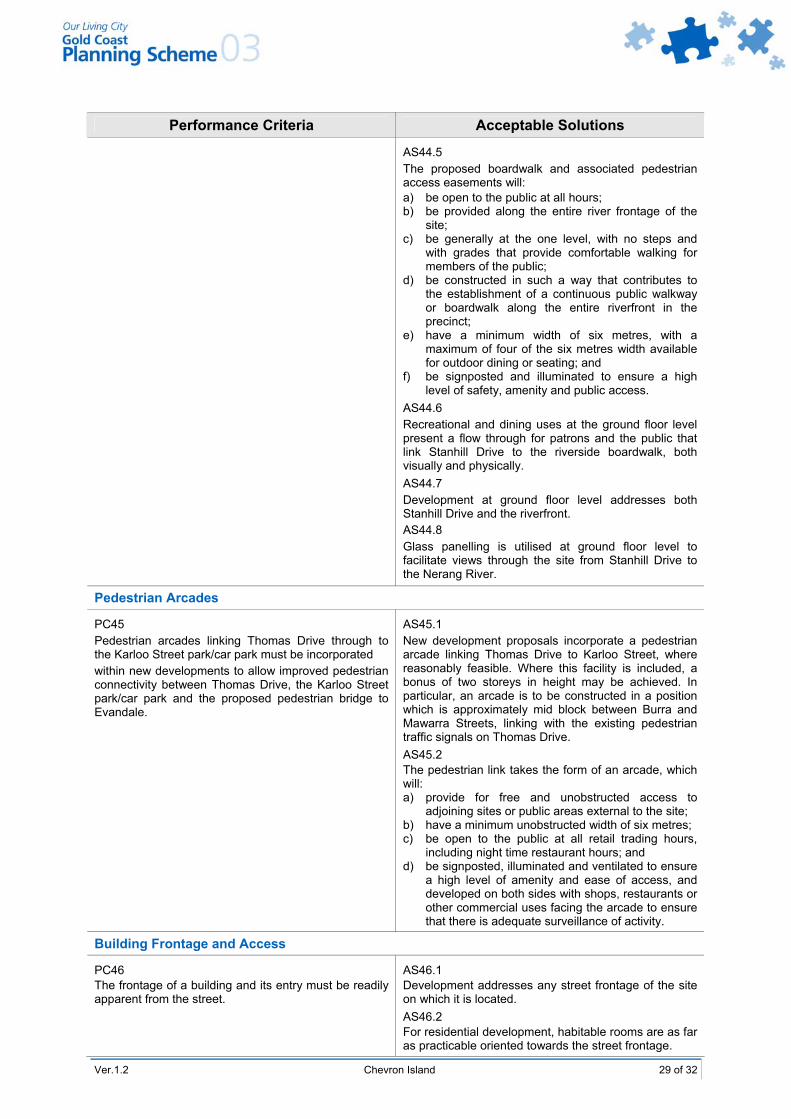
Ver.1.2 Chevron Island 29 of 32
Performance Criteria Acceptable Solutions AS44.5
The proposed boardwalk and associated pedestrian access easements will: a) be open to the public at all hours; b) be provided along the entire river frontage of the
site; c) be generally at the one level, with no steps and
with grades that provide comfortable walking for members of the public;
d) be constructed in such a way that contributes to the establishment of a continuous public walkway or boardwalk along the entire riverfront in the precinct;
e) have a minimum width of six metres, with a maximum of four of the six metres width available for outdoor dining or seating; and
f) be signposted and illuminated to ensure a high level of safety, amenity and public access.
AS44.6 Recreational and dining uses at the ground floor level present a flow through for patrons and the public that link Stanhill Drive to the riverside boardwalk, both visually and physically. AS44.7 Development at ground floor level addresses both Stanhill Drive and the riverfront. AS44.8 Glass panelling is utilised at ground floor level to facilitate views through the site from Stanhill Drive to the Nerang River.
Pedestrian Arcades
PC45 Pedestrian arcades linking Thomas Drive through to the Karloo Street park/car park must be incorporated within new developments to allow improved pedestrian connectivity between Thomas Drive, the Karloo Street park/car park and the proposed pedestrian bridge to Evandale.
AS45.1 New development proposals incorporate a pedestrian arcade linking Thomas Drive to Karloo Street, where reasonably feasible. Where this facility is included, a bonus of two storeys in height may be achieved. In particular, an arcade is to be constructed in a position which is approximately mid block between Burra and Mawarra Streets, linking with the existing pedestrian traffic signals on Thomas Drive. AS45.2 The pedestrian link takes the form of an arcade, which will: a) provide for free and unobstructed access to
adjoining sites or public areas external to the site; b) have a minimum unobstructed width of six metres; c) be open to the public at all retail trading hours,
including night time restaurant hours; and d) be signposted, illuminated and ventilated to ensure
a high level of amenity and ease of access, and developed on both sides with shops, restaurants or other commercial uses facing the arcade to ensure that there is adequate surveillance of activity.
Building Frontage and Access
PC46 The frontage of a building and its entry must be readily apparent from the street.
AS46.1 Development addresses any street frontage of the site on which it is located. AS46.2 For residential development, habitable rooms are as far as practicable oriented towards the street frontage.

30 of 32 Chevron Island Ver.1.2
Performance Criteria Acceptable Solutions
AS46.3 Development has at least one prominent pedestrian entry that connects a foyer with a footpath leading directly to the street frontage of the site.
Plot Ratio
PC47 Buildings over four storeys in height must avoid a regular, bulky built form, and promote slender towers and a variety of design solutions.
AS47.1 The building exceeds four storeys in height, and the basic plot ratio complies with the requirements of Specific Development Code 19 – High Rise Residential and Tourist Accommodation.
Car Parking Provision
AS48 Car parking spaces are provided at the following rates:
retail, service industry, cafe and restaurant uses
one (1) space per 25m2 of GFA, or part thereof
office and services uses commercial
one (1) space per 50m2 of GFA, or part thereof
residential uses one (1) space per one bedroom dwelling 1.25 spaces for any dwelling with more than one bedroom
PC48 Sufficient car parking must be provided for the normal operation of all development in the LAP area.
all other uses – as provided in Constraint Code 4 - Car Parking, Access and Transport Integration.
PC49 Off-street car parking must be located and designed to maintain an attractive streetscape and minimise amenity impacts on adjacent development.
AS49.1 At least 90% of all car parking provided on a development site is located within an underground basement. AS49.2 Any ground level car parking is landscaped and paved with high quality materials, to present an attractive view to any public street.
Recreational Open Space
PC50 Sufficient clearly defined and useable on-site open space must be provided for use of all residential building and mixed use building occupants.
AS50 For any development in Precinct 1, on-site landscaped open space and recreational space is to be provided as follows: communal open space is provided at the roof level
of the commercial component of any mixed use development proposal and/or on the roof of the residential component of any mixed use development. Such recreation may consist of podium landscape planting, seating areas, areas that are shaded from the sun, and areas, which are suitable for barbecue and resident entertainment purposes. Communal open space is predominantly north facing to allow for solar access to recreation areas. Facilities such as swimming pools, gymnasiums, saunas and tennis courts may be provided on-site, where they are only accessible to on-site residents and where no adverse impacts to adjoining sites will be created;

Ver.1.2 Chevron Island 31 of 32
Performance Criteria Acceptable Solutions communal open space for mixed use development
proposals is provided at a rate of at least 20m2 per dwelling unit for developments consisting of less than six dwellings and 15m2 for every additional dwelling beyond six. Such areas are to provided in dimensions which will allow for their utilisation (generally a width and depth of five metres is considered appropriate);
rooftop and podium spaces, utilised for communal open space, are free of obstructions such as air vents, exhaust chimneys, aerials/antenna, hot water heaters, lift motors or any other rooftop machinery/infrastructure which is likely to be adversely affect the effective use of such areas;
rooftop and podium communal open space areas; retain some areas of privacy, when viewed from
street level or from taller adjoining buildings; private balconies are provided for each residential
unit above ground level within Precinct 1. At least one balcony per dwelling is directly accessible from the living area of each dwelling, and has a minimum area of 8m2 and a minimum width of two metres.
Public Convenience Facilities Within Buildings
PC51 Commercial developments must include public convenience facilities, where there is a need for their provision.
AS51 Where provided, public toilet facilities are open and readily accessible to the general public during retail trading hours or other trading hours relevant to the development.
Building Services
PC52 Development must provide necessary site facilities which are visually attractive and low maintenance. These facilities include, where relevant: a) garbage bin areas; b) mail boxes; c) clothes drying; d) storage areas.
AS52.1 Garbage bin storage areas are contained within building basements or, if located outside, effectively screened from view from any public street. AS52.2 Garbage bin storage areas are easily accessible for on-site collection, or close to the street frontage for street collection. AS52.3 Individual mail boxes are located close to each ground floor dwelling entry, or a mail box structure is located close to the major pedestrian entrance of a site. In major developments, pedestrian shelter should be provided for mailbox areas. AS52.4 A space of 8m2 per dwelling is set aside exclusively for resident storage. This may form part of a carport or garage.
Refuse Storage
PC53 Adequate facilities to service of the development with a refuse disposal service must be provided to meet the needs of the development, with a minimal impact on the visual amenity of the local area.
AS53.1 The outdoor refuse storage area is provided with suitable access on-site, for the removal of refuse. AS53.2 All outdoor storage or refuse disposal areas are screened from public view.

32 of 32 Chevron Island Ver.1.2
Performance Criteria Acceptable Solutions Vehicular Access and Loading Bays
PC54 Adequate facilities for the loading and unloading of goods must be provided to meet the needs of the development.
AS54 A loading area is provided on site that is separated from the public access areas and readily accessible from all commercial tenancies on the site.
Vehicular Access
PC55 Vehicular access arrangements must promote the efficient operation of the movement system on the Island.
AS55 All development complements the principles included in the Movement and Circulation Concept Plan, as outlined in LAP Map 7.5 – Movement and Circulation Concept Plan.
PC56 Conflict between pedestrians and motor vehicles must be minimised, whilst allowing safe and convenient access to properties.
AS56.1 In Sub-precinct 1a, all access to sites is via Karloo or Barranbali Streets. AS56.2 In Sub-precinct 1b, vehicle access is taken from any public street other than Thomas Drive, unless no reasonable alternative exists. AS56.3 In Sub-precinct 1c, all access is taken from Mawarra or Burra Streets. AS56.4 In Precinct 2, there is no direct vehicular access to Thomas Drive, where an alternative access street is available.
8.4 Verification of Natural Ground Level
Natural ground level is the level of a site in its original condition, immediately following the construction of public roads, drainage and other service infrastructure, and prior to any filling or excavation to facilitate the construction of buildings or other development on any site.
Verification of natural ground level will be required for all development applications involving the construction of a basement car parking level. For such applications, the following information will be required to be provided at the application stage: a plan prepared and certified by a licensed surveyor that shows surveyed natural ground level; levels are to be taken on a minimum three metre grid and contours at 100mm intervals are to be
prepared; the levels are to be reported in terms of Australian Height Datum (AHD); in the case of a site that has been filled or excavated or modified in some other material way, an
estimate is to be provided of the likely natural ground level, prior to any earthworks or modification to the site. This estimation is to be prepared and certified by a licensed surveyor, and is to take into account levels of nearby lands that have not been modified and any other information that assists in identifying the natural ground level of the site; and
if the site/adjoining sites have been filled or modified in some way, the modified ground level is to be shown in addition to the natural ground level or estimated natural ground level.
Elevations of all sides of a building are to be prepared and lodged with any development application, and such elevations are to show the natural ground level or estimated natural ground level and the modified natural ground level at the outer face of any basement car park structure.